Embed Size (px)
Citation preview
Infrastructure Planning ‘08
CEPT University, Ahmedabad
PDF created with pdfFactory trial version www.pdffactory.com

Proposal for Master Plan of Auroville
2
Infrastructure Planning ‘08
Summer Internship Report
TABLE OF CONTENT
Abstract
1. Introduction
2. Concept of Auroville
3. Existing Scenario
3.1 Location & regional Setting
3.2 Existing internal road Network
3.3 Population Details
4. Concept of Master Plan
4.1 Traffic pattern of master plan
4.2 Preference for non polluting movements
4.3 Streets & Path ways
5. Analysis of Master Plan
5.1 Projected population
5.2 Volume count study
5.3 Distance Study
5.4 Inferences of study
6. Case study
6.1 Issues
6.2 Requirement
6.3 Concept of Master Plan
6.4 Probable Solution / Proposal based on Issues & requirement
7. Approach/Strategies to achieve the master plan
7.1 By Mid-term Development(2010-2025)
7.2 By long-term Development(2025-2050)
7.3 Distances Comparison Between Community & Service provider Areas after Proposed Roads
7.4 Proposed Land use
Glimpses study
Annexure
About Organization
Acknowledgement
PDF created with pdfFactory trial version www.pdffactory.com
Proposal for Master Plan of Auroville
3
Infrastructure Planning ‘08
Summer Internship Report
ABSTRACT
Mobility is a basic need. “To be mobile” is the most important characteristic of a modern society. It
means opportunities for education, work and recreation and assures the delivery of goods and
information at the right time and place. Obviously, mobility also means a lot of traffic. Pollution and
threat to individual health and city life seem to be unavoidable consequences. The ever increasing
usage of the private automobile throughout the last century and the “car-centred city” being the ideal
of every town planner (working into the hands of the car industry and the real estate managers), led
in most cities to the dominance of the technical demands of car-driving in terms of security, speed
and comfort.
By giving other traffic participants, such as pedestrians and cyclists, even children playing or
going to school, the second priority, the quality of streets and street spaces (which give character and
life to a city), as well as the safety and health of its inhabitants has been seriously affected. This
development is also responsible for an often inadequate and inconvenient public transport system
which is expensive and difficult to finance. Most people regard public transport a third-rate way of
getting around suitable only for those who cannot afford a car.
For the greater part of the last century, walking became “old fashioned”. The car got more
and more preference even for shorter trips. This did not always save time – but to find oneself the
weakest participant in an environment exclusively designed for the car did not do much to support
an alternative mode of transport. But no city can eliminate walking. It is indispensable as an
interface between the parking lot and the destination. In the city centers, it is still the dominant
means of movement (80%). However, further out in the suburbs, the car is used even for short trips.
Here walking has almost become a symbol of social failure. While walking, a person not only
supports a sound environment but also maintains his health. The highest percentage of sickness-
leave in Europe is due to spine problems, the reason for which is lack of exercise. A small dose of
regular walking is recommended by orthopedic physicians to counterbalance a sedentary work
schedule and to maintain mobility right into old age.
Planners have neglected the qualities of a city experienced by pedestrians. For pedestrians, it
is rich in details whereas the drivers can only be interested in fast and immediate information,
ultimately reduced to the poster and the billboard. They demand distance and separation from the
world of the pedestrians. The predominant means of traffic decisively influences a city’s architecture
and urban design. The cities planned in the twentieth century, e.g. Chandigarh and Brasilia, call for
being experienced from a moving car. Their public centers impress by their sheer dimensions. The
Architects have placed the buildings at ample distances, preventing them from forming urban spaces
of a human scale.
PDF created with pdfFactory trial version www.pdffactory.com
Proposal for Master Plan of Auroville
4
Infrastructure Planning ‘08
Summer Internship Report
1. INTRODUCTION:
A City set for the Future Auroville, to be true to The Mother’s vision, will provide alternative forms
of mobility to suit the needs for peaceful conditions throughout the city area. Today’s type of
environmentally polluting, hazardous, and high-speed motorized transport will no longer have its
predominant, overbearing position – the individual will regain his own spatial dignity.
The indications given by the Mother (four zones in the form of a four petal flower) for an
experimental town favoring the evolving conditions for man has been translated into the concept of
the Galaxy. The 12 Radials, connecting the Crown Road to the Outer Ring Road, are the dynamic
representation of the Mother’s symbol. The shape of the Galaxy has the following inherent
advantages:
• Reducing transport time;
• Allowing a better interaction between the residents;
• The Crown brings together the prominent activities specific to each zone;
• The pedestrian is freed from the pressure of traffic the closer one comes to the Matrimandir;
The layout of Auroville would ideally be developed to be a pedestrian-friendly city.
There are many reasons to plan for non motorized transportation. Walking, cycling, jogging and
skating1 are increasingly popular for transport and recreation. Safe and convenient non motorized
travel provides a many benefits, including reduced traffic congestion, user savings, road and parking
facility savings, economic development and a better environment. This section presents a brief
overview of the importance of considering non-motorized transport in transport plans.
The ultimate goal of transportation is to provide access to goods, services and activities. In
general, the more transportation options available, the better the access. Non-motorized modes are
important transport choices, for trips made entirely by walking or cycling, and to support public
transport. In urban areas, walking and cycling are often the fastest and most efficient way to perform
short trips. A built environment that is hostile to non-motorized transport reduces everybody’s travel
choices. The result of this “automobile dependency” is increased traffic congestion, higher road and
parking facility costs, increased consumer costs, and greater environmental degradation. Adequate
pedestrian and cycling conditions are essential to guarantee everybody a minimal level of mobility.
The present plan- ‘Auroville Master Plan- Direction for Growth’, has been made possible by the
‘Auroville innovative Urban Management’ project funded under the Asia Urbs Programme of the
European Commission.
The plan builds on the earlier plan, in effect consolidated the thinking behind the construction
of the unique township from out a road map for the future, indicating direction broad based
principles on which it is to be built. This latest plan charts out a road map for the future, indicating
PDF created with pdfFactory trial version www.pdffactory.com
Proposal for Master Plan of Auroville
5
Infrastructure Planning ‘08
Summer Internship Report
direction for its growth in the coming five years, which can lay a strong foundation for realizing the
city in a systematic, professional and humane way over the coming two decades.
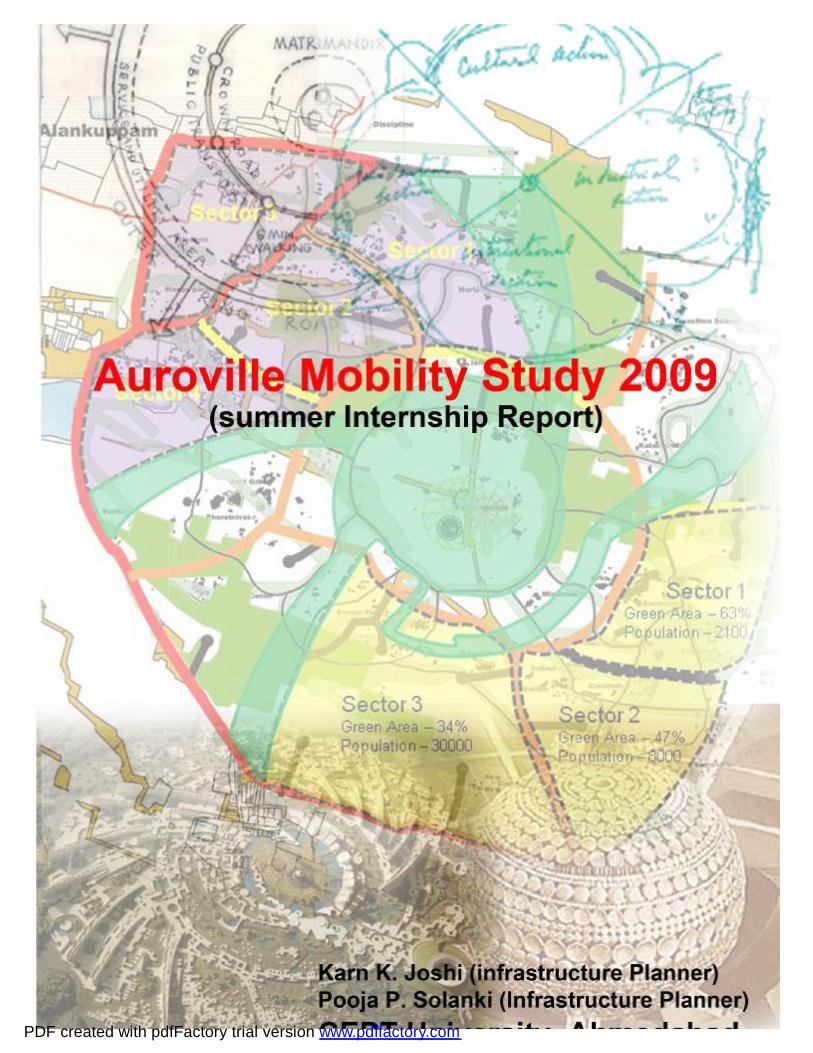
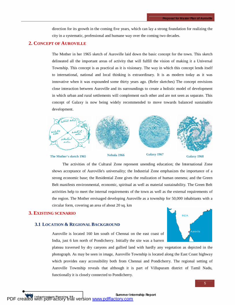
2. CONCEPT OF AUROVILLE
The Mother in her 1965 sketch of Auroville laid down the basic concept for the town. This sketch
delineated all the important areas of activity that will fulfill the vision of making it a Universal
Township. This concept is as practical as it is visionary. The way in which this concept lends itself
to international, national and local thinking is extraordinary. It is as modern today as it was
innovative when it was expounded some thirty years ago. (Refer sketches) The concept envisions
close interaction between Auroville and its surroundings to create a holistic model of development
in which urban and rural settlements will complement each other and are not seen as separate. This
concept of Galaxy is now being widely recommended to move towards balanced sustainable
development.
The activities of the Cultural Zone represent unending education; the International Zone
shows acceptance of Auroville's universality; the Industrial Zone emphasizes the importance of a
strong economic base; the Residential Zone gives the realization of human oneness; and the Green
Belt manifests environmental, economic, spiritual as well as material sustainability. The Green Belt
activities help to meet the internal requirements of the town as well as the external requirements of
the region. The Mother envisaged developing Auroville as a township for 50,000 inhabitants with a
circular form, covering an area of about 20 sq. km
3. EXISTING SCENARIO
3.1 LOCATION & REGIONAL BACKGROUND
Auroville is located 160 km south of Chennai on the east coast of
India, just 6 km north of Pondicherry. Initially the site was a barren
plateau traversed by dry canyons and gullied land with hardly any vegetation as depicted in the
photograph. As may be seen in image, Auroville Township is located along the East Coast highway
which provides easy accessibility both from Chennai and Pondicherry. The regional setting of
Auroville Township reveals that although it is part of Villupuram district of Tamil Nadu,
functionally it is closely connected to Pondicherry.
The Mother's sketch 1965 Nebula 1966 Galaxy 1967 Galaxy 1968
PDF created with pdfFactory trial version www.pdffactory.com
Proposal for Master Plan of Auroville
6
Infrastructure Planning ‘08
Summer Internship Report
As mentioned earlier, the township boundary is in the form of a circle of 2.5 km radius
encompassing 20 sq. km Most of the area lies in Villupuram district and comprises the panchayats
of Irumbai and Bommapalayam. Small areas of this land are in Kottakuppam, Rayapudupakkam,
Mathur Panchayats and Alankuppam, within the Union Territory of Pondicherry. The land is
generally of poor quality for agriculture and the entire area was identified as a backward area. The
village settlements of Edayanchavadi, Irumbai, Kottakarai, Rayapudupakkam, Pettai and
Alankuppam fall in the designated area of the township. Pondicherry city, is the largest urban centre
at a distance of 6 km to its south while Tindivanam, the headquarter of Tindivanam taluk is about 25
km to the north-west.
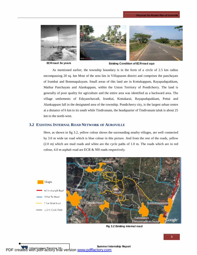
3.2 EXISTING INTERNAL ROAD NETWORK OF AUROVILLE
Here, as shown in fig 3.2, yellow colour shows the surrounding nearby villages, are well connected
by 3.0 m wide tar road which is blue colour in this picture. And from the rest of the roads, yellow
(2.0 m) which are mud roads and white are the cycle paths of 1.0 m. The roads which are in red
colour, 4.0 m asphalt road are ECR & NH roads respectively.
ECR road 3o years Existing Condition of ECR road ago
Fig 3.2 Existing internal road
PDF created with pdfFactory trial version www.pdffactory.com
Proposal for Master Plan of Auroville
7
Infrastructure Planning ‘08
Summer Internship Report
3.3 POPULATION DETAILS
The township envisaged for a population of 50,000, aims to provide opportunities for people from
all nations and all types of backgrounds to come together to work for the fulfillment of its character.
Today it has about 1700 residents representing some 35 nations including 350 persons from the
adjoining villages. It has also established very cordial relation with the larger population in its
vicinity, extending over an area of approx 825 sq.kms.
The population growth in the last
decade has been approx.5% per annum.
There has been an average addition of
around 90 persons per year in Auroville’s
population over the last decade. It has been
observed that the ratio of newcomer
population to total Auroville population
usually works out at 1:10. In addition to the
resident population there are:
• Researchers and students, during the internship programs learn and contribute to the efforts of
development and research. Nearly 100 students and researchers are in Auroville at any given point
of time. As Auroville grows, the number of students and researchers will also grow. The estimated
number of researchers is 1,200 annually.
• Day-workers, about 5,000 persons residing in its neighbourhood in both manufacturing units and
services from neighboring villages working in Auroville's economic and service activities.
• Short-term, including casual visitors, Matrimandir is the main attraction to visitors from outside
and, on an average, 1,000 persons visit it every day. Sundays and holidays are special days when the
number of visitors go up to 2- 5000 persons coming to see the experience of Auroville's work in
diverse fields. The number of casual visitors is estimated at 2.5 lakh/year.
Note: The population listed under the last two categories falls under the category of "floating
population" in the township.
There are 13 villages in the immediate area of Auroville, comprising about 40,000 people,
and a total of 40 villages in the wider bioregion. Six villages and colonies are located in the
Auroville township area. Among the villages in the Auroville township area, Edayanchvadi is
having the highest population of 4,272 and Alankuppan- Annai nagar the lowest, with a total of 528.
Alankuppam-Annai nagar is having highest density, and kottakarai the lowest. The population, area
& density of these villages & colonies are given in Table 3.3.1.
PDF created with pdfFactory trial version www.pdffactory.com
Proposal for Master Plan of Auroville
8
Infrastructure Planning ‘08
Summer Internship Report
Sr.No. Villages in Township area
Population Growth Rate Area Density
1971 1981 1991 2001 1971-81 1981-91 1991-01 (Ha) (Persons/Ha)
Auroville 300 461 715 1601 53.67 55.10 123.92 1 Alankuppam 790 895 985 1380 13.29 10.06 40.10 9.31 148 Alankuppam-
Annai Nagar 315 450 610 528 42.86 35.56 -13.44 1.41 373
2 Edaynchvadi 2215 2460 3480 4272 11.06 41.46 22.76 32.77 130 3 Irumbai 480 490 580 657 2.08 18.37 13.28 Irumbai-Chitoor 280 300 315 408 7.14 5.00 29.52
10.45
102.00
4 Kottakarai 465 570 880 1612 22.58 54.39 83.18 19.42 83 Kottakarai-
Ambedkar nagar
310 405 510 650 30.65 25.93 27.45 6.23 104
5 Raypettai 680 745 780 1028 9.56 4.70 31.79 5.46 188 6 Sanjeevi Nagar 905 950 1030 1188 4.97 8.42 15.34 9.84 121
Total 6740 7726 9885 13324 94.89 4. CONCEPT OF MASTER PLAN
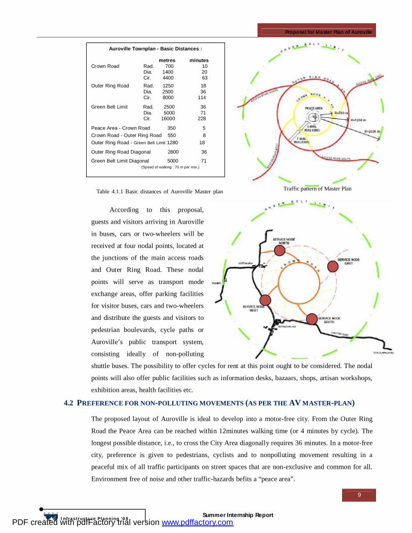
4.1 TRAFFIC PATTERN AS OUTLINED IN THE AUROVILLE MASTER PLAN
The centre of Auroville is formed by the Peace Area, with the Matrimandir, Amphitheatre and
Banyan Tree. In the Master Plan, according to the Galaxy concept, green corridors (containing
pedestrian lanes and cycle paths) radiate out from the centre. Within 5 minutes walking distance of
the Peace Area lies the Crown Road, which encircles the inner city area. The Crown Road is
conceived as a circle with a radius of about 700m. Within approximately 7 minutes walking distance
of the Crown Road is the Outer Ring Road, located with a radius of about 1.25 km. The boundary of
the township is also defined in the form of a circle. With a radius of 2.5 km, it encloses an area of
about 20 sq. km. (2000 ha) as shown in fig. & table no 4.1.1.
In a similar way, building developments alternating with green areas spiral out from the Peace
Area to the Outer Ring Road in an impressive macro-form. The major spirals (called “Lines of
Force”) intersect with the Crown Road giving rise to unusual urban spaces of a surprising variety.
And in a similar way, building developments alternating with green areas spiral out from the Peace
Area to the Outer Ring Road in an impressive macro-form.
These intersections are destined to become the focal points for the city’s services. The ring-
shaped roads are perceived as bundles of tangential pathways. The Outer Ring Road leads outward
traffic via two main access roads in the west and south to the Pondicherry-Tindivanam Road, and
via two in the east and north to the East Coast Road connecting Chennai & Pondicherry.
Table 3.3.1 : Population Detail of Auroville & surrounded villages ( Source : Auroville Master Plan 2004
PDF created with pdfFactory trial version www.pdffactory.com
Proposal for Master Plan of Auroville
9
Infrastructure Planning ‘08
Summer Internship Report
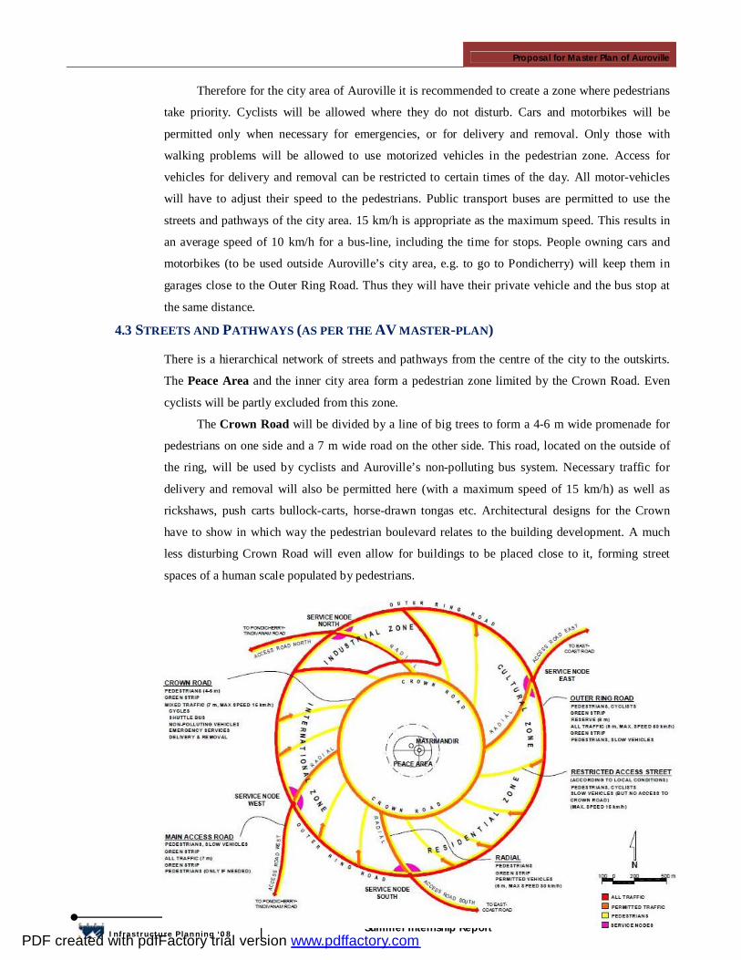
According to this proposal,
guests and visitors arriving in Auroville
in buses, cars or two-wheelers will be
received at four nodal points, located at
the junctions of the main access roads
and Outer Ring Road. These nodal
points will serve as transport mode
exchange areas, offer parking facilities
for visitor buses, cars and two-wheelers
and distribute the guests and visitors to
pedestrian boulevards, cycle paths or
Auroville’s public transport system,
consisting ideally of non-polluting
shuttle buses. The possibility to offer cycles for rent at this point ought to be considered. The nodal
points will also offer public facilities such as information desks, bazaars, shops, artisan workshops,
exhibition areas, health facilities etc.
4.2 PREFERENCE FOR NON-POLLUTING MOVEMENTS (AS PER THE AV MASTER-PLAN)
The proposed layout of Auroville is ideal to develop into a motor-free city. From the Outer Ring
Road the Peace Area can be reached within 12minutes walking time (or 4 minutes by cycle). The
longest possible distance, i.e., to cross the City Area diagonally requires 36 minutes. In a motor-free
city, preference is given to pedestrians, cyclists and to nonpolluting movement resulting in a
peaceful mix of all traffic participants on street spaces that are non-exclusive and common for all.
Environment free of noise and other traffic-hazards befits a “peace area”.
Auroville Townplan - Basic Distances : metres minutes Crown Road Rad. 700 10 Dia. 1400 20 Cir. 4400 63
Outer Ring Road Rad. 1250 18 Dia. 2500 36 Cir. 8000 114
Green Belt Limit Rad. 2500 36 Dia. 5000 71 Cir. 16000 228
Peace Area - Crown Road 350 5
Crown Road - Outer Ring Road 550 8
Outer Ring Road - Green Belt Limit 1280 18 Outer Ring Road Diagonal 2800 36
Green Belt Limit Diagonal 5000 71
(Speed of walking : 70 m per min.)
Table 4.1.1 Basic distances of Auroville Master plan Traffic pattern of Master Plan
PDF created with pdfFactory trial version www.pdffactory.com
Proposal for Master Plan of Auroville
10
Infrastructure Planning ‘08
Summer Internship Report
Therefore for the city area of Auroville it is recommended to create a zone where pedestrians
take priority. Cyclists will be allowed where they do not disturb. Cars and motorbikes will be
permitted only when necessary for emergencies, or for delivery and removal. Only those with
walking problems will be allowed to use motorized vehicles in the pedestrian zone. Access for
vehicles for delivery and removal can be restricted to certain times of the day. All motor-vehicles
will have to adjust their speed to the pedestrians. Public transport buses are permitted to use the
streets and pathways of the city area. 15 km/h is appropriate as the maximum speed. This results in
an average speed of 10 km/h for a bus-line, including the time for stops. People owning cars and
motorbikes (to be used outside Auroville’s city area, e.g. to go to Pondicherry) will keep them in
garages close to the Outer Ring Road. Thus they will have their private vehicle and the bus stop at
the same distance. 4.3 STREETS AND PATHWAYS (AS PER THE AV MASTER-PLAN)
There is a hierarchical network of streets and pathways from the centre of the city to the outskirts.
The Peace Area and the inner city area form a pedestrian zone limited by the Crown Road. Even
cyclists will be partly excluded from this zone.
The Crown Road will be divided by a line of big trees to form a 4-6 m wide promenade for
pedestrians on one side and a 7 m wide road on the other side. This road, located on the outside of
the ring, will be used by cyclists and Auroville’s non-polluting bus system. Necessary traffic for
delivery and removal will also be permitted here (with a maximum speed of 15 km/h) as well as
rickshaws, push carts bullock-carts, horse-drawn tongas etc. Architectural designs for the Crown
have to show in which way the pedestrian boulevard relates to the building development. A much
less disturbing Crown Road will even allow for buildings to be placed close to it, forming street
spaces of a human scale populated by pedestrians.
A
l
l
m
o
t
o
r
-
PDF created with pdfFactory trial version www.pdffactory.com
Proposal for Master Plan of Auroville
11
Infrastructure Planning ‘08
Summer Internship Report
All motor vehicles will be allowed in the Industrial Zone, but there will be access to the
Crown Road only for permitted vehicles. In all the zones, the design of restricted-access streets
will depend upon the local conditions and architectural layout of the area. For motor-vehicles, a
maximum speed of only 15 km/h will be permitted here and they will be allowed to travel only via
the Outer Ring Road, not the Crown Road. The drivers will turn back out of their own accord as
they will be allowed to drive faster on the Outer Ring Road. Besides the four major Radials, the only
direct connections between Outer Ring Road and Crown will be pathways for pedestrians and
cycles. The widths of these will be determined according to the local need and architectural design.
5. ANALYSIS OF MASTER PLAN
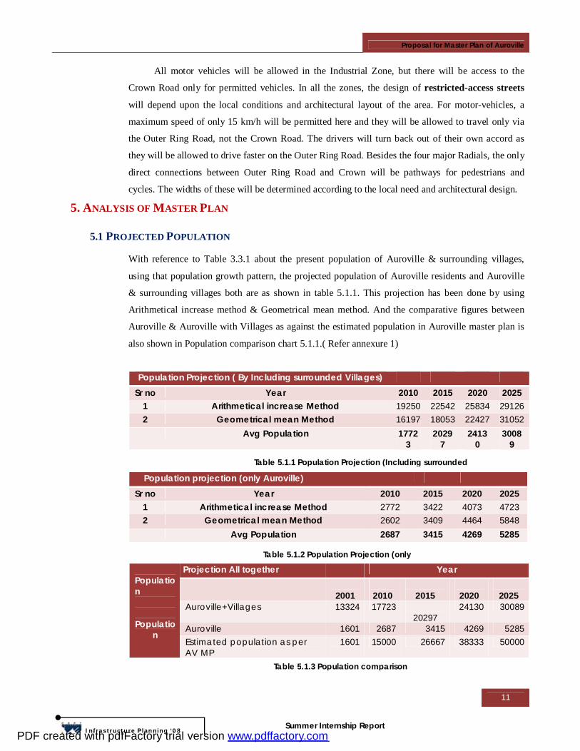
5.1 PROJECTED POPULATION
With reference to Table 3.3.1 about the present population of Auroville & surrounding villages,
using that population growth pattern, the projected population of Auroville residents and Auroville
& surrounding villages both are as shown in table 5.1.1. This projection has been done by using
Arithmetical increase method & Geometrical mean method. And the comparative figures between
Auroville & Auroville with Villages as against the estimated population in Auroville master plan is
also shown in Population comparison chart 5.1.1.( Refer annexure 1)
Population Projection ( By Including surrounded Villages) Sr no Year 2010 2015 2020 2025
1 Arithmetical increase Method 19250 22542 25834 29126 2 Geometrical mean Method 16197 18053 22427 31052 Avg Population 1772
3 2029
7 2413
0 3008
9
Population projection (only Auroville) Sr no Year 2010 2015 2020 2025
1 Arithmetical increase Method 2772 3422 4073 4723 2 Geometrical mean Method 2602 3409 4464 5848 Avg Population 2687 3415 4269 5285
Projection All together Year
2001
2010
2015
2020
2025 Auroville+Villages 13324 17723
20297 24130 30089
Auroville 1601 2687 3415 4269 5285
Population
Population
Estimated population as per AV MP
1601 15000 26667 38333 50000
Table 5.1.3 Population comparison
Table 5.1.2 Population Projection (only
Table 5.1.1 Population Projection (Including surrounded
PDF created with pdfFactory trial version www.pdffactory.com
Proposal for Master Plan of Auroville
12
Infrastructure Planning ‘08
Summer Internship Report
As shown in table 5.1.3, projected
population of 50,000 as per the Auroville
master plan far exceeds the growth as
projected in yr 2025. So we are considering
50,000 populations with all visitors, students
& researchers, villagers & Aurovilians (i.e.
all users).
From this projection we come to know
that phase wise midterm development by 2010-
2025 & Long term development by 2025-2050 is necessary.
5.2 VOLUME COUNT STUDY
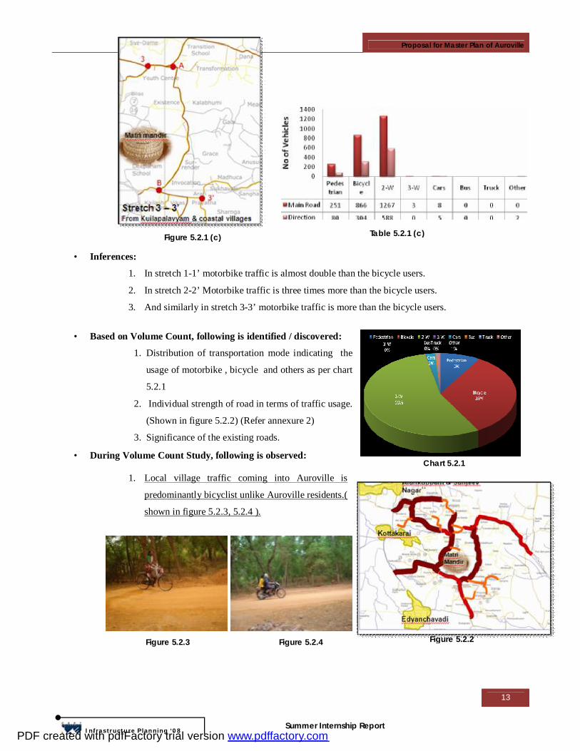
Figure 5.2.1 shows the existing condition of the
Auroville internal road networks & nearby villages.
Considering Matrimandir as a centre, there are main
six entries from which most of the traffic comes inside
Auroville. And if these six entries are considered for
volume count then Auroville traffic is divided in main
three stretches shown in figure 5.2.1(a), 5.2.1(b),
5.2.1(c) & the number of vehicles passes through
respectively. And number of vehicles passes through
these roads are given in table 5.2.1(a), 5.2.1(b),
5.2.1(c) respectively.
Chart 5.1.1 Population comparison
Figure 5.2.1 Existing condition of Auroville
Figure 5.2.1 (a) Table 5.2.1 (a)
Table 5.2.1 (b) Figure 5.2.1 (b)
PDF created with pdfFactory trial version www.pdffactory.com
Proposal for Master Plan of Auroville
13
Infrastructure Planning ‘08
Summer Internship Report
• Inferences:
1. In stretch 1-1’ motorbike traffic is almost double than the bicycle users.
2. In stretch 2-2’ Motorbike traffic is three times more than the bicycle users.
3. And similarly in stretch 3-3’ motorbike traffic is more than the bicycle users.
• Based on Volume Count, following is identified / discovered:
1. Distribution of transportation mode indicating the
usage of motorbike , bicycle and others as per chart
5.2.1
2. Individual strength of road in terms of traffic usage.
(Shown in figure 5.2.2) (Refer annexure 2)
3. Significance of the existing roads.
• During Volume Count Study, following is observed:
1. Local village traffic coming into Auroville is
predominantly bicyclist unlike Auroville residents.(
shown in figure 5.2.3, 5.2.4 ).
Figure 5.2.1 (c) Table 5.2.1 (c)
Chart 5.2.1
Figure 5.2.2 Figure 5.2.3 Figure 5.2.4
PDF created with pdfFactory trial version www.pdffactory.com

Proposal for Master Plan of Auroville
14
Infrastructure Planning ‘08
Summer Internship Report
5.3 DISTANCE STUDY (RESIDENTIAL - COMMERCIAL)
There isn’t any Commercial activity or Service centre within Auroville. Commercial activity
is mainly done at Kuilapalayam & Alankuppam. But Alankuppam does not have a well developed
market or Service provider. Auroville residents go to this market to buy daily supplies. Or else they
have to depend on Pondicherry for other daily purchases. Figure 5.3.1 shows residential area within
Auroville & bordering villages with some commercial activity. Distance study was taken to assess
the distance between the residential & commercial / service centre. The nearest available service
centre is at Kuilapalayam, which is at a distance of 1.5km from the residential sector (radial
distances) & Alankuppam is in between 1 to 1.5 km from Aurodam (shown in fig 5.3.2)
Kuilapalayam (in K.M.) Kottakarai (in K.M.) Alankuppam (in K.M.) Community
Present Future Present Future Present Future Surrender – Grace 2.4 5.2 1.8 2.4 4.0 2.7 Madhuca – Sukhavati 3.7 4.0 3.1 3.2 5.3 3.8
Invocation - Arati – Creativity
3.2 4.7 2.6 3.5 4.7 3.4
Prarthana – Samasti 3.3 3.4 2.7 4.1 4.8 4.3
Centre field 4.3 4.0 1.7 1.9 3.8 3.1
Distance study was done by overlapping the proposed Master Plan roads on existing roads.
These distances were measured road by road. The difference of distances between the existing
(present) & Master plan (future) road shown in Table 5.3.1 & Chart 5.3.1.
1.5 km 1.5 km
Figure 5.3.1
Table 5.3.1
Chart 5.3.1
Figure 5.3.2 Figure 5.3.3
PDF created with pdfFactory trial version www.pdffactory.com
Proposal for Master Plan of Auroville
15
Infrastructure Planning ‘08
Summer Internship Report
• Inferences: 1. As per the proposed master plan, distances between residential and service providers will
increase. Thereby increasing the motorized traffic.
2. To promote bicycle & to prevent increase in motorized traffic, up gradation of existing
roads for the mid-term development is more sustainable.
5.4 INFERENCES FROM STUDY
1. Population projection: Phase wise development is essential. Mid term Development (2010 –
2025) &Long term Development (2025 – 2050 ).
2. Volume Count: Identification of important roads which should be up graded.
3. Distance Study: The distance of Existing Roads is lesser in comparison to Master plan roads
so existing roads should be upgraded.
• Propose mixed use development with development control regulation & Importance of an
integrated planning of land-use with transportation network.
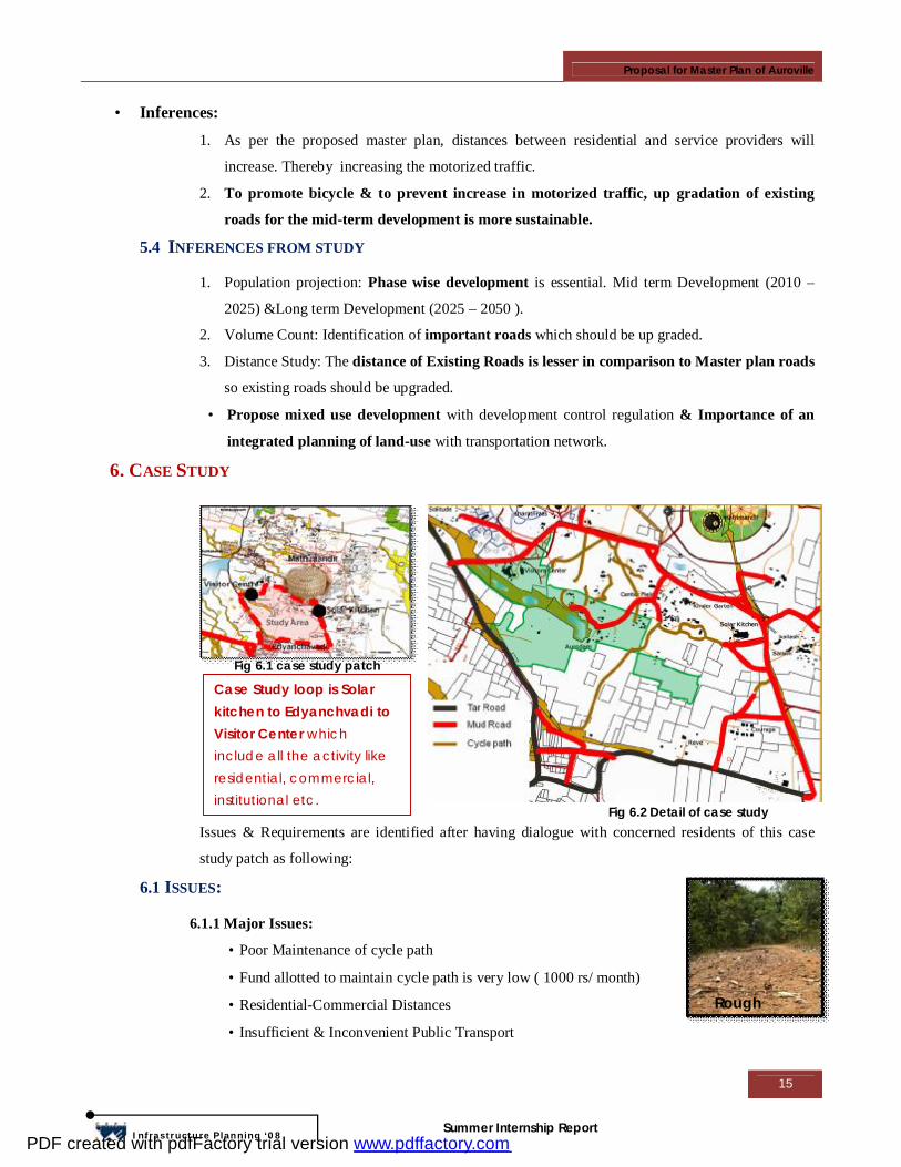
6. CASE STUDY
Issues & Requirements are identified after having dialogue with concerned residents of this case
study patch as following:
6.1 ISSUES:
6.1.1 Major Issues:
• Poor Maintenance of cycle path
• Fund allotted to maintain cycle path is very low ( 1000 rs/ month)
• Residential-Commercial Distances
• Insufficient & Inconvenient Public Transport
Case Study loop is Solar kitchen to Edyanchvadi to Visitor Center which include all the activity like residential, commercial, institutional etc.
Fig 6.1 case study patch
Fig 6.2 Detail of case study
Rough Surface
PDF created with pdfFactory trial version www.pdffactory.com
Proposal for Master Plan of Auroville
16
Infrastructure Planning ‘08
Summer Internship Report
6.1.2 Other Issues:
• High Speed of motorized vehicles affect the safety of cycle
riders
• For motorized vehicles, Regulation is necessary
• Identity of cycle path
• Signage for Cycle path
• Dust situation
• Noise
6.2 REQUIREMENT:
6.2.1 Commercial area: (Centre guest house & College Guest house, workshops, Language Lab,
visitor centre)
• No of 2-Wheeler & 4-Wheeler users are more so
motorized road is necessary.
• Free flow motorized traffic pattern by excluding cycle
path.(i.e. Separate Bicycle path)
• Connectivity of cycle path to the Visitor’s center, Solar
Kitchen & Main road with minimum distance.
6.2.2 Institutional Area: (Visitor Center, Nandanam School,
Kindergarten, Solar kitchen)
• No of bicycle & 2-Wheelers are more, so motorized
road and cycle path are necessary.
• Connectivity to the residential area, with minimum
distance is necessary.
• Separate pedestrian walkway in between Matrimandir & Visitor’s Center.
6.2.3 Residential Area: (Aurodam, Courage, Reve, Center Field)
• Silent Zone
• Cycle path connectivity to the Visitor’s Center, School, Solar
kitchen, Main Road are necessary with lesser distance.
• Maintenance of Cycle path
6.3 CONCEPT OF MASTER PLAN FOR CASE STUDY PATCH
By overlapping galaxy with this patch proposal is not viable due to
following reasons (Shown in fig 6.3.1):
• To avoid the crown road crossing through the existing amenities.
• To avoid unwanted traffic from Edyanchvadi through the radial roads.
Poor Maintenance
Lack of Visibility
PDF created with pdfFactory trial version www.pdffactory.com
Proposal for Master Plan of Auroville
17
Infrastructure Planning ‘08
Summer Internship Report
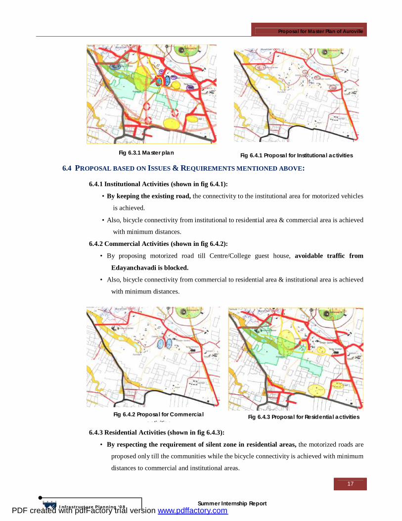
6.4 PROPOSAL BASED ON ISSUES & REQUIREMENTS MENTIONED ABOVE:
6.4.1 Institutional Activities (shown in fig 6.4.1):
• By keeping the existing road, the connectivity to the institutional area for motorized vehicles
is achieved.
• Also, bicycle connectivity from institutional to residential area & commercial area is achieved
with minimum distances.
6.4.2 Commercial Activities (shown in fig 6.4.2):
• By proposing motorized road till Centre/College guest house, avoidable traffic from
Edayanchavadi is blocked.
• Also, bicycle connectivity from commercial to residential area & institutional area is achieved
with minimum distances.
6.4.3 Residential Activities (shown in fig 6.4.3):
• By respecting the requirement of silent zone in residential areas, the motorized roads are
proposed only till the communities while the bicycle connectivity is achieved with minimum
distances to commercial and institutional areas.
Fig 6.3.1 Master plan Fig 6.4.1 Proposal for Institutional activities
Fig 6.4.2 Proposal for Commercial activities
Fig 6.4.3 Proposal for Residential activities
PDF created with pdfFactory trial version www.pdffactory.com
Proposal for Master Plan of Auroville
18
Infrastructure Planning ‘08
Summer Internship Report
7. APPROACH & STRATEGIES TO ACHIEVE MP
The proposed master plan has taken into careful consideration the existing roads, buildings/existing
structures (shown in fig 7.1).
7.1 MID-TERM DEVELOPMENT PLAN (2010-2025) (REFER ANNEXURE 3)
The Mid-term development plan has taken into account the location of private lands, portions of
which may have to be acquired over a period of time to develop a comprehensive long term plan.
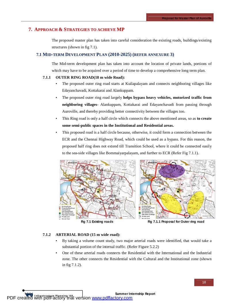
7.1.1 OUTER RING ROAD(18 m wide Road): • The proposed outer ring road starts at Kuilapalayam and connects neighboring villages like
Edayanchavadi, Kottakarai and Alankuppam.
• The proposed outer ring road largely helps bypass heavy vehicles, motorized traffic from
neighboring villages- Alankuppam, Kottakarai and Edayanchavadi from passing through
Auroville, and thereby providing better connectivity between the villages too.
• This Ring road is only a half circle which connects the above mentioned areas, so as to create
some semi-public spaces in the Institutional and Residential areas.
• This proposed road is a half circle because, otherwise, it could form a connection between the
ECR and the Chennai Highway Road, which could be used as a bypass. For this reason, the
proposed half ring does not extend till Transition School, where it could be connected easily
to the sea-side villages like Bommaiyarpalayam, and further to ECR (Refer Fig 7.1.1).
7.1.2 ARTERIAL ROAD (15 m wide road):
• By taking a volume count study, two major arterial roads were identified, that would take a substantial portion of the internal traffic. (Refer Figure 5.2.2)
• One of these arterial roads connects the Residential with the International and the Industrial zone. The other connects the Residential with the Cultural and the Institutional zone (shown in fig 7.1.2).
Fig 7.1 Existing roads Fig 7.1.1 Proposal for Outer ring road
PDF created with pdfFactory trial version www.pdffactory.com
Proposal for Master Plan of Auroville
19
Infrastructure Planning ‘08
Summer Internship Report
7.1.3 SUB-ARTERIAL ROADS(9 m wide road): • Some existing roads have been identified by a volume count study and are proposed to be
upgraded and used as sub-arterial roads which connect the main arterial roads. • One of these sub-arterial roads connects Kottakarai to the arterial road and caters to traffic
from the villages. • One other sub-arterial road connects the Residential zone to an Arterial road (shown in fig
7.1.3).
7.1.4 BICYCLE PATH (4.5 m road):
• The proposed bicycle path has taken into consideration the existing greens, eco-sensitive areas, canyons and existing cycle paths (shown in fig 7.4.1(a))
• A 20 meter green buffer is proposed around the canyons. (shown in fig 7.4.1(b)) • The bicycle paths are thus proposed to run within communities, through these
existing/proposed green areas, and with optimum distances. • Care has been taken to see that all communities are connected with these bicycle paths. • The bicycle paths only run through green/eco-sensitive areas, whereas some bicycle tracks
(paved tracks for considerably faster travel) have been provided along the motorized roads( shown in fig 7.1.4)
Fig 7.1.2 Proposal for Arterial road Fig 7.1.3 Proposal for Sub-Arterial road
Fig 7.1.4(a) Existing green
Fig 7.1.4(b) Proposed Green through canyon Fig 7.1.4 Proposed Bicycle path
PDF created with pdfFactory trial version www.pdffactory.com
Proposal for Master Plan of Auroville
20
Infrastructure Planning ‘08
Summer Internship Report
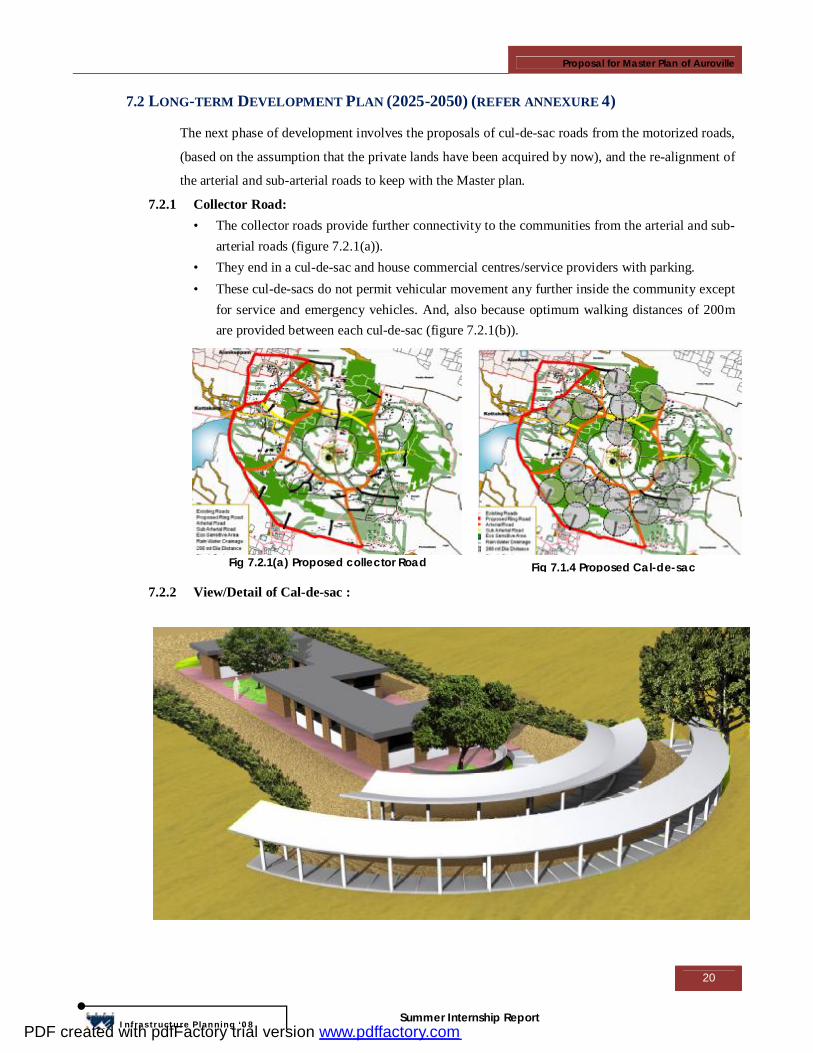
7.2 LONG-TERM DEVELOPMENT PLAN (2025-2050) (REFER ANNEXURE 4)
The next phase of development involves the proposals of cul-de-sac roads from the motorized roads,
(based on the assumption that the private lands have been acquired by now), and the re-alignment of
the arterial and sub-arterial roads to keep with the Master plan.
7.2.1 Collector Road: • The collector roads provide further connectivity to the communities from the arterial and sub-
arterial roads (figure 7.2.1(a)). • They end in a cul-de-sac and house commercial centres/service providers with parking. • These cul-de-sacs do not permit vehicular movement any further inside the community except
for service and emergency vehicles. And, also because optimum walking distances of 200m are provided between each cul-de-sac (figure 7.2.1(b)).
7.2.2 View/Detail of Cal-de-sac :
Fig 7.2.1(a) Proposed collector Road Fig 7.1.4 Proposed Cal-de-sac
PDF created with pdfFactory trial version www.pdffactory.com
Proposal for Master Plan of Auroville
21
Infrastructure Planning ‘08
Summer Internship Report
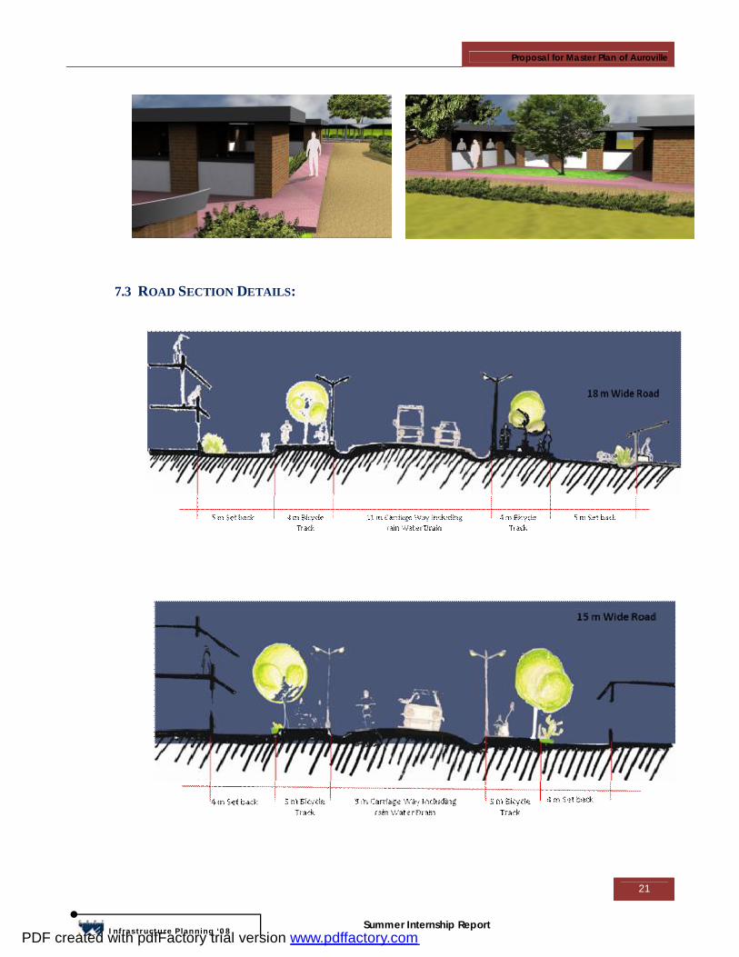
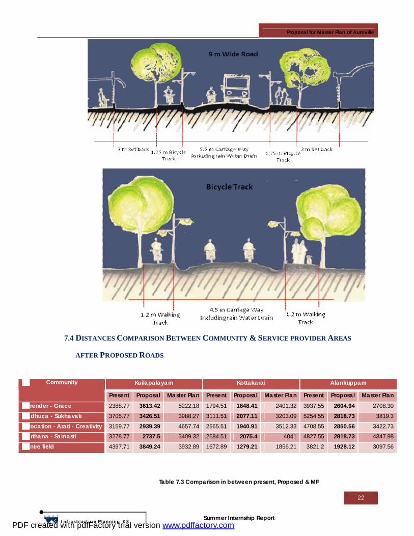
7.3 ROAD SECTION DETAILS:
PDF created with pdfFactory trial version www.pdffactory.com
Proposal for Master Plan of Auroville
22
Infrastructure Planning ‘08
Summer Internship Report
7.4 DISTANCES COMPARISON BETWEEN COMMUNITY & SERVICE PROVIDER AREAS
AFTER PROPOSED ROADS
Kuilapalayam Kottakarai Alankuppam Community
Present Proposal Master Plan Present Proposal Master Plan Present Proposal Master Plan
Surrender - Grace 2388.77 3613.42 5222.18 1794.51 1648.41 2401.32 3937.55 2604.94 2708.30
Madhuca - Sukhavati 3705.77 3426.51 3988.27 3111.51 2077.11 3203.09 5254.55 2818.73 3819.3
Invocation - Arati - Creativity 3159.77 2939.39 4657.74 2565.51 1940.91 3512.33 4708.55 2850.56 3422.73
Prarthana - Samasti 3278.77 2737.5 3409.32 2684.51 2075.4 4041 4827.55 2818.73 4347.98
Centre field 4397.71 3849.24 3932.89 1672.89 1279.21 1856.21 3821.2 1928.12 3097.56
Table 7.3 Comparison in between present, Proposed & MP
PDF created with pdfFactory trial version www.pdffactory.com
Proposal for Master Plan of Auroville
23
Infrastructure Planning ‘08
Summer Internship Report
7.5 PROPOSED LAND USE
7.5.1 Assumptions: o Residential Sectors:
• Required per head built up area is taken as 35 sq.m. hence, • Total Built up required=Population*35 sq.m • Ground coverage is 70% of the total developable area & 30% left for private open spaces and
building set back. • Proposed land use given by UDPFI (Urban Development Plan Formulation and
Implementation) standards which may vary as per future requirement. o Industrial Sectors:
- Working population is assumed as per UDPFI standards - Land use may vary as per future requirement.
Calculation is shown in table 7.4. And the Proposed land use for international, cultural & institutional will carried out as per the future requirement.
Ground Coverage & F.S.I. Calculation
Total Area
Non Developable
Land
Green Area Existing Footprint
Population Served
Built up Required
Total Developable
Area
Residential
(Sq.M.) (%) (Sq.M.) (%) (Sq.M.) (%) As per 40000 pop
35 Sq.M. / Person
(Sq.M.) (%)
Sector 1 316553.12 1734.52 0.55 200352.75 63.29 9575.74 3.03
2100 73500 104890.10 33.1
Sector 2 305533.52 0.00 0.00 142272.41 46.57 3937.31 1.29
8000 280000 159323.79 52.1
Sector 3 663973.61 0.00 0.00 224722.75 33.85 5568.49 0.84
30300 1060500 433682.37 65.3
Total 1286060.2 1734.52 0.13 567347.92 44.12 19081.5 1.48
40400.00 1414000 697896.27 54.2
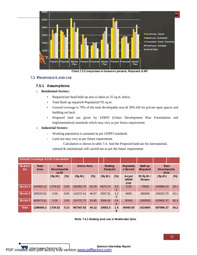
Chart 7.3 Comparison in between present, Proposed & MP
Table 7.4.1 Existing land use in Residential Zone
PDF created with pdfFactory trial version www.pdffactory.com
Proposal for Master Plan of Auroville
24
Infrastructure Planning ‘08
Summer Internship Report
Above table shows the detail of existing land-use in Residential area such as, existing building
footprints, non developable area as well as existing & proposed green areas. By excluding existing
& proposed areas, the developable areas are shown in table. (Refer Table 7.4.1)
Landuse (Residential)
Total Area
Total Developable Area Residential Commercial Institutional Sector
(Sq.M.) (%) 70% 20% 10% Residential 1 316553.12 104890.10 33.14 73423.07 20978.02 10489.01 Residential 2 305533.52 159323.79 52.15 111526.66 31864.76 15932.38 Residential 3 663973.61 433682.37 65.32 303577.66 86736.47 43368.24
By Considering 70% of Ground coverage out of total developable area, achieved individual sector
FSI shown in table 7.4.3.(Refer annexure 5)
• Glimpses for the next stage of study
1. Public Transportation Routes & Mode of Public Transportation
2. Road Sections
3. Detailed Land use planning & Development Control Regulation
4. Urban Design Details
ANNEXURE
1. Population Projection
2. Importance of road through Volume count
3. Mid-term development
4. Long term Development
5. Detail Calculation of Proposed Land use
Ground Coverage
F.S.I. Proposed Bicycle Proposed Roads
70% (Sq.M.) (%) (Sq.M.) (%) 73423.07 1.00 3838.39 1.21 2296.83 0.73 111526.66 2.51 4605.09 1.51 2236.7 0.73 303577.66 3.49 5712.07 0.86 4447.57 0.67 488527.39 2.89 14155.55 1.10 8981.10 0.70
Residential
Sector 1 Sector 2 Sector 3
Total
Table 7.4.2 Proposed Land use
Table 7.4.3 Proposed Ground Coverage & F.S.I
PDF created with pdfFactory trial version www.pdffactory.com
Proposal for Master Plan of Auroville
25
Infrastructure Planning ‘08
Summer Internship Report
ABOUT THE ORGANIZATION:
TYPE/NATURE OF ORGANIZATION
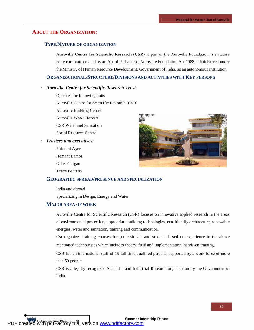
Auroville Centre for Scientific Research (CSR) is part of the Auroville Foundation, a statutory
body corporate created by an Act of Parliament, Auroville Foundation Act 1988, administered under
the Ministry of Human Resource Development, Government of India, as an autonomous institution.
ORGANIZATIONAL/STRUCTURE/DIVISIONS AND ACTIVITIES WITH KEY PERSONS
• Auroville Centre for Scientific Research Trust Operates the following units
Auroville Centre for Scientific Research (CSR)
Auroville Building Centre
Auroville Water Harvest
CSR Water and Sanitation
Social Research Centre
• Trustees and executives: Suhasini Ayer
Hemant Lamba
Gilles Guigan
Tency Baetens
GEOGRAPHIC SPREAD/PRESENCE AND SPECIALIZATION
India and abroad
Specializing in Design, Energy and Water.
MAJOR AREA OF WORK
Auroville Centre for Scientific Research (CSR) focuses on innovative applied research in the areas
of environmental protection, appropriate building technologies, eco-friendly architecture, renewable
energies, water and sanitation, training and communication.
Csr organizes training courses for professionals and students based on experience in the above
mentioned technologies which includes theory, field and implementation, hands-on training. CSR has an international staff of 15 full-time qualified persons, supported by a work force of more
than 50 people.
CSR is a legally recognized Scientific and Industrial Research organisation by the Government of
India.
PDF created with pdfFactory trial version www.pdffactory.com
Proposal for Master Plan of Auroville
26
Infrastructure Planning ‘08
Summer Internship Report
TYPE OF WORK CURRENTLY UNDERTAKEN
• Water management Projects under UNESCO-HELP, which supports specific improvements in water management,
science, policy and law for water studies of the bioregion. Publication of scientific monograph titled
“Towards a sustainable water resources management for Auroville and the bioregion.
Collaboration with the Université Pierre et Marie Curie, Université Paris-Sud, Ecole des Mines de
Paris & Ecole Nationale du Génie Rural des Eaux et des Forēts (France) for a study on the hydro
geochemical characteristics of the Kaliveli basin in South-east India. Study also supported a PhD
student.
Collaboration with Hydron, Dutch water board organisation, support for a pre-feasibility study on
integrated water management for Auroville and bioregion
• Waste water treatment Collaboration with Smithsonian Institute, Department of Botany, Centre for Environmental
Restoration. A feasibility study using Algal turf scrubber systems for cleaning waste water. The
study explores a pilot project to clean waste water with natural methods for the city of Pondicherry.
In-house consultants for ITC Ltd, Kolkata, for water audits in hotels and factories. For the
implementation of DEWATS (decentralised waste water treatment systems at hotel and factory
premises.
Implementation of more than 100 Dewats systems in India and abroad.
• Sanitation Impact assessment of the Tsunami on Water and Sanitation conditions in the temporary shelters
along the coast of Tamil Nadu. Collaboration with the Tamil Nadu govt and several major
international NGO’s. Resulting in training programs for engineers, professionals and NGO
executives on the subject of sanitation and decentralised waste water treatment systems.
Implementation of 16 innovative sanitation demonstration projects along the coast of Tamil Nadu.
• Appropriate Technologies Research activities take place under the unit Auroville Building Centre(AVBC). AVBC executes
research and development projects in the area of ferrocement and earth technology.
Major projects in these two areas include the Visitors Centre, the solar Kitchen, Pavilion of Tibetan
Culture and numerous individual building spread around the community of Auroville.
• Renewable energy CSR/Aurore has done research projects and carried out implementations in the area of the following
technologies: biogas, wind pumps, wind generators, solar cookers, solar lanterns, solar dryers, solar
water heaters, solar concentrators, solar bowl, gasifiers and battery operated vehicles.
- Development and manufacturing of maintenance-free ferrocement biogas plants of two types:
floating drum and fixed dome. R&D was financed by MNES.
PDF created with pdfFactory trial version www.pdffactory.com
Proposal for Master Plan of Auroville
27
Infrastructure Planning ‘08
Summer Internship Report
- R&D for the prototype of India's best performing wind-pumps (5.5 m diameter wheel, 25 m high
tower). The wind pumps are manufactured and marketed by "Aureka", a sister unit under the
Auroville Foundation. R&D was financed by MNES.
- R&D for the construction of a 15 metre diameter fixed spherical solar concentrator for Auroville's
"Solar Kitchen". The ferrocement base of this stationary bowl is 15 meters in diameter and 7 meters
above ground level. The sun's rays, trapped by a huge hemispherical mirror, focus on a cylindrical
boiler which follows the sun's position by means of a computerised tracking device. On a clear day,
sufficient steam at a temperature of 150°C can be generated in this boiler to cook two meals a day
for 1,000 people. The system is fully automatic and hybridized in order to produce steam regardless
of the cloud cover. MNES and Hudco were sponsors.
- Implementing a 37 kW solar photovoltaic power plant for Matrimandir.
- Installation of more than 1500 solar photovoltaic water pumps in India.
- Manufacturing of components for a 8-metre diameter solar parabolic concentrator equipped with a
10 kW Stirling Engine. This system was designed in Germany and installed at Vellore Engineering
College in Tamil Nadu.
• Communication, Trainings Csr organizes training courses for professionals and students based on experience in the above
mentioned technologies which includes theory, field and implementation, hands-on training.
Students, Indian and foreign, undergo trainings up to 6 months for undergraduates and postgraduates
in renewable energy and water and sanitation topics.
The training programmes are organized and conducted with the collaboration of 24 different
agencies, governmental, non-governmental, both national and international.
From 1990 onwards Csr has trained over 3300 professionals and students in 10 different
technologies.
TYPE OF ACTIVITIES RELATED TO PLANNING
- Integrated site planning for educational and training campus
- Development plan for housing projects
- Master plans with development phasing and marketing support
- Support studies and design consultancy for land, water and waste for rehabilitation projects
- Internship and training programs for students of architecture and planning
- Workshops on sustainable development for NGO, academia and private sector organizations
PDF created with pdfFactory trial version www.pdffactory.com
Proposal for Master Plan of Auroville
28
Infrastructure Planning ‘08
Summer Internship Report
ACKNOWLEDGEMENT
We sincerely acknowledge the valuable inputs and support rendered by the following individuals
during the course of this exercise:
Mr. Tency, CSR, Dew
Ar. Suhasini Ayer, AVDC / CSR
Ar. Tejaswini Mistri, AVDC / CSR
Mr. Prashant Hedao, GIS planner and landscape architect
Mrs. Lata Iyer, GIS planner and regional architect
Harini, Socio-economic expert
Lalit and L’Avenir, information on the master plan and mobility plan 2004
We would also like to thank the following individuals for extending their full support and co
operations during the interview:
Tineke & Saravanam, Centre guest house
Laura, College guest house
Lakshmi, Nandanam school
Guy, Radiance workshop, Aurodam
Nicole, Visitors centre
Angelika, Solar kitchen
Rauf Ali, Environmental expert, Aurodam
Gillian Bicycle paths / Aurodam resident
Last but not least, we extend our deepest gratitude to all the Volunteers for their support and
enthusiasm during the Volume Count studies.
Max Schuh – Social Service Volunteer
Aabid Raheem - Architect
Nirav Makwana – Urban and Regional Planner - CEPT
PDF created with pdfFactory trial version www.pdffactory.com


![PRELIMINARY ASSESSMENT OF BUS RAPID TRANSIT SYSTEMS …cdn.cseindia.org/userfiles/darshini_mahadevia.pdf · Member Secretary, Centre for Urban Equity, CEPT University, Ahmedabad]](https://img.pdfslide.us/doc/110x75/5ebde9b9b70e7b3e3f487707/preliminary-assessment-of-bus-rapid-transit-systems-cdn-member-secretary-centre.jpg)