Embed Size (px)
Citation preview
CEOS Contributions to Informing Energy Management and PolicyDecision Making Using Space-Based Earth Observations
Richard S. EckmanNASA Headquarters, Mail Suite 3B74, Washington, DC USA 20546-0001
Phone: +1-202-358-2567, Fax: +1-202-358-3172, [email protected]
ABSTRACT
Earth observations are playing an increasingly significant role in informing decision makingin the energy sector. In renewable energy applications, space-based observations nowroutinely augment sparse ground-based observations used as input for renewable energyresource assessment applications. As one of the nine Group on Earth Observations (GEO)societal benefit areas, the enhancement of management and policy decision making in theenergy sector is receiving attention in activities conducted by the Committee on EarthObservation Satellites (CEOS). CEOS has become the “space arm” for the implementation ofthe Global Earth Observation System of Systems (GEOSS) vision. It is directly supportingthe space-based, near-term tasks articulated in the GEO three-year work plan.This paper describes a coordinated program of demonstration projects conducted by CEOSmember agencies and partners to utilize Earth observations to enhance energy managementend-user decision support systems. I discuss the importance of engagement with stakeholdersand understanding their decision support needs in successfully increasing the uptake of Earthobservation products for societal benefit. Several case studies are presented, demonstratingthe importance of providing data sets in formats and units familiar and immediately usable bydecision makers. These projects show the utility of Earth observations to enhance renewableenergy resource assessment in the developing world, forecast space-weather impacts on thepower grid, and improve energy efficiency in the built environment.
Keywords: Energy management, renewable energy resource assessment, Committee onEarth Observation Satellites, Group on Earth Observations, energy efficiency, decisionsupport
1. Introduction
A consensus is emerging that global temperature increase from increasing greenhouse gasesmust be limited to 2°C. The deployment of low carbon energy technologies and enhancingenergy efficiency are key components in society’s efforts to mitigate climate change impacts.[1] Earth observations are critical in enhancing the implementation of renewable energytechnologies and improving energy efficiency. Measurements of solar radiation at the Earth’ssurface, winds, and a range of atmospheric parameters are being used to assess to potential ofrenewable energy resources at a given location across a variety of scales ranging from theindividual household to large solar thermal power generation projects. Weather forecasts areused to optimize load forecasts by power utilities and to better integrate intermittent sourcesof energy into the electrical grid. Extreme weather events and climate forecasts are beingused for longer-term infrastructure planning. Observations made in the near spaceenvironment assist in the prediction of potentially damaging impacts on national grids,particularly at high latitudes near the geomagnetic poles.
Recognizing the importance of Earth observations in informing decision making across avariety of disciplines - including energy, water, disasters, and air quality - the G7 countries

called for the establishment of a Global Earth Observation System of Systems (GEOSS) atthe World Summit on Sustainable Development, held in 2002. The Group on EarthObservations (GEO) is a voluntary partnership of over 80 governments and internationalorganizations facilitating the establishment of GEOSS. A 10-year implementation plan,initiating in 2005, defines the vision for this system of systems approach.[2] Critical to thesuccessful establishment of GEOSS is the engagement of end users who are responsible formaking the management and policy decisions at national, regional, and local levels across arange of societal benefit areas. These end users are generally non-scientists, who arefrequently unfamiliar with the utility of Earth observations to inform decision making. GEOemphasizes an end-to-end approach of creating data products derived from observations ofthe Earth system and providing them in formats and units relevant to end-user decisionsupport systems.
Space-based observations are unique in providing a global perspective on terrestrial and near-space processes. The Committee on Earth Observation Satellites (CEOS), an organization of28 space agencies and 20 related national and international organizations, coordinates civilspace-borne observations of the Earth. In this role, CEOS supports the space-based activitiesof GEO and works closely with GEO member organizations in supporting work plan tasks.
2. Methodology
The application of science results to inform end-user decision making requires differentmethodologies compared with more basic research activities. These end-users are typicallynon-scientists, who are unfamiliar with the science of the Earth system, conductingmeasurements from the ground or from space, and the intricacies of creating products thatthey may be used to enhance their decision support systems. GEO and CEOS seek to bridgethe divide between the scientist and decision maker by conducting a variety of demonstrationand prototype projects highlighting the utility of products derived from Earth observations toend-users.
Depending on the target application area, a variety of approaches are required tocommunicate the value of these derived, value-added products to the end-user. Severalapplication case studies are described in the results section below, but here I describe somegeneral approaches that have been successful for my colleagues in the GEO and CEOSenergy communities of practice.
2.1 Stakeholder Engagement and Marketing
Scientists are typically not trained in the art of marketing. Interacting with decision makerswho are frequently unaware of the utility of Earth observations requires novel methodologies.On behalf of the NASA Applied Sciences Program, a Stakeholders workshop was held inearly 2007 bringing together representatives from U.S. government agencies, the powerutility sector, and the renewable energy industry. [3] Our approach was to describe theavailability and potential utility of space-based Earth observations and understand the needsof those making decisions relating to energy management implementation and resourceassessment. My colleagues at Battelle conducted several facilitated discussions to betterunderstand end-user requirements and to match a range of Earth observations to potentialapplications. The meeting was viewed as successful by the organizers and participants andled to a funded demonstration project and several ongoing partnerships.
2
2.2 Professional Societies
An excellent venue for conveying the utility of products derived from space-basedobservations is at professional society meetings. My colleagues and I have engagedrepresentatives from ASHRAE, the American Institute of Architects (AIA), and the ElectricPower Research Institute (EPRI) at meetings. Researchers at the NASA Langley ResearchCenter are working with ASHRAE committees and the U.S. Department of Energy to explorethe utility of space-based observations to improve and update standards manuals related tothe heating and air-conditioning industries. Discussions at AIA meetings have focused onenhancing building efficiency with products derived from Earth observations. Theseinteractions are ongoing and have led to several projects.
2.3 Conferences
An essential component of our engagement is presenting research and application results atrelevant science conferences. My colleagues and I have also been proactive in organizingsessions at conferences, focusing on the application of atmospheric science measurements tothe energy sector. At the American Meteorological Society summer community meeting, heldin August 2009, we organized a 2-day session on meeting the needs of the solar and windenergy communities from an atmospheric science perspective using Earth observations andforecasts (http://www.ametsoc.org/MEET/fainst/2009summercommunity.html) .Approximately 150 individuals from the wind and solar energy industries, academia, andgovernment met to discuss issues relating to enhancing the uptake of atmospheric sciencemeasurements to support these industries.
2.4 Publications
Communicating the successes of the utility of the application of Earth observations to theenergy sector requires not only the use of traditionally focused science and applicationsjournals, books, and conference proceedings, but also more novel Web-based methods likepodcasts (see, e.g., http://blogs.aip.org/CLEAN/jrse-podcast.xml), blogs (e.g.,http://environmentalresearchweb.org/cws/article/futures/35553) and articles in the press (e.g.,http://www.busrep.co.za/index.php?fSectionId=&fArticleId=4163644 andhttp://www.earthzine.org/2009/07/06/from-satellite-to-solar-walls-a-look-at-geo-energy) . [4,5] Engagement of the media is often fortuitous, based on chance meetings at conferences, butincreasingly depends on reporters and other interested individuals discovering our work onthe Web.
2.5 Internet Search Engines
The importance of acquiring an Internet “footprint” cannot be overstated. As onedisseminates the results of Earth observation applications on the Web, they are cataloged bythe major search engine sites. Potential end-users and other interested parties can find theseresults while searching the Web. For example, a search using the keywords “spaceobservations energy management” employing several of the major Internet search enginesyields a wealth of relevant information on GEO and CEOS energy community of practiceactivities. I have received a number of enquiries relating to our renewable energy and energyefficiency products as a result of Web searches by potential end-users and correspondents.
3. Results
I describe the methodology of two research groups, supporting GEO work plan tasks, whichmake available parameters relevant to decision makes in the energy sector. These data areused in a variety of manners by end-users. Several case studies showing the use of these datain decision support tools and systems are illustrated.
3.1 Tailored Data Products
Typically, those making decisions about energy utilization or deployment are resourcemanagers, financers, and private citizens in both the developed and developing world. Theseindividuals are generally not scientists and not familiar with the utilization of data derivedfrom Earth observations. My colleagues at NASA and in other agencies participating in theGEO and CEOS energy communities of practice have found that data sets must be tailored toend-user requirements by packaging the products in easily usable formats, and madedownloadable on the Web or through other digital data sources (e.g., data CDs and DVDs).
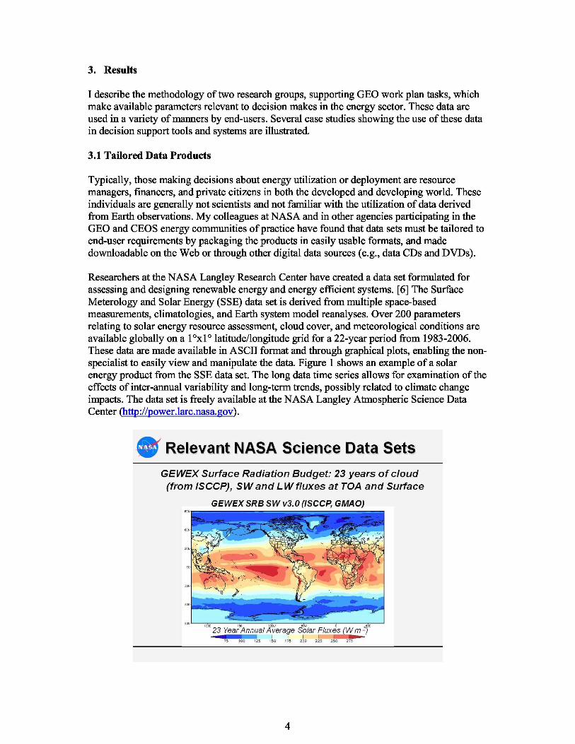
Researchers at the NASA Langley Research Center have created a data set formulated forassessing and designing renewable energy and energy efficient systems. [6] The SurfaceMeterology and Solar Energy (SSE) data set is derived from multiple space-basedmeasurements, climatologies, and Earth system model reanalyses. Over 200 parametersrelating to solar energy resource assessment, cloud cover, and meteorological conditions areavailable globally on a 1°x1° latitude/longitude grid for a 22-year period from 1983-2006.These data are made available in ASCII format and through graphical plots, enabling the non-specialist to easily view and manipulate the data. Figure 1 shows an example of a solarenergy product from the SSE data set. The long data time series allows for examination of theeffects of inter-annual variability and long-term trends, possibly related to climate changeimpacts. The data set is freely available at the NASA Langley Atmospheric Science DataCenter (http://power.larc.nasa.gov).
4
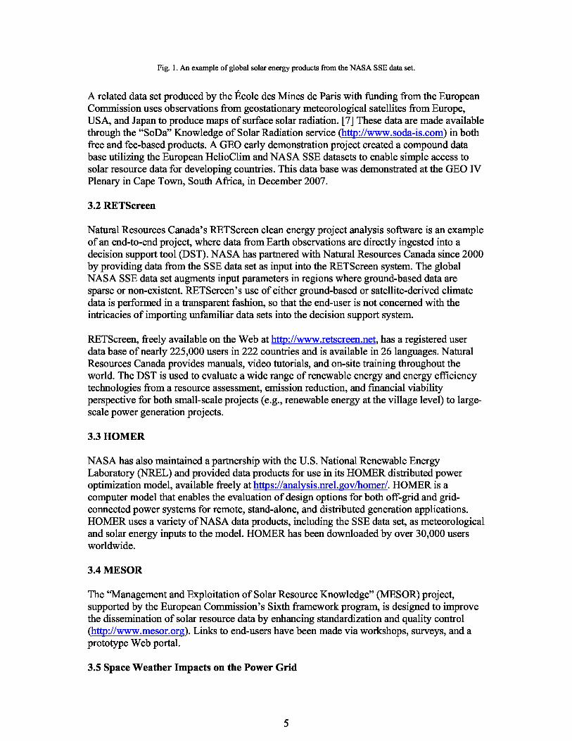
Fig. 1. An example of global solar energy products from the NASA SSE data set.
A related data set produced by the École des Mines de Paris with funding from the EuropeanCommission uses observations from geostationary meteorological satellites from Europe,USA, and Japan to produce maps of surface solar radiation. [7] These data are made availablethrough the “SoDa” Knowledge of Solar Radiation service (http://www.soda-is.com) in bothfree and fee-based products. A GEO early demonstration project created a compound database utilizing the European HelioClim and NASA SSE datasets to enable simple access tosolar resource data for developing countries. This data base was demonstrated at the GEO IVPlenary in Cape Town, South Africa, in December 2007.
3.2 RETScreen
Natural Resources Canada’s RETScreen clean energy project analysis software is an exampleof an end-to-end project, where data from Earth observations are directly ingested into adecision support tool (DST). NASA has partnered with Natural Resources Canada since 2000by providing data from the SSE data set as input into the RETScreen system. The globalNASA SSE data set augments input parameters in regions where ground-based data aresparse or non-existent. RETScreen’s use of either ground-based or satellite-derived climatedata is performed in a transparent fashion, so that the end-user is not concerned with theintricacies of importing unfamiliar data sets into the decision support system.
RETScreen, freely available on the Web at http://www.retscreen.net , has a registered userdata base of nearly 225,000 users in 222 countries and is available in 26 languages. NaturalResources Canada provides manuals, video tutorials, and on-site training throughout theworld. The DST is used to evaluate a wide range of renewable energy and energy efficiencytechnologies from a resource assessment, emission reduction, and financial viabilityperspective for both small-scale projects (e.g., renewable energy at the village level) to large-scale power generation projects.
3.3 HOMER
NASA has also maintained a partnership with the U.S. National Renewable EnergyLaboratory (NREL) and provided data products for use in its HOMER distributed poweroptimization model, available freely at https://analysis.nrel.gov/homer/. HOMER is acomputer model that enables the evaluation of design options for both off-grid and grid-connected power systems for remote, stand-alone, and distributed generation applications.HOMER uses a variety of NASA data products, including the SSE data set, as meteorologicaland solar energy inputs to the model. HOMER has been downloaded by over 30,000 usersworldwide.
3.4 MESOR
The “Management and Exploitation of Solar Resource Knowledge” (MESOR) project,supported by the European Commission’s Sixth framework program, is designed to improvethe dissemination of solar resource data by enhancing standardization and quality control(http://www.mesor.org). Links to end-users have been made via workshops, surveys, and aprototype Web portal.
3.5 Space Weather Impacts on the Power Grid
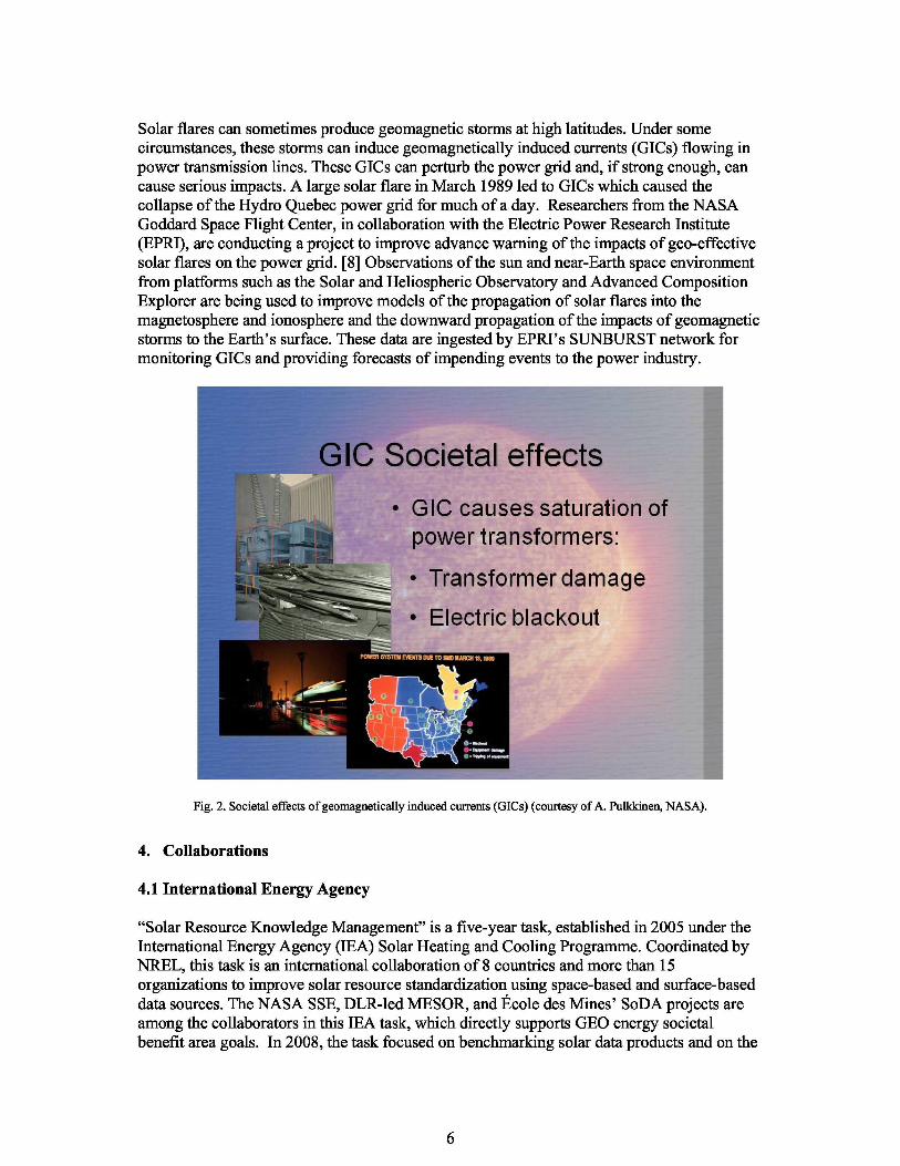
Solar flares can sometimes produce geomagnetic storms at high latitudes. Under somecircumstances, these storms can induce geomagnetically induced currents (GICs) flowing inpower transmission lines. These GICs can perturb the power grid and, if strong enough, cancause serious impacts. A large solar flare in March 1989 led to GICs which caused thecollapse of the Hydro Quebec power grid for much of a day. Researchers from the NASAGoddard Space Flight Center, in collaboration with the Electric Power Research Institute(EPRI), are conducting a project to improve advance warning of the impacts of geo-effectivesolar flares on the power grid. [8] Observations of the sun and near-Earth space environmentfrom platforms such as the Solar and Heliospheric Observatory and Advanced CompositionExplorer are being used to improve models of the propagation of solar flares into themagnetosphere and ionosphere and the downward propagation of the impacts of geomagneticstorms to the Earth’s surface. These data are ingested by EPRI’s SUNBURST network formonitoring GICs and providing forecasts of impending events to the power industry.
Fig. 2. Societal effects of geomagnetically induced currents (GICs) (courtesy of A. Pulkkinen, NASA).
4. Collaborations
4.1 International Energy Agency
“Solar Resource Knowledge Management” is a five-year task, established in 2005 under theInternational Energy Agency (IEA) Solar Heating and Cooling Programme. Coordinated byNREL, this task is an international collaboration of 8 countries and more than 15organizations to improve solar resource standardization using space-based and surface-baseddata sources. The NASA SSE, DLR-led MESOR, and École des Mines’ SoDA projects areamong the collaborators in this IEA task, which directly supports GEO energy societalbenefit area goals. In 2008, the task focused on benchmarking solar data products and on the
6
development of solar forecasting methods. By 2010, a best practices guide meeting the needsof stakeholders, utilities, financial planners, and other end-users is will be published tocapture the key findings of the 5-year activity. Further information on the IEA task may befound at http://www.iea-shc.org/task36/index.html.
4.2 United Nations Environment Programme
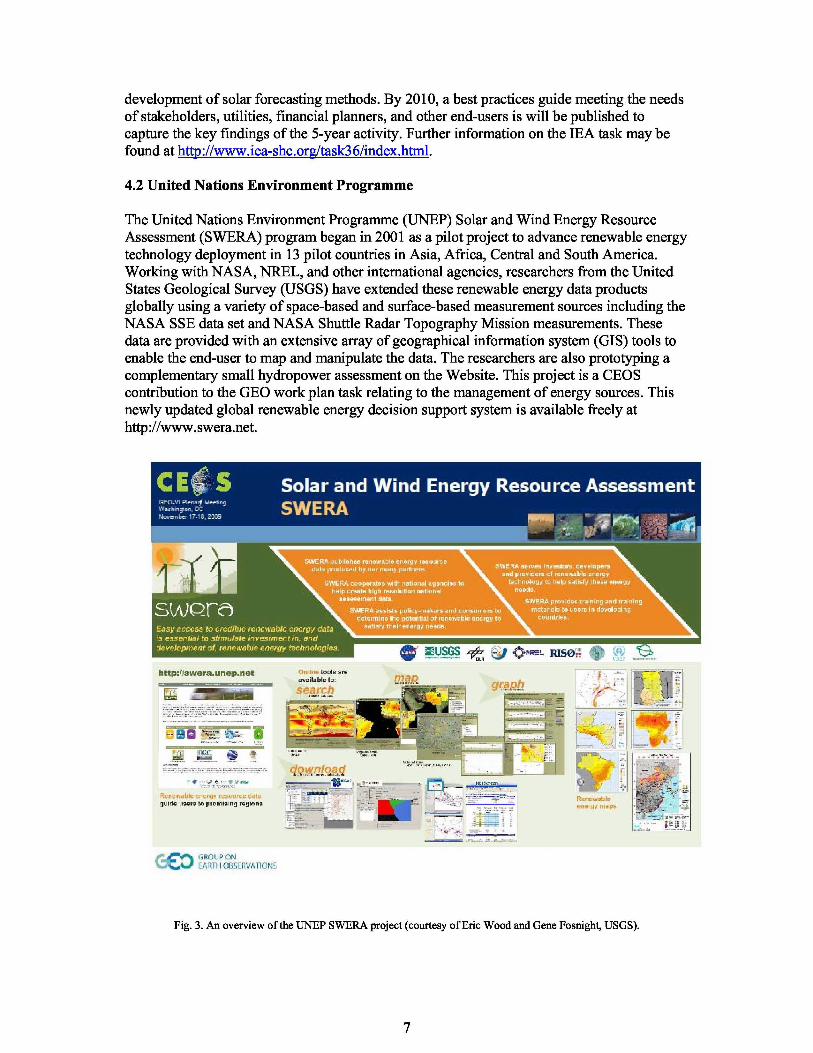
The United Nations Environment Programme (UNEP) Solar and Wind Energy ResourceAssessment (SWERA) program began in 2001 as a pilot project to advance renewable energytechnology deployment in 13 pilot countries in Asia, Africa, Central and South America.Working with NASA, NREL, and other international agencies, researchers from the UnitedStates Geological Survey (USGS) have extended these renewable energy data productsglobally using a variety of space-based and surface-based measurement sources including theNASA SSE data set and NASA Shuttle Radar Topography Mission measurements. Thesedata are provided with an extensive array of geographical information system (GIS) tools toenable the end-user to map and manipulate the data. The researchers are also prototyping acomplementary small hydropower assessment on the Website. This project is a CEOScontribution to the GEO work plan task relating to the management of energy sources. Thisnewly updated global renewable energy decision support system is available freely athttp://www.swera.net .
Fig. 3. An overview of the UNEP SWERA project (courtesy of Eric Wood and Gene Fosnight, USGS).
7
5. Conclusions
I have described several case studies demonstrating the utility of data sets derived from Earthobservations and Earth science model products to enhance end-user decision making in theenergy sector. Working with GEO and CEOS, national space agencies, end-userorganizations, and stakeholders have partnered to deliver and utilize specialized data sets tooptimize and deploy renewable energy technologies, improve energy efficiency, and provideadvance forecast of impending dangers to the power grid.
A key lesson learned from these early projects is the need for sustained end-user engagement.I have summarized a variety of methods used by my colleagues to engage stakeholders,provide information on the utility of Earth observations, and better understand theirrequirements. Successful outcomes require scientists and data owners to make these Earthobservation products available in formats tailored to the needs of end-users and using Web-based and other delivery systems to disseminate these products in a timely manner.
Challenges remain in the end-to-end delivery of scientific observations to improve decisionsupport systems. Once prototype projects are successfully demonstrated, funding must befound to maintain the delivery of data in an operational environment. Only limited progresshas been made thus far in transitioning these systems to operational agencies and privateindustry. Non-traditional funding sources are being examined to augment governmentfunding of these prototype projects. Nonetheless, the examples given in this paperdemonstrate the promise of the utility of constructing a Global Earth Observing System ofSystems for societal benefit in the energy sector.
Acknowledgements
The cases studies and methodologies described in this paper are the result of extensiveexperimentation by my colleagues at CEOS-member agencies and partner organizations. Igratefully acknowledge the support and advice from many of these researchers, includingPaul Stackhouse and the POWER team (NASA Langley Research Center), Erica Zell and JillEngel-Cox (Battelle), Marion Schroedter-Homscheidt (Deutsches Zentrum für Luft- undRaumfahrt), Thierry Ranchin, Lucien Wald, and Lionel Menard (École des Mines de ParisCenter for Energy Processes), Ellsworth LeDrew (University of Waterloo), Fernando Ramosand Alexia Massacand (GEO Secretariat), Antti Pulkkinen (NASA Goddard Space FlightCenter, and Greg Leng (RETScreen International).
References
[1] International Energy Agency, World Energy Outlook 2009, OECD/IEA, Paris, 2009, p. 45.[2] GEO Secretariat, “The Global Earth Observing System of Systems (GEOSS) 10-Year Implementation
Plan,” [Online]. Available: http://www.earthobservations.org/documents/10-Year%20Implementation%20Plan.pdf, 2007.
[3] Zell, E., and Engel-Cox, J., “NASA Energy Management Program Stakeholder Workshop: SummaryReport”, [Online]. Available: http://aspires.gsfc.nasa.gov/upload/EM_proj-233_5890_EM_eval_report.pdf2007.
[4] Zell, E., Engel-Cox, J., Eckman, R., and Stackhouse, Jr., P., Application of satellite sensor data and modelsfor energy management, IEEE Journal of Selected Topics in Applied Earth Observations and RemoteSensing, 2008, doi: 10. 1 109/JSTARS.2008.2001142: 1-13.

[5] Eckman, R. S., and Stackhouse, Jr., P. W., “Informing decision making in the energy sector using NASAspaceborne observations and model predictions,” In: GEO Secretariat (Ed.), The Full Picture, Tudor Rose,United Kingdom, 2007, pp. 195-197.
[6] Stackhouse, Paul W., Jr., T. Zhang, W.S. Chandler, C.H. Whitlock, J.M. Hoell, D.J. Westberg, R. Perez, S.Wilcox, Satellite Based Assessment of the NSRDB Site Irradiances and Time Series from NASA andSUNY/Albany Algorithms, Proceedings of the Solar 2008 Conference (American Solar Energy Society),May 3-8, 2008, San Diego, California.
[7] Diabat, L., Blanc, Ph., and Wald, L., Solar radiation climate in Africa, Solar Energy, 2004, 76: 733-744.[8] Pulkkinen, A., Hesse, M., Habib, S., Van der Zel, L., Damsky, B., Policelli, F., Fugate, D., and Jacobs, W.,
Solar Shield - forecasting and mitigating space weather effects on high-voltage power transmissionsystems, Natural Hazards, 2009, doi:10.1007/s11069-009-9432-x.