Embed Size (px)
Citation preview
Relinquishment Report
Licence P421 Block 21/20b
Centrica North Sea Oil Ltd Shell UK Ltd
May 2013
Disclaimer No liability whatsoever is accepted and no representation, warranty or undertaking, express or implied, is or will be made by Centrica plc or any of Centrica plc's subsidiaries, or any of their respective agents, being their directors, officers, employees, advisers, representatives or other agents, for any information, projections or any of the opinions contained in this report or for any errors, omissions or misstatements in this report. Neither Centrica plc nor any of Centrica plc's subsidiaries, nor any of their respective agents makes or has authorised to be made any representations or warranties (express or implied) in relation to any of the matters described herein or as to the truth, accuracy or completeness of this report, or any other written or oral statement provided. This report shall not be deemed to be an offer to sell or invitation to invest in Centrica plc or any of its assets and no information set out in this report is intended to form the basis of any contract, investment decision or any decision to purchase or invest in any such assets. Neither Centrica plc nor any of Centrica plc's subsidiaries nor any of their respective agents undertakes any obligation to provide any recipient with access to any additional information or to update or correct any inaccuracies in or omissions from this report. This report should not be considered as a recommendation by Centrica plc or any of Centrica plc's subsidiaries or any of their respective agents to invest in any securities (including, without limitation, those issued by Centrica plc) or any other assets. Recipients should rely solely on their own judgement, review and analysis in evaluating the information set out herein.
i
Table of Contents
1. Licence Information ..................................................................................................... 1
2. Synopsis ....................................................................................................................... 1
3. Exploration Activities .................................................................................................. 2
3.1 Seismic .................................................................................................................................... 2
3.2 Wells ........................................................................................................................................ 2
3.3 Studies ..................................................................................................................................... 3
4. Prospectivity Analysis ................................................................................................. 3
4.1 Christian .................................................................................................................................. 3
4.1.1 Trap type ......................................................................................................................... 3
4.1.2 Reservoir ......................................................................................................................... 3
4.1.3 Seal .................................................................................................................................. 4
4.1.4 Remaining risks/Chance of success ................................................................................. 4
4.2 Christian Deep ......................................................................................................................... 4
4.2.1 Trap type ......................................................................................................................... 4
4.2.2 Reservoir ......................................................................................................................... 4
4.2.3 Seal .................................................................................................................................. 4
4.2.4 Remaining risks/Chance of success ................................................................................. 5
5. Reserves Summary ........................................................................................................ 5
6. Maps and Figures ........................................................................................................... 6
7. Clearance ....................................................................................................................... 12
ii
Table of Figures
Figure 1: Location map showing Christian P421; outline of block 21/20b in red. ................... 6
Figure 2: A map showing interpreted Top Christian Sandstone in depth (TVDSS) with key
faults. Block outline of 21/20b overlain. Approximate lines of section shown. ........................ 7
Figure 3: A map showing interpreted Top Puffin Sandstone in depth (TVDSS). Block outline
of 21/20b overlain. Approximate lines of section shown. ....................................................... 8
Figure 4: An example West-East seismic section through 21/20b illustrated using the relative
acoustic impedance volume. ................................................................................................. 9
Figure 5: An example North-South seismic section through 21/20b illustrated using the
relative acoustic impedance volume. ..................................................................................... 9
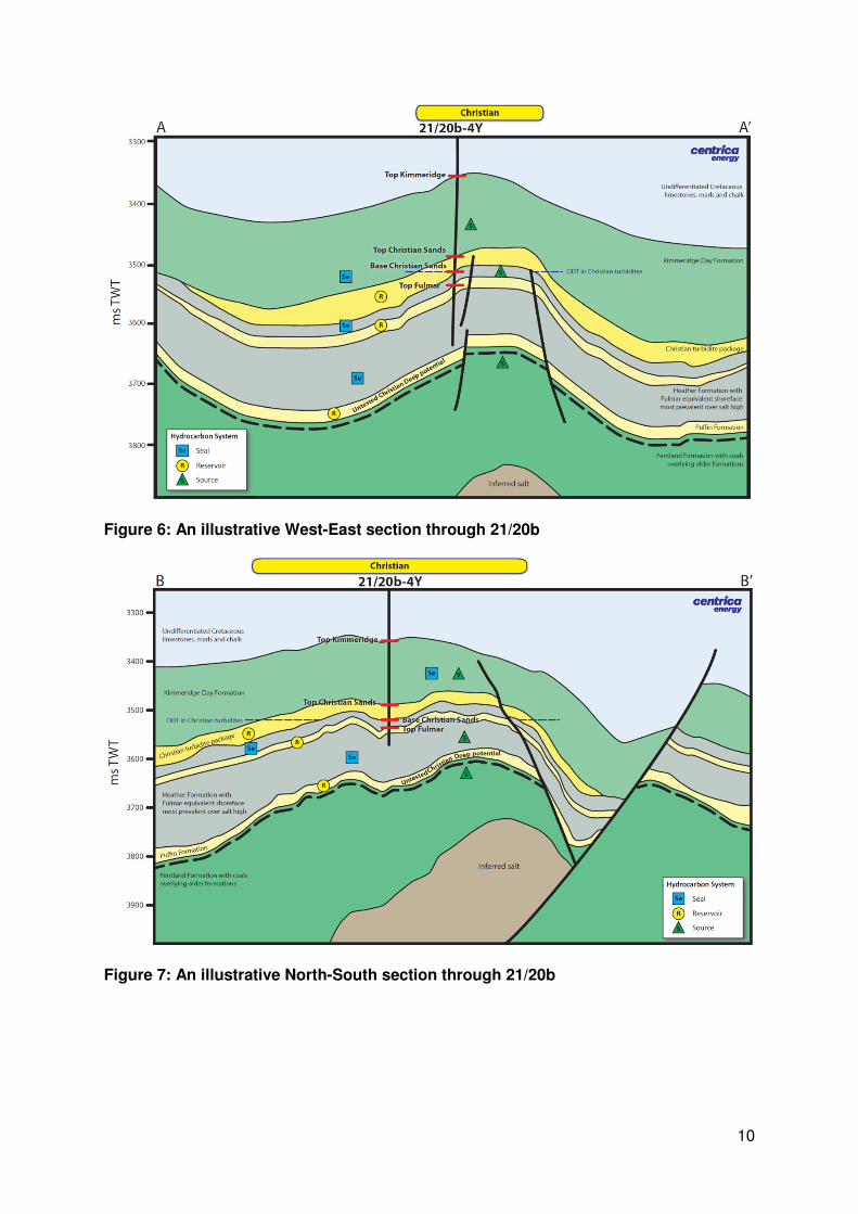
Figure 6: An illustrative West-East section through 21/20b ................................................. 10
Figure 7: An illustrative North-South section through 21/20b ............................................... 10
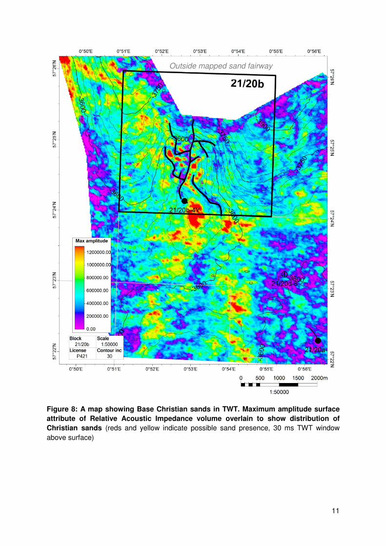
Figure 8: A map showing Base Christian sands in TWT. Maximum amplitude surface
attribute of Relative Acoustic Impedance volume overlain to show distribution of Christian
sands (reds and yellow indicate possible sand presence, 30 ms TWT window above surface)
........................................................................................................................................... 11
1
1. Licence Information Licence Number P421
Licence Type Traditional, 8th Round Single block licence awarded on 23rd Jan 1983 (6+30 year terms; expiry January 2019)
Block Number 21/20b
Licensees Centrica North Sea Oil Ltd 50% (Operator) Shell UK Ltd 50%
Licence Determined 1st April 2013 by letter from Secretary of State
2. Synopsis Licence P421 comprising block 21/20b was awarded in the 8th Round of licensing to a 50%-
50% partnership of Shell-Esso. Many changes occurred in the structure of the licence-
holding partnership, ultimately leading to Centrica and Shell each holding 50% equity in
2012.
Three wells were drilled on the licence (21/20b-3, 4Y and 6Z). At the time of relinquishment,
the licensed area included only one of these, the Christian discovery well 21/20b-4Y (drilled
in 1990). The licence was declared fallow in September 2003 and partial relinquishments
were made, reducing the licence area to its final shape which included only the Christian
discovery. Coordinates of the licence area at the time of relinquishment are provided in
Figure 1.
Christian was declared a Fallow Discovery in January 2009 and a rescue plan was agreed,
allowing the licence to be retained pending results of Bligh well 21/20d-8. It was hoped that
this well would provide insight about untested upside on the Christian structure within a
deeper Puffin Sandstone target (Christian Deep).
Following the Bligh appraisal well, the Partnership decided that insufficient information had
been gained to allow the commitment to a Christian FDP that would be required to retain
licence P421.
All work commitments on the licence having been met, the decision was taken, with approval
by partners, to relinquish the licence.
2
3. Exploration Activities
3.1 Seismic
The Christian discovery is fully covered by the following datasets licenced by the operator:
• PGS Megasurvey
– Regional dataset purchased after Senergy 2008 work
• Fugro2005 PSTM 3D – regional coverage
– 2005 Greater Kittiwake 3D merge/reprocessing
– Christian covered by merge of EO1990 3D & Shell E91100 3D
– 40ms bulk shift required
– Used as the basis for an AVO inversion carried out by Fugro Jason in
2007/2008. Final products were P-Impedance, S-Impedance, Density, and
VpVs, together with bandlimited equivalents. The bandlimited P-Impedance
was used for interpretation of the Christian Sand, for insights into sand
thickness and distribution not apparent from the previous reflectivity data.
• VeritasDGC 2000 PSDM – TWT & depth volumes
– 2000 reprocessing of EO 1990 3D
– 70o phase rotation applied
– Judged to have superior resolution to the 2005 Fugro data reflectivity data
• 2003 HFI 3D
3.2 Wells
Three wells were drilled on licence P421 (21/20b-3, 4Y and 6Z). At the time of
relinquishment, the licensed area included only the Christian discovery well 21/20b-4Y,
drilled by Shell in 1990-91.
Oil was encountered in the HPHT Upper Jurassic “Christian” turbidite sandstones (137ft
gross, 46 ft net) and a test produced oil at a rate of 6,200stb/d. Reservoir pressure was
11,200 psi and temperature 320°F. The well failed to reach the deeper Puffin sandstone
owing to losing the BHA.
The suite of well logs includes sonic and density from approximately 3000 ft MD to TD (the
lowest 375 ft could not be logged owing to leaving the BHA in the hole).
3
3.3 Studies
Between 2008 and 2009 Senergy performed a full re-evaluation of the Christian discovery
which included thorough re-mapping following reprocessing of the 2005 Fugro 3D
merge/PreSTM carried out over the Greater Kittiwake Area.
• Evaluation of the 21/20b-4y Christian Discovery; J06VEN01A, September 2007
• Christian Field – Geophysical Review of the Pimpedance dataset, and model rebuild;
J06VEN01A, April 2008
• Christian Field Integrated Evaluation; J06VEN01A, December 2008
4. Prospectivity Analysis Prospectivity in the area has been established in four intervals by drilling:
• Palaeocene Forties Sands (21/20a-1 – Morgan Prospect)
• Kimmeridgian Turbidites (Christian Sands, in 21/20b-4Y – Christian discovery)
• Late Jurassic Ryton Sands (Fulmar Sand equivalent, in 21/20a-2 – Cook Field, and
21/20b-4Y)
• Base Late Jurassic Puffin sands (21/20a-5 – Bligh discovery).
The drilling of the 21/20b-4Y and 21/20a-5 wells discounted the likelihood of commercial
hydrocarbon in Forties and Maureen equivalent sands; thus prospectivity in 21/20b is limited
to Late Jurassic sediments – the Kimmeridgian Christian turbidites, Fulmar/Ryton Sands and
the deeper Puffin/Pentland Sands.
4.1 Christian
The Christian oil discovery is an HPHT oil accumulation discovered by well 21/20b-4Y drilled
in 1990. The well encountered 137 ft gross of oil bearing Kimmeridgian turbiditic sands,
referred to as the Christian Sand Unit. These Kimmeridge sands are over-pressured and
tested 6,200 stb/d of 42° API oil. No oil water contact was encountered. Reservoir
conditions are estimated to be 11,220psia and 320°F at 13,475ft TVDSS. Typical shallow
marine shoreface Fulmar sands were encountered below the Christian Sand unit. The
accumulation also extends into Block 21/20d.
4.1.1 Trap type
The trapping style is a salt induced structural four-way dip closure in the base case. There
remains the potential for an upside case of off-structure stratigraphic trapping in the Christian
Sand reservoir. Significant faulting has been mapped in the northern part of the structure.
4.1.2 Reservoir
Analysis of the well logs show the Christian Sand unit to be interbedded sands and clays,
with sand beds typically less than 20 ft thick abruptly intercalated with clay beds less than 8
ft in thickness. This signature is interpreted to be the result of sedimentation by mass
transport, either debris flows or more classic turbidites. Mapping suggests that the sands
appear to have entered the system from the northwest then fanned out east and south into
the basin.
4
The age of the Christian Sands is Early Kimmeridgian, between the Baylei and Eudoxus
MFS (J62). Significant sands of this age are not seen in the other block 21/20 wells.
Average reservoir properties are 34% Net:Gross and 13.1% porosity.
4.1.3 Seal
The seal is interpreted to be the overlying and underlying Kimmeridge Clays.
4.1.4 Remaining risks/Chance of success
The 21/20b-4Y well has proven and tested a modest hydrocarbon volume in Christian Sands
in a 4-way closure. The remaining risk for on-structure Christian Sands is variability in
reservoir thickness and quality.
The main risks for the Christian Sand stratigraphic upside case are trap integrity, sand
distribution and reservoir quality. Mapping based on a relative acoustic impedance seismic
volume has been used to infer the possible extent of the Christian Sands stratigraphic trap,
however this is not definitive.
There is also uncertainty in the depth of the Christian Sands oil-water contact; 21/20b-4Y
encountered an oil-down-to at 13,497 ft TVDSS.
4.2 Christian Deep
The 21/20b-4Y well was terminated due to mechanical problems before the deeper target,
the Puffin Formation sand, was reached. Hence, this reservoir remains as untested upside
potential, particularly in the light of the discovery of retrograde gas-condensate in the Puffin
sand in the 21/20a-5 Bligh well, 5 km to the southeast.
4.2.1 Trap type
The trap at Christian Deep is mapped as a four way dip closure spilling to the west.
4.2.2 Reservoir
The main reservoir potential lies in the Puffin Sands. These are shallow marine shoreface
sandstones which have a strong diagenetic overprint. The sands are Middle Oxfordian age.
In 21/20a-5 they rest discordantly on Middle Jurassic Pentland Formation.
The Puffin Sands are believed to be developed in a confined, elongate north-northwest to
south-southeast trending trough coincident with today’s West Central Graben, bounded by
the Western Platform to the west and the Forties-Montrose High to the east. The
depositional model suggests that the Puffin should thicken towards the east and south, thus
the Puffin character should be similar or slightly poorer than seen at Bligh.
The sands of the Pentland section are generally thin, low NTG deposits of fluvio-deltaic
character. The coal bearing sequences are assigned to the Middle Jurassic. Again, the
facies are considered to thicken and develop more marine influence towards the southeast.
4.2.3 Seal
The seal is inferred to be the overlying Puffin and Heather shale sequences. They are
inferred to be sealing and pressure independent of the shallower Fulmar shoreface unit
encountered within 21/20b-4Y.
5
4.2.4 Remaining risks/Chance of success
The presence of Puffin Sand reservoir in Christian, deeper than the TD of 21/20b-4Y, may
be inferred by analogy with offset Bligh wells. However its presence is not proven, and
reservoir thickness and quality are uncertainties.
The key risks for the Puffin Sand prospect are seal failure due to overpressure, and the
reservoir quality and extent. The geological model predicts thinner and poorer quality
reservoir rock at Christian Deep than in Bligh.
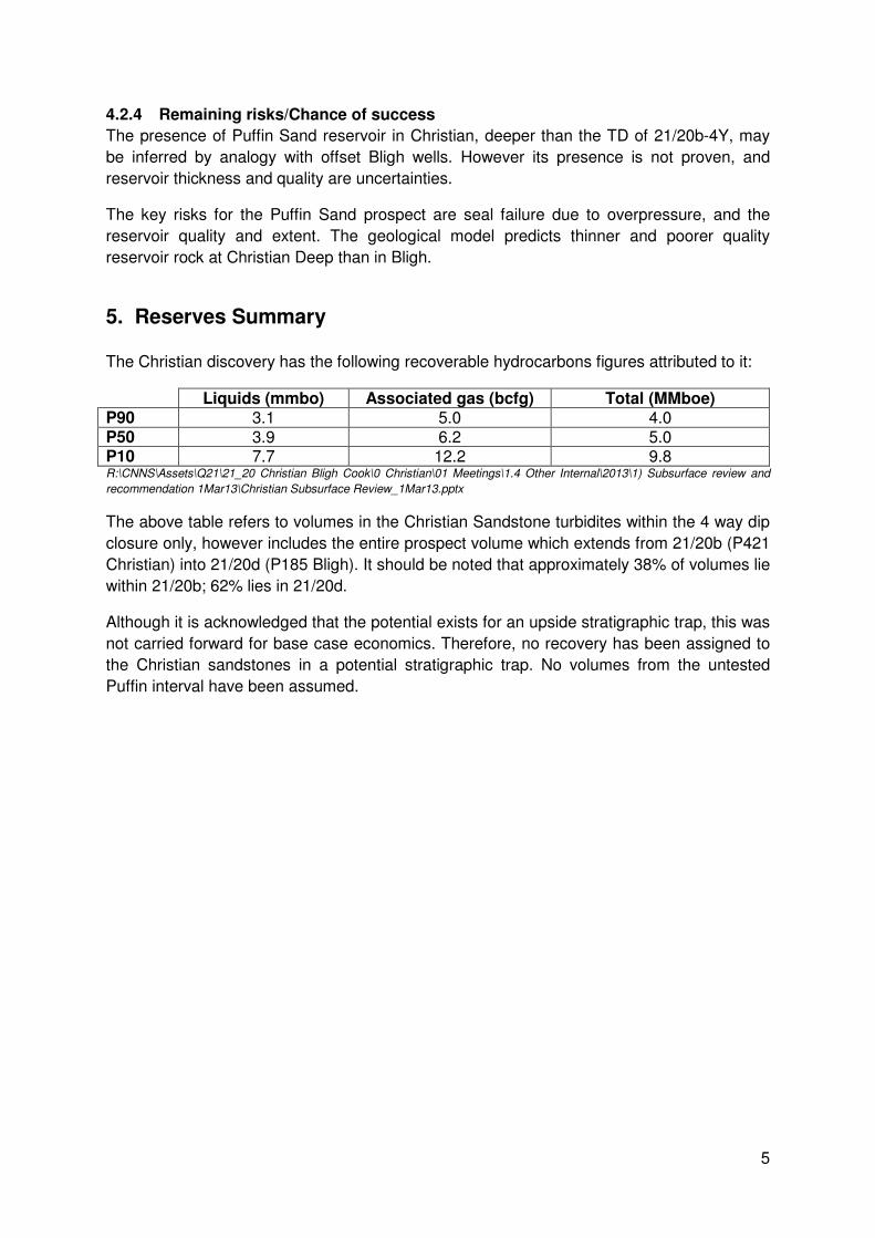
5. Reserves Summary The Christian discovery has the following recoverable hydrocarbons figures attributed to it:
Liquids (mmbo) Associated gas (bcfg) Total (MMboe) P90 3.1 5.0 4.0 P50 3.9 6.2 5.0 P10 7.7 12.2 9.8 R:\CNNS\Assets\Q21\21_20 Christian Bligh Cook\0 Christian\01 Meetings\1.4 Other Internal\2013\1) Subsurface review and
recommendation 1Mar13\Christian Subsurface Review_1Mar13.pptx
The above table refers to volumes in the Christian Sandstone turbidites within the 4 way dip
closure only, however includes the entire prospect volume which extends from 21/20b (P421
Christian) into 21/20d (P185 Bligh). It should be noted that approximately 38% of volumes lie
within 21/20b; 62% lies in 21/20d.
Although it is acknowledged that the potential exists for an upside stratigraphic trap, this was
not carried forward for base case economics. Therefore, no recovery has been assigned to
the Christian sandstones in a potential stratigraphic trap. No volumes from the untested
Puffin interval have been assumed.
6
6. Maps and Figures
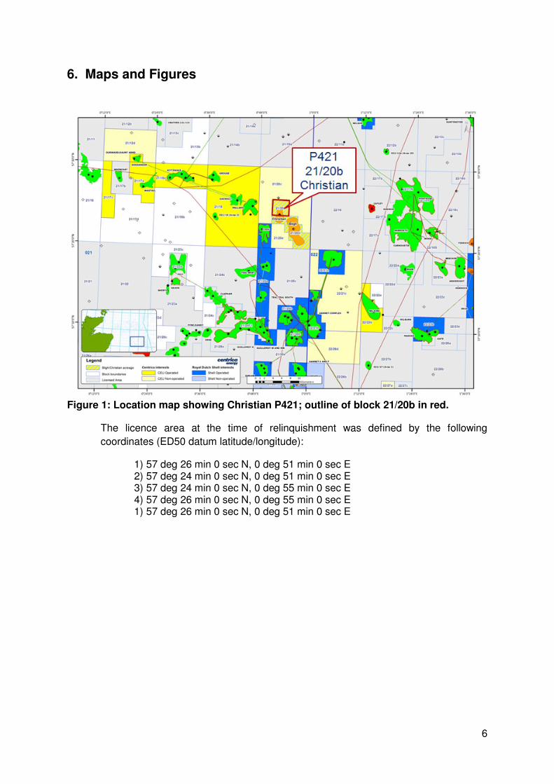
Figure 1: Location map showing Christian P421; outline of block 21/20b in red.
The licence area at the time of relinquishment was defined by the following
coordinates (ED50 datum latitude/longitude):
1) 57 deg 26 min 0 sec N, 0 deg 51 min 0 sec E 2) 57 deg 24 min 0 sec N, 0 deg 51 min 0 sec E 3) 57 deg 24 min 0 sec N, 0 deg 55 min 0 sec E 4) 57 deg 26 min 0 sec N, 0 deg 55 min 0 sec E 1) 57 deg 26 min 0 sec N, 0 deg 51 min 0 sec E
7
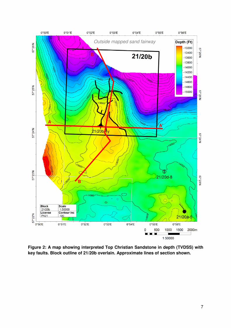
Figure 2: A map showing interpreted Top Christian Sandstone in depth (TVDSS) with
key faults. Block outline of 21/20b overlain. Approximate lines of section shown.
Outside mapped sand fairway
A A’
B
B’
8
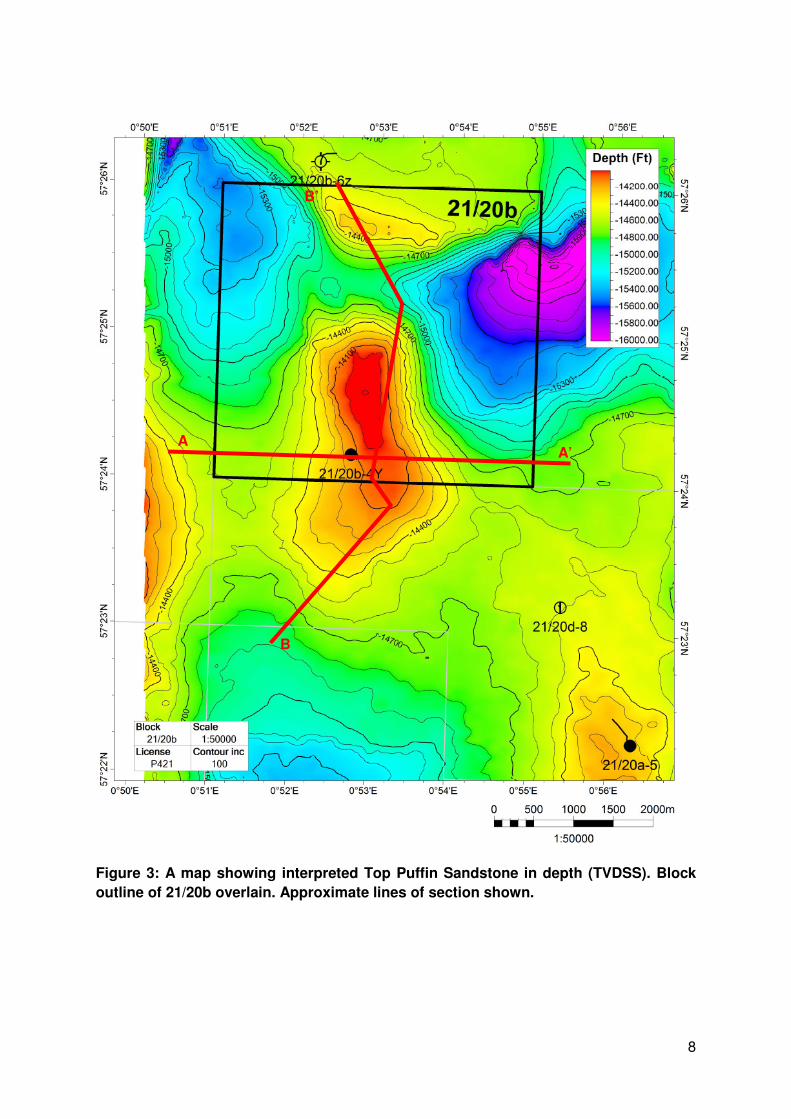
Figure 3: A map showing interpreted Top Puffin Sandstone in depth (TVDSS). Block
outline of 21/20b overlain. Approximate lines of section shown.
A A’
B
B’
9
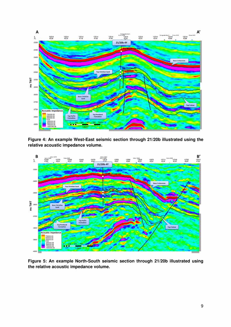
Figure 4: An example West-East seismic section through 21/20b illustrated using the
relative acoustic impedance volume.
Figure 5: An example North-South seismic section through 21/20b illustrated using
the relative acoustic impedance volume.
10
Figure 6: An illustrative West-East section through 21/20b
Figure 7: An illustrative North-South section through 21/20b
11
Figure 8: A map showing Base Christian sands in TWT. Maximum amplitude surface
attribute of Relative Acoustic Impedance volume overlain to show distribution of
Christian sands (reds and yellow indicate possible sand presence, 30 ms TWT window
above surface)
Outside mapped sand fairway

12
7. Clearance Partners have reviewed this document and verified that DECC is free to publish it. All 3rd party ownership rights (on any contained data and/or interpretations) have been considered and appropriately cleared for publication purposes. Seismic figures are based on TerraCube PSTM data supplied courtesy of Robertson GeoSpec International Limited (“TerraCube” is a registered trademark of Robertson, a CGG company).