Embed Size (px)
Citation preview
Remote Sensing and GIS Centre of Excellence for NRDMS in Uttarakhand
Department of Geography
Kumaun University SSJ Campus, Almora
About the Course
The Remote Sensing and GIS is a newly emerging discipline, developing gradually worldwide. In view of its
significance and importance in the activities of the academic community, governance, industry and civil
society, the Kumaun University has started M.Sc. Remote Sensing and GIS Course since 2009, in its
Department of Geography at the SSJ Campus Almora with the high-tech Remote Sensing/GIS/GPS
laboratory support from the DST, New Delhi. M.Sc. Remote Sensing and GIS is a four semester course
spread over two years (syllabus is attached), aims at imparting state-of-the-art knowledge in Remote Sensing
and GIS to meet the emerging demands of geospatial knowledge in different sectors of development.
Presently 60 students from 10 different State of our country are perusing their M.Sc. Degree in this
programme. The alumni of the programme are working in different National/State Research and Development
Institutions (i.e., DRDO, Chandigarh; IARI, New Delhi; Uttarakhand Space Application Centre, USAC,
Dehradun; Punjab Remote Sensing Centre, Punjab; HARSAC Hisar); in different Government Departments
(i.e.,Urban Development and Housing Department, Government of Sikkim, Sikkim; Forest Department,
Government of Sikkim, Sikkim; Land Revenue & Disaster Management Department, Government of Sikkim,
Sikkim; Himachal Pradesh Forest Department, Shimla, H.P.); and in various prestigious Corporate Sectors
and Companies (i.e., Map My India, Delhi; RMSI, Noida; Institute of Photogrammetry and Geo Informatics,
Delhi; PAN India Consultant, Gurgoun; Navteq India Pvt. Gurgaoun; TCS Delhi; Spatial Decision, Noida;
Genesis, Dehradun etc.)
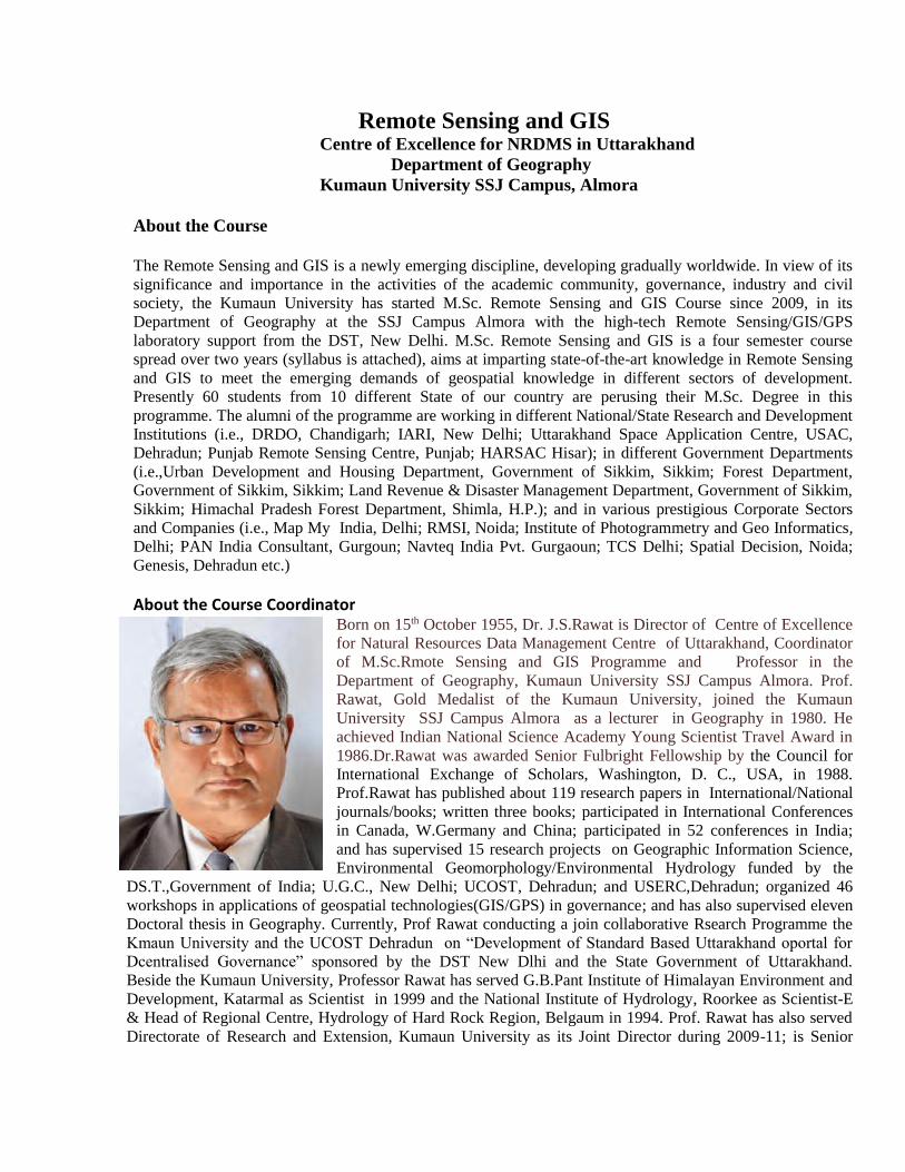
About the Course Coordinator Born on 15th October 1955, Dr. J.S.Rawat is Director of Centre of Excellence
for Natural Resources Data Management Centre of Uttarakhand, Coordinator
of M.Sc.Rmote Sensing and GIS Programme and Professor in the
Department of Geography, Kumaun University SSJ Campus Almora. Prof.
Rawat, Gold Medalist of the Kumaun University, joined the Kumaun
University SSJ Campus Almora as a lecturer in Geography in 1980. He
achieved Indian National Science Academy Young Scientist Travel Award in
1986.Dr.Rawat was awarded Senior Fulbright Fellowship by the Council for
International Exchange of Scholars, Washington, D. C., USA, in 1988.
Prof.Rawat has published about 119 research papers in International/National
journals/books; written three books; participated in International Conferences
in Canada, W.Germany and China; participated in 52 conferences in India;
and has supervised 15 research projects on Geographic Information Science,
Environmental Geomorphology/Environmental Hydrology funded by the
DS.T.,Government of India; U.G.C., New Delhi; UCOST, Dehradun; and USERC,Dehradun; organized 46
workshops in applications of geospatial technologies(GIS/GPS) in governance; and has also supervised eleven
Doctoral thesis in Geography. Currently, Prof Rawat conducting a join collaborative Rsearch Programme the
Kmaun University and the UCOST Dehradun on “Development of Standard Based Uttarakhand oportal for
Dcentralised Governance” sponsored by the DST New Dlhi and the State Government of Uttarakhand.
Beside the Kumaun University, Professor Rawat has served G.B.Pant Institute of Himalayan Environment and
Development, Katarmal as Scientist in 1999 and the National Institute of Hydrology, Roorkee as Scientist-E
& Head of Regional Centre, Hydrology of Hard Rock Region, Belgaum in 1994. Prof. Rawat has also served
Directorate of Research and Extension, Kumaun University as its Joint Director during 2009-11; is Senior
Editor of the "International Journal of Advanced Earth Science and Engineering"; and is also Resource Person
of Uttarakhand Judicial and Legal Academy of Uttarakhand; and UGC-Human Rsource Centre Nainital. For
his distinguished contribution in education and research works in Geographic Information Science,
Geomorphology and Hydrology, Prof.Rawat has been honored by the American Geophysical Union as an
Elected Member of the American Geophysical Union in 1989; by the Governing Council of the New York
Academy of Sciences as an Active Member of The New York Academy of Sciences in 1995; by the Geological
Society of India as Fellow of Geological Society of India in 1998; as Kumaun Gaurav Samman in 2013; and
by India International Friendship Society and International Institute as Bharat Jyoti Samman and Glory of
India Gold Medal, in 2013, and Bharat Gaurav Samman in 2016.
Ph.: +91 7533983533, e-Mail ID: [email protected]
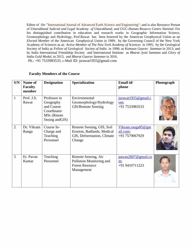
Faculty Members of the Course
S/N Name of
Faculty
member
Designation Specialization Email id/
phone
Photograph
1 Prof. J.S.
Rawat
Professor in
Geography
and Course
Coordinator
MSc (Rmote
Snsing andGIS)
Environmental
Geomorphology/Hydrology
GIS/Remote Sensing
om;
+91 7533983533
2 Dr. Vikram
Ranga
Course In-
Charge and
Teaching
Personnel
Remote Sensing, GIS, Soil
Erosion, Badlands, Medical
GIS, Deforestation, Climate
Change
Vikram.ranga85@gm
ail.com;
+91 7579067929
3 Er. Pavan
Kumar
Teaching
Personnel
Remote Sensing, Air
Pollution Monitoring and
Forest Resource
Management
m;
+91 9410711223
ACADEMIC PROFILE OF FACULTY MEMBERS
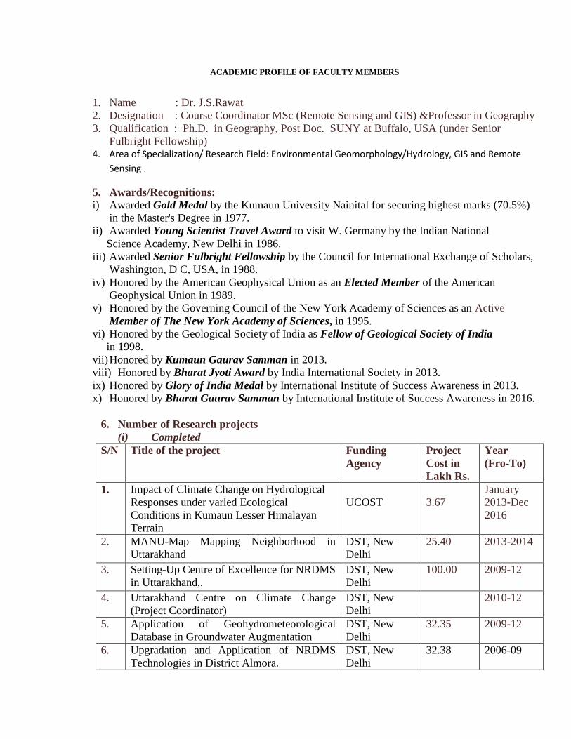
1. Name : Dr. J.S.Rawat
2. Designation : Course Coordinator MSc (Remote Sensing and GIS) &Professor in Geography
3. Qualification : Ph.D. in Geography, Post Doc. SUNY at Buffalo, USA (under Senior
Fulbright Fellowship) 4. Area of Specialization/ Research Field: Environmental Geomorphology/Hydrology, GIS and Remote
Sensing .
5. Awards/Recognitions:
i) Awarded Gold Medal by the Kumaun University Nainital for securing highest marks (70.5%)
in the Master's Degree in 1977.
ii) Awarded Young Scientist Travel Award to visit W. Germany by the Indian National
Science Academy, New Delhi in 1986.
iii) Awarded Senior Fulbright Fellowship by the Council for International Exchange of Scholars,
Washington, D C, USA, in 1988.
iv) Honored by the American Geophysical Union as an Elected Member of the American
Geophysical Union in 1989.
v) Honored by the Governing Council of the New York Academy of Sciences as an Active
Member of The New York Academy of Sciences, in 1995.
vi) Honored by the Geological Society of India as Fellow of Geological Society of India
in 1998.
vii) Honored by Kumaun Gaurav Samman in 2013.
viii) Honored by Bharat Jyoti Award by India International Society in 2013.
ix) Honored by Glory of India Medal by International Institute of Success Awareness in 2013.
x) Honored by Bharat Gaurav Samman by International Institute of Success Awareness in 2016.
6. Number of Research projects
(i) Completed
S/N Title of the project Funding
Agency
Project
Cost in
Lakh Rs.
Year
(Fro-To)
1. Impact of Climate Change on Hydrological
Responses under varied Ecological
Conditions in Kumaun Lesser Himalayan
Terrain
UCOST
3.67
January
2013-Dec
2016
2. MANU-Map Mapping Neighborhood in
Uttarakhand
DST, New
Delhi
25.40 2013-2014
3. Setting-Up Centre of Excellence for NRDMS
in Uttarakhand,.
DST, New
Delhi
100.00 2009-12
4. Uttarakhand Centre on Climate Change
(Project Coordinator)
DST, New
Delhi
2010-12
5. Application of Geohydrometeorological
Database in Groundwater Augmentation
DST, New
Delhi
32.35 2009-12
6. Upgradation and Application of NRDMS
Technologies in District Almora.
DST, New
Delhi
32.38 2006-09
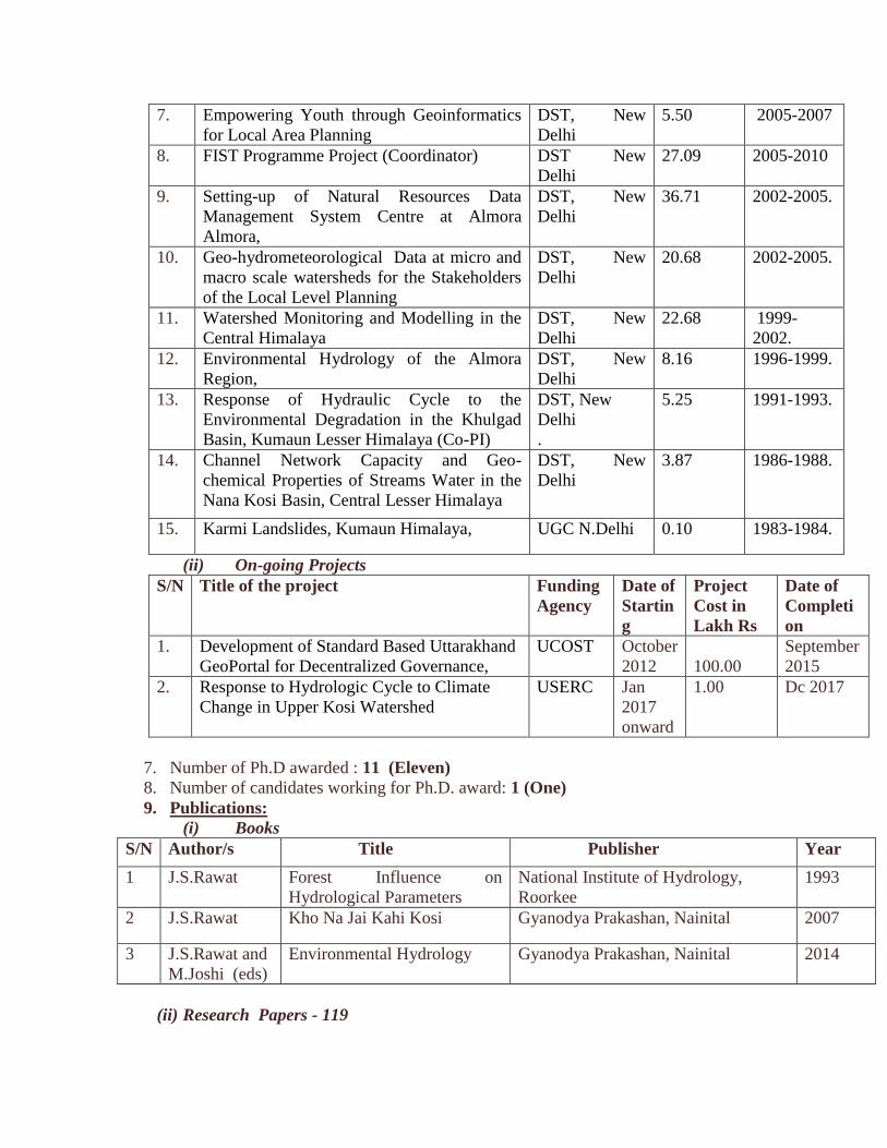
7. Empowering Youth through Geoinformatics
for Local Area Planning
DST, New
Delhi
5.50 2005-2007
8. FIST Programme Project (Coordinator) DST New
Delhi
27.09 2005-2010
9. Setting-up of Natural Resources Data
Management System Centre at Almora
Almora,
DST, New
Delhi
36.71 2002-2005.
10. Geo-hydrometeorological Data at micro and
macro scale watersheds for the Stakeholders
of the Local Level Planning
DST, New
Delhi
20.68 2002-2005.
11. Watershed Monitoring and Modelling in the
Central Himalaya
DST, New
Delhi
22.68 1999-
2002.
12. Environmental Hydrology of the Almora
Region,
DST, New
Delhi
8.16 1996-1999.
13. Response of Hydraulic Cycle to the
Environmental Degradation in the Khulgad
Basin, Kumaun Lesser Himalaya (Co-PI)
DST, New
Delhi
.
5.25 1991-1993.
14. Channel Network Capacity and Geo-
chemical Properties of Streams Water in the
Nana Kosi Basin, Central Lesser Himalaya
DST, New
Delhi
3.87 1986-1988.
15. Karmi Landslides, Kumaun Himalaya, UGC N.Delhi 0.10 1983-1984.
(ii) On-going Projects
S/N Title of the project Funding
Agency
Date of
Startin
g
Project
Cost in
Lakh Rs
Date of
Completi
on
1. Development of Standard Based Uttarakhand
GeoPortal for Decentralized Governance,
UCOST
October
2012
100.00
September
2015
2. Response to Hydrologic Cycle to Climate
Change in Upper Kosi Watershed
USERC Jan
2017
onward
1.00 Dc 2017
7. Number of Ph.D awarded : 11 (Eleven)
8. Number of candidates working for Ph.D. award: 1 (One)
9. Publications:
(i) Books
S/N Author/s Title Publisher Year
1 J.S.Rawat Forest Influence on
Hydrological Parameters
National Institute of Hydrology,
Roorkee
1993
2 J.S.Rawat Kho Na Jai Kahi Kosi Gyanodya Prakashan, Nainital 2007
3 J.S.Rawat and
M.Joshi (eds)
Environmental Hydrology Gyanodya Prakashan, Nainital 2014
(ii) Research Papers - 119
1. Saving the Himalayan dwindling rivers through river rejuvenation measures, J,S,Rawat, in (ed. Gupta and Mehrautra) Water for Future, Ankit Prakashan 2017, pp.39-54.
2. Estimation of urban population dynamics using DMPS-OLS-Night Time Lights Time Series Sensors Data, Bismay Ranjan Tripathy, Vijay Tiwari, Vinita Pandey, Christopher D. Elvidge,J. S. Rawat, M. P. Sharma, Ravindra Prawasi, and Pavan Kumar, IEEE Sensors Journal, Vol. 17, No. 4, February 15, 2017, PP.1013-1020.
3. Perennial to ephemeral transformation of a Lesser Himalayan Watershed, J.S.Rawat, Ajit Govind, Geeta Rawat, Mallickarjun Joshi,Shiv Prakash Rai and Navneet Gahlot, Current Science, Vol.104, No.4, 25 August 2016, pp.687-693.
4. The impact of Global Warming on climate on the shifting of the vegetation line in Indian Himalaya: a case study
from the Kuthiyangthi watershed, J.S.Rawat. Manish Kumar, Navneet Gahlot in Globalization and
Marginalization in Mountain Regions (ed. R.Chand and W. Leimgruber), Springer International Publishing
Switzerland, 2016, pp.191-198.
5. Site suitability analysis for fish farming using Heuristic Approach Method, a case study in Silingtoli village of
Bageshwar District (Uttarakhand), Sahnoor Bano,J.S. Rawat, Shashikant, Vikram Ranga,Ankur Sharma, Reetu
Sharma, International Journal of Science ,Engineering and Technology Research,Volume-5,Feb 2016,pp.548-551.
6. Study of snow cover dynamics of Pinder watershed in Central Himalaya using Remote Sensing and GIS
Technologies, N.C.Pant, Manish Kumar, J.S. Rawat, Neha Rani, Cloud Publications, International Journal of
Advanced Earths Science and Engineering, Vol.3, Issue 3, 2014, pp.
7. The rivers networks of Almora, J.S.Rawat, Companion, Vol.1, Issue-1, 2014, pp.92-95.
8. Land records mordenization to users in g-governance in Uttarakhand,J.S.Rawat,India Geosptial Digest,May 2014. 9. Land use/land cover dynamics using multi-temporal satellite imageries: a case study from the Haldwani town
area, district Nainital,Uttarakhand,India,J.S.Rawat, Vivek Viswas, Manish Kumar,International Journal of Geomatics and Geosciences, 4(3), 2014 pp.536-543.
10. Spatial dynamics for relative contribution of cropping pattern analysis on environment by integrating remote sensing and GIS, P.Bisht, P.Kumar,M.Yadav,J.S.Rawat, M.Sharma, R.S.Hooda,International Journal of Plant Production, Vol.8,No.1, 2014, pp.1-17.
11. Spatio-temporal dynamics of Almora town area, Rawat J.S., Manish Kumar, International Journal of Advanced
Remote Sensing and GIS, 2 (1), 2013,pp.363-373.
12. An integrated approach of Remote Sensing and GIS for landuse/landcover change detection,; a case study of
Bhimtal tourist town (India), J.S.Rawat, Manish Kumar and V. Biswas, Bulletin of Environment and Scientific
Research, 2 (2-3),2013,pp.1-6.
13. Change detection using GIS and Remote Sensing: A case Study of the Ramnagar City in Uttarakhand State, India
J.S.Rawat, Manish Kumar and Vivek Viswas, Egyptian Journal Remote Sensing and Space Science, 16, 2013,
pp.111-117.
14. Quantifying land use/cover dynamics using remote sensing and GIS techniques of Nainital town, J.S.Rawat,
Vivek Kumar, Manish Kumar, Asian Journal of Geoinformatics, Geo-informatics Centre Asian Institute of
Technology, Thailand, Vol.13, No.2, June,2013,pp.7-12.
15. Geohydrology and a strategy for sustainable development of headwater springs, the Khulgad watershed, India,
J.S.Rawat,M.Joshi, Geeta Rawat in (eds.J.S.Rawat and M.Joshi) Environmental Hydrology, Gyanodaya
Prakashan, Nainital, 2013, pp.95-124.
16. Human impact on hydrology and physio-chemical properties of stream water, a study from the Nana Kosi
watershed, J.S.Rawat, K.N.Mathpal,M.Joshi, in (eds.J.S.Rawat and M.Joshi) Environmental Hydrology,
Gyanodaya Prakashan, Nainital, 2013, pp.139-149.
17. Artificial neural network based daily rainfall-runoff model for an agricultural hilly watershed, Singh P.V.Kumar
Akhilesh, J.S.Rawat and Kumar Devendra, International Journal of Engineering and Management Sciences,
Vol.42 No.2,pp.108-112, 2013 .
18. Report on GIS for district planning and administration, J.S.Rawat, Asian Surveying and Mapping, Denver, US
State of Colorado, www.asmmag.com/2012-12-30-14-40-18/feature/4931-report-on-gis-for-district-planning-and-
administration-workshop.html, 2013.
19. Application of Remote Sensing and GIS in landuse and land cover change detection: a case study of Gagas
Watershed, Kumaun Lesser Himalaya,Pooja Kamal, J.S.Rawat and Manish Kumar, Quest, the Journal of UGC-
ASC Nainital,6(2), pp.342-345, 2012.
20. Landslide disasters, seeking causes: a case study from Uttarakhand, India,Martin Haigh and J.S.Rawat, Chapter
18, pp 218-253, in Krecek, J., Haigh, M., Hofer, T. & Kubin, E. (eds) Management of Mountain Watersheds.
Cosponsored by FAO and the EFC) Dordrecht, NL: Springer. [ISBN 978-94-007-2475-4 (HB); ISBN 978-94-
007-2476-1, 2012.
21. Climate Change, J.S.Rawat, R.Dobhal and V.P.S.Arora, Uttarakhand:State of the Environment Report-2012,
UCOST, Dehradun 2012, pp.262-301.
22. Landslide causes: human impacts on Himalayan landslides swarm,M.J.Haigh and J.S.Rawat, Belgian Journal of
Geography, 3-4, pp.201-219, 2011.
23. A Report on the workshop on Climate Change,J.S.Rawat , Journal of Geological Society of India,Vol.77,
No.1,2011, pp.97-98.
24. Geo-hydrometeorological database of the Khulgad watershed, J.S.Rawat, Current Science, Vol. 98, No.10,
pp.1340-1348,2010.
25. Jalwayu pariwartan ke kuch baijhyanik pahlu, J.S.Rawat, Samwad 2010, pp.45-49.
26. Dharpani dhar sukhe jal abhyaran ke punarjanan hetu eak jal begyanik vishlesan,J.S..Rawat, Quest, Vol. I, 2009.
27. Saving the Himalayan Rivers, J.S.Rawat, in (B.L.Shah ed) Natural Resources Conservation in Uttarakhand, Ankit
Prakashan Haldwani, 2009,pp.41-68.
28. Kya hei Bhogolik Suchna Vighyan,Uttarakhand Mei Pragati Ki Rah Par, J.S.Rawat, Lokmaya, Bhopal, Sitambar,
2009,pp.40-45.
29. Uttarakhand ke peyjal shroton ke bartman, bhoot evm bhawishya pr ek drishti, J.S.Rawat,Sambad-2009, pp.15-24
30. GIST in higher education, The Kumaun University Intervention, J.S.Rawat, World of Academics,Arc India News,
Vol.3, Issue-2,2009, pp.29.
31. Simulation of surface runoff and sediment yield using the water erosion prediction project (WEPP) model: a study
in Kaneli watershed, Himalaya, India, Raaj. Ramsankaran ,U. C. Kothyari ,J. S. Rawat, Hydrological Sciences
Journal, Published online: 19 Dec 2009, Vo.54:3, pp.513-525.
32. Dharpani dhar; eak sukha jal-abhyaran, J.S.Rawat, Sanbad, Uttarakhand Sramjeevi Patrkar Union
Almora,2008,pp.76-80.
33. Current scenario of GIS applicationin micro-planning in Uttarakhand: an overview, J.S.Rawat, Samaj Vighyan
Shodh Patrika, Special Issue (Uttarakhand-1), August, 2007, pp.111-124.
34. Modelling of soil erosion in Himalayan watershed, R. Ramashankaran, U.C.Kothiyari, J.S.Rawat,
S.Dasgupta,D.S.Kumar,Geosptial Today,7(10), 2007,pp.18-23.
35. NRDMS Centre Almora, J.S.Rawat, Souvenir, North Zone Vice Chancellors’ Conference-2006, Kumaun
University, Nainital, 2006, pp.38-41.
36. NRDMS Centre Almora, Vision 2020,Kumaun University Nainital, pp.100-101.
37. Status of GIS of District Almora and its Problems, J.S. Rawat, in (eds S.K.Ghosh and S.C.D.Sarkar) Geographic
Information Strategy for District Level NRDMS Databases, School of Information Technology, IIT Khargpur,
2005, p.10.
38. Watershed Geographic Information System (WGIS); preliminary results, J.S.Rawat and Geeta Rawat, in (ed.
B.B.Basu) Integrated Watershed Technologies for Sustainable Development, School of Fundamental Research,
Kolkatta, 2004, pp.167-171.
39. Determination of road proximity of villages, using GIS: a case study of district Almora, Uttarachanchal,
J.S.Rawat, C.M.S.Adhikari, V.S.Rawat, Journal of Regional Science and Development, 2-3 (1-2), 2002-2003,
pp.27-34.
40. Micro-level spatial variability and human impact in air temperature: a study from the Almora region, Uttaranchal
Himalaya, India, J.S.Rawat, in (ed.C.M.Agrawal) Dimensions of Uttaranchal,Indian Publishers Distributers,
Delhi,2003, pp.393-416.
41. Geo-hydrometeorological study of an anthropologically stressed Himalayan watershed, J.S.Rawat, Geeta Rawat
and D.Dutta, in (ed. M.S.S.Rawat) Central Himalaya; Environment and Development (Potential, Action and
Challenges), Garhwal University, Sri Nagar, 2003, pp.49-70.
42. Evaluation of pedo-transfer functions for predicting field capacity and wilting point soil moisture contents from
routinely surveyed soil texture and organic carbon data, R.Kaur, S.Kumar, J.S.Rawat, S.Prasad, Geeta Rawat,
Journal of Indian Society of Soil Science, 50(2), 2002, pp.205-208.
43. Deolikhan jal sambharan ke prakritik sampada ka vashistikaran, Ravindra Kaur, J.S.Rawat, Shiv Paraksh, Om Ber
and Geeta Rawat, Bharitiya Vighyanik Ayum Anushandhan Patrika, 10 (1), 2002, pp.31-37.
44. Environmental Hydrology of the Almora Region, Methodology Innovation and Prelimiry
Results,J.S.Rawat,Geeta Rawat, S.P.Rai,in (ed D.C.Singhal), Emerging Trends in Hydrology, Department of
Hydrology, Roorkee University, 2001, pp.163-175.
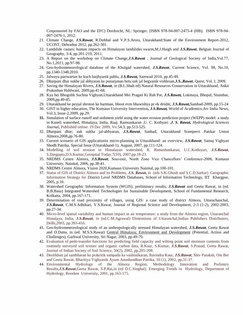
45. Impact of human activities on geomorphic processes in the Almora region,Central Himalaya, India, J.S.Rawat,
Geeta Rawat, S.P.Rai, in (ed.O.Slymaker) Geomorphology, Human Activity and Global Change, John Wiley and
Sons, New York, 2000, pp.285-297.
46. Dissolved load of a Central Himalayan forest headwater in an experimental catchment,
India,M.S.Rawat,M.J.Haigh,J.Krecek,J.S.Rawat,Mitt.Geol-Palaont. Inst.Univ.Hamburg Marz, 1999, pp.185-195.
47. Integrated geo-bio-atmospheric study under varied ecological conditions in the Central Himalaya, J.S.Rawat, (in
ed.Das and Bahadur) The Himalayan Environment, New Age International (P) Limited, Publishers, New Delhi,
1999, pp.227-234.
48. Management of water resources: spring sanctuaries, S.P.Rai, K.S.Valdiya, J.S.Rawat, in (ed. K.S.Valdiya) The
Khulgad Project; An Experiment in Sustainable Development, Gyanodaya Prakashan, Nainital, 1998, pp.41-60.
49. Environmental Monitoring in the Central Himalaya, A Watershed Approach, J.S.Rawat,G.Rawat,S.P.Rai,in
Proceedings of the National Conference on Dimensions of Environmental Stress in India, Department of
Geology, Baroda University,1997,pp.109-118.
50. Pattern and intensity of erosion under stressed environment in the Khulgad Watershed, J.S. Rawat and S.P.Rai,
Journal of The Geological Society of India, 50,1997, pp.331-338.
51. Response of hydrologic cycle to environmental degradation in the Khulgad Watershed, Central Himalaya,
J.S.Rawat, S. P. Rai, K. S. Valdiya, in Sustainable Replicable Eco-Development in Central Himalaya
(ed.S.L.Shah), Almora Book Depot., Almora, 1997,pp.127-161.
52. Land system mapping in sustainable land utilization, J.S.Rawat and Geeta Rawat, Land Utilization in the
Central Himalaya: Problems and Management Options, Indus Publishing Company, New Delhi, 1997, pp.155-
176.
53. Impact of human activities on hydrological systems of Kumaun Himalaya, J.S.Rawat, Afroj Ahmed, Geeta
Rawat, Research in Geography (ed. R.B. Singh), New Delhi,1996, pp. 263-276.
54. Tectonic geomorphology of the Nana Kosi Basin, J.S.Rawat and M.S.Rawat, in Indian Geomorphology
(ed.S.R.Jog), Vol.II, Rawat Publication, Jaipur, 1995, pp.57-74.
55. Road construction and environmental hazards: case study from two Kumaun hill roads, J.S. Rawat, M.S.Rawat
and Jyoti Shastri, in Indian Geomorphology, (ed.S.R.Jog), Vol.II,, Rawat Publication,Jaipur,1995,pp.297-306.
56. Interaction between forest and landslide activity along new highways in the Kumaun
Himalaya,M.J.Haigh,J.S.Rawat, M.S.Rawat,S.K.Bartarya and S.P.Rai, Forest Ecology and Management,
U.S.A.,78,1995,pp.173- 189.
57. Kumaun Himalaya ke Khulgad jalagam mei van vinash se prabhawit aperdan dar ka prayogik adhyan, S.P.Rai and
J.S.Rawat, Proc. National Syamposium on Jal Vighyan and Jal Sansadhan, National Institute of Hydrology,
December 1995, pp.275-281.
58. Tectonic Geomorphology of the Nana Kosi watershed, J.S.Rawat and M.S.Rawat, in Indian Geomorphology,
(ed.S.R.Jog), Vol.II, Rawat Publi., Jaipur, 1995, pp.57-73.
59. Land denudation by mass wasting in the Central Himalaya, J. Shastri, J.S.Rawat, India : Geomorphological
Diversity (ed. Dixit, Kale, Kaul) Jaipur, 1994, pp.172-186.
60. Anthropogenic transformation of sheetwash erosion: an experimental study from Kumaun, J.S. Rawat,
M.S.Rawat, India: Geomorphological Diversity (ed. Dixit, Kale, Kaul ), Jaipur, 1994, pp.187 – 201.
61. Accelerated erosion and denudation in the Nana Kosi Watershed, Central Himalaya, India, J.S.Rawat and
M.S.Rawat, Mountain Research and Development, U.S.A., 14(10), 1994, pp.25-38.
62. Accelerated erosion in the watershed of the Nana Kosi, Central Himalaya, J. S. Rawat and M. S. Rawat,India:
Geomorphological Diversity (ed. Dixit,Kaul,Kale) Jaipur,1994, pp150-171.
63. Response of hydrologic cycle to environmental degradation in the Khulgad Watershed, Kumaun Himalaya,
J.S.Rawat and S.P.Rai, CHEA Bulletin, 6, 1993, pp.53-57.
64. Hydrologic responses of a Himalayan Pine forest micro-watershed, preliminary results, Proc. Intl. Symp. on
Hydrology of Mountainous Areas, J.S. Rawat, National Institute of Hydrlogy, Roorkee, 1993, pp.235-258.
65. The Nana Kosi Watershed, Central Himalaya, India, Part – II, human impact on stream runoff, J.S.Rawat and
M.S.Rawat, Mountain Research and Development, U.S.A, 14(3), 1993, pp. 225-260
66. Factor affecting landslide morphology along new highways in the Central Himalaya, M.J.Haigh, J.S.Rawat,
S.K.Bartarya and M.S.Rawat, Japanese Geomorphological Union, Japan, 14,1993,pp.99-123.
67. Environmental influences of landslide activity: Almora by Pass, Kumaun Lesser Himalaya, M. J. Haigh,
J.S.Rawat, S.K.Bartarya Natural Hazard, Netherlands, 1993, pp.153-170.
68. Representative basin studies in Malaprabha and Ghataprabha basins, J.S.Rawat, B.K.Purendra, National Institute
of Hydrology Roorkee, 1992-93,pp. 1-93.
69. The use of principal component analysis in geomorphology, J. S. Rawat et al., Indian Journal of Landscape
System and Ecological Studies, 5(122), 1992, pp.43-53.
70. Environmental degradation due to population pressure, migration and settlement; a case study of Central
Himalaya, J.S. Rawat, S.C.Rai and A. Ahmad, Dynamics of Mountain Geosystems (ed.R.B.Singh), Ashok
Publishing House, New Delhi,1992, pp.222-246.
71. Hydrological responses of Himalayan pine forest,the Animal Park Project: preliminary results, J.S.Rawat, M. J.
Haigh, M.S.Rawat, Pro. Intr. Symp. Hydro. Mounts. Areas, National Institute of Hydrology, 1992, pp.235-258.
72. Analysis of landslide :Kilbary Road,Kumaun Himalaya jointly with M.J.Haigh, J.S.Rawat, S.K.Bartarya,
M.S.Rawat, Current Science,62(2),1992, pp.518-522.
73. Sediment discharges from a Himalayan Pine headwater, M.S.Rawat, J.S.Rawat and M.J. Haigh, Environmental
Regeneration (ed.Krecek and Haigh), Prague Soc. of the Jizera Mountain, Czech.Republic,1992,pp.182-187.
74. Channel runoff in the oak forest watersheds in Kumaun Himalaya, J.Shastri, M.S.Rawat and J.S.Rawat,
Geographical Review of India,52(4),1990,pp.84-86.
75. An analysis of Himalaya Environment and guidelines for its management and ecologically sustainable
development, A.Ahmed, J.S.Rawat and S.C.Rai, The Environmentalist, London, 10(4),1990, pp.281-298.
76. Channel Network Capacity and Geochemical Properties of Stream Water, J.S.Rawat, Proceedings of Group
Monitoring in Earth Sciences, D.S.T.New Delhi,1990, pp.11-15.
77. Environmental indicators of landslide activity along the Kilbury Road, Nainital, Kumaun Lesser
Himalaya,M.J.Haigh,J.S.Rawat and S.K.Bartarya, Mountain Research and Evelopment, U.S.A., 9(1), 1989,
pp.25-33.
78. Capacity of channel runoff in the agricultural land, Central Himalayan watersheds, A.Bhatt, J.S.Rawat,
Transaction; Indian Institute of Geographers, 11(1),1989.pp.33-37.
79. Capacity of channel runoff in the pine forest watershed, Central Lesser Himalaya, M.S.Rawat and J.S.Rawat,
Prospective in Aquatic Biology (ed. Khulbe), Papyrus Publishing House, New Delhi,1989,pp.515-519.
80. Towards an epistemology of environmental sciences, J.S. Rawat, M. Joshi, Prospective in Aquatic Biology (ed.
Khulbe), Papyrus Publishing House, New Delhi, 1989, pp.521-525.
81. Dwindling capacity of Naini Lake, J.S.Rawat, Himalaya; Man and Nature, January-February, 1988, pp.17-18.
82. Water resources and burning hydrological problems of Kumaun, J.S.Rawat, in (ed.K.S.Valdiya) Kumaun Land
and People, Gyanodaya Prakashan, Nainital, 1988, pp.201-212.
83. Geomorphology and tectonic history of the South Almora Thrust Zone near Kakarighat, Nainital District (UP),
India, J.S. Rawat, in (ed. Singh and Tewari) Geomorphology and Environment, Allahabad Geographical Society,
Allahabad, 1988, pp.326-336.
84. Environmental correlates of landslide frequency along new highways in the Himalaya: preliminary results,
CATENA Supplement 15, Germany, M.J.Haigh, J.S.Rawat and S.K.Bartarya,1988,pp.533-5503.
85. Sources of water erosion damage to new highways, Uttrakhand, Lesser Himalaya, India, M.J.Haigh, J.S.Rawat
and K.S.Bartaya, Proc. Intrrl. Symp. On Wate Erosion, VARNA, BULGARIA, UNESCO, IPH/ MAB, Sofia,
1988, pp.65-70.
86. Hydrological impact of deforestation in Central, Himalaya,M.J.Haigh, J.S.Rawat and H.S.Bisht,Hydrology in
Mountainous Areas,Czechoslovakia, IAHS Pub .No. 190, 1988,pp.419-433.
87. Entropy minimiging landscape system, M.J.Haigh, J.S.Rawat, S.K.Bartarya, Current Science, 47, 1988, pp. 1000-
1002.
88. Capacity of channel runoff in the pine forested Central Lesser Himalayan watershed, M. S. Rawat and
J.S.Rawat Prospective in Aquatic Biology ( ed. Khulbe), Papyrous Publishing House, New
Delhi,1988,pp.515-519.
89. Water resources and their burning hydrological problems,J.S.Rawat, Kumaun Land and People
(ed.K.S.Valdiya),Gyanodaya Prakashan,Nainital,1988, pp.201 – 212.
90. Geomorphic outline of the Nainital Watershed, J.S. Rawat, Geographical Review of India, 50, 1, 1988, pp.53-63.
91. Anthropogenic transformation of channel network capacity: an experimental study in Kumaun Himalaya,
J.S.Rawat, Proc. Indian National Science Academy, 54 A, 1988, pp.605-615.
92. Modelling of water and sediment budget: concept and strategies, J.S.Rawat, CATENA Supplement 10, A
Cooperative Journal of the International Society of Soil Science, West Germany, 1987, pp.147-159. .
93. Morphology and morphometry of Naini Lake Basin, J.S.Rawat, Journal of the Geological Society of India, 30(6),
1987, pp.493-498.
94. Impact of hillroad on downslope forest,M.J.Haigh,J.S.Rawat and S.K.Bartarya, Himalaya Man And Nature,
11(4), 1987, pp.2-3.
95. Prediction of silt delivery of the non-glacial fed Himalayan streams draining to the crystalline rocks,
J.S.Rawat, Impact of Environmental Protection on Future Development In India, Institute of
Engineers,Lucknow,1987,pp.308-309.
96. Impact of hill roads on down slope forest cover, M.J.Haigh, J.S.Rawat, S. Bartarya, Himalaya; Man and Nature,
11(4), September, 1987, pp.2-3.
97. Curve fitting between water discharge and silt delivery; an example from a Lesser Himalayan River,
J.S.Rawat and M.M.Tewari, Himalayan Journal of Sciences,4(1),1987,pp.11-20.
98. Rates of silt delivery from Binno Basin, Garhwal Himalaya, J.S.Rawat, Indian Journal of Landscape System
and Ecological System, 10(2), 1986,pp.41-43.
99. Geomorphic study of the Balia Valley along Main Boundary Fault, District Nainital, J.S.Rawat, Indian Journal
of Landscape System and Ecological Studies, 9(11),1986, pp.134-142.
100. Morphometry applied to Kakarghat area of the Kumaun Himalaya, J.S. Rawat, Indian Journal of Landscape
System and Ecological Studies, 8(11),1985, pp.43-54.
101. Hydrometric implications of morphometry and geology, J.S. Rawat, Journal of the Geological Society of India,
25 (10), 1985, pp.434-443.
102. Relation between stream water discharge and silt delivery in the lesser Himalaya, J.S.Rawat and M.M.Tewari,
Geographical Review of India, 47 (30), 1985, pp.88-90.
103. The Upper Ramganga Catchment: a quantitative geomorphic analysis, J.S.Rawat and S.C.Joshi, Geographical
Review of India, 47(1),4, 1985,pp.19-24.
104. The drainage basin as a unit for physical environmental studies,J.S.Rawat,in Environmental Regeneration,
(ed.J.S.Singh) Gyanodaya Prakashan, Nainital, 1985, pp.427-434.
105. Outline of the geomorphology of the Patali Doon Valley; Central U.P. Himalaya, S. C. Joshi,J.S.Rawat and
D.C.Pandey, Geographical Mosaic, Culcutta, 1985, pp. 146-154.
106. A new gravity model of interaction areas of central place system, D.C.Pandey and J.S. Rawat, Modern
Geographic Trends (ed.P.Pandey),Today and Tomorrow Printer & Publisher, New Delhi 1984,pp.445-458.
107. Polycyclic landscape and its relationships with tectonic instability and palaeoclimate, J. S. Rawat,
D.C.Pandey, P.C.Tewari, Transaction; Indian Institute of Geographers,6,1984.pp.28-33.
108. Himalaya ke krol kram ke chattanu kee bhuakariki, J.S.Rawat and D.C.Pandey, Vikassheel Bhugol Patrika,
2(17),1983.pp.60-65.
109. Sikurati hui Naini Lake: Bartman tatha Bhavishya ka Paryavaran, J.S. Rawat, Hillance, 1983, p.3.
110. Centrality and ranking of settlement -a comparative study, J.S. Rawat, jointly with P.C.Tewari, D.
C. Pandey, The Deccan Geographer, 21 ( 3 ), 1983, pp. 391-401.
111. Metamorphism and development of morphometric parameters, J.S.Rawat and S. C. Joshi, Journal of the
Geological Society of India, 25(5), 1983, pp.284-253.
112. Himalaya ke Krol kram kee chattanu kee bhooakariki, J.S.Rawat and D.C.Pandey, Vikasheel Bhoogol Patrika, 2
(1), 1983,pp.60-65.
113. Himalayan streams; their capacity and environmental degradation, J. S. Rawat and S.C.Joshi, Himalayan
Research and Development, 2(1), 1983,PP.47- 51.
114. Himalayan streams: their capacity and environmental degradation, J.S.Rawat and S.C.Joshi, Himalayan
Research and Development, 2(1), 1983, pp.47-51.
115. Morphometric personality of Himalayan tectonic units, J.S.Rawat and S. C.Joshi, Transaction, Indian
Institute of Geographers, 4 (2), 1982, pp.185-190.
116. Geomorphic imprints of neotectonic movements, an illustration from Ramganga Catchment, U. P.
Himalaya, J. S. Rawat and M. Chand, Himalayan Research and Development, 1(1), 1982, pp.106- 107.
117. Channel morphometry indices and stream discharge in the Kumaun Himalaya,S.Cjoshi and J.S.Rawat,
Geographical Review of India,44,1982,pp71-78.
118. River sinuosity in Sona Basin, its significance in landscape analysis, J.S.Rawat, Geographical Review of
India,42(2), 1980,pp.701-702.
119. A quantitative morphometric analysis of stratigraphic formations in the Lower Ramganga Catchment, J.S.
Rawat, Himalayan Geology, 9, 1979, pp.701 – 715.
10. Conference/Seminar/Workshops organized:46 (Forty Six)
S/N Status as
organizer
Title of the conference/seminar/Workshop Year and
dates
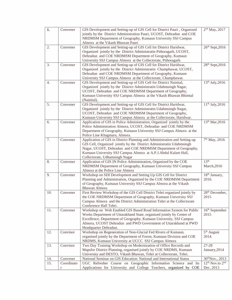
1. Convener GIS Development and Setting-up of GIS Cell for District Pauri , Organized
jointly by the District Administration Pauri, UCOST, Dehradun and COE
NRDMSM Department of Geography, Kumaun University SSJ Campus
Almora at the Vikash Bhawan Pauri
2nd May, 2017
2. Convener GIS Development and Setting-up of GIS Cell for District Haridwar,
Organized jointly by the District Administratin Pithoragarh, UCOST,
Dehradun and COE NRDMSM Department of Geography, Kumaun
University SSJ Campus Almora at the Collectorate, Pithoragarh.
26th Sept,2016
3. Convener GIS Development and Setting-up of GIS Cell for District Haridwar,
Organized jointly by the District Administratin Champhawat, UCOST,
Dehradun and COE NRDMSM Department of Geography, Kumaun
University SSJ Campus Almora at the Collectorate, Champhawat.
28th Sept,2016
4. Convener GIS Development and Setting-up of GIS Cell for District Nainital,
Organized jointly by the District Administratin Udahmsingh Nagar,
UCOST, Dehradun and COE NRDMSM Department of Geography,
Kumaun University SSJ Campus Almora at the Vikash Bhawan Bhimtal
(Nainital).
13th July,2016
5. Convener GIS Development and Setting-up of GIS Cell for District Haridwar,
Organized jointly by the District Administratin Udahmsingh Nagar,
UCOST, Dehradun and COE NRDMSM Department of Geography,
Kumaun University SSJ Campus Almora at the Collectorate, Haridwar.
11th July,2016
6. Convener Application of GIS in Police Administration, Organized jointly by the
Police Administration Almora, UCOST, Dehradun and COE NRDMSM
Department of Geography, Kumaun University SSJ Campus Almora at the
Police Line Khagmara, Almora.
13th Mar,2016
7. Convener Application of GIS in District Planning and Administration and Setting-up
GIS Cell, Organized jointly by the District Administratin Udahmsingh
Nagar, UCOST, Dehradun and COE NRDMSM Department of Geography,
Kumaun University SSJ Campus Almora at A.P.J.Abdul Kalam Hall,
Collectorate, Udhamsingh Nagar
7th May, 2016
8. Convener Application of GIS IN Police Administration, Organized by the COE
NRDMSM Department of Geography, Kumaun University SSJ Campus
Almora at the Police Line Almora
13th
March,2016
9. Convener Workshop on SDI Development and Setting Up GIS Cell for District
Planning and Administration, Organized by the COE NRDMSM Department
of Geography, Kumaun University SSJ Campus Almora at the Vikash
Bhawan Almora
18th January,
2016.
10. Convener First Review Workshop of the GIS Cell District Tehri organized jointly by
the COE NRDMSM Department of Geography, Kumaun University SSJ
Campus Almora and the District Administration Tehri at the Collectorate
Conference Hall Tehri.
28th December,
2015
11. Convener Workshop on Web Enabled GIS Based Road Information System for Public
Works Department of Uttarakhand State, organized jointly by Centre of
Excellence, Department of Geography, Kumaun University, SSJ Campus
Almora, UCOST Dehradun and PWD Government of Uttarakhand at PWD
Headquarter Dehradun.
16th September
2015
12. Convinor Workshop on Regeneration of Non-Glacial Fed Rivers of Kumaun,
organised jointly by the Department of Forest, Kumaun Division and COE
NRDMS, Kumaun University at UCCC SSJ Campus Almora
5th August
2014.
13.
Convinor Two Day Training Workshop on Modernization of Office Records and
Mapsfor District Planning, organised jointly by COE NRDMS, Kumaun
University and DESTO, Vikash Bhawan, Tehri at Collectorate, Tehri.
27-28
January,2014
14. Convener National Seminar on GIS Education: National and International Status 30thNov., 2013
15. Coordinato
r
UGC Refresher Course on Geographic Information Science and Its
Applications for University and College Teachers, organized by COE
12th Nov.to 2nd
Dec. 2013
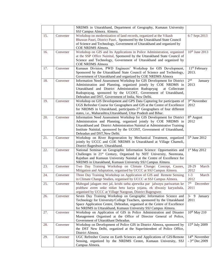
NRDMS in Uttarakhand, Department of Geography, Kumaun University
SSJ Campus Almora. Almora.
15. Convener Workshop on modernization of land records, organized at the Vikash
Bhawan Pauri, District Pauri, Sponsored by the Uttarakhand State Council
of Science and Technology, Government of Uttarakhand and organized by
COE NRDMS Almora.
6-7 Sept.2013
16. Convener Workshop on GIS and Its Applications in Police Administration, organized
at the SSP Office Nainital, Sponsored by the Uttarakhand State Council of
Science and Technology, Government of Uttarakhand and organized by
COE NRDMS Almora
10th June 2013
17. Convener Kumaun Division, PWD Engineers’ Workshop for GIS Development,
Sponsored by the Uttarakhand State Council of Science and Technology,
Government of Uttarakhand and organized by COE NRDMS Almora
11th February
2013.
18. Convener Information Need Assessment Workshop for GIS Development for District
Administration and Planning, organized jointly by COE NRDMS in
Uttarakhand and District Administration Rudrapryag at Collectrate
Rudraprayag, sponsored by the UCOST, Government of Uttarakhand,
Dehradun and DST, Government of India, New Delhi.
2nd January
2013
19. Convener Workshop on GIS Development and GPS Data Capturing for participants of
UGS Refresher Course for Geographers and GIS at the Centre of Excellence
for NRDMS in Uttarakhand, participants-27 Geographers of four different
states, i.e., Maharashtra,Uttarakhand, Uttar Pradesh and Bihar.
3rd November
2012
20. Convener Information Need Assessment Workshop for GIS Development for District
Administration and Planning, organized jointly by COE NRDMS in
Uttarakhand and District Administration Nainital at Administrative Training
Institute Nainital, sponsored by the UCOST, Government of Uttarakhand,
Dehradun and DST,New Delhi.
8th August
2012
21. Convener Workshop on River Regeneration by Mechanical Treatment, organized
jointly by UCCC and COE NRDMS in Uttarakhand at Village Chamoli,
District Bageshwer, Uttarakhand.
5th June 2012
22. Convener National Seminar on Geographic Information Science: Opportunities and
Challenges in 21st Century, Organised by NIIT University, Neemrana,
Rajsthan and Kumaun University Nainital at the Centre of Excellence for
NRDMS in Uttarakhand, Kumaun University SSJ Campus Almora.
1st May 2012
23. Convener Two Day Training Workshop on Climate Change: Concept, Causes,
Mitigation and Adaptation, organised by UCCC at SSJ Campus Almora.
28-29 March
2012
24. Convener Three Day Training Workshop on Application of GIS and Remote Sensing
in Climate Change Studies, organised by UCCC at SSJ Campus Almora.
1-3 March
2012
25. Convener Mahogad jalagam mei jal, krishi tatha ajeewika par jalwayu pariwartan ke
prabhaw avem unke nidan hetu karya yojana, ek diwasiy karyashala,
organised by UCCC at Village Naogoun, District Bagesgwer.
7th December
2011
26. Convener Seven Day Training Workshop on Geographic Information Science and
Technology for University/College Teachers, sponsored by the Uttarakhand
Space Application Centre, Dehradun, organised at the Centre of Excellence
for NRDMS in Uttarakhand, Kumaun University SSJ Campus Almora.
3- 9 January
2011
27. Convener Workshop on Application of GIS in Police Administration and Disaster
Management Organised at the Office of Director General of Police,
Government of Uttarakhant Dehradun.
10th May 210
28. Convener Workshop on Development of Police GIS in District Almora, sponsored by
the DST New Delhi, organized at the Superintendent of Police Office,
District Almora.
15th July 2009
29. Convener UGC Refresher Course on Earth Sciences and Applications of GIS/Remote
Sensing, organized by the NRDMS Centre, Kumaun University, SSJ
Campua Almora.
14th November
- 3rd Dec.2009
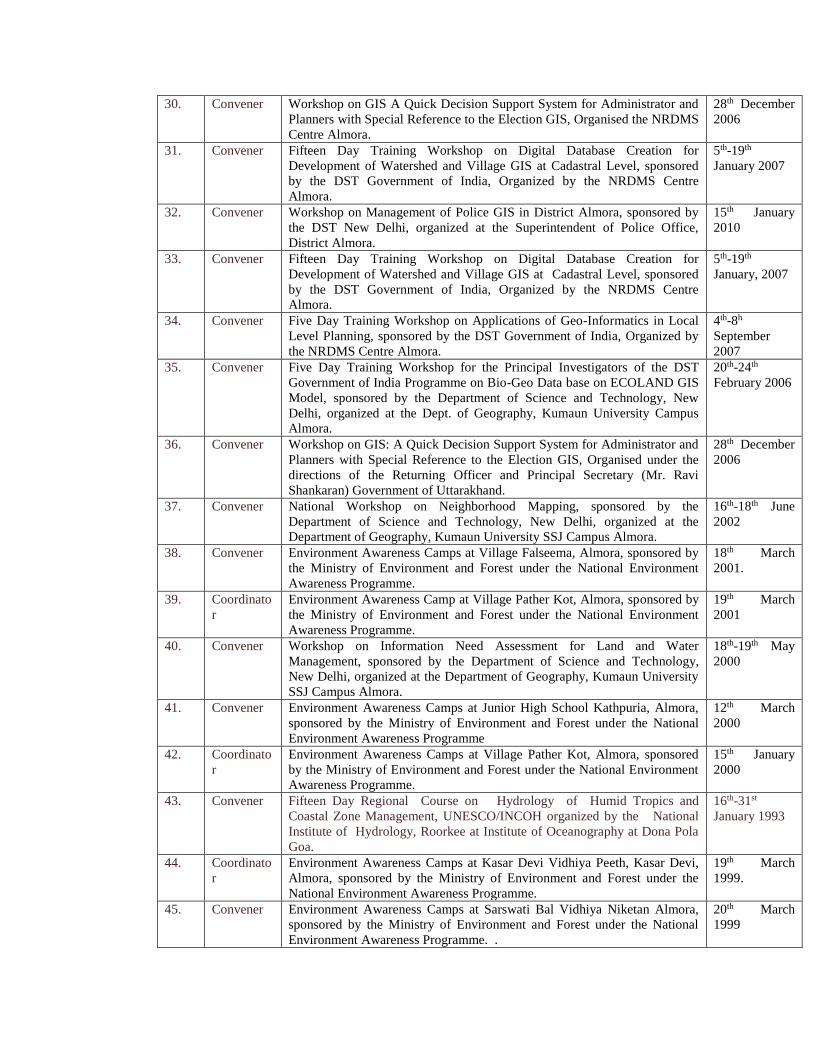
30. Convener Workshop on GIS A Quick Decision Support System for Administrator and
Planners with Special Reference to the Election GIS, Organised the NRDMS
Centre Almora.
28th December
2006
31. Convener Fifteen Day Training Workshop on Digital Database Creation for
Development of Watershed and Village GIS at Cadastral Level, sponsored
by the DST Government of India, Organized by the NRDMS Centre
Almora.
5th-19th
January 2007
32. Convener Workshop on Management of Police GIS in District Almora, sponsored by
the DST New Delhi, organized at the Superintendent of Police Office,
District Almora.
15th January
2010
33. Convener Fifteen Day Training Workshop on Digital Database Creation for
Development of Watershed and Village GIS at Cadastral Level, sponsored
by the DST Government of India, Organized by the NRDMS Centre
Almora.
5th-19th
January, 2007
34. Convener Five Day Training Workshop on Applications of Geo-Informatics in Local
Level Planning, sponsored by the DST Government of India, Organized by
the NRDMS Centre Almora.
4th-8h
September
2007
35. Convener Five Day Training Workshop for the Principal Investigators of the DST
Government of India Programme on Bio-Geo Data base on ECOLAND GIS
Model, sponsored by the Department of Science and Technology, New
Delhi, organized at the Dept. of Geography, Kumaun University Campus
Almora.
20th-24th
February 2006
36. Convener Workshop on GIS: A Quick Decision Support System for Administrator and
Planners with Special Reference to the Election GIS, Organised under the
directions of the Returning Officer and Principal Secretary (Mr. Ravi
Shankaran) Government of Uttarakhand.
28th December
2006
37. Convener National Workshop on Neighborhood Mapping, sponsored by the
Department of Science and Technology, New Delhi, organized at the
Department of Geography, Kumaun University SSJ Campus Almora.
16th-18th June
2002
38. Convener Environment Awareness Camps at Village Falseema, Almora, sponsored by
the Ministry of Environment and Forest under the National Environment
Awareness Programme.
18th March
2001.
39. Coordinato
r
Environment Awareness Camp at Village Pather Kot, Almora, sponsored by
the Ministry of Environment and Forest under the National Environment
Awareness Programme.
19th March
2001
40. Convener Workshop on Information Need Assessment for Land and Water
Management, sponsored by the Department of Science and Technology,
New Delhi, organized at the Department of Geography, Kumaun University
SSJ Campus Almora.
18th-19th May
2000
41. Convener Environment Awareness Camps at Junior High School Kathpuria, Almora,
sponsored by the Ministry of Environment and Forest under the National
Environment Awareness Programme
12th March
2000
42. Coordinato
r
Environment Awareness Camps at Village Pather Kot, Almora, sponsored
by the Ministry of Environment and Forest under the National Environment
Awareness Programme.
15th January
2000
43. Convener Fifteen Day Regional Course on Hydrology of Humid Tropics and
Coastal Zone Management, UNESCO/INCOH organized by the National
Institute of Hydrology, Roorkee at Institute of Oceanography at Dona Pola
Goa.
16th-31st
January 1993
44. Coordinato
r
Environment Awareness Camps at Kasar Devi Vidhiya Peeth, Kasar Devi,
Almora, sponsored by the Ministry of Environment and Forest under the
National Environment Awareness Programme.
19th March
1999.
45. Convener Environment Awareness Camps at Sarswati Bal Vidhiya Niketan Almora,
sponsored by the Ministry of Environment and Forest under the National
Environment Awareness Programme. .
20th March
1999
46. Convener Environment Awareness Camps at Primary Pathshala Kayala, Almora,
sponsored by the Ministry of Environment and Forest under the National
Environment Awareness Programme. .
28th March
1999
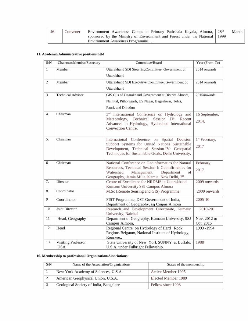
11. Academic/Administrative positions held
S/N Chairman/Member/Secretary Committee/Board Year (From-To)
1 Member Uttarakhand SDI SteerringCommittee, Government of
Uttarakhand
2014 onwards
2 Member Uttarakhand SDI Executive Committee, Government of
Uttarakhand
2014 onwards
3 Technical Advisor GIS Clls of Uttarakhand Government at District Almora,
Nainital, Pithoragarh, US Nagar, Bageshwar, Tehri,
Pauri, and Dhradun
2015onwards
4. Chairman 3rd International Conference on Hydrology and
Meteorology, Technical Session IV: Recent
Advances in Hydrology, Hyderabad International
Convection Centre,
16 September,
2014.
5. Chairman International Conference on Spatial Decision
Support Systems for United Nations Sustainable
Development, Technical Session-IV: Geospatial
Techniques for Sustainable Goals, Delhi University,
1st February,
2017
6 Chairman National Conference on Geoinformatics for Natural
Resources, Technical Session-I: Geoinfirmatics for
Watershed Management, Department of
Geography, Jamia Milia Islamia, New Delhi, 7th
February,
2017.
7. Director Centre of Excellence for NRDMS in Uttarakhand
Kumaun University SSJ Campus Almora
2009 onwards
8. Coordinator M.Sc (Remote Sensing and GIS) Programme 2009 onwards
9 Coordinator FIST Programme, DST Government of India,
Department of Geography, ssj Cmpus Almora
2005-10
10. Joint Director Research and Development Directorate, Kumaun
University, Nainital
2010-2011
11 Head, Geography Department of Geography, Kumaun University, SSJ
Campus Almora,
Nov. 2012 to
Oct. 2015 12 Head Regional Centre on Hydrology of Hard Rock
Regions Belgaum, National Institute of Hydrology,
Roorkee,.
1993 -1994
13 Visiting Professor
USA
State University of New York SUNNY at Buffalo,
U.S.A. under Fulbright Fellowship.
1988
16. Membership to professional Organization/Associations:
S/N Name of the Association/Organizations Status of the membership
1 New York Academy of Sciences, U.S.A. Active Member 1995
2 American Geophysical Union, U.S.A. Elected Member 1989
3 Geological Society of India, Bangalore Fellow since 1998
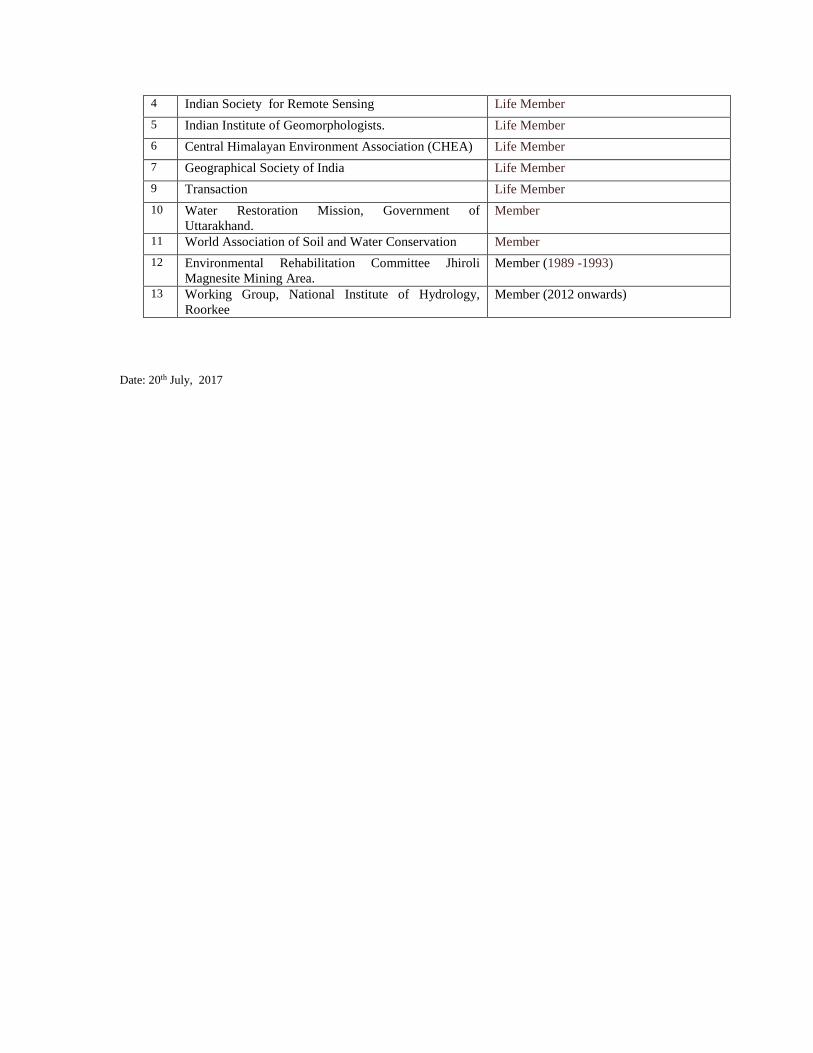
4 Indian Society for Remote Sensing Life Member
5 Indian Institute of Geomorphologists. Life Member
6 Central Himalayan Environment Association (CHEA) Life Member
7 Geographical Society of India Life Member
9 Transaction Life Member
10 Water Restoration Mission, Government of
Uttarakhand.
Member
11 World Association of Soil and Water Conservation Member
12 Environmental Rehabilitation Committee Jhiroli
Magnesite Mining Area.
Member (1989 -1993)
13 Working Group, National Institute of Hydrology,
Roorkee
Member (2012 onwards)
Date: 20th July, 2017
ACADEMIC PROFILE OF FACULTY MEMBER
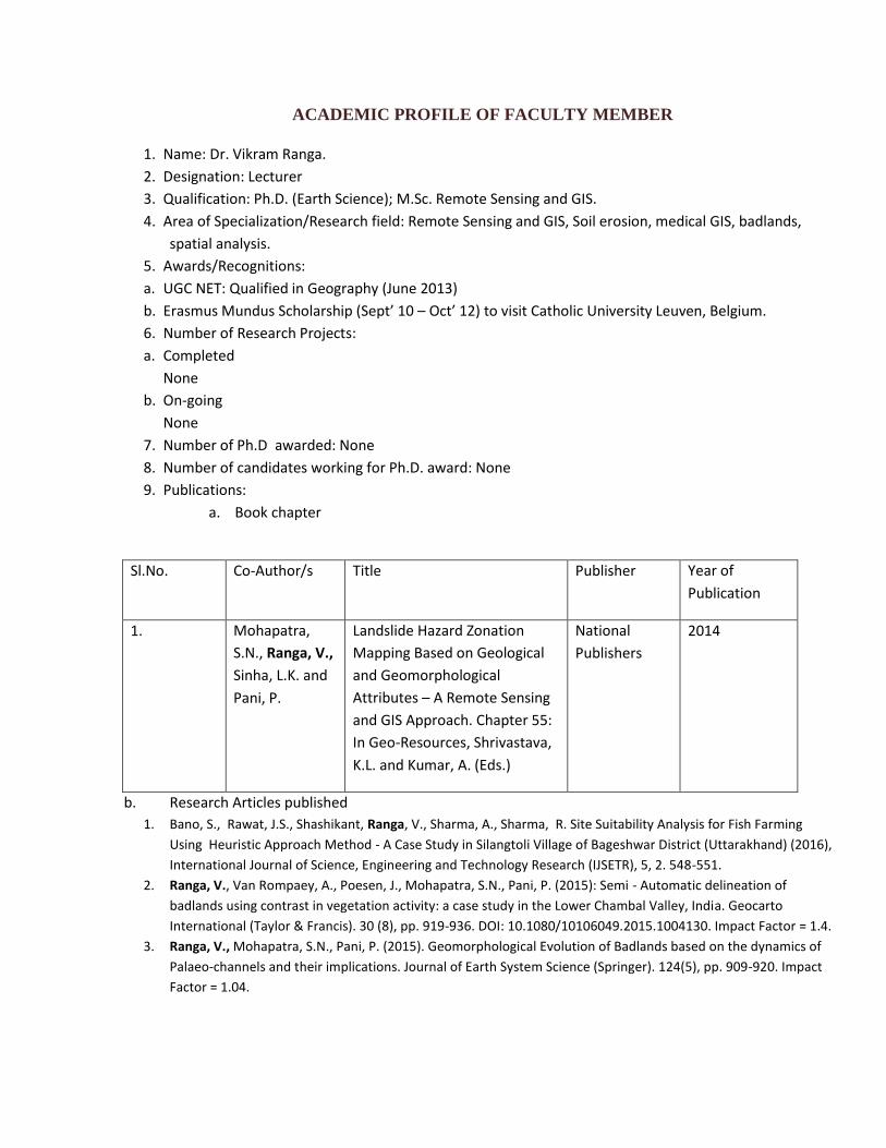
1. Name: Dr. Vikram Ranga.
2. Designation: Lecturer
3. Qualification: Ph.D. (Earth Science); M.Sc. Remote Sensing and GIS.
4. Area of Specialization/Research field: Remote Sensing and GIS, Soil erosion, medical GIS, badlands,
spatial analysis.
5. Awards/Recognitions:
a. UGC NET: Qualified in Geography (June 2013)
b. Erasmus Mundus Scholarship (Sept’ 10 – Oct’ 12) to visit Catholic University Leuven, Belgium.
6. Number of Research Projects:
a. Completed
None
b. On-going
None
7. Number of Ph.D awarded: None
8. Number of candidates working for Ph.D. award: None
9. Publications:
a. Book chapter
b. Research Articles published
1. Bano, S., Rawat, J.S., Shashikant, Ranga, V., Sharma, A., Sharma, R. Site Suitability Analysis for Fish Farming
Using Heuristic Approach Method - A Case Study in Silangtoli Village of Bageshwar District (Uttarakhand) (2016),
International Journal of Science, Engineering and Technology Research (IJSETR), 5, 2. 548-551.
2. Ranga, V., Van Rompaey, A., Poesen, J., Mohapatra, S.N., Pani, P. (2015): Semi - Automatic delineation of
badlands using contrast in vegetation activity: a case study in the Lower Chambal Valley, India. Geocarto
International (Taylor & Francis). 30 (8), pp. 919-936. DOI: 10.1080/10106049.2015.1004130. Impact Factor = 1.4.
3. Ranga, V., Mohapatra, S.N., Pani, P. (2015). Geomorphological Evolution of Badlands based on the dynamics of
Palaeo-channels and their implications. Journal of Earth System Science (Springer). 124(5), pp. 909-920. Impact
Factor = 1.04.
Sl.No. Co-Author/s Title Publisher Year of
Publication
1. Mohapatra,
S.N., Ranga, V.,
Sinha, L.K. and
Pani, P.
Landslide Hazard Zonation
Mapping Based on Geological
and Geomorphological
Attributes – A Remote Sensing
and GIS Approach. Chapter 55:
In Geo-Resources, Shrivastava,
K.L. and Kumar, A. (Eds.)
National
Publishers
2014
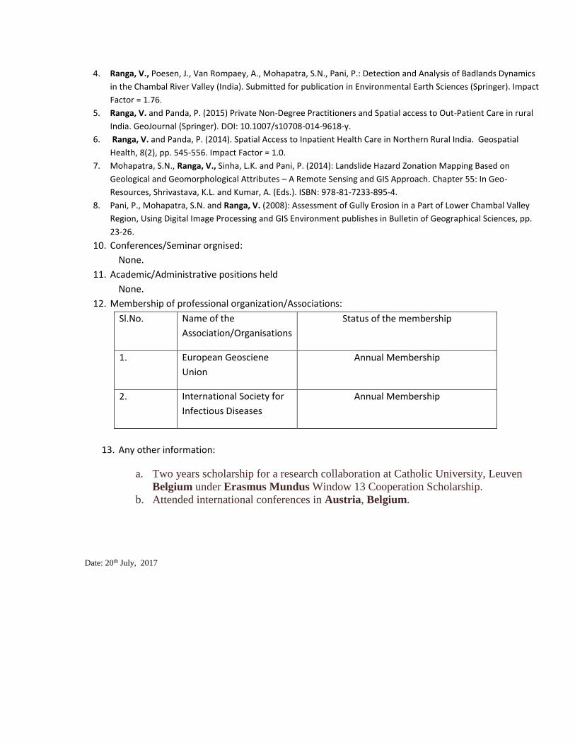
4. Ranga, V., Poesen, J., Van Rompaey, A., Mohapatra, S.N., Pani, P.: Detection and Analysis of Badlands Dynamics
in the Chambal River Valley (India). Submitted for publication in Environmental Earth Sciences (Springer). Impact
Factor = 1.76.
5. Ranga, V. and Panda, P. (2015) Private Non-Degree Practitioners and Spatial access to Out-Patient Care in rural
India. GeoJournal (Springer). DOI: 10.1007/s10708-014-9618-y.
6. Ranga, V. and Panda, P. (2014). Spatial Access to Inpatient Health Care in Northern Rural India. Geospatial
Health, 8(2), pp. 545-556. Impact Factor = 1.0.
7. Mohapatra, S.N., Ranga, V., Sinha, L.K. and Pani, P. (2014): Landslide Hazard Zonation Mapping Based on
Geological and Geomorphological Attributes – A Remote Sensing and GIS Approach. Chapter 55: In Geo-
Resources, Shrivastava, K.L. and Kumar, A. (Eds.). ISBN: 978-81-7233-895-4.
8. Pani, P., Mohapatra, S.N. and Ranga, V. (2008): Assessment of Gully Erosion in a Part of Lower Chambal Valley
Region, Using Digital Image Processing and GIS Environment publishes in Bulletin of Geographical Sciences, pp.
23-26.
10. Conferences/Seminar orgnised:
None.
11. Academic/Administrative positions held
None.
12. Membership of professional organization/Associations:
Sl.No. Name of the
Association/Organisations
Status of the membership
1. European Geosciene
Union
Annual Membership
2. International Society for
Infectious Diseases
Annual Membership
13. Any other information:
a. Two years scholarship for a research collaboration at Catholic University, Leuven
Belgium under Erasmus Mundus Window 13 Cooperation Scholarship.
b. Attended international conferences in Austria, Belgium.
Date: 20th July, 2017
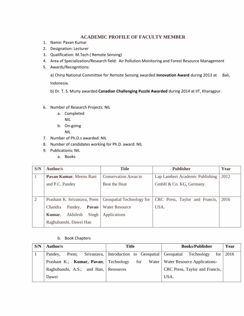
ACADEMIC PROFILE OF FACULTY MEMBER 1. Name: Pavan Kumar
2. Designation: Lecturer
3. Qualification: M.Tech ( Remote Sensing)
4. Area of Specialization/Research field: Air Pollution Monitoring and Forest Resource Management
5. Awards/Recognitions:
a) China National Committee for Remote Sensing awarded Innovation Award during 2013 at Bali,
Indonesia.
b) Dr. T. S. Murty awarded Canadian Challenging Puzzle Awarded during 2014 at IIT, Kharagpur.
6. Number of Research Projects: NIL
a. Completed
NIL
b. On-going
NIL
7. Number of Ph.D.s awarded: NIL
8. Number of candidates working for Ph.D. award: NIL
9. Publications: NIL
a. Books
S/N Author/s Title Publisher Year
1 Pavan Kumar, Meenu Rani
and P.C. Pandey
Conservation Areas to
Beat the Heat
Lap Lambert Academic Publishing
GmbH & Co. KG, Germany.
2012
2 Prashant K. Srivastava, Prem
Chandra Pandey, Pavan
Kumar, Akhilesh Singh
Raghubanshi, Dawei Han
Geospatial Technology for
Water Resource
Applications
CRC Press, Taylor and Francis,
USA.
2016
b. Book Chapters
S/N Author/s Title Books/Publisher Year
1 Pandey, Prem; Srivastava,
Prashant K.; Kumar, Pavan;
Raghubanshi, A.S.; and Han,
Dawei
Introduction to Geospatial
Technology for Water
Resources
Geospatial Technology for
Water Resource Applications-
CRC Press, Taylor and Francis,
USA.
2016
2 Pandey, Prem Chandra;
Raghubanshi, R. S.;
Mandal,Vinay;Tomar,Vandana;
Katiyar,Swati; Ravishankar, N.;
Kumar, Pavan and Nathawat,
M. S.
Spatial Integration of Rice
based Cropping Systems for
Soil and Water Quality
through Spatial Techniques.
Geospatial Technology for
Water Resource Applications-
CRC Press, Taylor and Francis,
USA.
2016
3 Tomar,Vandana; Khobragade,
Anand N.; Indal; Chandra
Pandey, Prem and Kumar,
Pavan
Envision of Geospatial
strategy to prepare Water
Resource Development Plan
in WGKKC2 watershed
Geospatial Technology for
Water Resource Applications-
CRC Press, Taylor and Francis,
USA.
2016
4 Bisht, Poonam; Rani, Meenu;
Kumar, Pavan; Yadav, Manoj;
Kumar, Manish & Hooda, R. S.
Change Detection of Gagas
River Basin in Almora, India
Using Geospatial Approach.
Climate Change and
Agriculture- Discovery
Publishing House, India.
2012
5 Gupta, Gargi; Singh, Jyoti;
Pandey, Prem Chandra; Tomar,
Vandana; Rani, Meenu and
Kumar, Pavan
Geospatial Strategy for
Estimation of Soil Organic
Carbon in Tropical Wildlife
Reserve
Remote Sensing Applications in
Environmental Research-
Springer Publisher, Las Vegas
USA.
2014
6 Sinha, Suman; Pandey, Prem
Chandra; Sharma, Laxmi Kant;
Nathawat, Mahendra Singh;
Kumar, Pavan and Kanga
Shruti
Remote Estimation of Land
Surface Temperature for
Different LULC Features of
a Moist Deciduous Tropical
Forest Region
Remote Sensing Applications in
Environmental Research-
Springer Publisher, Las Vegas
USA.
2014
c. Research Articles published
1. Tripathi, Bismay Ranjan; Tiwari, Vijay; Pandey, Vinita; Elvidge, Christopher; Rawat, J. S.; Sharma, M. P.; Pravasi,
Ravindra; Kumar, Pavan (2017). Estimation of Urban Population Dynamics using DMSP-OLS Night-time Lights
Time Series Sensors Data, Sensors Journal, IEEE, vol.7, no.4, pp. 1013 – 1020. (IF: 2.51).
2. Murthy,C.S.; Singh, J.; Kumar, Pavan.; and Sai, M.V.R.S. (2016). Meteorological drought analysis over India using
analytical framework on CPC rainfall time series. Natural Hazards. (IF: 1.83).
3. Kumar, Pavan, Pandey, P.C.; Singh, B.K.; Katiyar, S.; Mandal, V.; Rani, M.; and Tomar, V.; (2016). Estimation of
accumulated soil organic carbon stock in tropical forest using geospatial strategy, The Egyptian Journal of
Remote Sensing and Space Science. (Still Computing).
4. Pandey, P.C.; Kumar, Pavan., Yadav, M.; Katiyar, S.; Mandal, V.; Singh, R.K.; Tomar, V.; and Rani, M. (2015).
Vigorous Appraisal of Fluoride on Industrial Proponent in Thermal Power Plant over Anthropoid Biosphere Using
F- Ion Selective Electrode, Translational Engineering in Health and Medicine, IEEE Journal of, IEEE, Vol.3. (Still
Computing).
5. Pandey Prem Chandra; Kumar Pavan; Tomar Vandana; Rani Meenu; Katiyar Swati and Nathawat M.S. (2015).
Modelling spatial variation of fluoride pollutant using geospatial approach in the surrounding environment of an
aluminium industries. Environmental Earth Sciences, 1-12. (IF: 1.6).
6. Pandey Prem Chandra; Mandal Vinay; Katiyar Swati; Kumar Pavan; Tomar Vandana; Patairiya Shashikanta;
Ravisankar Natesan; Gangwar Babujee (2015). Geospatial Approach to Assess the Impact of Nutrients on Rice
Equivalent Yield using MODIS Sensors’ Based MOD13Q1-NDVI Data. Sensors Journal, IEEE, vol.15, no.1, pp. 6108
- 6115. (IF: 2.51).
7. Singh Kartar; Ghosh Mili; Sharma, S. R.; Kumar Pavan (2014). Blue-Red-NIR Model for Chlorophyll- a Retrieval in
Hypersaline-Alkaline Water Using Landsat ETM+ Sensor. IEEE Journal of Selected Topics in Applied Earth
Observations and Remote Sensing, vol. 7(8), 3553-3559. (IF: 2.92).
8. Pavan Kumar; Pandey, P.C.; Kumar, V.; Singh, B.K.; Tomar, V.; Rani, M., (2014). Efficient Recognition of Forest
Species Biodiversity by Inventory Based Geospatial Approach Using LISS IV. Sensors Journal, IEEE, vol.13, no.6,
pp. 2161-2165. (IF: 2.51).
9. Upasan; Singh Shalini; Tomar vandana; Pandey Prem Chandra; Rani Meenu; Kumar Pavan and Tomar Vandana
(2014). Geospatial Strategy for Assessment of Urban Change Dynamics using LISS III-Sensor. Bulletin of
Environmental and Scientific Research, Vol 3, No 4. (IF: Still Computing).
10. Manda,V.P.; Shutrana, S,; Pandey, P.C.; Patairiya, S.; Shamim, M.; and Sharma, S. (2014). Appraisal of
suitability for urban planning and expansion analysis using quick bird satellite data. ARPN Journal of Engineering
and Applied Sciences, 9 (12), 2716-2722.
11. Pandey Prem Chandra; Kumar Pavan; Rani Meenu; Katiyar Swayi and Tomar vandana (2014). Fluoride-induced
impact of aluminium industrial power plant on plants and human inhabiting areas. Geofizika Journal, Vol. 31,
151-168. (IF: 0.34).
12. Pavan Kumar, Vandana Tomar, Pragati Srivastava, Jyoti Singh, Gargi Gupta (2014). Geospatial Approach for
Carbon Sink in the Timbered Biomass for Tropical Wildlife Reserve. Asian Journal of Geoinformatics, Vol 14 (1),
1-7. (IF: Still Computing).
13. Vandana Tomar, Vinay Prasad Mandal, Pragati Srivastava, Shashikanta Patairiya, Kartar Singh, Natesan
Ravisankar, Natraj Subash and Pavan Kumar (2014). Rice Equivalent Crop Yield Assessment Using MODIS
Sensors’ Based MOD13A1-NDVI Data. Sensors Journal, IEEE, vol.13, no.6, pp. 2161-2165. (IF: 2.51).
14. Pavan Kumar (2014). Detection of UV-B-Induced Thymine Dimer in a Cyanobacterium, Scytonema sp. The
Journal of Microbiology, Biotechnology and Food Sciences, 8 (1) 1-17. (IF: 0.98).
15. Yadav, Manoj; Sharma, M. P.; Prawasi, P.; Khichi, Rajeev; Kumar, Pavan; Mandal, V. P.; Salim, Abdul and
Hooda, R. S. (2014). Estimation of Wheat/Rice Residue Burning Areas in Major Districts of Haryana, India, Using
Remote Sensing Data. Journal of the Indian Society of Remote Sensing, 42(2):343-352. (IF: 0.72).
16. Bisht, Poonam; Kumar, Pavan; Yadav, Manoj; Ravat, J. S.; Sharma, M. P. and Hooda, R. S. (2014). Spatial
Dynamics for Relative Contribution of Cropping Pattern Analysis on Environment by Integrating Remote Sensing
and GIS. International Journal of Plant Production, 4 (3), 299-304. (IF: 1.15).
17. Singh, Kartar, Kumar, Pavan; and Singh, Binay (2013). An Associative Relational Impact of Water Quality on Crop
Yield: A Comprehensive Index Analysis using LISS-III Sensor. Sensors Journal, IEEE, 13 (12), 4912-4917. (IF: 2.51).
18. Tomar, Vandana and Kumar, Pavan; Rani, Meenu; Gupta, Gargi; Singh, Jyoti (2013). Satellite-based Biodiversity
Dynamics Capability in Tropical Forest. The Electronic Journal of Geotechnical Engineering, 18 (Bund F):1171-
1180. (IF: 0.84).
19. Singh, Jyoti; Gupta, Gargi; Niharika; Kumar, Amit; Tomar, Vandana and Kumar, Pavan (2013). Smart Sensors and
Wireless Technology for Scrutinizing Civil Infrastructure. International Journal of Scientific and Engineering
Research, 4(5):1-4. (IF: 1.4).
20. Kumar, Pavan and Tomar, Vandana (2013). Monitoring of Traffic and its Impact on Environment Using
Geospatial Technology. Journal of Ecosystem Ecography, 3(1): 123. (IF: Still Computing).
21. Kumar, Pavan; Singh, Binay and Rani, Meenu (2013). An Efficient Hybrid Classification Approach for Land Use /
Land Cover Analysis in Semi-Desert Area using ETM+ and LISS-III Sensor. Sensors Journal, IEEE, vol.13, no.6, pp.
2161-2165. (IF: 1.85).
22. Kumar, Pavan; Sharma, L.K.; Pandey, P.C; Sinha Suman and Nathawat, M.S. (2012). Geospatial strategy for forest
biomass estimation of tropical forest of Sariska Wildlife Reserve (India). IEEE Journal of Selected Topics in
Applied Earth Observations and Remote Sensing, vol.6, no.2, pp.917-923. (IF: 2.92).
23. Kumar, Pavan; Kuma,r Dushyant; Mandal, V. P.; Pandey, P. C.; Rani, Meenu; Tomar, Vandana (2012). Settlement
Risk Zone Recognition Using High Resolution Satellite Data in Jharia Coal Field, Dhanbad, India. Life Science
Journal, 9(1s):1-6. (IF: 0.2).
24. Rani, Meenu; Kumar, Pavan; Yadav, Manoj & Hooda, R. S. (2011). Wetland Assessment and Monitoring Using
Image processing Techniques: A Case Study of Ranchi, India. Journal of Geographic Information System, 3, 345-
350. (IF: 0.65).
25. Sharma, M. P.; Yadav, Manoj; Yadav, Kirti; Prawasi, R.; Kumar, Pavan; and Hooda, R. S. (2011). Cropping System
Analysis Using Remote Sensing & GIS: A Block Level Study of Kurukshetra District. Journal of Agricultural and
Biological Science, 6(10): 45-61. (IF: Still Computing).
26. Kumar, Pavan; Rani, Meenu and Nath, Amar (2011). Role of Geospatial Techniques in Regional Pollution Control
Board: A Case Study of Varanasi City in India. Journal of Basic and Applied Scientific Research; 1(7): 798-802. (IF:
Still Computing).
27. Kumar, Pavan and Rani, Meenu (2011). Impact of Fluoride on Flora in and Around Hindalco Industries Ltd.,
Renukoot (India). Journal of Applied Environmental and Biological Science, 1(5): 81-83. (IF: Still Computing).
28. Kumar, Pavan; Rani, Meenu; Bisht, Poonam; Yadav, Manoj; Sharma, M. P.; Prawasi, R. and Hooda, R. S.(2011).
An Overview of Synthetic Aperture Radar and Its Applications. New York Science Journal; 4(6): 6-10. (IF: Still
Computing).
29. Rani, Meenu; Kumar, Pavan; Yadav, Manoj and Hooda, R. S. (2011). Role of Geospatial Techniques in Forest
Resource Management of Sariska Tiger Reserve (Rajasthan), India. New York Science Journal; 4(6): 77-82. (IF:
Still Computing).
30. Kumar, Pavan; Rani, Meenu; Pandey, P.C.; Arnab, Majumdar and Nathawat, M.S. (2010). Monitoring of
Deforestation and Forest Degradation Using Remote Sensing and GIS: A Case Study of Ranchi in Jharkhand
(India). Report and Opinion; 2(4):14-20. (IF: Still Computing).
10. Conferences/Seminar organized: NIL
11. Academic/Administrative positions held: NIL
12. Membership of professional organization/Associations:
Sl.No. Name of the Association/Organisations Status of the membership
1. Membership of National Environmental
Science Academy (NESA), New Delhi,
India
Life Time
13. Any other Information: Foreign countries visited under different
conference/seminar/workshop- Malaysia, China, Netherlands, France, Brazil, Indonesia and
Russia.
Date: 20th July, 2017
KUMAUN UNIVERSITY
SCHEME OF EXAMINATION
AND
COURSES OF STUDY
M.Sc. Remote Sensing and GIS
CENTRE OF EXCELLENCE FOR NRDMS IN UTTARAKHAND
DEPARTMENT OF GEOGRAPHY
KUMAUN UNIVERSITY
SSJ CAMPUS, ALMORA-263601
UTTARAKHAND
© KUMAUN UNIVERSITY
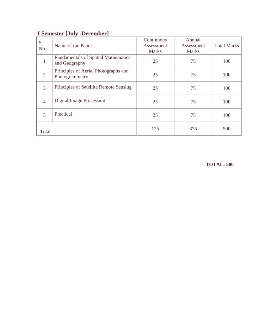
I Semester [July -December]
S.
No Name of the Paper
Continuous
Assessment
Marks
Annual
Assessment
Marks
Total Marks
1 Fundamentals of Spatial Mathematics
and Geography 25 75 100
2 Principles of Aerial Photographs and
Photogrammetry 25 75 100
3 Principles of Satellite Remote Sensing 25 75 100
4 Digital Image Processing 25 75 100
5 Practical 25 75 100
Total 125 375 500
TOTAL: 500
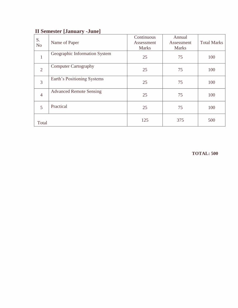
II Semester [January -June]
S.
No Name of Paper
Continuous
Assessment
Marks
Annual
Assessment
Marks
Total Marks
1 Geographic Information System
25 75 100
2 Computer Cartography
25 75 100
3 Earth’s Positioning Systems
25 75 100
4 Advanced Remote Sensing
25 75 100
5 Practical 25 75 100
Total 125 375 500
TOTAL: 500
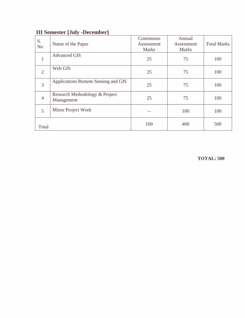
III Semester [July -December]
S.
No Name of the Paper
Continuous
Assessment
Marks
Annual
Assessment
Marks
Total Marks
1 Advanced GIS
25 75 100
2 Web GIS
25 75 100
3 Applications Remote Sensing and GIS
25 75 100
4 Research Methodology & Project
Management
25 75 100
5 Minor Project Work -- 100 100
Total 100 400 500
TOTAL: 500
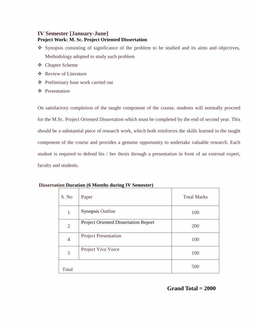
IV Semester [January-June] Project Work: M. Sc. Project Oriented Dissertation
Synopsis consisting of significance of the problem to be studied and its aims and objectives,
Methodology adopted to study such problem
Chapter Scheme
Review of Literature
Preliminary base work carried out
Presentation
On satisfactory completion of the taught component of the course, students will normally proceed
for the M.Sc. Project Oriented Dissertation which must be completed by the end of second year. This
should be a substantial piece of research work, which both reinforces the skills learned in the taught
component of the course and provides a genuine opportunity to undertake valuable research. Each
student is required to defend his / her thesis through a presentation in front of an external expert,
faculty and students.
Dissertation Duration (6 Months during IV Semester)
S. No Paper Total Marks
1 Synopsis Outline 100
2 Project Oriented Dissertation Report
200
4 Project Presentation
100
5 Project Viva Voice
100
Total 500
Grand Total = 2000
Semester-I
Paper Code: RS/GIS-101
FUNDAMENTALS OF SPATIAL MATHEMATICS AND GEOGRAPHY
Paper-I
Term End Exam: 75 Marks
Internal Assessment: 25 Marks
Total: 100 Marks
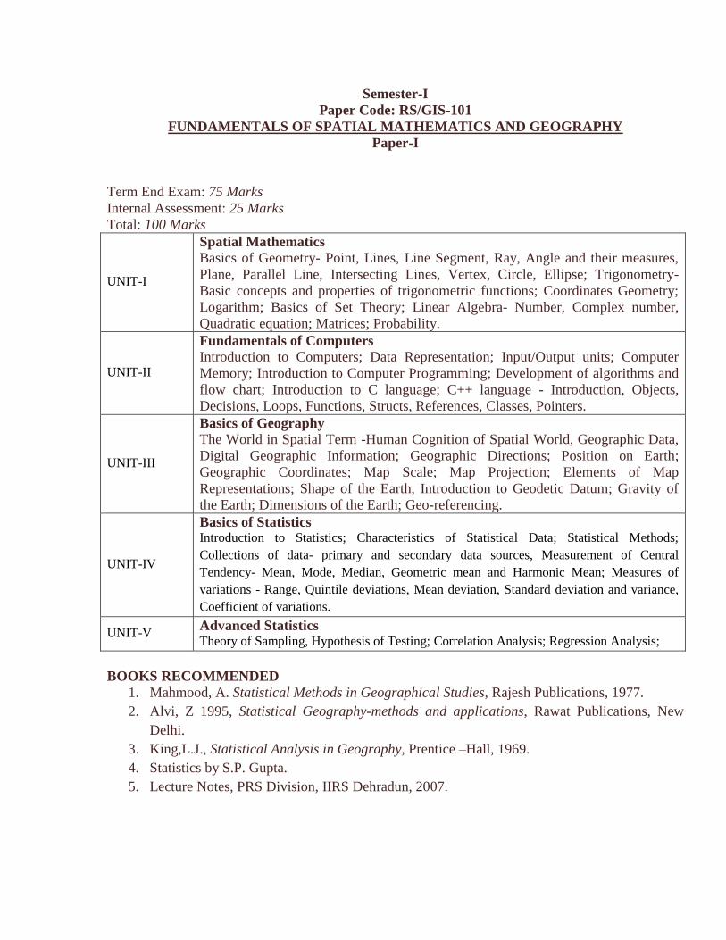
UNIT-I
Spatial Mathematics
Basics of Geometry- Point, Lines, Line Segment, Ray, Angle and their measures,
Plane, Parallel Line, Intersecting Lines, Vertex, Circle, Ellipse; Trigonometry-
Basic concepts and properties of trigonometric functions; Coordinates Geometry;
Logarithm; Basics of Set Theory; Linear Algebra- Number, Complex number,
Quadratic equation; Matrices; Probability.
UNIT-II
Fundamentals of Computers
Introduction to Computers; Data Representation; Input/Output units; Computer
Memory; Introduction to Computer Programming; Development of algorithms and
flow chart; Introduction to C language; C++ language - Introduction, Objects,
Decisions, Loops, Functions, Structs, References, Classes, Pointers.
UNIT-III
Basics of Geography
The World in Spatial Term -Human Cognition of Spatial World, Geographic Data,
Digital Geographic Information; Geographic Directions; Position on Earth;
Geographic Coordinates; Map Scale; Map Projection; Elements of Map
Representations; Shape of the Earth, Introduction to Geodetic Datum; Gravity of
the Earth; Dimensions of the Earth; Geo-referencing.
UNIT-IV
Basics of Statistics Introduction to Statistics; Characteristics of Statistical Data; Statistical Methods;
Collections of data- primary and secondary data sources, Measurement of Central
Tendency- Mean, Mode, Median, Geometric mean and Harmonic Mean; Measures of
variations - Range, Quintile deviations, Mean deviation, Standard deviation and variance,
Coefficient of variations.
UNIT-V Advanced Statistics Theory of Sampling, Hypothesis of Testing; Correlation Analysis; Regression Analysis;
BOOKS RECOMMENDED
1. Mahmood, A. Statistical Methods in Geographical Studies, Rajesh Publications, 1977.
2. Alvi, Z 1995, Statistical Geography-methods and applications, Rawat Publications, New
Delhi.
3. King,L.J., Statistical Analysis in Geography, Prentice –Hall, 1969.
4. Statistics by S.P. Gupta.
5. Lecture Notes, PRS Division, IIRS Dehradun, 2007.
Semester-I
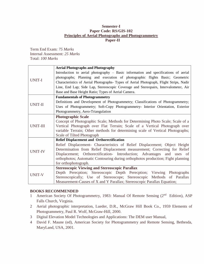
Paper Code: RS/GIS-102
Principles of Aerial Photographs and Photogrammetry
Paper-II
Term End Exam: 75 Marks
Internal Assessment: 25 Marks
Total: 100 Marks
UNIT-I
Aerial Photographs and Photography
Introduction to aerial photography – Basic information and specifications of aerial
photographs; Planning and execution of photographic flights Basic; Geometric
Characteristics of Aerial Photographs- Types of Aerial Photograph, Flight Strips, Nadir
Line, End Lap; Side Lap, Stereoscopic Coverage and Stereopairs, Intervalometer, Air
Base and Base Height Ratio; Types of Aerial Camera.
UNIT-II
Fundamentals of Photogrammetry
Definitions and Development of Photogrammetry; Classifications of Photogrammetry;
Uses of Photogrammetry; Soft-Copy Photogrammetry- Interior Orientation, Exterior
Photogrammetry, Aero-Triangulation
UNIT-III
Photographic Scale
Concept of Photographic Scale; Methods for Determining Photo Scale; Scale of a
Vertical Photograph over Flat Terrain; Scale of a Vertical Photograph over
variable Terrain; Other methods for determining scale of Vertical Photographs;
Scale of Tilted Photograph
UNIT-IV
Relief Displacement and Orthorectification
Relief Displacement- Characteristics of Relief Displacement; Object Height
Determination from Relief Displacement measurement; Correcting for Relief
Displacement; Orthorectification- Introduction; Advantages and uses of
orthophotos; Automatic Contouring during orthophotos production; Fight planning
for orthophotograph.
UNIT-V
Stereoscopic Viewing and Stereoscopic Parallax
Depth Perecption; Stereoscopic Depth Perecption; Viewing Photographs
Stereoscopically; Use of Stereoscope; Stereoscopic Methods of Parallax
Measurement-Causes of X and Y Parallax; Stereoscopic Parallax Equation;
BOOKS RECOMMENDED
1 American Society Of Photogrammetry, 1983: Manual Of Remote Sensing (2nd Edition), ASP
Falls Church, Virginia.
2 Aerial photographic interpretation, Lueder, D.R., McGraw Hill Book Co., 1959 Elements of
Photogrammetry, Paul R. Wolf, McGraw-Hill, 2000.
3 Digital Elevation Model Technologies and Applications: The DEM user Manual,
4 David F. Maune (ed), American Society for Photogrammetry and Remote Sensing, Bethesda,
MaryLand, USA, 2001.
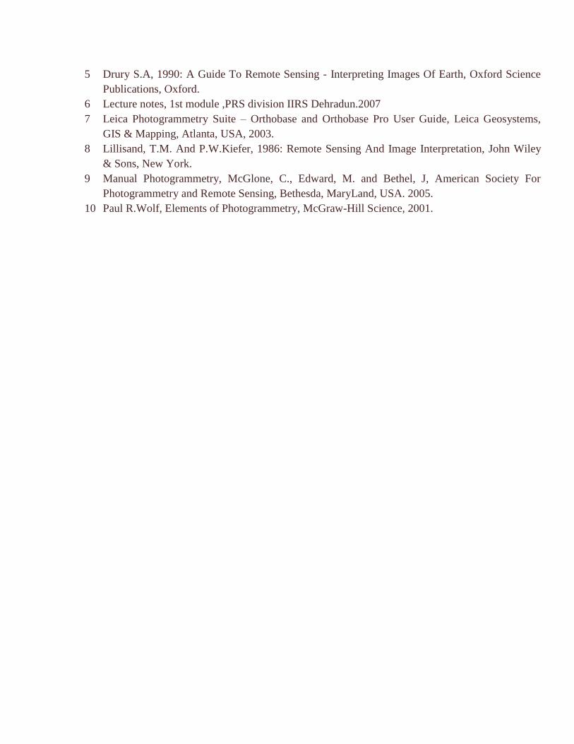
5 Drury S.A, 1990: A Guide To Remote Sensing - Interpreting Images Of Earth, Oxford Science
Publications, Oxford.
6 Lecture notes, 1st module ,PRS division IIRS Dehradun.2007
7 Leica Photogrammetry Suite – Orthobase and Orthobase Pro User Guide, Leica Geosystems,
GIS & Mapping, Atlanta, USA, 2003.
8 Lillisand, T.M. And P.W.Kiefer, 1986: Remote Sensing And Image Interpretation, John Wiley
& Sons, New York.
9 Manual Photogrammetry, McGlone, C., Edward, M. and Bethel, J, American Society For
Photogrammetry and Remote Sensing, Bethesda, MaryLand, USA. 2005.
10 Paul R.Wolf, Elements of Photogrammetry, McGraw-Hill Science, 2001.
Semester-I
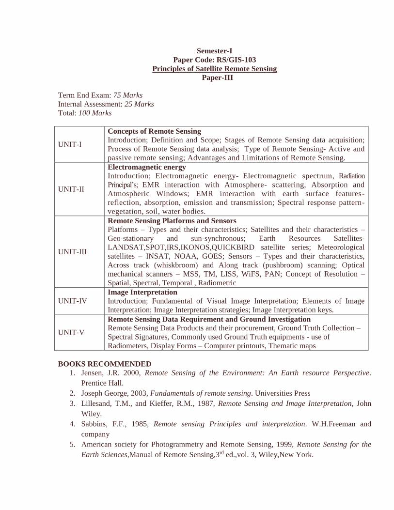
Paper Code: RS/GIS-103
Principles of Satellite Remote Sensing
Paper-III
Term End Exam: 75 Marks
Internal Assessment: 25 Marks
Total: 100 Marks
UNIT-I
Concepts of Remote Sensing
Introduction; Definition and Scope; Stages of Remote Sensing data acquisition;
Process of Remote Sensing data analysis; Type of Remote Sensing- Active and
passive remote sensing; Advantages and Limitations of Remote Sensing.
UNIT-II
Electromagnetic energy
Introduction; Electromagnetic energy- Electromagnetic spectrum, Radiation
Principal’s; EMR interaction with Atmosphere- scattering, Absorption and
Atmospheric Windows; EMR interaction with earth surface features-
reflection, absorption, emission and transmission; Spectral response pattern-
vegetation, soil, water bodies.
UNIT-III
Remote Sensing Platforms and Sensors
Platforms – Types and their characteristics; Satellites and their characteristics –
Geo-stationary and sun-synchronous; Earth Resources Satellites-
LANDSAT,SPOT,IRS,IKONOS,QUICKBIRD satellite series; Meteorological
satellites – INSAT, NOAA, GOES; Sensors – Types and their characteristics,
Across track (whiskbroom) and Along track (pushbroom) scanning; Optical
mechanical scanners – MSS, TM, LISS, WiFS, PAN; Concept of Resolution –
Spatial, Spectral, Temporal , Radiometric
UNIT-IV Image Interpretation
Introduction; Fundamental of Visual Image Interpretation; Elements of Image
Interpretation; Image Interpretation strategies; Image Interpretation keys.
UNIT-V
Remote Sensing Data Requirement and Ground Investigation
Remote Sensing Data Products and their procurement, Ground Truth Collection –
Spectral Signatures, Commonly used Ground Truth equipments - use of
Radiometers, Display Forms – Computer printouts, Thematic maps
BOOKS RECOMMENDED
1. Jensen, J.R. 2000, Remote Sensing of the Environment: An Earth resource Perspective.
Prentice Hall.
2. Joseph George, 2003, Fundamentals of remote sensing. Universities Press
3. Lillesand, T.M., and Kieffer, R.M., 1987, Remote Sensing and Image Interpretation, John
Wiley.
4. Sabbins, F.F., 1985, Remote sensing Principles and interpretation. W.H.Freeman and
company
5. American society for Photogrammetry and Remote Sensing, 1999, Remote Sensing for the
Earth Sciences,Manual of Remote Sensing,3rd ed.,vol. 3, Wiley,New York.
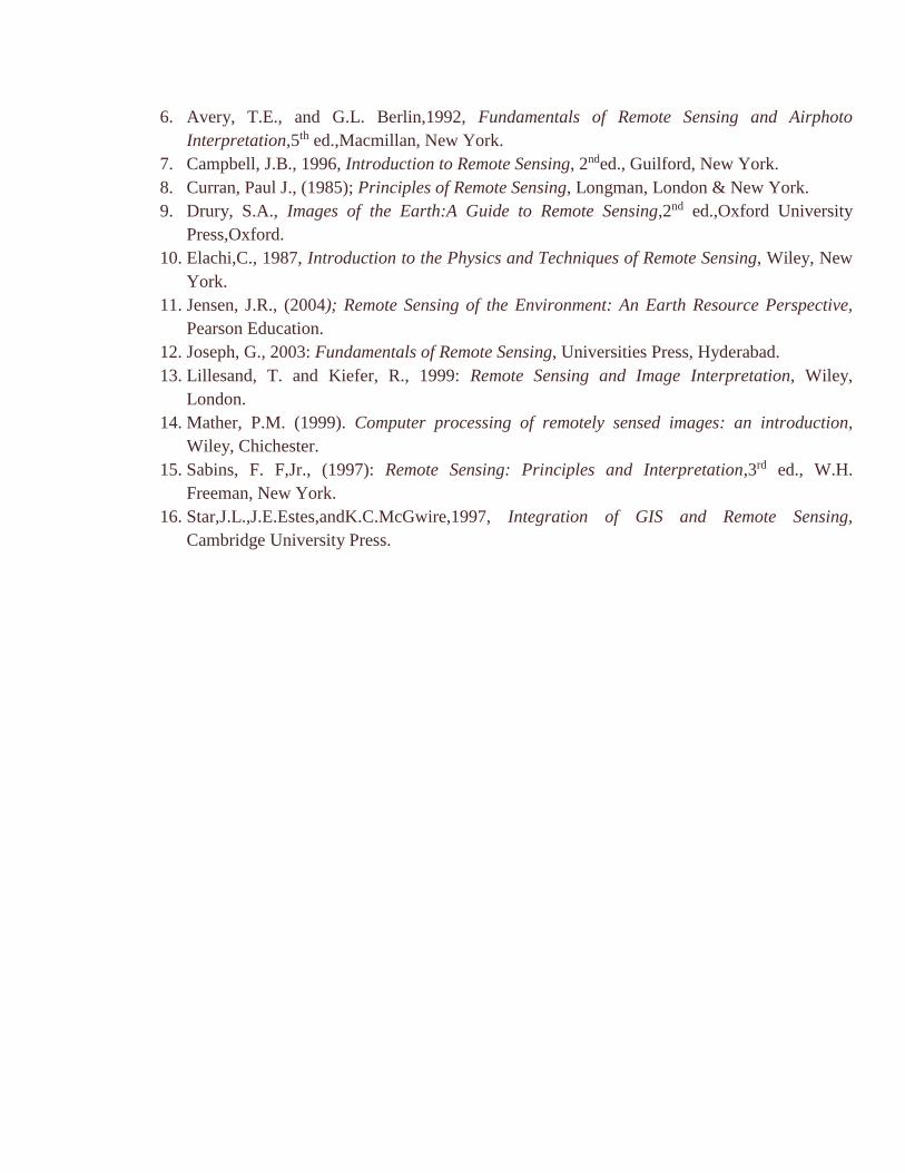
6. Avery, T.E., and G.L. Berlin,1992, Fundamentals of Remote Sensing and Airphoto
Interpretation,5th ed.,Macmillan, New York.
7. Campbell, J.B., 1996, Introduction to Remote Sensing, 2nded., Guilford, New York.
8. Curran, Paul J., (1985); Principles of Remote Sensing, Longman, London & New York.
9. Drury, S.A., Images of the Earth:A Guide to Remote Sensing,2nd ed.,Oxford University
Press,Oxford.
10. Elachi,C., 1987, Introduction to the Physics and Techniques of Remote Sensing, Wiley, New
York.
11. Jensen, J.R., (2004); Remote Sensing of the Environment: An Earth Resource Perspective,
Pearson Education.
12. Joseph, G., 2003: Fundamentals of Remote Sensing, Universities Press, Hyderabad.
13. Lillesand, T. and Kiefer, R., 1999: Remote Sensing and Image Interpretation, Wiley,
London.
14. Mather, P.M. (1999). Computer processing of remotely sensed images: an introduction,
Wiley, Chichester.
15. Sabins, F. F,Jr., (1997): Remote Sensing: Principles and Interpretation,3rd ed., W.H.
Freeman, New York.
16. Star,J.L.,J.E.Estes,andK.C.McGwire,1997, Integration of GIS and Remote Sensing,
Cambridge University Press.
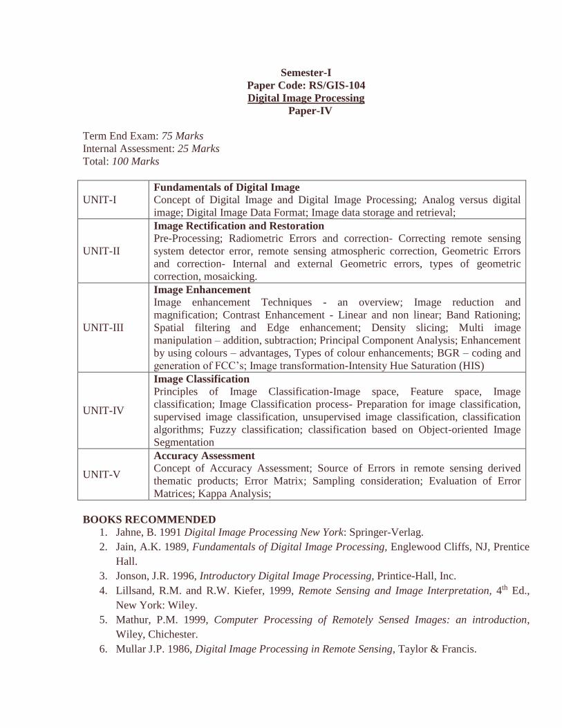
Semester-I
Paper Code: RS/GIS-104
Digital Image Processing
Paper-IV
Term End Exam: 75 Marks
Internal Assessment: 25 Marks
Total: 100 Marks
UNIT-I Fundamentals of Digital Image
Concept of Digital Image and Digital Image Processing; Analog versus digital
image; Digital Image Data Format; Image data storage and retrieval;
UNIT-II
Image Rectification and Restoration
Pre-Processing; Radiometric Errors and correction- Correcting remote sensing
system detector error, remote sensing atmospheric correction, Geometric Errors
and correction- Internal and external Geometric errors, types of geometric
correction, mosaicking.
UNIT-III
Image Enhancement
Image enhancement Techniques - an overview; Image reduction and
magnification; Contrast Enhancement - Linear and non linear; Band Rationing;
Spatial filtering and Edge enhancement; Density slicing; Multi image
manipulation – addition, subtraction; Principal Component Analysis; Enhancement
by using colours – advantages, Types of colour enhancements; BGR – coding and
generation of FCC’s; Image transformation-Intensity Hue Saturation (HIS)
UNIT-IV
Image Classification
Principles of Image Classification-Image space, Feature space, Image
classification; Image Classification process- Preparation for image classification,
supervised image classification, unsupervised image classification, classification
algorithms; Fuzzy classification; classification based on Object-oriented Image
Segmentation
UNIT-V
Accuracy Assessment
Concept of Accuracy Assessment; Source of Errors in remote sensing derived
thematic products; Error Matrix; Sampling consideration; Evaluation of Error
Matrices; Kappa Analysis;
BOOKS RECOMMENDED
1. Jahne, B. 1991 Digital Image Processing New York: Springer-Verlag.
2. Jain, A.K. 1989, Fundamentals of Digital Image Processing, Englewood Cliffs, NJ, Prentice
Hall.
3. Jonson, J.R. 1996, Introductory Digital Image Processing, Printice-Hall, Inc.
4. Lillsand, R.M. and R.W. Kiefer, 1999, Remote Sensing and Image Interpretation, 4th Ed.,
New York: Wiley.
5. Mathur, P.M. 1999, Computer Processing of Remotely Sensed Images: an introduction,
Wiley, Chichester.
6. Mullar J.P. 1986, Digital Image Processing in Remote Sensing, Taylor & Francis.

7. Pratt, W.K., 1991, Digital Image Processing 2nd ed., New York Wiley.
8. Richards, J.A,, 1986, Remote Sensing Digital Image Analysis, New York: Springer-Verlag.
9. Russ, J.C. 1992, Image Processing Handbook. Boca Raton, FL: CRC Press.
10. Schowengerdt, R.A., 1983, Techniques for image processing and classification in Remote
Sensing, New York: Academic Press.
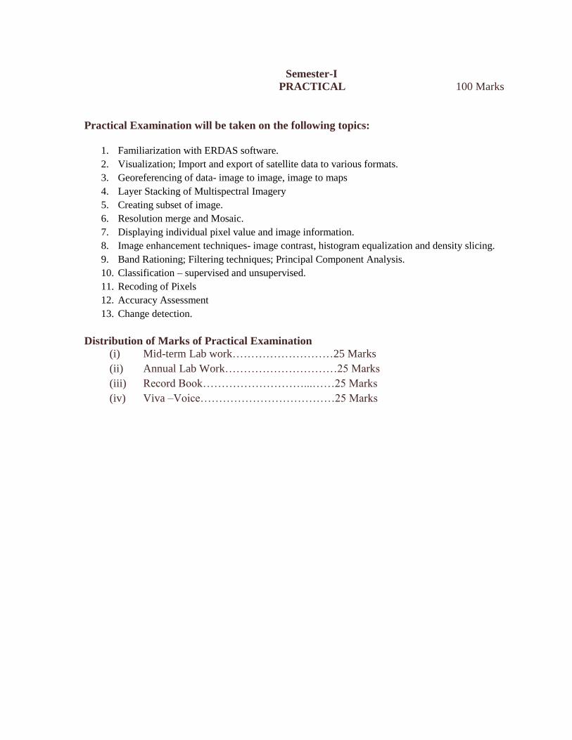
Semester-I
PRACTICAL 100 Marks
Practical Examination will be taken on the following topics:
1. Familiarization with ERDAS software.
2. Visualization; Import and export of satellite data to various formats.
3. Georeferencing of data- image to image, image to maps
4. Layer Stacking of Multispectral Imagery
5. Creating subset of image.
6. Resolution merge and Mosaic.
7. Displaying individual pixel value and image information.
8. Image enhancement techniques- image contrast, histogram equalization and density slicing.
9. Band Rationing; Filtering techniques; Principal Component Analysis.
10. Classification – supervised and unsupervised.
11. Recoding of Pixels
12. Accuracy Assessment
13. Change detection.
Distribution of Marks of Practical Examination
(i) Mid-term Lab work………………………25 Marks
(ii) Annual Lab Work…………………………25 Marks
(iii) Record Book………………………...……25 Marks
(iv) Viva –Voice………………………………25 Marks
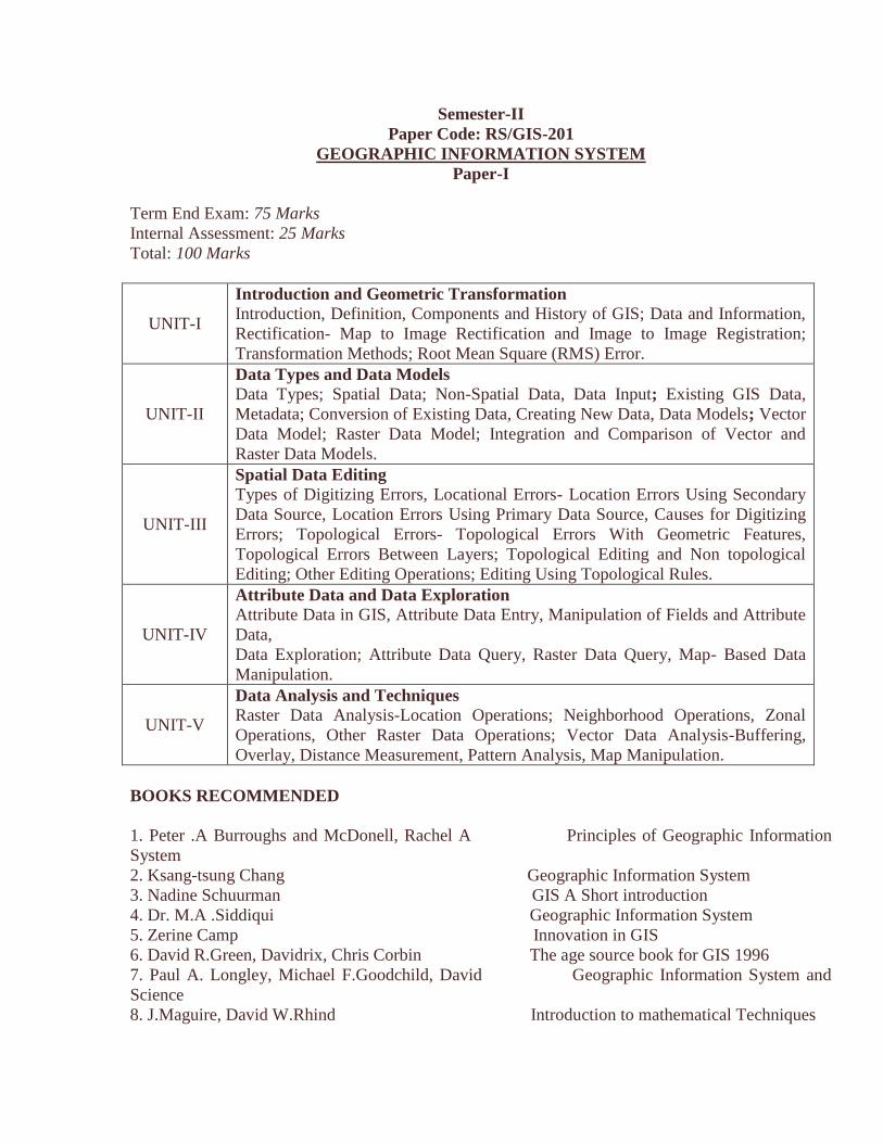
Semester-II
Paper Code: RS/GIS-201
GEOGRAPHIC INFORMATION SYSTEM
Paper-I
Term End Exam: 75 Marks
Internal Assessment: 25 Marks
Total: 100 Marks
UNIT-I
Introduction and Geometric Transformation
Introduction, Definition, Components and History of GIS; Data and Information,
Rectification- Map to Image Rectification and Image to Image Registration;
Transformation Methods; Root Mean Square (RMS) Error.
UNIT-II
Data Types and Data Models
Data Types; Spatial Data; Non-Spatial Data, Data Input; Existing GIS Data,
Metadata; Conversion of Existing Data, Creating New Data, Data Models; Vector
Data Model; Raster Data Model; Integration and Comparison of Vector and
Raster Data Models.
UNIT-III
Spatial Data Editing
Types of Digitizing Errors, Locational Errors- Location Errors Using Secondary
Data Source, Location Errors Using Primary Data Source, Causes for Digitizing
Errors; Topological Errors- Topological Errors With Geometric Features,
Topological Errors Between Layers; Topological Editing and Non topological
Editing; Other Editing Operations; Editing Using Topological Rules.
UNIT-IV
Attribute Data and Data Exploration
Attribute Data in GIS, Attribute Data Entry, Manipulation of Fields and Attribute
Data,
Data Exploration; Attribute Data Query, Raster Data Query, Map- Based Data
Manipulation.
UNIT-V
Data Analysis and Techniques
Raster Data Analysis-Location Operations; Neighborhood Operations, Zonal
Operations, Other Raster Data Operations; Vector Data Analysis-Buffering,
Overlay, Distance Measurement, Pattern Analysis, Map Manipulation.
BOOKS RECOMMENDED
1. Peter .A Burroughs and McDonell, Rachel A Principles of Geographic Information
System
2. Ksang-tsung Chang Geographic Information System
3. Nadine Schuurman GIS A Short introduction
4. Dr. M.A .Siddiqui Geographic Information System
5. Zerine Camp Innovation in GIS
6. David R.Green, Davidrix, Chris Corbin The age source book for GIS 1996
7. Paul A. Longley, Michael F.Goodchild, David Geographic Information System and
Science
8. J.Maguire, David W.Rhind Introduction to mathematical Techniques

Used in GIS
9. John E.Harmon & Sleven J.Anderson Geographic Information Systems
10. Peter A.Burrough & Rachael A.Mcdonnell Principles of GIS
11. John P. Wilson and A. S. Fotheringham Science The Handbook of Geographic Information
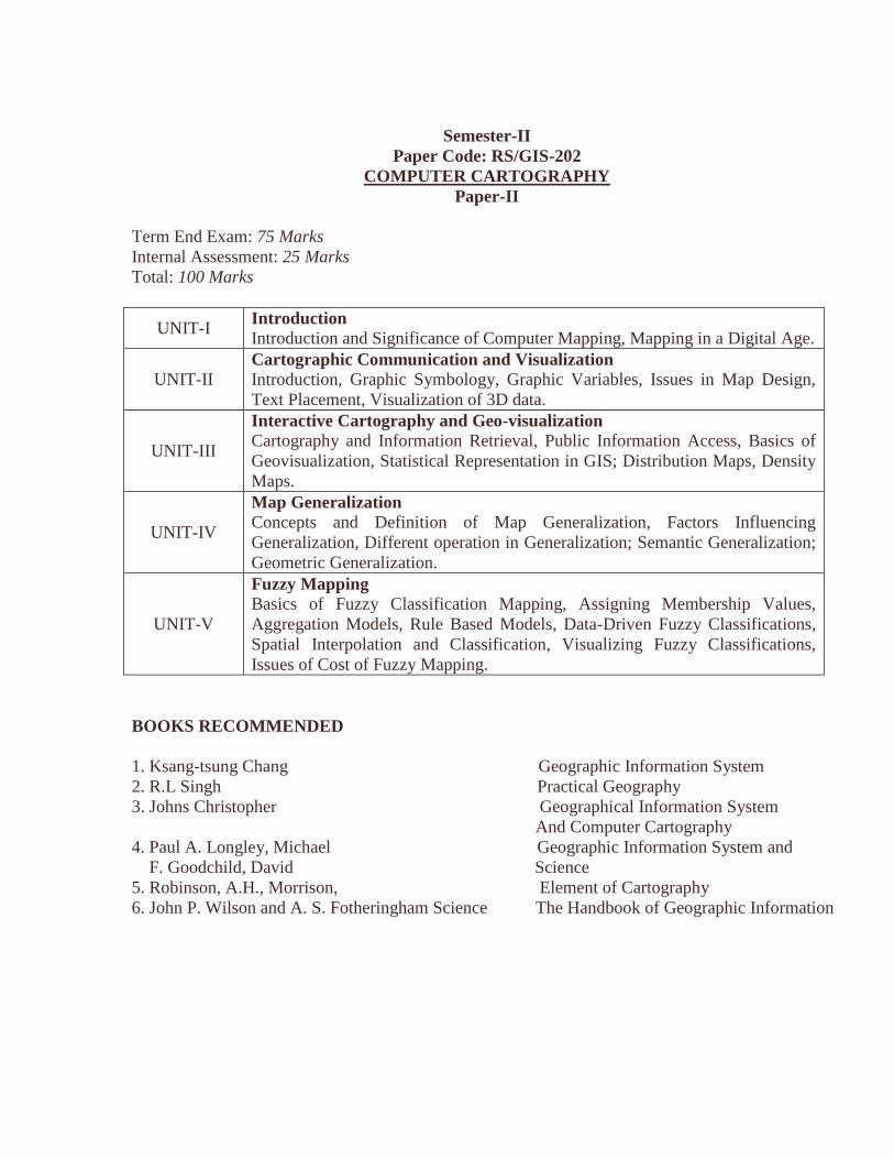
Semester-II
Paper Code: RS/GIS-202
COMPUTER CARTOGRAPHY
Paper-II
Term End Exam: 75 Marks
Internal Assessment: 25 Marks
Total: 100 Marks
UNIT-I Introduction
Introduction and Significance of Computer Mapping, Mapping in a Digital Age.
UNIT-II Cartographic Communication and Visualization
Introduction, Graphic Symbology, Graphic Variables, Issues in Map Design,
Text Placement, Visualization of 3D data.
UNIT-III
Interactive Cartography and Geo-visualization
Cartography and Information Retrieval, Public Information Access, Basics of
Geovisualization, Statistical Representation in GIS; Distribution Maps, Density
Maps.
UNIT-IV
Map Generalization
Concepts and Definition of Map Generalization, Factors Influencing
Generalization, Different operation in Generalization; Semantic Generalization;
Geometric Generalization.
UNIT-V
Fuzzy Mapping
Basics of Fuzzy Classification Mapping, Assigning Membership Values,
Aggregation Models, Rule Based Models, Data-Driven Fuzzy Classifications,
Spatial Interpolation and Classification, Visualizing Fuzzy Classifications,
Issues of Cost of Fuzzy Mapping.
BOOKS RECOMMENDED
1. Ksang-tsung Chang Geographic Information System
2. R.L Singh Practical Geography
3. Johns Christopher Geographical Information System
And Computer Cartography
4. Paul A. Longley, Michael Geographic Information System and
F. Goodchild, David Science
5. Robinson, A.H., Morrison, Element of Cartography
6. John P. Wilson and A. S. Fotheringham Science The Handbook of Geographic Information
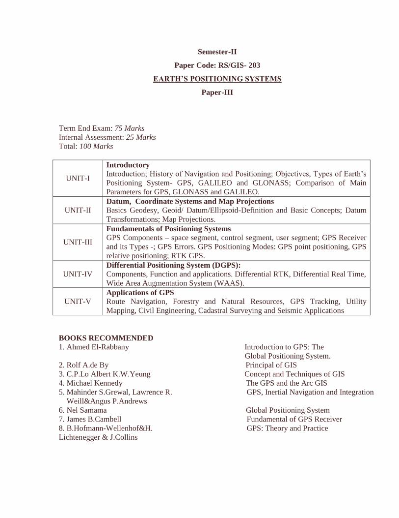
Semester-II
Paper Code: RS/GIS- 203
EARTH’S POSITIONING SYSTEMS
Paper-III
Term End Exam: 75 Marks
Internal Assessment: 25 Marks
Total: 100 Marks
UNIT-I
Introductory
Introduction; History of Navigation and Positioning; Objectives, Types of Earth’s
Positioning System- GPS, GALILEO and GLONASS; Comparison of Main
Parameters for GPS, GLONASS and GALILEO.
UNIT-II Datum, Coordinate Systems and Map Projections
Basics Geodesy, Geoid/ Datum/Ellipsoid-Definition and Basic Concepts; Datum
Transformations; Map Projections.
UNIT-III
Fundamentals of Positioning Systems
GPS Components – space segment, control segment, user segment; GPS Receiver
and its Types -; GPS Errors. GPS Positioning Modes: GPS point positioning, GPS
relative positioning; RTK GPS.
UNIT-IV Differential Positioning System (DGPS):
Components, Function and applications. Differential RTK, Differential Real Time,
Wide Area Augmentation System (WAAS).
UNIT-V Applications of GPS
Route Navigation, Forestry and Natural Resources, GPS Tracking, Utility
Mapping, Civil Engineering, Cadastral Surveying and Seismic Applications
BOOKS RECOMMENDED
1. Ahmed El-Rabbany Introduction to GPS: The
Global Positioning System.
2. Rolf A.de By Principal of GIS
3. C.P.Lo Albert K.W.Yeung Concept and Techniques of GIS
4. Michael Kennedy The GPS and the Arc GIS
5. Mahinder S.Grewal, Lawrence R. GPS, Inertial Navigation and Integration
Weill&Angus P.Andrews
6. Nel Samama Global Positioning System
7. James B.Cambell Fundamental of GPS Receiver
8. B.Hofmann-Wellenhof&H. GPS: Theory and Practice
Lichtenegger & J.Collins
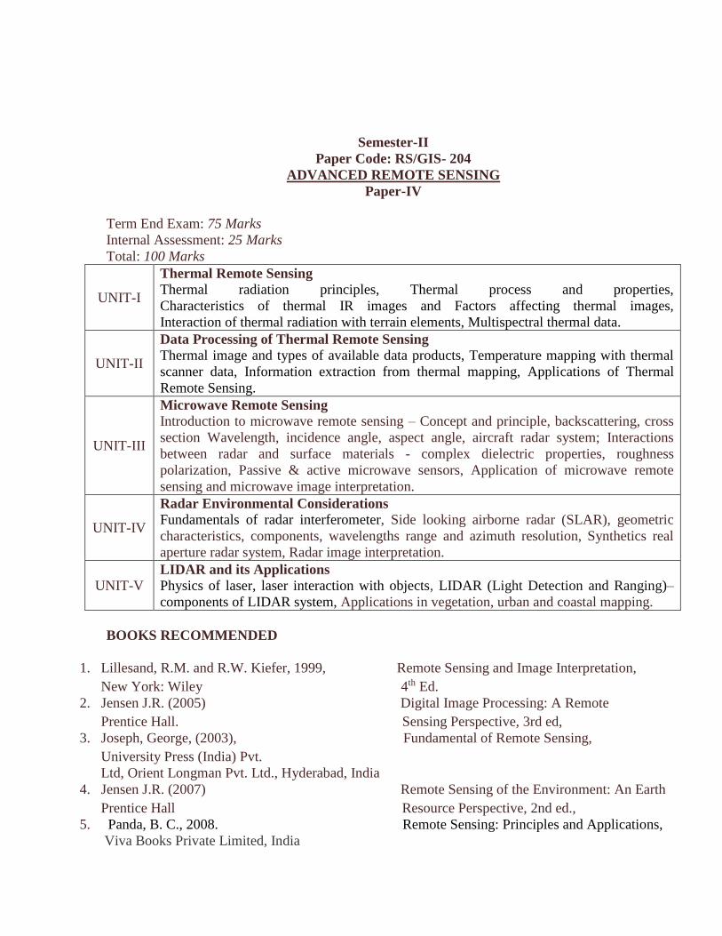
Semester-II
Paper Code: RS/GIS- 204
ADVANCED REMOTE SENSING
Paper-IV
Term End Exam: 75 Marks
Internal Assessment: 25 Marks
Total: 100 Marks
UNIT-I
Thermal Remote Sensing
Thermal radiation principles, Thermal process and properties,
Characteristics of thermal IR images and Factors affecting thermal images,
Interaction of thermal radiation with terrain elements, Multispectral thermal data.
UNIT-II
Data Processing of Thermal Remote Sensing
Thermal image and types of available data products, Temperature mapping with thermal
scanner data, Information extraction from thermal mapping, Applications of Thermal
Remote Sensing.
UNIT-III
Microwave Remote Sensing Introduction to microwave remote sensing – Concept and principle, backscattering, cross
section Wavelength, incidence angle, aspect angle, aircraft radar system; Interactions
between radar and surface materials - complex dielectric properties, roughness
polarization, Passive & active microwave sensors, Application of microwave remote
sensing and microwave image interpretation.
UNIT-IV
Radar Environmental Considerations Fundamentals of radar interferometer, Side looking airborne radar (SLAR), geometric
characteristics, components, wavelengths range and azimuth resolution, Synthetics real
aperture radar system, Radar image interpretation.
UNIT-V LIDAR and its Applications
Physics of laser, laser interaction with objects, LIDAR (Light Detection and Ranging)–
components of LIDAR system, Applications in vegetation, urban and coastal mapping.
BOOKS RECOMMENDED
1. Lillesand, R.M. and R.W. Kiefer, 1999, Remote Sensing and Image Interpretation,
New York: Wiley 4th Ed.
2. Jensen J.R. (2005) Digital Image Processing: A Remote
Prentice Hall. Sensing Perspective, 3rd ed,
3. Joseph, George, (2003), Fundamental of Remote Sensing,
University Press (India) Pvt.
Ltd, Orient Longman Pvt. Ltd., Hyderabad, India
4. Jensen J.R. (2007) Remote Sensing of the Environment: An Earth
Prentice Hall Resource Perspective, 2nd ed.,
5. Panda, B. C., 2008. Remote Sensing: Principles and Applications,
Viva Books Private Limited, India
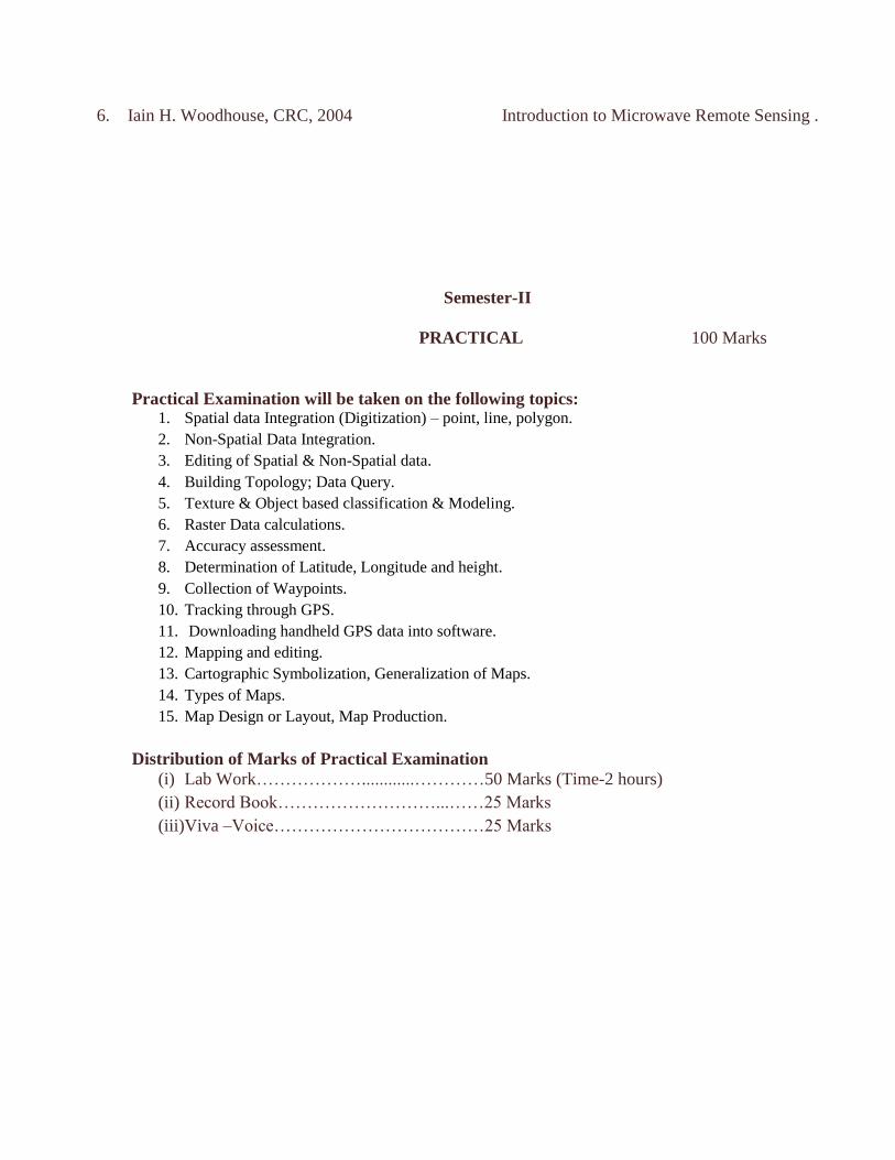
6. Iain H. Woodhouse, CRC, 2004 Introduction to Microwave Remote Sensing .
Semester-II
PRACTICAL 100 Marks
Practical Examination will be taken on the following topics: 1. Spatial data Integration (Digitization) – point, line, polygon.
2. Non-Spatial Data Integration.
3. Editing of Spatial & Non-Spatial data.
4. Building Topology; Data Query.
5. Texture & Object based classification & Modeling.
6. Raster Data calculations.
7. Accuracy assessment.
8. Determination of Latitude, Longitude and height.
9. Collection of Waypoints.
10. Tracking through GPS.
11. Downloading handheld GPS data into software.
12. Mapping and editing.
13. Cartographic Symbolization, Generalization of Maps.
14. Types of Maps.
15. Map Design or Layout, Map Production.
Distribution of Marks of Practical Examination
(i) Lab Work………………............…………50 Marks (Time-2 hours)
(ii) Record Book………………………...……25 Marks
(iii)Viva –Voice………………………………25 Marks
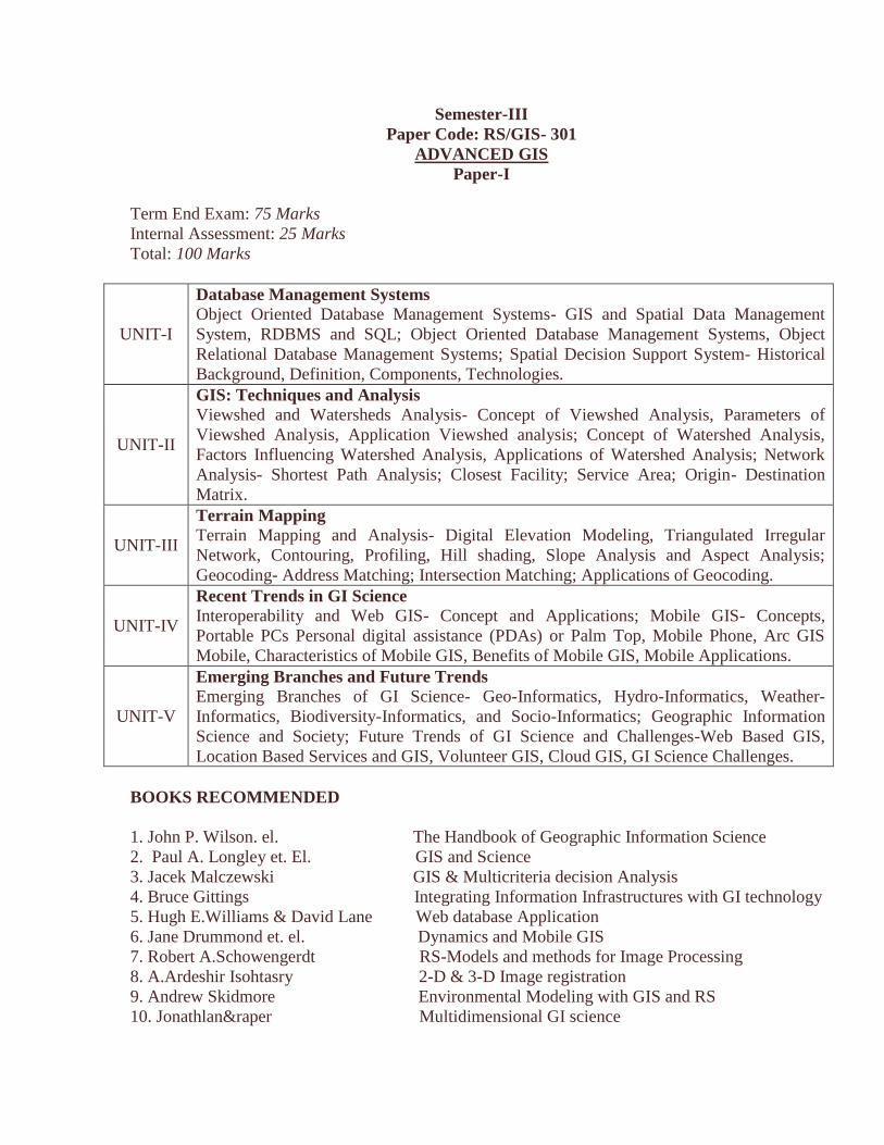
Semester-III
Paper Code: RS/GIS- 301
ADVANCED GIS
Paper-I
Term End Exam: 75 Marks
Internal Assessment: 25 Marks
Total: 100 Marks
UNIT-I
Database Management Systems
Object Oriented Database Management Systems- GIS and Spatial Data Management
System, RDBMS and SQL; Object Oriented Database Management Systems, Object
Relational Database Management Systems; Spatial Decision Support System- Historical
Background, Definition, Components, Technologies.
UNIT-II
GIS: Techniques and Analysis Viewshed and Watersheds Analysis- Concept of Viewshed Analysis, Parameters of
Viewshed Analysis, Application Viewshed analysis; Concept of Watershed Analysis,
Factors Influencing Watershed Analysis, Applications of Watershed Analysis; Network
Analysis- Shortest Path Analysis; Closest Facility; Service Area; Origin- Destination
Matrix.
UNIT-III
Terrain Mapping
Terrain Mapping and Analysis- Digital Elevation Modeling, Triangulated Irregular
Network, Contouring, Profiling, Hill shading, Slope Analysis and Aspect Analysis;
Geocoding- Address Matching; Intersection Matching; Applications of Geocoding.
UNIT-IV
Recent Trends in GI Science
Interoperability and Web GIS- Concept and Applications; Mobile GIS- Concepts,
Portable PCs Personal digital assistance (PDAs) or Palm Top, Mobile Phone, Arc GIS
Mobile, Characteristics of Mobile GIS, Benefits of Mobile GIS, Mobile Applications.
UNIT-V
Emerging Branches and Future Trends
Emerging Branches of GI Science- Geo-Informatics, Hydro-Informatics, Weather-
Informatics, Biodiversity-Informatics, and Socio-Informatics; Geographic Information
Science and Society; Future Trends of GI Science and Challenges-Web Based GIS,
Location Based Services and GIS, Volunteer GIS, Cloud GIS, GI Science Challenges.
BOOKS RECOMMENDED
1. John P. Wilson. el. The Handbook of Geographic Information Science
2. Paul A. Longley et. El. GIS and Science
3. Jacek Malczewski GIS & Multicriteria decision Analysis
4. Bruce Gittings Integrating Information Infrastructures with GI technology
5. Hugh E.Williams & David Lane Web database Application
6. Jane Drummond et. el. Dynamics and Mobile GIS
7. Robert A.Schowengerdt RS-Models and methods for Image Processing
8. A.Ardeshir Isohtasry 2-D & 3-D Image registration
9. Andrew Skidmore Environmental Modeling with GIS and RS
10. Jonathlan&raper Multidimensional GI science

11. Yashavant Kanethar Let Us C
12. Ivan Bayross QL, PL/SQL
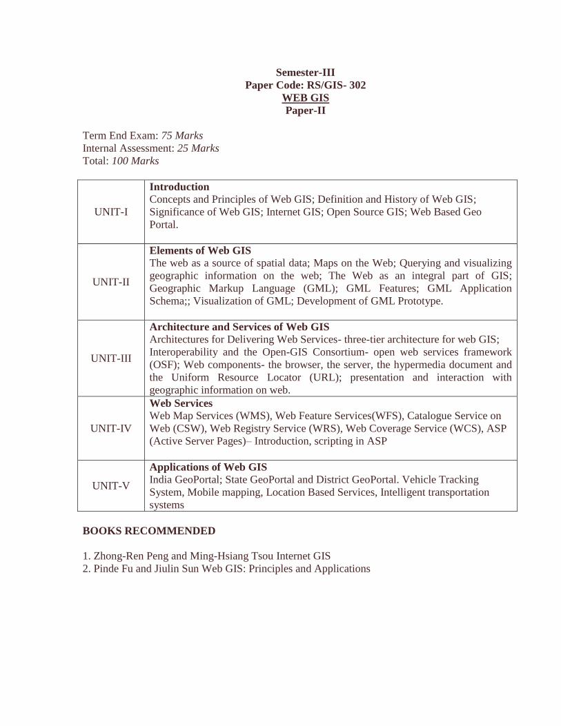
Semester-III
Paper Code: RS/GIS- 302
WEB GIS
Paper-II
Term End Exam: 75 Marks
Internal Assessment: 25 Marks
Total: 100 Marks
UNIT-I
Introduction
Concepts and Principles of Web GIS; Definition and History of Web GIS;
Significance of Web GIS; Internet GIS; Open Source GIS; Web Based Geo
Portal.
UNIT-II
Elements of Web GIS
The web as a source of spatial data; Maps on the Web; Querying and visualizing
geographic information on the web; The Web as an integral part of GIS;
Geographic Markup Language (GML); GML Features; GML Application
Schema;; Visualization of GML; Development of GML Prototype.
UNIT-III
Architecture and Services of Web GIS
Architectures for Delivering Web Services- three-tier architecture for web GIS;
Interoperability and the Open-GIS Consortium- open web services framework
(OSF); Web components- the browser, the server, the hypermedia document and
the Uniform Resource Locator (URL); presentation and interaction with
geographic information on web.
UNIT-IV
Web Services
Web Map Services (WMS), Web Feature Services(WFS), Catalogue Service on
Web (CSW), Web Registry Service (WRS), Web Coverage Service (WCS), ASP
(Active Server Pages)– Introduction, scripting in ASP
UNIT-V
Applications of Web GIS
India GeoPortal; State GeoPortal and District GeoPortal. Vehicle Tracking
System, Mobile mapping, Location Based Services, Intelligent transportation
systems
BOOKS RECOMMENDED
1. Zhong-Ren Peng and Ming-Hsiang Tsou Internet GIS
2. Pinde Fu and Jiulin Sun Web GIS: Principles and Applications
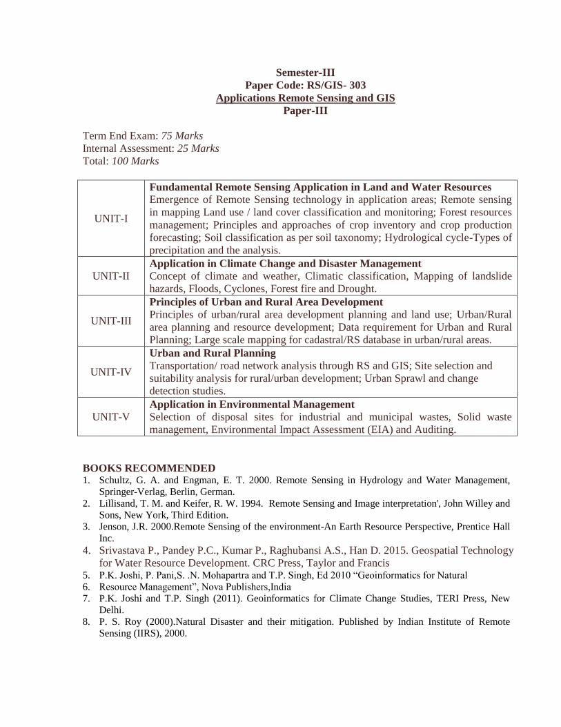
Semester-III
Paper Code: RS/GIS- 303
Applications Remote Sensing and GIS
Paper-III
Term End Exam: 75 Marks
Internal Assessment: 25 Marks
Total: 100 Marks
UNIT-I
Fundamental Remote Sensing Application in Land and Water Resources
Emergence of Remote Sensing technology in application areas; Remote sensing
in mapping Land use / land cover classification and monitoring; Forest resources
management; Principles and approaches of crop inventory and crop production
forecasting; Soil classification as per soil taxonomy; Hydrological cycle-Types of
precipitation and the analysis.
UNIT-II Application in Climate Change and Disaster Management
Concept of climate and weather, Climatic classification, Mapping of landslide
hazards, Floods, Cyclones, Forest fire and Drought.
UNIT-III
Principles of Urban and Rural Area Development
Principles of urban/rural area development planning and land use; Urban/Rural
area planning and resource development; Data requirement for Urban and Rural
Planning; Large scale mapping for cadastral/RS database in urban/rural areas.
UNIT-IV
Urban and Rural Planning Transportation/ road network analysis through RS and GIS; Site selection and
suitability analysis for rural/urban development; Urban Sprawl and change
detection studies.
UNIT-V Application in Environmental Management
Selection of disposal sites for industrial and municipal wastes, Solid waste
management, Environmental Impact Assessment (EIA) and Auditing.
BOOKS RECOMMENDED 1. Schultz, G. A. and Engman, E. T. 2000. Remote Sensing in Hydrology and Water Management,
Springer-Verlag, Berlin, German.
2. Lillisand, T. M. and Keifer, R. W. 1994. Remote Sensing and Image interpretation', John Willey and
Sons, New York, Third Edition.
3. Jenson, J.R. 2000.Remote Sensing of the environment-An Earth Resource Perspective, Prentice Hall
Inc.
4. Srivastava P., Pandey P.C., Kumar P., Raghubansi A.S., Han D. 2015. Geospatial Technology
for Water Resource Development. CRC Press, Taylor and Francis 5. P.K. Joshi, P. Pani,S. .N. Mohapartra and T.P. Singh, Ed 2010 “Geoinformatics for Natural
6. Resource Management”, Nova Publishers,India
7. P.K. Joshi and T.P. Singh (2011). Geoinformatics for Climate Change Studies, TERI Press, New
Delhi.
8. P. S. Roy (2000).Natural Disaster and their mitigation. Published by Indian Institute of Remote
Sensing (IIRS), 2000.

9. Spatial Technologies for Natural Hazard Management. Proceedings of ISRS National
Symposium, Nov. 21-22, 2000, IIT, Kharagpur.
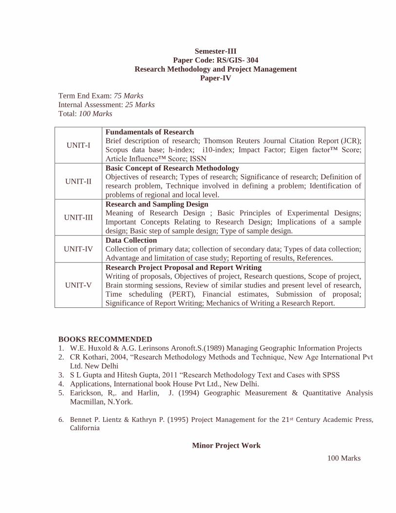
Semester-III
Paper Code: RS/GIS- 304
Research Methodology and Project Management
Paper-IV
Term End Exam: 75 Marks
Internal Assessment: 25 Marks
Total: 100 Marks
UNIT-I
Fundamentals of Research Brief description of research; Thomson Reuters Journal Citation Report (JCR);
Scopus data base; h-index; i10-index; Impact Factor; Eigen factor™ Score;
Article Influence™ Score; ISSN
UNIT-II
Basic Concept of Research Methodology
Objectives of research; Types of research; Significance of research; Definition of
research problem, Technique involved in defining a problem; Identification of
problems of regional and local level.
UNIT-III
Research and Sampling Design
Meaning of Research Design ; Basic Principles of Experimental Designs;
Important Concepts Relating to Research Design; Implications of a sample
design; Basic step of sample design; Type of sample design.
UNIT-IV Data Collection
Collection of primary data; collection of secondary data; Types of data collection;
Advantage and limitation of case study; Reporting of results, References.
UNIT-V
Research Project Proposal and Report Writing
Writing of proposals, Objectives of project, Research questions, Scope of project,
Brain storming sessions, Review of similar studies and present level of research,
Time scheduling (PERT), Financial estimates, Submission of proposal;
Significance of Report Writing; Mechanics of Writing a Research Report.
BOOKS RECOMMENDED 1. W.E. Huxold & A.G. Lerinsons Aronoft.S.(1989) Managing Geographic Information Projects
2. CR Kothari, 2004, “Research Methodology Methods and Technique, New Age International Pvt
Ltd. New Delhi
3. S L Gupta and Hitesh Gupta, 2011 “Research Methodology Text and Cases with SPSS
4. Applications, International book House Pvt Ltd., New Delhi.
5. Earickson, R,. and Harlin, J. (1994) Geographic Measurement & Quantitative Analysis
Macmillan, N.York.
6. Bennet P. Lientz & Kathryn P. (1995) Project Management for the 21st Century Academic Press,
California
Minor Project Work
100 Marks
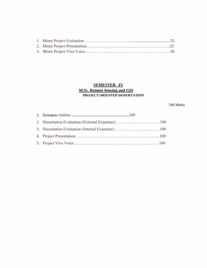
1. Minor Project Evaluation ……………………………........................................25
2. Minor Project Presentation……………………………………………………..25
3. Minor Project Viva Voice………………………………………………………50
SEMESTER –IV
M.Sc. Remote Sensing and GIS
PROJECT ORIENTED DISSERTATION
500 Marks
1. Synopsis Outline ………………………………………………………..100
2. Dissertation Evaluation (External Examiner)……………………………100
3. Dissertation Evaluation (Internal Examiner)…………………………….100
4. Project Presentation……………………………………………………...100
5. Project Viva Voice………………………………………………………100