Embed Size (px)
Citation preview
Central University of Kashmir Nowgam, Srinagar, J&K- 190015
www.cukashmir.ac.in
MTTM C-106 Tourism Geography and Ecology
Objectives: This course explores the basic components of geography in relation with
tourism. Knowledge of geography shall also give an extra edge to the students in
designing the itineraries for the travellers, suggesting them various destinations.
Unit–I
Meaning, Scope and contents of Geography. Importance of Geography in tourism,
Climatic variations, climatic regions of world, study of maps, longitude & latitude,
international date line, Standard time and Day light saving time.
Course Title: Tourism Geography and Ecology
Course Code: MTM C-106
Department: Tourism Studies
Year: 2016
Contributor’s Name: Ms. Shahnaz Akhtar
Email: [email protected]
Contact: 9419190637
Designation: Assistant Professor
Unit I

CENTRAL UNIVERSITY OF KASHMIR
Tourism Geography and Ecology
Introduction.
Geography is a field of science dedicated to the study of lands, the features, the
inhabitants, and the phenomena of earth. A literal translation would be “to describe or
write about the earth”. The first person to use the word ‘geography 'was Eratosthenes
(276-194 BC).
Geography is largely the study of the interaction of all physical and human phenomena
and landscapes created by such interactions.” It is about how, why and where human
and natural activities occur and how these activities are interconnected.
Geography is divided into three main branches:
1. Human geography, 2. Physical geography
3. Regional geography.
Physical geography: It is a branch of geography which aims to understand the physical
problems and issues of lithosphere, hydrosphere, atmosphere, pedosphere, and global
flora and fauna patterns (biosphere).
Human geography: It is a branch of geography that focuses on the study of pattern and
processes that shape the human society. It encompasses the human, political, cultural,
social & economic aspects.
Regional geography: It is that branch of geography which studies the regions of all
sizes across the earth. The main aim is to understand, or define the uniqueness, or
characteristics of a particular region that consists of natural as well as human elements.
Unit I
Tourism: The activities of a person travelling outside his or her usual environment for
less than a specified period of time and whose main purpose of travel is other than
exercise of an activity remunerated from the place visited (WTO).
Tourism Geography: Tourism geography is the study of travel and tourism, as an
industry and as a social and cultural activity. It is that branch of science which deals
with the study of travel and its impact on places. The geography of tourism is dominated
by number of key themes, which relate location, place, space, human and cultural
characteristics, and the movement of people. The geography of tourism is also concern
with the flows of tourism from generating countries to the destinations. These can be
heavily influenced by the economic and political factors, with the flows of tourism from
traditionally from developed countries to the less developed countries.
Scope of Geography.
Geography has acquired the status of science that explains the arrangements of various
natural and cultural features on the earth surface. In general, the natural phenomena
like mountains, rivers, lakes etc. change slowly while the cultural elements like
buildings, roads, crops, change fast. Travelling from one place to another you notice that
the trees number and types of trees change from area to area. All this because of
continuous interaction between the environment in which we live in and the way we
use it. The study of geography is about observing such patterns.
Another aspect of geography is to understand the factors, how do social, cultural,
economic and demographic factors change our physical landscape and create new or
altered landscapes by human interventions. For example, human settlements are
transformation of forests or barren lands for living purpose by human being.
As earlier, even today geographical information about an area is available through
reports, travel diaries and gazetteers. At present maps can be drawn by using satellite
images using Geographic Information Systems (GIS) tools.
Thus, the scope of geography is in various disciplines, like armed forces, environment
management, water resources, disaster management, meteorology and planning and
various social sciences. Apart from that, a geographer can help in day to day life like
tourism, housing and health related activities and more.
Importance of geography in tourism.
Geography is fundamental to the study of tourism, because tourism in geographical in
nature. Tourism occurs in places, it involves movement and activities between places
and it is an activity in which both place characteristics and personal self-identities are
formed, through relationships that are created among places, landscapes and people.
Physical geography provides the essential background, against which tourism places are
created and environmental impacts and concerns are major issues, that must be
considered in managing the development of tourism places.
How characteristics of the tourism system relate to geography?
Rural tourism : Focused on countryside
Urban tourism : Focused on town & cities
Spa tourism : Travel for health & wellness
Sport tourism: Focused on spectators travelling to sports events.
Eco tourism : Based on nature
Heritage tourism: Focused on heritage cities and Heritage buildings.
Contents of Geography.
A. Physical Geography:
Physical geography (also known as geosystems or physiography) is one of the two
major sub-fields of geography. Physical geography is that branch of natural science
which deals with the study of processes and patterns in the natural environment like
the atmosphere, hydrosphere, biosphere, and geosphere, as opposed to the cultural or
built environment, the domain of human geography.
It has a number of sub-branches which treat different kind of physical phenomena.
1. Geomorphology: Geomorphology: is the field concerned with understanding the
surface of the Earth and the processes by which it is shaped, both at the present as well
as in the past. Geomorphology as a field has several sub-fields that deal with the specific
landforms of various environments e.g. desert geomorphology etc. Geomorphologists
seek to understand why landscapes look the way they do, to understand landform
history and dynamics and to predict changes through a combination of field
observations, physical experiments and numerical modelling.
2. Hydrology: Hydrology is the scientific study of the movement, distribution, and
quality of water on Earth and other planets, including the hydrologic cycle, water
resources and environmental watershed sustainability. Thus the field encompasses
water in rivers, lakes, aquifers and to an extent glaciers, in which the field examines the
process and dynamics involved in these bodies of water.
Similar to most fields of physical geography it has sub-fields that examine the specific
bodies of water or their interaction with other spheres e.g. limnology and ecohydrology.
3. Glaciology: Glaciology is the scientific study of glaciers, or more generally ice and
natural phenomena that involve ice. Glaciology also has a vast array of sub-fields
examining the factors and processes involved in ice sheets and glaciers e.g. snow
hydrology and glacial geology.
4. Bio-geography: It is concerned with the biological phenomena in space, especially in
terms of the distribution of various kinds of floral and faunal species.
Biogeography may be subdivided into plant or floral geography, animals or faunal
geography, and human ecology.
4. Climatology: It is the study of the climate, scientifically defined as weather conditions
averaged over a long period of time. Climatology examines both the nature of micro
(local) and macro (global) climates and the natural and anthropogenic influences on
them. The field is also sub-divided largely into the climates of various regions and the
study of specific phenomena or time periods e.g. tropical cyclone rainfall climatology
and paleoclimatology.
5. Meteorology: It is the interdisciplinary scientific study of the atmosphere that focuses
on weather processes and short term forecasting (in contrast with climatology).
Meteorological phenomena are observable weather events which illuminate and are
explained by the science of meteorology. Meteorology phenomena are observable
weather events that illuminate, and are explained by the science of meteorology. Those
events are bound by the variables of Earth's atmosphere: temperature, air pressure,
water vapour, and the gradients and interactions of each variable, and how they change
over time.
6. Pedology:It is the study of soils in their natural environment. It is one of two main
branches of soil science, the other being edaphology. Pedology mainly deals with
paedogenesis, soil morphology, soil classification.
In physical geography pedology is largely studied due to the numerous interactions
between climate (water, air, temperature), soil life (micro-organisms, plants, animals),
the mineral materials within soils (biogeochemical cycles) and its position and effects
on the landscape such as laterization.
7. Palaeogeography: It is the study of historical geography. The term generally refers to
the study of physical landscapes, but it can also refer to the study of human or cultural
environments. When the focus is specifically on the study of landforms, the term
paleogeomorphology is sometimes used instead.
8. Coastal geography: It is the study of the dynamic interface between the ocean and the
land, incorporating both the physical geography (i.e. coastal geomorphology, geology
and oceanography) and the human geography of the coast. It involves an understanding
of coastal weathering processes, particularly wave action, sediment movement and
weathering, and also the ways in which humans interact with the coast.
Coastal geography, although predominantly geomorphological in its research, is not just
concerned with coastal landforms, but also the causes and influences of sea level
change.
9. Oceanography: It is the branch of physical geography that studies the Earth's oceans
and seas. It covers a wide range of topics, including marine organisms and ecosystem
dynamics (biological oceanography); ocean currents, waves, and geophysical fluid
dynamics (physical oceanography); plate tectonics and the geology of the sea floor
(geological oceanography); and fluxes of various chemical substances and physical
properties within the ocean and across its boundaries (chemical oceanography).
10. Environmental Geography: It is a branch of geography that analyzes the spatial
aspects of interactions between humans and the natural world.
The branch bridges the divide between human and physical geography and thus
requires an understanding of the dynamics of geology, meteorology, hydrology,
biogeography, and geomorphology, as well as the ways in which human societies
conceptualize the environment.
B. Human Geography.
Human geography is a branch of geography that focuses on the study of patterns and
processes that shape the human society. It encompasses the human, political, cultural,
social, and economic aspects. It is further divided into various sub-branches.
1. Cultural geography: Cultural geography is the study of cultural products and norms
and their variations across and relations to spaces and places. It focuses on describing
and analyzing the ways language, religion, economy, government and other cultural
phenomena vary or remain constant, from one place to another.
2. Development geography: Development geography is a branch of geography which
refers to the standard of living and quality of life of its human inhabitants. In this
context, development is a process of change that affects people's lives. It may involve an
improvement in the quality of life as perceived by the people undergoing change.
In development geography, geographers study spatial patterns in development. They
try to find by what characteristics they can measure development by looking at
economic, political and social factors.
3. Economic geography: Economic geography is the study of the location, distribution
and spatial organization of economic activities across the world. Economic geography
has taken a variety of approaches to many different subject matters, including but not
limited to the location of industries, economies of agglomeration (also known as
"linkages"), transportation, international trade, development, real estate, gentrification,
and the relationship between the environment and the economy and globalization.
4. Health geography: Health geography is the application of geographical information,
perspectives, and methods to the study of health, disease, and health care.
5. Political geography: Political geography is a specific field of study within the more
general field of human geography that examines how people in specific locations around
the world have organized themselves into distinctive political groups, and how they
influence and interact with each other.
It is the study of how space is made into territory - that is to say, how political
communities divide the world between themselves. It can be summarised as the inter-
relationships between people, state, and territory.
6. Demography: Demography is the statistical study of populations, including of human
beings. Demography encompasses the study of the size, structure, and distribution of
these populations, and spatial and/or temporal changes in them in response to time,
birth, migration, ageing, and death. Based on the demographic research of the earth,
earth’s population up to the year 2050 and 2100 can be estimated by the demographers.
7. Religion geography: Religion geography is the study of the impact of geography, i.e.
place and space, on religious belief.
Another aspect of the relationship between religion and geography is religious
geography, in which geographical ideas are influenced by religion, such as early map-
making, and the biblical geography that developed in the 16th century to identify places
from the Bible.
Thus, geographers are less concerned about religion, but are more sensitive to how
religion as a cultural feature affects social, cultural, political and environmental systems.
The point of focus is not the specifics of religious beliefs and practices, but how these
religious beliefs and practices are internalised by adherents, and how these processes of
internalization influence, and is influenced by, social systems.
8. Transportation geography: Transportation geography, also transport geography, is a
branch of Economic geography that particularly investigates the movement of and
connections between things of interest to people: people themselves, vehicles,
commodities, information.
At the most basic level, humans move and thus interact with each other by walking, but
transportation geography typically studies more complex and regional or global
systems of transportation that include multiple interconnected modes like public
transit, personal cars, bicycles, freight railroads, airplanes and more. Transportation
geography measures the result of human activity between and within locations. It
focuses on things such as travel time, routes chosen, and modes of transport, cost and
resource use.
9. Tourism geography: Tourism geography is the study of travel and tourism, as an
industry and as a social and cultural activity. Tourism geography covers a wide range of
interests including the environmental impact of tourism, the geographies of tourism and
leisure economies, answering tourism industry and management concerns and the
sociology of tourism and locations of tourism.
Tourism occurs in places, it involves movement and activities between places and it is
an activity in which both place characteristics and personal self-identities are formed,
through the relationships that are created among places, landscapes and people.
Physical geography provides the essential background, against which tourism places
are created and environmental impacts and concerns are major issues that must be
considered in managing the development of tourism places.
10. Urban geography: Urban geography is the sub-discipline of Geography which
concentrates on those parts of the Earth's surface that have a high concentration of
buildings and infrastructure. Predominantly towns and cities, these are settlements
with a high population density and with the majority of economic activities in the
secondary sector and tertiary sectors.
C. Regional Geography.
Regional geography is a branch of geography that studies the world's regions. A region
itself is defined as a part of the Earth's surface with one or many similar characteristics
that make it unique from other areas.
Regional geography studies the specific unique characteristics of places related to their
culture, economy, topography, climate, politics and environmental factors such as their
different species of flora and fauna.
1. Macro-region: A macro-region is a geopolitical subdivision that encompasses several
traditionally or politically defined regions. The meaning may vary, with the common
denominator being cultural, economical, historical or social similarity within a macro-
region.
2. Micro-region: A micro-region can be defined as a territorial area that is smaller than a
state to which it belongs, but larger than a municipality. Typical examples of such micro-
regions are provinces, districts, departments or even mega-cities.
3. Meso-region: A meso-region is a medium-sized region between the size of a city or
district and that of a nation.
Climatic Variation.
Climate is the long-term pattern of weather in a particular area. It is measured by
assessing the patterns of variation in temperature, humidity, atmospheric pressure,
wind, precipitation, atmospheric particle count and other meteorological variables in a
given region over long periods of time. Climate is different from weather, in that
weather only describes the short-term conditions of these variables in a given region. A
region's climate is generated by the climate system, which has five components:
atmosphere, hydrosphere, cryosphere, lithosphere, and biosphere.
The climate of a location is affected by its latitude, terrain, and altitude, as well as
nearby water bodies and their currents. Climates can be classified according to the
average and the typical ranges of different variables, most commonly temperature and
precipitation.
Climatic change: Climate change is the statistical distribution of weather patterns when
that change lasts for an extended period of time (i-e., decades to millions of years).
Climate change is caused by factors such as biotic processes, variations in solar
radiations received by Earth, plate tectonics, and volcanic eruptions. Certain human
activities have also been identified as significant causes of recent climate change, often
referred to as “global warming”.
Types of climate variation:
Climate although very slowly, keeps evolving. There are many causes behind variation
in climate. Climate variations can be categorised into two broad contexts.
Natural Climate Variation.
Human-induced Climate Variation.
A. Natural Climate Variation: There are several natural causes that force climate to
change across time and scale. It can be further drilled down into the following
categories;
1. Natural Forcing of the Climate System.
2. Natural Variability of the Climate.
Natural Forcing of the Climate System.
Natural forcing is of two types.
1. External Forcing: these are essential linked to changes in the orbital parameters of
the earth that control the intensity and location of incident solar radiation, and
fluctuations in solar energy.
2. Internal Forcing: these comprise all those changes that occur within the same system
itself, in particular volcanic activity, fluctuations in ocean circulations and large-scale
changes in the marine and terrestrial biosphere or in the cryosphere.
The Sun and the Global Energy Balance.
The sun is the prime source of external energy for the earth. Every moment huge
amount of energy reaches the earth from the sun. Let us see this from a flow chart that

shows what happens to the solar radiation that reaches the earth.
From this chart, we find that of the total energy that reaches the sun,
6% is reflected by atmosphere
16% is absorbed by atmosphere
20% is reflected by clouds
3% is absorbed by clouds
51% is absorbed by oceans and land
4% is reflected by the surface of the earth.
Of the energy that remains in the earth (absorbed by atmosphere, clouds, and earth’s
surface)
64% is radiated out into the space (atmosphere and clouds)
6% is radiated directly into the space by earth’s surface
7% is utilized in the movement of air
23% is utilized in evaporation of water from earth’s surface.
This is how the balance of energy is maintained in the environment. The global energy
balance is, therefore, the balance between incoming energy from the sun and outgoing
heat from the earth.
b. Radiative Forcing: At equilibrium, the average net radiation is zero. However, a
change in either the solar radiation or the infra red radiation changes the net radiation.
This imbalance is called radiative forcing. A positive radiative forcing tends to warm
earth’s surface on the average where as a negative radiative forcing tends to cool it. In
either case climate system must react to restore the balance.
C. Greenhouse Effect: Greenhouse effect is a phenomenon whereby earth’s atmosphere
traps solar radiation caused by the presence of gases such as carbon dioxide, water
vapour, and methane that allow incoming sunlight to pass through but absorb the heat
radiated back from earth’s surface. The gases that trap heat radiated from the earth are
called greenhouse gases (GHGs).
Natural Variability of the Climate.
There are lots of natural factors that cause significant changes in the climate. These
causes can be within the earth or coming outside from the earth. Based on this , natural
climate variability can be categorised into two groups.
1. Externally induced Climate Variability.
2. Internally induced Climate Variability.
Externally Induced Climate Variability: It refers to the impact of some external factor
that leads to variability such as the impact of:
Variations in Solar radiation.
Solar and Lunar tides.
Internally Induced Climate Variability: It refers to internal interactions between
components of the climate system, such as the interaction between:
Ocean and Atmosphere
Atmosphere and Biosphere.
B. Human- induced Climate Variation.
Scientists agree that humans very likely bring about changes in climate through various
activities. This can happen at an individual level or at a group level. Each individual in
today’s world plays a role, directly or indirectly, in contributing his or her bit to climate
change. Let us see how:
Electric power is generated mainly by thermal power plants. These releases a huge
amount of GHGs.
Vehicles run on petrol or diesel, both are fossil fuels. These releases a huge amount of
GHGs.
The more people consume luxury goods, essentials, and household goods, the more
industry flourishes.
A great deal of waste that we generate such as plastics, does not get degraded and
remains in the environment for many years, causing damage.
The use of trees in large quantities for construction of houses leads to further depletion
of forests.
High-yield varieties of crops require large quantities of fertilizers. More fertilizer use
leads to more emissions of N20.
1. Enhanced Greenhouse Effect:
Most human activities influence the climate by bringing about an increase in the
concentration of greenhouse gasses in the atmosphere. An increase in the concentration
of greenhouse gases leads to an increase in the magnitude of the greenhouse effect. This
is known as Enhanced greenhouse effect. The enhanced greenhouse effect is a direct
result of human activities through processes such as the burning of fossil fuels,
industrial operations and forest clearing releasing carbon dioxide, methane and nitrous
oxide into the atmosphere. Chlorofluorocarbons or CFCs are also potent greenhouse
gases.
2. Land use evolution:
By replacing forests with arable lands or the natural vegetation by asphalt and concrete,
humanity modifies the way in which terrestrial surface reflects sunlight and releases
heat. All these changes can also modify the regional configuration of evaporation,
streaming and rains.
3. Atmospheric aerosols:
Due to its agricultural and industrial activities, humanity adds great quantities of fine
particles called aerosols to the atmosphere. Most of the aerosols are quickly falling due
to gravity and precipitations, but they do not less influence the atmosphere radiative
absorption. It is the quantity and the nature of these particles as well as the nature of
underneath surface (land or water) that determines if this have a heating effect or not.
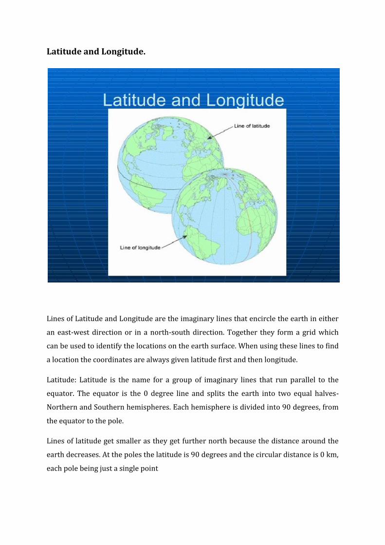
Latitude and Longitude.
Lines of Latitude and Longitude are the imaginary lines that encircle the earth in either
an east-west direction or in a north-south direction. Together they form a grid which
can be used to identify the locations on the earth surface. When using these lines to find
a location the coordinates are always given latitude first and then longitude.
Latitude: Latitude is the name for a group of imaginary lines that run parallel to the
equator. The equator is the 0 degree line and splits the earth into two equal halves-
Northern and Southern hemispheres. Each hemisphere is divided into 90 degrees, from
the equator to the pole.
Lines of latitude get smaller as they get further north because the distance around the
earth decreases. At the poles the latitude is 90 degrees and the circular distance is 0 km,
each pole being just a single point
Longitude: Lines of longitude run north-south around the planet. They begin at the
prime meridian and split the Earth into East and West hemispheres. There are 180
degrees in each hemisphere. All lines of longitude are the same length. There is only one
important line of longitude other than Prime Meridian-the International Date Line. This
is the 180 degree line in both directions.
International Date Line.
It is the imaginary line on the Earth that separates two consecutive calendar days. The
date in the eastern hemisphere, to the left of line, is always one day ahead of the date in
the western hemisphere. It has been recognized as a matter of convenience and has no
force in international law.
Day Light Saving Time.
Daylight saving time (DST) or summer time is the practice of advancing clocks during
summer months by one hour so that in the evening hours day light is experienced later,
while sacrificing normal sunrise times. Typically, users in regions with summer time
adjust clocks forward one hour close to the start of spring and adjust them backward in
the autumn to standard time.
New Zealander George Hudson proposed the modern idea of daylight saving in 1895.
Germany and Austria-Hungary organized the first implementation, starting on 30 April
1916.
Standard Time.
Standard time is the synchronization of clocks within a geographical area or a region to
a single time standard, rather than using solar time or a locally chosen meridian
(longitude) to establish a local mean time standard. Historically, the concept was
established during the 19th century to aid weather forecasting and train travel.