Embed Size (px)
Citation preview
Old Dominion UniversityODU Digital CommonsHampton Roads Intergovernmental Pilot Project:Website
Hampton Roads Intergovernmental Pilot ProjectArchive
2017
Center For Sea Level RiseCenter for Sea Level Rise, Old Dominion University
Follow this and additional works at: https://digitalcommons.odu.edu/hripp_website
This Creative Work is brought to you for free and open access by the Hampton Roads Intergovernmental Pilot Project Archive at ODU DigitalCommons. It has been accepted for inclusion in Hampton Roads Intergovernmental Pilot Project: Website by an authorized administrator of ODUDigital Commons. For more information, please contact [email protected].
Repository CitationCenter for Sea Level Rise, Old Dominion University, "Center For Sea Level Rise" (2017). Hampton Roads Intergovernmental PilotProject: Website. 1.https://digitalcommons.odu.edu/hripp_website/1
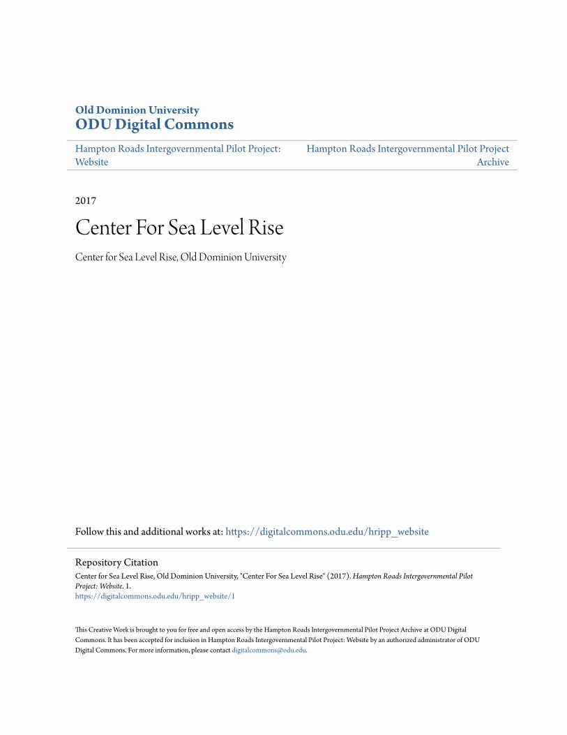
A WHOLE OF GOVERNMENT, WHOLE OF COMMUNITY APPROACH Several initiatives to address sea level rise are already in progress at varying levels of government, and across the community, but there is currently no coordination across these disparate efforts. Effective regional planning to prepare for and mitigate sea level rise requires unified, coordinated planning efforts across Federal, state, and local government agencies and the private sector, with public participation in the planning process.
By utilizing Old Dominion University as a convener to orchestrate these planning efforts, this Pilot Project will close this coordination gap with a “whole of government, whole of community” approach. A unified approach will achieve an unprecedented level of cooperation between the Federal government, the Commonwealth of Virginia, regional and local governments, businesses, community efforts of the Hampton Roads area.
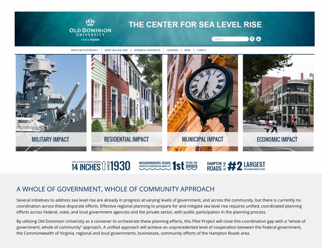
MILITARY IMPACT Hampton Roads is home to the world’s largest Navy Base, and numerous military bases – combined, the Department of Defense contributes approximately 46% to the local economy. In Virginia, sea levels are rising faster than the global average because the land is sinking, primarily from natural causes. Sea level rise, and the vulnerabilities created are front and center issues for military leaders. Norfolk Naval Base is home to 14 World War II era piers that are experiencing significant maintenance issues due to the rising sea levels that have occurred since they were built. These piers are being replaced over time, at a cost of $35-40 million per pier, according to the Department of Defense. This forced adaptation due to sea level rise couldn’t come at a worse time. Hampton Roads and the state of Virginia are already feeling the effects of cutbacks in federal military spending because of the budget battles in Washington.
“This is a matter of national security… It’s a mission readiness issue,” said Alice Hill, senior adviser for preparedness and resilience at the National Security Council. Just as encroaching residential development threatened the move of Naval Air Station Oceana in Virginia Beach, “you can’t help but think of flooding problems as a form of encroachment,” said John Conger, deputy undersecretary of defense. “How does it affect your mission?”
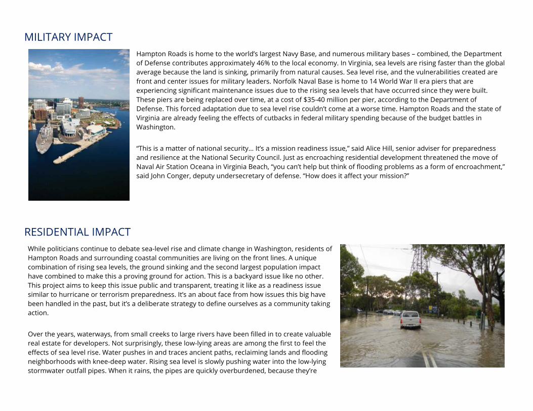
RESIDENTIAL IMPACT While politicians continue to debate sea-level rise and climate change in Washington, residents of Hampton Roads and surrounding coastal communities are living on the front lines. A unique combination of rising sea levels, the ground sinking and the second largest population impact have combined to make this a proving ground for action. This is a backyard issue like no other. This project aims to keep this issue public and transparent, treating it like as a readiness issue similar to hurricane or terrorism preparedness. It’s an about face from how issues this big have been handled in the past, but it’s a deliberate strategy to define ourselves as a community taking action.
Over the years, waterways, from small creeks to large rivers have been filled in to create valuable real estate for developers. Not surprisingly, these low-lying areas are among the first to feel the effects of sea level rise. Water pushes in and traces ancient paths, reclaiming lands and flooding neighborhoods with knee-deep water. Rising sea level is slowly pushing water into the low-lying stormwater outfall pipes. When it rains, the pipes are quickly overburdened, because they’re
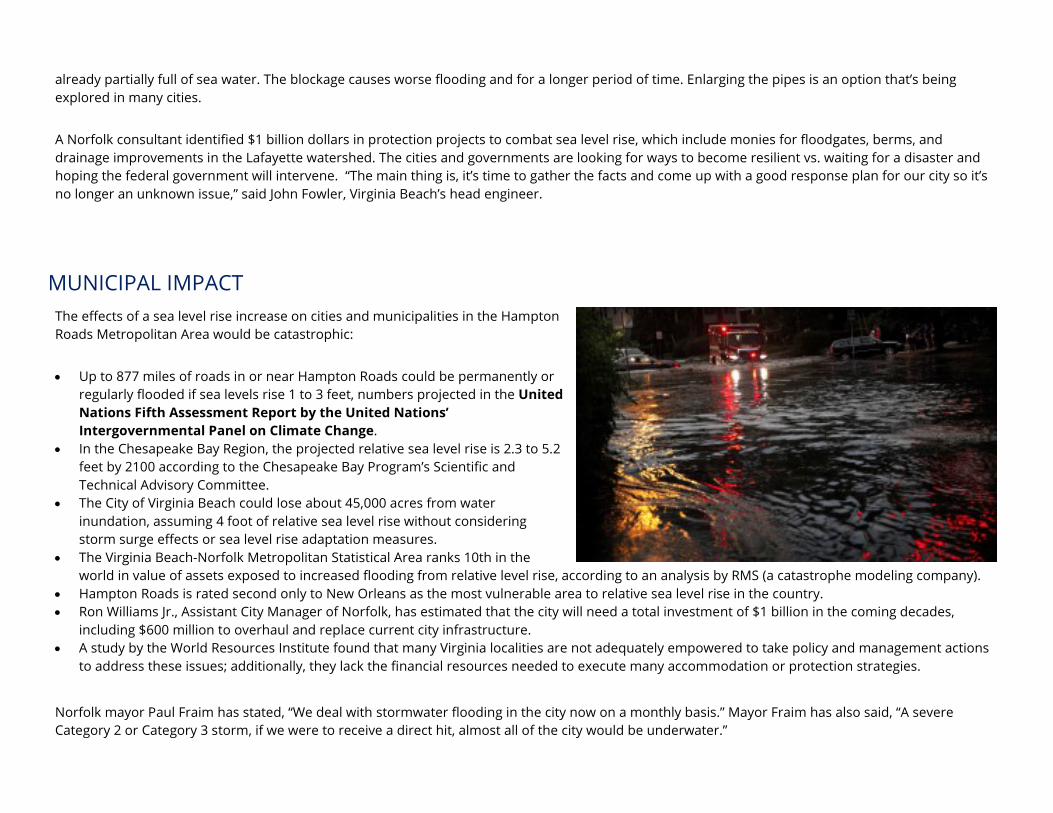
already partially full of sea water. The blockage causes worse flooding and for a longer period of time. Enlarging the pipes is an option that’s being explored in many cities.
A Norfolk consultant identified $1 billion dollars in protection projects to combat sea level rise, which include monies for floodgates, berms, and drainage improvements in the Lafayette watershed. The cities and governments are looking for ways to become resilient vs. waiting for a disaster and hoping the federal government will intervene. “The main thing is, it’s time to gather the facts and come up with a good response plan for our city so it’s no longer an unknown issue,” said John Fowler, Virginia Beach’s head engineer.
MUNICIPAL IMPACT The effects of a sea level rise increase on cities and municipalities in the Hampton Roads Metropolitan Area would be catastrophic:
• Up to 877 miles of roads in or near Hampton Roads could be permanently or regularly flooded if sea levels rise 1 to 3 feet, numbers projected in the United Nations Fifth Assessment Report by the United Nations’ Intergovernmental Panel on Climate Change.
• In the Chesapeake Bay Region, the projected relative sea level rise is 2.3 to 5.2 feet by 2100 according to the Chesapeake Bay Program’s Scientific and Technical Advisory Committee.
• The City of Virginia Beach could lose about 45,000 acres from water inundation, assuming 4 foot of relative sea level rise without considering storm surge effects or sea level rise adaptation measures.
• The Virginia Beach-Norfolk Metropolitan Statistical Area ranks 10th in the world in value of assets exposed to increased flooding from relative level rise, according to an analysis by RMS (a catastrophe modeling company).
• Hampton Roads is rated second only to New Orleans as the most vulnerable area to relative sea level rise in the country. • Ron Williams Jr., Assistant City Manager of Norfolk, has estimated that the city will need a total investment of $1 billion in the coming decades,
including $600 million to overhaul and replace current city infrastructure. • A study by the World Resources Institute found that many Virginia localities are not adequately empowered to take policy and management actions
to address these issues; additionally, they lack the financial resources needed to execute many accommodation or protection strategies.
Norfolk mayor Paul Fraim has stated, “We deal with stormwater flooding in the city now on a monthly basis.” Mayor Fraim has also said, “A severe Category 2 or Category 3 storm, if we were to receive a direct hit, almost all of the city would be underwater.”
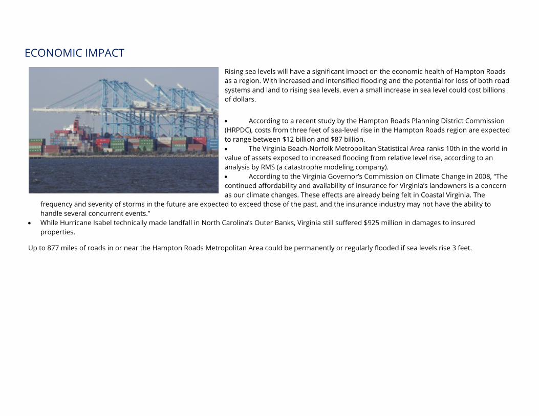
ECONOMIC IMPACT Rising sea levels will have a significant impact on the economic health of Hampton Roads as a region. With increased and intensified flooding and the potential for loss of both road systems and land to rising sea levels, even a small increase in sea level could cost billions of dollars.
• According to a recent study by the Hampton Roads Planning District Commission (HRPDC), costs from three feet of sea-level rise in the Hampton Roads region are expected to range between $12 billion and $87 billion. • The Virginia Beach-Norfolk Metropolitan Statistical Area ranks 10th in the world in value of assets exposed to increased flooding from relative level rise, according to an analysis by RMS (a catastrophe modeling company). • According to the Virginia Governor’s Commission on Climate Change in 2008, “The continued affordability and availability of insurance for Virginia’s landowners is a concern as our climate changes. These effects are already being felt in Coastal Virginia. The
frequency and severity of storms in the future are expected to exceed those of the past, and the insurance industry may not have the ability to handle several concurrent events.”
• While Hurricane Isabel technically made landfall in North Carolina’s Outer Banks, Virginia still suffered $925 million in damages to insured properties.
Up to 877 miles of roads in or near the Hampton Roads Metropolitan Area could be permanently or regularly flooded if sea levels rise 3 feet.
WHAT IS THE PILOT PROJECT? Read our Phase 1 Report
Phase 2 Report, unveiled Oct. 19 at an event in Washington, D.C. at the World Resources Institute.
The Hampton Roads Sea Level Rise Preparedness and Resilience Intergovernmental Planning Pilot Project is the first of its kind. This two-year project seeks to develop adaptive planning for sea level rise by combining the efforts of federal, state and local agencies with private industries and researchers. Using a collaborative approach, this pilot project will serve as a template for affected regions across the United States with the development of an intergovernmental planning body starting in 2016.
Old Dominion University combines teaching, research and outreach missions as the coordinator of the pilot project. ODU is where minds, research and intellectual capital come together to go beyond previous sea level studies, find results and effectively inform and engage citizens. Within the context of this project, ODU will be coordinating an unprecedented level of cooperation and collaboration between communities, private organizations, researchers, and governmental agencies of all levels.
WHY HAMPTON ROADS IS THE PERFECT LOCATION FOR THIS PROGRAM
Since 2010, ODUs Climate Change and Sea Level Rise Initiative has facilitated research and education in all aspects of climate change and sea level rise. As an outgrowth of CCSLRI, the Mitigation and Adaptation Research Institute (MARI) works to generate knowledge and reduce the negative effects of sea level rise for thriving coastal communities. To develop the practice-relevant solutions, MARI engages in research that produces the practice-relevant knowledge needed to cope with the impacts of climate change and sea level rise on the coastal zone and the urban coast in particular. In doing so, MARI responds to the knowledge needs of a wide range of community stakeholders, including government, military, private sector, and citizens
The high rate of local sea level rise, the exposure to extreme weather events, and the complex socio-economic structure makes Hampton Roads a natural laboratory for climate change and sea level rise. MARI utilizes this laboratory and works with stakeholders within and outside the region to generate the knowledge that can enable them not only to reduce the negative impacts but also to utilize the opportunities in the changes to come.
Mission The mission of the Pilot Project is to develop a regional “whole of government” and “whole of community” approach to sea level rise preparedness and resilience planning in Hampton Roads that also can be used as a template for other regions. View the Pilot Project Charter for an in-depth look at the Pilot Projects intentions.
Vision Upon completion of the Pilot Project, Hampton Roads will have in place an intergovernmental planning organization that can effectively coordinate the sea level rise preparedness and resilience planning of Federal, state and local government agencies and the private sector, taking into account the perspectives and concerns of the citizens of the region.
The project planning will address the four major impacts of sea level rise:
• Permanent inundation • Increased tidal flooding • Increased storm surge, both frequency and magnitude. This is also referred to as recurrent flooding. • Combined impact of sea level rise, precipitation and groundwater elevation on storm water drainage.
A letter from the U.S. Department of Defense announcing the Pilot: Distribution Memo to Services Announcing DoD Led CEQ Climate Change Plan.
Timeline The Pilot Project will be conducted in two phases, each tentatively lasting one year.
Phase I. June 2014 – June 2015 The goal of the first phase is to develop a Memorandum of Agreement setting the organizational structure and operating procedures for coordinating intergovernmental sea level rise preparedness and resilience planning. Phase I will include a review of key Federal, Commonwealth of Virginia, and regional reports and policy documents that may provide guidance or recommendations applicable to this regional planning effort, lessons learned and best practices from other regional sea level rise planning efforts in the United States and abroad, and other studies and analyses related to sea level rise adaptation that may help inform this planning effort. The Steering Committee should assess the value of modeling and simulation tools for the initial planning efforts to be launched in Phase II.
Phase II. June 2015 – June 2016 The initial intergovernmental planning organization developed in Phase I will commence coordination of sea level rise preparedness and resilience planning by Federal, state and local government agencies and the private sector, with inputs from the public. The lessons learned in Phase II will be used to refine the organizational structure and operating procedures to allow a permanent intergovernmental planning organization to commence operations immediately upon conclusion of the Pilot Project.
Committees and Working Groups
Members of the committees and working groups are dedicated volunteers with the experience and knowledge to further the Pilot Projects goals. Current groups are:
• Steering Committee • Legal Working Group • Infrastructure Planning Working Group • Public Health Working Group • Land Use Planning Working Group • Citizen Engagement Working Group • Senior Advisory Committee • Science Advisory Committee • Economic Impacts Advisory Committee • Private Infrastructure Advisory Committee
The list may expand as the project progresses.
STEERING COMMITTEE
RESPONSIBILITIES OF STEERING COMMITTEE MEMBERS
The Steering Committees and Advisory Committees are comprised of government, military, industrial, economic, community, scientific and environmental leaders from throughout the country. Members of Pilot Project committees are volunteers.
• Actively contribute to the deliberations of the Steering Committee. • Attend Steering Committee meetings and participate in other
Steering Committee activities to the maximum extent possible. • Principals may designate an alternate who has authority to speak
and vote on behalf of the principal. • Keep the Member’s organization informed of Steering Committee
deliberations and activities, and provide feedback to the Steering Committee as appropriate
• Provide “reach back,” serving as a link to other offices in the member’s organization that may be able to provide information, analyses.
Chair: Mayor Kenneth Wright, City of Portsmouth.
Organizations represented by members of the Steering Committee include:
• City of Portsmouth • U.S. Navy Mid-Atlantic Region • U.S. Army Corps of Engineers, Norfolk District • United States Coast Guard, Shore Infrastructure Logistics Center • U.S. Coast Guard, Region 5 • Naval Facilities Engineering Command Mid-Atlantic • Joint Base Langley- Eustis • Virginia Port Authority • Hampton Roads Planning District Commission • Emergency Preparedness & Response, City of Norfolk • Commonwealth of Virginia • Huntington Ingalls
*Please note: Not all members of the Steering Committee are voting members.
LEGAL WORKING GROUP
The Legal Working Group will address legal issues that arise during the Pilot Project and draft a Memorandum of Understanding (MOU) for the follow-on project that emerges from the pilot project. The draft MOU will be submitted to the Steering Committee no later than April 2016. The Working Group will consult with contacts designated by other Steering Committee members.
The group has created a Legal Primer to discuss potential issues for a large project like the Pilot.
Chair: Roy Hoagland, Virginia Coastal Policy Clinic at the William & Mary School of Law.
Organizations represented by members of the Legal Working Group include:
• Hampton Roads Planning District Commission • Office of the Attorney General (for Natural Resources) • U.S. Navy • Williams-Mullen • U.S. Coast Guard • City of Chesapeake • City of Newport News • Isle of Wight • Wetlands Watch • Office of the Attorney General (for VDOT) • City of Hampton • National Oceanic and Atmospheric Administration
INFRASTRUCTURE PLANNING WORKING GROUP
The Infrastructure Planning Working Group will recommend which infrastructures in Hampton Roads require adaptation planning and formulate recommendations for intergovernmental coordination of that planning, and in consultation with the Private Infrastructure Advisory Committee, formulate recommendations for privately owned infrastructure planning.
Chair: Ann Phillips, Rear Admiral, U.S. Navy (Ret.)
Organizations represented by Infrastructure Planning Working Group members include:
• U.S. Army • Naval Facilities, U.S. Navy • Camp Pendleton, U.S. Army • Department of Education • Department of Transportation • Virginia Port Authority • Hampton Roads Planning District Commission • Hampton Roads Transportation Planning Organization • Homeland Security, Richmond & Hampton Roads • Health & Human Services • Virginia Department of Transportation • ODU • Joint Base Langley-Eustis • City of Virginia Beach • City of Newport News, City Attorneys office
LAND USE PLANNING WORKING GROUP
The Land Use Planning Working Group will recommend which land use related plans, programs and policies in Hampton Roads require adaptation planning and formulate recommendations for intergovernmental coordination. In consultation with the Municipal Planning Advisory Committee, the Working Group will address land use planning, floodplain management, local government comprehensive plans, zoning, building codes and other plans, programs and policies it identifies in the course of its work.
Chair: Burrell Saunders, Urban Land Institute- Hampton Roads.
Organizations represented by members of the Land Use Planning Working Group include:
• Urban Land Institute- Hampton Roads • NASA Langley • Terry Peterson Company • Harvey Lindsay Real Estate • City of Virginia Beach, Strategic Growth • City of Portsmouth, Planning • Department of Environmental Quality (Virginia) • FEMA Region 3 • Gaugamela LLC • Harbor Group • Williams Mullen • Navy Facilities Engineering Command • ODU School of Public Service • ODU, Public Administration and Urban Policy • City of Norfolk • VMASC • City of Hampton • City of Poquoson • Hampton Roads Planning District Commission • ODU, Public Administration
CITIZEN ENGAGEMENT WORKING GROUP
The Citizen Engagement Working Group will prepare a communications and engagement plan for the Steering Committee that addresses informing the public on the Pilot Project on an on-going basis, and soliciting public comment on recommendations for intergovernmental coordination of planning. The Working Group also will coordinate messaging, oversee the ODU public-facing web site, and organize public events. The individuals listed below may designate Working Group members from their organizations, but are themselves responsible for approving the communications and engagement plan that will be submitted to the Steering Committee.
Co-chairs: Michelle Covi, Old Dominion University and Virginia Sea Grant; Chris Bonney, Hampton Roads Center for Civic Engagement and Bonney Research.
Affiliations of members include:
• City of Norfolk • League of Women Voters • Office of the Attorney General (Virginia) • City of Hampton • WHRO • Virginia Institute of Marine Science • The Planning Council • Peninsula Chamber of Commerce • ODU School of Public Service • City of Virginia Beach • ODU, Communication and Theater Arts • Hampton Roads Planning District Commission • Wetlands Watch • Lynnhaven River NOW
SENIOR ADVISORY COMMITTEE
The Senior Advisory Committee consists of between six and 12 longtime Hampton Roads residents who have held senior leadership positions in government, business or academia, and who have been actively involved in regional or community activities related to the work of the Pilot Project.
Chair: Joe Frank, former mayor of Newport News.
• Huntington Ingalls • Hampton Roads Community Foundation • Hampton Roads Planning District Commission • Eastern Virginia Medical School • Hampton Roads Military and Federal Facilities Alliance • Mymic • Schexnider & Associates, LLC • WHRO • PB Mares • Jodys Popcorn
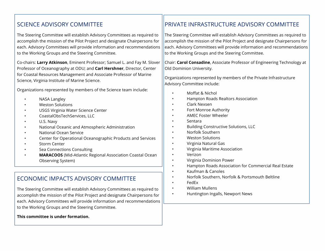
SCIENCE ADVISORY COMMITTEE
The Steering Committee will establish Advisory Committees as required to accomplish the mission of the Pilot Project and designate Chairpersons for each. Advisory Committees will provide information and recommendations to the Working Groups and the Steering Committee.
Co-chairs: Larry Atkinson, Eminent Professor; Samuel L. and Fay M. Slover Professor of Oceanography at ODU; and Carl Hershner, Director, Center for Coastal Resources Management and Associate Professor of Marine Science, Virginia Institute of Marine Science.
Organizations represented by members of the Science team include:
• NASA Langley • Weston Solutions • USGS Virginia Water Science Center • CoastalObsTechServices, LLC • U.S. Navy • National Oceanic and Atmospheric Administration • National Ocean Service • Center for Operational Oceanographic Products and Services • Storm Center • Sea Connections Consulting • MARACOOS (Mid-Atlantic Regional Association Coastal Ocean
Observing System)
ECONOMIC IMPACTS ADVISORY COMMITTEE
The Steering Committee will establish Advisory Committees as required to accomplish the mission of the Pilot Project and designate Chairpersons for each. Advisory Committees will provide information and recommendations to the Working Groups and the Steering Committee.
This committee is under formation.
PRIVATE INFRASTRUCTURE ADVISORY COMMITTEE
The Steering Committee will establish Advisory Committees as required to accomplish the mission of the Pilot Project and designate Chairpersons for each. Advisory Committees will provide information and recommendations to the Working Groups and the Steering Committee.
Chair: Carol Consadine, Associate Professor of Engineering Technology at Old Dominion University.
Organizations represented by members of the Private Infrastructure Advisory Committee include:
• Moffat & Nichol • Hampton Roads Realtors Association • Clark Nexsen • Fort Monroe Authority • AMEC Foster Wheeler • Sentara • Building Constructive Solutions, LLC • Norfolk Southern • Weston Solutions • Virginia Natural Gas • Virginia Maritime Association • Verizon • Virginia Dominion Power • Hampton Roads Association for Commercial Real Estate • Kaufman & Canoles • Norfolk Southern, Norfolk & Portsmouth Beltline • FedEx • William Mullens • Huntington Ingalls, Newport News
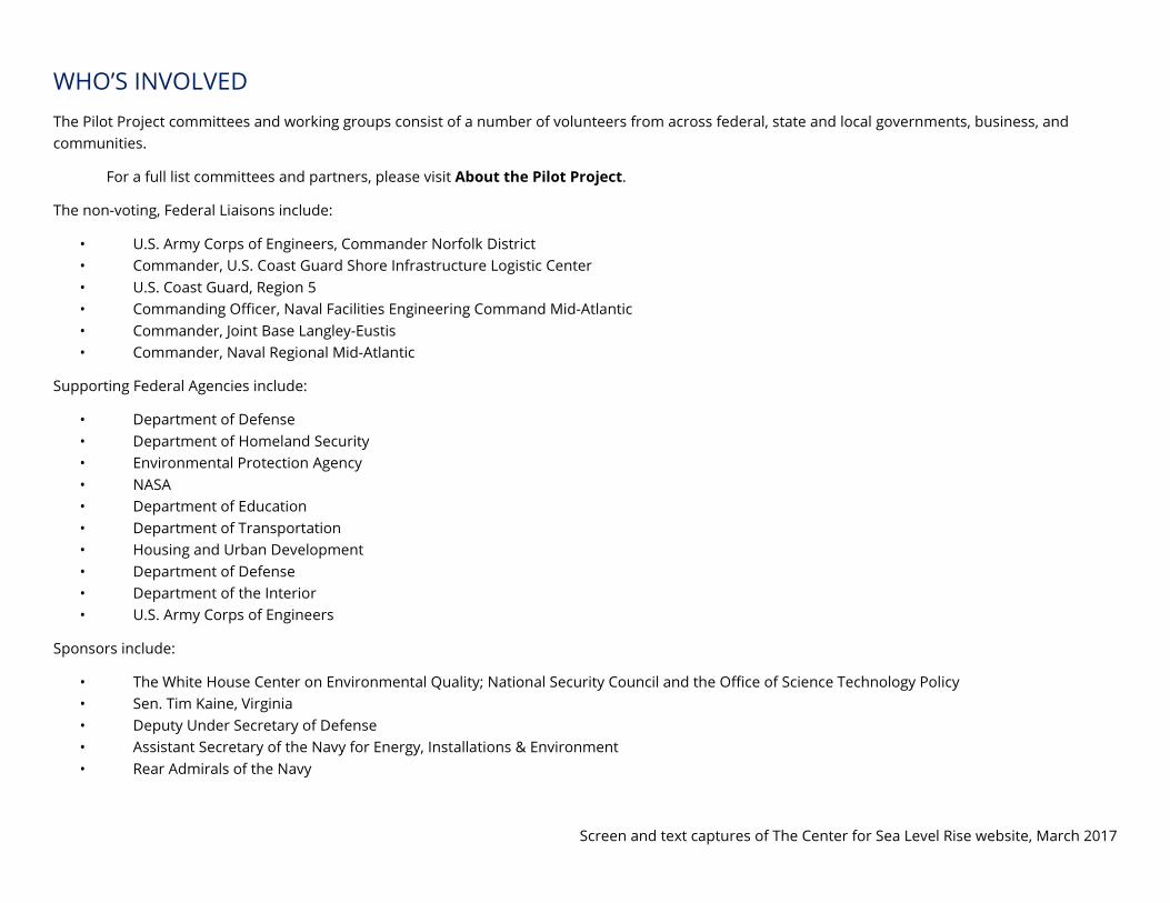
WHO’S INVOLVED The Pilot Project committees and working groups consist of a number of volunteers from across federal, state and local governments, business, and communities.
For a full list committees and partners, please visit About the Pilot Project.
The non-voting, Federal Liaisons include:
• U.S. Army Corps of Engineers, Commander Norfolk District • Commander, U.S. Coast Guard Shore Infrastructure Logistic Center • U.S. Coast Guard, Region 5 • Commanding Officer, Naval Facilities Engineering Command Mid-Atlantic • Commander, Joint Base Langley-Eustis • Commander, Naval Regional Mid-Atlantic
Supporting Federal Agencies include:
• Department of Defense • Department of Homeland Security • Environmental Protection Agency • NASA • Department of Education • Department of Transportation • Housing and Urban Development • Department of Defense • Department of the Interior • U.S. Army Corps of Engineers
Sponsors include:
• The White House Center on Environmental Quality; National Security Council and the Office of Science Technology Policy • Sen. Tim Kaine, Virginia • Deputy Under Secretary of Defense • Assistant Secretary of the Navy for Energy, Installations & Environment • Rear Admirals of the Navy
Screen and text captures of The Center for Sea Level Rise website, March 2017