Embed Size (px)
Citation preview
IPA12-G-028
PROCEEDINGS, INDONESIAN PETROLEUM ASSOCIATION Thirty-Sixth Annual Convention & Exhibition, May 2012
CENOZOIC HISTORY OF THE EAST JAVA FOREARC
A.M. Surya Nugraha*
Robert Hall*
ABSTRACT Cenozoic subduction of the Indo-Australian plate beneath Java began in the Middle Eocene. The East Java forearc preserves a record of Cenozoic sedimentation and tectonic history, and information about the character of the deeper crust. Based on new seismic data, morphology analysis, and correlation with offshore wells and geology on land, the East Java forearc stratigraphy can be divided into six tectono-stratigraphic units with three major unconformities. The lowest unit is a section with continuous strong reflectors that can be seen to depths of 10 sec TWT and is absent beneath the Central and West Java forearc. This unit could be a Paleogene succession which is equivalent to the deep Kendeng Basin on land in East Java. Alternatively, it could be a pre-Cenozoic sequence deposited on continental crust which was rifted from western Australia. We prefer the latter interpretation based on the seismic and morphological characteristics of the deep section. A Middle Eocene to Lower Oligocene sequence was deposited above a Middle Eocene unconformity during an extensional phase. It was followed by Upper Oligocene to Lower Miocene deposition accompanying voluminous volcanism. There was localized contraction of Lower Miocene and older units which records deformation prior to termination of Paleogene–Early Neogene arc activity. This was marked by an explosive super-eruption and there is a Lower–Middle Miocene unconformity in a forearc structural high. An extensive carbonate platform was deposited above the Lower–Middle Miocene unconformity during a tectonically quiet period with much reduced volcanism. Significant subsidence to present depths began in the Late Miocene. There was significant deformation at the southern side of * SE Asia Research Group
the forearc after deposition of the Upper Miocene unit which we interpret to be caused by arrival of a buoyant plateau at the subduction margin. Afterwards, carbonates were buried by Late Pliocene volcanogenic deposits at high rates of sedimentation. INTRODUCTION The study area is located in offshore SE Java and is situated at the southeast edge of the Eurasian plate, known as Sundaland (Figure 1 and Figure 2). Sundaland is the continental core of SE Asia and was constructed by amalgamation of continental blocks during the Mesozoic (Hamilton, 1979; Metcalfe, 1996; Hall & Morley, 2004). In East Java, the basement has long been considered to be Cretaceous arc and ophiolitic-accretionary complexes (Hamilton, 1979; Wakita, 2000) but there is increasing evidence of continental crust beneath the East Java Sea (Manur & Barraclough, 1994; Emmett et al., 2009; Granath et al., 2011), and the southern part of East Java (Smyth, 2005; Smyth et al., 2007, 2008). These seismic lines south of Java have imaged a deep stratified sequence (Figure 3 and Figure 4) which is restricted to East Java and is absent beneath the West Java forearc. The age of the lower section is still uncertain but Deighton et al. (2011) suggested it may be Mesozoic. This paper uses the new seismic data to assess the age of the lower section and acquire a better understanding of the tectono-stratigraphic evolution of the East Java forearc. REGIONAL SETTING East Java is situated at the southeast edge of the Sundaland margin and to the south it is bounded by the Java Trench (Figure 1). Java is a part of the Sunda Arc system and is a volcanic island which consists of modern and ancient volcanic arcs which formed by northward subduction of the Indo-Australia plate beneath Eurasia at the Java Trench. The trench has been in its present position since the Middle Eocene (Hall, 2002; Smyth et al., 2008).
Back to Session

Character of the basement The basement beneath Java is known only from limited exposures at Ciletuh in West Java, and Karangsambung and the Jiwo Hills in Central Java. These include chert, limestone, basalt, siliceous shale, sandstone, shale, volcanic breccia, conglomerate, high P/T and ultra high P metamorphic rocks and ultramafic rocks (Hamilton, 1979; Parkinson et al., 1998; Wakita, 2000). Hamilton (1979) suggested Java is underlain by Cretaceous continental basement in the west part and Cretaceous melange in the east part. Wakita (2000) postulated the basement is part of a Cretaceous accretionary-collision complex which is characterized by fragments of arc and ophiolitic material accreted to the Sundaland margin. Sribudiyani et al. (2003) proposed a continental basement beneath East Java based on the presence of Pre-Ngimbang sedimentary units in which Eocene sands are reported to have a continental origin. The ages of zircons from Cenozoic igneous and sedimentary rocks indicates at least the southern part of East Java is underlain by ancient Gondwana continental crust (Smyth, 2005; Smyth et al., 2005, 2007, 2008). Seubert & Sulistianingsih (2008) speculated that there were several continental fragments accreted to Java that underlie the Southern Mountains. Continental crust beneath the East Java Sea was proposed by Manur & Barraclough (1994) based on granitic rocks sampled in an oil-exploration well. Matthews & Bransden (1995 reported the basement of the East Java Sea Basin includes Cretaceous metasediments, quartzite and chert. Recent studies have imaged a thick deep pre-Cenozoic section in the East Java Sea and interpreted it to be part of an East Java–West Sulawesi continental block (Emmett et al., 2009; Hall et al., 2009; Granath et al., 2011). The character of the deep crust beneath offshore SE Java is still unknown. There have been a few studies of the South Java forearc but much of the deeper part is still not well imaged. The basement has been long considered as transitional from continental in Sumatra through to oceanic in Flores (Hamilton, 1988; van der Werff et al., 1994; Kopp, 2011). Wagner et al. (2007) interpreted results from high-velocity joint inversion of active and passive seismic data as indicating continental crust beneath Mt. Merapi in Central Java. Kopp et al. (2006) were not able to image the lower section beneath the East Java forearc because of the lack of data penetration but Shulgin et al. (2011) speculated gravity features could be associated with the presence of continental
crust below Java. Unfortunately, the gravity studies are not accompanied by adequate seismic data and cannot be reliably interpreted due to the non-uniqueness of the gravity modelling. Seismic refraction data below the Java and Lombok Basins indicate crust of intermediate thickness (18-25 km) and velocities (5.6-6.8 km/s) which suggest rifted crust of continental origin rather than anomalously thickened oceanic lithosphere (van der Werff, 1996). Regional stratigraphy Subduction and significant arc volcanism ceased beneath Java from about 90 Ma to 45 Ma (Hall et al., 2009, Hall, 2009, 2011). Subduction resumed when Australia began to move northwards in the Middle Eocene (Hall, 2009). The oldest Cenozoic sediments reported on land in East Java are Middle Eocene (Lelono, 2000, Smyth et al., 2008) and were deposited unconformably on basement rocks. The Early Cenozoic sandstones above the oldest sediments increase in volcanic material up-section recording initiation of the Southern Mountain Arc (Smyth, 2005). There is an intra-Oligocene unconformity across East Java and the East Java Sea that was mainly caused by sea level change (Matthews and Bransden, 1995; Smyth, 2005). Oligocene sediments contain significant volcanic debris (Smyth et al., 2008). Explosive volcanic activity was extensive in the Southern Mountains Arc during the Late Oligocene to Early Miocene as indicated by thick sequences of volcanic and epiclastic rocks (Smyth, 2005; Smyth et al., 2008). Upper Oligocene volcaniclastic rocks have been reported in the Shell Alveolina-1 well, offshore Central Java. In the Borelis-1 well, the oldest dated rocks are Early Miocene (Figure 5). These two wells terminated in undated basalt (Bolliger & de Ruiter, 1975) confirming Southern Mountain Arc volcanism in offshore South Java. The Early Cenozoic arc volcanism was terminated by the short-lived Early Miocene Semilir super-eruption event (Smyth 2005, Smyth et al., 2008, 2011). The whole southeast region of Sundaland was uplifted during this period (Sribudiyani et al., 2005). To the north, a sequence boundary is placed at the top of the Prupuh Limestone because basin inversion is interpreted to have been initiated on a regional scale near to the end of its deposition in the Middle Miocene (Matthews and Bransden, 1995). During the Middle Miocene to Late Miocene, volcanic activity was much reduced. Older volcanic material was reworked and carbonate platforms

developed extensively during this period (Bolliger & de Ruiter, 1975; Smyth, 2005). The carbonates range in age from late Early Miocene to Middle Miocene (Lokier, 2000; Smyth, 2005). Several tuff beds are observed in turbidite sequences in the Southern Mountains and range in age from 12 to 10 Ma (Smyth, 2005). This represents the resumption of volcanic activity at the position of the present Sunda Arc (Smyth et al., 2005). Lunt et al. (2009) suggested an important unconformity recorded a Late Miocene tectonic event which created a new series of basins that were filled by erosion of structural highs in Central Java. There are no Pliocene or Quaternary deposits in the Southern Mountains zone due to uplift and erosion. The Shell exploration wells record a major tectonic event in the Late Pliocene interpreted to have caused uplift of Java marked by widespread Pliocene and Quaternary sediments in the offshore area (Bolliger and de Ruiter, 1975). DATASET AND METHODOLOGY The primary dataset comprises three long-offset 2D-seismic datasets (SJR-9, SJR-10, and SJI-10) acquired by TGS (Figure 2). These data consists of thirty-seven 2D marine seismic lines across the Java forearc with a total of 8266 km survey length. The SJR-9 survey was acquired in 2009 and is mainly located in the west Java offshore area. This dataset includes a long strike line in the forearc basin (631 km) that shows the deep crustal differences from offshore SW Java to offshore SE Java. SJR-10 and SJI-10 were acquired in 2010 and are largely in the SE Java basin. The SJI-10 infill survey provided a grid of about 20-25 km spacing. Previously published seismic data (Kopp et al., 2006) were limited to shallow imaging 4-streamer seismic sections. All three TGS seismic datasets have imaged down to 9 seconds two-way-time (TWT), and show very deep units in the forearc basin not seen in previously published seismic data in the forearc area (Deighton et al., 2010). Three well datasets were available, including: Cilacap-1, Borelis-1, and Alveolina-1 . The Borelis-1 and Alveolina-1 wells were drilled by Djawa Shell N.V. (Bolliger & de Ruiter, 1975) in the early 1970s and are located in the shallow part of the offshore Central Java forearc (Figure 2). These wells encountered mid-late Cenozoic rocks and have about 2 km total depth. The biostratigraphic top information (Shell interpretations) from these wells are the main reference for our mid and late Tertiary age-controlled stratigraphic interpretation (Figure 5). The Cilacap-1 well was drilled by Union
Texas but appears to have been terminated before returning cuttings (Deighton et al., 2011). SEISMIC UNITS We identified six seismic units, labelled A to F (Figure 6), on the basis of their age, seismic character, deformation style in combination with published studies. We describe these units from the shallowest to deepest, i.e. from F to A. Seismic Unit F Unit F is the deepest seismic unit recognizable from the surveys (Figure 6). It is observed only in the deepest part of the forearc basin (Figure 3 and Figure 4). This unit shows a relatively uniform ~3 s TWT thickness across the forearc basin. The carbonate platform in the forearc landward flank and the intense faulting and folding in the accretionary zone obscure its boundaries to north and south on seismic images. To the east, this unit disappears close to the Lombok Basin. To the west it cannot be traced beyond a transverse high block at the position of the Progo-Muria lineament of Smyth et al. (2005). The lower section part of this unit shows moderate to weak reflectors. The middle part is characterized by bright and parallel reflectors with discontinuous lower amplitude reflectors. The upper part is characterized by chaotic, discontinuous weak amplitude reflectors which are brighter and relatively parallel near the forearc basin edges. This unit is cut by a series of planar extensional fault with small displacements forming graben and half graben (Figure 7). The faults are more intense in E-W sections along the forearc basin than in N-S sections. A few faults have been reactivated close to the subduction complex and structural highs to the north. There are also a few internal thrust faults within this unit which record later deformation. In places this unit seems to be truncated by younger units. Seismic Unit E Unit E is mainly observed in the arc-flank area and is characterized by parallel discontinuous reflectors (Figure 7). Bedding is generally parallel to younger units. Wedge geometry is observed with thickening towards faults. Along the East Java Forearc Flank, Unit E is the deepest recognizable unit in the forearc flank and is interpreted as a sedimentary layer deposited in a syn-rift event. A series of planar extensional fault graben and half graben are

observed within this unit with a larger displacement than Unit F. Several of these faults are have been reactivated at the structural high. Seismic Unit D Unit D was deposited above Unit E (Figure 7) and is only observed in the forearc flank area. In contrast with the unit below, Unit D shows generally continuous and well bedded strong reflectors with a wedge geometry, but does not clearly thicken towards faults. The seismic reflectors become brighter and more continuous basinward which suggests a facies change. Unit D was probably deposited at the end of the rift stage. This unit appears to be thinner and truncated at the base of Unit C near to structural highs, and is interpreted to be associated with inversion and erosion. Seismic Unit C Unit C shows strong, parallel and fairly continuous reflectors which become variable in amplitude away from carbonate build ups. The bright reflectors are interpreted as limestone and the varying amplitude is interpreted as an alternation of shelf carbonates and mudstone. The carbonate build ups tends to be developed on top of structural or topographic highs (Figure 8). Pinnacle reefs are observed at the later stage of several carbonate build-up developments. Near the shelf break the lower part of carbonate platform downlaps onto an unconformity surface and includes packages of progradation, retrogradation and aggradation upward (Figure 8). The prograding architecture is observed on the top of an unconformity and thickens to the shelf break before thinning basinward. The carbonate platform is widespread in the western part of the study area and decreases to the east. Seismic Unit B Unit B is characterized by bright, continuous, and well bedded reflectors, which are weaker in the middle part (Figure 9). In the forearc basin it is hard to pick the boundary between Units C and B because it is conformable. The upper part of Unit B is observed to onlap onto the lower part of the carbonate build-up Unit C (Figure 6). Unit B shows a relatively constant 0.6-0.8 s TWT thickness suggesting deposition on the margin slope or outer platform. The lower part is interpreted as carbonate mudrock, while the upper part could be mudrock or tuff. To the east close to Lombok Basin, Unit B thins towards the forearc basin depocentre (Figure
10) where it is interpreted to have been deposited above a paleo-high, suggested by a high positive gravity anomaly across the eastern part of the East Java forearc (Seubert & Sulistianingsih, 2008). This unit has been uplifted and eroded in the outer arc ridge and forearc flank (Figure 9). A slump or mass transport complex is observed and is interpreted to be the result of reactivation of an older structure.
Seismic Unit A Unit A shows moderate to weakly continuous reflectors interrupted by bright continuous reflectors in places (Figure 9 and Figure 10). It is interpreted to consist of pelagic/hemipelagic and volcanogenic deposits. These reflectors thin and prograde seaward onto the top of carbonates in the shallow northern area. Submarine canyons and mass transport complexes/slump deposits with chaotic and discontinuous seismic reflectors are present within this unit. There are some normal faults which are interpreted as the result of differential compaction and subsidence. Curved faults induced by gravitational sliding are observed in the vicinity of the slope break area. Unit A shows several local unconformities that record episodic uplift of the outer arc ridge near the subduction zone. The unit is characterized by an alternation of weak amplitude reflectors interpreted as marine shale and high amplitude reflectors interpreted as sandstone or siltstone beds. Reflectors tilt landward, onlapping Unit B and forming a wedge geometry which covers the entire forearc basin. Reflectors of Unit A in the central part of the forearc basin are folded and locally truncated by the youngest deformation (Figure 9) interpreted to reflect slumping of a mass transport complex.
Structural observations within the forearc Seismic lines from the west to the east display the important features observed along the East Java forearc. South of the forearc basin is the outer forearc high, subduction complex and Java Trench. Re-entrant scars and isolated topographic highs are observed (Kopp et al., 2002) and correlate with subducted seamounts (Masson et al., 1990; Kopp et al., 2006; Shulgin et al., 2010). There are thrusts and backthrusts with different amounts of tilting of strata, and piggy-back basins resulting from imbricate thrusts in the accretionary complex. Faults generally have a trench-parallel ESE-WNW orientation (Figure 2).
In the forearc basin, folding and faulting affect both the deeper and shallower sections with different

amounts of deformation from west to east (Figure 11). The lower section is characterised by mainly planar extensional faults with evidence of fault reactivation. These faults have small displacements, ENE-WSW and E-W trends, and form a series of graben and half-graben. They are more obvious in E-W sections than in N-S sections, and suggest broadly E-W extension. Some of these faults seem have been reactivated as thrusts and propagate into the units above the lower section, and reactivation is mainly associated with structural highs. Backthrusts are observed mainly in the inner slope of the outer arc ridge. These two types of thrust commonly develop into a series of thin skinned fold and thrust systems in the outer arc ridge bulge. Internal thrust faults are observed within the lower section in the western part of the study area which are related to later deformation as they cut older normal faults and affect all units above.
Structures in the upper section of the forearc basin include planar normal faults and folds (Figure 9). The normal faults mainly cut Unit B. These faults are interpreted to be associated with extension related to fold hinges and/or flexure caused by sediment loading in the forearc basin. The reactivation of pre-existing faults by later deformation has produced folds in the forearc basin, and some can be identified from the bathymetric map. Near to the forearc flank, the upper section shows normal faults which are confined to Unit A, perhaps related to differential compaction and subsidence. Gravity- induced curved faults are observed in the vicinity of a slope break area.
Bolliger & de Ruiter (1975) identified a number of NW-SE deep seated fault alignments offshore south of Central Java based on seismic and magnetic data. Several NW-SE structural lineaments were observed in the present study of the East Java Forearc, including submarine canyons, outer arc ridge features and deeper structure lineaments. There is evidence of a reactivated deep fault in the middle of the forearc basin. Based on E-W forearc basin seismic sections, this deep fault appears to cut the complete section from Units F to A. Most deep structural lineaments in the East Java Forearc are not active at the present, but they do appear to have influenced the development of the area (such as influencing submarine canyons and ridges) during the Cenozoic to present day. However, a few have been reactivated and affect all younger units.
Sedimentation and Tectonic history of the East Java Forearc
The ages of Units D to A are reasonably constrained by the exploration wells drilled south of Central
Java (Figure 5). The ages of Units E and F are unknown. We consider two possible interpretations of the lower section. Unit E shows in places a half graben character suggesting rifting and extension and is plausibly correlated with Southern Mountains volcanics and volcaniclastic deposits on land in East Java (Smyth et al., 2005, 2008). Unit F could be a deeper part of this arc sequence. To the north of the Southern Mountains is the thick sequence of the Kendeng Basin. Thus one possibility is that the thick sequence of Units E and F is equivalent to the Middle Eocene to Oligocene deposits of the Kendeng Basin. An alternative is that Unit F is a pre-Eocene sequence that was rifted when arc activity resumed in the Middle Eocene.
Pre-Neogene: Unit F
The Kendeng Basin formed during the Middle Eocene through to Early Miocene (de Genevraye & Samuel, 1972; Untung & Sato, 1978; Smyth et al., 2005, 2008) and consists of terrestrial and shallow marine rocks in a thick succession which thicken toward the Southern Mountains volcanic arc. Untung & Sato (1978) suggested that the deeper parts of the basin contain ~6 km of section. Waltham et al. (2008) used gravity data to suggest an approximate thickness of up to 10 km and proposed that the Kendeng Basin formed by volcanic arc loading of a broken plate, with a contribution from crustal extension and/or deep crustal loading. One implication of this model is that there would be an equivalent load-induced depocentre south of the arc comparable to the Kendeng Basin succession, which would thicken towards the arc, although the distribution and thickness of the sequence would be influenced by several other factors such as the character of the underlying crust, the width of the forearc, and dip of the subducting slab. Unit F is best imaged beneath the forearc basin (Figure 3 and Figure 4) where the Neogene cover is thin (Figure 6), and the structure is relatively simple, and cannot be mapped at depths below about 6 sec TWT beneath the forearc flank closer to the Southern Mountains. Although not seen, Unit F could thicken towards the arc, and its internal character would be expected to become more complex and seismically opaque closer to the arc since it would be dominated by volcanic rocks rather than volcaniclastics and carbonates deposited farther from the active arc. In this interpretation the half graben of Unit E would represent extension at a relatively late stage in the development of the Southern Mountains arc. An alternative is that Unit F is older than Middle Eocene. Deighton et al. (2011) suggested this unit to

be Mesozoic based on its position and seismic character similarities with Mesozoic and/or Palaeozoic sections from the Australian NW Shelf. If the rifting that affects Unit E is Middle Eocene then Unit F is older. Smyth et al. (2005; 2007; 2008) suggested that parts of East Java are underlain by a Gondwana fragment derived from western Australia, and a thick cover sequence of pre-Cenozoic age has been identified offshore East Java (Emmett et al., 2009; Granath et al., 2010), and suggested to have a West Australian origin. In the part of the forearc where Unit F is well imaged it has a relatively constant thickness with sub-parallel reflectors and can be traced for several hundred kilometres along the length of the forearc. Internal deformation is largely restricted to extensional faulting pre-dating deposition of the forearc basin sequence of Miocene and younger age. These features are consistent with a terrestrial to open marine sedimentary sequence deposited on continental crust when the East Java–West Sulawesi fragment was part of the Australian margin (Hall et al., 2009). This suggestion is supported by the existence of deep NW-SE lineaments discussed above. Hall (2011) suggested NW-SE deep structural lineaments often traced across Borneo and into Sulawesi (e.g. Satyana et al. 1999; Fraser et al. 2003; Gartrell et al. 2005; Puspita et al. 2005; Simons et al. 2007) are basement structures inherited from Australian blocks. Deep and old structures can be traced offshore across the NW Shelf and western Australia (e.g. Cadman et al. 1993; Goncharov 2004). We suggest the deep NW-SE structural lineaments in the East Java Forearc have a Gondwana origin. Therefore based on the limited evidence available we prefer to interpret Unit F as a Mesozoic or older section above Australian continental basement. Pre-Neogene: Units E and D Unit E is interpreted to have been deposited unconformably above Unit F (Figure 12). In places close to the slope break in the forearc flank, Unit F seems to be truncated by Unit E. Unit E is tentatively interpreted as alluvial to delta plain deposits, with higher and lower amplitudes indicating intervals of sand and shale. It is cut by large displacement normal faults and deposits thicken towards faults. It is suggested that this sequence was deposited during rifting in the Middle Eocene. Contemporaneous clastic sediments in the East Java Sea Basin (Matthews & Bransden, 1995) and Java were deposited above a regional angular
unconformity in a terrestrial to marine environment. In the Southern Mountains the Middle Eocene Nanggulan Formation includes coals, conglomerates, silts and quartz-rich sands (Lelono, 2000; Smyth, 2005; Smyth et al., 2005; 2008). Unit D was deposited conformably above Unit E. Unit D contains the Globigerina angulisuturalis and Globigerinoides trilobus biozones in wells and has been dated as Late Oligocene (N2-N3) and Middle Early Miocene (N5-N6) above basalts, volcanic agglomerates, tuffs and clays (Bolliger & de Ruiter, 1975). Contemporaneous volcanic deposits crop out in the Southern Mountains Zone and Kendeng Zone (Smyth 2005; Smyth et al., 2005; 2008). Neogene Unit C lies above a regional unconformity (Figure 12) that can be mapped across the forearc. The unconformity between Units D and C is interpreted to be of Early to Middle Miocene age. Unit C is interpreted as Middle Miocene carbonates based on well data and seismic character and is equivalent to the onshore Middle Miocene to Lower Pliocene Wonosari Formation (Lokier, 1999). The Borelis-1 well penetrates the lower part of this unit and is dated as late Middle Miocene based on the Globorotalia siakensis biozone. The Alveolina-1 well records carbonate wackestone above (Bolliger & de Ruiter, 1975). Unit C is characterized by widespread carbonate development above the unconformity particularly on structurally high areas with localized contraction truncated by the unconformity. Progradational cycles are observed within the lower part of the carbonates above the unconformity showing they were initially deposited in lowstands during a period of quiet tectonism and much reduced volcanism (Figure 13), with cycles from progradational to retrogradational and/or aggradational upward (Figure 8). Unit B was deposited conformably above Unit C in a transgressive setting. Deepening at this time is associated with a diminished area of carbonate deposition which became isolated pinnacle reefs (Figure 13). The Borelis-1 well penetrates clay at the top of this unit dated as Late Miocene (N18, Globorotalia margaritae biozone; Bolliger and de Ruiter, 1975). The upper part of this unit onlaps onto the deeper parts of the Unit C carbonate build-up. Unit B may correspond with an outer platform environment based on a relatively uniform thickness, except in the eastern part where there is a structural high marked by a positive gravity anomaly close to the Lombok Basin. Deformation

occurred during deposition of Unit B characterized by uplift that folded and eroded the upper part of the sequence (Figure 11). This abrupt deformation is interpreted to be related to the arrival of the seamount or buoyant plateau (similar to but not the Roo Rise) at about 8 Ma. Lunt et al. (2009) noted several basins filled with reworked material caused by this deformation in Central Java. Unit A was deposited unconformably above Unit B with high rates of sedimentation (Figure 13) across the whole East Java Forearc. This unit contains Globoquadrina altispira and Globorotalia tosaensis biozones in wells, thus dated as Early Pliocene (N19) and Middle-Late Pliocene (N20-N21). Unit A is interpreted as Pliocene volcaniclastics, deep marine clays, sometimes interbedded with calci-turbidites (Bolliger and de Ruiter, 1975). In the forearc basin, Unit A is characterized by a wedge tilting landward with a number of local unconformities that record the episodic uplift of the outer arc ridges. These sequences onlap and downlap onto Unit B. Mass transport-slump complexes observed in this unit reflect submarine slope failure associated with uplift of the outer-arc high above the subduction zone (Figure 11). Further north canyons incise Unit A; some are infilled whereas others are active at the present-day (Figure 14). The high rates and widespread sedimentation could be related to resumption of volcanic activity in the modern Java Arc. CONCLUSIONS New seismic data allow the East Java forearc to be divided into six major seismic units bounded by three major unconformities. We suggest the deepest, Unit F, is a pre-Cenozoic sequence deposited on continental crust which was derived from western Australia. A major regional unconformity separates this from a Middle Eocene to Lower Miocene sequence (Units E and D) equivalent to the Southern Mountains volcanic arc and Kendeng Basin deposits of East Java. Extensive shallow water carbonates (Unit C) were deposited above a Lower–Middle Miocene unconformity during a tectonically quiet period with much reduced volcanism in the northern part of the present forearc. Major changes in the forearc began in the Late Miocene. There was significant subsidence (Unit B) with drowning of the former carbonate platforms. We interpret deformation at the southern side of the forearc to be caused by arrival of a buoyant plateau at the subduction margin producing a regional unconformity that can be mapped across
the whole East Java forearc. Afterwards, older rocks were buried by Late Pliocene volcanogenic deposits (Unit A) during a period with high rates of sedimentation. ACKNOWLEDGEMENTS We thank TGS for providing the data, the consortium of oil companies who support the SE Asia Research Group for funding the MSc study of A.M. Surya Nugraha, and Chris Elders, Ian Deighton and Simon Suggate for advice and help. REFERENCES Bolliger, W. & de Ruiter, P. A. C. 1975. Geology of the South Central Java Offshore Area. Indonesian Petroleum Association, Proceedings 4th Annual Convention, 67-82. Cadman, S. J., Pain, L., Vuckovic, V. & le Poidevin, S. R. 1993 Canning Basin, W.A. Bureau of Resource Sciences, Australian Petroleum Accumulations Report 9, 81 pp. de Genevraye, P. & Samuel, L. 1972. The geology of Kendeng Zone (East Java). Indonesian Petroleum Association, Proceedings 1st Annual Convention, 17-30. Deighton, I., Hancock, T., Hudson, G., Tamannai, M., Conn, P. & Oh, K. 2011. Infill seismic in the southeast Java Forearc Basin: Implications for Petroleum Prospectivity. Proceedings Indonesian Petroleum Association, 35th Annual Convention, IPA11-G-068. Emmet, P. A., Granath, J. W. & Dinkelman, M. G. 2009. Pre-Tertiary sedimentary “keels” provide insights into tectonic assembly of basement terranes and present-day petroleum systems of the East Java Sea. Indonesian Petroleum Association, Proceedings 33rd Annual Convention, IPA09-G-046 1-11. Fraser, T. H., Jackson, B. A., Barber, P. M., Baillie, P. & Myers, K. 2003. The West Sulawesi Fold Belt and other new plays within the North Makassar Straits - a prospectivity review, Indonesian Petroleum Association, Proceedings 29th Annual Convention. Jakarta, 431-450. Gartrell, A., Hudson, C. & Evans, B. 2005. The influence on basement faults during extension and oblique inversion of the Makassar Straits rift system: Insights from analog models. American

Association of Petroleum Geologists Bulletin 89, 495-506. Goncharov, A. 2004. Basement and crustal structure of the Bonaparte and Browse basins, Australian northwest margin. In: Ellis, G. K., Baillie, P. & Munson, T. J. (Eds.), Proceedings of the Timor Sea Symposium. Special Publication 1, Northern Territory Geological Survey, Darwin Northern Territory, Australia. Granath, J. W., Christ, J. M., Emmet, P. A. & Dinkelman, M. G. 2011. Pre-Cenozoic sedimentary section and structure as reflected in the JavaSPAN crustal-scale PSDM seismic survey, and its implications regarding the basement terranes in the East Java Sea In: Hall, R., Cottam, M. A. & Wilson, M. E. J. (Eds.), The SE Asian Gateway: History and Tectonics of the Australia-Asia collision. Geological Society of London Special Publication, 355, 53-74. Hall, R. 2002. Cenozoic geological and plate tectonic evolution of SE Asia and the SW Pacific: computer-based reconstructions, model and animations. Journal of Asian Earth Sciences 20, 353-434. Hall, R. 2009. The Eurasian SE Asian margin as a modern example of an accretionary orogen. In: Cawood, P. A. & Kröner, A. (Eds.), Accretionary Orogens in Space and Time. Geological Society of London Special Publication, 318, 351-372. Hall, R. 2011. Australia-SE Asia collision: plate tectonics and crustal flow. In: Hall, R., Cottam, M. A. & Wilson, M. E. J. (Eds.), The SE Asian Gateway: History and Tectonics of the Australia-Asia collision. Geological Society of London Special Publication, 355, 75-109. Hall, R. & Morley, C. K. 2004. Sundaland Basins. In: Clift, P., Wang, P., Kuhnt, W. & Hayes, D. E. (Eds.), Continent-Ocean Interactions within the East Asian Marginal Seas. Geophysical Monograph, 149, American Geophysical Union, Washington, D.C., 55-85. Hall, R., Clements, B. & Smyth, H. R. 2009. Sundaland: Basement character, structure and plate tectonic development. Proceedings Indonesian Petroleum Association, 33rd Annual Convention, IPA09-G-134 1-27.
Hamilton, W. 1979. Tectonics of the Indonesian region, U.S. Geological Survey Professional Paper, 1078, 345 pp.
Hamilton, W. 1988. Plate tectonics and island arcs. Geological Society of America Bulletin 100, 1503-1527. Kopp, H. 2011. The Java convergent margin: structure, seismogenesis and subduction processes. In: Hall, R., Cottam, M. A. & Wilson, M. E. J. (Eds.), The SE Asian Gateway: History and Tectonics of the Australia-Asia collision. Geological Society of London Special Publication, 355, 111-137. Kopp, H., Klaeschen, D., Flueh, E. R., Bialas, J. & Reichert, C. 2002. Crustal structure of the Java margin from seismic wide-angle and multichannel reflection data. Journal of Geophysical Research 107, doi:10.1029/2000JB000095. Kopp, H., Flueh, E. R., Petersen, C. J., Weinrebe, W., Wittwer, A. & Scientists, M. 2006. The Java margin revisited: Evidence for subduction erosion off Java. Earth and Planetary Science Letters 242, 130-142. Lelono, E. B. 2000. Palynological study of the Eocene Nanggulan Formation, Central Java, Indonesia. PhD Thesis, University of London, 453 pp. Lokier, S. W. 1999. Volcaniclastic controls on carbonate sedimentation within the Gunung Sewu area, south area, south Central Java, Indonesia. In: Darman, H. & Sidi, F.H. (eds) Tectonics and Sedimentation of Indonesia, Indonesian Sedimentologists Forum Special Publication 1, 50. Lokier, S. W. 2000. The development of the Miocene Wonosari Formation, south Central Java. Indonesian Petroleum Association, Proceedings 27th Annual Convention, 217-222. Lunt, P., Burgon, G. & Baky, A. 2009. The Pemali Formation of Central Java and equivalents: Indicators of sedimentation on an active plate margin. Journal of Asian Earth Sciences 34 100-113. Manur, H. & Barraclough, R. 1994. Structural control on hydrocarbon habitat in the Bawean area, East Java Sea. Indonesian Petroleum Association, Proceedings 23rd Annual Convention, 129-144. Masson, D. G., Parson, L. M., Milsom, J., Nichols, G. J., Sikumbang, N., Dwiwanto, B. & Kallagher, H. 1990. Subduction of seamounts at the Java Trench; a view with long range side-scan sonar. Tectonophysics 185, 51-65.

Matthews, S. J. & Bransden, P. J. E. 1995. Late Cretaceous and Cenozoic tectono-stratigraphic development of the East Java Sea Basin, Indonesia. Marine and Petroleum Geology 12, 499-510. Metcalfe, I. 1996. Pre-Cretaceous Evolution of SE Asian Terranes. In: Hall, R. & Blundell, D. J. (Eds.), Tectonic Evolution of SE Asia. Geological Society of London Special Publication, 106, 97-122. Parkinson, C. D., Miyazaki, K., Wakita, K., Barber, A. J. & Carswell, D. A. 1998. An overview and tectonic synthesis of the pre-Tertiary very- high-pressure metamorphic and associated rocks of Java, Sulawesi and Kalimantan, Indonesia. Island Arc 7, 184-200. Puspita, S. D., Hall, R. & Elders, C. F. 2005. Structural styles of the Offshore West Sulawesi Fold Belt, North Makassar Straits, Indonesia. Indonesian Petroleum Association, Proceedings 30th Annual Convention, 519-542. Satyana, A. H., Nugroho, D. & Surantoko, I. 1999. Tectonic controls on the hydrocarbon habitats of the Barito, Kutei, and Tarakan Basins, eastern Kalimantan, Indonesia: major dissimilarities in adjoining basins. Journal of Asian Earth Sciences 17, 99-122. Seubert, B. W. & Sulistianingsih, F. 2008. A proposed new model for the tectonic evolution of South Java, Indonesia. Shulgin, A., Kopp, H., Mueller, C., Planert, L., Lueschen, E., Flueh, E. R. & Djajadihardja, Y. 2011. Structural architecture of oceanic plateau subduction offshore Eastern Java and the potential implications for geohazards. Geophysical Journal International 184, 12-28. Simons, W. J. F., Socquet, A., Vigny, C., Ambrosius, B. A. C., Abu, S. H., Promthong, C., Subarya, C., Sarsito, D. A., Matheussen, S. & Morgan, P. 2007. A decade of GPS in Southeast Asia: Resolving Sundaland motion and boundaries. Journal of Geophysical Research 112, B06420, doi:10.1029/2005JB003868. Smyth, H. R. 2005. Eocene to Miocene basin history and volcanic history in East Java, Indonesia. PhD Thesis, University of London, 476 pp. Smyth, H., Hall, R., Hamilton, J. & Kinny, P. 2005. East Java: Cenozoic basins, volcanoes and ancient
basement. Indonesian Petroleum Association, Proceedings 30th Annual Convention, 251-266. Smyth, H. R., Hamilton, P. J., Hall, R. & Kinny, P. D. 2007. The deep crust beneath island arcs: inherited zircons reveal a Gondwana continental fragment beneath East Java, Indonesia. Earth and Planetary Science Letters 258, 269-282. Smyth, H. R., Hall, R. & Nichols, G. J. 2008. Cenozoic volcanic arc history of East Java, Indonesia: the stratigraphic record of eruptions on an active continental margin. In: Draut, A. E., Clift, P. D. & Scholl, D. W. (Eds.), Formation and Applications of the Sedimentary Record in Arc Collision Zones. Geological Society of America Special Paper, 436, 199-222. Smyth, H. R., Crowley, Q. G., Hall, R., Kinny, P. D., Hamilton, P. J. & Schmidt, D. N. 2011. A Toba-scale eruption in the Early Miocene: The Semilir eruption, East Java, Indonesia. Lithos 126, 198-211. Sribudiyani, Muchsin, N., Ryacudu, R., Kunto, T., Astono, P., Prasetya, I., Sapiie, B., Asikin, S., Harsolumakso, A. H. & Yulianto, I. 2003. The collision of the East Java Microplate and its implication for hydrocarbon occurrences in the East Java Basin, Indonesian Petroleum Association, Proceedings 29th Annual Convention. Jakarta, 335-346. Untung, M. & Sato, Y. 1978. Gravity and geological studies in Java, Indonesia. Geological Survey of Indonesia and Geological Survey of Japan, Special Publication, 6, 207 pp. van der Werff, W., Prasetyo, H., Kusnida, D. & van Weering, T. C. E. 1994. Seismic stratigraphy and Cenozoic evolution of the Lombok forarc basin, Eastern Sunda Arc. Marine Geology 117, 119-134. van der Werff, W. 1996. Variation in the forearc basin development along the Sunda Arc, Indonesia. Journal of Southeast Asian Earth Sciences 14, 331- 349. Wagner, D., Koulakov, I., Rabbel, W., Luehr, B. G., Wittwer, A., Kopp, H., Bohm, M. & Asch, G. 2007. Joint inversion of active and passive seismic data in Central Java. Geophysical Journal International 170, 923-932. Wakita, K. 2000. Cretaceous accretionary-collision complexes in central Indonesia. Journal of Asian Earth Sciences 18, 739-749.

Waltham, D., Hall, R., Smyth, H. R. & Ebinger, C. J. 2008. Basin formation by volcanic arc loading. In: Draut, A. E., Clift, P. & Scholl, D. W. (Eds.),
Formation and Applications of the Sedimentary Record in Arc Collision Zones. Geological Society of America Special Paper, 436, 11-26.

Figure 1 – Location of the study area (red box).
Figure 2 – Seismic grid used in this study and location of wells.

Figure 3 – Approximately N-S seismic line across the East Java Forearc (A) uninterpreted and (B) interpreted, showing main tectonic elements of the forearc and the Lower and Upper Sections.
Figure 4 – Approximately E-W seismic line along the Java Forearc (A) uninterpreted and (B) interpreted,
showing the contrast in structure and stratigraphy of the forearc south of West and Central Java compared to that south of East Java. The Lower Section is thick south of East Java and dies out close to a cross-arc high at the position of the Progo-Muria lineament of Smyth et al. (2005).

Figure 5 – Parts of seismic lines that intersect wells Alveolina-1 and Borelis-1 showing seismic units identified in this study and ages of biozone tops from Bolliger & de Ruiter (1975).

Figure 6 – Approximately N-S seismic line across the East Java Forearc (A) uninterpreted and (B)
interpreted showing seismic units and principal structural features. The deeper reflectors of Unit F are mappable mainly below the forearc basin. Note the continuity and broadly constant thickness of seismic reflectors in Unit F which is cut mainly by extensional faults, except close to the accretionary zone where there are some thrust faults.

Figure 7 – Approximately N-S seismic line across the forearc flank (A) uninterpreted and (B) interpreted.
Units D and E are clearly observed below the Unit C carbonate platform and build-ups.
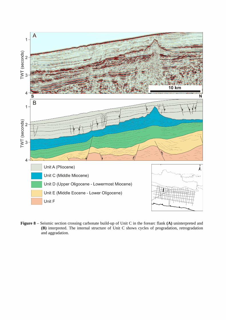
Figure 8 – Seismic section crossing carbonate build-up of Unit C in the forearc flank (A) uninterpreted and
(B) interpreted. The internal structure of Unit C shows cycles of progradation, retrogradation and aggradation.

Figure 9 – Seismic section showing units at the southern boundary of the forearc basin with the outer-arc
slope (A) uninterpreted and (B) interpreted. The basin is affected by the latest deformation which has folded Units A and B and appears to be driven be uplift of the outer-arc high. Note slump complexes in the upper part of the outer-arc slope.

Figure 10 – Seismic section showing units at the southern boundary of the forearc basin with the outer-arc
slope east of Figure 9 (A) uninterpreted and (B) interpreted. The forearc basin in this area here is largely filled with Pliocene sediments of Unit A. Note Unit B is thinner towards the forearc basin depocentre.

Figure 11 – Structural sketches showing variation in deformation history along the East Java Forearc from
west to east since the Late Miocene through to Recent.
Figure 12 – Proposed relations between seismic units of offshore East Java and stratigraphy of the Southern
Mountains Zone on land in East Java from Smyth et al. (2005, 2008).

Figure 13 – Palaeogeographic maps for the East Java forearc based on this study for (A) Middle Miocene, (B) Late Miocene to Middle Pliocene, (c) Late
Pliocene, and (d) Recent. The entire forearc has subsided significantly since the Late Miocene.

Figure 14 – Cross section across one of the present-day submarine canyons in the outer part of the forearc
flank (A) uninterpreted and (B) interpreted. Stepped profile of the canyon margin suggests a repeated cut and fill process. There are several inactive canyons which has been filled and buried by later sediment.