Embed Size (px)
Citation preview
1
CEDERBERG NATURE RESERVE COMPLEX
MANAGEMENT PLAN
Edited by: Lee Saul, Gail Cleaver-Christie, Marius Wheeler, Patrick Lane and Rika du Plessis
The Cederberg Nature Reserve Complex is comprised of the following: Cederberg declared a “Demarcated Forest” in Government Notice No. 491 of 1897 under Act 28 of 1888; Cederberg State Forest, setting aside of Wilderness Area in terms of Section 7A of the Forest Act, 1968 (Act 72 of 1968) on 27 July 1973, Notice number 1256 of 1973; Cederberg State Forest, amendment of the boundaries of the Wilderness Area in terms of section 7A of the Forest Act, 1968 (Act 72 of 1968) on 26 March 1976, Notice number 476 of 1976; Matjies Rivier Nature Reserve, proclaimed a Provincial Nature Reserve in terms of section 6(1) of the Nature and Environmental Conservation Ordinance, 1974 (Ordinance 19 of 1974) on 27 March 2000, Notice number 16 of 2000.
DATE APPROVED: DATE OF MOST RECENT UPDATE: 14 December 2011
VERSION: SMP-I AUTHORIZATION PAGE
2
This Integrated Management Plan for the Cederberg Nature Reserve Complex was drafted and recommended by the Reserve Management Committee (RMC), a multi-disciplinary team consisting of: Reserve Management Committee: Mr. Elbe Cloete (Area Manager) Mr. Patrick Lane (Conservation Manager: Cederberg Wilderness) Ms. Rika du Plessis (Conservation Manager: Matjies Rivier Nature Reserve) Ms. Lee Saul (Regional Ecologist) Mr. Marius Wheeler (Ecological Co-ordinator) Ms. Sunet Basson (Community Conservation Manager) Mr. Johan Burger (Conservation Services Manager) Mr. Wentzel Hornimann (Conservation Services Officer) Ms. Sheila Henning (GIS Technician) Supported By: Ms. Gail Cleaver (Programme Manager: Quality Management) Ms. Coral Birss (Regional Ecologist) Mr. Donovan Kirkwood (Ecological Planner) Recommended and adopted by: Name and Title Signature and Date
CapeNature - Technical Review Mr J. van Deventer PROGRAM MANAGER: WILDLIFE
CapeNature - Scientific Review Ms J. Gouws AQUATIC SCIENTIST
Organisation (of the External Review) (insert name) DESIGNATION
CapeNature Ms M. Moroka CHIEF EXECUTIVE OFFICER
Western Cape Nature Conservation Board Conservation Committee Dr C. Johnson CHAIRMAN OF THE BOARD CONSERVATION COMMITTEE
Western Cape Nature Conservation Board Prof A. Redlinghuis CHAIRMAN OF THE BOARD
Department of Environmental Affairs and Development Planning Mr T. Gildenhuys ACTING HEAD OF DEPARTMENT
3
Approved by: Name and Title Signature and Date
Local Government, Environmental Affairs and Development Planning Mr A. Bredell MINISTER
4
PREAMBLE The Cederberg Nature Reserve Complex is comprised of three proclaimed protected areas namely Cederberg Wilderness, Matjies Rivier Nature Reserve and Hexberg State Forest and covers an area of 79 735 ha. The aim of this Management Plan is to ensure that the Cederberg Nature Reserve Complex has clearly defined objectives and activities to direct the protection and sustainable use of its natural, scenic and heritage resources over a five year period. The Management Plan thus provides the medium-term operational framework for the prioritised allocation of resources and capacity in the management, use and development of the reserve. The Management Plan intends to add value and continuity by clearly stating management objectives, scheduling action and providing guidelines on the management approach. The Cederberg Nature Reserve Complex is situated in the Cederberg Mountains which forms the northern extent of the Cape Fold Mountains. As a result of its mountainous terrain and relative high rainfall, the Cederberg Mountains are an important water catchment area, providing water for domestic and agricultural use by communities and farmers living along the Olifants-Doring River system. The Cederberg Nature Reserve Complex strives to manage the protected areas in the complex according to the internationally accepted principles of a Wilderness Area and a World Heritage site. The Cederberg Nature Reserve Complex falls within the Greater Cape Floristic Region (GCFR). The GCFR comprises two biomes, the Cape Floristic Region (CFR) and the Succulent Karoo. The CFR located in South Africa is the smallest and richest of the six floral kingdoms in the world, and it is the only one to be found entirely within one country. Its rich biodiversity is under serious threat for a variety of reasons including conversion of natural habitat to permanent agriculture, inappropriate fire management, rapid and insensitive development, overexploitation of water resources, marine resources, and infestation by alien species. The region has been identified as one of the world’s most species rich hotspots of biodiversity. In response to on-going threats to the CFR, a process of extensive consultation involving various interested parties, including local government and non-governmental organizations, resulted in the establishment of a strategic plan referred to as Cape Action for People and the Environment (CAPE). It identified the key threats and root causes of biodiversity losses that need to be addressed in order to conserve the CFR. This resulted in a spatial plan identifying areas which need to be conserved. These plans were incorporated in the expansion strategy of the Greater Cederberg Biodiversity Corridor (GCBC) and include a series of broad program activities which need to be undertaken over a 20 year period. Based on the situation assessment and analysis of threats, three overarching themes that complement and reinforce one another were developed:
establish an effective reserve network, enhance off-reserve conservation, and support bioregional planning;
strengthen and enhance institutions, policies, laws, co-operative governance, and community participation;
5
develop methods to ensure sustainable yields, promote compliance with laws, integrate biodiversity concerns into catchment management, and promote sustainable eco-tourism.
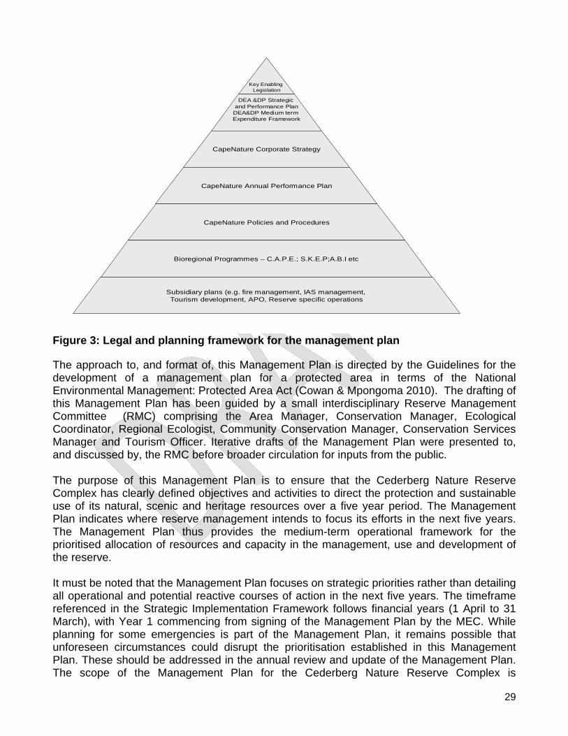
THE PROCESS The planning session, facilitated by the Regional Ecologist and guided by the Conservation Manager, defined the vision and purpose of the Cederberg Nature Reserve Complex as an umbrella statement, indicating the direction of the management intent for the Cederberg Nature Reserve Complex to guide the formulation of the management objectives. The submitted objectives were evaluated against the definitions in “A Procedure for Defining Conservation Management Objectives and Goals” (Coombes & Mentis 1992) and sorted into categories: Objectives, Action Plans and Tasks. The final objectives were prioritised through a pairwise comparison process and the results were used to populate the section in the management plan referred to as the Strategic Implementation Framework. Actions Plans were associated with Objectives, and Tasks (Activities) were identified within each Action Plan. Guiding Principles for defining Vision, Purpose, Objectives, Action Plans and Tasks: VISION: Indicates the direction of management aspiration, describes the unit, reflects uniqueness of the unit and justifies the existence of the unit. PURPOSE: The foundation on which all future actions are based and are in line with the overall management philosophy of the organisation. OBJECTIVES: Derived from the vision and purpose, representing key areas in which achievement must be obtained to give direction to the management intention: not measurable or testable; aimed at Key Performance Areas; and prioritised with Action Plans developed. ACTION PLANS (Operational Goals): Functional Performance Areas which describe expected results which will contribute to the realisation of the objectives. An action plan must be achievable within capability, measurable and attainable. Performance indicators are developed in description of outputs. Tasks, responsibilities, indicators, timeframes and references to existing procedures are provided. Approval Process The RMC compiled the draft Management Plan for review. The Cederberg Nature Reserve Complex Management Plan was internally reviewed and recommended for stakeholder participation by all Executive Directors, Programme Managers, Catchment Managers, Senior Managers within each Support Service including Financial and Administration Services, Human Resource Management, Occupational Health and Safety, Risk Management and Business Development. A review was undertaken by Scientific Services on the ecological content of the Management Plan. Furthermore an internal review on the scientific and technical content was undertaken respectively, using the CapeNature Scientific and Technical
6
PAMP review template (Waller 2011). The Management Plan was then recommended for stakeholder participation to the Executive Director: Operations. Stakeholder comments were considered and incorporated. The Cederberg Nature Reserve Complex Management Plan was reviewed by an independent external reviewer on a voluntary basis, who commented and recommended that the Management Plan met the criteria as determined in the CapeNature Scientific and Technical PAMP review template. The Western Cape Nature Conservation Board (WCNCB) Conservation Committee recommended to the WCNCB that the management plans be adopted. The WCNCB adopted the Cederberg Nature Reserve Complex Management Plan and submitted to Department of Environmental Affairs and Development Planning (DEA&DP) for submission to the MEC for approval. ACKNOWLEDGEMENTS The authors would like to express their gratitude to all those who contributed to this Management Plan, including members of the public and community forums especially the following individuals; Ms. Gail Cleaver (Programme Manager: Quality Management) Dr Donovan Kirkwood (Ecological Planner: Business Development) EXECUTIVE SUMMARY In compliance with the National Environment: Protected Areas Act No. 57 of 2003, CapeNature is required to develop management plans for each of its nature reserve clusters. In developing the management plan for the Cederberg Nature Reserve Complex, CapeNature strives to establish biodiversity conservation as a foundation of a sustainable economy creating access, benefits and opportunities for all. The Cederberg Nature Reserve Complex is comprised of the Cederberg Wilderness, Matjies Rivier Nature Reserve and Hexberg State Forest. The Cederberg Nature Reserve Complex is situated about 250 km north of Cape Town, stretching approximately from Clanwilliam in the north to Citrusdal in the south. It is bound by the Northern Cape Province in the east and includes 79 735 ha of land. The area falls under the jurisdiction of the West Coast District Municipality and the Cederberg Local Municipality. The surrounding economy mostly comprises of citrus farming, grape farming, rooibos tea plantations, livestock farming and tourism. Furthermore, the area is predominantly situated within the winter rainfall region, with sections in the east also receiving rain in summer. The Cederberg Nature Reserve Complex falls within the Greater Cape Floristic Region, spanning two biodiversity hotspots namely the Fynbos and Succulent Karoo and represents nine of the 435 South African vegetation units (Mucina and Rutherford, 2006). The expansion of the Cederberg Nature Reserve Complex has been achieved through the implementation of the Stewardship Programme and the Greater Cederberg Biodiversity Corridor landscape initiative in accordance with the Cape Action plan for People and the Environment (CAPE) objectives to establish natural corridors through the landscape.
7
The Protected Area Management Plan for the Cederberg Nature Reserve Complex is divided into three parts. The first part outlines the management objective framework of CapeNature and how this influences the Cederberg Nature Reserve Complex. The Cederberg Nature Reserve Complex’s vision and purpose was developed to guide management in its daily operations and long-term planning. The objectives for the Cederberg Nature Reserve Complex were developed in line with CapeNature’s strategic goals, objectives and key measurable objectives. Part one also highlights the legal framework under which CapeNature and the Cederberg Nature Reserve Complex operates and details the history, legal status, abiotic and biotic information, cultural heritage, tourism, and youth development and awareness programs. The second part of the Protected Area Management Plan outlines the strengths, weaknesses, opportunities and threats associated with the Cederberg Nature Reserve Complex. The Conservation Development Framework for the Cederberg Nature Reserve Complex provides for the zonation of the complex, based on an intuitive and defensible method for sensitivity analysis. These zones will guide operational, ecological and tourism management; the latter will ensure a quality tourism product aimed at the domestic and international markets. In addition to the Cederberg Nature Reserve Complex zonation plan, an expansion strategy for the reserve is presented. The Cederberg Nature Reserve Complex contributes to the local economy through job creation in the tourism and biodiversity management sectors by implementing the Expanded Public Works Programme (EPWP) and Integrated Catchment Management (ICM) projects. Furthermore it contributes to community development through awareness raising and training initiatives. These processes are in line with local Integrated Development Plans. The last part of the Protected Area Management Plan summarises the Strategic Implementation Framework. This section focusses on putting measurable actions in place to ensure that the Cederberg Nature Reserve Complex achieves its management objectives.
8
TABLE OF CONTENTS Page
SECTION 1: MANAGEMENT OBJECTIVES FRAMEWORK............................................................................................. 12
1.1 VISION AND MISSION OF CAPENATURE...............................................................................................................................12 1.2 CAPENATURE STRATEGIC GOALS, OBJECTIVES AND KEY MEASURABLE OBJECTIVES......................................................................12 1.3 VALUES OF CAPENATURE.................................................................................................................................................14 1.4 RESERVE VISION, PURPOSE, VALUES AND OBJECTIVES ...........................................................................................................15 1.5 GUIDING PRINCIPLES.......................................................................................................................................................16
SECTION 2: LEGAL FRAMEWORK.............................................................................................................................. 18
2.1 LEGAL AND POLICY FRAMEWORK.......................................................................................................................................18 2.1.1 Legal Framework .............................................................................................................................................18 2.1.2 Coordinated Policy Framework ........................................................................................................................20
2.2 MANAGEMENT AGREEMENTS ...........................................................................................................................................21 2.3 REGIONAL AND PROVINCIAL PLANNING...............................................................................................................................22 2.4 INSTITUTIONAL FRAMEWORK ............................................................................................................................................23 2.5 STRATEGIC MANAGEMENT PLAN .......................................................................................................................................28
2.5.1 Purpose of this Management Plan...................................................................................................................28 2.5.2 Stakeholder Participation Process....................................................................................................................30 2.5.3 Establishment of a CapeNature Protected Area Advisory Committee .............................................................32
SECTION 3: OVERVIEW AND BACKGROUND OF THE RESERVE ................................................................................... 35
3.1 LOCATION AND EXTENT ...................................................................................................................................................35 3.2 LEGAL STATUS ...............................................................................................................................................................37 3.3 HISTORY .......................................................................................................................................................................40 3.4 CLIMATE.......................................................................................................................................................................41 3.5 TOPOGRAPHY ................................................................................................................................................................43 3.6 GEOLOGY......................................................................................................................................................................44
3.6.1 Stratigraphy .....................................................................................................................................................44 3.6.2 Structural geology............................................................................................................................................45 3.6.3 Soils and sediments..........................................................................................................................................46
3.7 HYDROLOGY ..................................................................................................................................................................49 3.7.1 Catchments ......................................................................................................................................................50 3.7.2 Groundwater....................................................................................................................................................50 3.7.3 Rivers................................................................................................................................................................50 3.7.4 Other freshwater aquatic systems (Wetland, springs, pans) ...........................................................................51
3.8 FLORA..........................................................................................................................................................................51 3.8.1 Terrestrial vegetation ......................................................................................................................................52 3.8.2 Aquatic (Freshwater) .......................................................................................................................................60 3.8.3 Invasive Alien Plants ........................................................................................................................................60 3.8.4 Plantations .......................................................................................................................................................60
3.9 FAUNA .........................................................................................................................................................................62 3.9.1 Mammals .........................................................................................................................................................62 3.9.2 Avifauna...........................................................................................................................................................63 3.9.3 Reptiles.............................................................................................................................................................65 3.9.4 Amphibians ......................................................................................................................................................66 3.9.5 Fish...................................................................................................................................................................67 3.9.6 Invertebrates....................................................................................................................................................70 3.9.7 Invasive/alien fauna.........................................................................................................................................70
3.10 CULTURAL HERITAGE RESOURCES .................................................................................................................................70 3.11 PEOPLE AND CONSERVATION .......................................................................................................................................72 3.12 AWARENESS, YOUTH DEVELOPMENT AND VOLUNTEERS ....................................................................................................72 3.13 INFRASTRUCTURE.......................................................................................................................................................72 3.14 RECREATIONAL AND TOURISM SERVICES .........................................................................................................................84
9
SECTION 4: SWOT ANALYSIS .................................................................................................................................... 86
4.1 SWOT ANALYSIS ...........................................................................................................................................................86 4.1.1 Strengths, Weaknesses, Opportunities and Threats ........................................................................................86
SECTION 5: CONSERVATION DEVELOPMENT FRAMEWORK ...................................................................................... 88
5.1 RESERVE PLANNING ‐ SENSITIVITY ANALYSIS AND ZONING ......................................................................................................88 5.2 ZONATION CATEGORIES ...................................................................................................................................................90 5.3 ACCESS.......................................................................................................................................................................107 5.4 CONCEPT DEVELOPMENT PLAN .......................................................................................................................................109
SECTION 6: RESERVE EXPANSION STRATEGY .......................................................................................................... 112
6.1 PROTECTED AREA EXPANSION.........................................................................................................................................112 6.1.1 Introduction ...................................................................................................................................................112 6.1.2 Spatial Focus ..................................................................................................................................................112 6.1.3 Protected Area Expansion Mechanisms.........................................................................................................112 6.1.4 CapeNature’s Strategic Approach to Protected Area Expansion in the Western Cape ................................114
6.1.4.1 Spatial Focus ..........................................................................................................................................................114 6.1.4.2 Primary Mechanisms for CapeNature....................................................................................................................114 6.1.4.3 Implementation Phases .........................................................................................................................................114 6.1.4.4 Planning and Implementation Review Protocol ....................................................................................................114
6.1.5 Financial Plan for Protected Area and Buffer zone expansion .......................................................................115 6.2 BUFFER ZONES .............................................................................................................................................................115 6.3 EXPANSION OPPORTUNITIES ...........................................................................................................................................116
SECTION 7: STRATEGIC IMPLEMENTATION FRAMEWORK....................................................................................... 118
7.1 MANAGEMENT PROGRAMMES........................................................................................................................................118 7.1.1 Legal Status and Reserve expansion ..............................................................................................................118 7.1.2 Legislation......................................................................................................................................................118 7.1.3 Guiding Principles ..........................................................................................................................................119 7.1.4 Management Actions.....................................................................................................................................119
7.2 REGIONAL INTEGRATED PLANNING AND COOPERATIVE GOVERNANCE .....................................................................................121 7.2.1 Legislation......................................................................................................................................................121 7.2.2 Guiding Principles ..........................................................................................................................................121 7.2.3 Management Actions.....................................................................................................................................121
7.3 ECOSYSTEM AND BIODIVERSITY MANAGEMENT ...................................................................................................................123 7.3.1 Legislation......................................................................................................................................................123 7.3.2 Guiding Principles ..........................................................................................................................................123 7.3.3 Threats to Biodiversity and Ecosystems.........................................................................................................124 7.3.4 Management Actions.....................................................................................................................................124
7.4 WILDLIFE MANAGEMENT...............................................................................................................................................129 7.4.1 Legislation......................................................................................................................................................129 7.4.2 Guiding Principles ..........................................................................................................................................129 7.4.3 Management Actions.....................................................................................................................................129
7.5 FIRE MANAGEMENT......................................................................................................................................................132 7.5.1 Legislation......................................................................................................................................................132 7.5.2 Guiding Principles ..........................................................................................................................................132 7.5.3 Management Actions.....................................................................................................................................132
7.6 INVASIVE AND NON‐INVASIVE ALIEN SPECIES MANAGEMENT................................................................................................135 7.6.1 Legislation......................................................................................................................................................135 7.6.2 Guiding Principles ..........................................................................................................................................135 7.6.3 Management Actions.....................................................................................................................................135
7.7 CULTURAL HERITAGE RESOURCE MANAGEMENT ................................................................................................................138 7.7.1 Legislation......................................................................................................................................................138 7.7.2 Guiding Principles ..........................................................................................................................................138 7.7.3 Management Actions.....................................................................................................................................138
10
7.8 LAW ENFORCEMENT AND COMPLIANCE ............................................................................................................................141 7.8.1 Legislation......................................................................................................................................................141 7.8.2 Guiding Principals ..........................................................................................................................................141 7.8.3 Management Actions.....................................................................................................................................141
7.9 INFRASTRUCTURE MANAGEMENT ....................................................................................................................................144 7.9.1 Legislation......................................................................................................................................................144 7.9.2 Guiding Principles ..........................................................................................................................................144 7.9.3 Infrastructure Maintenance...........................................................................................................................144
7.9.3.1 Roads/Jeep Tracks .................................................................................................................................................144 7.9.3.2 Trails ......................................................................................................................................................................145 7.9.3.3 Buildings ................................................................................................................................................................145 7.9.3.4 Fences....................................................................................................................................................................145 7.9.3.5 Environmental Management.................................................................................................................................145 7.9.3.6 High Sites ...............................................................................................................................................................146 7.9.3.7 Signage ..................................................................................................................................................................146
7.9.4 Management Actions.....................................................................................................................................146 7.10 DISASTER MANAGEMENT..........................................................................................................................................150
7.10.1 Legislation .................................................................................................................................................150 7.10.2 Guiding Principles......................................................................................................................................150 7.10.3 Management Actions................................................................................................................................150
7.11 PEOPLE AND CONSERVATION .....................................................................................................................................152 7.11.1 Community Partnerships...........................................................................................................................152 7.11.2 Guiding Principles......................................................................................................................................152 7.11.3 Management Actions................................................................................................................................152
7.12 AWARENESS, YOUTH DEVELOPMENT AND VOLUNTEERS ..................................................................................................154 7.12.1 Guiding Principles......................................................................................................................................154 7.12.2 Management Actions................................................................................................................................154
7.13 MANAGEMENT EFFECTIVENESS ..................................................................................................................................157 7.13.1 Legislation .................................................................................................................................................157 7.13.2 Guiding Principals......................................................................................................................................157 7.13.3 Management Actions................................................................................................................................157
7.14 ADMINISTRATION ....................................................................................................................................................159 7.14.1 Finance and Administration Management ...............................................................................................159
7.14.1.1 Financial Sustainability ..........................................................................................................................................159 7.14.1.2 Guiding Principles ..................................................................................................................................................159 7.14.1.3 Management Actions ............................................................................................................................................159
7.14.2 Human Resource Management ................................................................................................................162 7.14.2.1 Legislation..............................................................................................................................................................162 7.14.2.2 Guiding Principals ..................................................................................................................................................162 7.14.2.3 Management Actions ............................................................................................................................................163
7.14.3 Occupational Health and Safety Management.........................................................................................166 7.14.3.1 Legislation..............................................................................................................................................................166 7.14.3.2 Guiding Principals ..................................................................................................................................................166 7.14.3.3 Management Actions ............................................................................................................................................166
7.14.4 Risk Management .....................................................................................................................................168 7.14.4.1 Legislation..............................................................................................................................................................168 7.14.4.2 Guiding Principals ..................................................................................................................................................168 7.14.4.3 Management Actions ............................................................................................................................................168
7.15 VISITOR MANAGEMENT AND SERVICES ........................................................................................................................170 7.15.1 Legislation .................................................................................................................................................170 7.15.2 Guiding Principles......................................................................................................................................170 7.15.3 Visitor management and services .............................................................................................................170 7.15.4 Management Actions................................................................................................................................170
7.16 TOURISM DEVELOPMENT FRAMEWORK........................................................................................................................172 7.16.1 Legislation .................................................................................................................................................172 7.16.2 Guiding Principals......................................................................................................................................172 7.16.3 Management Actions................................................................................................................................173
11
SECTION 8: REFERENCES ........................................................................................................................................ 175
8.1 REFERENCES ................................................................................................................................................................175 8.2 LIST OF ACRONYMS AND ABBREVIATIONS ..........................................................................................................................178 8.3 LIST OF TABLES ............................................................................................................................................................180 8.4 LIST OF FIGURES...........................................................................................................................................................180
12
PART 1
SECTION 1: MANAGEMENT OBJECTIVES FRAMEWORK
1.1 Vision and Mission of CapeNature VISION: A quality driven public entity conserving the unique natural heritage resources of the Western Cape for the benefit of all. MISSION: The establishment of Biodiversity conservation as a foundation of a sustainable economy creating access, benefits and opportunities for all. 1.2 CapeNature Strategic Goals, Objectives and Key Measurable Objectives CapeNature has four strategic goals, underpinned by a seven strategic objectives. Each strategic objective is further divided into key measurable objectives, as shown in Table 1. Table 1: Summary of CapeNature Strategic Results and Programme Allocations
STRATEGIC GOAL STATEMENT
STRATEGIC OBJECTIVE STATEMENT
KEY MEASURABLE OBJECTIVES CURRENT PROGRAMME
1.1 Effective knowledge management informs development and conservation priorities.
1.1.1 To provide biodiversity input into Western Cape Provincial land use planning and decision making.
1.1.2 To manage biodiversity knowledge to ensure effective conservation management.
2: Planning and Operations
1.2 Implementation of the Western Cape Biodiversity Plan and Protected Area Expansion Strategy secure priority biodiversity.
1.2.1 To ensure rigorous conservation planning in the Western Cape within the national legislative framework.
1.2.2 To implement measures to ensure resilience and persistence of biodiversity of the Province in the light of anticipated climate changes.
1.2.3 A network of Protected Areas with appropriate status and effectively managed by CapeNature (incorporating terrestrial, freshwater and marine).
2: Planning and Operations
1.3 Sustained conservation management in priority catchments maintains ecosystem services.
1.3.1 To ensure the implementation of effective conservation management interventions in the Western Cape.
2: Planning and Operations
1. Securing priority biodiversity and ecosystem services through integrated biodiversity planning and management enabling appropriate climate change response.
1.4 Legal and wildlife support services and biodiversity crime prevention result in the protection and sustainable use of biodiversity.
1.4.1 To enhance biodiversity protection and conservation in areas outside the formal CapeNature Protected Area Network.
2: Planning and Operations
2. Contributing to the reconstruction and development of social capital.
2.1 Facilitate youth and community development through environmental awareness and assist in developing the knowledge, skills, values and commitment
2.1.1 To provide learners with access to a quality environmental education Programme.
2.1.2 To provide experiential service learning
2: Planning and Operations
13
STRATEGIC GOAL STATEMENT
STRATEGIC OBJECTIVE STATEMENT
KEY MEASURABLE OBJECTIVES CURRENT PROGRAMME
necessary to achieve sustainable development.
opportunities in the conservation sector.
3. Sustaining and growing the conservation economy.
3.1 Develop and implement strategies to facilitate equitable access to and participation in the conservation economy through a People and Parks Programme.
3.1.1 To provide access to work opportunities through implementation of conservation and tourism management services.
3.1.2 To improve access to protected areas for sustainable traditional, cultural and spiritual uses.
3.1.3 To enhance opportunities for stakeholder participation in protected area management.
3.1.4 To grow and effectively deploy volunteer capacity.
2: Planning and operations
3: Business Development
3: Business Development
4.1 Increased sustainable revenue is attained through enhanced tourism product development and the development of a system for payment of ecosystem services.
4.1.1 Create awareness/market the tourism products within our portfolio to domestic and international visitors, and contributing positively towards sustainable tourism.
4.1.2 To establish partnerships that will improve corporate and social investment into our reserves and by so doing positively impacting on visitor expectations and the livelihoods of local communities.
4.1.3 Develop sustainable tourism products while providing access to both the domestic and international market.
4.1.4 To establish a system for payment for ecosystem services management as a sustainable basis for income in the MTEF allocation. 1: Administration
1: Administration 4.2. Develop policies, systems and processes to support effective service delivery.
4.2.1 Support strategic decision making to ensure good corporate governance.
4.2.2 Ensure all CapeNature’s activities are executed within a framework of sound controls and the highest standards of corporate governance.
4.2.3 To develop and implement an effective and efficient communication strategy for all internal and external stakeholders and role-players.
4.2.4 To implement Information Technology and Systems that is compliant and supports the core business of the organisation.
3: Business Development
4. Ensuring an efficient and effective institution through cutting edge leadership.
4.3. Institution building enables a supportive working environment.
4.3.1 To provide a professional human resource management support service.
1: Administration
14
1.3 Values of CapeNature CapeNature strives to create a work environment that nurtures people and motivates a high level of performance in putting people first through implementing the Batho Pele principles. The following are our core values: Honesty: We conduct our business with honesty, accuracy and without
error. Excellence: We espouse a deep sense of responsibility to our work and
endeavour to constantly improve it, so that we may give our stakeholders the highest quality of service. We believe that work done excellently gives us dignity, fulfilment, and self-worth.
Fitness of purpose: We strive to ensure that our mission remains relevant to the local,
provincial, national and international context of transformation and modernisation of the biodiversity conservation sector.
Fitness for purpose: We strive to ensure that our strategic responses and resource
allocations, including staff appointments, add optimal value in implementing our mandate.
Accountability: We ensure financial, performance and political accountability in
the implementation of our mandate. Equity and access: We strive to ensure that benefits and opportunities accruing from
the conservation of biodiversity are equitably shared and that our resources and services are accessible to all; ensuring redress for historically disadvantaged individuals with specific emphasis on women, youth and the disabled; and enabling cultural, traditional and spiritual uses of natural resources on a sustainable basis.
Personal responsibility: We, as the custodians of the natural resources essential for
human health and well-being; and growth and development in the Western Cape, undertake this responsibility with the highest possible level of personal responsibility. We are committed to measurable targets for individual performance which we pursue through strong professional work ethics, political neutrality and selfless service.
15
1.4 Reserve Vision, Purpose, Values and Objectives VISION Cederberg Nature Reserve Complex will be a world heritage site of excellence for the conservation of biodiversity and its unique natural and cultural resources. PURPOSE The conservation of the biological, cultural and wilderness integrity of the area, through effective management and partnerships that strengthen conservation at a landscape level. PURPOSE FOR DECLARATION OF CEDERBERG NATURE RESERVE COMPLEX EXTRACTED FROM NEM: PAA (SECTION 17)
to protect ecologically viable areas representative of South Africa’s biological diversity and its natural landscapes and seascapes in a system of protected areas;
to preserve the ecological integrity of those areas; to conserve biodiversity in those areas; to protect areas representative of all ecosystems, habitats and species naturally
occurring in South Africa; to protect South Africa’s threatened or rare species; to protect an area which is vulnerable or ecologically sensitive; to assist in ensuring the sustained supply of environmental goods and services; to provide for the sustainable use of natural and biological resources; to create or augment destinations for nature-based tourism; to manage the interrelationship between natural environmental biodiversity, human
settlement and economic development; generally, to contribute to human, social, cultural, spiritual and economic development; to rehabilitate and restore degraded ecosystems and promote the recovery of
endangered and vulnerable species. VALUES 1. Being a World Heritage Site; 2. Having unique archaeological and geological features; 3. Being at the Cape Floristic Region and Succulent Karoo interface; 4. Being the core of a Landscape Conservation Initiative; 5. Having unique biodiversity; 6. Wilderness status; 7. Comprising nine South African vegetation types; 8. Has a high number of endemic fish species. OBJECTIVES 1. To conserve the unique biodiversity of the Fynbos and Succulent Karoo Biomes that
support ecological pattern and process; 2. To achieve management excellence through cooperative governance, informed decision
making and effective systems in accordance with relevant legislation; 3. To conserve and promote the cultural, historical, and geological heritage of the area; 4. To support landscape conservation and research through partnerships in the face of
anticipated climate change;
16
5. To support sustainable socio economic opportunities that contributes to local economic development;
6. To create and allow opportunities for environmental education and awareness through equitable access;
7. To provide sustainable tourism opportunities that promotes a wilderness experience. 1.5 Guiding Principles The following guiding principles underpin the Management Plan for Cederberg Nature Reserve Complex. It is important to note that while these principles are intended to guide reserve management in its work, the reserve is also subject to the principles and provisions of relevant international treaties and conventions, national and provincial legislation and policy, and any local contractual agreements. Custodianship - Reserve management
will seek to respect, protect and promote the
Cederberg Nature Reserve Complex, and its environmental and heritage resources, as a common heritage and a national asset for all South Africans. Common Heritage - The management of the Cederberg Nature Reserve Complex must serve the public interest by safeguarding the ecological, cultural and scenic resources as a common heritage, and national asset for all South Africans. Duty of Care - The Cederberg Nature Reserve Complex must ensure that all individuals, institutions and organisations act with due care and share the responsibility to conserve, and avoid degradation of the ecological, cultural and scenic resources, and to use the resources of the Cederberg Nature Reserve Complex sustainably, equitably and efficiently. Sustainability – Reserve management will seek to achieve a balance between ecological sustainability, social equity and economic efficiency without compromising the ecological integrity of the reserve. Holism - The Reserve and its surrounds form an indivisible system. The management of the Reserve must adopt an integrated approach and recognise the interconnectedness and interdependence of social, ecological and economic components. Intrinsic Value - All life forms and ecological systems have intrinsic value. Cooperation and Partnerships - Reserve management will seek to work co-operatively and in partnership with public institutions, the private sector, non-governmental organisations (NGO) and local communities. Equitable Access: Reserve management shall seek to ensure that stakeholders shall have equitable, sustainable, and managed access to the reserves and the benefits that are derived from the reserves.
17
Precaution - Where there may be a threat of significant negative impact but inadequate or inconclusive scientific evidence exists to prove this, action shall be taken to avoid, prevent or minimise the potential impact. Empowerment and Transformation - The Cederberg Nature Reserve Complex shall strive to empower stakeholders involved in the Reserve through capacity building and access to economic opportunities. Co-operative Governance - All spheres and organs of government that are involved in management of the Reserve, or in making decisions affecting the Reserve, shall work together co-operatively to ensure the conservation of the Reserve. Excellence in Management and Service - The Cederberg Nature Reserve Complex shall strive to attain excellence in managing the Reserve and servicing the visitors that use it through accountable and informed decision-making and co-ordination, co-operation and integration with relevant government agencies and stakeholders. The Cederberg Nature Reserve Complex shall strive for continual improvement through a creative and collaborative approach to problem solving and learning. Capacity – Reserve management will seek to ensure that the management of the Cederberg Nature Reserve Complex is adequately resourced to meet its mandated and ethical responsibilities in the effective management of the respective reserves. Alignment and Integration - Reserve management will seek to align and integrate the reserve’s management activities and priorities into, and with, the relevant local and regional conservation, institutional, socio-economic and developmental context. Culture of learning – Reserve management will aim for continual improvement through both a scientific based approach that provides the basis for informed decision making, and a creative and collaborative approach to problem solving and learning. Accountability and transparency - Reserve management will seek to ensure that management tasks in the Cederberg Nature Reserve Complex are carried out efficiently and within stipulated time frames, productivity is increased, costs are controlled and impacts are managed, with integrity and in compliance with applicable laws. In practical terms, the Management Plan needs to ensure that the following requirements for the effective management of the Cederberg Nature Reserve Complex are adequately addressed: The necessary mandate, human capacity and financial resources to implement and achieve the objectives and activities described in the management plan;
The delivery of socio-economic benefits to local communities where possible. Flexibility of service delivery that encourages innovation and a wide range of
government, community and non-government sector involvement. Performance indicators and accountability measures that provides for regular review of
outcomes.
18
SECTION 2: LEGAL FRAMEWORK
2.1 Legal and Policy Framework
2.1.1 Legal Framework The legal framework that directs planning and operational management activities in the reserve are addressed in detail within the Strategic Implementation Framework. Constitutional and Legislative mandates The Constitution of the Republic of South Africa Act, (Act No. 108 of 1996, Section 24) states that: ‘Everyone has the right to an environment that is not detrimental to their health or well-being’. The Constitution further states that: ‘The environment must be protected for present and future generations through reasonable legislation and other measures that will prevent pollution and environmental degradation, promote conservation and will ensure ecologically sustainable development and sustainable use of natural resources while striving for justifiable economical and social development.’ CapeNature is a public entity established in terms of and governed by the Western Cape Nature Conservation Board Act (Act No. 15 of 1998) and the Western Cape Nature Conservation Laws Act, (Act No. 3 of 2000). This is a public institution with the statutory responsibility for biodiversity conservation in the Western Cape. It is mandated to: promote and ensure nature conservation; render services and provide facilities for research and training; and generate income.
Constitution of the Republic of South Africa Act, (Act No. 108 of 1996) Western Cape Nature Conservation Board Act, (Act No. 15 of 1998) Western Cape Nature Conservation Laws Act, (Act No. 3 of 2000)
The following are the key national and provincial statutes relevant to the implementation of the mandate of nature conservation and include all amendments to these acts and ordinances and any regulations and norms and standards promulgated there under. Note that the list below excludes all other relevant legislation to which public entities as employers, implementers of government mandate and managers of public finance are subject.
International Conventions, Protocols and Policies Bonn Convention on the Conversation of Migratory Species of Wild Animals (CMS) Convention on Biological Diversity (The) (CBD) Convention on International Trade in Endangered Species in Wild Fauna and Flora
(The) (CITES) Secretariat of the Climate Change Convention and the Kyoto Protocol (Bonn) International Union for Conservation of Nature (The) (IUCN) World Heritage Committee (WHC) World Tourism Organisation (WTO)
19
National Legislation All National legislation applies to activities in the Cederberg Nature Reserve Complex, but the following have direct reference to the reserves management activities:
Constitution of the Republic of South Africa, (Act No. 108 of 1996) National Environmental Management Act,(Act No. 107 of 1998) National Environmental Management Biodiversity Act, (Act No. 10 of 2004) National Environmental Management: Protected Areas Act, (Act No. 57 of 2003) Mountain Catchment Areas Act, (Act No. 63 of 1970) National Forests Act, (Act No. 84 of 1998) Conservation of Agricultural Resources Act, (Act No. 43 of 1983) World Heritage Convention Act, (Act No. 49 0f 1999) Environment Conservation Act, (Act No. 73 of 1989) National Water Act, (Act No. 36 of 1998) National Veld and Forest Fire Act, (Act No. 101 of 1998) National Heritage Resources Act, (Act No. 25 of 1999) Disaster Management Act, (Act No. 57 of 2002)
This Management Plan is further guided by the principles outlined in Section 2 of the National Environmental Management Act, (Act No. 107 of 1998) and Section 17 of the National Environmental Management: Protected Areas Act, (Act No. 57 of 2003). Within Section 17 the purposes of the declaration of areas as protected areas are described. These are:
To protect ecologically viable areas representative of South Africa’s biological diversity and its natural landscapes and seascapes in a system of protected areas;
To preserve the ecological integrity of those areas; To conserve biodiversity in those areas; To protect areas representative of all ecosystems, habitats and species naturally
occurring in South Africa; To protect South Africa’s threatened or rare species; To protect an area, which is vulnerable or ecologically sensitive; To assist in ensuring the sustained supply of environmental goods and services; To provide for the sustainable use of natural and biological resources; To create or augment destinations for nature-based tourism; To manage the interrelationship between natural environmental biodiversity, human
settlement and economic development; Generally, to contribute to human, social, cultural, spiritual and economic development;
and To rehabilitate and restore degraded ecosystems and promote the recovery of
endangered and vulnerable species. Provincial Legislation Although all Provincial legislation applies to activities in the Cederberg Nature Reserve Complex, the following have direct reference to the reserve management activities:
Constitution of the Western Cape Act, (Act No. 1 of 1998)
20
Western Cape Nature Conservation Board Act, (Act No. 15 of 1998) Western Cape Nature Conservation Laws Act, (Act No. 3 of 2000) Western Cape Planning and Development Act, (Act No. 7 of 1999) Land Use Planning Ordinance, (Ordinance No. 15 of 1985) Nature Conservation Ordinance, (Ordinance No. 19 of 1974) Provincial Notice 955 of 1975
New legislation The following legislation is either new or pending and it is envisaged that this legislation will impact on CapeNature.
CITES Regulations, 2009 Threatened or Protected Species (ToPS) Regulations, 2007 Alien and Invasive Species (AIS) Regulations, 2009, (still in draft form) National Environmental Management: Integrated Coastal Management Act, (Act No.
24 of 2008) Proper administrations of protected areas Regulations, 2010, (still in draft form) Norms and Standards for the management of protected areas in South Africa, 2011,
(still in draft) Norms and standards for Biodiversity Management Plans for Species, 2009, (Gazette
No 214 March 2009) Draft update of Ordinance
2.1.2 Coordinated Policy Framework The Cederberg Nature Reserve Complex management is guided by a number of internal CapeNature policies, procedures and guidelines. The policies, procedures and guidelines applicable to this management plan are referenced in the Strategic Implementation Framework. The following have direct reference to management activities:
Wilderness Policy Fire Policy Finance Policy Game Translocation and utilization Policy Fish Utilisation and Translocation Policy
21
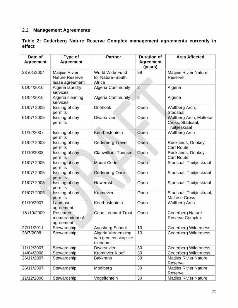
2.2 Management Agreements Table 2: Cederberg Nature Reserve Complex management agreements currently in effect
Date of Agreement
Type of Agreement
Partner Duration of Agreement
(years)
Area Affected
23 /01/2004 Matjies Rivier Nature Reserve lease agreement
World Wide Fund for Nature–South Africa
99 Matjies Rivier Nature Reserve
01/04/2010 Algeria laundry services
Algeria Community 2 Algeria
01/04/2010 Algeria cleaning services
Algeria Community 2 Algeria
01/07/ 2005 Issuing of day permits
Driehoek Open Wolfberg Arch, Stadsaal
01/07/ 2005 Issuing of day permits
Dwarsrivier Open Wolfberg Arch, Maltese Cross, Stadsaal, Truitjieskraal
01/12/2007 Issuing of day permits
Keurbosfontein Open Wolfberg Arch
01/02/ 2008 Issuing of day permits
Cederberg Travel Open Rocklands, Donkey Cart Route
01/10/2008 Issuing of day permits
Clanwilliam Tourism Open Rocklands, Donkey Cart Route
01/07/ 2005 Issuing of day permits
Mount Ceder Open Stadsaal, Truitjieskraal
01/07/ 2005 Issuing of day permits
Cederberg Oasis Open Stadsaal, Truitjieskraal
01/07/ 2005 Issuing of day permits
Nuwerust Open Stadsaal, Truitjieskraal
01/07/ 2005 Issuing of day permits
Kromrivier Open Stadsaal, Truitjieskraal, Maltese Cross
01/10/2007 Land use agreement
Keurbosfontein Open Wolfberg Arch
15 /10/2009 Research memorandum of agreement
Cape Leopard Trust Open Cederberg Nature Reserve Complex
27/11/2011 Stewardship Augsberg School 10 Cederberg Wilderness 28/7/2008 Stewardship Algeria Vereeniging
van gemeenskaplike eiendom
10 Cederberg Wilderness
11/12/2007 Stewardship Dwarsrivier 30 Cederberg Wilderness 14/04/2008 Stewardship Kromrivier Kloof 30 Cederberg Wilderness 26/11/2007 Stewardship Bakkrans 30 Matjies Rivier Nature
Reserve 26/11/2007 Stewardship Mooiberg 30 Matjies Rivier Nature
Reserve 11/12/2006 Stewardship Vogelfontein 30 Matjies Rivier Nature
22
Reserve 16/07/2011 Stewardship Nuwerust
(Rooiberg) 30 Matjies Rivier Nature
Reserve 11/08/2011 Stewardship Cederberg Oasis 30 Matjies Rivier Nature
Reserve 16/07/2011 Stewardship Rooimuis 10 Matjies Rivier Nature
Reserve 02/02/2011 Stewardship Kruisrivier 1 Matjies Rivier Nature
Reserve 13/0/2009 Stewardship Kruis 30 Matjies Rivier Nature
Reserve 13/01/2009 Stewardship Hoogelegen 30 Matjies Rivier Nature
Reserve 13/01/2009 Stewardship Nieuwegift 30 Matjies Rivier Nature
Reserve 13/01/2009 Stewardship Taaiboschkraal 30 Matjies Rivier Nature
Reserve 13/01/2009 Stewardship Alsfontein 30 Matjies Rivier Nature
Reserve 13/01/2009 Stewardship Vogelfontein
Restand 30 Matjies Rivier Nature
Reserve 04/06/2011 Stewardship Suurfontein Game
Reserve CC. 1 Matjies Rivier Nature
Reserve 04/06/2011 Stewardship Zuurfontein Reserve
Trust 1 Matjies Rivier Nature
Reserve 2.3 Regional and Provincial Planning In terms of the Municipal Systems Act, (Act No.32 of 2000), local municipalities in South Africa are required use integrated development planning to plot future development in their area. An Integrated Development Plan (IDP) is a 5-year strategic plan in which the municipal strategic and budget priorities are set. An IDP is intended to be the principal strategic instrument to inform planning and development within a municipality. It should co-ordinate the work of local and other spheres of government and must take into account the existing conditions, constraints and resources available. Among other things, the IDP should address how the environment will be managed and protected. Among the key components of an IDP are disaster management plans and a Spatial Development Framework (SDF). SDF’s are essentially the spatial reflection of a municipality’s IDP. A SDF is updated every five years and must indicate the desired patterns of land-use for the municipality and provide strategic guidance regarding the location and form of development, as well as conservation, within the municipality. A SDF must include basic guidelines for a land use management system for the municipality and should be used to guide changes in land-use rights and public investment in infrastructure. The local municipalities are responsible for producing and co-coordinating IDP and SDF’s, but they must consult other stakeholders in the area who can impact on and/or be impacted on by
23
development and other changes in the area. All government departments working in the area should refer to the IDP to ensure their work is aligned. In essence SDF’s and IDP’s are tools for integrating social-, economic- and environmental issues and development within a municipality. As biodiversity is a fundamental component of sustainable development, SDF’s and IDP’s offer an opportunity to ensure that biodiversity priorities are incorporated into planning processes. In turn, the identification of biodiversity-related projects for the IDP can support local economic development and poverty alleviation. The Cederberg Nature Reserve Complex falls within the boundaries of the West Coast District Municipality (WCDM) as well as the Cederberg Municipality. The IDP and SDF for the West Coast District Municipality run on a five year cycle, the current cycle is 2007-2011. The IDP is a basic strategic plan for the development in the West Coast District Municipality. The WCDM-SDF is the spatial expression of the WCDM-IDP. Consequently, the SDF is a policy document of the WCDM to be used by organs of state as a guideline in decision-making. According to the WCDM-SDF (Unpublished, 2007) six objectives were identified of which four speaks directly to the operations of CapeNature within the WCDM. The operations in the Cederberg Nature Reserve Complex also address the following four objectives in the SDF: Objective 2 – Facilitate job creation; Objective 4 – Conserve and strengthen a sense of place for all; Objective 5 – Ensure wise use of existing resources; Objective 6 – Conserve biodiversity resources. The main components of this SDF pertaining to the Cederberg Nature Reserve Complex are:
the conservation of the heritage of the area; the conservation of the biodiversity resources of the area; the development of tourism opportunities; and the creation of jobs.
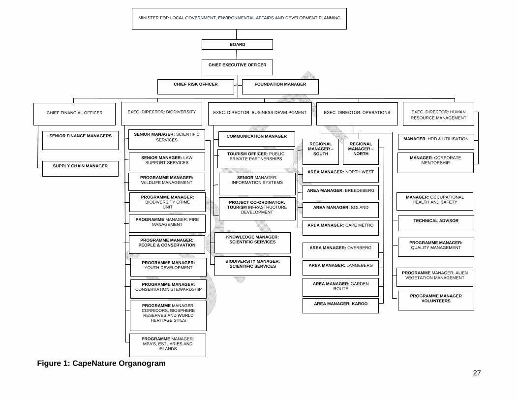
2.4 Institutional Framework The Western Cape Nature Conservation Board is trading as CapeNature and is shown in Figure 1. Programme 1: Administration The purpose is to ensure that good corporate governance is achieved and that efficient and effective services are delivered to the organisation with regards to finances and corporate services and all aspects of human resource management. The Programme consists of the following sub-programmes:
24
Sub-Programme 1.1: Office of the CEO Purpose: The Office of the CEO is primarily responsible for the execution of the core mandate, responsibility and function of the Western Cape Nature Conservation Board, on behalf of the Accounting Authority.
This is accomplished through the provision of strategic leadership, focus and direction in support of realising its vision, mission, strategic goals and objectives and ensuring adequate support to the Accounting Authority to enable it to fulfill its mandate.
This sub-programme comprises:
The Office of the Chief Executive Officer; The Board; and Investments.
Sub-Programme 1.2: Finance and Administration Services Purpose: The Financial and Administration Services sub-programme is responsible for effective preparation and implementation of a financial plan and budget for the organisation and the judicious application and control of public funds. These include ensuring that accurate financial records are kept and that financial procedures and controls are being adhered to for proper, effective and efficient use and accountability of resources as required by the Public Finance Management Act, (Act No. 1 of 1999) (PFMA). This sub-programme comprises:
Finance Logistical Services Supply Chain Management
Sub-Programme 1.3: Human Resource Management Purpose: Human Resource Management is responsible for developing a culture that develops human potential by creating an enabling environment for people development through strategic corporate initiatives that focus on coaching and mentoring, on-going performance management and proactive workforce practices such as succession planning, recruitment and selection, and sound employee relations. This sub-programme comprises of various components:
Human Resources Practices Human Resources Development and Utilisation Employee Relations Corporate Mentorship Programme
25
Programme 2: Planning and Operations The aim of this programme is to realise strategic biodiversity management and planning objectives on and off protected areas in pursuance of expanding the conservation economy of the Western Cape. Sub-Programme 2.1: Management and Biodiversity Support Purpose: To develop and apply effective knowledge management systems to identify and inform sustainable conservation management and priorities, to expand the protected area network, to facilitate effective wildlife management and biodiversity crime prevention, youth and community development including environmental awareness and equitable access linked to enhanced participation in the environmental economy.
The sub-programme consists of two main sub-sections, namely:
A) Management - Management interventions of CapeNature’s core business are carried out within the eight areas in the Western Cape:
North West Breede Berg Boland Cape Metro Overberg Langeberg Garden Route Karoo.
These eight areas are also supported by the Occupational Health and Safety Manager and Technical Advisor. Within each Area there are five components that report to the Area Manager:
Conservation Management Staff manage nature reserves; Conservation Services Staff, which focus activities off-reserve; Community Conservation Staff focus on people and conservation issues including
awareness, youth development and volunteer management; Ecological coordinators and GIS technicians focus on knowledge management; and Tourism staff attends to visitor management and services on the reserve.
B) Biodiversity Support Services include the following components or programmatic areas which focuses CapeNature activities strategically. These include:
Scientific Services Law Support Services Wildlife Management Support Biodiversity Crime Prevention Fire Management Support Alien Vegetation Management People and Conservation Youth Development and Environmental Awareness
26
Conservation Stewardship Corridors, Biosphere Reserves and World Heritage Sites Marine Protected Areas, Islands and Estuaries Quality Management.
Sub-Programme 2.2: Special Projects: Planning and Operations Purpose: The purpose of this programme is to conserve the unique natural heritage of the Western Cape, to build social capital through people and conservation initiatives, and to promote equitable access to and sustainable use of natural resources in pursuit of the conservation economy. Programme 3: Business Development The purpose of the programme is to increase the revenue of CapeNature through marketing and managing the organisation’s tourism products. Sub-Programme 3.1: Tourism, Marketing and Communication Purpose: To develop and maintain unique tourism product offerings that contribute to the sustainability of biodiversity management and to establish a positive and credible CapeNature brand by ensuring effective and efficient communication and marketing to both internal and external stakeholders. This sub-programme comprises various components
Tourism Communication Marketing and Branding Central Reservation System Filming Public Private Partnerships.
Sub-Programme 3.2: Information Technology and Systems Purpose: To provide an integrated support service with regards to Information Technology and Systems, IT infrastructure and architectural development which enables the organisation to deliver on its objectives.
Grow and implement the Information Technology network and data connection
infrastructure; Identify and implement appropriate Information Systems; Render professional and prompt support and maintenance service; and Ensure sound IT/IS Governance.
Sub-Programme 3.3: Special Projects: Business Development Purpose: To develop and maintain unique tourism product offerings that contributes to the sustainability of biodiversity management.
27
Figure 1: CapeNature Organogram
MINISTER FOR LOCAL GOVERNMENT, ENVIRONMENTAL AFFAIRS AND DEVELOPMENT PLANNING
BOARD
CHIEF EXECUTIVE OFFICER
EXEC. DIRECTOR: BUSINESS DEVELPOMENT
EXEC. DIRECTOR: BIODIVERSITY
PROGRAMME MANAGER: WILDLIFE MANAGEMENT
PROGRAMME MANAGER: BIODIVERSITY CRIME
UNIT
PROGRAMME MANAGER: YOUTH DEVELOPMENT
PROGRAMME MANAGER: PEOPLE & CONSERVATION
SENIOR MANAGER: LAW SUPPORT SERVICES
SENIOR MANAGER: SCIENTIFIC SERVICES
PROGRAMME MANAGER: FIRE MANAGEMENT
PROGRAMME MANAGER: CONSERVATION STEWARDSHIP
PROGRAMME MANAGER: CORRIDORS, BIOSPHERE RESERVES AND WORLD
HERITAGE SITES
CHIEF FINANCIAL OFFICER
EXEC. DIRECTOR: HUMAN
RESOURCE MANAGEMENT
EXEC. DIRECTOR: OPERATIONS
REGIONAL MANAGER –
NORTH
REGIONAL MANAGER –
SOUTH
PROGRAMME MANAGER: MPA'S, ESTUARIES AND
ISLANDS
BIODIVERSITY MANAGER: SCIENTIFIC SERVICES
KNOWLEDGE MANAGER: SCIENTIFIC SERVICES
COMMUNICATION MANAGER
CHIEF RISK OFFICER
AREA MANAGER: NORTH WEST
PROGRAMME MANAGER: QUALITY MANAGEMENT
PROGRAMME MANAGER: ALIEN VEGETATION MANAGEMENT
AREA MANAGER: BREEDEBERG
AREA MANAGER: BOLAND
AREA MANAGER: CAPE METRO
AREA MANAGER: OVERBERG
AREA MANAGER: LANGEBERG
AREA MANAGER: GARDEN ROUTE
TOURISM OFFICER: PUBLIC PRIVATE PARTNERSHIPS
SENIOR MANAGER: INFORMATION SYSTEMS
PROJECT CO-ORDINATOR: TOURISM INFRASTRUCTURE
DEVELOPMENT
AREA MANAGER: KAROO
SENIOR FINANCE MANAGERS
SUPPLY CHAIN MANAGER
MANAGER: HRD & UTILISATION
MANAGER: CORPORATE MENTORSHIP
PROGRAMME MANAGER VOLUNTEERS
MANAGER: OCCUPATIONAL HEALTH AND SAFETY
TECHNICAL ADVISOR
FOUNDATION MANAGER
28
2.5 Strategic Management Plan
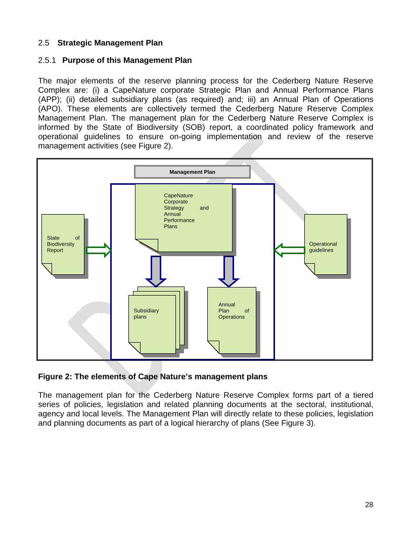
2.5.1 Purpose of this Management Plan The major elements of the reserve planning process for the Cederberg Nature Reserve Complex are: (i) a CapeNature corporate Strategic Plan and Annual Performance Plans (APP); (ii) detailed subsidiary plans (as required) and; iii) an Annual Plan of Operations (APO). These elements are collectively termed the Cederberg Nature Reserve Complex Management Plan. The management plan for the Cederberg Nature Reserve Complex is informed by the State of Biodiversity (SOB) report, a coordinated policy framework and operational guidelines to ensure on-going implementation and review of the reserve management activities (see Figure 2).
Figure 2: The elements of Cape Nature’s management plans The management plan for the Cederberg Nature Reserve Complex forms part of a tiered series of policies, legislation and related planning documents at the sectoral, institutional, agency and local levels. The Management Plan will directly relate to these policies, legislation and planning documents as part of a logical hierarchy of plans (See Figure 3).
Management Plan
Subsidiary plans
Annual Plan of Operations
CapeNature Corporate Strategy and Annual Performance Plans
State of Biodiversity Report
Operational guidelines
29
Key Enabling Legislation
DEA &DP Strategic and Performance Plan
DEA&DP Medium term Expenditure Framework
CapeNature Corporate Strategy
CapeNature Annual Performance Plan
CapeNature Policies and Procedures
Bioregional Programmes – C.A.P.E.; S.K.E.P;A.B.I etc
Subsidiary plans (e.g. fire management, IAS management, Tourism development, APO, Reserve specific operations
Figure 3: Legal and planning framework for the management plan The approach to, and format of, this Management Plan is directed by the Guidelines for the development of a management plan for a protected area in terms of the National Environmental Management: Protected Area Act (Cowan & Mpongoma 2010). The drafting of this Management Plan has been guided by a small interdisciplinary Reserve Management Committee (RMC) comprising the Area Manager, Conservation Manager, Ecological Coordinator, Regional Ecologist, Community Conservation Manager, Conservation Services Manager and Tourism Officer. Iterative drafts of the Management Plan were presented to, and discussed by, the RMC before broader circulation for inputs from the public. The purpose of this Management Plan is to ensure that the Cederberg Nature Reserve Complex has clearly defined objectives and activities to direct the protection and sustainable use of its natural, scenic and heritage resources over a five year period. The Management Plan indicates where reserve management intends to focus its efforts in the next five years. The Management Plan thus provides the medium-term operational framework for the prioritised allocation of resources and capacity in the management, use and development of the reserve. It must be noted that the Management Plan focuses on strategic priorities rather than detailing all operational and potential reactive courses of action in the next five years. The timeframe referenced in the Strategic Implementation Framework follows financial years (1 April to 31 March), with Year 1 commencing from signing of the Management Plan by the MEC. While planning for some emergencies is part of the Management Plan, it remains possible that unforeseen circumstances could disrupt the prioritisation established in this Management Plan. These should be addressed in the annual review and update of the Management Plan. The scope of the Management Plan for the Cederberg Nature Reserve Complex is
30
constrained by the reserve’s actual or potential performance capability - given available personnel, funding, and any other external factors - to ensure that the plan is achievable and sustainable. The Cederberg Nature Reserve Complex Management Plan has been compiled on the basis of current available resources (funding and human capital). Legislation listed in the Strategic Implementation Framework is non-exhaustive.
2.5.2 Stakeholder Participation Process CapeNature has adapted the South African National Parks (SANParks), Stakeholder Participation in Developing Park Management Plans (Spies and Symonds 2011) for the stakeholder participation process. Section 39(3) of the National Environmental Management: Protected Areas Act, (Act No. 57 of 2003) states that when preparing a management plan for a protected area, the management authority concerned must consult municipalities, other organs of state, local communities and other affected parties which have an interest in the area. Section 41(2) (e) requires that the Management Plan contains procedures for public participation, including participation by the owner (if applicable), any local community or other interested party. All stakeholders must register and a stakeholder register, as well as attendance registers for workshops and meetings, must be kept. Additional individuals, wishing to participate in the process, must register as stakeholders and should be accommodated to ensure that the process is inclusive. Figure 4 shows the stakeholder participation strategy for CapeNature management plans. Any persons having direct or indirect interests or rights in a nature reserve may be considered a stakeholder. The stakeholder process will facilitate the establishment of a comprehensive Protected Area Advisory Committee. In CapeNature’s efforts to comply with the deadlines for this process, certain of these steps had to be combined for this Management Plan. Stakeholder meeting 1 and 2 shown in Figure 4, will be combined with stakeholder meeting 3. At this meeting opportunity will be provided to stakeholders to comment on the desired state and objectives for Cederberg Nature Reserve Complex.
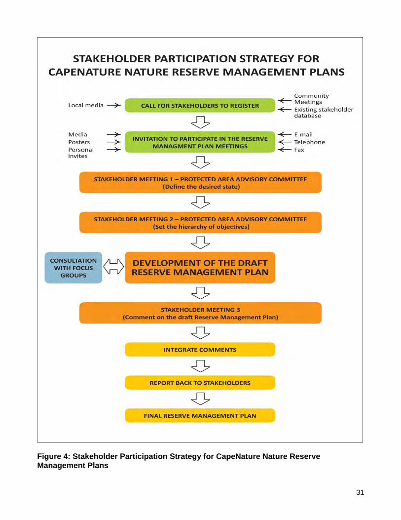
31
Figure 4: Stakeholder Participation Strategy for CapeNature Nature Reserve Management Plans
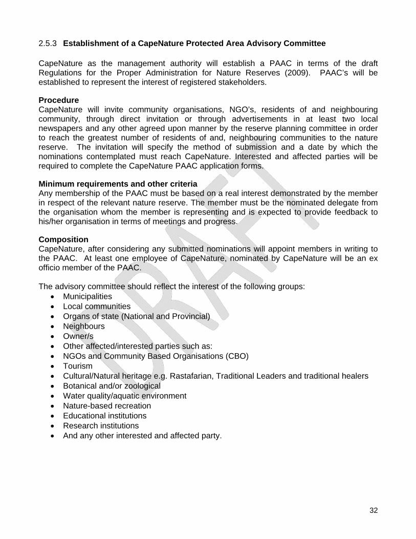
32
2.5.3 Establishment of a CapeNature Protected Area Advisory Committee CapeNature as the management authority will establish a PAAC in terms of the draft Regulations for the Proper Administration for Nature Reserves (2009). PAAC’s will be established to represent the interest of registered stakeholders. Procedure CapeNature will invite community organisations, NGO’s, residents of and neighbouring community, through direct invitation or through advertisements in at least two local newspapers and any other agreed upon manner by the reserve planning committee in order to reach the greatest number of residents of and, neighbouring communities to the nature reserve. The invitation will specify the method of submission and a date by which the nominations contemplated must reach CapeNature. Interested and affected parties will be required to complete the CapeNature PAAC application forms. Minimum requirements and other criteria Any membership of the PAAC must be based on a real interest demonstrated by the member in respect of the relevant nature reserve. The member must be the nominated delegate from the organisation whom the member is representing and is expected to provide feedback to his/her organisation in terms of meetings and progress. Composition CapeNature, after considering any submitted nominations will appoint members in writing to the PAAC. At least one employee of CapeNature, nominated by CapeNature will be an ex officio member of the PAAC. The advisory committee should reflect the interest of the following groups:
Municipalities Local communities Organs of state (National and Provincial) Neighbours Owner/s Other affected/interested parties such as: NGOs and Community Based Organisations (CBO) Tourism Cultural/Natural heritage e.g. Rastafarian, Traditional Leaders and traditional healers Botanical and/or zoological Water quality/aquatic environment Nature-based recreation Educational institutions Research institutions And any other interested and affected party.
33
Term of office Each member is expected to serve for a fixed two year period as determined by
CapeNature management but the respective organisation’s rights and procedures with respect to member representation will be allowed as long as it is in the interest of conservation and good governance.
Nominees representing organisations and formally constituted groups must be nominated by their organisation/group on official letter heads, signed by an executive authority, and be duly appointed to act in the interest of their organisation. Organisations must also nominate a second member to attend and represent the organisation when the primary nominee is not available. The nomination letters from the organisations must be accompanied by the application forms.
Membership is voluntary and no remuneration will be provided to PAAC members. As part of good governance, all PAAC members will be required to adhere to the PAAC code of conduct and if any member does not adhere to the code of conduct stipulations, the organisation that the member is representing will be expected to deal with their member accordingly. Terms of Reference for PAACs The committee will be expected to:
1. Provide input into management decisions relating to protected area management; 2. Act as a forum to provide advice on reserve issues; 3. Play a role in educating the community and various interest groups about the
importance of preservation, protection and management of natural resources and the objectives of the reserve management plan that are intended to pursue these goals;
4. Monitor and evaluate progress on implementation of programmes in the reserve management plan;
5. Make recommendations on how CapeNature can improve programmes and policies; 6. Promote involvement in decision-making around the management of natural and
cultural heritage resources within the scope of the reserve management plan; 7. Promote the integration of conservation activities within the nature reserve with those
of surrounding areas; 8. Identify opportunities and constraints pertaining to the Bio-prospecting Access and
Benefit Sharing, where applicable; and 9. Establish and maintain links between CapeNature and other stakeholders.
Functioning of the Advisory Committee The committee will meet a minimum of once a year. At the first meeting a Chairperson and a secretary who will be required to take minutes of all matters discussed, will be elected. The committee will be expected to submit a copy of the minutes for each meeting and a full report, to the management authority (the Area Manager for submission to the Executive Director: Operations), highlighting issues and making recommendations on matters arising from the implementation of the Cederberg Nature Reserve Complex Management Plan. The Chairperson may at his/her discretion form working groups when required. Minutes of all working groups meetings must be kept and submitted through the Chairperson to reserve management.
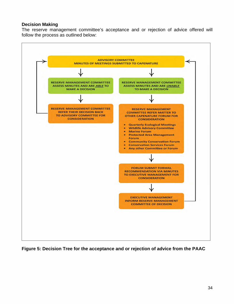
34
Decision Making The reserve management committee’s acceptance and or rejection of advice offered will follow the process as outlined below:
Figure 5: Decision Tree for the acceptance and or rejection of advice from the PAAC
35
SECTION 3: OVERVIEW AND BACKGROUND OF THE RESERVE
3.1 Location and Extent The Cederberg Nature Reserve Complex is situated between latitudes 34º 06’ S and 32º 44' S and longitudes 32º 09' E and 32 º 29' E. It is approximately 79 735 ha in extent and includes the following: Cederberg Wilderness (65 098 ha), Matjies River Nature Reserve (12 815 ha) and Hexberg State Forest (1 821 ha). The Cederberg Nature Reserve Complex falls within nine (9) quarter degree grids: 1. 3218BB – Clanwilliam 2. 3218BD – Oliewenboskraal 3. 3219AA – Pakhuis 4. 3219AC – Wuppertal 5. 3219AD – Grootberg 6. 3219BC – Elandsvlei 7. 3219CA – Citrusdal 8. 3219CB – Grootrivier 9. 3219DA – Tulpfontein The Cederberg Wilderness lies some 250 km north of Cape Town and 70 km from the Atlantic Seaboard. This vast area stretches from the Middelberg Pass at Citrusdal in the south, to north of the Pakhuis Pass at Clanwilliam, encompassing some 67 000 ha of rugged, mountainous terrain. The north/south extent of the reserve is approximately 70 km and the east/west extent, approximately 32 km. The main access route to the office at Algeria is via a 17 km stretch of gravel road which branches off to the east, from the N7 main road between Citrusdal and Clanwilliam. Algeria is situated approximately 30 km south-east of Clanwilliam and 23 km north-east of Citrusdal. The Cederberg Wilderness is traversed by two roads; the main road (R364) from Clanwilliam over Pakhuis Pass to Calvinia in the north-east and a secondary road from Clanwilliam to Ceres in the central part. The Hexberg State Forest is situated approximately 8 km south of the Cederberg Wilderness and is accessed via the main road (R303) that runs from Citrusdal towards Ceres. Matjies Rivier Nature Reserve lies to the east of the southern part of the Cederberg Wilderness. The reserve is bounded towards the east by the Doring River which also forms the boundary with the Tankwa Karoo and Northern Cape Province. The north/south extent of the reserve is approximately 15 km and the east/west extent, approximately 22 km. The main access route to the office is via the secondary gravel road that runs from Clanwilliam to Ceres. The Matjies Rivier office complex is situated approximately 70 km south-east of Clanwilliam and 120 km north of Ceres.
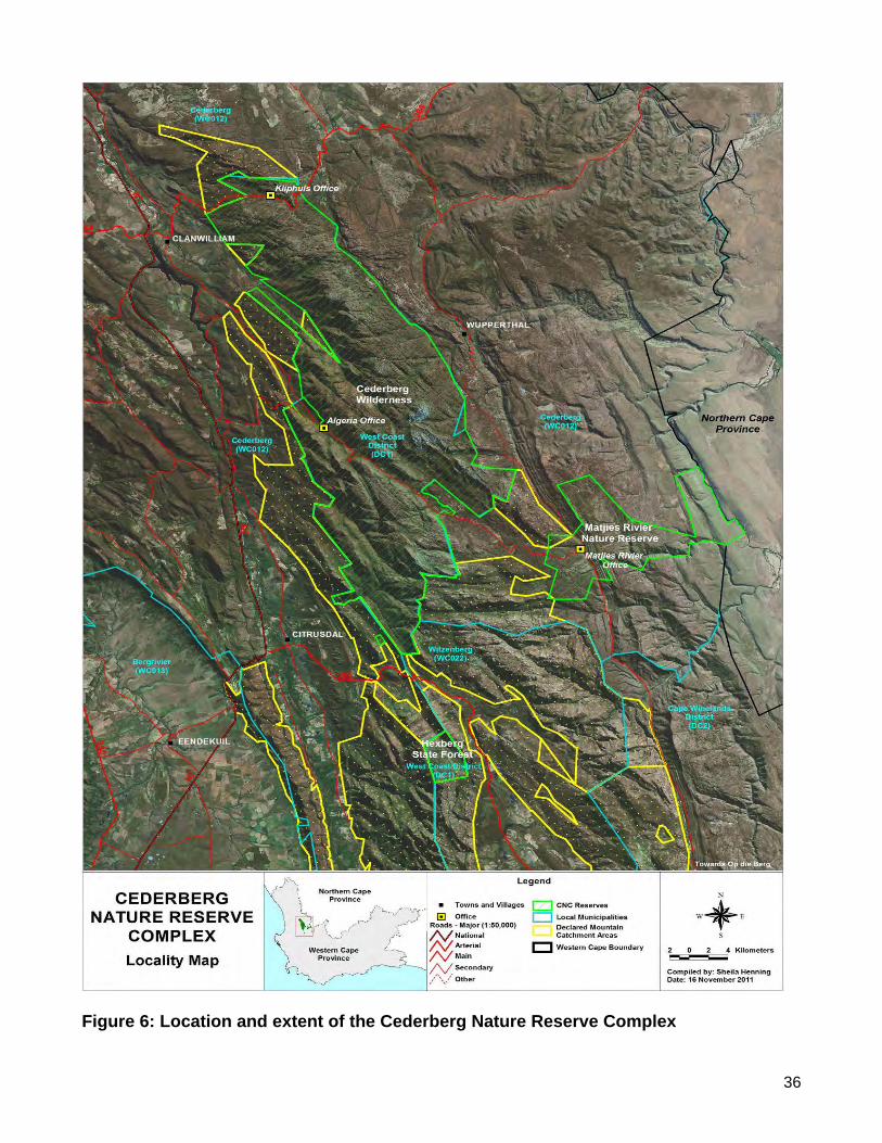
36
Figure 6: Location and extent of the Cederberg Nature Reserve Complex
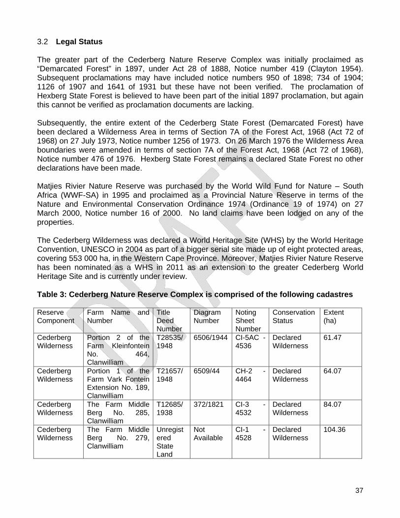
37
3.2 Legal Status The greater part of the Cederberg Nature Reserve Complex was initially proclaimed as “Demarcated Forest” in 1897, under Act 28 of 1888, Notice number 419 (Clayton 1954). Subsequent proclamations may have included notice numbers 950 of 1898; 734 of 1904; 1126 of 1907 and 1641 of 1931 but these have not been verified. The proclamation of Hexberg State Forest is believed to have been part of the initial 1897 proclamation, but again this cannot be verified as proclamation documents are lacking. Subsequently, the entire extent of the Cederberg State Forest (Demarcated Forest) have been declared a Wilderness Area in terms of Section 7A of the Forest Act, 1968 (Act 72 of 1968) on 27 July 1973, Notice number 1256 of 1973. On 26 March 1976 the Wilderness Area boundaries were amended in terms of section 7A of the Forest Act, 1968 (Act 72 of 1968), Notice number 476 of 1976. Hexberg State Forest remains a declared State Forest no other declarations have been made. Matjies Rivier Nature Reserve was purchased by the World Wild Fund for Nature – South Africa (WWF-SA) in 1995 and proclaimed as a Provincial Nature Reserve in terms of the Nature and Environmental Conservation Ordinance 1974 (Ordinance 19 of 1974) on 27 March 2000, Notice number 16 of 2000. No land claims have been lodged on any of the properties. The Cederberg Wilderness was declared a World Heritage Site (WHS) by the World Heritage Convention, UNESCO in 2004 as part of a bigger serial site made up of eight protected areas, covering 553 000 ha, in the Western Cape Province. Moreover, Matjies Rivier Nature Reserve has been nominated as a WHS in 2011 as an extension to the greater Cederberg World Heritage Site and is currently under review. Table 3: Cederberg Nature Reserve Complex is comprised of the following cadastres Reserve Component
Farm Name and Number
Title Deed Number
Diagram Number
Noting Sheet Number
Conservation Status
Extent (ha)
Cederberg Wilderness
Portion 2 of the Farm Kleinfontein No. 464, Clanwilliam
T28535/1948
6506/1944 CI-5AC - 4536
Declared Wilderness
61.47
Cederberg Wilderness
Portion 1 of the Farm Vark Fontein Extension No. 189, Clanwilliam
T21657/1948
6509/44 CH-2 - 4464
Declared Wilderness
64.07
Cederberg Wilderness
The Farm Middle Berg No. 285, Clanwilliam
T12685/1938
372/1821 CI-3 - 4532
Declared Wilderness
84.07
Cederberg Wilderness
The Farm Middle Berg No. 279, Clanwilliam
Unregistered State Land
Not Available
CI-1 - 4528
Declared Wilderness
104.36
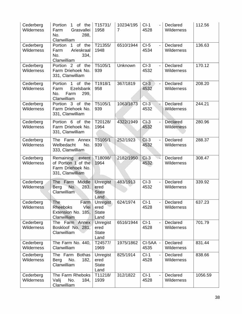
38
Cederberg Wilderness
Portion 1 of the Farm Grasvallei No. 288, Clanwilliam
T15731/1958
10234/1957
CI-1 - 4528
Declared Wilderness
112.56
Cederberg Wilderness
Portion 1 of the Farm Arieskraal No. 334, Clanwilliam
T21355/1948
6510/1944 CI-5 - 4534
Declared Wilderness
136.63
Cederberg Wilderness
Portion 2 of the Farm Driehoek No. 331, Clanwilliam
T5105/1939
Unknown CI-3 - 4532
Declared Wilderness
170.12
Cederberg Wilderness
Portion 1 of the Farm Ezelsbank No. Farm 299, Clanwilliam
T1918/1958
367/1819 CI-3 - 4532
Declared Wilderness
208.20
Cederberg Wilderness
Portion 3 of the Farm Driehoek No. 331, Clanwilliam
T5105/1939
1063/1873 CI-3 - 4532
Declared Wilderness
244.21
Cederberg Wilderness
Portion 6 of the Farm Driehoek No. 331, Clanwilliam
T20128/1964
4322/1949 CI-3 - 4532
Declared Wilderness
280.96
Cederberg Wilderness
The Farm Annex Welbedacht No. 333, Clanwilliam
T5105/1939
252/1923 CI-3 - 4532
Declared Wilderness
288.37
Cederberg Wilderness
Remaining extent of Portion 1 of the Farm Driehoek No. 331, Clanwilliam
T18098/1964
2182/1950 CI-3 - 4532
Declared Wilderness
308.47
Cederberg Wilderness
The Farm Middle Berg No. 283, Clanwilliam
Unregistered State Land
483/1913 CI-3 - 4532
Declared Wilderness
339.92
Cederberg Wilderness
The Farm Rheeboks Vlei Extension No. 185, Clanwilliam
Unregistered State Land
624/1974 CI-1 - 4528
Declared Wilderness
637.23
Cederberg Wilderness
The Farm Annex Boskloof No. 281, Clanwilliam
Unregistered State Land
6516/1944 CI-1 - 4528
Declared Wilderness
701.79
Cederberg Wilderness
The Farm No. 440, Clanwilliam
T24577/1969
1975/1862 CI-5AA - 4535
Declared Wilderness
831.44
Cederberg Wilderness
The Farm Bothas Berg No. 182, Clanwilliam
Unregistered State Land
825/1914 CI-1 - 4528
Declared Wilderness
838.66
Cederberg Wilderness
The Farm Rheboks Valij No. 184, Clanwilliam
T11218/1939
312/1822 CI-1 - 4528
Declared Wilderness
1056.59
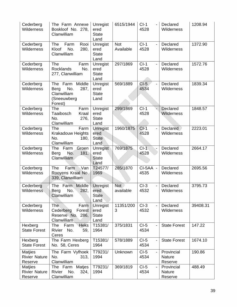
39
Cederberg Wilderness
The Farm Annexe Boskloof No. 278, Clanwilliam
Unregistered State Land
6515/1944 CI-1 - 4528
Declared Wilderness
1208.94
Cederberg Wilderness
The Farm Rooi Kloof No. 280, Clanwilliam
Unregistered State Land
Not Available
CI-1 - 4528
Declared Wilderness
1372.90
Cederberg Wilderness
The Farm Rocklands No. 277, Clanwilliam
Unregistered State Land
297/1869 CI-1 - 4528
Declared Wilderness
1572.76
Cederberg Wilderness
The Farm Middle Berg No. 287, Clanwilliam (Sneeuwberg Forest)
Unregistered State Land
569/1889 CI-5 - 4534
Declared Wilderness
1839.34
Cederberg Wilderness
The Farm Taaibosch Kraal No. 276, Clanwilliam
Unregistered State Land
299/1869 CI-1 - 4528
Declared Wilderness
1848.57
Cederberg Wilderness
The Farm Krakadouw Heights No. 180, Clanwilliam
Unregistered State Land
1960/1875 CI-1 - 4528
Declared Wilderness
2223.01
Cederberg Wilderness
The Farm Groen Berg No. 181, Clanwilliam
Unregistered State Land
769/1875 CI-1 - 4528
Declared Wilderness
2664.17
Cederberg Wilderness
The Farm Van Rooyens Kraal No. 339, Clanwilliam
T24577/1969
285/1870 CI-5AA - 4535
Declared Wilderness
2695.56
Cederberg Wilderness
The Farm Middle Berg No. 282, Clanwilliam
Unregistered State Land
Not available
CI-3 - 4532
Declared Wilderness
3795.73
Cederberg Wilderness
The Farm Cederberg Forest Reserve No. 286, Clanwilliam
Unregistered State Land
11351/2003
CI-3 - 4532
Declared Wilderness
39408.31
Hexberg State Forest
The Farm Heks Rivier No. 59, Ceres
T15381/1964
375/1831 CI-5 - 4534
State Forest 147.22
Hexberg State Forest
The Farm Hexberg No. 58, Ceres
T15381/1964
578/1889 CI-5 - 4534
State Forest 1674.10
Matjies Rivier Nature Reserve
The Farm Vyfhoek No. 313, Clanwilliam
T79231/1994
Unknown CI-5 - 4534
Provincial Nature Reserve
190.86
Matjies Rivier Nature Reserve
The Farm Matjes Rivier No. 324, Clanwilliam
T79231/1994
369/1819 CI-5 - 4534
Provincial Nature Reserve
488.49
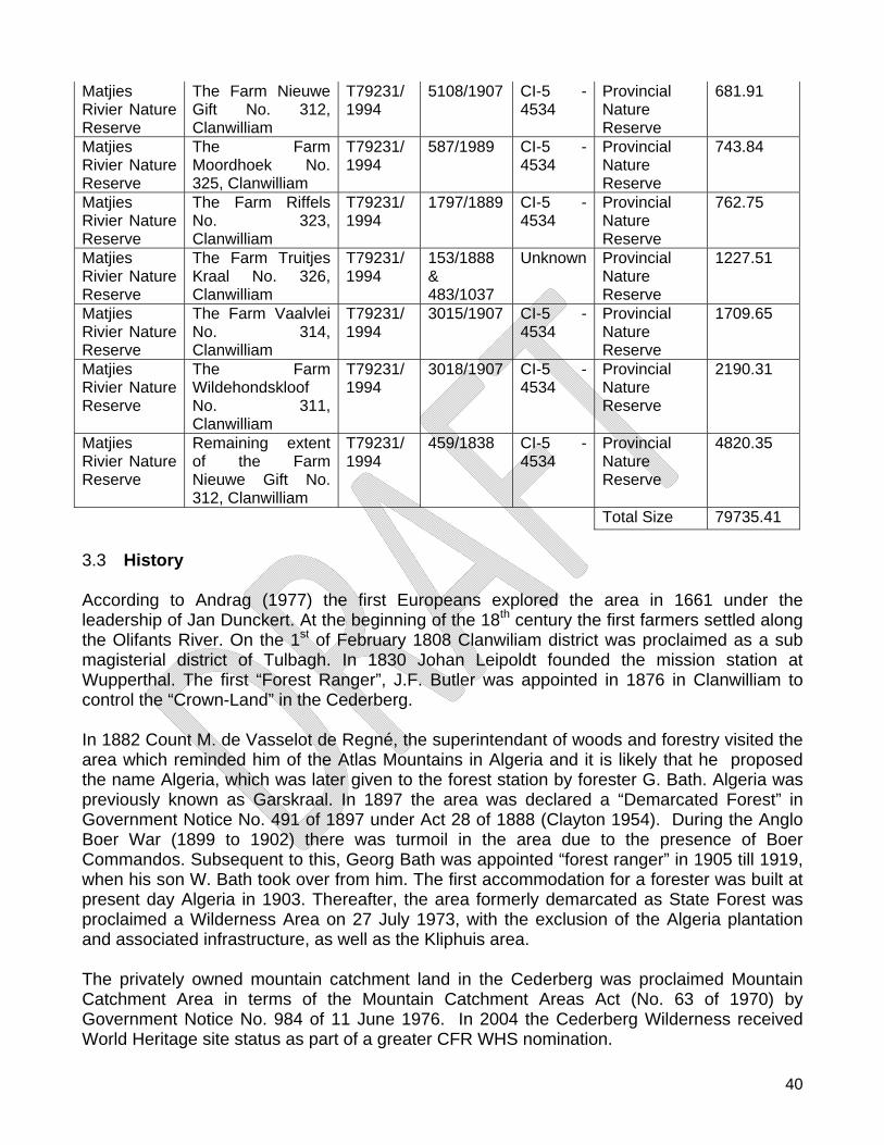
40
Matjies Rivier Nature Reserve
The Farm Nieuwe Gift No. 312, Clanwilliam
T79231/1994
5108/1907 CI-5 - 4534
Provincial Nature Reserve
681.91
Matjies Rivier Nature Reserve
The Farm Moordhoek No. 325, Clanwilliam
T79231/1994
587/1989 CI-5 - 4534
Provincial Nature Reserve
743.84
Matjies Rivier Nature Reserve
The Farm Riffels No. 323, Clanwilliam
T79231/1994
1797/1889 CI-5 - 4534
Provincial Nature Reserve
762.75
Matjies Rivier Nature Reserve
The Farm Truitjes Kraal No. 326, Clanwilliam
T79231/1994
153/1888 & 483/1037
Unknown Provincial Nature Reserve
1227.51
Matjies Rivier Nature Reserve
The Farm Vaalvlei No. 314, Clanwilliam
T79231/1994
3015/1907 CI-5 - 4534
Provincial Nature Reserve
1709.65
Matjies Rivier Nature Reserve
The Farm Wildehondskloof No. 311, Clanwilliam
T79231/1994
3018/1907 CI-5 - 4534
Provincial Nature Reserve
2190.31
Matjies Rivier Nature Reserve
Remaining extent of the Farm Nieuwe Gift No. 312, Clanwilliam
T79231/1994
459/1838 CI-5 - 4534
Provincial Nature Reserve
4820.35
Total Size 79735.41
3.3 History According to Andrag (1977) the first Europeans explored the area in 1661 under the leadership of Jan Dunckert. At the beginning of the 18th century the first farmers settled along the Olifants River. On the 1st of February 1808 Clanwiliam district was proclaimed as a sub magisterial district of Tulbagh. In 1830 Johan Leipoldt founded the mission station at Wupperthal. The first “Forest Ranger”, J.F. Butler was appointed in 1876 in Clanwilliam to control the “Crown-Land” in the Cederberg. In 1882 Count M. de Vasselot de Regné, the superintendant of woods and forestry visited the area which reminded him of the Atlas Mountains in Algeria and it is likely that he proposed the name Algeria, which was later given to the forest station by forester G. Bath. Algeria was previously known as Garskraal. In 1897 the area was declared a “Demarcated Forest” in Government Notice No. 491 of 1897 under Act 28 of 1888 (Clayton 1954). During the Anglo Boer War (1899 to 1902) there was turmoil in the area due to the presence of Boer Commandos. Subsequent to this, Georg Bath was appointed “forest ranger” in 1905 till 1919, when his son W. Bath took over from him. The first accommodation for a forester was built at present day Algeria in 1903. Thereafter, the area formerly demarcated as State Forest was proclaimed a Wilderness Area on 27 July 1973, with the exclusion of the Algeria plantation and associated infrastructure, as well as the Kliphuis area. The privately owned mountain catchment land in the Cederberg was proclaimed Mountain Catchment Area in terms of the Mountain Catchment Areas Act (No. 63 of 1970) by Government Notice No. 984 of 11 June 1976. In 2004 the Cederberg Wilderness received World Heritage site status as part of a greater CFR WHS nomination.
41
During the 18th century, settler farmers moved into the area east of the current Uitkyk pass and started farming with livestock. Prior to 1848, Matjies rivier was used as an outpost for livestock from the farm Vogelvallei, today known as Vogelfontein (Neetling 2007). As a result, the Matjiesrivier area was grazed intensively by livestock. In 1848, C.C.P. Wagener, originally from Niederwerbe in Germany, married a Nieuwoudt daughter and settled on Matjiesrivier. Livestock (sheep and goats) was the main source of income, while tobacco, fruit and vegetables was also produced on the farm. During 1995 WWF-SA purchased the farm Matjiesrivier which was subsequently proclaimed as a Nature Reserve in 2000 (KNB 1997). 3.4 Climate The Cederberg Wilderness and Hexberg State Forest falls in the winter rainfall zone of South Africa, with hot dry summers from October to April, and cold wet winters from May to September. The hottest months are generally January and February and the coldest July and August. Rain normally follows a cold front moving across from the north-west but thunderstorms are not uncommon, particularly in spring and autumn. These convection storms are more common in the eastern portions of the CNRC (Bands 1978). Minimum temperatures in winter (June to September) frequently drop below freezing and frost is common, particularly on the higher plateaux. Snowfalls are generally isolated to the higher mountain peaks and can occur at any time between June and October but these events are generally short lived. Summer (November to March) temperatures frequently rise to 30°C plus and extremes of over 40°C are not uncommon (Bands, 1978). Mist is common on the high-altitude peaks throughout the year. Although the Cederberg Wilderness receives at least 80% of its rain in the three winter months, its annual total is lower than in most other Cape Mountains (Taylor 1996). The mountain peaks above 1 000 m receives appreciably more precipitation than the valleys, much of it in the form of mist. A general pattern of higher winter rain in the west, with precipitation levels decreasing northwards exist. Within this pattern, precipitation also tends to increase rapidly with altitude. For example, Middelberg has an average rainfall of 393 mm while Algeria in the valley below has an average of 407 mm.
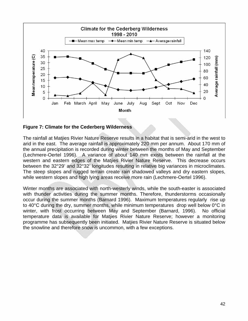
42
Figure 7: Climate for the Cederberg Wilderness The rainfall at Matjies Rivier Nature Reserve results in a habitat that is semi-arid in the west to arid in the east. The average rainfall is approximately 220 mm per annum. About 170 mm of the annual precipitation is recorded during winter between the months of May and September (Lechmere-Oertel 1996). A variance of about 140 mm exists between the rainfall at the western and eastern edges of the Matjies Rivier Nature Reserve. This decrease occurs between the 32°29’ and 32°32’ longitudes resulting in relative big variances in microclimates. The steep slopes and rugged terrain create rain shadowed valleys and dry eastern slopes, while western slopes and high lying areas receive more rain (Lechmere-Oertel 1996). Winter months are associated with north-westerly winds, while the south-easter is associated with thunder activities during the summer months. Therefore, thunderstorms occasionally occur during the summer months (Barnard 1996). Maximum temperatures regularly rise up to 40°C during the dry, summer months, while minimum temperatures drop well below 0°C in winter, with frost occurring between May and September (Barnard, 1996). No official temperature data is available for Matjies Rivier Nature Reserve; however a monitoring programme has subsequently been initiated. Matjies Rivier Nature Reserve is situated below the snowline and therefore snow is uncommon, with a few exceptions.
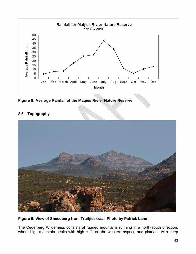
43
Figure 8: Average Rainfall of the Matjies Rivier Nature Reserve 3.5 Topography
Figure 9: View of Sneeuberg from Truitjieskraal. Photo by Patrick Lane The Cederberg Wilderness consists of rugged mountains running in a north-south direction, where high mountain peaks with high cliffs on the western aspect, and plateaus with deep
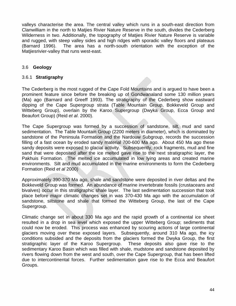
44
valleys characterise the area. The central valley which runs in a south-east direction from Clanwilliam in the north to Matjies Rivier Nature Reserve in the south, divides the Cederberg Wilderness in two. Additionally, the topography of Matjies Rivier Nature Reserve is variable and rugged, with steep valley sides and high ridges with sporadic valley floors and plateaus (Barnard 1996). The area has a north-south orientation with the exception of the Matjiesrivier-valley that runs west-east. 3.6 Geology
3.6.1 Stratigraphy The Cederberg is the most rugged of the Cape Fold Mountains and is argued to have been a prominent feature since before the breaking up of Gondwanaland some 130 million years (Ma) ago (Barnard and Greeff 1993). The stratigraphy of the Cederberg show eastward dipping of the Cape Supergroup strata (Table Mountain Group, Bokkeveld Group and Witteberg Group), overlain by the Karoo Supergroup (Dwyka Group, Ecca Group and Beaufort Group) (Reid et al. 2000). The Cape Supergroup was formed by a succession of sandstone, silt, mud and sand sedimentation. The Table Mountain Group (2200 meters in diameter), which is dominated by sandstone of the Peninsula Formation and the Nardouw Subgroup, records the succession filling of a fast ocean by eroded sandy material 700-600 Ma ago. About 450 Ma ago these sandy deposits were exposed to glacial activity. Subsequently, rock fragments, mud and fine sand that were deposited after the ice melted gave rise to the next stratigraphic layer, the Pakhuis Formation. The melted ice accumulated in low lying areas and created marine environments. Silt and mud accumulated in the marine environments to form the Cederberg Formation (Reid et al 2000) Approximately 390-370 Ma ago, shale and sandstone were deposited in river deltas and the Bokkeveld Group was formed. An abundance of marine invertebrate fossils (crustaceans and bivalves) occur in this stratigraphic shale layer. The last sedimentation succession that took place before major climatic changes set in was 370-430 Ma ago with the accumulation of sandstone, siltstone and shale that formed the Witteberg Group, the last of the Cape Supergroup. Climatic change set in about 330 Ma ago and the rapid growth of a continental ice sheet resulted in a drop in sea level which exposed the upper Witteberg Group; sediments that could now be eroded. This process was enhanced by scouring actions of large continental glaciers moving over these exposed layers. Subsequently, around 310 Ma ago, the icy conditions subsided and the deposits from the glaciers formed the Dwyka Group, the first stratigraphic layer of the Karoo Supergroup. These deposits also gave rise to the sedimentary Karoo Basin which was filled with shale, mudstone and sandstone deposited by rivers flowing down from the west and south, over the Cape Supergroup, that has been lifted due to intercontinental forces. Further sedimentation gave rise to the Ecca and Beaufort Groups.
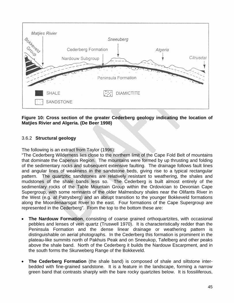
45
Figure 10: Cross section of the greater Cederberg geology indicating the location of Matjies Rivier and Algeria. (De Beer 1998)
3.6.2 Structural geology The following is an extract from Taylor (1996): “The Cederberg Wilderness lies close to the northern limit of the Cape Fold Belt of mountains that dominate the Capensis Region. The mountains were formed by up thrusting and folding of the sedimentary rocks and subsequent extensive faulting. The drainage follows fault lines and angular lines of weakness in the sandstone beds, giving rise to a typical rectangular pattern. The quartzitic sandstones are relatively resistant to weathering, the shales and mudstones of the shale bands less so. The Cederberg is built almost entirely of the sedimentary rocks of the Table Mountain Group within the Ordovician to Devonian Cape Supergroup, with some remnants of the older Malmesbury shales near the Olifants River in the West (e.g. at Patrysberg) and an abrupt transition to the younger Bokkeveld formations along the Moordenaarsgat River to the east. Four formations of the Cape Supergroup are represented in the Cederberg”. From the top to the bottom these are: The Nardouw Formation, consisting of coarse grained orthoquartzites, with occasional
pebbles and lenses of vein quartz (Truswell 1970). It is characteristically redder than the Peninsula Formation and the dense linear drainage or weathering pattern is distinguishable on aerial photographs. In the Cederberg this formation is prominent in the plateau-like summits north of Pakhuis Peak and on Sneeukop, Tafelberg and other peaks above the shale band. North of the Cederberg it builds the Nardouw Escarpment, and in the south forms the Skurweberg Range of the Bokkeveld.
The Cederberg Formation (the shale band) is composed of shale and siltstone inter-
bedded with fine-grained sandstone. It is a feature in the landscape, forming a narrow green band that contrasts sharply with the bare rocky quartzites below. It is fossiliferous,
46
and lacks the pock marks or “heuweltjies” characteristic of the Malmesbury and Bokkeveld shales.
The Pakhuis Formation is the thin layer of tillite, or glacial mudstones and related rocks,
immediately below the shale band. It contains random-sized pebbles some of which have been facetted and striated during the movement of ice over the underlying rock pavement. On Pakhuis Pass and at Groenberg, remnants of the glacial pavement are exposed, showing the deep irregular grooves made by the passage of the ice.
The Peninsula Formation, like the Nardouw, is a very thick deposit of coarse-grained
quartzitic sanstones with occasional white quartz pebbles. Sand-shale lenses of various sizes occur throughout this formation. This formation comprises all those parts of the Cederberg from which the upper strata have been eroded away, i.e., southward from Pakhuis Pass, including Krakadouw, Middelberg, Vensterberg and Maraisberg, but excluding the eastern peaks from Sneeukop to Sandfontein.
Highest and lowest points of the Cederberg Wilderness and Hexberg State Forest are: Sneeuberg 2027 metres above sea level, Tafelberg 1968 m.a.s.l., Sneeukop 1929 m.a.s.l. and Krakadouw Peak 1710 m.a.s.l. with the Jan Dissels valley at the lowest altitude of 240 m.a.s.l. Highest and lowest points on Matjies Rivier Nature Reserve are: Moordhoek in the north-west having the highest point at 1300 m.a.s.l. with Wildehondskloof on the eastern boundary at the Doring River at 400 m.a.s.l. (Lechmere-Oertel 1996). The overlying strata of the Nardouw Subgroup, Bokkeveld Group, Witteberg Group and Dwyka Formation are observed on Matjies Rivier Nature Reserve from west to east. The Stadsaal Caves and Truitjieskraal are erosion remnants of the resistant and thick-bedded sandstone of the Nardouw Subgroup. The Dwyka Formation overlies the white Witteberg Group in the east of Matjies Rivier Nature Reserve at Sandleegte where rock fragments from glacier deposits are scattered. On Matjies Rivier Nature Reserve the Fynbos vegetation grows on the shales and sand of the Table Mountain Group while the Succulent Karoo vegetation is found on the Bokkeveld, Witteberg, and Dwyka Formations (Low and Rebelo 1996). In the west of the reserve, up until the main road to Ceres, the sandstone is part of the Table Mountain group. The majority of the sandstone found in the reserve, from the middle to the eastern side of the reserve, is associated with the Witteberg Group. The rock strata have been considerably folded to form synclines and anticlines that give rise to the rugged topography.
3.6.3 Soils and sediments Sandy loam to clay loam soils are generally derived from the shales and mudstones of the Cederberg Formation in situ or as transported materials in the valleys. Cederberg soils are highly leached acid sands, low in nutrients with a low moisture retaining capacity. The soils on the sandstones slopes are typically unstratified and sandy, often with high grit content in places. In many areas, the bedrock is close to the surface and is frequently exposed. In the flatter run-on areas such as around Stadsaal Cave, deep Aeolian sands are found. Within these fine-grained Aeolian sands, localised patches of what appears to be coarse-grained sands has been found. The soils derived from the shale bands are finer-grained and more
47
fertile than those derived from the quartzite. These finer-grained soils are often concealed by an over-burden of quartzitic debris from a sandstone source further upslope. Throughout Matjies Rivier Nature Reserve there are localised patches of gravel (approximate pebbles size between 5 and 20 mm in diameter) that appear to be from a tertiary planation surface. The pebbles themselves are probably derived from conglomerates commonly found in Table Mountain sandstone that has broken down during the erosion of the landscape, thus releasing the pebbles.
48
Figure 11: Geology of the Cederberg Nature Reserve Complex
49
3.7 Hydrology
Figure 12: Hydrology of the Cederberg Nature Reserve Complex
50
3.7.1 Catchments As a result of the mountainous terrain and altitude of the Cederberg Mountains the area has a relatively high rainfall. The Cederberg Mountain catchment forms the northern spine of the watershed between the Olifants River to the west and the Doring River towards the east. Together these two river systems form the bigger Olifants-Doring catchment which plays a vital role in sustaining live in the Greater Cederberg Area. This catchment is managed to ensure the optimal sustained flow of high quality water. The Cederberg Wilderness has numerous perennial rivers that flow east and west into the Doring and Olifants Rivers respectively. In contrast, and although the north-western section of Matjies Rivier Nature Reserve is declared Mountain Catchment the reserve has a low rainfall and contributes a relatively low water yield to the Matjies and Krom rivers which both flow east into the Doring River.
3.7.2 Groundwater No known boreholes are currently located in the Cederberg Wilderness or Hexberg State Forest. However, two boreholes are located on the Matjies Rivier Nature Reserve; one is located at the office complex and the other at Sandleegte in the eastern part of the reserve. Water from the borehole at the office is mainly utilised for garden irrigation and occasionally for human consumption. The borehole at Sandleegte is currently not utilised but contains water of high quality
3.7.3 Rivers Thirteen rivers originate in the Cederberg Wilderness and Hexberg State Forest, all of which drain west and east into the Olifants and Doring Rivers respectively. The annual average flow of the Olifants River measured at Clanwilliam above the Clanwilliam Dam, is 404 200 mega litres. It is estimated that the Jan Dissels River, which enters the Olifants River below the Clanwilliam Dam contributes an annual average of approximately 115 000 mega litres to the system. Apart from the two perennial rivers, Matjies and Krom, that traverse the Matjies Rivier Nature Reserve there are a number of seasonal streams that start to flow after summer downpours. Matjies Rivier Nature Reserve is bounded in the east by the Doring River which flows in a northerly direction. The Doring River enters the Olifants River at Trawal, approximately 40 km north of Clanwilliam. The following is a list of the perennial rivers found within the CNRC:
Heks River (Olifants Catchment) Jan Dissel River (Olifants Catchment) Driehoek River - later becomes the Matjies River. (Doring Catchment) Dwars River in Krakadouw area. (Olifants Catchment) Taaiboskraal River Kliphuis River Eselbank River (Doring Catchment) Dassieboskloof River
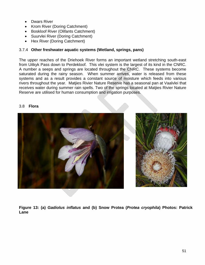
51
Dwars River Krom River (Doring Catchment) Boskloof River (Olifants Catchment) Suurvlei River (Doring Catchment) Hex River (Doring Catchment)
3.7.4 Other freshwater aquatic systems (Wetland, springs, pans) The upper reaches of the Driehoek River forms an important wetland stretching south-east from Uitkyk Pass down to Perdekloof. This vlei system is the largest of its kind in the CNRC. A number a seeps and springs are located throughout the CNRC. These systems become saturated during the rainy season. When summer arrives, water is released from these systems and as a result provides a constant source of moisture which feeds into various rivers throughout the year. Matjies Rivier Nature Reserve has a seasonal pan at Vaalvlei that receives water during summer rain spells. Two of the springs located at Matjies Rivier Nature Reserve are utilised for human consumption and irrigation purposes. 3.8 Flora
Figure 13: (a) Gadiolus inflatus and (b) Snow Protea (Protea cryophila) Photos: Patrick Lane
52
3.8.1 Terrestrial vegetation The Cederberg Nature Reserve Complex is located in the Greater Cape Floristic Kingdom. Due to the topographic, geological and climatic diversity the area spans two “Biodiversity HotSpots” namely the Cape Floral Region (Fynbos) and the semi-arid Succulent Karoo (Mucina and Rutherford 2006). According to Manning (2007) Fynbos is a fire adapted vegetation type and evidence suggests that, in the absence of regular fire, all Fynbos types but those adapted to drier conditions would become dominated by trees. Fynbos can thus be viewed as a fire dependant vegetation type. The infertility of Fynbos soils means that the recycling of soil nutrients is essential for Fynbos survival. Fire is the driver this cycle, and fires at appropriate intervals are not only an integral, but also an essential part of Fynbos ecology. Fires are common in Fynbos, this is a result of the extreme flammability of the dried, often intricately branched shrubs and restiods, and it is rare to find a stand of Fynbos more than 20 years old. Fires rejuvenate the vegetation by removing moribund growth and recycling nutrients back into the soil. They also remove the choking canopy that has matured during the intermediate years, allowing light to reach the soil surface (Manning 2007). Whether they re-establish by re-sprouting from woody stock or through germination of seeds, Fynbos shrubs that have been burnt take years to reach their former size. Meanwhile the space that has been created promotes flourishing growth of herbaceous plants. Sunlight that reaches the soil surface after a fire stimulates a flush of annuals and short lived perennials, whose seeds have often been primed by chemicals in the smoke itself. These pioneer plants take advantage of the newly released nutrients and favourable growing conditions to complete short life cycles, returning to the soil as seeds once the larger shrubs overwhelm them, remaining dormant until the next fire (Manning 2007).
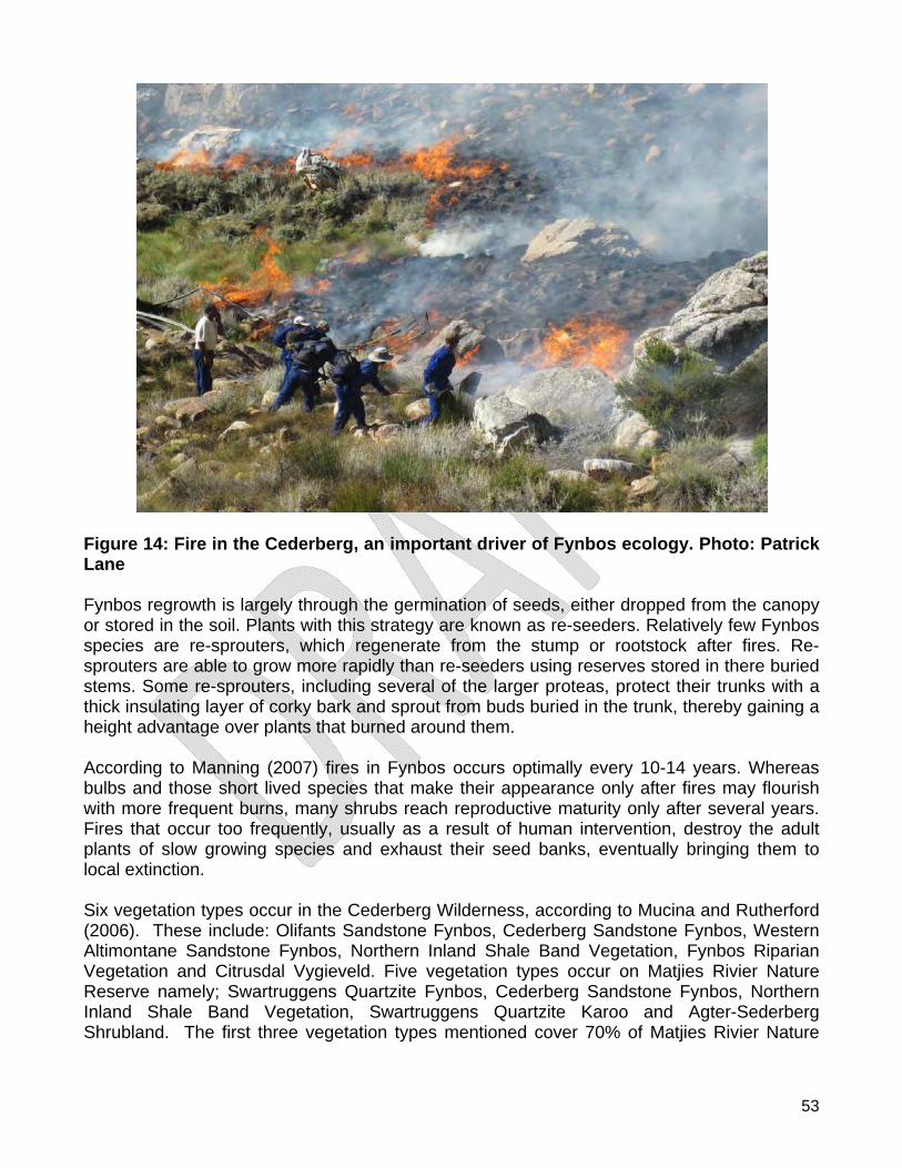
53
Figure 14: Fire in the Cederberg, an important driver of Fynbos ecology. Photo: Patrick Lane Fynbos regrowth is largely through the germination of seeds, either dropped from the canopy or stored in the soil. Plants with this strategy are known as re-seeders. Relatively few Fynbos species are re-sprouters, which regenerate from the stump or rootstock after fires. Re-sprouters are able to grow more rapidly than re-seeders using reserves stored in there buried stems. Some re-sprouters, including several of the larger proteas, protect their trunks with a thick insulating layer of corky bark and sprout from buds buried in the trunk, thereby gaining a height advantage over plants that burned around them. According to Manning (2007) fires in Fynbos occurs optimally every 10-14 years. Whereas bulbs and those short lived species that make their appearance only after fires may flourish with more frequent burns, many shrubs reach reproductive maturity only after several years. Fires that occur too frequently, usually as a result of human intervention, destroy the adult plants of slow growing species and exhaust their seed banks, eventually bringing them to local extinction. Six vegetation types occur in the Cederberg Wilderness, according to Mucina and Rutherford (2006). These include: Olifants Sandstone Fynbos, Cederberg Sandstone Fynbos, Western Altimontane Sandstone Fynbos, Northern Inland Shale Band Vegetation, Fynbos Riparian Vegetation and Citrusdal Vygieveld. Five vegetation types occur on Matjies Rivier Nature Reserve namely; Swartruggens Quartzite Fynbos, Cederberg Sandstone Fynbos, Northern Inland Shale Band Vegetation, Swartruggens Quartzite Karoo and Agter-Sederberg Shrubland. The first three vegetation types mentioned cover 70% of Matjies Rivier Nature
54
Reserve. In total the Complex hosts nine vegetation types which are listed in order of area covered in the Complex as described in Mucina and Rutherford (2006). Cederberg Sandstone Fynbos (52%):
This is the dominant vegetation type in the Cederberg Nature Reserve Complex. It occurs in the mountains and on rocky flats from the Pakhuisberg, in the north-west and Nardousberg in the north-east, through the Cederberg to Hexberg, the Breekkransberg and Sandfontein peaks in the south. The flat to gently east or north sloping tableland, with steeper west-facing slopes are rugged and dominated by rocky outcrops with gullies and flats of deep sand. The vegetation consists of closed restiolands on deeper moister sands, with low, sparse shrubs that become denser and Restionaceae less dominant in the drier areas. Structurally it is predominantly asteraceous, restioid and proteoid of nature. The soils are acidic lithosol soils derived from Ordovician sandstone of the Table Mountain Group. This is a winter-rainfall area with an annual precipitation of between 180-600 mm, peaking from May to August. Cederberg Sandstone Fynbos is least threatened with a conservation target of 29%.
Olifants Sandstone Fynbos (30%):
This unit comprises a combination of communities tending to occur on west facing slopes where bare rocks and cliffs are dominant and there is less accumulation of sand. The rock provides protection from fire, resulting in the dominance of cape thicket and asteraceous Fynbos with interspersed low trees and tall shrubs forming a medium tall shrub matrix. Proteoid Fynbos is most prominent on the lower slopes and sandy plateaus and restioid Fynbos occurs on deeper sands and shallower soils. The soils are acidic lithosol soils derived from Ordovician sandstone of the Table Mountain Group. Rainfall ranges from 250-700 mm peaking from May to August.
The Swartruggens Quartzite Fynbos (8%):
This vegetation type occurs on the high plateau areas from the Tra-Traberg north of Wupperthal to Blinkberg in the south. The alternating ridges and plains with sandy and skeletal soils derived from Witteberg Group quartzite support medium dense, moderate tall, restioid and ericoid shrubland with open emergent tall proteoid shrubs. This is a diverse Fynbos mixture containing all structural Fynbos types (except graminoid Fynbos). In the lower dry areas it is replaced by Karoo shrublands on sandstone. The Fynbos transcends to Karoo as the restios thin out and succulent plants become more dominant. This is a sub-arid, winter-rainfall area with a mean annual precipitation of between 200-620 mm, peaking from May to August. Swartruggens Quartzite Fynbos is least threatened with a conservation target of 29%.
Swartruggens Quartzite Karoo (4%):
This vegetation type occurs from Karoopoort in the south to the Hottentotsberge in the north. The hilly landscape is dissected by valleys with steep rocky slopes housing succulent shrublands with Euphorbia, Tylecodon, and Phiambolia. Fynbos and Renosterveld elements shared with neighbouring dry Sandstone Fynbos units include Willdenowia, Dodonaea and Elytropappus. The quartzitic sandstone of the Witteberg Group support shallow skeletal soils. This semi-desert winter-rainfall area has a mean annual precipitation of approximately 200 mm, peaking from June to August. Swartruggens Quartzite Karoo is least threatened with a conservation target of 19% of
55
which the majority is conserved within Matjies Rivier Nature Reserve. This vegetation type shows no signs of serious alien plant infestations and is the development centre of the recently recognised endemic succulent genus Phiambolia.
Northern Inland Shale Band Vegetation (3%):
This vegetation unit occurs on narrow shale bands from Pakhuis Pass in the north to Koue Bokkeveld in the south and is often associated with long linear plateaus in the Cederberg Mountains. The narrow linear features are smooth and flat and often used for paths and roads. This vegetation type encompasses diverse shrublands ranging from Karoo at lower levels and northerly aspects, Renosterveld at low and medium altitudes and various aspects and Fynbos at higher altitudes. Heuweltjies are prominent in the northern portion of the band. The clay soils derive from the shales of the Cederberg Formation. The area is typical winter-rainfall with an annual precipitation of between 250-1 360 mm, peaking from May to August. Northern Inland Shale Band Vegetation is least threatened with a conservation target of 29%. The majority (80%) of this vegetation type is protected within both the Cederberg and Grootwinterhoek Wilderness Areas.
Fynbos Riparian Vegetation (2%):
Fynbos Riparian Vegetation forms narrow belts of alluvial thicket accompanied by Palmiet (Prionium serratum), along upper stretches of rivers draining Mountain Fynbos. These are present at altitudes below 1300m. Narrow flat or slightly sloping alluvial flats support a complex of reed beds dominated by tall Palmiet and restios including low shrublands with moisture loving Berzelia, Cliffortia and Helichrysum. Alluvial sandy or silty soils over quaternary sediments are largely derived from weathering of Table Mountain sandstone and Cape supergroup shales. Streams are mainly fed by rainfall during winter and later on during summer by seeps carrying organic rich water. Large streams carry water all year round, while some smaller streams turn into a series of disconnected pools in the upper reaches during summer. All streams are prone to seasonal flooding and riparian vegetation is well adapted to cope with uprooting and water damage. Erosion occurs occasionally and can lead to patchy riparian vegetation.
Agter-Sederberg Shrubland (1%):
This occurs on a narrow shale belt extending south from Wupperthal squeezed between the Skurweberg and Swartruggens to Zonderwater in the south. The slopes of low mountains and deeply incised valleys support tall shrublands composed of a mixture of succulent (Crassula, Euphorbia, Ruschia, Tylecodon) and non-succulent (Berkheya, Felicia, Pteronia) species. The geology includes dark grey siltstones and shales with intercalated mudstones and sandstones of the Devonian Ceres and Biedouw Subgroups (Bokkeveld Group) and quartzitic sandstone of the Witteberg Group and Nardouw Supergroup (Table Mountain Group). This supports deep soils over shales and shallow soils over quartzitic sandstone. Heuweltjies are a prominent aspect in this vegetation type. The area is typical winter-rainfall with a mean annual precipitation of approximately 250 mm, peaking from June to August. Agter-Sederberg Shrubland is least threatened with a conservation target of 19% of which a small patch is statutorily conserved in Matjies Rivier Nature Reserve. This vegetation type is poorly studied.
56
Western Altimontane Sandstone Fynbos (<1%): This vegetation unit is found on summits and ridges of mountains from about 1 800 m upwards and includes patches on Jurie se Berg (1 930 m), Shadow Peak (1 898 m) and Sneeuberg (2 026 m). High altitude peaks are generally fragmented and localized. The vegetation structure is characterised by low, open to medium dense restiod Fynbos, with ericaceous and asteraceous components occurring locally. Proteoid Fynbos are generally absent. Skeletal and rocky lithosol soils are derived from Ordovician sandstones of the Table Mountain Group. Rainfall is relatively high and can range from anything between 450-3 140 mm, peaking from May to August.
Citrusdal Vygieveld (<1%):
Within the CNRC, this vegetation unit is the smallest in size and encompasses patches situated on the broad bottom of the Olifants River valley, in the surrounds of Citrusdal and Clanwilliam. Broad, slightly sloping mountain flanks as well as ridges of low hillocks emerging from the valley between mountain ranges. It is mainly comprised of succulent shrubland, medium to tall in height, often dominated by Euphorbia mauritanica. This vegetation type often leads to spectacular floral displays during spring. Dominated by shale and quartzite of the Cape Supergroup this area supports moderately deep sandy and sandy loamy soils. Rainfall occurs in winter with an annual mean of 316 mm.
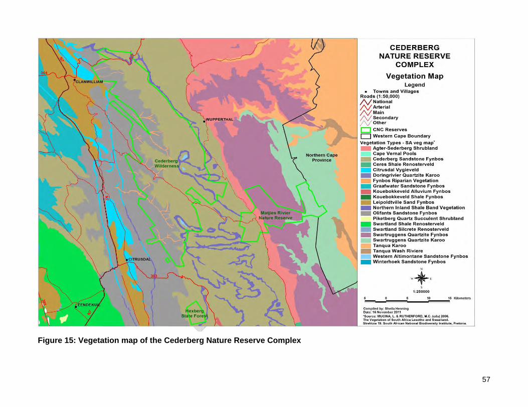
57
Figure 15: Vegetation map of the Cederberg Nature Reserve Complex
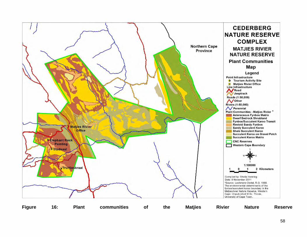
58
Figure 16: Plant communities of the Matjies Rivier Nature Reserve
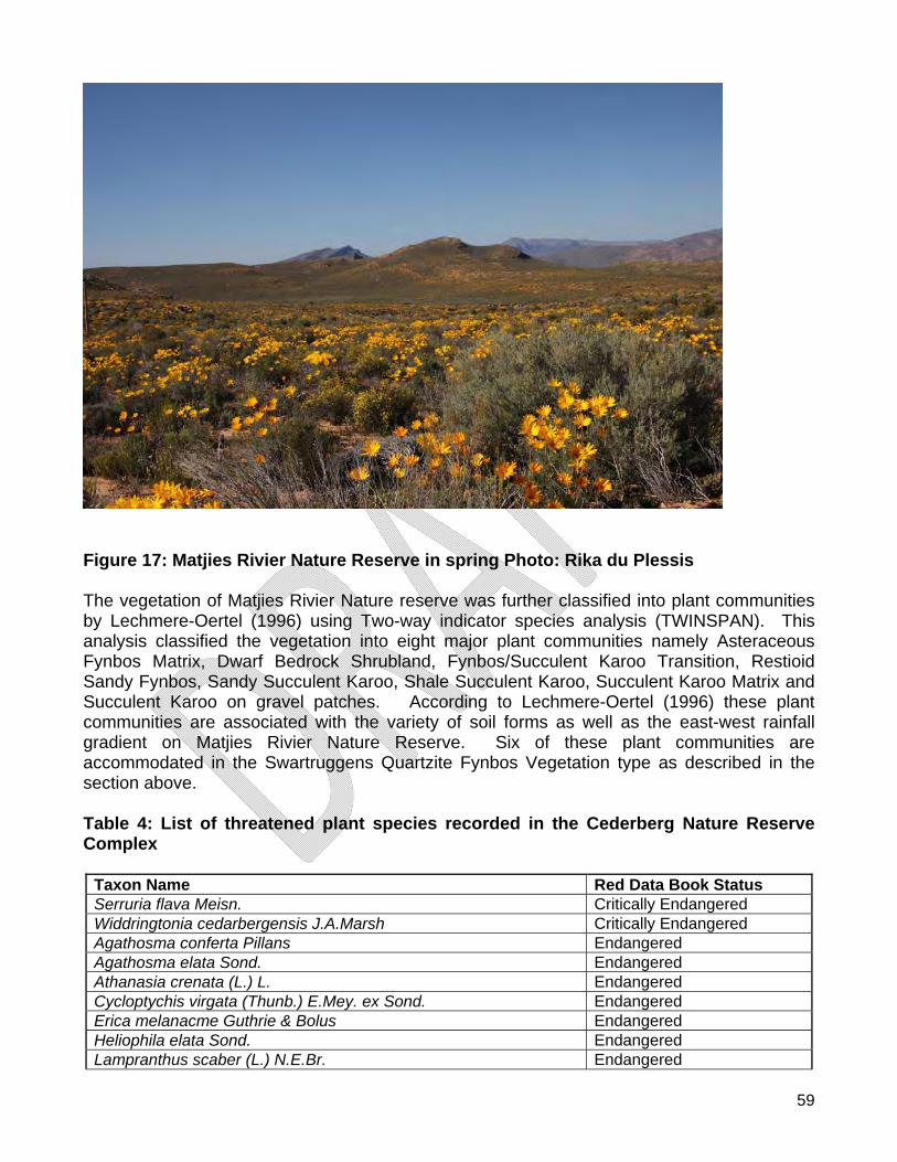
59
Figure 17: Matjies Rivier Nature Reserve in spring Photo: Rika du Plessis The vegetation of Matjies Rivier Nature reserve was further classified into plant communities by Lechmere-Oertel (1996) using Two-way indicator species analysis (TWINSPAN). This analysis classified the vegetation into eight major plant communities namely Asteraceous Fynbos Matrix, Dwarf Bedrock Shrubland, Fynbos/Succulent Karoo Transition, Restioid Sandy Fynbos, Sandy Succulent Karoo, Shale Succulent Karoo, Succulent Karoo Matrix and Succulent Karoo on gravel patches. According to Lechmere-Oertel (1996) these plant communities are associated with the variety of soil forms as well as the east-west rainfall gradient on Matjies Rivier Nature Reserve. Six of these plant communities are accommodated in the Swartruggens Quartzite Fynbos Vegetation type as described in the section above. Table 4: List of threatened plant species recorded in the Cederberg Nature Reserve Complex
Taxon Name Red Data Book Status Serruria flava Meisn. Critically Endangered Widdringtonia cedarbergensis J.A.Marsh Critically Endangered Agathosma conferta Pillans Endangered Agathosma elata Sond. Endangered Athanasia crenata (L.) L. Endangered Cycloptychis virgata (Thunb.) E.Mey. ex Sond. Endangered Erica melanacme Guthrie & Bolus Endangered Heliophila elata Sond. Endangered Lampranthus scaber (L.) N.E.Br. Endangered
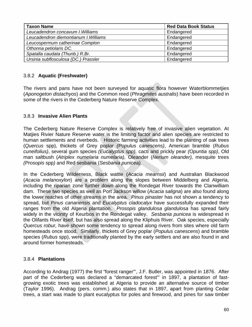
60
Taxon Name Red Data Book Status Leucadendron concavum I.Williams Endangered Leucadendron diemontianum I.Williams Endangered Leucospermum catherinae Compton Endangered Othonna petiolaris DC. Endangered Spatalla caudata (Thunb.) R.Br. Endangered Ursinia subflosculosa (DC.) Prassler Endangered
3.8.2 Aquatic (Freshwater) The rivers and pans have not been surveyed for aquatic flora however Waterblommetjies (Aponogeton distachyos) and the Common reed (Phragmites australis) have been recorded in some of the rivers in the Cederberg Nature Reserve Complex.
3.8.3 Invasive Alien Plants The Cederberg Nature Reserve Complex is relatively free of invasive alien vegetation. At Matjies Rivier Nature Reserve water is the limiting factor and alien species are restricted to human settlements and riverbeds. Historic farming activities lead to the planting of oak trees (Quercus spp), thickets of Grey poplar (Populus canescens), American bramble (Rubus cuneifolius), several gum species (Eucalyptus spp), cacti and prickly pear (Opuntia spp), Old man saltbush (Atriplex numelaria numelaria), Oleander (Nerium oleander), mesquite trees (Prosopis spp) and Red sesbania (Sesbania punicea). In the Cederberg Wilderness, Black wattle (Acacia mearnsii) and Australian Blackwood (Acacia melanoxylon) are a problem along the slopes between Middelberg and Algeria, including the riparian zone further down along the Rondegat River towards the Clanwilliam dam. These two species as well as Port Jackson willow (Acacia saligna) are also found along the lower reaches of other streams in the area. Pinus pinaster has not shown a tendency to spread, but Pinus canariensis and Eucalyptus cladocalyx have successfully expanded their ranges from the old Algeria plantation. Prosopis glandulosa glandulosa has spread fairly widely in the vicinity of Keurbos in the Rondegat valley. Sesbania punicea is widespread in the Olifants River itself, but has also spread along the Kliphuis River. Oak species, especially Quercus robur, have shown some tendency to spread along rivers from sites where old farm homesteads once stood. Similarly, thickets of Grey poplar (Populus canescens) and bramble species (Rubus spp), were traditionally planted by the early settlers and are also found in and around former homesteads.
3.8.4 Plantations According to Andrag (1977) the first “forest ranger”’, J.F. Butler, was appointed in 1876. After part of the Cederberg was declared a “demarcated forest”’ in 1897, a plantation of fast-growing exotic trees was established at Algeria to provide an alternative source of timber (Taylor 1996). Andrag (pers. comm.) also states that in 1897, apart from planting Cedar trees, a start was made to plant eucalyptus for poles and firewood, and pines for saw timber
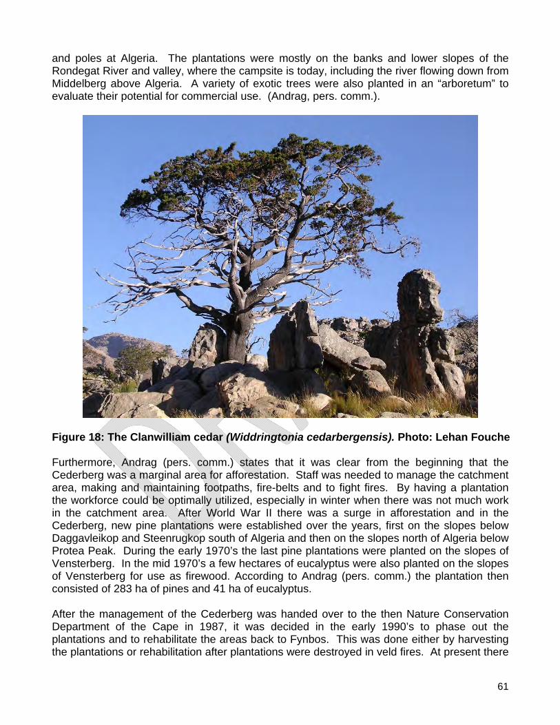
61
and poles at Algeria. The plantations were mostly on the banks and lower slopes of the Rondegat River and valley, where the campsite is today, including the river flowing down from Middelberg above Algeria. A variety of exotic trees were also planted in an “arboretum” to evaluate their potential for commercial use. (Andrag, pers. comm.).
Figure 18: The Clanwilliam cedar (Widdringtonia cedarbergensis). Photo: Lehan Fouche Furthermore, Andrag (pers. comm.) states that it was clear from the beginning that the Cederberg was a marginal area for afforestation. Staff was needed to manage the catchment area, making and maintaining footpaths, fire-belts and to fight fires. By having a plantation the workforce could be optimally utilized, especially in winter when there was not much work in the catchment area. After World War II there was a surge in afforestation and in the Cederberg, new pine plantations were established over the years, first on the slopes below Daggavleikop and Steenrugkop south of Algeria and then on the slopes north of Algeria below Protea Peak. During the early 1970’s the last pine plantations were planted on the slopes of Vensterberg. In the mid 1970’s a few hectares of eucalyptus were also planted on the slopes of Vensterberg for use as firewood. According to Andrag (pers. comm.) the plantation then consisted of 283 ha of pines and 41 ha of eucalyptus. After the management of the Cederberg was handed over to the then Nature Conservation Department of the Cape in 1987, it was decided in the early 1990’s to phase out the plantations and to rehabilitate the areas back to Fynbos. This was done either by harvesting the plantations or rehabilitation after plantations were destroyed in veld fires. At present there
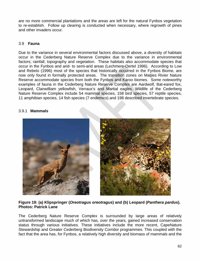
62
are no more commercial plantations and the areas are left for the natural Fynbos vegetation to re-establish. Follow up clearing is conducted when necessary, where regrowth of pines and other invaders occur. 3.9 Fauna Due to the variance in several environmental factors discussed above, a diversity of habitats occur in the Cederberg Nature Reserve Complex due to the variance in environmental factors; rainfall, topography and vegetation. These habitats also accommodate species that occur in the Fynbos and arid- to semi-arid areas (Lechmere-Oertel 1996). According to Low and Rebelo (1996) most of the species that historically occurred in the Fynbos Biome, are now only found in formally protected areas. The transition zones on Matjies Rivier Nature Reserve accommodate species from both the Fynbos and Karoo biomes. Some noteworthy examples of fauna in the Cederberg Nature Reserve Complex are Aardwolf, Bat-eared fox, Leopard, Clanwilliam yellowfish, Verraux’s and Martial eagles. Wildlife of the Cederberg Nature Reserve Complex include 54 mammal species, 158 bird species, 57 reptile species, 11 amphibian species, 14 fish species (7 endemics) and 198 described invertebrate species.
3.9.1 Mammals
Figure 19: (a) Klipspringer (Oreotragus oreotragus) and (b) Leopard (Panthera pardus). Photos: Patrick Lane The Cederberg Nature Reserve Complex is surrounded by large areas of relatively untransformed landscape much of which has, over the years, gained increased conservation status through various initiatives. These initiatives include the more recent, CapeNature Stewardship and Greater Cederberg Biodiversity Corridor programmes. This coupled with the fact that the area has, for Fynbos, a relatively high diversity and biomass of mammals and the
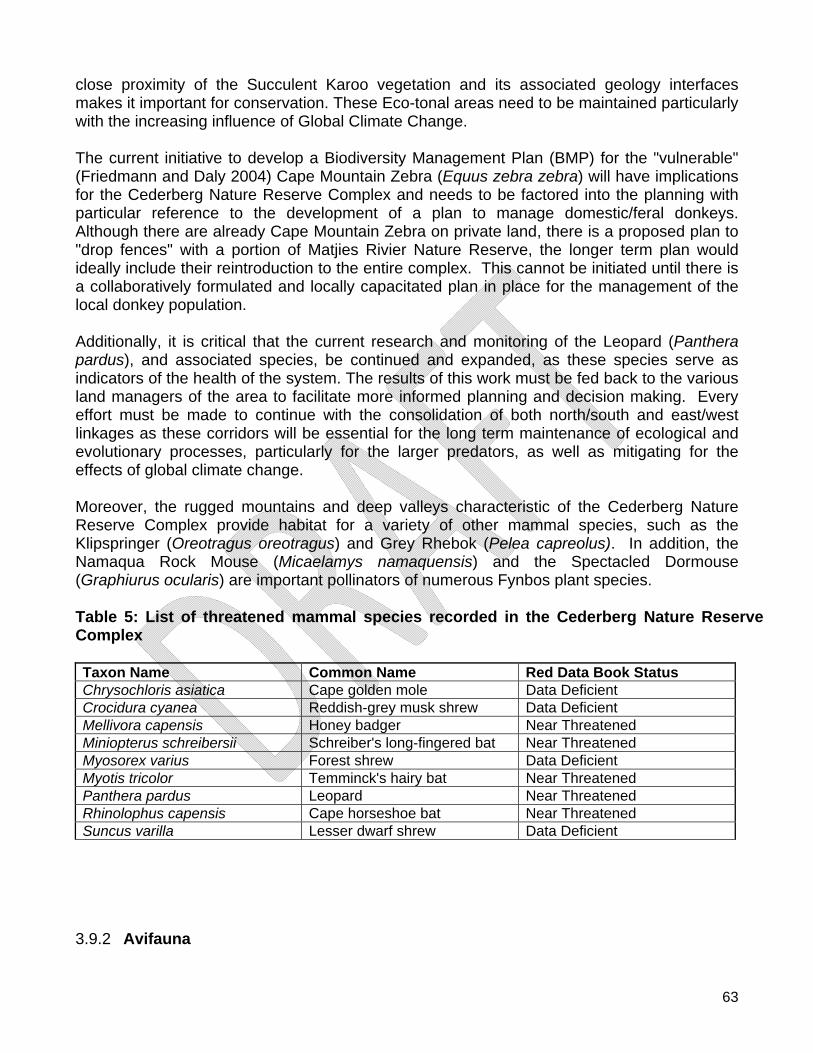
63
close proximity of the Succulent Karoo vegetation and its associated geology interfaces makes it important for conservation. These Eco-tonal areas need to be maintained particularly with the increasing influence of Global Climate Change. The current initiative to develop a Biodiversity Management Plan (BMP) for the "vulnerable" (Friedmann and Daly 2004) Cape Mountain Zebra (Equus zebra zebra) will have implications for the Cederberg Nature Reserve Complex and needs to be factored into the planning with particular reference to the development of a plan to manage domestic/feral donkeys. Although there are already Cape Mountain Zebra on private land, there is a proposed plan to "drop fences" with a portion of Matjies Rivier Nature Reserve, the longer term plan would ideally include their reintroduction to the entire complex. This cannot be initiated until there is a collaboratively formulated and locally capacitated plan in place for the management of the local donkey population. Additionally, it is critical that the current research and monitoring of the Leopard (Panthera pardus), and associated species, be continued and expanded, as these species serve as indicators of the health of the system. The results of this work must be fed back to the various land managers of the area to facilitate more informed planning and decision making. Every effort must be made to continue with the consolidation of both north/south and east/west linkages as these corridors will be essential for the long term maintenance of ecological and evolutionary processes, particularly for the larger predators, as well as mitigating for the effects of global climate change. Moreover, the rugged mountains and deep valleys characteristic of the Cederberg Nature Reserve Complex provide habitat for a variety of other mammal species, such as the Klipspringer (Oreotragus oreotragus) and Grey Rhebok (Pelea capreolus). In addition, the Namaqua Rock Mouse (Micaelamys namaquensis) and the Spectacled Dormouse (Graphiurus ocularis) are important pollinators of numerous Fynbos plant species. Table 5: List of threatened mammal species recorded in the Cederberg Nature Reserve Complex Taxon Name Common Name Red Data Book Status Chrysochloris asiatica Cape golden mole Data Deficient Crocidura cyanea Reddish-grey musk shrew Data Deficient Mellivora capensis Honey badger Near Threatened Miniopterus schreibersii Schreiber's long-fingered bat Near Threatened Myosorex varius Forest shrew Data Deficient Myotis tricolor Temminck's hairy bat Near Threatened Panthera pardus Leopard Near Threatened Rhinolophus capensis Cape horseshoe bat Near Threatened Suncus varilla Lesser dwarf shrew Data Deficient
3.9.2 Avifauna
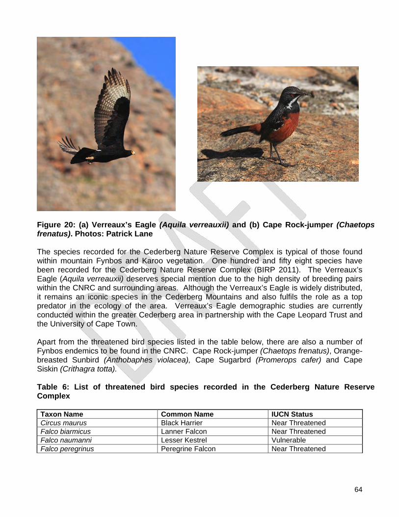
64
Figure 20: (a) Verreaux’s Eagle (Aquila verreauxii) and (b) Cape Rock-jumper (Chaetops frenatus). Photos: Patrick Lane The species recorded for the Cederberg Nature Reserve Complex is typical of those found within mountain Fynbos and Karoo vegetation. One hundred and fifty eight species have been recorded for the Cederberg Nature Reserve Complex (BIRP 2011). The Verreaux’s Eagle (Aquila verreauxii) deserves special mention due to the high density of breeding pairs within the CNRC and surrounding areas. Although the Verreaux’s Eagle is widely distributed, it remains an iconic species in the Cederberg Mountains and also fulfils the role as a top predator in the ecology of the area. Verreaux’s Eagle demographic studies are currently conducted within the greater Cederberg area in partnership with the Cape Leopard Trust and the University of Cape Town. Apart from the threatened bird species listed in the table below, there are also a number of Fynbos endemics to be found in the CNRC. Cape Rock-jumper (Chaetops frenatus), Orange-breasted Sunbird (Anthobaphes violacea), Cape Sugarbrd (Promerops cafer) and Cape Siskin (Crithagra totta). Table 6: List of threatened bird species recorded in the Cederberg Nature Reserve Complex Taxon Name Common Name IUCN Status Circus maurus Black Harrier Near Threatened Falco biarmicus Lanner Falcon Near Threatened Falco naumanni Lesser Kestrel Vulnerable Falco peregrinus Peregrine Falcon Near Threatened
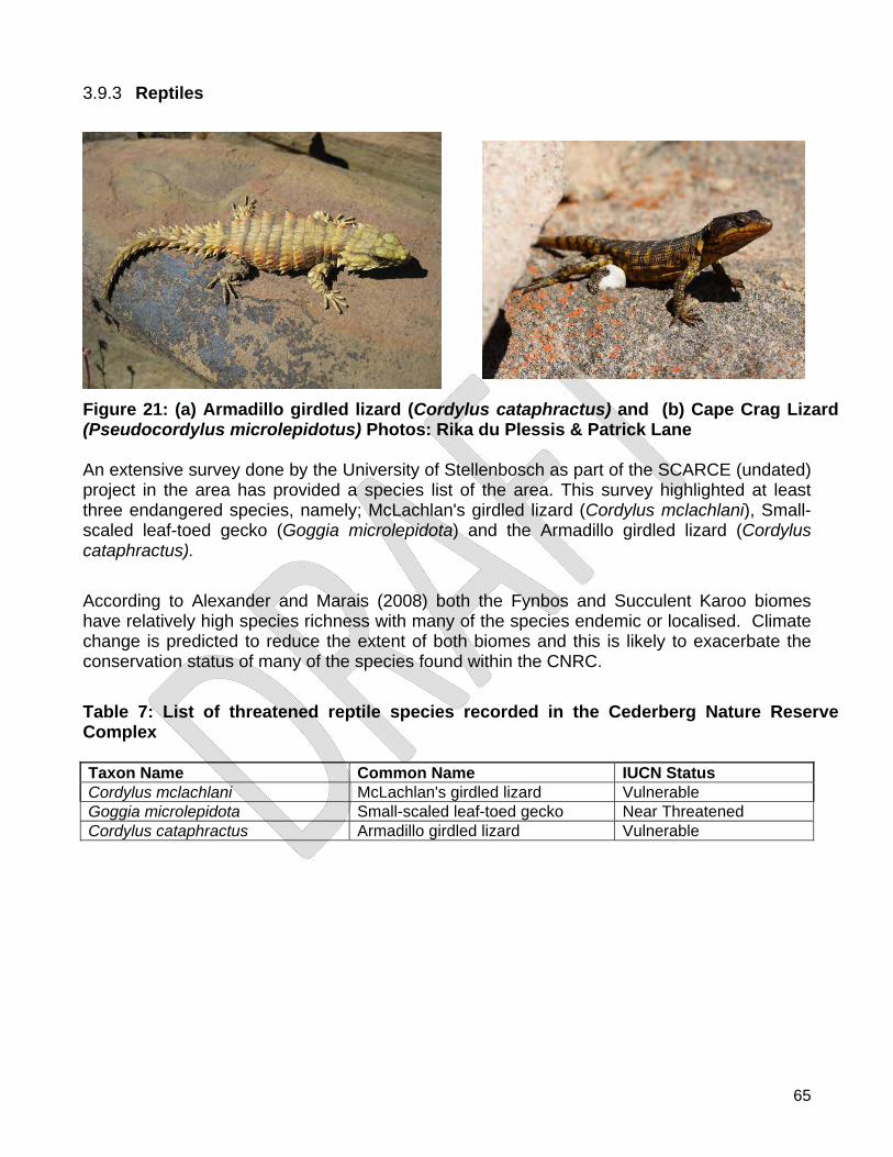
65
3.9.3 Reptiles
Figure 21: (a) Armadillo girdled lizard (Cordylus cataphractus) and (b) Cape Crag Lizard (Pseudocordylus microlepidotus) Photos: Rika du Plessis & Patrick Lane An extensive survey done by the University of Stellenbosch as part of the SCARCE (undated) project in the area has provided a species list of the area. This survey highlighted at least three endangered species, namely; McLachlan's girdled lizard (Cordylus mclachlani), Small-scaled leaf-toed gecko (Goggia microlepidota) and the Armadillo girdled lizard (Cordylus cataphractus).
According to Alexander and Marais (2008) both the Fynbos and Succulent Karoo biomes have relatively high species richness with many of the species endemic or localised. Climate change is predicted to reduce the extent of both biomes and this is likely to exacerbate the conservation status of many of the species found within the CNRC.
Table 7: List of threatened reptile species recorded in the Cederberg Nature Reserve Complex Taxon Name Common Name IUCN Status Cordylus mclachlani McLachlan's girdled lizard Vulnerable Goggia microlepidota Small-scaled leaf-toed gecko Near Threatened Cordylus cataphractus Armadillo girdled lizard Vulnerable
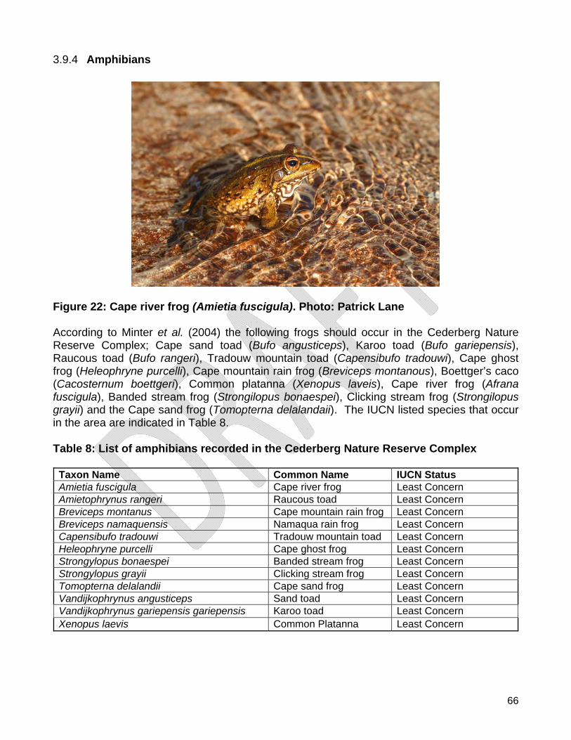
66
3.9.4 Amphibians
Figure 22: Cape river frog (Amietia fuscigula). Photo: Patrick Lane According to Minter et al. (2004) the following frogs should occur in the Cederberg Nature Reserve Complex; Cape sand toad (Bufo angusticeps), Karoo toad (Bufo gariepensis), Raucous toad (Bufo rangeri), Tradouw mountain toad (Capensibufo tradouwi), Cape ghost frog (Heleophryne purcelli), Cape mountain rain frog (Breviceps montanous), Boettger’s caco (Cacosternum boettgeri), Common platanna (Xenopus laveis), Cape river frog (Afrana fuscigula), Banded stream frog (Strongilopus bonaespei), Clicking stream frog (Strongilopus grayii) and the Cape sand frog (Tomopterna delalandaii). The IUCN listed species that occur in the area are indicated in Table 8. Table 8: List of amphibians recorded in the Cederberg Nature Reserve Complex
Taxon Name Common Name IUCN Status Amietia fuscigula Cape river frog Least Concern Amietophrynus rangeri Raucous toad Least Concern Breviceps montanus Cape mountain rain frog Least Concern Breviceps namaquensis Namaqua rain frog Least Concern Capensibufo tradouwi Tradouw mountain toad Least Concern Heleophryne purcelli Cape ghost frog Least Concern Strongylopus bonaespei Banded stream frog Least Concern Strongylopus grayii Clicking stream frog Least Concern Tomopterna delalandii Cape sand frog Least Concern Vandijkophrynus angusticeps Sand toad Least Concern Vandijkophrynus gariepensis gariepensis Karoo toad Least Concern Xenopus laevis Common Platanna Least Concern
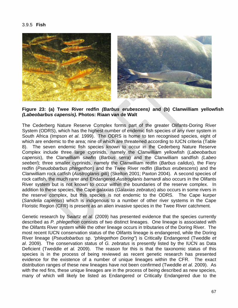
67
3.9.5 Fish
Figure 23: (a) Twee River redfin (Barbus erubescens) and (b) Clanwilliam yellowfish (Labeobarbus capensis). Photos: Riaan van de Walt The Cederberg Nature Reserve Complex forms part of the greater Olifants-Doring River System (ODRS), which has the highest number of endemic fish species of any river system in South Africa (Impson et al. 1999). The ODRS is home to ten recognised species, eight of which are endemic to the area; nine of which are threatened according to IUCN criteria (Table 8). The seven endemic fish species known to occur in the Cederberg Nature Reserve Complex include three large cyprinids, namely the Clanwilliam yellowfish (Labeobarbus capensis), the Clanwilliam sawfin (Barbus serra) and the Clanwilliam sandfish (Labeo seeberi); three smaller cyprinids, namely the Clanwilliam redfin (Barbus calidus), the Fiery redfin (Pseudobarbus phlegethon) and the Twee River redfin (Barbus erubescens) and the Clanwilliam rock catfish (Austroglanis gilli) (Skelton 2001; Paxton 2004). A second species of rock catfish, the much rarer and Endangered Austroglanis barnardi also occurs in the Olifants River system but is not known to occur within the boundaries of the reserve complex. In addition to these species, the Cape galaxias (Galaxias zebratus) also occurs in some rivers in the reserve complex, but this species is not endemic to the ODRS. The Cape kurper (Sandelia capensis) which is indigenous to a number of other river systems in the Cape Floristic Region (CFR) is present as an alien invasive species in the Twee River catchment. Genetic research by Swartz et al. (2009) has presented evidence that the species currently described as P. phlegethon consists of two distinct lineages. One lineage is associated with the Olifants River system while the other lineage occurs in tributaries of the Doring River. The most recent IUCN conservation status of the Olifants lineage is endangered, while the Doring River lineage (Pseudobarbus sp. “phlegethon Doring”) is Critically Endangered (Tweddle et al. 2009). The conservation status of G. zebratus is presently listed by the IUCN as Data Deficient (Tweddle et al. 2009). The reason for this is that the taxonomic status of this species is in the process of being reviewed as recent genetic research has presented evidence for the existence of a number of unique lineages within the CFR. The exact distribution ranges of these new lineages have not been confirmed (Tweddle et al. 2009). As with the red fins, these unique lineages are in the process of being described as new species, many of which will likely be listed as Endangered or Critically Endangered due to the
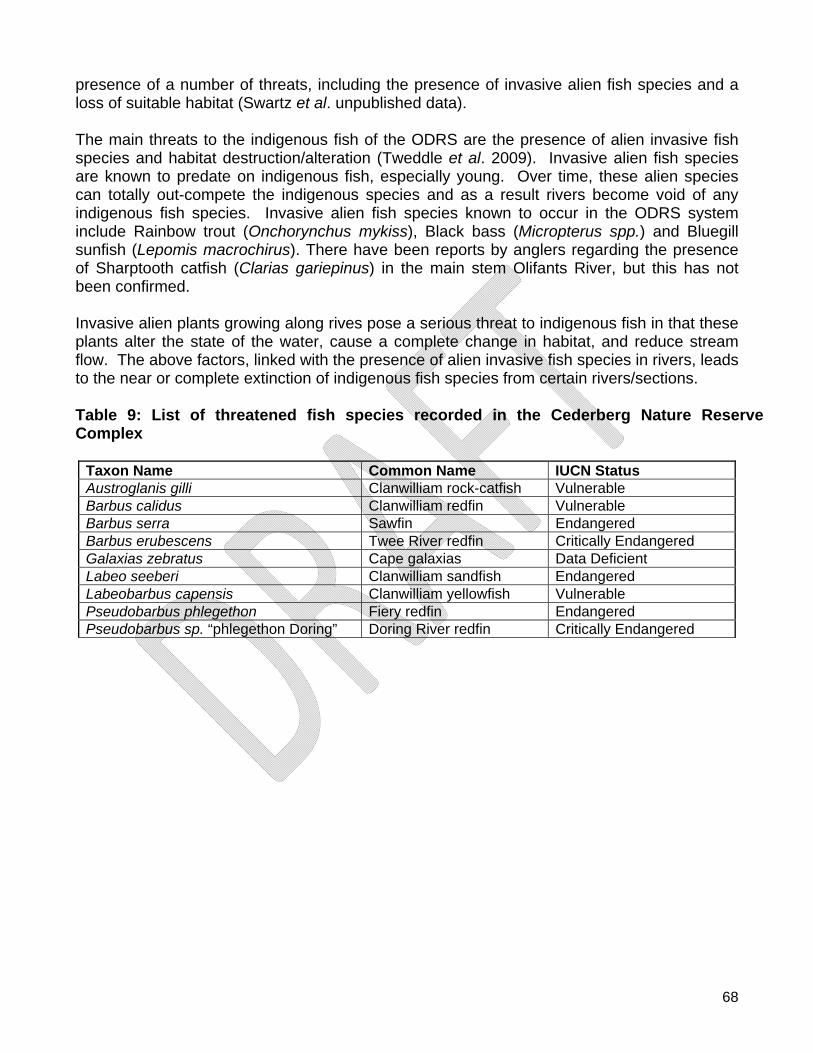
68
presence of a number of threats, including the presence of invasive alien fish species and a loss of suitable habitat (Swartz et al. unpublished data). The main threats to the indigenous fish of the ODRS are the presence of alien invasive fish species and habitat destruction/alteration (Tweddle et al. 2009). Invasive alien fish species are known to predate on indigenous fish, especially young. Over time, these alien species can totally out-compete the indigenous species and as a result rivers become void of any indigenous fish species. Invasive alien fish species known to occur in the ODRS system include Rainbow trout (Onchorynchus mykiss), Black bass (Micropterus spp.) and Bluegill sunfish (Lepomis macrochirus). There have been reports by anglers regarding the presence of Sharptooth catfish (Clarias gariepinus) in the main stem Olifants River, but this has not been confirmed. Invasive alien plants growing along rives pose a serious threat to indigenous fish in that these plants alter the state of the water, cause a complete change in habitat, and reduce stream flow. The above factors, linked with the presence of alien invasive fish species in rivers, leads to the near or complete extinction of indigenous fish species from certain rivers/sections. Table 9: List of threatened fish species recorded in the Cederberg Nature Reserve Complex
Taxon Name Common Name IUCN Status Austroglanis gilli Clanwilliam rock-catfish Vulnerable Barbus calidus Clanwilliam redfin Vulnerable Barbus serra Sawfin Endangered Barbus erubescens Twee River redfin Critically Endangered Galaxias zebratus Cape galaxias Data Deficient Labeo seeberi Clanwilliam sandfish Endangered Labeobarbus capensis Clanwilliam yellowfish Vulnerable Pseudobarbus phlegethon Fiery redfin Endangered Pseudobarbus sp. “phlegethon Doring” Doring River redfin Critically Endangered
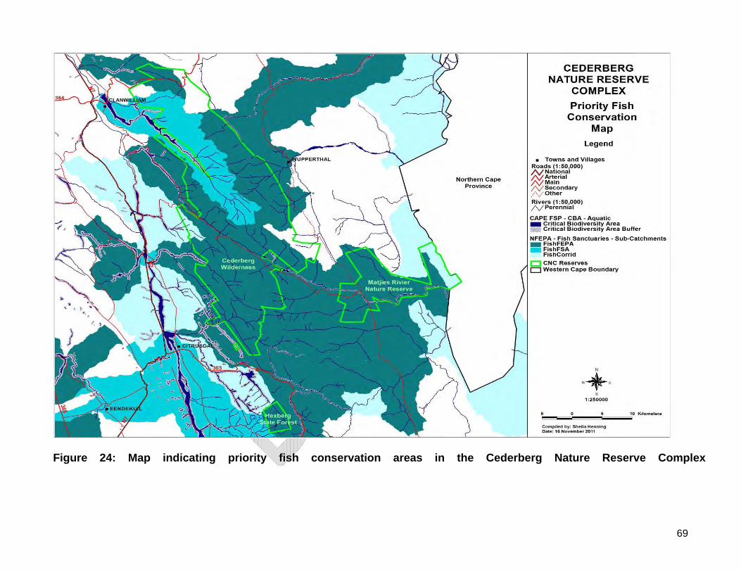
69
Figure 24: Map indicating priority fish conservation areas in the Cederberg Nature Reserve Complex
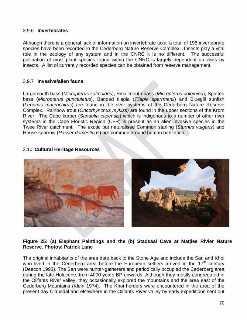
70
3.9.6 Invertebrates Although there is a general lack of information on invertebrate taxa, a total of 198 invertebrate species have been recorded in the Cederberg Nature Reserve Complex. Insects play a vital role in the ecology of any system and in the CNRC it is no different. The successful pollination of most plant species found within the CNRC is largely dependent on visits by insects. A list of currently recorded species can be obtained from reserve management.
3.9.7 Invasive/alien fauna Largemouth bass (Micropterus salmoides), Smallmouth bass (Micropterus dolomieu), Spotted bass (Micropterus punctulatus), Banded tilapia (Tilapia sparrmanii) and Bluegill sunfish (Lepomis macrochirus) are found in the river systems of the Cederberg Nature Reserve Complex. Rainbow trout (Oncorhynchus mykiss) are found in the upper sections of the Krom River. The Cape kurper (Sandelia capensis) which is indigenous to a number of other river systems in the Cape Floristic Region (CFR) is present as an alien invasive species in the Twee River catchment. The exotic but naturalised Common starling (Sturnus vulgaris) and House sparrow (Passer domesticus) are common around human habitation. 3.10 Cultural Heritage Resources
Figure 25: (a) Elephant Paintings and the (b) Stadsaal Cave at Matjies Rivier Nature Reserve. Photos: Patrick Lane The original inhabitants of the area date back to the Stone Age and include the San and Khoi who lived in the Cederberg area before the European settlers arrived in the 17th century (Deacon 1993). The San were hunter-gatherers and periodically occupied the Cederberg area during the late Holocene, from 4000 years BP onwards. Although they mostly congregated in the Olifants River valley, they occasionally explored the mountains and the area east of the Cederberg Mountains (Klein 1974). The Khoi herders were encountered in the area of the present day Citrusdal and elsewhere in the Olifants River valley by early expeditions sent out
71
from the settlement at the Cape (present day Cape Town). They were pastoralists and were reported to have habitually burnt the veld to provide pasture for their sheep (Mossop 1927). The herders eventually permanently occupied the mountains and instituted a regular patch burning fire regime which probably marginalised the San (Meadows & Sugden 1990). By the end of the 18th century the sites around the present day Citrusdal and Clanwilliam were already well settled. Farmers occupied the valley lands and used the mountains for grazing (Andrag 1977). During 1840 the first homestead was constructed at the farm Vogelvallei, farmers became permanent residents in the Cederberg Mountains and more homesteads and stock posts were constructed in remote places throughout the area (Neetling 2007). Farming activities started when small patches of level or near level ground were cultivated and planted with crops such as wheat and other cereals, beans and tobacco (Bands 1977). Various cultural historic buildings and structures depicting life and activities of previous occupants of the area are found throughout the Cederberg Nature Reserve Complex. These structures include farm homesteads, kraals, shepard’s houses, graves, hyena stone traps and blockhouses constructed by settlers living in the area. According to Dr J Deacon (unpublished, 1993) stone age people lived in the Western Cape for more than a million years before the first European settlers arrived in the 17th century. Rock art in the Cederberg area is related to the Later Stone Age and is dated within the last 6000 years. Occupation in the Cederberg Nature Reserve Complex was not constant and populations fluctuated as a result of environmental changes. During a rock art survey conducted in the Cederberg Wilderness between April 1991 and March 1993, a total of 90 archaeological sites were recorded by Mr S.T Bassett. In 1999, Ms M.K du Plessis did a similar survey at Matjies Rivier Nature Reserve which revealed 40 archaeological sites (Du Plessis pers. comm.). All of the above sites have been lodged with the archaeological database at the University of Cape Town. New sites are recorded when found. Rock art in the Cederberg Nature Reserve Complex are predominately fine-line paintings, but finger paintings also occur. Paintings were made by the Khoi-San descendants who lived in the area periodically. Paintings depict therianthropes, human figures, bags, animals, handprints, dots, palettes, smeared paint and patterns. Examples of mono-chrome, bi-chrome, poly-chrome as well as shaded poly-chrome paintings occur in the area (Deacon 1998). In caves where rock art is found, there is typically also a presence of Late Stone Age artefacts scattered on the cave floor and in the area in front of the cave or overhang. Rock art is a non-renewable heritage and sound management of rock art sites is a necessity. Marine invertebrate fossils (crustaceans and bivalves) are located in the shale and sandstone of the Bokkeveld Group that was deposited in river deltas 390-370 Ma ago (Low et al. 2004). Examples of Bivalves, Brachiopods, Crinoids and Trilobites are found in the shale bands on the east and west of the Cederberg Nature Reserve Complex.
72
3.11 People and Conservation The Cederberg area is relatively big with six communities of HDI spread around the area. Three economic centres are located close to the Cederberg Nature Reserve Complex namely; Clanwilliam, Citrusdal and Op-die-Berg. Clanwilliam is the industrial capital for the Cederberg Nature Reserve Complex. CapeNature seeks to unlock opportunities to ensure that the benefits of natural resources and their sustainable utilization and conservation are realized by local communities. The Cederberg Nature Reserve Complex provides job opportunities to local communities through a variety of job creation projects funded by CapeNature as well as the Expanded Public Works Programme (EPWP). According to the West Coast District Municipality IDP (unpublished, 2011) the West Coast District potentially had a labour pool (population 15-64 years of age) of 188,903 persons recorded in 2007. This represents 0.613% of the potential national labour pool and 5.259% of the provincial total. The data indicate that 38% of the population in the West Coast District are employed, 8% are unemployed, 34% are undetermined and 17% of the population of the West Coast District are not economically active. The Cederberg Nature Reserve Complex provides opportunities to ensure that the benefits of natural resources and/or their sustainable utilization and conservation are realized by local communities through regular meetings with the Cederberg Conservancy and the Protected Area Advisory Committee which was established in June 2011. 3.12 Awareness, Youth Development and Volunteers Youth Development is promoted through creating opportunities for environmental education and awareness and participation in the conservation economy. The Cape Leopard Trust (CLT) conduct environmental education camps from Matjies Rivier Nature Reserve. These camps are under the management of the CLT. Furthermore, the Cedar Tree Restoration Project in conjunction with Just Trees, Red Espresso® and Bushmans Kloof Wilderness Reserve, focus on creating awareness regarding the importance of the Cedar Tree to the Cederberg by involving local schools, communities and the general public. No formal volunteer activities are planned in the Cederberg Nature Reserve Complex. Volunteer work takes place on an ad hoc basis. 3.13 Infrastructure Matjies rivier All buildings on Matjies Rivier Nature Reserve date back to the time when Matjiesrivier was utilized as a farm. The homestead, living quarters, school and stores are located at the reserve centre. The Harding-house accommodates the reserve manager, and the construction date of this house is unknown (Neetling, 2007). The Harding-house was the first dwelling at Matjiesrivier which was altered in the 1970’s to its current state. The Wagener-house was constructed in 1849 by C.C.P. Wagener and the woodwork in the house shows the carpentry skills of the time. Cedar-wood (Widdringtonia cedarbergensis) was mostly used for wood furnishings in the houses. The building was altered in the 1960’s and is currently used as the reserve office complex. The Rupert-house was also constructed by C.C.P. Wagener in 1860, currently rented out as accommodation to researchers. The watermill
73
(1850) was used to grind wheat for flour for baking purposes. The Du Preez-house (1901) and Suurberg (1960) was used for share-croppers (bywoners) housing (Neetling, 2007). These houses are currently used as additional accommodation when staff and volunteers work on Matjies Rivier Nature Reserve. The teacher’s- and school house from the same era are currently standing empty. The old stables and shed are utilised as storage facilities while the tobacco shed has been altered and is used as a garage. Ruins of Shepard’s houses and kraals are located throughout the reserve. Formal and informal graveyards are also found on Matjies Rivier Nature Reserve. Algeria Garskraal which was built in 1910 was the original farm house in the Algeria area. It is currently used for tourism as accommodation. Rietdak was built in 1941 as accommodation for forestry staff; it was later used as an office and currently serves as tourist accommodation. Uitkyk was a farm house built in about 1920 and is currently used as tourist accommodation. Waenhuis was built in the 1930’s as a stable and was later converted to tourist accommodation. Prik se Werf, Sas se Werf and Peerboom were built in 1993 as tourist accommodation. The ablution block in Algeria camp was built in 1980 to service the 48 campsites. The “old office” was extended in 1989 and subsequently destroyed by fire in 2009. Furthermore, two staff house were built in 1960 and a manager’s house was built in 1970. One of the staff houses is currently being used as an office, replacing the burnt office. Kliphuis Three houses built in 1950 are being converted into tourist accommodation. The ablutions in the campsite were constructed in 1950. The wooden managers’ house is planned for demolishing and will be replaced by other staff accommodation early 2011. Fences The boundaries of the Cederberg Wilderness are mostly unfenced, although certain boundaries with private landowners and communities are fenced off. The boundary from Pakhuisberg past Heuningvlei, along the eastern boundary of the Cederberg Wilderness to Eselbank is partially fenced. All fences are in a state of disrepair and a policy decision needs to be taken on their maintenance. The borders between Matjies Rivier Nature Reserve and livestock- and game-farms are fenced. Other boundaries are not fenced and most of the internal fences have been removed. At specific points, such as Stadsaal and Truitjieskraal sections of fences are used to control access to the area. A steel fence was constructed at the elephant rock art to prevent visitors from getting too close to the archaeological site. Following the fire of 2004, the access road to Stadsaal Cave and the Elephant paintings was “fenced” with Eucalyptus poles to restrict visitors to the road surface. Roads The R364 from Clanwilliam enters the Cederberg Nature Reserve Complex near Leipoldt’s Grave and exits the complex on the eastern side of Pakhuis. The Pakhuis jeep track is a proclaimed road from Pakhuis Pass to Heuningvlei. Through a long-standing agreement with the Heuningvlei community, the gate is kept locked and the community only uses the road in an emergency, hence the local name “Nood Pad”. This agreement is under some contention,
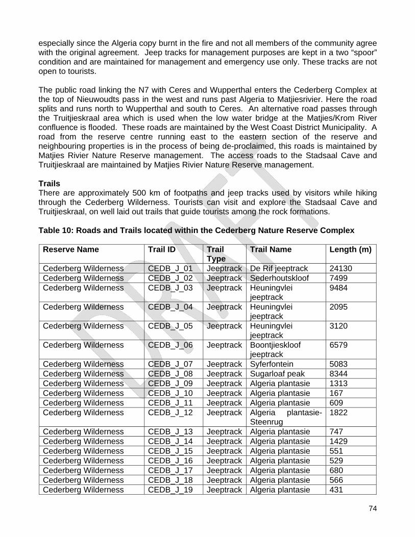
74
especially since the Algeria copy burnt in the fire and not all members of the community agree with the original agreement. Jeep tracks for management purposes are kept in a two “spoor” condition and are maintained for management and emergency use only. These tracks are not open to tourists. The public road linking the N7 with Ceres and Wupperthal enters the Cederberg Complex at the top of Nieuwoudts pass in the west and runs past Algeria to Matjiesrivier. Here the road splits and runs north to Wupperthal and south to Ceres. An alternative road passes through the Truitjieskraal area which is used when the low water bridge at the Matjies/Krom River confluence is flooded. These roads are maintained by the West Coast District Municipality. A road from the reserve centre running east to the eastern section of the reserve and neighbouring properties is in the process of being de-proclaimed, this roads is maintained by Matjies Rivier Nature Reserve management. The access roads to the Stadsaal Cave and Truitjieskraal are maintained by Matjies Rivier Nature Reserve management. Trails There are approximately 500 km of footpaths and jeep tracks used by visitors while hiking through the Cederberg Wilderness. Tourists can visit and explore the Stadsaal Cave and Truitjieskraal, on well laid out trails that guide tourists among the rock formations. Table 10: Roads and Trails located within the Cederberg Nature Reserve Complex Reserve Name Trail ID Trail
Type Trail Name Length (m)
Cederberg Wilderness CEDB_J_01 Jeeptrack De Rif jeeptrack 24130 Cederberg Wilderness CEDB_J_02 Jeeptrack Sederhoutskloof 7499 Cederberg Wilderness CEDB_J_03 Jeeptrack Heuningvlei
jeeptrack 9484
Cederberg Wilderness CEDB_J_04 Jeeptrack Heuningvlei jeeptrack
2095
Cederberg Wilderness CEDB_J_05 Jeeptrack Heuningvlei jeeptrack
3120
Cederberg Wilderness CEDB_J_06 Jeeptrack Boontjieskloof jeeptrack
6579
Cederberg Wilderness CEDB_J_07 Jeeptrack Syferfontein 5083 Cederberg Wilderness CEDB_J_08 Jeeptrack Sugarloaf peak 8344 Cederberg Wilderness CEDB_J_09 Jeeptrack Algeria plantasie 1313 Cederberg Wilderness CEDB_J_10 Jeeptrack Algeria plantasie 167 Cederberg Wilderness CEDB_J_11 Jeeptrack Algeria plantasie 609 Cederberg Wilderness CEDB_J_12 Jeeptrack Algeria plantasie-
Steenrug 1822
Cederberg Wilderness CEDB_J_13 Jeeptrack Algeria plantasie 747 Cederberg Wilderness CEDB_J_14 Jeeptrack Algeria plantasie 1429 Cederberg Wilderness CEDB_J_15 Jeeptrack Algeria plantasie 551 Cederberg Wilderness CEDB_J_16 Jeeptrack Algeria plantasie 529 Cederberg Wilderness CEDB_J_17 Jeeptrack Algeria plantasie 680 Cederberg Wilderness CEDB_J_18 Jeeptrack Algeria plantasie 566 Cederberg Wilderness CEDB_J_19 Jeeptrack Algeria plantasie 431
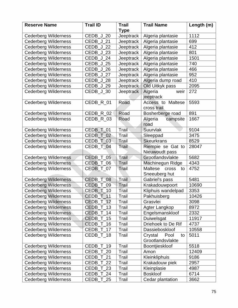
75
Reserve Name Trail ID Trail Type
Trail Name Length (m)
Cederberg Wilderness CEDB_J_20 Jeeptrack Algeria plantasie 1112 Cederberg Wilderness CEDB_J_21 Jeeptrack Algeria plantasie 699 Cederberg Wilderness CEDB_J_22 Jeeptrack Algeria plantasie 412 Cederberg Wilderness CEDB_J_23 Jeeptrack Algeria plantasie 801 Cederberg Wilderness CEDB_J_24 Jeeptrack Algeria plantasie 1501 Cederberg Wilderness CEDB_J_25 Jeeptrack Algeria plantasie 740 Cederberg Wilderness CEDB_J_26 Jeeptrack Algeria plantasie 466 Cederberg Wilderness CEDB_J_27 Jeeptrack Algeria plantasie 952 Cederberg Wilderness CEDB_J_28 Jeeptrack Algeria dump road 410 Cederberg Wilderness CEDB_J_29 Jeeptrack Old Uitkyk pass 2095 Cederberg Wilderness CEDB_J_30 Jeeptrack Algeria weir
jeeptrack 272
Cederberg Wilderness CEDB_R_01 Road Access to Maltese cross trail
5593
Cederberg Wilderness CEDB_R_02 Road Bosherberge road 891 Cederberg Wilderness CEDB_R_03 Road Algeria campsite
road 1667
Cederberg Wilderness CEDB_T_01 Trail Suurvlak 9104 Cederberg Wilderness CEDB_T_02 Trail Sleeppad 3475 Cederberg Wilderness CEDB_T_03 Trail Skeurkrans 8529 Cederberg Wilderness CEDB_T_04 Trail Riempie se Gat to
Nieuwoudt pass 28047
Cederberg Wilderness CEDB_T_05 Trail Grootlandsvlakte 5682 Cederberg Wilderness CEDB_T_06 Trail Machinegun Ridge 4343 Cederberg Wilderness CEDB_T_07 Trail Maltese cross to
Sneeuberg hut 4752
Cederberg Wilderness CEDB_T_08 Trail Gabriel's pass 5481 Cederberg Wilderness CEDB_T_09 Trail Krakadouwpoort 10690 Cederberg Wilderness CEDB_T_10 Trail Kliphuis wandelpad 3353 Cederberg Wilderness CEDB_T_11 Trail Pakhuisberg 10426 Cederberg Wilderness CEDB_T_12 Trail Grasvlei 3098 Cederberg Wilderness CEDB_T_13 Trail Agter Langkop 8972 Cederberg Wilderness CEDB_T_14 Trail Engelsmanskloof 2332 Cederberg Wilderness CEDB_T_15 Trail Duiwelsgat 11917 Cederberg Wilderness CEDB_T_16 Trail Driehoek to De Rif 4737 Cederberg Wilderness CEDB_T_17 Trail Dassieboskloof 10558 Cederberg Wilderness CEDB_T_18 Trail Crystal Pool to
Grootlandsvlakte 5011
Cederberg Wilderness CEDB_T_19 Trail Boontjieskloof 5518 Cederberg Wilderness CEDB_T_20 Trail Amon 12409 Cederberg Wilderness CEDB_T_21 Trail Kleinkliphuis 9186 Cederberg Wilderness CEDB_T_22 Trail Krakadouw piek 2957 Cederberg Wilderness CEDB_T_23 Trail Kleinplasie 4987 Cederberg Wilderness CEDB_T_24 Trail Boskloof 6714 Cederberg Wilderness CEDB_T_25 Trail Cedar plantation 3662
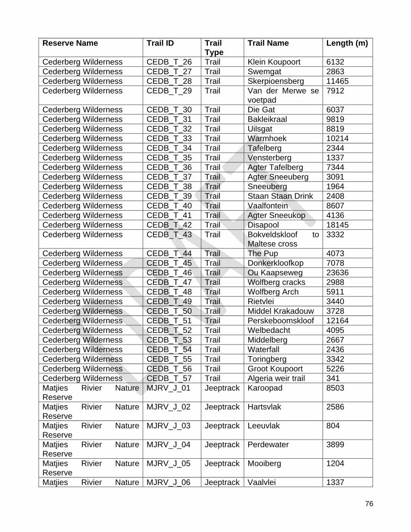
76
Reserve Name Trail ID Trail Type
Trail Name Length (m)
Cederberg Wilderness CEDB_T_26 Trail Klein Koupoort 6132 Cederberg Wilderness CEDB_T_27 Trail Swemgat 2863 Cederberg Wilderness CEDB_T_28 Trail Skerpioensberg 11465 Cederberg Wilderness CEDB_T_29 Trail Van der Merwe se
voetpad 7912
Cederberg Wilderness CEDB_T_30 Trail Die Gat 6037 Cederberg Wilderness CEDB_T_31 Trail Bakleikraal 9819 Cederberg Wilderness CEDB_T_32 Trail Uilsgat 8819 Cederberg Wilderness CEDB_T_33 Trail Warmhoek 10214 Cederberg Wilderness CEDB_T_34 Trail Tafelberg 2344 Cederberg Wilderness CEDB_T_35 Trail Vensterberg 1337 Cederberg Wilderness CEDB_T_36 Trail Agter Tafelberg 7344 Cederberg Wilderness CEDB_T_37 Trail Agter Sneeuberg 3091 Cederberg Wilderness CEDB_T_38 Trail Sneeuberg 1964 Cederberg Wilderness CEDB_T_39 Trail Staan Staan Drink 2408 Cederberg Wilderness CEDB_T_40 Trail Vaalfontein 8607 Cederberg Wilderness CEDB_T_41 Trail Agter Sneeukop 4136 Cederberg Wilderness CEDB_T_42 Trail Disapool 18145 Cederberg Wilderness CEDB_T_43 Trail Bokveldskloof to
Maltese cross 3332
Cederberg Wilderness CEDB_T_44 Trail The Pup 4073 Cederberg Wilderness CEDB_T_45 Trail Donkerkloofkop 7078 Cederberg Wilderness CEDB_T_46 Trail Ou Kaapseweg 23636 Cederberg Wilderness CEDB_T_47 Trail Wolfberg cracks 2988 Cederberg Wilderness CEDB_T_48 Trail Wolfberg Arch 5911 Cederberg Wilderness CEDB_T_49 Trail Rietvlei 3440 Cederberg Wilderness CEDB_T_50 Trail Middel Krakadouw 3728 Cederberg Wilderness CEDB_T_51 Trail Perskeboomskloof 12164 Cederberg Wilderness CEDB_T_52 Trail Welbedacht 4095 Cederberg Wilderness CEDB_T_53 Trail Middelberg 2667 Cederberg Wilderness CEDB_T_54 Trail Waterfall 2436 Cederberg Wilderness CEDB_T_55 Trail Toringberg 3342 Cederberg Wilderness CEDB_T_56 Trail Groot Koupoort 5226 Cederberg Wilderness CEDB_T_57 Trail Algeria weir trail 341 Matjies Rivier Nature Reserve
MJRV_J_01 Jeeptrack Karoopad 8503
Matjies Rivier Nature Reserve
MJRV_J_02 Jeeptrack Hartsvlak 2586
Matjies Rivier Nature Reserve
MJRV_J_03 Jeeptrack Leeuvlak 804
Matjies Rivier Nature Reserve
MJRV_J_04 Jeeptrack Perdewater 3899
Matjies Rivier Nature Reserve
MJRV_J_05 Jeeptrack Mooiberg 1204
Matjies Rivier Nature MJRV_J_06 Jeeptrack Vaalvlei 1337
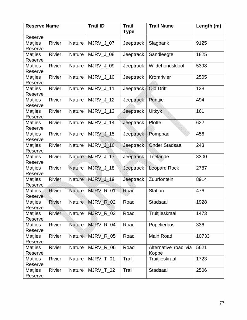
77
Reserve Name Trail ID Trail Type
Trail Name Length (m)
Reserve Matjies Rivier Nature Reserve
MJRV_J_07 Jeeptrack Slagbank 9125
Matjies Rivier Nature Reserve
MJRV_J_08 Jeeptrack Sandleegte 1825
Matjies Rivier Nature Reserve
MJRV_J_09 Jeeptrack Wildehondskloof 5398
Matjies Rivier Nature Reserve
MJRV_J_10 Jeeptrack Kromrivier 2505
Matjies Rivier Nature Reserve
MJRV_J_11 Jeeptrack Old Drift 138
Matjies Rivier Nature Reserve
MJRV_J_12 Jeeptrack Puntjie 494
Matjies Rivier Nature Reserve
MJRV_J_13 Jeeptrack Uitkyk 161
Matjies Rivier Nature Reserve
MJRV_J_14 Jeeptrack Plotte 622
Matjies Rivier Nature Reserve
MJRV_J_15 Jeeptrack Pomppad 456
Matjies Rivier Nature Reserve
MJRV_J_16 Jeeptrack Onder Stadsaal 243
Matjies Rivier Nature Reserve
MJRV_J_17 Jeeptrack Teelande 3300
Matjies Rivier Nature Reserve
MJRV_J_18 Jeeptrack Leopard Rock 2787
Matjies Rivier Nature Reserve
MJRV_J_19 Jeeptrack Zuurfontein 8914
Matjies Rivier Nature Reserve
MJRV_R_01 Road Station 476
Matjies Rivier Nature Reserve
MJRV_R_02 Road Stadsaal 1928
Matjies Rivier Nature Reserve
MJRV_R_03 Road Truitjieskraal 1473
Matjies Rivier Nature Reserve
MJRV_R_04 Road Popelierbos 336
Matjies Rivier Nature Reserve
MJRV_R_05 Road Main Road 10733
Matjies Rivier Nature Reserve
MJRV_R_06 Road Alternative road via Koppe
5621
Matjies Rivier Nature Reserve
MJRV_T_01 Trail Truitjieskraal 1723
Matjies Rivier Nature Reserve
MJRV_T_02 Trail Stadsaal 2506
78
Parking Parking spaces were developed at the Stadsaal Cave and Truitjieskraal for visitors to the areas. In fact, parking areas are found at the start to most trails in the Cederberg Wilderness e.g. Pakhuisberg, Welbedacht, Uitkyk and Eikeboom and Algeria. A number of trails start on private land where parking is also available. Sign boards There are sign boards at the start of all hiking trails, but no further signage is found along the trails in the Wilderness. There are signboards at entrances to the Cederberg Wilderness along all major routes. At Matjies Rivier Nature Reserve, signboards are located at the three entry points to the nature reserve (north, west and south), at the two tourism sites (Stadsaal Cave and Truitjieskraal) and at the reserve centre. In addition, an interpretation board is located at the location of the Elephant Rock Art to provide information to visitors about the archaeology of the area. At the Stadsaal Cave an interpretation board also provides general information about the geology of the Cederberg as well as the historic significance of the graffiti found in the cave. Generic interpretation posters and material are exhibited in the parking area at Stadsaal cave. Water works Drinking water for Algeria is piped from the Helskloof River into tanks and reservoirs for use by staff and tourists. Water for the Bosherberge is piped out of Duiwelsgat into tanks for consumption. Water at Kilphuis is piped from a spring above the manager’s house into a reservoir to be utilised by staff and tourists. At Matjies Rivier Nature Reserve, water for household use and gardens are abstracted from the Matjies rivier with a pump that fills supply tanks from where the water flows by gravitational forces to where it is needed. Electricity/Eskom power lines Power lines come from Clanwilliam up the Rondegat valley and crosses over the Rondegat River at Garskraal. From there it goes along the lower terrace to the store where it travels underground to various distribution points. By contrast, the Eskom electricity supply to Matjies Rivier Nature Reserve comes from Ceres in the south and follows the roads leading to the reserve centre and Kromrivier farm. Communication systems/Telkom telephone lines Telkom repeaters are situated near the Algeria Bosdorp and on top of Uitkyk Pass. The telephones lines roughly follow the road from Clanwilliam to Kliphuis Campsite. Telkom telephone lines runs along the Ceres-Wupperthal road and provide telephone communication to the reserve. A Telkom repeater site is located along the alternative road via Truitjieskraal. Furthermore, the placing of a radio repeater on the reserve is currently being investigated for safety purposes. Table 11: Infrastructure located within the Cederberg Nature Reserve Complex
Reserve Name Feature Name Location Feature Type Cederberg Wilderness Ablution Block Kliphuis Ablution Block Cederberg Wilderness Ablution Block Algeria Office Ablution Block Cederberg Wilderness Ablution Block Algeria Office Ablution Block
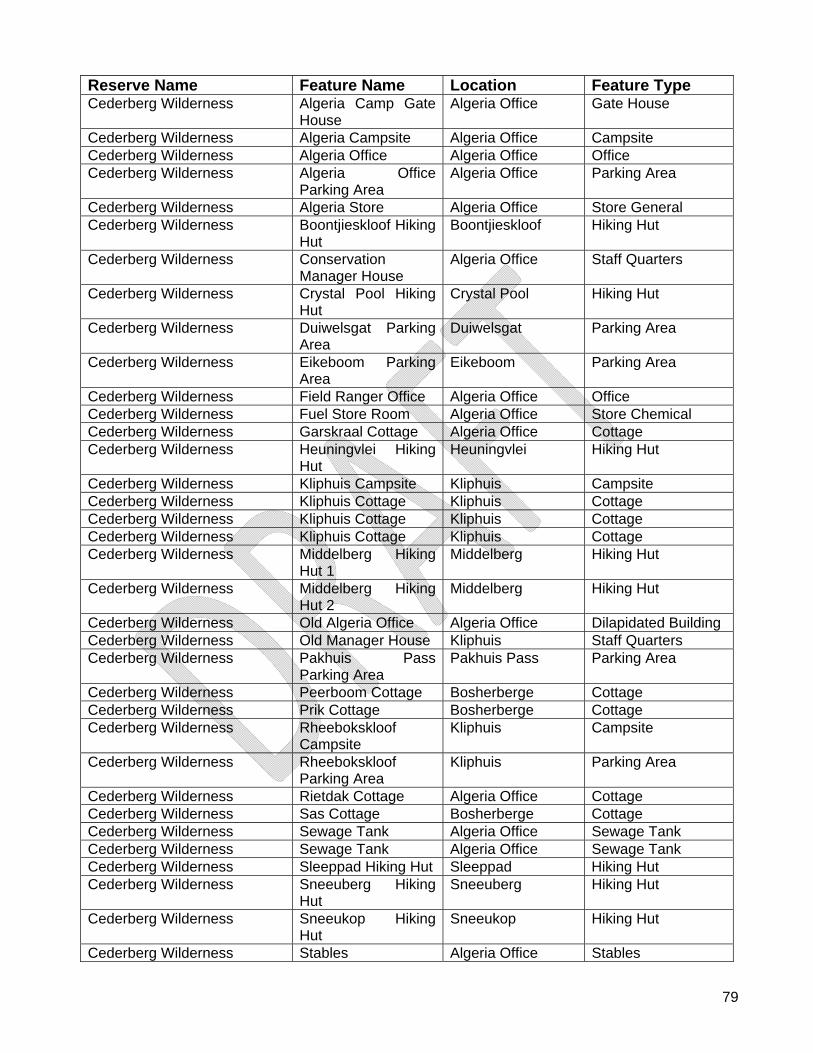
79
Reserve Name Feature Name Location Feature Type Cederberg Wilderness Algeria Camp Gate
House Algeria Office Gate House
Cederberg Wilderness Algeria Campsite Algeria Office Campsite Cederberg Wilderness Algeria Office Algeria Office Office Cederberg Wilderness Algeria Office
Parking Area Algeria Office Parking Area
Cederberg Wilderness Algeria Store Algeria Office Store General Cederberg Wilderness Boontjieskloof Hiking
Hut Boontjieskloof Hiking Hut
Cederberg Wilderness Conservation Manager House
Algeria Office Staff Quarters
Cederberg Wilderness Crystal Pool Hiking Hut
Crystal Pool Hiking Hut
Cederberg Wilderness Duiwelsgat Parking Area
Duiwelsgat Parking Area
Cederberg Wilderness Eikeboom Parking Area
Eikeboom Parking Area
Cederberg Wilderness Field Ranger Office Algeria Office Office Cederberg Wilderness Fuel Store Room Algeria Office Store Chemical Cederberg Wilderness Garskraal Cottage Algeria Office Cottage Cederberg Wilderness Heuningvlei Hiking
Hut Heuningvlei Hiking Hut
Cederberg Wilderness Kliphuis Campsite Kliphuis Campsite Cederberg Wilderness Kliphuis Cottage Kliphuis Cottage Cederberg Wilderness Kliphuis Cottage Kliphuis Cottage Cederberg Wilderness Kliphuis Cottage Kliphuis Cottage Cederberg Wilderness Middelberg Hiking
Hut 1 Middelberg Hiking Hut
Cederberg Wilderness Middelberg Hiking Hut 2
Middelberg Hiking Hut
Cederberg Wilderness Old Algeria Office Algeria Office Dilapidated Building Cederberg Wilderness Old Manager House Kliphuis Staff Quarters Cederberg Wilderness Pakhuis Pass
Parking Area Pakhuis Pass Parking Area
Cederberg Wilderness Peerboom Cottage Bosherberge Cottage Cederberg Wilderness Prik Cottage Bosherberge Cottage Cederberg Wilderness Rheebokskloof
Campsite Kliphuis Campsite
Cederberg Wilderness Rheebokskloof Parking Area
Kliphuis Parking Area
Cederberg Wilderness Rietdak Cottage Algeria Office Cottage Cederberg Wilderness Sas Cottage Bosherberge Cottage Cederberg Wilderness Sewage Tank Algeria Office Sewage Tank Cederberg Wilderness Sewage Tank Algeria Office Sewage Tank Cederberg Wilderness Sleeppad Hiking Hut Sleeppad Hiking Hut Cederberg Wilderness Sneeuberg Hiking
Hut Sneeuberg Hiking Hut
Cederberg Wilderness Sneeukop Hiking Hut
Sneeukop Hiking Hut
Cederberg Wilderness Stables Algeria Office Stables
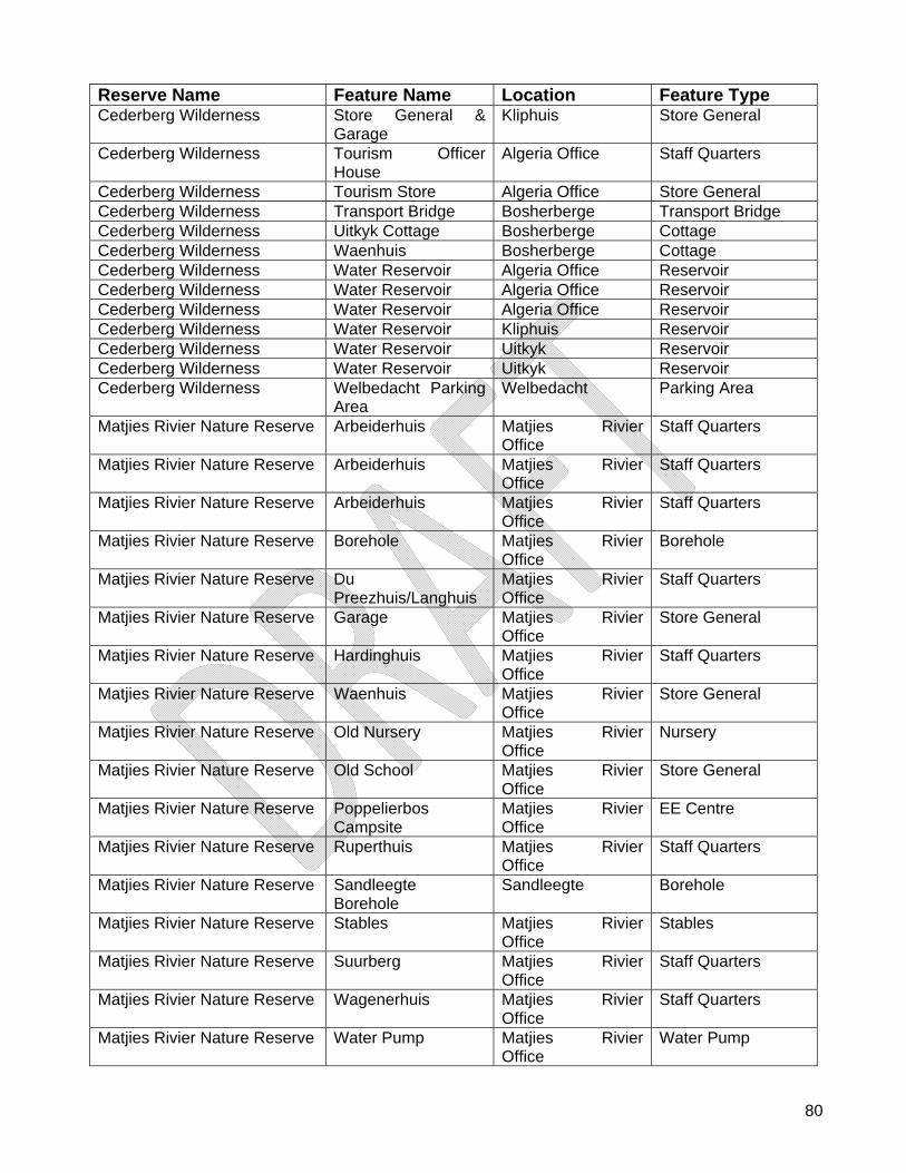
80
Reserve Name Feature Name Location Feature Type Cederberg Wilderness Store General &
Garage Kliphuis Store General
Cederberg Wilderness Tourism Officer House
Algeria Office Staff Quarters
Cederberg Wilderness Tourism Store Algeria Office Store General Cederberg Wilderness Transport Bridge Bosherberge Transport Bridge Cederberg Wilderness Uitkyk Cottage Bosherberge Cottage Cederberg Wilderness Waenhuis Bosherberge Cottage Cederberg Wilderness Water Reservoir Algeria Office Reservoir Cederberg Wilderness Water Reservoir Algeria Office Reservoir Cederberg Wilderness Water Reservoir Algeria Office Reservoir Cederberg Wilderness Water Reservoir Kliphuis Reservoir Cederberg Wilderness Water Reservoir Uitkyk Reservoir Cederberg Wilderness Water Reservoir Uitkyk Reservoir Cederberg Wilderness Welbedacht Parking
Area Welbedacht Parking Area
Matjies Rivier Nature Reserve Arbeiderhuis Matjies Rivier Office
Staff Quarters
Matjies Rivier Nature Reserve Arbeiderhuis Matjies Rivier Office
Staff Quarters
Matjies Rivier Nature Reserve Arbeiderhuis Matjies Rivier Office
Staff Quarters
Matjies Rivier Nature Reserve Borehole Matjies Rivier Office
Borehole
Matjies Rivier Nature Reserve Du Preezhuis/Langhuis
Matjies Rivier Office
Staff Quarters
Matjies Rivier Nature Reserve Garage Matjies Rivier Office
Store General
Matjies Rivier Nature Reserve Hardinghuis Matjies Rivier Office
Staff Quarters
Matjies Rivier Nature Reserve Waenhuis Matjies Rivier Office
Store General
Matjies Rivier Nature Reserve Old Nursery Matjies Rivier Office
Nursery
Matjies Rivier Nature Reserve Old School Matjies Rivier Office
Store General
Matjies Rivier Nature Reserve Poppelierbos Campsite
Matjies Rivier Office
EE Centre
Matjies Rivier Nature Reserve Ruperthuis Matjies Rivier Office
Staff Quarters
Matjies Rivier Nature Reserve Sandleegte Borehole
Sandleegte Borehole
Matjies Rivier Nature Reserve Stables Matjies Rivier Office
Stables
Matjies Rivier Nature Reserve Suurberg Matjies Rivier Office
Staff Quarters
Matjies Rivier Nature Reserve Wagenerhuis Matjies Rivier Office
Staff Quarters
Matjies Rivier Nature Reserve Water Pump Matjies Rivier Office
Water Pump
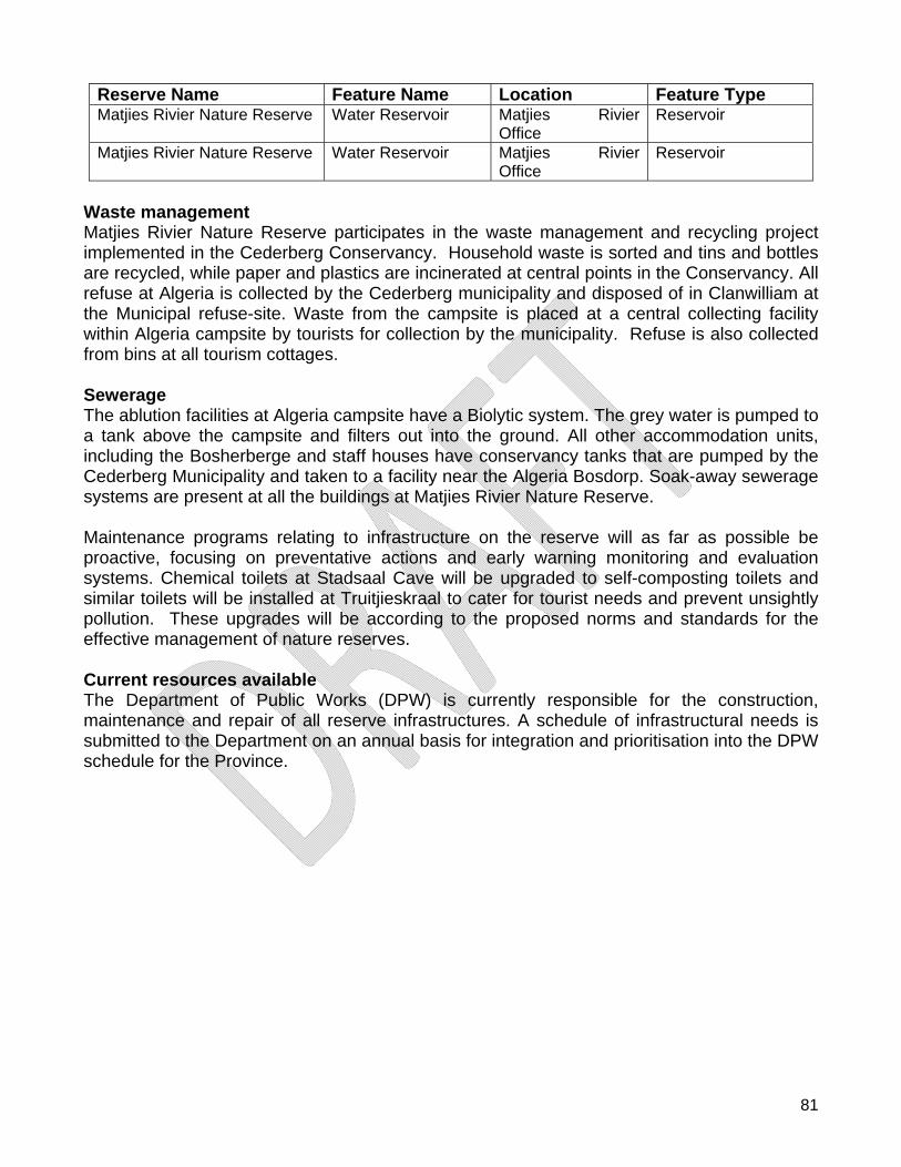
81
Reserve Name Feature Name Location Feature Type Matjies Rivier Nature Reserve Water Reservoir Matjies Rivier
Office Reservoir
Matjies Rivier Nature Reserve Water Reservoir Matjies Rivier Office
Reservoir
Waste management Matjies Rivier Nature Reserve participates in the waste management and recycling project implemented in the Cederberg Conservancy. Household waste is sorted and tins and bottles are recycled, while paper and plastics are incinerated at central points in the Conservancy. All refuse at Algeria is collected by the Cederberg municipality and disposed of in Clanwilliam at the Municipal refuse-site. Waste from the campsite is placed at a central collecting facility within Algeria campsite by tourists for collection by the municipality. Refuse is also collected from bins at all tourism cottages. Sewerage The ablution facilities at Algeria campsite have a Biolytic system. The grey water is pumped to a tank above the campsite and filters out into the ground. All other accommodation units, including the Bosherberge and staff houses have conservancy tanks that are pumped by the Cederberg Municipality and taken to a facility near the Algeria Bosdorp. Soak-away sewerage systems are present at all the buildings at Matjies Rivier Nature Reserve. Maintenance programs relating to infrastructure on the reserve will as far as possible be proactive, focusing on preventative actions and early warning monitoring and evaluation systems. Chemical toilets at Stadsaal Cave will be upgraded to self-composting toilets and similar toilets will be installed at Truitjieskraal to cater for tourist needs and prevent unsightly pollution. These upgrades will be according to the proposed norms and standards for the effective management of nature reserves. Current resources available The Department of Public Works (DPW) is currently responsible for the construction, maintenance and repair of all reserve infrastructures. A schedule of infrastructural needs is submitted to the Department on an annual basis for integration and prioritisation into the DPW schedule for the Province.
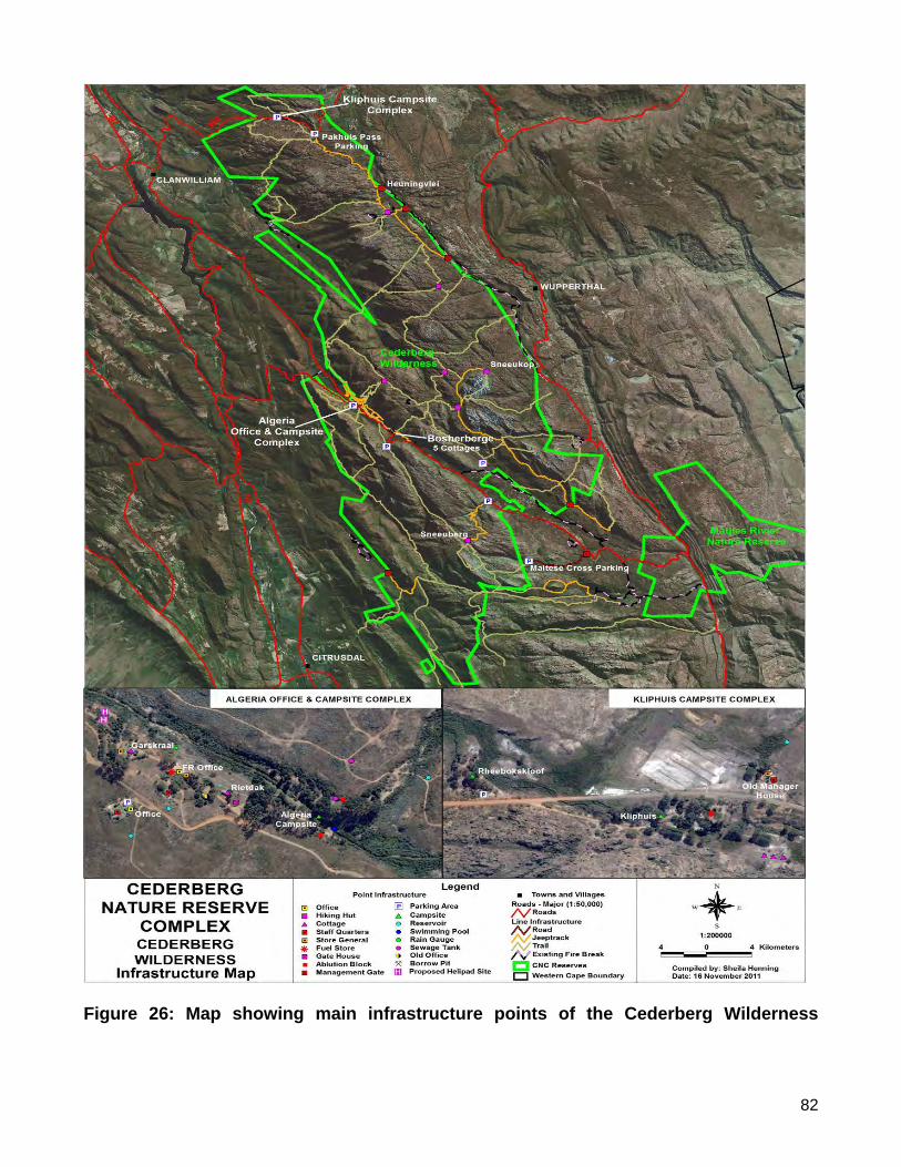
82
Figure 26: Map showing main infrastructure points of the Cederberg Wilderness
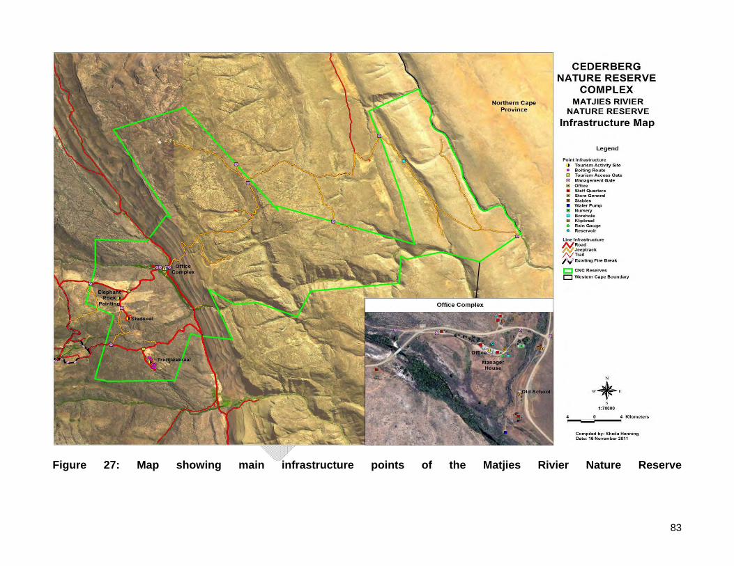
83
Figure 27: Map showing main infrastructure points of the Matjies Rivier Nature Reserve
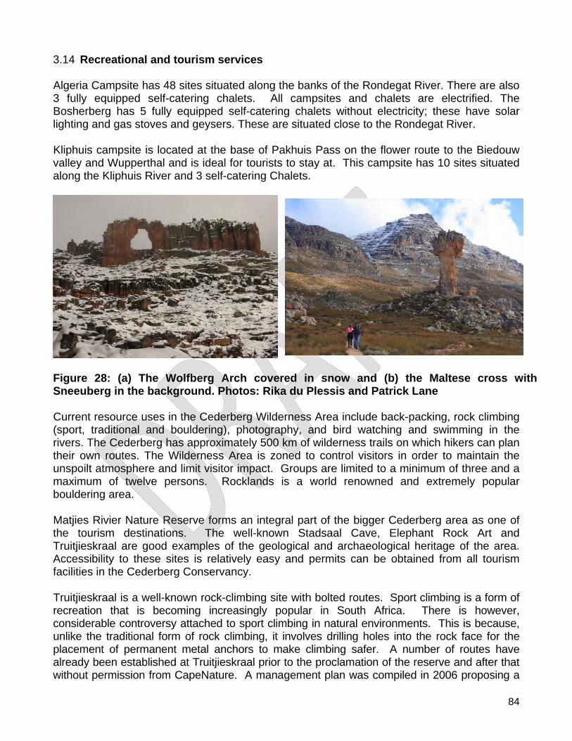
84
3.14 Recreational and tourism services Algeria Campsite has 48 sites situated along the banks of the Rondegat River. There are also 3 fully equipped self-catering chalets. All campsites and chalets are electrified. The Bosherberg has 5 fully equipped self-catering chalets without electricity; these have solar lighting and gas stoves and geysers. These are situated close to the Rondegat River. Kliphuis campsite is located at the base of Pakhuis Pass on the flower route to the Biedouw valley and Wupperthal and is ideal for tourists to stay at. This campsite has 10 sites situated along the Kliphuis River and 3 self-catering Chalets.
Figure 28: (a) The Wolfberg Arch covered in snow and (b) the Maltese cross with Sneeuberg in the background. Photos: Rika du Plessis and Patrick Lane Current resource uses in the Cederberg Wilderness Area include back-packing, rock climbing (sport, traditional and bouldering), photography, and bird watching and swimming in the rivers. The Cederberg has approximately 500 km of wilderness trails on which hikers can plan their own routes. The Wilderness Area is zoned to control visitors in order to maintain the unspoilt atmosphere and limit visitor impact. Groups are limited to a minimum of three and a maximum of twelve persons. Rocklands is a world renowned and extremely popular bouldering area. Matjies Rivier Nature Reserve forms an integral part of the bigger Cederberg area as one of the tourism destinations. The well-known Stadsaal Cave, Elephant Rock Art and Truitjieskraal are good examples of the geological and archaeological heritage of the area. Accessibility to these sites is relatively easy and permits can be obtained from all tourism facilities in the Cederberg Conservancy. Truitjieskraal is a well-known rock-climbing site with bolted routes. Sport climbing is a form of recreation that is becoming increasingly popular in South Africa. There is however, considerable controversy attached to sport climbing in natural environments. This is because, unlike the traditional form of rock climbing, it involves drilling holes into the rock face for the placement of permanent metal anchors to make climbing safer. A number of routes have already been established at Truitjieskraal prior to the proclamation of the reserve and after that without permission from CapeNature. A management plan was compiled in 2006 proposing a

85
combined management strategy between CapeNature and the Mountain Club of South Africa (MCSA) to manage the climbing and bolting activities at Truitjieskraal. No tourism accommodation is available on Matjies Rivier Nature Reserve. However, Environmental Education camps are run from Matjies Rivier Nature Reserve by the Cape Leopard Trust. This facility is only accessible for school groups and bookings are made through the Cape Leopard Trust. Integrated tourism, management and marketing exist between CapeNature and the Cederberg Conservancy. A tourism committee meets quarterly and websites of both institutions are linked. Marketing material and brochures give exposure to both institutions. Additionally, agreements are in place with neighbouring landowners to sell permits on behalf of CapeNature to make the area more accessible to visitors.
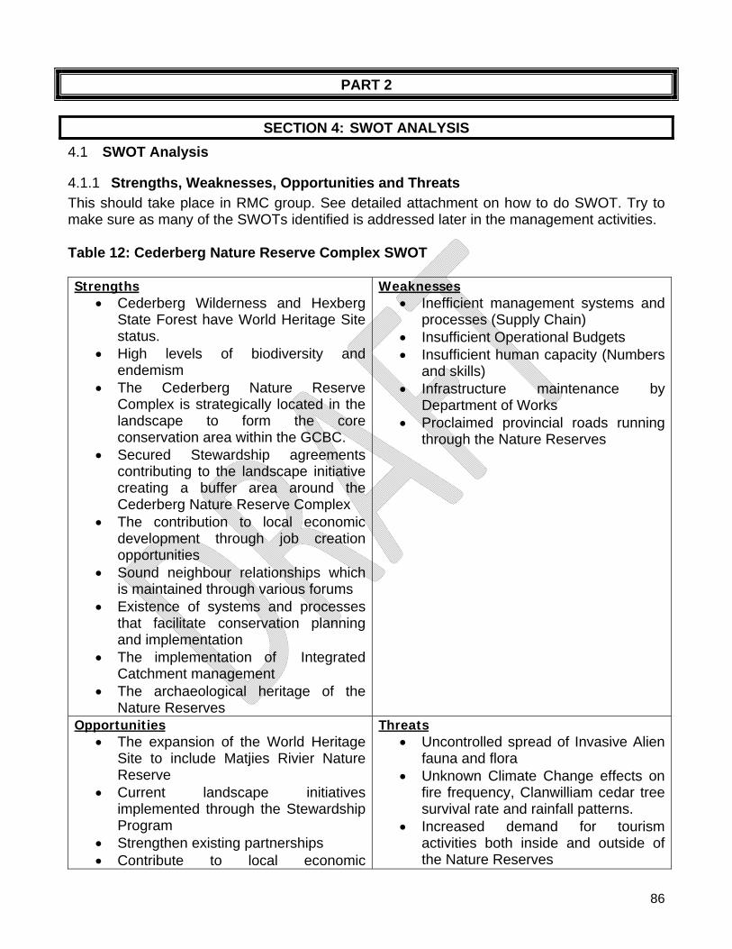
86
PART 2
SECTION 4: SWOT ANALYSIS
4.1 SWOT Analysis
4.1.1 Strengths, Weaknesses, Opportunities and Threats This should take place in RMC group. See detailed attachment on how to do SWOT. Try to make sure as many of the SWOTs identified is addressed later in the management activities. Table 12: Cederberg Nature Reserve Complex SWOT Strengths
Cederberg Wilderness and Hexberg State Forest have World Heritage Site status.
High levels of biodiversity and endemism
The Cederberg Nature Reserve Complex is strategically located in the landscape to form the core conservation area within the GCBC.
Secured Stewardship agreements contributing to the landscape initiative creating a buffer area around the Cederberg Nature Reserve Complex
The contribution to local economic development through job creation opportunities
Sound neighbour relationships which is maintained through various forums
Existence of systems and processes that facilitate conservation planning and implementation
The implementation of Integrated Catchment management
The archaeological heritage of the Nature Reserves
Weaknesses Inefficient management systems and
processes (Supply Chain) Insufficient Operational Budgets Insufficient human capacity (Numbers
and skills) Infrastructure maintenance by
Department of Works Proclaimed provincial roads running
through the Nature Reserves
Opportunities The expansion of the World Heritage
Site to include Matjies Rivier Nature Reserve
Current landscape initiatives implemented through the Stewardship Program
Strengthen existing partnerships Contribute to local economic
Threats Uncontrolled spread of Invasive Alien
fauna and flora Unknown Climate Change effects on
fire frequency, Clanwilliam cedar tree survival rate and rainfall patterns.
Increased demand for tourism activities both inside and outside of the Nature Reserves
87
development through the identification of job creation opportunities
The development of sustainable tourism products
Uncontrolled access and illegal activities (e.g. hiking without permits and illegal grazing of domestic livestock)
Ineffective Inter-Governmental communication and capacity to perform mandates
88
SECTION 5: CONSERVATION DEVELOPMENT FRAMEWORK
5.1 Reserve Planning - Sensitivity Analysis and Zoning A modified version of the sensitivity-value approach to biodiversity and physical environment analysis developed by SANParks was applied to the Cederberg Nature Reserve Complex. The process maps:
areas where human access or disturbance will have a negative impact on biodiversity or heritage;
areas where physical disturbance or infrastructure development will result in higher short- and long-term environmental impacts and/or higher construction and on-going maintenance costs; and
areas where there is significant environmental risk to infrastructure. The method ensures that the location, nature and required mitigation for access, activities, and infrastructure development within nature reserves can be guided by the best possible landscape-level biodiversity informants. Decisions are defensible and based on a transparent process. The process can accommodate both expert-derived information and objective scientific data. Physical, heritage and biodiversity conservation features are all rated on a standard scale of 0 to 4, where 0 represents no or minimal sensitivity and 4 indicates maximum sensitivity. Higher scores represent areas that should be avoided for access and infrastructure, or where extensive mitigation would be required in order to address identified environmental sensitivity. A score of 4 typically represents a highly restricted area or a site where mitigation for access or any infrastructure development would be extreme or expensive as to be off-limits. Outputs allow direct comparison of sites both within and between reserves to support CapeNature planning at local and regional scales. Sensitivity maps are intended to be the main decision support tool guiding spatial planning within nature reserves:
for all local, and ad-hoc infrastructure development e.g. location of firebreaks, trails etc., and
for reserve planning and formalisation of use and access as a Reserve Zonation Scheme
Sensitivity maps cannot replace all site-scale investigation, but they are suitable for rapidly reviewing known environmental risks, and guiding reserve planning to minimise overall negative environmental impact. Reserve Zonation is developed by evaluating existing infrastructure and access, plus potential future infrastructure and access requirements against the Sensitivity Maps to determine appropriate management and visitor-use zones. Zonation goes beyond natural resource protection and must also provide for appropriate visitor experience, access, environmental education and commercial activities. Zonation therefore requires input from all appropriate internal CapeNature stakeholders and is a key component to be evaluated during Stakeholder Participation evaluation of management plans.
89
CapeNature Method for Sensitivity Scoring and Synthesis
Consistent and intuitive Sensitivity Scoring Every input layer or feature is scored on a standard and absolute scale of 0-4:
Scores for individual features and combined summary maps relate directly to land use or management recommendations. Individual sensitivity features are combined into summary maps by selecting the highest score for any particular area. This approach is more intuitive than relativized or summed-scoring approaches, and provides a final output that better highlights the few areas within nature reserves likely to be most suitable for access or infrastructure development. Figure 29: CapeNature Method for Sensitivity Scoring and Synthesis
4 3 2 1 0
• Not sensitive at all • Not important for biodiversity conservation • Sites with highly degraded or no natural habitat in well-conserved,
least threatened ecosystems • More suitable for use, infrastructure development • Habitats likely to be a lower priority for management action.
• Highest sensitivity/conservation importance • Features of global importance • Features highly vulnerable to impacts from nearly any activity • Intact habitat in Critically Endangered Ecosystems, or natural
wetland systems • Off limits to any negative impact • Management must be to the highest standard. • Infrastructure development and maintenance not cost effective • Access or infrastructure development is very strongly discouraged
and unacceptable unless all negative impacts can be mitigated
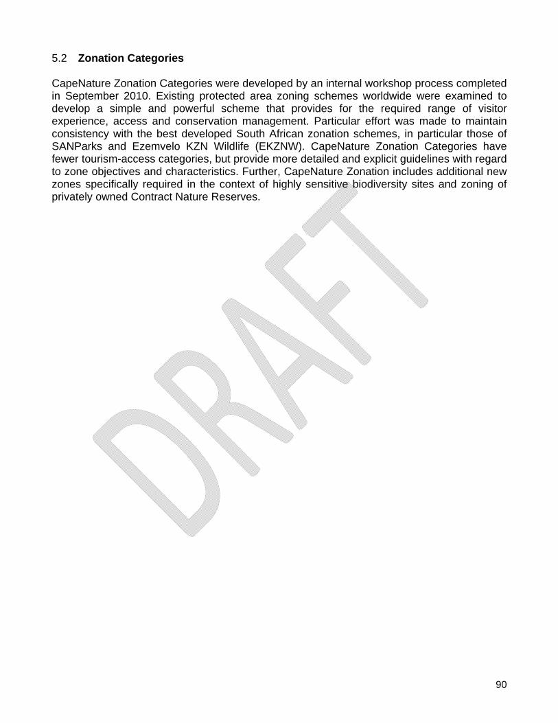
90
5.2 Zonation Categories CapeNature Zonation Categories were developed by an internal workshop process completed in September 2010. Existing protected area zoning schemes worldwide were examined to develop a simple and powerful scheme that provides for the required range of visitor experience, access and conservation management. Particular effort was made to maintain consistency with the best developed South African zonation schemes, in particular those of SANParks and Ezemvelo KZN Wildlife (EKZNW). CapeNature Zonation Categories have fewer tourism-access categories, but provide more detailed and explicit guidelines with regard to zone objectives and characteristics. Further, CapeNature Zonation includes additional new zones specifically required in the context of highly sensitive biodiversity sites and zoning of privately owned Contract Nature Reserves.
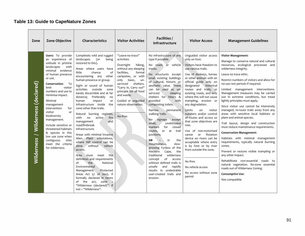
91
Table 13: Guide to CapeNature Zones
Zone Zone Objective Characteristics Visitor Activities Facilities /
Infrastructure Visitor Access Management Guidelines
Wild
erne
ss / W
ilderne
ss (d
eclared)
Users: To provide an experience of solitude in pristine landscapes with minimal evidence of human presence or use.
Conservation: To limit visitor numbers and use to minimise impact.
Minimal management intervention for visitor or biodiversity management.
Include sensitive or threatened habitats & species in this low use zone when contiguous sites meet the criteria for wilderness.
Completely wild and rugged landscapes (or being restored to this).
Areas where users have little chance of encountering any other human presence or group.
Sight or sound of human activities outside zone barely discernible and at far distance; Preferably no human impact or infrastructure inside the zone other than trails.
Natural burning regimes, with no active fire management and road/firebreak infrastructure.
Areas with minimal Invasive Alien Plant infestations, where IAP control can be done without vehicle access.
Area must meet the definition and requirements of the National Environmental Management: Protected Areas Act 57 of 2003. If formally declared in terms of the act, zone = “Wilderness (declared)”; if not = “Wilderness”.
“Leave‐no‐trace” activities:
Overnight hiking, without any sleeping facilities, formal campsites, or with only basic, un‐serviced shelters. "Carry in, Carry out" principle for all food and waste.
Guided or unguided nature observation.
No fires
No infrastructure of any type if possible.
No roads or vehicle tracks.
No structures except small existing buildings of cultural, historic or aesthetic value. These can be used as un‐serviced sleeping shelters for hikers & provided with composting toilets.
Narrow permanent walking trails.
No signage except small, unobtrusive markers for closed routes, or at trail junctions.
NB – in the mountainous, slow‐growing Fynbos of the Western Cape, the traditional wilderness concept of access without defined trails is unsafe and rapidly results in undesirable user‐created trails and erosion.
Unguided visitor access only on foot.
Visitors have freedom to use various trails.
Use of donkeys, horses or other animals with an official guide only on designated historical routes and trails, or existing roads, and only where this will not cause trampling, erosion or any degradation.
Limits on visitor numbers and/or control of routes and access so that zone objectives are met.
Use of non‐motorised canoe or flotation device on rivers can be acceptable where entry is by foot or by river from outside the zone.
No fires
No vehicle access
No access without zone permit
Visitor Management:
Manage to conserve natural and cultural resources, ecological processes and wilderness integrity.
Leave no trace ethic.
Restrict numbers of visitors and allow for no‐use rest periods if required.
Limited management interventions. Management measures may be carried out in extreme conditions, but tread lightly principles must apply.
Since visitor use cannot be intensively managed, re‐route trails away from any areas with sensitive local habitats or plant and animal species.
Trail layout, design and construction must reduce maintenance requirements.
Conservation Management:
Habitats with minimal management requirements, typically natural burning zones.
Prevent or restore visible trampling or any other impact.
Rehabilitate non‐essential roads to natural vegetation. Re‐zone essential roads out of Wilderness Zoning.
Consumptive Use:
Not compatible
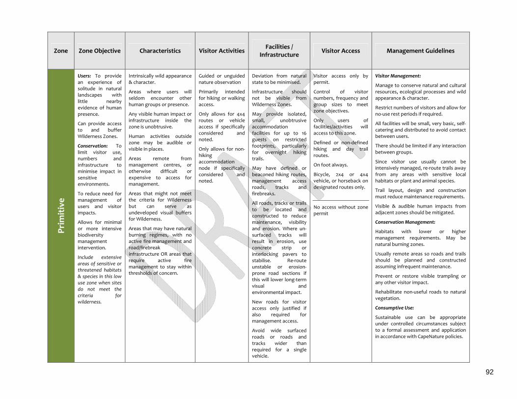
92
Zone Zone Objective Characteristics Visitor Activities Facilities /
Infrastructure Visitor Access Management Guidelines
Prim
itive
Users: To provide an experience of solitude in natural landscapes with little nearby evidence of human presence.
Can provide access to and buffer Wilderness Zones.
Conservation: To limit visitor use, numbers and infrastructure to minimise impact in sensitive environments.
To reduce need for management of users and visitor impacts.
Allows for minimal or more intensive biodiversity management intervention.
Include extensive areas of sensitive or threatened habitats & species in this low use zone when sites do not meet the criteria for wilderness.
Intrinsically wild appearance & character.
Areas where users will seldom encounter other human groups or presence.
Any visible human impact or infrastructure inside the zone is unobtrusive.
Human activities outside zone may be audible or visible in places.
Areas remote from management centres, or otherwise difficult or expensive to access for management.
Areas that might not meet the criteria for Wilderness but can serve as undeveloped visual buffers for Wilderness.
Areas that may have natural burning regimes, with no active fire management and road/firebreak infrastructure OR areas that require active fire management to stay within thresholds of concern.
Guided or unguided nature observation
Primarily intended for hiking or walking access.
Only allows for 4x4 routes or vehicle access if specifically considered and noted.
Only allows for non‐hiking accommodation node if specifically considered and noted.
Deviation from natural state to be minimised.
Infrastructure should not be visible from Wilderness Zones.
May provide isolated, small, unobtrusive accommodation facilities for up to 16 guests on restricted footprints, particularly for overnight hiking trails.
May have defined or beaconed hiking routes, management access roads, tracks and firebreaks.
All roads, tracks or trails to be located and constructed to reduce maintenance, visibility and erosion. Where un‐surfaced tracks will result in erosion, use concrete strip or interlocking pavers to stabilise. Re‐route unstable or erosion‐prone road sections if this will lower long‐term visual and environmental impact.
New roads for visitor access only justified if also required for management access.
Avoid wide surfaced roads or roads and tracks wider than required for a single vehicle.
Visitor access only by permit.
Control of visitor numbers, frequency and group sizes to meet zone objectives.
Only users of facilities/activities will access to this zone.
Defined or non‐defined hiking and day trail routes.
On foot always.
Bicycle, 2x4 or 4x4 vehicle, or horseback on designated routes only.
No access without zone permit
Visitor Management:
Manage to conserve natural and cultural resources, ecological processes and wild appearance & character.
Restrict numbers of visitors and allow for no‐use rest periods if required.
All facilities will be small, very basic, self‐catering and distributed to avoid contact between users.
There should be limited if any interaction between groups.
Since visitor use usually cannot be intensively managed, re‐route trails away from any areas with sensitive local habitats or plant and animal species.
Trail layout, design and construction must reduce maintenance requirements.
Visible & audible human impacts from adjacent zones should be mitigated.
Conservation Management:
Habitats with lower or higher management requirements. May be natural burning zones.
Usually remote areas so roads and trails should be planned and constructed assuming infrequent maintenance.
Prevent or restore visible trampling or any other visitor impact.
Rehabilitate non‐useful roads to natural vegetation.
Consumptive Use:
Sustainable use can be appropriate under controlled circumstances subject to a formal assessment and application in accordance with CapeNature policies.
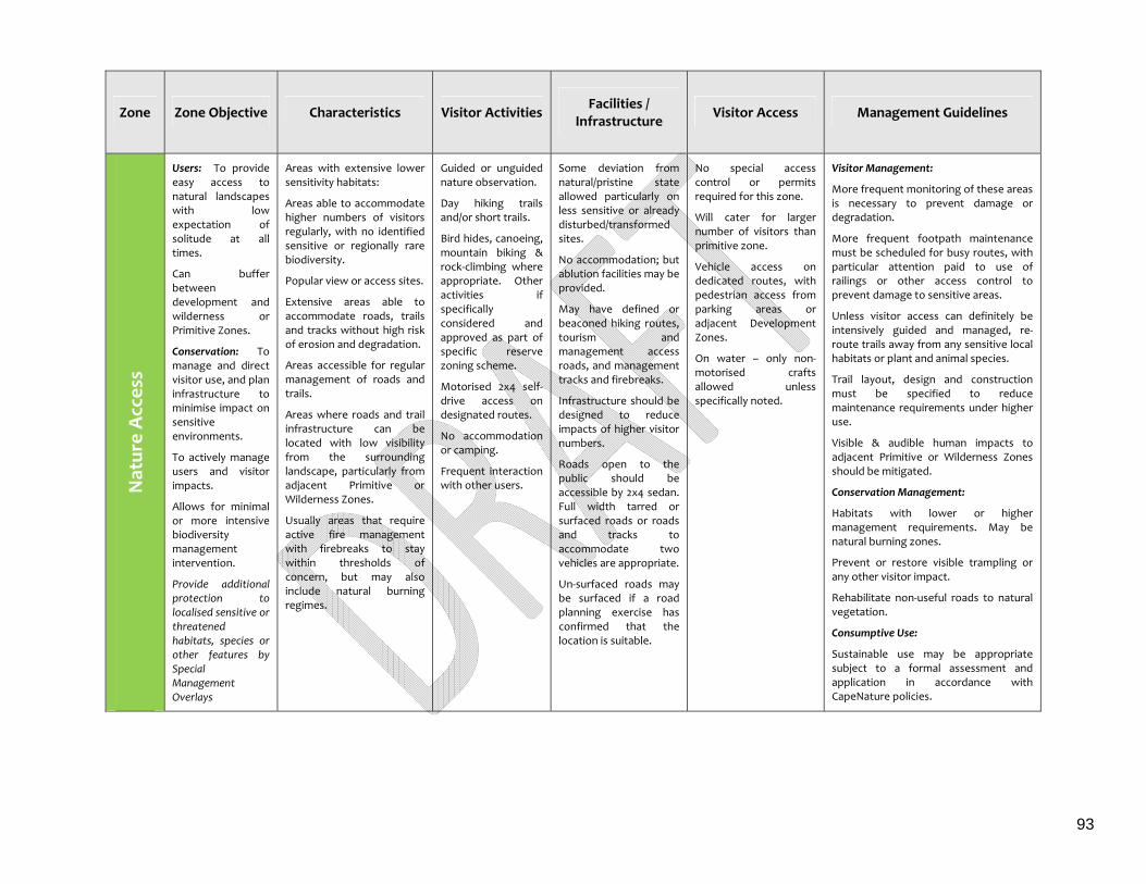
93
Zone Zone Objective Characteristics Visitor Activities Facilities /
Infrastructure Visitor Access Management Guidelines
Natur
e Acces
s Users: To provide easy access to natural landscapes with low expectation of solitude at all times.
Can buffer between development and wilderness or Primitive Zones.
Conservation: To manage and direct visitor use, and plan infrastructure to minimise impact on sensitive environments.
To actively manage users and visitor impacts.
Allows for minimal or more intensive biodiversity management intervention.
Provide additional protection to localised sensitive or threatened habitats, species or other features by Special Management Overlays
Areas with extensive lower sensitivity habitats:
Areas able to accommodate higher numbers of visitors regularly, with no identified sensitive or regionally rare biodiversity.
Popular view or access sites.
Extensive areas able to accommodate roads, trails and tracks without high risk of erosion and degradation.
Areas accessible for regular management of roads and trails.
Areas where roads and trail infrastructure can be located with low visibility from the surrounding landscape, particularly from adjacent Primitive or Wilderness Zones.
Usually areas that require active fire management with firebreaks to stay within thresholds of concern, but may also include natural burning regimes.
Guided or unguided nature observation.
Day hiking trails and/or short trails.
Bird hides, canoeing, mountain biking & rock‐climbing where appropriate. Other activities if specifically considered and approved as part of specific reserve zoning scheme.
Motorised 2x4 self‐drive access on designated routes.
No accommodation or camping.
Frequent interaction with other users.
Some deviation from natural/pristine state allowed particularly on less sensitive or already disturbed/transformed sites.
No accommodation; but ablution facilities may be provided.
May have defined or beaconed hiking routes, tourism and management access roads, and management tracks and firebreaks.
Infrastructure should be designed to reduce impacts of higher visitor numbers.
Roads open to the public should be accessible by 2x4 sedan. Full width tarred or surfaced roads or roads and tracks to accommodate two vehicles are appropriate.
Un‐surfaced roads may be surfaced if a road planning exercise has confirmed that the location is suitable.
No special access control or permits required for this zone.
Will cater for larger number of visitors than primitive zone.
Vehicle access on dedicated routes, with pedestrian access from parking areas or adjacent Development Zones.
On water – only non‐motorised crafts allowed unless specifically noted.
Visitor Management:
More frequent monitoring of these areas is necessary to prevent damage or degradation.
More frequent footpath maintenance must be scheduled for busy routes, with particular attention paid to use of railings or other access control to prevent damage to sensitive areas.
Unless visitor access can definitely be intensively guided and managed, re‐route trails away from any sensitive local habitats or plant and animal species.
Trail layout, design and construction must be specified to reduce maintenance requirements under higher use.
Visible & audible human impacts to adjacent Primitive or Wilderness Zones should be mitigated.
Conservation Management:
Habitats with lower or higher management requirements. May be natural burning zones.
Prevent or restore visible trampling or any other visitor impact.
Rehabilitate non‐useful roads to natural vegetation.
Consumptive Use:
Sustainable use may be appropriate subject to a formal assessment and application in accordance with CapeNature policies.
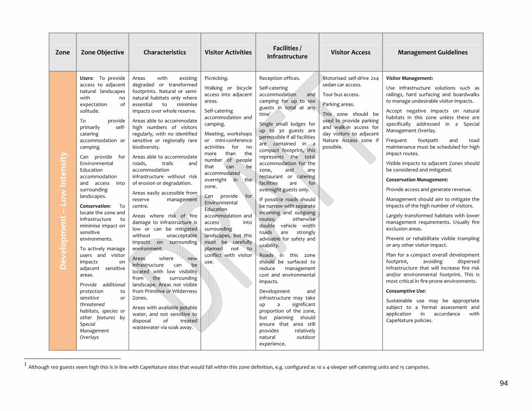
94
Zone Zone Objective Characteristics Visitor Activities Facilities /
Infrastructure Visitor Access Management Guidelines
Dev
elop
men
t – Low
Intens
ity
Users: To provide access to adjacent natural landscapes with no expectation of solitude.
To provide primarily self‐catering accommodation or camping.
Can provide for Environmental Education accommodation and access into surrounding landscapes.
Conservation: To locate the zone and infrastructure to minimise impact on sensitive environments.
To actively manage users and visitor impacts on adjacent sensitive areas.
Provide additional protection to sensitive or threatened habitats, species or other features by Special Management Overlays
Areas with existing degraded or transformed footprints. Natural or semi‐natural habitats only where essential to minimise impacts over whole reserve.
Areas able to accommodate high numbers of visitors regularly, with no identified sensitive or regionally rare biodiversity.
Areas able to accommodate roads, trails and accommodation infrastructure without risk of erosion or degradation.
Areas easily accessible from reserve management centre.
Areas where risk of fire damage to infrastructure is low or can be mitigated without unacceptable impacts on surrounding environment.
Areas where new infrastructure can be located with low visibility from the surrounding landscape. Areas not visible from Primitive or Wilderness Zones.
Areas with available potable water, and not sensitive to disposal of treated wastewater via soak away.
Picnicking.
Walking or bicycle access into adjacent areas.
Self‐catering accommodation and camping.
Meeting, workshops or mini‐conference activities for no more than the number of people that can be accommodated overnight in the zone.
Can provide for Environmental Education accommodation and access into surrounding landscapes, but this must be carefully planned not to conflict with visitor use.
Reception offices.
Self‐catering accommodation and camping for up to 100 guests in total at any time1
Single small lodges for up to 30 guests are permissible if all facilities are contained in a compact footprint, this represents the total accommodation for the zone, and any restaurant or catering facilities are for overnight guests only.
If possible roads should be narrow with separate incoming and outgoing routes; otherwise double vehicle width roads are strongly advisable for safety and usability.
Roads in this zone should be surfaced to reduce management cost and environmental impacts.
Development and infrastructure may take up a significant proportion of the zone, but planning should ensure that area still provides relatively natural outdoor experience.
Motorised self‐drive 2x4 sedan car access.
Tour bus access.
Parking areas.
This zone should be used to provide parking and walk‐in access for day visitors to adjacent Nature Access zone if possible.
Visitor Management:
Use infrastructure solutions such as railings, hard surfacing and boardwalks to manage undesirable visitor impacts.
Accept negative impacts on natural habitats in this zone unless these are specifically addressed in a Special Management Overlay.
Frequent footpath and road maintenance must be scheduled for high impact routes.
Visible impacts to adjacent Zones should be considered and mitigated.
Conservation Management:
Provide access and generate revenue.
Management should aim to mitigate the impacts of the high number of visitors.
Largely transformed habitats with lower management requirements. Usually fire exclusion areas.
Prevent or rehabilitate visible trampling or any other visitor impact.
Plan for a compact overall development footprint, avoiding dispersed infrastructure that will increase fire risk and/or environmental footprint. This is most critical in fire‐prone environments.
Consumptive Use:
Sustainable use may be appropriate subject to a formal assessment and application in accordance with CapeNature policies.
1 Although 100 guests seem high this is in line with CapeNature sites that would fall within this zone definition, e.g. configured as 10 x 4‐sleeper self‐catering units and 15 campsites.
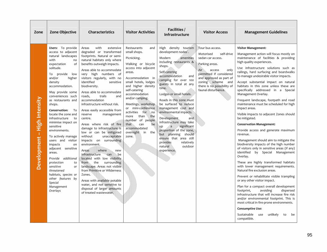
95
Zone Zone Objective Characteristics Visitor Activities Facilities /
Infrastructure Visitor Access Management Guidelines
Dev
elop
men
t – High Intens
ity
Users: To provide access to adjacent natural landscapes with no expectation of solitude.
To provide low and/or higher density accommodation.
May provide some conveniences such as restaurants and shops.
Conservation: To locate the zone and infrastructure to minimise impact on sensitive environments.
To actively manage users and visitor impacts on adjacent sensitive areas.
Provide additional protection to sensitive or threatened habitats, species or other features by Special Management Overlays
Areas with extensive degraded or transformed footprints. Natural or semi‐natural habitats only where benefits outweigh impacts.
Areas able to accommodate very high numbers of visitors regularly, with no identified sensitive biodiversity.
Areas able to accommodate roads, trails and accommodation infrastructure without risk.
Areas easily accessible from reserve management centre.
Areas where risk of fire damage to infrastructure is low or can be mitigated without unacceptable impacts on surrounding environment.
Areas where new infrastructure can be located with low visibility from the surrounding landscape. Areas not visible from Primitive or Wilderness Zones.
Areas with available potable water, and not sensitive to disposal of larger amounts of treated wastewater.
Restaurants and small shops.
Picnicking.
Walking or bicycle access into adjacent areas.
Accommodation in small hotels, lodges and higher density self‐catering accommodation and/or camping.
Meetings, workshop or mini‐conference activities for no more than the number of people that can be accommodated overnight in the zone.
High density tourism development nodes`.
Modern amenities including restaurants & shops.
Self‐catering accommodation and camping for over 100 guests in total at any time.
Lodges or small hotels.
Roads in this zone must be surfaced to reduce management cost and environmental impacts.
Development and infrastructure may take up a significant proportion of the zone, but planning should ensure that area still provides relatively natural outdoor experience.
Tour bus access.
Motorised self‐drive sedan car access.
Parking areas.
Air access only permitted if considered and approved as part of zoning scheme and there is no possibility of faunal disturbance.
Visitor Management:
Management action will focus mostly on maintenance of facilities & providing high quality experiences.
Use infrastructure solutions such as railings, hard surfacing and boardwalks to manage undesirable visitor impacts.
Accept substantial impact on natural habitats in this zone unless these are specifically addressed in a Special Management Overlay.
Frequent landscape, footpath and road maintenance must be scheduled for high impact areas.
Visible impacts to adjacent Zones should be mitigated.
Conservation Management:
Provide access and generate maximum revenue.
Management should aim to mitigate the biodiversity impacts of the high number of visitors only in sensitive areas (if any) identified by Special Management Overlay.
These are highly transformed habitats with lower management requirements. Natural fire exclusion areas.
Prevent or rehabilitate visible trampling or any other visitor impact.
Plan for a compact overall development footprint, avoiding dispersed infrastructure that will increase fire risk and/or environmental footprint. This is most critical in fire‐prone environments.
Consumptive Use:
Sustainable use unlikely to be compatible.
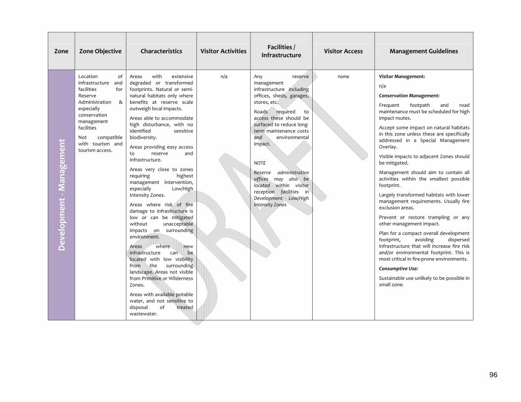
96
Zone Zone Objective Characteristics Visitor Activities Facilities /
Infrastructure Visitor Access Management Guidelines
Dev
elop
men
t ‐ M
anag
emen
t Location of infrastructure and facilities for Reserve Administration & especially conservation management facilities
Not compatible with tourism and tourism access.
Areas with extensive degraded or transformed footprints. Natural or semi‐natural habitats only where benefits at reserve scale outweigh local impacts.
Areas able to accommodate high disturbance, with no identified sensitive biodiversity.
Areas providing easy access to reserve and infrastructure.
Areas very close to zones requiring highest management intervention, especially Low/High Intensity Zones.
Areas where risk of fire damage to infrastructure is low or can be mitigated without unacceptable impacts on surrounding environment.
Areas where new infrastructure can be located with low visibility from the surrounding landscape. Areas not visible from Primitive or Wilderness Zones.
Areas with available potable water, and not sensitive to disposal of treated wastewater.
n/a Any reserve management infrastructure including offices, sheds, garages, stores, etc.
Roads required to access these should be surfaced to reduce long‐term maintenance costs and environmental impact.
NOTE
Reserve administrative offices may also be located within visitor reception facilities in Development ‐ Low/High Intensity Zones
none Visitor Management:
n/a
Conservation Management:
Frequent footpath and road maintenance must be scheduled for high impact routes.
Accept some impact on natural habitats in this zone unless these are specifically addressed in a Special Management Overlay.
Visible impacts to adjacent Zones should be mitigated.
Management should aim to contain all activities within the smallest possible footprint.
Largely transformed habitats with lower management requirements. Usually fire exclusion areas.
Prevent or restore trampling or any other management impact.
Plan for a compact overall development footprint, avoiding dispersed infrastructure that will increase fire risk and/or environmental footprint. This is most critical in fire‐prone environments.
Consumptive Use:
Sustainable use unlikely to be possible in small zone.

97
Zone Zone Objective Characteristics Visitor Activities Facilities /
Infrastructure Visitor Access Management Guidelines
Dev
elop
men
t ‐
Prod
uction
Commercial or subsistence farming.
(only applicable to privately owned & managed Contract Nature Reserves)
Areas identified for production farming.
Areas with extensive degraded or transformed footprints.
Natural or semi‐natural habitats only when use of these areas is supported by a bioregional plan and specialist site assessment.
May allow agri‐tourism
Any agricultural infrastructure.
May allow agri‐tourism Agricultural best practise to support surrounding natural areas, particularly with regard to river and wetland buffer areas.
Dev
elop
men
t –
Private Areas Private dwelling
and surrounds.
(only applicable to privately owned & managed Contract Nature Reserves)
Private homestead.
Areas with existing degraded or transformed footprints.
Natural or semi‐natural habitats only when use of these areas is supported by a bioregional plan and specialist site assessment.
n/a Dwellings and private accommodation areas.
Roads to access these.
No access by the public without permission from landowner.
Should have no negative impacts on the surrounding conservation area.
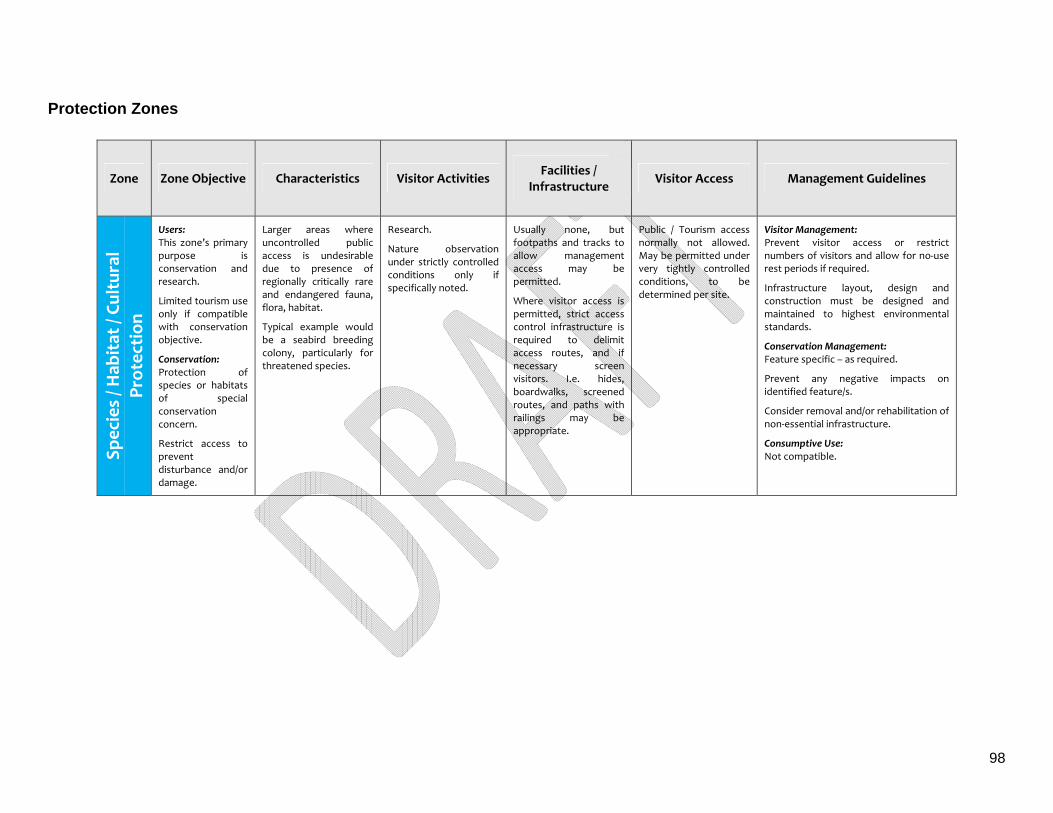
98
Protection Zones
Zone Zone Objective Characteristics Visitor Activities Facilities /
Infrastructure Visitor Access Management Guidelines
Spec
ies / H
abitat / Cu
ltur
al
Prot
ection
Users: This zone’s primary purpose is conservation and research.
Limited tourism use only if compatible with conservation objective.
Conservation: Protection of species or habitats of special conservation concern.
Restrict access to prevent disturbance and/or damage.
Larger areas where uncontrolled public access is undesirable due to presence of regionally critically rare and endangered fauna, flora, habitat.
Typical example would be a seabird breeding colony, particularly for threatened species.
Research.
Nature observation under strictly controlled conditions only if specifically noted.
Usually none, but footpaths and tracks to allow management access may be permitted.
Where visitor access is permitted, strict access control infrastructure is required to delimit access routes, and if necessary screen visitors. I.e. hides, boardwalks, screened routes, and paths with railings may be appropriate.
Public / Tourism access normally not allowed. May be permitted under very tightly controlled conditions, to be determined per site.
Visitor Management: Prevent visitor access or restrict numbers of visitors and allow for no‐use rest periods if required.
Infrastructure layout, design and construction must be designed and maintained to highest environmental standards.
Conservation Management: Feature specific – as required.
Prevent any negative impacts on identified feature/s.
Consider removal and/or rehabilitation of non‐essential infrastructure.
Consumptive Use: Not compatible.
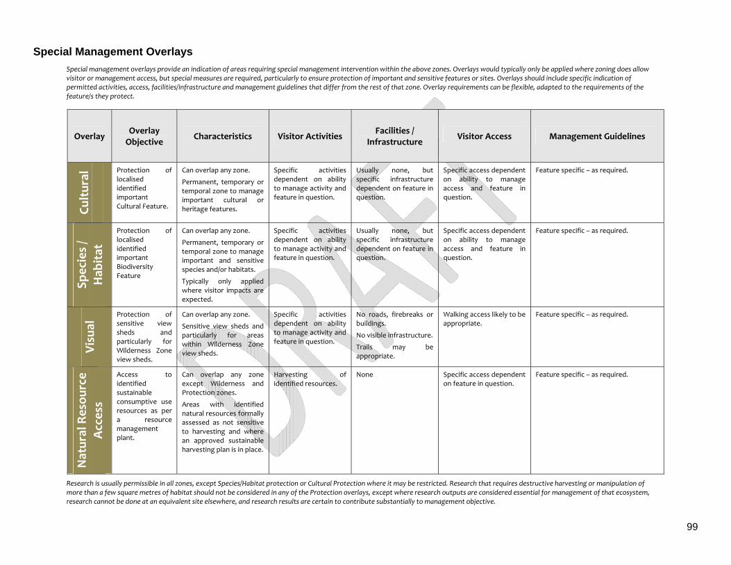
99
Special Management Overlays
Special management overlays provide an indication of areas requiring special management intervention within the above zones. Overlays would typically only be applied where zoning does allow visitor or management access, but special measures are required, particularly to ensure protection of important and sensitive features or sites. Overlays should include specific indication of permitted activities, access, facilities/infrastructure and management guidelines that differ from the rest of that zone. Overlay requirements can be flexible, adapted to the requirements of the feature/s they protect.
Overlay Overlay Objective
Characteristics Visitor Activities Facilities /
Infrastructure Visitor Access Management Guidelines
Cultur
al
Protection of localised identified important Cultural Feature.
Can overlap any zone.
Permanent, temporary or temporal zone to manage important cultural or heritage features.
Specific activities dependent on ability to manage activity and feature in question.
Usually none, but specific infrastructure dependent on feature in question.
Specific access dependent on ability to manage access and feature in question.
Feature specific – as required.
Spec
ies /
Hab
itat
Protection of localised identified important Biodiversity Feature
Can overlap any zone.
Permanent, temporary or temporal zone to manage important and sensitive species and/or habitats.
Typically only applied where visitor impacts are expected.
Specific activities dependent on ability to manage activity and feature in question.
Usually none, but specific infrastructure dependent on feature in question.
Specific access dependent on ability to manage access and feature in question.
Feature specific – as required.
Visu
al Protection of
sensitive view sheds and particularly for Wilderness Zone view sheds.
Can overlap any zone.
Sensitive view sheds and particularly for areas within Wilderness Zone view sheds.
Specific activities dependent on ability to manage activity and feature in question.
No roads, firebreaks or buildings.
No visible infrastructure.
Trails may be appropriate.
Walking access likely to be appropriate.
Feature specific – as required.
Natur
al Res
ource
Acces
s
Access to identified sustainable consumptive use resources as per a resource management plant.
Can overlap any zone except Wilderness and Protection zones.
Areas with identified natural resources formally assessed as not sensitive to harvesting and where an approved sustainable harvesting plan is in place.
Harvesting of identified resources.
None Specific access dependent on feature in question.
Feature specific – as required.
Research is usually permissible in all zones, except Species/Habitat protection or Cultural Protection where it may be restricted. Research that requires destructive harvesting or manipulation of more than a few square metres of habitat should not be considered in any of the Protection overlays, except where research outputs are considered essential for management of that ecosystem, research cannot be done at an equivalent site elsewhere, and research results are certain to contribute substantially to management objective.
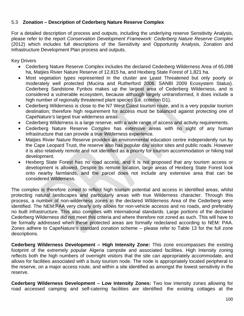
100
5.3 Zonation – Description of Cederberg Nature Reserve Complex For a detailed description of process and outputs, including the underlying reserve Sensitivity Analysis, please refer to the report Conservation Development Framework: Cederberg Nature Reserve Complex (2012) which includes full descriptions of the Sensitivity and Opportunity Analysis, Zonation and Infrastructure Development Plan process and outputs. Key Drivers
Cederberg Nature Reserve Complex includes the declared Cederberg Wilderness Area of 65,098 ha, Matjies Rivier Nature Reserve of 12,815 ha, and Hexberg State Forest of 1,821 ha.
Most vegetation types represented in the cluster are Least Threatened but only poorly or moderately well protected (Mucina and Rutherford 2006, SANBI 2009 Ecosystem Status). Cederberg Sandstone Fynbos makes up the largest area of Cederberg Wilderness, and is considered a vulnerable ecosystem, because although largely untransformed, it does include a high number of regionally threatened plant species (i.e. criterion D1).
Cederberg Wilderness is close to the N7 West Coast tourism route, and is a very popular tourism destination; therefore high requirement for access must be balanced against protecting one of CapeNature’s largest true wilderness areas.
Cederberg Wilderness is a large reserve, with a wide range of access and activity requirements. Cederberg Nature Reserve Complex has extensive areas with no sight of any human
infrastructure that can provide a true Wilderness experience. Matjies Rivier Nature Reserve provides an environmental education centre independently run by
the Cape Leopard Trust, the reserve also has popular day visitor sites and public roads. However it is also relatively remote and not identified as a priority for tourism accommodation or hiking trail development.
Hexberg State Forest has no road access, and it is not proposed that any tourism access or development is allowed. Despite its remote location, large areas of Hexberg State Forest look onto nearby farmlands, and the parcel does not include any extensive area that can be considered Wilderness.
The complex is therefore zoned to reflect high tourism potential and access in identified areas, whilst protecting natural landscapes and particularly areas with true Wilderness character. Through this process, a number of non-wilderness zones in the declared WIlderness Area of the Cederberg were identified. The NEM:PAA very clearly only allows for non-vehicle accesss and no roads, and preferably no built infrastructure. This also complies with international standards. Large portions of the declared Cederberg Wilderness did not meet this criteria and where therefore not zoned as such. This will have to be formally addressed when these protected areas are formally redeclared according to NEM: PAA. Zones adhere to CapeNature’s standard zonation scheme – please refer to Table 13 for the full zone descriptions. Cederberg Wilderness Development – High Intensity Zone: This zone encompasses the existing footprint of the extremely popular Algeria campsite and associated facilities. High Intensity zoning reflects both the high numbers of overnight visitors that the site can appropriately accommodate, and allows for facilities associated with a busy tourism node. The node is appropriately located peripheral to the reserve, on a major access route, and within a site identified as amongst the lowest sensitivity in the reserve. Cederberg Wilderness Development – Low Intensity Zones: Two low intensity zones allowing for road accessed camping and self-catering facilities are identified: the existing cottages at the
101
Bosherberge near Algeria, and the Kliphuis campsite and cottages in the north of the Wilderness, situated along the Pakhuis Pass road. It is noted that the Bosherberge site is located within and adjacent to a wetland area, and any re-development within this zone should be planned accordingly with no expansion of infrastructure within this area, impacting on wetland habitat. Cederberg Wilderness Development – Management Zones: Management footprints are provided at Algeria that are close to, but appropriately separated from tourism areas. Current proposed re-development and upgrades at Algeria mean that layout has been optimised to prevent any negative impact on tourism experience, while promoting efficient and cost effective management access to facilities. A small satellite management centre has been provided for adjacent to Kliphuis campsite to allow cost-effective and convenient management of the campsite and northern section of Cederberg Wilderness would otherwise incur very high on-going travel and time costs. Cederberg Wilderness Nature - Access Zones: Nature access zones are allowed for along existing public roads to reflect actual use, and to provide for access and appropriate management of the most popular day visitor sites, in particular the bouldering (rock climbing) area of Rocklands. An extensive nature access zone is provided at Algeria and serves to buffer the high intensity development zone of Algeria. It is appropriately located to take advantage of a popular day trail up to the Middelberg waterfall, and makes use of existing disturbed habitat, roads and trails, left by previous forestry plantation operations. Cederberg Wilderness - Primitive Zones: As the entire Cederberg Wilderness is a declared Wilderness, all areas that could reasonably qualify should where possible be zoned Wildness Zone. Primitive zones were determined largely by means of a viewshed analysis and reflect extensive areas that look upon nearby farmlands, roads or other human infrastructure and as a result do not qualify as a true wilderness zone. Cederberg Wilderness - Wilderness Zone: Cederberg wilderness does include extensive areas with entirely natural and wild viewsheds, and where no built infrastructure, roads or vehicular access should be permitted. Matjies Rivier Development – Low Intensity Zones: The small Development – Low Intensity Zones on existing footprints provide for limited environmental education and day visitor interpretation access. As a special condition, these zones at Matjies Rivier do not permit self-catering or other overnight tourism development as tourism development is currently not planned here. Matjies Rivier Development – Management Zones: The management zone provides for staff accommodation, stores, and administration. As this location is highly visible and must also provide a reception service for day visitors, facilities should be planned and operated with visual and noise impacts in mind. Matjies Rivier Nature Reserve - Nature Access Zones: Nature access zones are allowed for along existing public roads to reflect actual use, and to provide for access and appropriate management of the most popular day visitor sites, in particular the very popular Stadsaal cave and Elephant rock art site, and the Truitjieskraal climbing area. Matjies Rivier Nature Reserve - Primitive Zones: As Matjies Rivier does not currently provide for hiking , overnight facilities, or other remote lodges, and none is planned, all areas that could reasonably
102
qualify were zoned as wilderness. Primitive zones reflect extensive areas that look onto some farmland, roads or other human infrastructure, and do not qualify as true wilderness. Matjies Rivier Nature Reserve - Wilderness Zone: The eastern portion of Matjies Rivier has entirely natural and wild viewsheds. No built infrastructure, roads or vehicular access should be permitted. Reserve staff felt that further areas would qualify as wilderness; although a GIS viewshed analysis with verification using Google Earth terrain models did not support this. It is suggested that an appropriate field sampling grid should be established for field verification to allow updating of future zoning and management plans.
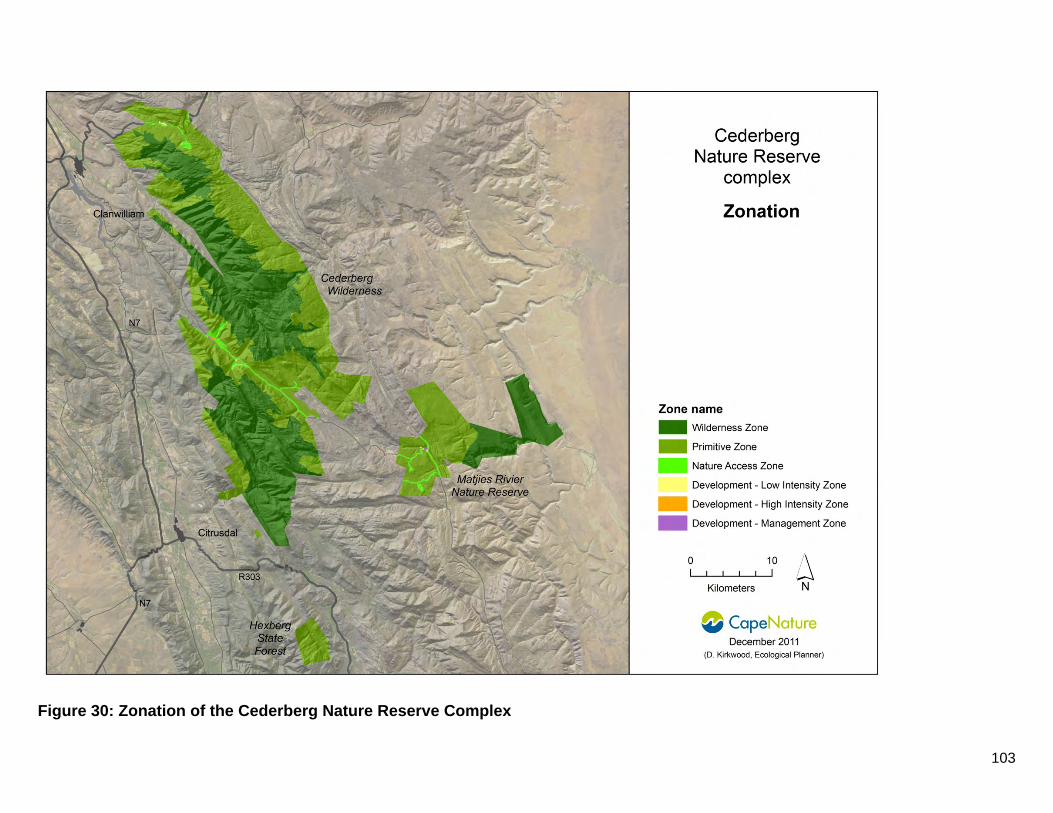
103
Figure 30: Zonation of the Cederberg Nature Reserve Complex
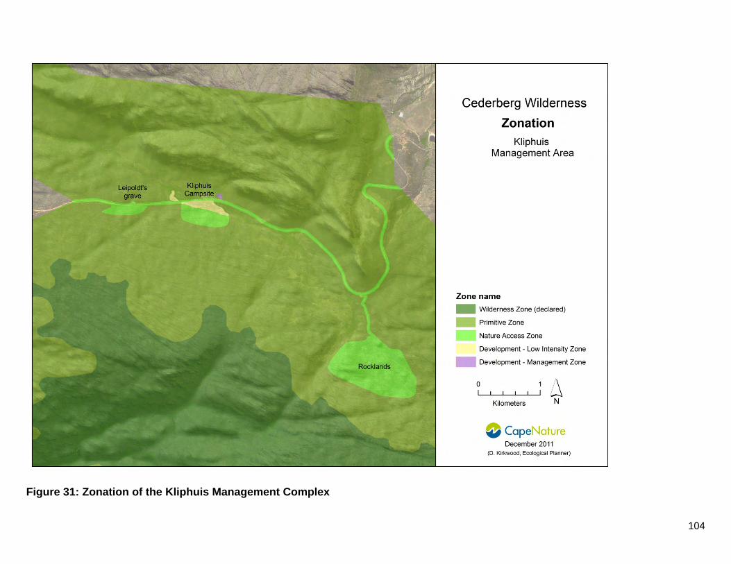
104
Figure 31: Zonation of the Kliphuis Management Complex
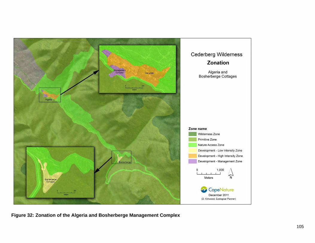
105
Figure 32: Zonation of the Algeria and Bosherberge Management Complex
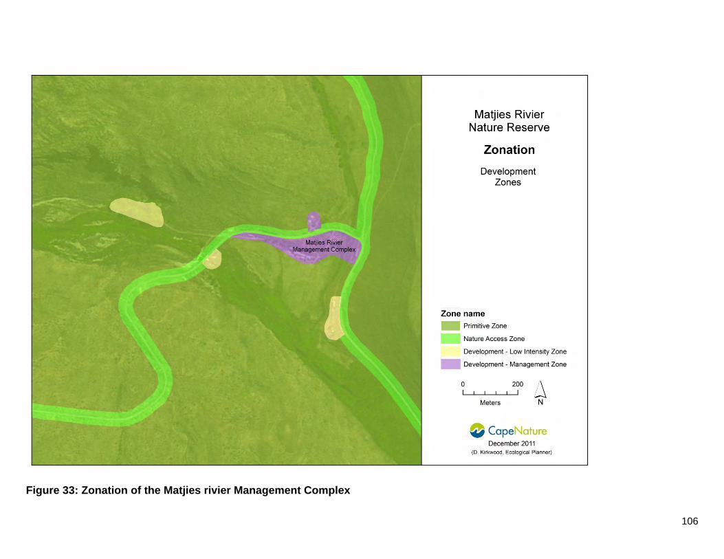
106
Figure 33: Zonation of the Matjies rivier Management Complex
107
5.4 Access The main management centres of the Cederberg Nature Reserve Complex are located at Algeria, Matjies Rivier and Kliphuis. Permits to obtain access to the area are available from these management centres and other tourism offices in the Cederberg Conservancy. Permit conditions specify the areas and conditions of access. Uncontrolled and remote access to the Cederberg Wilderness and Hexberg State Forest poses particular management and safety risks. Access to tourists at Matjies Rivier Nature Reserve is controlled by gates locked with combination locks. Currently no designated helicopter landing sites exist. Two landings sites have been identified at Algeria and included in the development plan for final approval. Moreover, no airfields exist within the Cederberg Nature Reserve Complex. A no fly-zone restriction of 2 500 feet above the highest point of the area, exists over the World Heritage Site, which in effect results in a no fly-zone of 3 000 meters above sea level (according to the NEM:PAA of 2003). Access via the Heuningvlei jeep track is for Community tourism in the form of a donkey cart route and is open for medical emergencies only. Access for legal harvesting of natural resources are evaluated and considered on an ad hoc basis as required.
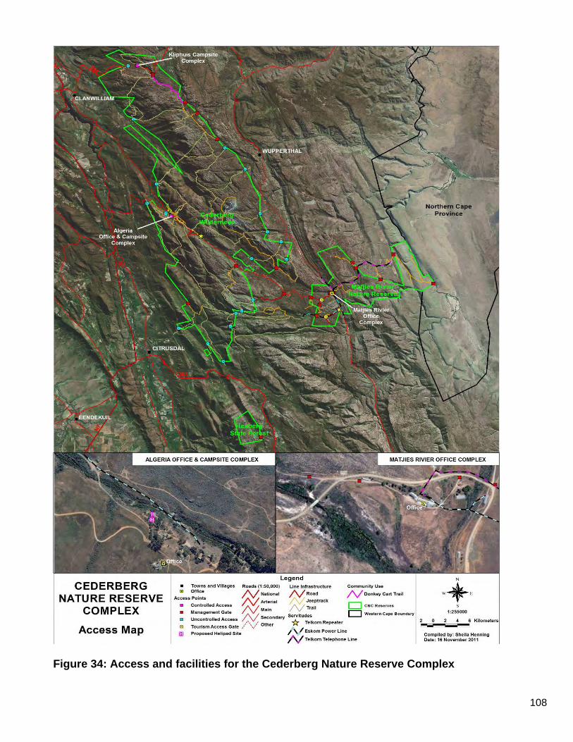
108
Figure 34: Access and facilities for the Cederberg Nature Reserve Complex
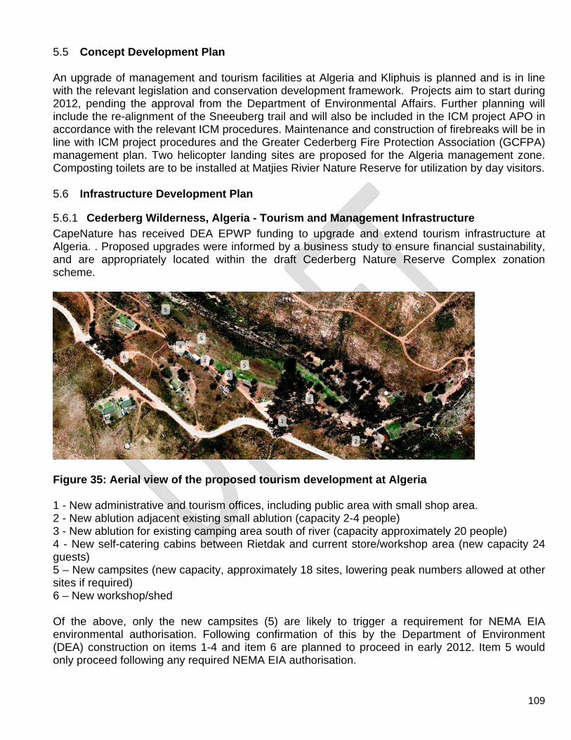
109
5.5 Concept Development Plan An upgrade of management and tourism facilities at Algeria and Kliphuis is planned and is in line with the relevant legislation and conservation development framework. Projects aim to start during 2012, pending the approval from the Department of Environmental Affairs. Further planning will include the re-alignment of the Sneeuberg trail and will also be included in the ICM project APO in accordance with the relevant ICM procedures. Maintenance and construction of firebreaks will be in line with ICM project procedures and the Greater Cederberg Fire Protection Association (GCFPA) management plan. Two helicopter landing sites are proposed for the Algeria management zone. Composting toilets are to be installed at Matjies Rivier Nature Reserve for utilization by day visitors. 5.6 Infrastructure Development Plan
5.6.1 Cederberg Wilderness, Algeria - Tourism and Management Infrastructure CapeNature has received DEA EPWP funding to upgrade and extend tourism infrastructure at Algeria. . Proposed upgrades were informed by a business study to ensure financial sustainability, and are appropriately located within the draft Cederberg Nature Reserve Complex zonation scheme.
Figure 35: Aerial view of the proposed tourism development at Algeria 1 - New administrative and tourism offices, including public area with small shop area. 2 - New ablution adjacent existing small ablution (capacity 2-4 people) 3 - New ablution for existing camping area south of river (capacity approximately 20 people) 4 - New self-catering cabins between Rietdak and current store/workshop area (new capacity 24 guests) 5 – New campsites (new capacity, approximately 18 sites, lowering peak numbers allowed at other sites if required) 6 – New workshop/shed Of the above, only the new campsites (5) are likely to trigger a requirement for NEMA EIA environmental authorisation. Following confirmation of this by the Department of Environment (DEA) construction on items 1-4 and item 6 are planned to proceed in early 2012. Item 5 would only proceed following any required NEMA EIA authorisation.
110
5.6.2 Cederberg Wilderness, Kliphuis - Tourism and Management Infrastructure Existing camping sites, ablution and cottages at Kliphuis campsite will be renovated and re-opened to the public in 2012. No new or expanded infrastructure is proposed here. Associated with this, existing derelict management houses within the Development – Management Zone at Kliphuis will be demolished and replaced with new units to provide accommodation for reserve staff.
5.6.3 Cederberg Wilderness, Tourism Infrastructure – access, roads and trails Formalisation of further day trails and mountain bike routes will be confined to existing forestry roads and tracks within the Nature Access Zone.
5.6.4 Cederberg Wilderness, Management Infrastructure – access, roads and trails The existing road and trail network provides adequate access for required management and monitoring activities. It is noted that in terms of the NEM:PAA, no roads or vehicular access is permitted in declared Wilderness zones. The management plan will address identification and closure of all possible non-essential roads and trails within Cederberg Wilderness, particularly those identified within this plan as true Wilderness Zone.
5.6.5 Matjies Rivier Nature Reserve- Management Infrastructure No new infrastructure is proposed, existing infrastructure to be maintained to standard.
5.6.6 Matjies Rivier Nature Reserve, Tourism Infrastructure – access, roads and trails Upgrades are limited to formalisation of existing day trails within the nature access zones at Stadsaal Cave and Truitjieskraal climbing site. This will include improvement of signage and access control as required to prevent long-term trampling and erosion. Boardwalks or similar measures for sensitive and/or high traffic areas will be considered implemented as required. Composting toilets suitable for high volume use will be provided at Stadsaal parking area to replace current unsuitable chemical toilets. No tourism accommodation or new day or overnight hiking trails are proposed. Similar units will be provided at Truitjieskraal. No new tourism accommodation or hiking trails are proposed.
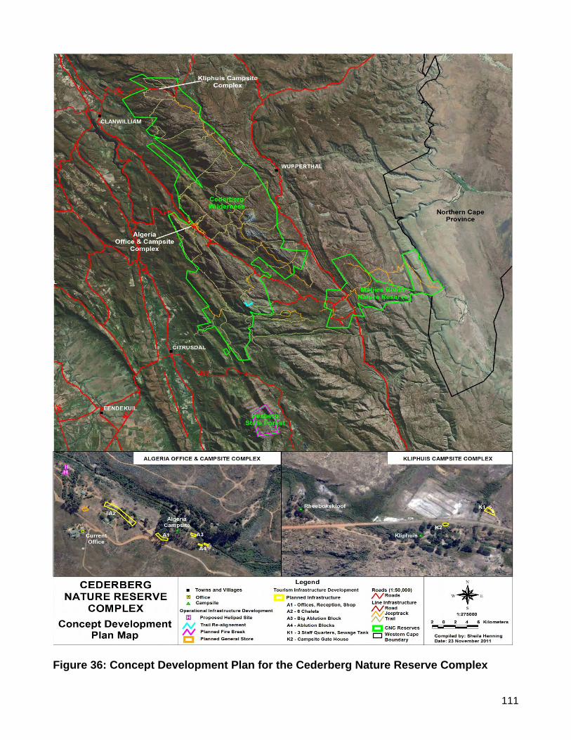
111
Figure 36: Concept Development Plan for the Cederberg Nature Reserve Complex

112
SECTION 6: RESERVE EXPANSION STRATEGY
6.1 Protected Area Expansion
6.1.1 Introduction The establishment and management of a provincial protected area system which is aligned with the National Protected Area Expansion Strategy (2010), is a key strategic approach to the conservation of the globally significant biodiversity of the Western Cape. Several conservation planning initiatives are used to inform the consolidated Provincial Protected Area Expansion Strategy (2010). The strategy aims to guide expansion priorities which
i. Contribute towards meeting national and provincial biodiversity targets 2 ii. National and provincial protected area targets3
Several mechanisms are available for the expansion of protected areas in order to meet both biodiversity and protected area targets. A further requirement in order to adequately manage these protected areas is the establishment and management, co-management or management guidance of buffer areas. Protected area expansion and buffer areas, although closely linked, will be dealt with as two distinct activities.
6.1.2 Spatial Focus The National and Provincial Protected Area network was assessed at a broad scale by the National Spatial Biodiversity Assessment (NSBA, now NBA) and the National Biodiversity Framework (NBF). The NBA (Driver et al. in Prep) identified crucial freshwater, estuarine and marine conservation priorities to inform the Protected Area Expansion strategy for the Western Cape. CapeNature employs several conservation planning products which may inform the CapeNature Protected Area Expansion Strategy and Implementation Plan 2010-2015 (Purnell et al. 2010) in order to meet national and provincial biodiversity targets as well as protected area targets. These include the Conservation Action Plan (CAP) map, Important Biodiversity Layers (IBL) and the various regional Fine Scale Plans (e.g. Cederberg, Witzenberg).
6.1.3 Protected Area Expansion Mechanisms Several mechanisms are available for the expansion of protected areas in order to meet both biodiversity and protected area targets and are linked to land ownership and tenure.
2 Biodiversity targets refer to how much of a biodiversity feature should be protected in order for it to persist. 3 Protected Area targets refer to the area of land which should be represented in Protected Areas by a certain date
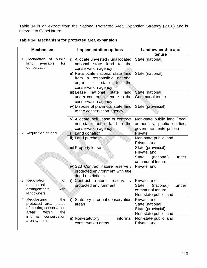
113
Table 14 is an extract from the National Protected Area Expansion Strategy (2010) and is relevant to CapeNature: Table 14: Mechanism for protected area expansion
Mechanism Implementation options Land ownership and tenure
i) Allocate unvested / unallocated national state land to the conservation agency
State (national)
ii) Re-allocate national state land from a responsible national organ of state to the conservation agency
State (national)
iii) Lease national state land under communal tenure to the conservation agency
State (national) Communal tenure
iv) Dispose of provincial state land to the conservation agency
State (provincial)
1. Declaration of public land available for conservation
v) Allocate, sell, lease or contract non-state, public land to the conservation agency
Non-state public land (local authorities, public entities, government enterprises)
i) Land donation Private ii) Land purchase Non-state public land
Private land iii) Property lease State (provincial)
Private land State (national) under communal tenure
2. Acquisition of land
iv) S23 Contract nature reserve / protected environment with title deed restrictions
Private land
3. Negotiation of contractual arrangements with landowners
i) Contract nature reserve / protected environment
Private land State (national) under communal tenure Non-state public land
i) Statutory informal conservation areas
Private land State (national) State (provincial) Non-state public land
4. Regularizing the protected area status of existing conservation areas within the informal conservation area system.
ii) Non-statutory informal conservation areas
Non-state public land Private land
114
6.1.4 CapeNature’s Strategic Approach to Protected Area Expansion in the Western Cape
6.1.4.1 Spatial Focus
The Conservation Action plan (CAP) map is the primary informant to the expansion priorities for CapeNature. This product is supported by IBL and the Fine-Scale Plans. These plans are all biodiversity driven and CapeNature will unreservedly pursue priorities based on biodiversity net gain. Marine priorities which are adjacent to existing terrestrial areas or protected islands will be prioritised accordingly. Other marine / terrestrial interfaces e.g. estuaries will be considered in the priority evaluation process as informed by relevant biodiversity conservation plans not listed above. Properties which have cultural, archaeological and paleontological features will also be evaluated in the context of biodiversity first.
6.1.4.2 Primary Mechanisms for CapeNature
The following mechanisms which address the various landownership scenarios for properties which are identified will be used by CapeNature for the immediate future:
i. Declaration of Provincial Nature Reserves on state owned land / sea or island. a. CapeNature as management authority b. Co-management agreement with another organ of state c. Another organ of state delegated as management authority
ii. Declaration of S23 Nature Reserves on private land as per the stewardship protocol. iii. Biodiversity Agreements (including those with “in perpetuity” title deed restrictions
usually also zoned Open Space III Nature Reserve). iv. Declared Protected Environments (preferably with title deed restrictions in perpetuity or
at least 30 years). v. Donation of land which contributes significantly to both biodiversity and protected area
targets. vi. Purchase of land of biodiversity significance either with state or donor funds.
6.1.4.3 Implementation Phases
I. Annual Expansion plan spatially depicted per Area or conservation region;
II. Five Year Plan (revised at end of MTEF three year cycle); and III. 20 Year Plan.
6.1.4.4 Planning and Implementation Review Protocol
Annual and 5-year Protected Area Expansion plans at Area level will be reviewed by an appropriately constituted panel. This is in order to verify biodiversity and other strategic gains and to consolidate a provincial plan for CapeNature for executive approval. All sites identified
115
for protected area expansion will be assessed using the appropriate site review process these site assessments will be evaluated by the Protected Area Expansion Review Panel (appropriate management and scientific representation being a pre-requisite). A site assessment protocol will be provided using refinements from the draft land acquisition policy and the stewardship site assessment template as well as protected areas and their expansion by other agencies e.g. SANParks, Department of Environmental Affairs: Oceans and Coast and Department of Agriculture Forestry and Fisheries (DAFF).
6.1.5 Financial Plan for Protected Area and Buffer zone expansion
Should CapeNature be the management authority of a stewardship site as per agreement with the private landowner then the details of this budget should be reflected in the respective management plan whether it is an extension of one of CapeNature’s own reserves or a Nature Reserve in its own right which will require a management plan approved by the MEC. 6.2 Buffer zones The term ”buffer zone” is widely used in the context of the conservation of biodiversity, and is usually used to denote some sort of spatial protection mechanism. The configuration and extent of, and “restrictions” applied to a particular buffer zone may vary considerably depending on the attributes that require protection, and the nature of the “threat/s”. World Heritage Sites (WHS) are designed to recognise and protect areas of “Outstanding Universal Value” (OUV) to humanity, both cultural and natural. Biosphere Reserves are designed to conserve for use by mankind, the diversity and integrity of biotic communities within natural and semi-natural ecosystems and to maintain genetic diversity; to provide areas for research and facilities for research and training. Thus the difference is that WHS have to have OUV and Biosphere Reserves may not. Both however have “buffer zones”. WHS “buffer zones” are clearly delineated area(s) outside a World Heritage property but adjacent to its boundaries which contribute to the protection, management, integrity, authenticity and sustainability of the OUV of the property. Although World Heritage “buffer zones” are not regarded as part of the inscribed World Heritage property, their boundaries and relevant management approaches are evaluated, approved and formally recorded at the time they are proposed by a State Party. Where “buffer zones” are defined, they should be seen as an integral component of the State Party’s commitment to the protection and management of the World Heritage property. The functions of the buffer zone should reflect the different types and levels of protection needed to protect the outstanding universal value of the World Heritage property. Biosphere Reserve “buffer zones” is typically arranged concentrically around the core areas to which they provide protection by restricting potentially detrimental activities and promoting wise utilisation. Due to the importance and distribution across the landscape of the biodiversity of the CFR several “buffering mechanisms” have been developed to ensure the long term persistence of both pattern and process, as well to provide mitigation for Global Climate Change. These “buffering mechanisms” are often overlapping, always mutually supportive and continuously evolving and expanding. These buffering mechanisms include but are not restricted to,
116
declared private mountain catchments areas, biosphere reserves, corridor initiatives, stewardship agreements and critical biodiversity areas (both terrestrial and aquatic). It is from these “buffer zones” that most, but not all, stewardship sites are likely to come. It is also important to bear in mind that local development plans need to take into account the buffering requirements of protected areas. The Cederberg Wilderness was declared a World Heritage Site (WHS) by the World Heritage Convention, UNESCO in 2004 as part of a bigger serial site made up of eight protected areas, covering 553,000-ha, in the Western Cape Province. Matjies Rivier Nature Reserve has been nominated as a WHS in 2011 as an extension to the greater Cederberg World Heritage Site and is currently under review. The Greater Cederberg Biodiversity Corridor (GCBC) is a landscape scale conservation initiative of 1.8 million hectares that aims to establish a corridor from the West Coast of South Africa inland. It stretches from Elandsbaai in the west to the Tankwa Karoo National Park in the east and again from the Groot Winterhoek Wilderness Area in the south to Nieuwoudtville in the north. The GCBC has been divided into core corridors which can be seen as strategic management units, consisting of privately owned farmland that is specifically beneficial in connecting and buffering protected areas. The Cederberg Nature Reserve Complex forms the core of the GCBC and is surrounded by the Grootwinterhoek-, Bokkeveld-, Olifantsberg- and Tanqua Core Corridors. The Cederberg Conservancy was established in 1997 and some landowners in the Conservancy have since signed stewardship agreements that consolidate and link Matjies Rivier Nature Reserve and the Cederberg Wilderness. This link and consolidation has been a catalytic event in the development of the Red Cederberg Karoo Park (private initiative) that supports expansion of the Cederberg Core Corridor towards the Tankwa Karoo National Park in the east. 6.3 Expansion Opportunities The CapeNature Protected Area Expansion Strategy document describes an implementation plan and explicit spatial targets for the next 5 year period for the Biodiversity Stewardship Programme. It also describes the current approach to land acquisition, and how explicit spatial targets and a funding and implementation strategy will be developed for this mechanism. The CapeNature Protected Area Expansion Strategy and Implementation Plan therefore provide a provincial framework for an integrated and coordinated approach to:
the expansion of Protected Areas to allow for the protection of biodiversity and persistence of ecological services; and
the securing of landscape corridors to facilitate climate change adaptation. Through the GCBC initiative the Cederberg Core Corridor has been secured and is now entering a maintenance phase. There are opportunities for further stewardship expansion and linking the Cederberg Core Corridor with the Sanded area towards the west and the Grootwinterhoek Wilderness towards the south. The establishment of the Tanqua Core Corridor will require dedicated funding and co-ordination with the Department of Environment and Nature Conservation Northern Cape (DENC) and SANParks.
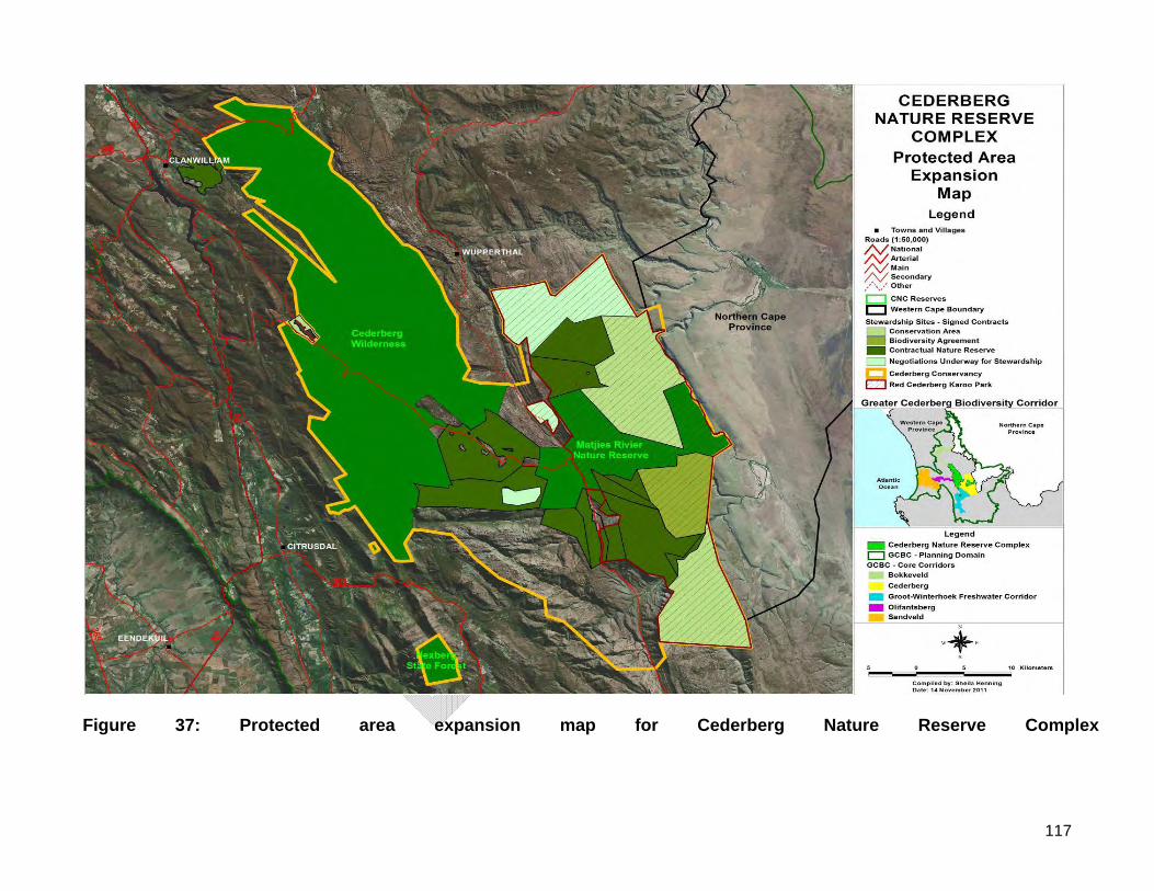
117
Figure 37: Protected area expansion map for Cederberg Nature Reserve Complex
118
PART 3
SECTION 7: STRATEGIC IMPLEMENTATION FRAMEWORK
7.1 Management Programmes
7.1.1 Legal Status and Reserve expansion Cederberg declared a “Demarcated Forest” in Government Notice No. 491 of 1897 under Act 28 of 1888; Cederberg State Forest, setting aside of Wilderness Area in terms of Section 7A of the Forest Act, 1968 (Act 72 of 1968) on 27 July 1973, Notice number 1256 of 1973; Cederberg State Forest, amendment of the boundaries of the Wilderness Area in terms of section 7A of the Forest Act, 1968 (Act 72 of 1968) on 26 March 1976, Notice number 476 of 1976; Matjies Rivier Nature Reserve, proclaimed a Provincial Nature Reserve in terms of section 6(1) of the Nature and Environmental Conservation Ordinance, 1974 (Ordinance 19 of 1974) on 27 March 2000, Notice number 16 of 2000.
7.1.2 Legislation
National Environmental Management: Protected Areas Act, (Act No. 57 of 2003) (NEM: PAA);
National Forest Act, (Act No. 84 of 1998); Mountain Catchment Areas Act, (Act No. 63 of 1970); Nature Conservation Ordinance, (Ordinance No. 19 of 1974); World Heritage Convention Act, (Act. No. 49 of 1999).
All parcels of land of the Cederberg Nature Reserve Complex need to be consolidated and awarded secure conservation status in terms of the NEM: PAA. Section 9 of the NEM: PAA recognises the following kinds of protected areas:
Special Nature Reserves, National Parks, Nature Reserves (including Wilderness Areas) and Protected Environments;
World Heritage Sites; Specially protected Forest Areas, Forest Nature Reserves and Forest Wilderness
Areas declared in terms of the National Forests Act, (Act No. 84 of 1998); Mountain Catchment Areas declared in terms of the Mountain Catchment Areas Act,
(Act No. 63 of 1970). Section 12 of the NEM: PAA, recognises a protected area which immediately before this section took effect was reserved or protected in terms of provincial legislation for any purpose

119
for which an area could in terms of this Act be declared as a nature reserve or protected environment, must be regarded to be a nature reserve or protected environment for the purpose of this Act, including:
Provincial Nature Reserves (including islands) established in terms of the Nature Conservation Ordinance, 1974.
7.1.3 Guiding Principles
Reserve Management will ensure the Reserve is awarded secure legal status according to the Protected Areas Act;
Reserve Management will ensure that the Reserve boundaries are clearly demarcated and known to local residents;
Reserve Management shall identify and prioritise parcels of land, public and private, to be incorporated into the Reserve through an on-going systematic, defensible and socially acceptable procedure in accordance with the CapeNature Protected Area Expansion Strategy and Implementation Plan 2010-2015;
Reserve Management shall strive to seek the incorporation of identified land parcels at the lowest possible financial, social and ecological net cost to the Reserve;
Reserve Management shall continue to work together with private, public, and communal landowners, to enable the donation, purchase and contracting-in of conservation worthy land into the Reserve in accordance with the Cape Nature Protected Area Expansion Strategy;
Reserve Management shall, with the co-operation of stakeholders, strive to prevent any fragmentation of the Reserve and of areas that have been identified for inclusion into the Reserve.
7.1.4 Management Actions Refer to Table 7.1
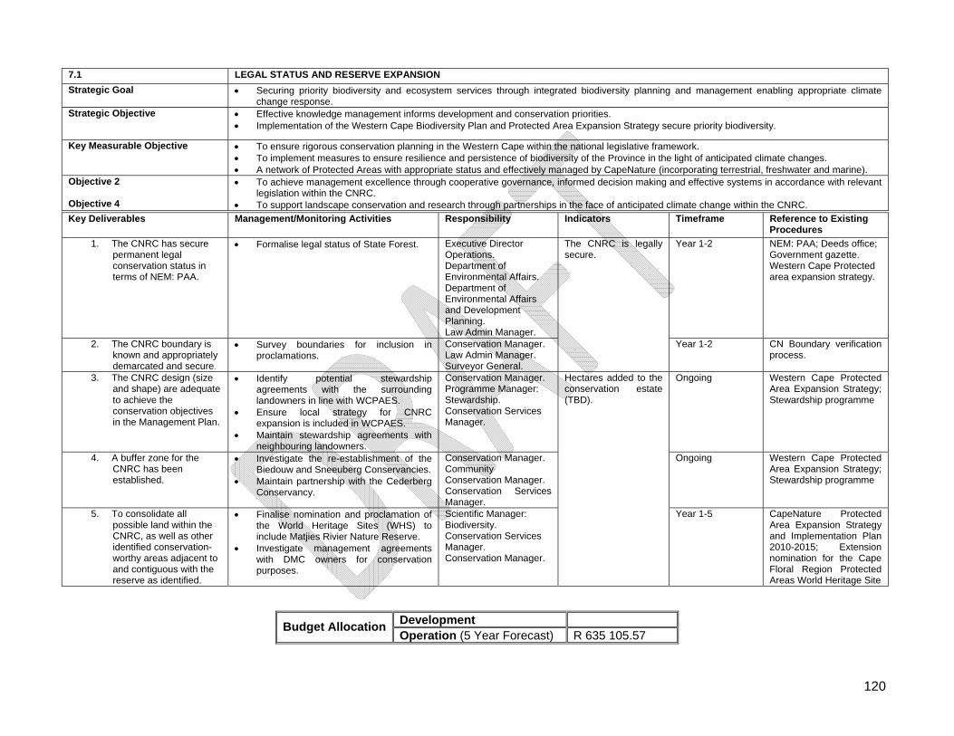
120
7.1 LEGAL STATUS AND RESERVE EXPANSION
Strategic Goal Securing priority biodiversity and ecosystem services through integrated biodiversity planning and management enabling appropriate climate change response.
Strategic Objective Effective knowledge management informs development and conservation priorities. Implementation of the Western Cape Biodiversity Plan and Protected Area Expansion Strategy secure priority biodiversity.
Key Measurable Objective To ensure rigorous conservation planning in the Western Cape within the national legislative framework. To implement measures to ensure resilience and persistence of biodiversity of the Province in the light of anticipated climate changes. A network of Protected Areas with appropriate status and effectively managed by CapeNature (incorporating terrestrial, freshwater and marine).
Objective 2 Objective 4
To achieve management excellence through cooperative governance, informed decision making and effective systems in accordance with relevant legislation within the CNRC.
To support landscape conservation and research through partnerships in the face of anticipated climate change within the CNRC.
Key Deliverables Management/Monitoring Activities Responsibility Indicators Timeframe Reference to Existing Procedures
1. The CNRC has secure permanent legal conservation status in terms of NEM: PAA.
Formalise legal status of State Forest. Executive Director Operations. Department of Environmental Affairs. Department of Environmental Affairs and Development Planning. Law Admin Manager.
Year 1-2 NEM: PAA; Deeds office; Government gazette. Western Cape Protected area expansion strategy.
2. The CNRC boundary is known and appropriately demarcated and secure.
Survey boundaries for inclusion in proclamations.
Conservation Manager. Law Admin Manager. Surveyor General.
The CNRC is legally secure.
Year 1-2 CN Boundary verification process.
3. The CNRC design (size and shape) are adequate to achieve the conservation objectives in the Management Plan.
Identify potential stewardship agreements with the surrounding landowners in line with WCPAES.
Ensure local strategy for CNRC expansion is included in WCPAES.
Maintain stewardship agreements with neighbouring landowners.
Conservation Manager. Programme Manager: Stewardship. Conservation Services Manager.
Ongoing Western Cape Protected Area Expansion Strategy; Stewardship programme
4. A buffer zone for the CNRC has been established.
Investigate the re-establishment of the Biedouw and Sneeuberg Conservancies.
Maintain partnership with the Cederberg Conservancy.
Conservation Manager. Community Conservation Manager. Conservation Services Manager.
Ongoing Western Cape Protected Area Expansion Strategy; Stewardship programme
5. To consolidate all possible land within the CNRC, as well as other identified conservation-worthy areas adjacent to and contiguous with the reserve as identified.
Finalise nomination and proclamation of the World Heritage Sites (WHS) to include Matjies Rivier Nature Reserve.
Investigate management agreements with DMC owners for conservation purposes.
Scientific Manager: Biodiversity. Conservation Services Manager. Conservation Manager.
Hectares added to the conservation estate (TBD).
Year 1-5 CapeNature Protected Area Expansion Strategy and Implementation Plan 2010-2015; Extension nomination for the Cape Floral Region Protected Areas World Heritage Site
Development Budget Allocation
Operation (5 Year Forecast) R 635 105.57
121
7.2 Regional Integrated Planning and cooperative Governance
7.2.1 Legislation When South Africa implemented the new Constitution [Constitution of the Republic of South Africa Act, (Act No. 108 of 1996)], adopted in 1996, they included a South African innovation: a chapter on ‘cooperative governance, which aims to ensure good relations between South Africa’s three spheres of government.
Intergovernmental Relations Framework Act, (Act No. 13 of 2005). It is therefore essential that co-operative relationships are maintained and improved with all spheres of government and stakeholders and that all directly or indirectly contribute to the attainment of the vision and objectives of the Cederberg Nature Reserve Complex. The same applies to regional planning and initiatives within the Province.
7.2.2 Guiding Principles
Reserve Management shall co-operate with national, provincial and local government and stakeholders in strategic conservation initiatives aimed at conserving conservation-worthy areas adjacent, or related, to the Reserve;
Reserve Management, together with relevant authorities, shall strive to integrate planning and development in areas of their respective control;
Reserve Management shall, in co-operation with the local and provincial authorities, strive to avoid further fragmentation of contiguous natural areas within and adjacent to the Reserve;
Reserve Management shall co-operate with other conservation initiatives adjacent to the Reserve, especially where these are contiguous with the Reserve.
7.2.3 Management Actions Refer to Table 7.2.
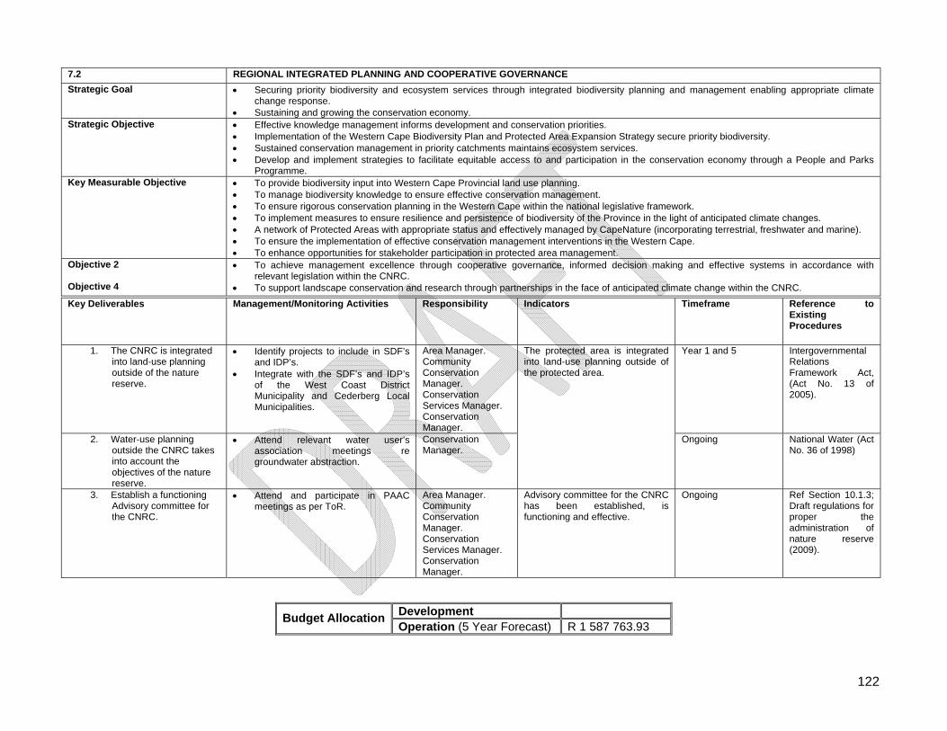
122
7.2 REGIONAL INTEGRATED PLANNING AND COOPERATIVE GOVERNANCE
Strategic Goal Securing priority biodiversity and ecosystem services through integrated biodiversity planning and management enabling appropriate climate change response.
Sustaining and growing the conservation economy. Strategic Objective Effective knowledge management informs development and conservation priorities.
Implementation of the Western Cape Biodiversity Plan and Protected Area Expansion Strategy secure priority biodiversity. Sustained conservation management in priority catchments maintains ecosystem services. Develop and implement strategies to facilitate equitable access to and participation in the conservation economy through a People and Parks
Programme. Key Measurable Objective To provide biodiversity input into Western Cape Provincial land use planning.
To manage biodiversity knowledge to ensure effective conservation management. To ensure rigorous conservation planning in the Western Cape within the national legislative framework. To implement measures to ensure resilience and persistence of biodiversity of the Province in the light of anticipated climate changes. A network of Protected Areas with appropriate status and effectively managed by CapeNature (incorporating terrestrial, freshwater and marine). To ensure the implementation of effective conservation management interventions in the Western Cape. To enhance opportunities for stakeholder participation in protected area management.
Objective 2 Objective 4
To achieve management excellence through cooperative governance, informed decision making and effective systems in accordance with relevant legislation within the CNRC.
To support landscape conservation and research through partnerships in the face of anticipated climate change within the CNRC.
Key Deliverables Management/Monitoring Activities Responsibility Indicators Timeframe Reference to Existing Procedures
1. The CNRC is integrated into land-use planning outside of the nature reserve.
Identify projects to include in SDF’s and IDP’s.
Integrate with the SDF’s and IDP’s of the West Coast District Municipality and Cederberg Local Municipalities.
Area Manager. Community Conservation Manager. Conservation Services Manager. Conservation Manager.
Year 1 and 5 Intergovernmental Relations Framework Act, (Act No. 13 of 2005).
2. Water-use planning outside the CNRC takes into account the objectives of the nature reserve.
Attend relevant water user’s association meetings re groundwater abstraction.
Conservation Manager.
The protected area is integrated into land-use planning outside of the protected area.
Ongoing National Water (Act No. 36 of 1998)
3. Establish a functioning Advisory committee for the CNRC.
Attend and participate in PAAC meetings as per ToR.
Area Manager. Community Conservation Manager. Conservation Services Manager. Conservation Manager.
Advisory committee for the CNRC has been established, is functioning and effective.
Ongoing Ref Section 10.1.3; Draft regulations for proper the administration of nature reserve (2009).
Development Budget Allocation
Operation (5 Year Forecast) R 1 587 763.93
123
7.3 Ecosystem and biodiversity management Conserving biodiversity is vital, not only in terms of its intrinsic values but because many economic activities are based on healthy and functioning natural ecosystems. Any use of natural resources must be sustainable and the conservation and management of biodiversity is essential for the maintenance of natural ecosystems.
7.3.1 Legislation Although all legislation mentioned in Part 1 can be applied, the following is specific to the conservation of biodiversity:
National Environmental Management Act, (Act No. 107 of 1998); National Environmental Management Biodiversity Act, (Act No. 10 of 2004); National Environmental Management: Protected Areas Act, (Act No. 57 of 2003); Conservation of Agricultural Resources Act, (Act No. 43 of 1983); Western Cape Nature Conservation Board Act, (Act No. 15 of 1998); Nature Conservation Ordinance, (Ordinance No. 19 of 1974); Threatened or Protected Species Regulations, 2007; Alien and Invasive Species Regulations, 2009 (still in draft form); CITES Regulations, 2009; Regulations for the proper administration of nature reserves, 2010 (still in draft form) in
terms of NEM: PAA; Norms and Standards for the compilation of Biodiversity Management Plans for
Species (BMP-s) in terms of. NEM: BA; Norms and Standards for the management of protected areas in South Africa (still in
draft form) in terms of NEM: PAA.
7.3.2 Guiding Principles
Biodiversity resources must be conserved at community and species levels in the long term and the reduction of population levels of individual species, or the extinction of any species, as a result of human activity, must be prevented;
Adequate management attention must be given to maintaining and improving, where relevant, the status of endemic, rare or threatened species (species of conservation concern);
The unintentional introduction into the reserve of all plants or plant materials must be controlled;
An active adaptive management, minimum intervention approach, based on scientific evidence will be followed;
The quantity, quality and reliability of water required to maintain the ecological functions on which humans depend shall be reserved so that the human use of water does not individually or cumulatively compromise the long term sustainability of aquatic and associated ecosystems;
Water quality and quantity are interdependent and shall be managed in an integrated manner, which is consistent with broader environmental management approaches;
124
Water quality management options shall include the use of economic initiatives and penalties to reduce pollution; and the possibility of irretrievable environmental degradation as a result of pollution shall be prevented;
Water resource development and supply activities shall be managed in a manner which is consistent with the broader national approaches to environmental management;
Water management issues must be integrated into local catchment management authorities’ activities;
The knowledge base available to the reserve will be promoted and developed to support applied and other research;
Research cooperation and collaboration partnership will be established and maintained;
All research carried out on CapeNature reserves require permits.
7.3.3 Threats to Biodiversity and Ecosystems
Loss of habitat and fragmentation; Increased competition of indigenous biota with invasive alien fauna and flora for
resources; Unplanned and uncontrolled fires; Increased surface water abstraction from the catchment; Poaching/illegal harvesting; Raptors threatened by poisoning and electrocution; Negative impacts from uncontrolled tourist activities.
7.3.4 Management Actions Refer to Table 7.3.
125
7.3 ECOSYSTEM AND BIODIVERSITY MANAGEMENT
Strategic Goal Securing priority biodiversity and ecosystem services through integrated biodiversity planning and management enabling appropriate climate change response.
Strategic Objective Effective knowledge management informs development and conservation priorities. Implementation of the Western Cape Biodiversity Plan and Protected Area Expansion Strategy secure priority biodiversity. Sustained conservation management in priority catchments maintains ecosystem services. Legal and wildlife support services and biodiversity crime prevention result in the protection and sustainable use of biodiversity.
Key Measurable Objective To provide biodiversity input into Western Cape Provincial land use planning. To manage biodiversity knowledge to ensure effective conservation management. To ensure rigorous conservation planning in the Western Cape within the national legislative framework. To implement measures to ensure resilience and persistence of biodiversity of the Province in the light of anticipated climate changes. A network of Protected Areas with appropriate status and effectively managed by CapeNature (incorporating terrestrial, freshwater and
marine). To ensure the implementation of effective conservation management interventions in the Western Cape. To enhance biodiversity protection and conservation in areas outside the formal CapeNature Protected Area Network.
Objective 1 Objective 2 Objective 3 Objective 4
To conserve the unique biodiversity of the Fynbos and Succulent Karoo Biomes that support ecological pattern and process within the CNRC. To achieve management excellence through cooperative governance, informed decision making and effective systems in accordance with
relevant legislation within the CNRC. To conserve and promote the cultural, historical, and geological heritage of the CNRC. To support landscape conservation and research through partnerships in the face of anticipated climate change within the CNRC.
Key Deliverables Management/Monitoring Activities Responsibility Indicators Timeframe Reference to Existing Procedures
1. Compile an Ecological Plan of Operation and Ecological Matrices for CNRC.
Compile an Ecological Plan of Operations to support the Ecological Matrices.
Collate all relevant monitoring and research protocols and data sheets to inform the Ecological Plan of Operations.
Develop approved Ecological Matrices for the CNRC.
Conservation Manager. Ecological Co-Ordinator. Regional Ecologist.
Ongoing Ecological Plan of Operations Ecological Matrix
2. A biodiversity resource inventory for the CNRC is in place.
Prioritisation of projects for inclusion on the Ecological Matrices.
Implement the Ecological Matrices. Collect voucher specimens and
DNA samples (where relevant) for all fauna and flora in the CNRC and submit to Scientific Services. Maintain and develop herbaria for all plant species, especially species of conservation concern.
Analyse data, re-assess and implement adaptive management strategies.
Conservation Manager. Ecological Co-Ordinator. Regional Ecologist. Scientific Services
The CNRC will annually indicate an upward trend in the METT-SA score. 100% of actions identified in the integrated auditing system will be implemented.
Ongoing Baseline data collection and monitoring manual (2010). Ecological Plan of Operations.
126
Key Deliverables Management/Monitoring Activities Responsibility Indicators Timeframe Reference to Existing Procedures
3. A monitoring programme for the CNRC is being implemented.
Review monitoring protocols. Identify monitoring needs of the
CNRC in consultation with Scientific Services.
Establish indicators for monitoring. Implement monitoring activities as
per the Ecological Matrices. Report on monitoring activities as
per the Ecological Matrices. Analyse data, re-assess and
implement adaptive management strategies.
Implement relevant national monitoring initiatives as per Ecological Matrices.
Collection of climatic data in the CNRC as per the Ecological Matrices.
Conservation Manager. Ecological Co-Ordinator. Regional Ecologist.
Ongoing Baseline data collection and monitoring manual (2010). Ecological Plan of Operations.
4. A research programme for the CNRC is being implemented.
Identify research needs for the reserve.
Develop and implement an applied research programme for the reserve in consultation with Scientific Services.
Results of research projects are fed back to the management of the reserve.
Results are used to adapt management of the nature reserve where relevant.
Maintain existing research MoU’s. Provide support to researchers as
per Ecological Matrices and research permit conditions.
Conservation Manager. Ecological Co-Ordinator. Regional Ecologist. Scientific Services.
Ongoing Baseline data collection and monitoring manual (2010). Ecological Plan of Operations. Ecological Matrix
5. The CNRC contributes to the maintenance of ecosystem services.
Design and implement appropriate fire (Refer to Table 7.5) and alien invasive management (Refer to Table 7.6) programmes.
Conduct a trail, jeep-track and roads assessment as per ICM standards.
Compile maintenance schedule. Implement trail, jeep-track and
roads maintenance schedule. Close and rehabilitate inappropriate
trails, jeep-tracks and roads in accordance with assessment report.
Implement monitoring as per the Ecological Matrices.
Conservation Manager. Ecological Co-Ordinator. Regional Ecologist. Catchment Manager. Programme Manager: Fire. Programme Manager: AVM.
Ongoing ICM Standard Operating Procedures. Fire Management Policy.
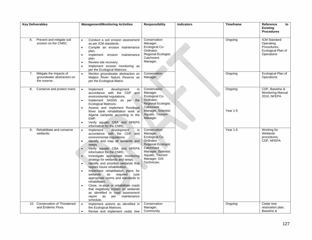
127
Key Deliverables Management/Monitoring Activities Responsibility Indicators Timeframe Reference to Existing Procedures
6. Prevent and mitigate soil erosion on the CNRC.
Conduct a soil erosion assessment as per ICM standards.
Compile an erosion maintenance plan.
Implement erosion maintenance plan.
Review site recovery. Implement erosion monitoring as
per the Ecological Matrices.
Conservation Manager. Ecological Co-Ordinator. Regional Ecologist. Catchment Manager.
Ongoing ICM Standard Operating Procedures, Ecological Plan of Operations
7. Mitigate the impacts of groundwater abstraction on the reserve.
Monitor groundwater abstraction on Matjies Rivier Nature Reserve as per the Ecological Matrix.
Conservation Manager.
Ongoing Ecological Plan of Operations
8. Conserve and protect rivers. Implement development in accordance with the CDF and environmental regulations.
Implement SASS5 as per the Ecological Matrices.
Assess and implement Rondegat River bank rehabilitation work at Algeria campsite according to the EMP.
Verify aquatic CBA and NFEPA information for the CNRC.
Conservation Manager. Ecological Co-Ordinator. Regional Ecologist. Catchment Manager, Scientist: Aquatic, Tourism Manager.
Ongoing Year 1-5
CDF, Baseline & Monitoring Manual 2010, NFEPA
9. Rehabilitate and conserve wetlands.
Implement development in accordance with the CDF and environmental regulations.
Identify and map all wetlands and seeps.
Verify aquatic CBA and NFEPA information for the CNRC.
Investigate appropriate monitoring strategy for wetlands and seeps.
Identify and prioritise wetlands that require future rehabilitation.
Implement rehabilitation plans for wetlands as required (use appropriate norms and standards to rehabilitate).
Close, re-align or rehabilitate roads that negatively impact on wetlands as identified in road assessment report as per maintenance schedule.
Conservation Manager. Ecological Co-Ordinator. Regional Ecologist. Catchment Manager, Scientist: Aquatic, Tourism Manager, GIS Technician.
Year 1-5 Working for Wetlands procedures, CDF, NFEPA
10. Conservation of Threatened and Endemic Flora.
Implement actions as identified in the Ecological Matrices.
Revise and implement cedar tree
Conservation Manager, Community
Ongoing Cedar tree restoration plan, Baseline &
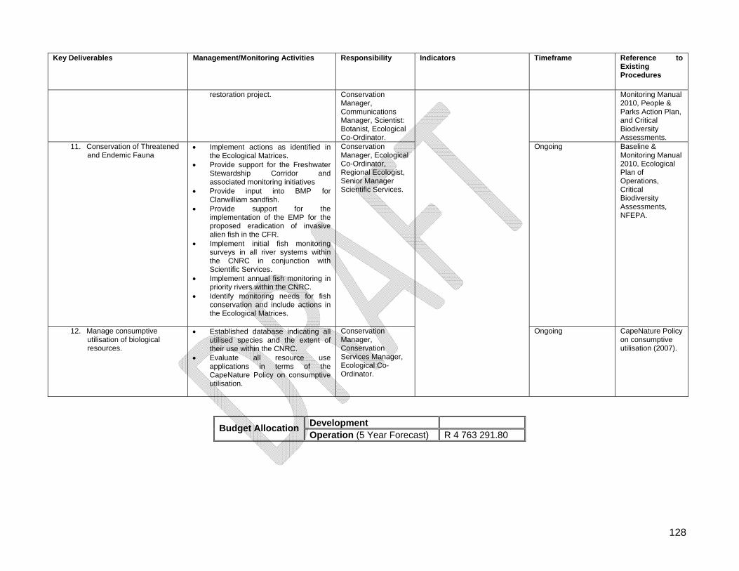
128
Key Deliverables Management/Monitoring Activities Responsibility Indicators Timeframe Reference to Existing Procedures
restoration project.
Conservation Manager, Communications Manager, Scientist: Botanist, Ecological Co-Ordinator.
Monitoring Manual 2010, People & Parks Action Plan, and Critical Biodiversity Assessments.
11. Conservation of Threatened and Endemic Fauna
Implement actions as identified in the Ecological Matrices.
Provide support for the Freshwater Stewardship Corridor and associated monitoring initiatives
Provide input into BMP for Clanwilliam sandfish.
Provide support for the implementation of the EMP for the proposed eradication of invasive alien fish in the CFR.
Implement initial fish monitoring surveys in all river systems within the CNRC in conjunction with Scientific Services.
Implement annual fish monitoring in priority rivers within the CNRC.
Identify monitoring needs for fish conservation and include actions in the Ecological Matrices.
Conservation Manager, Ecological Co-Ordinator, Regional Ecologist, Senior Manager Scientific Services.
Ongoing Baseline & Monitoring Manual 2010, Ecological Plan of Operations, Critical Biodiversity Assessments, NFEPA.
12. Manage consumptive utilisation of biological resources.
Established database indicating all utilised species and the extent of their use within the CNRC.
Evaluate all resource use applications in terms of the CapeNature Policy on consumptive utilisation.
Conservation Manager, Conservation Services Manager, Ecological Co-Ordinator.
Ongoing CapeNature Policy on consumptive utilisation (2007).
Development Budget Allocation
Operation (5 Year Forecast) R 4 763 291.80
129
7.4 Wildlife Management
7.4.1 Legislation
Western Cape Nature Conservation Ordinance, (Ordinance 19 of 1974); Regulations proclaimed in terms of the Ordinance, Provincial Notice 955 of 1975.
7.4.2 Guiding Principles
Biodiversity resources of the reserve must be protected from illegal harvesting and unsustainable use;
Re-Introduction of species to the reserve is only considered if a species occurred historically and suitable habitat is still available on the reserve. Genetics of source populations is also taken into consideration to prevent ‘contamination’;
Lethal control may be used as a management tool in certain instances. This should be professionally done through a tender process. Species must be selected only through extensive research and knowledge of population dynamics;
Damage causing wildlife/nuisance fauna shall be managed in a humane manner, through recommendation from CapeNature’s Wildlife Advisory Committee (WAC) and authorisation from CapeNature Executive.
7.4.3 Management Actions Refer to Table 7.4.
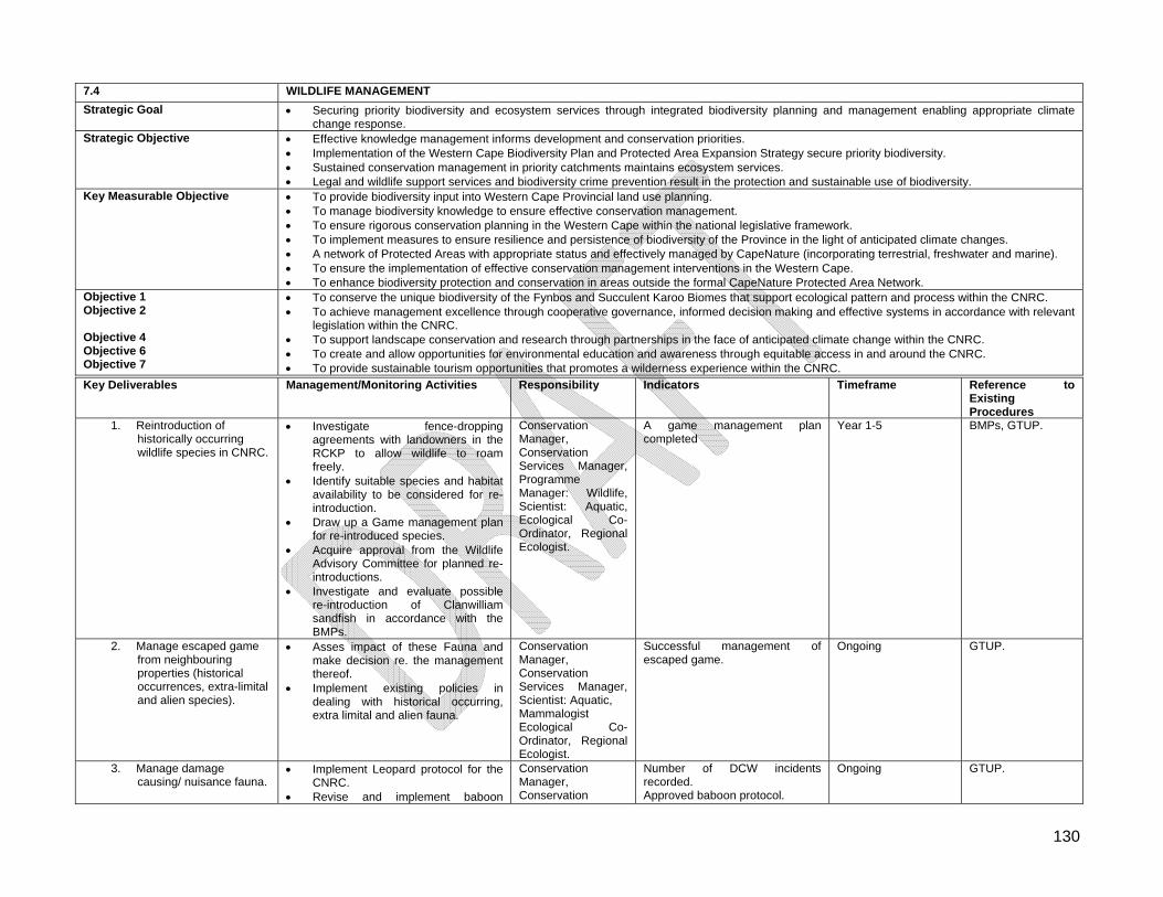
130
7.4 WILDLIFE MANAGEMENT
Strategic Goal Securing priority biodiversity and ecosystem services through integrated biodiversity planning and management enabling appropriate climate change response.
Strategic Objective Effective knowledge management informs development and conservation priorities. Implementation of the Western Cape Biodiversity Plan and Protected Area Expansion Strategy secure priority biodiversity. Sustained conservation management in priority catchments maintains ecosystem services. Legal and wildlife support services and biodiversity crime prevention result in the protection and sustainable use of biodiversity.
Key Measurable Objective To provide biodiversity input into Western Cape Provincial land use planning. To manage biodiversity knowledge to ensure effective conservation management. To ensure rigorous conservation planning in the Western Cape within the national legislative framework. To implement measures to ensure resilience and persistence of biodiversity of the Province in the light of anticipated climate changes. A network of Protected Areas with appropriate status and effectively managed by CapeNature (incorporating terrestrial, freshwater and marine). To ensure the implementation of effective conservation management interventions in the Western Cape. To enhance biodiversity protection and conservation in areas outside the formal CapeNature Protected Area Network.
Objective 1 Objective 2 Objective 4 Objective 6 Objective 7
To conserve the unique biodiversity of the Fynbos and Succulent Karoo Biomes that support ecological pattern and process within the CNRC. To achieve management excellence through cooperative governance, informed decision making and effective systems in accordance with relevant
legislation within the CNRC. To support landscape conservation and research through partnerships in the face of anticipated climate change within the CNRC. To create and allow opportunities for environmental education and awareness through equitable access in and around the CNRC. To provide sustainable tourism opportunities that promotes a wilderness experience within the CNRC.
Key Deliverables Management/Monitoring Activities Responsibility Indicators Timeframe Reference to Existing Procedures
1. Reintroduction of historically occurring wildlife species in CNRC.
Investigate fence-dropping agreements with landowners in the RCKP to allow wildlife to roam freely.
Identify suitable species and habitat availability to be considered for re-introduction.
Draw up a Game management plan for re-introduced species.
Acquire approval from the Wildlife Advisory Committee for planned re-introductions.
Investigate and evaluate possible re-introduction of Clanwilliam sandfish in accordance with the BMPs.
Conservation Manager, Conservation Services Manager, Programme Manager: Wildlife, Scientist: Aquatic, Ecological Co-Ordinator, Regional Ecologist.
A game management plan completed
Year 1-5 BMPs, GTUP.
2. Manage escaped game from neighbouring properties (historical occurrences, extra-limital and alien species).
Asses impact of these Fauna and make decision re. the management thereof.
Implement existing policies in dealing with historical occurring, extra limital and alien fauna.
Conservation Manager, Conservation Services Manager, Scientist: Aquatic, Mammalogist Ecological Co-Ordinator, Regional Ecologist.
Successful management of escaped game.
Ongoing GTUP.
3. Manage damage causing/ nuisance fauna.
Implement Leopard protocol for the CNRC.
Revise and implement baboon
Conservation Manager, Conservation
Number of DCW incidents recorded. Approved baboon protocol.
Ongoing GTUP.
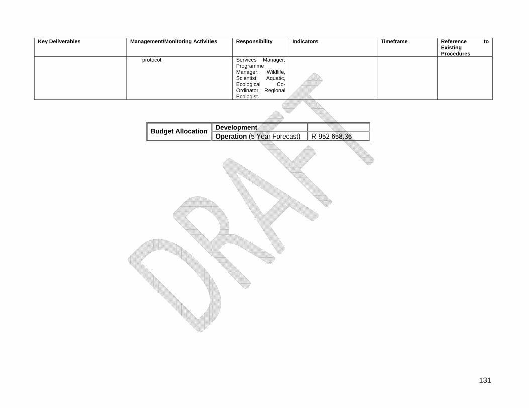
131
Key Deliverables Management/Monitoring Activities Responsibility Indicators Timeframe Reference to Existing Procedures
protocol.
Services Manager, Programme Manager: Wildlife, Scientist: Aquatic, Ecological Co-Ordinator, Regional Ecologist.
Development Budget Allocation
Operation (5 Year Forecast) R 952 658.36
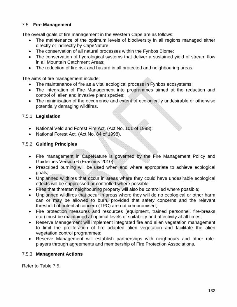
132
7.5 Fire Management The overall goals of fire management in the Western Cape are as follows:
The maintenance of the optimum levels of biodiversity in all regions managed either directly or indirectly by CapeNature;
The conservation of all natural processes within the Fynbos Biome; The conservation of hydrological systems that deliver a sustained yield of stream flow
in all Mountain Catchment Areas; The reduction of fire risk and hazard in all protected and neighbouring areas.
The aims of fire management include:
The maintenance of fire as a vital ecological process in Fynbos ecosystems; The integration of Fire Management into programmes aimed at the reduction and
control of alien and invasive plant species; The minimisation of the occurrence and extent of ecologically undesirable or otherwise
potentially damaging wildfires.
7.5.1 Legislation
National Veld and Forest Fire Act, (Act No. 101 of 1998); National Forest Act, (Act No. 84 of 1998).
7.5.2 Guiding Principles
Fire management in CapeNature is governed by the Fire Management Policy and Guidelines Version 6 (Erasmus 2010);
Prescribed burning will be used when and where appropriate to achieve ecological goals;
Unplanned wildfires that occur in areas where they could have undesirable ecological effects will be suppressed or controlled where possible;
Fires that threaten neighbouring property will also be controlled where possible; Unplanned wildfires that occur in areas where they will do no ecological or other harm
can or may be allowed to burn, provided that safety concerns and the relevant threshold of potential concern (TPC) are not compromised;
Fire protection measures and resources (equipment, trained personnel, fire-breaks etc.) must be maintained at optimal levels of suitability and affectivity at all times;
Reserve Management will implement integrated fire and alien vegetation management to limit the proliferation of fire adapted alien vegetation and facilitate the alien vegetation control programmes;
Reserve Management will establish partnerships with neighbours and other role-players through agreements and membership of Fire Protection Associations.
7.5.3 Management Actions Refer to Table 7.5.
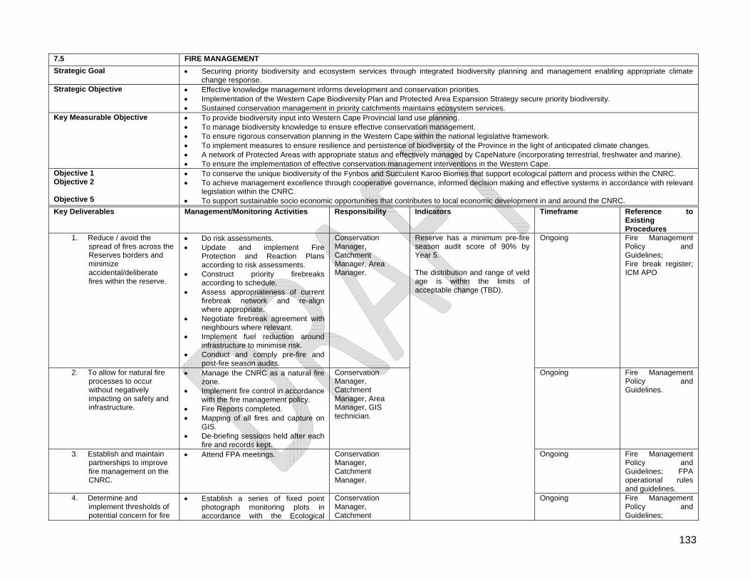
133
7.5 FIRE MANAGEMENT
Strategic Goal Securing priority biodiversity and ecosystem services through integrated biodiversity planning and management enabling appropriate climate change response.
Strategic Objective Effective knowledge management informs development and conservation priorities. Implementation of the Western Cape Biodiversity Plan and Protected Area Expansion Strategy secure priority biodiversity. Sustained conservation management in priority catchments maintains ecosystem services.
Key Measurable Objective To provide biodiversity input into Western Cape Provincial land use planning. To manage biodiversity knowledge to ensure effective conservation management. To ensure rigorous conservation planning in the Western Cape within the national legislative framework. To implement measures to ensure resilience and persistence of biodiversity of the Province in the light of anticipated climate changes. A network of Protected Areas with appropriate status and effectively managed by CapeNature (incorporating terrestrial, freshwater and marine). To ensure the implementation of effective conservation management interventions in the Western Cape.
Objective 1 Objective 2 Objective 5
To conserve the unique biodiversity of the Fynbos and Succulent Karoo Biomes that support ecological pattern and process within the CNRC. To achieve management excellence through cooperative governance, informed decision making and effective systems in accordance with relevant
legislation within the CNRC. To support sustainable socio economic opportunities that contributes to local economic development in and around the CNRC.
Key Deliverables Management/Monitoring Activities Responsibility Indicators Timeframe Reference to Existing Procedures
1. Reduce / avoid the spread of fires across the Reserves borders and minimize accidental/deliberate fires within the reserve.
Do risk assessments. Update and implement Fire
Protection and Reaction Plans according to risk assessments.
Construct priority firebreaks according to schedule.
Assess appropriateness of current firebreak network and re-align where appropriate.
Negotiate firebreak agreement with neighbours where relevant.
Implement fuel reduction around infrastructure to minimise risk.
Conduct and comply pre-fire and post-fire season audits.
Conservation Manager, Catchment Manager, Area Manager.
Ongoing Fire Management Policy and Guidelines; Fire break register; ICM APO
2. To allow for natural fire processes to occur without negatively impacting on safety and infrastructure.
Manage the CNRC as a natural fire zone.
Implement fire control in accordance with the fire management policy.
Fire Reports completed. Mapping of all fires and capture on
GIS. De-briefing sessions held after each
fire and records kept.
Conservation Manager, Catchment Manager, Area Manager, GIS technician.
Ongoing Fire Management Policy and Guidelines.
3. Establish and maintain partnerships to improve fire management on the CNRC.
Attend FPA meetings. Conservation Manager, Catchment Manager.
Ongoing Fire Management Policy and Guidelines; FPA operational rules and guidelines.
4. Determine and implement thresholds of potential concern for fire
Establish a series of fixed point photograph monitoring plots in accordance with the Ecological
Conservation Manager, Catchment
Reserve has a minimum pre-fire season audit score of 90% by Year 5. The distribution and range of veld age is within the limits of acceptable change (TBD).
Ongoing Fire Management Policy and Guidelines;
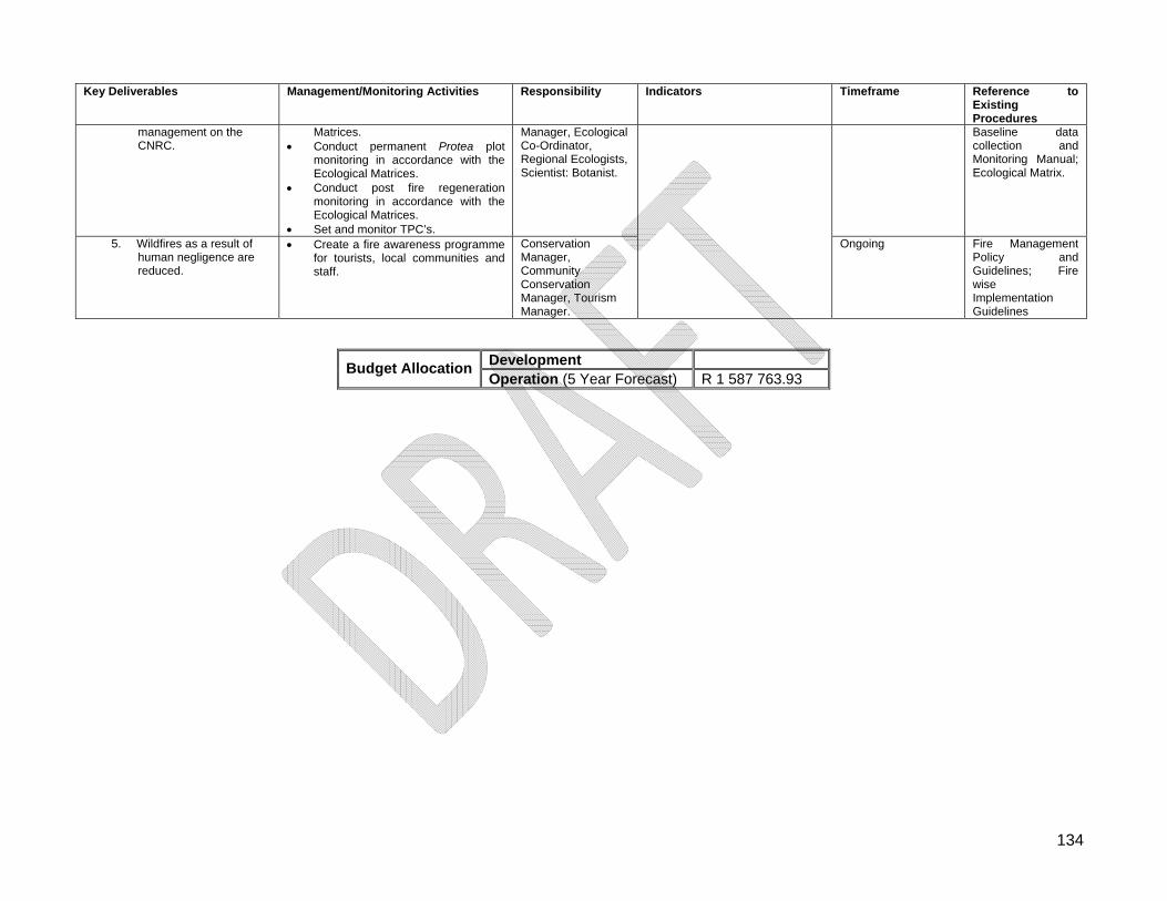
134
Key Deliverables Management/Monitoring Activities Responsibility Indicators Timeframe Reference to Existing Procedures
management on the CNRC.
Matrices. Conduct permanent Protea plot
monitoring in accordance with the Ecological Matrices.
Conduct post fire regeneration monitoring in accordance with the Ecological Matrices.
Set and monitor TPC’s.
Manager, Ecological Co-Ordinator, Regional Ecologists, Scientist: Botanist.
Baseline data collection and Monitoring Manual; Ecological Matrix.
5. Wildfires as a result of human negligence are reduced.
Create a fire awareness programme for tourists, local communities and staff.
Conservation Manager, Community Conservation Manager, Tourism Manager.
Ongoing Fire Management Policy and Guidelines; Fire wise Implementation Guidelines
Development Budget Allocation
Operation (5 Year Forecast) R 1 587 763.93
135
7.6 Invasive and Non-invasive Alien Species Management
7.6.1 Legislation Although most legislation mentioned in Section 2.1 can be applied, the following is specific to the eradication of alien and invasive species:
Section 64 to 77 of the National Environmental Management: Biodiversity Act, (Act No. 10 of 2004);
Conservation of Agricultural Resources Act, (Act No. 43 of 1983): Amendments published in the Government Gazette Vol. 429, No 22166 of 30 March 2001.
It must be noted that Section 77 of the National Environmental Management: Biodiversity Act, (Act No. 10 of 2004) states the following:
The management authority of a protected area must at regular intervals prepare and submit to the Minister or the MEC for Environmental Affairs in the Province a report on the status of any listed invasive species that occurs in that area.
A status report must include:
a detailed list and description of all listed invasive species that occur in the protected area;
a detailed description of the parts of the area that are infested with listed invasive species;
an assessment of the extent of such infestation; a report on the efficacy of previous control and eradication measures.
7.6.2 Guiding Principles
Maintain the integrity of local species biodiversity by prohibiting and, as far as possible, preventing the introduction of alien and invasive species;
Discourage the keeping of domestic animals within and from entering the Reserve from surrounding areas. Removal of alien and invasive species must be performed in a cost-effective manner.
7.6.3 Management Actions Refer to Table 7.6.
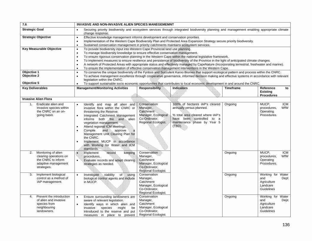
136
7.6 INVASIVE AND NON-INVASIVE ALIEN SPECIES MANEGEMEMNT
Strategic Goal Securing priority biodiversity and ecosystem services through integrated biodiversity planning and management enabling appropriate climate change response.
Strategic Objective Effective knowledge management informs development and conservation priorities. Implementation of the Western Cape Biodiversity Plan and Protected Area Expansion Strategy secure priority biodiversity. Sustained conservation management in priority catchments maintains ecosystem services.
Key Measurable Objective To provide biodiversity input into Western Cape Provincial land use planning. To manage biodiversity knowledge to ensure effective conservation management. To ensure rigorous conservation planning in the Western Cape within the national legislative framework. To implement measures to ensure resilience and persistence of biodiversity of the Province in the light of anticipated climate changes. A network of Protected Areas with appropriate status and effectively managed by CapeNature (incorporating terrestrial, freshwater and marine). To ensure the implementation of effective conservation management interventions in the Western Cape.
Objective 1 Objective 2 Objective 5
To conserve the unique biodiversity of the Fynbos and Succulent Karoo Biomes that support ecological pattern and process within the CNRC. To achieve management excellence through cooperative governance, informed decision making and effective systems in accordance with relevant
legislation within the CNRC. To support sustainable socio economic opportunities that contributes to local economic development in and around the CNRC.
Key Deliverables Management/Monitoring Activities Responsibility Indicators Timeframe Reference to Existing Procedures
Invasive Alien Flora
1. Eradicate alien and invasive species within the CNRC on an on-going basis.
Identify and map all alien and invasive flora within the CNRC or threatening the Reserve.
Integrated Catchment Management informs both fire and alien vegetation management.
Attend regional ICM Meetings. Compile and approve a
Management Unit Clearing Plan for the CNRC.
Implement MUCP in accordance with Working for Water and ICM standards.
Conservation Manager, Catchment Manager, Ecological Co-Ordinator, Regional Ecologist.
Ongoing MUCP, ICM procedures, WfW Operating Procedures.
2. Monitoring of alien clearing operations on the CNRC to inform adaptive management strategies.
Implement record keeping procedures.
Evaluate records and adapt clearing strategies as needed.
Conservation Manager, Catchment Manager, Ecological Co-Ordinator, Regional Ecologist.
Ongoing MUCP, ICM procedures, WfW Operating Procedures.
3. Implement biological control as a method of IAP management.
Investigate viability of using biological control agents and include in MUCP.
Conservation Manager, Catchment Manager, Ecological Co-Ordinator, Regional Ecologist.
Ongoing Working for Water and Dept Agriculture Landcare Guidelines
4. Prevent the introduction of alien and invasive species from neighbouring landowners.
Ensure surrounding landowners are aware of relevant legislation.
Identify ways in which alien and invasive species might be introduced to the reserve and put measures in place to prevent
Conservation Manager, Catchment Manager, Ecological Co-Ordinator, Regional Ecologist.
100% of hectares IAP's cleared annually versus planned. % total area cleared where IAP’s have been controlled to a maintenance phase by Year 5 (TBD).
Ongoing Working for Water and Dept Agriculture Landcare Guidelines
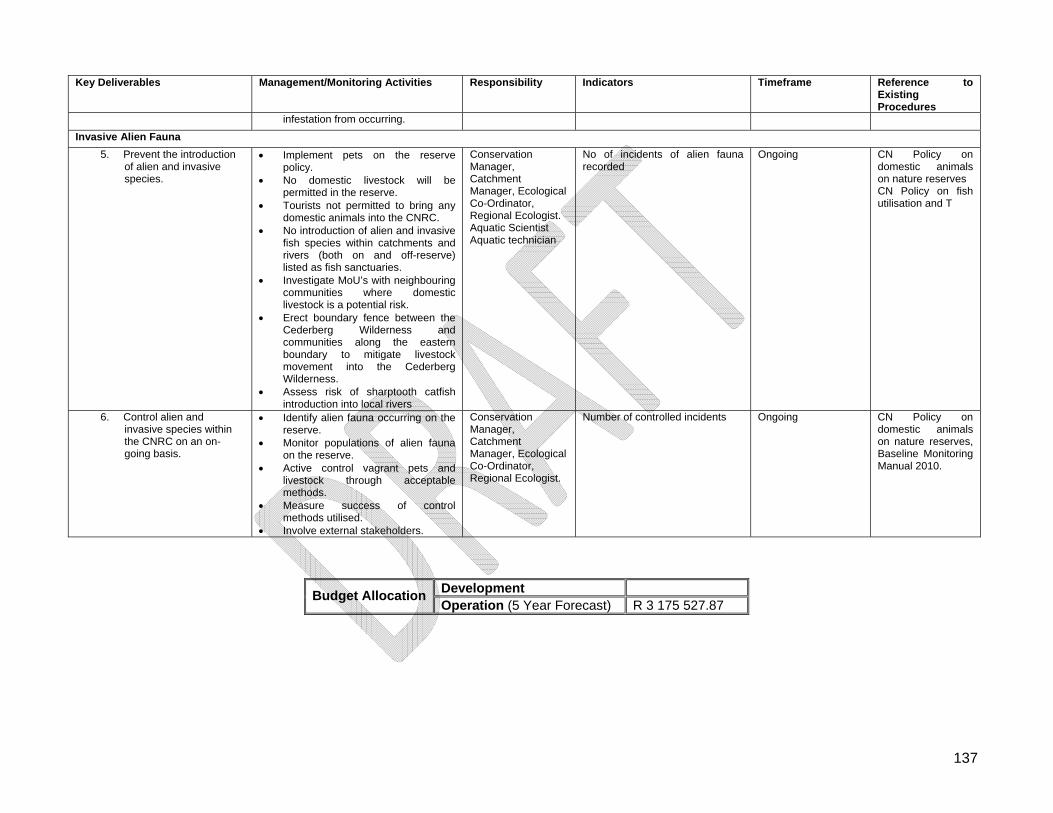
137
Key Deliverables Management/Monitoring Activities Responsibility Indicators Timeframe Reference to Existing Procedures
infestation from occurring.
Invasive Alien Fauna
5. Prevent the introduction of alien and invasive species.
Implement pets on the reserve policy.
No domestic livestock will be permitted in the reserve.
Tourists not permitted to bring any domestic animals into the CNRC.
No introduction of alien and invasive fish species within catchments and rivers (both on and off-reserve) listed as fish sanctuaries.
Investigate MoU’s with neighbouring communities where domestic livestock is a potential risk.
Erect boundary fence between the Cederberg Wilderness and communities along the eastern boundary to mitigate livestock movement into the Cederberg Wilderness.
Assess risk of sharptooth catfish introduction into local rivers
Conservation Manager, Catchment Manager, Ecological Co-Ordinator, Regional Ecologist. Aquatic Scientist Aquatic technician
No of incidents of alien fauna recorded
Ongoing CN Policy on domestic animals on nature reserves CN Policy on fish utilisation and T
6. Control alien and invasive species within the CNRC on an on-going basis.
Identify alien fauna occurring on the reserve.
Monitor populations of alien fauna on the reserve.
Active control vagrant pets and livestock through acceptable methods.
Measure success of control methods utilised.
Involve external stakeholders.
Conservation Manager, Catchment Manager, Ecological Co-Ordinator, Regional Ecologist.
Number of controlled incidents Ongoing CN Policy on domestic animals on nature reserves, Baseline Monitoring Manual 2010.
Development Budget Allocation
Operation (5 Year Forecast) R 3 175 527.87
138
7.7 Cultural Heritage Resource Management
7.7.1 Legislation
National Heritage Resource Act, (Act No. 25 of 1999) which has repealed the National Monuments Act, (Act No. 28 of 1969);
World Heritage Convention Act, (Act No. 49 of 1999).
7.7.2 Guiding Principles
Reserve Management will seek to respect, protect and promote the natural and cultural heritage resources of the reserve;
Cultural Heritage referred to in the Management Plan includes cultural, historical, archaeological and paleontological resources.
7.7.3 Management Actions Refer to Table 7.7.
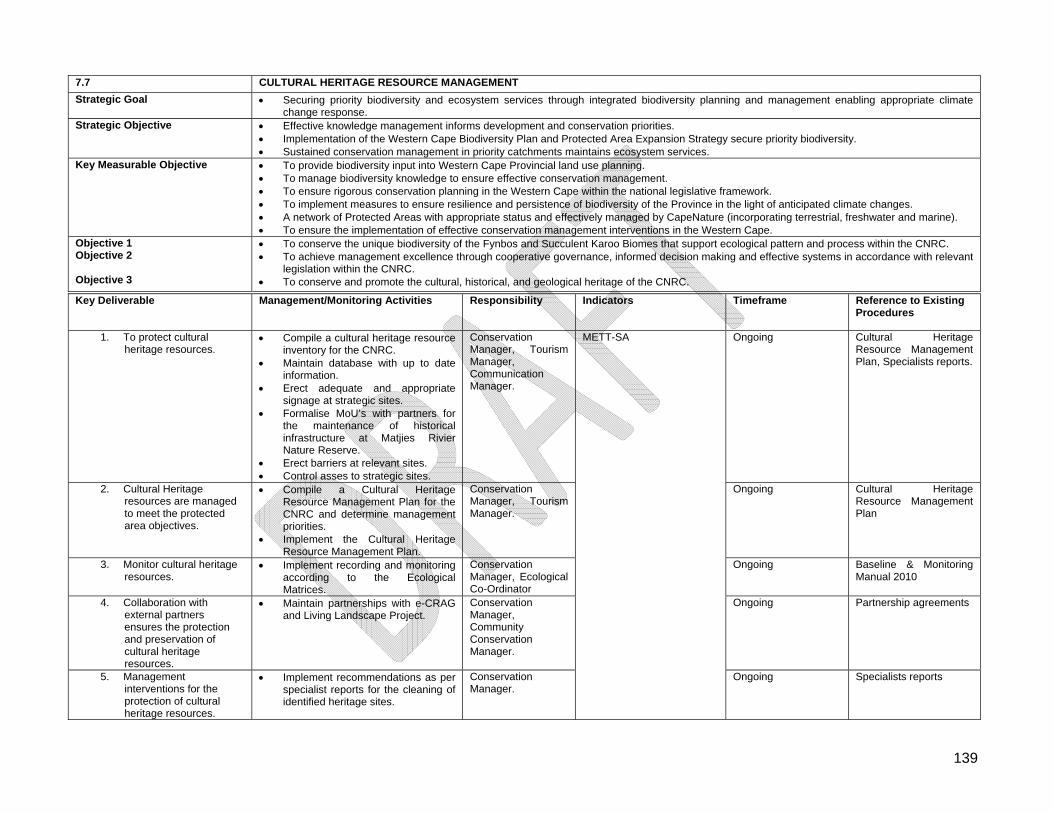
139
7.7 CULTURAL HERITAGE RESOURCE MANAGEMENT
Strategic Goal Securing priority biodiversity and ecosystem services through integrated biodiversity planning and management enabling appropriate climate change response.
Strategic Objective Effective knowledge management informs development and conservation priorities. Implementation of the Western Cape Biodiversity Plan and Protected Area Expansion Strategy secure priority biodiversity. Sustained conservation management in priority catchments maintains ecosystem services.
Key Measurable Objective To provide biodiversity input into Western Cape Provincial land use planning. To manage biodiversity knowledge to ensure effective conservation management. To ensure rigorous conservation planning in the Western Cape within the national legislative framework. To implement measures to ensure resilience and persistence of biodiversity of the Province in the light of anticipated climate changes. A network of Protected Areas with appropriate status and effectively managed by CapeNature (incorporating terrestrial, freshwater and marine). To ensure the implementation of effective conservation management interventions in the Western Cape.
Objective 1 Objective 2 Objective 3
To conserve the unique biodiversity of the Fynbos and Succulent Karoo Biomes that support ecological pattern and process within the CNRC. To achieve management excellence through cooperative governance, informed decision making and effective systems in accordance with relevant
legislation within the CNRC. To conserve and promote the cultural, historical, and geological heritage of the CNRC.
Key Deliverable Management/Monitoring Activities Responsibility Indicators Timeframe Reference to Existing Procedures
1. To protect cultural heritage resources.
Compile a cultural heritage resource inventory for the CNRC.
Maintain database with up to date information.
Erect adequate and appropriate signage at strategic sites.
Formalise MoU’s with partners for the maintenance of historical infrastructure at Matjies Rivier Nature Reserve.
Erect barriers at relevant sites. Control asses to strategic sites.
Conservation Manager, Tourism Manager, Communication Manager.
Ongoing Cultural Heritage Resource Management Plan, Specialists reports.
2. Cultural Heritage resources are managed to meet the protected area objectives.
Compile a Cultural Heritage Resource Management Plan for the CNRC and determine management priorities.
Implement the Cultural Heritage Resource Management Plan.
Conservation Manager, Tourism Manager.
Ongoing Cultural Heritage Resource Management Plan
3. Monitor cultural heritage resources.
Implement recording and monitoring according to the Ecological Matrices.
Conservation Manager, Ecological Co-Ordinator
Ongoing Baseline & Monitoring Manual 2010
4. Collaboration with external partners ensures the protection and preservation of cultural heritage resources.
Maintain partnerships with e-CRAG and Living Landscape Project.
Conservation Manager, Community Conservation Manager.
Ongoing Partnership agreements
5. Management interventions for the protection of cultural heritage resources.
Implement recommendations as per specialist reports for the cleaning of identified heritage sites.
Conservation Manager.
METT-SA
Ongoing Specialists reports
140
Development Budget Allocation
Operation (5 Year Forecast) R 1 587 763.93

141
7.8 Law Enforcement and Compliance
7.8.1 Legislation
National Environmental Management Act, (Act No. 107 of 1998); National Environmental Management: Protected Areas Act, (Act No. 57 of 2003); National Environmental Management: Biodiversity Act, (Act No. 10 of 2004); Threatened or Protected Species (ToPS) Regulations, 2007; Western Cape Nature Conservation Ordinance, (Ordinance 19 of 1974); Regulations proclaimed in terms of the Ordinance, Provincial Notice 955 of 1975; Proclamation 357 of 1972, Fish and Rivers Regulations.
Also the provisions of the Bill of Rights detailed in Chapter 2 in the Constitution, No. 108 of 1996, as well as the provisions of the Criminal Procedure Act, (Act No. 51 of 1977), are also important when performing law enforcement actions.
7.8.2 Guiding Principals
Reserve Management and personnel will ensure that all law enforcement actions are executed in a Fair, Reasonable and Objective manner, with due respect for Human Rights and in accordance with applicable Law;
Reserve Management and personnel will identify and prioritise sensitive areas and species and prioritise law enforcement patrols accordingly, in order to ensure that resources are allocated in the most efficient and effective manner;
Reserve Management and personnel will partner with local law enforcement role-players, such as SAPS, local authorities and Oceans and Coasts, in order to effectively utilise resources to combat biodiversity crime within the protected area;
Reserve Management will liaise with adjacent communities, in conjunction with relevant components, in order to identify and prioritise areas of natural and cultural heritage significance, in order to effectively manage impacts and to prevent illegal activities in these areas.
7.8.3 Management Actions Refer to Table 7.8
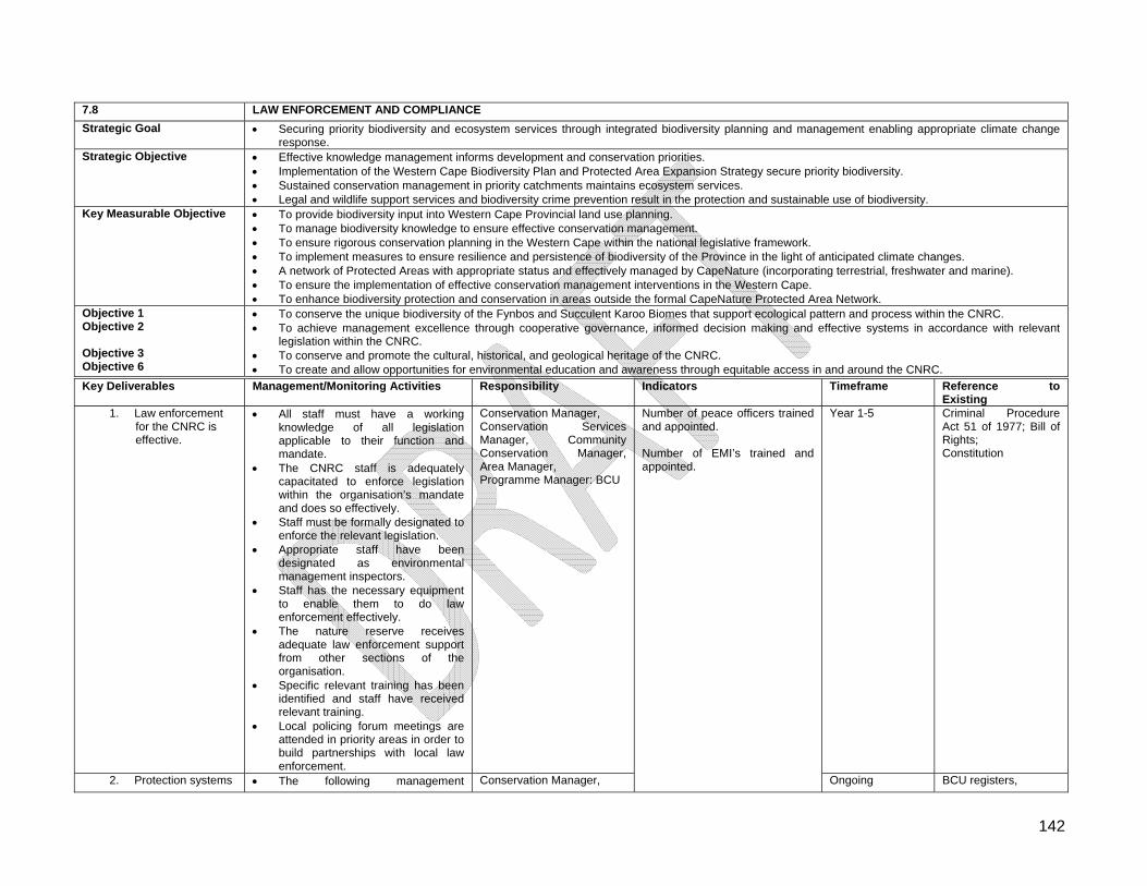
142
7.8 LAW ENFORCEMENT AND COMPLIANCE
Strategic Goal Securing priority biodiversity and ecosystem services through integrated biodiversity planning and management enabling appropriate climate change response.
Strategic Objective Effective knowledge management informs development and conservation priorities. Implementation of the Western Cape Biodiversity Plan and Protected Area Expansion Strategy secure priority biodiversity. Sustained conservation management in priority catchments maintains ecosystem services. Legal and wildlife support services and biodiversity crime prevention result in the protection and sustainable use of biodiversity.
Key Measurable Objective To provide biodiversity input into Western Cape Provincial land use planning. To manage biodiversity knowledge to ensure effective conservation management. To ensure rigorous conservation planning in the Western Cape within the national legislative framework. To implement measures to ensure resilience and persistence of biodiversity of the Province in the light of anticipated climate changes. A network of Protected Areas with appropriate status and effectively managed by CapeNature (incorporating terrestrial, freshwater and marine). To ensure the implementation of effective conservation management interventions in the Western Cape. To enhance biodiversity protection and conservation in areas outside the formal CapeNature Protected Area Network.
Objective 1 Objective 2 Objective 3 Objective 6
To conserve the unique biodiversity of the Fynbos and Succulent Karoo Biomes that support ecological pattern and process within the CNRC. To achieve management excellence through cooperative governance, informed decision making and effective systems in accordance with relevant
legislation within the CNRC. To conserve and promote the cultural, historical, and geological heritage of the CNRC. To create and allow opportunities for environmental education and awareness through equitable access in and around the CNRC.
Key Deliverables Management/Monitoring Activities Responsibility Indicators Timeframe Reference to Existing
1. Law enforcement for the CNRC is effective.
All staff must have a working knowledge of all legislation applicable to their function and mandate.
The CNRC staff is adequately capacitated to enforce legislation within the organisation’s mandate and does so effectively.
Staff must be formally designated to enforce the relevant legislation.
Appropriate staff have been designated as environmental management inspectors.
Staff has the necessary equipment to enable them to do law enforcement effectively.
The nature reserve receives adequate law enforcement support from other sections of the organisation.
Specific relevant training has been identified and staff have received relevant training.
Local policing forum meetings are attended in priority areas in order to build partnerships with local law enforcement.
Conservation Manager, Conservation Services Manager, Community Conservation Manager, Area Manager, Programme Manager: BCU
Year 1-5 Criminal Procedure Act 51 of 1977; Bill of Rights; Constitution
2. Protection systems The following management Conservation Manager,
Number of peace officers trained and appointed. Number of EMI’s trained and appointed.
Ongoing BCU registers,
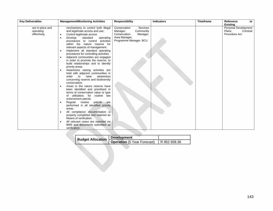
143
Key Deliverables Management/Monitoring Activities Responsibility Indicators Timeframe Reference to Existing
are in place and operating effectively.
mechanisms to control both illegal and legitimate access and use:
Control legitimate access Develop standard operating
procedures to control activities within the nature reserve for relevant aspects of management.
Implement all standard operating procedures for controlling activities.
Adjacent communities are engaged in order to promote the reserve, to build relationships and to identify priority areas.
Awareness raising activities are held with adjacent communities in order to raise awareness concerning reserve and biodiversity conservation.
Areas in the nature reserve have been identified and prioritised in terms of conservation value or type of utilisation, for routine law enforcement patrols.
Regular routine patrols are performed in all identified priority areas.
All compliance documentation is properly completed and retained as Means of verification.
All relevant cases are reported via BMS and documents submitted as verification.
Conservation Services Manager, Community Conservation Manager, Area Manager, Programme Manager: BCU
Personal Development Plans, Criminal Procedure Act.
Development
Budget AllocationOperation (5 Year Forecast) R 952 658.36
144
7.9 Infrastructure Management
7.9.1 Legislation
Occupational Health and Safety Act, (Act No 85 of 1993); Water Services Act, (Act No.108 of 1997); National Water Act, (Act No. 36 of 1998); Constitution of the Republic of South Africa (1996); According to the Constitution of the Republic of South Africa (1996), responsibility for
waste management functions is to be devolved to the lowest possible level of government;
Water Services Act, (Act No. of 1997); The management of sewage sludge is currently regulated by this Act; National Environmental Management Act, (Act No. 107 of 1998) (NEMA); NEMA increases the ambit of people who can be held responsible for pollution damage
from not only any person, company or government department causing pollution, to any person, company or department owning, using or controlling the land on which the problem exists - even if the pollution causing activity was authorised by law;
White Paper on Integrated Pollution and Waste Management, 1998; White Paper on the Energy Policy of the Republic of South Africa (approved by
Cabinet on 2 December 1998).
7.9.2 Guiding Principles
Infrastructure management includes the planning, construction, maintenance, replacement, control and monitoring of all fixed structures, equipment and other moveable assets;
Reserve management will strive to improve systems so as to reduce costs and negative impacts on the physical environment;
Ensure that future developments within the Reserve are socially, environmentally and economically sustainable;
Reserve Management will strive to phase out all French drains, pit latrines and other sewerage disposal systems on the reserve;
Environmental management includes waste, dumping sites, potable water, water systems, sewage systems and herbicide and fuel stores.
7.9.3 Infrastructure Maintenance
7.9.3.1 Roads/Jeep Tracks Roads within the Cederberg Nature Reserve Complex are mostly gravel and are accessible by all vehicles. These are public roads that are used by tourist to access the CNRC. Maintenance of these roads fall under the Provincial and District Road Authorities. Jeep tracks are exclusively used for management purposes and are only accessible by 4x4 vehicles. Due to the high risk of soil erosion the grading of jeep tracks within the CNRC is not allowed. Regular assessments and maintenance work is conducted as part of ICM.
145
7.9.3.2 Trails Cederberg Nature Reserve Complex has a network of day and overnight hiking trails providing access for hikers to the remote mountainous areas and other popular tourist sites. Trails are vulnerable to erosion due to steep slopes and sandy substrate. Some of the day trails to popular geological features carry high tourist traffic and require regular maintenance. Maintenance is conducted as part of ICM.
7.9.3.3 Buildings Maintenance and repairs of buildings are prioritised and included on the schedule of Department of Public Works. Minor maintenance and repairs to buildings are identified and attended to by management.
7.9.3.4 Fences In the Matjies Rivier Nature Reserve all internal fences have been removed. Boundary fences shared with properties where game has been reintroduced are intact and are being maintained by the relevant landowners. Tourism management barriers are in place at tourist sites to control access. The Cederberg Wilderness remains largely unfenced and occasionally this results in tourism, operational or ecological problems. The maintenance of the eastern boundary fence has been prioritised to prevent nuisance animals from entering the wilderness. Tourism management barriers have been placed at a number of popular tourist sites to restrict unauthorised access. The Hexberg State Forest is currently unfenced, or where fences exist they are in a state of disrepair.
7.9.3.5 Environmental Management No waste disposal sites are available within the CNRC and all waste is removed off the reserve and disposed of at the municipal refuse site in Clanwilliam. Matjies Rivier Nature Reserve participates in the Cederberg Conservancy recycling project. The Algeria office and camp complex is currently initiating a recycling project. Potable water is abstracted from the Matjies river for use at Matjies Rivier Nature Reserve. At the Algeria complex, water is piped out of Helsekloof River and Duiwelsgat for tourism and management use. The Kliphuis management centre receives its water from a spring located on the southern slope of the Pakhuisberg.
146
7.9.3.6 High Sites Currently only Protea Peak above Algeria is registered as a high site. The site is used as a radio repeater site by CapeNature.
7.9.3.7 Signage Sign boards are located at all major vehicle and hiking entrance points to the Cederberg Wilderness, however no signage is located within the Wilderness area itself. At Matjies Rivier Nature Reserve, sign boards are located at the three entrances to the reserve, the two popular tourism sites (Stadsaal Cave and Truitjieskraal), and at the reserve centre. An interpretation board is located at the Elephant Rock Art site to provide information to visitors about the archaeology of the area. At Stadsaal Cave, interpretation signage provides information regarding the geology of the Cederberg as well as the historic significance of the graffiti found in the cave.
7.9.4 Management Actions Refer to Table 7.9.
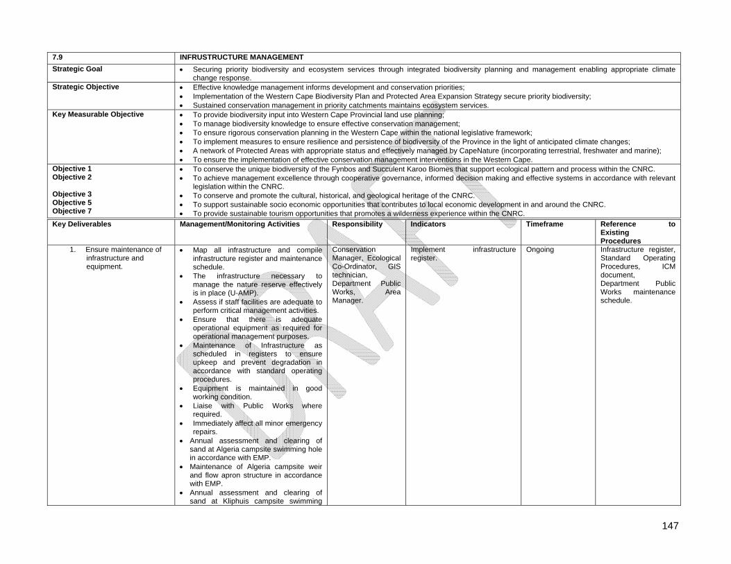
147
7.9 INFRUSTRUCTURE MANAGEMENT
Strategic Goal Securing priority biodiversity and ecosystem services through integrated biodiversity planning and management enabling appropriate climate change response.
Strategic Objective Effective knowledge management informs development and conservation priorities; Implementation of the Western Cape Biodiversity Plan and Protected Area Expansion Strategy secure priority biodiversity; Sustained conservation management in priority catchments maintains ecosystem services.
Key Measurable Objective To provide biodiversity input into Western Cape Provincial land use planning; To manage biodiversity knowledge to ensure effective conservation management; To ensure rigorous conservation planning in the Western Cape within the national legislative framework; To implement measures to ensure resilience and persistence of biodiversity of the Province in the light of anticipated climate changes; A network of Protected Areas with appropriate status and effectively managed by CapeNature (incorporating terrestrial, freshwater and marine); To ensure the implementation of effective conservation management interventions in the Western Cape.
Objective 1 Objective 2 Objective 3 Objective 5 Objective 7
To conserve the unique biodiversity of the Fynbos and Succulent Karoo Biomes that support ecological pattern and process within the CNRC. To achieve management excellence through cooperative governance, informed decision making and effective systems in accordance with relevant
legislation within the CNRC. To conserve and promote the cultural, historical, and geological heritage of the CNRC. To support sustainable socio economic opportunities that contributes to local economic development in and around the CNRC. To provide sustainable tourism opportunities that promotes a wilderness experience within the CNRC.
Key Deliverables Management/Monitoring Activities Responsibility Indicators Timeframe Reference to Existing Procedures
1. Ensure maintenance of infrastructure and equipment.
Map all infrastructure and compile infrastructure register and maintenance schedule.
The infrastructure necessary to manage the nature reserve effectively is in place (U-AMP).
Assess if staff facilities are adequate to perform critical management activities.
Ensure that there is adequate operational equipment as required for operational management purposes.
Maintenance of Infrastructure as scheduled in registers to ensure upkeep and prevent degradation in accordance with standard operating procedures.
Equipment is maintained in good working condition.
Liaise with Public Works where required.
Immediately affect all minor emergency repairs.
Annual assessment and clearing of sand at Algeria campsite swimming hole in accordance with EMP.
Maintenance of Algeria campsite weir and flow apron structure in accordance with EMP.
Annual assessment and clearing of sand at Kliphuis campsite swimming
Conservation Manager, Ecological Co-Ordinator, GIS technician, Department Public Works, Area Manager.
Implement infrastructure register.
Ongoing Infrastructure register, Standard Operating Procedures, ICM document, Department Public Works maintenance schedule.
148
Key Deliverables Management/Monitoring Activities Responsibility Indicators Timeframe Reference to Existing Procedures
hole in accordance with EMP. Annual assessment and clearing of
flood debris from Bosherberge bridge in accordance with EMP.
Annual assessment and clearing of sand and reeds from the low water bridge across the Matjies and Krom River confluence in accordance with EMP.
2. Align all infrastructure to the conservation development framework and zonation.
Assess infrastructure development appropriateness to the CDF.
Compile a re-alignment plan. Implement the re-alignment plan.
Conservation Manager, Conservation Planner, Area Manager, Tourism Manager, Regional Ecologist, Ecological Co-Ordinator.
Approved re-alignment plan. Ongoing CDF, EIA Regulations.
3. Roads/Jeep Tracks and Trails are managed to minimise impact on the environment.
Conduct annual assessment of roads, Jeep tracks and trails in the CNRC.
Implement maintenance schedule as part of the ICM APO.
Re -align road network and align with the CDF where required.
Rehabilitate where necessary. Burrow pits mapped, assessed and
rehabilitated (where required). Monitor use and impact of borrow pits. Monitor cost effectiveness of
infrastructure maintenance.
Conservation Manager, Catchment Manager, Ecological Co-Ordinator,
ICM schedule implemented Ongoing ICM Procedures.
4. Buildings are effectively maintained.
Implement maintenance schedule. Maintain thatch roofs according to
maintenance schedule. Provide Department of Public Works
with works list to reflect maintenance requirements.
Maintenance or new infrastructure is appropriately planned (EMP), approved by the QEM and if required the Appropriate EIA completed.
Conservation Manager, Department of Public Works, Tourism Manager.
Infrastructure maintenance schedule.
Ongoing Infrastructure register, Department Public Works maintenance schedule.
5. Maintain fences according to legislative requirements.
Conduct ongoing fence monitoring and assessment.
Implement fence maintenance schedule.
Erect boundary fence between the Cederberg Wilderness and communities along the eastern boundary to mitigate livestock movement into the Cederberg
Conservation Manager
Infrastructure maintenance schedule.
Ongoing Infrastructure register.
149
Key Deliverables Management/Monitoring Activities Responsibility Indicators Timeframe Reference to Existing Procedures
Wilderness.
6. Environmental Management: Waste Disposal
Implement the Cederberg Conservancy recycling project at Matjies Rivier Nature Reserve.
Implement recycling program at Cederberg Wilderness.
Install baboon-proof bin at strategic visitor sites.
Maintenance of storage bins as scheduled in registers to ensure upkeep and prevent pollution.
Conservation Manager, Tourism Manager.
Infrastructure maintenance schedule.
Ongoing Cederberg Conservancy Project Plan. Infrastructure register.
7. Environmental Management: Water
Maintenance of water reticulation as scheduled in registers to ensure upkeep and prevent degradation.
Schedule regular inspections. Ensure environmentally sound options
are being implemented by Department of Public Works by introducing water saving technologies in old and new infrastructure (Green Building principals).
Conservation Manager, Tourism Manager.
Infrastructure maintenance schedule.
Ongoing Infrastructure register.
8. Environmental Management: Sewage
Install effective environmentally friendly sewage facilities in collaboration with Department of Public Works.
Install self-composting toilets at strategic visitor sites.
Department of Public Works
Infrastructure maintenance schedule.
Ongoing Infrastructure register.
9. Environmental Management: Energy
Ensure environmentally sound options are being implemented by Department of Public Works by introducing energy saving and renewable technologies in old and new infrastructure (Green Building principals).
Department of Public Works
Infrastructure maintenance schedule.
Ongoing Infrastructure register.
10. Environmental Management: Herbicide, gas and Fuel Stores
Maintain fuel and herbicide registers. Store hazardous materials according to
regulations.
Conservation Managers
Integrated audit system. Ongoing Infrastructure register.
11. Management of High Sites.
Map all High sites (with photos). Conservation Managers
All site mapped. Year 1 Infrastructure register.
12. Signage is appropriate and effective to support management.
Conduct a signage audit. Compile a signage register with
maintenance plan.
Conservation Managers, Tourism Manager
Audit report and completed register.
Year 1 Ongoing
Infrastructure register.
Development Budget Allocation
Operation (5 Year Forecast) R 3 175 527.87
150
7.10 Disaster Management
7.10.1 Legislation
Disaster Management Act, (Act No. 57 of 2002); Occupational Health and Safety Act, (Act No. 85 of 1993).
7.10.2 Guiding Principles
The first priority of disaster management is the protection of the people who are most at risk. The second priority is the protection of the critical resources and systems on which communities depend;
Disaster prevention and preparedness should be an integral part of every development policy;
Disaster assistance must be provided in an equitable, consistent and predictable manner in association with the Local and Provincial authorities;
Communities, with the assistance from the Local and Provincial tiers of government and Reserve Management, must know what disaster management and risk reduction stand for, what their own responsibilities are, how they can help prevent disasters, how they must react during a disaster (and why) and what they can do to support themselves and relief workers, when necessary.
7.10.3 Management Actions Refer to Table 7.10.
151
7.10 DISASTER MANAGEMENT
Strategic Goal Securing priority biodiversity and ecosystem services through integrated biodiversity planning and management enabling appropriate climate change response.
Strategic Objective Effective knowledge management informs development and conservation priorities; Implementation of the Western Cape Biodiversity Plan and Protected Area Expansion Strategy secure priority biodiversity; Sustained conservation management in priority catchments maintains ecosystem services.
Key Measurable Objective To provide biodiversity input into Western Cape Provincial land use planning; To manage biodiversity knowledge to ensure effective conservation management; To ensure rigorous conservation planning in the Western Cape within the national legislative framework; To implement measures to ensure resilience and persistence of biodiversity of the Province in the light of anticipated climate changes; A network of Protected Areas with appropriate status and effectively managed by CapeNature (incorporating terrestrial, freshwater and marine); To ensure the implementation of effective conservation management interventions in the Western Cape.
Objective 1 Objective 2
To conserve the unique biodiversity of the Fynbos and Succulent Karoo Biomes that support ecological pattern and process within the CNRC. To achieve management excellence through cooperative governance, informed decision making and effective systems in accordance with relevant
legislation within the CNRC.
Key Deliverables Management/Monitoring Activities Responsibility Indicators Timeframe Reference to Existing P d1. Disaster prevention and
preparedness Conduct a risk assessment and identify
areas of potential concern. Compile and implement disaster
management plan for CNRC in accordance with relevant legislation.
Engage with disaster management units from municipalities.
Conduct an annual audit of disaster management plans and mitigation measure readiness.
Annual review and exercise of contingency and evacuation plans.
Conservation Manager, Chief Risk Officer, Catchment Manager
Ongoing Fire Management Policy, H&S Policy, Provincial Disaster Plan.
2. Disaster response. Train staff and NGOs to ensure capacity to manage and mitigate the effects of disasters.
Procure equipment for disaster response and mitigation.
Participate and assist district municipality disaster management structure.
Activate evacuation and contingency plans.
Conservation Manager, Chief Risk Officer, Catchment Manager
Approved Contingency Plans
Ongoing Fire Management Policy, H&S Policy, Provincial Disaster Plan.
Development Budget Allocation
Operation (5 Year Forecast) R 1 270 211.15
152
7.11 People and Conservation
7.11.1 Community Partnerships The long term success of the CNRC is dependent on developing a constructive, mutually beneficial relationship between the Reserve and communities resident adjacent to the Reserve. Various projects and programmes that enhance the relationship between the Reserve and the neighbouring communities are currently in progress. Expansion in partnerships with the surrounding communities of the CNRC is essential for the success of the Reserve.
7.11.2 Guiding Principles
The CNRC contribution to the local and regional economy must be recognised and therefore will be seen as an important vehicle through which rural development and transformation is achieved;
Promote the strong sense of ownership and empowerment amongst resident people and communities and ensure a strong supporting institutional base;
The right to equality, a healthy environment and the right to information are to be guaranteed;
Co-operative governance should take place between citizens and between different government departments;
Benefits from biodiversity are to be fairly shared and the benefit flows to people in and around protected areas improved;
The capacity of neighbouring communities should be developed in order to participate in protected area management;
Equitable accessibility by all people to the Reserve is to be ensured; Community based initiatives and partnerships shall promote and support economic and
employment opportunities, particularly for local disadvantaged persons and communities.
7.11.3 Management Actions Refer to Table 7.11.
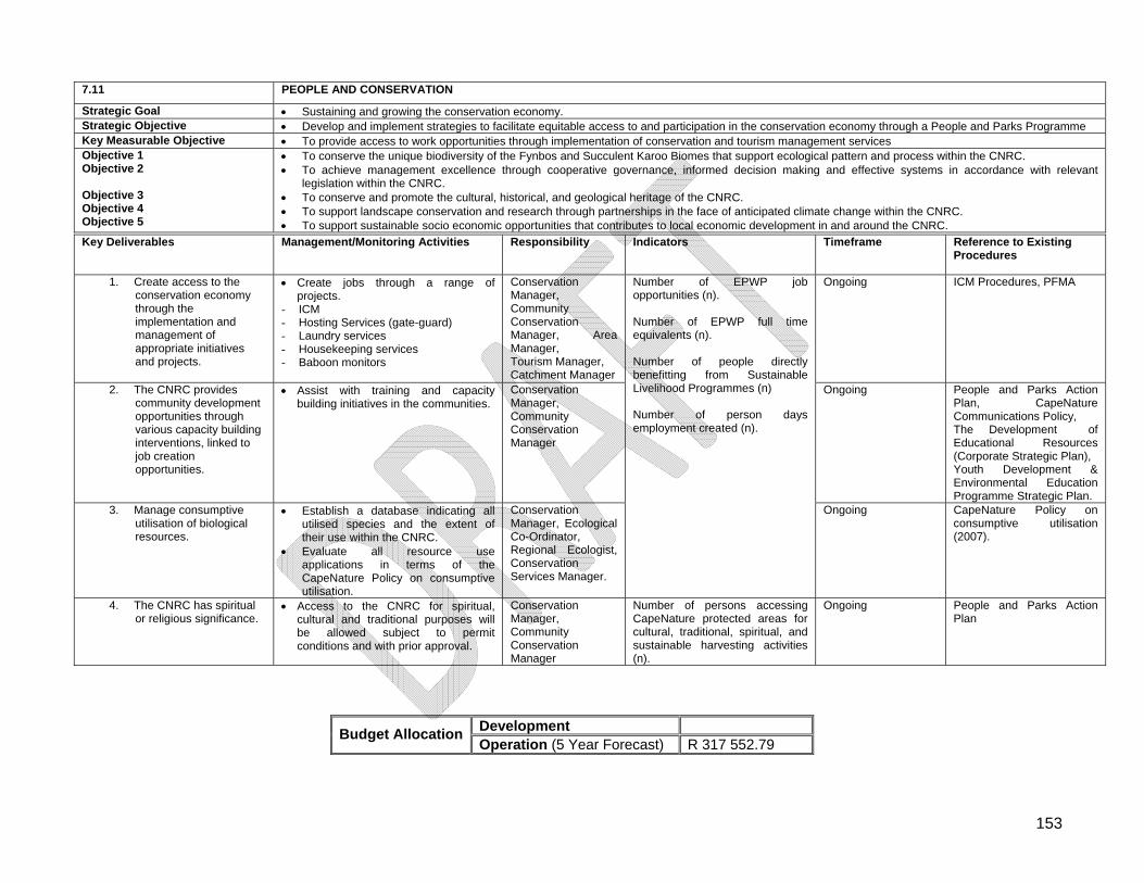
153
7.11 PEOPLE AND CONSERVATION
Strategic Goal Sustaining and growing the conservation economy. Strategic Objective Develop and implement strategies to facilitate equitable access to and participation in the conservation economy through a People and Parks Programme Key Measurable Objective To provide access to work opportunities through implementation of conservation and tourism management services Objective 1 Objective 2 Objective 3 Objective 4 Objective 5
To conserve the unique biodiversity of the Fynbos and Succulent Karoo Biomes that support ecological pattern and process within the CNRC. To achieve management excellence through cooperative governance, informed decision making and effective systems in accordance with relevant
legislation within the CNRC. To conserve and promote the cultural, historical, and geological heritage of the CNRC. To support landscape conservation and research through partnerships in the face of anticipated climate change within the CNRC. To support sustainable socio economic opportunities that contributes to local economic development in and around the CNRC.
Key Deliverables Management/Monitoring Activities Responsibility Indicators Timeframe Reference to Existing Procedures
1. Create access to the conservation economy through the implementation and management of appropriate initiatives and projects.
Create jobs through a range of projects.
- ICM - Hosting Services (gate-guard) - Laundry services - Housekeeping services - Baboon monitors
Conservation Manager, Community Conservation Manager, Area Manager, Tourism Manager, Catchment Manager
Ongoing ICM Procedures, PFMA
2. The CNRC provides community development opportunities through various capacity building interventions, linked to job creation opportunities.
Assist with training and capacity building initiatives in the communities.
Conservation Manager, Community Conservation Manager
Ongoing People and Parks Action Plan, CapeNature Communications Policy, The Development of Educational Resources (Corporate Strategic Plan), Youth Development & Environmental Education Programme Strategic Plan.
3. Manage consumptive utilisation of biological resources.
Establish a database indicating all utilised species and the extent of their use within the CNRC.
Evaluate all resource use applications in terms of the CapeNature Policy on consumptive utilisation.
Conservation Manager, Ecological Co-Ordinator, Regional Ecologist, Conservation Services Manager.
Number of EPWP job opportunities (n). Number of EPWP full time equivalents (n). Number of people directly benefitting from Sustainable Livelihood Programmes (n) Number of person days employment created (n).
Ongoing CapeNature Policy on consumptive utilisation (2007).
4. The CNRC has spiritual or religious significance.
Access to the CNRC for spiritual, cultural and traditional purposes will be allowed subject to permit conditions and with prior approval.
Conservation Manager, Community Conservation Manager
Number of persons accessing CapeNature protected areas for cultural, traditional, spiritual, and sustainable harvesting activities (n).
Ongoing People and Parks Action Plan
Development Budget Allocation
Operation (5 Year Forecast) R 317 552.79
154
7.12 Awareness, Youth Development and Volunteers Environmental education should be actively encouraged especially in the context of developing knowledge in protected area management, especially for school children from the area. Where possible, partnerships should be established with role players and interested parties to ensure that this takes place. Facilitate youth and community development through environmental awareness and assist in developing the knowledge, skills, values and commitment necessary to achieve sustainable development.
7.12.1 Guiding Principles
Focus awareness on the protection of the natural environment and sustainable use of natural resources;
The image of CapeNature to be promoted among local communities, provincial and national politicians and the public;
Reserve Management shall develop an interpretive and educational programme, which will provide each visitor with an experience that is enjoyable and inspirational, within the context of the reserves tangible resources and the values they represent;
Reserve Management shall provide both on- and off-site interpretive presentations and media, which facilitate a connection between the interests of the visitor and the meanings of the Reserve;
Educational Programmes must align with the National School Curriculum; Opportunities to participate in National Environmental Initiatives such as Arbor Day,
Wetlands Day and Water Week should be taken where appropriate; Reserve Management will create an enabling environment that provides youth with
opportunities for learning/training, personal growth and healing; The CNRC seeks to create an environment which contributes directly to the growth
and development of responsible young citizens; Facilitate and promote the use of the natural environment for the development of
youth; Environmental education activities will be restricted to peripheral / appropriate zones
within the reserve; Promote the use of the CNRC as a place of self-discovery, personal growth, emotional
healing, formal learning and adventure; Volunteers are encouraged to contribute to projects on the reserve.
7.12.2 Management Actions Refer to Table 7.12.
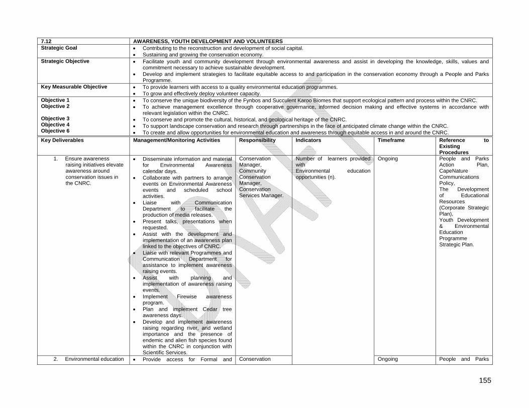
155
7.12 AWARENESS, YOUTH DEVELOPMENT AND VOLUNTEERS Strategic Goal Contributing to the reconstruction and development of social capital.
Sustaining and growing the conservation economy. Strategic Objective Facilitate youth and community development through environmental awareness and assist in developing the knowledge, skills, values and
commitment necessary to achieve sustainable development. Develop and implement strategies to facilitate equitable access to and participation in the conservation economy through a People and Parks
Programme. Key Measurable Objective To provide learners with access to a quality environmental education programmes.
To grow and effectively deploy volunteer capacity. Objective 1 Objective 2 Objective 3 Objective 4 Objective 6
To conserve the unique biodiversity of the Fynbos and Succulent Karoo Biomes that support ecological pattern and process within the CNRC. To achieve management excellence through cooperative governance, informed decision making and effective systems in accordance with
relevant legislation within the CNRC. To conserve and promote the cultural, historical, and geological heritage of the CNRC. To support landscape conservation and research through partnerships in the face of anticipated climate change within the CNRC. To create and allow opportunities for environmental education and awareness through equitable access in and around the CNRC.
Key Deliverables Management/Monitoring Activities Responsibility Indicators Timeframe Reference to Existing Procedures
1. Ensure awareness raising initiatives elevate awareness around conservation issues in the CNRC.
Disseminate information and material for Environmental Awareness calendar days.
Collaborate with partners to arrange events on Environmental Awareness events and scheduled school activities.
Liaise with Communication Department to facilitate the production of media releases.
Present talks, presentations when requested.
Assist with the development and implementation of an awareness plan linked to the objectives of CNRC.
Liaise with relevant Programmes and Communication Department for assistance to implement awareness raising events.
Assist with planning and implementation of awareness raising events.
Implement Firewise awareness program.
Plan and implement Cedar tree awareness days.
Develop and implement awareness raising regarding river, and wetland importance and the presence of endemic and alien fish species found within the CNRC in conjunction with Scientific Services.
Conservation Manager, Community Conservation Manager, Conservation Services Manager.
Ongoing People and Parks Action Plan, CapeNature Communications Policy, The Development of Educational Resources (Corporate Strategic Plan), Youth Development & Environmental Education Programme Strategic Plan.
2. Environmental education Provide access for Formal and Conservation
Number of learners provided with Environmental education opportunities (n).
Ongoing People and Parks
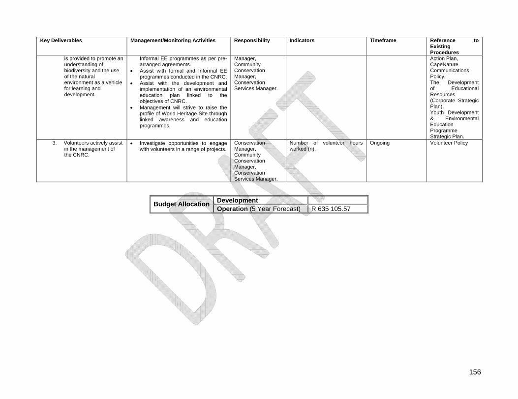
156
Key Deliverables Management/Monitoring Activities Responsibility Indicators Timeframe Reference to Existing Procedures
is provided to promote an understanding of biodiversity and the use of the natural environment as a vehicle for learning and development.
Informal EE programmes as per pre-arranged agreements.
Assist with formal and Informal EE programmes conducted in the CNRC.
Assist with the development and implementation of an environmental education plan linked to the objectives of CNRC.
Management will strive to raise the profile of World Heritage Site through linked awareness and education programmes.
Manager, Community Conservation Manager, Conservation Services Manager.
Action Plan, CapeNature Communications Policy, The Development of Educational Resources (Corporate Strategic Plan), Youth Development & Environmental Education Programme Strategic Plan.
3. Volunteers actively assist in the management of the CNRC.
Investigate opportunities to engage with volunteers in a range of projects.
Conservation Manager, Community Conservation Manager, Conservation Services Manager.
Number of volunteer hours worked (n).
Ongoing Volunteer Policy
Development Budget Allocation
Operation (5 Year Forecast) R 635 105.57
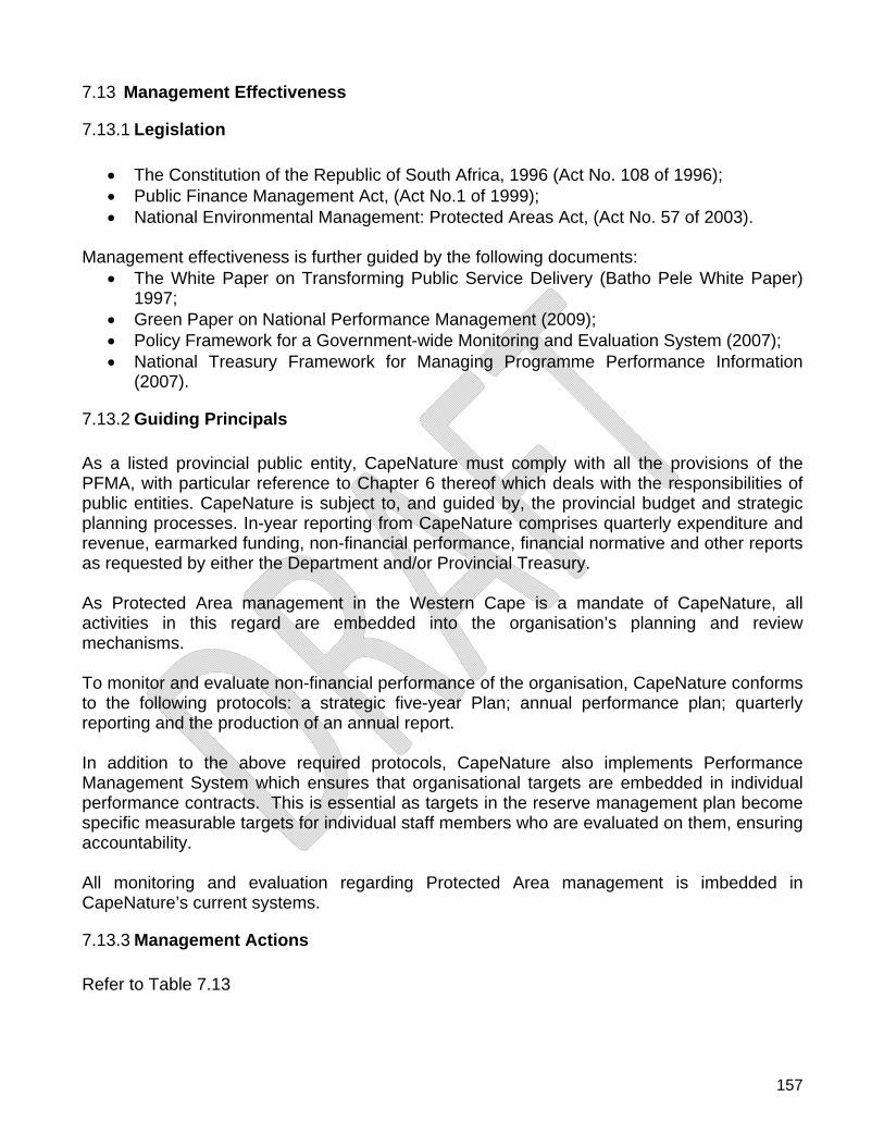
157
7.13 Management Effectiveness
7.13.1 Legislation
The Constitution of the Republic of South Africa, 1996 (Act No. 108 of 1996); Public Finance Management Act, (Act No.1 of 1999); National Environmental Management: Protected Areas Act, (Act No. 57 of 2003).
Management effectiveness is further guided by the following documents:
The White Paper on Transforming Public Service Delivery (Batho Pele White Paper) 1997;
Green Paper on National Performance Management (2009); Policy Framework for a Government-wide Monitoring and Evaluation System (2007); National Treasury Framework for Managing Programme Performance Information
(2007).
7.13.2 Guiding Principals As a listed provincial public entity, CapeNature must comply with all the provisions of the PFMA, with particular reference to Chapter 6 thereof which deals with the responsibilities of public entities. CapeNature is subject to, and guided by, the provincial budget and strategic planning processes. In-year reporting from CapeNature comprises quarterly expenditure and revenue, earmarked funding, non-financial performance, financial normative and other reports as requested by either the Department and/or Provincial Treasury. As Protected Area management in the Western Cape is a mandate of CapeNature, all activities in this regard are embedded into the organisation’s planning and review mechanisms. To monitor and evaluate non-financial performance of the organisation, CapeNature conforms to the following protocols: a strategic five-year Plan; annual performance plan; quarterly reporting and the production of an annual report. In addition to the above required protocols, CapeNature also implements Performance Management System which ensures that organisational targets are embedded in individual performance contracts. This is essential as targets in the reserve management plan become specific measurable targets for individual staff members who are evaluated on them, ensuring accountability. All monitoring and evaluation regarding Protected Area management is imbedded in CapeNature’s current systems.
7.13.3 Management Actions Refer to Table 7.13
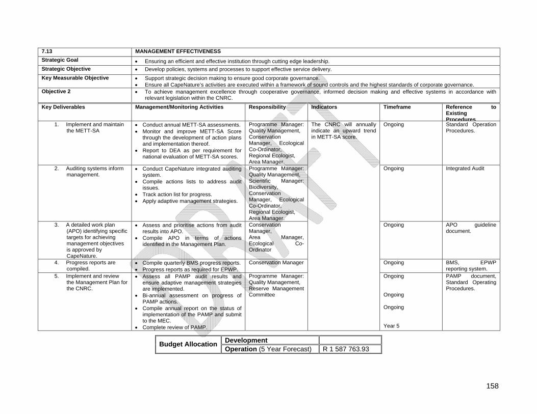
158
7.13 MANAGEMENT EFFECTIVENESS
Strategic Goal Ensuring an efficient and effective institution through cutting edge leadership.
Strategic Objective Develop policies, systems and processes to support effective service delivery.
Key Measurable Objective Support strategic decision making to ensure good corporate governance. Ensure all CapeNature’s activities are executed within a framework of sound controls and the highest standards of corporate governance.
Objective 2 To achieve management excellence through cooperative governance, informed decision making and effective systems in accordance with relevant legislation within the CNRC.
Key Deliverables Management/Monitoring Activities Responsibility Indicators Timeframe Reference to Existing Procedures
1. Implement and maintain the METT-SA
Conduct annual METT-SA assessments. Monitor and improve METT-SA Score
through the development of action plans and implementation thereof.
Report to DEA as per requirement for national evaluation of METT-SA scores.
Programme Manager: Quality Management, Conservation Manager, Ecological Co-Ordinator, Regional Ecologist, Area Manager.
Ongoing Standard Operation Procedures.
2. Auditing systems inform management.
Conduct CapeNature integrated auditing system.
Compile actions lists to address audit issues.
Track action list for progress. Apply adaptive management strategies.
Programme Manager: Quality Management, Scientific Manager: Biodiversity, Conservation Manager, Ecological Co-Ordinator, Regional Ecologist, Area Manager.
Ongoing Integrated Audit
3. A detailed work plan (APO) identifying specific targets for achieving management objectives is approved by CapeNature.
Assess and prioritise actions from audit results into APO.
Compile APO in terms of actions identified in the Management Plan.
Conservation Manager, Area Manager, Ecological Co-Ordinator
Ongoing APO guideline document.
4. Progress reports are compiled.
Compile quarterly BMS progress reports. Progress reports as required for EPWP.
Conservation Manager Ongoing BMS, EPWP reporting system.
5. Implement and review the Management Plan for the CNRC.
Assess all PAMP audit results and ensure adaptive management strategies are implemented.
Bi-annual assessment on progress of PAMP actions.
Compile annual report on the status of implementation of the PAMP and submit to the MEC.
Complete review of PAMP.
Programme Manager: Quality Management, Reserve Management Committee
The CNRC will annually indicate an upward trend in METT-SA score.
Ongoing Ongoing Ongoing Year 5
PAMP document, Standard Operating Procedures.
Development Budget Allocation
Operation (5 Year Forecast) R 1 587 763.93
159
7.14 Administration
7.14.1 Finance and Administration Management
7.14.1.1 Financial Sustainability Nature Reserves within South Africa are expected to provide a high level of internal and public accountability for the use of resources through the use of accounting systems. The Reserve will have to have the support of external funding from international and local authority sources over and above support received from the provincial body and the income it generates itself. Legislation
Public Finance Management Act, (Act No.1 of 1999).
7.14.1.2 Guiding Principles
Ensure that the Reserve continually seeks improvements in the management of its financial resources and operations;
Strive to develop a robust income base for the Reserve from diverse sources, while conserving the integrity of its ecological, cultural, and scenic resources;
Support initiatives aimed at increasing grant funding and donations to the Reserve; Assess opportunities for donor funding within the reserve, evaluate appropriate donor
funding organisations for projects, establish and manage contacts with such organisations and maintain relationships with potential and existing donor organisations;
Seek, and where possible create, opportunities for economic empowerment and the involvement of Small, Medium and Micro Enterprises (SMMEs) in developing public private partnerships in commercial activities;
Apply, and be subject to, sound and transparent financial policies and practices, and shall make available detailed information about its income, expenditure and budgets, as well as about the assumptions upon which such budgets are based;
Financial management will be within the parameters of the PFMA, Treasury regulations and internal policies of CapeNature e.g. Supply Chain Management, delegation of powers etc.;
Charge appropriate fees for the use of the reserve’s utilisable zones by tourists and operators.
7.14.1.3 Management Actions Refer to Table 7.14.1.
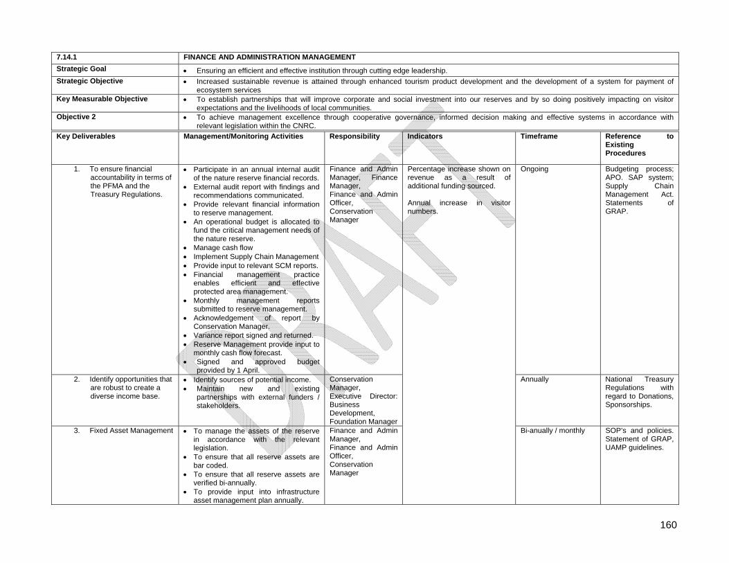
160
7.14.1 FINANCE AND ADMINISTRATION MANAGEMENT
Strategic Goal Ensuring an efficient and effective institution through cutting edge leadership.
Strategic Objective Increased sustainable revenue is attained through enhanced tourism product development and the development of a system for payment of ecosystem services
Key Measurable Objective To establish partnerships that will improve corporate and social investment into our reserves and by so doing positively impacting on visitor expectations and the livelihoods of local communities.
Objective 2 To achieve management excellence through cooperative governance, informed decision making and effective systems in accordance with relevant legislation within the CNRC.
Key Deliverables Management/Monitoring Activities Responsibility Indicators Timeframe Reference to Existing Procedures
1. To ensure financial accountability in terms of the PFMA and the Treasury Regulations.
Participate in an annual internal audit of the nature reserve financial records.
External audit report with findings and recommendations communicated.
Provide relevant financial information to reserve management.
An operational budget is allocated to fund the critical management needs of the nature reserve.
Manage cash flow Implement Supply Chain Management Provide input to relevant SCM reports. Financial management practice
enables efficient and effective protected area management.
Monthly management reports submitted to reserve management.
Acknowledgement of report by Conservation Manager.
Variance report signed and returned. Reserve Management provide input to
monthly cash flow forecast. Signed and approved budget
provided by 1 April.
Finance and Admin Manager, Finance Manager, Finance and Admin Officer, Conservation Manager
Ongoing Budgeting process; APO. SAP system; Supply Chain Management Act. Statements of GRAP.
2. Identify opportunities that are robust to create a diverse income base.
Identify sources of potential income. Maintain new and existing
partnerships with external funders / stakeholders.
Conservation Manager, Executive Director: Business Development, Foundation Manager
Annually National Treasury Regulations with regard to Donations, Sponsorships.
3. Fixed Asset Management To manage the assets of the reserve in accordance with the relevant legislation.
To ensure that all reserve assets are bar coded.
To ensure that all reserve assets are verified bi-annually.
To provide input into infrastructure asset management plan annually.
Finance and Admin Manager, Finance and Admin Officer, Conservation Manager
Percentage increase shown on revenue as a result of additional funding sourced. Annual increase in visitor numbers.
Bi-anually / monthly SOP’s and policies. Statement of GRAP, UAMP guidelines.
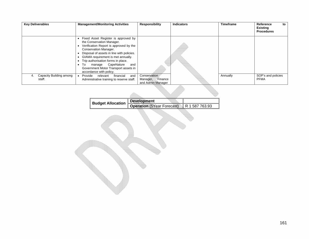
161
Key Deliverables Management/Monitoring Activities Responsibility Indicators Timeframe Reference to Existing Procedures
Fixed Asset Register is approved by the Conservation Manager.
Verification Report is approved by the Conservation Manager.
Disposal of assets in line with policies. GIAMA requirement is met annually. Trip authorisation forms in place. To manage CapeNature and
Government Motor Transport assets in accordance with policy.
4. Capacity Building among staff.
Provide relevant financial and Administrative training to reserve staff.
Conservation Manager, Finance and Admin Manager
Annually SOP’s and policies PFMA
Development Budget Allocation
Operation (5Year Forecast) R 1 587 763.93

162
7.14.2 Human Resource Management
7.14.2.1 Legislation Cape Nature’s Human Resources and Labour Relations Practices are primarily based on the following legislation:
The Constitution of the RSA, (1996); The Western Cape Nature Conservation Board Act, (Act No.15 of 1998); Labour Relations Act, (Act No. 66 of 1995); Basic Condition of Employment Act, (Act No. 75 of 1997); Employment Equity Act, (Act No 55 of 1998); Occupational Health and Safety Act, (Act No. 85 of 1993); Skills Development Act, (Act No. 97 of 1998); The Protected Disclosures Act, (Act No. 26 of 2000); The Promotion of Access to Information Act, (Act No. 2 of 2000); The Promotion of Administrative Justice Act, (Act No. 3 of 2000); Our policies are further shaped by the Public Service Act, (Act No 38 of 2008) and the
Regulations thereto, the collective agreements entered into in the public service bargaining chambers as well as the Public Finance Management Act, (Act No. 1 of 1999) and Treasury Regulations issued in terms thereof.
7.14.2.2 Guiding Principals (1) Cape Nature commits itself to the principles enshrined in the Labour Relations Act (Act No. 66 of 1995), these being:
(a) to give effect to the right to fair labour practices and those further rights enshrined in section 23 of the Constitution of the Republic of South Africa;
(b) to give effect to obligations incurred by the Republic as a member state of the International Labour Organisation;
(c) to provide a framework within which employees and their trade unions, employers and employers' organisations can- (i) collectively bargain to determine wages, terms and conditions of
employment and other matters of mutual interest; and (ii) formulate industrial policy.
(d) to promote- (i) orderly collective bargaining; (ii) collective bargaining at sectorial level; (iii) employee participation in decision-making in the workplace; and (iv) the effective resolution of labour disputes.
(2) Cape Nature will interact with its employees or its representatives in a manner which fosters transparent, respectful and harmonious working relationships between management and employees.
(3) Cape Nature is an equal opportunities employer that is committed to using its recruitment and selection processes to address, in a fair manner, all workplace injustices caused by Apartheid policies.
163
(4) We are committed to growing our human capital by providing appropriate training and development initiatives for our employees.
(5) We are further committed to maximising career-pathing to ensure that employees are constantly growing and that the workplace remains challenging and stimulating.
7.14.2.3 Management Actions See Table 7.14.2.
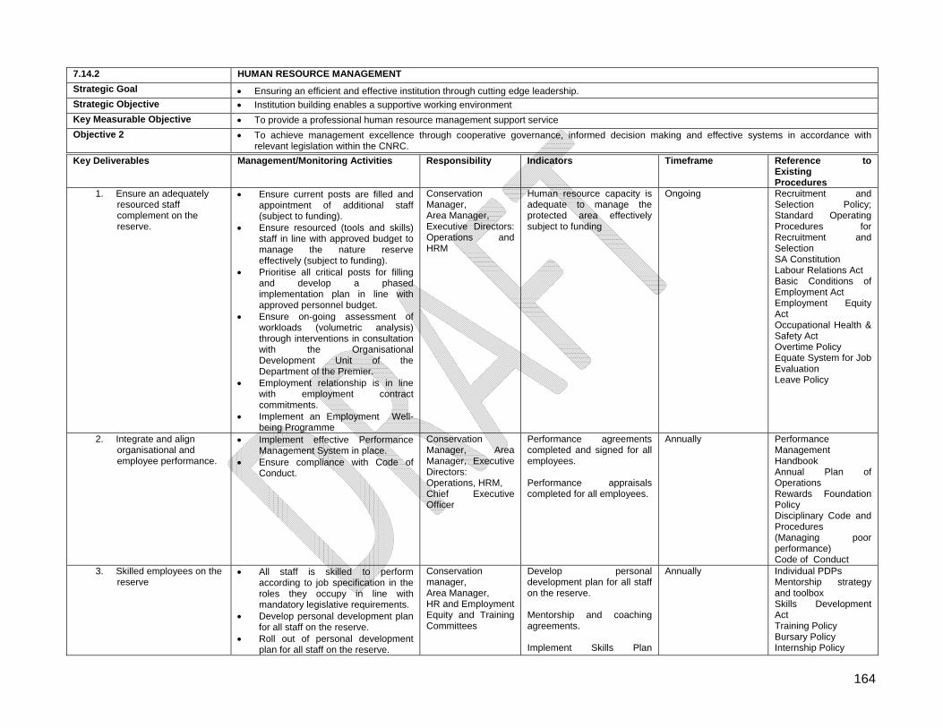
164
7.14.2 HUMAN RESOURCE MANAGEMENT
Strategic Goal Ensuring an efficient and effective institution through cutting edge leadership. Strategic Objective Institution building enables a supportive working environment
Key Measurable Objective To provide a professional human resource management support service
Objective 2 To achieve management excellence through cooperative governance, informed decision making and effective systems in accordance with relevant legislation within the CNRC.
Key Deliverables Management/Monitoring Activities Responsibility Indicators Timeframe Reference to Existing Procedures
1. Ensure an adequately resourced staff complement on the reserve.
Ensure current posts are filled and appointment of additional staff (subject to funding).
Ensure resourced (tools and skills) staff in line with approved budget to manage the nature reserve effectively (subject to funding).
Prioritise all critical posts for filling and develop a phased implementation plan in line with approved personnel budget.
Ensure on-going assessment of workloads (volumetric analysis) through interventions in consultation with the Organisational Development Unit of the Department of the Premier.
Employment relationship is in line with employment contract commitments.
Implement an Employment Well-being Programme
Conservation Manager, Area Manager, Executive Directors: Operations and HRM
Human resource capacity is adequate to manage the protected area effectively subject to funding
Ongoing Recruitment and Selection Policy; Standard Operating Procedures for Recruitment and Selection SA Constitution Labour Relations Act Basic Conditions of Employment Act Employment Equity Act Occupational Health & Safety Act Overtime Policy Equate System for Job Evaluation Leave Policy
2. Integrate and align organisational and employee performance.
Implement effective Performance Management System in place.
Ensure compliance with Code of Conduct.
Conservation Manager, Area Manager, Executive Directors: Operations, HRM, Chief Executive Officer
Performance agreements completed and signed for all employees. Performance appraisals completed for all employees.
Annually Performance Management Handbook Annual Plan of Operations Rewards Foundation Policy Disciplinary Code and Procedures (Managing poor performance) Code of Conduct
3. Skilled employees on the reserve
All staff is skilled to perform according to job specification in the roles they occupy in line with mandatory legislative requirements.
Develop personal development plan for all staff on the reserve.
Roll out of personal development plan for all staff on the reserve.
Conservation manager, Area Manager, HR and Employment Equity and Training Committees
Develop personal development plan for all staff on the reserve. Mentorship and coaching agreements. Implement Skills Plan
Annually Individual PDPs Mentorship strategy and toolbox Skills Development Act Training Policy Bursary Policy Internship Policy
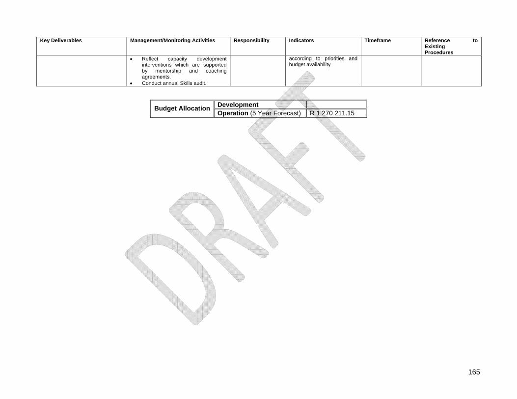
165
Key Deliverables Management/Monitoring Activities Responsibility Indicators Timeframe Reference to Existing Procedures
Reflect capacity development interventions which are supported by mentorship and coaching agreements.
Conduct annual Skills audit.
according to priorities and budget availability
Development Budget Allocation
Operation (5 Year Forecast) R 1 270 211.15
166
7.14.3 Occupational Health and Safety Management
7.14.3.1 Legislation
The Occupational Health and Safety Act, (Act No. 85 of 1993), as amended, with reference to:
1. The Regulations which fall within the ambit of the Act; 2. Standards and Approved Codes of Practice under the Act.
Compensation for Occupational Injuries and Diseases Act (Act No. 130 of 1993).
7.14.3.2 Guiding Principals
Reserve Management must bring about and maintain, as far as reasonably practicable, the safety of workers, contractors, volunteers, students and the public;
Reserve Management must bring about and maintain, as far as reasonably practicable, a work environment that is safe and without risk to the health of the staff members;
Where this is not possible, Reserve Management must inform staff of these dangers, how they may be prevented, and how to work safely, and provide other protective measures for a safe workplace;
The staff member must also take care of his or her own health and safety, as well as that of other persons who may be affected by his or her actions or negligence to act;
Appropriate training, awareness, education on the use of universal infection control measures so as to identify, deal with and reduce the risk of HIV transmission in the workplace will be provided.
7.14.3.3 Management Actions Refer to Table 7.14.3.
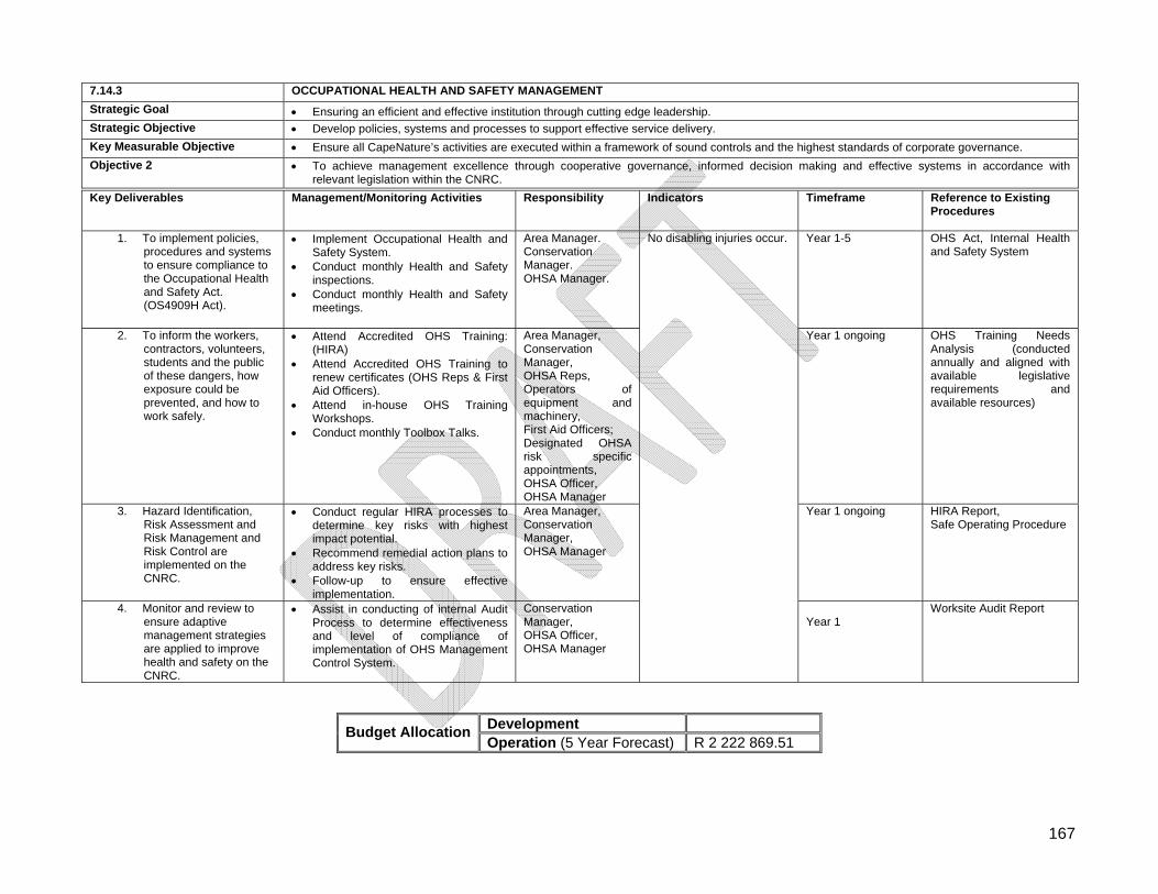
167
7.14.3 OCCUPATIONAL HEALTH AND SAFETY MANAGEMENT
Strategic Goal Ensuring an efficient and effective institution through cutting edge leadership. Strategic Objective Develop policies, systems and processes to support effective service delivery.
Key Measurable Objective Ensure all CapeNature’s activities are executed within a framework of sound controls and the highest standards of corporate governance.
Objective 2 To achieve management excellence through cooperative governance, informed decision making and effective systems in accordance with relevant legislation within the CNRC.
Key Deliverables Management/Monitoring Activities Responsibility Indicators Timeframe Reference to Existing Procedures
1. To implement policies, procedures and systems to ensure compliance to the Occupational Health and Safety Act. (OS4909H Act).
Implement Occupational Health and Safety System.
Conduct monthly Health and Safety inspections.
Conduct monthly Health and Safety meetings.
Area Manager. Conservation Manager. OHSA Manager.
Year 1-5 OHS Act, Internal Health and Safety System
2. To inform the workers, contractors, volunteers, students and the public of these dangers, how exposure could be prevented, and how to work safely.
Attend Accredited OHS Training: (HIRA)
Attend Accredited OHS Training to renew certificates (OHS Reps & First Aid Officers).
Attend in-house OHS Training Workshops.
Conduct monthly Toolbox Talks.
Area Manager, Conservation Manager, OHSA Reps, Operators of equipment and machinery, First Aid Officers; Designated OHSA risk specific appointments, OHSA Officer, OHSA Manager
Year 1 ongoing OHS Training Needs Analysis (conducted annually and aligned with available legislative requirements and available resources)
3. Hazard Identification, Risk Assessment and Risk Management and Risk Control are implemented on the CNRC.
Conduct regular HIRA processes to determine key risks with highest impact potential.
Recommend remedial action plans to address key risks.
Follow-up to ensure effective implementation.
Area Manager, Conservation Manager, OHSA Manager
Year 1 ongoing HIRA Report, Safe Operating Procedure
4. Monitor and review to ensure adaptive management strategies are applied to improve health and safety on the CNRC.
Assist in conducting of internal Audit Process to determine effectiveness and level of compliance of implementation of OHS Management Control System.
Conservation Manager, OHSA Officer, OHSA Manager
No disabling injuries occur.
Year 1
Worksite Audit Report
Development Budget Allocation
Operation (5 Year Forecast) R 2 222 869.51
168
7.14.4 Risk Management
7.14.4.1 Legislation Risk Management is based on the requirements of the Public Finance Management Act, (Act No. 1 of 1999) which requires the Accounting Authority to implement systems of financial management, risk management and internal control.
7.14.4.2 Guiding Principals
To promote the highest standards of corporate governance in providing assurance to stakeholders that organisational goals and objectives are achieved in an effective and efficient manner and within an ethical environment;
Ensure the implementation of risk management systems and procedures for the identification, assessment and monitoring of risks. All risks are to be documented and controls identified to mitigate these risks;
Ensure the development and implementation of standard operating procedures for all relevant business processes.
7.14.4.3 Management Actions Refer to Table 7.14.4.
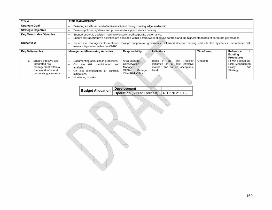
169
7.14.4 RISK MANAGEMENT
Strategic Goal Ensuring an efficient and effective institution through cutting edge leadership. Strategic Objective Develop policies, systems and processes to support service delivery.
Key Measurable Objective Support strategic decision making to ensure good corporate governance. Ensure all CapeNature’s activities are executed within a framework of sound controls and the highest standards of corporate governance.
Objective 2 To achieve management excellence through cooperative governance, informed decision making and effective systems in accordance with relevant legislation within the CNRC.
Key Deliverables Management/Monitoring Activities Responsibility Indicators Timeframe Reference to Existing Procedures
1. Ensure effective and integrated risk management within a framework of sound corporate governance.
Documenting of business processes. On site risk identification and
analysis. On site identification of controls/
mitigations. Monitoring of risks.
Area Manager. Conservation Manager. OHSA Manager, Chief Risk Officer.
Risks in the Risk Register mitigated in a cost effective manner and to an acceptable level.
Ongoing PFMA Section 38. Risk Management Policy and Strategy.
Development Budget Allocation
Operation (5 Year Forecast) R 1 270 211.15
170
7.15 Visitor Management and Services
7.15.1 Legislation
Tourism Act, (Act No. 72 of 1993).
7.15.2 Guiding Principles
Acknowledgement of the areas diverse natural heritage and a commitment to ensuring the safeguarding thereof for future generations;
The responsible and sustainable development of tourism facilities compatible with the nature reserve’s zonation policy.
7.15.3 Visitor management and services The short to medium-term strategic focus for tourism and recreation in the CNNRC is:
The development of a middle -market visitor accommodation facilities; The maintenance of a range of low impact recreational adventure activities; Access control at entry points; The maintenance of key information on visitor profiles and their needs.
7.15.4 Management Actions Refer to Table 7.15.
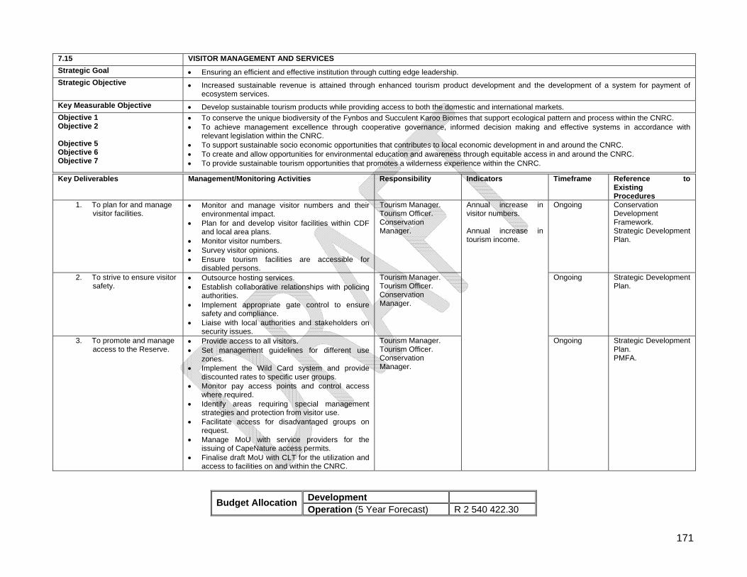
171
7.15 VISITOR MANAGEMENT AND SERVICES
Strategic Goal Ensuring an efficient and effective institution through cutting edge leadership. Strategic Objective Increased sustainable revenue is attained through enhanced tourism product development and the development of a system for payment of
ecosystem services.
Key Measurable Objective Develop sustainable tourism products while providing access to both the domestic and international markets. Objective 1 Objective 2 Objective 5 Objective 6 Objective 7
To conserve the unique biodiversity of the Fynbos and Succulent Karoo Biomes that support ecological pattern and process within the CNRC. To achieve management excellence through cooperative governance, informed decision making and effective systems in accordance with
relevant legislation within the CNRC. To support sustainable socio economic opportunities that contributes to local economic development in and around the CNRC. To create and allow opportunities for environmental education and awareness through equitable access in and around the CNRC. To provide sustainable tourism opportunities that promotes a wilderness experience within the CNRC.
Key Deliverables Management/Monitoring Activities Responsibility Indicators Timeframe Reference to Existing Procedures
1. To plan for and manage visitor facilities.
Monitor and manage visitor numbers and their environmental impact.
Plan for and develop visitor facilities within CDF and local area plans.
Monitor visitor numbers. Survey visitor opinions. Ensure tourism facilities are accessible for
disabled persons.
Tourism Manager. Tourism Officer. Conservation Manager.
Ongoing Conservation Development Framework. Strategic Development Plan.
2. To strive to ensure visitor safety.
Outsource hosting services. Establish collaborative relationships with policing
authorities. Implement appropriate gate control to ensure
safety and compliance. Liaise with local authorities and stakeholders on
security issues.
Tourism Manager. Tourism Officer. Conservation Manager.
Ongoing Strategic Development Plan.
3. To promote and manage access to the Reserve.
Provide access to all visitors. Set management guidelines for different use
zones. Implement the Wild Card system and provide
discounted rates to specific user groups. Monitor pay access points and control access
where required. Identify areas requiring special management
strategies and protection from visitor use. Facilitate access for disadvantaged groups on
request. Manage MoU with service providers for the
issuing of CapeNature access permits. Finalise draft MoU with CLT for the utilization and
access to facilities on and within the CNRC.
Tourism Manager. Tourism Officer. Conservation Manager.
Annual increase in visitor numbers. Annual increase in tourism income.
Ongoing Strategic Development Plan. PMFA.
Development Budget Allocation
Operation (5 Year Forecast) R 2 540 422.30
172
7.16 Tourism Development Framework Legislation, Guidelines, Zonation and Planning for infrastructure development and land-use.
7.16.1 Environmental legislation relevant to infrastructure development and conservation management activities
Key areas of legislation relevant to infrastructure use and development on Nature Reserves and conservation management. Please refer to the CapeNature guidelines. National Environmental Management Act (NEMA, Act 107 of 1998) - provides a
framework for environmental governance and decision making. National Environmental Management: Protected Areas Act, 2003 (NEMPAA), as
amended 2009 – regulates development, use and management of all protected areas. NEMA Environmental Impact Assessment Regulations (GN No. R. 543 of June 2010
as corrected by Correction Notices 1 (GN No. R. 660 of July 2010) and 2 (GN R. 1159 of December 2010) ‐ stipulates environmental authorisation process for a wide range of activities.
National Water Act (Act 36 of 1998, as amended by Act 45 of 1999) – controls use of ground and surface water, and sets standards for wastewater quality.
National Heritage Resources Act (Act 25 of 1999) – protects and provides for authorisation relating to heritage features including buildings, archaeological and paleontological sites, and landscape character.
The National Waste Act (Act 59 of 2008) – controls disposal of waste
Tourism Act, (Act No. 72 of 1993) – provides a grading and classification scheme for tourism accommodation.
Occupational Health and Safety Act, (Act No 85 of 1993) – specifies requirements for a safe and healthy working environment for all employees.
7.16.2 Guiding Principals
Before any significant infrastructure development, reserves must have: o a zoning scheme based on a defensible environmental analysis of sensitivity
and opportunities, proper internal consultation, and CapeNature regional strategy ;
o an infrastructure development plan that specifies the type and location of all new infrastructure;
Any infrastructure or activity, including change of use, must comply with all legislated licencing and authorisation requirements.
Roads and tracks have the highest environmental and cost impact – planning should focus on providing efficient, lowest-impact road and trail networks.
Layout of existing infrastructure and operations should be re-evaluated. Development Zones and Access Zones should be peripheral to nature reserve, and
easily accessible to staff and visitors.
173
Viewshed impacts of new infrastructure should be considered, especially any that might impact Wilderness Areas.
Development Zones should be as tightly clustered as possible. All planning must explicitly avoid, minimise and mitigate fire risk. Management vs. tourism infrastructure should be close but separate. Tourism products should be located to balance visitor experience against
environmental impact and access. Development Zones should utilise existing degraded or transformed habitat, although
road access must be factored into the overall impact footprint. All new development or expansion must be informed by a financial feasibility study,
reserve sensitivity analysis, and if appropriate specialist assessment of impact. New building infrastructure, especially in remote or sensitive locations, must consider
total lifespan impact including decommissioning and removal. Green building techniques must be implemented to reduce carbon emissions, energy
and water use, and waste contamination associated with construction and operation, although the primary consideration must be reducing local impact.
7.16.3 Management Actions Refer to Table 7.16
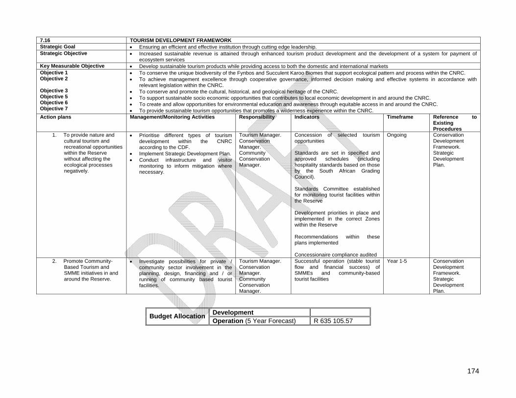
174
7.16 TOURISM DEVELOPMENT FRAMEWORK Strategic Goal Ensuring an efficient and effective institution through cutting edge leadership. Strategic Objective Increased sustainable revenue is attained through enhanced tourism product development and the development of a system for payment of
ecosystem services Key Measurable Objective Develop sustainable tourism products while providing access to both the domestic and international markets Objective 1 Objective 2 Objective 3 Objective 5 Objective 6 Objective 7
To conserve the unique biodiversity of the Fynbos and Succulent Karoo Biomes that support ecological pattern and process within the CNRC. To achieve management excellence through cooperative governance, informed decision making and effective systems in accordance with
relevant legislation within the CNRC. To conserve and promote the cultural, historical, and geological heritage of the CNRC. To support sustainable socio economic opportunities that contributes to local economic development in and around the CNRC. To create and allow opportunities for environmental education and awareness through equitable access in and around the CNRC. To provide sustainable tourism opportunities that promotes a wilderness experience within the CNRC.
Action plans Management/Monitoring Activities Responsibility Indicators Timeframe Reference to Existing Procedures
1. To provide nature and cultural tourism and recreational opportunities within the Reserve without affecting the ecological processes negatively.
Prioritise different types of tourism development within the CNRC according to the CDF.
Implement Strategic Development Plan. Conduct infrastructure and visitor
monitoring to inform mitigation where necessary.
Tourism Manager. Conservation Manager. Community Conservation Manager.
Concession of selected tourism opportunities Standards are set in specified and approved schedules (including hospitality standards based on those by the South African Grading Council). Standards Committee established for monitoring tourist facilities within the Reserve Development priorities in place and implemented in the correct Zones within the Reserve Recommendations within these plans implemented Concessionaire compliance audited
Ongoing Conservation Development Framework. Strategic Development Plan.
2. Promote Community-Based Tourism and SMME initiatives in and around the Reserve.
Investigate possibilities for private / community sector involvement in the planning, design, financing and / or running of community based tourist facilities.
Tourism Manager. Conservation Manager. Community Conservation Manager.
Successful operation (stable tourist flow and financial success) of SMMEs and community-based tourist facilities
Year 1-5 Conservation Development Framework. Strategic Development Plan.
Development Budget Allocation
Operation (5 Year Forecast) R 635 105.57
175
PART 4
SECTION 8: REFERENCES
8.1 References ALEXANDER, G. & MARAIS, J. 2008. A guide to the Reptiles of Southern Africa. Struik
Publishers, Cape Town. ANDRAG, R.H. 1977. Studies in die Sederberge oor (1) Die status van die Clanwilliam
seder (Widdringtonia cedarbergensis), (2) Buitelugontspanning. University of Stellenbosch, unpublished.
ANDRAG, R.H. 2011. Personal communication. BANDS, D.P. 1977. Prescribed burning in Cape Fynbos. In: Proceedings of the symposium
on the environmental consequences of fire and fuel management in Mediterranean ecosystems (pp. 245-256). USDA Forest Service General Technical Report WO-3.
BANDS, D.P. 1978. Policy memorandum, Cederberg Catchment Area No. 1. Management
Plan for the period 1979/80-1983/84. Department of Forestry. Stellenbosch, unpublished.
BARNARD, B. 1996. Geologiese opnames-Matjiesrivier. University of Stellenbosch,
unpublished. BARNARD, W.S. & GREEFF, R. 1993. Grys en grillig: ‘n Verkenning van denudasievorme in
die Sedeberge, K.P. SA Geograaf. Birds in Reserves Project. 2011. Animal Demography Unit. Department of Zoology,
University of Cape Town.
CLAYTON, C.H. 1954. Memorandum on the Cederberg Forest Reserve. Department of Forestry. Cape Town, unpublished.
COOMBES, P.J. & MENTIS, M.T. 1992. A Procedure for Defining Conservation
Management Objectives and Goals. TPA. Nature and Environmental Conservation, Pretoria.
COWAN, G.I. & MPONGOMA, N. 2010. Guidelines for the development of a management
plan for a protected area in terms of the National Environmental Management: Protected Areas Act, 2003. Department of Environment Affairs (pp. 17). Pretoria, unpublished.
DEACON, J. 1993. Management Guidelines for Rock Art Sites in Nature Conservation areas
and Forestry Reserves in the Western Cape. University of Stellenbosch, unpublished.
176
DEACON, J. 1998. Some views on Rock paintings in the Cederberg. The National
Monuments Council, Cape Town.
DU PLESSIS, M.K. 2011. Personal communication. FRIEDMAN, Y. & DALY, B. 2004. Red Data Book of the Mammals of South Africa: A
Conservation Assessment. CBSG Southern Africa, Conservation Breeding Specialist Group (SSC/IUCN), Endangered Wildlife Trust. South Africa
IMPSON, N.D., BILLS, I.R., CAMBRAY, J.A. & LE ROUX, A. 1999. The primary freshwater
fishes of the Cape Floristic Region: conservation needs for a unique and highly threatened fauna (pp. 26). Western Cape Nature Conservation Board.
Integrated Development Plan for the West Coast District Municipality. 2007. West Coast
District Municipality, unpublished. KIRKWOOD, D. 2012 Conservation Development Framework Cederberg Nature Reserve
Complex: Sensitivity & Opportunity Analysis, Zonation, Infrastructure Development Plan. Unpublished CapeNature report.
KLEIN, R.G. 1974. Environment and subsistence of prehistoric man in the southern Cape
Province. World Archaeology 5: 249-284, South Africa. LECHMERE-OERTEL, R. 1996. A Vegetation survey of Matjiesrivier Nature Reserve-
Cederberg. Institute for Plant conservation. Department of Botany, University of Cape Town, unpublished.
LOW, A.B., DIAMOND, R. & ALMOND, J. 2004. The Cederberg-Tanqua tension zone:
Setting the scene. Veld & Flora. April 2004. LOW, A.B. & REBELO, A.G. (Eds.). 1996. Vegetation of Southern Africa, Lesotho and
Swaziland. Department of Environmental Affairs & Tourism, Pretoria.
MANNING, J. 2007, Field Guide to Fynbos. Struik Nature, Cape Town. Matjiesrivier Natuurreservaat Bestuursplan. 1997. Wes-Kaapse Natuurbewaring,
unpublished. MEADOWS, M.E. & SUGDEN, J.M. 1993. The late quaternary palaeoecology of a floristic
kingdom: the southwestern Cape South Africa. Palaeogeography, Palaeoclimatology, Palaeoecology 101: 271-281.
MINTER, L.R., BURGER, M., HARRISON, J.A., BRAACK, H.H., BISHOP, P.J. &
KLOEPFER, D. 2004. Atlas and Red Data Book of the Frogs of South Africa, Lesotho and Swaziland. Animal Demography Unit. Department of Zoology, University of Cape Town.
177
MOSSOP, E.E. 1927. Old Cape Highways. Maskew Miller, Cape Town. MUCINA, L. & RUTHERFORD, M.C. (eds.) 2006. The Vegetation of South Africa, Lesotho
and Swaziland. Strelitzia 19. South African National Biodiversity Institute, Pretoria. National Protected Area Expansion Strategy of South Africa 2010: Priorities for expanding
the protected area network for ecological sustainability and climate change adaption. 2010. Government of South Africa, Pretoria.
NEETLING, D. 2007. History of the Nieuwoudt and Wagener family, unpublished. PAXTON, B.R. & KING, J.M. 2004. Multi-scale habitat use and movement of freshwater fish
species in a large river system: implications for dam placement, operation and design. Mid-year progress report July 2004. Freshwater Research Unit. Department of Zoology, University of Cape Town.
REID, D.L., ROGERS, J. & MINTER, W.E.L. 2000. The Geology of the Western Cape. Field
Excursion. University of Cape Town. SKELTON, P.H. 2001. A complete guide to the freshwater fishes of Southern Africa. Struik
Publishers, Cape Town.
Spatial Development Framework for the West Coast District Municipality. 2007. West Coast District Municipality, unpublished.
SPIES, A. & SYMONDS, A. 2011. Stakeholder Participation in Developing Park
Management Plans. Conservation Services Division. South African National Parks, Pretoria.
Survey of Cederberg Amphibians and Reptiles for Conservation and Ecotourism. 2011.
Department of Botany and Zoology, University of Stellenbosch. SWARTZ, E.R., SKELTON, P.H. & BLOOMER, P. 2009. Phylogeny and biogeography of
the genus Pseudobarbus (Cyprinidae): Shedding light on the drainage history of rivers associated with the Cape Floristic Region. Molecular Phylogenetics and Evolution 51: 71-84.
TAYLOR, H.C. 1996. Cederberg Vegetation and Flora. Strelitzia 3. South African National
Biodiversity Institute, Pretoria.
TRUSWELL, J.F. 1970. An introduction to the historical geology of South Africa. Purnell, Cape Town.
TWEDDLE, D., BILLS, R., SWARTZ, E., COETZER, W.D.A., COSTA, L., ENGELBRECHT,
J., CAMBRAY, J., MARSHALL, B., IMPSON, N.D., SKELTON, P.H., DARWALL, W.R.T. & SMITH, K.S. 2009. The status and distribution of freshwater fishes. In: Darwall, W.R.T., Smith, K.G., Tweddle, D. & Skelton, P.H. (Eds.). The status and
178
distribution of freshwater biodiversity in southern Africa (pp. 21-37). Gland and Grahamstown: IUCN and South African Institute for Aquatic Biodiversity.
WALLER, L.J. 2011. CapeNature PAMP Scientific and Technical Review Guidelines.
8.2 List of Acronyms and Abbreviations AIS Alien and Invasive Species APP Annual Performance Plan APO Annual Plan of Operations BCU Biodiversity Crime Unit BMP Biodiversity Management Plan BMP-S Biodiversity Management Plan for Species BMS Biodiversity Monitoring System CAP Conservation Action Plan CAPE Cape Action for People and the Environment CARA Conservation of Agricultural Resources Act CBA Critical Biodiversity Area CBD Convention on Biological Diversity CBO Community Based Organisation CDF Conservation Development Framework CEO Chief Executive Officer CFR Cape Floristic Region CITES Convention on International Trade in Endangered Species in Wild Fauna and
Flora CMS Bonn Convention on the Conversation of Migratory Species of Wild Animals CNRC Cederberg Nature Reserve Complex CLT Cape Leopard Trust DAFF Department of Agriculture, Forestry and Fisheries DEA Department of Environmental Affairs DEA&DP Department of Environmental Affairs and Development Planning DENC Department of Environment and Nature Conservation Northern Cape DPW Department of Public Works EIA Environmental Impact Assessment EMI Environmental Management Inspector EKZNW Ezemvelo KZN Wildlife EMP Environmental Management Plan EPWP Expanded Public Works Programme GCBC Greater Cederberg Biodiversity Corridor GCFPA Greater Cederberg Fire Protection Association GCFR Greater Cape Floristic Region GIS Geographical Information System GRAP Generally Recognised Accounting Practices HIRA Hazard Identification and Risk Assessment HRM Human Resource Manager IBL Important Biodiversity Layers ICM Integrated Catchment Management
179
IDP Integrated Development Plan IUCN International Union for the Conservation of Nature Ma Megaannum (Million Years) MCSA Mountain Club of South Africa MEC Member of Executive Council MUCP Management Unit Clearing Plan NEMA National Environmental Management Act NFEPA National Freshwater Ecosystem Priority Areas NGO Non-governmental Organisation NEM: PAA National Environmental Management: Protected Areas Act NEM: BA National Environmental Management: Biodiversity Act ODRS Olifants-Doring River System OHS Occupational Health and Safety OHSA Occupational Health and Safety Act OUV Outstanding Universal Value PAAC Protected Area Advisory Committee PAMP Protected Area Management Plan PDP Personal Development Plan PFMA Public Finance Management Act QEM Quarterly Ecological Meeting RCKP Rooi Cederberg Karoo Park RMC Reserve Management Committee SANParks South African National Parks SDF Spatial Development Framework SMP Strategic Management Plan SOB State of Biodiversity SOP Standard Operating Procedures ToR Terms of Reference ToPS Threatened or Protected Species Regulations TPC Threshold of Potential Concern TWINSPAN Two-way indicator species analysis UNESCO United Nations Educational, Scientific and Cultural Organisation UCT University of Cape Town US University of Stellenbosch U-AMP User Asset Management Plan WAC Wildlife Advisory Committee WCDM West Coast District Municipality WCNCB Western Cape Nature Conservation Board WCPAES Western Cape Protected Area Expansion Strategy WHC World Heritage Committee WfW Working for Water WWF-SA World Wild Fund for Nature – South Africa WHS World Heritage Site
180
8.3 List of Tables Table 1: Summary of CapeNature Strategic Results and Programme Allocations; Table 2: Cederberg Nature Reserve Complex management agreements currently in effect; Table 3: Cederberg Nature Reserve Complex is comprised of the following cadastres; Table 4: List of threatened plant species recorded in the Cederberg Nature Reserve Complex; Table 5: List of threatened mammal species recorded in the Cederberg Nature Reserve Complex; Table 6: List of threatened bird species recorded in the Cederberg Nature Reserve Complex; Table 7: List of threatened reptile species recorded in the Cederberg Nature Reserve Complex; Table 8: List of amphibians recorded in the Cederberg Nature Reserve Complex; Table 9: List of threatened fish species recorded in the Cederberg Nature Reserve Complex; Table 10: Roads and Trails located within the Cederberg Nature Reserve Complex; Table 11: Infrastructure located within the Cederberg Nature Reserve Complex; Table 12: Cederberg Nature Reserve Complex SWOT; Table 13: Guide to CapeNature Zones; Table 14: Mechanism for protected area expansion. 8.4 List of Figures Figure 1: CapeNature Organogram Figure 2: The elements of Cape Nature’s management plans Figure 3: Legal and planning framework for the management plan Figure 4: Stakeholder Participation Strategy for CapeNature Nature Reserve Management Plans Figure 5: Decision Tree for the acceptance and or rejection of advice from the PAAC Figure 6: Location and extent of the Cederberg Nature Reserve Complex Figure 7: Climate for the Cederberg Wilderness Figure 8: Average Rainfall of the Matjies Rivier Nature Reserve Figure 9: View of Sneeuberg from Truitjieskraal. Photo by Patrick Lane Figure 10: Cross section of the greater Cederberg geology indicating the location of Matjies Rivier and Algeria. (De Beer 1998) Figure 11: Geology of the Cederberg Nature Reserve Complex Figure 12: Hydrology of the Cederberg Nature Reserve Complex Figure 13: (a) Gadiolus inflatus and (b) Snow Protea (Protea cryophila) Photos: Patrick Lane Figure 14: Fire in the Cederberg, an important driver of Fynbos ecology. Photo: Patrick Lane Figure 15: Vegetation map of the Cederberg Nature Reserve Complex Figure 16: Plant communities of the Matjies Rivier Nature Reserve Figure 17: Matjies Rivier Nature Reserve in spring Photo: Rika du Plessis Figure 18: The Clanwilliam cedar (Widdringtonia cedarbergensis). Photo: Lehan Fouche Figure 19: (a) Klipspringer (Oreotragus oreotragus) and (b) Leopard (Panthera pardus). Photos: Patrick Lane Figure 20: (a) Verreaux’s Eagle (Aquila verreauxii) and (b) Cape Rock-jumper (Chaetops frenatus). Photos: Patrick Lane Figure 21: (a) Armadillo girdled lizard (Cordylus cataphractus) and (b) Cape Crag Lizard (Pseudocordylus microlepidotus) Photos: Rika du Plessis & Patrick Lane Figure 22: Cape river frog (Amietia fuscigula). Photo: Patrick Lane
181
Figure 23: (a) Twee River redfin (Barbus erubescens) and (b) Clanwilliam yellowfish (Labeobarbus capensis). Photos: Riaan van de Walt Figure 24: Map indicating priority fish conservation areas in the Cederberg Nature Reserve Complex Figure 25: (a) Elephant Paintings and the (b) Stadsaal Cave at Matjies Rivier Nature Reserve. Photos: Patrick Lane Figure 26: Map showing main infrastructure points of the Cederberg Wilderness Figure 27: Map showing main infrastructure points of the Matjies Rivier Nature Reserve Figure 28: (a) The Wolfberg Arch covered in snow and (b) the Maltese cross with Sneeuberg in the background. Photos: Rika du Plessis and Patrick Lane Figure 29: CapeNature Method for Sensitivity Scoring and Synthesis Figure 30: Zonation of the Cederberg Nature Reserve Complex Figure 31: Zonation of the Kliphuis Management Complex Figure 32: Zonation of the Algeria and Bosherberge Management Complex Figure 33: Zonation of the Matjiesrivier Management Complex Figure 34: Access and facilities for the Cederberg Nature Reserve Complex Figure 35: Concept Development Plan for the Cederberg Nature Reserve Complex Figure 36: Protected area expansion map for Cederberg Nature Reserve Complex