Embed Size (px)
Citation preview
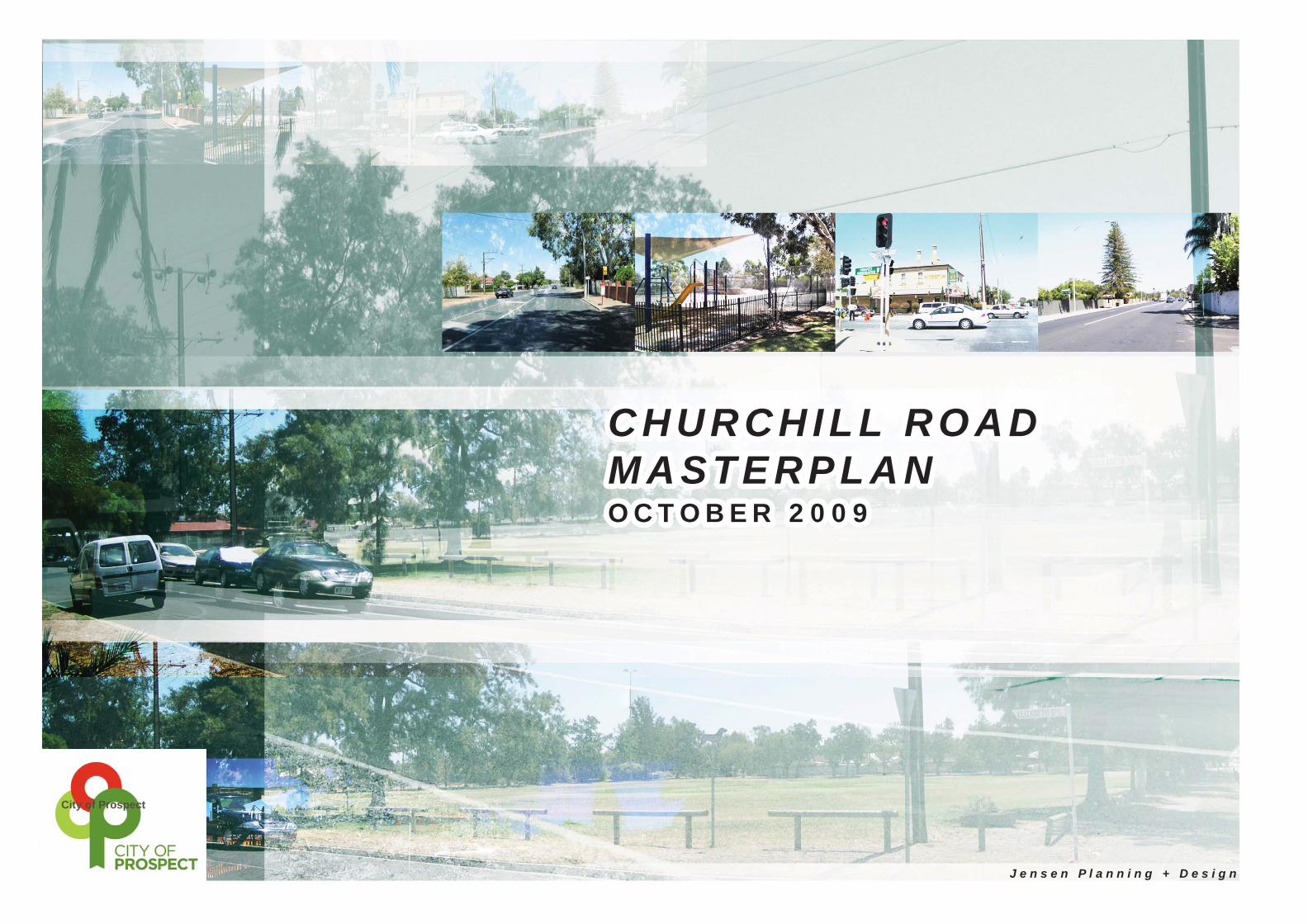
CHURCHILL ROAD MASTERPLANJ e n s e n P l a n n i n g + D e s i g n October 2009 CHURCHILL ROAD J e n s e n P l a n n i n g + D e s i g n
C H U R C H I L L R O A DC H U R C H I L L R O A DM A S T E R P L A NM A S T E R P L A NOCTOBER 2009OCTOBER 2009
City of Prospect

CHURCHILL ROAD MASTERPLANJ e n s e n P l a n n i n g + D e s i g n October 2009
City of Prospect

CHURCHILL ROAD MASTERPLANJ e n s e n P l a n n i n g + D e s i g n October 2009 1
STUDY TEAMJensen Planning + Design
in association with:
Brecknock Consulting FMG Engineering
Village Well
TABLE OF CONTENTS
EXECUTIVE SUMMARY 2
INTRODUCTION 3
CONTEXT 7
PEOPLE + ECONOMY + POLICY 8
People 8
Economy 8
Policy 9
INVESTIGATONS AND ANALYSIS 11
CURRENT EXPERIENCE, IMAGE AND IDENTITY OF CHURCHILL ROAD 12
BUILDING A NEW IMAGE AND IDENTITY 14
LAND USES AND ZONING 15
Residential Zones Issues and Opportunities 15
Commercial and Retailing Zones Issues and Opportunities 16
Community and Recreation Zones Issues and Opportunities 16
Mixed Land Uses Zones Issues and Opportunities 17
Industrial Land Use Zone Issues and Opportunities 17
MOVEMENT AND PARKING 18
Issues 18
Opportunities 18
STREETSCAPE, LANDSCAPING AND PUBLIC REALM 19
Issues 19
Opportunities 19
INTEGRATED PUBLIC ART 20
Issues 20
Opportunities 20
SERVICES AND INFRASTRUCTURE 21
Issues 21
Opportunities 21
CHURCHILL ROAD MASTER PLAN 23
Precincts, Gateways and Nodes 24
Overall Streetscape Concept 25
Torrens Road Gateway 26
Cane Reserve Node 27
Central Residential Precinct 28
Pym Street Precinct 29
Alexandra Street Node 30
Regency Road Gateway 31
DESIGN ELEMENTS 32
LANDSCAPING 33
IMPLEMENTATION 35
AcknowledgementThis Masterplan focuses on
the traditional lands of the Kaurna Plains people. The
City of Prospect and the Study Team respect their
spiritual relationship to their country, culture and heritage.
City of Prospect

CHURCHILL ROAD MASTERPLANJ e n s e n P l a n n i n g + D e s i g n October 2009
EXECUTIVE SUMMARY
Introduction to Churchill Road
Churchill Road is one of three important arterial corridors linking the city of Adelaide and the northern suburbs. It, along with Prospect Road and Main North Road are integral to the movement of vehicles and people on a daily basis. Churchill Road has been overlooked for an upgrade of services and infrastructure for quite some time. This is unusual given its proximity to the city of Adelaide and the passenger (and freight) railway line.
The infrastructure along Churchill Road is generally run down, kerbs and gutters are dilapidated and in some cases non existent, there is little amenity for pedestrians and residents, and it is diffi cult to cross the road.
The character of The Churchill Road corridor is dominated by its primary use as a freight route, with a large number of heavy vehicles, fast fl owing commuter traffi c and very little pedestrian amenity or safety for users walking along or trying to cross Churchill Road.
In the midst of the traffi c and noise, however, Churchill Road offers a mix of shops, small businesses and recreation reserves. Cane Reserve, for example, is a wonderful asset with good facilities, shade and amenity for the surrounding community.
Furthermore there have been recent initiatives implemented that have improved the safely for pedestrians wishing to cross the road.
Whilst it lacks a consistent identity and is in some parts extremely run down, Churchill Road corridor has enormous potential as an important transport boulevard in a similar fashion to Glen Osmond Road or Portrush Road- both of which are arterial freight routes.
The City Prospect, in partnership with the South Australian Department for Planning and Local Government through the “Places for People” program, has engaged Jensen Planning + Design in association with Brecknock Consulting, FMG Engineering and Village Well to prepare a Masterplan for the Churchill Road corridor.
Masterplan Content
This Masterplan outlines the background context, the issues and opportunities associated with the various parts of Churchill Road, and the views and ideas that have been expressed during the consultation process.
The Masterplan describe the key areas along Churchill Road - the gateways (Torrens Road and Regency Road) and the main activity nodes (Cane Reserve node and Alexandra Street node), and the main precincts (Central Residential Precinct and Pym Street Precinct).
For each area the Masterplan describes:
the future built form and design (style, character and use of • buildings)traffi c elements (parking, lanes, cycling, pedestrians, function of • roads) that will assist the Prospect community to achieve the vision for Churchill Roadstreetscape elements - paving, lighting, buildings, trees, public art• priorities, implementation and staging.•
2
A high quality urban transport corridor made up of quality medium to high density housing, attractive commercial offi ce and employment precincts, local shops and facilities and “green” recreational areas and streetscapes.
An area highly accessible to the Adelaide CBD and local employment areas that is attractive to commuters to Adelaide’s CBD and the western suburbs through an upgraded and effi cient rail and bus system.
The Churchill Road Corridor Transformed
It is time for a complete transformation of the Churchill Road corridor. With the impending electrifi cation of the northern rail line and the upgrade of stations, together with new investment in public transport more generally, the Churchill Road corridor provides a strategic opportunity for new housing and employment growth in close proximity to the Adelaide CBD. The road itself is long overdue for upgrading. While retaining its important freight transport role, the opportunity exists to transform it into a more attractive boulevard lined with commercial offi ces, higher density housing and other mixed use developments that take advantage of the public transport services.
With new investment in the road corridor, adjacent public parks, transport infrastructure and new residential and employment buildings, the Churchill Road corridor will play a key role in the rejuvenation of the inner northern suburbs.
Portrush RoadVision of a future Churchill Road?
City of Prospect

CHURCHILL ROAD MASTERPLANJ e n s e n P l a n n i n g + D e s i g n October 2009
THIS MASTERPLAN IS A FRAMEWORK FOR THE FUTURE
This Masterplan is a framework that establishes goals and overall long term plans for ways in which the council, the traders and businesses along Churchill Road, local residents and investors can harness and build upon the potential of the Churchill Road corridor.
Before detailed design or construction of specifi c elements like street upgrades, pavements or trees can begin, a Masterplan framework is necessary. A framework brings all of the pieces of the jigsaw together into one unifi ed long term vision. It means that the council and community know where they are going, and what needs to be done along the way in order to reach their goals for a vibrant, sustainable and people friendly environment.
The Masterplan builds upon the opportunities that have been identifi ed through many conversations with traders, residents and business owners, key government and industry stakeholders, together with our research and fi eld work.
A series of general masterplans for the key areas along Churchill Road are described. They are “big picture” plans - the next stage is to develop more detailed design plans.
3
“Without goals and plans, you are like a ship that has set sail with no destination.”
Glen Osmond RoadVision of a future Churchill Road?
City of Prospect

CHURCHILL ROAD MASTERPLANJ e n s e n P l a n n i n g + D e s i g n October 2009
WHO HAD INPUT INTO THE PLAN AND WHAT DID THEY SAY?
The future look, feel and function of Churchill Road will impact on local traders, business owners, local residents, visitors and commuters, and therefore an open, respectful and inclusive consultation and community engagement approach was taken with people who shared their thoughts and ideas with the consultancy team. Some groups - government agencies, council staff and Elected Members in particular, have a particular role in implementing the outcomes of this report along Churchill Road corridor and so they also played a major part in inputting into the process.
The First Phase of Consultation - Understanding Issues, Collecting Ideas, Exploring Opinions
Throughout the early development of this Masterplan, a range of consultation approaches and techniques were used so that people had different opportunities to have an input. Each consultation activity was developed to both provide information about the background (i.e. communication), and to facilitate sharing of ideas and stories (i.e. engagement).
All of the conversations during this phase helped to paint a picture about what Churchill Road currently is, and what it could become. The ideas and aspirations shared by residents, traders, business owners, government agencies, council staff and Elected Members assisted to develop a broad vision for Churchill Road. From the vision, a draft Masterplan was developed which details individual ideas and plans for different parts of the road.
The Second Phase of Consultation - Feedback on the Draft Master Plan
Once the Draft Masterplan was developed it was publicly displayed in supermarkets, the local library and the Civic Centre, a brochure was distributed to every household and business in the City of Prospect, workshops were held, online survey forms were completed, email and phone conversations were had.
89 individual feedback responses were received. All feedback has been analysed and given full consideration.
The main feedback on the Draft Masterplan is shown opposite.
Further detail about the consultation process and the issues raised is provided in a separate report - (Churchill Road Summary Consultation Report).
4
City of Prospect

CHURCHILL ROAD MASTERPLANJ e n s e n P l a n n i n g + D e s i g n October 2009
VISIONThe Vision for Churchill Road was developed through consultation and team collaboration with the key components being:
Land Use + Built Form:
Well designed medium to high density housing that provides a range of housing ●choices located along the Churchill Road corridor, with concentrations of housing close to the three rail stationsAn employment corridor wi ● th an emphasis on commercial offi ce and mixed use development similar to Henley Beach Road and Glen Osmond RoadMulti-storey development set behind quality landscaping that presents ●attractively to Churchill RoadSeveral parks with highly visible green edges that can be seen along the road ●Limited number of driveways onto Churchill Road to protect freight movement ●function Local businesses, services and retail uses to serve the day-to-day needs of ●residents, workers and commuters
Movement + Parking:
Better lane d ● elineation and median strips to reinforce the role and function of Churchill Road as an arterial transport and freight corridor Improve the functionality and safety of the Pym Street / Churchill Road junction ●Improve the pedestrian environment along the road, including regular and safe ●crossings and connections to rail stations and east to Prospect RoadEstablish a landscaped cycle corridor along to the rail corridor to provide for ●commuter and recreational cyclists Upgrade the rail stations and improve bus stops and bus services to attract ●public transport patronsEncourage undercroft / basement parking and parking to the rear of buildings ●Provide indented parking for residential and commercial premises ●
Streetscape + Public Realm:
An attractive, safe and landscaped transport boulevard with new footpaths, ●landscaped verges, street trees, indented parking bays and attractive fencing / walling (within the constraints forced by existing services)Underground the low voltage power lines to promote healthy street tree growth ●‘Welcoming’ signs and landscaping at the northern boundary of the Council area ●Public art, landscaping and signage at the Torrens Road Gateway Precinct ●promoting the City of ProspectPublic art, landscaping and signage at public reserves to build upon their use ●and importance as local destinations for the surrounding peopleUse contemporary materials that have associations with the character of the ●surrounding areasAttractive public and feature lighting ●Improve key streetscapes that provide important east-west pedestrian linkages ●such as Gladstone RoadProtect and / or relocate underground services where possible ●Upgrade utility services to meet increased demand ●Build in opportunities to capture and recycle stormwater (WSUD) ●Landscaping and design elements will assist to create safe areas for ●pedestrians during the day and night
5
An attractive growth corridor and transport boulevard that is framed by medium and higher density, multi-level housing, employment and retail activities.
City of Prospect

CHURCHILL ROAD MASTERPLANJ e n s e n P l a n n i n g + D e s i g n October 2009
MAKING CHURCHILL ROAD A GREAT PLACE FOR PEOPLE
Introduction
The Masterplan identifi es the variety of ways in which Churchill Road can become a great place for people - with its own unique personality and identity.
What makes a great place?
These elements are the ones found along many great roads:
a strong sense of place - with a start and fi nish• a sense of safety for all • density of employment and residential population to generate • demand for local service activities and enhance street lifeunique identity based on built form and streetscape• diverse - creative, artistic, mixtures of expression and culture• connection to the past through cultural heritage and built form• a sense of continuity and longevity - from the past to the present • to the futureretailing areas that meet day to day shopping needs• mixture of houses - shops, offi ces, play areas, quiet and restful • areas, vibrant and energetic areasenvironmentally responsible - harvesting and reusing our water, • recycling, environmentally responsible business practices, providing accessible and frequent public transportcommunity eating places • easy to access by bus, train, bike and by foot• child, woman, elderly and family friendly• mixed levels of activity - some at street level, some above street • level with some activity spilling on to the footpathconnection to nature - sunlight, green areas, trees - even more • important as we grapple with the enormous implications of climate change.
This Masterplan aims to incorporate these elements within the Churchill Road corridor.
6
Portrush Road - attractive streetscape upgrade of a freight corridor
Goodwood Road - artistic signage
Goodwood Road- artist designed mosaic bench
“Prospect should be a walking city. It’s the best way to stay healthy!”
- Local Resident
“Greenery yes. But please let’s harvest our rainwater
and use it to water our street trees.”
- Local Resident
City of Prospect

CHURCHILL ROAD MASTERPLANJ e n s e n P l a n n i n g + D e s i g n October 2009
CONTEXT
7
City of Prospect
CHURCHILL ROAD MASTERPLANJ e n s e n P l a n n i n g + D e s i g n October 2009
THE CONTEXT OF THE PLAN
PEOPLE + ECONOMY + POLICY
The Masterplan has been infl uenced by both local and more regional communities of interest - who they are, who they are likely to be in the future, their needs and their aspirations. It has also been infl uenced by local government and state government policy that provides direction to the shape of a local area - particularly population growth, land uses, and transport infl uences.
People
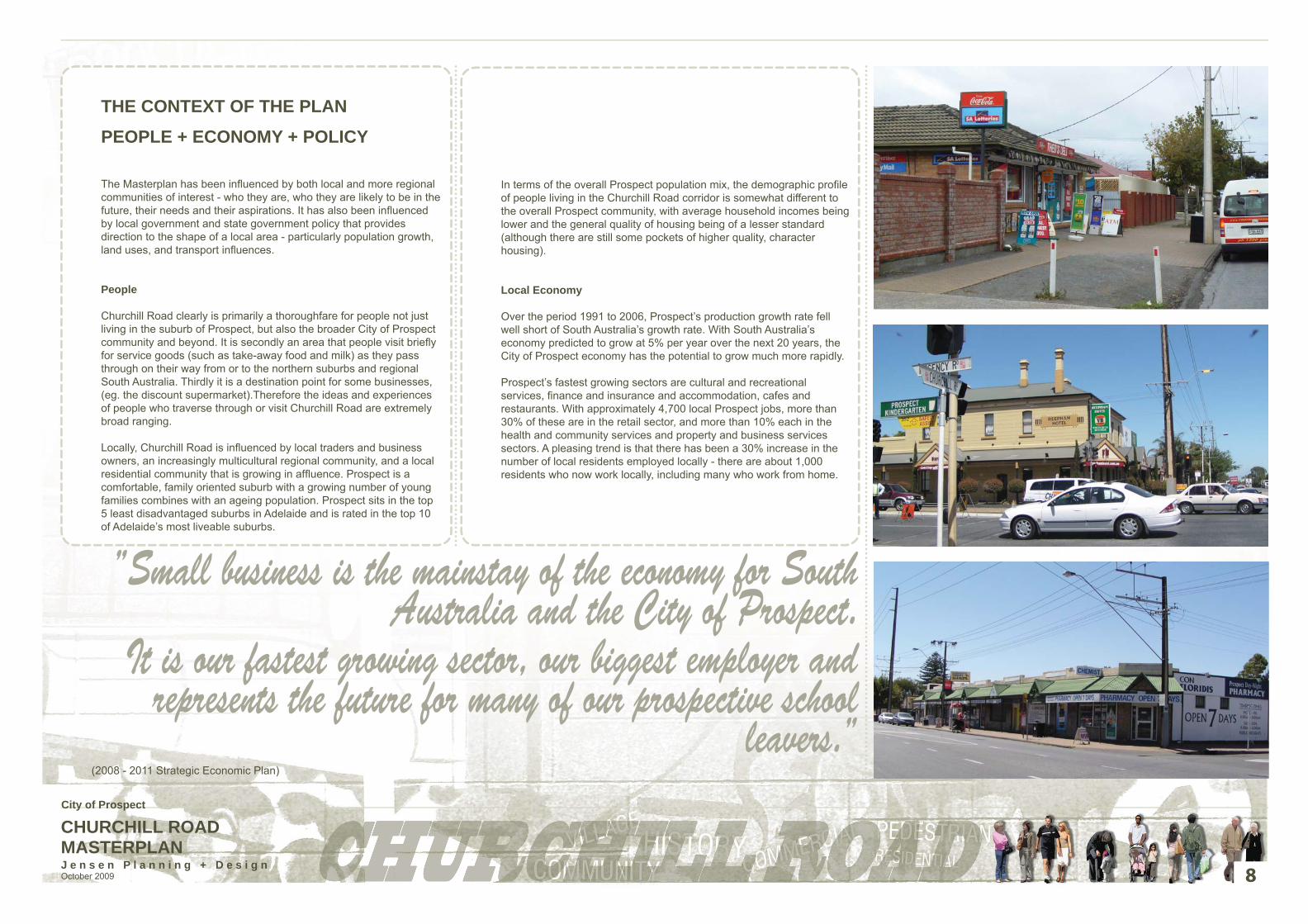
Churchill Road clearly is primarily a thoroughfare for people not just living in the suburb of Prospect, but also the broader City of Prospect community and beyond. It is secondly an area that people visit briefl y for service goods (such as take-away food and milk) as they pass through on their way from or to the northern suburbs and regional South Australia. Thirdly it is a destination point for some businesses, (eg. the discount supermarket).Therefore the ideas and experiences of people who traverse through or visit Churchill Road are extremely broad ranging. Locally, Churchill Road is infl uenced by local traders and business owners, an increasingly multicultural regional community, and a local residential community that is growing in affl uence. Prospect is a comfortable, family oriented suburb with a growing number of young families combines with an ageing population. Prospect sits in the top 5 least disadvantaged suburbs in Adelaide and is rated in the top 10 of Adelaide’s most liveable suburbs.
In terms of the overall Prospect population mix, the demographic profi le of people living in the Churchill Road corridor is somewhat different to the overall Prospect community, with average household incomes being lower and the general quality of housing being of a lesser standard (although there are still some pockets of higher quality, character housing).
Local Economy
Over the period 1991 to 2006, Prospect’s production growth rate fell well short of South Australia’s growth rate. With South Australia’s economy predicted to grow at 5% per year over the next 20 years, the City of Prospect economy has the potential to grow much more rapidly.
Prospect’s fastest growing sectors are cultural and recreational services, fi nance and insurance and accommodation, cafes and restaurants. With approximately 4,700 local Prospect jobs, more than 30% of these are in the retail sector, and more than 10% each in the health and community services and property and business services sectors. A pleasing trend is that there has been a 30% increase in the number of local residents employed locally - there are about 1,000 residents who now work locally, including many who work from home.
8
”Small business is the mainstay of the economy for South Australia and the City of Prospect.
It is our fastest growing sector, our biggest employer and represents the future for many of our prospective school
leavers.” (2008 - 2011 Strategic Economic Plan)
City of Prospect

CHURCHILL ROAD MASTERPLANJ e n s e n P l a n n i n g + D e s i g n October 2009
POLICY
Global Trends and Policy Linkages
The future plans for Churchill Road are strongly consistent with policy directions and plans established by Local government, State Government and Federal Government.
The Churchill Road Masterplan has also been developed within a global context of increasing priority being given to the wise and sustainable use of our natural resources, and to citizen movements across the world that advocate to “tread gently” on the earth. Food security, increasing obesity, climate change and water scarcity are some of the major Western trends that will impact directly on the look, shape and function of Churchill Road into the future. Importantly, there has been a signifi cant global shift in consumer behaviour as shoppers move from enclosed “big box” malls and big brand supermarkets, to main street retail strips and online shopping. The move back to community based main streets is a refl ection of the value consumers place on a community space, independent entrepreneurialship and small business innovation. Research in the USA suggests for every $100 spent in a mall shopping centre, only $17 is re-circulated within the local economy yet for every one hundred dollars spent in a main street shopping precinct, $45 is re-circulated within the local economy. This is why supporting Main Streets and local shopping precincts in Prospect is so important.
The Vision for Churchill Road which promotes increased medium density housing and employment activity sits comfortably with major global advances in carbon neutral policies, restrictions of urban growth at the fringes of our cities so that we can keep productive land and travel less distances, and a return to lifestyles that value a diverse and active local community and locally grown food.
The following diagram illustrates the relationships between the different key plans at these different levels of government.
State Government Policy Linkages
There are a number of documents prepared by the South Australian State Government which infl uence the future form and character of Churchill Road corridor, including South Australia’s Strategic Plan and the recently released Draft 30 Year Plan for Greater Adelaide.
This latest Plan establishes the overall direction for future development in Adelaide, with a particular focus on locating the majority of new housing in current urban areas (i.e. not at the fringe) and around transport corridors. It is set within the context of anticipated signifi cant population increase in our state - an additional 537,000 people by 2030. It is anticipated that about 187,000 additional residents will be accommodated in 85,000 dwellings in transit corridors throughout metropolitan Adelaide over the next 30 years. This will mean a major increase in housing and population densities in some areas.
To accommodate some of this growth, there is a focus on creating 13 new Transit Oriented Developments (TOD’s) along Adelaide’s railways. Whilst no locations are identifi ed formally alongside the railway line near Churchill Road, it is likely however that Dudley Park, Ovingham and Islington Railway Station will be upgraded in the future to accommodate increased train patronage. The proposed major new development on 250 Churchill Road will also likely facilitate new development around the Islington Railway Station.
Churchill Road is not currently recognized as a corridor in the Draft 30 Year Plan. However the Churchill Road Masterplan provides for typical “corridor” activities - an increase in medium to high density housing and a greater number of mixed use employment activities incorporating shops and offi ce. It would be appropriate for Churchill Road to be formally considered as an activity corridor in keeping with the overall vision for the corridor.
Medium to high density housing, and a greater number of mixed use employment activities incorporating shops and offi ces will be encouraged to locate along both Prospect Road and Churchill Road.
The draft 30 Year Plan also proposes a “Greenways policy” which requires the establishment of cycling/open space corridors alongside all rail lines. This may be potentially achieved alongside Devonport Terrace.
South Australia’s Strategic Plan also includes a Target to increase the use of public transport to 10% of metropolitan weekday passenger vehicle kilometres travelled by 2018. To meet this target the state government is investing heavily in rail and tram infrastructure including the service that runs from Glenelg through the Adelaide CBD, to West Lakes and to Semaphore through Port Adelaide, the extension of the tramline further along North Terrace onto Port Road, extension of the Noarlunga line to Seaford and upgraging the northern train line from Adelaide to Gawler.
The draft 30 Year Plan indicated a desire for more effi cient and frequent bus movements along Prospect Road, and the longer term potential for a tram line (or light rail) along Prospect Road (which is also supported by Prospect Council).
9
Accommodating this direction to increase residential density along Churchill Road and provide more opportunities for mixtures of commercial and retailing land uses will need to be sensitively planned.
The suburb of Prospect has a strong character refl ected in its large blocks, wide frontages and setbacks, tree lined streets and heritage buildings and these areas should be protected. However Churchill Road (and Prospect Road) already have a strong presence of multi unit fl ats interspersed along the length of the street and there is opportunity to increase residential densities by infi lling along parts of the road away from the character areas.
Local Government Strategic Policy Linkages
The City of Prospect Strategic Plan has identifi ed the need to recognise heritage and character within the City of Prospect through the preservation of character dwellings, ensuring new development is complementary to the existing area, increase the number of leafy streets, and include quality public art and attractive public spaces. The Strategic Plan has also identifi ed the need for more environmentally sustainable design techniques for urban development.
Council’s Development Plan Review 2008-2011 has identifi ed key issues that need to be considered when undertaking new development in residential areas. Heritage and character is considered important to create a sense of place, with a desire for heritage buildings not to be demolished and vegetation on private land preserved. The Review has identifi ed the need to recognize additional items of heritage value within the council area.
Prospect Road has been identifi ed as a “corridor” in the Draft 30 Year Plan. Corridor activities as defi ned in the 30 Year Plan are consistent with Prospect Road Masterplan’s directions which provides for an increase in medium to high density housing and a greater number of mixed use employment activities incorporating shops and offi ces.
The document also recommended supporting the redevelopment of Lot 250 Churchill Road (on the south western corner of Churchill Road and Regency Road intersection) for residential with mixed use and open space.
Council recognises that business development plays a fundamental role in the development of a sustainable city and aims to support and encourage business owners within the defi ned precincts.
City of Prospect

CHURCHILL ROAD MASTERPLANJ e n s e n P l a n n i n g + D e s i g n October 2009 10
City of Prospect

CHURCHILL ROAD MASTERPLANJ e n s e n P l a n n i n g + D e s i g n October 2009
INVESTIGATIONS AND ANALYSIS
11
City of Prospect

CHURCHILL ROAD MASTERPLANJ e n s e n P l a n n i n g + D e s i g n October 2009
THE CURRENT EXPERIENCE, IMAGE AND IDENTITY OF CHURCHILL ROAD
The branding and profi le of Churchill Road is important. The way in which it is perceived is a fundamental part of how successful and economically sustainable it is.
An analysis of the current experience, image and identity of Churchill Road has been undertaken to assist in developing a future vision.
The Current Situation
Churchill Road is in urgent need of a streetscape and road surface upgrade. Apart from the Torrens Road Gateway which is visually appealing with wide landscaped verges, paved footpaths and underground powerlines, the remainder of the street is looking run down. Kerbs and gutters are cracked- in some places non existent, footpaths are inconsistent, street trees are sparse and the overhead powerlines dominate the skyline.
The result of this run down and shabby identity has been the closure of some businesses, shops showing declining investment, poor promotion and take up of commercial opportunities, sometimes incompatible development and compromised safety for residents and visitors to Churchill Road.
Churchill Road provides a vital arterial link between the Adelaide CBD and the northern suburbs for commuters.
It also functions as a freight route for heavy vehicles bypassing the city and linking industry north and south of Adelaide. It is also a known ‘shortcut’ for road users wanting to aviod South and Main North Roads.
Locally, Churchill Road is the home to many small businesses including delis, hotels, pharmacies and even a biscotti shop. Many of these businesses rely on passing traffi c to survive so although the road is dominated by vehicle movements and vehicle noise, this activity is also the life blood for businesses on the road.
Conversely interspersed between small businesses are many private residents who, have listed traffi c and traffi c noise as being one of their biggest issues with Churchill Road.
In the midst of the vehicle dominance Churchill Road has two signifi cant reserves - Cane Reserve and George Whittle Reserve - that provide respite and sanctuary for residents and visitors.
Crossing Churchill Road can be diffi cult, either on foot or by car. The procession of traffi c is constant, partly due to the lack of traffi c lights to control the fl ow, as well as a lack of safe pedestrian crossing points. Hence Churchill Road tends to divide the community, with the residents east of Churchill Road preferring to use Prospect Road and Prospect Road facilities. While those on the western side generally use local facilities on Churchill Road or drive elsewhere.
12
The Torrens Road and Churchill Road intersection (Torrens Road Gateway) is attractively landscaped with trees and shrubs in the verges that screen the residential development behind. This intersection has been recently upgraded by the Department of Transport Energy and Infrastructure (DTEI) to increase the transport capacity and improve it’s function.
Run down and gritty streetscape is visually unappealing and lacks legibility which is a safety concern for road users and pedestrians.
Continual heavy vehicles add to traffi c noise and congestion while also making it diffi cult and uncomfortable to cross Churchill Road. Traffi c dominates the street.
Crossing Churchill Road is diffi cult and there are limited crossing points.
George Whittle Reserve is one of two reserves on Churchill Road in which you can escape the traffi c and noise. We consider these reserves to be the oases of Churchill Road.
City of Prospect
CHURCHILL ROAD MASTERPLANJ e n s e n P l a n n i n g + D e s i g n October 2009
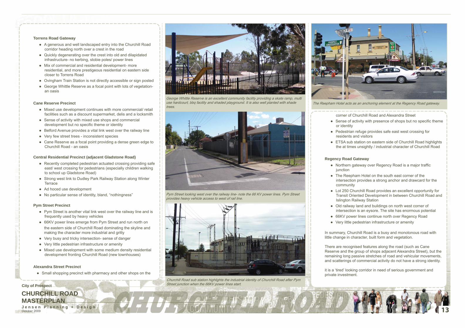
corner of Churchill Road and Alexandra StreetSense of activity with presence of shops but no specifi c theme ●or identityPedestrian refuge provides safe east west crossing for ●residents and visitorsETSA sub station on eastern side of Churchill Road highlights ●the at times unsightly / industrial character of Churchill Road
Regency Road GatewayNorthern gateway over Regency Road is a major traffi c ●junctionThe Reepham Hotel on the south east corner of the ●intersection provides a strong anchor and drawcard for the communityLot 250 Churchill Road provides an excellent opportunity for ●Transit Oriented Development in between Churchill Road and Islington Railway StationOld railway land and buildings on north west corner of ●intersection is an eysore. The site has enormous potential66KV power lines continue north over Regency Road ●Very little pedestrian infrastructure or amenity ●
In summary, Churchill Road is a busy and monotonous road with little change in character, built form and vegetation.
There are recognised features along the road (such as Cane Reserve and the group of shops adjacent Alexandra Street), but the remaining long passive stretches of road and vehicular movements, and scatterings of commercial activity do not have a strong identity.
it is a ‘tired’ looking corridor in need of serious government and private investment.
Pym Street looking west over the railway line- note the 66 KV power lines. Pym Street provides heavy vehicle access to west of rail line.
Churchill Road sub station highlights the industrial identity of Churchill Road after Pym Street junction when the 66KV power lines start.
The Reepham Hotel acts as an anchoring element at the Regency Road gateway.George Whittle Reserve is an excellent community facility providing a skate ramp, multi use hardcourt, bbq facility and shaded playground. It is also well planted with shade trees.
Torrens Road Gateway A generous and well landscaped entry into the Churchill Road ●corridor heading north over a crest in the roadQuickly degenerating over the crest into old and dilapidated ●infrastructure- no kerbing, stobie poles/ power linesMix of commercial and residential development- more ●residential, and more prestigeous residential on eastern side closer to Torrens RoadOvingham Train Station is not directly accessible or sign posted ●George Whittle Reserve as a focal point with lots of vegetation- ●an oasis
Cane Reserve PrecinctMixed use development continues with more commercial/ retail ●facilities such as a discount supermarket, delis and a locksmithSense of activity with mixed use shops and commercial ●development but no specifi c theme or identityBelford Avenue provides a vital link west over the railway line ●Very few street trees - inconsistent species ●Cane Reserve as a focal point providing a dense green edge to ●Churchill Road - an oasis
Central Residential Precinct (adjacent Gladstone Road)Recently completed pedestrian actuated crossing providing safe ●east/ west crossing for pedestrians (especially children walking to school up Gladstone Road)Strong west link to Dudley Park Railway Station along Winter ●TerraceAd hoced use development ●No particular sense of identity, bland, “nothingness” ●
Pym Street PrecinctPym Street is another vital link west over the railway line and is ●frequently used by heavy vehicles66KV power lines emerge from Pym Street and run north on ●
the eastern side of Churchill Road dominating the skyline and making the character more industrial and gritty
Very busy and tricky intersection- sense of danger ●Very little pedestrian infrastructure or amenity ●Mixed use development with some medium density residential ●development fronting Churchill Road (new townhouses)
Alexandra Street PrecinctSmall shopping precinct with pharmacy and other shops on the ●
13
City of Prospect
CHURCHILL ROAD MASTERPLANJ e n s e n P l a n n i n g + D e s i g n October 2009
BUILDING A NEW IMAGE + IDENTITY
There are many opportunities to enhance the image and identity of Churchill Road, and to authentically market the Churchill Road “story” to new and existing residents, shoppers, business owners and property developers. Some opportunities relate to buildings and design treatments, whilst others relate to culture, the way business is conducted, marketing and perceptions.
Transform the Land Uses
The Churchill Road corridor is located within 10 minutes of the Adelaide CBD and includes both road and heavy rail infrastructure. It has huge potential to provide for an increased residential and employment base, particularly in the form of higher density housing and commercial offi ce/employment developments. New townhouse and apartment developments will also diversify the overall Prospect housing mix, enabling those who wish to move from larger homes into smaller, more affordable housing to stay within the community.
Signifi cant changes to zoning are therefore required, as is signifi cant investment in the public realm infrastructure to promote private investment.
Build the culture
Council needs to provide bold leadership and governance with • respect to Churchill Road residents and business ownersIt needs to resource and initiate short term actions recommended in • this MasterplanIt should run small business image and identity workshops to build • the skill and knowledge about how local businesses can contribute to the overall experience of Churchill RoadIt should seek to create the foundations for strategic and high • quality development through changes to the Development Plan and Council should actively promote these short term actions and • changes so that the broader community knows that “something is happening”
14
Authentic engagement of community and business
Council needs to work closely with active local traders and residents• It needs to value their input• It should actively respond to their ideas • It should mobilise the community to a common vision/story• It needs to build upon the ground swell of ideas and energy created • during the development of this Masterplan Council should use activities (such as street markets), local groups • (such as a business owners group) to continue to build upon the energy and actions
Build the look and feel
Churchill Road’s identity and image should be celebrated and promoted • in vibrant contemporary waysThe design development and documentation of Churchill Road • streetscape works should be fast tracked to capture the momentum and community interest in the projectArtists should be engaged in the design development and • documentation streetscape works to ensure the integration of art elements with new infrastructureArtist designed fl ags/banners could be used to mark different precincts • along Churchill RoadApply for funding to underground powerlines- make it happen•
Greening Churchill Road
Council to work closely with local business to develop a Greening • Churchill Road StrategyConsider using resources that are renewable and recyclable and use • less energy to make and transport themPlant more trees. They improve the look of the area as well as provide • shade, canopy, and help create a local microclimate
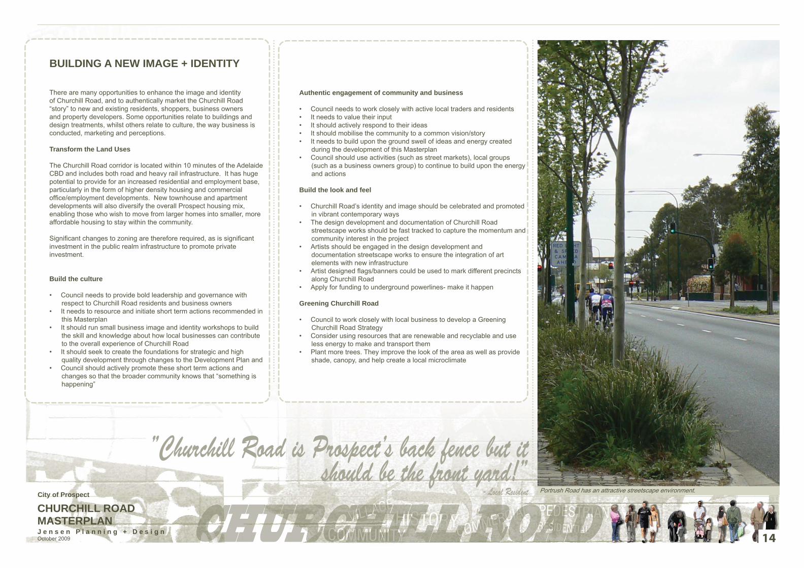
Portrush Road has an attractive streetscape environment.
”Churchill Road is Prospect’s back fence but it should be the front yard!”
- Local ResidentCity of Prospect

CHURCHILL ROAD MASTERPLANJ e n s e n P l a n n i n g + D e s i g n October 2009 15
LAND USES AND ZONING
Any changes to the land uses along Churchill Road will need to consider many aspects including the longer term vision for the corridor, incompatible land uses (such as commercial adjacent residential), building heights, traffi c, safety, existing vegetation and the streetscape quality. Land use changes also need to be considered in terms of the provisions in the Prospect (City) Development Plan. This is the document guiding the assessment of new development in the Council area.
Any signifi cant changes to land uses along the Churchill Road corridor are likely to require changes to the actual zones or policy areas described in the Development Plan. This will mean undertaking a Development Plan Amendment which will involve public consultation and more detailed investigations.
For these reasons it is important to understand the current zoning provisions contained in Council’s Development Plan.
Residential Zone IssuesResidential Policy Area B200Most residential areas along the Churchill Road corridor are located within this Policy Area which promotes a diverse mix of two to three-storey, medium density housing in the form of semi-detached dwellings, row and group dwellings and residential fl at buildings. Densities should increase in areas adjacent to public transport and arterial roads with higher density development being located on amalgamated allotments.
Residential Policy Area A350This Policy Area is located in the Torrens Road Gateway Precinct at the southern end of the corridor, to the western side of Churchill Road. It seeks an attractive residential environment comprising a mix of existing dwellings at low to medium densities and the redevelopment of sites generally at greater densities than the existing housing stock. Two storey buildings and medium density development on amalgamated allotments may be suitable in certain locations providing existing mature vegetation is retained and dwelling styles and materials are sympathetic to the existing housing stock. Setbacks from property boundaries should allow for the retention of existing vegetation and additional landscaping, particularly in the front yard area.
Residential Policy Area A450This is located in the Torrens Road Gateway Precinct at the southern end of Churchill Road on the eastern side. It seeks to achieve an attractive residential environment comprising predominantly single storey detached dwellings on large, densely landscaped allotments and mature street trees. The amalgamation of sites may result in appropriately designed medium density development on allotments within close proximity to public transport nodes and shopping areas.
However, this should not be achieved at the expense of the generously vegetated garden character of the area.
The Policy Area requires generous setbacks from property boundaries to allow for front and side landscaping which creates a visual separation between dwellings.
Residential Zone Opportunities
Regency Road Gateway PrecinctA future Transit Oriented Development (TOD) is proposed for land on the western side of Churchill Road located within the Mixed Use Zone.
This development could feed into and link with the eastern side of Churchill Road. However, the RB200 and RA450 zoning on the eastern side of Churchill Road restrict densities that support TOD’s and mixed uses. While the RB200 zoning allows for somewhat higher densities, it does not allow for a variety of uses. The RA450 Policy Area encourages single storey dwellings generally at lower densities. Changes in zoning are required to encourage development that supports TOD’s.
Central Residential Precinct/ Alexandra Street Precinct/ Pym Street PrecinctWhile these precincts are zoned to allow new medium density development to be constructed along the Churchill Road corridor, densities and height limits will need to be reviewed to promote multi-level higher density apartment buildings. These areas are within walking distance of Dudley Park Rail Station, buses along Churchill Road and between two shopping centre precincts. The Council area has a shortage of well located, higher density housing areas within close proximity to public transport, recreation and retail areas. Increasing medium density development in this location would meet the needs of the community in a convenient location.
Cane Reserve HubWhile this area is ideally suitable for medium-high density development, currently densities in this area are quite low.
There are opportunities to concentrate medium density housing adjacent Cane Reserve and the train line. This is generally in-keeping with the Desired Character of the Residential Policy Area B200 which encourages medium density development at two to three storeys.
However densities and height limits will need to be increased to promote attractive, high density apartment buildings close to public transport facilities.
Torrens Road Gateway PrecinctResidential development in this precinct is controlled by the Residential Policy Areas B200, A350 and A450. The RB200 allows for medium density development along Churchill Road. There is a local shop and skate park within the RA350 Policy Area which services the local area and a bus stop in front of the skate park. This area would therefore respond well to medium density development at a greater capacity than the RA350 allows.
Figure 1: Churchill Road Zoning MapCity of Prospect

CHURCHILL ROAD MASTERPLANJ e n s e n P l a n n i n g + D e s i g n October 2009 16
There is the opportunity to upgrade Ovingham Railway Station and encourage train usage with new signage and through good station design with passive surveillance, better lighting and parking.
There are a number of character homes in this Precinct on both sides of Churchill Road. The local community has urged Council to protect these areas from higher density development to retain the existing character. However there are only two properties that have Local Heritage status, with no properties on the State Heritage list. This area is located very close to Ovingham railway station and is very close to the central city area, thereby fulfi lling the key requirements typical for encouraging high density residential redevelopment. Further investigations will need to be undertaken as part of a future DPA to determine the balance between promoting higher density development and protecting low density, character areas.
A gateway statement with public art and signage, could be provided on the western corner of Fitzroy Terrace and Churchill Road to announce the arrival into Prospect from the city.
Generally The interface between residential and industrial/commercial uses can create noise issues for residents. A transitional zone would place greater restrictions on industrial/commercial land uses operating adjacent to residential zones and improve the amenity of residents.
There may be an opportunity to provide a “Portrush Road” style of fencing and landscaping treatments for noise attenuation. These styles of fences are not consistent with the current Development Plan provisions, as Residential Policy Areas B200, A350 and A450 each require that front fences are visually permeable and are an open style. A change in policy is necessary to allow masonry and solid styles of fences along Churchill Road.
Commercial Zone Issues
This Zone accommodates a range of retail, light industrial and commercial activities. Appropriate uses within the Zone and along Churchill Road include offi ce, outdoor display, petrol fi lling station, service trade premises, store and warehousing. Medium to high density student accommodation may also be appropriate on land nearby the Churchill Road/Regency Road intersection.
Commercial Zone Opportunities
Regency Road Gateway This area lacks identity and an entrance statement, which reinforces the change of character from industrial to mixed use and residential. These is opportunity to provide this at this intersection.
There are opportunities for increased retail and commercial land uses with a café opposite the TOD on Churchill Road or around the corner in a side street.
Alexandra Street Node / Pym Street PrecinctSome of the uses within the Commercial Zone may be noisy and confl ict with the adjacent residential areas. This node is seen as the retail core of Churchill Road and may function better as a Local Centre/Mixed Use Zone which provides services to the local residential community. Industrial and other similar uses should be discouraged in favour of commercial offi ce, retail and residential uses.
The Alexandra Street mini-node is predominantly retail with some residential development. The nature of the area needs to be reinforced with strong clusters of retail development and include good signage to give the area a strong identity.
Pym Street is used as a truck thoroughfare and is not wide enough to accommodate safe and convenient turning to and from Churchill Road. The eastern end of Pym Street is not wide enough to allow a large truck to turn without using both sides of the road and subsequently some trucks have been mounting and damaging the footpaths and putting pedestrians at risk.There may be an opportunity to acquire some privately owned residential land to widen the corner of Pym Street and allow for safe and convenient truck turning.
Cane Reserve HubNew development needs to be sympathetic to the adjacent residential development and provide for the local needs of residents. The commercial zoning to the east and south of this area may not be the best zoning for the desired land uses. There are shops located adjacent to Cane Reserve, which could be expanded to create a hub of convenience stores.
The Discount Supermarket store has insuffi cient car parking to service customers and is located adjacent to the Italian Club which is rarely used during the day. The Club carpark is now being shared between the two businesses.
This section of Churchill Road could become an area for boutique commercial uses encouraging small businesses similar to the Ossetti Biscuits business at 80 Churchill Road. This particular business is located within the Residential Policy Area B200 which is not suitable for commercial uses. However, as an existing use it can continue to operate. There is an opportunity to extend mixed use zoning further south and include specifi c principles which encourage small scale boutique retail and service uses and energise this section of the road.
GenerallyThere are issues with a lack of identity along all sections of Churchill Road with no clearly defi ned nodes of activity around shops, parks and
transport links. The corridor would benefi t from clearly defi ned precincts or nodes with clear signage. The commercial and retailing areas would benefi t from streetscape improvements to re-invigorate retail and community activity.
Community and Recreation Zone Issues
All community and recreational land uses located within Residential Policy Areas A350 and B200. These zones do not specifi cally address recreational issues in detail.
Community and Recreation Zone Opportunities
Regency Road Gateway The Development Plan suggests that new large scale development provides links to adjoining land uses and open space areas. There is only one portion of open space in the locality, to the north east of the future TOD site and located across two arterial roads. Providing links to access this area would be diffi cult and additional open space would need to be provided within the TOD to service the needs of the new residents.
The existing land use to the north and west of the future TOD is industrial which may be incompatible with residential land uses within the TOD and links to these areas, other than to the railway station, may not be benefi cial. Land currently zoned Light Industry could be rezoned to Mixed Use/TOD.
Cane Reserve HubCane Reserve could become a focal point by providing links to the reserve along Churchill Road and across the road by the use of a signalised pedestrian crossing.
The local community need a meeting place to connect and socialise. The Cane Reserve Node is an ideal location for a meeting place as it is a large reserve and is adjacent some local shops. The inclusion of a café here would also provide a place to meet while children play in the reserve or after a bike ride along the new bike path.
George Whittle Reserve (in Torrens Road Gateway Precinct)The use of the Skate Park and shop located on the corner of Allan Street and Churchill Road would increase if additional facilities such as outdoor seating, landscaping and bins were provided for people to stop, rest and enjoy the area. The provision of outdoor seating around the corner of the shop to link with the Skate Park is unlikely to cause issues with zoning as any improvements are an extension of the existing land uses.
City of Prospect
CHURCHILL ROAD MASTERPLANJ e n s e n P l a n n i n g + D e s i g n October 2009 17
Torrens Road GatewayThe shops located on the corner of Allan Street and Churchill Road and the skate park which is adjacent are both within the Residential Policy Area A350. They serve the local area and are considered appropriate in the zone.
GenerallyThere is insuffi cient provision of public recreation and open space generally throughout the Council area.
The open space areas currently provided need to be designed for maximum usage and easily accessed by surrounding residents. The potential for new areas of open space also needs to be investigated by Council.
A shared use path is proposed in a Linear Park Corridor along the railway line (alongside of Devonport Terrace). This area could be made into a landscaped park to provide cyclists and rail users with a more pleasant experience, encouraging sustainable transport use in the area.
There is an opportunity to undertake a feasibility study into undergrounding the 11KV transmission lines and feeder poles where possible and re-route 66KV lines along the railway corridor. The undergrounding of power would allow for street tree avenue planting along Churchill Road, greatly improve the appearance and provide incentive for private investment.
Pedestrian amenity can be improved through the provision of better quality, wider footpaths and kerbs, increased lighting to improve safety and shade trees planted along Churchill Road.
Mixed Use Zone Issues
A mix of all medium density housing forms are appropriate in the mixed use (Churchill Road) zone, including aged and student accommodation, which takes advantage of the proximity of the zone to transport services and facilities. There is a potential for transit oriented development adjacent the Islington Railway Station and the development of a local activity centre with frontage to both the Railway Station and nearby arterial roads.
Three storey development may be appropriate in certain locations, however, development should be generally two storeys. Buildings should be set back from the main roads and the railway line boundaries a minimum of six metres to allow for an intensive landscape buffer. Medium density residential development combined with the mixed use nature of the Zone will require innovative and sustainable design approaches to address potential issues such as bulk and scale, amenity, privacy, overshadowing, noise attenuation, open space, setbacks and landscaping.
A public open space network needs to be established focusing on passive recreation pursuits, linking areas and land uses across the zone and with adjoining open space, recreation and road networks. The recognized need for on-site car parking and the limited vehicle access to arterial roads, combined with bike and pedestrian pathways and public open space, will create a people orientated living environment.
Mixed Use Zone Opportunities
Regency Road Gateway This corner currently lacks identity and has a different land use on each corner. It is predominantly commercial and industrial with a large portion of land on the south western corner currently held as vacant land (Lot 250). Residential dwellings are scattered along the south eastern corner of Churchill Road. There needs to be a strengthening of mixed and residential land uses to the southern side of Regency Road to defi ne the area and allow for a gateway statement.
Proposals are currently being developed for the land on the south western corner to be developed as a mixed use TOD which would help strengthen the residential nature along the southern side of Regency Road. The development of this site will provide opportunities to ensure that good urban design principles are applied within the site and to the interface of Churchill Road, and also creating links to the wider community.
A central reserve could be included within the site that could link to the railway station and the future shared use path located along the railway line.
There is an opportunity at the Regency Road/Churchill Road intersection to provide a gateway statement announcing the entrance into the residential and mixed use precinct.
Given the size and location of this site opportunities for greater intensity of development than that provided for by the current zoning should be explored.
Industrial Zone Issues
The Light Industry Zone, located in the north-west quadrant of the Churchill/Regency Road intersection, accommodates low nuisance and low traffi c-generating light industrial land uses (light manufacturing, fabricating, storage and ancillary offi ce activities and marshalling yards relating to the railway line). Development undertaken in the zone should not create levels of noise, smoke, smell, dust or other nuisance or generate traffi c which would be detrimental to the character and amenity of adjoining residential development in residential zones to the east and south.
Industrial Zone Opportunities
The former railways land located within the Light Industry Zone is largely underutilised and provides great opportunities for high intensity, transit-oriented development taking advantage of the site’s proximity to the Islington railway station and to bus transport.
While some parts of the site are being used for industrial purposes, opportunities should be explored to completely redevelop the land and phase out these activities over time. In this way development on this land can, in the longer term, complement that proposed to the south of Regency Road.
Given the interface issues future uses that provide large numbers of employment opportunities and/or provide educational opportunities allowing students to travel to the site by public transport should be pursued.
GenerallyChurchill Road should be encouraged over Prospect Road for all freight and heavy traffi c movements.
Industrial land uses along the corridor should be progressively phased out and replaced with higher order, low impact employment uses such as commercial offi ce, mixed use and residential developments.
Greater integration is required between high intensity transit oriented development and the excellent (and improving) public transport infrastructure along the corridor.
“Getting the zoning right is critical before the Churchill Road vision can be achieved. A review of the existing zoning provisions
through a Development Plan Amendment is therefore a high priority.”
City of Prospect

CHURCHILL ROAD MASTERPLANJ e n s e n P l a n n i n g + D e s i g n October 2009
MOVEMENT AND PARKINGEase of movement is essential to the function and safety of any road. This is paramount not only for vehicles but also for pedestrians and cyclists. Improvements will make movement along Churchill Road and across Churchill Road more effi cient and safe for all users by upgrading facilities and increasing the legibility of the road space.
Car parking is always a contentious issue on main street projects, especially where local traders are dependent on passing traffi c for trade and where parking as close as possible to the front of the shop is the primary concern of the business owner (and of the driver). This is certainly the case on Churchill Road.
Churchill Road within the City of Prospect area stretches from Torrens Road in the south to Livingstone Avenue in the north.
The Annual Average Daily Traffi c (AADT) on this road is approximately 22,000 vehicles per day at the Torrens Road entrance and increases to 27,900 vehicles per day north of Regency Road (Reference DTEI data). The carriageway width varies signifi cantly on Churchill Road and varies between 13 and 15m in most instances, with one area being 19m wide. The verge width also varies along the length of the road. All street intersections, except Winter Street, are provided with painted or channelized right turn lanes.
IssuesWide road and verges but only line marked as a single lane road ●Painted median only- some use it as an overtaking lane and it does ●not provide a pedestrian refuge when crossing the streetVery few designated pedestrian crossing points (more are being ●constructed as this report is being fi nalised)Freight route- traffi c noise and pollution ●Pym Street junction not working due to stobie pole at the corner ●which jeopardises the turning of large vehicles into and out of the street. The right turn from Churchill Road to Pym Street has a protected right turn lane with kerbing towards outer wheel side which is unusual for the right turning vehicles and does not protect the oncoming traffi c pathMostly through traffi c with some destination traffi c within the precinct ●(discount supermarket)On street parking / verge parking is mostly ad hoc and not well ●designated. Motorists are afraid to park on the street due to heavy vehicles and speeding traffi cNo designated cycle lane ●Busy in peak hours and school periods ●Some forecourt parking to supplement on street/ verge parking ●Central right turn lanes in painted median into numerous side streets ●keep traffi c fl ow movingTorrens/Churchill Road and rail intersection is cause of serious ●congestion, particularly during peak periods with passing freight trains
OpportunitiesChange the fl ows of the road from a traffi c thoroughfare to an ●integrated mixed use boulevard within a transit corridor Increase pedestrian safety and east / west accessibility with more ●designated pedestrian crossing points with median refuges (more are being constructed as this report is being fi nalised)Formalise the streetscape (with raised median, better line marking, ●better verge treatment with landscaping) to increase legibility and safety for road users, cyclists and pedestriansBreak up the monotony of Churchill Road by altering the ●streetscape / landscape at points of interest along the road (for example Cane Reserve and George Whittle Reserve- the oases)Investigate opportunities for off street verge car parking adjacent to ●businesses that rely on passing trade to increase safety and help with traffi c movementIntegrate proposals for 250/252 Churchill Road with the ●recommendations of this Masterplan
RecommendationsWork with Department for Transport Energy and Infrastructure ●(DTEI) to design of a safer and more legible road and streetscape design for Churchill Road (Pym Street intersection a priority) to benefi t road users, cyclists and pedestrians and improve movement and traffi c circulationUpgrade road verges to facilitate easier pedestrian movement, ●verge parking and better driveway access to residences/businessesIncrease public transport frequency (buses), improved public ●transport facilities and road safety to encourage increased public transport usageUpgrade and promote (through signage and better east/ west ●connections) the three railway stations servicing the Churchill Road corridorProvide permanent bicycle lanes ●Investigate design options for Pym Street. Relocation of the ●electricity pole would signifi cantly improve the intersection effi ciency and safety. The costs associated with such a relocation may be prohibitive in the medium term, and other geometric changes, in association with some land acquisition, would also improve the intersection by providing a larger vehicle turn radiusCreate additional accessible and well signposted forecourt and rear ●of shop car parking areasInvestigate linking up and formalising carparking areas at the rear of ●businessesProvide more designated pedestrian crossing points with median ●refuges to improve east / west access for residents and pedestrians over Churchill Road (more are being constructed as this report is being fi nalised)
Indented verge parking needs to be investigated for businesses relying on passing traffi c for trade to increase safety and help with traffi c movement.
The Pym Street junction is a safety issue for motorists and pedestrians due to the proximity of a large stobie pole on the edge of the road restricting movement.
A streetscape upgrade of the road and verge will not only improve the appearance of Churchill Road but will increase legibility and safety for road users, cyclists and pedestrians.
18
City of Prospect

CHURCHILL ROAD MASTERPLANJ e n s e n P l a n n i n g + D e s i g n October 2009
STREETSCAPE, LANDSCAPING + PUBLIC REALM
The streetscape / public realm is vitally important to the functioning of a road. The legibility increases safety and aids movement. Increasingly it has also been shown that investment in the streetscape / public realm is a catalyst for economic revival, with businesses capitalising on the more user friendly and attractive nature of the road and verge environment. Improved amenity attracts new investment dollars and developers.
Examining the landscaping and public realm is a valuable process whereby the potential of a streetscape can be realised and exemplifi ed through design. It has the ability to defi ne (or re defi ne) a space to form a sense of place, and can add increase value and a higher quality experience of a place.
IssuesGenerally poor and run down streetscape for the length of the ●road (except for the junction with Torrens Road which was upgraded relatively recently)Inconsistent tree planting generally, spacing varies, tree species ●varies- some parts are well catered for with consistent tree planting. However some tree species (Plane Tree in particular) is a poor choice of tree given they have been planted under power lines and will soon need regular pruningGenerally poor and run down footpaths and kerbs- the ●interlocking pavers used are worn and are breaking up under vehicle useInconsistent verge widths/ treatments/ fencing makes for an ●unattractive streetscape and poor legibility Lack of precinct defi nition- housing, commercial and retail is ●mixed along the street affecting aestheticsPresence of stobie poles and 66KV high voltage poles north of ●Pym Street on the eastern side dominate the skyline and are visually unattractiveStreet and footpath lighting is poor- safety compromised at ●nightThe nothern end of the road near Charles Street is subject to ●localised fl ooding, and no water sensitive design features are incorporatedThe lack of large trees results in a hostile environment during ●hot climatic conditions
The existing streetscape amenity of Churchill Road is poor. Note the lack of kerbing in this photo.
19
OpportunitiesInvestigate opportunities for landscaping (street tree planting ●and low groundcover/ native grass planting) in road verges and in median strip similar to Portrush RoadIncrease space for pedestrians and improve pedestrian ●amenity and safety wherever possible through safe crossings, seating and shadeUse landscaping and public art to defi ne precincts and ●gateways along Churchill RoadCapitalise on existing assets / precincts (such as George ●Whittle Reserve and Cane Reserve) to break up the monotony of Churchill RoadUse contemporary materials for footpaths and street furniture ●that have associations with the character of Churchill Road and the wider Prospect communityIncorporate ways to capture and reuse stormwater (Water ●Sensitive Urban Design)Investigate opportunities to underground the power lines to ●improve the amenity and aesthetics of the streetIncrease safety at night by upgrading lighting (in conjunction ●with undergrounding of power lines)
RecommendationsWork with Department for Transport Energy and Infrastructure ●(DTEI) to develop a more attractive road and streetscape design for Churchill Road to benefi t residents, business owners, pedestrians and commutersIntegrate public art with the streetscape upgrade and provide ●attractive “gateway” sculpture/landscaping/lighting or other features at Torrens Road and Regency Road Undertake site specifi c designs to improve the legibility, ●function and beauty of certain precincts along Churchill Road to break up the monotony of the roadUndertake a Council wide Signage Strategy to help with the ●branding, legibility and function of Churchill RoadUndertake a Council wide Style Manual for urban furniture ●(bins, seats, bollards, lights, street trees) to identify and unite Churchill RoadInvestigate design options for a landscaped linear park shared ●use path corridor adjacent to the railway lineIntegrate best practice pursuits in the landscape design ●(including water sensitive urban design- WSUD and Crime Prevention through Environmental Design- CPTED)Seek funding for future undergrounding of powerlines and ●upgrade of street lightingWork with ETSA to soften the visual impact of the substation ●Work with developers of 250/252 Churchill Road sites to ●incorporate attractive streetscape edges along Churchill Road
George Whittle Reserve should be a focal point for landscaping and public art.
A raised and planted median could help to soften and green Churchill Road.
City of Prospect
CHURCHILL ROAD MASTERPLANJ e n s e n P l a n n i n g + D e s i g n October 2009
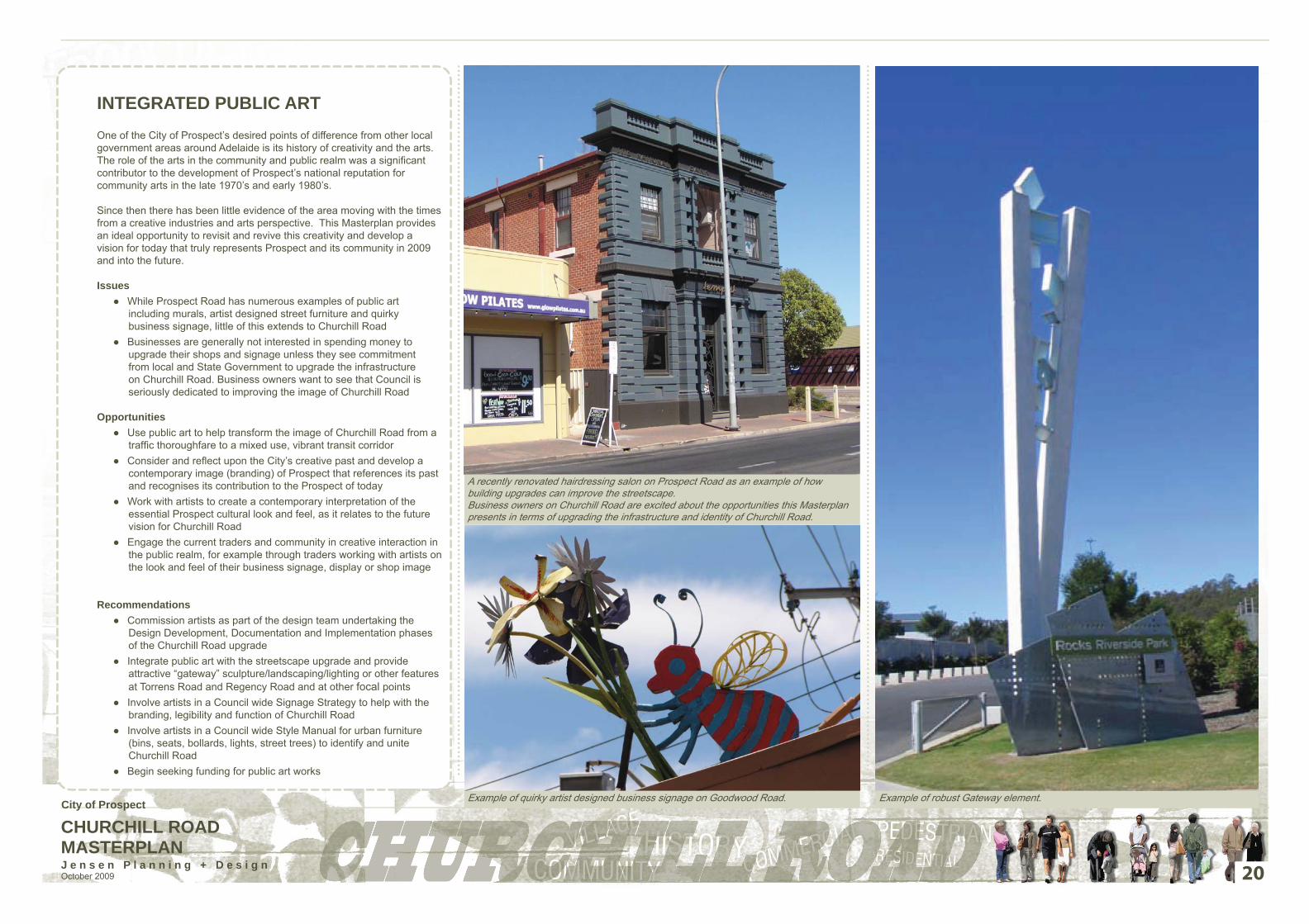
INTEGRATED PUBLIC ARTOne of the City of Prospect’s desired points of difference from other local government areas around Adelaide is its history of creativity and the arts. The role of the arts in the community and public realm was a signifi cant contributor to the development of Prospect’s national reputation for community arts in the late 1970’s and early 1980’s.
Since then there has been little evidence of the area moving with the times from a creative industries and arts perspective. This Masterplan provides an ideal opportunity to revisit and revive this creativity and develop a vision for today that truly represents Prospect and its community in 2009 and into the future.
IssuesWhile Prospect Road has numerous examples of public art ●including murals, artist designed street furniture and quirky business signage, little of this extends to Churchill RoadBusinesses are generally not interested in spending money to ●upgrade their shops and signage unless they see commitment from local and State Government to upgrade the infrastructure on Churchill Road. Business owners want to see that Council is seriously dedicated to improving the image of Churchill Road
OpportunitiesUse public art to help transform the image of Churchill Road from a ●traffi c thoroughfare to a mixed use, vibrant transit corridorConsider and refl ect upon the City’s creative past and develop a ●contemporary image (branding) of Prospect that references its past and recognises its contribution to the Prospect of todayWork with artists to create a contemporary interpretation of the ●essential Prospect cultural look and feel, as it relates to the future vision for Churchill RoadEngage the current traders and community in creative interaction in ●the public realm, for example through traders working with artists on the look and feel of their business signage, display or shop image
RecommendationsCommission artists as part of the design team undertaking the ●Design Development, Documentation and Implementation phases of the Churchill Road upgradeIntegrate public art with the streetscape upgrade and provide ●attractive “gateway” sculpture/landscaping/lighting or other features at Torrens Road and Regency Road and at other focal pointsInvolve artists in a Council wide Signage Strategy to help with the ●branding, legibility and function of Churchill RoadInvolve artists in a Council wide Style Manual for urban furniture ●(bins, seats, bollards, lights, street trees) to identify and unite Churchill RoadBegin seeking funding for public art works ●
20
A recently renovated hairdressing salon on Prospect Road as an example of how building upgrades can improve the streetscape.Business owners on Churchill Road are excited about the opportunities this Masterplan presents in terms of upgrading the infrastructure and identity of Churchill Road.
Example of quirky artist designed business signage on Goodwood Road. Example of robust Gateway element.City of Prospect
CHURCHILL ROAD MASTERPLANJ e n s e n P l a n n i n g + D e s i g n October 2009
SERVICES AND INFRASTRUCTURE
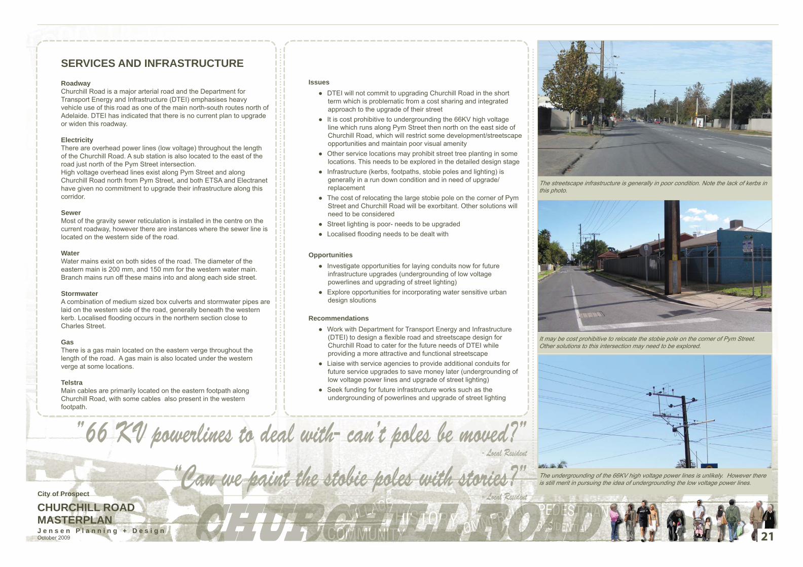
RoadwayChurchill Road is a major arterial road and the Department for Transport Energy and Infrastructure (DTEI) emphasises heavy vehicle use of this road as one of the main north-south routes north of Adelaide. DTEI has indicated that there is no current plan to upgrade or widen this roadway.
ElectricityThere are overhead power lines (low voltage) throughout the length of the Churchill Road. A sub station is also located to the east of the road just north of the Pym Street intersection. High voltage overhead lines exist along Pym Street and along Churchill Road north from Pym Street, and both ETSA and Electranet have given no commitment to upgrade their infrastructure along this corridor.
SewerMost of the gravity sewer reticulation is installed in the centre on the current roadway, however there are instances where the sewer line is located on the western side of the road.
WaterWater mains exist on both sides of the road. The diameter of the eastern main is 200 mm, and 150 mm for the western water main. Branch mains run off these mains into and along each side street.
StormwaterA combination of medium sized box culverts and stormwater pipes are laid on the western side of the road, generally beneath the western kerb. Localised fl ooding occurs in the northern section close to Charles Street.
GasThere is a gas main located on the eastern verge throughout the length of the road. A gas main is also located under the western verge at some locations.
TelstraMain cables are primarily located on the eastern footpath along Churchill Road, with some cables also present in the western footpath.
IssuesDTEI will not commit to upgrading Churchill Road in the short ●term which is problematic from a cost sharing and integrated approach to the upgrade of their streetIt is cost prohibitive to undergrounding the 66KV high voltage ●line which runs along Pym Street then north on the east side of Churchill Road, which will restrict some development/streetscape opportunities and maintain poor visual amenityOther service locations may prohibit street tree planting in some ●locations. This needs to be explored in the detailed design stageInfrastructure (kerbs, footpaths, stobie poles and lighting) is ●generally in a run down condition and in need of upgrade/ replacementThe cost of relocating the large stobie pole on the corner of Pym ●Street and Churchill Road will be exorbitant. Other solutions will need to be consideredStreet lighting is poor- needs to be upgraded ●Localised fl ooding needs to be dealt with ●
OpportunitiesInvestigate opportunities for laying conduits now for future ●infrastructure upgrades (undergrounding of low voltage powerlines and upgrading of street lighting)Explore opportunities for incorporating water sensitive urban ●design sloutions
RecommendationsWork with Department for Transport Energy and Infrastructure ●(DTEI) to design a fl exible road and streetscape design for Churchill Road to cater for the future needs of DTEI while providing a more attractive and functional streetscapeLiaise with service agencies to provide additional conduits for ●future service upgrades to save money later (undergrounding of low voltage power lines and upgrade of street lighting)Seek funding for future infrastructure works such as the ●undergrounding of powerlines and upgrade of street lighting
21
The streetscape infrastructure is generally in poor condition. Note the lack of kerbs in this photo.
It may be cost prohibitive to relocate the stobie pole on the corner of Pym Street. Other solutions to this intersection may need to be explored.
The undergrounding of the 66KV high voltage power lines is unlikely. However there is still merit in pursuing the idea of undergrounding the low voltage power lines.
”66 KV powerlines to deal with- can’t poles be moved?”- Local Resident
“Can we paint the stobie poles with stories?”- Local ResidentCity of Prospect

CHURCHILL ROAD MASTERPLANJ e n s e n P l a n n i n g + D e s i g n October 2009 22
City of Prospect
CHURCHILL ROAD MASTERPLANJ e n s e n P l a n n i n g + D e s i g n October 2009 23
MASTERPLANS
City of Prospect
CHURCHILL ROAD MASTERPLANJ e n s e n P l a n n i n g + D e s i g n October 2009
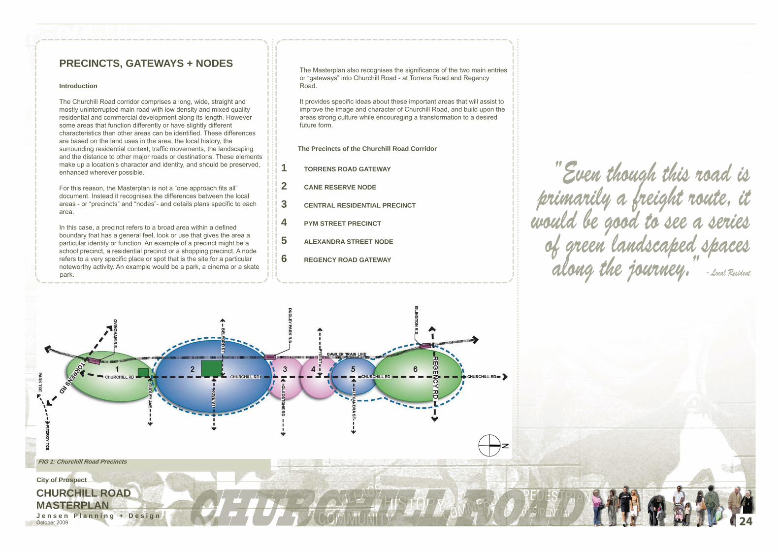
PRECINCTS, GATEWAYS + NODES
Introduction
The Churchill Road corridor comprises a long, wide, straight and mostly uninterrupted main road with low density and mixed quality residential and commercial development along its length. However some areas that function differently or have slightly different characteristics than other areas can be identifi ed. These differences are based on the land uses in the area, the local history, the surrounding residential context, traffi c movements, the landscaping and the distance to other major roads or destinations. These elements make up a location’s character and identity, and should be preserved, enhanced wherever possible.
For this reason, the Masterplan is not a “one approach fi ts all” document. Instead it recognises the differences between the local areas - or “precincts” and “nodes”- and details plans specifi c to each area.
In this case, a precinct refers to a broad area within a defi ned boundary that has a general feel, look or use that gives the area a particular identity or function. An example of a precinct might be a school precinct, a residential precinct or a shopping precinct. A node refers to a very specifi c place or spot that is the site for a particular noteworthy activity. An example would be a park, a cinema or a skate park.
The Masterplan also recognises the signifi cance of the two main entries or “gateways” into Churchill Road - at Torrens Road and Regency Road.
It provides specifi c ideas about these important areas that will assist to improve the image and character of Churchill Road, and build upon the areas strong culture while encouraging a transformation to a desired future form.
The Precincts of the Churchill Road Corridor
1 TORRENS ROAD GATEWAY
2 CANE RESERVE NODE
3 CENTRAL RESIDENTIAL PRECINCT
4 PYM STREET PRECINCT
5 ALEXANDRA STREET NODE
6 REGENCY ROAD GATEWAY
FIG 1: Churchill Road Precincts
24
”Even though this road is primarily a freight route, it
would be good to see a series of green landscaped spaces along the journey.” - Local Resident
City of Prospect

CHURCHILL ROAD MASTERPLANJ e n s e n P l a n n i n g + D e s i g n October 2009 25
Churchill Road - indicative cross section showing the proposed streetscape treatment
Churchill Road - Artists impression of the proposed streetscape treatment
Churchill Road - plan detail showing the proposed streetscape treatment
OVERALL STREETSCAPE CONCEPTThe proposed streetscape treatment is derived from the following summary of stakeholder/ community imput and feedback and our professional knowledge of streetscape design:
improve the footpath environment• improve safety for pedestrians crossing the road• improve provision for on-street parking for residents and businesses• make more attractive with trees / vegetation• increase residential densities and promote new commercial development• improve recreation facilities - existing parks and new linear park along side • railway corridorimprove east / west linkages to Prospect Road and railway stations. •
The streetscape concept responds to these principles by providing a forma-lised road structure with a raised median and planting (where possible) and new kerbs and linemarking designating traffi c and bicycle lanes.
The streetscape concept also shows an upgraded road verge with new foot-path paving and driveway crossovers, new paved verge with specifi c indented parking bays and landscaping to soften the road edge and above ground infrastructure (eg powerlines, ETSA sub-station).
The design concepts seek to provide future direction for the detailed design process and are indicative only. The model depicted will need to be tested in the detailed design phase with respect to existing services and railway widths along the length of the road.
City of Prospect
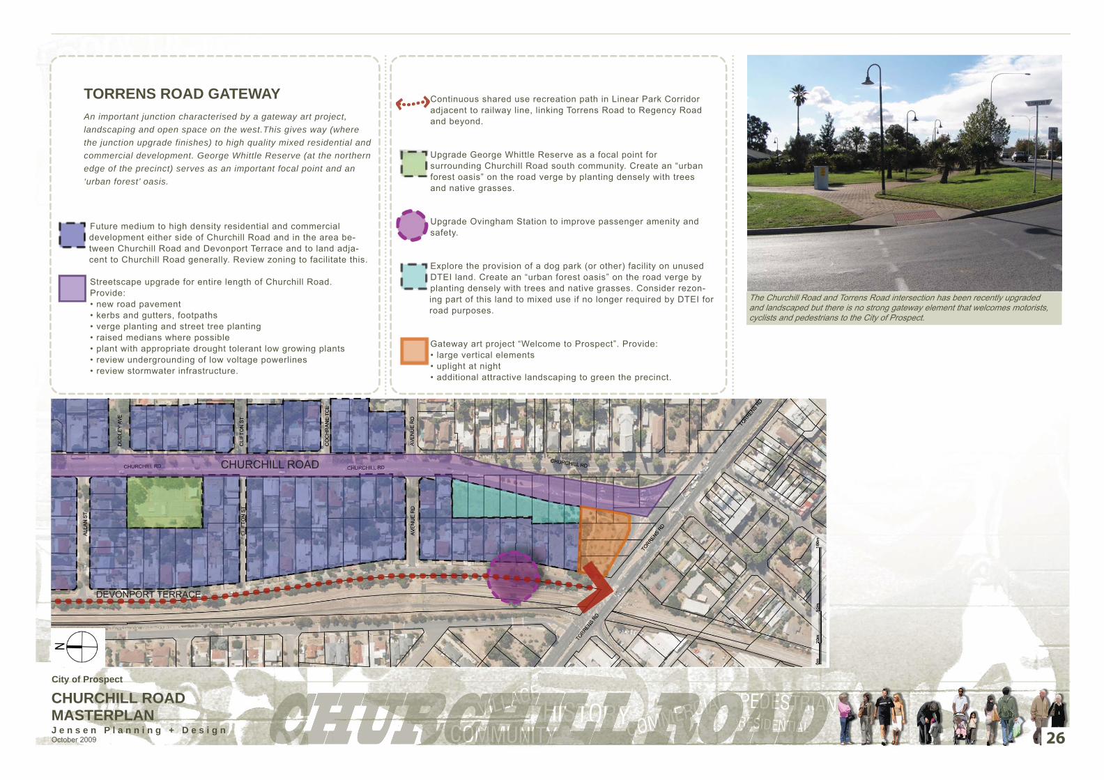
CHURCHILL ROAD MASTERPLANJ e n s e n P l a n n i n g + D e s i g n October 2009
TORRENS ROAD GATEWAYAn important junction characterised by a gateway art project, landscaping and open space on the west.This gives way (where the junction upgrade finishes) to high quality mixed residential and commercial development. George Whittle Reserve (at the northern edge of the precinct) serves as an important focal point and an ‘urban forest’ oasis.
Future medium to high density residential and commercial development either side of Churchill Road and in the area be-tween Churchill Road and Devonport Terrace and to land adja-cent to Churchill Road generally. Review zoning to facilitate this.
Streetscape upgrade for entire length of Churchill Road. Provide: • new road pavement • kerbs and gutters, footpaths • verge planting and street tree planting • raised medians where possible • plant with appropriate drought tolerant low growing plants • review undergrounding of low voltage powerlines • review stormwater infrastructure.
Continuous shared use recreation path in Linear Park Corridor adjacent to railway line, linking Torrens Road to Regency Road and beyond.
Upgrade George Whittle Reserve as a focal point for surrounding Churchill Road south community. Create an “urban forest oasis” on the road verge by planting densely with trees and native grasses.
Upgrade Ovingham Station to improve passenger amenity and safety.
Explore the provision of a dog park (or other) facility on unused DTEI land. Create an “urban forest oasis” on the road verge by planting densely with trees and native grasses. Consider rezon-ing part of this land to mixed use if no longer required by DTEI for road purposes.
Gateway art project “Welcome to Prospect”. Provide: • large vertical elements • uplight at night • additional attractive landscaping to green the precinct.
26
The Churchill Road and Torrens Road intersection has been recently upgraded and landscaped but there is no strong gateway element that welcomes motorists, cyclists and pedestrians to the City of Prospect.
CHURCHILL ROAD
DEVONPORT TERRACE
City of Prospect
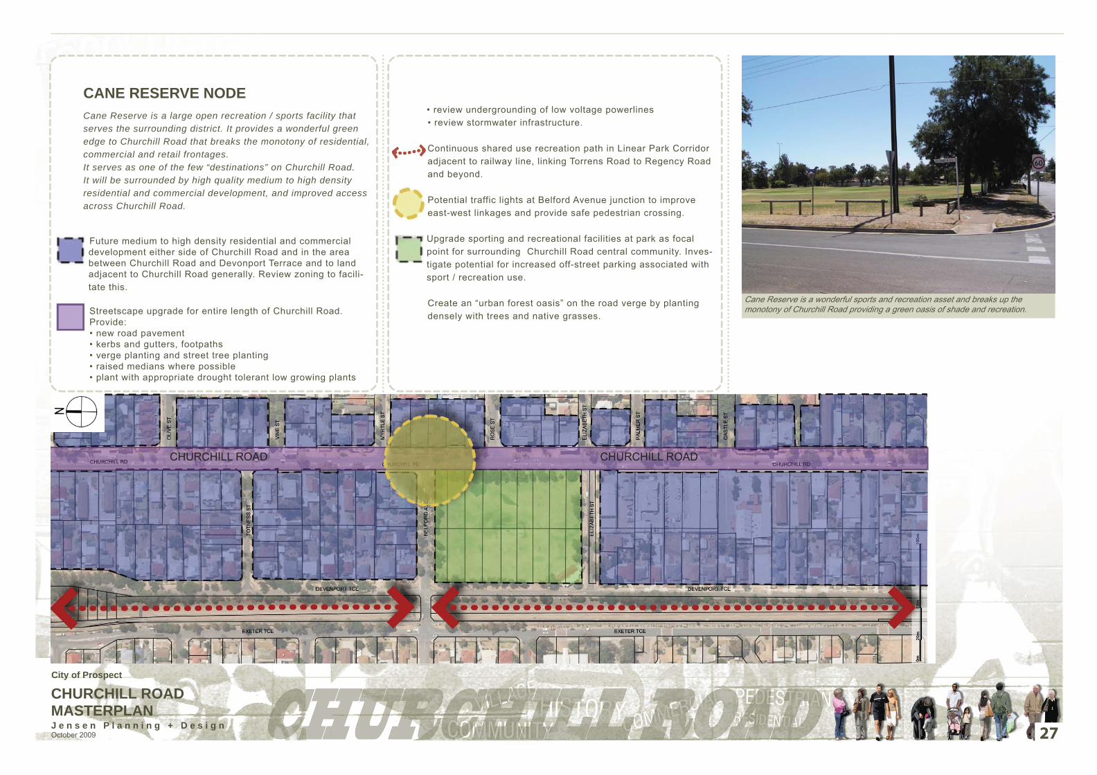
CHURCHILL ROAD MASTERPLANJ e n s e n P l a n n i n g + D e s i g n October 2009
CANE RESERVE NODECane Reserve is a large open recreation / sports facility that serves the surrounding district. It provides a wonderful green edge to Churchill Road that breaks the monotony of residential, commercial and retail frontages.It serves as one of the few “destinations” on Churchill Road. It will be surrounded by high quality medium to high density residential and commercial development, and improved access across Churchill Road.
Future medium to high density residential and commercial development either side of Churchill Road and in the area between Churchill Road and Devonport Terrace and to land adjacent to Churchill Road generally. Review zoning to facili-tate this.
Streetscape upgrade for entire length of Churchill Road. Provide: • new road pavement • kerbs and gutters, footpaths • verge planting and street tree planting • raised medians where possible • plant with appropriate drought tolerant low growing plants
• review undergrounding of low voltage powerlines • review stormwater infrastructure.
Continuous shared use recreation path in Linear Park Corridor adjacent to railway line, linking Torrens Road to Regency Road and beyond.
Potential traffic lights at Belford Avenue junction to improve east-west linkages and provide safe pedestrian crossing.
Upgrade sporting and recreational facilities at park as focal point for surrounding Churchill Road central community. Inves-tigate potential for increased off-street parking associated with sport / recreation use.
Create an “urban forest oasis” on the road verge by planting densely with trees and native grasses.
27
Cane Reserve is a wonderful sports and recreation asset and breaks up the monotony of Churchill Road providing a green oasis of shade and recreation.
CHURCHILL ROAD CHURCHILL ROAD
City of Prospect

CHURCHILL ROAD MASTERPLANJ e n s e n P l a n n i n g + D e s i g n October 2009
CENTRAL RESIDENTIAL PRECINCTWell designed medium to high density residential and commercial development in the precinct corridor. Improved east / west movement from Dudley Park Railway Station west up Gladstone Road and Boyle Street to nearby schools. Dudley Park Station will be a highly used and safe station that is integrated with surrounding development.
Future medium to high density residential and commercial development either side of Churchill Road and in the area between Churchill Road and Devonport Terrace and to land adjacent to Churchill Road generally. Review zoning to facili-tate this.
Streetscape upgrade for entire length of Churchill Road. Provide: • new road pavement • kerbs and gutters, footpaths • verge planting and street tree planting
• raised medians where possible • plant with appropriate drought tolerant low growing plants • review undergrounding of low voltage powerlines • review stormwater infrastructure.
Continuous shared use recreation path in Linear Park Corridor adjacent to railway line, linking Torrens Road to Regency Road and beyond.
Recently completed pedestrian traffic light crossing located between Gladstone Street and Boyle Street provides safe crossing linking rail station precinct to schools & residential areas to the east.
Streetscape upgrade to improve pedestrian linkage to schools along Gladstone Road and other east-west streets. Provide improved: • footpaths • verge planting and street tree planting • lighting
Upgrade Dudley Park Railway Station to improve passenger amenity and safety and increase patronage.
28
Patronage of the railway stations adjacent to Churchill Road would increase if access and signage were improved, and if the stations and surrounding environment were upgraded.
CHURCHILL ROAD
City of Prospect

CHURCHILL ROAD MASTERPLANJ e n s e n P l a n n i n g + D e s i g n October 2009
PYM STREET PRECINCTWell designed medium to high density commercial and residential development in the precinct corridor with opportunities for safer pedestrian crossings across Churchill Road near Pym Street.
Future medium to high density residential and commercial development either side of Churchill Road and in the area between Churchill Road and Devonport Terrace and to land adjacent to Churchill Road generally. Review zoning to facili-tate this.
Streetscape upgrade for entire length of Churchill Road. Provide: • new road pavement • kerbs and gutters, footpaths • verge planting & street tree planting • raised medians where possible
• plant with appropriate drought tolerant low growing plants • review undergrounding of low voltage powerlines• review stormwater infrastructure.
Continuous shared use recreation path in Linear Park Corridor adjacent to railway line, linking Torrens Road to Regency Road and beyond.
Potential traffic lights/ intersection upgrade at Pym Street junction to alleviate traffic issues and provide safe pedestrian crossing. Avoid traffic increase in Beatrice Street.
29
Churchill Road looking north at the Pym Street junction. Vehicles need to position themselves on the right hand side of the concrete median to turn right into Pym Street which is unnatural and confusing to drivers. This whole intersection needs further separate attention in the detailed design phase of Churchill Road.
CHURCHILL ROAD
City of Prospect

CHURCHILL ROAD MASTERPLANJ e n s e n P l a n n i n g + D e s i g n October 2009
ALEXANDRA STREET NODEA cluster of retail and commercial development on Churchill Road between Alexandra and Albert Street which acts as a focal point or node for the surrounding local community. This cluster is surrounded by medium to high density mixed use residential and other commercial and retail uses.
Future medium to high density residential and commercial development either side of Churchill Road and in the area between Churchill Road and Devonport Terrace and to land adjacent to Churchill Road generally. Review zoning to facili-tate this.
Streetscape upgrade for entire length of Churchill Road. Provide: • new road pavement • kerbs and gutters, footpaths • verge planting and street tree planting • raised medians where possible
• plant with appropriate drought tolerant low growing plants • review undergrounding of low voltage powerlines• review stormwater infrastructure.
Continuous shared use recreation path in Linear Park Corridor adjacent to railway line, linking Torrens Road to Regency Road and beyond.
Existing pedestrian refuge crossing.
Upgrade shopping node around pharmacy.
30
The cluster of retail and commercial shops on the corner of Churchill Road and Alexandra Street should be upgraded as a community focal point or node.
CHURCHILL ROAD
City of Prospect

CHURCHILL ROAD MASTERPLANJ e n s e n P l a n n i n g + D e s i g n October 2009
REGENCY ROAD GATEWAYA well designed gateway with a public art at Regency Road and a high density well integrated mixed use Transit Oriented Development (TOD) surrounding an upgraded safe and highly patronised Isilington Railway Station.
Future medium to high density residential and commercial development alongside Churchill Road. Review zoning to facilitate this.
Streetscape upgrade for entire length of Churchill Road. Provide: • new road pavement • kerbs and gutters, footpaths • verge planting and street tree planting • raised medians where possible • plant with appropriate drought tolerant low growing plants
• review undergrounding of low voltage powerlines • upgrade stormwater infrastructure to deal with localised flooding.
Continuous shared use recreation path in Linear Park Corridor adjacent to railway line, linking Torrens Road to Regency Road and beyond.
Gateway art project “Welcome to Prospect”. Use large vertical elements, uplight at night, provide landscaping.
Possible mixed use/ education Transit Oriented Development (TOD) currently being masterplanned by developers. Link with Port Adelaide/Enfield Council and to TOD site south of Regency Road.
Pub on eastern side and higher density development on opposite corner to act as landmarks. Proposed higher density mixed use Transit Oriented Development (TOD) currently being masterplanned by developers. Link to TOD site north of Regency Road.
31
Proposed development should allow for central open space. Water Sensitive Urban Design (WSUD) and local stormwater management initiatives to be investigated.
Provide a landscaped and acoustic buffer between proposed TOD development and Churchill Road.
Upgrade existing Islington Railway Station. Provide “Park and Ride” facility on the western side of the rail line.
CHURCHILL ROADCHURCHILL ROAD
City of Prospect

CHURCHILL ROAD MASTERPLANJ e n s e n P l a n n i n g + D e s i g n October 2009
DESIGN ELEMENTSThese design guidelines will inform the future choice and design of specific design elements for Churchill Road such as bollards, paving, bike racks, seats and rubbish bins.
The design elements should be chosen to complement or reinforce the existing character of Churchill Road and of the wider Prospect community. Elements need to be robust and maintenance free where possible and colouring should consider the site context and surrounding built form.
Paving materials and street furniture are excellent ways of uniting a street or precinct as they introduce consistent themes of colour, texture, form and pattern. Paving processes such as sand blasting and adding colour oxide to concrete are inexpensive ways of introducing patterns and artistic elements into the footpath. Also paving bands and header courses with unit pavers introduce a rhythm to the street and can act to delineate pedestrian and other spaces.
Street furniture should be complementary to the paving material. All furniture items should complement each other in materials, texture and form. Bollards and bike rails act to separate pedestrian and other spaces while introducing a vertical rhythm to the street.
Lighting performs a functional and security role, however it can also be used for wayfinding and to uplight or illuminate important elements in the streetscape.
The integration of public art should seek to complement the choice of materials to unite the street or precinct.
32
Hardwood timber bollards Street & Park Furniture bin enclosure Stainless steel bike rails Uplighting can add vitality at night Street & Park Furniture - Grindle Seat
Paving banding and header courses introduce a rhythm to the street and can act to delineate pedestrian and other spaces.
Paving processes such as sand blasting and adding colour oxide to concrete are inexpensive ways
of introducing patterns and artistic elements into the footpath.
Paving bands - James Place Adelaide Sandblasted granite - Canberra
Sandblasted granite - Kilburn SAPaving bands - Grote Street Adelaide
City of Prospect
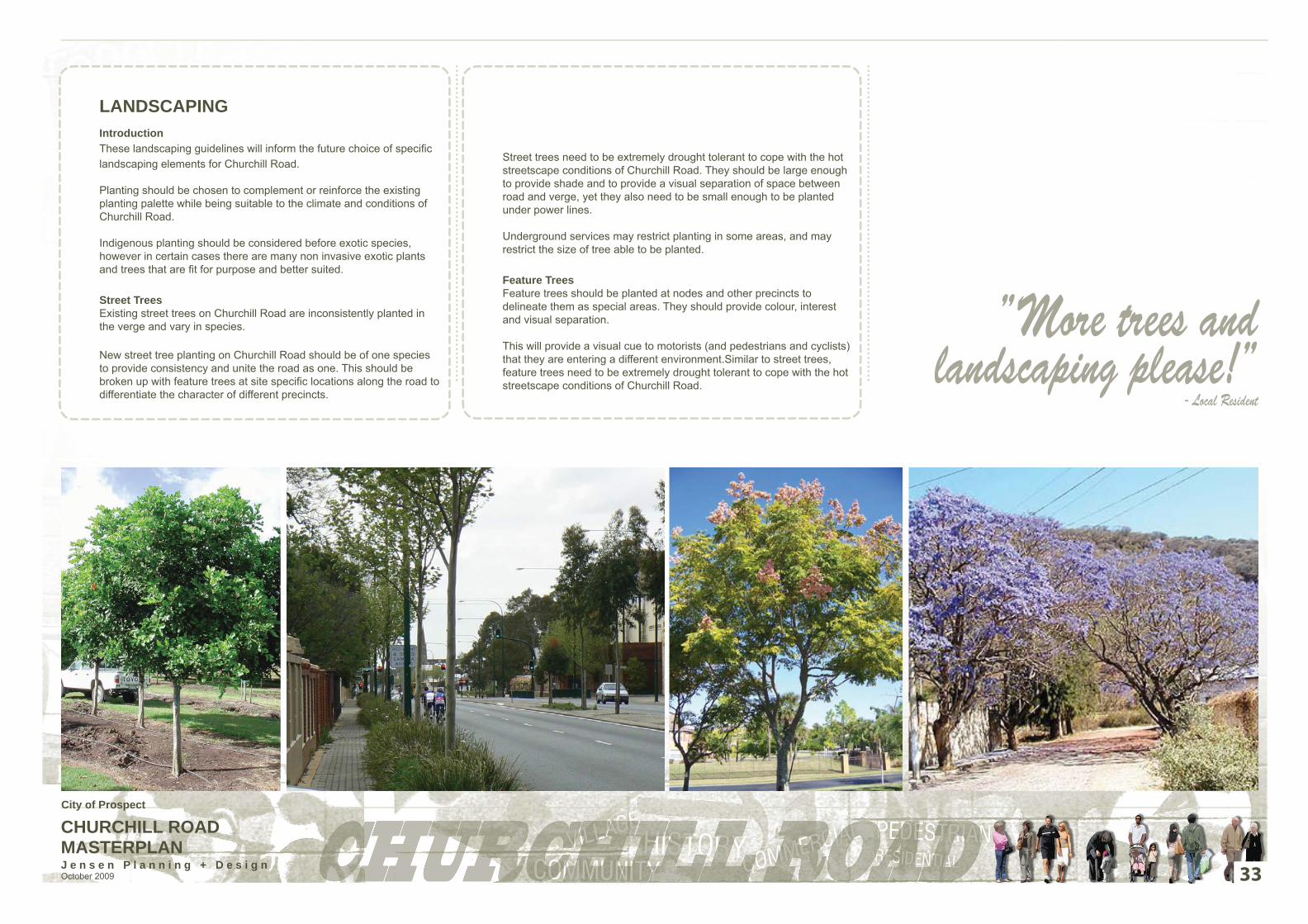
CHURCHILL ROAD MASTERPLANJ e n s e n P l a n n i n g + D e s i g n October 2009
LANDSCAPINGIntroductionThese landscaping guidelines will inform the future choice of specifi c landscaping elements for Churchill Road.
Planting should be chosen to complement or reinforce the existing planting palette while being suitable to the climate and conditions of Churchill Road.
Indigenous planting should be considered before exotic species, however in certain cases there are many non invasive exotic plants and trees that are fi t for purpose and better suited.
Street TreesExisting street trees on Churchill Road are inconsistently planted in the verge and vary in species.
New street tree planting on Churchill Road should be of one species to provide consistency and unite the road as one. This should be broken up with feature trees at site specifi c locations along the road to differentiate the character of different precincts.
Street trees need to be extremely drought tolerant to cope with the hot streetscape conditions of Churchill Road. They should be large enough to provide shade and to provide a visual separation of space between road and verge, yet they also need to be small enough to be planted under power lines.
Underground services may restrict planting in some areas, and may restrict the size of tree able to be planted.
Feature TreesFeature trees should be planted at nodes and other precincts to delineate them as special areas. They should provide colour, interest and visual separation.
This will provide a visual cue to motorists (and pedestrians and cyclists) that they are entering a different environment.Similar to street trees, feature trees need to be extremely drought tolerant to cope with the hot streetscape conditions of Churchill Road.
33
”More trees and landscaping please!”
- Local Resident
City of Prospect

CHURCHILL ROAD MASTERPLANJ e n s e n P l a n n i n g + D e s i g n October 2009
Verge Planting- Groundcovers and Native Grasses/ Sedges
Groundcovers and native grasses/ sedges should be chosen to require as little maintenance as possible and have a mature overall height of less that one metre to keep sight lines open.
Native grasses/ sedges could be planted en masse or in bands to highlight differing fl ower and foliage types.
Integration of Water Sensitive Urban Design
Water sensitive urban design (WSUD) is one of the key principles of ecologically sustainable development.
At the streetscape level WSUD can involve the utilization of stormwater from the surrounding site to create “green streets” through a capture/ cleanse/ release process. One method that facilitates this process is through specifi cally designed garden beds called rain gardens.
Rain gardens can be integrated into urban streets at the detailed design phase. The key features of a rain garden include:
• direction of surface stormwater into the garden bed (through methods such as slotted kerbs, drains in the kerb and gutter, inverted gutter designs)• creation of a “pond” environment to trap and store stormwater• selection of plants that can tolerate periods of inundation• selection of plants and growing media (soil) that can fi lter stormwater• collection of fi ltered water and discharge back into the stormwater system• an overfl ow system for large storm events.
Other water sensitive urban design techniques include:• selection of drought tolerant plants• grouping of plants together that require similar watering regimes• use of landscaped swales.
34
Rain garden (WSUD)- Duthy Street, Unley
”Churchill Road needs trees and softening”- Local Resident
City of Prospect
CHURCHILL ROAD MASTERPLANJ e n s e n P l a n n i n g + D e s i g n October 2009 35
IMPLEMENTATION
City of Prospect
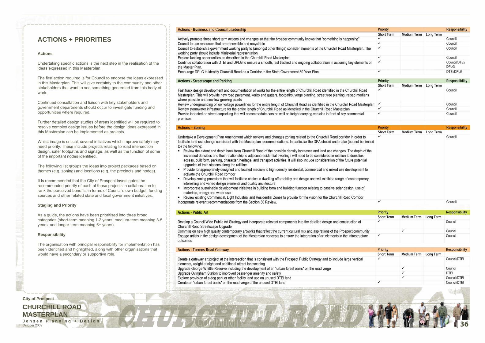
CHURCHILL ROAD MASTERPLANJ e n s e n P l a n n i n g + D e s i g n October 2009
ACTIONS + PRIORITIES
Actions
Undertaking specifi c actions is the next step in the realisation of the ideas expressed in this Masterplan.
The fi rst action required is for Council to endorse the ideas expressed in this Masterplan. This will give certainty to the community and other stakeholders that want to see something generated from this body of work.
Continued consultation and liaison with key stakeholders and government departments should occur to investigate funding and opportunities where required.
Further detailed design studies of areas identifi ed will be required to resolve complex design issues before the design ideas expressed in this Masterplan can be implemented as projects.
Whilst image is critical, several initiatives which improve safety may need priority. These include projects relating to road intersection design, safer footpaths and signage, as well as the function of some of the important nodes identifi ed.
The following list groups the ideas into project packages based on themes (e.g. zoning) and locations (e.g. the precincts and nodes).
It is recommended that the City of Prospect investigates the recommended priority of each of these projects in collaboration to rank the perceived benefi ts in terms of Council’s own budget, funding sources and other related state and local government initiatives.
Staging and Priority
As a guide, the actions have been prioritised into three broad categories (short-term meaning 1-2 years; medium-term meaning 3-5 years; and longer-term meaning 6+ years).
Responsibility
The organisation with principal responsibility for implementation has been identifi ed and highlighted, along with other organisations that would have a secondary or supportive role.
36
City of Prospect

CHURCHILL ROAD MASTERPLANJ e n s e n P l a n n i n g + D e s i g n October 2009
The implementation of these design ideas needs to be staged over time to reduce the overall impact of the construction work on the road, to enable strategic agreements with other bodies to be made, and of course to enable funding to be generated to construct the works.
Early Projects
The following projects are small “early start” projects that can be identifi ed early that do not require large budgets or extensive consultation with other Government bodies:
• Churchill Road Gateway Public Art Projects (north and south ends)
• Liaise with and provide support to businesses for the upgrade of the shopping facilities in the Alexandra Street / Churchill Road node
• Upgrade facilities and car parking at Cane Reserve.
Links to infrastructure upgrades
As a way of allocating funding to projects, it is possible to break project components down into tasks that can be funded as part of other ongoing infrastructure works by Council.
Typical examples of where this can happen include:
• footpath upgrades• street tree planting• signage upgrades• lighting upgrades• road linemarking/ re-surfacing• park upgrades.
37
City of Prospect

CHURCHILL ROAD MASTERPLANJ e n s e n P l a n n i n g + D e s i g n October 2009
FUNDING OPPORTUNITIESThe following are potential funding sources available to the Council for assistance with carrying out the works outlined in this Masterplan:
• Places for People Program (administered through the Department for Planning and Local Government)• State Black Spot Funding Program (State Government);• Community Recreation & Sport Facilities Program (State Government);• Tourism Development Fund;• The State Bicycle Fund.• The Regional and Local Community Infrastructure Program
Places For People ProgramThe Places For People program is a State Government initiative aimed at revitalising important public places around the state.
The program offers funding to assist Local Governments to plan, design and build high quality community places to encourage community life and economic investment and development. Funds from this program have been obtained to help develop this Masterplan.
The Churchill Road streetscape works would fulfi ll the requirements for funding, and this Masterplan report provides the body of work that is required when applying for funding.
More information, including how to apply is available from the Department for Planning and Local Government website: www.planning.sa.gov.au
State Black Spot FundingThe Black Spot Program provides funding for road related works around Australia. It specifi cally targets intersections and heavy vehicle roads that are accident prone. The program requires a nomination process involving the undertaking of a Road Safety Audit (if one has not been completed for that location already). All nominations are to be referred to the Black Spot Consultative Panel care of the Department of Transport Energy and Infrastructure.
Also available is the Aus Link Black Spot program which is administered by the Federal Government.
More information is available from the Department of Transport Energy and Infrastructure website: www.dtei.sa.gov.au
Community Recreation & Sport Facilities Program The Offi ce for Recreation and Sport has various funding opportunities available for recreation programs and facility upgrades.
It is a possibility that projects such as the proposed Linear Park shared use path along the railiway line could attract such funding opportunities.
For more information visit the website: www.recsport.sa.gov.au
Tourism Development FundThe South Australian Tourism Commission through the Tourism Development Fund provides funding to assist with tourism infrastructure projects that provide economic and social benefi ts to local comunities.
More information (including guidelines and application forms) are available from the following website: www.tourism.sa.gov.au
State Bicycle FundThe Department of Transport Energy and Infrastructure provides 50% funding to develop and implement bicycle treatments that are made within the framework of a Local Area Bicycle Plan (LABP), and also for the development of such a plan. However, LABP funding cannot be used in conjunction with other State Government funding to increase the State Government’s contribution to bicycle projects to over 50%.
See www.transport.sa.gov.au. DTEI will also undertake bicycle works identifi ed on State Government roads under an LABP, subject to approval and other funding requirements.
The Regional and Local Community Infrastructure Program This program was announced by the Prime Minister at the Australian Council of Local Government inaugural meeting on 18 November 2008 as part of the Nation Building Economic Stimulus Plan. Since its inception, the Regional and Local Community Infrastructure Program has made more than $1 billion available to local government authorities to build and modernise community infrastructure.This funding will assist councils to build and modernise community facilities, including main streets, town halls, libraries, community centres, sports grounds and environmental infrastructure and is intended to support local jobs and provide long-term benefi ts to communities by renewing and upgrading local infrastructure.
OtherOther funding opportunities can be sourced from the following websites:
Local Government Grants/ Funding: www.planning.sa.gov.au
State Government Grants/ Funding: www.grants.ord.sa.gov.au
Commonwealth Government Grants/ Funding: www.grantslink.gov.au
38
CONCLUSIONS AND ACKNOWLEDGEMENTS
The corridor of land either side of Churchill Road is set for a major transformation. The Masterplan outlines a vision for its transformation to a higher density, mixed use living and working environment taking advantage of easy access to the Adelaide CBD via rapid transit.These new intensive land uses take advantage of proximity to the three railway stations as well as buses along Churchill Road, and will signifi cantly increase local employment opportunities for residents.
Movement
Churchill Road will continue to function as a freight corridor and will cater for increased vehicle movements as a result of proposed changes to Prospect Road. However, the streetscape upgrade will signifi cantly improve the functioning of the existing carriageway in terms of better legibility for motorists, cyclists, pedestrians and those wishing to park along the road. Improved pedestrian crossing points will also increase safety at key locations. Upgraded railway stations and access to them, together with improvements in the bus system will promote public transport usage.
Improved Amenity
The Masterplan provides a range of initiatives to improve the amenity of the Churchill Road corridor for residents, workers and visitors. The Churchill Road corridor is long overdue for a major “makeover” in terms of all public realm infrastructure. This includes more attractive and safer access to railway stations and major improvements to the existing parks. Areas adjacent to key shopping nodes are also proposed to be upgraded.
Acknowledgements
It is hoped that this Masterplan will be used by Council to generate interest and funding to undertake further detailed design and investigation and ultimately implementation of the initiatives proposed.
We are confi dent that the staged implementation of the Masterplan will signifi cantly benefi t Churchill Road and the businesses and residents that will live along / adjacent to it, while the land use changes will greatly diversify employment and housing.
We would also like to acknowledge the funding provided by the Places for People Program (DPLG).
Finally, a special thanks to the City of Prospect staff, Elected Members, the wider Prospect Community and various State Government offi cers for their important contributions during the development of the ideas in this Masterplan.
City of Prospect

CHURCHILL ROAD MASTERPLANJ e n s e n P l a n n i n g + D e s i g n October 2009
REFERENCESAustralAsia Economics Pty Ltd, Blandy Richard, Davies Alison, Davies Paul, 2009, Assisting Economic Activity in the City of Prospect: A Quantitive Assessment of the Prospect Economy, Final Report.
Brecknock Consulting, 2004, Prospect Road Creative Opportunities Strategy, Draft.
City of Prospect, City of Prospect Community Profile, 2006 and 2001 Enumerated Census Information for: City of Prospect.
City of Prospect, 2008, Future Prospect 2008-2011 Strategic Economic Plan.
City of Prospect, 2008, Your Street, Your City, Development Plan Review 2008 Issue Paper.
Government of South Australia, 2009, Planning the Adelaide we all Want: Progressing the 30 year Plan for Greater Adelaide.
Government of South Australia, 2008, Prospect (City) Development Plan.
Tonkin Engineering, 2007, City of Prospect Stormwater Management Future Works and Strategy Development.
39
City of Prospect