Embed Size (px)
Citation preview

AQA GCSE Geography Example and Case Study
Revision Guide
Paper 1 – Natural Hazards, Ecosystems, Coasts and RiversPaper 2 – Urban Issues and Challenges, The Changing Economic World and The challenge of Resource ManagementPaper 3 – Pre Release and Fieldwork
[email protected]@[email protected]@chesterton.cambs.sch.uk
Natural Hazards

Nepal earthquake - Example of a tectonic hazard in an LICOn 25th April 2015 Nepal was struck by an earthquake measuring 7.9 on the Richter scale. The epicenter was 50miles North West of the capital Katmandu. The earthquake was very shallow which resulted in sever ground shaking, landslides and avalanches.
Primary effects Secondary effects9000 people died Ground shaking causing landslides and avalanches20,000 injured Avalanches on Mt Everest caused at least 19 deaths3million people left homeless Landslide blocked Gandaki river resulting in people being
evacuated due to risk of flooding1.4million needed emergency food and shelter in the days after the quake
Tourism is a major source of revenue in Nepal and the earthquake led to a sharp drop in the number of visitors
7000 schools destroyed Harvests were reduced or lost that season50% of shops destroyedCost of damage estimated at US$5billion
Earthquakes in Nepal are not uncommon. There are large earthquakes every 80 years but building regulations had not been followed and the country was not prepared
Immediate responses Long term responsesInternational aid was provided. India and China in total committed over $1 billion to help support Nepal
Roads were repaired and landslides cleared
The UK offered help and support. Over 100 search and rescue responders, medical experts, and disaster and rescue experts were sent
7000 schools rebuilt or repaired
500,000 tents were provided for shelterField hospitals were set up.
Stricter building regulations were enforced
The GIS tool “Crisis mapping” was used to coordinate the response
Chile earthquake - Example of a tectonic hazard in an HICOn 257h February 2010 Chile was struck by an earthquake measuring 8.8 on the Richter scale. The earthquake lasted 3 minutes and as the epicenter was out at sea tsunami warnings were issued as waves reaches speeds of up to 800km per hour
Primary effects Secondary effects500 people died 1500km of roads damages or destroyed

12,,000 injured Several coastal towns destroyed by tsunami waves22,000 homes, 4500 school and 56 hospitals were destroyed
Pacific countries damages by the tsunami – no loss of life due to warnings
Ports and airports badly damaged A fire at a chemical plant led to people being evacuated Much of Chile lost power Copper production—a major contributor to Chile’s
economy—was halted at several minesCost of damage estimated at US$30billion The limited availability of food and gasoline led to
widespread looting
Earthquakes in Chile are common and the country was prepared. Chile had the money to support its people and rebuild quickly.
Immediate responses Long term responsesEmergency services responded quickly and international field hospitals were set up
1 month after the earthquake a housing reconstruction plan was launched
Temporary repairs made to Route 5 within 24hours allowing aid to be moved around the country
Chiles strong economy was able to recover without foreign aid.
Power restored to 90% of homes within 10 days The President predicted it could take about 4 years to fully recover
National appeal raised more than US$60million Improvements to tsunami warning system and earthquake training.
Typhoon Haiyan - example of a tropical storm The Philippines consists of a group of islands in the South China Sea. The country regularly suffers from large typhoons that move in from the south west every. The worst affected city, Tacloban, is at the end of a bay that funnelled water from the storm surge Typhoon Haiyan - known locally as Yolanda - hit eastern Samar Island at 8.40pm GMT on 7 November 2013 It caused a storm surge that was 25 feet high in some areas, including in the town of Tacloban.
Primary effects Secondary effectsOver 14 million people were affected across 46 provinces
The economy was affected, with estimated losses at $2.9billion with much of this in agriculture - 131,611 tons

of rice was lostFive million people saw their homes severely damaged or destroyed
Looting and violence broke out in Tacloban
approximately 7400 people (6,340 confirmed, 1,061 missing
Local ecosystems were also affected by sewage leaking from overwhelmed sewage systems
Tacloban airport badly damaged Many jobs were lost as hospitals, shops and schools damaged
550,000 houses destroyed and an additional 580,000 houses were severely damaged
A lack of sanitation in days following the event also leads to a higher level of pollution
30,000 fishing boats destroyed The limited availability of food and gasoline led to widespread looting
Immediate responses Long term responsesThe government was criticised for its slow response to this event.
The Philippines authorities have invested in disaster risk reduction and climate change adaptation
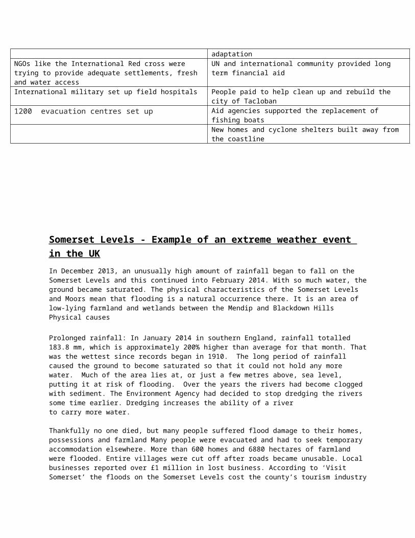
NGOs like the International Red cross were trying to provide adequate settlements, fresh and water access
UN and international community provided long term financial aid
International military set up field hospitals People paid to help clean up and rebuild the city of Tacloban
1200 evacuation centres set up Aid agencies supported the replacement of fishing boats New homes and cyclone shelters built away from the coastline
Somerset Levels - E xample of an extreme weather event in the UKIn December 2013, an unusually high amount of rainfall began to fall on the Somerset Levels and this continued into February 2014. With so much water, the ground became saturated. The physical characteristics of the Somerset Levels and Moors mean that flooding is a natural occurrence there. It is an area of low-lying farmland and wetlands between the Mendip and Blackdown Hills Physical causes
Prolonged rainfall: In January 2014 in southern England, rainfall totalled 183.8 mm, which is approximately 200% higher than average for that month. That was the wettest since records began in 1910. The long period of rainfall caused the ground to become saturated so that it could not hold any more water. Much of the area lies at, or just a few metres above, sea level, putting it at risk of flooding. Over the years the rivers had become clogged with
sediment. The Environment Agency had decided to stop dredging the rivers some time earlier. Dredging increases the ability of a river to carry more water.
Thankfully no one died, but many people suffered flood damage to their homes, possessions and farmland Many people were evacuated and had to seek temporary accommodation elsewhere. More than 600 homes and 6880 hectares of farmland were flooded. Entire villages were cut off after roads became unusable. Local businesses reported over £1 million in lost business. According to ‘Visit Somerset’ the floods on the Somerset Levels cost the county’s tourism industry £200 million. Farmers struggled to deal with flooded fields, ruined crops and the costs of moving livestock away from the affected areas.
The response to the floods was rapid and well organised, as expected for an economically developed country (Figure 5). The Met Office issued an amber warning for heavy rain in South West England. They informed the public to be prepared for significant flooding. People used sandbags to protect their homes and moved valuable items upstairs. Extra police patrols were brought in to respond to increased crime. By the end of January, the army had been sent in with specialist equipment. They delivered food and gave out sandbags. By 6 February they were joined by 40 Royal Marines. Sixty-five pumps were used to drain 65 million m3 of floodwater.
The longer-term response focused on flood management to prevent a future flood of this scale. This took the form of ‘The Somerset Levels and Moors Flood Action Plan’. It included measures such as dredging, a tidal barrage, and extra permanent pumping sites, with a total cost of £100 million
EcosystemsNap Wood - example of a small scale UK ecosystem Nap Wood can be used to illustrate the functioning of the nutrient cycle. A relatively small area of woodland, it was previously part of an estate, but has since passed into the care of the National Trust.. Most deciduous woodlands in the UK today are managed in some form. At Nap Wood the management level is low, since the small amount of human usage has little impact on the functioning of the ecosystem. The National Trust’s role is one of protection rather than of interference Nap Wood includes many fallen trees. In March 2002, a significant minority of the silver birches had been either totally or partially uprooted over winter 2001/02, the reason probably being high rainfall for the second consecutive winter. Saturated ground gives tree roots less purchase in strong winds, and the silver birch’s root system is not wide, so these are the first trees to fall. By leaving Nap Wood’s fallen trees where they lie, the National Trust is allowing the nutrient cycle to operate naturally and fully.
Malaysia - case study of a tropical rainforest

Causes of deforestationLogging – Malaysia was the worlds largest exporter of tropical wood in the 1980s Timber companies are interested in trees such as mahogany and teak and sell them to other countries to make furniture (selective logging). Smaller trees are often used as wood for fuel or made into charcoal. Vast areas of rainforest are cleared in one go (clear felling).Mineral extraction – Some of the minerals that richer countries need are found beneath rainforest. In Malaysia, mining is mainly about tin. Drilling for oil and gas has recently stated. The rainforest suffers badly from this.Energy development – An unlimited supply of water and ideal river conditions have encourage dams to be built to generate hydroelectric power, an example of this is the Bakun Dam which flooded over 700km of farmland. This involves flooding large areas of rainforest. Commercial Farming: Malaysia is the largest exported of palm oil in the worldRoad building: Roads are needed to bring in equipment and transport products to markets, but road building means cutting great swathes of rainforest. Population pressure – poor people were encouraged to move into the countryside from the cities, 15000 hectors of rainforest was cut down for housing. Subsistence farming - slash and burn farming methods can create vital nutrients but can also spread out of control.
Impacts of deforestationGlobal warming: When trees are felled, more carbon dioxide remains in the air. Also, fire is often used in clearing rainforests, which means that the carbon stored in the wood returns to the atmosphere. Loss of biodiversityBiodiversity will be reduced and individual species will become endangered or extinct. Globally, It is estimated that 137 plant, animal and insect species are being lost every day. This amounts to 50,000 species a year. As the species disappear, so do many cures for life threatening diseases. Local ImpactsClimate change – Deforestation disrupts the water cycle. With the felling of trees, evapotranspiration is reducing so there is less moisture in the atmosphere. The local climate becomes drier. Once the recycling of water is reduced, the local climate becomes warmer. This is bad for farming.Soil erosion and fertility – As soon as any part of the forest cover is cleared, the thin topsoil is quickly removed by heavy rainfall. Bare slopes are particularly prone to soil erosion. Once the top soil has been removed, there is little hope of anything growing again. River pollution – Gold mining not only causes deforestation but the mercury used to separate the gold from the ground is allowed to enter the rivers. Fish are poisoned as well as people living in nearby towns.

Thar Desert - case study of a hot desert The Thar Desert is the world's seventh largest desert. It is a hostile environment on the border between India and Pakistan and covers over 200,000km squared. On its western margin lies the mighty Indus River. The Thar Desert is not empty of human or plant life, it has some trees and animal life, and it has been colonised for a long time. It is the most populated desert in the world with nearly 30 million people and is also the most densely populated with 83 people per km2. It is an environment with many opportunities and challenges to development.Tourism - Recent times have seen the population grow by a third, as its booming tourist industry sucks people in. More than 600,000 people now call the area home. The city is struggling to keep up, especially in terms of water use. The demand for water into the city has gone up 12 fold, and the waste water passes under the foundations and undermines them. People are coming as tourists because of its large fort, the history of the Maharajahs and because Jaisalmer is often used as a base to explore the nearby desert, in jeeps or by camel safari. Even the fort is struggling due to increased tourism. Originally the fort relied upon wells, but water was piped in in the 1970s. They failed to put in proper drainage with the water and it is now at risk of collapsing in parts. Many tourist hotels are in the fort and this adds to the problem.Subsistence farming Many of the people who live in the Thar Desert are involved in farming.Many of the people are subsistence farmers, farming enough food for themselves and their families with little for sale. There are depressions between the sand dunes that act as mini drainage basins. When it does rain the water collects at the bottom of these depressions and allows desert grasses to grow. People survive here by herding goats and women play an integral role in village life whilst the men are away with the animals. They have to fetch water twice a day. The way of life is self-sufficient and the goats provide milk for the villagers. The women cook with butter milk as it saves water; similarly they do the washing up with sand! The women also have to collect firewood. Commercial farming The desert biome is under threat from commercial farming. A huge canal has been constructed from the River Sutlej across the desert. Initially it was 143km long but was extended as the Indira Ghandi canal. This brings water to major cities such as

Bikaner and Jaisalmer, but also water to irrigate the land. The desert area now produces crops like cotton and wheat, which can grow in these areas with the additional water. The land is being fenced off and used for more intensive agriculture. Sprinkler systems are irrigating fields once grazed by animals.Mineral Extraction Mineral extraction is the removal of solid mineral resources from the earth. In Rajasthan these resources include limestone and gypsum (for making plaster) are found in this desert - and are valuable for the building industry.
Energy use - The desert is also used to generate energy. Close to Jaisalmer is the largest wind turbine farm in India. It consists of 75 wind turbines with a total capacity of 60 MW. The project provides renewable electricity to the Northern regional electricity grid. There are also plans to develop a huge solar farm across large parts of the desert.
Desertification is the process by which land becomes drier and degraded, as a result of climate change or human activities, or both. It is caused by a mixture of climate change and the issues raised by population pressure. As population increases they increase the numbers of animals they keep, such as goats, which eat more vegetation. They also farm the land more intensively, which extracts nutrients and removes the natural vegetation. People also collect more firewood to keep warm at night or for cooking. In addition, Climate change is making temperatures hotter and rainfall less reliable and more variable. All of these things reduce the amount of natural vegetation. There are no plants or leaves to intercept rain and soil is left exposed to hot sun so the sun bakes the soil and it cracks. When it rains, the rainwater runs over the surface of the soil rather than soaking in which means that soil can often be washed away. This means that the soil is degraded; losing fertility and structure. This completes the cycle, as even less vegetation can be supported and the environment declines further.

Coasts
Landforms created by erosion
Coastlines where the geology alternates between bands of hard rock and soft rock are called discordant coastlines. A concordant coastline has the same type of rock along its length. Concordant coastlines tend to have fewer bays and headlands
Weathering and erosion can create caves, arches, stacks and stumps along a headland.
Caves occur when waves force their way into cracks in the cliff face. The water contains sand and other materials that grind away at the rock until the cracks become a cave. Hydraulic action is the predominant process.
If the cave is formed in a headland, it may eventually break through to the other side forming an arch.
The arch will gradually become bigger until it can no longer support the top of the arch. When the arch collapses, it leaves the headland on one side and a stack (a tall column of rock) on the other.
The stack will be attacked at the base in the same way that a wave-cut notch is formed. This weakens the structure and it will eventually collapse to form a stump.
One of the best examples in Britain is Old Harry Rocks, a stack found off a headland in the Isle of Purbeck.

Landforms created by deposition
Spits are created due to deposition. A spit is an extended stretch of beach material that projects out to sea and is joined to the mainland at one end.
Spits are formed where the prevailing wind blows at an angle to the coastline, resulting in longshore drift. An example of a spit is Spurn Head, found along the Holderness coast in Humberside
Longshore drift moves material along the coastline.
A spit forms when the material is deposited where there is a change in the direction of the coastline
Over time, the spit grows and develops a hook if wind direction changes further out.
Waves cannot get past a spit, which creates a sheltered area where silt is deposited and mud flats or salt marshes form

Managed retreat at Medmerry - Example of a coastal management scheme in the UK

This flat, low-lying coast is mainly used for farming and caravan parks. For many years the land was protected by a low sea wall but this is now in need of repair. Building a new sea wall to protect the area against future sea-level rise was a very expensive option.
Managed retreat is a method whereby hard sea defenses are removed and salt marshes are created. An earth bund can be created in land if required as an additional sea defense. The salt marsh not only provides a natural defense but also creates a nature reserve. This can only work where the costs of compensation are significantly less than the costs of building coastal defences, and can be a cheap option. It can also be beneficial to plants and animals by providing new habitat. This method is highly controversial however, as land is lost and the human cost can be greater than just financial.
The Medmerry scheme cost £28 million and the controlled breaching of the old sea defences took place in November 2013. In the future, this scheme will:◆ create a large natural saltmarsh to form a natural buffer to the sea◆ help to protect the surrounding farmland and caravan parks from flooding◆ establish a valuable wildlife habitat and encourage visitors to the area.
RiversRiver Tees - example of a river valley in the UK Physical FactorsThe River Tees catchment is located in the north east of England. It has three main rivers, the River Tees, the River Skerne and the River Leven. The River Tees drains the eastern slopes of Cross Fell in the Pennines and flows eastward to the North Sea. The

River Tees rises on the slopes of Cross Fell at a height of 893metres. The rainfall reaches the river quickly because the slopes are steep and very little water can infiltrate due to the impermeable rocks and saturated peat. After heavy rainfall or when the snow melts in the spring the river level can rise quickly and the water also flows downstream quickly. The catchment has areas with distinctly different characteristics. The rivers in the Upper Tees have steep channel gradients and valley sides. In the mid-catchment, the valley widens out and channel slopes become much gentler. The lower catchment is close to sea level and predominantly tidal in nature.Human FactorsThe Tees Barrage forms an artificial barrier between the Tees Estuary and the upstream catchment. This helps maintain water levels for amenity purposes and eliminates tidal effects further upstream. Land use in the west of the area is mainly moorland and pasture. On the lower slopes and middle catchment the land use changes to a greater amount of pasture and woodland.To the east land use is mainly arable farmland interspersed with large built up areas, including Middlesbrough and Stockton-on-Tees. Approximately 687,000 people live within the catchment area concentrated in the main towns of Darlington, Hartlepool, Middlesbrough, Redcar and Cleveland, and Stockton-on-Tees. There are also large industrial areas such as the ICI chemical works. Flood damage can run into hundreds of thousands of pounds. There is also a huge demand for water for use in homes, industry and agriculture
Boscastle example of a flood management scheme in the UKWhy was the new management scheme required? There were a number of human factors which affected the river, such as • Narrowing the river as it came through the town • Building low bridges which trapped boulders and trees • Removing vegetation further back up the valley which decreased interception, • All of these human induced issues needed fixing and it cost £5 million to fix
Strategy How did it help protect Boscastle Lower river bed by 75cm Means that the river can hold a lot more water, there
fore discharge must be higher to cause a flood
Remove trees from river banks During floods these can not be ripped out and block channel like in 2004

Raise the height of the carpark This stops the river from jumping channel and travelling across carpark
Widen the channel Allows river to hold more water, reducing flood risk
Raise the heights of the bridges Less chance of trees getting caught under them forming a dam.
Encourage farmers to plant trees on slope Increase interception
Widen the river upstream and encourage meanders
Slow the river down up stream, meaning more time for evaporation or infiltration, lowering peak discharge.
How effective have the management strategies been?
Social impacts of the work Economic issues Environmental issues
After the flood the council, the environment agency, National Trust and the local people all came together to plan the changes to the town, this increased community spirit. The new bridges were out of character and some of the locals do not it.
The new flood defences cost £5 million , this money could have been spent on other improvements.
The Environment agency suggest that the new defences have reduced the chance of flooding from once in every 10 years to a once in 75 year event. Thus protecting the town from more financial costs.
Some landowners lost farming land through the need to plant forests to intercept rainfall.
Urban Issues and ChallengesRio de Janiero - case study of a major city in an LIC Rio de Janeiro is a city located on Brazil’s south-east coast. It is one of Brazil’s largest settlements with a population of approximately 11.7 million people. The population of Rio de Janeiro has grown for a number of reasons. Natural Increase is one reason for its growth. The population has also grown as the result of rural to urban migration. Millions of people have migrated from Brazil’s rural areas to Rio de Janeiro. 65% of urban growth is a result of migration.
Social challenges in RioHealth care – only 55% of the city had access to a health clinic, services for pregnant women and the old were especially poor. In response the authorities medical staff took health kits into people living in favelas which were able to detect up to 20 different diseases. As a result infant mortality has fallen
Education – Education in Brazil is compulsory between the ages of 6 and 14, In Rio only half of all students stay on beyond the age of 14 with many dropping out earlier and becoming involved in crime. There are a lack of schools and teachers due to a poor salary and training. The authorities have tried to improve education by encouraging local people to volunteer in

schools, giving grants to poor families to keep their children in school and making money available to fund lessons in sport.
Water supply – 12% of people in Rio do nit have access to clean running water. 37% of water supply is lost through leaking pipes and illegal access. Seven new treatment plants have been built and over 300km of new pipes have been recently installed.
Energy - The whole of Rio suffers from power cuts due to growing demand and lack of supply. Many people in the favelas get their power illegally by tapping into the supply. Electricity has been improved by installing 60Km of new power lines and building a new nuclear reactor. There has also been investment in hydro-electricity
Economic challenges - Rio is Brazil’s 2nd most important economic area and provided 6% of all employment. There are many different types if jobs in Rio. However, there is still high unemployment in Rio especially in the favelas where it is about 20% Many people work in the informal economy which is poorly paid. The government is trying to reduce unemployment by investing in education.
The result of high unemployment is high crime rates, including murder kidnapping and drug trafficking. Gangs control the favelas but the police are now trying to reclaim them from drug dealers.
Improving the environment
Traffic congestion – Rio is the most congested city in South America. Steep mountains mean that new roads are difficult to develop unless you tunnel through the mountains. The number of cars has risen by over 40% in the last decade partially because people would prefer to travel by car due to high crime rates. To reduce traffic congestion the metro system has been expanded to take people off roads and new toll roads have been created.
Water pollution – The bays of Rio are highly polluted causing a major threat to wildlife. Fishing has declines and there is concern pollution will affect the tourist industry. The pollution is caused by many of the rivers flowing to the coast being polluted from open sewers. Nearly 200 tonnes of raw sewage and 50 tonnes of industrial waste are discharged every day into the bays. Ships also empty their tanks into the sea as there are no facilities close by. However, 12 new sewage works have been built and ships are now fined. New sewer pipes have also been installed.
Waste pollution – as the favels are built on steep hillsides with poor access, waste collection rarely happens. As a result most waste is dumped and pollutes the water system. To help dispose the waste a new power plant has been set up which uses methane from rotting rubbish.
Managing growth of favelas - favelas are illegal settlements with many challenges. Rocinha is the largest with a population of over 75,000. Many of its residents work in the wealthy areas of Rio and this has led to many improvements. 90% of houses are now built with brick and have running water and electricity. The area has its own radio station and newspaper and many shops and restaurants. There are also health facilities, schools and even a university.
Improving the favelas – favela Bairro Project – Local authority provide land and services for people to build their own house. Roads are paved, water and drainage is included building of health and education facilities. There is a cable car which allows people to travel to work for free, access to credit to allow people to buy building materials, 100% mortgages and a local

police force. All of these have improved the lives of the poor in Rio. However, the budget will not benefit everybody and the infrastructure is not always being maintained. People still lack the basic skills and need training.
Cambridge - case study of a major city in the UK
Cambridge is an important city within the UK and globally due to Cambridge Universit the technology industry (bio-tech’ & clean tech’) and also the history & architectureUrban change has created many opportunities:
Cultural mix - Mill Road has many international supermarkets, restaurants as well as the new mosque
Recreation and entertainment - The Lion Yard, Grand Arcade and the Grafton Centre provide a wide range of social activities. As well as this Cambridge Leisure Park (The Light Cinema, restaurants, The Junction) have a wide range of entertainment Employment - Cambridge Science Park and Cambridge Biomedical Campus (incl. AstraZeneca) provide many jobs for local peopleIntegrated transport systems - Cambridgeshire Guided Busway and park and ride allow easy transportation around the city. There are also 2 train stations serving London and other parts of the UKEnvironmental - the new area of Eddington (community centre, public spaces, University of Cambridge Primary School) is one of the more sustainment development with features such as urban greeningUrban change has also created many challenges: Abbey ward is located along the railway line. When cities grow, generally industry develops along the railway line and secondary sector jobs attract workers who then need homes. Homes are generally on small plots, tightly packed (e.g terraced housing). Newnham is located on University-owned land further away from the industry of the city. Housing plots are generally larger with gardens and are set back from the road.Inequalities in housing - the average house price in Newnham is £677,000 with %40 of these homes owned outright. There are on average 5.9 rooms per house. The average house price in Abbey is £349,000 with 17% owned outright with an average of 4.9 rooms per house.
Education – In Newnham 64% residents aged 16+ have 5 or more GCSEs at A*- C or equivalent but in Abbey this is 34%

Health In Newnham, life expectancy at birth for males is 85.1 years and female is 94.3 years. Life expectancy for males in Abbey is 79.8 and for females it is 88.1 Employment 33.6% of Newnham’s population are economically active. 57% are employed as ‘professionals’ and 0.7% have never worked. 0.3% of Newnham residents are long term unemployed. 74.6% of Abbey’s population are economically active and 27% are employed as ‘professionals’. 3.4% of Abbey residents have never worked. 1.5% long term unemployedDereliction CB1 area had lots of derelict land being used as unofficial car parks Lots of land derelict land attracting litter and fly tipping and high levels of anti-social behavior and lots of properties boarded upBuilding on brownfield and greenfield sites Building in the green belt on undeveloped green field sites is a very controversial and contentious issue. Eddington has been built on greenfield and the CB1 redevelopment is brownfield
Waste disposal Local authority is building a new incinerator at Waterbeach to handle the increase in household & business waste. It is estimated that the electricity generated could power 63,000 homes (this is more than half of the homes in Cambridge). The new facility will cost £200 million and create 300 jobs. Educating schools on waste education - The Education Centre at Amey offers free visits to schools and community groups. In Eddington 450 recycling and general waste bins in the form of underground banks placed across 155 locations, eliminating the need for around 9,000 wheelie bins.The growth of commuter settlementsNorthstowe (new town) Based on the site of the former RAF Oakington base and surrounding farmland between Cambridge and Huntingdon. Northstowe will have 10,000 homes.The impact of urban sprawl on the rural–urban fringe Eddington (new housing development) Eddington has been built on a greenfield site in Northwest Cambridge. The land was previously farmland and part-owned by various colleges within Cambridge University. Eddington will have 3000 new homes.
An example of an urban regeneration project CB1 the area of CB1 was full of derelcir buildings and a magnet for crime. The redvelopemnt has included: Wider pavements, more taxi ranks and bus stops and a multi storey car park and more secure cycle parkingMore office space has been created with lots of different sizes to accommodate different needs. All are of modern design and eco-friendly with efficient floorspaces
For the local population houses have been built with high levels of building quality to meet sustainability guidelines and built around green spaces with public art there are many supermarkets, coffee shops, restaurants. All listed buildings conserved and cleaned and enhanced with public art installations

The Changing economic worldJamaica – An example of how the growth of tourism in an LIC or NEE helps to reduce the development gap.
Tourism, along with bauxite and energy, is one of the few growth sectors of Jamaica’s economy. Jamaica enjoys good international air communications and is a hub for cruise ships.Tourism is important to the Jamaican economy, generating taxes, employment and income. Over the last few decades it has helped raise the level of development in Jamaica and reduce the development gap.
Economy - In 2014 tourism contributed 24 per cent of Jamaica’s GDP – one of the highest proportions of any country in the world. This is expected to rise to 32 per cent by 2024. Income from tourism is US$2 billion each year and taxes paid to the government contribute further to the development of the country. This in turn helps to reduce the development gap. The increase in tourism from cruises has brought many benefits. However, the annual 1.1 million cruise passengers only spend an average US$70 per day. This compares with an average US$120 per day spent by the 2.5 million other visitors.
Employment Tourism is the main source of employment in Jamaica. It provides jobs for 200 000 people either directly in hotels, transport and tourist attractions or indirectly in shops, manufacturing and banking. These are mainly in or around the main tourist towns. Employment in tourism provides income which helps to further boost the local economy as people spend money in shops and on services and recreation Those in employment learn new skills which can improve their prospects of better-paid jobs in the future. The quality of life for many people has improved.
Infrastructure Tourism has led to a high level of investment on the north coast where much of the country’s tourism is centred. New port and cruise-liner facilities have been built at Trelawney together with new hotel accommodation. However, improvements in roads and airports have been slower and some parts of the island remain isolated.
Quality of life In the northern tourist areas of Montego Bay and Ocho Rios, wealthy Jamaicans live in high-quality housing with a high standard of living. These areas have benefited from the tourist industry. However, large numbers of people live nearby in poor housing with limited food supply and inadequate access to fresh water, health care and education.
The environment Mass tourism can create environmental problems such as footpath erosion, excessive waste and harmful emissions. It can also bring environmental benefits. Conservation and landscaping projects provide job opportunities and encourage people to visit the island. Montego Bay on the north coast has been improved by landscaping, and a new water treatment plant at Logwood has reduced pollution from hotels. The Negril Marine Nature Park attracts many tourists and brings direct and indirect income. Community tourism and sustainable ecotourism is expanding in more isolated regions, with people running small-scale guesthouses or acting as guides.
Nigeria - case study of an LIC or NEE

Nigeria is a former colony of the UK that can be found in West Africa. It is growing rapidly as a country both economically and in terms of population. Many people around the globe think that Nigeria could be Africa’s global superpower if it can overcome the many problems that limit its development. It already has the continent’s biggest economy, a huge military budget and is active in the West African and African continent.
Nigeria is rich in oil, and this makes 75 per cent of government money, but the rapid economic growth (over 7 per cent per year since 2009) is found mostly in the non-oil. Nigeria is making increasing amounts of money from manufacturing (making things) and services. However, despite this wealth Nigeria has a quarter of Africa’s extreme poor people. In addition, more than 100 women die every day from complications during pregnancy and childbirth. Over 2,000 children under 5 die every day from preventable diseases and 8.5 million children do not go to school (the most of any country in the world).
Political links- Nigeria has many political and economic links around the world and has moved on from its days as a Commonwealth country occupied by the UK). Its main trading partners include the European Union (EU), the United States, India, Brazil, and China. Nigeria is also an active member of the Economic Community of West African States (ECOWAS) and is also part of the African Union. Nigeria has also stepped up its involvement in international affairs, the country ranks as the fifth largest contributor to UN peacekeeping missions (United Nations 2014) and has a non-permanent seat on the UN Security Council for 2014-15.The industrial structure of Nigeria- The economy of Nigeria is changing, and it is shifting from mainly PRIMARY based economy reliant on farming and extractive industries such as oil and gas, to one which making more money or GDP from manufacturing or secondary industries and more services in the tertiary sector. Despite these changes Nigeria remains a country divided as the graph below shows. Many people still work in farming and wealth is not well distributed between the very wealthy and the very poor.The economy of Nigeria grew at a massive 7% per year every year for over a decade (2004-2014).The oil industry has been one of the drivers of this change, but more recently it has been the growth of manufacturing and services that are helping the Nigerian economy grow. ECONOMIC POTENTIALNigeria’s economic potential is big because;1. It has a large National (domestic) market2. Its geographical position is good in West Africa3. It has human resources (a large population)4. It has plentiful natural resources such as OilLIMITS TO GROWTHLimits to growth for ALL Nigerians include;• Poor infrastructure such as roads• Limited access to financial services for small/medium businesses and poor people.• Lack of electricity• Job creation being limited by import and export taxes or barriers• A reliance on agriculture (with low productivity) is the main livelihood for poor people • Poor governance and ongoing instability - Nigeria has problems with corrupt politicians and recent terrorist attacks by Boko Haram in the north• Disputes over land and water and access to (government) resources have also created grievances and violence. The Niger Delta continues to be fragile, but there has been no

significant return to violence since an amnesty was implemented in 2010.• Nigeria has only been democratic since 1999How manufacturing industry can stimulate economic development - Manufacturing is a very important sector of an economy. It is with manufacturing (also known as secondary industry) where primary goods such as food stuffs (like cocoa) or minerals (e.g. Iron Ore) are processed into usable goods such as chocolate or steel. This is important for many LICs and NEEs because the price they receive for primary goods is often low and varies a lot on the world market. Secondary goods command a higher price so the country can raise its GDPAdvantages and disadvantages of TNC(s) to the host country- There are many positives and negatives of Trans National Corporations for a country like Nigeria. TNCs like Shell provide jobs in factories making supplies and in services where the products are available for sale, and they do try to clean up after they accidently damage the environment. TNCs often have charities to help people in the country they work in. Shell has the Shell foundation to help sustainability and biodiversity and help local communities. The main advantage is that TNCs can help countries develop by investing moneyENCOURAGING DEVELOPMENT. Shell has spent $12 billion in LICs for example. This also means that TNCs pay tax which can be used by the governments of countries to help their people. Shell paid £20billion in corporation tax in 2013 for example. Finally, oil refineries like those in Nigeria use lots of local companies to help them run. This creates a multiplier effect and TNCs allow the import of new technologies into a country, improving it.However, sometimes TNCs come in for criticism. Their activities have polluted the environment in the past. Shell has had many incidents involving oil spills for example. TNCs have been accused of human rights abuses in the past. Shell have been accused of crimes against the Ogoni people in the Niger Delta (see case study box). In addition, employees in LIC’s are working for long hours (e.g. 12+ hours) in poor conditions (in factories known as “Sweat Shops”). Also, employees in LIC’s might be paid much less than employees in HIC’s for doing higher intensity jobs. Some TNCs have even been known to use child labour in their factories. In addition, the jobs in the LIC’s are not secure. They could lose their jobs without warning if company decide to set up somewhere cheaper. The profits from the production go straight to the headquarters in the HIC. They aren’t reinvested in the LIC. Even in HICs, big TNCs like Amazon and Starbucks have been accused of doing everything they can to limit the amount of tax they pay by playing the system.
International aid: types of aid, impacts of aid on the receiving countryThe issues in Nigeria - More than 60% of those living in poverty are in the north and more than three quarters are estimated to be in rural areas Other issues include:• Nigeria now has 15% of the world’s children out of school and 10% of the world’s child and maternal deaths.• Many girls and women are excluded from opportunities: only about 57% of girls in northern Nigeria attend primary school, and less than 1 in 4 moves on to secondary school.• Businesses lack access to regular electricity supply• Lack of financial services limits people’s ability to start businesses• Agriculture is the main job for many but it is not very productive so Nigeria has to import food• Terrorism occurs in the North, with Boko Haram making repeated attacks since 2012

• There are outbreaks of violence and protest in the Niger delta to the south based around access to oil wealth
How economic development is improving the quality of life for the populationNigeria is improving slowly as a country, its GDP is growing and as it does so, so do certain parts of the quality of life pf the people. As can be seen from the graph opposite Nigeria’s GDP has grown massively over the past 15 years and Nigeria is now classified as a Newly Emerging Economy and a middle income country by the World Bank.
DRAX Power Station & Uni Lever example of how modern industrial development can be more environmentally sustainable
Drax power station, the single largest power plant in the country, is transforming itself into a predominantly biomass-fuelled electricity generator. Historically fuelled by coal, three of Drax’s six units are now producing energy from biomass.By replacing coal with sustainable biomass, pellets made from low grade wood sourced from commercial forestry, timber processing operations and agricultural crops, Drax has carbon savings of more than 80 per cent compared to coal and has now saved its 20 millionth tonne of carbon, making it Europe’s single largest decarbonisation project. Biomass ash can contain significant amounts of inorganic constituents, including sulphur, chlorine and potassium, the burning of which create salts that have the potential to impair the performance of power generating capabilities. Differing sources of biomass contain different amounts of these materials, and ensuring all fuel is compliant with their specification is a key way that Drax control fuel related risks.

To diversify fuel sources, Drax now burns biomass made from residual agricultural products, including wheat straw and oat husks. Miscanthus, a fast-growing type of grass that thrives in poor conditions, is another alternative source of fuel
Uni Lever – Zero non-hazardous waste to landfill In Leeds the upgraded effluent treatment plant sends more than 1,000 tonnes of effluent to be used as a fertiliser for professional football pitch turf, saving more than £35,000 a year. This helps meet the company’s target of zero non-hazardous waste being sent to landfill.Renewable energy sources All 15 sites in the UK are now using electricity from renewable wind sources as part of a new contract with Eneco. Since April this year, Unilever UK has become the dedicated beneficiary of the energy produced at the 23-turbine strong Scottish Highlands-based wind farm in Lochluichart owned by renewable energy company, Eneco UK. A total of 165GWh or 87% of the farm’s output has been purchased by Unilever UK with the site’s surplus power (24GWh) sold under a retail tariff to local communities in the surrounding area.Using biomethane to power heating at UK sites Unilever UK & Ireland has signed a deal with a renewable energy company GENeco, which means that from 1 January 2017, its offices in Leatherhead (Surrey) and 100 Victoria Embankment (London), and its food and drink factories in Norwich, Trafford Park and Cork, will use by 10,000 MWh of biomethane to power the sites’ heating and significantly reduce carbon emissions from the sites. The biomethane – which is fully traceable and certified – is generated by GENeco’s anaerobic digester in Avonmouth, which converts inedible food waste and sewage into energy.Investing in roof gardens - The HQ building in Central London has a roof garden. This cools the building in the summer, helping to reduce the demand for air-conditioning, and warms it in the winter, helping to reduce the demand for heating. It also helps to manage rainwater, making it cleaner and reducing the speed of run-off. The rooftop garden has also helped to increase biodiversity and improve air quality in the local area.Ensuring sites are connected to the cycle network and to nature - Having cycle routes helps to reduce reliance on cars, promoting cycling to work. This can help to improve local air quality. Ensuring that sites are surrounded by greenery promotes biodiversity and can also help improve air quality. The site at Port Sunlight has lots of mature trees that have not been cut down during development.

The Challenge of Resource Management
Thanet Earth - example of a large scale agricultural development
Thanet Earth is a large-scale agricultural development in Kent, in south-east England. It has 4 greenhouses, each the size of 10 football pitches, are used to grow salad vegetables — tomatoes, cucumbers and peppers — using hydroponics, nearly all year round.The development aims to be sustainable. Each greenhouse has its own power station to provide heat and lighting and rainwater collected from the roofs is used to provide the water supply. Hot air and carbon dioxide from the power stations is pumped back into the greenhouses.
Advantages• More than 500 jobs have been created in an area with relatively high unemployment.• British salad vegetables can be grown nearly all year round, reducing reliance on foreign imports. This gives the UK better food security. Reducing the number of air miles on our food isalso better for the environment.• Bees are used for pollination and natural predators are used to reduce pest numbers, reducing the need for artificial pesticides.• The hydroponic system is completely automated so each plant gets the right amount of nutrients, limiting the amount of fertiliser needed.
Disadvantages • A large area of farmland has been built on.• Natural habitats have been lost and ecosystems disrupted.• The money generated goes mostly to the large companies that have invested in it, rather than to local communities.• The greenhouses are built on high land and are artificially lit, causing visual and light pollution.

• A large amount of energy is required to power the greenhouses, as well as to package and deliver the produce to the supermarkets.
Jamalpur - example of a local scheme in an LIC or NEE to increase sustainable supplies of food.
Rice fish farming In this project farmers are introducing another 'crop' into their rice fields - small, indigenous fish that can live in flooded paddy fields whilst the rice is growing. This technique is good for both the fish and the rice. Safely hidden from birds, the fish thrive in the dense rice plants, while they in turn provide a source of fertilizer with their droppings, eat insect pests and help to circulate oxygen around the rice field. Keeping fish in rice fields can increase rice yields by up to 10% – plus they have the additional supplies of fish.A diet of fish is an excellent source of protein and so improves people’s health. Extra rice yields, meanwhile, not only put meals on tables but enable families to sell surplus food at market.Harvesting Come the first harvest, approximately 4–5 months later, the farmer will harvest the rice first, and then drain the rice field to collect the fish into the ditch where they can easily be caught. In areas where Practical Action has helped people to develop rice-fish culture, farmers have reported a 10% increase in rice yields, plus enough fish to provide regular, high-protein meals for their families.Every year, Kamrul Barik’s family was faced with starvation, but thanks to rice-fish culture he has been able to turn their lives around. Once he could only produce enough food to last two thirds of the year, now he’s able to grow more food for his family to eat and some to sell at the local market. His story can be seen opposite.
This scheme is good because it is sustainable, involves using local people and expertise, improves the diet of these people and is relatively easy to establish. This is a good example of appropriate technology.

![Climate Change and Its Impact on Thar Desert Ecosystem · 2018-09-12 · 2013] Climate Change and Its Impact on Thar Desert Ecosystem 73 of 21st century, an increase in temperature](https://img.pdfslide.us/doc/110x75/5f05ef267e708231d415744e/climate-change-and-its-impact-on-thar-desert-ecosystem-2018-09-12-2013-climate.jpg)