Embed Size (px)
Citation preview
7/26/2019 Causes of Borehole Failure in Complex Basement Terrains:
http://slidepdf.com/reader/full/causes-of-borehole-failure-in-complex-basement-terrains 1/10
American Journal of Engineering Research (AJER) 2015
American Journal of Engineering Research (AJER)
e-ISSN: 2320-0847 p-ISSN : 2320-0936Volume-4, Issue-10, pp-192-201
www.ajer.org
Research Paper Open Access
w w w . a j e r . o r g Page 192
Causes of Borehole Failure in Complex Basement Terrains:ABUAD Case Study, Southwestern Nigeria
1* Ogundana, A.K ,
2 Aladesanmi A. O.,
3 Okunade A.,
4Olutomilola O.O
, Department of Geology, Afe Babalola University, Ado-Ekiti.
ABSTRACT : A preliminary assessment of primary causes of borehole failure has being conducted using Afe
Babalola University as a case study. A total of fourteen boreholes (namely borehole 1-14) were studied, verticalelectrical soundings, depth sounding, flushing and pump testing were conducted on each of the boreholes to
establish their status at the time of the study and possible evaluation of the groundwater potential of the wells.
Four out of the fourteen boreholes (borehole 1-4) are productive and in-use, while the remaining ten (borehole
5-14) are out-of-use and abandoned for various. The productive holes were able to support continuous flow of
water for over 3 hours without drop in volume of water flow. Seven of the holes (boreholes 5, 6, 8, 9, 11, 12 &
14) failed and were abandoned because of low yield (could not flow beyond 5 minutes), while the remaining
three (boreholes 7, 10 & 13) failed and were abandoned due to wrong location and improper completion,
caving/formation problems, and wrong installation/completion respectively. Proper well completion is essential
in areas prone to caving and other formation related problems. Air drilling should be avoided in areas with
thick and loose overburden. Right mixture of drilling mud should be applied to secure the hole wall while
flushing should be continuous throughout drilling in such formation. Casing should be done immediately and such holes should be lined and grouted. Timers should be installed on low yield wells and
regulated/programmed for 5 or 10 minutes flow depending on the recharge rate. Pump rating for installation
should be strictly based on well recharge rate. Productive wells should be properly maintained and monitored
for optimal performance.
KEYWORDS: Caving, Loose overburden, Improper completion, Grouting, Optimal performance.
I. INTRODUCTIONThe rate of borehole failure has been alarming in recent time. High expectations from borehole yield and thehuge amount of resources involved in sinking a borehole are making such failures unbearable and unacceptable.
The unprofessional approach of many drillers are partly responsible for the failure while the role of poor
maintenance culture and practices are also hindering optimal well performance. The need for careful, detailed
geophysical study in citing borehole location and appropriate completion design cannot be overemphasized.
Groundwater exploration reports around Ado-Ekiti suggest low fracture in most part of this state capital. This
results in low yield in most of the boreholes own by private individual and public.
Several workers such as Dutcher and Garret (1965), Clerk (1985), Olorunfemi and Olorunniwo (1985),Olorunfemi (1990), Olayinka and Olorunfemi (1992) Olorunfemi and Olayinka (1992), Olorunfemi and Fasuyi
(1993), Oladipo et al, (2005) Olayinka and Weller (1993), Rehil and Birk (2010), Ojo et al, (2011), Talabi
(2013) have carried research in various aspect of groundwater exploration/investigation, evaluation and
structural delineation using geophysical methods in several location within the basement complex terrain around
the world.
Groundwater exploration in the basement aquifers posed a serious challenge resulting from complexity of rocks
and minerals and their attendant heterogeneous grain size distribution. Olayinka and Olorunfemi (1992)emphasized the need to conduct a surface geophysical survey such as Vertical Electrical Resistivity Sounding in
identifying the localized aquiferous zones before siting boreholes. Electrical resistivity method has been used
extensively in groundwater investigation especially in the basement complex terrains (Grant and West, 1965,
Olorunfemi and Olorunniwo, 1985. Olorunfemi, 1990. Olorunfemi and Olayinka, 1992). Recently, Ademiluwa
and Eluwole 2013 evaluated groundwater potential of some part of the university and concluded that weathered basement and fractured basement constitute the main aquifer types within the study area based on their layer
thicknesses and resistivity.
7/26/2019 Causes of Borehole Failure in Complex Basement Terrains:
http://slidepdf.com/reader/full/causes-of-borehole-failure-in-complex-basement-terrains 2/10
American Journal of Engineer ing Research (AJER) 2015
w w w . a j e r . o r g Page 193
Afe Babalola University (ABUAD) has a total of 30 boreholes to cater for the daily water requirement of the
University; however, some of the boreholes have failed due to various reasons. This study therefore aims atassessing the primary causes of borehole failure in basement complex using ABUAD as a case study
.
II. LOCATION AND GEOLOGY OF THE STUDY AREA
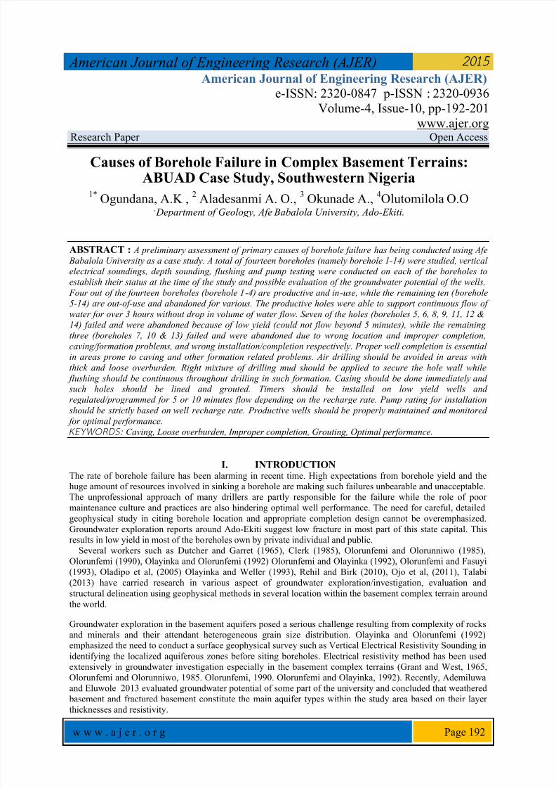
2.1 Location Afe Babalola University is located in Ado-Ekiti along Ijan road, opposite The Federal Polytechnics. The study
area is randomly selected within the university campus. The terain is gently undulating, with topographic
elevation ranging from 345m to 370m above sea level. Ado Ekiti is underlain by crystalline rocks made of Older
granite, Migmatite and Charnockites, with little or no fracture in most location and shallow overburden.
2.2 Climate, Geology and Hydrogeology of The Area The area is situated within the tropical rain forest region, with a climate characterized by dry and wet seasons.
Average annual rainfall in this area is 1300 mm, with average wet days of about 100. The annual temperature
varies between 180C to 34
0C. The study area lies within the basement complex of south-western Nigeria and is
made up of; older granite, Migmatite and Charnockites. The overburden is relatively shallow within the study
area with average of 9.6m. The groundwater is found within the overburden and fractured basement while the
area is drained by the river Ogbese which flow SW-NE direction. The basement complex rocks are poor
aquifers as they are characterized by low porosity and negligible permeability, resulting from their crystallinenature.
Fig. 1. Geological Map of the study area (Adapted from NGSA)
7/26/2019 Causes of Borehole Failure in Complex Basement Terrains:
http://slidepdf.com/reader/full/causes-of-borehole-failure-in-complex-basement-terrains 3/10
American Journal of Engineer ing Research (AJER) 2015
w w w . a j e r . o r g Page 194
III. Methodology, Data acquisition and Interpretation A reconnaissance survey of study area was carried out for site familiarization, planning and selection of the
wells for the study. This was followed with geophysical investigation of the wells, flushing, depth sounding and
pump testing. Resistivity sounding was adopted in resolving resistivity variation with depth, thus sounding
helped in delineating the various subsurface lithological units, aquiferous layers and their hydrogeological
significance.
IV. RESULTS AND DISCUSSIONS
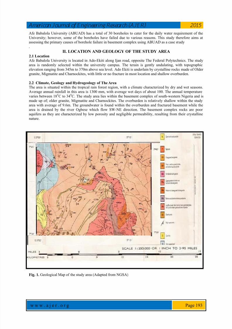
4.1 Vertical Electrical Sounding A total of 14 selected boreholes across the study area were sounded. The processed data were interpreted,
resulting curve types were assessed, existing subsurface lithologic units were established, and the geoelectric
properties of the various subsurface layers were used in delineating the aquiferous units in the study area. Field
observations were made, flushing and pump testing were conducted on the boreholes. Status of each of the
boreholes at the time of the study were established. The results are presented in the form of table (Table 1),
geoelectric curves (Figure 2a, b, c & d) and sections (Figure; 3a, b, c & d).
Two curve types were obtained from the study area namely; HA and HK. Five geo-electric layers were delineated from the
sounding curves namely; top soil, sandy clay, weathered basement, fractured basement and basement. A correlation table was
generated by comparing different geo-electric layers revealed by the sounding curves (Table 1). The top soil, sandy clay andweathered basement layers constitute the overburden. Basement is relatively shallow in this area with an average depth-to-
basement of 10.8m.
A summary of the results of interpretation, on which the findings were hinged, is shown in figure 2 below.
Fig. 2. Typical Geoelectric curves from the study area
7/26/2019 Causes of Borehole Failure in Complex Basement Terrains:
http://slidepdf.com/reader/full/causes-of-borehole-failure-in-complex-basement-terrains 4/10
American Journal of Engineer ing Research (AJER) 2015
w w w . a j e r . o r g Page 195
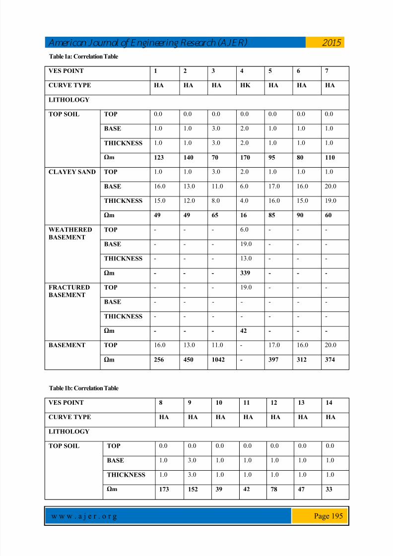
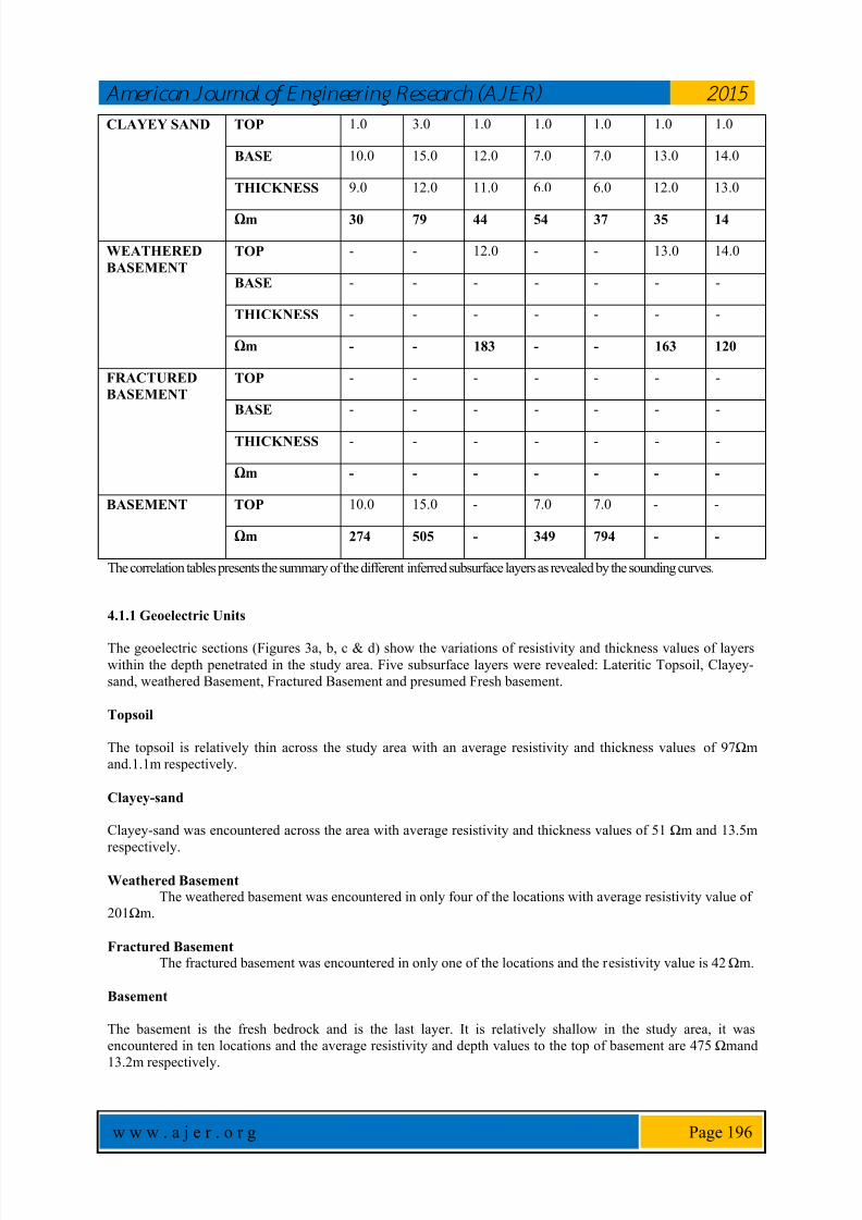
Table 1a: Correlation Table
VES POINT 1 2 3 4 5 6 7
CURVE TYPE HA HA HA HK HA HA HA
LITHOLOGY
TOP SOIL TOP 0.0 0.0 0.0 0.0 0.0 0.0 0.0
BASE 1.0 1.0 3.0 2.0 1.0 1.0 1.0
THICKNESS 1.0 1.0 3.0 2.0 1.0 1.0 1.0
Ωm 123 140 70 170 95 80 110
CLAYEY SAND TOP 1.0 1.0 3.0 2.0 1.0 1.0 1.0
BASE 16.0 13.0 11.0 6.0 17.0 16.0 20.0
THICKNESS 15.0 12.0 8.0 4.0 16.0 15.0 19.0
Ωm 49 49 65 16 85 90 60
WEATHERED
BASEMENT
TOP - - - 6.0 - - -
BASE - - - 19.0 - - -
THICKNESS - - - 13.0 - - -
Ωm - - - 339 - - -
FRACTURED
BASEMENT
TOP - - - 19.0 - - -
BASE - - - - - - -
THICKNESS - - - - - - -
Ωm - - - 42 - - -
BASEMENT TOP 16.0 13.0 11.0 - 17.0 16.0 20.0
Ωm 256 450 1042 - 397 312 374
Table 1b: Correlation Table
VES POINT 8 9 10 11 12 13 14
CURVE TYPE HA HA HA HA HA HA HA
LITHOLOGY
TOP SOIL TOP 0.0 0.0 0.0 0.0 0.0 0.0 0.0
BASE 1.0 3.0 1.0 1.0 1.0 1.0 1.0
THICKNESS 1.0 3.0 1.0 1.0 1.0 1.0 1.0
Ωm 173 152 39 42 78 47 33
7/26/2019 Causes of Borehole Failure in Complex Basement Terrains:
http://slidepdf.com/reader/full/causes-of-borehole-failure-in-complex-basement-terrains 5/10
American Journal of Engineer ing Research (AJER) 2015
w w w . a j e r . o r g Page 196
CLAYEY SAND TOP 1.0 3.0 1.0 1.0 1.0 1.0 1.0
BASE 10.0 15.0 12.0 7.0 7.0 13.0 14.0
THICKNESS 9.0 12.0 11.0 6.0 6.0 12.0 13.0
Ωm 30 79 44 54 37 35 14
WEATHERED
BASEMENT
TOP - - 12.0 - - 13.0 14.0
BASE - - - - - - -
THICKNESS - - - - - - -
Ωm - - 183 - - 163 120
FRACTURED
BASEMENT
TOP - - - - - - -
BASE - - - - - - -
THICKNESS - - - - - - -
Ωm - - - - - - -
BASEMENT TOP 10.0 15.0 - 7.0 7.0 - -
Ωm 274 505 - 349 794 - -
The correlation tables presents the summary of the different inferred subsurface layers as revealed by the sounding curves.
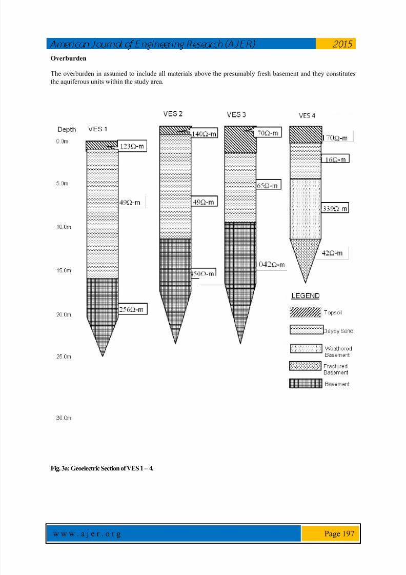
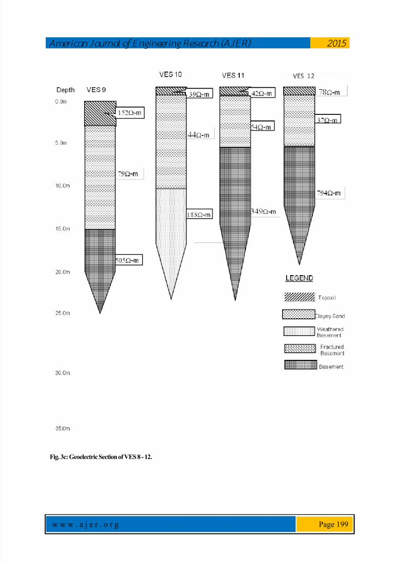
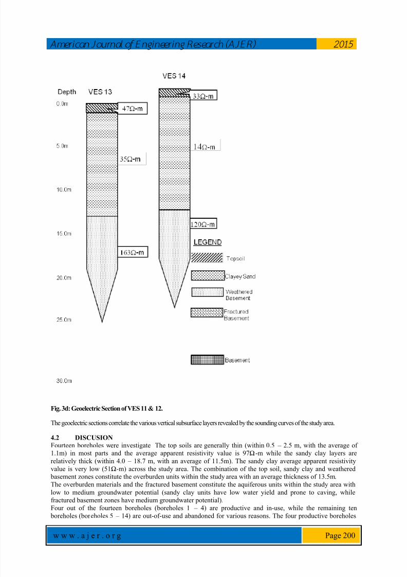
4.1.1 Geoelectric Units
The geoelectric sections (Figures 3a, b, c & d) show the variations of resistivity and thickness values of layers
within the depth penetrated in the study area. Five subsurface layers were revealed: Lateritic Topsoil, Clayey-
sand, weathered Basement, Fractured Basement and presumed Fresh basement.
Topsoil
The topsoil is relatively thin across the study area with an average resistivity and thickness values of 97Ωm
and.1.1m respectively.
Clayey-sand
Clayey-sand was encountered across the area with average resistivity and thickness values of 51 Ωm and 13.5m
respectively.
Weathered Basement
The weathered basement was encountered in only four of the locations with average resistivity value of201Ωm.
Fractured Basement
The fractured basement was encountered in only one of the locations and the resistivity value is 42Ωm.
Basement
The basement is the fresh bedrock and is the last layer. It is relatively shallow in the study area, it was
encountered in ten locations and the average resistivity and depth values to the top of basement are 475Ωmand
13.2m respectively.
7/26/2019 Causes of Borehole Failure in Complex Basement Terrains:
http://slidepdf.com/reader/full/causes-of-borehole-failure-in-complex-basement-terrains 6/10
American Journal of Engineer ing Research (AJER) 2015
w w w . a j e r . o r g Page 197
Overburden
The overburden in assumed to include all materials above the presumably fresh basement and they constitutes
the aquiferous units within the study area.
Fig. 3a: Geoelectric Section of VES 1 – 4.

7/26/2019 Causes of Borehole Failure in Complex Basement Terrains:
http://slidepdf.com/reader/full/causes-of-borehole-failure-in-complex-basement-terrains 7/10
American Journal of Engineer ing Research (AJER) 2015
w w w . a j e r . o r g Page 198
Fig. 3b: Geoelectric Section of VES 5 - 8.
7/26/2019 Causes of Borehole Failure in Complex Basement Terrains:
http://slidepdf.com/reader/full/causes-of-borehole-failure-in-complex-basement-terrains 8/10
American Journal of Engineer ing Research (AJER) 2015
w w w . a j e r . o r g Page 199
Fig. 3c: Geoelectric Section of VES 8 - 12.
7/26/2019 Causes of Borehole Failure in Complex Basement Terrains:
http://slidepdf.com/reader/full/causes-of-borehole-failure-in-complex-basement-terrains 9/10
American Journal of Engineer ing Research (AJER) 2015
w w w . a j e r . o r g Page 200
Fig. 3d: Geoelectric Section of VES 11 & 12.
The geoelectric sections correlate the various vertical subsurface layers revealed by the sounding curves of the study area.
4.2 DISCUSION
Fourteen boreholes were investigate The top soils are generally thin (within 0.5 – 2.5 m, with the average of
1.1m) in most parts and the average apparent resistivity value is 97Ω-m while the sandy clay layers are
relatively thick (within 4.0 – 18.7 m, with an average of 11.5m). The sandy clay average apparent resistivity
value is very low (51Ω-m) across the study area. The combination of the top soil, sandy clay and weathered basement zones constitute the overburden units within the study area with an average thickness of 13.5m.
The overburden materials and the fractured basement constitute the aquiferous units within the study area with
low to medium groundwater potential (sandy clay units have low water yield and prone to caving, while
fractured basement zones have medium groundwater potential).
Four out of the fourteen boreholes (boreholes 1 – 4) are productive and in-use, while the remaining ten boreholes (boreholes 5 – 14) are out-of-use and abandoned for various reasons. The four productive boreholes
7/26/2019 Causes of Borehole Failure in Complex Basement Terrains:
http://slidepdf.com/reader/full/causes-of-borehole-failure-in-complex-basement-terrains 10/10
American Journal of Engineer ing Research (AJER) 2015
w w w . a j e r . o r g Page 201
were able to support continuous flow of water for 1 hour. Seven of the boreholes (boreholes 5, 6, 8, 9, 11, 12
and 14) failed and were abandoned because of low yield (could not flow beyond 5 minutes), while the remainingthree (boreholes 7, 10 and 13) failed and were abandoned due to wrong location and completion,
caving/formation/completion problem, and wrong installation/completion respectively.
4.3 RECOMMENDATIONSDetail and extensive geophysical studies are prerequisite for citing borehole locations. Proper completion should
be ensured in areas prone to caving and other formation problems. Air drilling should be avoided in areas withthick and loose overburden, right mixture of drilling mud should be applied to secure the hole wall while
flushing should be continuous throughout drilling in such formation. Casing should be done immediately and
such holes should be lined and properly grouted. Timers should be installed on low yield wells and
regulated/programmed for 5 minutes flow and 10 minutes recharge. The productive wells should be properly
maintained and monitored for optimal performance.
4.4 CONCLUSION
The failed boreholes were partly due to low groundwater potential of the area, wrong location of some of the
boreholes (boreholes 5, 6, 8, 9, 11, 12 and 14), improper installation, completion and formation problem
(boreholes 13 and 10) and poor maintance culture (borehole 7). With proper maintenance and monitoring of the
productive wells and reactivation of the abandoned ones, there will be improved performance from the existing
wells.
References
[1] Ademiluwa OL and Eluwole AB (2013) Hydrogeophysical Evaluation of the Groundwater Potential of Afe Babalola University
Ado Ekiti, South-western Nigeria. Journal of Emerging trends in Engineering and Applied Sciences, Vol 4 Issue 1 p77
[2] Clerk L (1985). Groundwater Abstraction from Basement Complex Areas of Africa. J. Eng. Geol., London 18: 25-34.
[3] Dutcher, L.C. and Garrett. A.A., 1963, Geologic and hydrologic features of the San Bernardino area , Califonia: U.S.Geologicalsurvey Water-Supply Paper 1419, 114p.
[4] Oladipo, A. A., Oluyemi, E. A., Tubosun, I. A., Fasisi, M. K. and Ibitoye, F. I, Chemical Examination of Ikogosi Warm Spring in
South Western Nigeria. Journal of Applied Sciences, 2005, 5 (1): 75-79[5] Olayinka A. I. and Weller A. 1997. The inversion of geoelectrical data for hydrogeological applications in crystalline basement
areas of Nigeria. Journ. of Applied Geosciences, Vol. 37, Issue 2, June 1997, pp 103 – 105.
[6] Olayinka AI, Olorunfemi MO (1992). Determination of geoelectrical Characteristic in Okene Area and implication for boreholessetting. J. Min. Geol., 28: 403 - 412.
[7] Ojo, J.S., Olorunfemi, M.O. and Falebita, D.E, An Appraisal of the Geologic Structure beneath the Ikogosi Warm Spring in
South- Western Nigeria Using Integrated Surface Geophysical Methods. Earth Sciences Research Journal. 2011, 15(1):27-34.[8] Olorunfemi MO, Fasuyi SA (1993). Aqufier types and geoelectric/hydrogeologic characteristics of part of central basement
terrain of Nigeria (Niger State). J. Africa Earth Sci., 16(3): 309-317.
[9] Olorunfemi M. D. & Olayinka A. I. (1992): Alteration of Geoelectric in Okene are and Implication for Borehole Sitting. Journalof Mining and Geology, pp. 403-411.
[10] Olorunfemi M. O. (1990): The Hydrogeological Implication of Topographic Variation with Overburden Thickness in Basement
Complex. Area of South Western Nigeria. Journal of Mining and Geology. Vol 26, No. 1.[11] Olorunfemi M. O. & Oloruniwo M. A. (1985): Geoelectric Parameters and Aquifer Characteristics of Some Part of South
Western Nigeria. Journal of Mining and Geology.
[12] Olorunfemi MO, Olorunniwo MA (1985). Parameters and aquifer characteristics of some parts of SW. Nigeria Geologic ApplicaE. Hydrogeological, XX Part 1, pp. 99-109.
[13] Rehrl, C. and Birk, S. 2010, Hydrogeological Characterisation and Modelling of Spring Catchments in a Changing Environment.
Austrian Journal of Earth Sciences Volume 103 Issue 2, p106-117 Vienna.[14] Talabi, A. O., 2013, Hydrogeochemistry and Stable Isotopes (δ18O and δ2H) Assessment of Ikogosi Spring Waters. American
Journal of Water Resources, 2013, Vol. 1, No. 3, 25-33.

![Regulatory Perspectives on Deep Borehole Disposal Concepts.drilling a borehole into crystalline basement rock, typically granite, to depths up to 5,000 m [16,400 ft]. Waste canisters](https://img.pdfslide.us/doc/110x75/5e937b485121515eb6620194/regulatory-perspectives-on-deep-borehole-disposal-drilling-a-borehole-into-crystalline.jpg)


![Deep Borehole Field Test Laboratory and Borehole Testing ... · The characterization borehole (CB) is the smaller-diameter borehole (i.e., 21.6 cm [8.5”] diameter at total depth),](https://img.pdfslide.us/doc/110x75/5ebe68817151f10bcd35645a/deep-borehole-field-test-laboratory-and-borehole-testing-the-characterization.jpg)