Embed Size (px)
Citation preview

' )
Catalogue of Salmon Streams - ~-~ and Spawning Escapements:..~ .... of Statistical Area 14
. Comox-Parksville
M.J. Hancock and D.E. Marshal~ ...... rr
Department of Fisheries and Oceans Salmonid Enchancement Program 1090 West Pender Street Vancouver, B.C. V6E 2P1
March 1985
Canadian Data Report of Fisheries & Aquatic Sciences No. 504

Canadian Data Report of Fisheries and Aquatic Sciences
Data reports provide a medium for filing and archiving data compilations where little or no analysis is included. Such compilations commonly will have been prepared in support of other journal publications or reports. The subject matter of data reports renects the broad interests and policies of the Department of Fisheries and Oceans, namely. fisheries and aquatic sciences.
Data reports are not intended for general distribution and the contents must not be referred to in other publications without prior written authorization from the issuing establishment. The correct citation appears above the abstract of each report. Data reports are abstracted in Aquatic Sciences and Fisheries Abstracts and indexed in the Department's annual index to scientific and technical publications.
Numbers 1-25 in this series were issued as Fisheries and Marine Service Data Records. Numbers 26-160 were issued as Department of Fisheries and the Environment, Fisheries and Marine Service Data Reports. The current series name was introduced with the publication of report number 161.
Data reports are produced regionally but are numbered nationally. Requests for individual reports will be filled by the issuing establishment listed on the front cover and title page. Out-of-stock reports will be supplied for a fee by commercial agents.
Rapport statistique canadien des sciences halieutiques et aquatiques
Les rapports statistiques servent a c1asser et a archiver les compilations de donnees pour lesquelles il y a peu ou point d'analyse. Ces compilations auront d'ordinaire ete preparees a I'appui d'autres publications ou rapports. Les sujets des rapports statistiques renetent la vaste gamme des interets et des politiques du ministere des Peches et des Oceans, c'est-a-dire les sciences halieutiques et aquatiques.
Les rapports statistiques ne sont pas destIl1es a une vaste distribution et leur contenu ne doit pas etre mentionne dans une publication sans autorisation ecrite prealable de I'etablissement auteur. Le titre exact parait au-dessus du resume de chaque rapport. Les rapports statistiques sont resumes dans la revue Resumes des sciences aquatiques et halieutiques, et ils sont classes dans I'index annuel des publications scientifiques et techniques du Ministere.
Les numeros I a 25 de cette serie ont ete publies a titre de relevesstatistiques, Services des peches et de la mer. Les numeros 26 a 160 ont ete publies a titre de rapports statistiques du Service des peches et de la mer, ministere des Peches et de l'Environnement. Le nom actuel de la serie a ete etabli lors de la parution du numero 161.
Les rapports statistiques sont produits a I'echelon regional, mais numerotes a I'echelon national. Les demandes de rapports seront satisfaites par I'etablissement auteur dontle nom figure sur la couverture et la page du titre. Les rapports epuises seront fournis contre retribution par des agents commerciaux.

Canadian Data Report of
Fisheries and Aquatic Sciences
No. 504
March 1985
CATAL(X;UE OF SAl.M)N S1REAMS AND SPAWNING ESCAPEMENTS
STATISTICAL AREA 14
CCM)X - PARKSVILLE
by
M.J.Hancock and D.E.Marshall
Department of Fisheries and Oceans
Salmonid Enhancement Program
1090 West Pender Street
Vancouver, B.C. V6E 2Pl

, '
Minister of Supply and Services Canada 1985 Cat. No. Fs 97-13/504 ISSN 0706-6465
Correct citation for this publication:
Hancock, M.J. and D.E.Marshall. 1985 Catalogue of Salmon Streams and Spawning Escapements of Statistical Area 14 Camox-Parksville Can. Data Rep. Fish and Aquat. Sci. 504: xiii + l34p.
i i

ABSTRACT
Hancock, M.J. and D.E.Marshall, 1985. Catalogue of Salmon Streams and Spawning Escapements of Statistical Area 14, Comox-Parksville.Can. Data Rep. Fish and Aquat. Sci. 504: xiii + 134p.
Catalogue containing each stream's location, spawnin~ distribution, barriers and points of difficult ascent, escapement records and other general data pertaining to the stream. The catalogue also includes a topographical map of the stream and in some cases a sketch map which further describes the surrounding area.
Keywords: British Columbia, Statistical Area 14, Comox-Parksville, salmon streams, spawning escapements.
/
RESUME
Hancock, M.J. and D.E.Marshall, 1985. Catalogue of Salmon Streams and Spawning Escapements of Statistical Area 14, Comox-Parksvi11e. Can. Data Rep. Fish and Aquat. Sci. 504: xiii + 134p.
Le present repertoire donne l'emplacement de chaque cours d'eau, la repartition de fraie, les points de remonte difficile, les donnees sur les saumons de remonte et d'autres information generales concernant le cours d'eau. On y trouve aussi une carte topographique de l'emplacement du cours d'eau et, dans quelque cas, un croquis decrivant la zone environte.
Mots-cles: Co1ombie-Britannique, zone statistique 14, Comox-Parksvi11e, cours d'eau a saumons, remonte. ·
iii

CONI'ENTS
Abstract/Rest..nUe • • • • • • • • • • • • • • • • • • • • • • • • • • • • .. • • • • • • • • • • • • • .. • • • •• -i i i
Table of Contents............................................... i v
Statistical Maps ..........•..................................... v,vi
Mana~ement Divisions ...........................................• vii
Districts and Sulxlistricts .........•............................ viii
Standards Used .....•........•...............•................... ix,x
Federal Fisheries District Addresses .......•.................... xi
Index to Map of Salmon Spawning Streams of Statistical Area 14 xii
Escapement Summary for Statistical Area 14, Comox-Parksvi11e xiii
STREAM DATA
(Armie Creek, Shaws Creek) ..•••........................••. 2 BlACK CREEK.. . • . . • . . • . • • • . • • . . . • • • • • • . . • . . • . . • . • . . . • . • . • • . 4 CHEF CREEK (Lymn Creek) ....•................•............ 12 (Cook Creek) .•.............•.......•.....••........•.•... 12 COWIE CREEK (Cougar Creek) .....•............•..........•. 21 CRAIG CREEK (Beaver Creek) .....•••................•...... 26 ENGLISHMAN RIVER ......................................... 31,32,33 (Fi11ong1ey Creek) ..............•........................ 38 FRlli CH CREEK.............................................. 42 HART CREEK............... . • . • . • . . . • . • . . • . . • • . . . • . . . . . . . . • 47 (Kitty Coleman Creek) .•.................................. 51 MILlARD CREEK (Lard Creek) ........•...........•.......... 67 LITTLE RIVER .•.............•...........•................. 53 LITTLE WALICUM RIVER ...............................•.... 58 McNAUGI-IT'ON CREEK................................. . . . . . . .. 63 NILE CREEK ••••••••••••••••••••••••••••••••••••••••.•••.•• 72 OYSTER RIVER ...........•.........•......•............•... 77 , 78 PUNILEIX:;E RIVER ....•..................................... 83 .84 WALICUM RIVER (Big) ........•..........•..•.............. 89,90 ROSEWALL CREEK ........•....................... ,.......... 95 THAMES CREEK............................................. 72 TRENT RIVER ...........•...•.............................. 108 ,109 TSABLE RIVER .....•....•.......•......................•.. 113,114 TSOLUM RIVER ..•........•......•.......•....•............. 118 WATERLOO CREEK .•........••......••...................... 12 3 WILFRED CREEK (Coal Creek) ..........•..••.....•.......... 123 (Woods Creek) ........•...•......................•........ 130 (Brooklyn Creek) •••....•..•..•...•...••..•••..•.......... 100 ROY CREEK (Royston Creek) ....•................•...•..•.. 100 STORIE CREEK (Storrie Creek) ...•.....•••..•.•.••......... 130
iv

STATISTI CAL AREAS ARE DIVIDED
8Y RED LINES
SA LMON FI SHING WITH NET S OF ANY
KINO IS NOT PERMIT TED OU TSID E Of -
THAT IS SEAWARD OF - THE HEAVY BLACK LINE .
NOTE AR EA S 5,6,7,8 AND 9 '
<
READ CAREFULLY
L PIN UP IN WHEELHOUSE 2. WHEN DELIVERING YOUR CATCH, GIVE TALLY MAN
THE MAP NUMBER , OR NUMBERS SHOWING THE AREA IN WHICH YOUR FISH WERE CAUGHT
3. ACCURATE CATCH REPORTS WILL HELP PRESERVE YOUR FISHERIES .
4. FOR COMPLETE DETAILS , CONSULT BRITISH COLUMBIA FISHERIES REGULATIONS.
c:l
~ ~~
0" ~ .
~q
q '" G~ ~~ ~ /,,/ vv<.t; C() *,ov
,/ tt; 0° , 'v
49'"NI- ____ _
MAp· FRASER RIVER
~v"~
.~~ _ 29-0 ~~ , -- ~~~~
29-E
\ '0
SC4l..( IN .... ILES
STATISTICAL AREAS ARE DIVIDED
BY RED LINES
SALMON FISHING WITH NETS OF ANY KIND IS NOT PERMIT TED OUTSIDE OF-THAT IS SEAWARD OF - THE HEAVY BLACK LINE .
• FISHERIES SERVICES OFFICES
/ /
/ /
FOR ALL FISH CAUGHT OFF THE COAST OF THE STATE OF WASHINGTON
SOUTH OF CAPE FLATTERY REPORT AS AREA .. C·
DEPARTMENT OF THE
FISHERIES
ENVIRONMENT
SERVICE
STATISTICAL MAP SHOWING AREAS OF CATCH FOR
BRITISH COLUMBIA WATERS
(SOUTHERN HALF)
10 '0 '0 <0 '0 SCAL.E Ihi " ILES
~ -0-
~
_ ~O~U~B!.A ~9.N u. s. A.
FOURTH [Ol lION APRIL 197Z

I
i
..... ..
South Coast
DIvIsion
vii
MANAGEMENT DIVISIONS
FISHERIES & OCEANS
PACIFIC REGION
Fraser River ,
Yukon
Division
-. _.- ..... . -

<
LEGEND DISTRICT BOUNDARY _
SUBDISTRICT BOUNDARY ---
SURREY CHILLIWACK
'i jl7 . l~ .
l1BIR J]1r [[ ~Jl!l (CC! DJJ ,ij '~[(n[(A
FISHERIES & OCEANS - Pacific Region
WHITEHORSE DISTRICT

STANDARDS USED ON STREAM DATA PAGE
Name of Stream: Name given in Gazetteer of Canada, British Columbia 1966 edition;
Statistical Area: As defined by D.F.0.showing areas of catch for B.C.waters (Map dated Jan. 1974)
Districts and Subdistricts: As defined by D.F.O.(Map 1985)
RAE Numbers : The Aquatics {mit of the Resource Analysis Branch, Ministry of the Environment have assigned a hierarchical coding system (RAB number) to drainage basins of British Columbia. RAB numbers classify catchment areas and river channels. Further information on RAB coding system can be found in "A Hierarchical Watershed Coding System for British Columbia", RAB Technical Paper #3, Ministry of the Environment, Victoria, B.C. June 1980.
Location and Position: Defined by quadrant indexing. Each geographical quadrilateral of the earth's surface of 1 degree in extent in latitude and longitude is divided into the SEt SW, NE and NW quarters. The south-east corner of each quadrilateral gives the initial point for the figure of reference (Gazetteer of Canada).
1240 1230 1220
540 540
X
NW NE
EXAMPLE "X" I
53° 1220 NW ,
~-------l-- -- ---
SW SE
53° 530
124° 1230 1220
i x

Length: The portion of the stream accessible to spawning salmon.
Draina~e: Area in square kilometers of the entire drainage basin feeding the stream.
Discharge: Extremes of maximum and minimum daily discharge for the period of the last 30 years. Discharge date is taken from ''Historical Stream flow Stmnary", British ColUmbia, Water Survey of Canada.
Temperature: As described (oC)
Barriers and Points ~f difficult ascent: Complete and partial barriers to salmon and their distance from the stream mouth. Species likely to be affected may be listed. Both natural and man-made obstructions are defined.
Spawning distribution: Portion of the stream utilized by each species. Distribution is indicated by brief comments opposite the species.
General remarks: Emphasizes features of stream and spawning populations. Also includes industrial activity, routes of accessibility, etc. The comments and dates are taken fran "Annual Reports of Salmon Streams and Spawning Grounds". In some cases, references to additional information not included in the General remarks may be given.
Escapement Records: The escapement represents the mid point of the coded range of escapement for each species. For example: the letter ''H'' representing 5000-10000 fish would be entered as 7)00. Where absolute numbers are provided by Fisheries Personnel, these numbers are entered. N/O means the stream was inspected, but no fish were observed; UNK means there was evidence of fish present, but no estimates were made; NO RECORDS means no escapement records for the applicable years could be found in the escapement files.
Timing: Dates which salmon arrive in the stream, begin to spawn, reach peak spawning pericx:i and finish spawning.
E early (1st to 10th of the month) M mid (11th to 20th of the month) L late (21st to end of the month)
NB: Distance references are fran the mouth of the stream unless otherwise stated.
x

FISHERIES & OCEANS Pacific Region
DISTRICr/SUB-DISTRICf OFrrCES
D ISTRI CI' /SUB-DISI'RI CI'
DISTRI CI' ! 1 - Kaml oq:>s Salrron Am Prince George Clearwater Lillooet Quesnel WilliinS Lake
DISTRICI' • 2 - New Westminster vancouver Surrey Coquitl.!i," Steveston Squcrni sh Mission Ch i 11 i wade
DISTRICI' • 3 - NanaiJro Nana iJro/Ladysrni th Qua li C\JTl Beach OJrrox DUnan ?owe 11 Ri ve r Pender Harbour
DISTRICI' '4 - Port Alberni Port Albernl Quatsino Sound Kyuquot Tahsis Tofino
OISTRICI' .5 - C5IJbell River ciIJ1l*)e 11 Rl ve r Seym::>ur Inlet Alert Bay
DISTRICI' 16 - Victoria Vlctorld!Saanlch Sooke
DISI'RICI' 17 - Kitimat Butedale Bella Bella Bella Coola Ri vers Inlet Smith Inlet
DISTRICI' .8 - Prince Rupert Waterfront Skeena Greenville - Principe ~r Nass Upper Nass Hazelton Smithers Terrace
OISTRICI' .9 - Queen Cllarlotte Is. West Coast Q.C.I. Hasset Sandspi t
DISTRICI' '10 - ~itehorse Yukon South/NOrthern B.C. Yukon-Arctic Alsek-Taku
202 - 317 Seyno.Jr St., Kmtloops, V2C 2E9 Ebx 1160, 461 Beatty Ave. ~, SalJron Arm VOE 2392 Q5pika Blvd., Prince George, V2N 3N5 Ebx 610, Clearwater, VOE lNO
2TO
Ebx 315, Lillooet, VOK lVO Ebx 4340, Quesnel, V2J 3J3 540 Ebrland St , williams Lake, V2G lR9
309 - 549 Golumbia St., New West., V3L lB3 309 - 549 Columbia St., New West., V3L lB3 309 - 549 Golumbia St., New West., V3L 183 309 - 549 Columbia St., New West., V3L lB3 1255 No. 1 Fbad, Richrond, V7E lT7 Ebx 85, SqUilllish, V~ ~ Box 3308, Mission, V2V 4J5 Suite 5, 9375 Mary St., Chilliwack, V2P 4G9
60 Front St., Nanairro, V9R 5H7 60 Front St., Nanaimo, V9R 5H7 Ebx 1270, QualiCUll Beach, VOR 2TO Ebx 1328, Comox, V9N 3Z0 Ebx 241, 191 Ingrcrn St., Duncan, VOL 3X3 4488 Marine Avenue, ~ll River, V8A 2K2 Ebx 10, ~ira Park, V~ 2H0
Ebx 280, Federal Building, Port Alberni, V9Y 1M7 Box 280, Federal aJilding, Port Alberni, V9Y 7fIf7 Ebx 10, Port Hardy, V~ 2PO Ebx 549, Tahsis, VOP lXO Ebx 549, Tahsis, VOP lXO Ebx 48, Tof ino, VCR 2Z0
215 - 950 Alder St., Campbell River, VOW 21'8 215 - 950 Alder St., Can'{bell River, V~ 21'8 Ebx 10, Port Hardy, VON 2PO Ebx 10, Alert Bay, V~ 1M
116 - 816 Government St., Victoria, vaw lW9 116 - 816 Goverrrnent St., Victoria, V8W lW9 Ebx 460, Sooke, VOZ lNO
315 .- 450 Federal Building, Kitimat, vee 1~ 315 - 450 Federal Building, KitUnat, vee lT6 Ebx 38, Bella Bella, VOT 180 Ebx 130, Bella Coola, VOT lCO Dawson Landing P.O., Rivers Inlet, V~ lMO Dawson Landing P.O., Rivers Inlet, VON lMO
109 - 417 2nd Ave. West, Prince Rupert, V8J 109 - 417 2nd Ave. West, Prince IUpert, V8J 109 - 417 2nd Ave. West, Prince Rupert, V8J 109 - 417 2nd Ave. West, Prince IUpert, V8J 109 - 417 2nd Ave. West, Prince Rupert, V8J Box 29, Nass Carp, VOJ 3J0 Ebx 327, Field Street, Hazelton, VOJ lYO Ebx 578, Smithers, VOJ ~ 4721-B Lazelle Ave., ~rrace, VIIG lR6
Ebx 99, Queen Charlotte City, VOT 150 Ebx 99, ()Jeen Cllarlotte City, VOT 150 Ebx 99, Masset, VOT lMO Box 222, Sandspit, VOT ITO
lG8 1GB lG8 lG8 lG8
122 Industrial fbad, ~iteoorse, Y.T., YIA m 122 Industr ial RoOO, Iolli tehorse, Y. T., YIA 2T9 122 Industrial Fbad, Whiteoorse, Y.T., YIA m Box 5341, Haines Junction, Y.T., YOn lLO
xi
TE~
374-4322 832-8037 564-7030 674-2633 256-4525 992-2434 398-6544
524-7181 524-7306 524-7171 524-7169 274-7217 892-3230 826-3664 792-6011
754-3257 754-3257 752-9712 339-2031 746-6221 485-9621 883-2313
724-0195 724-0195 949-6422 934-6606 934-6606 725-3468
287-2102 287-2102 949-6422 974-5216
566-3252 566-3252 642-5322
632-4884 632-4884 957-2363 799-5345
624-9137 624-9137 624-9137 624-9137 624-9137 633-2408 842-6327 847-2312 635-2206
559-4413 559-4413 626-3316 637-5340
667-2235 667-2235 667-2235 634-2235
SUB-D ISTRI CI' NtJoIBER
29K 291 29J 29F 29H 29G
2M 29B 29C 29A 28B 290 29E
17 145 14N 18 15 16
23 27 26 25 24
13 11 12
19 20
6 7 8 9 10
4A 5 3A 3B 4C 4D 4B
2W 1 2E
120 110 130

SALMON SPAWNING STREAMS STATISTICAL AREA 14
o I
ki1aneters
1. Annie Creek 2. Black Creek 3. Chef Creek (Lymn Creek) 4. Cook Creek 5. Cowie Creek(Caugar Creek) 6. Craig Creek (Beaver Creek) 7. Englishman River 8. Fillongley Creek 9. French Creek
10. Hart Creek 11. Kitty Coleman Creek 12. Millard Creek (Lard Creek) 13. Little River 14. Little Qualicum River 15. McNaughton Creek 16. Nile Creek 17. Oyster River 18. Puntledge River 19. Qualicum River (Big) 20. Rosewall Creek 21. 'Thames Creek 22. Trent River 23. Tsable River 24. Tsolum River 25. Waterloo Creek 26. Wilfred Creek 27. Woods Creek 28. Brooklyn Creek 29. Roy Creek (Royston Creek) 30. Storie Creek (Storrie Creek)
xi i
Qualicum Beach
Strait. of Geor~ia

SUMMARY
ESCAPEMENT RECORD FOR STATISTICAL AREA 14 - COMOX-PARKSVILlE
YEAR SOCKEYE CHINOOK COHO CHUM PINK STEELHEAD 47 3,550 42,738 328,759 84,950 3,575 48 3,500 24,175 127,101 90,750 1,000 49 7,725 26,050 11 ~825 37,625 800 50 8,550 30,175 152,925 126,625 6,175 51 8,125 40,400 281,625 6,625 15,400 52 3,950 85,150 123,000 117,500 13,225 53 5,200 57,500 158,675 58,550 19,650 54 16,525 48,525 168,225 191,775 17,775 55 75 10,500 36,725 124,475 55,300 6,725 56 75 4,525 35,825 82,175 58,800 10,300 57 250 5,775 48,000 147,175 101,900 8,925 58 650 9,000 47,125 164,400 186,300 11 ,850 59 76 6,336 50,574 199,500 20,062 11,325 60 100 5,844 29,712 151,262 14,900 9,125 61 75 3,036 35,961 76,600 16,626 8,175 62 28 2,687 41,873 126,975 7,751 9,250 63 2,919 38,725 156,450 18_,628 10,000 64 50 2,127 83,409 122,875 2,450 65 61 3,443 40,617 39,550 5,850 4,225 66 25 2,795 70,424 145,350 24,850 67 20 2,029 20,156 121,100 5,604 68 275 2,090 26,331 342,350 10,700 69 100 1,900 1~,101 209,987 575 137 70 75 2,820 49,093 296,150 9,680 71 75 2,132 56,525 133,025 2,650 72 125 1,860 18,250 238,875 13,700 73 175 1,932 22,778 310,580 5,368 74 50 1,559 56,431 214,720 11 ,950 45 75 50 2,329 47,392 178,153 11 ,410 76 225 1,979 27,657 161,425 11 ,230 77 75 4,750 103,760 169,528 8,050 78 370 5,605 50,990 295,150 3,535 79 100 9,534 74,605 191,375 15,650 1,000 80 260 8,821 68,552 238,350 16,695 81 70 5,510 97,440 228,600 10,955 82 38 6,852 74,784 274,093 1,096 10 83 50 7,361 61,990 285,695 3,310 200 84 85
TIMING: ARRIVE START PEAK END
~EMARKS ____________________________________________________________ __
xii i

,. leu m __ ;-__ ----11 - -----t-----'Y
N
l AImie Creek 0 2
I I ki lomet res

2
NAME OF STREAM _~(..!:.A~rm~i~e....:C~r~e~e::!:k~,~Sha~:!:!.w~s....:C~r!:..!e~e::!:k~)~ _______ ---.!.:;FAB!...!:!:::.....!Nc:..!0:::..:.:..........::9:..::2:....-.::::.3.:::5~20~ __
CONSERVATION DISTRICT __ ~3~ ___ _ STATISTICAL AREA _~1~4~ ________ _
LOCATION OF MOUTH _...:F~l::..::o:.::w:.::s:.......:.:NW:.:.:..:.---.:::.i.:..:n~t~o_S~t::..Y"~_a::::~::..:· t~s::....::o::.::f::........::Ge::..::..::o:.:r.s;;g:..:i:.=a.1.,--=S..:.. • .....=.o=-f_QJa~=-l:..:i:..:c:..:um=..:..:....-=B:...:a:.LY.2.' ___ _
Newcastle Dist. POS I TI ON _....:4~9_=12=_4.:........:::S~W..:... __ __
LENGTH ________ __ km WIDTH ________ __ m DRAINAGE ________ _
COMPOSITION: BEDROCK ____ _ BOULDER ____ _ COARSE ----- FINE ___ _
SILT & SAND ____ _ UNCLASSIFIED _______________ __
PERCENT GRADIENT 0.00 0.25 0.25 - 0.50 0.50 0.75 0.75 1.00
> 1.00
WETTED AREA _______ m2 SPAWNING AREA _______ m2
DISCHARGE (m3/s)
TEMPERATURE (OC)
BARRIERS OR POINTS OF DIFFICULT ASCENT ____ ~----~~-~~~~----___ Twin 4 ft. culverts under Hwy. 19 are passable at high flows. Small log jams partially removed in 1958. Impassable high ground at Hwy. 19 culvert should be changed.
SPAWNING DISTRIBUTION
SPECIES SOCKEYE CHINOOK COHO -in CHUM PINK (ODD YEAR) PINK (EVEN YEAR) STEELHEAD
conditions:
SECTION OF STREAM USED
lower creek below Hwv 19. few above Hwv.
Physical 1970178 No significant erosion and silting. 1979 Extensive erosion and silting in lower reaches -- extensive scouring
flash floOding. 1980783 Reported heavy discoloration and gravel shifting in lower reaches.
GENERAL REMARKS __ ~~_~ __ ~~~ __ ~ __ ~_~ ___ ~ ________ _ 1970/72 A ve in lower ortion.
A c is roblems. site the
1981
1982

3
E SCAP EME NT RECORD FOR _-,(...:...A_n n..;,....i....:.e_C-,-r....:.e...,;;.e_k -<-' ....:.S_ha_w_'-'-s_C_r...,;;.e_ek-l.)~ _____________ _
YEAR SOCKEYE CHINOOK COHO CHUM PINK STEELHEAD 1947
48 49 50 51 52 53 54 55 56 57 58 59 60 61 62 63 64 65 66 67 68 NO RECORDS P lOR TO 1970 69 70 75 71 75 72 25 73 ~5 74 75 75 25 76 25 77 25 78 45 79 10 80 10 81 25 82 2 83 10 84 85
TIMING: ARRIVE E NOV START NOV PEAK E DEC END L DEC
REMARKS _______________________________________ __

~I-\: 24
'"
.,.
N
t 0
t:C I-' ~
" (")
~ 0 (") 3 'i en (0 .... ~ ..,
~ 1\\ \ \ '\\\\\\\8 !~"'~~~ ~n \ \'\ 24 en CJ)
I\J
5
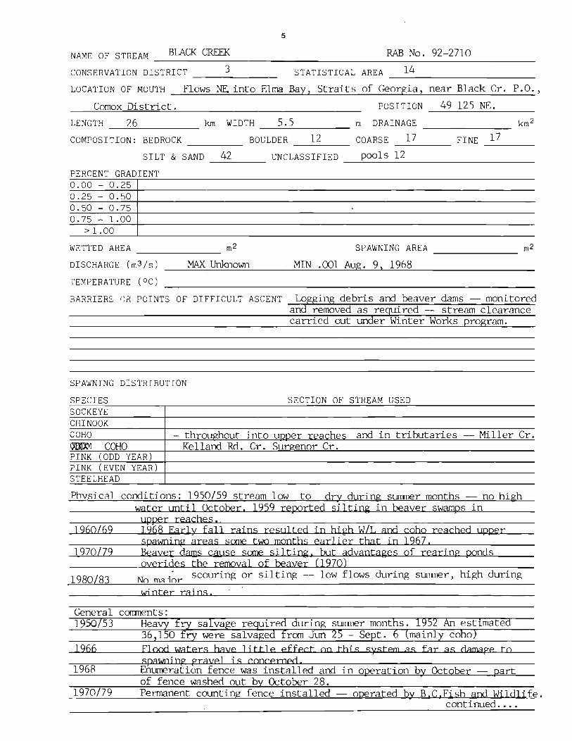
NAME OF STREAM BLACK CREEK RAB No. 92-2710 -----------------------------------------------------------------CONSERVATION DISTRICT 3 STATISTICAL AREA ___ 1_4 _____________ __
LOCATION OF MOUTH
Comox District.
Flows NE into Elma Bay, Straits of Georgia, near Black Cr. P.O.,
POSITION 49 125 NE. ------------------LENGTH __ -'~:..:..;_6"__ ____ kIn WIDTH _-'5;..,._5 _______ m DRAINAGE __________ __
COMPOSITION: BEDROCK BOULDER 12 COARSE 17 FINE _17_° ___ _ --------- -----SILT & SAND 42 UNCLASSIFIED pools 12 ------- ---~----------------------------
PERCENT GRADIENT 0.00 - 0.25 0.25 - 0.50 0.50 - 0.75 0.75 - 1.00
> 1.00
WETTED AREA ______________ m2 SPAWNING AREA m2 ---------DISCHARGE (m3/s)
TEMPERATURE (OC)
MAX Unknown MIN .001 Aug. 9, 1968
BARRIERS I) i{ POINTS OF DIFFICULT ASCENT Logging debris and beaver dams -- monitored aDd removed as required -- stream clearance carried out under Winter Works program.
SPAWNING DISTRIBUTION
SPECIES SECTION OF STREAM USED SOCKEYE CHINOOK COHO - throughout into UDDer reaches and in tributaries -- Miller Cr. ~ COHO Kelland Rd. Cr. Surgenor Cr. PINK (ODD YEAR) PINK (EVEN YEAR) STEELHEAD
Phvsical conditions: 1950/59 stream low to dry during surrrner months -- no high water until October. 1959 reported siltin~ in beaver swamps in
'lPper reache s . 1960/69 1968 Earl y fall rains resulted j n hj ph wi!. and coho reached upper
spawoing areas some two months earlier that in 1967. 1970179 Beayer darns cause some siltin~, but advantages of rearing ponds
_______ overides the removal of beaver (1970) 1980183 No mAi~r scourin~ or siltin~ -- low flows during surrrner, high during
General 1950/53
]966
1968,
1970179
wj nter raj ns .
surrrner months. 1952 An estimated - Sept. mainly co 0
Flood waters hAve ljttle effect on this system as far as damage to spawn; hg gravel j s concerned Enumeration fence was installed and in operation by October -- part of fence washed out by October 28. Permanent counting fence installed -- operated Qy B,C.Fish and Wildlife.
conti Trued ..•.
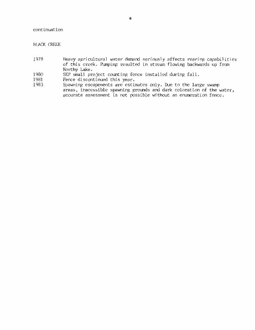
6
continuation
BUCK~
1978 Heavy agricultural water demand seriously affects rearing capabilities of this creek. Pumping resulted in stream flowing backwards up from Northy Lake.
1980 SEP small project counting fence installed during fall. 1981 Fence discontinued this year. 1983 Spawning escapements are estimates only. Due to the large swamp
areas, inacessible spawning grounds and dark coloration of the water, accurate assessment is not possihle without an enumeration fence.

Sketch of Black Creek. 1968
Gulf of Georgia
Island Highway
Black
7
/------"", "
Creek
/ /
/ --/
,,/Duncan Bay ~ain Road
I
/
I
/
"' / Y
/ /
/ l
lIsland Highway I
orrison Lake
Road

8
ESCAPEMENT RECORD FOR BLACK CREEK ----------------~---------------------------------
YEAR SOCKEYE CHINOOK COHO CHUM PINK STEELHEAD 1947 3,500 NjO NjO
48 1,500 NjO NjO 49 1,500 750 NjO 50 1,500 NjO NjO 51 1,500 NjO 200 52 1,500 NjO 200 53 1,500 NjO 200 ~4 1,500 NjO 200 55 1,500 NjO 200 56 1,500 NjO 75 57 7,500 NjD 200 58 1,500 NjO 750 59 7,500 NjO 400 60 400 NjO 200 61 7,500 NjO 200 62 7,500 NjO 200 63 3,500 NjO 200 64 15,000 NjD NjO 65 7,500 NjO NjO 66 15,000 NjO NjD 67 6,000 NjO NjO 68 4,656 NjO NjO 69 1,200 NjO NjO 70 8,000 NjO NjO 71 10,000 NjO NjO 72 4,500 NjO NjO 73 6,000 NjO NjO 74 8,000 NjO NjO 75 10,000 NjO NjO 76 3,500 NjO NjU 77 4,500 - -78 8,400 - -79 2,000 - -80 3,500 - -81 750 - -82 2,500 - -83 3,000 - -84 85
TIMING: Af<RIVE L OCT START L OCT PEAK L NOV END JAN
REMARKS Timing orf~M~i~g-ra~t~i-on-:------~Pe-r~i-od'-----'IAO~%--------7.50~%'-----~9~OW%-o~f~To~t-a~1------
Adult Coho 1968 Oct. 11 Oct. 22 Dec. 13

9
(Brooklyn Creek)
See Roy Cr. p.lOO

10
NAME OF STREAM (Brooklyn Creek) RAB No. 92-2780
CONSERVATION DISTRICT _____ 3 ________ __ STATISTICAL AREA __ ~1~4 __________________ __
LOCATION OF MOUTH __ ~F~l~o~w~s~i~n~t~o~C~omo~~x~Ba~YL-______________________________________ _
POSITION ------------------LENGTH ______________ __ km WIDTH m DRAINAGE ---------------- ---------------COMPOSITION: BEDROCK ________ _ BOULDER COARSE _________ FINE ____ __
SILT & SAND ______ UNCLASSIFIED ______________________________ ___
PERCENT GRADIENT 0.00 - 0.25 0.25 - 0.50 0.50 - 0.75 0.75 - 1.00
> 1.00
WETTED AREA ______________ m2 SPAWNING AREA _______________ m2
DISCHARGE (m3/s)
TEMPERATURE (OC)
BARRIERS OR POINTS OF DIFFICULT ASCENT Culvert at Ba)moral Aye. 2.Skru from mouth.
SPAWNING DISTRIBUTION
SPECIES SOCKEYE CHINOOK
Recommend removal (1983)
SECTION OF STREAM USED
COHO - hPlow R::lllTl()r::ll Ave CHUM PINK (ODD YEAR) PINK (EVEN YEAR) STEELHEAD
POTENTIAL OF INACCESSIBLE PORTION OF STREAM
GENERAL REMARKS 1983 Some minor SEP work bas been lDxl.ertaken on this stream, however habitat degredation is adversely affecting salmonid production.
1983 Physical conditions: Considerable silt load during heavy precipitation. Water level crjtjcally low during Slmner months with extreme fll1ctuations dlrrjng heavy rajns.

11
ESCAPEMENT RECORD FOR (Brooklyn Creek) --~--~----~---------------------------------
YEAR SOCKEYE CHINOOK COHO CHUM PINK STEELHEAD 1947
48 49 50 51 5~
53 t>4 55 56 t>7 58 59 60 61 62 63 64 65 66 67 68 69 10 71 72 73 74 75 76 77 78 79 80 81 82 83 L ~4
85 TIMING: Uc_, ARRIVE L ocr START M Nt)V
PEAK L NUV END
REMARKS _________________________________________________ _

12
s .0 U
I\l~
N COOk Creek
t &
Chef Creek 0 2
I I kilo metres

13
NAME OF S TREAM _---=-CHEF::...=:.........:C::.REEK=~ ____________ _=RAB:..::..:::........:.N:..::o...:..._9.::...;2=_-_=3=_4:..::l:..::2 ____ _
CONSERVATION DISTRICT ___ 3______ STATISTICAL AREA __ 1_4 _________ _
LOCATION OF MOUTH Flows NW. and NE. into Deep Bay, NW. of Bowser, Newcastle Dist.
POSITION 48 124 $W.
LENGTH _--=-5..:.,.. ::...5 ____ krn WIDTH _-..:.4..:.. . .:::,.5 ___ _ m DRAINAGE _______ _
COMPOSITION: BEDROCK BOULDER ____ _ COARSE _____ FINE ___ _
SILT & SAND _____ UNCLASSIFIED _______________ __
PERCENT GRADIENT 0.00 - 0.25 0.25 - 0.50 0.50 - 0.75 0.75 - 1.00
> 1.00
WETTED AREA _~2~5~0~1~3 ____ m2 SPAWNING AREA ---.....::1::....:7....:::5~5..::::.6 ____ m2
DISCHARGE (m3/s)
TEMPERATURE (OC)
BARRIERS OR POINTS OF DIFFICULT ASCENT _-uN~o~o~b~s~t~ru~c~t~i~o~n~s~ ___________ __
SPAWNING DISTRIBUTION
SPECIES SECTION OF STREAM USED SOCKEYE CHINOOK COHO - throughout to upper limits CHUM - inter tidal and lower reaches PINK (ODD YEAR) PINK (EVEN YEAR) STEELHEAD
Phvsical conditions: 1950/59 A very stable flow throu~hout this period. 1960/69 A very stable stream, slight siltjng and moderate scouring.Occasional ·
change in inter-tidal zone due to beaver activity (1969) 1970/79 Low flows during summer months, but this stream never goes dry.
Continuing beaver activity results in occasional changes in stream course. 1980 Moderate scouring late Dec. due to Dec. flood.
GENERAL REMARKS 1954/56 Large numbers of coho fry released in this stream after being salvaged from Cook and McNaughton Creeks.
1957/59 Lower portion of stream is a large beaver swamp - recoomend removal. 1960 Stream improved by Pacific Biological Station Personnel. An accurate
count of spawning stocks obtained at the fence erected near the hwy. 1961/64 Research Board personnel operated two fences to enumerate coho
population. Discontinued 1965 1971 Fisheries Research Board ed in coho studies under
direction of J. Pa
continued ••••.

14
continuation
CHEF CREEK
1980 1981 1982 1983
Considerable reduction in commercial fishing Significant reduction in spawners over brood No chum seen -- coho return estimate only. This stream was inspected twice in Oct. only. coho spawners that entered in late fall.
time in Johnson Straits. year reason unknown.
There may have been some

15
Sketch of Chef Creek, 1968
Baynes Sound
Deep Bay
'''''''''' ') r~~:~el _._._.- -.- - - Island Highway
Boulders N
Mixed Good Gravel

16
ESCAPEMENT RECORD FOR CHEF CREEK ------------------------------------------------------YEAR SOCKEYE CHINOOK COHO CHUM PINK STEELHEAD 1947
48 NO RECORDS RIOR TO 195 49 50 51 400 200 52 400 NjO 53 1,500 200 54 400 200 55 750 75 56 400 25 57 750 200 58 750 25 59 200 NjO 60 1,500 200 61 750 25 62 750 25 63 750 75 64 1,500 75 65 750 25 66 1,500 25 67 800 NjO 68 900 100 69 1,000 50 70 1,200 NjO 71 1,500 NjO 72 1,300 NjO 73 800 N/O 74 1,200 NjO 75 800 NjO 76 _600 100 77 750 150 78 750 200 79 400 -80 400 200 81 75 50 82 50 -83 N.O. 84 85
TIMING: ARRIVE M OCT E OCT START E NOV E NOV PEAK L NOV E DEC END DEC L DEC
REt'IARKS Timing of Mi9ration: Period 10% 50% 90% of Total
Adult Coho 1901 Nov. 1 Nov. 10 Nov. 22 Adult Coho 1962 Nov. 9 Nov. 12 Nov. 21 Adult Coho 1963 Oct. 21 Nov. 14 Nov. 29 Adult Coho 1964 Nov. 9 Nov. 23 Nov. 30

17
(Cook Creek)
See Chef. Cr. P.12

18
NAME OF STREAM (Cook Creek)
CONSERVATION DISTRICT ____ 3 ________ ___ STATISTICAL AREA _____ 1_4 ________________ __
LOCA TI ON OF MOUTH ___ Fl __ o_w_s __ N_. __ i n __ to __ De __ e....!p __ Ba---".y-','--NW __ • __ o_f __ Bo_w_s_e_r~, _N_e_wc __ a_s_t_l_e __ D_i_s_t_. _____ _
POSITION 49 124 sw. LENGTH ___ 2_.5 ___ ___ km WIDTH ____ 1_0 _________ m DRAINAGE
COMPOSITION: BEDROCK 1 BOULDER 40 COARSE 18 FINE 28 --------- ------- ------- --------SILT & SAND ________ UNC LASS I FlED ---!.poo ___ l_s __ 13 __________________ _
PERCENT GRADIENT 0.00 - 0.25 0.25 - 0.50 0.50 - 0.75 0.75 - 1.00
> 1.00
WETTED AREA __ ~2~5~8~9~6 _______ m2
DISCHARGE (m3/s)
TEMPERATURE (OC)
BARRIERS OR POINTS OF DIFFICULT ASCENT
SPAWNING DISTRIBUTION
SPECIES SOCKEYE CHINOOK
SPAWNING AREA ~1~1~7~04~ ______ m2
Impassable 6m falls 2.5 - 3 km from mouth
log jams monitored and removed at migration
SECTION OF STREAM USED
COHO - throughout to upper limits CHUM -concentrated below Island Hwy. in lower reaches PINK (ODD YEAR) PINK (EVEN YEAR) STEELHEAD
Physical Conditions: 1950/59 Usually dry in lower reaches until fall. Sli~ht erosion and silting in lower reaches (5%)
1960/69 Erosion and silting ranging from 20% to 30%. Considerable scouring and course changes in lower reaches (63/66) 1968 Stream broke thrQlghbanks and diverted to culverts. then diSSipated into swampy area.
1970/79 Dry or extremely low during summer -- subject to heavy fall floods and heavy scouring (1975)
1980/83 Slight siltation durin~ freshets moderate scourjng during thi s peri ad. W~rpy levels critically low in summer, but maintains fairly stable flow during winter.
General 1956/57 1961/62 1963
conti TD IPd

continuation 19
(Cook Creek)
1977
1978 1980
1982
1983
Gravel bars are building up in the lower river. Fry salvage throughout the summer due to flows going underground. Chum spawned in intertidal flats due to extreme low water levels.(79) Considerable reduction in commercial fishing time Johnson Strait. Area below railway bridge dries in summer with resultant coho fry mortality. Spawning stocks significantly reduced over past year. Coho return estimate only. This stream is a major chum producer in this area. Spawning populations of chum have shown a gradual but steady increase since 1960 with the odd year having below nonnal returns.
Evidence of egg digging near confluence of McNaughton and Cook Creek immediately upstream of intertidal zone.
Usual predators.

20
E SCAP E~lE NT RECORD FOR _.....l(....::.C~oo=--k.:.........:..C=--re:....;:e~k-'--) ___________________ _
YEAR SOCKEYE CHINOOK COHU CHur1 PINK STEELHEAD 1947 750 7,500 N/O N/l)
48 750 7,500 N/O UNK 49 750 3,~()0 N/O UNK 50 400 7,500 N/O 200 51 400 7,500 N/O 2UO 52 It> u 3,500 ~t> 75 53 75U 3,500 25 200 54 400 3_,500 N/O N/Ll S5 200 75U NjU N/O 56 200 750 N/O 75 'J7 400 3,500 N/O 75 58 40() 7,500 N/U 200 59 200 3,500 N/O N/l) 6U 200 750 N/O 75 61 200 1,500 r~/o 75 6L 200 1,500 N/O 75 63 200 750 N/O 75 64 400 1,500 N/O UNK 65 75 200 N/ O UN K 66 400 1,500 N/O N/O 67 150 1,200 N/O N/O 68 375 6,500 N/O N/l) 69 75 900 N/O N/O 70 400 5,000 N/O N/O 71 400 1,300 N/O N/O n 150 7,500 N/O N/O 73 150 4,000 N/O N/O 74 400 5,000 r1/0 N/O 75 200 3,000 N/O N/O 76 75 1,200 N/O N/O 77 400 2,950 78 250 7,500 79 ~OU 3,2UO 8U 325 5,UOO 81 200 6,900 82 300 3,200 83 300 5,500 84 8S
TIM I NG: ARRIVE M OCT M OCT START L OCT r~ UCI PE AK L NOV L NOV END UI:.C lJl:C
R E~1ARK S ---------------------------------------------

N
t 0 ~p~\~\~\
n 7'1 0
It ~. (1)
n ~ ~
~ 1 1~)~~i~J~t'·:i;::·r;·:· , \ . S ~ . · ;;::::::~f. \\\\:
A ~~~ia ~f,(f ft\\\i·.iI:~+=:::1· . L > ~/ . I . . ....... .•.
- - -
0 I
l b-~
..., ...

22
NAME OF STREAM __ CCMI __ E_CREEK _____ ( C_o_u_g_a_r_C_r_e_e_k_) ____ RAB __ N_o_. _9_2_-_3_200 ____ _
CONSERVATION DISTRICT ___ 3____ STATISTICAL AREA ____ 14 __________ _
LOCATION OF MOUTH ___ F_l_o_w_s_NE_._in_t_o_F_a_nn-Ly_Ba~y~,_N_e_wc_a_s_t_le_D_i_s_t_. ________ __
POSI TION __ 4..;...;9:-.,::1c:;.2..;..4.....:;NW-'--. __
LENGTH 5 km WIDTH 7 m DRAINAGE km 2 ---~-------- --~------ ----------
COMPOSITION: BEDROCK 4 BOULDER 43 COARSE 26 FINE 27 --~--- --~---- ------ -----
SILT & SAND _______ UNCLASSIFIED _______________ _
PERCENT GRADIENT 0.00 - 0.25 0.25 - 0.50 0.50 - 0.75 0.75 - 1.00
> 1.00
WETTED AREA __ 4..;;..5..;;..61.;;;..2~ ______ m2 SPAWNING AREA ~2.,;;j4&2;;:I;44::L....-___ m2
DISCHARGE (m3 /s)
TEMPERATURE (OC)
BARRIERS OR POINTS OF DIFFICULT ASCENT __ ~ __ --------__ ----__ -------------__ 1 passable cascading type falls with 1 impassable falls with 4' drop at 1.6km 30' drop at 3.70kro
SPAWNING DISTRIBUTION
SPECIES SECTION OF STREAM USED SOCKEYE CHINOOK COHO - middle to UDner reaches CHUM - below Island Hwy. at intertid~l 20ne PINK (ODD YEAR) PINK (EVEN YEAR) STEELHEAD
scqlrjng jn lower reaches
General Remarks: 1954/55 Two fishways blasted out by Fisheries persormel -- one washed out owing
to soft rock, the other still very satisfactokY' Fishway requires some modification. 1958
1966 1970 The Winter Works program employed a crew for stream clearance work.
Chum seeding subject to heavy scouring duri~ fall floods.
1978 Extreme low water canbined with beaver activity held up the movement of coho. Chum were confined to the intertidal areas and lower reaches.
continued •..••

continuation *
COWIE CREEK (Cougar Smith Creek)
23
1980 Considerable reduction in commercial fishing times Johnson Straits. 1982 Chum return very poor, coho return estimate only. 1983 This stream has shown a marked recovery of chum spawners. The largest
return since 1968 when 1500 chum were recorded.
* Cougar Smith Creek, a tributary of Cowie Creek has a total accessible length of 1.6 km with an average width of 6.5 m and contributes approx. 10299 sq. meters of wetted area. Impassable falls 1.6 km above junction with Cowie Creek. Gradient and temperature comparable to Cowie Creek.

24
;21~etch .2.f Cowi~ Creek. 1968
Baynes Sound
...-Island Highway ~ --.-' - _ . ...- ...... '- -'_.
-t-rt+"--t-t+:E H-' I , t+
J ~ars. Ic~~vel j
Cowie Cre~k Cougar Smith Creek
\
. 25
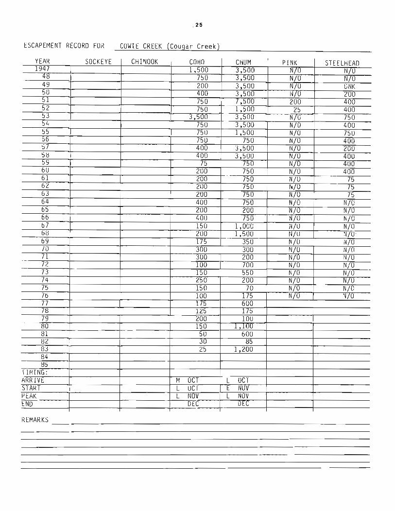
t SCAP EME NT RE C ORO FOR __ C_OW_I_E_C_R_E_E_K ...... (_Co_u--"9'-.a_r _C_r_ee_k-L) ______________ _
YEAR SOCKEYE CHINOOK COHO CHUM PINK STEELHEAD 1947 1,500 3,500 N/O N/U
48 750 3,~UO N/O N/O 49 200 3,500 N/O UNK 50 400 3,500 l~iO 200 51 750 1,500 200 400 52 750 1,500 25 400 53 3,500 3,500 N/O 750 54 750 3,500 N/O 400 55 75 [) 1,500 N/O 75U 56 75U 750 N/O 400 57 400 3,500 N/O 200 5H 400 3,500 N/O 400 59 75 150 N/O 400 6U 200 750 N/O 400 61 200 750 N/U 75 62 200 750 NLO 75 63 200 750 N/O 75 64 400 750 N/O N/O 6~ 200 200 N/O N/lJ 66 400 750 N/O N/O 67 150 1,000 N/U N/O 68 200 1,500 N/U N/O· 69 175 350 N/O N/O 70 300 300 N/O N/O 71 300 200 N/U N/O 72 100 700 N/O N/O 73 150 550 N/O N/O 74 250 200 N/O N/U 75 150 70 N/O N/O 76 100 175 N/O N/O 77 1/5 600 78 125 175 79 200 IOU 80 150 Jc'~ 81 50 600 82 30 85 83 25 1,200 84 85
T HllNG: ARRIVE M OCT L OCT START L UCT E NUV PEAK L NOV L NOV END DEC D~
RtMARKS __________________________________ __

z.,
:t 63 -+ . 1 1!:~jJj~~~~~;~~~~~~~~~~~~~~i~~m;-~J:::::~t----~--:li~ '----T-'----- Gerald Island
~ Madrona Point . ~ Dorcas Point ~ f\ Douglas "'G ~Island
~ ~~, .. , ' ~''; : 110 I '1~ 62 .--.~ LJ.-~~W~HG;:t~L~~~~=P.f.:~~~~~---~BraYY - '\~ ~~~ ~Amelia ............. . X,, " ~h'~"',' C mpSit : _: , ~
~m1~ ~k j\~ t -61-4-- --."tiJ'J-:-I
N
t 0
() ". ~ r-"
0 ()Q
3 () (t) Ii .... (1)
""' (1) (t) ~ CJ)
I\)
27
NAME OF STREAM CRAIG CREEK RAB No. 92-3825 --~~==-=~~----------------------~~~~~~~~-------------
CONSERVATION DISTRICT _____ 3~_______ STATISTICAL AREA __ ~1~4 __________________ __
LOCATION OF MOUTH Flows N. into Straits of Georgia, SEt of Parksville, Nanoose Dist.
POSITION 49 124 SEt ------------------LENGTH ___ 3 ________ kin WIDTH _____ 3 ________ m DRAINAGE __________ _
COMPOSITION: BEDROCK ________ BOULDER COARSE 22 FINE 23 -------- ------ ------SILT & SAND 49 UNCLASSIFIED pools 6
--~-----------------------------PERCENT GRADIENT 0.00 - 0.25 0.25 - 0.50 0.50 - 0.75 0.75 - 1.00
> 1.00
WETTED AREA __ 9....;..7=1=..1 ____ m2
DISCHARGE (m3/s)
TEMPERATURE (OC)
SPAWNING AREA ~4 .... 3Q4",-7 _____ m2
BARRIERS OR POINTS OF DIFFICULT ASCENT Numerous beaver dams -- passable at high water -- monitored and removed as required.
SPAWNING DISTRIBUTION
SPECIES SOCKEYE CHINOOK
High grOtmd 3-3.50 km fran mouth.
SECTION OF STREAM USED
COHO - mainly in lower reaches up to l.6km -- sane thinly scattered CHID( above Northwest Bay Rd. PINK (ODD YEAR) PINK (EVEN YEAR) STEELHEAD
Physical conditions: 1950/59 Normal water levels. 1960/69 Water levels low to acute low in summer -- normal freshets Oct/Nov.
heavy freshets December. Erosion and silting light to moderate. 1970/79 Bank erosion and silting especially in lower stream 10% stream affected.
Sane scouring and gravel movement damaging to spawning areas . (1972) 1980/83 Extensive silting in early November fran Degt. of Highways vroject --
stabilized in 1981.
General Comments: ~77------------~--~----~----------------~~~~~----------1950 A very small stream entering the salt water on a gravel beach. Heavv
accumulations of gravel at low water prevent entry of coho. 1957 Coho run to this stream becoming grogressively later. Beaver quite active
with resultant hindrance to upstream migrants. but beneficial for water · conservation at low water periods.
1960/69 A small creek with consistent coho run. Later than other runs to local creeks. 1970/71 Swamp environment downstream and good soawning gravel up to vicinity of
Hwy. 19. continued ..•..

28
continuation
CRAIG CREEK
1973 Extensive landclearing at headwaters has aggravated low flows during summer draughts.
1974 LIP grant project improved definition of creek in swamp areas. 1979 Same improvements done by French Creek Boat Owners with a SEP grant.
1981 Big Qualicum coho transplanted this year. Higbways installed a good culvert and stabilized new highway nm-off .SEP "Old Timers" improvement work at the Northwest Bay culvert. This will probably return to a first class coho producer now that the system is stable.

29
Sketch of Craig Creek, 1968
N
GEORGIA STRAIT
Hwy. No 4.
D - coho spawning grounds

30
t S CAP t MEN T RI: CO R[) FOR __ C_R_A_I G_' _C_R E_E_K---->-( f3_e_a v_e_r_C r_e_e_k L..-) ______________ _
YEAR SOCKEYE CHINOOK COHO CHUIv! PINK STEELHEAD )~47 25
48 25 49 N/O 50 7S ~1 400 52 400 53 400 54 400 55 N/O 56 200 57 25 58 400 59 400 6u 200 61 200 62 200 63 200 b4 400 65 200 66 200 67 25 68 200 69 75 70 75 71 200 72 25 73 25 74 200 75 25 76 25 77 25 78 25 79 10 SO 10 B1 N/O 82 56 83 6 84 85
T Ir1 I NG : ARRIV E NOV START E DEC PEAK DEC END L DEC
Rl: fI'lARKS ---------------------------

I ~ Z
0
~r ~ - ro· o [fl
~ i CD ;j
(Jl ~
;i; I\) 'i
a ~' : ~ \ '~" ""' 5DO~ ~ »~~ _~:~.: .. ' oj<J ~~ :?1VI · 0~ ~I ~l~ j~ 10 1 ~1 '~\\\d(tl c.l
.... ., Cll (Jl
N
t o
& I-' f-'. rn
~ ~ r5 'i

South Englishman River o . 2
I I ki lomet res

34
NAME OF STREAM ENGLISHMAN RIVER RAE No. 92-3800
CONSERVATION DISTRICT ____ ~3~ ____ __ STATISTICAL AREA ____ 1_4 ________________ _
LOCATION OF MOUTH Flows N. into Straits of Georgia, E. of Parksville, Nanoose Dist.
POSITION 49 124 SE.
LENGTH __ -,1~6,,---_______ km WIDTH __ ....;3:....;9....; • ...,:.5 _______ m DRAINAGE ____________ _
COMPOSITION: BEDROCK 8 BOULDER 69 COARSE __ 1~2 ______ FINE __ 5 ____ _
SILT & SAND UNCLASSIFIED pools 6 --------- ---~--------------------------PERCENT GRADIENT 0.00 - 0.25 0.25 - 0.50 0.50 - 0.75 0.75 - 1.00
> 1.00
WETTED AREA 637540
DISCHARGE (m3/s) Near 2arksvil1.e,. TEMPERATO~E rete}
MAX 387 Dec. 17. 1979
SP AWNING AREA ---=-10~8:::.;6~80=-_____ m2
MIN 1.16 Aug 29. 1971
BARRIERS OR POINTS OF DIFFICULT ASCENT Impassable falls at 16 krn -- series of steep rock falls and cataracts in canyon area.
SPAWNING DISTRIBUTION
SPECIES SECTION OF STREAM USED SOCKEYE - few creek sockeye in J2Qo1 below falls CHINOOK COHO - in unoer reaches Morrison c'rppk and South Fork -- UP to fall s CHUM - generally in lower end at hLehwav and on numerous ~avel bars. PINK (ODD YEAR) PINK (EVEN YEAR) STEELHEAD
POTENTIAL OF INACCESSIBLE PORTION OF STREAM From aerial observation it a~pears that suitable spawning and rearing conditions exist for eight miles above the falls. However, due to clear logging in some areas the enyi ronment may be endangered for salmon production.
GENERAL REMARKS A bad flash st~eam. Subject to excessive water fluctuation, but extensive watershed compensates Somewhat in providing prolonged spring runoff.
1952/54 Gradually improving water flow conditions are bei~ reflected in steadier production levels.
1955 First sockeye on record observed in stream this year.1956 Sockeye ran in light numbers for second year running. 1958 Considerable loss of spawn of chum due to flash floods.
1959 The drop in pink return from the brood year i s attri ruted to severe flash floods ht,ich came in Jamliu:y and Febnmry of 1958.
1961 Gravel removal is being carri ed Ollt by contractor jn lower reaches; thj s is beneficial as gravel hUld-up is considerable on sane bars.
continued •••

35 continuation
ENGLISHMAN RIVER
1966 Chtnn TIm showed improvement. Pinks returned after nil showing in 62 and 64. Seeding of all salmonids was drastically reduced by December flood levels.
1970/79 This river is under stress due to recreational use by the publiC, large scale logging activities throughout the watershed and land developments.
1978 Over subscription of water licences and under pressure from the town of Parksville wishing to obtain a further million gallons plus per day.
1981 Drilling streamside wells this year to supplement Parksville Water supply. This system will never be a good producer unless some form of flow control is instituted, such as damming above falls.
Some overcrowding -- egg digging by late TIm chtnn (77) same overlapping by chtnn and pinks.(80/83)
Most common predator black bear -- heavy on chtnn.

36
Sket ch of Englishman River. 1968
I
Highway 1/ 19-- -:-;.,L ._ ._ ._._.-.. ._ /
f Highway 114 I
I Po rt A1berni- ·- ._ ./
Georgia Strait
Rathtrevor Beach Park
1119
South Englishman River ----,
\
, Englishman River
Englishman River Falls Provincial Park
Englishman River Spawning Gravel
Generally coarse gravels & extensive areas of boulder bed in upstream areas. Best spawning gravels downstream areas to point approx. 2~ mi. above mouth. Intensive logging in watershed over period of many years has produced unstable flows with attendant scouring, erosion, flooding & drought environment in summer.

37
ESCAPEMENT RECORD FOR ENGLISHMAN RIVER --~~~~~~--------------------------------------
YEAR SOCKEYE CHINOOK COHO CHUM PINK SHELHEAO 1947 N/O N/O 1,500 35,000 N/U 3,500
48 N/O N/O 500 10,000 N/O 1,000 49 N/O N/O 1,200 7,000 N/O 800 50 N/O N/O 1,500 7,500 3,500 750 51 N/O N/O 750 7,500 75 750 52 N/O N/O 1,500 7,500 1,500 1,500 53 N/O N/O 750 15,000 200 1,500 5-zr N/O N/O 1,500 15,000 150 1,500 55 25 N/O 750 1,500 750 UNK 56 25 N/O 1,500 750 400 1,500 57 25 N/O 3,500 7,500 3,500 1,500 58 25 N/O 750 15,000 400 1,500 59 1 N/O 750 3,500 1 1,500 60 25 25 400 3,500 200 1,500 61 25 25 150 3,500 ~~ 750 62 N/O N/O 750 3,500 N/O 750 63 N/O 25 750 750 2 1,500 64 25 25 1,500 1,500 N/O UNK 65 61 75 1,500 1,500 N/O 750 66 25 25 1,500 7,500 200 UNK 67 20 75 285 500 N/O UNK 68 75 115 1,000 6,000 100 UNK 6~ 25 75 400 7,500 25 UNK 7U 25 75 1,500 3,500 75 UNK 71 25 75 1,500 3,500 25 UNK 72 25 75 400 15,000 25 UNK 7J 75 75 750 7,5UO 25 UNK 74 25 25 1,500 5,000 25 UNK 75 25 75 400 750 75 UNK 76 25 25 750 1,500 25 UNK 77 25 25 1,500 1,500 25 -78 300 75 1,500 6,000 10 -79 - - 1,200 4,000 - -
-~-- - . 80 - - 300 1,000 100 -81 - N/O 300 400 - -82 18 14 1,000 2,5~ 3 -83 UNK UNK 200 84 85
TIMING : ARRIVE E SEPT OCT OCT O~ E OCT START L SEPT OCT OCT OCT E OCT PEAK OCT OCT L NOV OCT L OCT END OCT M NOV E JAN L UCI L NOV
REMARKS ____________________________________________________________ __

N
t 0
'%j ,.... I--' ". I--'
~
H I--' ro
'<:
n ~ ~
I\)
I'\r~ ~~~::::/ :li;i 0
. .1:,
I '* '~ I '" ~ -i 2~~\. !--- -
- K \ 4< \ '":\~;\.: .
::\\t;\.
• .0 I
--\---"''4\ I
to) CD

39
NAME OF STREAM (Fillongley Creek) RAB No. 92-3100-130 CONSERVATION DISTRICT 3 STATISTICAL AREA _____ 1_4 ________________ __
LOCATION OF MOUTH flows SEe into Lambert Charmel, E. side of Denman Island ,Nanaimo. Dist. POSITION 49 124 NW. -----------------
LENGTH ____ 2_._2_5 ________ krn WIDTH _____________ m DRAINAGE ___________ _
COMPOSITION: BEDROCK BOULDER COARSE FINE --------- ----- ------ ------SILT & SAND _____ UNCLASSIFIED ______________________________ __
PERCENT GRADIENT 0.00 - 0.25 0.25 - 0.50 0.50 - 0.75 0.75 - 1.00
> 1.00
WETTED AREA _____________ m2 SPAWNING AREA m2 --------------DISCHARGE (m3/s)
TEMPERATURE (OC)
BARRIERS OR POINTS OF DIFFICULT ASCENT Log jams, beaver dams and debris passable rapids through shale section lkm upstream
1970 Winter Works Program -- stream clearance to allow fish passage.
SPAWNING DISTRIBUTION
SPECIES SECTION OF STREAM USED SOCKEYE CHINOOK COHO - throughout the system CHUM PINK (ODD YEAR) PINK (EVEN YEAR) STEELHEAD
Physical conditions: 1970 Gradient is very low throughout 80% of tbe stream and rapid section
through broken shale and boulders. 1971/72 Silting and tidal sludge in lower 1/4 mile. Upper tributaries badly
silted and mainstem through swamp silted. 1973/75 in lower section duri s . 1980 81 Light silting in upper areas -- minimal erosion and scarring -- low flows
GENERAL REMARKS in summer. 1970179 Fry salva"e carried out each Slmrner. Fry transpl anted in Chi ckadee Lake
and swamp pond on South trib utary of FilJ ongJ ey Creek 1978 Work party was engaged in extensive stream clearance. 1979 Fry sal vage conducted lIsi ng a 1 arge beaver pond. 1980 Fry survival is limi ted by ] ow Slmner f] ows.
Predation from birds and public.

BAYNES SOUND
40
N
Sketch of Fillongley Cr. 1970
DENMAN ISLAND
" , , '" , I , \ ,I( ,Swamp ,'I , , I'
I I HI' , 'I I 'I ,
J' '",' -I Fillongley
Creek r -
Road
Lambert Channel

41
ESCAPEME NT RECORD FOR _ ...... (_Fl_· 1_1_on ..... 9<-1--1ey'--C_re_e_k ....... ) _________________ _
YEAR SOCKEYE CHINOOK COHO CHUM PINK STEELHEAD 1947
48 49 50 51 52 53 54 55 56 57 58 59 60 61 62 63
, 64 65 66 67 68 NO RECORDS P IOR TO 1970 69 70 150 71 600 72 150 73 150 74 350 75 150 76 150 77 200 78 200 79 100 80 150 81 25 82 UNK 83 NOT INSPECTE~
84 85
TIMING: ARRIVE L OCT START E NOV PEAK L NOV END DEC
REMARKS ________________________________________________ __

N
t French Creek
0 2
I I kilometres

43
NAME OF STREAM __ F'REN __ Gl __ CREEK ______________ R_AB __ N_o_. _9_2_-_3_700 ____ _
CONSERVATION DISTRICT 3 STATISTICAL AREA __ ~1~4~ ________________ _
LOCATION OF MOUTH Flows NE. into Str. of Georgia W. of Parksville, Nanoose Dist.
POSITION 49 124 SEe ------------------LENGTH 15 km WIDTH 12 m DRAINAGE ---------------- ----------------COMPOSITION: BEDROCK 19 BOULDER 19 COARSE 20 FINE 20 ------ ------ ----
SILT & SAND ____ _ UNCLASSIFIED pools 22
PERCENT GRADIENT 0.00 - 0.25 0.25 - 0.50 0.50 - 0.75 0.75 - 1.00
> 1.00
WETTED AREA
DISCHARGE (m3/s)
m2 SPAWNING AREA m2 ----------- --------MAX Unknown MIN 0 Aug. 10, 1969
TEMPERATURE (OC)
BARRIERS OR POINTS OF DIFFICULT ASCENT _~I~m~p~a~s~sa~b~1~e~r~o~c~k~fa~11~s~o~n~W~e~s~t~f~or~k~l~l~km~ from mouth
Small falls at 5.50 km, small fish ladder
SPAWNING DISTRIBUTION
SPECIES SOCKE YE CHINOOK COHO - gene ra 11 y in upper CHUM - in lower reaches PINK (ODD YEAR) PINK (EVEN YEAR) STEELHEAD
s rin. W
put in in 1961;works well.
SECTION OF STREAM USED
reaches and feeder streams
1960/69 SeaSonal fluctuations in water level s. J 966 reported lIDlIS1!8ll y hi gb flows
1972173 resultine in severe bank undercutting in lower reaches. 25-30% erosion and bank undercutting, severe scouring during late Dec. and January floods.
1980 Subject to flash flooding -- extensive erosion and silting along most of stream. Lower reaches show extensive gravel movement.
1982/83 Extensive erosion and silting in the B.C.Forest Products area where clear cutting and access roads are a ~roblem.
General CO!T111ents: 1950/59 Heavy fq salvage operations during sl!JJ)J¥?r months 1954/55 Coho were able to ascend most of stream withjn 24 haIrs of enterjng
hec81lse of work card ed out by Dept techni ci an dllring SlnTUJer. 1965 Fish ladder utilized by migrating coho adults. 1960/69 Fry salvage operations.
continued ....•

44
continuation
FRENCH CREEK
1966 Severe environmental stresses occurred in December due to abnormally high flows with attendant scouring and erosion.
1968 B.C.Forest Products have Tree Farm Licence in water shed and good cooperation is received in matters affecting salmon.
1970/79 Encroachment of civilization will prevent any great populations of fish to build up. Over subscribed in water licences. Logging at the headwaters will undoubtedly effect this stream's coho run.
1980 BCFP Tree Farm clearing more acreage in upper reaches. 1982 Mini hatchery constructed this year by S.E.P. and first incubation of eggs
under sponsership of Fish and Game Club. V.I.C.Program surveyed entire water system.

45
Sketch of French Creek, 1968
N
1
Highway 114
Georgia St rait
Highway 1119 ...... -.... -....
rook's Falls Fish Ladder
~~ _._'- '-'--'- '- .-I I , I .-- ' / . - . .-- I
-- I f I \ ,Errington 1\ Road I I
I
French Creek Spawning Gravel
GenerRlly good coho spawning gravels & survival habitat (i.e. good cover) in upstream areas vicinity of Coombs. Bouldery bed with scattered fair gravels bf'L;w Brooks Falls down to vicinity of E & N Railway thence fair to good gravels down to tidewater. Surface water temperature in upstream areas during summer are usually 2 - 3 degrees cooler than downstream areas near Highway 1119.

46
ESC APEMENT RECO~D FUR FRENCH C~EEK ----~~~~---------------------------------------
YEA~ SOCKEYE CHINOOK COHO CHU~l t PINK STEELHEAlJ 1947 N/O 750 7,500 750 UNK
48 N/O 400 7,500 II N/O UNK 49 N/U 750 750 I: N/O UNK 50 25 3,500 750 N/O 200 51 N/O 7,500 750 N/O 750 52 N/U 7,500 25 N/O . 750 53 N/O 7,500 750 N/O 750 54 N/O 3,500 750 N/O 750 55 N/O 1,500 cUU N/U UNK S6 N/U 3,500 200 N/O 400 57 N/O 3,500 3,500 N/O 750 58 N/O 3,500 750 N/O 400 59 N/U 3,500 400 N/O 400 60 N/O 750 N/O N/O 400 61 NjU I~U 4UU N/U 4UU b2. N/O 750 200 N/O 400 63 NjO 750 75 N/O 400 64 N/O 3,500 200 N/O UNK 65 N/O 1,500 25 N/O 400 66 NjU 3,500 1,~UU 25 UNK 67 Nju 425 100 N/l) UNK 68 N/O 1,000 1,000 50 UNK 69 N/L) 750 1,500 N/O UNK 70 N/O 3,500 25 N/O UNK 71 N/O 3,500 25 N/O UNK 72 N/O 400 3,500 N/O UNK 73 NjO 150 400 N/O UNK 74 N/O 1,500 25 N/O UNK 75 N/O 750 25 N/O UNK 76 N/O 750 25 N/O UNK 77 3,500 25 -78 1,~50 250 79 50 200 80 1,000 50 81 N/O N/O 82 700 2 83 50 40 84 85
TI~lI NG: ARRIVE L OCT L OCT START UCI OCT PEAK NOV NOV END L DEC DEC
~EI'''A RKS --------------------------------------------------------------

99 ··---f----!
68
N
t 0
::r: =". Ol
;:t 0 3 - (")
ti (1) (i) .... (i) ..,
i'" 1::\ (::~ ~ ~ ~ ~~ \ ~ \\"ll156~a"e I ~"" R \ 1\ \ ~ \ \\:.\. .. ~ I ~ (1) CJl
I\) - . '- - .... '- '- '''''' '' '- • " I .... \ I • , I I . 1 _ ..... _ "," •
~

48
NAME OF STREAM _--.!..!HAR~T~CRE~:!::EK~ ______________ ~(W:..::a::!..:s::.:.h..:.::e:..:;r-..:::C.!;.;re:::..:e:::.!k~),--__ CONSERVATION DISTRICT _~3_____ STATISTICAL AREA __ -=1~4 _________ _
LOCATION OF MOUTH Flows NE. into Baynes Sound, N. of Union Bay, Nelson Dist.
POSITION 49 124 NW.
LENGTH ______ _ kIn WIDTH ________ m DRAINAGE _______ _
COMPOSITION: BEDROCK ____ _ BOULDER COARSE _____ _ FINE ___ _
SILT & SAND _____ _ UNCLASSIFIED ________________ _
PERCENT GRADIENT 0.00 0.25 0.25 0.50 0.50 0.75 0.75 1.00
> 1.00
WETTED AREA _______ m2
DISCHARGE (m3/s)
TEMPERATURE (DC)
BARRIERS OR POINTS OF DIFFICULT ASCENT
SPAWNING DISTRIBUTION
SPECIES SOCKEYE CHINOOK COHO - throu~hout
SPAWNING AREA ________ m2
Impassable falls approx .8km. not surveyed
SECTION OF STREAM USED
CHUM - lower reaches below highway PINK (ODD YEAR) PINK (EVEN YEAR) STEELHEAD
Ph sical conditions: Water levels extremel low to d
1980/81 Slight erosion and silting
near lood stage in fall and winter. 1970779
1983 Moderate scouring Considerable erosion and silting in lower 3.2 km.
GENERAL REMARKS 1970 First report. Washer Creek is a minor system whic h supports small numbers of . coho and chum. This system is reported to have a steelhead run every winter.
1972 Stream obstruction report filed in the fall of 1970 regarding the old
1983 This stream was decimated by past coal mining activity and water diversions. Suggest rehabilitation as there is valuable under_utilized habitat.
wood flume below highways bridge. No action taken yet.

49
ESCAPEMENT RECORD FOR HART CREEK -----------------------------------------------------YEAR SUCKEYE CHINOOK COHO CHUM PINK STEELHEAD 1947
48 49 50 51 52 ~3 54 55 . 56 57 58 59 60 61 62 63 64 6~ 66 67 68 NO RECORDS P lOR TO 1970 69 70 75 50 71 150 75 72 15 25 73 50 25 74 75 NjO 75 ~O UNK 76 30 _UNK 77 25 3 78 50 -79 50 -80 300 20
. 81 100 10 82 25 -83 N.O. N.O. 84 85
TIMING: ARRIVE M OCT L NOV START L OCT L NOV PEAK L NOV L DEC END DEC JAN
REMARKS ______________________________________________________________ __

N
t o
N

51
NAME OF STREAM __ (Ki_' t_t....;.y_C_o_le_ma_n_C_r_e_ek_) ____________________ _
CONSERVATION DISTRICT ___ 3 ________ __ STATISTICAL AREA ___ 1_4 _________________ __
LOCATION OF MOUTH Flows E. into Str. of Georgia, Comox Dist. ----------------------------~--~----------------------------
POSITION 49 125 NE.
LENGTH km WIDTH m DRAINAGE ---------------- ---------------COMPOSITION: BEDROCK BOULDER COARSE FINE ------
SILT & SAND ______ UNCLASSIFIED
PERCENT GRADIENT 0.00 - 0.25 0.25 - 0.50 0.50 - 0.75 0.75 - 1.00
> 1.00
WETTED AREA ____________ m2 SPAWNING AREA ___________ m2
DISCHARGE (m 3/s)
TEMPERATURE (OC)
BARRIERS OR POINTS OF DIFFICULT ASCENT Logs, brush and beaver dams along most of stream -- monitored and removed as required.
SPAWNING DISTRIBUTION
SPECIES SECTION OF STREAM USED SOCKEYE CHINOOK COHO - throughout CHUM PINK (ODD YEAR) PINK (EVEN YEAR) STEELHEAD
PhYSical condjtjons; Very Jow gradient for 85% of stream. Li~ht to moderate erosi on and scouring. Very low to dry during suumer months. Fi sh 11s11a II y a scem dllri ng earl y November. In the surrmer months cabo fry 51 Inri ve in beaver ponds 'lpstream.
GENERAL REMARKS 1951 Beaver jams have formed very good pools where fry are protected during dry spells.
1958 Coho fry salvage required during summer months -- numerous beaver dams in middle and upper reaches.
1981 Pacific Trollers Assn. has an incubation facility located approx 3.2 km upstream. 25,000 eyed coho eggs given to P.T.A. from Puntledge Hatchery.
1983 S.E.P.Project abandoned.

52
E SCAP EME NT RE CORD FOR _---'('-K_i t_t--"'-Y---=--Co_l_e_ma_n-----"-C_re_e_k.L) ________________ _
YEAR SOCKEYE CHINOOK COHO CHUr~ PINK STEELHEAD 1947 1,500 NjD NjD
48 750 NjD NjD 49 750 NjU NjO 50 750 NjU N/O 51 400 NjD 75 52 200 NjO 75 53 400 NjU 25 54 400 NjO 25 55 200 NjO NjO 56 200 NjO L!:J 57 200 NjO r~jO
58 200 NjO NjO 59 25 NjO 25 60 25 NjO 25 61 25 NjD l~jO 62 63 64 65 NO RECORDS F~R 1%2 - 19 9 66 67 68 69 70 200 25 NjO 71 300 l~jO NjO 72 200 NjD r~jO
73 100 NjO NjO 74 300 NjO l~jU
75 100 NjO NjO 76 75 NjO NjO 77 150 - -78 75 - -79 75 25 -80 100 - -81 75 - -82 250 - -83 100 84 85
TIMING: ARRIVE M OCT START E NOV PEAK L NOV E Nt) DEC
REMARKS ---------------------------------

~~~{ R' In+----l·?+~::::~-j----- 1-~-1---~·r· 12
0
l' ~,
7'1 rt rt t-'
lr
(1)
::::0 ~,
~ r<
N
'.:. n. ... ";]i' 1 0 F I ~in~~.,ark ~ ;
/ /
/ /
/ /
/ /
/
I~ 117]1 , ~~" KveF":::::::::::: .. / ------ --.. 0 ..... --, - ---.-" "~~"~.~~'~ ···F:':·:;;::::""-: I / t 8 I ---I ~~-1t~ ~~~OM~_: ... i ·:.oi\:J£~S81~>;::::::..1 __ ;;"'-- .
~:: I 9 .~ - ~ 206. , :1;!'!}::'>- '-- 1'--' 07 .. __ -+_---_1 \ • , Cap.e Lazo :!- '. - _. -- '-\--a: I -F~ , :,:)W
~I ~ ~'""~7 * 1~/ I 1 ~ "l '~::::"1 I 06 ·····---·+-----~ 158 .. " , _ _ 170":;" _ _ S71 J 94 .~ 195 \ ' J45 ,, - 89Gr'~·· ~/! ---T--' . '. , . /,' . I I / "\ I ' I, ,.Jill .... ~.
~ ~drcc lY\~~ . ~ -:r:;:&7 l~ I ~,~. ._- \1 1\ ~lI.W- r-. I . _____ •. ·05
r:·:·r:::::;;:;~ :·:::·· :··~1l:~· ~GoIfCourst::i;:t~' n l \ ', I: 1 r", .-~.::::.:.' ~.':;.: .. -".".:~: :::::::: .. :: ..... -::.:.:. .... .. . _. ............. . ... - - . . . . .::;. -~- --+-.-.. 04 ··
(/I to)

54
NAME OF STREAM __ L_I_TIL_E_R_I_VER ________________________ _
CONSERVATION DISTRICT 3 STATISTICAL AREA __ ~1~4 ___________ ~ __ __
LOCATION OF MOUTH Flows E. into Str. of Georgia, NW. of Kye Bay, Cornox Dist.
POSITION __ 4_9_1_2_4_NW_· _. __
LENGTH _____ 1_._6 ___ kIn WIDTH ___ 4 _____ m DRAINAGE _______ _
COARSE _____ _ BOULDER ------ FINE COMPOSITION: BEDROCK ______ _
SIL T & SAND ___ 7_5 __ UNCLASSIFIED ______________________________ _
PERCENT GRADIENT 0.00 - 0.25 0.25 0.50 0.50 - 0.75 0.75 - 1.00
> 1.00
WETTED AREA __________ _ m2 SPAWNING AREA _________ _ m2
DISCHARGE {m3/s}
TEMPERATURE (DC)
BARRIERS OR POINTS OF DIFFICULT ASCENT Numerous beaver dams, mostly in middle and upper reaches -- removed as necessary.
SPAWNING DISTRIBUTION
SPECIES SECTION OF STREAM USED SOCKEYE CHINOOK COHO - throughout to upper reaches CHUM PINK (ODD YEAR) PINK (EVEN YEAR) STEELHEAD
Physj cal condi tj ons' 1950/59 Water 1 eve] s very low fran 1111 to earl y Nov
otherwi se nonna 1 . 1960/69 Only slight erosjon and silting. 1965 reported 15%. 1968 Above normal
water levels early in fall allowed fish to reach uppermost limits of system. 1970/79 Heavy floods caused same scouring, but was beneficial in removing
accumulated silt behind beaver dams.
1980/83 Silting in lower reaches, erosion not a problem. Moderate scouring due to late December floods. 1983 Significant silting and erosion in lower reaches.
General coornents: 1950 1961
Very good spawning ground along entire stream. Water always discoloured. Too much drain on this stream during dry months. RCAF Station, farmers, householders and summer cottagers all draw water from watershed.
1969 This stream drys up every sumner due heavy irrigation and Cornox Airbase domestic usage. Upper swamp area is maintaining run.
continued ..•..

55
continuation
LITTLE RIVER
1970 Massive stream improvement work carried out by Winter Works crew. Old growth fir logs and beaver dams had caused a severe build up of silt -- now much alleviated. Parkin Logging removed fifty old logs and snags from stream bed. In future logging company will bridge the stream and not haul timber across stream bed.
1976 Beaver Meadow Farms continued to co-operate in sharing available water so that flows were maintained throughout the year. Availability of Regional District water in 1977 will alleviate critical dry periods if Beaver Meadows Farm applies and uses Comox Lake water for their operations.
1978/79 Water is available from Regional District but no application has been made by Beaver Meadows Farm. Farms installed a system of drains to adjacent ditches .resulting in faster and greater amount of run-off. Fertilizer is seeping through the soil and into the drains causing a sewer like smell downstream.
1981 Agriculture and urban development in the mid and upper reaches continue to create extreme flooding in the lower end. Water storage facilities should be incorporated into all urban development plans to alleviate this problem.
1983 Development has abated this year and a flood control survey and study is currently underway.
Predation: Bears, birds and juveniles a real problem in lower reaches.

56
I .. Z
Swamp
Sketch of Little River, 1968
Anderton Road
o - coho spawning grotmds
To Airport __ -
STRAIT OF GEORGIA

57
ESCAPEMENT RECO~D FOR LITTLE RIVER -----------------------------------------------------YEAR SOCKEYE CHINOOK COHO CHUr1 PINK STEELHEAD 1947 1,500
48 750 49 750 50 750 51 400 52 750 53 750 54 400 55 200 56 400 57 200 5~ 4UU 59 400 60 200 61 200 62 200 63 200 64 _400 65 400 66 400 67 /'J 68 150 69 75 70 j'J~
71 350 n 125 73 200 74 500 75 200 76 125 77 375 78 350 79 /'J 80 300 81 250 82 500 83 400 84 85
TIMING: ARRIVE L OCT START E NOV PEAK L NUV END DEC
RE~lARKS _ ______ _____________________________________________ _
;1':'
o 3 CD .. ..., CD (Jl
N
t o L'
1-'-rt rt ~ ro
t ~ 1-'-
g ~ ~
I\) Ii
(11
co

59
NAME OF STREAM __ LI_TIL __ E_QJ_AL_I_CUM __ R_IVER ___________ RAB __ NO_. _9_2_-_36_00 ___ _
CONSERVATION DISTRICT 3 STATISTICAL AREA ___ ~1~4 ________ __
LOCATION OF MOUTH Flows NE. and NW into Str. of Georgia, W. of Qualicum Beach,
Newcastle Dist. POS I TI ON _--=4:!:..=9:....--=.1::.:24:!.......!::S~E~. __ _ LENGTH ___ 1_1_._5 ___ km WIDTH ______ _ m DRAINAGE ______ _
COARSE ____ _ FINE ----BOULDER ____ _ COMPOSITION: BEDROCK ____ _
SILT & SAND _____ UNCLASSIFIED ________________ __
PERCENT GRADIENT 0.00 - 0.25 0.25 - 0.50 0.50 - 0.75 0.75 - 1.00
> 1.00
WETTED AREA _______ m2 SPAWNING AREA _______ m2
DISCHARGE (m3/s) MAX 154 Jan. 19, 1968 MIN 0.736 Sept. 7, 1966
TEMPERATURE (OC)
BARRIERS OR POINTS OF DIFFICULT ASCENT Series of impassable rock falls in Little Qualicum Falls Provincial Park Area -- approx 13 km from mouth.
SPAWNING DISTRIBUTION
SPECIES SECTION OF STREAM USED SOCKEYE CHINOOK - most side streams and UDDer reaches COHO - generally uDriver and in Whi sky and Kinkade Creeks CHUM - 90% below hatchery PINK (ODD YEAR) - lower reaches PINK (EVEN YEAR) - " " STEELHEAD
Physical conditions; Normal seasonal fluctlmtioDs jD water levels. 1950/59 10-15% erosion and silting in lower reacbes(1958/59)
Severe f1asb flood .Ian/Feb 1958 1960/69 Erosion and silting reports range from 15 25% 1965/66 mod severe
SCOl1ri ng and hank llnderCJ!tti ng. 1970/79 1973,75 reported severe bank undercutting and silting, otherwise normal.
1980 Some bank erosion during flood stage--extensive gravel shifting and uprooted trees and stumps causing a problem.
1981/83 Moderate to heavy silting during flood stage -- extensive gravel shifting.
General remarks: 1950/59 Subject to flash floods. 1958 reported significant loss of fry and
spawn owing to very heavy freshets. 1956 Sockeye entered stream for second time on record. First was in 1955.
continued .....

continuation 60
LITTLE <JJALICUM RIVER
1960/69 1969
1974
1975
1976
1978
1980 1982
1983
1978/83
Heavy floods resulting in heavy egg losses. This river is one of the most popular streams for fresh water angling in the area. Commercial exploitation of chum run was restricted to Johnston Strait. Extensive logging in upper Cameron River area result in severe silting in adjacent water courses. A few Big Qualicum coho strayed back to this river. Verified by adipose clip. Chum escapement estimate by SEP contract. Low of 155,000 and high of 185,000 chum spawners. Channel escapement 6,500 chum First returns of chinook from Big Qualicum transplant. Channel had 28,704 chum (5500 ferried in by helicopter) 31,000 chum in channel
Some egg digging -- overlapping by two runs of chum.

61
Sketch of Little Oualicum River, 1968
Little Qualicum Falls Provincial
Park
Highway 19 _ ._-- .....
)
/
E & N
Whiskey Creek
~ark Road_ ._1-, " ./ . / .v
/
/ Highway 4 . /
Cameron Lake ~~ P
· 1· ·/ ·..-c./ \k'\ ""LOCkWOOd ~pe ~ne ree k \ Creek
Strait of Georgia
.-..... .,
,.. -----/
I' /
\ , , ..... ·-HIghway 4

62
ESCAPEMENT RECORD FOR LITTLE QUALICUM RIVER --~~~~~~~~~---------------------------------
YEAR SOCKEYE CHINOOK . COHO CHUM PINK STEELHEAD 1947 NjO 25 3,500 75,000 NjO UNK
48 NjO NjO 3,500 35,000 NjO UNK 49 NjO NjO 3,500 35,000 25 UNK 50 NjO 200 3,500 75,000 400 UNK 51 NjO 200 3,500 75,UOO 750 3,500 52 NjO 200 7,500 35,000 400 1,500 53 NjO 750 3,500 35,000 200 3,500 54 NjO 750 3,500 35,000 400 3,500 55 25 1,500 3,500 35,000 400 UNK 56 25 1,500 3,500 35,000 400 1,500 57 25 750 3,500 35,000 1,~UU 1,500 58 200 750 3,500 35,000 750 1,500 59 25 400 1,500 35,000 25 1,500 60 25 750 3,500 35,000 75 1,500 61 25 400 3,500 35,000 75 1,500 6L N/U 400 7,500 35,000 NjU 1,500 63 NjO 750 J,~UU 35,000 75 1,500 64 UNK 750 7,500 35,000 NjO UNK 65 NjO 750 3,500 15,000 25 1,500 66 NjO 400 7,500 35,000 75 UNK 67 NjO 350 1,200 40,000 NjO UNK 68 200 425 3,500 85,000 25 UNK 69 75 400 1,500 75,000 NjO UNK 70 25 400 3,500 104,775 75 UI~K 71 25 750 3,500 35,000 NjO UNK 72 75 400 400 50,000 25 UNK 73 75 400 1,500 75,000 25 UNK 74 25 200 3,500 65,000 25 UNK 75 25 200 400 35,000 25 UNK 76 200 400 3,500 22,500 25 ur~K 77 25 75 3,500 35,000 NjO -78 45 30 5,500 75,000 - -79 100 25 2,000 40,000 - -80 100 NjO 4,000 fiO,OOO - -81 20 10 1,500 30,000 - -82 20 1,083 1,000 66,704 - -83 3,000 2,000 55,000 - -84 85
TIMING: ARRIVE SEPT SEPI SEPT E OCT SEPT START SEPT SEPT UCT OCT SEPT PEAK OCT OCT NOV NOV SEPT END OCT UCT iJeC L OEC E UCI
KENARKS ----------------------------------------------------------------

N
t 7'

64
NAME OF STREAM McNAUGHTON CREEK RAB No. 92-3410 CONSERVATION DISTRICT 3 STATISTICAL AREA __ ~1~4 __________________ _
LOCATION OF MOUTH Flows NE. into Cook Cr., Newcastle Dist.
POSITION 49 124 SW.
LENGTH ___ 2_._f ________ kIn WIDTH ___ 9 ______ m DRAINAGE ________ _
COMPOSITION: BEDROCK BOULDER 37 COARSE 29 FINE 29 ------ --------- ------SI L T & SAND ________ UNC LASSI FI ED __ J.:..poo.::..=.1::.:s::........::5~ __________________ _
PERCENT GRADIENT 0.00 - 0.25 0.25 - 0.50 0.50 - 0.75 0.75 - 1.00
> 1.00
WETTED AREA _________ m2 SPAWNING AREA _________ m2
DISCHARGE (m3/s)
TEMPERATURE (OC)
BARRIERS OR POINTS OF DIFFICULT ASCENT Numerous beaver dams and log jams in lower and middle reaches -- monitored and removed as required. Rock falls approx 3.2 km upstream.
SPAWNING DISTRIBUTION
SPECIES SECTION OF STREAM USED SOCKEYE CHINOOK COHO - throughout CHUM - matnl y below E & N Railway CrossiI}g PINK (ODD YEAR) PINK (EVEN YEAR) STEELHEAD
Physical characteristics: This stream is dry during the summer, but moderate to high flows during escapement and spawning.
1950/59 Only slight silting reported 5%. Stream changing course in middle and lower reaches (1956.58.59)
1960/69 1965/66 15% erosion and silting, very heavy scouring in mid. and lower reaches during fall floods.
1970/79 Only slight erosion and silting. 1982 Moderate to heavy erosion below private farm. 1983 Severe erosion
downstream of Ckleaux Farm.
General carments: 1958 Considerable fry salvage carried out during summer months. 1966 Chum spawning subject to heavy scouring during fall floods. 1968 This system breaks up into many small tributaries the size of small
ditches throughout a large sw~ area above and below the RR line and below the Island Highway.
continued .....

continued 64
McNAUGI-ITON CREEK
1970 Water levels dropped early and quickly this past spring before fry salvage operations commenced. Stream clearanceJmder Winter Works carried out extensive removal of log jams and forest debris providing an excellent spawning area especially in the lower swampy section. This section was heavily utilized for the first time in many years by chum salmon. This years return was only exceeded by the return of 6,500 in 1959.
1980 Considerable reduction commercial fishing time Johnson Straits. C.P.R. land clearing along tracks for a fence line. Some siltation,but min imal.Farm development in lower area is affecting this stream.
1983 Agricultural development downstream of Island Hwy. is causing some habitat degredation.
Predation: biros, bears and public.

65
Sketch of McNaughton Creek, 1968
"-
• - chum spawning grourrls D - coho spawning grounds
\. c
N
o
-
Fine gravel to Hwy. Rocky gravel to Power Line

66
ESCAPEMENT RECORD FOR McNAUGHTON CREEK ----~~~~~~------------------------------------
YEAR SOCKEYE CHINOOK COHO CHUM PINK STEELHEAD 1947
48 NO RECO DS PRIOR TO 1951 49 50 51 200 3,500 75 52 200 3,500 25 53 200 7,500 75 54 200 7,500 25 55 400 3,500 25 56 200 J ,500 75 57 400 3,500 75 58 200 3,500 75 59 200 7,500 75 60 200 3,500 75 61 200 750 25 62 75 200 25 63 £lUO 1,500 25 64 750 1,500 N/O 65 200 75 N/O 66 400 400 N7U 67 200 300 N/O 6B 100 250 N/O 69 55 150 N/O 70 650 4,500 N/O 71 600 1,100 N/O n 150 1,500 N/O 73 300 1,800 N/O 74 400 2,500 N/O 75 300 700 N/O 76 150 300 N/O 77 375 1,900 -78 250 4,000 -79 375 700 -80 250 2,600 -81 50 2,050 -82 50 600 -83 200 1,000 -84 85
TIMING: ARRIVE M OCT L OCT START L OCT E NOV PEAK L NOV L NUV
END DEC DEC
RtMAK KS ____________________________________________ ~----------------

1- ", • • :1-·· . L 16
N i "" II '>- ~,. ! ~ :yj~ , ~ :::f::: :: .. :: . .::.:: \ ' fj::"''':':: ::: '
N
t 0
~ ,..... ;Jt"1 ,.....
Al
H a (J
h i ;;5
J i ~-- -- I (1)
~
11 ~. I\J
-- ~ --- ... - --~-
I , 03 - ----+------
I
02 ----_+__
I
CL I 00 I • I I · .... , ..
Ol ....

68
NAME OF STREAM _M_I_L_LARD __ c_REEK ___ C_La_r_d_c_re_e_k_) ________ RAB __ N_o_._92_-_2_8_30 __ _
CONSERVATION DISTRICT ___ 3________ STATISTICAL AREA ____ 1_4 __________________ _
LOCATION OF MOUTH ___ F1_o~w~s~NE __ • __ i_n~t~o_C~omo~~x __ H~a=r~bo~u~r~,_C~om==o~x~Di~·=s~t~. __________________ _
POSITION 49 124 NW. ----------------LENGTH 2.5 km WIDTH 4.5 m DRAINAGE ------------- --------------- --------------COMPOSITION: BEDROCK _______ _ BOULDER 5 COARSE 30 FINE 45
--------- --------S}LT & SAND 20 UNCLASSIFIED
-------- ------------------------PERCENT GRADIENT 0.00 - 0.25 0.25 - 0.50 0.50 - 0.75 0.75 - 1.00
> 1.00
WETTED AREA ___________ m2 SPAWNING AREA ___________ m2
DISCHARGE (m 3 /s)
TEMPERATURE (OC)
BARRIERS OR POINTS OF DIFFICULT ASCENT Passable culvert at certain flows .5 km impassable falls 2.5 km (Stoat Falls) beaver dams along most of stream -- cleared during runs.
SPAWNING DISTRIBUTION
SPECIES SECTION OF STREAM USED SOCKEYE CHINOOK COHO CHur4 PINK (ODD YEAR) PINK (EVEN YEAR) STEELHEAD
Physical
1960/69 1970179
characteristics: 1950/59 Normal seasonal fluctuations in water levels. This stream is dry in upper reaches durin2 sU!lJIl€r. 1954.55 Very high water in November. 1968/69 Reported favourable early hi~ water levels. 1975 Reported moderate erosion and silting due to floods and nearby construction.
1980/83 Considerable erosion and silting during heavy rain due to urban and agricultural development.
General remarks: 1950/59 Fry salvaging carried out in summer months (53,55) 1959 The lower part of creek is a larf;!e beaver swamp lmtil dams are broken.
Good spawning gravel uncovered. 1960 Beaver dams broached as required. 1970 No stream clearance required other than removal of acclrnrnlJation minor
forest debris. This stream does not go completely dry. Probably has its source in the groundwater from Comox Lake.
continued .....
69
continuation
MILLARD CREEK (Lard Creek)
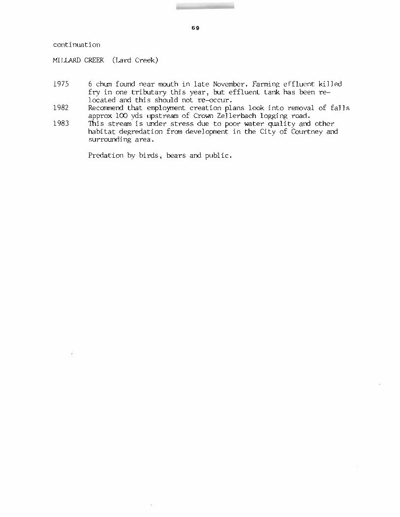
1975 6 chum found near mouth in late November. Farming effluent killed fry in one tributary this year, but effluent tank has been relocated and this should not re-occur.
1982 Recommend that employment creation plans look into removal of falls approx 100 yds upstream of Crown Zellerbach logging road.
1983 This stream is under stress due to poor water quality and other habitat degredation from development in the City of Courtney and surrounding area.
Predation by birds, bears and public.

70
N
Sketch of Millard Creek 1968
o - coho spawning grotmds

71
ESCAPEMENT RECORD FOR __ M_I......;LL~A_R_D ......;C_R..::..:EE=..:...K~( L~a......;r_d ......;C_r......;ee_k-L) _______________________ _
YEAR SOCKEYE CHINOOK COHO CHUM PINK STEELHEAD 1947 750 N/O N/O N/O
48 400 N/O N/O N/O 49 75 75 N/O N/O 50 400 75 N/O N/O 51 400 75 750 200 52 750 75 75 75 53 750 200 75 200 54 400 75 25 N/O 55 400 25 25 N/O 56 200 25 25 200 57 400 25 N/O N/O 58 400 25 25 200 59 200 N/O N/O 200 60 200 N/O N/O UNK 61 200 N/O N/O N/O 62 75 N/O N/O 25 63 200 N/O 25 25 64 400 N/l) N/O UNK 65 200 N/O N/O N/O 66 200 N/O N/O N/O 67 75 N/O N/O N/O 68 200 N/O N/O N/O 69 175 N/O N/O N/O 70 350 N/O N/O N/O 71 350 N/O N/O N/O 72 250 N/O N/O N/O 73 250 N/O N/O N/O 74 500 N/O N/O N/O 75 250 N/O N/O N/O 76 350 N/O N/O N/O 77 500 UNK UNK 78 275 UNK UNK 79 175 UNK UNK 80 300 75 10 81 100 UNK 15 82 100 N/O N/O 83 30 25 84 85
TIMING: ARRIVE L OCT START L -OCT PEAK L NOV END DEC
REMARKS ---------------------------------------------------------

N
t 0
Z
i~ Al
Ir
Ul Ii (1)
0(1) ~?' ~P.:>
I\)
H _ ~h ····« , ~=b •.• .i:,.J; ~-G ~::::·:gtillig ) \}(\: . '1'4.1: '\.. · ~~·:S. <>lQ-':'- -
I I
-1--
- - t-
G
"-.I N

73
NAME OF STREAM NILE CREEK RAB No. 92-3480 CONSERVATION DISTRICT ____ ~3 ______ ___ STATISTICAL AREA _~]~4L-________________ _
LOCATION OF MOUTH Flows NE. into Qualicum Bay, Newcastle Dist.
POSI T I ON _.....:4.;:.9....,;1::..::2=-4:........::SW.:..:....:..... __ _
LENGTH ______ 5 ______ _ km WIDTH _____ 8=--_______ m DRAINAGE ___________ _
COMPOSITION: BEDROCK _______ _ BOULDER _..:.5 ____ _ COARSE _....;;;3.,;:.5 ____ _ FINE ---'=3:.;::5 ____ _
SILT & SAND _________ UNC LASS I FI ED ____________________________ _
PERCENT GRADIENT 0.00 0.25 0.25 0.50 0.50 0.75 0.75 1.00
> 1.00
WETTED AREA _____________ m2 SPAWNING AREA ____________ m2
DISCHARGE (m3/s) _~MAX~~3~3L.~4~.r~aunL._]~5~.~1~9u7~4~~M~IN~OL.~O~6~5~Illl1~1~3~1L,~1~9~6~1-------------TEMPERATURE (OC) _______________________________________________________ ___
BARRIERS OR POINTS OF DIFFICULT ASCENT _~I~mp~a~ss~a~b~1~e~r~o~c~k~fa~1~1~s~5~.~6~km~~fr~orn~~m~ou~t~h~ __
SPAWNING DISTRIBUTION
SPECIES SECTION OF STREAM USED SOCKEYE CHINOOK COHO - in upper reaches CHUM - in lower reaches PINK (ODD YEAR) - in lower and middle reaches PINK (EVEN YEAR) - IT " STEELHEAD - in upper reaches to base of falls
1960769
1970779
1980183 Reported 40% of stream affected by erosion and silting. Some bank erosion -- extensive gravel shifting and scoured banks. Water levels low up till spawning time, then subject to flash fJooding.
General Remarks: This stream is the base of an experimental station conducted by Fisheries Research Board.
1954756 Reported poor nms of salmon. 1959 Several gillnets and one small seine worked just outside the Nile Creek
boundary when the fish were arriving. 1964 Observations of steelhead too limited to estimate size of stock.
continued .....

74
continuation
NILE CREEK
1967 1972/73
1977
1981
1982
High flows in December damaged chum and coho spawn. A small creek with good quality potable water which is used by domestic consumers served by Horne Lake Waterworks District. The relatively small salmon runs are a normal feature of this stream. A large scale residential sub-division is now situated adjacent to the East bank of Nile Creek above Hwy. 19.Water from the creek serves the Horne Lake Waterworks District which is a consumer coop supplying the Big Qualicum project and adjacent populated area with domestic water supplies. Second growth timber is scheduled for harvesting in the near future. (MacMillan Rloedel). Commercial net fishery openings on the Big Qualicum may affect salmon stocks native to Nile Creek. Some bank shoring done by Water Board, more proposed by new residents next year. Some bank rip-rap to repair extensive erosion at lower end of creek. This is a first year return from Big Qualicum coho transplant.

75
N
Sketch of Nile Creek, 1968
Power Transmission Line
GEORGIA STRAIT
Mountainous Area
o - coho spawning area 4. - chum spawning area
Spawning gravels: Extensive bouldery areas especially upstream. Best grade gravel from E & N Railway trestle downstream to mouth.

76
ESCAPErvlENT RECORlJ FOR _....:...N:...:,.I.::..;LE:........::.C;.:,,:RE::...:E:..:.,:K ____________________ _
YEAR SOCKEYE CHINOOK COHO CHUM PINK STEELHEALJ 1947 NjO 463 1,009 NjO NjO
48 NjO 200 400 NjO NjO 49 NjO 200 750 25 NjO 50 NjO 200 400 200 NjO 51 NjO 400 200 200 NjO 52 25 750 1,500 200 NjO 53 NjO 750 25 75 NjO 54 NjO 400 200 200 UNK 55 NjO 400 400 400 NjO 56 NjO 200 200 200 200 57 NjO 200 200 1,500 UNK 58 NjO 200 75 25 200 59 NjO 75 200 NjO 200 60 NjO 200 200 NjO 200 61 NjO 75 75 NjO 75 62 NjO 200 75 NjO 75 63 NjO 200 75 NjO 75 64 NjO 400 200 NjO UNK 65 NjO 200 75 NjO 75 66 NjO 200 75 75 UNK 67 NjO 50 50 NjO UNK 68 NjO 100 400 NjO UNK 69 NjO 75 200 NjO UNK 70 NjO 75 25 NjO UNK 71 NjO 200 25 NjO UNK 72 NjO 25 400 _NjO UNK 73 NjO 25 75 NjO LINK 74 NjO 200 25 NjO LINK 7S NjO 25 25 NjO UNK 76 NjO 25 25 NjO LINK 77 25 25 - -78 20 25 - -79 10 25 - -80 30 - -81 25 50 - -82 100 30 - -83 20 50 - -84 85
TIMING: ARRIVE OCT OCT OCT START OCT OCT PEAK E NOV NOV END L DEC NOV
REMARKS~~-~----~~~----_.AnJ---_r~------~~~~~--Timing of Migration: Period 10% 50% 90% of Total
Adult Coho 1945 - 53 Oct. 15 Nov. 1 Nov. 16

77
.!:-1/v" t.fidenatch I.JJ ,U I o/P'''''ITLE:NATCH "Iv", DIS . AOVINelAL
v ''''/1 J Dls~er
/lIef" - -
Jfj(uh",,"an Pt.
~,1111il,li.nns Beach
N
t Oyster River
0 10
I I ki lomet res
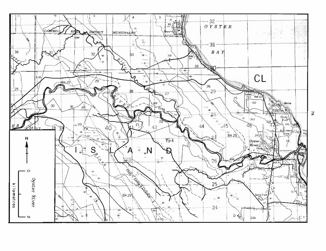
~/ k I 0 ~2S T k R
J i .;!L \ -- " 1 \ I ~'-.,.;, I 31 '1 - - --t-, - -\::-- \ ,. ~.~"
BA
CL
N
t o
~ " I (Jl
o t W 3 (1) ~ .... <:
~ ~ ~····4 ~Jt ~~-t \>~ :k\-~_ \ ~ ~' .. ' -- -' - 24· - : - __ - _ >1L - -7-'- ~: \* ~ - --. 1 1
I\) 10, I - --~ $ \ ~- ->~_ \, \, * (,\, ~\ 1 V "0<1\ 1 h'JA 1 .J' 1 ./ _ I r. r, )j
..., CD

79
NAME OF STREAM ____ O_Y_S_TER __ R_I_VER _______________________ _
CONSERVATION DISTRICT __ .....:3~ ________ _ STATISTICAL AREA __ ~1~4~ ________________ _
LOCATION OF MOUTH Flows E. into Str. of Georgia, S. of Kuhushan Pt., Comox Dist.
POS IT ION _--'-4..:....9.....:l:..::2:..::5---=:..:.NE=...;.,.. __ _
LENGTH _____ 20~ _________ km WIDTH ____ ~30~ _________ m DRAINAGE
COMPOSITION: BEDROCK __ .....:3~6~ __ _ BOULDER 36 COARSE 12 FINE 9 ---'-~----- -~------ --------
UNCLASSIFIED ---------------------------------SILT & SAND ________ _
PERCENT GRADIENT 0.00 - 0.25 0.25 - 0.50 0.50 - 0.75 0.75 - 1.00
> 1.00
WETTED AREA ______________ m2 SPAWNING AREA ______________ m2
DISCHARGE (m3 /s)
TEMPERATURE (OC)
MAX 2.31 May 18, 1972 MIN 0 Sept. 23, 1966
BARRIERS OR POINTS OF DIFFICULT ASCENT Impassable cascade and cataract type falls 20 km from mouth
SPAWNING DISTRIBUTION
SPECIES SOCKEYE CHINOOK COHO - in upper reaches CHUM - in lower reaches PINK (ODD YEAR) - in lower reaches PINK (EVEN YEAR) STEELHEAD
Physical
1960/68
SECTION OF STREAM USED
and tributaries of main stem of main stem
ana have resulted in heavy ana lower reaches.
Heavy
1980/83 This river s stem is ve unstable -- sub'ect to ma 'or erosion and silting throughout. Major scouring in lower reaches -- moderate in upper waters e and tributaries.
General Remarks: 1950/59 Bi ster had fairl surrrner dry s
Oyster was dry from August to November Fry Salvage 1960/63 Very high percentage of jacks.
continued .....

continuation 80
OYSTER RIVER
1969 Logging on upper reaches, well above known salmon spawning grounds results in flushes of silt during heavy rainfall run-off over new road construction.
1970 The coho transplant from the Little Oyster tributary to Woodhouse tributary was proved successful this year as the first returns endeavoured to enter Woodhouse Creek with an estimated 400 to 500 observed in the entrance to the creek. The rock falls require modification as there are a number of miles of excellent gravel in the main stem Oyster River above the falls.
1971/76 Logging on both main tributaries has resulted in serious silting and acceleration of run-off. Considerable chum and pink spawning(90%) lost due to floods. Bank stabilization and channelization for flood control on Lower Oyster River completed by Water Rights Branch. Large buried boulders and spurs from rip-rap banks were built into the works to enhance salmon habitat.
1977 Flash run off from logging claims has resulted in serious silting and accelerated flows rendering spawning grounds very unstable.
1980/83 A very volatile water shed mainly due to logging and unstable soils in upper areas. December flood caused extreme gravel displacement, scouring and silting throughout.All spawn from Island Hwy.bridge to mouth lost. (100% of chum 25% of pinks) This river is rapidly losing the remnant stocks of salmonids.

Sketch of Oyster River. 1968
Strait of Georgia
..,.-_.-' _.
Lit tIe
/
York Road
, Iron ,River , Road \ , I
, \ \ \
\ \ \ \ \ , ,
---
Caribou Creek
81
Gravel
Little Oyster River Spawning Gravel
There is good gravel throughout. however, several sections have been heavily silted.
/
/
,. /
/
//Duncan Bay Main Road
z .....

82
ESCAPEMENT RECORD FOR OYSTER RIVER ----------------------------------------------------YEAR SOCKEYE CHINOOK COHO CHUM PINK STEELHEAD 1947 25 7,500 7,500 7,500 UNK
48 NjO 3,500 1,500 75,000 UNK 49 25 3,500 3,500 15,000 UNK 50 75 3,500 3,500 100,000+ 1,500 51 25 7,500 3,500 3,500 1,500 52 25 35,000 7,500 100,000+ 750 53 200 15,000 7,500 15,000 1,500 54 25 15,000 15,000 100,000+ 1,500 55 NjO 15,000 3,500 3,500 1,500 56 25 7,500 750 35,000 750 57 25 7,500 3,500 3,500 750 58 NjO 15,000 7,500 75,000 1,500 59 25 15,000 750 1,500 750 60 NjO 7,500 400 3,500 750 61 NjO 7,500 400 1,500 750 62 NjO 7,500 1,500 750 750 63 25 7,500 750 3,500 750 64 NjO 15,000 400 200 UNK 65 UNK 15,000 75 750 LINK 66 UNK 15,000 200 3,500 NjO 67 NjO 4,000 50 1,200 NjO 68 NjO 5,500 800 2,150 NjO 69 NjO 3,000 250 200 NjO 70 NjO 6,000 200 1,600 NjO 71 N/O 8,000 100 1,400 NjO 72 NjO 3,500 850 1,100 NjO 73 NjO 3,500 ~50 1~0 NjO 74 NjO 5,000 500 850 NjO 75 NjO 3,500 450 900 NjO 76 NjO 1,500 450 800 NjO 77 3,700 75 200 -78 3,200 1,300 400 -79 2,500 125 400 -80 3,000 175 5,000 -81 500 75 100 -82 1,200 80 150 -83 500 N.O. 150 -84 85
TIMING: ARRIVE E OCT M AUG M OCT START E OCT E SEPT L OCT PEAK L NOV L SEPT M NOV END JAN OCT DEC
f(EMARKS ___________________________________________________ _

N
t 0
§ 7' It ...... 0 ~ 3 ~ CD ....
~ ~
CD en ~
'1
0

~z
0
§ ("t
if t--' (1) 0-
()Q (1)
~ ~ Ii
I\)
~~~s~~ s~ o/. ,1W./n~ # " jC;) ,.,co·,.. j - .' Cd~ J->; ~ . • ~at l S ' • , )\ , .. . ' . . : ,
CD
"'"

85
NAME OF STREAM PUNTLEDGE RIVER RAE No. 92-2800
CONSERVATION DISTRICT ___ ~3 ______ _ STATISTICAL AREA ~1~4 _______________ _
LOCATION OF MOUTH Flows NE. into Courtney River, Comox Dist.
POSITION _....:..4~9---=l:..:2:....:4........:...:.NW:..:....:..... __ _ LENGTH ____ ~1~4~ _______ km WIDTH ____ ~5~9 _________ m DRAINAGE ______________ _
COMPOSITION: BEDROCK 38 BOULDER __ .::.2.:,.3 ___ COARSE __ 8 __ _ FINE __ 5 __ _
SILT & SAND ____ _ UNCLASSIFIED __ £po~o~ls~2~6~ ____________ ___
PERCENT GRADIENT 0.00 0.25 0.25 0.50 0.50 0.75 0.75 1.00
> 1.00
WETTED AREA 841618*
DISCHARGE (m3/s) MAX 334 Nov.5, 1975 At Courtenay
SP AWNI NG AREA _1=.0:....9_5_1_6_*___ m2
MIN 5.49 Sept. 3, 1955
TEMPERATURE (Oc)
BARRIERS OR POINTS OF DIFFICULT ASCENT Passable with controlled flows and fishways two B.C.Hydro dams 10km arid lSkm upstream -- Stotan arid Nib Falls 6 and 8km under observation and continuin~ modification by Dept (79)
1980 Recommend additional ladders.
SPAWNING DISTRIBUTION
SPECIES SOCKEYE
SECTION OF STREAM USED
CHINOOK - upstream to diversion dam COHO - 1.1 " CHUM - lower 3.5 km am above hatchery where gravel ava~lable. PINK (ODD YEAR) - lower :3 km below power house PINK (EVEN YEAR) " " I -STEELHEAD
* Wetted area and s awnin area includes that ortion of stream above diversion ctam (11-14km and is not utilized at the present time. The wetted area and spawning area are approx 229567 s9 meters and 75753 sq meters respectively above the diversion dam The Puntledge River is the site of a hydro power project datin~ to 1913. A further development scheme initiated in 1953 increased the hazards of salmon production.
continued .....

86
continuation
PUNTLEIX;E RIVER
A spawning channel was constructed in 1965 as part of the program to protect the fishing resource. In 1972 rearing ponds at the spawning channel were completed and a small temporary hatchery was set up in the old B.C.Hydro Powerhouse building for the production of early and fall run chinook.
Physical conditions:
1950/59 1960/69 1967 1970179 1980
General 1977
1979
1980
1981 1982 1983
Usual seasonal fluctuations in water levels. 10/15% erosion, very heavy scouring of major spawning area. No gravel left upstream of power house -- previous chum spawning grounds. 1971/76 Controlled flows during critical period -- slight to mOderate scouring. 1982/83 Silt load carried into Punt 1 edge from Browns River.High water during heavy fall and winter rains.
corrrnents: A fish ladder was constructed on Nib Falls this past summer and should prevent injuries to early run of pinks. Construction work at channel may have been the cause of the heavy run of pinks -- possibly diverted from the Tsol8m by the continuous flow of silt. Rip-Rap installed by Indian Affairs approx. 1 km downstream from the Condensory Bridge. The Tsolum River has broken through just below the rip-rap spilling onto a chum spawning area on the Puntledge. Considerable reduction commercial fishing time in Johnson Straits.
Approx 12,000 coho jacks in system " 12,058" " ""
69 summer chinook, 54 fall chinook
12,380" " "" Chum over spawning in lower river area.

Sketch of Punt ledge River, 1968
Headquarters .,,/ Road
\ \
\
\Island Highway \
\
\
\ \
.,-"
,/ -"
//1 / I
// I ." I
Plateau
\
Browns River
87
Cornox
Bay
/'
/Island Highway
" "
Creek
puntled:X C . " ornox
Spawning "" Channel, ",
Lake
Rearing Ponds ........ , .... & Rearing Channel I
I
I I I. I I I I I
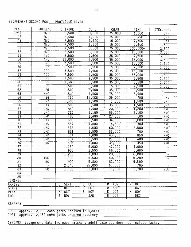
88
ESCAPEMENT RECORD FUR PUNTLEDGE RIVER --~~~~~~--------------------------------------
YEAR SOCKEYE CHINOOK COHU CHUM PINK STEELHEAD 1947 NjO 3,500 3,500 75,000 1,500 UNK
48 NjO 3,500 1,500 35,000 750 UNK 49 NjU 7,500 3,500 15,000 7,500 UNK 50 NjO 7,500 1,500 15,000 7,500 1,500 51 NjO 7,500 3,500 75,000 100,000+ 3,500 52 NjO 3,500 3,500 15,000 15,000 3,500 53 NjO 3,500 7,500 35,000 /,50U 3,500 54 NjO 15,000 7,500 35,000 15,000 3,500 55 25 7,500 3,500 35,000 15,000 1,500 56 25 1,500 3,500 15,000 7,500 1,500 57 200 3,500 7,500 35,000 15,000 1,500 58 400 7,500 7,500 35,000 35,000 1,500 59 25 3,500 1,5UO 35,000 3,500 1,500 60 25 3,500 3,500 35,000 3,500 1,500 61 25 1,500 3,500 15,000 7,500 1,500 62 25 1,500 3,500 35,000 3,500 1,500 63 NjO 1,500 7,500 75,000 7,500 1,500 64 25 750 15,000 35,00U 750 UNK 65 UNK 1,500 1,500 1,500 1,500 UNK 66 UNK 1,500 3,500 35,000 1,500 UNK 67 UNK 840 1,500 20,000 1,200 NjO 68 UNK 720 1,100 55,000 2,100 NjO 69 UNK 486 1,400 27,500 100 NjO 70 UNK 685 2,500 34,000 1,000 N/O 71 UNK 557 4,000 14,50U 300 NjO 72 UNK 635 1,500 60,000 2,500 NjO 73 UNK 821 1,500 55,000 700 NjO 74 UNK 564 7,000 45,000 850 NjO 75 UNK 754 2,500 27,500 400 NjO 76 UNK 605 1,000 35,000 350 NjO 77 - 1,150 5,UUU 47,000 4,000 -78 900 2,500 68,000 1,600 -79 1,200 7,000 20,000 8,000 -80 150 1,300 5,500 60,000 6,200 -81 50 900 5,800 82,000 5,500 -82 - 2,340 25,000 65,000 700 -83 50 1,500 31,000 75,000 1,700 200 84 85
TIMING: ARRIVE L SEPT E OCT M AUG M OCT START E oCr E OCT M SEPT L OCT PEAK M OCT E NUV E OCT M NOV END E NOV JAN M OCT DEC
REMARKS ____________________________________________________________ __
1980 Approx. 12,000 coho jacks arrived in system 1981 Approx. 12,058 coho jacks entered hatchery
1980j83 Escapement data includes hatchery adult take but does not include jacks.

\ \
----\ \
:\ I
I
o ~Sanp'.r I
4> G
L
~ Ballenas
~
CD ID
N
t 0
f
H I-' 1-'-
§ ~ < (l) Ii
0

N
f 0
;11:"1 f ~
H .....
5 ~ ~ ti
I\)
~~:------1 ------
~\ \\\ ~ Q
302';>
.:
'!' CD o

91
NAME OF STREAM QJALICUM RIVER (Big Qualicum River) RAB No. 92-3500
CONSERVATION DISTRICT ____ ~3 ______ __ STATISTICAL AREA ____ 1_4 __________________ __
LO CA TI ON 0 F MO UTH ____ F_l_o_w_s __ NE __ • __ i n __ to __ S_t_r __ . _o_f __ Ge __ o_r .... g.:....i_a..,.<.·, __ S_. __ o_f_Qua->--_l_. ~_. c_um ___ Ba---",Y-",---N_e_wc_a_s-,-t_le_
Dist. POSITION 49 124 SW.
LENGTH 10 km WIDTH 23 m DRAINAGE
BOULDER 27 COARSE 23 FINE 23 COMPOSITION: BEDROCK ________ _ ------ --------- -----SILT & SAND UNCLASSIFIED pools
--~-----------------------------
PEkCENT GRADIENT 0.00 - 0.25 0.25 - 0.50 0.50 - 0.75 0.75 - 1.00
> 1.00
WETTED AREA 25506 m2 --~----------
SPAWN I NG AREA --'1 ___ 1 ___ 7;::,.29"-0:.....-___ m 2
DISCHARGE (m3/s) Near Bowser TEMPERATURE (OC)
MAX 90.6E Jan 15, 1961 MIN 0.388 Aug 28, 1961
BARRIERS OR POINTS OF DIFFICULT ASCENT Impassable series of falls and Big Qualicum Water Works at 9.6km.
SPAWNING DISTRIBUTION
SPECIES SECTION OF STREAM USED SOCKEYE CHINOOK mainly above Hunts Cr. 5km preferring upper reaches COHO throughout - also Hunts Creek CHUM mainly mouth to mid reaches - scattered in UDper reaches PINK (ODD YEAR) PINK (EVEN YEAR) STEELHEAD
POTENTIAL OF INACCESSIBLE PORTION OF STREAM ____________________________________ _
Horne Lake (7.68 km) appears to have potential for rearing coho and sockeye.
GENERAL REMARKS The Oualicum River is being developed by the Federal Govt. to increase the production of the indigenous stock of chum. coho am chinook salmon. The development project was directed initially to control the stream discharge and temperature. Artificial spawni~ channels. rearing ponds. rearing channels and a hatchery are an integral part of the scheme. Further development bas resulted in improvements of the spawning grounds. .
1959 Counting fence established in Fish Culture Branch in lower reaches and an accurate cOunt of salmon passin~ this fence was obtained.
1961 Special project to give continuous controlled flow of water is proceedjng and scheduled for completion by next fall.
contirrued ..

92 continuation
QJALICUM RIVER (Big Qualicum River)
1962 Project to control water flows and temperature is continuing with Hunt Creek tributary water now under control.
1962/67 Controlled flows and fence counts. 1967 Facilities were expanded by a building project in 1967 season. Facilities
involved additional spawning channel area for chum and chinook rearing ponds.
1972 For the first time in many years Big Qualicum chum were exposed to a commercial net fishery just off the river estuary.
1979 Falmurden Developments this year logged extensively on both sides of the river. Silting in the main river was the result of the minor feeder streams being disturbed by lack of cover.
1980 25,000 chum in new channel. 1981 Coho and chinook allowed natural spawning in upper river; chum utilizing
new channel and lower river. 1983 Indian Food Fishery Chinook - 8 jacks
Coho -8,709 adults, 12,166 jacks Chum -20,804
25,000 chum in channel
Timing of Migration Period 10% 50% 90% of Total
Juvenile chinook 1960-67 Mar. 5 Mar.5-Apl. 26 May 17 (E. Grp.) Juvenile chinook 1960-67 May 4 May 29-Jun. 10 Jun. 29 (L. Grp.) Juvenile coho 1960-67 Mar. 20 May 3-May 21 Jun. 21 Juvenile chum 1960-67 Apl.10 Apl. 29-May 19 May 30

N , J
i I
"UN'. C.!(_ 0IV!.'110N DIK! ... 0 Cc*'.OL
...•. , ... 4.r
... ~~~ i"~' 'f" III &
.,.-"", . ./ ... ;".
" :~~~ ~ ~ ~ :~.~;", , ~,' I.: ..
It .£... t-" ' I -.. : .....
AII'"'tLL Clillllilil lIMO
.SITE. _PLAN .. • .. 0 1,..,1 ....
I!:!± 2!!!!l '."r.JII" ...... ,
0"0 •• '.UCTu.1
'PtIrNI ,All, i L~ _ _ . j )::::,.,
( J \ ,,/ « ~~~ .. ~
" e:~ ., .\.- ,
4> . ",,) ...
VANCOUVER ~ .. ~. ... ~-- < ,~ 1',-,:::. ' .
- \. . ' ) )). \}. "-
ISLAND
KEY r-L..-''1 to 'J, .) 10.11 -."' .... ~~ -.',
, v --'. '. ..... , '\-
-,....j < ~(> -" 0 r ) ~ J .".".,
O · ,/
~' ~ ... \ \ , \
,nero.,,, /)
DEPARTMENT OF FISHERIES. CANADA
BIG QUALICUM RIVER DEVELOPMENT PROJECT
eo Col
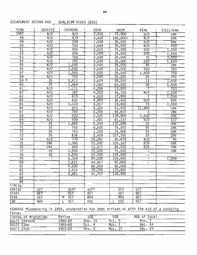
94
ESCAPEME~T RECORD FOR ~~Q~U~AL~I~C~UM~R~IV~E~R~(B~I~G~)~~~~~~~~~~~~~~~~~
YEAR SOCKEYE 1947 NjO
48 NjO 49 NjO 50 NjO 51 NjO 52 NjO 53 NjO 54 NjO 55 NjO 56 NjO 57 NjO 58 N/U 59 * 25 60 25 61 NjO 62 NjO 63 NjO 64 N/O 65 NjO 66 NjO 67 N/O 68 NjO 69 NjO 70 25 71 25 72 25 73 25 74 NjO 75 UNK 76 UNK 77 25 78 25 79 -80 81 82 83 84 85
TIMING: ARRIVE OCT S1ART OCT PEAK OCT END NOV
REMARKS *Commencing in fence: Timing of Migration: Adult Chi nook Adult Coho Adult Chum
CHINOOK COHO CHUM PINK STEELHEAD NjO 3,500 75,000 N70 UNK NjO 3,500 100,000+ NjO UNK 200 1,500 35,000 NjO UNK 750 3,500 35,000 NjO 400 400 3,500 75,000 400 1,500 200 3,~uu 35,000 200 1,500 750 3,500 35,000 75 3,!JUU 750 3,500 35,000 200 1,500
1,500 3,500 ]5,000 25 UNK 1,500 3,500 15,000 200 750 1,500 3,500 35,000 1,500 750
750 3,500 35,000 25 150 2,411 3,624 98,500 11 1,500 1,569 2,562 60,000 25 1,500 1,111 2,286 13,8W 1 750
787 4,223 46,700 NjO 1,500 619 4,500 37,900 1 1,500 602 4,859 36,400 N/O UNK
1,118 3,817 18,800 75 1,500 870 4,324 53,400 11,900 UNK 764 1,346 46,600 4 J.LNK 830 2,325 139,900 2,500 UNK 939 1,821 81,337 NjO 137
1,660 5,293 132,000 25 UNK 750 8,500 75,000 25 UNK 750 1,500 75,000 25 UNK 636 2,428 157,755 25 UNK 770 18,281 80,620 NjO 45
1,300 23,592 109,383 NjO UNK 949 13,477 92,1J1JU 1f7U UNK
3,500 75,000 75,000 - UNK 4,600 22,000 124,000 - -8,309 54,525 120,000 - 1,000 7,521 44,957 87,000 - -4,600 86,000 82,000 3,415 39,156 133,482 2,861 21,757 130,-405
SEPT SEPT OCT OCT OCT 1)C1 OCT OC1
M OCT NOV r'IDV OCT -
L OCT DEC L DEC OCT
1959, enumeration has been arrived at with the aid of a counting
Period 10% 50% 90% of Tota 1 1960-68 Sep. 10 Oct. 9 Nov. 7 1959-68 Oct. 4 Nov. 1 Dec. 14 1959-68 Nov. 8 Nov. 27 Dec. 23

Z4
R
osewall C
reek o I
kilo
me
tres
95
2 I

96
NAME OF STREAM __ RO_S_EW_AL_L_CREEK ______________ RAB __ N_o_. _9_2_-_3_4_00 ____ _
CONSERVATION DISTRICT ____ 3____ STATISTICAL AREA ___ 14 _________ _
LOCATION OF MOUTH ___ F_l_o_w_s __ NE __ . __ in_t_o __ Mud ____ Ba~y~,_W __ ._o_f __ De __ e~p __ Ba~y~,_N_e_w_c_a_s_t_l_e_Di __ ·s_t_. ____ ___
POSITION 49 124 SW.
LENGTH ___ 4 _____ km WIDTH __ =-14...;,..,:....:. 5;....;0~ ___ m DRAINAGE _______ ___
COMPOSITION: BEDROCK ------ BOULDER 31 ----- COARSE --.:2:..:.7_______ FI NE _2=-7~ __
SILT & SAND ______ UNCLASSIFIED __ ~po~o_1_s __ 1_5 ____________________ __
PERCENT GRADIENT 0.00 - 0.25 0.25 - 0.50 0.50 - 0.75 0.75 - 1.00
> 1.00
WETTED AREA m2 -------------- SPAWNING AREA ______________ m2
DISCHARGE (m3/s)
TEMPERATURE (OC)
BARRIERS OR POINTS OF DIFFICULT ASCENT Impassable falls at 3.8km 21 m drop over 92 m
SPAWNING DISTRIBUTION -I( BEFORE FENCE INSTALLATION SPECIES SECTION OF STREAM USED SOCKEYE CHINOOK COHO - throughout CHurl! - YOlo below highway bridge PINK (ODD YEAR) PINK (EVEN YEAR) STEELHEAD
1960/69
1981
General 1961
1966 1968
levels -- erosion and silting
1980 Fairly extensive scouring and change of stream course oelow hatchery. Major erosion in vicinity of hatchery site.
Remarks: This stream has adequate gravel to sUQQort a much larger salmon population, but requires flood control. Chum spawning subject to heavy scouring during fall floods. Fisheries Research Board experimental hatchery facilities in operation by late fallon site near mouth of stream. Salmon eggs utilized from ___ _ a wide variety of coastal streams.
continued .....

continuation
97
ROSEWALL CREEK
1970 Stream clearance work. Crews had only minor work to do. Many logs left in the stream to decelerate flows during peak run-off periods.
1980 Hatchery personnel report approx 1/2 of the spawners below the hatchery were marked hatchery fish.
1981 Escapement totals include return to experimental hatchery. Natural distribution is prohibited by hatchery fence.
1983 Spawning distribution is controlled by the electric barrier fence. A few coho were hand lifted over the fence by F.R.B.Personnel.
*DISTRIBUTION AFTER FENCE INSTALLED 1974 Coho and chum mainly below F.R.B.electric fence 1977 100 wild stock coho were passed above fence -majority of coho and
chum below fence. 1981 Fence prohibits uncontrolled migration.
Predation: Birds, bears and otters.

Sketch of Rosewa11 Creek, 1968
o - coho spawning grounds • - chum spawning gro~s
Fann Road
Gravel and \ Boulders
Rock Rapids-4-
\
\
98
Power Line
Railway
BAYNES SOUND
N

99
~SCAPEMENT RECORD FOR ROSEWALL CREEK --~~~~~---------------------------------------
YEAR SOCKEYE CHINOOK COHO CHUM PINK STEELHEAD 1947 750 15,000 NjO
48 750 7,500 NjO 49 75 750 UNK 50 400 1,500 200 51 400 7,500 75 52 750 3,500 200 53 400 3,500 200 54 400 3,500 ~UU
55 200 3,500 75 56 200 1,500 200 57 200 3,500 I';)
58 200 1,500 200 59 200 3,500 200 60 200 3,500 200 61 200 750 75 62 200 750 200 63 200 400 200 64 200 750 UNK 65 75 200 NjO 66 200 1,500 NjO 67 150 2,500 NjO 68 400 6,000 N70 69 160 1,400 NjO 70 450 2,000 NjO 71 500 600 NjO 72 150 3,000 NjO 73 250 2,650 NlU 74 300 800 NjO 75 150 325 NjO 76 75 125 NjO 77 475 600 -78 - -79 500 600 -80 1,000 5,000 -81 250 1 , !j00 -82 70 630 -83 300 2,000 84 85
TII"1ING: ARRIVE M UCI M OCT START L OCT L UCI PEAK L NOV L NOV END DEC DEC
R Et·1AR KS --------------------------------------------------------------


101
NAME OF STREAM _R_a_~_CREEK ___ (R_o_y_s_t_on_C_r_e_e_k_) ___________ RAB __ N_o_,_9_2_-2_8_80_
CONSERVATION DISTRICT __ ~3~ ______ __ STATISTICAL AREA __ ~1~4~ ________________ _
LOCATION OF MOUTH ___ F_l_o_w_s __ NE __ ,_~_'n_t_o~C~omo~~x_H~r~,~N~e~l~s~on~~D~i~st~, ______________________ _
POSITION 49 124 NW ,
LENGTH ____________ kIn WroTH ___________ _ m DRAINAGE ____________ _
COMPOSITION: BEDROCK BOULDER _______ _ COARSE _________ FI NE _____ _
SILT & SAND ________ UNC LASS IF IED ______________________________ _
PERCENT GRADIENT 0.00 - 0.25 0.25 - 0.50 0.50 - 0.75 0.75 - 1.00
> 1.00
WETTED AREA _____________ m2 SP AWNING AREA ___________ m2
DISCHARGE (m3/s)
TEMPERATURE (OC)
BARRIERS OR POINTS OF DIFFICULT ASCENT ---77--~~~~~--~--~--------------Culvert at E & N Railway relieved by baffle installation . Skm from stream mouth
SPAWNING DISTRIBUTION
SPECIES SOCKEYE CHINOOK
SECTION OF STREAM USED
COHO - throughout. above the Island f...lWv. CHUM PINK (ODD YEAR) PINK (EVEN YEAR) STEELHEAD
POTENTIAL OF INACCESSIBLE PORTION OF STREAM _________________________________ __
GENERAL REMARKS ~~-~---------~~------------------__ 1983 Erosjon and slight silting resulting from upstream agricultural activity,
Sljght scourjng at SEP sjte. Water levels low jn sImmer hjgh during fall and winter.
Predatj aD' Bj rrls and humans

102
ESC APEt<IE rH R E C ORO FOR _....;,.R...:.O_Y --..:C:...;,.;R-=.E =.,:.E K..:.........l.(....;,.R o~y...:.s--=-t o:.....;n----=-C.;....re:.....;e:...;,.;k..L) _______________ _
YEAR SOCKEYE CHINOOK COHO CHUM PINK STEELHEAO 1947
48 49 50 51 52 53 54 55 56 57 58 59 60 61 62 63 64 65 66 67 68 69 70 71 72 73 74 75 76 77 78 79 80 81 82 83 50 84 85
TIMING: ARRIVE Oct 15 START Oct. 31 PTi'I.K Nov. 10 ENO Dec. 1
REMARKS ------------------------------------

STORRIE CREEK (Storrie Creek)
exact location tmknown, but close to Woods Creek P.l30

103
NAME OF STREAM STORIE CREEK (Storrie Creek) RAB No. 92-1300-080 -------------------------------------------------------------
CONSERVATION DISTRICT ____ ~3 ______ __ STATISTICAL AREA ------------------------14 LOCATION OF MOUTH ___ F_1_o_w_s __ E_._~_·n_t_o __ S_t_r_. __ o_f_Ge __ o_r~g~i_a~, __ C_omo __ ~ __ D_i_s_t_. __________________ _
POSITION 49 55 125 11
LENGTH km WIDTH m DRAINAGE km 2 --------------- --------------- ---------------
COMPOSITION: BEDROCK BOULDER COARSE _________ FINE ______ __
SILT & SAND UNCLASSIFIED ______________________________ __
PERCENT GRADIENT 0.00 - 0.25 0.25 - 0.50 0.50 - 0.75 0.75 - 1.00
> 1.00
WETTED AREA ______________ m2 SPAWNING AREA ______________ m2
DISCHARGE (m3/s)
TEMPERATURE (ac)
BARRIERS OR POINTS OF DIFFICULT ASCENT --~----------------~~-----------------Beaver darns and log jams -- removed during migration.
SPAWNING DISTRIBUTION
SPECIES SOCKEYE CHINOOK COHO - thrOUEhout CHUM PINK (ODD YEAR) PINK (EVEN YEAR) STEELHEAD
SECTION OF STREAM USED
POTENTIAL OF INACCESSIBLE PORTION OF STREAM __________________________________ __
GENERAL REMARKS Urban deve] opnent is affecting rearing habitat and water C]l181 i ty j n thj s stream. Water ] eve1 s ] OW in Slmner, hj gb during fall and winter rains. (] 983)
Predatj on hy hi nis aoo hlDDans.

104
ESCAP EME NT ~ECORD FOR __ S_T_OR_I_E_C_~_E_E K---,(~S_to_r_r_i e_C_re_e_k--'-) _____________ _
YEA~ SOCKEYE CHINOOK COHO CHUM PINK STEELHEAD 1947
48 49 50 51 52 53 54 55 56 57 58 59 60 61 62 63 64 65 66 67 68 69 70 71 72 73 74 75 76 77 78 79 8_0 81 82 83 50 84 85
TIMING: ARRIVE Oct. 25 START Nov. 10 PEAK Nov. 30 EI~D Dec 10
~EMARKS -------------------------------------

105
WAMES CREEK
see p. 72

106
THAMES CREEK RAB Nos. 92-3460 NAME OF STREAM ________________________________________________________________ _
CONSERVATION DISTRICT ______ 3 ______ __ STATISTICAL AREA ____ ~1~4 __________________ _
LOCA T I ON OF MOUTH ____ F_l_o_w_s __ E_. __ in_t_o __ S_t_r_. __ o_f __ Ge __ o_r~g:....i_a __ a_t_Bo __ w_s_e_r~, _N_e_wc __ a_s_t_l....::.e __ D.::,i..:..s..:..t_. ___ _
POS I T I ON ___ 4_8_l:....:2:....:3--=.S=.E.:...... __ _
LENGTH ______________ _ kIn WIDTH ______________ m DRAINAGE _____________ _
COMPOSITION: BEDROCK _______ _ BOULDER ________ _ COARSE ________ _ FI NE ______ _
SIL T & SAND ________ _ UNCLASSIFIED ______________________________ _
PERCENT GRADIENT 0.00 - 0.25 0.25 - 0.50 0.50 - 0.75 0.75 - 1.00
> 1.00
WETTED AREA m2 SPAWNING AREA m2 ------------- -----------
DISCHARGE (m3/s)
TEMPERATURE (OC)
BARRIERS OR POINTS OF DIFFICULT ASCENT Impassable during low flows -- high ground culvert under Islam. Hwy. with concrete apron l8Qn fran tidal waters
SPAWNING DISTRIBUTION
SPECIES SOCKEYE CHINOOK
SECTION OF STREAM USED
COHO - scattered throughout for approx 3.2km CHUM PINK (ODD YEAR) PINK (EVEN YEAR) STEELHEAD
POTENTIAL OF INACCESSIBLE PORTION OF STREAM __________________________________ __
GENERAL REMARKS A small creek with quite extensive spawning areas, but suffers acute low flow conditions in dry summers. 1974 Coho run was held up by acute shortage of water in the early fall. On Nov.
6th a massed mi ation of coho ssed the • 19 culvert at a rate of 12 coho r 10 minute interval.Fish were in advanced s
1976 Net fishing opening for Big Qwalicum may take a toll on s ree 1981 Excess coho fran the Bi licum used for restocki this stream. 1982 First year return fran Big Qualicum transplant.Remedial work on g way
culvert to be taken.
1970/83 Normal seasonal fluctuations in water levels.

107
ESCAPEMENT RECORD FOR THAMES CREEK --~--~~=------------------------------------------
YEAR SOCKEYE CHINOOK COHO CHUM PINK STEELHEAD 1947
48 49 50 51 52 53 54 55 56 57 58 59 60 61 62 63 64 65 66 67 68 NO RECORDS P lOR TO 1970 69 70 200 UNK 71 200 UNK 72 75 UNK 73 75 UNK 74 200 NjO 75 15 NjO 76 25 NjO 77 25 -78 25 -79 NjO -80 N/O -81 NjO -82 30 -83 10 84 85
TIMING: ARRIVE OCI START NOV PEAK NOV END L DEC
RE~1ARKS _____________________________________ _

N
t 0
;tr;1
0 3 (I) -.., (I) CIl
I\)
~ (l) ;j rt
!A1 ,..... (i$ Pi
.... o CD

N
f 0 - ----.-- - -_.-. _. - _ . . . - ._ .
~ ~31 r~~ IIlF{i.:: . . ,,' ro . ~I .. 4 ":' • •• ' • • _ . :W}i~;~, ::1
H rt
~ ~ 1"/
63
-... -f------.. ------... ---I
~ i I
I -t-_·_-
Cl i
6l
l C K!tj!'\III\~l~~~1 ,
. ! 1 . 65 ::%~,
Sa~n'I.'~~' I . ':', j . t '. ~viDClai .: t .---- ., ,- , I ; . ;{ ! '., -'. . ... :. . -.' ~ -. l , ~ ~ '"' ~ '. _ ,~ ,: ~_. I ' '\~, _ j -- .--- .
I . ,';
I --' ---+I I .
02 ··-
01 -
00---+---.
I ---I
~;I ~
... 0;
I· . if.;,;;.;, ! .. Bo, .• +-- . I .•
-,\-~ .•• _'u -
I
--o 10

110
NAME OF STREAM TRW RIVER RAE No. 92-2900
CONSERVATION DISTRICT ____ ~3~~ __ __ STATISTICAL AREA __ ~14~ ____________ __
LOCATION OF MOUTH __ ~F~1~02w~s_NE~~.~~~·n~t~0~C2om~0~x~H~a~r~bo~u~r2,~N~e~l~s~o~n~D~i~s~t~. __________________ _
POS IT I ON ___ 4-'...:9:-.=1.::;.24...:........:NW..:.:..,;.;:. __ _
LENGTH ___ ----"9~____ kIn WIDTH ___ ....;:1:..:::6'---__ _ m DRAINAGE
COMPOSITION: BEDROCK ___ 4~5~_ BOULDER 45 COARSE 5 --~--- ----- FINE 5
SILT & SAND _____ _ UNCLASSIFIED ___________________________ _
PERCENT GRADIENT 0.00 - 0.25 0.25 - 0.50 0.50 - 0.75 0.75 - 1.00
> 1.00
WETTED AREA __________ m2 SPAWNING AREA _____________ m2
DISCHARGE (m3/s) MAX 11.9 ApI. 18, 1971 MIN 0 Sept. 4, 1974
TEMPERATURE (OC)
BARRIERS OR POINTS OF DIFFICULT ASCENT ___ I~m~p~a~s~s~a~b~l~e~ve~rt~i~c~a~l~d~r~o~p-f~a~l~l~s~1~8~m_h~~~·g~h~ 9 km from mouth
SPAWNING DISTRIBUTION
SPECIES SOCKEYE CHINOOK COHO - thrommout CHUM - in lower km PINK (ODD YEAR) - in lower km PINK (EVEN YEAR) - " " STEELHEAD
Physical conditions:
large log wing dams first 1.2km decelerate flows-- do not impede migrating salmon.
SECTION OF STREAM USED
Seasonal fluctuations in water levels. Usually very low in summer rising rapidly to near flood during fall and winter freshets. Some gravel shifting. 1983 Reported severe erosion and silting throughout. NOrmally light to moderate scouring. 1962/63 This stream was polluted by coal mine effluent many years ago which
practically wiped out the salmon runs. However small runs of coho. chum and steelhead are gradually building up in recent years.
GENERAL REMARKS 1966 Chum seeding subject to heavy scouring. A most unusual hea run of coho and an extremel late arrival of chum. Consi era Ie ishing time in Johnson Straits. First recoTdin of the even ear c cleo

/
111
Sketch of Trent River, 1968
/
Impassable / Falls
/
/
/
./ Power Line
River
o coho spawning grounds .. - chum spawning grounds
,.z
/
/
CCM)X BAY

112
ESCAPEMENT RECORD FOR TRENT RIVER --~~--~------------------------------------------
YEAR SOCKEYE CHINOOK COHO CHUf"1 PINK STEELHEAD 1947
48 49 5U 51 52 53 54 55 56 57 58 59 60 NO RECORDS P lOR TO 1962 61 62 200 25 200 63 200 25 200 64 400 200 NjO 65 200 25 NjO 66 400 200 NjO 67 200 300 NjO 68 250 350 NjO 69 300 700 NjU 70 1,100 1,200 NjO 71 350 100 NjO 72 200 1,000 NjO 73 150 325 NjO 74 300 1,500 NjU 75 150 200 NjO 76 75 225 NjU 77 100 500 -78 150 3,000 -79 -200 -450 50 -80 250 1,000 35 -81 60 1,040 25 -82 325 90 3 83 1,000 1,500 150 84 85
TIMING: ARRIVE L OCT L OCT START E NOV E NUV PEAK L NOV L NOV END JAN DEC
REMARKS --------------------------------------------------------------

N
t 0
~ CJl III
H r:::r ~ ro
~ ~
(J) Ii

~
N
l 0
1-:3 Cfl
7'1 OJ 0" I-'
0 (1)
3 ~ Cb - ~ ....
Cb 'i CIl
I\)

115
NAME OF STREAM TSABLE RIVER RAE No. 92-3000 CONSERVATION DISTRICT _____ 3 ________ _ STATISTICAL AREA __ ~1~4 _________________ _
LOCATION OF MOUTH ____ F_l_ow_s_E_._i_n_t_o_Ba~yn'_____e_s_S_o_und __ ...!.,_N_e_l_s_o_n_D_i_s_t_. _________ _
POSITION 49 124 NW. LENGTH __ ---=-5 _______ km WIDTH _----'-2_3 _____ m DRAINAGE ______ _
COMPOSITION: BEDROCK ____ _ BOULDER 56 COARSE 19 FINE 19 ------- ----- ~~----
SILT & SAND _____ _ UNCLASSIFIED __ ~po~0~1~s~6 ___________ ___
PERCENT GRADIENT 0.00 - 0.25 0.25 - 0.50 0.50 - 0.75 0.75 - 1.00
> 1.00
WETTED AREA ________ m2 SPAWNING AREA _________ m2
DISCHARGE (m3/s) MAX 261E Jan. 15, 1974 MIN 0.139 Aug. 20, 1977
TEMPERATURE (OC)
BARRIERS OR POINTS OF DIFFICULT ASCENT Series of vertical drop falls in canyon 5 km fran mouth.
SPAWNING DISTRIBUTION
SPECIES SOCKEYE CHINOOK
Impassable -- observed by helicopter
SECTION OF STREAM USED
COHO - mainlv uDoer reaches UD to falls CHUM - in lower 3.2 km PINK (ODD YEAR) " " PINK (EVEN YEAR) - " " STEELHEAD - throu2:hout
Physical conditions: Normal seasonal fluctuations in water levels. 1950/59 Extensive erosion and silting in middle and lower reaches 20% (1957/59) 1960/69 Very heavy scouring in lower reaches - pink and cblm seedjn~ affected (55,56) 1975 Fall floods very heavy wiping out pink and spawning and some coho redds. 1980/83 Normal conditions.
GENERAL REMARKS 1954 September and October chum nID improvin~ greatly. Pink nm very poor canpared to 20 years ago. 1958 Water levels very high durin~ Jan. and Feb. re@tltin~ js sjgnificant loss
of spawn in middle and lower reaches. 1964 Upwelling fran flooding of coal mine fire caused some deposits on river
bed in early summer. By fall the river was running clear as mjne fjre bas been sealed off.
1970 This stream had RID casuals counting and pitchin~ chum urxier a wjnter works enumeration program. The last wave of chum occlrrred after the program was terminated but the main or peak return was covered by the pi tchi ng crew.
1983 Turbid waters and difficult foot access make accurate spawning enumeration a problem on this stream

Sketch of Tsable River, 1968
Mining
./ /
/
I ./
./ /
/
116
Road I
/ I
r-~
I \ \ ) \
\ )
I I I
) I I \ \ \
1"/ )
/ I
I
/
Baynes Sour.d /Island Highway
& N Railway
/ I
/
, }
/ /
Canyon
Shale
Gravel
Road

117
E SCAP EME NT RE CORD FOR _--:.T-=-SA..,;.:B:,.::L-=-E --:.R,;,.:,I..:.,.V E=-R.:...--__________________ _
YEAR SOCKEYE CHINOOK COHO CHUM PINK STEELHEAD 1947 3,500 7,500 200 UNK
48 1,500 7,500 NjO UNK 49 200 3,500 75 UNK 50 700 200 25 UNK 51 400 15,000 /~o 400 52 3,500 7,500 75 4U0 53 750 7,500 400 1,500 54 400 7,500 200 400 55 200 3,500 200 400 56 400 7,500 75 -£f00 57 400 7,500 400 400 58 400 15,000 75 400 59 75 7,500 25 400 60 200 3,500 75 400 61 200 3,500 25 400 62 200 750 1 400 63 200 1,500 25 400 64 400 7,500 NjO UN K 65 20-0 1,500 NjU NjO 66 400 7,500 75 UN K 67 350 7,000 200 N(O 68 300 21,000 250 NjO 69 215 11 ,500 50 NjO 70 400 7,000 25 Nj O 71 500 1,100 100 NjO 72 150 16,000 25 NjO 73 200 3,500 25 NjO 74 500 6,500 IOU NjO 75 150 400 10 NjO 76 75 7,500 _~O NjO 77 260 2,200 25 -78 275 4,000 25 -79 200 T,500 200 -80 400 6,200 350 -81 150 8,600 220 -82 250 1,200 40 -83 100 2,000 85 84 85
Trr~ING: ARRIVE E UCT L SEPT E OCT START L OCT E OCT M OCT PEAK L NOV E OCT L NOV END JAN E OCT I DEC
REMARKS _________________________________________ __

118
-------~__1_---__\--I
~ ______ ___ __________ _ 1. __ ______ __
I \
I -- T
TY COLEMAN :BEACH P"'>V"'C"'L PA~K
N
t 0
I
\
\
Tsolum River 10
I kilometres
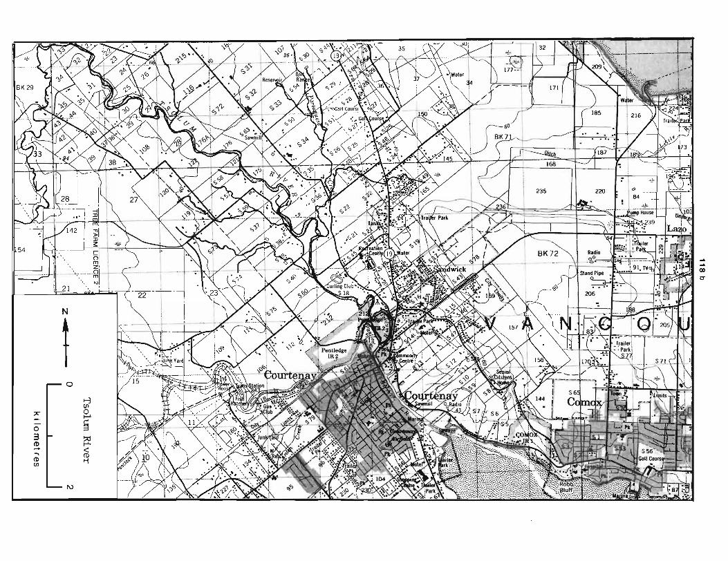
CD C-
" NI i ~ I ~ .\\~~ .. -/~ ~~/ I \~~:~ ?J= ~~" ri- -22'--i-- . '\ '
I I : .. 19 ~,' !-r 206 .~ ~ I ,
~ , I ~ , :.... . N
t 0
I-j en ". 0 r-'
0 ~ 3 ~ (1) 1-"
... ~ (1) t1 en
I\)

119
NAME OF STREAM ___ Ts_O_L_UM_R_I_VER ___________ RAB __ N_o_.----,-92_-_2_800-__ 0_1_0 ____ _
CONSERVATION DISTRICT ___ 3______ STATISTICAL AREA ____ 1_4 __________________ _
LOCATION OF MOUTH ___ ~F~l~o~w~s_=SE~.~l~·n~t~o~C~o~u~rt~n~e~y~R=i~v=e~r~,_C~om~o~x~D~i~s~t~.~ _______ _
POS I TI ON __ 4-'-9:...-...::1:..::2....:.4....:NW:...:..:..:.....~ __
LENGTH __ 2=-9::.....-___ _ km WIDTH 22 ~~-------
m DRAINAGE ________ _
COMPOSITION: BEDROCK 5 BOULDER 38 COARSE 16 FINE 16 ----- ----SILT & SAND ____ _ UNCLASSIFIED _....:po~0_1_s __ 2_4 ___________________ _
PERCENT GRADIENT 0.00 - 0.25 0.25 - 0.50 0.50 - 0.75 0.75 - 1.00
> 1.00
WETTED AREA __________ m2 SPAWNING AREA __________ m2
DISCHARGE (m3/sl MAX 192 Jan. 15, 1973 MIN 0.031 Aug 4, 1965
TEMPERATURE (OCl
BARRIERS OR POINTS OF DIFFICULT ASCENT ___ Lo~gg~i-ngT-d-e~brr~l~·s~-,r-em-07v~e-d-a-s-r-e~qu~i-r-e-d~-_-~ otherwise left to fUnction as flow control
SPAWNING DISTRIBUTION
SPECIES SECTION OF STREAM USED SOCKEYE CHINOOK COHO - throughout CHUM - in lower reaches for 3 km PINK (ODD YEAR) - well into Headquarters Creek PINK (EVEN YEAR) - " " STEELHEAD
Physical condjtions; Rapid changes in water levels 1956/59 Reported extensive erosion and silting. Extensive scoJJring fran logs aryl debris disJcyl~ed tbr01Jgh freshets. 1960/69 1970/79
Extensive silting and erosion heavy scollri ng shi fti ng grave] hars 1975 Very heavy flooding -- took out C1!lverts and flooded main roads 1976 ('.,ood water 1 evel s Sllppl ernented by f] ow re] ea ses fran !No] flake
.1983 Severe erosion and s~ J tj ng in lot.zer ] 2 km Water J evel s very low In sumner to near flood dunng fall and winter rains Sane over spawning by churn. 198] Jeter spawning chllm 11ti1ized same gravel as pinks.
GENERAL RE11ARKS; 1953 Heavy fry salvaging required in trihltaries every year 1958 This stream subject to flash floods. Barrier fence erected at mry1tb
1961 Low water in SUIDJer and fl cxxl conditi ODS in wi nter poi nt up the di re to prevent loss of pinks durjng very low water
need for a controlled flow on this rjver. 1962/64 Loggin2 operations contjnue throJ!gbol!t the watershed, contrib1ting to
con tinued ....

120
continuation
TSOLUM RIVER
1962/64 1965
1970
1975
1980 1983
the flood and draught conditions on this river. Logging operations on the Tsolum watershed and milling from Mt. Washington Mine contributes to the silting of this stream. Water levels are not stable in this system -- subject to rapid rises in water levels and draught in summers. Winter Works stream clearing crew spent over a week on Constitution Cr., a tributary of the Tsolum. 12 Spring carcasses reported in lower 3/4 mile of stream by a reliable person.
Considerable reduction in commercial fishing time in Johnson Straits. Pink salmon stocks continue to decline.
Timing of Migration
Juvenile pink Juvenile pink
Period
1964 1965
10/0
Apl. 10 Apl.8
50%
Apl. 18 Apl. 15
90% of total
Apl. 30 Apl. 24
The Tsolum River flows parallel to the coastal plain and because of this no falls exist on the mainstem. The lower 5km of stream has some flood plain with a bed composition of gravel and rock compacted by sand and silt. From 5 - 14 km very little stable gravel is found with boulders and bedrock predominating. The major gravel deposits are located upstream of 14 km. Low flows inhibit the upstream migration and result in significant mortality in some years.
Accessible tributaries: Portuguese Creek, Headquarters Creek, Dove Creek.

121
Sketch of Tsolum River, 1968
I
I ,Duncan Eay Main Road Helldiver Lake ,
I I I \
, ,
, , \ , . \
Puntledge
N
1
Portuguese Creek
Courtenay
Courtenay
Comox Harbour

122
ESCAPEMENT RECORD FOR TSOLUM RIVER -----------------------------------------------------YEAR SUCKEYE CHINOOK COHO CHU ~, PINK STEELHEAD 1~4/ NjO 7,500 750 75,QQO UNK
48 NjU 3,500 750 15,000 UNK 49 NjO 7,500 1,500 15,000 UNK 50 NjO 7,500 750 15,000 750 51 NjO 7,500 4UU 100,000+ 1,500 52 NjL) 15,000 400 100,000+ 1,500 53 NjU 7,500 1,500 35,000 1,500 54 ~JjO 7,500 1,500 75,000 3,500 55 NjO 3,500 200 35,000 1,500 56 NjO 7,500 75 15,000 1,500 57 NjO 7,500 750 75,000 750 58 25 7,500 25 75,000 1,500 59 NjO 15,000 400 15,000 1,500 60 NjO 7,500 NjO 7,500 UNK 61 NjO 7,500 200 7,500 1,500 62 3 7,500 200 3,500 1,500 63 NjO 7,500 750 7,50U 1,500 64 NjO 15,000 750 1,500 UNK 65 UNK 3,500 75 3,500 UNK 66 UNK 15,000 N/O 7,500 UNK 67 UNK 3,000 200 3,000 NjO 68 UNK 3,800 5,000 5,525 NjO 69 NjO 2,500 500 200 NjO 70 UNK 12,000 200 6,880 NjO 71 UNK 10,000 NjO 800 NjO 72 UNK 2,500 NjU 10,000 NjO 73 UNK 3,000 NjO 3,368 NjO 74 UNK 5,000 50 10,100 NjO 75 UNK 3,000 100 10,000 NjU 76 UNK 1,000 75 10,000 NjL) 77 - 2,300 500 3,800 -78 - 2,500 150 1,500 -79 2,000 - 7,000 -80 10 1,800 7,000 5,000 -81 - 1,000 11 ,000 5,095 -82 - 2,000 300 200 10 83 1,000 11,000 1,200 84 85
TIMING: ARRIVE E OCT L AUG L OCT START L OCT M SEPT E NOV PEAK L NOV E OCT L NOV END JAN L OCT DEC
Rt:MARKS Timing o~f~M~i-g-ra~t~i~on-:----~P~e~r7i~odr------,1~0~%------'5~0~%-----c9mO~%~o~f:r.To~t~aTl-----------
Adult Pink 1959 M Aug M Oct Adult Coho All yrs. L Sept L Jan

o I Waterloo C
reek
Wilfr~ Creek
kilo
me
tres
2 I

124
NAME OF STREAM WATERLOO CREEK CONSERVATION DISTRICT __ ~3 ________ __
RAE No. 92-3340
STATISTICAL AREA 14 --~--------------------
LOCA TI ON 0 F MOUTH ____ F_l_ow_s __ E_. __ i_n_t_o __ Ba_yn"--e_s---'S'-o--'und--'-...L, __ N_. _o_f __ Mud ____ Ba---'-y..L, _N_e_w_c_a_s_t_l_e __ Di_' _s_t _. __ _
POSITION 49 124 SW.
LENG TH ____ ---=3:....:.~2~___ kIn WIDTH ____ .::..5..;,..;;;,.5 ________ m DRAIN AG E ____________ _
COMPOSITION: BEDROCK ________ _ BOULDER __ ---'75~ __ _ COARSE __ --=13::....-___ FINE __ 1.::,.2 __ _
SILT & SAND UNCLASSIFIED --------- --------------------------------
PERCENT GRADIENT 0.00 - 0.25 0.25 - 0.50 0.50 - 0.75 0.75 - 1.00
> 1.00
WETTED AREA ______________ m2 SPAWNING AREA m2 --------------
DISCHARGE (m3/ s)
TEMPERATURE (OC)
BARRIERS OR POINTS OF DIFFICULT ASCENT __ -=Imp~a~s~s~a~b~1~e~f=a~1~ls~4~km~~f~r~om~mo~u~t~h~ ______ _
SPAWNING DISTRIBUTION
SPECIES SECTION OF STREAM USED SOCKEYE CHINOOK COHO - throughout -- mainly above Island Hwv. CHUM - downstream of E.& N. Railwa~ Bridge PINK (ODD YEAR) PINK (EVEN YEAR) STEELHEAD
POTENTIAL OF INACCESSIBLE PORTION OF STREAM ________________________ ~~~----__ Physical condition: 1950/59 Slight erosion and silting in lower reaches (54)
water veO' low during sumner. . 1960/69 Moderate scouring in lower 3/4 mile (1966,68) 1968 Reported vekY low in
surrmer. Early hi~h levels compared to past years -- subject to vekY heavy floOOs durin~ chum spawning.
1970/79 No unusual conditions • 1980/83 Sli~ht to moderate erosion.
GENERAL 1959/63 1966 1970
1980 1981
REMARKS 1952 -1700 chlnD and 600 coho fry sal vaged j n ,Il me. Beaver dams breached as necessary for migration. Chum spawning subject to scouring from fall floOOs • . Migrating coho delayed while winter works stream clearing crew carried out extensive removal of logs and debris. Considerable reduction in commercial fishing time in Johnson Straits. Slight overspawning of chum in lower section.

Sketch of Waterloo Creek, 1968
.. - chum spawning grounds o - coho spawning grounds
125
Waterloo Creek
I"Z
Power Line
Railway
Island Hwy.
Rosewall Creek
BAYNES SOUND
~ood gravel as far as railway track

126
ESCAPEMENT RECORD FOR WA TERLOO CREEK ---------------------------------------------------YEAR SOCKEYE CHINOOK COHO CHUM PINK STEELHEAD 1947 N/O 15,000 N/O
48 N/O 7,500 NjO 49 25 750 N/O 50 200 1,500 75 51 200 1,500 25 52 200 750 25 53 200 1,500 NjO 54 75 1,500 25 55 75 150 25 56 75 400 NjO 57 25 3,500 N/O 58 25 3,500 25 59 75 1,500 25 60 75 1,500 NjO 61 25 200 25 62 75 400 N/O 63 75 750 NjO 64 200 400 NjO 65 25 200 NjO 66 200 400 NjO 67 75 400 N/O 68 150 1,200 NjO 69 50 150 NjO 70 250 350 N/O 71 350 100 NjO 72 50 400 NjO 73 150 800 NjO 74 300 500 NjO 75 150 75 N/O 76 50 100 N/O 77 350 600 -78 175 800 -79 100 125 -80 150 500 -81 45 500 -82 20 110 -83 25 150 84 85
TIMING: ARRIVE M OCT L OCT START E NOV E NOV PEAK L NOV L NOV END DEC DEC
REMARKS ____________________________________________________________ __

127
NAME OF STREAM WILFRED CREEK (Coal Creek) RAE No. 92-3300
CONSERVATION DI STRI CT ____ ~3 ________ _ STATISTICAL AREA __ ~1~4 __________________ _
LOCA TI ON 0 F MO UTH _-...:.F..::.l:..::o:..:.:w~s:......:...:NE.::=...:... ---.:::.and:...:::::.--.:S::::cE:=..:..... --.:i~n~t::..::o::.......!:B:::::a:....zyn...:....:::e:..::s~S~o~lll1~d::::..l., --.:N~. --.:o::..:f::........:Mu..::::::d::.......!:Ba-:::::...J.y.....l,:......:...:N~e..:::w.:::c::!a.:::s t.:::l=.:e:::..-
District POSITI ON ___ 4..:...:9:........::.1~2....:.4....:S::..:W.:....:.~_
LENGTH __ --..:..4 _____ _ km WIDTH 12 -~~----------
m DRAINAGE ______________ _
COMPOSITION: BEDROCK ________ _ BOULDER ___ 4~7~ __ _ COARSE __ -=2.:....7 ____ _ FINE -=23::;......... __
SILT & SAND _____ _ UNCLASSIFIED __ ~p~oo~1~s~3 ____________________ ___
PERCENT GRADIENT 0.00 - 0.25 0.25 - 0.50 0.50 - 0.75 0.75 - 1.00
> 1.00
WETTED AREA ______________ m2 SPAWNING AREA ______________ m2
DISCHARGE (m3/ s)
TEMPERATURE (O C)
BARRIERS OR POINTS OF DIFFICULT ASCENT Impassable 6 m vertical falls 4 km from mouth
SPAWNING DISTRIBUTION
SPECIES SECTION OF STREAM USED SOCKE YE CHINOOK COHO - throuehout CHUM - below Island Hwv. Bridge PINK (ODD YEAR) PINK (EVEN YEAR) STEELHEAD - observed
POTENTIAL OF INACCESSIBLE PORTION OF STREAM ~-~--~~~--~~~~~~~-----Pbysical conditions: Seasonal fluctuations in water levels -- light siltation
durin~ heavy fall and winter rains. Stream has changed cOurse near mouth in recent years.
GENERAL REMARKS --~~~----~--~--~------------------~----~------------
1950 This stream had a ~ood steady flow all summer and no fry salvage ODS. necesssary. 1959 It is very possible that losses occurred to the Pink eggs planted in lower
1960 reaches by Fish Culture Branch due to silting conditons last winter. Considerable erosion and stream channel change in lower river at the fence erected by Fish Culture.
1970 Stream improvement work lIDCier winter works program. 1980 Cons; derabl e redllct; on in carrnercial fishin~ time in Johnson Straits.
Altbollpb spawn;ng areas and rearing habitat appear in good condition, this 1983 stream is Dot prorn1cing anywhere near optimum capacity.

128
~z
Sketch of Wilfred Creek, 1968
Island Hwy.
0- coho spawning grounds 6. - chum spawning grounds
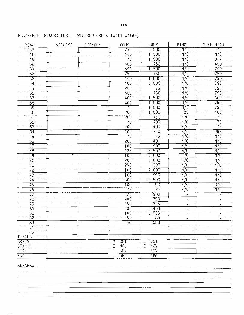
129
t SCM E I~E NT KE CO RD FO R __ W_I _LF_R_E_D _C_R_E E_K-->-( C_o_a_l _C_r_ee_k...,L) ______________ _
YEAR SOCKEYE CHINOOK COHU CHUM PINK STEELHEAD 1947 750 3,500 N/O 75
48 400 1,500 NjO NjO 49 75 1,500 NjO UNK 5U 400 750 NjO 400 51 400 1,500 NjO 750 52 750 750 NjO 750 53 400 1,500 NjO 750 54 400 3,500 NjO 750 55 200 75 NjO 750 56 400 750 NjQ 750 57 400 1,500 NjO 400 58 400 1,500 NjO 750 59 75 1,500 NjO 750 60 200 1,500 25 400 61 200 750 NjO 75 62 75 400 NjU 75 63 200 400 NjO 75 64 200 750 NjO UNK 65 75 75 N/U NjO 66 200 400 NjO NjO 67 100 900 NjO NjO 68 125 2,500 NjO NjO 69 100 1,000 N/U NjO 70 200 1,000 NjO NjO 71 250 300 NjO N/U 72 100 4,000 NjU NjO 73 100 950 NjO NjO 74 300 1,500 N/U NjO 75 100 50 NjO NjU 76 75 125 NjO NjO 77 425 900 - -78 400 750 - -79 250 325 - -80 300 1,400 - -81 100 1,525 - -82 50 80 - -83 50 b~U
84 85
TIMING: ARRIVE M OCT L OCT START E NOV E NOV PEAK L NOV L NOV END DEC DEC
RE~1ARKS --------------------------------

1 (2).:' ~: .... : . . :. ~ ~ ~I ) I~ r =fF~ .. ~ \ \ \ 36 I I I I .~ ~;:''''''; '' "~'>-L , - ... : .,"i1 • '''', \
, . f. '\(~ . ~ .... , ~ // ~ :':,.:." " .
PORT ~}~;~" ;" " ~ 'I ~I \16! \\ ~I ·~.· .. Y"':"" t . 35 I I I'" .". ~... ' _ u . ~ 15 . ... -----:-",.o:r-r-t" ' i;, • ' ~, . \ ! l, " . '/.'}: ;"::.
\ \~ ~ ~---:- > I ~ \i I ' I . fA:' I 34 I II
-33
.... I I 11'4 11\~:3 '?-~rfl/: ''Il. o L"\:---l 1\1 5 Co>
I 8 I· ".' 32 - ' 0
OYSTER
rt\ I ~1 U \. rP I I"m I ~~ l: I ~,J 3:A
I "
0
7' ~ 8.
0
r (/)
3 (") CD ti ..... (1) ...,
(1) CD ~ (J)
N .A I I "'.. _~L . .J...::U::!!Z -- I , ~ '\ \ ~""'"'---~// I r-----.\' ~ rv-. ~ " " -------~
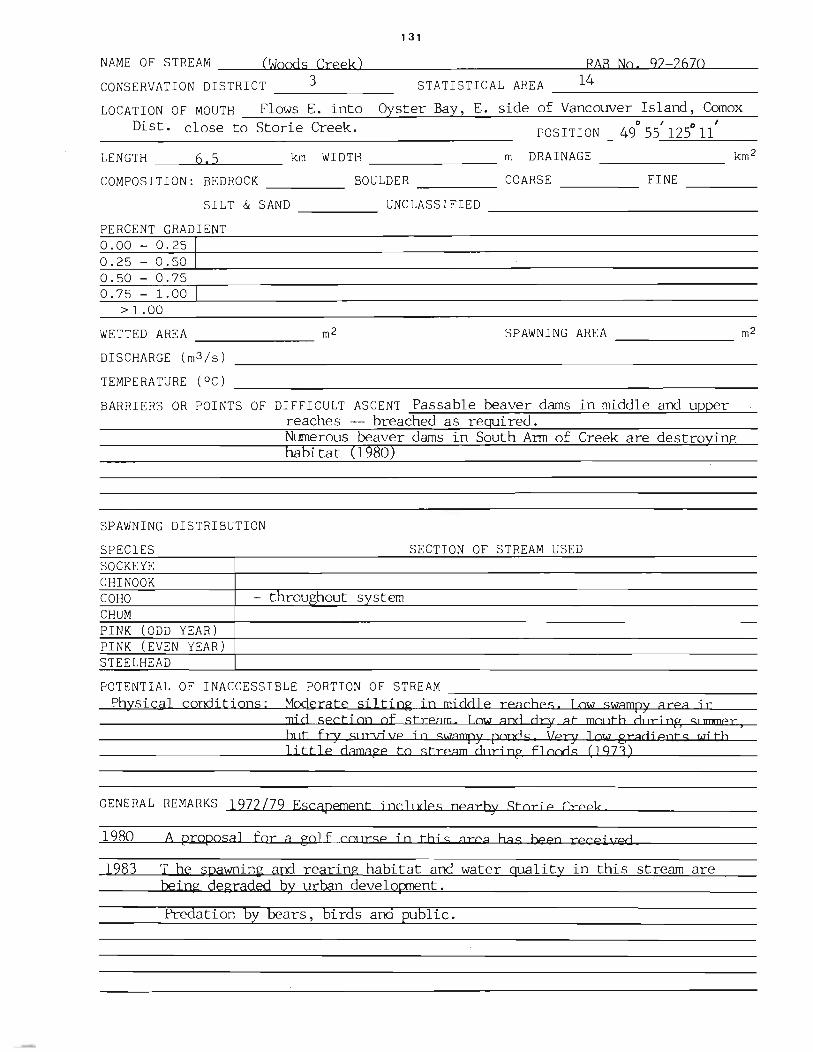
131
NArJIE OF S TREAM __ ~(W:a:olo.£lod....:...l.is~C.I.oI.r..s;;e;.s;;eJ:lok..L) ____________ -lp.:..!A:l.LB.J.....J.:Nl.I..oL.&.~9.L...2=2w6u..7l..l0.l....-__
CONSERVATION DISTRICT ___ 3______ STATISTICAL AREA __ 1_4 _________ _
LOC A TI ON 0 F MO UTH _..:.F-=l-=o~w_=s......:::E..:... -=:i n:..:.t~o=--~Oy:.t..::.s::...:t::...:e:..:r:........::Ba:..=.4.y..J.,......:::E..:... --=-s~i d=.e=--o::.;f=--V:....:a:..::n..:.::c:....:o:....:u::....:v--=e:..,:r:........::I..:.s..:.l=an::...:d.::.2...' _C::..;orn:;,:.:..:.:o:.,:X-=------Dist. close to Storie Creek. POSITION 49
0 55' 1250 11'
LEN GTH ___ --'6L.1.'-'<5'-----__ _ km WIDTH _______ _ m DRAINAGE _______ _
BOULDER ____ _ COARSE ____ _ FINE ----COMPOSITION: BEDROCK ____ _
SILT & SAND ____ _ UNCLASSIFIED _______________ ___
PERCENT GRADIENT 0.00 - 0.25 0.25 - 0.50 0.50 - 0.75 0.75 - 1.00
> 1.00
WETTED AREA ________ m2 SPAWNING AREA _______ m2
DISCHARGE (m3/s)
TEMPERATURE (OC)
BARRIERS OR POINTS OF DIFFICULT ASCENT Passable beaver dams in middle and upper reaches -- breached as required.
SPAWNING DISTRIBUTION
SPECIES SOCKEYE CHINOOK
Numerous beaver dams in South Arm of Creek are destroying habitat (1980)
SECTION OF STREAM USED
COHO - throughout system CHUM PINK (ODD YEAR) PINK (EVEN YEAR) STEELHEAD
POTENTIAL OF INACCESSIBLE PORTION OF STREAM __________________ _ PhYSical conditions: Moderate silting in middle reaches. low swampy area jn
mi d secti on of stream. Low and dry at mOlltb dlJd ng 51 mrner) hl It fry SllDrj \Ie j n swampy pond 5 Vexy J QlM grad j eot s wi tb 1 i ttl e damage to stream dlJri Dg flood s (1973)
GENERAL REMARKS 1972/79 Escapement includes nearby Storie Creek
1980 A proposal for a golf cQ]lrse ip tbi s area bas beeo receiEed
1983 T he spawning and rearing habitat and water quality in this stream are being degraded by urban development.
Predation by bears, birds aDd public.

132
N
Sketch of Woods Creek, 1970
, "~I SWampy Area
,'I "~I Shelter Point.

133
E~CAPEMENT RECORD FOR WOODS CREEK --~--~-----------------------------------------------
YEAR SOCKEYE CHINOOK COHO CHUM PINK STEELHEAD 1947
48 49 50 51 52 53 54 55 56 57 58 59 60 61 62 63 64 65 66 67 68 NO RECOROS P lOR TO 1970 69 70 300 71 350 72 250 73 200 74 300 75 200 76 /5 77 100 78 100 79 100 80 100 81 10 82 20 83 NOT INSPECTE[ 84 85
TIMING: ARRIVE L OCT START I:. NUV PEAK L NOV END DEC
I~ EMARKS - Escape~me~n~t~re~c~o~r7d~s"f~r~om~1r.9'7~2---'1n-97rr6~i~nc~l~u~a~ecS~·t~o~rl'-'e~C~re~eT.k-.-------------------------

134
Metric Equivalents
CONVERSION FACTORS
The following list of convenient equivalents of measure gives the relationship between imperial units and the International System of Units (SIl.
I inch equals 2.54 cm (centimetres) 1 foot equals 0.3048 m (metre) 1 statute mile equals 1.6093 km (kilometres)
1 cm (centimetre) equals 0.39370 inch 1 m (metre) equals 3.2808 feet 1 km (kilometre) equals 0 .621 37 mile
1 acre equals 43 560 square feet 1 acre equals 0.404 69 ha (hectare)
1 square mile equals 640 acres 1 square mile equals 2.5900 km' (square kilometres) I square mile equals 259.0 ha (hectares)
1 ha (hectare) equals 10000 m' (square metres)
1 ha (hectare) equals 2.4710 acres 1 km' (square kilometre) equals 0.386 10 square mile
cubic foot equals 6.2288 imperial gallons imperial gallon equals 4.546 09 L (Iitres) imperial gallon equals 1.2010 U.S . gallons U.S gallon equals 0.133 68 cubic foot
1 cubic foot equals 0.068317 m' (cubic metre) 1 m' (cubic metre) equals 35.315 cubic feet
cubic foot per second for One day equals 1.9835 acre·feet cuhic foot per second for one day covers one square mile to a
depth of 0 .037 19 inch
acr e·foot equals I. 2 33 5 dam' (cubic decametres)
m'ls (cubic metre per second) for one dar equals R6.4 dam' (,ubic decametre)
m'ls (cubic metre per second) for one day covers one square kilometre to a depth of 0 .0864 m (metre)
1 foot per second equals 0 .6818 mile per hour 1 mile per hour equals 1.467 feet per second 1 mls (metre per second) equals 3.6 kmlh (kilometre per hour) 1 kmlh (kilometre per hour) equals 0.2778 mls (metre per second)
cubic foot per second equals 0.028 317 m'ls (cubic metre per second)
m'ls (cubic metre per second) equals 35 .315 cubic feet per second
pound equals 0.45359 kg (kilogram) kg (kilogram) equals 2.2046 pounds
J short ton (2000 pounds) equals 0 .907 18 t (tonne) I t (tonne) equals 2204.6 pounds
degree, Celsius = 5/9 (degrees Fahrenheit - 32)
degrees Flhrenheit = 9/5 (degrees Celsius) + 32
FACTEURS DE CONVERSION
Voici une liste des unites de mesure imperiales et leurs equivalences dans Ie Systeme international d'unites (SI).
1 pouce vaut 2.54 cm (centimhres) 1 pied vaut 0.3048 m (metre)
1 mille terrestre equivaut a 1.6093 km (kilometre)
1 cm (centimetre) equivaut a 0.39370 pouce
1 m (metre) equivaut a 3.2808 pieds 1 km (kilometre) equivaut a 0.621 37 mille
1 acre vaut 43 560 pieds carres 1 acre equivaut a 0.404 69 ha (hectare)
1 mille carre vaut 640 acres 1 mille carre equivaut a 2.5900 km' (kilometres carres)
1 mille carre equivaut a 259.0 ha (hectare)
1 ha (hectare) vaut 10000 m' (metres carres)
1 ha (hectare) equivaut a 2.4710 acres 1 km' (kilometre carre) equivaut a 038610 mille carre
1 pied cube equivaut a 6.2288 gallons imp"'ials 1 gallon imperial vaut 4.54609 L (Iitres) 1 gallon imperial equivaut a 1.2010 gallon americain 1 gallon americain equivaut a 0.133 68 pied cube 1 pied cube vaut 0 .068 317 m' (metre cube) 1 m' (metre cube) vaut 35.315 pieds cubes
pied cube par seconde pendant un jour equivaut a 1.9835 acre
pied pied cube par seconde pendant un jour equivaut a un volume
d'un mille carre par 0.037 19 poucc acre·pied equivaut a 1.2335 darn' (decametres cubes)
m' /s (metre cube par seconde) pour un jour vaut 86.4 darn'
(decametre cube) m'/s (metre cube par secondel pour un jour couvre un kilometre
carre a une profondeur de 0.0864 m (metre)
pied par seconde equivaut a 0 .6818 mille par heure mille par heure equivaut a 1.467 pied par seconde
I m l s (metre par seconde) vaut 3.6 km/h (kilometre par hcure) 1 km lh (kilometre par heure) vaut 0 .2778 mls (metre par seconde)
pied cuhe par seconde equivaut it 0 .028 317 m' Is (metre cube par second e)
m' l s (metre cube par seconde) equivaut ;. 35 315 pieds cubes par seconde
livre equivaut a 0 .45359 kg (kilogramme) kg Ikilogramme) equivaut a 2.1046 Iivres
tonne courte (2000 livres) equivaut it U.907 18 t (tonne)
t (tonne) equivaut ;. 2204.6 livres
dcgres Celsius = 5/9 (de~res Fahrenheit - 32) degres Fahrenheit = 9/5 (degres Celsius) + 32