Embed Size (px)
Citation preview
Author G. Lozano, M. Pulido, J. Andreu Date April 15, 2007
Case Study Report Serpis
SERPIS RIVER (Jucar River Basin District), Spain (Deliverable D33)

Contact information AquaMoney Partners
Copyright © 2006 All rights reserved. No part of this publication may be reproduced, stored in a retrieval system or transmitted in any form or by anymeans, electronic, mechanical, photocopying, recording or otherwise without the prior written permission of the copyright holder.
Colophone
This report is part of the EU funded project AquaMoney, Development and Testing of Practical Guidelines for the Assessment of Environmental and Resource Costs and Benefits in the WFD, Contract no SSPI-022723. General Deliverable D33. Case study Report Jucar RBD (Serpis river basin) Deadline 15-04-2007 Complete reference Lozano, G., Pulido, M., J. Andreu (2007), Case study Report Jucar, Subcatchment
Serpis UPVLC, Valencia, Spain Status Author(s) Date Comments Date Approved / Released Reviewed by Pending for Review Second draft First draft for Comments
Lozano, G., M. Pulido, J. Andreu
15-04-2007
Under Preparation Confidentiality Public Restricted to other programme participants (including the Commission Service) Restricted to a group specified by the consortium (including the Advisory Board) Confidential, only for members of the consortium X Accessibility Workspace Internet Paper

AquaMoney
Content 1. General case study characteristics 1
1.1 Location of the case study area 1 1.2 Geographical characteristics 1
1.2.1 Physical general characteristics 1 1.2.2 Climate 2 1.2.3 Lithology & Geology 2 1.2.4 Population and land uses 2 1.2.5 Biotic framework 3
1.3 Water system characteristics 3 1.3.1 Total natural runoff and available water resources 3 1.3.2 Streams and aquifer characteristics 4 1.3.3 Hydraulic infrastructure 5
1.4 Characterisation of water use 7 1.4.1 Water uses and services by socio-economic sectors 7 1.4.2 Origin of water use 7 1.4.3 Environmental flow requirements 8 1.4.4 Economic analysis of water use 8 1.4.5 Trends and future projections 10 1.4.6 Water quality and environmental problems 11
2. Pressure, impact and risk analysis 12 2.1 Significant pressures impacting on water status 12
2.1.1 Point and diffuse source pressures 12 2.1.2 Abstraction and flow regulation pressures 13 2.1.3 Morphological pressures 13 2.1.4 Pressures on groundwater bodies 13
2.2 Impacts on surface and groundwater bodies 14 2.2.1 Sure impact 14 2.2.2 Probable impact 14 2.2.3 Probable impact on heavily modified water bodies, reservoirs 15 2.2.4 Impacts on groundwater 16
2.3 Water bodies at risk of not achieving a good status 16 2.4 Diagnosis of water quality and ecological issues 18 2.5 General trends and future pressures 18
3. Policy issues 19 3.1 Water management framework and major issues 19
3.1.1 Institutional framework 19 3.1.2 Legal and water rights issues 19 3.1.3 Droughts and water scarcity problems 19 3.1.4 Flood risk issues 20 3.1.5 Water quality issues 20 3.1.6 Resources overexploitation 20 3.1.7 Water use efficiency 20
3.2 Relevant water policy questions in the basin 20 3.2.1 Policy options and goal achievement 20
3.3 Information sources and stakeholder involvement 21 4. Environmental and resource cost analysis and methodological issues 22
4.1 Main water-related goods and services provided in the basin 22 4.2 Possible benefits and cost from that water services 22 4.3 Type of ERC analysis to performance 22 4.4 Proposed methods and tools for the valuation of ERC: 23 4.5 Some practical and methodological issues 24
5. References 25
Case Study Report Serpis
1
1. General case study characteristics1
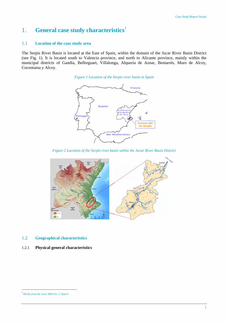
1.1 Location of the case study area The Serpis River Basin is located at the East of Spain, within the domain of the Jucar River Basin District (see Fig. 1). It is located south to Valencia province, and north to Alicante province, mainly within the municipal districts of Gandía, Bellreguart, Villalonga, Alquería de Aznar, Beniarrés, Muro de Alcoy, Cocentaina y Alcoy.
Figure 1 Location of the Serpis river basin in Spain
España
Francia
Portugal
Mar Mediterráneo
Confederación Hidrográfica
del Júcar
Cuenca del río Serpis
España
Francia
Portugal
Mar Mediterráneo
Confederación Hidrográfica
del Júcar
Cuenca del río Serpis
Cuenca del río Serpis
Figure 2 Location of the Serpis river basin within the Jucar River Basin District
Emb. Beniarrés
Río VallesetaAlcoy
Gandia
Río Bernisa
Río Serpis
Río Penaguila
Río Agres
Río Polop
Bco. La Encantada
Río Barxell
Mediterráneo
Emb. Beniarrés
Río VallesetaAlcoy
Gandia
Río Bernisa
Río Serpis
Río Penaguila
Río Agres
Río Polop
Bco. La Encantada
Río Barxell
Emb. Beniarrés
Río VallesetaAlcoy
Gandia
Río Bernisa
Río Serpis
Río Penaguila
Río Agres
Río Polop
Bco. La Encantada
Río Barxell
Mediterráneo
1.2 Geographical characteristics
1.2.1 Physical general characteristics
1Mainly from the Jucar RBD Art. 5. Report
AquaMoney
2
Table 1 Physical general characteristics of the basin
Characteristics Description Management System Serpis
River basins Serpis, Jaraco, Beniopa Surface are of the whole system (km2) 990
Surface Serpis river basin (km2) 753 Serpis river length (km) 74.5 Altitute From 1462 m above sea level to the sea (Mediterraneam sea)
Main tributaries Upper basin: Valleseta, Penaguila, Barchell, Polop rivers Middle basin: Agres river, La Encantada gully Lower basin: Bernisa river
1.2.2 Climate Table 2 Main climatic characteristics
Characteristics Description Main climate type Coastal Mediterranean
Climate Mild continental Mediterranean
Average annual temperature 16.3 ºC
Average annual precipitation 630 mm
Average annual evapotranspiration 988 mm
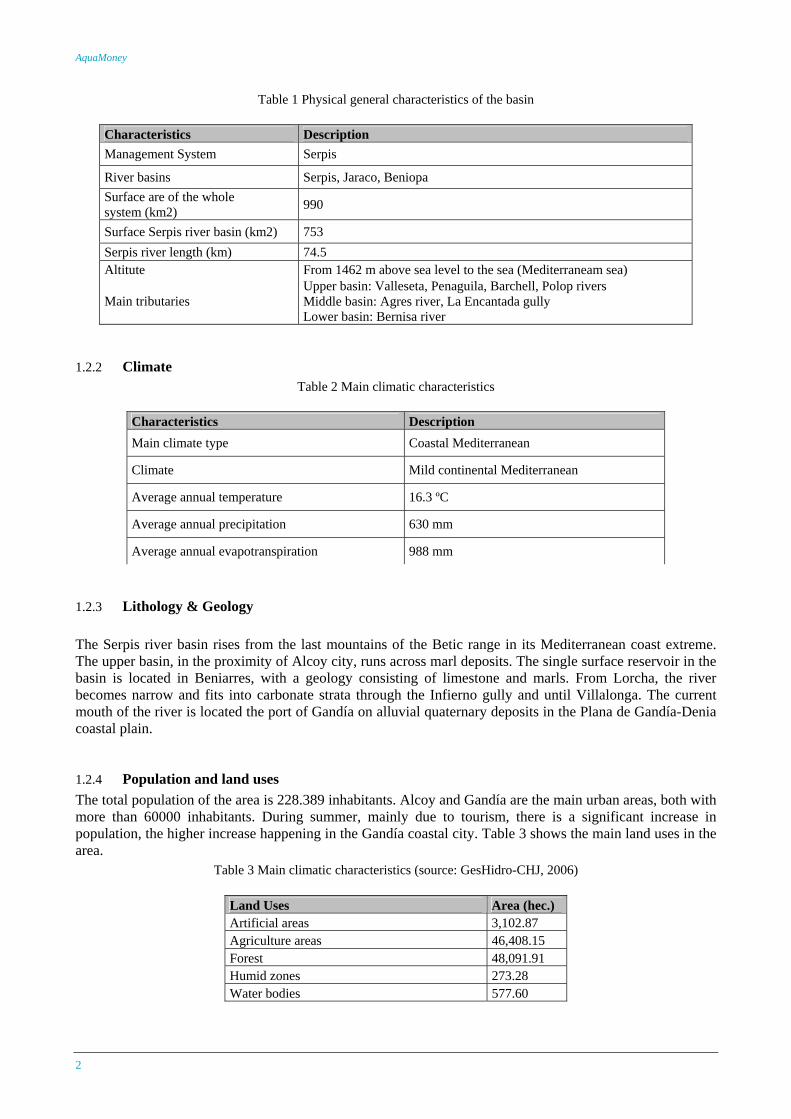
1.2.3 Lithology & Geology The Serpis river basin rises from the last mountains of the Betic range in its Mediterranean coast extreme. The upper basin, in the proximity of Alcoy city, runs across marl deposits. The single surface reservoir in the basin is located in Beniarres, with a geology consisting of limestone and marls. From Lorcha, the river becomes narrow and fits into carbonate strata through the Infierno gully and until Villalonga. The current mouth of the river is located the port of Gandía on alluvial quaternary deposits in the Plana de Gandía-Denia coastal plain.
1.2.4 Population and land uses The total population of the area is 228.389 inhabitants. Alcoy and Gandía are the main urban areas, both with more than 60000 inhabitants. During summer, mainly due to tourism, there is a significant increase in population, the higher increase happening in the Gandía coastal city. Table 3 shows the main land uses in the area.
Table 3 Main climatic characteristics (source: GesHidro-CHJ, 2006)
Land Uses Area (hec.) Artificial areas 3,102.87 Agriculture areas 46,408.15 Forest 48,091.91 Humid zones 273.28 Water bodies 577.60
Case Study Report Serpis
3
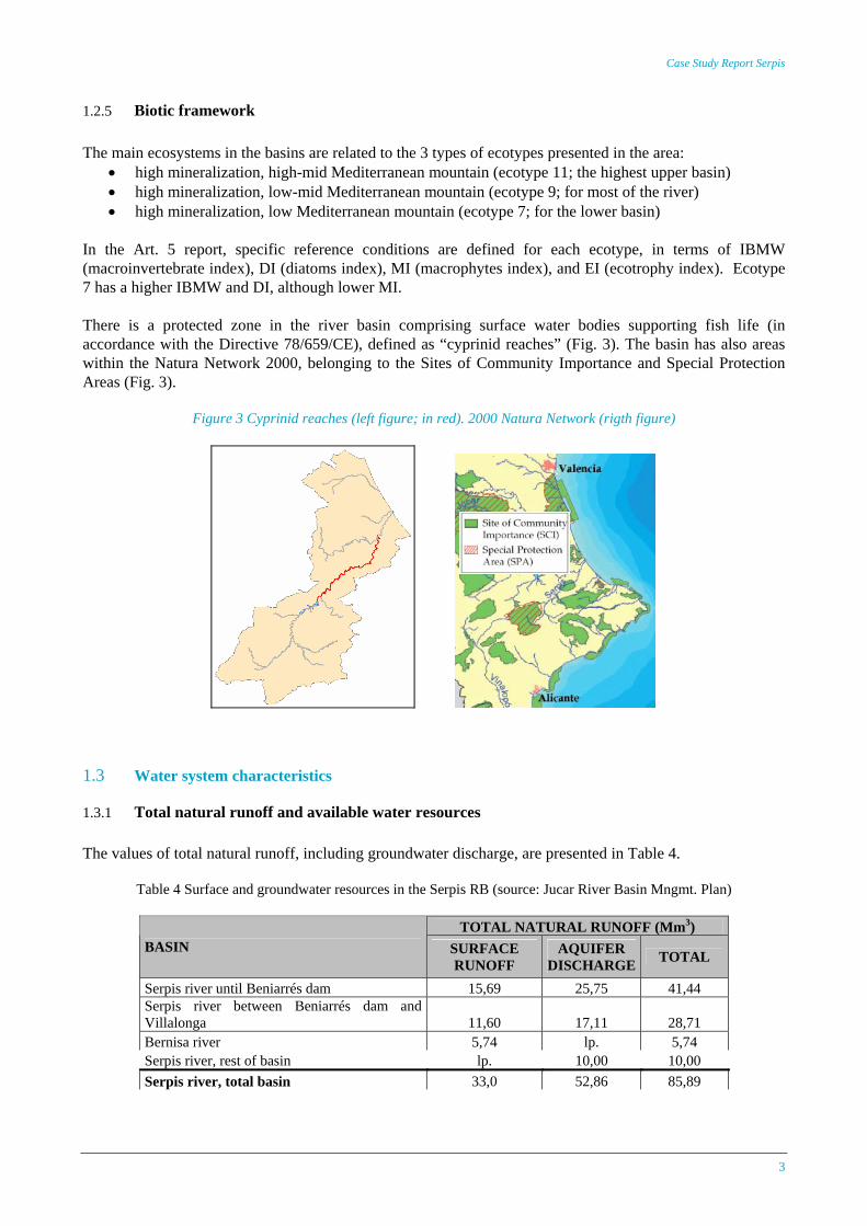
1.2.5 Biotic framework The main ecosystems in the basins are related to the 3 types of ecotypes presented in the area:
• high mineralization, high-mid Mediterranean mountain (ecotype 11; the highest upper basin) • high mineralization, low-mid Mediterranean mountain (ecotype 9; for most of the river) • high mineralization, low Mediterranean mountain (ecotype 7; for the lower basin)
In the Art. 5 report, specific reference conditions are defined for each ecotype, in terms of IBMW (macroinvertebrate index), DI (diatoms index), MI (macrophytes index), and EI (ecotrophy index). Ecotype 7 has a higher IBMW and DI, although lower MI. There is a protected zone in the river basin comprising surface water bodies supporting fish life (in accordance with the Directive 78/659/CE), defined as “cyprinid reaches” (Fig. 3). The basin has also areas within the Natura Network 2000, belonging to the Sites of Community Importance and Special Protection Areas (Fig. 3).
Figure 3 Cyprinid reaches (left figure; in red). 2000 Natura Network (rigth figure)
1.3 Water system characteristics
1.3.1 Total natural runoff and available water resources The values of total natural runoff, including groundwater discharge, are presented in Table 4.
Table 4 Surface and groundwater resources in the Serpis RB (source: Jucar River Basin Mngmt. Plan)
TOTAL NATURAL RUNOFF (Mm3) BASIN SURFACE
RUNOFF AQUIFER
DISCHARGE TOTAL
Serpis river until Beniarrés dam 15,69 25,75 41,44 Serpis river between Beniarrés dam and Villalonga 11,60 17,11 28,71 Bernisa river 5,74 lp. 5,74 Serpis river, rest of basin lp. 10,00 10,00 Serpis river, total basin 33,0 52,86 85,89
AquaMoney
4
Total available surface and groundwater resources are presented in Table 5. Table 5 Surface and groundwater resources in the Serpis RB (source: Jucar River Basin Mngmt. Plan)
Characteristics Description Conventional resources
Superficial resources regulate 17.0 Mm3/year Groundwater resources 105.0 Mm3/ year Irrigation return 8.0 Mm3/ year Total volume of available resources 130 Mm3/ year
Marginal (nonconventional) resources Reuse sewage waters* 4.5 Mm3
* Proyected in the current Jucar RB Hydrological Plan (CHJ, 1999)
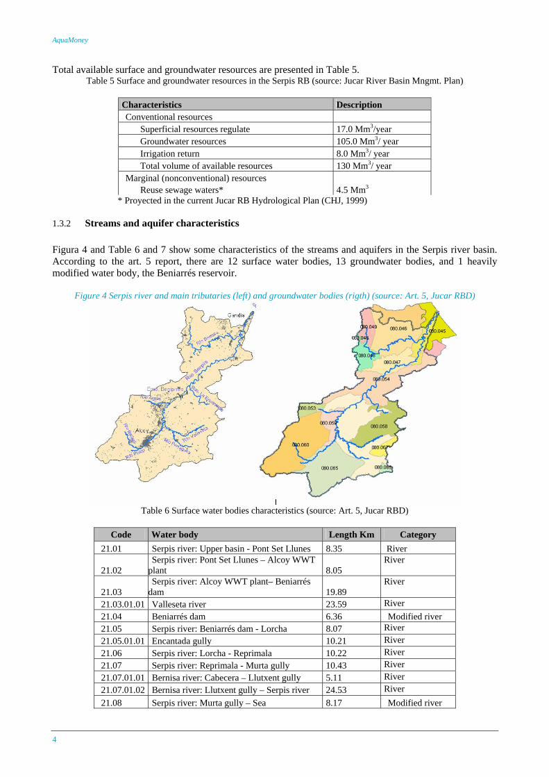
1.3.2 Streams and aquifer characteristics Figura 4 and Table 6 and 7 show some characteristics of the streams and aquifers in the Serpis river basin. According to the art. 5 report, there are 12 surface water bodies, 13 groundwater bodies, and 1 heavily modified water body, the Beniarrés reservoir.
Figure 4 Serpis river and main tributaries (left) and groundwater bodies (rigth) (source: Art. 5, Jucar RBD)
Table 6 Surface water bodies characteristics (source: Art. 5, Jucar RBD)
Code Water body Length Km Category
21.01 Serpis river: Upper basin - Pont Set Llunes 8.35 River
21.02 Serpis river: Pont Set Llunes – Alcoy WWT
plant 8.05 River
21.03 Serpis river: Alcoy WWT plant– Beniarrés
dam 19.89 River
21.03.01.01 Valleseta river 23.59 River 21.04 Beniarrés dam 6.36 Modified river 21.05 Serpis river: Beniarrés dam - Lorcha 8.07 River 21.05.01.01 Encantada gully 10.21 River 21.06 Serpis river: Lorcha - Reprimala 10.22 River 21.07 Serpis river: Reprimala - Murta gully 10.43 River 21.07.01.01 Bernisa river: Cabecera – Llutxent gully 5.11 River 21.07.01.02 Bernisa river: Llutxent gully – Serpis river 24.53 River 21.08 Serpis river: Murta gully – Sea 8.17 Modified river
Case Study Report Serpis
5
Table 7 Main groundwater bodies and characteristics (source: Jucar River Basin Mngmt. Plan)
Pumping (Hm3)
Lateral transfer (Hm3)
31 De las Agujas mountain Highly permeable outcrop 90 Jurassic-
Cretassic 50 Springs 22 20
32 Grossa mountain Highly permeable outcrop 430 Cretássic-
Miocenic 100 Albaida, Jaraco and Cañoles rivers 11 12
37 Almirante Mustalla Highly permeable outcrop 180 Cretassic
and Tertiary 100 Bullens, Albaida and Serpis rivers 11 15
38 Plana de Gandía-Denia Highly permeable outcrop 240 125 Jaraco and Serpis rivers,
springs, discharges to sea 70
39 Almudaina-Alfaro-Mediodía-Segania
Highly permeable outcrop 150 Cretassic 45 Girona and Racons rivers 15 15
40 Mariola mountain Highly permeable outcrop 210
Jurassic, Cretassic
and quaternary
25 Serpis and Vinalopó rivers 7
44 Barrancones-Carrasqueta Highly permeable outcrop 200 15 Springs 9
46 Serella-Aixorta-Algar Highly permeable outcrop 150 40 Springs 10
HGU Name Surface Area (km2) Geology Recharge
(Hm3/year) Naturals exitsExtractions
There are some reaches of the Serpis river and the tributaries with stream-aquifer hydraulic connection. There also some small wetlands and lagoons along the basin with important groundwater feeding.
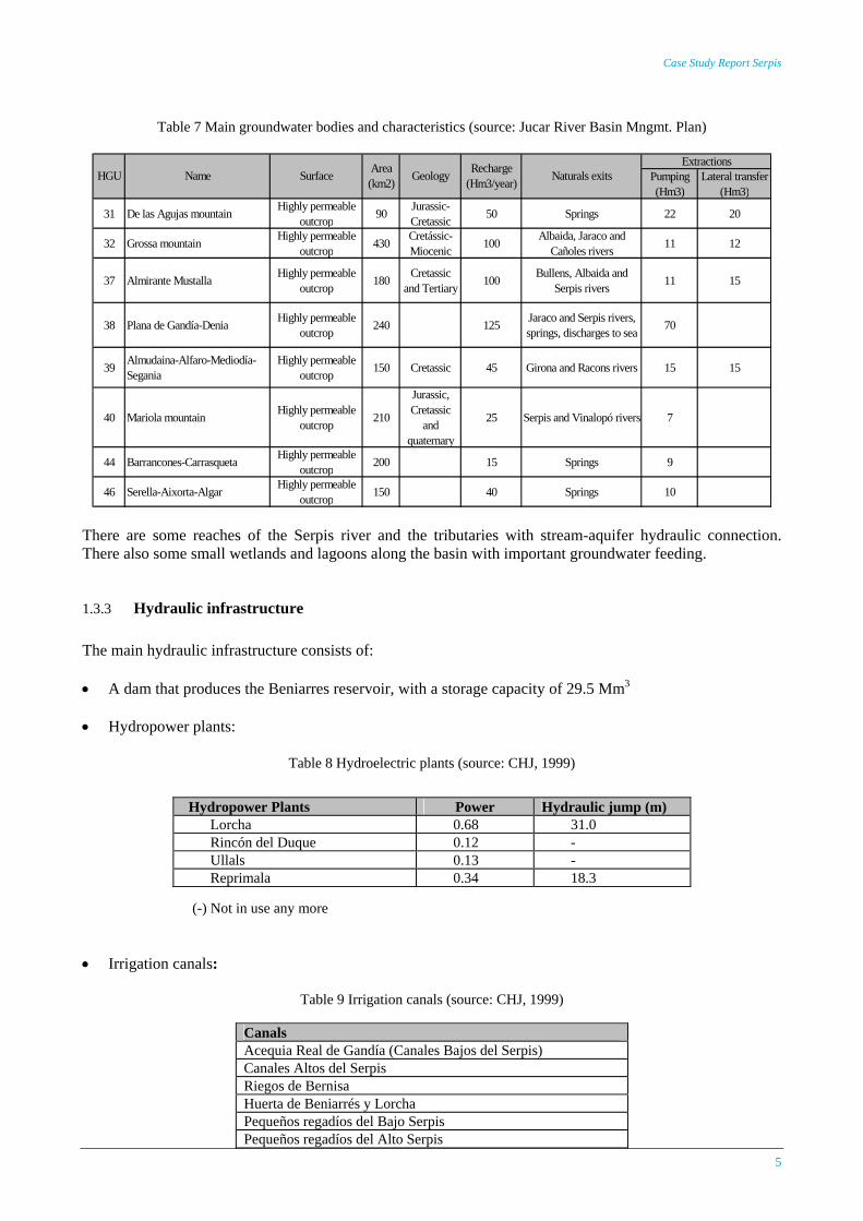
1.3.3 Hydraulic infrastructure The main hydraulic infrastructure consists of: • A dam that produces the Beniarres reservoir, with a storage capacity of 29.5 Mm3
• Hydropower plants:
Table 8 Hydroelectric plants (source: CHJ, 1999) (-) Not in use any more
• Irrigation canals:
Table 9 Irrigation canals (source: CHJ, 1999)
Hydropower Plants Power Hydraulic jump (m) Lorcha 0.68 31.0 Rincón del Duque 0.12 - Ullals 0.13 - Reprimala 0.34 18.3
Canals Acequia Real de Gandía (Canales Bajos del Serpis) Canales Altos del Serpis Riegos de Bernisa Huerta de Beniarrés y Lorcha Pequeños regadíos del Bajo Serpis Pequeños regadíos del Alto Serpis
AquaMoney
6
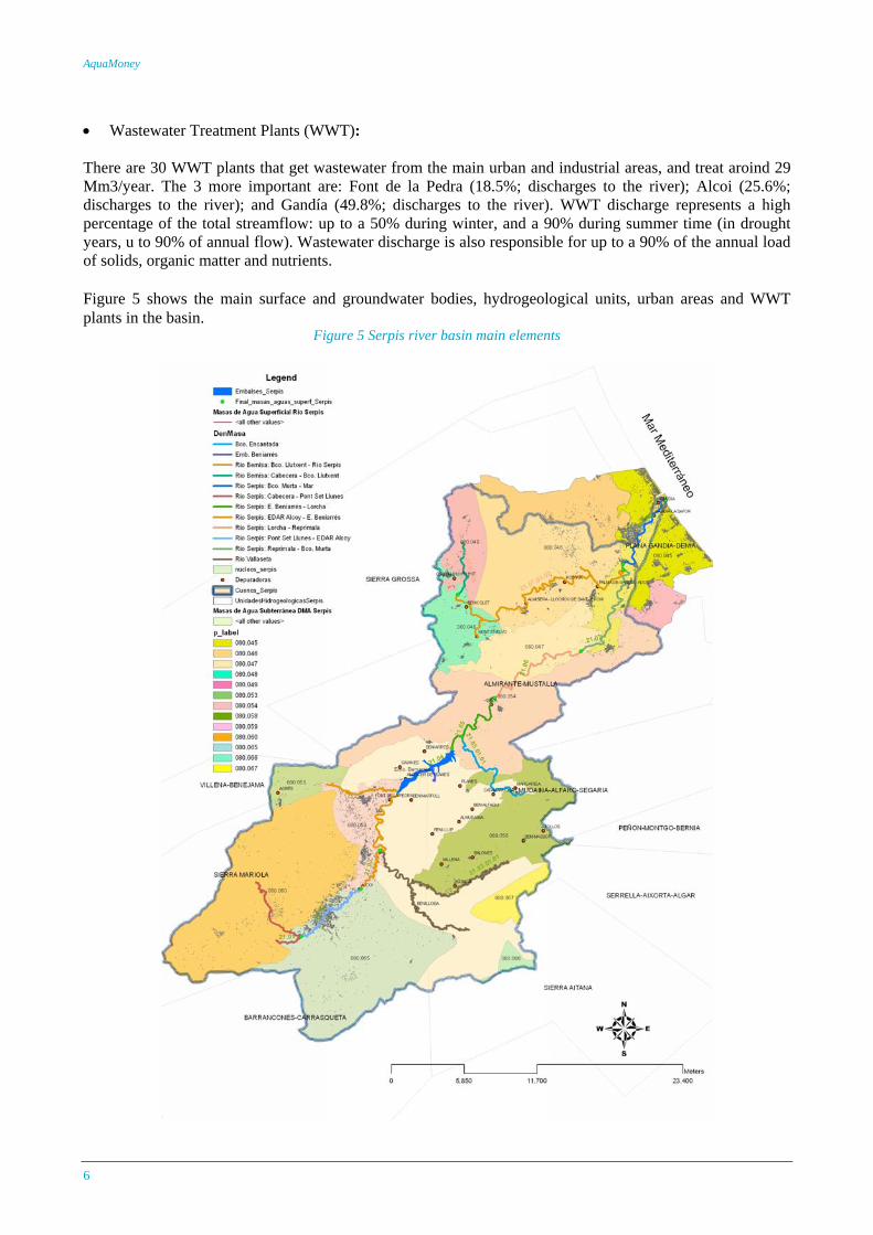
• Wastewater Treatment Plants (WWT): There are 30 WWT plants that get wastewater from the main urban and industrial areas, and treat aroind 29 Mm3/year. The 3 more important are: Font de la Pedra (18.5%; discharges to the river); Alcoi (25.6%; discharges to the river); and Gandía (49.8%; discharges to the river). WWT discharge represents a high percentage of the total streamflow: up to a 50% during winter, and a 90% during summer time (in drought years, u to 90% of annual flow). Wastewater discharge is also responsible for up to a 90% of the annual load of solids, organic matter and nutrients. Figure 5 shows the main surface and groundwater bodies, hydrogeological units, urban areas and WWT plants in the basin.
Figure 5 Serpis river basin main elements
Case Study Report Serpis
7
1.4 Characterisation of water use
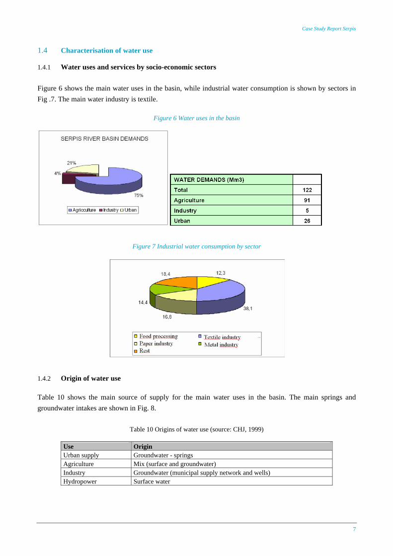
1.4.1 Water uses and services by socio-economic sectors Figure 6 shows the main water uses in the basin, while industrial water consumption is shown by sectors in Fig .7. The main water industry is textile.
Figure 6 Water uses in the basin
Figure 7 Industrial water consumption by sector
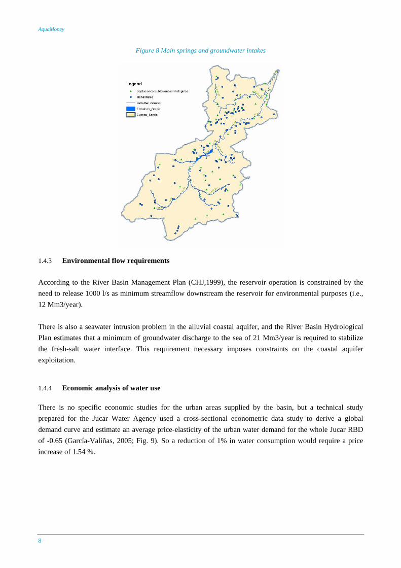
1.4.2 Origin of water use Table 10 shows the main source of supply for the main water uses in the basin. The main springs and groundwater intakes are shown in Fig. 8.
Table 10 Origins of water use (source: CHJ, 1999)
Use Origin Urban supply Groundwater - springs Agriculture Mix (surface and groundwater) Industry Groundwater (municipal supply network and wells) Hydropower Surface water
AquaMoney
8
Figure 8 Main springs and groundwater intakes
1.4.3 Environmental flow requirements According to the River Basin Management Plan (CHJ,1999), the reservoir operation is constrained by the need to release 1000 l/s as minimum streamflow downstream the reservoir for environmental purposes (i.e., 12 Mm3/year). There is also a seawater intrusion problem in the alluvial coastal aquifer, and the River Basin Hydrological Plan estimates that a minimum of groundwater discharge to the sea of 21 Mm3/year is required to stabilize the fresh-salt water interface. This requirement necessary imposes constraints on the coastal aquifer exploitation.
1.4.4 Economic analysis of water use There is no specific economic studies for the urban areas supplied by the basin, but a technical study prepared for the Jucar Water Agency used a cross-sectional econometric data study to derive a global demand curve and estimate an average price-elasticity of the urban water demand for the whole Jucar RBD of -0.65 (García-Valiñas, 2005; Fig. 9). So a reduction of 1% in water consumption would require a price increase of 1.54 %.

Case Study Report Serpis
9
Figure 9 Urban economic water demand curve
The total cost per habitant of the water supply and potable water treatment services, and the intake, conveyance, distribution, wastewater treatment and discharge, for the whole Jucar RBD, is approximately 120 €/year, with an average payment of 96 €. Most of the subsidies are located in water and wastewater treatments. The unit cost per cubic meter is 1.06 € (MMA, 2005). This figure does not include the cost of the sewer system, 0.42 €/m3, since this is not a cost strictly associated to urban domestic water supply. The average recovery of the costs of urban water services in 2002 was a 95% (MMA, 2005; see Fig. 10).
Figure 10 Cost recovery (% and €/m3) of water services in the Jucar RBD
(source: General Directorate of Water, Spain)
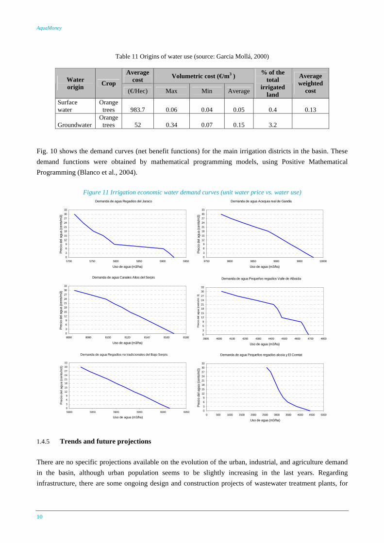
García-Mollá (2000) analyzed water demand in diverse irrigation districts in the Comunidad Valenciana autonomous region. Two important irrigation districts with surface water are included in the study: Comunidad de Regantes Alcoy-Bernisa and Canales Altos del Río Serpis, as well as several groundwater irrigation districts. The main crop is orange trees, about 90% of the area, and the rest consists mainly on fruit trees and vegetables. Table 11 shows irrigation costs.
AquaMoney
10
Table 11 Origins of water use (source: Garcia Mollá, 2000)
Average
cost Volumetric cost (€/m3 ) Water origin Crop
(€/Hec) Max Min Average
% of the total
irrigated land
Average weighted
cost
Surface water
Orange trees 983.7 0.06 0.04 0.05 0.4 0.13
Groundwater Orange
trees 52 0.34 0.07 0.15 3.2
Fig. 10 shows the demand curves (net benefit functions) for the main irrigation districts in the basin. These demand functions were obtained by mathematical programming models, using Positive Mathematical Programming (Blanco et al., 2004).
Figure 11 Irrigation economic water demand curves (unit water price vs. water use) Demanda de agua Regadíos del Jaraco
0369
1215182124273033
5700 5750 5800 5850 5900 5950
Uso de agua (m3/ha)
Prec
io d
el a
gua
(cen
ts/m
3)
Demanda de agua Acequia real de Gandía
0369
1215182124273033
9750 9800 9850 9900 9950 10000
Uso de agua (m3/ha)
Prec
io d
el a
gua
(cen
ts/m
3)
Demanda de agua Canales Altos del Serpis
0369
1215182124273033
8060 8080 8100 8120 8140 8160 8180
Uso de agua (m3/ha)
Prec
io d
el a
gua
(cen
ts/m
3)
Demanda de agua Pequeños regadíos Valle de Albaida
0369
1215182124273033
3900 4000 4100 4200 4300 4400 4500 4600 4700 4800
Uso de agua (m3/ha)
Pre
cio
del a
gua
(cen
ts/m
3)
Demanda de agua Regadíos no tradicionales del Bajo Serpis
0369
1215182124273033
5800 5850 5900 5950 6000 6050
Uso de agua (m3/ha)
Pre
cio
del a
gua
(cen
ts/m
3)
Demanda de agua Pequeños regadíos alcoia y El Comtat
0369
1215182124273033
0 500 1000 1500 2000 2500 3000 3500 4000 4500 5000
Uso de agua (m3/ha)
Prec
io d
el a
gua
(cen
ts/m
3)
1.4.5 Trends and future projections There are no specific projections available on the evolution of the urban, industrial, and agriculture demand in the basin, although urban population seems to be slightly increasing in the last years. Regarding infrastructure, there are some ongoing design and construction projects of wastewater treatment plants, for
Case Study Report Serpis
11
both, new plants or upgrading and expansion of existing plants. Also, two of the main WWT plants, Alcoy and Muro, will move to a more advance tertiary treatment with the aim of reusing wastewater from irrigation and industrial uses for irrigation purposes.
1.4.6 Water quality and environmental problems Water quality issues in the basin are mainly related pre-treated wastewater discharges from urban and agricultural uses. Water quality is usually better in the upstream water bodies. In the middle and lower basin, the water quality gets worse, mainly due to the polluted discharges from urban (Alcoy, Concentaina, Muro) and industrial areas in the upper basin, and from Gandia city in the lower basin. Probably the most important water quality problem occurs is the severe eutrophication process in Beniarres reservoir, located downstream the discharge of the urban and industrial areas of Alcoi, Concentaina, and Muro de Alcoy. It forms a hyper-eutrophic lake, with a high alga productivity level and intense alga bloom. This is affecting the current water use for irrigation and other possible uses. Under warm summer weather, a thermal stratification occurs, with the hypolimnion under anoxic conditions (without oxygen). This provokes fish kills in the reservoir. The eutrophication process is also causing the deterioration of aesthetic conditions, unpleasant odour and colour, the impossibility of recreation uses, etc. On the other hand, water impoundment in the Beniarrés reservoir improves downstream water quality; downstream, the status deteriorates again due to the previously mentioned industrial areas of the middle reaches. As previously discussed, groundwater is the basic source of urban water supply in the region. But there are sea water intrusion problems in the coastal aquifer (Plana de Gandía – Denia aquifer), and a high nitrate and ammonia concentration under irrigated lands, compromising it use for drinking water supply. Other water quality impacts are: - High abstraction pressure on the river - Issues on protected areas (fish life, 2000 Natura Network protected areas) - Morphological pressures (dams, weirs, channelling, etc.) But there are also specific water quantity problems: - Low guarantee of surface water supply for irrigation - Drought episodes - Eventual flood issues
AquaMoney
12
2. Pressure, impact and risk analysis
2.1 Significant pressures impacting on water status
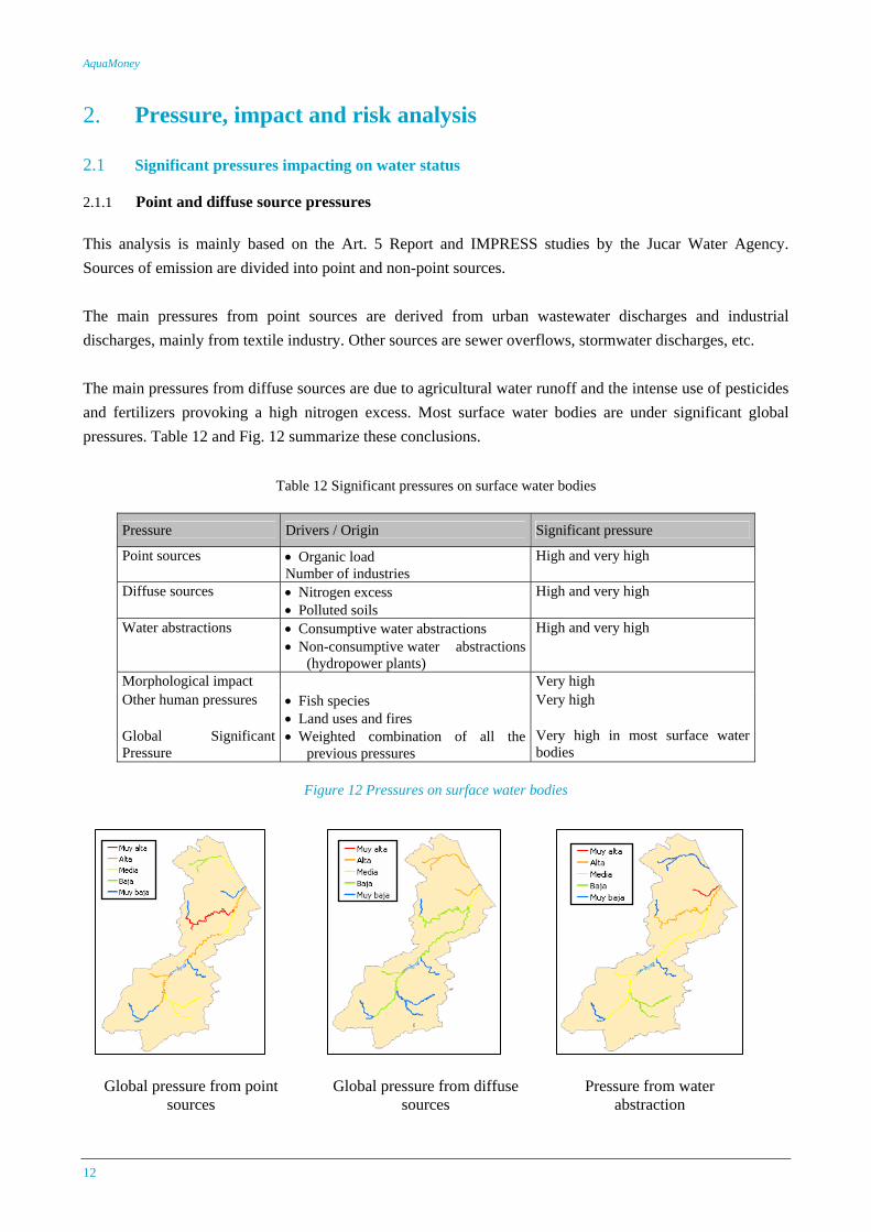
2.1.1 Point and diffuse source pressures This analysis is mainly based on the Art. 5 Report and IMPRESS studies by the Jucar Water Agency. Sources of emission are divided into point and non-point sources. The main pressures from point sources are derived from urban wastewater discharges and industrial discharges, mainly from textile industry. Other sources are sewer overflows, stormwater discharges, etc. The main pressures from diffuse sources are due to agricultural water runoff and the intense use of pesticides and fertilizers provoking a high nitrogen excess. Most surface water bodies are under significant global pressures. Table 12 and Fig. 12 summarize these conclusions.
Table 12 Significant pressures on surface water bodies
Pressure Drivers / Origin Significant pressure
Point sources • Organic load Number of industries
High and very high
Diffuse sources • Nitrogen excess • Polluted soils
High and very high
Water abstractions • Consumptive water abstractions • Non-consumptive water abstractions
(hydropower plants)
High and very high
Morphological impact Very high Other human pressures • Fish species
• Land uses and fires Very high
Global Significant Pressure
• Weighted combination of all the previous pressures
Very high in most surface water bodies
Figure 12 Pressures on surface water bodies
Global pressure from point sources
Global pressure from diffuse sources
Pressure from water abstraction
Case Study Report Serpis
13
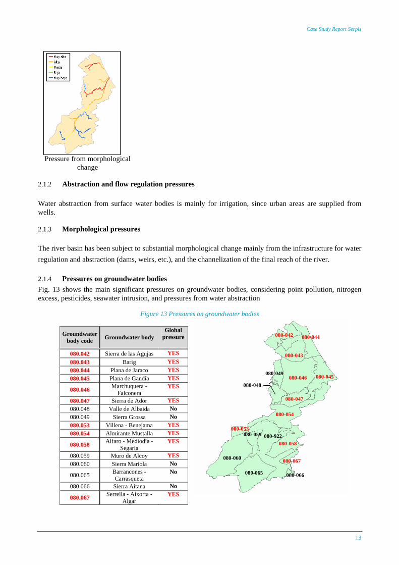
Pressure from morphological change
2.1.2 Abstraction and flow regulation pressures Water abstraction from surface water bodies is mainly for irrigation, since urban areas are supplied from wells.
2.1.3 Morphological pressures The river basin has been subject to substantial morphological change mainly from the infrastructure for water regulation and abstraction (dams, weirs, etc.), and the channelization of the final reach of the river.
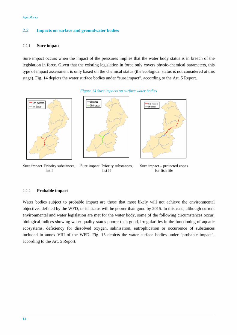
2.1.4 Pressures on groundwater bodies Fig. 13 shows the main significant pressures on groundwater bodies, considering point pollution, nitrogen excess, pesticides, seawater intrusion, and pressures from water abstraction
Figure 13 Pressures on groundwater bodies
Groundwater
body code Groundwater body Global
pressure
080.042 Sierra de las Agujas YES 080.043 Barig YES 080.044 Plana de Jaraco YES 080.045 Plana de Gandía YES
080.046 Marchuquera - Falconera
YES
080.047 Sierra de Ador YES 080.048 Valle de Albaida No 080.049 Sierra Grossa No 080.053 Villena - Benejama YES 080.054 Almirante Mustalla YES
080.058 Alfaro - Mediodía - Segaria
YES
080.059 Muro de Alcoy YES 080.060 Sierra Mariola No
080.065 Barrancones - Carrasqueta
No
080.066 Sierra Aitana No
080.067 Serrella - Aixorta - Algar
YES
080-042 080-044
080-043
080-045 080-046 080-049
080-047
080-054
080-053
080-058 080-922
080-067
080-066
080-059
080-065
080-060
080-048
AquaMoney
14
2.2 Impacts on surface and groundwater bodies
2.2.1 Sure impact Sure impact occurs when the impact of the pressures implies that the water body status is in breach of the legislation in force. Given that the existing legislation in force only covers physic-chemical parameters, this type of impact assessment is only based on the chemical status (the ecological status is not considered at this stage). Fig. 14 depicts the water surface bodies under “sure impact”, according to the Art. 5 Report.
Figure 14 Sure impacts on surface water bodies
Sure impact. Priority substances, list I
Sure impact. Priority substances, list II
Sure impact – protected zones for fish life
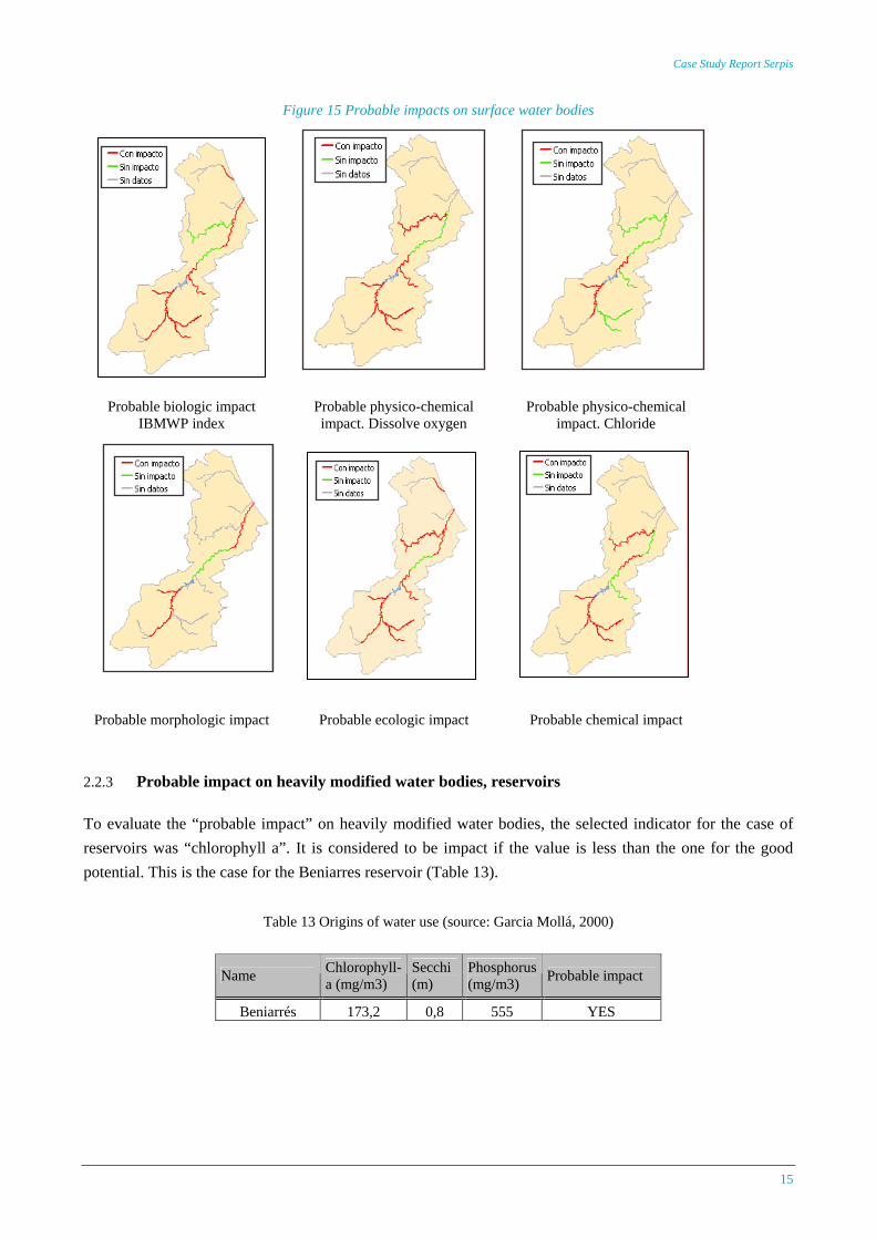
2.2.2 Probable impact Water bodies subject to probable impact are those that most likely will not achieve the environmental objectives defined by the WFD, or its status will be poorer than good by 2015. In this case, although current environmental and water legislation are met for the water body, some of the following circumstances occur: biological indices showing water quality status poorer than good, irregularities in the functioning of aquatic ecosystems, deficiency for dissolved oxygen, salinisation, eutrophication or occurrence of substances included in annex VIII of the WFD. Fig. 15 depicts the water surface bodies under “probable impact”, according to the Art. 5 Report.
Case Study Report Serpis
15
Figure 15 Probable impacts on surface water bodies
Probable biologic impact IBMWP index
Probable physico-chemical impact. Dissolve oxygen
Probable physico-chemical impact. Chloride
Probable morphologic impact Probable ecologic impact Probable chemical impact
2.2.3 Probable impact on heavily modified water bodies, reservoirs To evaluate the “probable impact” on heavily modified water bodies, the selected indicator for the case of reservoirs was “chlorophyll a”. It is considered to be impact if the value is less than the one for the good potential. This is the case for the Beniarres reservoir (Table 13).
Table 13 Origins of water use (source: Garcia Mollá, 2000)
Name Chlorophyll-a (mg/m3)
Secchi (m)
Phosphorus (mg/m3) Probable impact
Beniarrés 173,2 0,8 555 YES
AquaMoney
16
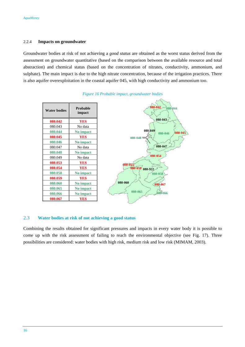
2.2.4 Impacts on groundwater Groundwater bodies at risk of not achieving a good status are obtained as the worst status derived from the assessment on groundwater quantitative (based on the comparison between the available resource and total abstraction) and chemical status (based on the concentration of nitrates, conductivity, ammonium, and sulphate). The main impact is due to the high nitrate concentration, because of the irrigation practices. There is also aquifer overexploitation in the coastal aquifer 045, with high conductivity and ammonium too.
Figure 16 Probable impact, groundwater bodies
080-042 080-044
080-043
080-045 080-046 080-049
080-047
080-054
080-053
080-058 080-922
080-067
080-066
080-059
080-065
080-060
080-048
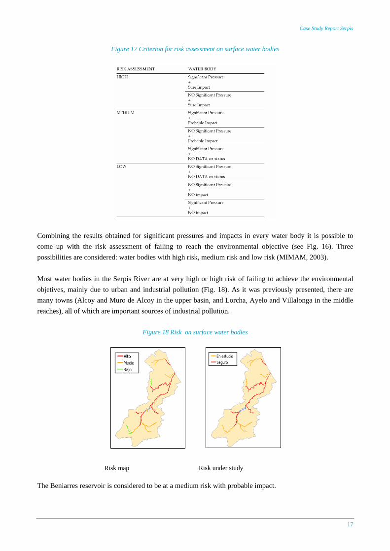
2.3 Water bodies at risk of not achieving a good status Combining the results obtained for significant pressures and impacts in every water body it is possible to come up with the risk assessment of failing to reach the environmental objective (see Fig. 17). Three possibilities are considered: water bodies with high risk, medium risk and low risk (MIMAM, 2003).
Water bodies Probable impact
080.042 YES 080.043 No data 080.044 No impact 080.045 YES 080.046 No impact 080.047 No data 080.048 No impact 080.049 No data 080.053 YES 080.054 YES 080.058 No impact 080.059 YES 080.060 No impact 080.065 No impact 080.066 No impact 080.067 YES
Case Study Report Serpis
17
Figure 17 Criterion for risk assessment on surface water bodies
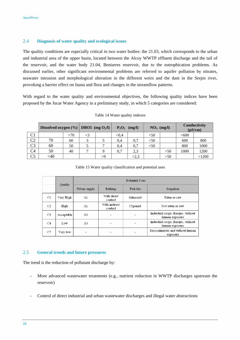
Combining the results obtained for significant pressures and impacts in every water body it is possible to come up with the risk assessment of failing to reach the environmental objective (see Fig. 16). Three possibilities are considered: water bodies with high risk, medium risk and low risk (MIMAM, 2003). Most water bodies in the Serpis River are at very high or high risk of failing to achieve the environmental objetives, mainly due to urban and industrial pollution (Fig. 18). As it was previously presented, there are many towns (Alcoy and Muro de Alcoy in the upper basin, and Lorcha, Ayelo and Villalonga in the middle reaches), all of which are important sources of industrial pollution.
Figure 18 Risk on surface water bodies
The Beniarres reservoir is considered to be at a medium risk with probable impact.
Risk map Risk under study
AquaMoney
18
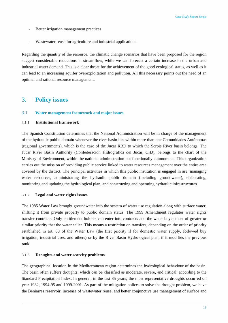
2.4 Diagnosis of water quality and ecological issues The quality conditions are especially critical in two water bodies: the 21.03, which corresponds to the urban and industrial area of the upper basin, located between the Alcoy WWTP effluent discharge and the tail of the reservoir, and the water body 21.04, Beniarres reservoir, due to the eutrophication problems. As discussed earlier, other significant environmental problems are referred to aquifer pollution by nitrates, seawater intrusion and morphological alteration in the different weirs and the dam in the Serpis river, provoking a barrier effect on fauna and flora and changes in the streamflow patterns. With regard to the water quality and environmental objectives, the following quality indices have been proposed by the Jucar Water Agency in a preliminary study, in which 5 categories are considered:
Table 14 Water quality indexes
Dissolved oxygen (%) DBO5 (mg O2/l) P2O5 (mg/l) NO3 (mg/l) Conductivity (µS/cm)
C1 >70 <3 <0,4 <50 <600 C2 70 60 3 5 0,4 0,7 <50 600 800 C3 60 50 5 7 0,4 0,7 <50 800 1000 C4 50 40 7 9 0,7 2,3 >50 1000 1200 C5 <40 >9 >2,3 >50 >1200
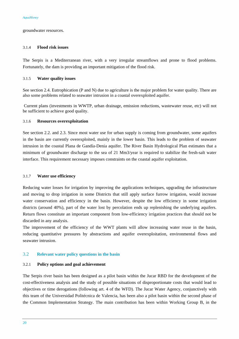
Table 15 Water quality classification and potential uses
2.5 General trends and future pressures The trend is the reduction of pollutant discharge by:
- More advanced wastewater treatments (e.g., nutrient reduction in WWTP discharges upstream the reservoir)
- Control of direct industrial and urban wastewater discharges and illegal water abstractions
Case Study Report Serpis
19
- Better irrigation management practices
- Wastewater reuse for agriculture and industrial applications Regarding the quantity of the resource, the climatic change scenarios that have been proposed for the region suggest considerable reductions in streamflow, while we can forecast a certain increase in the urban and industrial water demand. This is a clear threat for the achievement of the good ecological status, as well as it can lead to an increasing aquifer overexploitation and pollution. All this necessary points out the need of an optimal and rational resource management.
3. Policy issues
3.1 Water management framework and major issues
3.1.1 Institutional framework The Spanish Constitution determines that the National Administration will be in charge of the management of the hydraulic public domain whenever the river basin lies within more than one Comunidades Autónomas (regional governments), which is the case of the Jucar RBD to which the Serpis River basin belongs. The Jucar River Basin Authority (Confederación Hidrográfica del Júcar, CHJ), belongs to the chart of the Ministry of Environment, within the national administration but functionally autonomous. This organization carries out the mission of providing public service linked to water resources management over the entire area covered by the district. The principal activities in which this public institution is engaged in are: managing water resources, administrating the hydraulic public domain (including groundwater), elaborating, monitoring and updating the hydrological plan, and constructing and operating hydraulic infrastructures.
3.1.2 Legal and water rights issues The 1985 Water Law brought groundwater into the system of water use regulation along with surface water, shifting it from private property to public domain status. The 1999 Amendment regulates water rights transfer contracts. Only entitlement holders can enter into contracts and the water buyer must of greater or similar priority that the water seller. This means a restriction on transfers, depending on the order of priority established in art. 60 of the Water Law (the first priority if for domestic water supply, followed buy irrigation, industrial uses, and others) or by the River Basin Hydrological plan, if it modifies the previous rank.
3.1.3 Droughts and water scarcity problems The geographical location in the Mediterranean region determines the hydrological behaviour of the basin. The basin often suffers droughts, which can be classified as moderate, severe, and critical, according to the Standard Precipitation Index. In general, in the last 35 years, the most representative droughts occurred on year 1982, 1994-95 and 1999-2001. As part of the mitigation polices to solve the drought problem, we have the Beniarres reservoir, increase of wastewater reuse, and better conjunctive use management of surface and
AquaMoney
20
groundwater resources.
3.1.4 Flood risk issues The Serpis is a Mediterranean river, with a very irregular streamflows and prone to flood problems. Fortunately, the dam is providing an important mitigation of the flood risk.
3.1.5 Water quality issues See section 2.4. Eutrophication (P and N) due to agriculture is the major problem for water quality. There are also some problems related to seawater intrusion in a coastal overexploited aquifer. Current plans (investments in WWTP, urban drainage, emission reductions, wastewater reuse, etc) will not be sufficient to achieve good quality.
3.1.6 Resources overexploitation See section 2.2. and 2.3. Since most water use for urban supply is coming from groundwater, some aquifers in the basin are currently overexploited, mainly in the lower basin. This leads to the problem of seawater intrusion in the coastal Plana de Gandía-Denia aquifer. The River Basin Hydrological Plan estimates that a minimum of groundwater discharge to the sea of 21 Mm3/year is required to stabilize the fresh-salt water interface. This requirement necessary imposes constraints on the coastal aquifer exploitation.
3.1.7 Water use efficiency Reducing water losses for irrigation by improving the applications techniques, upgrading the infrastructure and moving to drop irrigation in some Districts that still apply surface furrow irrigation, would increase water conservation and efficiency in the basin. However, despite the low efficiency in some irrigation districts (around 40%), part of the water lost by percolation ends up replenishing the underlying aquifers. Return flows constitute an important component from low-efficiency irrigation practices that should not be discarded in any analysis. The improvement of the efficiency of the WWT plants will allow increasing water reuse in the basin, reducing quantitative pressures by abstractions and aquifer overexploitation, environmental flows and seawater intrusion. 3.2 Relevant water policy questions in the basin
3.2.1 Policy options and goal achievement The Serpis river basin has been designed as a pilot basin within the Jucar RBD for the development of the cost-effectiveness analysis and the study of possible situations of disproportionate costs that would lead to objectives or time derogations (following art. 4 of the WFD). The Jucar Water Agency, conjunctively with this team of the Universidad Politécnica de Valencia, has been also a pilot basin within the second phase of the Common Implementation Strategy. The main contribution has been within Working Group B, in the
Case Study Report Serpis
21
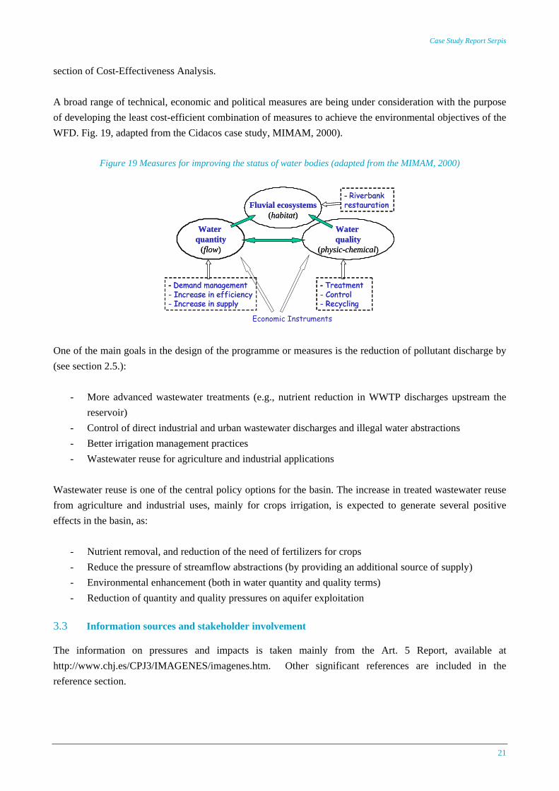
section of Cost-Effectiveness Analysis. A broad range of technical, economic and political measures are being under consideration with the purpose of developing the least cost-efficient combination of measures to achieve the environmental objectives of the WFD. Fig. 19, adapted from the Cidacos case study, MIMAM, 2000).
Figure 19 Measures for improving the status of water bodies (adapted from the MIMAM, 2000)
Waterquantity
(flow)
Waterquality
(physic-chemical)
Fluvial ecosystems(habitat)
- Demand management- Increase in efficiency- Increase in supply
- Treatment- Control- Recycling
- Riverbankrestauration
Waterquantity
(flow)
Waterquality
(physic-chemical)
Fluvial ecosystems(habitat)
- Demand management- Increase in efficiency- Increase in supply
- Treatment- Control- Recycling
- Riverbankrestauration
Economic Instruments
One of the main goals in the design of the programme or measures is the reduction of pollutant discharge by (see section 2.5.):
- More advanced wastewater treatments (e.g., nutrient reduction in WWTP discharges upstream the reservoir)
- Control of direct industrial and urban wastewater discharges and illegal water abstractions - Better irrigation management practices - Wastewater reuse for agriculture and industrial applications
Wastewater reuse is one of the central policy options for the basin. The increase in treated wastewater reuse from agriculture and industrial uses, mainly for crops irrigation, is expected to generate several positive effects in the basin, as:
- Nutrient removal, and reduction of the need of fertilizers for crops - Reduce the pressure of streamflow abstractions (by providing an additional source of supply) - Environmental enhancement (both in water quantity and quality terms) - Reduction of quantity and quality pressures on aquifer exploitation
3.3 Information sources and stakeholder involvement The information on pressures and impacts is taken mainly from the Art. 5 Report, available at http://www.chj.es/CPJ3/IMAGENES/imagenes.htm. Other significant references are included in the reference section.
AquaMoney
22
Monitoring data and GIS information is available from the GESHIDRO GIS-database, developed by the Jucar Water Agency. The identified stakeholders are: households (drinking water, recreation), industry (process water), agriculture (irrigation), recreation (fishing), and environmentalist groups.
4. Environmental and resource cost analysis and methodological issues
4.1 Main water-related goods and services provided in the basin Most important goods and services provided by the aquatic ecosystem include drinking water, irrigation water, recreation, and water used for industrial processes such as food processing, and textile and paper industry. Other services include nutrient storage and uptake, carbon sequestration, biodiversity and habitat, aesthetic values, flood protection, and water storage. 4.2 Possible benefits and cost from that water services The benefits provided by the aquatic ecosystem can be classified into use and non-use values. Following the classification proposed by NRC (1997), use values can be classified as extractive values (for surface water, mainly agricultural and industrial use values; others) and in-situ values (e.g., ecological values, buffer values, recreational values). In the case of groundwater, the extractive values correspond mainly to the municipal uses, and in-situ values involves buffer values, but also sea-water intrusion values(fundamental for coastal aquifers), and ecological and recreational values (since groundwater is feeding some wetlands, but also the river as baseflow). 4.3 Type of ERC analysis to performance Different interpretations have been given to the famous and controversial sentence of art. 9 of the WFD about the recovery of the costs of water services, including resource and environmental costs. The Jucar RBD, and in general, most of the south and east Mediterranean basins in Spain, have to deal not only with water quality issues, but also mainly with severe water quantity problems. Some of these rivers can even get completely dry during certain periods of the year when under a drought, as it happened to some reaches of the Jucar river during the 1994-94 drought. Of course, water quality is closely linked to water quantity, and water allocation decision have a great influence on water quality and the ecological status of the river. The WATECO Guidance (2002) defined environmental cost as the damage costs that water uses impose on the environment and ecosystems (including non-use values), and those who use the environment (use values). According to the conclusions of the ECO2 Group, environmental cost can be assessed as environmental damage cost or as damage avoidance (protection) cost (Brouwer 2004). Environmental costs can be also defined as the costs of not reaching good ecological status by 2015, using the GES as the reference condition for the definition of costs and benefits. The objective of our economic valuation study
Case Study Report Serpis
23
can be also the estimation of environmental and resource benefits of reaching good ecological status. This ERCB values can be included in the cost-effectiveness analysis to determine the WFD programme of measures, but also in a cost-benefit analysis of the identified WFD programme of measures to underpin possible derogation according to Article 4 and classification of Heavily Modified Water Bodies. The Ministry of Environment in Spain is about to approve a legally binding Technical Guidelines for the development of the new River Basin Management Plans (RBMP). In the last draft version of the Guidelines, resource cost is defined as “the opportunity cost or benefit forgone when a scarce resource is allocated to a use instead of other possible competing uses. This cost arises from an economically inefficient resource allocation in time or among users”. The information related with the economic efficiency of water use is very relevant in systems in which different uses compete for a scarce resource. Efficient water use is fundamentally about recognition of water’s opportunity costs (Griffin 2005). Theoretically, if water tariffs include this cost, an optimal resource allocation should be reached, marginal economic benefits of water would be equal across different uses, and society’s water related welfare would be maximized. Despite the concept’s apparent simplicity, measuring the opportunity cost of water is difficult. One option to simultaneously value and optimally allocate water may be to establish markets or tradable permits for water use or pollution. In the absence of well-functioning water markets, opportunity cost assessment requires “a systems approach and a number of more or less heroic assumptions about real impacts and responses to these” (Briscoe 1996). This assessment has to be based on a proper system to estimate the value of water for users in the system. In the mentioned Guidelines, environmental cost is defined as the additional cost of the measures to achieve the good ecological status, as a way to economically assess the gap between the BAU scenario and the environmental objectives. This is a practical, cost-based approach. However, the cost of imposing some measures, as for example, the maintenance of minimum ecological streamflows in the river (one of the main management decisions to achieve a good ecological status in rivers which severe low flow periods) have to be necessary defined in terms of opportunity cost. Minimum ecological streamflows impose changes in the system operation and water allocation; when these changes imply a reduction in the supply to other uses in the basin, an opportunity cost exists (in the sense of forgone benefits). A benefit-based definition of resource and environmental cost as the foregone benefit of not reaching the GES (or, what is the same, the benefits from reaching the GES) would require the contribution of direct (e.g., contingent valuation) or indirect (e.g., travel cost or hedonic pricing) environmental valuation methods.
4.4 Proposed methods and tools for the valuation of ERC: A combination of different methods and tools is expected for the valuation of ERBC. Hydro-economic models provide useful tools for a systematic assessment of the resource opportunity cost and the opportunity cost of the management measures required to achieve the environmental objectives (eg., minimum streamflow) in a water resources system. Theses values change dynamically in space and time.
AquaMoney
24
The integrated hydro-economic model can be developed “ad-hoc” for a specific system, or we can resort to the use of generic tools integrated in Decision Support Systems (DSS). New modules have been integrated in the DSS AQUATOOL, incorporating tools to apply the proposed methodology. AQUATOOL (Andreu et al., 1996) is a generalized DSS for integrated water resources planning and management. Using the AQUATOOL software, an integrated hydro-economic simulation model is currently being developed for the Serpis river basin, including simulation of water quantity and quality in the basin for both, surface and groundwater resources. The main water uses and hydraulic infrastructure is represented in the model. Demands are economically represented using economic demand (net benefit) functions for agricultural, industrial and urban uses. Legal and institutional constraints are incorporated to the model. We can also impose water quantity-quality constraints to reach a GES, and calculate the corresponding forgone benefits (opportunity costs). Inductive methods will be also used for valuing environmental water goods/services • Stated preferences methods (CV, choice experiments) • Benefits transfer Stated preference methods (choice experiment and/or contingent valuation) will be used to assess use and non-use values (as willingness to pay) associated with reaching a good ecological status in 2015. The main tools for analysis are: • Surveys (for the stated preference methods) • Statistical techniques (regression analysis) • GIS based value mapping
4.5 Some practical and methodological issues Some practical and methodological issues are: • Availability of good data on water status, pressures and impacts, and socioeconomic environment • Spatial and temporal aggregation for the economic analysis of the river basin water quality and quantity
issues • The way to deal with uncertainty issues • Integration of the different economic valuation tools and techniques for the final definition of ERCB
values
Case Study Report Serpis
25
5. References
• Andreu, J; J, Capilla; J. Ferrer; A. Solera.1996 Sistema Soporte de Decisión AQUATOOL. Universidad Politécnica de Valencia. Escuela Técnico Superior de Caminos, Canales y Puertos. Departamento de Ingeniería Hidráulica y Medio Ambiente. Valencia.
• Confederación Hidrográfica del Júcar. Oficina de Planificación Hidrológica. 2005. GesHidro. Soporte
digital Base de Datos y SIG. Valencia. • Confederación Hidrográfica del Júcar. Oficina de Planificación Hidrológica. 2005. Informa para la
Comisión Europea sobre los Artículos 5 y 6 de la Directiva Marco del Agua. Demarcación Hidrográfica del Júcar. Valencia
• Freeman, A.M. III, 2003. The measurement of environmental and resource values. Theory and methods.
Resources for the Future, Washington, DC. • García-Mollá, Marta. 2000. Análisis de la influencia de los costes en el consumo del agua en la
agricultura Valenciana. Caracterización de las entidades asociativas para riego. Tesis Doctoral. Universidad Politécnica de Valencia. Departamento de Economía y Ciencias Sociales. Valencia.
• Griffin, R.C., 2005. Water resource economics. The analysis of scarcity policies and projects. MIT press.
Cambridge, Massachusetts, USA. 402 pp. • Hernández Crespo, Carmen. 2006. Estudio de la calidad de las aguas en el embalse de Beniarrés
(Alicante) mediante el desarrollo de modelos de calidad de aguas superficiales. Ejercicio Final de Carrera Tipo II. Universidad Politécnica de Valencia. Escuela Técnico Superior de Caminos, Canales y Puertos. Valencia.
• Jenkins, M.W., J.R. Lund, and R.E. Howitt, 2003. Using economic loss functions to value urban water
scarcity in California. Jrnl. American Water Works Association, 95(2), 58-70 • Ministerio de Medio Ambiente. Confederación Hidrográfica del Júcar. 1999. Plan Hidrológico de Cuenca
del Júcar. Anejo Nº 4. Sistemas de Explotación. Madrid. • Villalobos de Alba, Ángel Alfonso. 2007. Análisis y de distintos tipos de sequía en la cuenca del río
Júcar. Tesis Doctoral. Universidad Politécnica de Valencia. Escuela Técnico Superior de Caminos, Canales y Puertos. Departamento de Ingeniería Hidráulica y Medio Ambiente. Valencia.
• WATECO, 2002. Economics and the Environment. The implementation challenge of the Water
Framework Directive. A Guidance Document. Guidance document N.1, Common Implementation Strategy for the Implementation of the Water Framework Directive, European Commission 2002.
• Young, R., 2005. Determining the economic value of water: concepts and methods. Resources for the
Future, Washington, DC.