Embed Size (px)
Citation preview

Case study of climatic changes in Martian fluvial systemsat Xanthe Terra
Akos KereszturiKonkoly Thege Miklos Astronomical Institute, Research Centre for Astronomy and Earth Sciences, Hungarian Academy of Sciences,Konkoly Thege M. 15-17, H-1121 Budapest, Hungary
a r t i c l e i n f o
Article history:Received 24 June 2013Received in revised form8 March 2014Accepted 18 March 2014Available online 29 March 2014
Keywords:MarsWaterValleyFluvial geomorphology
a b s t r a c t
An unnamed valley system was analyzed in Xanthe Terra south of Havel Vallis on Mars where threeseparate episodes of fluvial activity could be identified with different morphology, water source anderosional processes, inferring formation under different climatic conditions. The oldest scattered valleys(1. group) form interconnecting network and suggest areally distributed water source. Later two valleytypes formed from confined water source partly supported by possible subsurface water. The smallerupper reaches (2. group) with three separate segments and also a similar aged but areal washed terrainsuggest contribution from shallow subsurface inflow. These valleys fed the main channel (3. group),which morphology (wide, theater shaped source, few tributaries, steep walls) is the most compatiblewith the subsurface sapping origin. While the first valley group formed in the Noachian, the other two,more confined groups are younger. Their crater density based age value is uncertain, and could be only1200 million years. After these three fluvial episodes etch pitted, heavily eroded terrain formed possiblyby ice sublimation driven collapse. More recently (60–200 million years ago) dunes covered the bottomof the valleys, and finally the youngest event took place when mass movements produced debris coveredthe valleys' slopes with sediments along their wall around 5–15 million years ago, suggesting windactivity finished earlier than the mass movements in the region. This small area represents the sequenceof events probably appeared on global scale: the general cooling and drying environment of Mars.
Comparing the longitudinal profiles here to other valleys in Xanthe Terra, convex shaped valleyprofiles are usually connected to steep terrains. The location of erosional base might play an importantrole in their formation that can be produced convex shapes where the erosional base descendedtopographically (by deep impact crater or deep outflow channel formation) as time passed by. Theanalysis of such nearby systems that probably witnessed similar climatic forces in the past, providesideal possibility to identify reasons and geomorphological context of longitudinal profile shapeformation for fluvial valleys in general.
& 2014 Elsevier Ltd. All rights reserved.
1. Introduction
Valleys, outflow channels and various fluvial sedimentaryfeatures provide important points to elucidate the past existenceof liquid water on Mars. This work aims the comparative analysisof some valleys in Xanthe Terra, focusing on a previously unex-amined system. The reason for this analysis is to give more insightinto the possible differences in the formation of different valleysections, and understand the two morphological types in theregion like those were identified in Tyras Vallis (Kereszturi,2005) and several tributaries of Shalbatana Vallis (Kereszturi,2011) previously. These two sections consist of an upper shallow,
narrow, low slope angle, almost straight longitudinal profile part;and a lower, wider, deeper, steeper, occasionally convex shapedreach. These two sections were possibly formed under differentperiods and conditions, but the information from the analysis ofthese few valleys is not enough to elucidate the reasons for thesedifferences. The valley system analyzed in this work might providemore information on this question, and the different valleysections could also give insight into the change of fluvial surfacemodification method around the Noachian/Hesperian boundary.
Valley networks on the Mars has been attributed dominantly tosurface runoff (Craddock and Howard, 2002; Irwin and Howard,2002), groundwater sapping (Carr, 1981; Carr and Malin, 2000;Goldspiel and Squyres, 2000; Grant, 2000) or a combination ofrunoff and sapping (first suggested by Milton (1973)). Despite thegreat sum of available information, their origin is still not clear.
Contents lists available at ScienceDirect
journal homepage: www.elsevier.com/locate/pss
Planetary and Space Science
http://dx.doi.org/10.1016/j.pss.2014.03.0140032-0633/& 2014 Elsevier Ltd. All rights reserved.
E-mail address: [email protected]
Planetary and Space Science 96 (2014) 35–50
Sharp and Malin (1975) also suggested some channels withdendritic tributaries could be formed by runoff fed seepage andheadward growth by sapping. High degree of branching for somechannels on the plateau and canyons of the Valles Marineris favorthe atmospheric precipitation origin, and their mature appearancesuggest flow over long periods (Mangold et al., 2004). Fluvialstructures like terraces suggest multiple periods of formation, andthe complex network morphology, as well as the correlation withother fluviosedimentary features and chloride salts suggestextended activity periods (Hynek et al., 2010).
Despite this information, beside the origin, paleodischargevalues (Irwin et al., 2005) and other characteristics, including theduration of their active period (Kereszturi, 2012) are poorlyknown. It is also uncertain in many cases, which structures arevalleys (elongated depressions that were presumably carved overtime by water, but were never full of water) and which are riverchannels (once filled with water). Most valley networks formedaround the Noachian/Hesperian boundary (Hynek et al., 2010), butthere was valley formation in later episodes even during Amazo-nian ages (Fasset and Head, 2008) occasionally, although there areindications that suggest that the style of post Noachian activitydiffers from the later type (Howard et al., 2005).
Based on earlier studies (Erkeling et al., 2012; Mangold et al.,2012) the detailed analysis of certain valleys and networks isimportant, as they help to reconstruct the changing role of fluvialerosion in the geological history of Mars (Moore et al., 2012; Parsonset al., 2012). The aim of this work is the survey of a valley system thathas not been yet analyzed in details before, and to compare it tosome channels nearby, as such research may help to reconstruct thechange in the fluvial activity and erosional method.
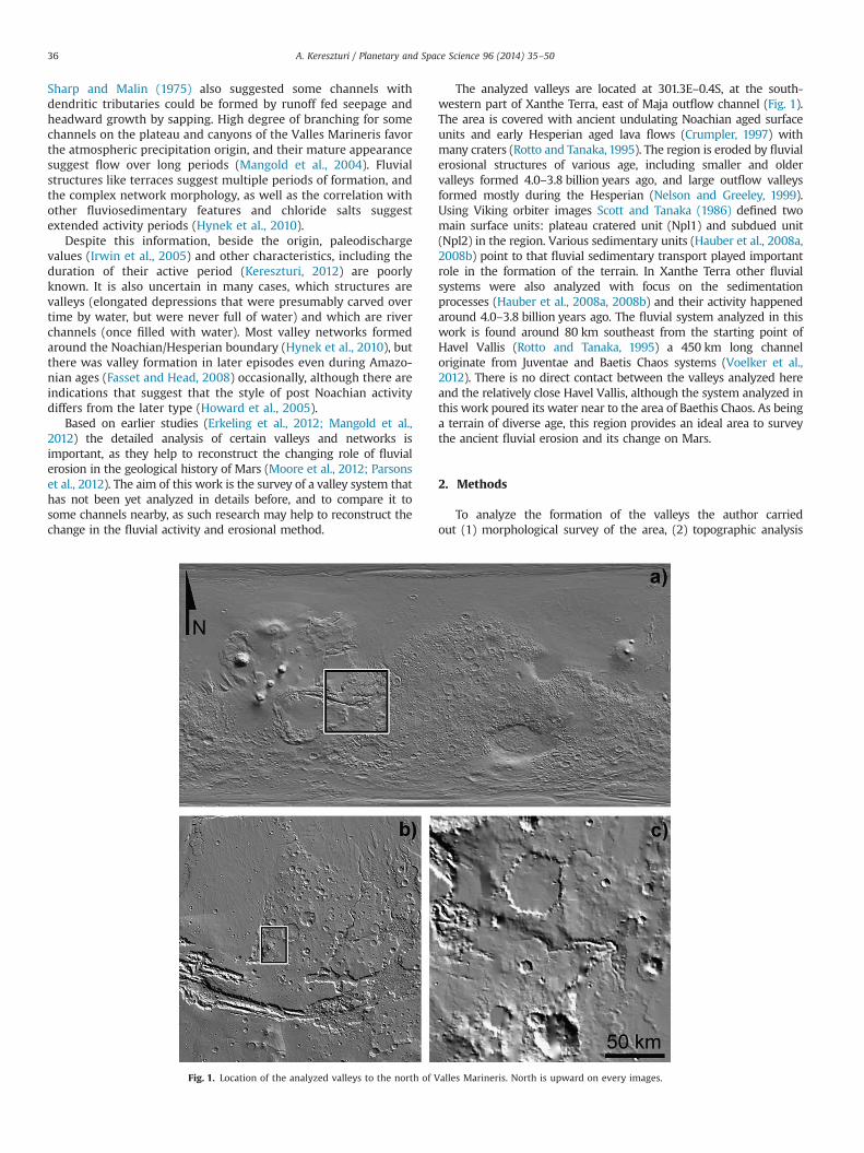
The analyzed valleys are located at 301.3E–0.4S, at the south-western part of Xanthe Terra, east of Maja outflow channel (Fig. 1).The area is covered with ancient undulating Noachian aged surfaceunits and early Hesperian aged lava flows (Crumpler, 1997) withmany craters (Rotto and Tanaka, 1995). The region is eroded by fluvialerosional structures of various age, including smaller and oldervalleys formed 4.0–3.8 billion years ago, and large outflow valleysformed mostly during the Hesperian (Nelson and Greeley, 1999).Using Viking orbiter images Scott and Tanaka (1986) defined twomain surface units: plateau cratered unit (Npl1) and subdued unit(Npl2) in the region. Various sedimentary units (Hauber et al., 2008a,2008b) point to that fluvial sedimentary transport played importantrole in the formation of the terrain. In Xanthe Terra other fluvialsystems were also analyzed with focus on the sedimentationprocesses (Hauber et al., 2008a, 2008b) and their activity happenedaround 4.0–3.8 billion years ago. The fluvial system analyzed in thiswork is found around 80 km southeast from the starting point ofHavel Vallis (Rotto and Tanaka, 1995) a 450 km long channeloriginate from Juventae and Baetis Chaos systems (Voelker et al.,2012). There is no direct contact between the valleys analyzed hereand the relatively close Havel Vallis, although the system analyzed inthis work poured its water near to the area of Baethis Chaos. As beinga terrain of diverse age, this region provides an ideal area to surveythe ancient fluvial erosion and its change on Mars.
2. Methods
To analyze the formation of the valleys the author carriedout (1) morphological survey of the area, (2) topographic analysis
Fig. 1. Location of the analyzed valleys to the north of Valles Marineris. North is upward on every images.
A. Kereszturi / Planetary and Space Science 96 (2014) 35–5036

of cross-sectional and longitudinal profiles, (3) crater size frequencydistribution analysis for age estimation. The joint and complexanalysis of these parameters provides useful results to elucidatesome basic characteristics of the fluvial surface modification on Marsand also temporal changes of climate.
To survey the morphology, HRSC images acquired by the MarsExpress (MEX) (Chicarro et al., 2004; Neukum and Jaumann, 2004),and CTX as well as HiRISE images acquired by the Mars Reconnais-sance Orbiter (MRO) spacecrafts (McEwen et al., 2007; Malin et al.,2007) were used. For the topographic analysis MOLA PEDR data withprocessing version L (Smith et al., 1999) with IAU2000 planetocentriccoordinates, referenced to the latest Mars gravity model; and alsoHRSC based DTMs were used (Neukum et al., 2004; Jaumann et al.,2007; Gwinner et al., 2010; Dumke et al., 2008), the later wascompiled by Freie Univeristy and DLR. These two datasets are idealfor different purposes: where the MOLA tracks show high spatialdensity, they provide more detailed result and were used instead ofHRSC DTM, and vice versa. In the case of the analysis of longitudinalprofile (that spans for relatively large distance) both datasets wereused (see the comparison in the Results section).
During the work the following numerical parameters weremeasured: depth, width, and longitudinal slope angle of thevalleys. The estimated radial accuracy of the topography data fromMOLA is 30–40 cm and is dominated by long-wavelength orbitaluncertainties of MGS, but here the height differences of neighbor-ing data points made the error substantially smaller. The precisionof MOLA measurement approaches 30 cm on smooth level sur-faces and increases to about 20 m on slopes. Beyond the errors inthe database, the manual pointing also causes errors. In the case ofheight determination, the horizontal distance of 200–300 mbetween the neighboring MOLA shots influences the used heightvalues on steep terrain. The geometric accuracy of HRSC DTMvaries with terrain characteristics, and the measured standarddeviation against MOLA tracks is about 20 m (Heipke et al., 2007).HRSC based topographic data could provide more accurate resultsabove all on steep terrains. All of the numerical values acquiredduring this work served as basis for statistical analysis.
For the extraction of cross sectional profiles individual MOLAtracks were used, corrected to the incidence angle of that trackwith the analyzed channel's longitudinal axis, and it was trans-formed to such a shape what is representative if the track wouldhave been perpendicular to the channel's longitudinal axis. Herethe spatial density of profiles along the channel was not constant,e.g. some profiles are closer, some are farther from the next one.The longitudinal profile was acquired from HRSD DTM as here theaim was to have a more homogenous sampling. Here the deepestpoints of the cross-sectional profiles were identified and arrangedaccording to the distance along the channel from its source.
3. Results
Despite this is a small channel system on Mars, it turned to be acomplex one, composed of sections with different morphology andpossibly age, thus it holds information on the changes of fluvialactivity. At the same time to exploit the information on such asmall system where errors and uncertainties cannot be neglected,the author compared its basic characteristics to other, channelsresemble (in size and morphology) in the region. The comparisonto other valley systems in the region can be read in the Discussionsection, as well as details using Earth analogs.
Fig. 1. shows the analyzed location on three MOLA based mapsections. The surrounding of the target terrain with higherresolution can be seen in Fig. 2. on a HRSC image (1918_0000) toprovide regional context and to indentify the classified types ofsurface units used in this work. This region of Xanthe Terra is
underrepresented regarding the high resolution (HiRISE, and SRC)observations, as a result during the work the author mostly usedHRSC and CTX images. Analyzing the connection between thetopography of the terrain and the location and track of thechannels, the following general findings can be drawn. Smalltributaries of the main channels start from the south (lower part)and migrate toward the middle of the image. After they merge,forming the deep, main channel, the main channel takes a largeforced curvature toward the left along the edge of an elevated andelongated ridge that runs from southwest toward northeast. Afterfinished this turn to the left (west) the channel makes twocurvatures, around two smaller heights at the north (details canbe seen in the topographic map of Fig. 5.) and finally in disappearsin a wide, unconfined depression (bracketed terrain in Fig. 5.).There are several fluvial systems scattered in this region (includingTyras (Di Achille et al., 2006) and Nanedi (Gregoire-Mazzocco etal., 2006)) but they are relatively separated from each other at theorder of 100 km distances.
During the morphological analysis the author surveyed thefluvial structures of the target region and classified them accord-ing to their appearance and superpositional relationship. Suchmeasurements provide information both on the style of fluvialerosion and on the erodibility of the surface material. As it is notthe aim of this work to provide a detailed stratigraphic analysis ofall features in this area, but only the focused inspection of fluviallandforms, the surface units were identified and analyzed onlyaccording to how much are they related to the fluvial erosion inthe area. In this section the cross sectional profiles' are outlinedfirstly, than the longitudinal profiles secondly. Thirdly theseparameters are analyzed in connection with the image basedmorphology.
3.1. Classification of fluvial structures
The analyzed valleys were classified into the following threegroups arbitrary by the author that could be regarded only as“informal classes” for this paper (their detailed characterizationsee later):
� main valley: deep, wide valley, the most prominent one in theanalyzed area, that can be taken as the lower reach of the uppertributary valleys described below (acronym: MV),
� upper tributaries of the main valley: shallower and narrowertributaries at the upper reaches of the MV (acronym: UT),
� small scattered valleys: smaller then MV and UV units, that arepresent only on the oldest terrain and they eroded the area asdense network of small valleys. They rarely have connectionwith the MV or UT (acronym: SV).
It was not evident to identify fluvial structures everywhere inthis terrain, as different parts of the area were eroded and altereddifferently in the past. The author identified those surface structuresas fluvial valleys where the elongated depression could be followedfirmly longer than 1 km length, and also showed somewhat sinuos-ing (not straight) track and connected to other similar structures in abranching pattern. In several cases the surface appearance suggeststhe presence of more ancient fluvial valleys – but probably because oflater surface alteration they were uncertain and difficult to identify.Examples for the surface morphology of the valley types areindicated as 5�5 km2 sized inset images in Fig. 3. The followinggeneral findings are characteristic for the identified surface units.
Main valley (MV): deep and wide valley (MV1, MV2 insets inFig. 3.), it is the dominant valley in the analyzed region, noresemble other one exists there. It has steep walls, and often dunecovered bottom level. The termination of the MV does not showany obvious sedimentary feature (MV5), and it vanishes smoothly
A. Kereszturi / Planetary and Space Science 96 (2014) 35–50 37
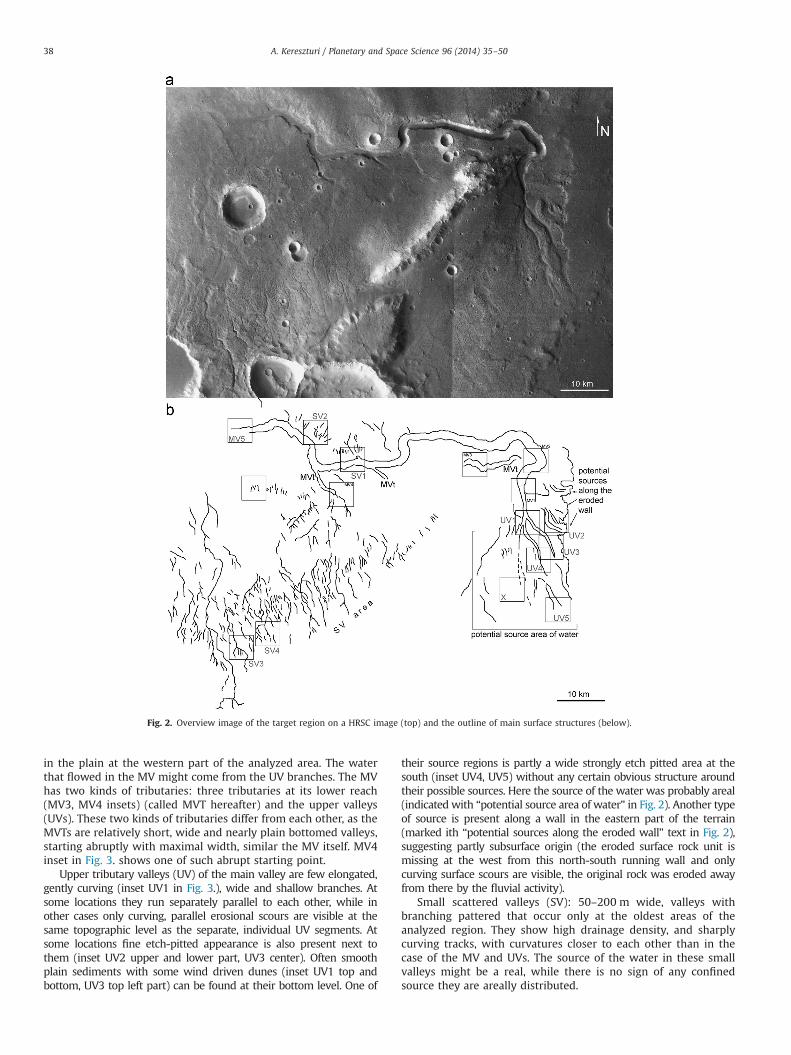
in the plain at the western part of the analyzed area. The waterthat flowed in the MV might come from the UV branches. The MVhas two kinds of tributaries: three tributaries at its lower reach(MV3, MV4 insets) (called MVT hereafter) and the upper valleys(UVs). These two kinds of tributaries differ from each other, as theMVTs are relatively short, wide and nearly plain bottomed valleys,starting abruptly with maximal width, similar the MV itself. MV4inset in Fig. 3. shows one of such abrupt starting point.
Upper tributary valleys (UV) of the main valley are few elongated,gently curving (inset UV1 in Fig. 3.), wide and shallow branches. Atsome locations they run separately parallel to each other, while inother cases only curving, parallel erosional scours are visible at thesame topographic level as the separate, individual UV segments. Atsome locations fine etch-pitted appearance is also present next tothem (inset UV2 upper and lower part, UV3 center). Often smoothplain sediments with some wind driven dunes (inset UV1 top andbottom, UV3 top left part) can be found at their bottom level. One of
their source regions is partly a wide strongly etch pitted area at thesouth (inset UV4, UV5) without any certain obvious structure aroundtheir possible sources. Here the source of the water was probably areal(indicated with “potential source area of water” in Fig. 2). Another typeof source is present along a wall in the eastern part of the terrain(marked ith “potential sources along the eroded wall” text in Fig. 2),suggesting partly subsurface origin (the eroded surface rock unit ismissing at the west from this north-south running wall and onlycurving surface scours are visible, the original rock was eroded awayfrom there by the fluvial activity).
Small scattered valleys (SV): 50–200 m wide, valleys withbranching pattered that occur only at the oldest areas of theanalyzed region. They show high drainage density, and sharplycurving tracks, with curvatures closer to each other than in thecase of the MV and UVs. The source of the water in these smallvalleys might be a real, while there is no sign of any confinedsource they are areally distributed.
Fig. 2. Overview image of the target region on a HRSC image (top) and the outline of main surface structures (below).
A. Kereszturi / Planetary and Space Science 96 (2014) 35–5038
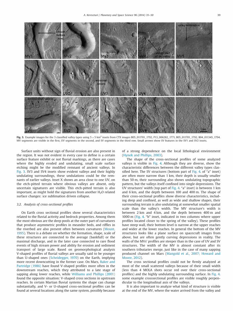
Surface units without sign of fluvial erosion are also present inthe region. It was not evident in every case to define is a certainsurface feature exhibit or not fluvial markings, as there are caseswhere the highly eroded and undulating, small scale surfaceetching might be the modified remnant of ancient valleys. InFig. 3. SV3 and SV4 insets show evident valleys and their highlyundulating surroundings, these undulations could be the rem-nants of earlier valleys. Inset X shows an area close to one UV, onthe etch-pitted terrain where obvious valleys are absent, onlyuncertain signatures are visible. This etch-pitted terrain is alsoimportant, as might hold the signatures from another H2O relatedsurface changes: ice sublimation driven collapse.
3.2. Analysis of cross-sectional profiles
On Earth cross sectional profiles show several characteristicsrelated to the fluvial activity and bedrock properties. Among themthe most obvious are the deep pools at the outer part of curvaturesthat produce asymmetric profiles in meander beds, and riffles inthe riverbed are also present often between curvatures (Mount,1995). There is a debate on whether the formation, shape, scale ofthese structures are connected to the average (bankfull) or themaximal discharge, and in the later case connected to rare floodevents of high stream power and ability for erosion and sedimenttransport of large scale. Based on geomorphological analysisV-shaped profiles of fluvial valleys are usually said to be youngerthan U-shaped ones (Scheidegger, 1970) on the Earth, implyingmore recent downcutting in the former case. On Mars, Baker andPartridge (1986) have found V-shaped profiles more often in thedownstream reaches, which they attributed to a late stage ofsapping along lower reaches, while Williams and Phillips (2001)found the opposite situation: V-shaped cross sections in upstreamreaches. In certain Martian fluvial systems the shape can changesubstantially, and V- or U-shaped cross-sectional profiles can befound at several locations along the same system, possibly because
of a strong dependence on the local lithological environment(Hynek and Phillips, 2003).
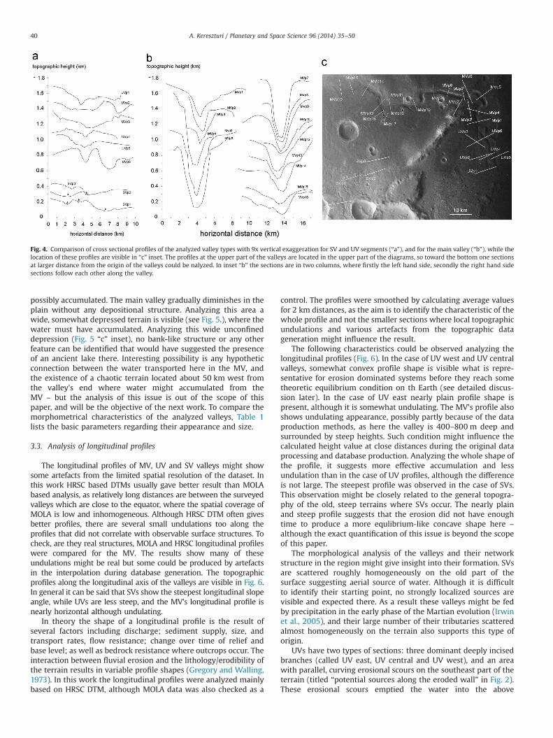
The shape of the cross-sectional profiles of some analyzedvalleys is visible in Fig. 4. Although they are diverse, show thecharacteristic differences between the different valley types clas-sified here. The SV structures (bottom part of Fig. 4. of “a” inset)are often more narrow than 1 km, their depth is usually smallerthan 50 m, their surrounding also shows undulating topographicpattern, but the valleys itself confined into single depressions. TheUV structures' width (top part of Fig. 4. “a” inset) is between 1 kmand 6 km, and the depth between 100 and 400 m. The shape oftheir cross-sectional profiles show diverse characteristics, includ-ing deep and confined, as well as wide and shallow shapes, theirsurrounding terrain is also undulating at somewhat smaller spatialscale than the valley's width. The MV structure's width isbetween 2 km and 4 km, and the depth between 400 m and1000 m (Fig. 4. “b” inset, indicated in two columns where upperprofiles located closer to the spring of the valley). These profileshave steep wall, their bottom level is narrow at the upper reachesand wider at the lower reaches. In general the bottom of the MVstructures looks like a plane surface on spacecraft images fromabove, but are often gently curving depressions in reality. Thewalls of the MVs' profiles are steeper than in the case of UV and SVstructures. The width of the MV is almost constant after itssouthern tributaries merge, just like in the case of many sappingproduced channel on Mars (Mangold et al., 2007; Howard andMoore, 2012).
The cross sectional profiles could not be firmly analyzed atmost of the small scattered valleys because of their small width(less than 4 MOLA shots occur red over their cross-sectionalprofiles) and the highly undulating surrounding surface. In Fig. 4.some example crosssectional profiles are visible roughly perpen-dicular to the longitudinal axis of the valleys.
It is also important to analyze what kind of structure is visibleat the end of the MV, where the water arrived from the valley and
Fig. 3. Example images for the 3 classified valley types using 5�5 km2 insets from CTX images B05_011701_1792, P13_006282_1771, B05_011701_1792, B04_011345_1794.MV segments are visible in the first, UV segments in the second, and SV segments in the third row. Small arrows show SV features in the SV1 and SV2 insets.
A. Kereszturi / Planetary and Space Science 96 (2014) 35–50 39
possibly accumulated. The main valley gradually diminishes in theplain without any depositional structure. Analyzing this area awide, somewhat depressed terrain is visible (see Fig. 5.), where thewater must have accumulated. Analyzing this wide unconfineddepression (Fig. 5 “c” inset), no bank-like structure or any otherfeature can be identified that would have suggested the presenceof an ancient lake there. Interesting possibility is any hypotheticconnection between the water transported here in the MV, andthe existence of a chaotic terrain located about 50 km west fromthe valley's end where water might accumulated from theMV – but the analysis of this issue is out of the scope of thispaper, and will be the objective of the next work. To compare themorphometrical characteristics of the analyzed valleys, Table 1lists the basic parameters regarding their appearance and size.
3.3. Analysis of longitudinal profiles
The longitudinal profiles of MV, UV and SV valleys might showsome artefacts from the limited spatial resolution of the dataset. Inthis work HRSC based DTMs usually gave better result than MOLAbased analysis, as relatively long distances are between the surveyedvalleys which are close to the equator, where the spatial coverage ofMOLA is low and inhomogeneous. Although HRSC DTM often givesbetter profiles, there are several small undulations too along theprofiles that did not correlate with observable surface structures. Tocheck, are they real structures, MOLA and HRSC longitudinal profileswere compared for the MV. The results show many of theseundulations might be real but some could be produced by artefactsin the interpolation during database generation. The topographicprofiles along the longitudinal axis of the valleys are visible in Fig. 6.In general it can be said that SVs show the steepest longitudinal slopeangle, while UVs are less steep, and the MV's longitudinal profile isnearly horizontal although undulating.
In theory the shape of a longitudinal profile is the result ofseveral factors including discharge; sediment supply, size, andtransport rates, flow resistance; change over time of relief andbase level; as well as bedrock resistance where outcrops occur. Theinteraction between fluvial erosion and the lithology/erodibility ofthe terrain results in variable profile shapes (Gregory and Walling,1973). In this work the longitudinal profiles were analyzed mainlybased on HRSC DTM, although MOLA data was also checked as a
control. The profiles were smoothed by calculating average valuesfor 2 km distances, as the aim is to identify the characteristic of thewhole profile and not the smaller sections where local topographicundulations and various artefacts from the topographic datageneration might influence the result.
The following characteristics could be observed analyzing thelongitudinal profiles (Fig. 6). In the case of UV west and UV centralvalleys, somewhat convex profile shape is visible what is repre-sentative for erosion dominated systems before they reach sometheoretic equilibrium condition on th Earth (see detailed discus-sion later). In the case of UV east nearly plain profile shape ispresent, although it is somewhat undulating. The MV's profile alsoshows undulating appearance, possibly partly because of the dataproduction methods, as here the valley is 400–800 m deep andsurrounded by steep heights. Such condition might influence thecalculated height value at close distances during the original dataprocessing and database production. Analyzing the whole shape ofthe profile, it suggests more effective accumulation and lessundulation than in the case of UV profiles, although the differenceis not large. The steepest profile was observed in the case of SVs.This observation might be closely related to the general topogra-phy of the old, steep terrains where SVs occur. The nearly plainand steep profile suggests that the erosion did not have enoughtime to produce a more equlibrium-like concave shape here –
although the exact quantification of this issue is beyond the scopeof this paper.
The morphological analysis of the valleys and their networkstructure in the region might give insight into their formation. SVsare scattered roughly homogeneously on the old part of thesurface suggesting aerial source of water. Although it is difficultto identify their starting point, no strongly localized sources arevisible and expected there. As a result these valleys might be fedby precipitation in the early phase of the Martian evolution (Irwinet al., 2005), and their large number of their tributaries scatteredalmost homogeneously on the terrain also supports this type oforigin.
UVs have two types of sections: three dominant deeply incisedbranches (called UV east, UV central and UV west), and an areawith parallel, curving erosional scours on the southeast part of theterrain (titled “potential sources along the eroded wall” in Fig. 2).These erosional scours emptied the water into the above
Fig. 4. Comparison of cross sectional profiles of the analyzed valley types with 9x vertical exaggeration for SV and UV segments (“a”), and for the main valley (“b”), while thelocation of these profiles are visible in “c” inset. The profiles at the upper part of the valleys are located in the upper part of the diagrams, so toward the bottom one sectionsat larger distance from the origin of the valleys could be nalyzed. In inset “b” the sections are in two columns, where firstly the left hand side, secondly the right hand sidesections follow each other along the valley.
A. Kereszturi / Planetary and Space Science 96 (2014) 35–5040

mentioned three deep branches. This areally eroded part of UVabruptly starts at a topographic step in the lava plain, and abovethis step no fluvial erosional features are visible, thus the watermight come from the subsurface of the eroding lava plain orflowed areally on the top of the lava plain without any scourmarks. This areally eroded, scour patterned plain might have
roughly the same crater density based age as the UVs (see later).The lack of fluvial erosional features at the plain might beexplained if water did not flow on this lava plain but spring frombelow the surface – although other solutions are also possible.
Branches of UV's transported the water to the MV. Analyzingthe cross-sectional profile shapes of UV valleys, their narrow widthand smaller depth are more favor the origin by water from arealsource by precipitation or surface melted ice, and in the case of theparallel areally eroded, curving scour patterned UV sectionsshallow subsurface melting and aerial surface wash of water isalso probable. While MV's deeper, wider and at some locationsnearly plain bottom shape and their abrupt start favours the originand dominance by sapping. Comparing the UV and MV to the SVstructures, it looks probable that these three groups formed indifferent ways, but the role of inhomogenity in the subsurfacelithology and its role in their formation cannot be ruled out.Although these findings on the possible formation method are notconfirmed from several separate measurements, they are compa-tible with the morphology. The specific setting of smaller, narrowand branching upper reaches and a deeper and wider lower reachwere also found at other channel systems on Mars in 100 kmdistance from this location (Kereszturi 2005) that might suggestregional climate related origin in the formation of their differentsections.
3.4. Crater based age estimation
The analysis of the crater size frequency distribution (SFD) ofthe three channel types is discussed below. There are both benefitsand draw backs of applying crater density based age values onsuch small features. The main difficulty in crater based agedetermination for these valleys is their small area itself as fewcraters accumulated there, producing high error level. Beside thesmall area sedimentary coverage by dunes, and talus slopes alsoinfluence the counting. Despite all of these problems, differencesshould be possible to identify between different sections.The following classification was used for the subunits in the craterdensity analysis (see examples insets in Fig. 7.):
� Subunits of the MV:○ Steep valley wall with smooth debris cover that probably
formed by mass wasting recently. Beside the sediment cover-age, the retention of craters here in this steep and loosematerial might differ from the other analyzed areas, but thecrater density still implies rough age values.
○ Dune covered area at the valley bottom, probably alsoformed recently and covers the older bottom level. Thosecraters were counted here that are not covered by the dunesbut formed inside the dune field and overprint them.
○ Valley bottom, dune and dust free area with larger numberof craters than the above mentioned two terrain subunits.
Fig. 5. Topographic characteristics of the area at the end of the main valley. Subset“a” shows the grayscale coded topography of the terrain while inset “b” shows theshaded topographic map of the same area. Four cross-sectional profiles (numbered1, 2, 3, 4) are indicated in inset “c” and presented with 20 times verticalexaggeration. Although not defined perimeter of an ancient lake can be identified,a wide and unconfined depression (boxed in inset “b”) might show the locationwhere the water could have ponded ephemerally in the past.
Table 1Summary of morphometric parameters of the analyzed valleys.
Name Width (m) Length (km) Depth (m) Characteristic distance of the nextnearby similar valley segment (km)
Connection with other units
MV main valley 1000–2000 83 400–800 No other valley of thistype is at the area
Incised into the lava plain in the area
UV main valleys' upper tributaries 100–4000 o18 50–200 4–6 Incised into the lava plain in the areaSV small scattered valleys o300
(Usually 50–200)o10 o50 1–3 Incised into the old, heavily fragmented terrain
A. Kereszturi / Planetary and Space Science 96 (2014) 35–50 41

This surface and its inferred age might be relevant to theperiod of fluvial erosion that produced the valley itself.
� Subunits of UV:○ Bottom sediment free level of individual UV branches:
separated, well defined individual sections of the UV (east-ern, central and western branches).
○ Dune covered parts of the above mentioned individual UVbranches with probably recently deposited dune fields.Those craters were counted here that are not covered bythe dunes but formed inside the dune field, overprinting it.
○ Areally eroded part of UVs with parallel curving erosionalscours (see the location in the right of Fig. 2. It representsthe original formation event of UVs where the water flowwas areal and was not focused into confined channels. Heredunes are not present, but some erosion might have takenplace after the fluvial episode based on the somewhatsculpted appearance of this area.
○ SVs: as these are small valleys and their individual (or evencumulative) area is very small with few craters superposethem and the undulating topography makes the crateridentification difficult, also increasing the uncertainty, thusthe crater density cumulatively for few largest ones of theseSVs was calculated. They predate the UVs' and MV's forma-tion. At some locations they are highly eroded by probablynon-fluvial process, and as a result they might show some-what younger ages than they are. For an upper limit of theirage the age of the terrain where they cut into can beconsidered.
� Nearby non-fluvial terrain surrounding the UVs was alsoanalyzed for comparison. In this terrain two subsunits wedefined (1) where the erosional surface modification was smalland the craters are easily identifiable, and (2) a heavily erodedpart where non fluvial surface alteration changed substantiallythe landscape.
The results of crater counting give insight into both relative andabsolute model ages, here Hartmann's model ages (Hartmann,2005) was used, but it is important to note that the small area ofthe surveyed fluvial features produce relatively large errors.Buffered crater counting method was applied above crater dia-meters of 1 km (Fasset and Head, 2008); here 1.5 times the craterdiameter was used to calculate the buffer zone from the center ofthe crater as a distance where the ejecta blanket is still able tosuperpose the surface features – but because of the very smallnumber of large craters, no difference arose in the result comparedto counting without buffer zones. In the cases of craters smallerthan 1 km (Fasset, 2010, personal communication) “normal”counting (crater rim/feature intersection) was used, as here theejecta could hardly be distinguished. In the crater age diagrams
error bars are equal to 1/√N, where N is the number of craters inall images counted in that bin.
Examples for representative craters in the analyzed terraintypes are visible in Fig. 7. Different rows show 500�500 m2 widesections of the analyzed terrain types, where craters show thefollowing characteristics (with inset numbers in brackets):
1. row, MV bottom level: lowest part of the MV bottom that is notor only poorly covered with later sediments. It shows erodedcraters (a1, a3), occasionally with different level of partial burialby subsequent deposited thin materials (a1, a2, a3), includingdunes and mass wasting debris from the valley wall. There arealso such craters (a5) where only albedo difference shows thecrater rim, while the originally depressed central bowl andelevated rim is not obvious any more. This surface level mightbe the most representative for the age of the valley.
2. row, MV dunes: parallel dunes at the bottom of the MV, atsome locations near to the wall but at other locations theymight cover most of the valley's bottom. This terrain typeoverprints the older, originally fluvial process produced valleybottom and the craters on it. Only small craters are visible inthis surface unit usually as deep bowl shaped depressions. Theage of this surface unit is representative to the subsequentdepositional process and not the original fluvial process.
3. row, wall of the MV formed by mass wasting processes, locatedalways at the steeper part of the cross-sectional profile. Itshows smooth surface (c1–c5) with few, usually small anddeep, probably fresh craters. It's age is representative to thesubsequent mass wasting process and not the original fluvialprocess.
4. row, UV plain: is an almost plain level surface where severalelongated, parallel fluvial erosional scours are visible withoutdeep valleys. Its morphology also suggests that some erosionmight also taken place after the fluvial episode.
5. row, nearby plain: nearly horizontal but not smooth surfaceunit without signs of fluvial erosion. It shows strongly erodedparts and there are several structures that might have beenimpact craters earlier, but because of their heavily erodedappearance, were not counted in the statitstics.
6. row, UV bottom: the uncovered bottom part of the valleys atthe upper reach with only thin sedimentary cover at fewlocations. The age of this terrain probably shows the formationof this valley section.
7. row, UV bottom dune: dune covered parts of the bottom ofupper reach's valleys. Dunes here show the same morphologyas the main valley' bottom. Here the small size of dunes andcraters produce uncertainty in the crater counting as it isdifficult to estimate in several cases was a certain crater formedbefore or after the deposition of dunes.
Fig. 6. Longitudinal profiles with averaged 2 km distances for three SVs (SV4, SV5, SV6 at top left), three UVs (UV west, UV central, UV east on the left and middle) units, andthe longitudinal profile of the MV (bottom, with a HRSC DTM and a MOLA profiles). The vertical axis shows only relative topographic height values to compare thesestructures. The profiles are indicated with 10 times vertical exaggeration.
A. Kereszturi / Planetary and Space Science 96 (2014) 35–5042

Fig. 7. 500�500 m2 sized example images representing craters and general surface pattern of the different units where crater size frequency disctribution was surveyed.Insets are from MRO CTX image B05_011701_1792. Most examples present areas where craters exist and were counted for that certain terrain type with the followingexceptrions. b5): crater superposed by dunes (counted for the original bottom level of the channel and not for the dune age estimation); e4), e5), h4), h5): structures thatmight be craters but erosion modified them strongly and were not counted as firmly identifed craters. For more details see Table 2. The rows represent the following furfaceunits (a) MV unit's dune free bottom level, (b) MV unit's dune covered bottom level, (c) MV unit's talus wall, (d) UV unit's fluvial plain, (e) nearby non-fluvial terrain forcomparison, (f) UV unit's dune free bottom level, (g) UV unit's dune covered bottom level, (h) UV unit's eroded section modified by non-fluvial processes, (i) SV unit's valleys,(j) ancient, eroded terrains around in the SV unit nearby the channels.
A. Kereszturi / Planetary and Space Science 96 (2014) 35–50 43

8. row, eroded part of the surrounding of the upper reaches. Itshows heavily eroded surfaces with many small ridges andpeaks (h1, h2, h3). There were several crater-like, probablyhighly eroded structures that were not counted as craters(h4, h5).
The appearance of craters in the region suggest different ages ofthe surveyed terrains' certain sections, the freshest ones showsharp outline and relatively deep interior at the dune and steepdebris covered terrains of valley walls. In the older surface areassubstantial erosion might happened, and the SFD of craters isexpected to show curved shape and paucity at the smallestdiameter range where the erosion erased the small craters themost easily.
In Table 2. the numerical values and some text based descrip-tion of the crater size frequency distribution analysis are listed.The second column contains information on the probable origin ofthe analyzed area based on only morphology and stratigraphicrelation to the surroundings. Diagrams in Fig. 8. show themeasured SFD of craters in the analyzed area. The small area ofthe valleys, and the few craters to count, together with thedifferent erosional episodes in the region produced such SFDcurves that rarely follow the theoretical distribution curves.Because of this fact the age estimation is uncertain, and theestimated absolute age values can be taken only as orientingvalues – but they are still useful, above all in the relative dating ofvarious structures and events in the region. It also should be takeninto account that these valleys are depressions, they could accu-mulate debris at their bottom, and their steep walls may erodemore effectively than horizontal surfaces, also decreasing thenumber of observable craters there (Baker et al., 1992). Theinferred age may show the age of the last erosive or accumulationevent, so it gives an upper limit for the age values.
Diagrams of the calculated crater size frequency distribution inFig. 8. show results for all of the separately analyzed surface units.The comparison of them is even more representative and visible inFig. 9., grouping together MV, UV, plains and sedimentary units.
General findings from the crater size frequency distributionanalysis are listed below. On the heavily eroded terrain next to the
UV (where after the fluvial episode probably other type of erosionwas active) the minimal identified crater diameter was somewhatsmaller than at other terrain types, probably because the highlyundulating surface made difficult to firmly identify craters at thesmall scale. There are several locations where the bottom of thevalleys was covered by dunes, and also at some other locations bytalus debris wasted from the walls. These locations were analyzedseparately, where the age of dunes and talus slopes point to notthe fluvial but other, more recent erosional episodes. The CSFDcurves bend down at crater sizes smaller than 30–50 m (mainly athighly undulating terrain), probably by observational selectioneffect, but erosion also decreases the number of the smallestcraters most effectively.
Specific findings regarding the different units and their relationto each other are discussed below. The different terrain unitsbeside UV, MV are classified here to plains and loose sediments.
UVs and their surroundings: The bottom of UV and the nearbyterrain show almost the same age, and surprisingly the elevatedsurrounding terrain shows characteristically fewer craters smallerthan 250 m. It is possible that the nearby elevated area wasrejuvenated regarding its small scale structures, although this isuncertain. Resemble strange case is present if one compares theCSFD of the areally eroded UV plain and the linear UV valleys'bottom, as the stratigraphically same aged areally eroded plainlooks somewhat younger than the valley. The third strange findingis that the dune covered part at the UV bottom looks older thanthe nearby plain without fluvial erosional signatures and alsoolder than the areally eroded UV terrain. One possible solution isthat the age values for the dunes are calculated from few smallcraters, where it is difficult to identify is a certain crater predatesor postdates the dunes.
MV units: The age difference (expected from stratigraphicrelationship) here can be observed nicely: the lowest locatedbottom level of the MV (without dune or talus cover) is the oldestunit. The MV wall unit looks to be the youngest, but it is a talusslope and difficult to compare to nearly horizontal surface unitsthat are more resistant to erosion, as the crater retention in a steepslope of loose sediment might differ from other units.
Plain units (excluding the occasionally occurring horizontal bot-tom part of the valleys): The plain surrounding the SVs (where they
Table 2Numerical results of the cratere counting using images B05_011701_1792, P17_007640_1805. The second column contains some text based description on the characteristicsof the crater size frequency distribution. The last column contains the estimated age ranges that are usually uncertain as the area of valleys is small and many craters couldnot be present there even in the case of old structures.
Name of area Morphology and stratigraphy based origin(corresponding row of inset images in Fig. 5.)
Characteristics of CSFD Area(km2)
Numberof craters
Crater sizerange (m)
Range of modelages (millionyears)
MV dune anddebris freebottom
Original bottom produced by fluvial erosion (a) Eroded, smoothed craters 5.736 97 9–133 800–1200
MV wall Fresh debris produced by mass wasting (c) Few and small craters, probably theyoungest unit in the area
16.230 21 9–33 5–15
MV bottomdune
Fresh dune covered bottom level (b) Few, small craters only 3.3 22 9–70 60–100
UV areallyeroded plain
Terrain areally eroded by fluvial activity at the uppervalleys (d)
Shows lack of small craters probably bysome later erosional event
46.2 153 9–391 600–1500
Nearby plain1 Nearby plain without any sign of fluvial erosion (e) Show signs of non-fluvial erosion 73.0 319 9–394 800–1200UV bottom Original bottom level of upper valleys produced by
fluvial erosion free of sediments (f)Eroded, smoothed craters at small,sediment free area
2.9 58 9–191 800–1200
UV bottom dune Dune covered part of the upper valleys (g) Few, small craters only 20.6 27 9–79 80–200nearby UVeroded
Not fluvially eroded plain next to the upper valleys,stratigraphically closely situated to the UV plain (h)
Heavily eroded, shows almost the sameage as the bottom of UV
50.1 200 12–272 800–1200
SV 1,2,3 Ancient valley networks with small area and stronglyeroded appearance (i)
Relatively few craters with smallerproportion below around 30 m of craterdiameter
22.2 103 9–293 200–3500
Eroded aroundSV
Terrain where the SVs are incised, as a result older thanthe SVs but also heavily eroded surface (j)
Shows the highest crater density, theoldest unit is in the analyzed area
13.4 466 9–1501 3500–4000
A. Kereszturi / Planetary and Space Science 96 (2014) 35–5044

Fig. 8. Crater size frequency distribution diagrams for the analyzed terrain types from different locations on the same four diagrams. Partly because of the small area fewlarge craters are superposed on the channels. Panels (a), (b) and (c) show the MV bottom with and without dune coverage and the wall respectively. Insets (d) and (e) showthe oldest scattered SV units, while (f), (g), (h) and (i) present the UV segments' uncovered, dune covered, areally eroded and non-fluvial eroded parts. For comparison inset(j) shows the nearby, non-fluvial terrain.
A. Kereszturi / Planetary and Space Science 96 (2014) 35–50 45

are incised) is the oldest of the analyzed surface units, near tocrater saturation.
“Loose” sedimentary young units: The MV dune covered bottomshows roughly the same crater based age as the UV dune coveredbottom, suggesting the dunes are of nthe same age at differentdepressions in the region as it is expected. The MV talus looksyounger than both dune covered units.
3.5. Geological history of the analyzed region
The probable timing of the formation of different surface unitsis the follows:
1. The oldest terrain is the steep, heavily eroded terrain of theelongated southwest-northeast hill-like ridge and its slopewith 3500–4000 Myr. Here SVs represent the fluvial erosionalsurface markings.
2. Among the fluvial structures SV features are the oldest, butbecause of their small area, the age estimation (where thelargest craters could be used the best as they are the lessinfluenced by later erosion and deposition) is very uncertain.The surrounding undulating terrain (see 1. point) provided theupper maximal age that is lower Noachian.
3. Another group of crater density based ages range between600 Myr and 1200 Myr – but the real values could be sub-stantial larger this range. Different surface structures arepresent within this time domain that need not necessarilyformed at the same period. Analyzing stratigraphic relationsbetween them, the following possible sequent of events mightbe relevant for their formation:○ Formation of the separated UV branches is probably coin-
cides with the formation of areally eroded UV surface unit,because of the resembling relative age and stratigraphicposition.
Fig. 9. Comparison of average CSFD curves for different parts of the MV (“a”), of the UV (“b”), for plain units (“c”) and the observed loose sediments (“d”). Note the young ageof talus slopes (a, d), the younger age of dunes relatively to terrain without dune coverage (a), the almost similar age of dune covered are both at UV and MV units suggestingdunes were deposited at the same time at different terrains as it is expected (d). In inset (c) the age difference between the terrain surrounding the SV unit and the area of UVunits are easily visible.
A. Kereszturi / Planetary and Space Science 96 (2014) 35–5046

○ Formation of the MV might coincide or post-date theformation of the UVs. MV's morphology (steep and deepchannel, few tributaries, theater headed starting point) isthe most compatible with the sapping formation modelamong the analyzed channels, while UVs suggest less thischaracteristic – although it is also possible that the lithologyof bedrock has strong control on the formation of thislargest valley. It is not possible yet to identify from craterdensity which formed earlier among MV and UV segments,but based on stratigraphy probably UVs are the older. At thelocation of change from UV on MV no topographic, lithologicor other unique structure is present that could have beenforced this change.
○ The last fluvial activity that could be identified is the age ofthe sediment free bottom level of the MV structure. TheCSFD suggests that this event took place around 600–1200 Myr, but this value is uncertain because of the smallarea where craters accumulated. Comparing with publishedages of other valleys in the region, a Hesperian age might bemore relevant than this younger value.
4. After these episodes no more fluvial surface alteration can beidentified, although the change of the landscape in the area didnot stop. Strong erosion sculpted the area south of the UVs,producing the etch-pitted pattern presented in Fig. 3. UV5 and“x” insets. Here small (50–200 m scale), elongated depressionsare arranged into quasi-parallel directions. Such etch pittedappearance on Mars is often attributed to sublimation drivencollapse (Sharp, 1973; Head and Pratt, 2001, Kadish et al.,2008), in many cases at debris covered terrains (Mangold,2003). This model of origin coincides with the geologicalevolution of Mars after fluvial periods, mostly ice dominatedsurface changes happened (Chuang and Crown, 2005, Elmaarryet al., 2010).
5. The latest surface changes are related to wind and dry masswasting in the region. Among them dunes look older withformation age around 60–200 Mys, and talus sediments at thesteep side of MV are younger with 5–15 Myr, although in thelater case the crater retention might differ from the abovementioned dunes, and the age could be larger.
4. Discussion
In this section we outline the basic findings from the cross-sectional and longitudinal profile analysis, implement the age estima-tion given results in the interpretation, and finally an outlook usingother channels in the area and also Earth analogs are given.
The analysis of cross–sectional profiles show different charac-teristic shapes for the three valley groups (SV, UV, MV). Amongthem SVs show the smallest incut in depth into to the bedrock andalso the smallest (probably) wetted area of the cross section. Basedon their branching hierarch and large number plus scatteredlocations at the old terrain, they are typical representatives ofancient valley networks in the region, formed by areal watersource, possibly by long term action of liquid water.
These smallest valleys are not present at the whole terrain, andshow possible connection with the MV only at the north-east endof the MV, as small branch-like valleys arrive to the MV (Fig. 3. SV1,SV2). Despite this fact they need not necessarily be the branchesformed at the same period as the MV. Here the SVs were probablynot tributaries of the later formed MV, and they run into the MV'slocation only because of MV is situated in the lowest topographicpart of the area. This earlier valley was probably present with thesame age as the UVs, which suggest areal water source but not aswidespread as for the SVs and still not as concentrated as thepossibly sapping dominated MV.
The UVs probably transported the water into the location ofMV, although the MV need not be necessarily present in currentform at that time. It is compatible with the observations that anyearlier formed valley at the location of MV today was enlargedlater by more sapping dominated process, producing a deeper andwider valley with few tributaries. This temporal change in theformation (later wider and less dendritic valleys at the deepestbranch of earlier existing smaller and more dentritic system)might not be unique, as similar situation was identified in anearby system also at Xanthe Terra (Kereszturi, 2013).
Those branches that formed at the same period like the MV arethe three wide and short tributaries (MVTs) at the same strati-graphic level as the MV, also showing sapping compatible mor-phology. The change of cross sectional profile's shape along MVshows wider and more shallow profiles toward its termination,suggesting the ancient river lost erosional power along its track,and the rate of vertical incut decreased while the lateral erosiondriven widening increased along the system. Resemble situationcan be observed at rivers on the Earth, for example valleys inOregon Coast Range, where valley width increases more rapidlydownstream than channel width (May et al., 2013).
Regarding the methodological aspect of the results, the com-parison of longitudinal profiles extracted from MOLA and HRSCbased DTMs for the MV can be seen at the bottom part of Fig. 6.Roughly similar trend is visibleat the two profiles, although MOLAshows a more smooth appearance, probably because of its lowerspatial resolution. For the analysis of moderate sized channelsboth datasets are useful. The comparison also suggests in the caseof a long and narrow depression that HRSC based DTMs bottomlevel might show higher elevation at certain locationsof thebottom level, possibly because in the calculating method thenearby steep walls might influence the calculated values forthe bottom of the valley.
4.1. Comparison to other channels on Mars and Earth analogs
To better understand the geomorphological context of thisvalley system, an outlook is summarized below on its comparisonto other valleys in its surroundings at Xanthe Terra, as similaritiesmight point to general characteristics of fluvial processes there.At the lower reach of several valleys steeper and convex shapedprofiles are present in Tyras and Shalbatana Vallis's tributaries(Kereszturi, 2005, 2011), possibly in connection with the change ofthe fluvial erosional processes, suggesting common characteristicsare important to search for among the systems.
The longitudinal slope angles of the rivers on Earth are usuallysmall, often the bigger the river the smaller the slope angle is(Anderson and Anderson, 2010). Such alluvial or braided riversshow m/km slope at their headwaters, cm/km at the inner part ofthe basin they filled with sediments at lower reaches, and the riverslopes comes to zero where it reaches the base level or theterminal lake, ocean. While hill slope rivers are commonly convexshaped on the Earth, alluvial rivers show concave up profile,although in reality the profile shape is influenced by severalparameters and connected to the surface forming processes too.
The longitudinal profile of rivers and its connection with theincision into the bedrock are important in landscape forming(Mount 1995). At natural formed channels on the Earth that aresteeper than about 201, incision is probably going on and domi-nated by episodic debris flows (Tinkler and Wohl, 1998), while atchannels with smaller longitudinal slope angles, sediments maybury the bedrock and prevent erosion. In fluvial geomorphologylarger channels (beside small gullies) are often characterized bytwo “end member” types: hill slope bedrock channels (high slopeangle, high erosion rate, strong incision, more stochastic sedimentsupply, formed dominantly by facilitated erosion and sediment
A. Kereszturi / Planetary and Space Science 96 (2014) 35–50 47
transport (Hack, 1957)) and alluvial channels (low slope angle, lowincision rate, more constant sediment supply, divergence bysediment laid down by the river itself: self-formed morphology).The second case is often termed to be as a normative state inchannel evolution (Whipple, 2001) when channels approachesconcave or finally nearly straight longitudinal profile – but it alsolooks possible that some rivers are unable to reach concavity (Xu,1991). There is also debate on the existence and exact character-istics of these two “end member” types. The mixed case is alsopresent (mixed bedrock/alluvial rivers) (Howard, 1998, Tooth andMcCarthy, 2004, Meshkova and Carling, 2013) and steep knickzones (from lithologic or tectonic reasons) often disrupt thepossible general trend in the longitudinal profile's shape (Larue,2011). In the geomorphology of the rivers on the Earth, theirlongitudinal profiles can be often characterized by the existence ofa steep hill slope like upper reach and a less steep alluvial likelower reach. Also there are several exceptional cases but as a roughapproach the upper reach of a river in a hilly terrain often showsconvex longitudinal profile.
In the case of the valleys in Xanthe Terra the longitudinalprofiles are diverse: in several cases we find upper reaches withstraight longitudinal profile, together with signs of weaker erosion(smaller width and depth) than in the lower reach. At the lowerreach the channels are often steeper, wider and deeper, and showa somewhat convex shaped longitudinal profile (suggesting stron-ger erosion). This is true for some tributaries of Shalbatana(Kereszturi, 2011), Tyras Vallis (Kereszturi, 2005), and an unnamedchannel system at 5.2N 301.4E (Kereszturi, 2013), while in the caseof the channel system analyzed here the situation is complex: theupper reach is steeper (also narrow and shallow), and the lowerreach is nearly straight with small longitudinal slope angle andwide plus deep cross sectional profile.
Several different effects influence the formation of a long-itudinal river profile both on Earth and Mars, despite the laterlacks the biogenic factors and soil cover. Using the above men-tioned Martian results and focusing on the available information,the following findings are relevant for all the analyzed systems inXanthe Terra (1) convex shaped profiles are present only insteeper Section, 2. larger cross sectional area could be presentboth at high and low longitudinal slope angle systems. It lookspossible and compatible with crater based model ages that in thecase of Tyras, Shalbatana's tributaries, and an unnamed channelsystem at 5.2N 301.4E the erosinal base sunk after the formation ofthe nearly horizontal, narrow and shallow upper reaches (byimpact crater formation or deep outflow channel formation),increasing the affectivity of the erosion and producing the steeperlower reaches. In the case of the valley system analyzed in thiswork the situation is different: no topographic decrease in ero-sional base happened and that is why the lower reach showsalmost horizontal profile. Although these are interesting findings,it is worth noting that the number of the analyzed valleys is smalland more related work is required in the future. But thesechannels sill provide opportunity to explore the characteristicchanges of erosion and valley profile formation on Mars inconnection with the local environment, and thus they deepenour knowledge in fluvial geomorphology.
5. Conclusion
In this work an unnamed valley system and its surroundings atXanthe Terra, south of Havel Vallis (at 301.3E�0.4S) was analyzedfocusing on those characteristics that point to the source of water,method of its erosion, and other properties of fluvial activity underpast climates. These valleys show characteristic different width,
depth, length and spatial density at different sections. Three ofsuch valley types could be identified:
� the smallest and oldest (called SV) ones are scattered with highspatial density at the oldest terrains. Larger and younger valleysections show more confined spatial appearance where twomore valley types could be separated (UV and MV sections).Although results from crater size frequency distributionbased ages are uncertain suggest at least two different periodsof fluvial erosion in the area.
� SVs probably formed by ancient precipitation or from otherareally distributed source of water in the Noachian. At the othertwo groups more spatially concentrated water source could bepresent. The UV group partly consists of separate, individualtributaries; and also of numerous shallow and parallel ero-sional scours on a horizontal plain, with possibly shallowsubsurface source of water there. The largest and deepest MVsection formed at the latest, around 600–1200 million yearsago or earlier – this age data is unfortunately uncertain.Because of the small area of channels, few large craters couldsuperpose on their area, thus old structures could be dated bylarger uncertainty (e.g. at smaller sized structures old agescould be determined with larger uncertainty) than youngerages at the same sized structures, as smaller (younger) cratersoccur with larger spatial density and more of them superposesmall area structures. At MV the number of branches is thesmallest and they are the most spatially concentrated, alsoshowing some characteristics indicative of sapping.
� MV terminates without any observable depositional features,while getting wider and disappears in a wide, unconfineddepression without observable sediments or bank-like features.Around 50 km to the west in a chaotic region subsurface waterbroke out – possibly in connection with the water transportedthere in the channels.
� Among the events in the post fluvial period pitted surfacesstructures suggest subsurface ice sublimation driven collapse.Recent sediment accumulation also appeared, mainly at thebottom of the valleys in the form of dunes. The youngestsurface features are the debris slopes at the valley walls,suggesting that the wind activity weakened earlier in theregion (around 60–200 million years) than the mass wastingprocesses at the steep walls.
This change from areally distributed water source (SV) towardspatially more concentrated sources with possible subsurfacecontribution is compatible with the trend of early wetter andlater less active, cooling planet and frozen surface (Sagan et al.,1973; Kasting et al., 1988; Solomon et al., 2005) of Mars. The massmovements on slopes were or are active recently by temperaturechanges and atmospheric dust fallout related strains in the loosesurface layer. Thus the analyzed region demonstrates severalcharacteristic landforms close to each other from different Martianperiods.
The comparison of the observed properties is useful to thesurrounding channels in Xanthe Terra as they experienced similarclimatic forcing. The valleys in the region show convex shapedprofiles only at steep sections at lower reaches (see Fig. 6 inKereszturi, 2013, and Fig. 6. in Kereszturi, 2011), probably by thesink of erosional base. The crater size frequency distribution basedage estimation should be completed with other methods to havemore accurate age values for such small structures like elongatedvalleys in the future. But if the ages determined in this work forthe UV and MV sections are valid, fluvial erosion might be presentfor longer time than earlier predicted in the region of Xanthe Terraon Mars.
A. Kereszturi / Planetary and Space Science 96 (2014) 35–5048

Although being a small area was analyzed in this work itreflects the global Martian evolution regarding the role of vola-tiles: surface modification starts from areally distributed watersources, later changed to toward spatially concentrated watersources, and partly subsurface waters. Even later only ice relatedsublimation changed the surface and finally dune deposition andmass wasting happened there, these two agents might still work-ing on today.
Acknowledgment
This work was supported by the OTKA PD Fund no 105970, andrealized as part of the Astrophysical and Geochemical Laboratory'sactivity. The access to the data of HRSC images from ESA and partlyprocessed by DLR is acknowledged, as well as the recent images byHiRISE from NASA and University of Arizona.
Appendix A. Supporting information
Supplementary data associated with this article can be found inthe online version at http://dx.doi.org/10.1016/j.pss.2014.03.014.
References
Anderson, R.S., Anderson, S.P., 2010. Geomorphology: The Mechanics andChemistry of Landscapes. University Press, Cambridge.
Baker, V.R., Partridge, J.B., 1986. Small martian valleys: pristine and degradedmorphology. J. Geophys. Res. 91, 3561–3572.
Baker, V.M., Carr, M.H., Gulick, V.M., Williams, C.R., Marley, M.S., 1992. Channelsand valley networks. In: Kieffer, H.H. (Ed.), Mars. University of Arizona Press,Tucson., pp. 493–522.
Carr, M.H., 1981. The Surface of MARS. Yale University Press.Carr, M.H., Malin, M.C., 2000. Meter-scale characteristics of Martian channels and
valleys. Icarus 146, 366–386.Chicarro, A., Martin, P., Trautner, R., 2004. The Mars Express mission: an overview. In:
Wilson, Andrew (Ed.), Mars Express: The Scientific Payload. ESA PublicationsDivision, Noordwijk, Netherlands., pp. 3–13 (Scientific Coordination: AgustinChicarro. ESA SP-1240).
Chuang, F.C., Crown, D.A., 2005. Surface characteristics and degradational history ofdebris aprons in the Tempe Terra/Mareotis fossae region of Mars. Icarus 179,24–42.
Craddock, R.A., Howard, A.D., 2002. The case for rainfall on a warm, wet early Mars.J. Geophys. Res. 107 (E11), 5111.
Crumpler, L.S., 1997. Geotraverse from Xanthe Terra to Chryse Planitia: Viking1 Lander region, Mars. J. Geophys. Res. 102 (E2), 4201–4218, http://dx.doi.org/10.1029/96JE03421.
Di Achille, G., Marinangeli, L., Ori, G.G., Hauber, E., Gwinner, K., Reiss, D., Neukum,G., 2006. Geological evolution of the Tyras Vallis paleolacustrine system, Mars.J. Geophys. Res. 111, E04003, http://dx.doi.org/10.1029/2005JE002561.
Dumke, A., Spiegel, M., Schmidt, R., Neukum, G., 2008. High-resolution digitalterrain models and ortho-image mosaics of mars: generation on the basis ofMars-Express HRSC data. In: Proceedings of the 39th Lunar and PlanetaryScience, abstract 1910.
Elmaarry, M., Kodikara, J., Markiewicz, W.J., Goetz, W., Pack, A., 2010. NumericalModeling of a Desiccation Mechanism for Formation of Crater Floor Polygonson Mars. American Geophysical Union (Fall Meeting 2010. Abstract #P53C-1534).
Erkeling, G., Reiss, D., Hiesinger, H., Poulet, F., Carter, J., Ivanov, M.A., Hauber, E.,Jaumann, R., 2012. Valleys, paleolakes and possible shorelines at the LibyaMontes/Isidis boundary: Implications for the hydrologic evolution of Mars.Icarus 219, 393–413.
Fasset, C.F., Head, J., 2008. The timing of Martian valley network activity:constraints from buffered crater counting. Icarus 195, 61–89.
Goldspiel, J.M., Squyres, S.W., 2000. Groundwater sapping and valley formation onMars. Icarus 148, 176–192.
Grant, J.A., 2000. Valley formation in Margaritifer Sinus, Mars, by precipitation-recharged ground-water sapping. Geology 28, 223–226.
Gregory, K.J., Walling, D.E., 1973. Drainage Basin Form and Processes. John Wiley,Hoboken.
Gregoire-Mazzocco, H., Mangold, N., Costard, F., Ansan, V., Masson P., Neukum, G.,the HRSC Team 2006. Estimate of discharge rates in Nanedi Vallis, Mars. In:Proceedings of the 37th Lunar and Planetary Science conference. Abstract 1806.
Gwinner, K., Scholten, F., Preusker, F., Elgner, S., Roatsch, T., Spiegel, M., Schmidt, R.,Oberst, J., Jaumann, R., Heipke, C., 2010. Topography of Mars from globalmapping by HRSC high-resolution digital terrain models and orthoimages:characteristics and performance. Earth Planet. Sci. Lett. 294, 506–519.
Hack, J.T., 1957. Studies in longitudinal stream profiles in Virginia and Maryland. U.S.Geol. Surv. Prof. Pap. 249-B, 45–97.
Hauber, E., Gwinner, K., Kleinhans, M., Reiss, D., Di Achille, G., Jaumann, R., 2008a.Fluvial valleys and sedimentary deposits in Xanthe Terra: implications for theancient climate on Mars. Second workshop on Mars Valley Networks Proceeding,27–30.
Hauber, E., Gwinner, K., Kleinhans, M., Reiss, D., Di Achille, G., Ori, G.G., Scholten, F.,Marinangeli, F., Jaumann, R., Neukum, G., 2008b. Sedimentary deposits inXanthe Terra: implications for the ancient climate on Mars. Eur. Planet. Sci.Congr. (Abstract EPSC2008-A-00434).
Hartmann, W.K., 2005. Martian cratering 8: isochron refinement and the chronol-ogy of Mars. Icarus 174, 294–320.
Head, J.W., Pratt, S., 2001. Extensive Hesperian-aged south polar ice sheet on Mars:evidence for massive melting and retreat, and lateral flow and ponding ofmeltwater. J. Geophys. Res. 106 (E6), 12275–12300.
Heipke, C., Oberst, J., Albertz, J., Attwenger, M., Dorninger, P., Dorrer, E., Ewe, M.,Gehrke, S., Gwinner, K., Hirschmüller, H., Kim, J.R., Kirk, R.L., Mayer, H., Muller,J.P., Rengarajan, R., Rentsch. M., Schmidt, R., Scholten, F., Shan, J., Spiegel, M.,Wählisch, M., Neukum, G., The HRSC Co-Investigator Team. 2007. THE HRSCDTM TEST. IRSPS meeting.
Howard, A.D., 1998. Long profile Development of Bedrock Channels: Interaction ofWeathering, Mass Wasting, Bed Erosion, and Sediment Transport. Rivers OverRock: Fluvial Processes in Bedrock Channels. (1998). In: Tinkler, J., Wohl, E. (Eds.),Geophys. Monogr. Ser., vol. 107. AGU, Washington, D. C., pp. 297–319.
Howard, A.D., Moore, J.M., 2012. Enigmatic valley in Northern Arabia: 800 km long,constant width, undulating profile, and no tributaries. In: Proceedings of the43rd Lunar and Planetary Science Conference, abstract 1106.
Howard, A.D., Moore, J.M., Irwin, R.P., 2005. An intense terminal epoch of wide-spread fluvial activity on early Mars: 1. Valley network incision and associateddeposits. J. Geophys. Res. 110 (E12) (CiteID E12S14).
Hynek, B.M., Phillips, R.J., 2003. New data reveal mature, integrated drainagesystems on Mars indicative of past precipitation. Geology 31, 757–760.
Hynek, B.M., Beach, M., Hoke, M.R.T., 2010. Updated global map of Martian valleynetworks and implications for climate and hydrologic processes. J. Geophys.Res. 115 (E9) (CiteID E09008).
Irwin, R.P., Howard, A.D., 2002. Drainage basin evolution in Noachian Terra Cimmeria,Mars. J. Geophys. Res. 107, E7, http://dx.doi.org/10.1029/2001JE001818.
Irwin, R.P., Craddock, R.A., Howard, A.D., 2005. Interior channels in Martian valleynetworks: discharge and runoff production. Geology 33 (6), 489–492.
Jaumann, R., Neukum, G., Behnke, T., Duxbury, T.C., Eichentopf, K., Flohrer, J.,Gasselt, S.V., Giese, B., Gwinner, K., Hauber, E., Hoffmann, H., Hoffmeister, A.,Kohler, U., Matz, K.-D., McCord, T.B., Mertens, V., Oberst, J., Pischel, R., Reiss, D.,Ress, E., Roatsch, T., Saiger, P., Scholten, F., Schwarz, G., Stephan, K., Wählisch,M., 2007. HRSC Co-Investigator Team, 2007. The high-resolution stereo camera(HRSC) experiment on Mars Express: Instrument aspects and experimentconduct from interplanetary cruise through the nominal mission. Planet. SpaceSci. 55, 928–952.
Kadish, S.J., Head, J.W., Barlow, N.G., Marchant, D.R., 2008. Martian pedestal craters:Marginal sublimation pits implicate a climate-related formation mechanism.Geophys. Res. Lett. 35 (16) (CiteID L16104).
Kasting, J.F., Toon, O.B., Pollack, J.B., 1988. How climate evolved on the terrestrialplanets. Sci. Am. 258, 90–97.
Kereszturi, A., 2005. Cross-sectional and longitudinal profiles of valleys andchannels in Xanthe Terra on Mars. J. Geophys. Res. 110, E12S17.
Kereszturi, A., 2011. Analysis of two sections of Shalbatana Vallis' tributarychannels. Planet. Space Sci. 58, 2008–2021.
Kereszturi, A., 2012. Review of wet environment types on mars with focus onduration and volumetric issues. Astrobiology 12 (6), 586–600.
Kereszturi, A., 2014. An unnamed fluvial valley system formed under differentclimates at Xanthe Terra, Mars. Planet. Space Sci. (in press).
Larue, J.P., 2011. Longitudinal profiles and knickzones: the example of the rivers ofthe Cher basin in the northern French Massif Central. In: Proceedings of theGeologists' Association. 122, pp. 125–142.
Malin, M.C., Bell, J.F., Cantor, B.A., Caplinger, M.A., Calvin, W.M., Clancy, R.T., Edgett,K.S., Edwards, L., Haberle, R.M., James, P.B., Lee, S.W., Ravine, M.A., Thomas, P.C.,Wolff, M.J., 2007. Context camera Investigation on board the Mars reconnais-sance orbiter. J. Geophys. Res. 112 (E5) (CiteID E05S04).
Mangold, N., 2003. Geomorphic analysis of lobate debris aprons on Mars at Marsorbiter camera scale: evidence for ice sublimation initiated by fractures. J.Geophys. Res. (Planets) 108 (E4) (pp. GDS 2-1).
Mangold, N., Quantin, C., Ansan, V., Delacourt, C., Allemand, P., 2004. Evidence forprecipitation on Mars from Dendritic Valleys in the Valles Marineris area.Science 305, 78–81.
Mangold, N., F., Poulet F, Mustard, F., Bibring, J.P., Langevin, Y., Gondet, B., Ansan, V.,Masson, P., Hoffmann, H., Neukum, G., The OMEGA Team and the HRSC team.2007. The clay-rich region of Nili Fossae as observed with Mars Express data.In: Proceedings of the 7th International Conference on Mars. Abstract 3126.
Mangold, N., Kite, E.S., Kleinhans, M.G., Newsom, H., Ansan, V., Hauber, E., Kraal, E.,Quantin, C., Tanaka, K., 2012. The origin and timing of fluvial activity atEberswalde crater, Mars. Icarus 220, 530–551.
May, C., Roering, J., Eaton, L.S., Burnett, K.M., 2013. Controls on valley width inmountainous landscapes: the role of landsliding and implications for salmonidhabitat. Geology 41 (4), p503.
McEwen, A.S., Eliason, E.M., Bergstrom, J.W., Bridges, N.T., Hansen, C.J., Delamere,W.A., Grant, J.A., Gulick, V.C., Herkenhoff, K.E., Keszthelyi, L., Kirk, R.L., Mellon,M.T., Squyres, S.W., Thomas, N., Weitz, C.M., 2007. Mars reconnaissance
A. Kereszturi / Planetary and Space Science 96 (2014) 35–50 49

orbiter's high resolution imaging science experiment (HiRISE). J. Geophys. Res.112 (E5) (CiteID E05S02).
Meshkova, L.V., Carling, P.A., 2014. Discrimination of alluvial and mixed bedrock-alluvial multichannel river networks. Earth Surf. Processes Landf. 38,1299–1316.
Milton, D.J., 1973. Water and processes of degradation in the martitan landscape. J.Geophys. Res. 78, 4037–4047.
Moore, J.M., Howard, A.D., Parsons, R., Hobley, D.E.J., 2012. Hesperian-amazoniantransition mid-latitude valleys: markers of a late martian climate optima? Am.Astron. Soc. (DPS Meeting. Abstract 44, 404.06).
Mount, J.F., 1995. California Rivers and Streams: The Conflict Between FluvialProcess and Land Use. University of California Press.
Nelson, D.M., Greeley, R., 1999. Geology of Xanthe Terra outflow channels and theMars Pathfinder landing site. J. Geophys. Res. 104 (E4), 8653–8669.
Neukum, G., Jaumann, R., 2004. HRSC: the high resolution stereo camera of Marsexpress. In: Wilson, Andrew (Ed.), In: Mars Express: The Scientific Payload. ESAPublications Division, Noordwijk, Netherlands., pp. 17–35 (scientificcoordination: Agustin Chicarro. ESA SP-1240).
Neukum, G., Jaumann, R., 2004. the HRSC Co-Investigator and Experiment Team,2004. HRSC: the high resolution stereo camera of Mars express. In: Wilson, A.(Ed.), Mars Express: The Scientific Payload. ESA, Noordwijk, The Netherlands.,pp. 17–35.
Parsons, R.A., Moore, J.M., Howard, A.D., 2012. Water volume and timescaleestimates for valley formation during the late Hesperian to early Amazonian,Mars. Comp. Climatol. Terr. Planets (Abstract 1675, id.8078).
Rotto, S., Tanaka, K.L., 1995. Geologic/Geomorphologic map of the Chryse Planitiaregion of Mars. U.S. Geol. Surv. Misc. Invest. Ser. Map (I-2441).
Sagan, C., Toon, O.B., Gierasch, P.J., 1973. Climatic change on Mars. Science 181,1045–1049.
Scheidegger, A.E., 1970. Theoretical Geomorphology. Springer, New York.Scott, D.H., Tanaka, K.L., 1986. USGS Misc. Inv. Serv. Map (I-1802-A).Sharp, R.P., 1973. Mars: south polar pits and etched terrain. J. Geophys. Res. 78,
4222–4230.Sharp, R.P., Malin, M.C., 1975. Channels on Mars. Geol. Soc. Am. Bull. 86, 539–609.Smith, D., Neumann, G., Ford, P., Arvidson, R.E., Guinness, E.A., Slavney, S., 1999.
Mars global surveyor laser altimeter precision experiment data record. NASAPlanet. Data Syst. (MGS-M-MOLA-3-PEDR-L1A-V1.0).
Solomon, S.C., Aharonson, O., Aurnou, J.M., Banerdt, W.B., Carr, M.H., Dombard, A.J.,Frey, H.V., Golombek, M.P., Hauck, S.A., Head, J.W., Jakosky, B.M., Johnson, C.L.,McGovern, P.J., Neumann, G.A., Phillips, R.J., Smith, D.E., Zuber, M.T., 2005. Newperspectives on ancient Mars. Science 307, 1214–1220.
Tinkler, J., Wohl, E. (Eds.), 1998. Geophys. Monogr. Ser., vol. 107. AGU, Washington,D. C., p. 323, http://dx.doi.org/10.1029/GM107.
Tooth, S., McCarthy, T.S., 2004. Anabranching in mixed bedrock-alluvial rivers: theexample of the Orange River above Augrabies Falls, Northern Cape Province,South Africa. Geomorphology 57 (3–4), 235–262.
Voelker, M., Platz, T., Tanaka, K.L., Fortezzo, C.M., Fergason, R., Hare, T.M. 2012.Geological mapping of Havel Vallis, Xanthe Terra, Mars: stratigraphy andreconstruction of valley formation. In: Proceedings of the 43rd Lunar andPlanetary Science Conference. Abstract 2738.
Whipple, K.X., 2001. Fluvial landscape response time: how plausible is steady-statedenudation? Am. J. Sci. 301, 313–325.
Williams, R.M., Phillips, R.J., 2001. Morphometric measurements of Martian valleynetworks from Mars Orbiter Laser Altimeter (MOLA) data. J. Geophys. Res. 106(E10), 23,737–23,751.
Xu, J., 1991. Study of overall longitudinal profile shape of alluvial rivers: an examplefrom rivers in the Huanghuaihai Plain, China. Z. Geomorphol. 35, 479–490.
A. Kereszturi / Planetary and Space Science 96 (2014) 35–5050

![Crater degradation in the Martian highlands: Morphometric ... · 2.3. Fluvial Erosion and Deposition [9] The modeling of fluvial erosion of impact craters is based on the model of](https://img.pdfslide.us/doc/110x75/5f1286d64f67986cc12498ad/crater-degradation-in-the-martian-highlands-morphometric-23-fluvial-erosion.jpg)
![DISTRIBUTION AND MORPHOLOGY OF VALLEY NETWORKS …the flanks of Alba Mons [9, 19-20] as well as on other volcanoes and terrains of Mars [e.g., 21-25]. Most Martian fluvial systems](https://img.pdfslide.us/doc/110x75/5fc7077382f20639d278ed2e/distribution-and-morphology-of-valley-networks-the-flanks-of-alba-mons-9-19-20.jpg)