Embed Size (px)
Citation preview
Case Study Fluvial and ecosystem restoration
of the Arga-Aragón Rivers systems
by combining measures
This report was prepared by the NWRM project, led by Office International de l’Eau (OIEau), in consortium with Actéon Environment (France), AMEC Foster Wheeler (United Kingdom), BEF (Baltic States), ENVECO (Sweden), IACO (Cyprus/Greece),
IMDEA Water (Spain), REC (Hungary/Central & Eastern Europe), REKK inc. (Hungary), SLU (Sweden) and SRUC (UK) under contract 07.0330/2013/659147/SER/ENV.C1 for
the Directorate-General for Environment of the European Commission. The information and views set out in this report represent NWRM project’s views on the subject matter and do not necessarily reflect the official opinion of the Commission. The Commission
does not guarantee the accuracy of the data included in this report. Neither the Commission nor any person acting on the Commission’s behalf may be held Key words:
Biophysical impact, runoff, water retention, effectiveness - Please consult the NWRM glossary for more information.
NWRM project publications are available at
http://www.nwrm.eu
Table of content
I. Basic Information ................................................................................................................................ 1
II. Policy context and design targets ...................................................................................................... 3
III. Site characteristics ................................................................................................................................ 5
IV. Design & implementation parameters .............................................................................................. 8
V. Biophysical impacts ........................................................................................................................... 11
VI. Socio-Economic Information .......................................................................................................... 13
VII. Monitoring & maintenance requirements ...................................................................................... 14
VIII. Performance metrics and assessment criteria .............................................................................. 16
IX. Main risks, implications, enabling factors and preconditions ..................................................... 16
X. Lessons learned .................................................................................................................................. 17
XI. References........................................................................................................................................... 17
XII. Photos Gallery ................................................................................................................................... 21
CS: Arga-Aragón Rivers, Spain
1
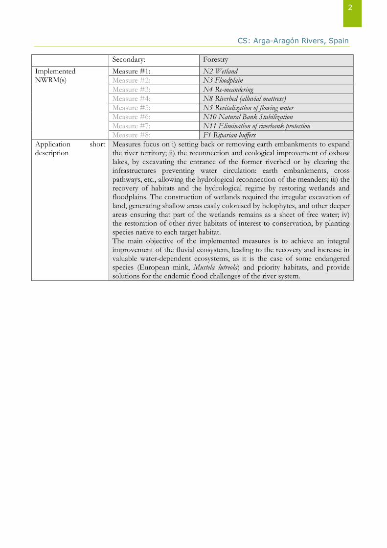
I. Basic Information
Application ID Spain_01
Application Name Fluvial and ecosystem restoration of the Arga-Aragón Rivers systems by combining measures
Application Location Country: Spain Country 2:
NUTS2 Code ES220-Comunidad Foral de Navarra
River Basin District Code
ES091
WFD Water Body Code
Description
Arga and Aragón rivers are two of the main tributaries of Ebro River (NE Spain). The dynamics of these rivers is very intense with swift adjustments to natural or artificial variations. This dynamic, in a section that was characterized by the plotting of free meanders with high natural ability to change, has been completely altered by works that have changed and constrained the riverbed, thus eliminating most of the flooding areas. Furthermore, conservation challenges are related to a lack of space for the river – agricultural land or poplar plantations have taken most of the floodplains. Many fluvial natural hydrogeomorphologic dynamics have been fixed by defence works, which has facilitated progressive human occupation of the territory, a process that actually meant an increase of risks and a significant loss of ecosystems and ecosystem services. The project comprises the lower reaches of Arga River (from the mouth of Salado River until the confluence of Arga and Aragón Rivers) and the middle-lower reaches of Aragón River (from Carcastillo until the union of the Aragón and Ebro Rivers). Stability does not exist in these sections; major flooding events were in February 2003 (Arga Q=930.2 m3/s T=15), in April 2007 (Arga Q=910 m3/s T= 10; Aragón Q= 1394 m3/s T=25) and in January 2010 (Aragón, Q= 806 m3/s; Arga, Q= 730 m3/s T= 3-4). These flood events have caused major changes even when the riverbed is totally channelled (or precisely because of that). This degradation of the riverine ecosystem is affecting local biodiversity, including fauna and flora species.
Application Site Coordinates
Latitude: 42.332222 N Specify: WGS84
Longitude: 1.691944 W Specify: WGS84
Target Sector(s) Primary: Hydromorphology
CS: Arga-Aragón Rivers, Spain
2
Secondary: Forestry
Implemented NWRM(s)
Measure #1: N2 Wetland
Measure #2: N3 Floodplain
Measure #3: N4 Re-meandering
Measure #4: N8 Riverbed (alluvial mattress)
Measure #5: N5 Revitalization of flowing water
Measure #6: N10 Natural Bank Stabilization
Measure #7: N11 Elimination of riverbank protection
Measure #8: F1 Riparian buffers
Application short description
Measures focus on i) setting back or removing earth embankments to expand the river territory; ii) the reconnection and ecological improvement of oxbow lakes, by excavating the entrance of the former riverbed or by clearing the infrastructures preventing water circulation: earth embankments, cross pathways, etc., allowing the hydrological reconnection of the meanders; iii) the recovery of habitats and the hydrological regime by restoring wetlands and floodplains. The construction of wetlands required the irregular excavation of land, generating shallow areas easily colonised by helophytes, and other deeper areas ensuring that part of the wetlands remains as a sheet of free water; iv) the restoration of other river habitats of interest to conservation, by planting species native to each target habitat. The main objective of the implemented measures is to achieve an integral improvement of the fluvial ecosystem, leading to the recovery and increase in valuable water-dependent ecosystems, as it is the case of some endangered species (European mink, Mustela lutreola) and priority habitats, and provide solutions for the endemic flood challenges of the river system.
CS: Arga-Aragón Rivers, Spain
3
II. Policy context and design targets
Brief description of the problem to be tackled
The natural resources of Arga and Aragón Rivers have been suffering over the last decades the consequences of economic growth and demographic change. Standing out embankment buildings and shortening the length of the rivers by cutting through meanders, which remained abandoned, has led to the removal of part of the rivers’ vegetation. Dikes and breakwater defences were built to protect agricultural and forestry plantations along the rivers’ floodplains, and the rivers were channelled to protect downstream towns from floods. Floods are a historical problem for municipalities like Falces (NUTS ES220/ LAU2 31104), Peralta (NUTS ES220/ LAU2 31202) and Funes (NUTS ES220/ LAU2 31107), little towns and villages in the southern part of the stretch, a wide floodplain of Arga River. Since 1960 the struggle against floods has been more intense: artificial cut-off, further channelization, breakwater, dredging, etc. Under these protections, villages, services and industrial activities have all taken up the floodplain. All these defence infrastructures have affected the dynamics of these two rivers, resulting in a decrease in natural habitats, a reduction in biodiversity, losses of ecohydrological connectivity, deterioration of the role of the natural habitats as traps for water and sediments and decreased the functionality of the flow regime to contribute to the good status of rivers and floodplains. Even despite all these defence infrastructures, extraordinary rainfall peaks and water from snow melting still cause extreme floods events that remain a main risk for downstream villages. For those villages the increasing flood risk entails large economic losses (the flooding events in 2003 and 2007 caused economic losses for more than 9 and 8 million euros respectively, including damages in public and private infrastructure and agricultural production) and turns inefficient all alert systems. (Source: Gobierno de Navarra, 2010) Hence, a series of projects have been considered in order to reach the following aims; restoration of the river longitudinal continuity to decrease the flood risk; improvement and restoration of the environment, specially for the European mink, and removal of sediments, deposited in the meander bed, that do not correspond to the riparian bed.
What were the primary & secondary targets when designing this application?
Primary target #1: Biodiversity and gene-pool conservation in riparia
Primary target #2: Flood control and flood risk mitigation
Secondary target #1: Regulation of hydrological cycle and water flow
Secondary target #2: Regulation of the chemical condition of freshwat
Remarks Achieving habitat management goals and restoring the natural river ecosystem, in order to enhance local biodiversity levels. Flood control and risk mitigation by restoring floodplains, so that they can perform its main function, driving away the energy of floodwaters by storing them during the flood process.
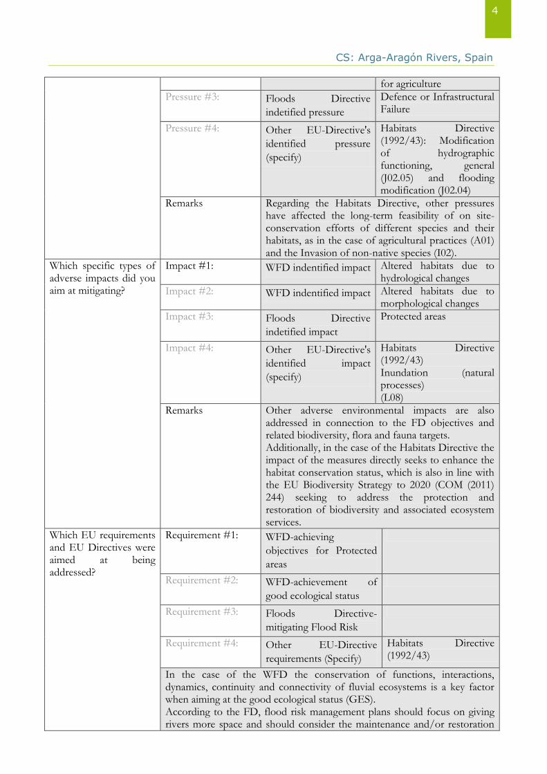
Which specific types of pressures did you aim at mitigating?
Pressure #1: WFD indentified
pressure
4.1.1 Physical alteration of channel/bed/riparian area/shore of water body for flood protection
Pressure #2: WFD indentified
pressure
4.1.2 Physical alteration of channel/bed/riparian area/shore of water body
CS: Arga-Aragón Rivers, Spain
4
for agriculture
Pressure #3: Floods Directive
indetified pressure
Defence or Infrastructural Failure
Pressure #4: Other EU-Directive's
identified pressure
(specify)
Habitats Directive (1992/43): Modification of hydrographic functioning, general (J02.05) and flooding modification (J02.04)
Remarks Regarding the Habitats Directive, other pressures have affected the long-term feasibility of on site-conservation efforts of different species and their habitats, as in the case of agricultural practices (A01) and the Invasion of non-native species (I02).
Which specific types of adverse impacts did you aim at mitigating?
Impact #1: WFD indentified impact Altered habitats due to hydrological changes
Impact #2: WFD indentified impact Altered habitats due to morphological changes
Impact #3: Floods Directive
indetified impact
Protected areas
Impact #4: Other EU-Directive's
identified impact
(specify)
Habitats Directive (1992/43) Inundation (natural processes) (L08)
Remarks Other adverse environmental impacts are also addressed in connection to the FD objectives and related biodiversity, flora and fauna targets. Additionally, in the case of the Habitats Directive the impact of the measures directly seeks to enhance the habitat conservation status, which is also in line with the EU Biodiversity Strategy to 2020 (COM (2011) 244) seeking to address the protection and restoration of biodiversity and associated ecosystem services.
Which EU requirements and EU Directives were aimed at being addressed?
Requirement #1: WFD-achieving
objectives for Protected
areas
Requirement #2: WFD-achievement of
good ecological status
Requirement #3: Floods Directive-
mitigating Flood Risk
Requirement #4: Other EU-Directive
requirements (Specify)
Habitats Directive (1992/43)
In the case of the WFD the conservation of functions, interactions, dynamics, continuity and connectivity of fluvial ecosystems is a key factor when aiming at the good ecological status (GES). According to the FD, flood risk management plans should focus on giving rivers more space and should consider the maintenance and/or restoration
CS: Arga-Aragón Rivers, Spain
5
of floodplains, since they contribute to reducing peak flows by flooding, and minimizing flooding levels which significant benefits in urban areas downstream. The comprised area is one of the Sites of Community Importance (SCI) included in the Natura 2000 network. The area’s importance is mainly due to the presence of Mediterranean river forest habitats (Mediterranean poplar and willow forests) and species such as European mink (Mustela lutreola), otter (Lutra lutra), European turtle (Emys orbicularis) and night heron (Nycticorax nycticorax). Additionally, some requirements from the EU Biodiversity Strategy to 2020 (maintaining and restoring ecosystems and their services and enhancing efforts to protect species and habitats) are also addressed by these measures.
Which national and/or regional policy challenges and/or requirements aimed to be addressed?
The implemented measures go in line with the Ministry Agriculture, Food and the Environment policy goals, that aim at improving the management of rivers and their conservation status, and that has undertaken plans and lines of action concerning water quality, as well as the protection and conservation of the Water Public Domain (Programme of Conservation and Enhancement of the Water Public Domain). In addition, a great deal of effort is going into water planning for the next WFD planning cycles, which introduces the challenge of producing new river basin management plans (aligned with the National Strategy for River Restoration) and propose a set of measures to improve the management of rivers and their ecological status.
III. Site characteristics
Dominant Land Use type(s)
Dominant land use 244 Agro-forestry areas
Secondary land use
Other important land use
Highly profitable crops mostly characterize the site: fruits, vegetables and poplars. In the Aragón River Basin we can find a great variety of crops due to the large area of irrigation. In the upper area the most characteristic are dry land cereal crops. Irrigated agriculture in Carcastillo (NUTS ES220/ LAU2 31067) and in other downstream municipalities, fruit, vines and orchards are gaining prominence, although in dry land cereals remain significant. The most important crops are: corn, peppers, rice, tomato, cereal, sugar beet, and vineyard. In the Arga River Basin, crop types are diverse, ranging from cereals to the most typical horticultural crops: asparagus and fruit to vine. Data from the relevant agricultural district for the 2013 (Source: Observatorio agrario, Gobierno de Navarra (2013)), that comprise most of our study site (Agricultural district number 6, Ribera Alta) show that arable crops represent 85% of the total agricultural productive area (72% of the whole agricultural district). The most representative cereals under this category are barley (47%) followed by corn (15%) and common wheat (13%). Woody crops represent 15% of the total agricultural productive area (Source: Observatorio agrario, Gobierno de Navarra (2013)) being vineyards the most representative crop (73%). Woodlands represent 22% of the agricultural district; being 66% non-timber forest (forest products which do not entail harvesting trees), the remainder are forest trees.
CS: Arga-Aragón Rivers, Spain
6
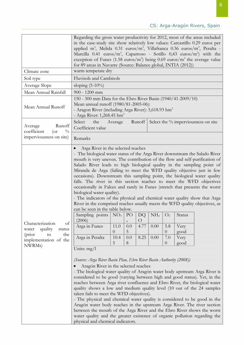
Regarding the gross water productivity for 2012, most of the areas included in the case-study site show relatively low values: Carcastillo 0.29 euros per applied m3, Melida 0.31 euros/m3, Villafranca 0.36 euros/m3, Peralta - Marcilla 0.41 euros/m3, Caparroso - Sotillo 0,43 euros/m3) with the exception of Funes (1.58 euros/m3) being 0.69 euros/m3 the average value for 89 areas in Navarre (Source: Balance global, INTIA (2012))
Climate zone warm temperate dry
Soil type Fluvisols and Cambisols
Average Slope sloping (5-10%)
Mean Annual Rainfall 900 - 1200 mm
Mean Annual Runoff
150 - 300 mm Data for the Ebro River Basin (1940/41-2009/10) Mean annual runoff (1980/81-2005-06): - Aragon River (including Arga River): 3,618.93 hm3 - Arga River: 1,268.45 hm3
Average Runoff coefficient (or % imperviousness on site)
Select the Average Runoff
Coefficient value
Select the % imperviousness on site
Remarks
Characterization of water quality status (prior to the implementation of the NWRMs)
Arga River in the selected reaches - The biological water status of the Arga River downstream the Salado River mouth is very uneven. The contribution of the flow and self-purification of Salado River leads to high biological quality in the sampling point of Miranda de Arga (failing to meet the WFD quality objective just in few occasions). Downstream this sampling point, the biological water quality falls. The river in this section reaches to meet the WFD objectives occasionally in Falces and rarely in Funes (stretch that presents the worst biological water quality). - The indicators of the physical and chemical water quality show that Arga River in the comprised reaches usually meets the WFD quality objectives, as can be seen in the table below.
Sampling points (2006)
NO3 PO
4 DQO
NH4 O2 Status
Arga in Funes 11.00
0.05
4.77 0.00 5.80
Very good
Arga in Peralta 10.45
0.08
8.25 0.00 7.00
Very good
Units: mg/l (Source: Arga River Basin Plan, Ebro River Basin Authority (2008))
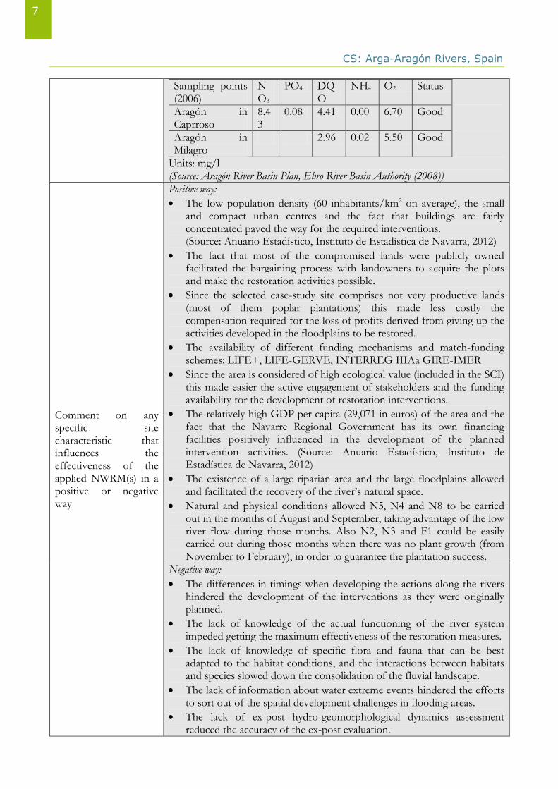
Aragón River in the selected reaches - The biological water quality of Aragón water body upstream Arga River is considered to be good (varying between high and good status). Yet, in the reaches between Arga river confluence and Ebro River, the biological water quality shows a low and medium quality level (10 out of the 24 samples taken fails to meet the WFD objectives). - The physical and chemical water quality is considered to be good in the Aragón water body reaches in the upstream Arga River. The river section between the mouth of the Arga River and the Ebro River shows the worst water quality and the greater existence of organic pollution regarding the physical and chemical indicators.
CS: Arga-Aragón Rivers, Spain
7
Sampling points (2006)
NO3
PO4 DQO
NH4 O2 Status
Aragón in Caprroso
8.43
0.08 4.41 0.00 6.70 Good
Aragón in Milagro
2.96 0.02 5.50 Good
Units: mg/l (Source: Aragón River Basin Plan, Ebro River Basin Authority (2008))
Comment on any specific site characteristic that influences the effectiveness of the applied NWRM(s) in a positive or negative way
Positive way:
The low population density (60 inhabitants/km2 on average), the small and compact urban centres and the fact that buildings are fairly concentrated paved the way for the required interventions. (Source: Anuario Estadístico, Instituto de Estadística de Navarra, 2012)
The fact that most of the compromised lands were publicly owned facilitated the bargaining process with landowners to acquire the plots and make the restoration activities possible.
Since the selected case-study site comprises not very productive lands (most of them poplar plantations) this made less costly the compensation required for the loss of profits derived from giving up the activities developed in the floodplains to be restored.
The availability of different funding mechanisms and match-funding schemes; LIFE+, LIFE-GERVE, INTERREG IIIAa GIRE-IMER
Since the area is considered of high ecological value (included in the SCI) this made easier the active engagement of stakeholders and the funding availability for the development of restoration interventions.
The relatively high GDP per capita (29,071 in euros) of the area and the fact that the Navarre Regional Government has its own financing facilities positively influenced in the development of the planned intervention activities. (Source: Anuario Estadístico, Instituto de Estadística de Navarra, 2012)
The existence of a large riparian area and the large floodplains allowed and facilitated the recovery of the river’s natural space.
Natural and physical conditions allowed N5, N4 and N8 to be carried out in the months of August and September, taking advantage of the low river flow during those months. Also N2, N3 and F1 could be easily carried out during those months when there was no plant growth (from November to February), in order to guarantee the plantation success.
Negative way:
The differences in timings when developing the actions along the rivers hindered the development of the interventions as they were originally planned.
The lack of knowledge of the actual functioning of the river system impeded getting the maximum effectiveness of the restoration measures.
The lack of knowledge of specific flora and fauna that can be best adapted to the habitat conditions, and the interactions between habitats and species slowed down the consolidation of the fluvial landscape.
The lack of information about water extreme events hindered the efforts to sort out of the spatial development challenges in flooding areas.
The lack of ex-post hydro-geomorphological dynamics assessment reduced the accuracy of the ex-post evaluation.
CS: Arga-Aragón Rivers, Spain
8
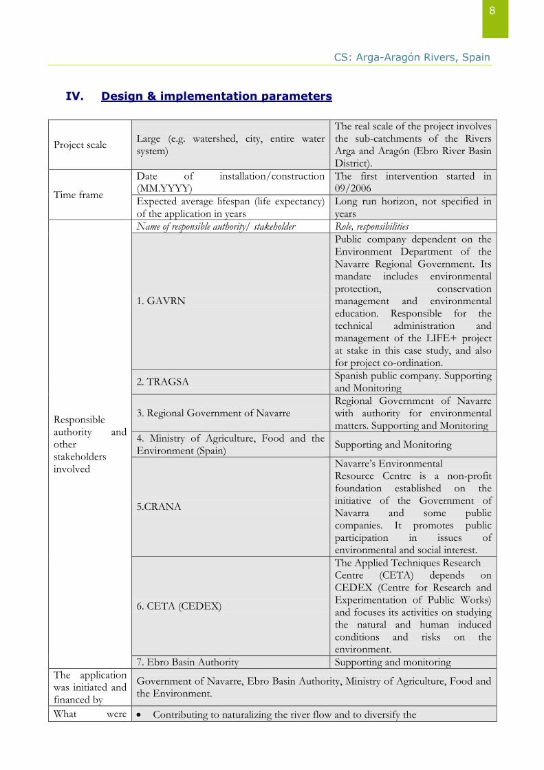
IV. Design & implementation parameters
Project scale Large (e.g. watershed, city, entire water system)
The real scale of the project involves the sub-catchments of the Rivers Arga and Aragón (Ebro River Basin District).
Time frame
Date of installation/construction (MM.YYYY)
The first intervention started in 09/2006
Expected average lifespan (life expectancy) of the application in years
Long run horizon, not specified in years
Responsible authority and other stakeholders involved
Name of responsible authority/ stakeholder Role, responsibilities
1. GAVRN
Public company dependent on the Environment Department of the Navarre Regional Government. Its mandate includes environmental protection, conservation management and environmental education. Responsible for the technical administration and management of the LIFE+ project at stake in this case study, and also for project co-ordination.
2. TRAGSA Spanish public company. Supporting and Monitoring
3. Regional Government of Navarre Regional Government of Navarre with authority for environmental matters. Supporting and Monitoring
4. Ministry of Agriculture, Food and the Environment (Spain)
Supporting and Monitoring
5.CRANA
Navarre’s Environmental Resource Centre is a non-profit foundation established on the initiative of the Government of Navarra and some public companies. It promotes public participation in issues of environmental and social interest.
6. CETA (CEDEX)
The Applied Techniques Research Centre (CETA) depends on CEDEX (Centre for Research and Experimentation of Public Works) and focuses its activities on studying the natural and human induced conditions and risks on the environment.
7. Ebro Basin Authority Supporting and monitoring
The application was initiated and financed by
Government of Navarre, Ebro Basin Authority, Ministry of Agriculture, Food and the Environment.
What were Contributing to naturalizing the river flow and to diversify the
CS: Arga-Aragón Rivers, Spain
9
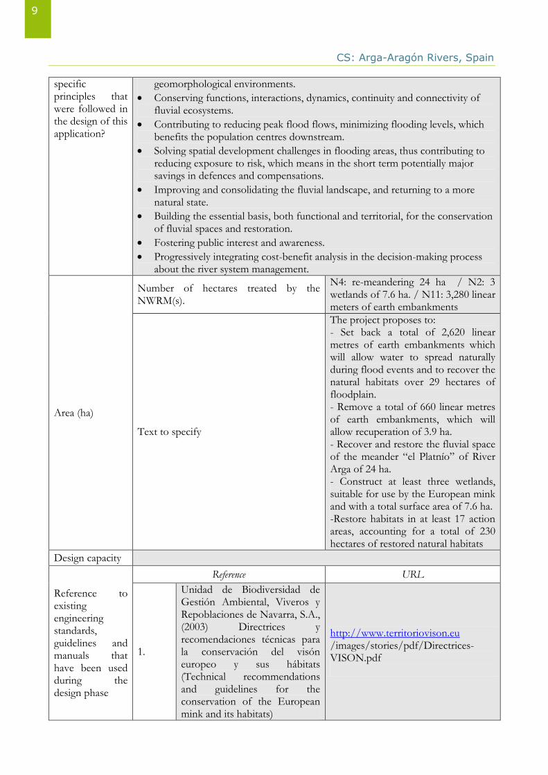
specific principles that were followed in the design of this application?
geomorphological environments.
Conserving functions, interactions, dynamics, continuity and connectivity of fluvial ecosystems.
Contributing to reducing peak flood flows, minimizing flooding levels, which benefits the population centres downstream.
Solving spatial development challenges in flooding areas, thus contributing to reducing exposure to risk, which means in the short term potentially major savings in defences and compensations.
Improving and consolidating the fluvial landscape, and returning to a more natural state.
Building the essential basis, both functional and territorial, for the conservation of fluvial spaces and restoration.
Fostering public interest and awareness.
Progressively integrating cost-benefit analysis in the decision-making process about the river system management.
Area (ha)
Number of hectares treated by the NWRM(s).
N4: re-meandering 24 ha / N2: 3 wetlands of 7.6 ha. / N11: 3,280 linear meters of earth embankments
Text to specify
The project proposes to: - Set back a total of 2,620 linear metres of earth embankments which will allow water to spread naturally during flood events and to recover the natural habitats over 29 hectares of floodplain. - Remove a total of 660 linear metres of earth embankments, which will allow recuperation of 3.9 ha. - Recover and restore the fluvial space of the meander “el Platnío” of River Arga of 24 ha. - Construct at least three wetlands, suitable for use by the European mink and with a total surface area of 7.6 ha. -Restore habitats in at least 17 action areas, accounting for a total of 230 hectares of restored natural habitats
Design capacity
Reference to existing engineering standards, guidelines and manuals that have been used during the design phase
Reference URL
1.
Unidad de Biodiversidad de Gestión Ambiental, Viveros y Repoblaciones de Navarra, S.A., (2003) Directrices y recomendaciones técnicas para la conservación del visón europeo y sus hábitats (Technical recommendations and guidelines for the conservation of the European mink and its habitats)
http://www.territoriovison.eu /images/stories/pdf/Directrices-VISON.pdf
CS: Arga-Aragón Rivers, Spain
10
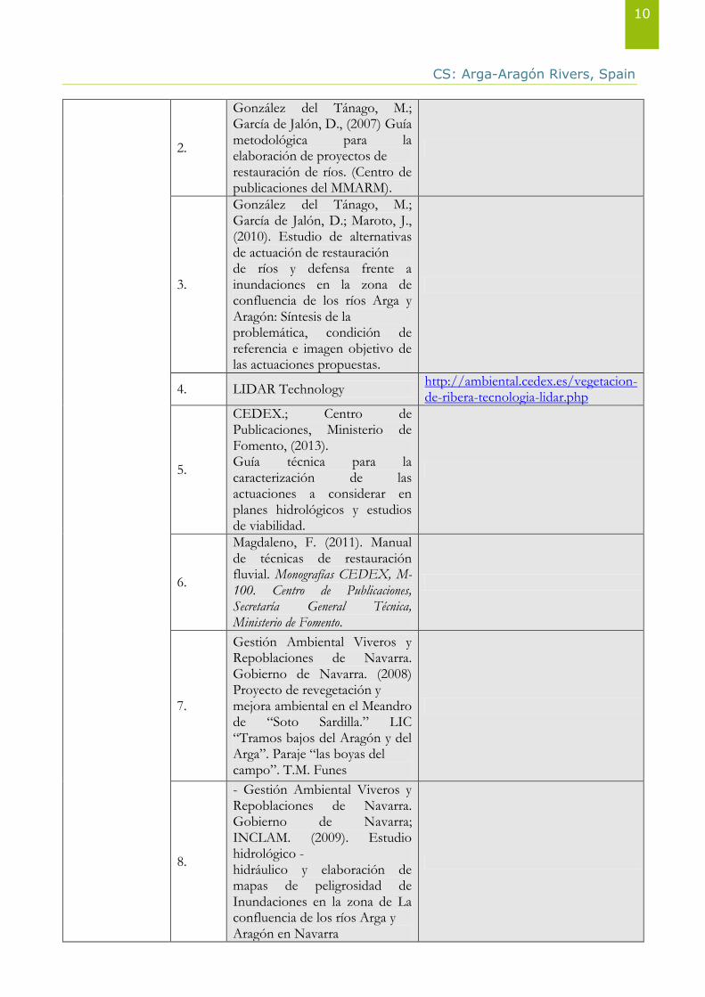
2.
González del Tánago, M.; García de Jalón, D., (2007) Guía metodológica para la elaboración de proyectos de restauración de ríos. (Centro de publicaciones del MMARM).
3.
González del Tánago, M.; García de Jalón, D.; Maroto, J., (2010). Estudio de alternativas de actuación de restauración de ríos y defensa frente a inundaciones en la zona de confluencia de los ríos Arga y Aragón: Síntesis de la problemática, condición de referencia e imagen objetivo de las actuaciones propuestas.
4. LIDAR Technology http://ambiental.cedex.es/vegetacion-de-ribera-tecnologia-lidar.php
5.
CEDEX.; Centro de Publicaciones, Ministerio de Fomento, (2013). Guía técnica para la caracterización de las actuaciones a considerar en planes hidrológicos y estudios de viabilidad.
6.
Magdaleno, F. (2011). Manual de técnicas de restauración fluvial. Monografías CEDEX, M-100. Centro de Publicaciones, Secretaría General Técnica, Ministerio de Fomento.
7.
Gestión Ambiental Viveros y Repoblaciones de Navarra. Gobierno de Navarra. (2008) Proyecto de revegetación y mejora ambiental en el Meandro de “Soto Sardilla.” LIC “Tramos bajos del Aragón y del Arga”. Paraje “las boyas del campo”. T.M. Funes
8.
- Gestión Ambiental Viveros y Repoblaciones de Navarra. Gobierno de Navarra; INCLAM. (2009). Estudio hidrológico - hidráulico y elaboración de mapas de peligrosidad de Inundaciones en la zona de La confluencia de los ríos Arga y Aragón en Navarra
CS: Arga-Aragón Rivers, Spain
11
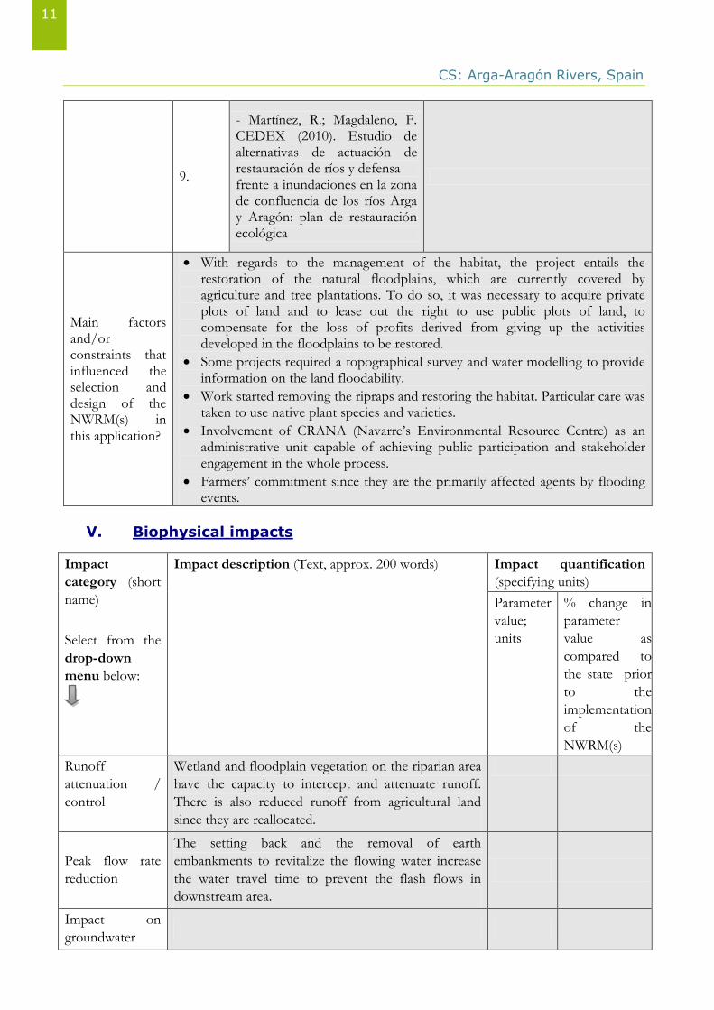
9.
- Martínez, R.; Magdaleno, F. CEDEX (2010). Estudio de alternativas de actuación de restauración de ríos y defensa frente a inundaciones en la zona de confluencia de los ríos Arga y Aragón: plan de restauración ecológica
Main factors and/or constraints that influenced the selection and design of the NWRM(s) in this application?
With regards to the management of the habitat, the project entails the restoration of the natural floodplains, which are currently covered by agriculture and tree plantations. To do so, it was necessary to acquire private plots of land and to lease out the right to use public plots of land, to compensate for the loss of profits derived from giving up the activities developed in the floodplains to be restored.
Some projects required a topographical survey and water modelling to provide information on the land floodability.
Work started removing the ripraps and restoring the habitat. Particular care was taken to use native plant species and varieties.
Involvement of CRANA (Navarre’s Environmental Resource Centre) as an administrative unit capable of achieving public participation and stakeholder engagement in the whole process.
Farmers’ commitment since they are the primarily affected agents by flooding events.
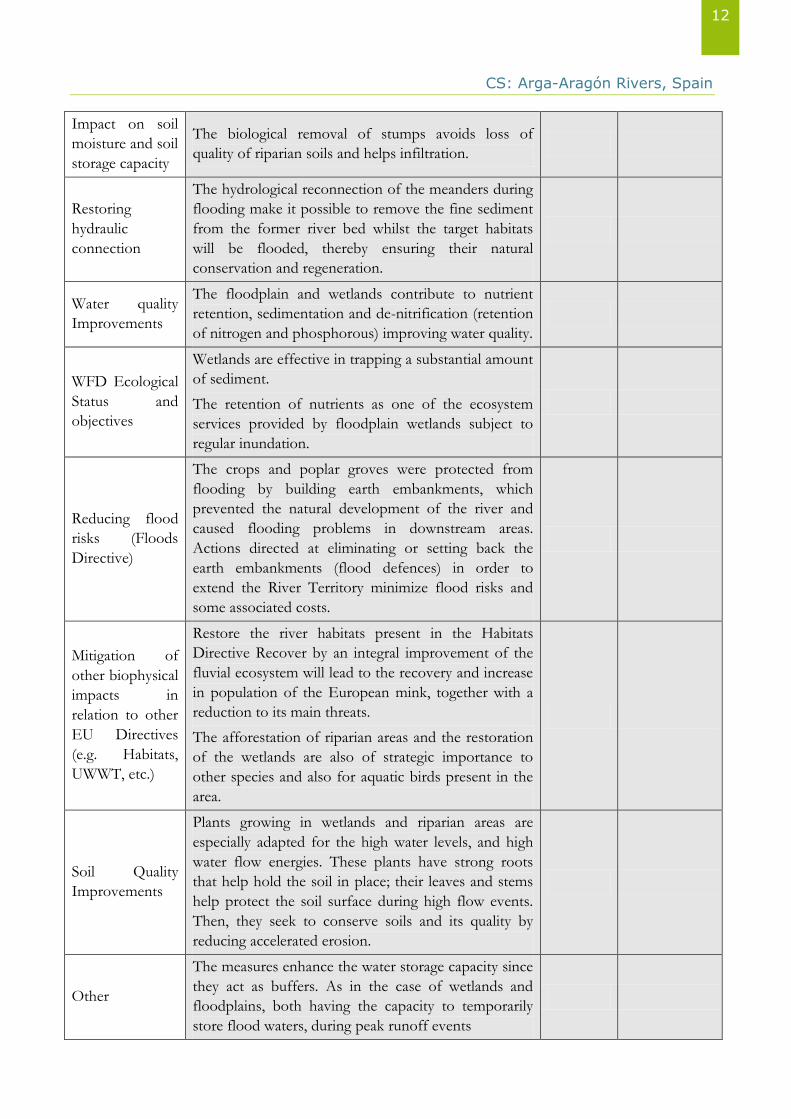
V. Biophysical impacts
Impact
category (short
name)
Select from the
drop-down
menu below:
Impact description (Text, approx. 200 words) Impact quantification
(specifying units)
Parameter
value;
units
% change in
parameter
value as
compared to
the state prior
to the
implementation
of the
NWRM(s)
Runoff
attenuation /
control
Wetland and floodplain vegetation on the riparian area
have the capacity to intercept and attenuate runoff.
There is also reduced runoff from agricultural land
since they are reallocated.
Peak flow rate
reduction
The setting back and the removal of earth
embankments to revitalize the flowing water increase
the water travel time to prevent the flash flows in
downstream area.
Impact on
groundwater
CS: Arga-Aragón Rivers, Spain
12
Impact on soil
moisture and soil
storage capacity
The biological removal of stumps avoids loss of
quality of riparian soils and helps infiltration.
Restoring
hydraulic
connection
The hydrological reconnection of the meanders during
flooding make it possible to remove the fine sediment
from the former river bed whilst the target habitats
will be flooded, thereby ensuring their natural
conservation and regeneration.
Water quality
Improvements
The floodplain and wetlands contribute to nutrient
retention, sedimentation and de-nitrification (retention
of nitrogen and phosphorous) improving water quality.
WFD Ecological
Status and
objectives
Wetlands are effective in trapping a substantial amount
of sediment.
The retention of nutrients as one of the ecosystem
services provided by floodplain wetlands subject to
regular inundation.
Reducing flood
risks (Floods
Directive)
The crops and poplar groves were protected from
flooding by building earth embankments, which
prevented the natural development of the river and
caused flooding problems in downstream areas.
Actions directed at eliminating or setting back the
earth embankments (flood defences) in order to
extend the River Territory minimize flood risks and
some associated costs.
Mitigation of
other biophysical
impacts in
relation to other
EU Directives
(e.g. Habitats,
UWWT, etc.)
Restore the river habitats present in the Habitats
Directive Recover by an integral improvement of the
fluvial ecosystem will lead to the recovery and increase
in population of the European mink, together with a
reduction to its main threats.
The afforestation of riparian areas and the restoration
of the wetlands are also of strategic importance to
other species and also for aquatic birds present in the
area.
Soil Quality
Improvements
Plants growing in wetlands and riparian areas are
especially adapted for the high water levels, and high
water flow energies. These plants have strong roots
that help hold the soil in place; their leaves and stems
help protect the soil surface during high flow events.
Then, they seek to conserve soils and its quality by
reducing accelerated erosion.
Other
The measures enhance the water storage capacity since
they act as buffers. As in the case of wetlands and
floodplains, both having the capacity to temporarily
store flood waters, during peak runoff events
CS: Arga-Aragón Rivers, Spain
13
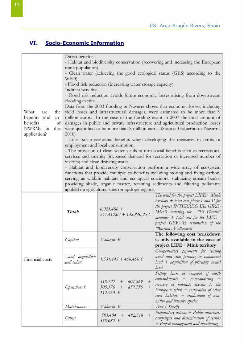
VI. Socio-Economic Information
What are the benefits and co-benefits of NWRMs in this application?
Direct benefits: - Habitat and biodiversity conservation (recovering and increasing the European mink population) - Clean water (achieving the good ecological status (GES) according to the WFD). - Flood risk reduction (Increasing water storage capacity). Indirect benefits: - Flood risk reduction avoids future economic losses arising from downstream flooding events. Data from the 2003 flooding in Navarre shows that economic losses, including yield losses and infrastructural damages, were estimated to be more than 9 million euros. In the case of the flooding event in 2007 the total amount of damages in public and private infrastructure and agricultural production losses were quantified to be more than 8 million euros. (Source: Gobierno de Navarra, 2010) - Local socio-economic benefits when developing the measures in terms of employment and local consumption. - The provision of clean water yields in turn social benefits such as recreational services and amenity (increased demand for recreation or increased number of visitors) and clean drinking water - Habitat and biodiversity conservation perform a wide array of ecosystem functions that provide multiple co-benefits including storing and fixing carbon, serving as wildlife habitats and ecological corridors, stabilizing stream banks, providing shade, organic matter, retaining sediments and filtering pollutants applied on agricultural sites on upslope regions.
Financial costs
Total: 6.023.406 + 257.412,07 + 138.840,25 €
The total for the project LIFE+ Mink territory + total cost phase I and II for the project INTERREG IIIa GIRE-IMER restoring the “El Plantio” meander + total cost for the LIFE+ project GERVE restoration of the “Barranco Vallacuera”
Capital: Value in € The following cost breakdown is only available in the case of project LIFE+ Mink territory
Land acquisition and value:
1.531.445 + 466.466 €
Compensatory payments for ceasing wood and crop farming in communal land + acquisition of privately owned land
Operational: 518.722 + 604.869 + 505.376 + 859.756 + 112.963 €
Setting back or removal of earth embankments + re-meandering + recovery of habitats specific to the European mink + restoration of other river habitats + eradication of non-native and invasive species
Maintenance: Value in € Text / Specify
Other: 583.404 + 482.318 + 358.082 €
Preparatory actions + Public awareness campaigns and dissemination of results + Project management and monitoring
CS: Arga-Aragón Rivers, Spain
14
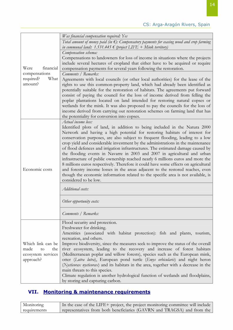
Were financial compensations required? What amount?
Was financial compensation required: Yes
Total amount of money paid (in €): Compensatory payments for ceasing wood and crop farming in communal land: 1.531.445 € (project LIFE + Mink territory)
Compensation schema: Compensations to landowners for loss of income in situations where the projects include several hectares of cropland that either have to be acquired or require compensation payments for several years following the restoration.
Comments / Remarks: Agreements with local councils (or other local authorities) for the lease of the rights to use this common-property land, which had already been identified as potentially suitable for the restoration of habitats. The agreements put forward consist of paying the council for the loss of income derived from felling the poplar plantations located on land intended for restoring natural copses or wetlands for the mink. It was also proposed to pay the councils for the loss of income derived from carrying out restoration schemes on farming land that has the potentiality for conversion into copses.
Economic costs
Actual income loss: Identified plots of land, in addition to being included in the Natura 2000 Network and having a high potential for restoring habitats of interest for conservation purposes, are also subject to frequent flooding, leading to a low crop yield and considerable investment by the administrations in the maintenance of flood defences and irrigation infrastructures. The estimated damage caused by the flooding events in Navarre in 2003 and 2007 in agricultural and urban infrastructure of public ownership reached nearly 6 millions euros and more the 8 millions euros respectively. Therefore it could have some effects on agricultural and forestry income losses in the areas adjacent to the restored reaches, even though the economic information related to the specific area is not available, is considered to be low.
Additional costs:
Other opportunity costs:
Comments / Remarks:
Which link can be made to the ecosystem services approach?
Flood security and protection. Freshwater for drinking. Amenities (associated with habitat protection): fish and plants, tourism, recreation, and others. Improve biodiversity, since the measures seek to improve the status of the overall river ecosystem, leading to the recovery and increase of forest habitats (Mediterranean poplar and willow forests), species such as the European mink, otter (Lutra lutra), European pond turtle (Emys orbicularis) and night heron (Nycticorax nycticorax) and its habitats in the area, together with a decrease in the main threats to this species. Climate regulation is another hydrological function of wetlands and floodplains, by storing and capturing carbon.
VII. Monitoring & maintenance requirements
Monitoring requirements
In the case of the LIFE+ project, the project monitoring committee will include representatives from both beneficiaries (GAVRN and TRAGSA) and from the
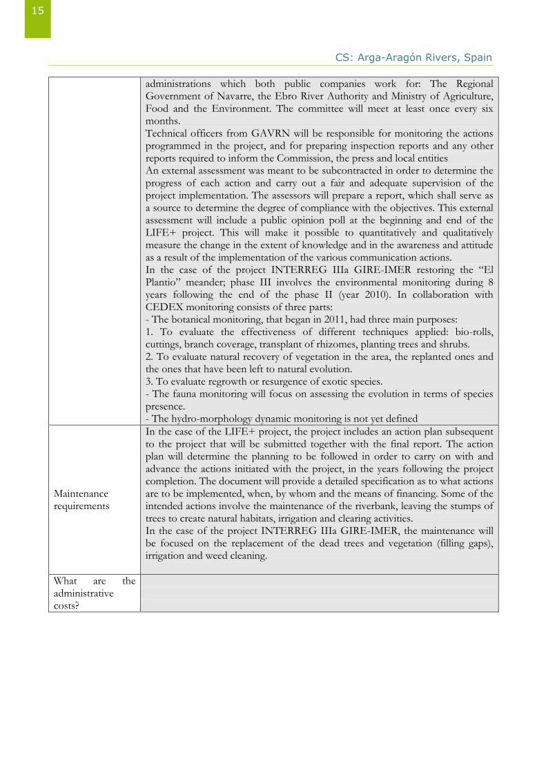
CS: Arga-Aragón Rivers, Spain
15
administrations which both public companies work for: The Regional Government of Navarre, the Ebro River Authority and Ministry of Agriculture, Food and the Environment. The committee will meet at least once every six months. Technical officers from GAVRN will be responsible for monitoring the actions programmed in the project, and for preparing inspection reports and any other reports required to inform the Commission, the press and local entities An external assessment was meant to be subcontracted in order to determine the progress of each action and carry out a fair and adequate supervision of the project implementation. The assessors will prepare a report, which shall serve as a source to determine the degree of compliance with the objectives. This external assessment will include a public opinion poll at the beginning and end of the LIFE+ project. This will make it possible to quantitatively and qualitatively measure the change in the extent of knowledge and in the awareness and attitude as a result of the implementation of the various communication actions. In the case of the project INTERREG IIIa GIRE-IMER restoring the “El Plantio” meander; phase III involves the environmental monitoring during 8 years following the end of the phase II (year 2010). In collaboration with CEDEX monitoring consists of three parts: - The botanical monitoring, that began in 2011, had three main purposes: 1. To evaluate the effectiveness of different techniques applied: bio-rolls, cuttings, branch coverage, transplant of rhizomes, planting trees and shrubs. 2. To evaluate natural recovery of vegetation in the area, the replanted ones and the ones that have been left to natural evolution. 3. To evaluate regrowth or resurgence of exotic species. - The fauna monitoring will focus on assessing the evolution in terms of species presence. - The hydro-morphology dynamic monitoring is not yet defined
Maintenance requirements
In the case of the LIFE+ project, the project includes an action plan subsequent to the project that will be submitted together with the final report. The action plan will determine the planning to be followed in order to carry on with and advance the actions initiated with the project, in the years following the project completion. The document will provide a detailed specification as to what actions are to be implemented, when, by whom and the means of financing. Some of the intended actions involve the maintenance of the riverbank, leaving the stumps of trees to create natural habitats, irrigation and clearing activities. In the case of the project INTERREG IIIa GIRE-IMER, the maintenance will be focused on the replacement of the dead trees and vegetation (filling gaps), irrigation and weed cleaning.
What are the administrative costs?
CS: Arga-Aragón Rivers, Spain
16
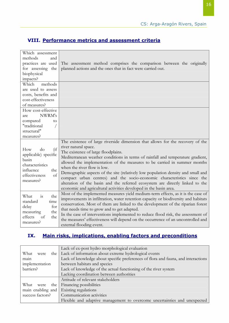
VIII. Performance metrics and assessment criteria
Which assessment methods and practices are used for assessing the biophysical impacts?
The assessment method comprises the comparison between the originally planned actions and the ones that in fact were carried out.
Which methods are used to assess costs, benefits and cost-effectiveness of measures?
How cost-effective are NWRM's compared to "traditional / structural" measures?
How do (if applicable) specific basin characteristics influence the effectiveness of measures?
The existence of large riverside dimension that allows for the recovery of the river natural space. The existence of large floodplains. Mediterranean weather conditions in terms of rainfall and temperature gradient, allowed the implementation of the measures to be carried in summer months when the river flow is low. Demographic aspects of the site (relatively low population density and small and compact urban centres) and the socio-economic characteristics since the alteration of the basin and the referred ecosystem are directly linked to the economic and agricultural activities developed in the basin area.
What is the standard time delay for measuring the effects of the measures?
Most of the implemented measures yield medium-term effects, as it is the case of improvements in infiltration, water retention capacity or biodiversity and habitats conservation. Most of them are linked to the development of the riparian forest that needs time to grow and to get adapted. In the case of interventions implemented to reduce flood risk, the assessment of the measures’ effectiveness will depend on the occurrence of an uncontrolled and external flooding event.
IX. Main risks, implications, enabling factors and preconditions
What were the main implementation barriers?
Lack of ex-post hydro morphological evaluation Lack of information about extreme hydrological events Lack of knowledge about specific preferences of flora and fauna, and interactions between habitats and species Lack of knowledge of the actual functioning of the river system Lacking coordination between authorities
What were the main enabling and success factors?
Attitude of relevant stakeholders Financing possibilities Existing regulations Communication activities Flexible and adaptive management to overcome uncertainties and unexpected
CS: Arga-Aragón Rivers, Spain
17
deviations from original design
Financing
EU-funds (LIFE+): 3,877,164 € Rest: Ministry of Agriculture, Food and the Environment + Government of Navarre and Ebro River Basin Authority. Total budget: 6,323,807 €
Flexibility & Adaptability
The implemented measures are quite flexible to be implemented in other areas of similar characteristics, even though some baseline site conditions should be taken into account for a cost-effective project. Some of them are listed below. - Climate conditions for the selection of plant species and the planting time. - The existence of large riverside areas that allows the recovery of the river’s natural space. - Population density and the existing on site. - The compensation scheme to offset landowners’ income losses and land productivity; in case that land productivity or the financial compensation is too high it may yield very large costs
Transferability
X. Lessons learned
Key lessons
Cost-benefit analyses commonly help make the case for NWRMs, but they have to be developed on a truly scientific basis. NWRMs require active public engagement and the best possible coordination. NWRMs help people and ecosystems, while committing legislation and optimizing our natural heritage. The identification of some information gaps regarding the ex-post hydro geomorphological behaviour, the knowledge of specific patterns of flora and fauna, and interactions between habitats and species, the influence of extreme hydrologic events, the influence of social and political trends in different terms and Influence of critical gaps in integrated approaches
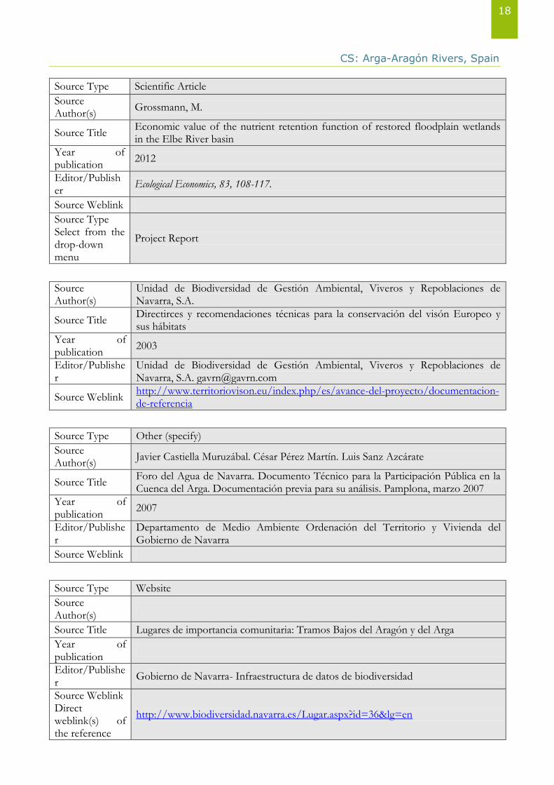
XI. References
Source Type Scientific Article
Source Author(s)
Kristensen, E. A., Baattrup-Pedersen, A., Jensen, P. N., Wiberg-Larsen, P., & Friberg, N.
Source Title Selection, implementation and cost of restorations in lowland streams: A basis for identifying restoration priorities
Year of publication
2012
Editor/Publisher
Environmental Science & Policy, 23, 1-11
Source Weblink
Key People
Name / affiliation Contact details
1.
2.
3.
4.
CS: Arga-Aragón Rivers, Spain
18
Source Type Scientific Article
Source Author(s)
Grossmann, M.
Source Title Economic value of the nutrient retention function of restored floodplain wetlands in the Elbe River basin
Year of publication
2012
Editor/Publisher
Ecological Economics, 83, 108-117.
Source Weblink
Source Type Select from the drop-down menu
Project Report
Source Author(s)
Unidad de Biodiversidad de Gestión Ambiental, Viveros y Repoblaciones de Navarra, S.A.
Source Title Directirces y recomendaciones técnicas para la conservación del visón Europeo y sus hábitats
Year of publication
2003
Editor/Publisher
Unidad de Biodiversidad de Gestión Ambiental, Viveros y Repoblaciones de Navarra, S.A. [email protected]
Source Weblink http://www.territoriovison.eu/index.php/es/avance-del-proyecto/documentacion-de-referencia
Source Type Other (specify)
Source Author(s)
Javier Castiella Muruzábal. César Pérez Martín. Luis Sanz Azcárate
Source Title Foro del Agua de Navarra. Documento Técnico para la Participación Pública en la Cuenca del Arga. Documentación previa para su análisis. Pamplona, marzo 2007
Year of publication
2007
Editor/Publisher
Departamento de Medio Ambiente Ordenación del Territorio y Vivienda del Gobierno de Navarra
Source Weblink
Source Type Website
Source Author(s)
Source Title Lugares de importancia comunitaria: Tramos Bajos del Aragón y del Arga
Year of publication
Editor/Publisher
Gobierno de Navarra- Infraestructura de datos de biodiversidad
Source Weblink Direct weblink(s) of the reference
http://www.biodiversidad.navarra.es/Lugar.aspx?id=36&lg=en
CS: Arga-Aragón Rivers, Spain
19
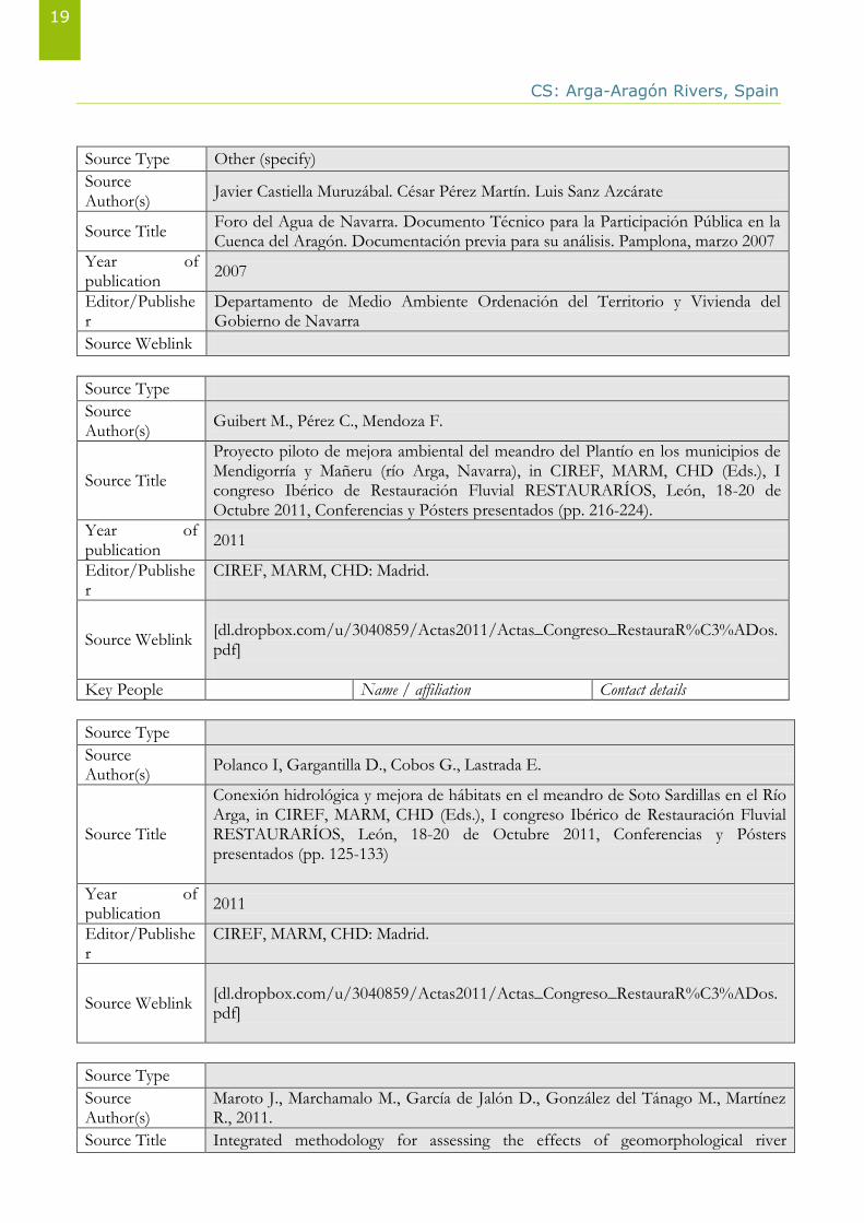
Source Type Other (specify)
Source Author(s)
Javier Castiella Muruzábal. César Pérez Martín. Luis Sanz Azcárate
Source Title Foro del Agua de Navarra. Documento Técnico para la Participación Pública en la Cuenca del Aragón. Documentación previa para su análisis. Pamplona, marzo 2007
Year of publication
2007
Editor/Publisher
Departamento de Medio Ambiente Ordenación del Territorio y Vivienda del Gobierno de Navarra
Source Weblink
Source Type
Source Author(s)
Guibert M., Pérez C., Mendoza F.
Source Title
Proyecto piloto de mejora ambiental del meandro del Plantío en los municipios de Mendigorría y Mañeru (río Arga, Navarra), in CIREF, MARM, CHD (Eds.), I congreso Ibérico de Restauración Fluvial RESTAURARÍOS, León, 18-20 de Octubre 2011, Conferencias y Pósters presentados (pp. 216-224).
Year of publication
2011
Editor/Publisher
CIREF, MARM, CHD: Madrid.
Source Weblink
[dl.dropbox.com/u/3040859/Actas2011/Actas_Congreso_RestauraR%C3%ADos.pdf]
Key People Name / affiliation Contact details
Source Type
Source Author(s)
Polanco I, Gargantilla D., Cobos G., Lastrada E.
Source Title
Conexión hidrológica y mejora de hábitats en el meandro de Soto Sardillas en el Río Arga, in CIREF, MARM, CHD (Eds.), I congreso Ibérico de Restauración Fluvial RESTAURARÍOS, León, 18-20 de Octubre 2011, Conferencias y Pósters presentados (pp. 125-133)
Year of publication
2011
Editor/Publisher
CIREF, MARM, CHD: Madrid.
Source Weblink
[dl.dropbox.com/u/3040859/Actas2011/Actas_Congreso_RestauraR%C3%ADos.pdf]
Source Type
Source Author(s)
Maroto J., Marchamalo M., García de Jalón D., González del Tánago M., Martínez R., 2011.
Source Title Integrated methodology for assessing the effects of geomorphological river
CS: Arga-Aragón Rivers, Spain
20
restoration on fish habitat and riparian vegetation, in CIREF, MARM, CHD (Eds.), I congreso Ibérico de Restauración Fluvial RESTAURARÍOS, León, 18-20 de Octubre 2011, Conferencias y Pósters presentados (pp. 307-313).
Year of publication
2011
Editor/Publisher
CIREF, MARM, CHD: Madrid.
Source Weblink
[dl.dropbox.com/u/3040859/Actas2011/Actas_Congreso_RestauraR%C3%ADos.pdf]
Source Type
Source Author(s)
Martínez R., Magdaleno F.
Source Title
Aplicaciones del LiDAR en la restauración fluvial: simulación hidráulica y empleo de ric-dar en el estudio geomorfológico y de vegetación de ribera in CIREF, MARM, CHD (Eds.), I congreso Ibérico de Restauración Fluvial RESTAURARÍOS, León, 18-20 de Octubre 2011, Conferencias y Pósters presentados (pp. 667-671).
Year of publication
2011
Editor/Publisher
CIREF, MARM, CHD: Madrid.
Source Weblink dl.dropbox.com/u/3040859/Actas2011/Actas_Congreso_RestauraR%C3%ADos.pdf
Source Type
Source Author(s)
CHE
Source Title Propuesta de proyecto de plan hidrológico de la cuenca del Ebro: Memoria [v.3]
Year of publication
2014
Editor/Publisher
MARM, CHE
Source Weblink http://www.chebro.es:81/Plan%20Hidrologico%20Ebro%202010-2015/Memoria/1.-%20Memoria_PHE_v3_8.pdf
Source Type
Source Author(s)
INTIA, Tecnología e Infraesturctura Agroalimentarias
Source Title Estudio actuaciones INTIA: Zonas, Cultivos, Productividad Bruta del Agua y Generación de Empleo.
Year of publication
2012
Editor/Publisher
INTIA, Tecnología e Infraesturctura Agroalimentarias
Source Weblink http://www.riegosdenavarra.com/agroind/IndiceBces.htm
Key People Name / affiliation Contact details
Source Type
CS: Arga-Aragón Rivers, Spain
21
Source Author(s)
INTIA, Tecnología e Infraesturctura Agroalimentarias
Source Title Evolución Zonas Regables: Actuaciones de INTIA, S.A. 2003-2012
Year of publication
2013
Editor/Publisher
INTIA, Tecnología e Infraesturctura Agroalimentarias
Source Weblink http://www.riegosdenavarra.com/agroind/IndiceBces.htm
Source Type
Source Author(s)
Gobierno de Navarra
Source Title Obresvatorio agrario
Year of publication
2013
Editor/Publisher
Gobierno de Navarra
Source Weblink http://www.navarra.es/home_es/Temas/Ambito+rural/Vida+rural/Observatorio+agrario/Agricola/Informacion+estadistica/produccion+agricola.htm
Source Type
Source Author(s)
Instituto de Estadística de Navarra
Source Title Instituto de Estadística de Navarra
Year of publication
2013
Editor/Publisher
Source Weblink http://www.cfnavarra.es/estadistica/
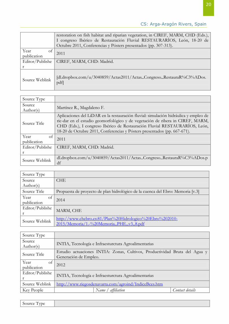
XII. Photos Gallery Figure 1 Application location: the confluence of the Arga and Aragón Rivers
Source: Government of Navarre in Magdaleno, 2014 (on the basis of SITNA)
CS: Arga-Aragón Rivers, Spain
22
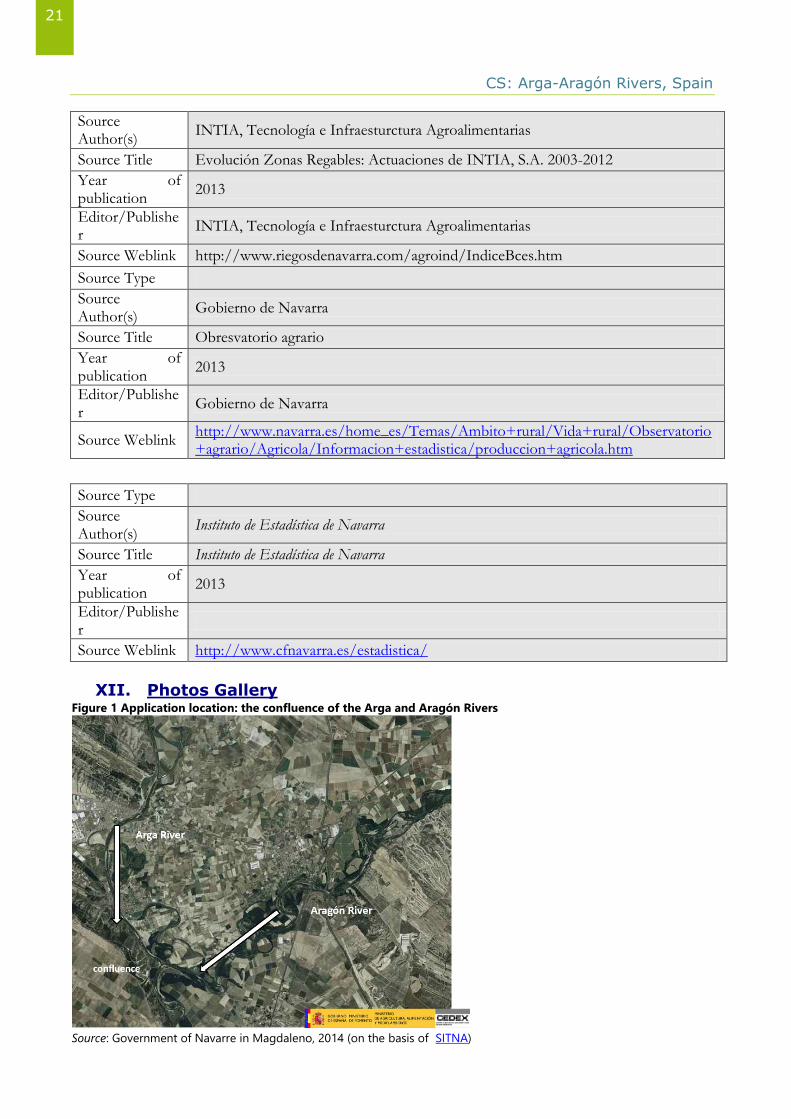
Figure 2 Application location: from 1956 to 2012
Source: Source: Government of Navarre in Magdaleno, 2014 (on the basis of SITNA)
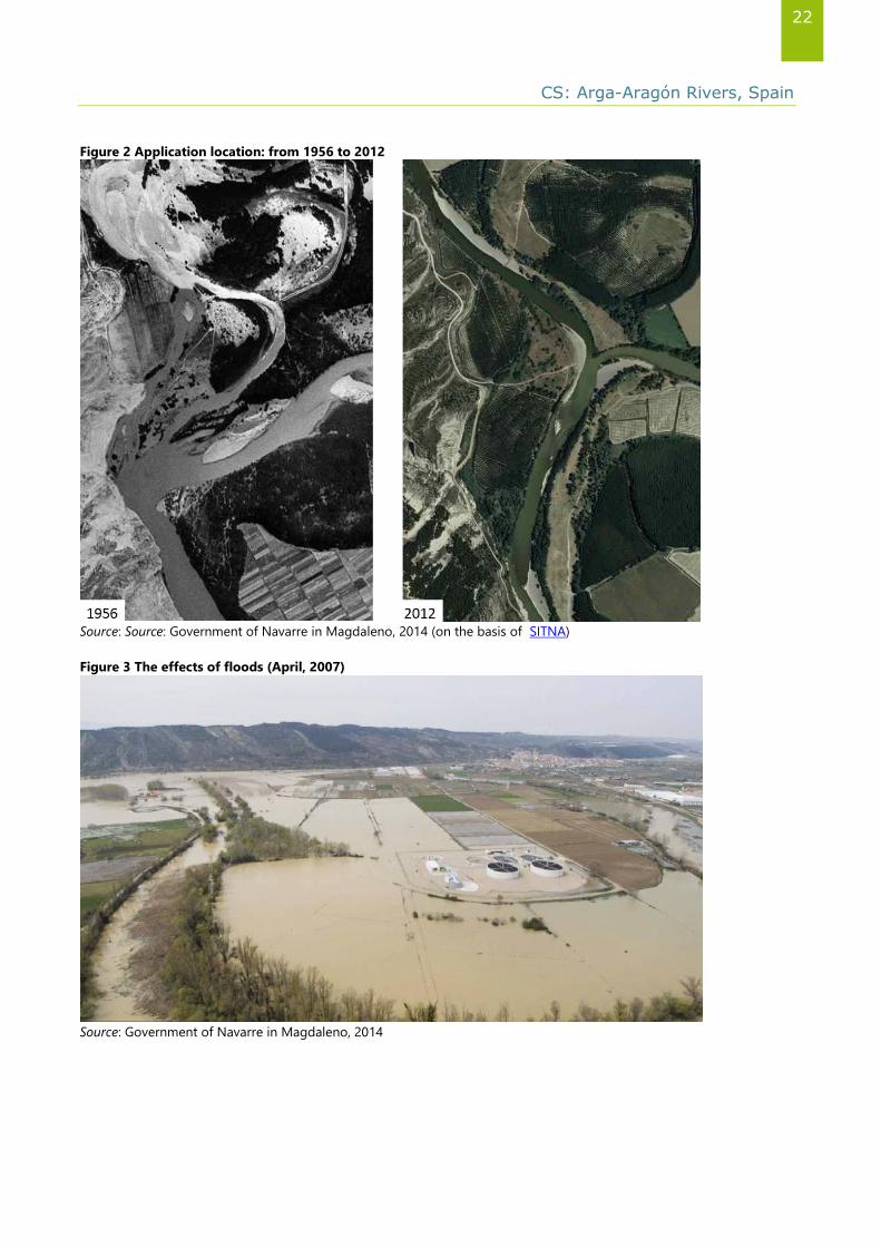
Figure 3 The effects of floods (April, 2007)
Source: Government of Navarre in Magdaleno, 2014
CS: Arga-Aragón Rivers, Spain
23
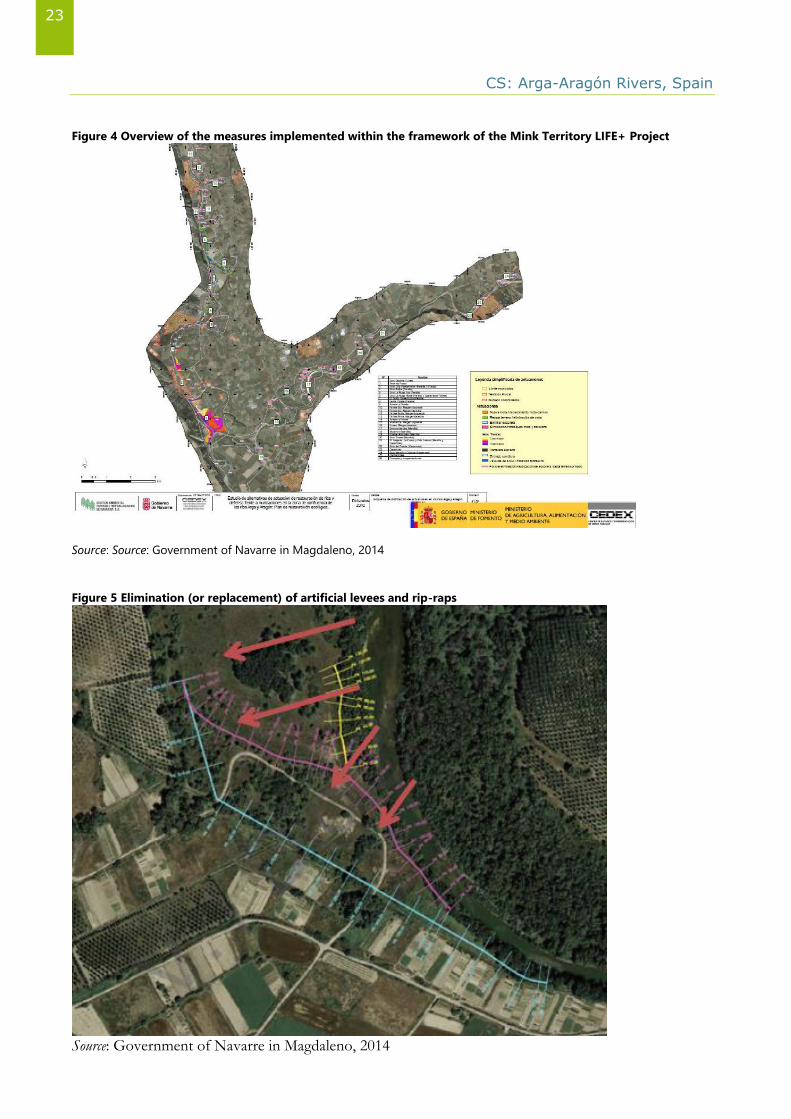
Figure 4 Overview of the measures implemented within the framework of the Mink Territory LIFE+ Project
Source: Source: Government of Navarre in Magdaleno, 2014
Figure 5 Elimination (or replacement) of artificial levees and rip-raps
Source: Government of Navarre in Magdaleno, 2014