Embed Size (px)
Citation preview
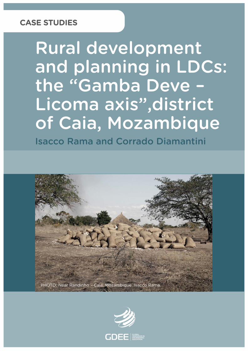
Isacco Rama and Corrado Diamantini
PHOTO: Near Randinho – Caia, Mozambique. Isacco Rama.
CASE STUDIES
Rural development and planning in LDCs: the “Gamba Deve –Licoma axis”,districtof Caia, Mozambique
DL B 10735-2015 ISBN 978-84-606-7546-4
Rural development and planning in LDCs: the “GambaDeve – Licoma axis”, district of Caia, Mozambique
COORDINATED BYAgustí Pérez-Foguet, Enric Velo, Pol Arranz, Ricard Ginéand Boris Lazzarini (Universitat Politècnica de Catalunya)Manuel Sierra (Universidad Politécnica de Madrid)Alejandra Boni and Jordi Peris (Universitat Politècnica de València)Guido Zolezzi and Gabriella Trombino (Università degli Studi di Trento)Rhoda Trimingham (Loughborough University)Valentín Villarroel (ONGAWA)Neil Nobles and Meadhbh Bolger (Practical Action)Francesco Mongera (Training Center for International Cooperation)Katie Cresswell-Maynard (Engineering Without Border UK)
EDITED BY Global Dimension in Engineering Education
Citation: Rama, I. and Diamantini, C. (2015) ' Rural development and planning in LDCs: the “Gamba Deve – Licoma axis”, district of Caia, Mozambique', in Case studies for developing globally responsible engineers, GDEE (eds.), Global Dimension in Engineering Education, Barcelona. Available from: http://gdee.eu/index.php/resources.html
This publication is distributedunder an Attribution- Noncommercial-Share Alike License for Creative Commons
CASE STUDIES
Disclaimer: This document has been produced with the financial assistance of the European UnionThe contents of this document are the sole responsibility of the authors and can under no circumstances be regarded as reflecting the position of the European Union
Rural Development and Planning in LDCs: The “Gamba Deve – Licoma axis”, District of Caia, Mozambique
RURAL DEVELOPMENT AND PLANNING IN LDCS: THE “GAMBA DEVE – LICOMA AXIS”, DISTRICT OF CAIA, MOZAMBIQUE Isacco Rama, DICAM – Università degli Studi di Trento Corrado Diamantini, DICAM – Università degli Studi di Trento
1
Rural Development and Planning in LDCs: The “Gamba Deve – Licoma axis”, District of Caia, Mozambique
INDEX 1. INTRODUCTION ........................................................................................................................... 3
1.1. DISCIPLINES COVERED ............................................................................................................. 3
1.2. LEARNING OUTCOMES .............................................................................................................. 4
1.3. ACTIVITIES .............................................................................................................................. 4
2. DESCRIPTION OF THE CONTEXT ............................................................................................. 4
2.1. THE PROBLEM OF ACCESSIBILITY OF REMOTE AREAS ................................................................. 4
2.2. THE CAIA DISTRICT ................................................................................................................. 5
2.3. THE STRATEGIC NATURE OF THE GAMBA DEVE – LICOMA AXIS ..................................................... 8
2.4. THE INFRASTRUCTURAL NETWORK .......................................................................................... 10
2.5. SERVICES TO THE POPULATION .............................................................................................. 12
3. CLASS ACTIVITY ....................................................................................................................... 18
3.1. CONTEXT AND DETERMINANTS................................................................................................ 18
3.2. EXAMINATION OF ROADWAY AND ROADWAY DEFECTS .............................................................. 21
3.3. TECHNICAL SOLUTIONS ADOPTED ........................................................................................... 25
3.4. MODEL SECTION .................................................................................................................... 26
3.5. EMBANKMENT SECTION .......................................................................................................... 26
3.6. LONGITUDINAL SLOPE SECTION .............................................................................................. 27
3.7. SECONDARY WATERWAYS CROSSING SECTION ........................................................................ 28
3.8. SYNERGIES ACHIEVED WITH THE ROADWAY ............................................................................. 29
4. HOMEWORK ACTIVITY ............................................................................................................. 29
4.1. ED1: PLANIMETRIC LAYOUT AND TECHNICAL SOLUTIONS ........................................................... 30
4.2. SERVICES TO THE POPULATION .............................................................................................. 30
4.3. EXPECTED BENEFITS IDENTIFICATION AND CLASSIFICATION ...................................................... 31
5. BIBLIOGRAPHY ......................................................................................................................... 32
2

Rural Development and Planning in LDCs: The “Gamba Deve – Licoma axis”, District of Caia, Mozambique
1. INTRODUCTION It is believed that the development of rural areas of low income countries is an important
factor in limiting migration to the cities, which do not appear capable of supporting this
weight in terms of labour demand and supply of services to the immigrant population. In this
kind of rural development, smaller towns play a key role and, thanks to the urban-rural
relations that smaller towns activate, they act as exchange nodes in supralocal relationships.
These rural-urban relationships are facilitated by transport infrastructures that result in ever
greater efficiency depending on their level of accessibility. One of the major problems of
access to the interior rural areas of developing countries consists, in fact, in the seasonality
of access to roads, often precluded during the rainy season.
Generally, benefits associated with efficient links between urban centres and rural areas are
the marketing of agricultural surplus and access to goods and services considered to be
urban. The creation of basic services distributed synergistically along rural axes is also
crucial in order to ensure higher standards of welfare to the rural population. Rural
infrastructural axes must be designed precisely to serve the local population and not solely
in support of commercial exchanges.
A final aspect of the problem is related to the costs of road infrastructures. Local
governments have often limited resources and the containment of costs during the design
phase is a fundamental factor.
1.1. DISCIPLINES COVERED
The proposed case study covers two disciplines, namely regional spacial planning and low-
volume road infrastructure design.
Concerning the first discipline, key aspects of the case study are:
• identification of the most suitable areas for road infrastructure, taking into
account both their growth potential and effectiveness for urban-rural relations;
• location of services to the population, taking into account the spatial
distribution and accessibility of human settlements.
• With regard to the second discipline covered, the fundamental aspect is the
road design aimed at maximizing the benefits with the minimum construction
and maintenance costs.
3
Rural Development and Planning in LDCs: The “Gamba Deve – Licoma axis”, District of Caia, Mozambique
1.2. LEARNING OUTCOMES
The learning objectives are:
• acknowledgement of the range of problems occuring in remote rural areas,
with reference to subsistence strategies, meaning production and
consumption by local population;
• acknowledgement of specific issues of the area, with reference both to the
marketing of agricultural surplus and to the access to public and private
services;
• ability to identify the appropriate contexts for investments in infrastructure and
services;
• ability to set up a road design adapted to the actual conditions within a
particular context, or at least the analysis of an infrastructure project in a low
income rural area.
1.3. ACTIVITIES
In class, students are introduced to the project. A discussion is then launched aimed at
clarifying doubts and, above all, determining any alternatives to the proposed technical
solution.
Activities carried out by students outside of class are expected to be in groups formed on the
basis of actual skills/interests possessed by each student.
2. DESCRIPTION OF THE CONTEXT The following section is focused on the context in which the case study takes place. The
problem of accessibility in remote areas will be detailed and the district of Caia will be
described. Successively, the specific issue of the strategic importance of the Gamba-Deve /
Licoma axis will be addressed, before providing a detailed description of the road services,
other infrastructures and service networks.
2.1. THE PROBLEM OF ACCESSIBILITY OF REMOTE AREAS
The roadway communication network was built in Mozambique during the colonial period.
There are settlements where the Portuguese roads did not arrive: the Portuguese favoured
trading and administrative posts and did not penetrate to the more remote areas that were
run by locals. The post-colonial government has invested as a priority in health and
education in the main urban centres and the current government invests in major works on
4
Rural Development and Planning in LDCs: The “Gamba Deve – Licoma axis”, District of Caia, Mozambique
the main axis. It is therefore evident that a capillary road network has not been developed to
date. Large areas still remain inadequately served by road networks for the transit of
vehicles, motorbikes and bicycles. The situation is aggravated during the rainy reason, when
the existing dirt roads become only partially passable due to the creation of mud and huge
water puddles. This fact generates huge restrictions for the transit of people and goods. In
countries where more than 70% of the population lives in rural areas, the lack of transport
infrastructure means a consequent lack of health and education services, low variety of
goods and general absence of modernity for the numerous remote areas.
2.2. THE CAIA DISTRICT Caia district is located in the central region of Mozambique, in a strategic position at the
crossroads of the EN1, the main roadway of the country, and the axis Caia-Sena-Tete. The
latter runs parallel to the railway line to Beira and Marromeu, the ER213 road and the
Zambezi river.
With an area of 3.542km2 and a population of 115,612 inhabitants, Caia is one of the most
densely populated rural districts of Mozambique (33ab / km2)1. The Caia district is bounded
on the northwest by the District of Chemba, to the east by the Zambezi River, on the west by
the District of Maringue and on the south by the districts of Cheringoma and Marromeu.
From the point of view of land cover, most of the district is savannah and wooded savannah
(66.3%). There are some forest areas (10.4%), areas of cultivated land (8.2%) and wetlands
and flooded areas (14.2%). Finally, infrastructure and settlements occupy a small part of the
territory of the district (0.8%).
1 INE, Censo Geral da População, 2007
5
Rural Development and Planning in LDCs: The “Gamba Deve – Licoma axis”, District of Caia, Mozambique
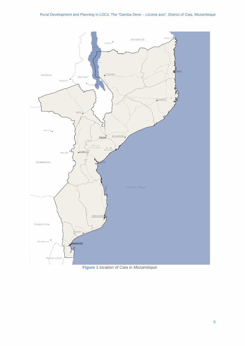
Figure 1 location of Caia in Mozambique
6
Rural Development and Planning in LDCs: The “Gamba Deve – Licoma axis”, District of Caia, Mozambique
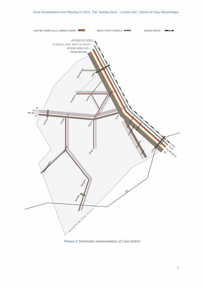
Figure 2 Schematic representation of Caia District
7
Rural Development and Planning in LDCs: The “Gamba Deve – Licoma axis”, District of Caia, Mozambique
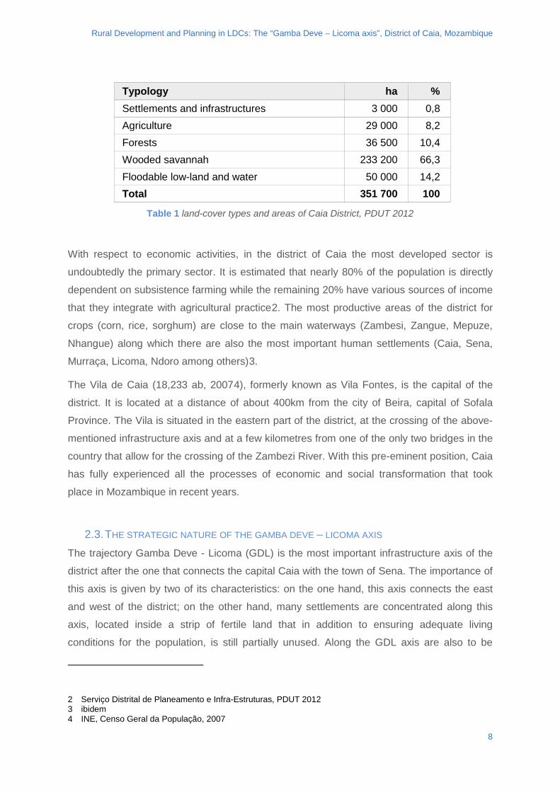
Typology ha % Settlements and infrastructures 3 000 0,8 Agriculture 29 000 8,2 Forests 36 500 10,4 Wooded savannah 233 200 66,3 Floodable low-land and water 50 000 14,2 Total 351 700 100
Table 1 land-cover types and areas of Caia District, PDUT 2012
With respect to economic activities, in the district of Caia the most developed sector is
undoubtedly the primary sector. It is estimated that nearly 80% of the population is directly
dependent on subsistence farming while the remaining 20% have various sources of income
that they integrate with agricultural practice2. The most productive areas of the district for
crops (corn, rice, sorghum) are close to the main waterways (Zambesi, Zangue, Mepuze,
Nhangue) along which there are also the most important human settlements (Caia, Sena,
Murraça, Licoma, Ndoro among others)3.
The Vila de Caia (18,233 ab, 20074), formerly known as Vila Fontes, is the capital of the
district. It is located at a distance of about 400km from the city of Beira, capital of Sofala
Province. The Vila is situated in the eastern part of the district, at the crossing of the above-
mentioned infrastructure axis and at a few kilometres from one of the only two bridges in the
country that allow for the crossing of the Zambezi River. With this pre-eminent position, Caia
has fully experienced all the processes of economic and social transformation that took
place in Mozambique in recent years.
2.3. THE STRATEGIC NATURE OF THE GAMBA DEVE – LICOMA AXIS
The trajectory Gamba Deve - Licoma (GDL) is the most important infrastructure axis of the
district after the one that connects the capital Caia with the town of Sena. The importance of
this axis is given by two of its characteristics: on the one hand, this axis connects the east
and west of the district; on the other hand, many settlements are concentrated along this
axis, located inside a strip of fertile land that in addition to ensuring adequate living
conditions for the population, is still partially unused. Along the GDL axis are also to be
2 Serviço Distrital de Planeamento e Infra-Estruturas, PDUT 2012 3 ibidem 4 INE, Censo Geral da População, 2007
8
Rural Development and Planning in LDCs: The “Gamba Deve – Licoma axis”, District of Caia, Mozambique
found some important service infrastructures for the population such as education and health
facilities, as well as private services that provide access to water and products on the local
markets.
The East-West connection is guaranteed by the road axis called Estrada Distrital N° 1
(ED1). This road, in addition to crossing through the GDL axis, connects at Licoma, the Caia
district with the district of Maringue, thus ensuring an inter-district link. The importance of the
GDL axis for the district is therefore evident, not only when considering the local scale, but
also on the regional scale.
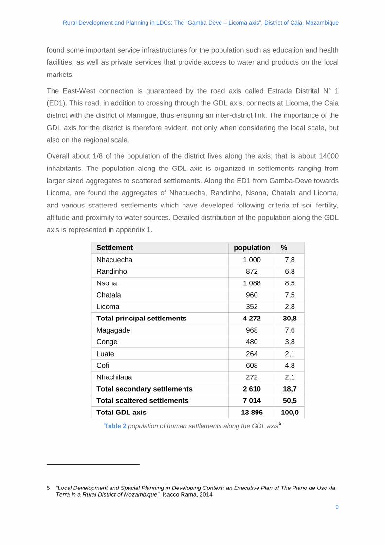
Overall about 1/8 of the population of the district lives along the axis; that is about 14000
inhabitants. The population along the GDL axis is organized in settlements ranging from
larger sized aggregates to scattered settlements. Along the ED1 from Gamba-Deve towards
Licoma, are found the aggregates of Nhacuecha, Randinho, Nsona, Chatala and Licoma,
and various scattered settlements which have developed following criteria of soil fertility,
altitude and proximity to water sources. Detailed distribution of the population along the GDL
axis is represented in appendix 1.
Settlement population % Nhacuecha 1 000 7,8 Randinho 872 6,8 Nsona 1 088 8,5 Chatala 960 7,5 Licoma 352 2,8 Total principal settlements 4 272 30,8 Magagade 968 7,6 Conge 480 3,8 Luate 264 2,1 Cofi 608 4,8 Nhachilaua 272 2,1 Total secondary settlements 2 610 18,7 Total scattered settlements 7 014 50,5 Total GDL axis 13 896 100,0
Table 2 population of human settlements along the GDL axis5
5 “Local Development and Spacial Planning in Developing Context: an Executive Plan of The Plano de Uso da Terra in a Rural District of Mozambique”, Isacco Rama, 2014
9
Rural Development and Planning in LDCs: The “Gamba Deve – Licoma axis”, District of Caia, Mozambique
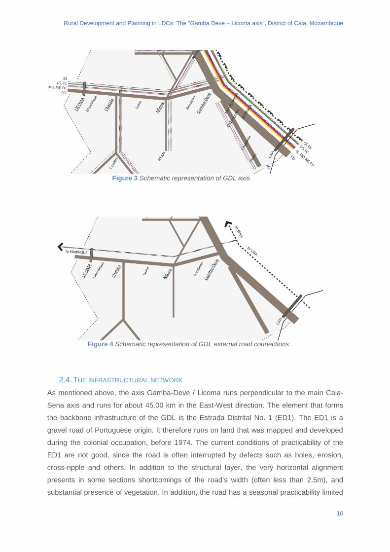
2.4. THE INFRASTRUCTURAL NETWORK As mentioned above, the axis Gamba-Deve / Licoma runs perpendicular to the main Caia-
Sena axis and runs for about 45.00 km in the East-West direction. The element that forms
the backbone infrastructure of the GDL is the Estrada Distrital No. 1 (ED1). The ED1 is a
gravel road of Portuguese origin. It therefore runs on land that was mapped and developed
during the colonial occupation, before 1974. The current conditions of practicability of the
ED1 are not good, since the road is often interrupted by defects such as holes, erosion,
cross-ripple and others. In addition to the structural layer, the very horizontal alignment
presents in some sections shortcomings of the road’s width (often less than 2.5m), and
substantial presence of vegetation. In addition, the road has a seasonal practicability limited
Figure 3 Schematic representation of GDL axis
Figure 4 Schematic representation of GDL external road connections
10
Rural Development and Planning in LDCs: The “Gamba Deve – Licoma axis”, District of Caia, Mozambique
to the dry season. Up to date traffic data is scarce but from observations made on site, a
transit of maximum 5 cars per day can be estimated, limited to vehicles with a dry mass of
less than about 5.5 tons.
The presence of defects along the ED1 road is a major limitation to the passage of people
and goods along the GDL axis. The greatest number of defects occurs on the road surface
due to two main factors: the longitudinal inclination of the track and the proximity to the river
Mepuze. Both these elements, combined with torrential rainfall between November and
March, contribute to engender the defects on the road, which, together with the low
maintenance of the road, severely restrict transit along the DGL. Transit which is currently
only possible for four-wheel drive vehicles or vehicles which are very well raised from the
ground.
From the intersection with the ER213 "Caia-Sena", the infrastructure track of the ED1 runs
for about 9.6 km in an altimetrically depressed section where the presence of still water on
the road surface is an almost complete obstacle to transit during almost half of the year and
a critical constraint also in the remaining months.
From km 9.6 to km 13.8 the ED1 rises slightly away from the level of the Mepuze river. Along
this section, the main difficulty is the longitudinal erosion of the structural layer, associated
with problems of slipperiness and the presence of holes.
Over the following 11km (13.8 km - 24.6 km) the path of the ED1 crosses at 8 points, some
of the minor streams that feed the river Mepuze. These crossings are characterized by the
presence of seasonal water in the rainy season that can reach a few feet high, invading the
road and making it nearly impossible to pass for all motor vehicles from November to late
March or so.
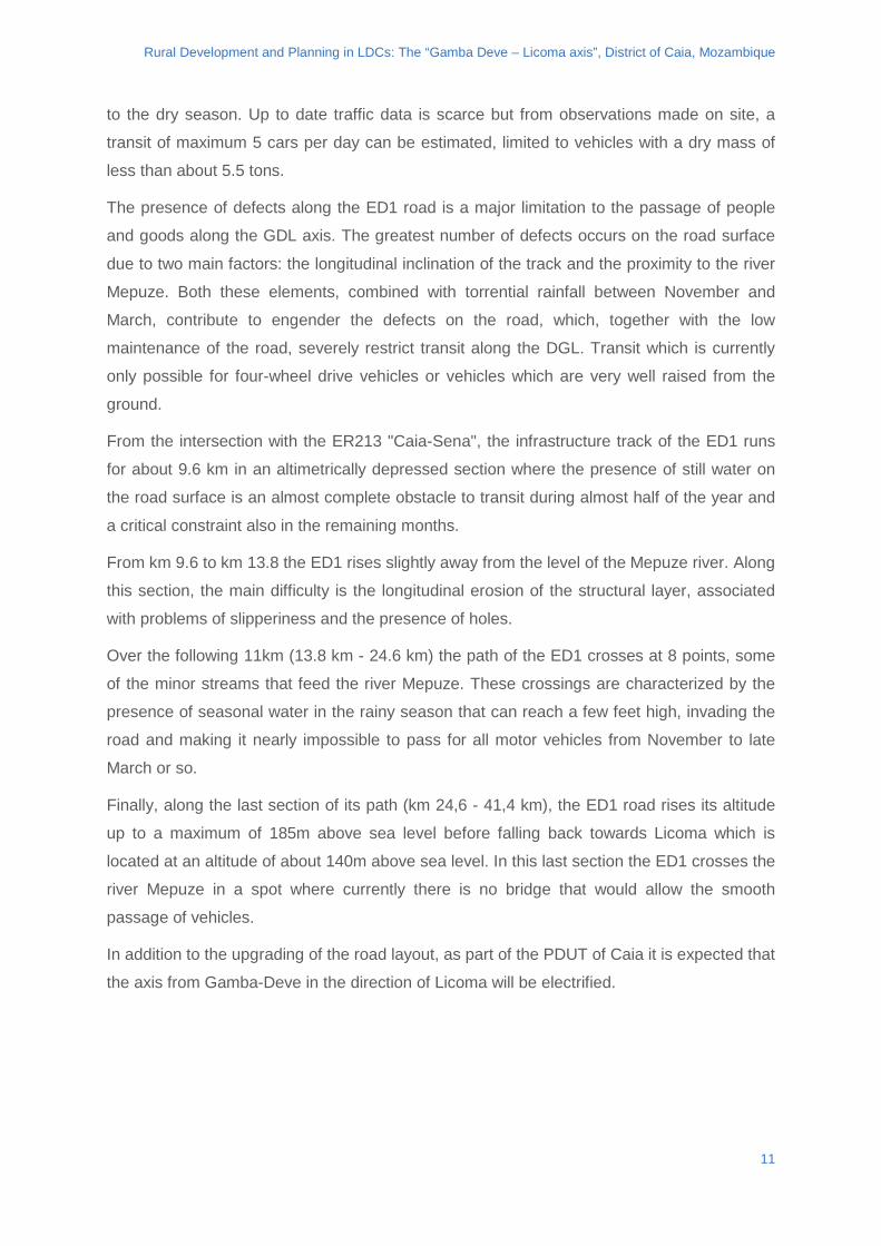
Finally, along the last section of its path (km 24,6 - 41,4 km), the ED1 road rises its altitude
up to a maximum of 185m above sea level before falling back towards Licoma which is
located at an altitude of about 140m above sea level. In this last section the ED1 crosses the
river Mepuze in a spot where currently there is no bridge that would allow the smooth
passage of vehicles.
In addition to the upgrading of the road layout, as part of the PDUT of Caia it is expected that
the axis from Gamba-Deve in the direction of Licoma will be electrified.
11
Rural Development and Planning in LDCs: The “Gamba Deve – Licoma axis”, District of Caia, Mozambique
2.5. SERVICES TO THE POPULATION
In rural areas of Mozambique, the network of public and private initiatives are cohabiting and
easily distinguishable. The public authority is represented by the administrative structure of
the state and provides two basic services to the population: education and healthcare. The
private sector is present with various initiatives, especially related to family-size or
cooperative structures, such as management of local markets, management of mills and the
network of water wells, supply of transport to the population, production and trade of
agricultural goods and, more rarely, working as employees.
Figure 5 view of the Mepuze river and ED1 road
12
Rural Development and Planning in LDCs: The “Gamba Deve – Licoma axis”, District of Caia, Mozambique
Again with reference to rural areas in Mozambique, basic health facilities, namely Centro de
Saude and Posto de Saude, as well as basic educational facilities, Escola Primaria de 1°
grau (EP1) and Escola Primaria Completa (EPC), are constructed according to an
architectural standard. This provides for simple structures in reinforced concrete, featuring
two or three rooms. Often, schools and health facilities do not have electricity, or resort to
the use of solar panels. They often do not have running water and if not, they may resort to
simple ad-hoc hydraulic systems. Schools work on several shifts during the day. In the vast
majority of cases professionals of the two sectors (teachers, nurses, attendants) come from
outside GDL and are housed in public residential facilities.
In terms of the GDL axis, the presence of the public sector is translated into administrative
structures, such as the Posto da Localidade de Licoma (PAL) and the network of schools
and health facilities. At the PAL sits a public official (called Chefe da Localidade) and a small
secretariat (composed of two people). This administrative structure exerts some simple
mandates of an executive nature, including the promotion of health and education within its
jurisdiction. The schools and health facilities network along the GDL follows, with some key
exceptions, the presence of the population. Structures are in fact placed to coincide with the
main centres (aggregates). In particular, schools can be found near Gamba-Deve,
Nhacuecha, Randinho, Nsona, Chatala, Cofi and Licoma. Health posts can be found in
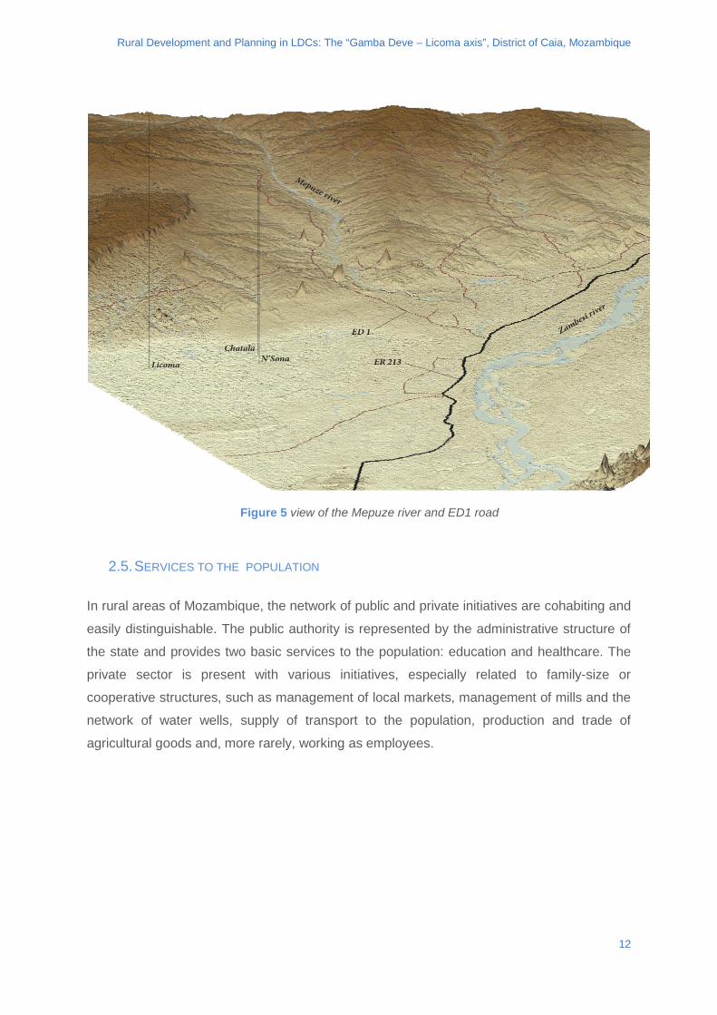
Figure 6 simplified map of the ED1 Gamba/Deve - Licoma and Mepuze river
13
Rural Development and Planning in LDCs: The “Gamba Deve – Licoma axis”, District of Caia, Mozambique
Gamba-Deva, Randinho, Chatala and Licoma. Aggregates listed above, all of medium size,
have a theoretically sufficient coverage of services.
The difficulty of access to services by the rural population is caused on the one hand by the
numerically significant presence of scattered settlements placed at a distance from the
aggregates, and on the other hand by the low quality of both education and health care
services. In fact, regarding schools, critical issues are related to: extremely high
pupils/teacher ratios, few school grades offered (grades 1 to 5), difficult access for distant
households, lack of teaching materials. As for the health care facilities, critical issues are
linked to: absence of qualified staff, lack of medicines and medical supplies, lack of health
care equipment, isolation of the health posts with respect to the hospital of Caia, resulting in
difficulty in the mobility of health staff and patients.
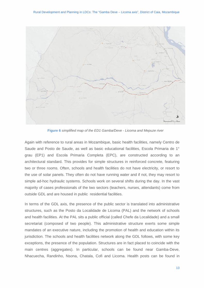
Health post population Centro de Saude de Gamba-Deve
3 198
Posto de Saude de Randinho 2 015 Centro de Saude de Chatala 3 166 Centro de Saude de Licoma 2 143 Total 10 522
Table 3 population per health post along the GDL axis
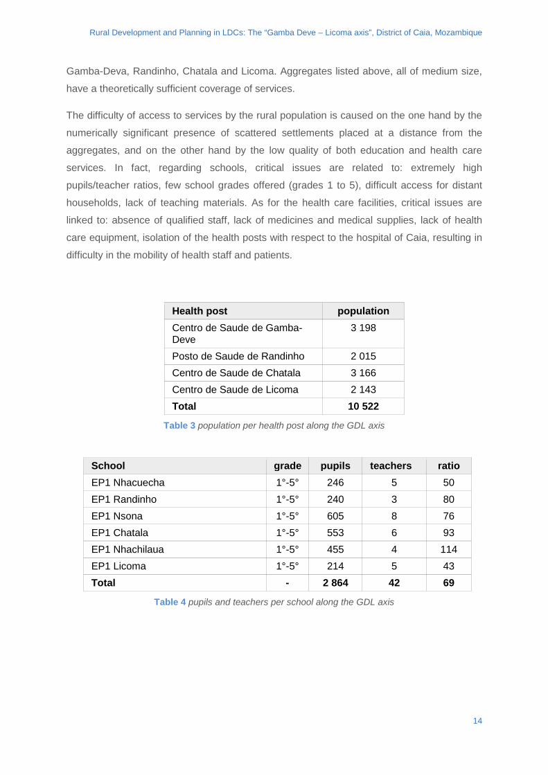
School grade pupils teachers ratio EP1 Nhacuecha 1°-5° 246 5 50 EP1 Randinho 1°-5° 240 3 80 EP1 Nsona 1°-5° 605 8 76 EP1 Chatala 1°-5° 553 6 93 EP1 Nhachilaua 1°-5° 455 4 114 EP1 Licoma 1°-5° 214 5 43 Total - 2 864 42 69
Table 4 pupils and teachers per school along the GDL axis
14
Rural Development and Planning in LDCs: The “Gamba Deve – Licoma axis”, District of Caia, Mozambique
In general, it can therefore be said that, although in recent years considerable efforts have been made by local and national governments to improve networks and structures, a shortage of materials/staff and poor quality of service remain at a critical level.
With regard to the services offered to the population and managed by the private sector, i.e. mills, water wells and local markets, the network is more dense and it is less easy to make generalizations. The water wells are generally constructed with funds managed partly by the technical district office (SDPI) and often obtained from donations. On average, wells do not exceed 35/40m depth and are composed of a battery of tubes connected with the water pump. Afridev-type manual water pumps are often used while more rarely small electric pumps are installed. As for the other services, the water well network follows largely the presence of the population, although there are a larger number of scattered settlements that are not covered by the service.
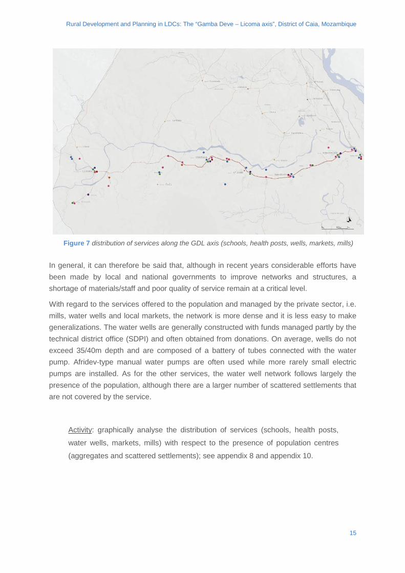
Activity: graphically analyse the distribution of services (schools, health posts,
water wells, markets, mills) with respect to the presence of population centres
(aggregates and scattered settlements); see appendix 8 and appendix 10.
Figure 7 distribution of services along the GDL axis (schools, health posts, wells, markets, mills)
15
Rural Development and Planning in LDCs: The “Gamba Deve – Licoma axis”, District of Caia, Mozambique
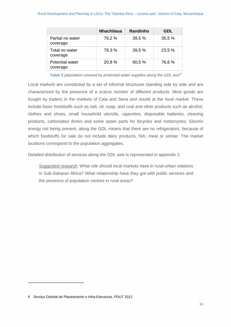
Nhachilaua Randinho GDL Partial no water coverage
79,2 % 39,5 % 35,5 %
Total no water coverage
79,3 % 39,5 % 23,5 %
Potential water coverage
20,8 % 60,5 % 76,6 %
Table 5 population covered by protected water supplies along the GDL axis6
Local markets are constituted by a set of informal structures standing side by side and are
characterized by the presence of a scarce number of different products. Most goods are
bought by traders in the markets of Caia and Sena and resold at the local market. These
include basic foodstuffs such as salt, oil, soap, and coal and other products such as alcohol,
clothes and shoes, small household utensils, cigarettes, disposable batteries, cleaning
products, carbonated drinks and some spare parts for bicycles and motorcycles. Electric
energy not being present, along the GDL means that there are no refrigerators, because of
which foodstuffs for sale do not include dairy products, fish, meat or similar. The market
locations correspond to the population aggregates.
Detailed distribution of services along the GDL axis is represented in appendix 2.
Suggested research: What role should local markets have in rural-urban relations
in Sub-Saharan Africa? What relationship have they got with public services and
the presence of population centres in rural areas?
6 Serviço Distrital de Planeamento e Infra-Estruturas, PDUT 2012
16
Rural Development and Planning in LDCs: The “Gamba Deve – Licoma axis”, District of Caia, Mozambique
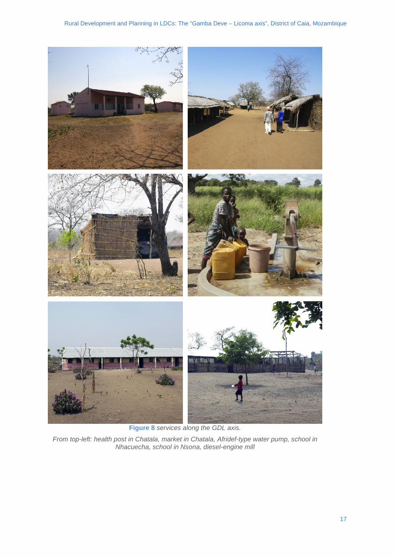
Figure 8 services along the GDL axis.
From top-left: health post in Chatala, market in Chatala, Afridef-type water pump, school in Nhacuecha, school in Nsona, diesel-engine mill
17
Rural Development and Planning in LDCs: The “Gamba Deve – Licoma axis”, District of Caia, Mozambique
3. CLASS ACTIVITY
It is suggested that the introduction to the project is made in 4 phases: (1) inspection of
context and determinants, (2) examination of the roadway and roadway defects, (3)
description of adopted technical solutions, (4) description of synergies adopted with the
roadway. In order to simplify the transmission of concepts during the lecture, in the following
section each of these stages will be illustrated.
Classroom activities can be developed according to the methods preferred by the professor,
although leaving ample space for interaction between students is considered of particular
importance. This is to be seen in the perspective of alternative proposals in terms of
technical-specific design for ED1 and the service network made by student groups during
the homework activity.
3.1. CONTEXT AND DETERMINANTS
It is very important to consider that the Case Study has been carried out in a rural area of
one of the countries with the lowest GDP per capita in the world. The GDL axis is
characterized by technological backwardness in agricultural practice, media isolation,
endemic poverty of the population. The rational allocation of resources is therefore of
fundamental importance, the detailed examination of the context and clarification of the
determining factors are the basis for a successful project.
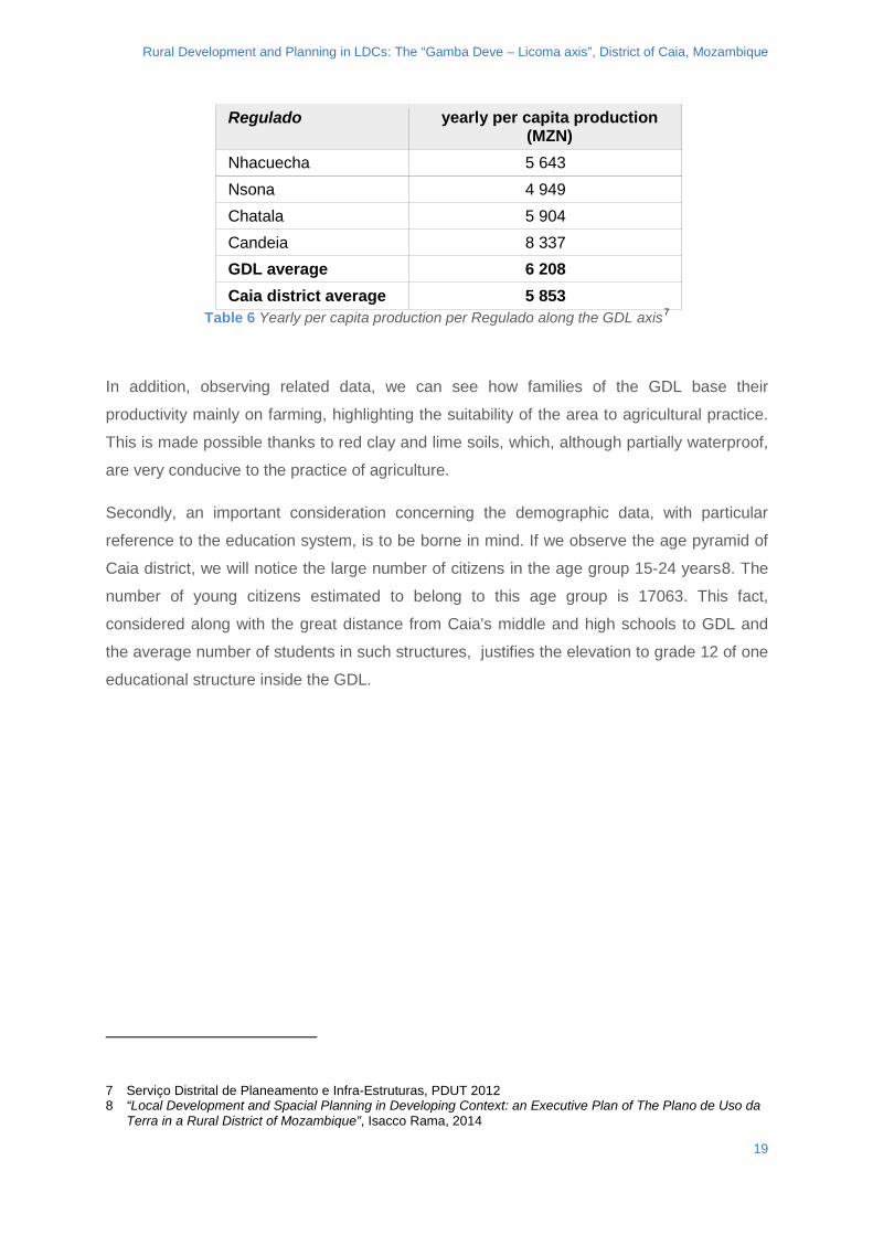
First of all it is important to consider that three out of four of the Regulados that stand on the
GDL axis have a per capita monetized annual production higher than the district average. In
relation to the Caia district, the overall productivity (the sum of the agricultural product and
that of animal hubandry) in Nhacuecha, Nsona, Chatala and Candeia is up to 6% higher
than the average.
18
Rural Development and Planning in LDCs: The “Gamba Deve – Licoma axis”, District of Caia, Mozambique
Regulado yearly per capita production (MZN)
Nhacuecha 5 643 Nsona 4 949 Chatala 5 904 Candeia 8 337 GDL average 6 208 Caia district average 5 853
Table 6 Yearly per capita production per Regulado along the GDL axis7
In addition, observing related data, we can see how families of the GDL base their
productivity mainly on farming, highlighting the suitability of the area to agricultural practice.
This is made possible thanks to red clay and lime soils, which, although partially waterproof,
are very conducive to the practice of agriculture.
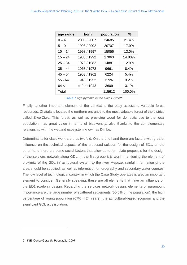
Secondly, an important consideration concerning the demographic data, with particular
reference to the education system, is to be borne in mind. If we observe the age pyramid of
Caia district, we will notice the large number of citizens in the age group 15-24 years8. The
number of young citizens estimated to belong to this age group is 17063. This fact,
considered along with the great distance from Caia's middle and high schools to GDL and
the average number of students in such structures, justifies the elevation to grade 12 of one
educational structure inside the GDL.
7 Serviço Distrital de Planeamento e Infra-Estruturas, PDUT 2012 8 “Local Development and Spacial Planning in Developing Context: an Executive Plan of The Plano de Uso da
Terra in a Rural District of Mozambique”, Isacco Rama, 2014
19
Rural Development and Planning in LDCs: The “Gamba Deve – Licoma axis”, District of Caia, Mozambique
age range born population % 0 – 4 2003 / 2007 24685 21.4% 5 – 9 1998 / 2002 20707 17.9% 10 – 14 1993 / 1997 15056 13.0% 15 – 24 1983 / 1992 17063 14.80% 25 – 34 1973 / 1982 14881 12.9% 35 – 44 1963 / 1972 9661 8.4% 45 – 54 1953 / 1962 6224 5.4% 55 - 64 1943 / 1952 3726 3.2% 64 < before 1943 3609 3.1% Total 115612 100.0%
Table 7 Age pyramid in the Caia District9
Finally, another important element of the context is the easy access to valuable forest
resources. Chatala is located the northern entrance to the most valuable forest of the district,
called Ziwe-Ziwe. This forest, as well as providing wood for domestic use to the local
population, has great value in terms of biodiversity, also thanks to the complementary
relationship with the wetland ecosystem known as Dimbe.
Determinants for class work are thus twofold. On the one hand there are factors with greater
influence on the technical aspects of the proposed solution for the design of ED1, on the
other hand there are some social factors that allow us to formulate proposals for the design
of the services network along GDL. In the first group it is worth mentioning the element of
proximity of the GDL infrastructural system to the river Mepuze, rainfall information of the
area should be supplied, as well as information on orography and secondary water courses.
The low level of technological context in which the Case Study operates is also an important
element to consider. Generally speaking, these are all elements that have an influence on
the ED1 roadway design. Regarding the services network design, elements of paramount
importance are the large number of scattered settlements (50.5% of the population), the high
percentage of young population (67% < 24 years), the agricultural-based economy and the
significant GDL axis isolation.
9 INE, Censo Geral da População, 2007
20
Rural Development and Planning in LDCs: The “Gamba Deve – Licoma axis”, District of Caia, Mozambique
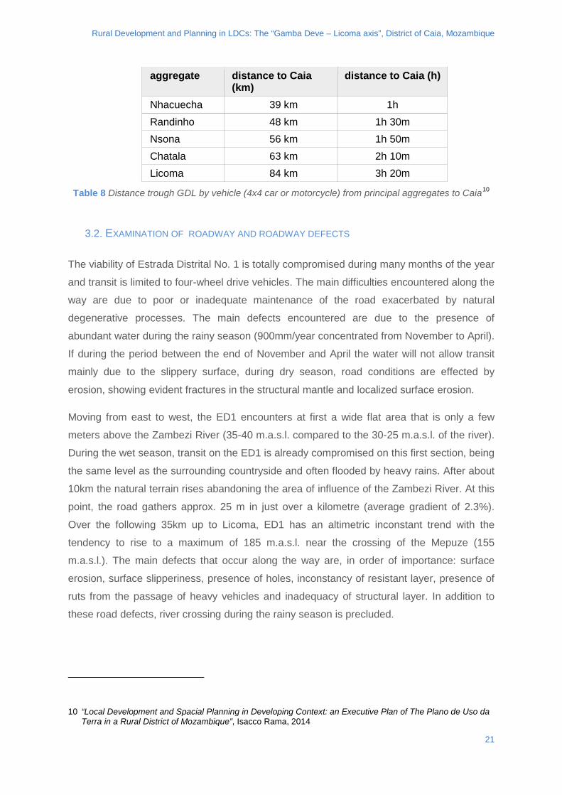
aggregate distance to Caia (km)
distance to Caia (h)
Nhacuecha 39 km 1h Randinho 48 km 1h 30m Nsona 56 km 1h 50m Chatala 63 km 2h 10m Licoma 84 km 3h 20m
Table 8 Distance trough GDL by vehicle (4x4 car or motorcycle) from principal aggregates to Caia10
3.2. EXAMINATION OF ROADWAY AND ROADWAY DEFECTS
The viability of Estrada Distrital No. 1 is totally compromised during many months of the year
and transit is limited to four-wheel drive vehicles. The main difficulties encountered along the
way are due to poor or inadequate maintenance of the road exacerbated by natural
degenerative processes. The main defects encountered are due to the presence of
abundant water during the rainy season (900mm/year concentrated from November to April).
If during the period between the end of November and April the water will not allow transit
mainly due to the slippery surface, during dry season, road conditions are effected by
erosion, showing evident fractures in the structural mantle and localized surface erosion.
Moving from east to west, the ED1 encounters at first a wide flat area that is only a few
meters above the Zambezi River (35-40 m.a.s.l. compared to the 30-25 m.a.s.l. of the river).
During the wet season, transit on the ED1 is already compromised on this first section, being
the same level as the surrounding countryside and often flooded by heavy rains. After about
10km the natural terrain rises abandoning the area of influence of the Zambezi River. At this
point, the road gathers approx. 25 m in just over a kilometre (average gradient of 2.3%).
Over the following 35km up to Licoma, ED1 has an altimetric inconstant trend with the
tendency to rise to a maximum of 185 m.a.s.l. near the crossing of the Mepuze (155
m.a.s.l.). The main defects that occur along the way are, in order of importance: surface
erosion, surface slipperiness, presence of holes, inconstancy of resistant layer, presence of
ruts from the passage of heavy vehicles and inadequacy of structural layer. In addition to
these road defects, river crossing during the rainy season is precluded.
10 “Local Development and Spacial Planning in Developing Context: an Executive Plan of The Plano de Uso da Terra in a Rural District of Mozambique”, Isacco Rama, 2014
21
Rural Development and Planning in LDCs: The “Gamba Deve – Licoma axis”, District of Caia, Mozambique
As seen, defects can be of different natures and suggest different design approaches. For
ED1, transit is affected basically by two main factors: presence of water on the road surface
and crossing of secondary water courses. Aside from these, crossings of Mulala and
Mepuze rivers are at the present moment nominally in the preliminary design and
construction phases.
Going back to road defects, the presence of water causes principally erosion and
slipperiness of the surface. This second defect is the more frequent as the wearing course is
composed of fine-grained soils (silts and clays). The interaction of these with water during
the rainy season gives rise to a highly plastic layer that can measure up to 20-25cm,
precluding the passage of all sorts of vehicles. This phenomenon has been observed both in
the low area adjacent to the Zambezi, and in lowland areas in the proximity of N'Sona and
Chatala where it is associated with the aggravating circumstance of a longitudinal gradient
/slope of the road higher than approx. 5/8%.
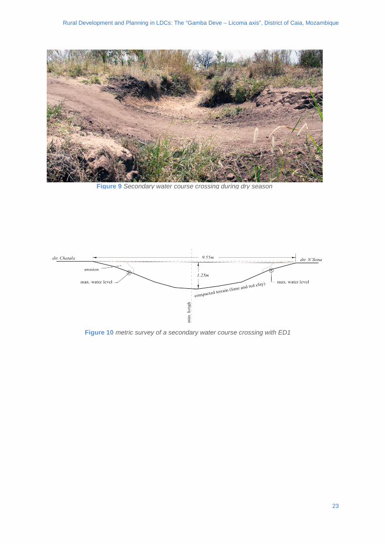
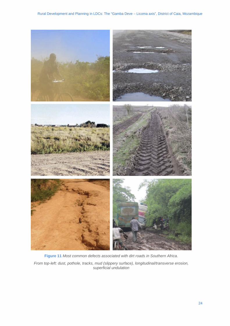
With regard to secondary water courses, these cross orthogonally the ED1 and during the
rainy season collect water from the corresponding basins (10km2 average size). A typical
crossing during the dry season is represented in figures 9 and 10.
Suggested material: “The Structural Design, Construction and Maintenance of
Unpaved Roads”, Department of Transport, Pretoria, Republic of South Africa,
1990, is the South Africa legislation reference for unpaved road design. See
appendix 11.
22
Rural Development and Planning in LDCs: The “Gamba Deve – Licoma axis”, District of Caia, Mozambique
Figure 10 metric survey of a secondary water course crossing with ED1
Figure 9 Secondary water course crossing during dry season
23
Rural Development and Planning in LDCs: The “Gamba Deve – Licoma axis”, District of Caia, Mozambique
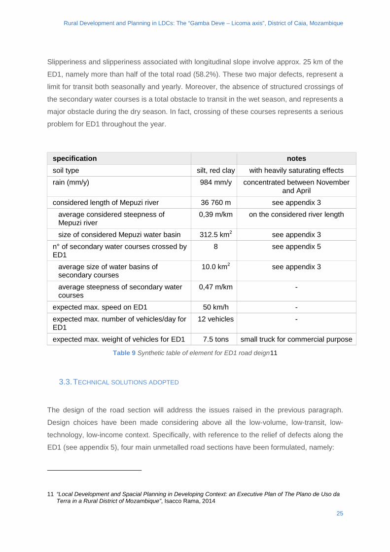
Figure 11 Most common defects associated with dirt roads in Southern Africa.
From top-left: dust, pothole, tracks, mud (slippery surface), longitudinal/transverse erosion, superficial undulation
24
Rural Development and Planning in LDCs: The “Gamba Deve – Licoma axis”, District of Caia, Mozambique
Slipperiness and slipperiness associated with longitudinal slope involve approx. 25 km of the
ED1, namely more than half of the total road (58.2%). These two major defects, represent a
limit for transit both seasonally and yearly. Moreover, the absence of structured crossings of
the secondary water courses is a total obstacle to transit in the wet season, and represents a
major obstacle during the dry season. In fact, crossing of these courses represents a serious
problem for ED1 throughout the year.
specification notes soil type silt, red clay with heavily saturating effects rain (mm/y) 984 mm/y concentrated between November
and April considered length of Mepuzi river 36 760 m see appendix 3
average considered steepness of Mepuzi river
0,39 m/km on the considered river length
size of considered Mepuzi water basin 312.5 km2 see appendix 3 n° of secondary water courses crossed by ED1
8 see appendix 5
average size of water basins of secondary courses
10.0 km2 see appendix 3
average steepness of secondary water courses
0,47 m/km -
expected max. speed on ED1 50 km/h - expected max. number of vehicles/day for ED1
12 vehicles -
expected max. weight of vehicles for ED1 7.5 tons small truck for commercial purpose
Table 9 Synthetic table of element for ED1 road deign11
3.3. TECHNICAL SOLUTIONS ADOPTED
The design of the road section will address the issues raised in the previous paragraph.
Design choices have been made considering above all the low-volume, low-transit, low-
technology, low-income context. Specifically, with reference to the relief of defects along the
ED1 (see appendix 5), four main unmetalled road sections have been formulated, namely:
11 “Local Development and Spacial Planning in Developing Context: an Executive Plan of The Plano de Uso da Terra in a Rural District of Mozambique”, Isacco Rama, 2014
25
Rural Development and Planning in LDCs: The “Gamba Deve – Licoma axis”, District of Caia, Mozambique
• model section
• embankment section (km 0.00 → km 9.60)
• longitudinal slope section (gradient >5/8%)
• secondary waterways crossing section (punctual)
These 4 design solutions will be briefly described below. Based on the cognitive framework
offered, students are encouraged during the homework activity to propose alternative
solutions that can subsequently be discussed in plenary.
3.4. MODEL SECTION
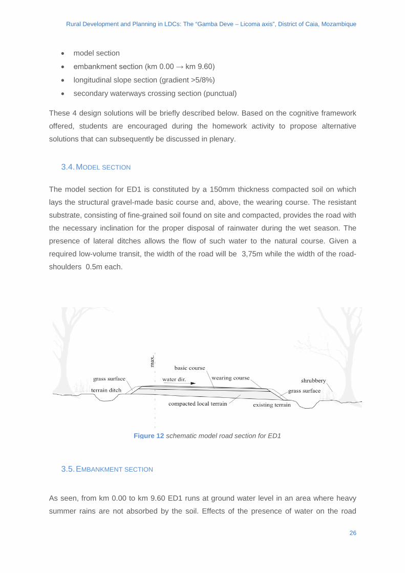
The model section for ED1 is constituted by a 150mm thickness compacted soil on which
lays the structural gravel-made basic course and, above, the wearing course. The resistant
substrate, consisting of fine-grained soil found on site and compacted, provides the road with
the necessary inclination for the proper disposal of rainwater during the wet season. The
presence of lateral ditches allows the flow of such water to the natural course. Given a
required low-volume transit, the width of the road will be 3,75m while the width of the road-
shoulders 0.5m each.
3.5. EMBANKMENT SECTION
As seen, from km 0.00 to km 9.60 ED1 runs at ground water level in an area where heavy
summer rains are not absorbed by the soil. Effects of the presence of water on the road
Figure 12 schematic model road section for ED1
26
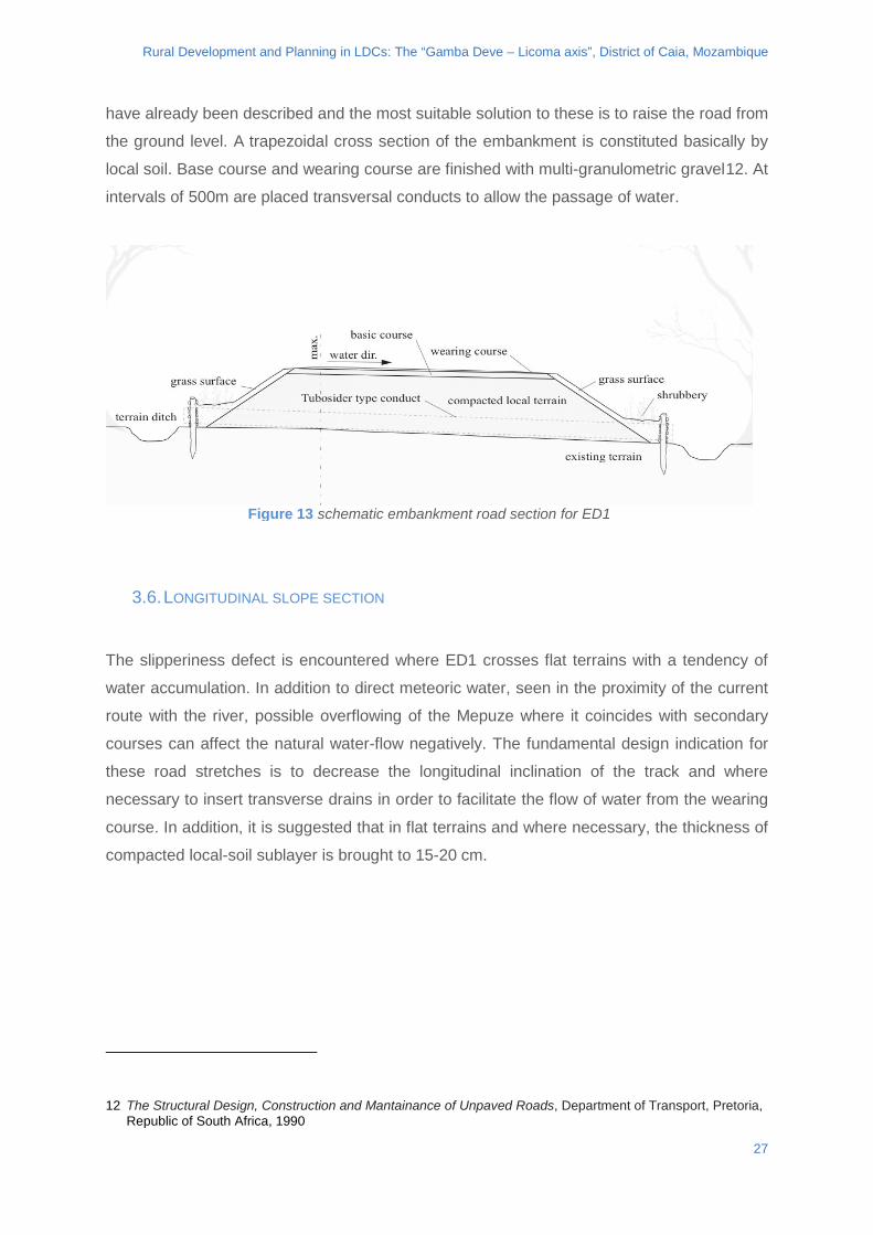
Rural Development and Planning in LDCs: The “Gamba Deve – Licoma axis”, District of Caia, Mozambique
have already been described and the most suitable solution to these is to raise the road from
the ground level. A trapezoidal cross section of the embankment is constituted basically by
local soil. Base course and wearing course are finished with multi-granulometric gravel12. At
intervals of 500m are placed transversal conducts to allow the passage of water.
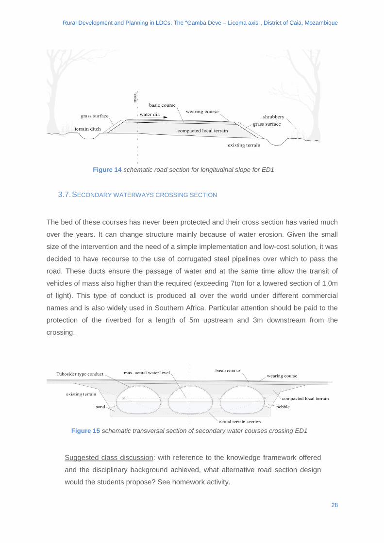
3.6. LONGITUDINAL SLOPE SECTION
The slipperiness defect is encountered where ED1 crosses flat terrains with a tendency of
water accumulation. In addition to direct meteoric water, seen in the proximity of the current
route with the river, possible overflowing of the Mepuze where it coincides with secondary
courses can affect the natural water-flow negatively. The fundamental design indication for
these road stretches is to decrease the longitudinal inclination of the track and where
necessary to insert transverse drains in order to facilitate the flow of water from the wearing
course. In addition, it is suggested that in flat terrains and where necessary, the thickness of
compacted local-soil sublayer is brought to 15-20 cm.
12 The Structural Design, Construction and Mantainance of Unpaved Roads, Department of Transport, Pretoria, Republic of South Africa, 1990
Figure 13 schematic embankment road section for ED1
27
Rural Development and Planning in LDCs: The “Gamba Deve – Licoma axis”, District of Caia, Mozambique
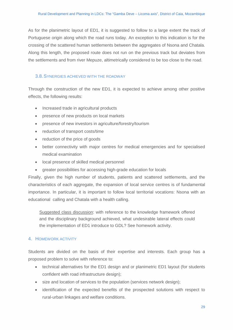
3.7. SECONDARY WATERWAYS CROSSING SECTION
The bed of these courses has never been protected and their cross section has varied much
over the years. It can change structure mainly because of water erosion. Given the small
size of the intervention and the need of a simple implementation and low-cost solution, it was
decided to have recourse to the use of corrugated steel pipelines over which to pass the
road. These ducts ensure the passage of water and at the same time allow the transit of
vehicles of mass also higher than the required (exceeding 7ton for a lowered section of 1,0m
of light). This type of conduct is produced all over the world under different commercial
names and is also widely used in Southern Africa. Particular attention should be paid to the
protection of the riverbed for a length of 5m upstream and 3m downstream from the
crossing.
Suggested class discussion: with reference to the knowledge framework offered
and the disciplinary background achieved, what alternative road section design
would the students propose? See homework activity.
Figure 15 schematic transversal section of secondary water courses crossing ED1
Figure 14 schematic road section for longitudinal slope for ED1
28
Rural Development and Planning in LDCs: The “Gamba Deve – Licoma axis”, District of Caia, Mozambique
As for the planimetric layout of ED1, it is suggested to follow to a large extent the track of
Portuguese origin along which the road runs today. An exception to this indication is for the
crossing of the scattered human settlements between the aggregates of Nsona and Chatala.
Along this length, the proposed route does not run on the previous track but deviates from
the settlements and from river Mepuze, altimetrically considered to be too close to the road.
3.8. SYNERGIES ACHIEVED WITH THE ROADWAY
Through the construction of the new ED1, it is expected to achieve among other positive
effects, the following results:
• Increased trade in agricultural products
• presence of new products on local markets
• presence of new investors in agriculture/forestry/tourism
• reduction of transport costs/time
• reduction of the price of goods
• better connectivity with major centres for medical emergencies and for specialised
medical examination
• local presence of skilled medical personnel
• greater possibilities for accessing high-grade education for locals
Finally, given the high number of students, patients and scattered settlements, and the
characteristics of each aggregate, the expansion of local service centres is of fundamental
importance. In particular, it is important to follow local territorial vocations: Nsona with an
educational calling and Chatala with a health calling.
Suggested class discussion: with reference to the knowledge framework offered and the disciplinary background achieved, what undesirable lateral effects could the implementation of ED1 introduce to GDL? See homework activity.
4. HOMEWORK ACTIVITY
Students are divided on the basis of their expertise and interests. Each group has a
proposed problem to solve with reference to:
• technical alternatives for the ED1 design and or planimetric ED1 layout (for students
confident with road infrastructure design);
• size and location of services to the population (services network design);
• identification of the expected benefits of the prospected solutions with respect to
rural-urban linkages and welfare conditions.
29
Rural Development and Planning in LDCs: The “Gamba Deve – Licoma axis”, District of Caia, Mozambique
In the following chapter requirements for each group of students we will specified. Note that
this exercise does not provide an assessment/mark to the student but encourages students
to support the choice of their proposal based on the cognitive framework offered.
4.1. ED1: PLANIMETRIC LAYOUT AND TECHNICAL SOLUTIONS
Specifically, students are required to verify the quality of the solution offered in the Case
Study and to formulate alternative solutions to the ED1 planimetric track layout. Essential
elements for the chosen formulation are: (1) distance to the river Mepuze, (2) relative
location of aggregates and scattered settlements. The suggested layout is shown in
Appendix 7 and Appendix 9.
The design sections for the ED1 have been described in the previous chapter. The technical
solution is based on the context description made at the beginning of this Case Study.
Students are invited to design alternatives to the proposed road sections, both in the use of
materials and machine technology. Essential elements to be considered are: (1) use of local
materials (soil, gravel, wood), (2) low-budget of the solution offered, (3) ease of
implementation.
4.2. SERVICES TO THE POPULATION The size of the network of services depends largely on the number of potential users that
each service may have. On this principle, and on the necessary quality of service offered, is
based the proposal to make Nsona an educational node and Chatala a healthcare node. For
both nodes an increase is expected in numeric capacity and an improvement in quality of
service. As shown, areas are found where the shortage of protected water sources is a
critical problem for the population, as well as the lack of basic products due to the absence
of local markets. The proposed reorganization of the services network for GDL is shown in
Appendix 3 and Appendix 8. It is based on the cognitive framework provided in chapter 1
and emphasizes the priority of each single intervention.
Given this description of the context, students are asked to propose any alternative
configuration of the network of public and private services that can meet the needs of the
population for now and in the near future. Essential elements for this are: (1) identification of
the most critical areas on the basis of the distribution of the population (Appendix 1) and the
current network of services (Appendix 2), (2) careful analysis of travel times to access the
services. In this sense, the joint reading of the functional restoration of ED1 and the
30
Rural Development and Planning in LDCs: The “Gamba Deve – Licoma axis”, District of Caia, Mozambique
proposed revision of the services network is necessary to obtain an holistic overview of the
GDL system.
4.3. EXPECTED BENEFITS IDENTIFICATION AND CLASSIFICATION
As previously mentioned in the Case Study the synergies expected thanks to the joint
process of functional restoration of ED1 and revision of the network of services to the
population have been highlighted. The joint design of infrastructure and services network
offers to the local population an enormous amount of benefits. As an example, thanks to the
new road, there is a reduction in time for transporting goods along the GDL as well as an
increase in the access to specialist health services for the population. In this last proposed
exercise, the student is required to identify, justifying each one, the expected benefits of the
joint design. It is also asked that they relate consequentially to each other such benefits and
study any adverse effects related to the incompleteness of the proposed solutions.
31

Rural Development and Planning in LDCs: The “Gamba Deve – Licoma axis”, District of Caia, Mozambique
5. BIBLIOGRAPHY
Boletim da Repubblica de Moçambique, 2007, Lei de Ordenamento do Territorio.
Boletim da Repubblica de Moçambique, 2008, Regulamento da Lei do Ordenamento do Territorio.
Department of Transport, Pretoria, Republic of South Africa, 1990, The Structural Design, Construction and Maintenance of Unpaved Roads.
FHWA Report TS-87-225, 1987 Washington DC, Surface Design and Rehabilitation Guidelines for Low-Volume Roads.
Governo do Distrito de Caia, Caia, 2012, PDUT - Plano Distrital de Uso da Terra do Distrito de Caia.
I. Rama, 2014, Local Development and Spacial Planning in Developing Context: an Executive Plan of The Plano de Uso da Terra in a Rural District of Mozambique.
Republica de Moçambique, Provincia de Sofala, Governo do Distrito de Caia, Caia, 2011, Plano Estrategico de Desenvolvimento do Distrito: PEDD 2010-2014.
Republica de Moçambique, Ministerio da Administraçao Estatal, 2005, Perfil do Distrito de Caia - Provincia de Sofala.
D. Satterthwaite, IIED, 2006, Small Urban Centres and Large Villages: The Habitat for Much of the World’s Low-Income Population.
C. Tacoli, IIED, 2006, The Earthscan Reader in Rural-Urban Linkages.
World Bank Publications, 2011. Africa’s Transport Infrastructure, K. M. Gwilliam.
32
Rural Development and Planning in LDCs: The “Gamba Deve – Licoma axis”, District of Caia, Mozambique
APPENDIXES
appendix 1: human settlements for GDL (cartography 1:50.000)
appendix 2: distribution of services for GDL (cartography 1:50.000)
appendix 3: proposed distribution of services for GDL (cartography 1:50.000)
appendix 4: water basin of the Mepuze River and secondary water courses (cartography 1:50.000)
appendix 5: photographic map of actual defects along ED1
appendix 6: in-site survey of present defects along ED1 (cartography 1:50.000)
appendix 7: proposed planimetry design for ED1 (cartography 1:50.000)
appendix 8: proposal for services and infrastructure for GDL (cartography 1:50.000)
appendix 9: schematic analysis of services and aggregates of GDL
appendix 10: functional scheme of services and aggregates of GDL
appendix 11: “The Structural Design, Construction and Maintenance of Unpaved Roads”, Department of Transport, Pretoria, Republic of South Africa, 1990.
Appendixes 1 to 10 are taken from I. Rama, 2014, Local Development and Spacial Planning in Developing Context: an Executive Plan of The Plano de Uso da Terra in a Rural District of Mozambique.
33
http://www.gdee.eu
This project is funded by