Embed Size (px)
Citation preview

November 2012
American Water Resources Association
Policy Committee
Case Studies in Integrated Water Resources Management: From Local Stewardship to National Vision

Case Studies in Integrated Water Resources Management: From Local Stewardship to National Vision
November 2012
Editors Brenda Bateman
Racquel Rancier
American Water Resources Association
Policy Committee
4 West Federal Street, P.O. Box 1626
Middleburg, Virginia 20118-1626
Phone: (540) 687-8390
Facsimile: (540) 687-8395
www.awra.org
© Copyright 2012
This report was made possible by the Oregon Water Resources Department.
Cover Photos Courtesy of Racquel Rancier
3
Acknowledgements
Special thanks to AWRA’s Policy Committee, led by Committee Chair Dr. Brenda Bateman and Vice-
Chair John Wells; AWRA Past President Dr. Ari Michelsen; AWRA Immediate Past President, Dr.
Michael E. Campana; AWRA President William Battaglin; and AWRA Executive Vice President Ken
Reid for their leadership in the field of integrated water resources management.
Thanks to Kathy Bowman, Cheryl Ulrich, Michael E. Campana, Dick Engberg, and William Battaglin for
assistance with editing and reviewing this report; Andrew Graham, Carol R. Collier, David Watt, Erik
Webb, John Wells, and Tom Bartol for their efforts in writing the case studies; Kamyar Guivetchi,
Michael Floyd, and Tom Lutterman for assistance with the California case study; Alyssa Mucken for
reviewing the Oregon case study; and Michael Wyatt and Dr. Rebecca Seal-Soileau for reviewing the
Minnesota River Basin case study.
Thanks are due to Director Philip C. Ward and the Oregon Water Resources Department for contributing
the resources to make this report possible.
About the Policy Committee
AWRA’s Policy Committee is comprised of water professionals and others with an interest in how public
policy shapes our collective management of water resources. It is a diverse committee that includes
scientists, educators, policy-makers and other experts at all stages of their careers.
4
Table of Contents
Introduction ................................................................................................................................................... 5
Oregon’s Integrated Water Resources Strategy: Implementing IWRM at the State Level ......................... 11
California’s Integrated Regional Water Management: Setting the Foundation for Regional Integrated
Planning ......................................................................................................................................... 17
The Delaware River Basin Commission: A Classic Example of IWRM .................................................... 25
The Yakima River Basin Integrated Water Resource Management Plan ................................................... 31
The Middle Rio Grande Regional Water Management Plan: Regional Planning Using an IWRM
Approach ........................................................................................................................................ 37
Developing a Plan and Decision Support System for Integrated Water Resources Management in the
Minnesota River Basin ................................................................................................................... 43
The St. Johns River Water Supply Impact Study: Creating Tools for Integrated Water Resources
Management ................................................................................................................................... 48
Lessons from the Case Studies ................................................................................................................... 53
List of Figures
Figure 1 Areas to Facilitate Change for IWRM Implementation ................................................................ 7
Figure 2 Map of the Case Studies ................................................................................................................ 8
Figure 3 Guiding Principles of Oregon’s IWRS ........................................................................................ 12
Figure 4 Recommended Actions from Oregon’s IWRS Framework ......................................................... 15
Figure 5 Members of the Greater Monterey County Regional Water Management Group ....................... 18
Figure 6 Requirements of California’s Integrated Regional Water Management Plans ............................ 19
Figure 7 California Water Management Strategies .................................................................................... 20
Figure 8 Potential Questions to be Addressed in the DRBC Strategy ....................................................... 29
Figure 9 Members of the YRBWEP Workgroup ....................................................................................... 33
Figure 10 Actions and Corresponding Elements of the Yakima River Basin Integrated Plan .................. 34
Figure 11 Proposed Actions in the Integrated Plan .................................................................................... 35
Figure 12 Goals of the Middle Rio Grande Regional Water Plan ............................................................. 38
Figure 13 Alternative Water Actions to Balance the Water Budget in the Middle Rio Grande ................ 40
Figure 14 Sample of Recommended Actions in the Middle Rio Grande Regional Water Plan ................ 41
Figure 15 Planning Question Topic Areas of the MRB Study ................................................................... 44
Figure 16 Objectives of the MRB Integrated Watershed Study................................................................. 46
Figure 17 The Global Water Partnership’s Areas to Facilitate Change for IWRM Implementation ......... 53

5
Introduction
Background and Purpose of Report
As social values have changed, traditional water
management approaches focused narrowly on water
supply development without consideration of social
or ecosystem impacts are no longer sufficient.
Recognizing this, water professionals have sought
to implement the principles of integrated water
resources management (IWRM) to address threats
from aging infrastructure, climate change, and
population growth while balancing environmental,
social, and economic needs (USACE, 2010).
Although the concept’s foundation can be traced to
early basin planning efforts in the United States in
the 1920s, the use of the term “IWRM” became
popular in the late 1990s in conjunction with work
by the Global Water Partnership to promote its use
(Biswas, 2008; Hooper, 2010).1
While in recent years there has been growing
international and national recognition of the need to
manage water using an IWRM approach (AWRA,
2011; USACE, 2010), implementation has
progressed slowly (Najjar & Collier, 2011).
IWRM principles often involve including all
sources of water in planning; addressing water
quantity, water quality and ecosystem needs;
incorporating principles of equity, efficiency, and
public participation in water planning; and sharing
information across disciplines and agencies (GWP
Technical Committee, 2005; USACE, 2010).2
The expected benefits of implementing an IWRM
approach include better planning and management
of water quality and supply, more cost-efficient
management, and improvements in distribution of
water between ecosystem needs and consumptive
uses (Najjar & Collier, 2011).
Despite the potential benefits of IWRM, adoption
of the approach has not occurred as quickly as
expected. Implementation has been hindered by the
lack of a consistent definition that can be made
1 For a more comprehensive history, see Hooper (2010).
2 Biswas (2008) critiques the use of the term “integrated”
and finds that more than 41 concepts have been
associated with integration.
operational with measurable criteria (AWRA, 2011;
Biswas, 2008). Real-life political, social, and
physical factors also make IWRM difficult to
achieve in practice (Najjar & Collier, 2011).
For these reasons, water professionals have called
for a greater focus on refining IWRM concepts
through research and by quantifying results of
IWRM implementation (AWRA, 2011; USACE,
2010).
In January of 2011, the American Water Resources
Association (AWRA) Board of Directors approved
two position statements from the AWRA Policy
Committee. One supported the development of a
national water vision and strategy (AWRA 2011a).
The other position statement called for
implementation of IWRM across the United States
and committed the AWRA to help strengthen and
refine IWRM concepts (AWRA, 2011). The Board
has made a commitment to link these two concepts,
calling for inclusion of the IWRM approach as a
necessary component of any future national water
vision.
As part of this endeavor to stimulate discussion of
IWRM in the water community, IWRM was the
focus of the 2011 AWRA Summer Specialty
conference, Integrated Water Resources
Management: The Emperor’s New Clothes or
Indispensable Process?
In addition, in March 2012, AWRA served as the
primary IWRM lead organization for the Sixth
World Water Forum. Past President Dr. Ari
Michelsen organized eight IWRM sessions under
Priority for Action 2.1 – Balancing Multiple Uses
through Integrated Water Resources Management.3
One of the sessions, organized by AWRA
Immediate Past President Dr. Michael E. Campana,
focused on IWRM and groundwater.4
To support implementation of IWRM, in 2012
AWRA instituted an award recognizing excellence
3 The final report from the eight sessions can be
downloaded at http://is.gd/7q3HIH.
4 The session description and presentations are available
at http://is.gd/WitwB9.
6
in the use of IWRM to develop and manage water
resources.
AWRA’s effort to advance and develop a better
understanding of IWRM continue in this current
publication, commissioned by the AWRA Policy
Committee to explore how IWRM is guiding water
management in the United States.
Report Structure
This report uses three components to build
knowledge of IWRM approaches. First, the
introduction provides an overview of the concepts
and principles of IWRM. Next, seven case studies
demonstrate efforts to practice IWRM in the United
States at the state, multi-state, and local levels to
show how theory translates into on the ground
implementation. Finally, this report closes with the
identification of themes and lessons learned from
the case studies.
Defining IWRM
This report utilizes common themes from multiple
definitions to provide a basis for discussion. It also
acknowledges that there is still a need for further
refinements to create a shared understanding
(AWRA, 2011; Bourget, 2006; Najjar & Collier,
2011; USACE, 2010).
In general, there is recognition of the need to
implement a more holistic approach to water
management than has been practiced in the past.
However, there is not a consensus on the definition
of IWRM and what implementation of an IWRM
approach entails. A survey of more than 600
professionals revealed that viewpoints on IWRM
were so different that in the United States it was
best described as “a process that strives to balance
regional economic growth while achieving wise
environmental stewardship” by encouraging the
participation of seemingly disparate interests
(Bourget, 2006, p. 107).
Overviews of three definitions of IWRM follow.
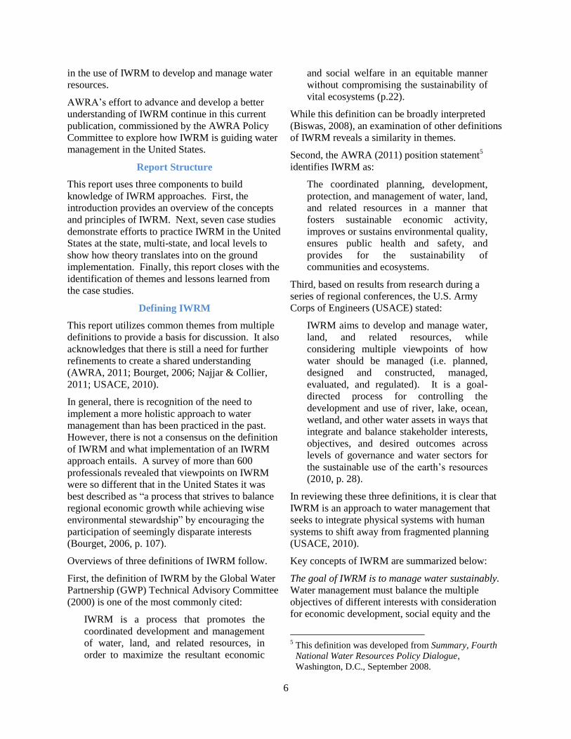
First, the definition of IWRM by the Global Water
Partnership (GWP) Technical Advisory Committee
(2000) is one of the most commonly cited:
IWRM is a process that promotes the
coordinated development and management
of water, land, and related resources, in
order to maximize the resultant economic
and social welfare in an equitable manner
without compromising the sustainability of
vital ecosystems (p.22).
While this definition can be broadly interpreted
(Biswas, 2008), an examination of other definitions
of IWRM reveals a similarity in themes.
Second, the AWRA (2011) position statement5
identifies IWRM as:
The coordinated planning, development,
protection, and management of water, land,
and related resources in a manner that
fosters sustainable economic activity,
improves or sustains environmental quality,
ensures public health and safety, and
provides for the sustainability of
communities and ecosystems.
Third, based on results from research during a
series of regional conferences, the U.S. Army
Corps of Engineers (USACE) stated:
IWRM aims to develop and manage water,
land, and related resources, while
considering multiple viewpoints of how
water should be managed (i.e. planned,
designed and constructed, managed,
evaluated, and regulated). It is a goal-
directed process for controlling the
development and use of river, lake, ocean,
wetland, and other water assets in ways that
integrate and balance stakeholder interests,
objectives, and desired outcomes across
levels of governance and water sectors for
the sustainable use of the earth’s resources
(2010, p. 28).
In reviewing these three definitions, it is clear that
IWRM is an approach to water management that
seeks to integrate physical systems with human
systems to shift away from fragmented planning
(USACE, 2010).
Key concepts of IWRM are summarized below:
The goal of IWRM is to manage water sustainably.
Water management must balance the multiple
objectives of different interests with consideration
for economic development, social equity and the
5 This definition was developed from Summary, Fourth
National Water Resources Policy Dialogue,
Washington, D.C., September 2008.

7
environment as well as current and future
generations.
Coordination is required for integration. Integrate
water management between and within levels of
government and other organizations, with
recognition of the respective roles of each.
Encourage participation. Involve the local public
and stakeholders from all water use sectors.
Resources are connected. Holistic management
recognizes the interconnectedness of land and
water, surface water and groundwater, water
quantity and water quality, freshwater and coastal
waters, and rivers and the broader watershed (GWP
Technical Committee, 2004; USACE, 2010).
Manage water in the context of a larger geographic
region such as a watershed or basin (USACE,
2010).
To implement these key principles and allow for
responsiveness to changing natural and human
systems, IWRM is process-oriented. One process
model suggests that the IWRM process is an
iterative spiral of four phases: (1) recognizing and
identifying, (2) conceptualizing, (3) coordinating
and detail planning, and (4) implementing,
monitoring and evaluating (UNESCO-IHP, WWAP
& NARBO, 2009, p. 53).
Phase 1 involves assessing the current situation,
recognizing problems, building governmental and
public awareness, and generating the capacity for
action. Phase 2 includes an assessment of the
problems and identification of potential solutions.
Phase 3 involves the evaluation of options by
various stakeholders and levels of government in
order to identify a plan. Finally, Phase 4 is an
implementation of the IWRM actions followed by
monitoring and an evaluation of the results. The
information obtained from the evaluation then feeds
back into the cycle to continue to advance water
management (p. 53-58).
The spiral is set in the context of policies,
legislation, and available resources for financing,
which may require modification in order to support
coordination throughout the process.
Another model asserts that IWRM is a continuous
process with steps similar to the above phases, and
suggests three key areas to target change to
facilitate the implementation of IWRM: the
enabling environment, institutional roles, and
management instruments (GWP Technical
Committee, 2005). These “change areas” as
discussed below are outlined in Figure 1.
The enabling environment consists of setting policy
and goals to drive the process with corresponding
legislation and financial support.
The institutional roles involve developing the
appropriate organizational structure and the
institutional capacity to coordinate water
management.
Figure 1 Areas to Facilitate Change for
IWRM Implementation
A. Enabling Environment
Policies
Legislative Framework
Financing and Incentive Structures
B. Institutional Roles
Creating an Organizational Framework
Institutional Capacity Building
C. Management Instruments
Water Resources Assessment
Plans for IWRM
Demand Management
Social Change Instruments
Conflict Resolution
Regulatory Instruments
Economic Instruments
Information Management and Exchange
Source: GWP Technical Committee (2005, p. 19-22).
8
Management instruments include: (1) assessing
water resources availability and needs,
(2) developing IWRM plans that balance economic,
social and environmental needs, (3) implementing
water efficiency measures to control demand,
(4) encouraging changes in public attitudes to
create a more water conscious culture, (5) resolving
conflicts over water, (6) regulating to protect water
supply and water quality, (7) implementing
economic tools that promote social equity and
efficiency, and (8) improving knowledge within
and across sectors and agencies to manage water
more effectively (p. 19-22).
The case studies in this report support the
underpinnings of IWRM as a process, and
demonstrate how change in these key areas can
facilitate IWRM implementation.
While more research is needed to increase
understanding of how IWRM can be successfully
implemented in practice, this report explores local
experiences with IWRM to understand its
application in the United States.
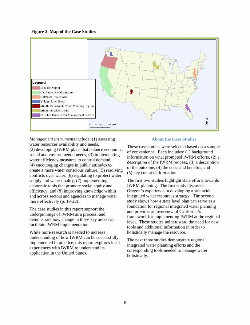
About the Case Studies
These case studies were selected based on a sample
of convenience. Each includes: (1) background
information on what prompted IWRM efforts, (2) a
description of the IWRM process, (3) a description
of the outcome, (4) the costs and benefits, and
(5) key contact information.
The first two studies highlight state efforts towards
IWRM planning. The first study discusses
Oregon’s experience in developing a statewide
integrated water resources strategy. The second
study shows how a state level plan can serve as a
foundation for regional integrated water planning
and provides an overview of California’s
framework for implementing IWRM at the regional
level. These studies point toward the need for new
tools and additional information in order to
holistically manage the resource.
The next three studies demonstrate regional
integrated water planning efforts and the
corresponding tools needed to manage water
holistically.
Figure 2 Map of the Case Studies
9
First is a discussion of the success of the multi-state
Delaware River Basin Commission in addressing
water quality and groundwater issues as well as
how it is planning for changing conditions in the
future. Next is an overview of the Yakima River
Basin Proposed Integrated Water Resource
Management Plan, which shows the benefits of
planning at the appropriate level of governance and
incorporating all interests in the planning process.
The third study highlights the unique governance
structure and technical tools used to facilitate
development of the Middle Rio Grande Regional
Water Plan.
The final two studies discuss the complexity of
managing water resources in a way that balances
human and environmental needs. They provide
overviews of the Minnesota River Integrated
Watershed, Water Quality, and Ecosystem Study
and the St. Johns River Water Supply Impact
Study. They demonstrate the development of
complex scientific models to understand the human
impacts of water use on the ecosystem and facilitate
decision-making that results in more sustainable
management of the resource.
Collectively, these seven case studies provide a
solid foundation for understanding how
practitioners in the United States are implementing
IWRM concepts.
In evaluating these case studies and the extent that
an IWRM approach is implemented, it is important
to keep in mind that IWRM requires a realistic
approach to integration.
The challenge is to find a balance between a fully
integrated approach (that risks getting mired in
complexity) and an approach in which each sector
blindly pursues its own narrowly defined interests
without looking at larger impacts and opportunities
(GWP Technical Committee, 2004, p. 3).
Collectively, the case studies highlight both the
integration of physical systems and human systems
with an emphasis on holistic management of the
resource and the need for participation from the
public and all water use sectors. They also show
the benefits of multiple agencies working together
in order to ensure that there is a sustainable supply
of water for humans and ecosystems now and into
the future.
_________________
References
American Water Resources Association. (2011,
January 21). AWRA Position Statement: Call for
a National Water Vision and Strategy.
http://www.awra.org/policy/policy-statements--
water-vision.html.
American Water Resources Association. (2011a,
January 21). AWRA Position Statement:
Integrated Water Resources Management in the
US. http://www.awra.org/policy/policy-
statements-IWRM.html.
Biswas, A. K. (2008, March). Integrated Water
Resources Management: Is It Working? Water
Resources Development, 24 (1), 5-22. doi:
10.1080/07900620701871718.
Bourget, P. G. (2006). Integrated Water Resources
Management Curriculum in the United States:
Results of a Recent Survey. Journal of
Contemporary Water Research & Education
(135), 107-114.
Global Water Partnership Technical Advisory
Committee. (2000, March). Integrated Water
Resources, TAC Background Papers (No. 4).
Stockholm: Global Water Partnership
http://www.gwp.org/Global/GWP-CACENA
_Files/en/pdf/tec04.pdf.
Global Water Partnership Technical Committee.
(2004). Unlocking the Door to Social
Development and Economic Growth: How a
More Integrated Approach to Water Can Help.
Stockholm: Global Water Partnership.
http://www.gwptoolbox.org/images/stories/gwpli
brary/policy/pb_1_english.pdf
Global Water Partnership Technical Committee.
(2005). Catalyzing Change: A Handbook for
Developing Integrated Water Resources
Management (IWRM) ) and Water Efficeincy
Strategies. http://www.unwater.org/downloads/
Catalyzing_change-final.pdf
Hooper, B. (2010). River Basin Organization
Performance Indicators: Application to the
Delaware River Basin Commission
[Supplementary file]. Water Policy, 12, 1-24.
doi: 10.2166/wp.2010.111.
10
Najjar, K. F., & Collier, C. R. (2011). Integrated
Water Resources Management: Bringing It All
Together. Water Resources IMPACT, 13 (3), 3-8.
UNESCO-International Hydrological Programme
(IHP), World Water Assessment Programme
(WWAP) & Network of Asian River Basin
Organizations (NARBO). (2009). IWRM
Guidelines at River Basin Level – Part 2-1: The
Guidelines for IWRM Coordination. United
Nations Educational, Scientific and Cultural
Organization. http://unesdoc.unesco.org/images/
0018/001864/186418e.pdf.
United States Army Corps of Engineers. (2010,
August). National Report: Responding to
National Water Resources Challenges, Building
Strong Collaborative Relationships for a
Sustainable Water Resources Future.
Washington, D.C. http://www.building-
collaboration-for-water.org/
Documents/nationalreport_final.pdf.

11
Oregon’s Integrated Water Resources Strategy: Implementing IWRM at the State Level
Need for an Integrated Water Strategy:
Creating the Enabling Environment
As integrated water resources management is
couched in the concept of sustainable development,
an IWRM approach in Oregon is important for
effective management of water resources, allowing
for economic development and the protection of
ecosystems.
As with many states across the west, Oregon is
experiencing significant challenges in managing
water resources to provide for the multiple uses of
water in the state. Oregon no longer has water
available for appropriation in most areas during
summer months and groundwater levels are
declining in many regions.
The limits of available water are further
exacerbated by degraded water quality and
ecosystem needs. More than 1,861 water bodies
are now listed as water quality impaired under the
Federal Clean Water Act. In addition, twenty-four
fish species have been listed as threatened or
endangered under the Federal Endangered Species
Act, and an additional 31 fish are listed as state
sensitive species.
In the future, Oregon expects additional challenges
in managing water resources due to land use
change, population growth, and climate change
(OWRD, 2012).
The Oregon Water Resources Commission (WRC)
has long recognized the need for a statewide water
strategy but it was not until 2009 that the joint
efforts, leadership, and forward thinking of the
WRC, state agencies, Governor’s Office,
Legislature, businesses, local governments,
environmental organizations, agricultural interests,
universities and other stakeholders, resulted in
concerted efforts to generate a strategy.
In the fall of 2008, five roundtables were held “to
receive input and advice from Oregonians and
develop information to inform efforts to identify
and communicate a vision” for water management
(OSU Institute for Water and Watersheds, Oregon
Sea Grant Extension, OUS Institute for Natural
Resources, & Oregon House Committee on Energy
and the Environment, 2008, p. 5).6 One theme that
emerged from the Oregon Water Roundtables was
the need to create a statewide framework for
integrated planning at the basin level.
Broad-based support for proactively managing the
resource instead of waiting for a crisis made it an
ideal time for the Oregon Water Resources
Department (OWRD) to propose legislation to
undertake the ambitious task of developing an
integrated water resources strategy.
In 2009, the Oregon Legislature passed House Bill
3369, which required OWRD to work with the
Oregon Department of Environmental Quality, the
Oregon Department of Fish and Wildlife, and the
Oregon Department of Agriculture to develop an
integrated water resources strategy (IWRS).
In developing the IWRS, the OWRD was directed
to consult with the public, stakeholders, Indian
tribes and all levels of government. The legislation
also required the IWRS to account for both
consumptive and non-consumptive needs including
water quantity, water quality, and ecosystem needs.
It also required the strategy to discuss other
influencing factors including climate change,
population growth, and land use change. Finally,
the IWRS was to be dynamic. To that end, it must
be reviewed and updated every five years, thereby
encouraging adaptive management (House Bill
3369, 2009).
6 For more information on the Oregon Water
Roundtables, visit
http://water.oregonstate.edu/roundtables/index.php.
“Every living thing depends upon clean and abundant water to meet basic needs. Oregon's economic
vitality, environmental integrity, and cultural identity depend upon it. Water is Oregon's most precious
natural resource.”
Oregon Water Resources Department (2012)
12
By securing legislative authority, the State agencies
were able to set the foundation for future support
from the Legislature and create a shared
understanding of the challenges that Oregon faces,
while ensuring cooperation from other State
agencies. In reviewing the components of the
legislation, it is clear that the active role of natural
resource agencies and other water professionals
shaped the law based on principles from IWRM.
Oregon’s Integrated Water Resources Strategy is an
ideal case study to demonstrate how the concepts of
IWRM can be applied outside of theory.
Overview of the IWRS
Development Process
Oregon’s experience in creating the IWRS shows
that the process of creating an integrated strategy is
different from generating a customary water supply
plan.
Unlike traditional water plan development, an
IWRM strategy requires thinking about water in the
context of economic, social and environmental
needs and creating an adaptable framework for
ongoing action and coordination instead of a static
project-oriented plan. To accomplish this, it is
imperative to include the public and all sectors
affected by water planning (GWP Technical
Committee, 2005).
Development and implementation of the Oregon
IWRS was broken into five phases: planning and
developing the process, identifying issues and
needs, developing recommendations, generating the
IWRS documents, and implementing and
evaluating the final strategy. The first four
development phases occurred from 2009-2012.
The implementation stage began in 2012 (OWRD,
2012).
Phase 1 involved creating guiding principles and
problem statements, designing a work plan,
identifying the structure of workgroups, and
creating capacity within agencies and other groups
to contribute to the IWRS.
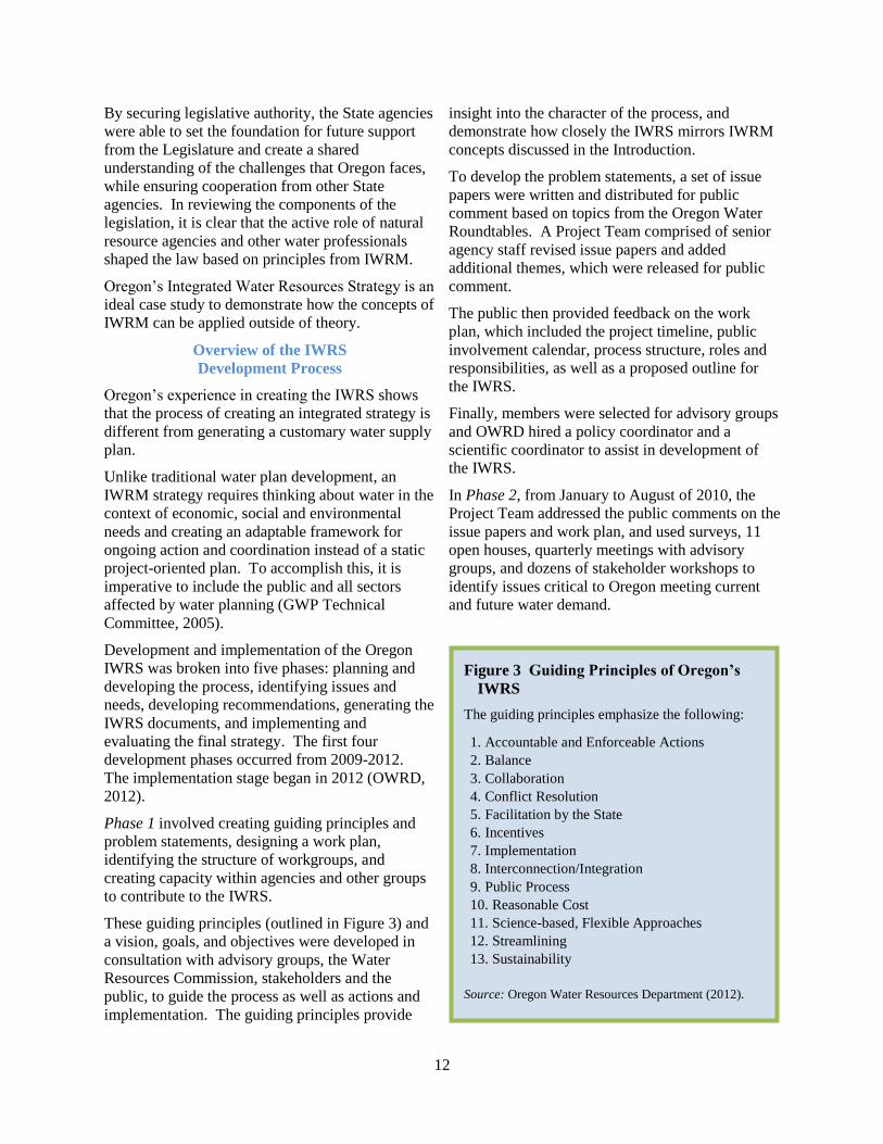
These guiding principles (outlined in Figure 3) and
a vision, goals, and objectives were developed in
consultation with advisory groups, the Water
Resources Commission, stakeholders and the
public, to guide the process as well as actions and
implementation. The guiding principles provide
insight into the character of the process, and
demonstrate how closely the IWRS mirrors IWRM
concepts discussed in the Introduction.
To develop the problem statements, a set of issue
papers were written and distributed for public
comment based on topics from the Oregon Water
Roundtables. A Project Team comprised of senior
agency staff revised issue papers and added
additional themes, which were released for public
comment.
The public then provided feedback on the work
plan, which included the project timeline, public
involvement calendar, process structure, roles and
responsibilities, as well as a proposed outline for
the IWRS.
Finally, members were selected for advisory groups
and OWRD hired a policy coordinator and a
scientific coordinator to assist in development of
the IWRS.
In Phase 2, from January to August of 2010, the
Project Team addressed the public comments on the
issue papers and work plan, and used surveys, 11
open houses, quarterly meetings with advisory
groups, and dozens of stakeholder workshops to
identify issues critical to Oregon meeting current
and future water demand.
Figure 3 Guiding Principles of Oregon’s
IWRS
The guiding principles emphasize the following:
1. Accountable and Enforceable Actions
2. Balance
3. Collaboration
4. Conflict Resolution
5. Facilitation by the State
6. Incentives
7. Implementation
8. Interconnection/Integration
9. Public Process
10. Reasonable Cost
11. Science-based, Flexible Approaches
12. Streamlining
13. Sustainability
Source: Oregon Water Resources Department (2012).
13
Over the next year, in Phase 3, the advisory groups
developed and evaluated recommendations to
address the critical water issues, while also
continuing to solicit feedback from the public.
In Phase 4, a discussion draft of the IWRS was
prepared and released for public comment in
December 2011. It was followed by a revised draft
in June. Ultimately, the August 2012 version was
adopted by the WRC.
Implementation began immediately – in Phase 5.
As required, the IWRS will be reviewed and
updated every five years to incorporate lessons
learned and new information (OWRD, 2012).
IWRM Institutional Roles: Integrating the
Public, Stakeholders, and Government
The emphasis on creating a holistic strategy that
addresses all water uses meant that development of
the IWRS relied heavily on input at every stage
from the public, tribes, stakeholder groups, and
public agencies representing a variety of interests
(OWRD, 2012). The process and structure for
integrating these groups is discussed next.
Public Involvement and
Inter-Sector Stakeholder Input
The public and stakeholders were provided multiple
opportunities to shape the IWRS. These
opportunities encouraged participation from all
sectors of the population and were designed to
ensure that the IWRS would be supported by
competing interests.
To those ends, information about the IWRS was
communicated through a variety of media,
including public meetings, newspapers, fliers,
newsletters, email, and the project website.
Feedback was received through an online survey,
traditional public comment channels, email and
more than 30 stakeholder workshops, as well as at
open houses.
Open houses were a particularly successful
outreach strategy. In the spring of 2010, twelve
open houses7 were held across the state with
presentations on water management practices and a
display of the water issues and opportunities in
Oregon. Participants were asked to identify the key
7 Eleven open houses were held in communities across
the state, while one was a virtual open house.
water issues facing their communities and the
solutions they would like to see pursued.
Based on this information, a preliminary set of
recommended actions were released for public
comment, organized as twelve bulletins
surrounding the identified critical issues. The
bulletins and request for feedback were widely
advertised through a variety of media and
stakeholder workshops to encourage public
participation. A discussion draft of the IWRS was
then developed and released for public comment
using similar methods as outlined above (OWRD,
2012).
The public also had a formal role in the process
through the establishment of the Policy Advisory
Group. This group included 18 appointed citizens
from a variety of water-related backgrounds such as
water and wastewater utilities, tribes, counties,
conservation organizations, and irrigated
agriculture. The Policy Advisory Group provided
an avenue to receive ideas and feedback from
citizens throughout the development of the IWRS,
which provided a perspective outside of
government interests.
These extensive efforts to engage the public and
stakeholder groups were well received and the
conscious effort to listen to and incorporate
feedback helped foster an environment of a state-
led but bottom-up approach. As a result of the
diverse public interests represented throughout the
development of the plan, the IWRS reflects
Oregonian’s water resource concerns and
corresponding solutions to address future needs and
challenges.
Integrating Government
Integrating water management is challenging in
part due to the large number of federal and state
agencies that take actions affecting water resources.
To achieve a more coordinated plan, two additional
groups were established.
The Agency Advisory Group was comprised of 18
state natural resource, economic development, and
health agencies as well as the Governor’s Office,
while the Federal Liaison Group consisted of 10
federal agencies involved in managing land, water,
and fish and wildlife.
14
Both groups met quarterly and provided technical
input on problems, solutions, and existing programs
(OWRD, 2012). For example, the Agency
Advisory Group identified opportunities for the
IWRS to integrate existing State natural resource
and economic development plans.
In addition to the state and federal agencies,
Oregon’s nine Federally-recognized Indian Tribes
– with whom Oregon has a Government-to-
Government relationship – were invited to
participate in the open houses. Eight tribes also
participated in a State-Tribal Water Forum and one
tribal member served on the Policy Advisory
Group.
Although development of the IWRS was led by
OWRD, the Oregon Department of Environmental
Quality, Oregon Department of Fish and Wildlife,
and Oregon Department of Agriculture were
heavily involved. To facilitate coordination, a
Project Team comprised of staff from the four
agencies was established. The Project Team
managed development of the IWRS and served as
the key contact for the Agency and Policy Advisory
Groups, the Federal Liaison Group, the nine tribes,
as well as stakeholders and the public. In addition,
the directors of the four agencies acted as liaisons
between the Project Team and the Governor’s
Office, the Oregon Legislature, and the four
commissions that have oversight responsibility for
the four departments.
Incorporating such a broad array of state and
federal agencies was necessary to shift away from
managing water separately and move toward jointly
managing the entire resource.
While integrating these various levels of
government was complex and challenging, drawing
from within and among the various levels of
government greatly enriched the capacity to
understand the current state of water resources as
well as future opportunities and challenges.
A Goal-Driven Process to Achieve
Integration and Address Critical Issues
A key concept in IWRM is to identify and
acknowledge the interconnectedness of water
resources and attempt to manage the entire system
by incorporating land and water, surface water and
groundwater, water quantity and water quality,
freshwater and coastal waters, and the broader
watershed (USACE, 2010).
The almost limitless reach of water requires a
strategic focus on establishing the parameters of
integration that will allow for better management of
the resource, as there is a fine balance between
effective integration and creating unmanageable
complexity (GWP Technical Committee, 2004).
The approach taken by Oregon to embrace
complexity is demonstrated by the IWRS itself and
shows how IWRM as a goal-driven process helps to
ensure that water is managed sustainably even in
the face of extreme complexity. The two
overarching goals of the IWRS were to better
understand Oregon’s water resources and to
develop strategies to meet Oregon’s water needs.
These goals drove development of objectives and
identification of critical issue areas, and kept the
Project team focused on what was important to
achieve in the IWRS.
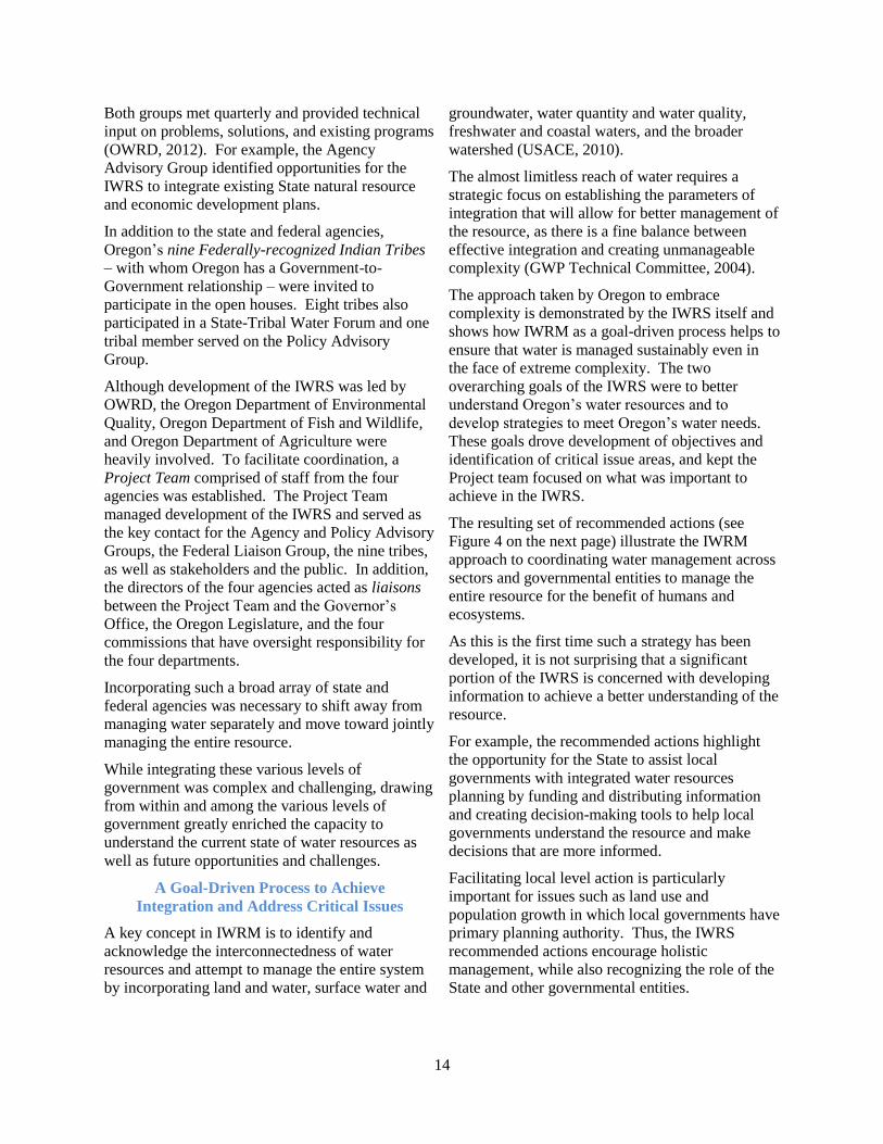
The resulting set of recommended actions (see
Figure 4 on the next page) illustrate the IWRM
approach to coordinating water management across
sectors and governmental entities to manage the
entire resource for the benefit of humans and
ecosystems.
As this is the first time such a strategy has been
developed, it is not surprising that a significant
portion of the IWRS is concerned with developing
information to achieve a better understanding of the
resource.
For example, the recommended actions highlight
the opportunity for the State to assist local
governments with integrated water resources
planning by funding and distributing information
and creating decision-making tools to help local
governments understand the resource and make
decisions that are more informed.
Facilitating local level action is particularly
important for issues such as land use and
population growth in which local governments have
primary planning authority. Thus, the IWRS
recommended actions encourage holistic
management, while also recognizing the role of the
State and other governmental entities.
15
Figure 4 Recommended Actions from Oregon’s IWRS Framework
Source: Oregon Water Resources Department (2012).
Understanding Water Resources / Supplies /
Institutions 1a. Conduct additional groundwater investigations. 1b. Improve water resource data collection and
monitoring. 1c. Coordinate interagency data collection,
processing, and use in decision-making.
Understanding Oregon’s Out‐of‐Stream
Needs/Demands 2a. Update long-term water demand forecasts. 2b. Improve water-use measurement and reporting. 2c. Determine pre-1909 water right claims. 2d. Update water right records with contact
information. 2e. Update Oregon’s water-related permitting
guide.
Understanding Oregon’s Instream Needs/Demands 3a. Determine flows needed (quality and quantity)
to support instream needs. 3b. Determine needs of groundwater dependent
ecosystems.
The Water‐Energy Nexus
4a. Analyze the effects on water from energy
development projects and policies. 4b. Take advantage of existing infrastructure to
develop hydroelectric power. 4c. Promote strategies that increase/integrate
energy and water savings.
Climate Change 5a. Support continued basin-scale climate change
research efforts. 5b. Assist with climate change adaptation and
resiliency strategies.
Economic Development and Population Growth (See Actions 2.A. and 3.A.)
The Water and Land Use Nexus 6a. Improve integration of water information into
land use planning (and vice-versa). 6b. Update state agency coordination plans. 6c. Encourage low-impact development practices.
Infrastructure 7a. Develop and upgrade water and wastewater
infrastructure. 7b. Encourage regional (subbasin) approaches to
water and wastewater systems
Education and Outreach 8a. Support Oregon’s K-12 environmental literacy
plan. 8b. Provide education and training for Oregon’s
next generation of water experts. 8c. Promote community education and training
opportunities. 8d. Identify ongoing water-related research needs.
Place‐Based Efforts
9a. Undertake place-based integrated, water
resources planning. 9b. Coordinate implementation of existing natural
resource plans. 9c. Partner with federal agencies, tribes, and
neighboring states in long-term water
resources management.
Water Management and Development 10a. Improve water-use efficiency and water
conservation. 10b. Improve access to built storage. 10c. Encourage additional water reuse projects. 10d. Reach environmental outcomes with non-
regulatory alternatives. 10e. Authorize and fund a water supply
development program.
Healthy Ecosystems 11a. Improve watershed health, resiliency, and
capacity for natural storage. 11b. Develop additional instream protections. 11c. Prevent and eradicate invasive species. 11d. Protect and restore instream habitat and habitat
access for fish and wildlife.
Public Health 12a. Ensure the safety of Oregon’s drinking water. 12b. Reduce the use of and exposure to toxics and
other pollutants. 12c. Implement water quality pollution control
plans.
Funding 13a. Fund development and implementation of
Oregon’s IWRS. 13b. Fund water resources management at the state
level. 13c. Fund communities needing feasibility studies
for water conservation, storage, and reuse
projects.

16
The IWRS as adopted provides a broad overview of
Oregon’s water resources and identifies general
solutions and next steps. It is a high-level
document that will require further identification of
specific projects in order to implement the
recommended actions.
The Costs and Benefits of Creating the IWRS
An estimate of costs and benefits resulting from the
IWRS is difficult to determine because much of the
IWRS was developed through volunteer
contributions and without the addition of further
staffing resources to most agencies. In addition,
while there are some costs that can be attributed to
the development of the IWRS, most of the costs
and benefits will largely be realized in the future as
the plan is implemented and improved.
The OWRD received $283,000 in the 2009-2011
budget from lottery-backed bonds and $292,000 in
the 2011-2013 budget in general funds to support a
scientific coordinator and a public policy
coordinator to work on development of the IWRS.
The overarching goal and intended benefit of the
IWRS is embedded in the Policy Advisory Group’s
vision, which aspires to have “healthy waters that
are able to sustain a healthy economy, environment,
cultures, and communities” (OWRD, 2012, p.1).
The success of the IWRS will largely depend on
funding support for implementation.
_______________
Key Contact Information
Brenda Ortigoza Bateman, Ph.D.
Senior Policy Coordinator
Oregon Water Resources Department
Alyssa Mucken
Policy Coordinator
Oregon Water Resources Department
Website
http://www.oregon.gov/owrd/pages/law/
integrated_water_supply_strategy.aspx.
Thanks to Alyssa Mucken for
reviewing this case study.
________________
References
Global Water Partnership Technical Committee.
(2004). Unlocking the Door to Social
Development and Economic Growth: How a
More Integrated Approach to Water Can Help.
Stockholm: Global Water Partnership.
http://www.gwptoolbox.org/images/stories/gwpli
brary/policy/pb_1_english.pdf.
Global Water Partnership Technical Committee.
(2005). Catalyzing Change: A Handbook for
Developing Integrated Water Resources
Management (IWRM) ) and Water Efficiency
Strategies. http://www.unwater.org/downloads/
Catalyzing_change-final.pdf.
Oregon Water Resources Department. (2012,
August). Oregon's Integrated Water Resources
Strategy. http://cms.oregon.gov/owrd/pages/
law/integrated_water_supply_strategy.aspx.
OSU Institute for Water and Watersheds, Oregon
Sea Grant Extension, OUS Institute for Natural
Resources, & Oregon House Committee on
Energy and the Environment. (2008, December
10). Statewide Water Resources Roundtables
Fall 2008: Synthesis Report.
http://hdl.handle.net/1957/14168.
United States Army Corps of Engineers. (2010,
August). National Report: Responding to
National Water Resources Challenges, Building
Strong Collaborative Relationships for a
Sustainable Water Resources Future.
Washington, D.C. http://www.building-
collaboration-for-water.org/
Documents/nationalreport_final.pdf.

17
California’s Integrated Regional Water Management: Setting the Foundation for Regional Integrated Planning
Development and Growth of Integrated
Regional Water Management
During the past 10 years, California sought to
implement integrated water resources management
at both the state and regional level.
California’s Integrated Regional Water
Management Act of 2002 set forth a new way of
thinking about water by authorizing the
development of Integrated Regional Water
Management plans (IRWMPs) to increase
collaboration between local agencies (DWR, 2012).
The Integrated Regional Water Management
program is guided by overarching principles at the
state level, but includes the flexibility to develop a
bottom-up, truly local approach to water
management.
As described in the 2009 California Water Plan:
The broad purpose of Integrated Regional
Water Management (IRWM) is to promote
a regional planning and implementation
framework to comprehensively address
water supply, water quality, flood, and
ecosystem challenges and to implement
integrated solutions through a collaborative
multi-partner process that includes water
managers, Tribes, nongovernmental
organizations, State, federal, and local
governments, and disadvantaged
communities (DWR, 2009, v.1 pp 7-8).
The 2002 legislation signaled the State’s dedication
to widespread implementation of IWRM.
However, it did not provide funding or significant
guidance on plan development, which hindered
progress.
It was not until later that year, when voters
authorized a grant program to fund IRWM projects,
that California Department of Water Resources
(DWR) and the State Water Resources Control
Board developed program guidelines to aid local
agencies in creating regional water management
groups and generating IRWMPs. Later, voters
approved additional grants for both planning and
implementation. The funding and guidance
provided by the grant program were integral to the
progress made in advancing IRWM (DWR, n.d.).
Even though the program is voluntary, IRWM is
now a key strategy in the California Water Plan
(DWR, 2009). Today, IRWM regions encompass
87 percent of the area of the state, and about 99
percent of the population is represented by a
planning region (DWR, 2012).
California is therefore an ideal case to demonstrate
how states can serve as a foundation for
implementation of IWRM principles to facilitate
greater integration, and to encourage holistic
management at the local level.
This case study focuses on California’s IRWM
framework with examples from regional planning
areas to demonstrate how concepts have been
translated into action. It begins with delineation of
planning regions and regional governance
structures, followed by an overview of IRWM plan
requirements, and elements of the planning process.
In addition, it highlights the State’s efforts to
incorporate social equity and integrated data
management into water planning and identifies
program challenges and costs.
“Integrated regional water management is a paradigm shift for water agencies in the Kings Basin
region. Solutions to water issues can happen, and it starts with collaboration. Instead of water
discussions focused on the conflicts of the varying interests that are vying for water for cities, farms, and
fish, and the resulting stalemate, the Kings Basin Water Authority is producing results in managing the
region’s water resources.”
David Orth (2012)
18
Establishing Planning Areas:
The Regional Acceptance Process
While the State of California set the foundation for
regional water management, it elected not to define
the planning regions in order to encourage local
leadership in developing the IRWMP. The DWR
did, however, set forth standards for regions to
meet to be eligible for grants. Prior to creating an
IRWMP, local groups must form a regional water
management group (RWMG) and propose a
regional planning area for approval by DWR.
At a minimum, a region is defined as a
contiguous geographic area encompassing
the service areas of multiple local agencies;
is defined to maximize the opportunities to
integrate water management activities; and
effectively integrates water management
programs and projects within a hydrologic
region defined in the California Water Plan,
the Regional Water Quality Control
Board…region, or subdivision or other
region specifically identified by DWR
(Public Resource Code Sec 75026(b) (1)).
The proposal must include an overview of the
management group’s composition, stakeholder and
public involvement efforts, governance structure,
justification of the area boundary, and approach to
inter-regional coordination. These elements allow
DWR to identify potentially competing regional
management groups and determine the extent to
which planning efforts are integrated (DWR, 2009).
They also allow significant flexibility in
establishing planning areas from the ground up
based on unique local needs.
The composition of regional water management
groups and corresponding governance structures are
specific to each region.
The San Diego RWMG, for example, is comprised
of the city of San Diego, San Diego County and
San Diego Water Authority, which represents a
joint effort between the land use planners and water
managers. To balance interests, the San Diego
RWMG is advised by a 32-member Regional
Advisory Committee consisting of water agencies,
water quality representatives, natural resource
organizations and agencies, inter-regional
coordinating entities, and members of the general
public (San Diego IRWM Program, 2012).
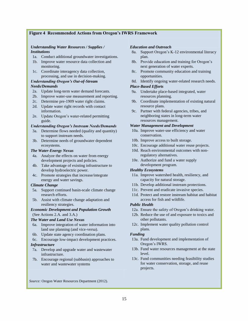
In contrast, the Greater Monterey County RWMG
(see Figure 5) includes 19 members from a broad
array of organizations that reflect the region’s
coastal location, water quality challenges, and
concerns about social equity (“Greater Monterey
County,” 2012).
The differences in the organizational structures of
RWMG’s illustrates that the California framework
is sufficiently flexible to meet the unique conditions
of each region.
Figure 5 Members of the Greater Monterey
County Regional Water Management
Group
Big Sur Land Trust
California Coastal Commission
California Water Service Company
Castroville Community Services District
City of Salinas
City of Soledad
Coastlands Mutual Water Company
Elkhorn Slough National Estuarine Research
Reserve
Environmental Justice Coalition for Water
Garrapata Creek Watershed Council
Marina Coast Water District
Monterey Bay National Marine Sanctuary Water
Quality Protection Program
Monterey County Agricultural Commissioner’s
Office
Monterey County Water Resources Agency
Monterey Regional Water Pollution Control
Agency
San Jerardo Co-operative
Watershed Institute at California State
University Monterey Bay
Moss Landing Marine Laboratories
Resource Conservation District of Monterey
County
Source: Greater Monterey County Integrated Regional
Water Management Program (2012).

19
The self-identified planning areas also reflect this
adaptability to local needs.
For example, the North Coast Regional
Management area is the only region in the state that
spans the entire hydrologic area from the
headwaters to the coast encompassing 12.5 million
acres.8 Geographically, it is the largest planning
region in the state due the realization that with its
relatively low population, the region’s best strategy
would be to pool physical and political resources to
gain funding for the area (“RMC Water,” 2006).
In contrast, the Upper Kings Region focused on the
need to coordinate management of declining shared
groundwater resources. Consequently, the regional
planning boundaries were set in accordance with
the groundwater basin (Kings Basin Authority,
2012).
As shown by these two examples, the decision to
allow areas to form their own regions has
encouraged local communities to identify
commonalities and coordinate actions to address
8 The entire drainage area within the state of California,
excluding the portion in Oregon.
water issues. Today, there are 48 different regional
plan areas in California, ranging from 170,000
acres to 12.5 million acres (DWR, 2012).
The IRWM Framework
While California has empowered regions to adapt
the IRWM process to regional and local needs, it
has stipulated a framework for developing plans
with a firm basis in IWRM principles.
First, all IRWMPs are required to address water
supply reliability and efficiency, water quality,
groundwater quantity and quality, ecosystem and
watershed stewardship, and the needs of
disadvantaged communities (CWC § 10540c). In
addition, the Legislature requires all IRWM plans
to include the 14 elements shown in Figure 6.
One of the elements requires IRWMPs to consider
the use of water management strategies outlined in
the California Water Plan; therefore, the regions
have an initial toolbox from which to draw
solutions (see Figure 7 on the next page).
Figure 6 Requirements of California’s Integrated Regional Water Management Plans
Consideration of all the resource management strategies identified in the California Water Plan.
Consideration of objectives in the appropriate regional basin plan or plans and strategies to meet
applicable water quality standards.
Description of major water-related objectives and conflicts within an IRWM planning region.
Measurable regional objectives and criteria for developing regional project priorities.
An integrated, collaborative, multibenefit approach to select and design projects and programs.
Identification and consideration of the water-related needs of disadvantaged communities in the area
within the boundaries of the plan.
Performance measures and monitoring program to demonstrate progress toward meeting regional
objectives.
A plan for implementation and financing of projects and programs.
Consideration of greenhouse gas emissions of identified projects and programs.
Evaluation of adaptability to climate change of water management systems in the region.
Documentation of data and technical analyses used in the development of the plan.
A communication process to disseminate data and information related to the development and
implementation of the plan.
A facilitation process to engage and coordinate water management projects and activities of participating
local agencies and governments, local stakeholders and Tribes to avoid conflicts and take advantage of
efficiencies.
Other matters as identified by DWR.
Source: California Water Code § 10541(e).

20
In addition, the grant program gives preference to
statewide priorities, which currently include:
drought preparedness, efficiency in water use,
climate change response actions, environmental
stewardship, integrated flood management,
protection of surface water and groundwater
quality, improving tribal water and natural
resources, and ensuring equitable distribution of
benefits (DWR, 2010, Table 1).
In this way, statewide goals and strategies are
integrated into regional planning through the
IRWM grant program.
Facilitating Integration,
Inclusiveness and Social Equity
A core concept of IWRM is that better water
management results from coordination between the
various water use sectors, governmental entities,
stakeholders and public. While California has not
required that all interests be represented in the
RWMG or the governance structure, the State does
require the IRWMP development process to
facilitate participation from diverse interests.
As outlined in the California Water Code §
10541(g), the IRWMP process must include water
purveyors, wastewater and flood control agencies,
local governments and special districts, electrical
companies, tribes, environmental and community
organizations, industry groups, water users,
governmental agencies from all levels, universities,
and disadvantaged community members and
organizations. Participation of such a broad array
of agencies and stakeholders encourages
multipurpose planning that can improve the
management of the physical resource and also
reduce tensions between user groups.
In the Kings Basin, for example, almost two dozen
entities managed groundwater resources separately
within their own areas. This contributed to
groundwater declines of 40 feet over 40 years.
Now the region “is a textbook example of the
effectiveness of local control and planning” with
more than 50 entities involved in the Kings River
Basin IRWMP (Orth, 2012, pp. 6).
The IRWM efforts in the Kings Basin have resulted
in advances towards more holistic and sustainable
management of the shared groundwater and surface
water resources among competing users.
Figure 7 California Water Management
Strategies
1. Reduce Water Demand
Agricultural Water Use Efficiency
Urban Water Use Efficiency
2. Improve Operational Efficiency and Transfers
Conveyance – Delta
Conveyance -- Regional / Local
System Reoperation
Water Transfers
3. Increase Water Supply
Conjunctive Management & Groundwater
Desalination
Precipitation Enhancement
Recycled Municipal Water
Surface Storage – CALFED
Surface Storage – Regional / Local
4. Improve Water Quality
Drinking Water Treatment and Distribution
Groundwater Remediation / Aquifer
Remediation
Matching Water Quality to Use
Pollution Prevention
Salt and Salinity Management
Urban Runoff Management
5. Practice Resources Stewardship
Agricultural Lands Stewardship
Economic Incentives (Loans, Grants, and Water
Pricing)
Ecosystem Restoration
Forest Management
Land Use Planning and Management
Recharge Area Protection
Water-Dependent Recreation
Watershed Management
6. Improve Flood Management
Flood Risk Management
7. Other Strategies
Source: Department of Water Resources (2009). Vol. 2.
21
Similarly, the Greater Monterey County IRWM
program has focused on reducing tension and
increasing integration. Believing that methods in
traditional conflict resolution models only generate
mistrust, the group has developed a process to
reduce regional conflicts, while increasing
collaboration and coordination during project
selection (RWMG, 2012).
The region now seeks to take a joint fact-finding
approach by first identifying questions about
projects that need to be answered to make a
decision. After that, the group identifies areas of
agreement and disagreement and determines how
additional information will be obtained to resolve
the questions. The key to this process is that it
establishes buy-in from stakeholders by bringing
them into the project at the beginning. The region
believes this approach will help to move beyond the
conflicts that have characterized the area in the past
(RWMG, 2012).
California has also sought to improve participation
from disadvantaged communities (DACs) in water
planning.
In recent years, the State has recognized that DACs
do not have the resources to put together
comprehensive plans or identify potential projects
without assistance (DWR, 2009). At the regional
level, DACs were not competitive for IRWM grants
because they did not have the resources to generate
a project proposal. Thus, these regions were
excluded from water planning due in part to the
initial setup of the program (“RMC Water”, 2006).
Recognizing the need for a focus on disadvantaged
communities, the State emphasized DACs in
IRWM program requirements, and created an
additional incentive by setting aside $10 million of
the proposition 84 funding for DACs (DWR, 2009).
Some regions have also acknowledged the
difficulties faced by DACs and have attempted to
improve social equity. For example, the North
Coast IRWM capitalized on the power of regional
coordination by leveraging resources to create the
Water & Wastewater Service Provider Outreach &
Support Program to help small service providers:
…exchange information, pool resources
such as qualified operators, specialized
tools, equipment and technical consultants,
target funding opportunities, identify
infrastructure improvement projects,
develop relevant training programs,
establish standardized procedures for
routine and occasional managerial
responsibilities, and act as a forum for
regional coordination (North Coast
IRWMP, n.d).
The North Coast is one example of how the IWRM
program has set the foundation for addressing
social equity in the management of water in the
state.
The Challenge of Achieving Integration
California has undertaken a remarkable and
ambitious effort in choosing to encourage IRWM.
Many regions have embraced the program’s
concepts and have found that it has helped to
improve water management. However, integration
and holistic management do not occur overnight
and the program continues to evolve as challenges
are identified.
For example, the initial IRWM plans lacked data
integration and coordination and, therefore, were
“only integrated conceptually and not
quantitatively” as data was not only insufficient,
but often stored and managed in a manner that was
not conducive to sharing between agencies (DWR,
2009, v. 1 p. 6-6).
According to the California Water Plan,
overcoming this difficulty is important, as data and
analytical tools enable regions to participate in
IRWM, manage risk and uncertainty, and improve
management of the resource in the face of a
changing climate.
The North Coast IRWM has approached this issue
by establishing a library of documents, plans and
other data accessible from its website, and has also
implemented an online tool to upload project
proposals (North Coast IRWMP, n.d).
The State has also invested resources into
streamlining information to improve data
management, information sharing, and decision-
making by creating an online information exchange
system and establishing protocols and standards for
data (DWR, 2009). The Greater Monterey County
RWMG, for example, is using the protocols
established by the State to collect data. The group
then inputs the information into the State’s database
22
to facilitate sharing across the region (RWMG,
2012).
The DWR has also restructured its grant program to
facilitate better integration. While the intent of the
program is to encourage regional planning from the
ground up instead of from the state down, the
flexibility and vagueness of the first iteration of the
program resulted in development of some plans as a
means to obtain funding for already identified
projects, thereby failing to increase integration.
The 2009 California Water Plan noted that there
was therefore a need for more incentives to
incorporate multi-objective planning and projects,
and to include different stakeholder groups in the
process. Since then, the State has focused on
carefully structuring grant opportunities to
encourage the desired behavior (DWR, 2009).
For example, the 2010 Guidelines for Prop 1E/Prop
84 funding included preferences for programs that
are regional or based on hydrologic basins, resolve
water conflicts, address the needs of disadvantaged
communities, incorporate land use planning, or
address other statewide priorities (DWR, 2010).
Despite difficulties, some regions have been
successful at facilitating greater cooperation and
coordinated planning, particularly during the
development of the IRWMP when regions solicit
and identify project proposals to be a part of the
plan and grant proposal.
For example, during the proposal of projects for the
Greater Monterey County IRWMP, the Project
Review Committee looked for opportunities to
integrate projects or to create regional instead of
area specific programs (RWMG, 2012).
Similarly, the Upper Santa Clara River IRWM held
presentations on each project, followed by
discussions about how to improve the projects and
opportunities to combine similar projects. This led
to greater efficiencies simply due to the sharing of
knowledge and data between agencies and non-
profit groups (Kennedy/Jenks Consultants, 2008).
As demonstrated by the examples throughout this
case study, while integration is an incremental
process, areas that have shown a dedication to
openly exploring and discussing projects can
increase coordination and efficiency, leverage
resources, and enhance cooperation. It is important
to note that as these efforts are led by the region
within a framework provided by the State, progress
varies by region.
The Costs, Benefits and Future
of Regional Planning
Grants have largely driven the success of the
program as collaboration, cooperation, and data
collection take significant resources. The initial
Proposition 50 grant program authorized $500
million to fund IRWM projects. In 2005, voters
approved Proposition 84, providing $1 billion for
IRWM planning and projects, as well as
Proposition 1E, authorizing an additional $300
million for IRWM stormwater projects with flood
control benefits (DWR, n.d.).
The California IRWM program has been successful
in achieving participation, due in part to these
grants. However, it is uncertain if regions have
sufficiently recognized the benefits to continue
IRWM without the grant program (“San Diego
Regional”, 2011). As it is unclear if new sources of
funding will become available, a priority for the
State in the future will be to highlight the benefits
of the IRWM approach and make it easier for
regions to implement it (K. Guivetchi, personal
communication, 2012).
California’s IRWM program is facilitating more
efficient water management in some regions
through pooling of resources and consideration of a
broader set of water issues to provide reliable and
affordable water supplies for economic,
environmental and social purposes. The State
expects that regional planning will reduce
duplicative efforts and allow areas to more
effectively respond and adapt to climate change by
pooling resources to reduce flooding, and
coordinating local water supplies in the event of
drought. The plans also provide water quality and
water supply benefits by promoting more reliance
on local supplies and nontraditional water
development such as recycling, conservation, and
modification of operations (DWR 2009).
Essentially, IRWM is increasing coordination and
facilitating more sustainable water management.
The program has also increased efficiency by
encouraging innovation at the local level, while
requiring regions to work through the same
framework.
23
As shown by the examples incorporated into this
case study, each region has its own approach and
much can be learned by studying the 48 regional
processes and plans. As a result, one important
outcome is that not only do local agencies benefit
from the combined resources of regional planning,
but also regions benefit from sharing experiences
and lessons learned with other areas. Therefore, as
part of its strategic planning efforts, the State is
currently working on developing case studies to
showcase some of the successes and lessons learned
(K. Guivetchi, personal communication, 2012).
During the past ten years, California has recognized
the value of the IRWM program and remains
dedicated to facilitating IRWM planning.
Therefore, the DWR is in the early stages of
developing The Strategic Plan for the Future of
IRWM in California, which will critically analyze
the current institutional setting and progress of the
program, outline a vision for its future, and identify
necessary actions to achieve that vision (DWR
2012).
It is a pivotal time in California’s IRWM program
history that will provide insight into the best
practices for implementing IWRM at the regional
scale.
_________________
Key Contact Information
Tracie L. Billington Chief, Financial Assistance Branch, Division of
Integrated Regional Water Management
California Department of Water Resources
Christina R.G. McCready Chief, Regional Planning Branch, Strategic
Planning and Local Partnerships, Division of
Integrated Regional Water Management
California Department of Water Resources
Phone (916) 651-9613
Email [email protected]
Website
www.water.ca.gov/irwm/.
Thanks to Tom Lutterman, Michael Floyd,
and Kamyar Guivetchi for their assistance
with this case study.
_________________
References
Department of Water Resources. (n.d). Integrated
Regional Water Management [Brochure].
http://www.water.ca.gov/irwm/docs/Brochures/I
RWM6.Background_120306.pdf.
Department of Water Resources. (2012). Strategic
Plan for the Future of Integrated Regional Water
Management in California: Development
Approach [Brochure]. http://www.water.ca.gov/
irwm/stratplan/documents/DWR_BrochureV9B.
pdf (large file).
Department of Water Resources. (2009,
December). California Water Plan Update 2009:
Integrated Water Management (Bulletin 160-09).
http://www.waterplan.water.ca.gov/cwpu2009/in
dex.cfm.
Department of Water Resources & State Water
Resources Control Board. (2004, November).
Integrated Regional Water Management Grant
Program Guidelines. Proposition 50, Chapter 8.
http://www.waterboards.ca.gov/water_issues/pro
grams/grants_loans/irwmgp/docs/r1_guidelines.p
df (large file).
Department of Water Resources, Division of
Integrated Water Management. (2010, August).
Proposition 84 & Proposition 1E Integrated
Regional Water Management Guidelines.
http://www.water.ca.gov/irwm/docs/Guidelines/
GL_Final_07_20_10.pdf.
Greater Monterey County Integrated Regional
Water Management Program. (2012). [Website].
http://www.greatermontereyirwmp.org, accessed
August 28, 2012.
Kennedy/Jenks Consultants. (2008, June). Upper
Santa Clara River Integrated Regional Water
Management Plan. http://www.ladpw.org/wmd/
scr/index.cfm?fuseaction=documents.
24
Kings Basin Authority. (2012, August). Integrated
Regional Water Management Plan - Public
Draft. http://www.krcd.org/water/ukbirwma/ .
North Coast IRWMP. (n.d.).
http://www.northcoastirwmp.net, accessed
August 26, 2008.
Orth, D. (2012). Huge Strides Made and Success
Achieved through Kings Basin Regional Water
Management Entity. Flood Line: A Newsletter of
the Fresno Metropolitan Flood Control District.
20 (2). http://fresnofloodcontrol.org/About%20
Us/flood%20line%20summer%202012.pdf
(large file).
Regional Water Management Group. (2012, June
20). Integrated Regional Water Management
Plan for the Greater Monterey County.
http://ccwg.mlml.calstate.edu/irwmp/documents.
RMC Water and Environment and Jones & Stokes,
Inc. (2006, March 16). San Francisco Bay Area
Integrated Regional Water Management Plan:
Appendix C Approach to Integration.
http://bairwmp.org/plan/.
San Diego IRWM Program. (2012). [Website].
http://www.sdirwmp.org/about-us, accessed on
August 26, 2012.
San Diego Regional Water Management Group and
RMC Water and Environment. (2011). San
Diego IRWM Program 2011 Report Card on
2007 IRWM Plan, Appendix C: Proposition 50
and Proposition 84 Project Overviews.
http://www.sdirwmp.org/2007-irwm-plan

25
The Delaware River Basin Commission: A Classic Example of IWRM
The Delaware River Basin9
In the eastern United States, the Delaware is the
longest undammed river, extending 330 miles from
the Catskill Mountains in New York State to the
mouth of the Delaware Bay, where it enters the
Atlantic Ocean. Its watershed covers 13,539 square
miles, draining parts of the states of Pennsylvania,
New Jersey, New York, and Delaware.
Approximately 200 miles or two-thirds of the river
length is non-tidal. About 150 miles of this stretch
has been included in the National Wild and Scenic
Rivers System.
The river and its surrounding land uses are very
diverse. The upper basin is known for its natural
beauty, world-class trout fishery, and rural
communities. The headwaters – often considered
the most important areas of a river system – are
currently undergoing pressures from population
growth and proposed natural gas development.
The lower, tidal portion of the basin is largely
developed with major population centers and ports.
The Delaware River Port Complex is the largest
freshwater port in the world. While it is truly a
“working river,” the ring of brackish and saltwater
marshes around Delaware Bay provides vital
habitat, nursery and spawning areas.
The Delaware is a relatively small river, but with a
large responsibility. Even though it drains only 0.4
percent of the total continental U.S. land area, the
Delaware River Basin provides water for over 15
million people (5 percent of the nation’s
population), including 9 million living outside the
watershed’s borders in New York City.
For its whole length, the river forms the boundary
between the states. A person standing on the banks
of the Delaware River is always looking across at a
different state. The waters of the Delaware are
9 Hooper B. (2006). Integrated River Basin Governance
and Key Performance Indicators. IWA Yearbook.
truly shared. Therefore, it is critical to have a water
management system that manages the whole
resource, and integrates the many agencies that
have a role in managing water. Further, the shared
importance of the river to the region requires that
the management system have a mechanism to
engage stakeholders in the process.
The Delaware River Basin Commission
Years before there was a U.S. Environmental
Protection Agency, or a federal Clean Water Act, or
even an environmental movement, a little
government agency was hard at work restoring life
to one of America’s most polluted rivers.
A pioneer in environmental protection, the
Delaware River Basin Commission (DRBC or
Commission) got its start on October 27, 1961, the
day the Delaware River Basin Compact became
law. The compact’s signing marked the first time
since the nation’s birth that the federal government
and a group of states joined as equal partners in a
river basin planning, development, and regulatory
agency.
The clean-up of the Delaware River and numerous
other DRBC accomplishments are rooted in the
compact’s chief canon – that the waters and related
resources of the Delaware River Basin are regional
assets vested with local, state, and national interests
for which there is a joint responsibility.
The Commission’s formation changed the
Delaware Valley from an arena of conflict to a
model of federal-state cooperation – unlike other
parts of the country where across-the-border water
squabbles continue to run up huge litigation costs.
Compact members have the collective power to
enter into binding agreements on all water-related
issues in the basin. Interstate disputes are settled by
a vote of the members, which has the force of law
without further state or congressional action.
“Effective governance in the water sector is not linear, prescriptive and logical; rather it tends to be
adaptive and ‘messy’, responding to the dynamic nature of the political and economic forces operating
at the time, and in response to changing environmental conditions (floods, hurricanes, droughts).”
Bruce P. Hooper (2006)9
26
The financial savings in legal fees to all five
commission members have historically far
exceeded DRBC’s operating costs. And that was
exactly what Congress had in mind when it voted to
create the commission back in 1961. As it stated
then:
The establishment of a single agency to
coordinate federal interests in the Delaware
River Basin is of as much importance as
the joining together of the four states and
the resultant coordination of the various
state activities. In brief, there is one river,
one basin, all water resources are
functionally inter-related, and each one is
dependent upon the other. Therefore, one
comprehensive plan and one coordinating
and integrating agency is essential for
efficient development and operation.
As a testament to the DRBC’s success, in 2011 the
DRBC celebrated its 50th Anniversary.
The DRBC as a Model of IWRM
The DRBC mission is to manage the resource using
the natural watershed boundaries without regard to
political boundaries. It exemplifies the major
aspects of IWRM: integration of the vertical and
horizontal layers of governmental agencies and
stakeholders and integration of the various sectors
of water.
The members of the DRBC are the governors of the
four basin states and an officer of the U.S. Army
Corps of Engineers who represents the President
and all federal agencies. Each commissioner has
one vote of equal power with a majority vote
needed to decide most issues. Each state and the
federal government have relinquished a portion of
their sovereign authority to come together and
manage water resources on a watershed basis.
The Commission currently employs 41 full-time
employees. The DRBC has seven advisory
committees including water quality, toxics,
regulated flows, monitoring and flood management
that engage the technical staff of the state and
federal agencies as well as stakeholders from the
regulated, environmental, and academic
communities.
The DRBC has authority to manage both water
quality and quantity, including both surface water
and groundwater from the estuary to the
headwaters, and also engages in flood mitigation
and drought management. The Delaware River
Basin Compact grants DRBC broad powers to plan,
develop, conserve, regulate, allocate and manage
water resources in the basin. DRBC sets uniform
water quality standards and, in concert with the
states, regulates water withdrawals and wastewater
effluents.
The Commission is also involved with allocation of
waters among the basin states to protect the uses of
human and instream communities. Unlike the prior
appropriation doctrine in the western United States,
the doctrine of equitable apportionment is the
premise of both the 1954 U.S. Supreme Court
Decree, which dictates diversions and releases from
the New York City reservoirs, and the Delaware
River Basin Compact.
One of DRBC’s requirements is to ensure that there
is enough freshwater flow coming down the river at
all times so that salt water from the Delaware
Estuary cannot be pushed upstream where it can
affect industrial intakes and the water supplies of
the city of Philadelphia and a significant portion of
New Jersey’s population. There are complex
operating plans for the basin’s reservoirs (all on
tributaries), as well as a drought management plan.
Since its inception, the Commission has
demonstrated its ability to use sound science,
adaptation, and collaboration to bring about
modifications to the 1954 U.S. Supreme Court
Decree that apportioned the shared waters of the
Delaware River through prescribed releases and
diversions. On numerous occasions, the
Commission has brought together and provided
support to the decree parties (the four basin states,
plus New York City) as they negotiate solutions to
water allocation disputes and respond to evolving
water challenges.
IWRM in Action
The DRBC demonstrates how programs can be
implemented within the framework of IWRM.
Examples follow, focused on three programs:
(1) management of groundwater in a multi-county
area of Pennsylvania on a cumulative, watershed
basis to protect both groundwater and surface
water; (2) protection of very high water quality in
the non-tidal river; and (3) planning for the future.
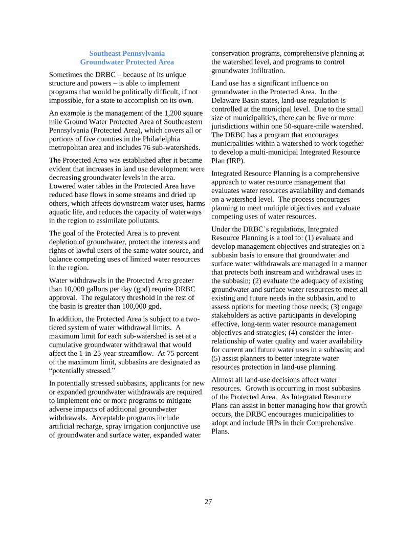
27
Southeast Pennsylvania
Groundwater Protected Area
Sometimes the DRBC – because of its unique
structure and powers – is able to implement
programs that would be politically difficult, if not
impossible, for a state to accomplish on its own.
An example is the management of the 1,200 square
mile Ground Water Protected Area of Southeastern
Pennsylvania (Protected Area), which covers all or
portions of five counties in the Philadelphia
metropolitan area and includes 76 sub-watersheds.
The Protected Area was established after it became
evident that increases in land use development were
decreasing groundwater levels in the area.
Lowered water tables in the Protected Area have
reduced base flows in some streams and dried up
others, which affects downstream water uses, harms
aquatic life, and reduces the capacity of waterways
in the region to assimilate pollutants.
The goal of the Protected Area is to prevent
depletion of groundwater, protect the interests and
rights of lawful users of the same water source, and
balance competing uses of limited water resources
in the region.
Water withdrawals in the Protected Area greater
than 10,000 gallons per day (gpd) require DRBC
approval. The regulatory threshold in the rest of
the basin is greater than 100,000 gpd.
In addition, the Protected Area is subject to a two-
tiered system of water withdrawal limits. A
maximum limit for each sub-watershed is set at a
cumulative groundwater withdrawal that would
affect the 1-in-25-year streamflow. At 75 percent
of the maximum limit, subbasins are designated as
“potentially stressed.”
In potentially stressed subbasins, applicants for new
or expanded groundwater withdrawals are required
to implement one or more programs to mitigate
adverse impacts of additional groundwater
withdrawals. Acceptable programs include
artificial recharge, spray irrigation conjunctive use
of groundwater and surface water, expanded water
conservation programs, comprehensive planning at
the watershed level, and programs to control
groundwater infiltration.
Land use has a significant influence on
groundwater in the Protected Area. In the
Delaware Basin states, land-use regulation is
controlled at the municipal level. Due to the small
size of municipalities, there can be five or more
jurisdictions within one 50-square-mile watershed.
The DRBC has a program that encourages
municipalities within a watershed to work together
to develop a multi-municipal Integrated Resource
Plan (IRP).
Integrated Resource Planning is a comprehensive
approach to water resource management that
evaluates water resources availability and demands
on a watershed level. The process encourages
planning to meet multiple objectives and evaluate
competing uses of water resources.
Under the DRBC’s regulations, Integrated
Resource Planning is a tool to: (1) evaluate and
develop management objectives and strategies on a
subbasin basis to ensure that groundwater and
surface water withdrawals are managed in a manner
that protects both instream and withdrawal uses in
the subbasin; (2) evaluate the adequacy of existing
groundwater and surface water resources to meet all
existing and future needs in the subbasin, and to
assess options for meeting those needs; (3) engage
stakeholders as active participants in developing
effective, long-term water resource management
objectives and strategies; (4) consider the inter-
relationship of water quality and water availability
for current and future water uses in a subbasin; and
(5) assist planners to better integrate water
resources protection in land-use planning.
Almost all land-use decisions affect water
resources. Growth is occurring in most subbasins
of the Protected Area. As Integrated Resource
Plans can assist in better managing how that growth
occurs, the DRBC encourages municipalities to
adopt and include IRPs in their Comprehensive
Plans.
28
Special Protection Waters –
Keeping the Clean Water Clean
Although states can have water quality standards
that are more stringent, the DRBC has the authority
to set uniform minimum standards for the basin. In
1967, the DRBC adopted the most comprehensive
water quality standards of any interstate river basin
in the nation. The standards, which focused on
dissolved oxygen levels, were tied to an innovative
wasteload allocation program that factored in the
waste assimilative capacity of the tidal Delaware
River - a TMDL (total maximum daily load) before
its time.
Interior Secretary Stewart Udall declared at the
time:
Only the Delaware among the nation’s
river basins is moving into high gear in its
program to combat water pollution.
A year later, the DRBC adopted regulations for
implementing and enforcing the standards,
prompting the Federal Water Pollution Control
Administration to observe:
This is the only place in the country where
such a procedure is being followed.
Hopefully, it will provide a model for other
regulatory agencies.
The DRBC, working with the basin states and
federal agencies, has developed a Toxics
Management Program for the tidal waters of the
basin with uniform toxic standards, TMDLs and
implementation plans for the cleanup of persistent
bio-accumulative PCBs (polychlorinated
biophenyls). Implementation addresses point and
nonpoint sources and requires pollutant
minimization plans, source track down studies,
monitoring, and annual reporting.
One of the most forward-thinking actions of the
Commission was to establish the Special Protection
Waters Program that requires any new or expanding
discharger to show no measurable change to the
existing water quality of the non-tidal shared
waters. The Special Protection Waters designation
has created the longest stretch of anti-degradation
waters in the United States. The program addresses
both point and nonpoint inputs. Protection of the
headwaters is critical in order to
maintain the high water quality supporting over 15
million water users and unique aquatic systems.
In an October 2011 University of Delaware
socioeconomic study, the ample, clean waters of the
Delaware Basin were shown to support:
1. Annual economic activity of $25 billion.
2. Ecosystem goods and services worth $21
billion per year (2010$), with a net present
value of $683 billion, discounted over 100
years.
3. Greater than 600,000 jobs and $10 billion per
year in wages.
The DRBC’s role in creating water quality
standards minimizes conflict among the states by
recognizing the connection between upstream and
downstream and ensuring that economic
development is balanced with social equity and
environmental health throughout the shared river.
Planning for the Future
The only effective way to manage the resource is to
embrace its complexity and interconnections. A
dynamic system requires adaptation, which is
facilitated by the involvement of all water sectors,
levels of government, and the public. This is the
successful model the DRBC has followed since its
inception and continues to follow today in its
planning efforts.
In 2004, the DRBC Commissioners and a number
of federal agencies approved the Water Resources
Plan for the Delaware Basin. The 30-year plan was
developed with extensive stakeholder input,
including a 36-member stakeholder Watershed
Advisory Council to ensure that the plan was
representative of the basin interests.
The Water Resources Plan provides a holistic goal-
driven framework to guide policy and actions by
water resources-related organizations, as is often
espoused in IWRM. The framework is organized
around five interrelated key result areas:
1. Sustainable Use and Supply.
2. Waterway Corridor Management.
3. Linking Land and Water Resource
Management.
4. Institutional Coordination and Cooperation.
5. Education and Involvement for Stewardship.
29
As in the past, the Commission continues to be at
the forefront of holistic water management with its
latest initiative to increase resiliency through the
DRBC Strategy for Sustainable Resources - 2060
(DRBC Strategy).
The DRBC Strategy is needed in recognition of
changing conditions that have a high level of
uncertainty. During the next 50 years, the
Delaware River Basin is expected to undergo
changes, including population growth and land-use
change, shifts in energy generation, and natural gas
development in the headwaters.
The DRBC is also studying the potential to
establish an environmental flow program in the
basin. Climate change brings an added layer of
uncertainty and volatility as sea level rises,
temperatures increase, and precipitation patterns
change.
The basin will be more adept at responding to
changes by modeling various scenarios, testing
sensitivities, and developing action plans that
address the range of potential impacts. The DRBC
Strategy will help the region understand answers to
questions such as those listed in Figure 8.
Separate tools are being developed to model
scenarios of landscape change, water supply needs,
ecological flow needs, water quality and influences
on ecological systems, and a range of intensities of
floods and drought.
The DRBC is working with federal agencies to help
develop the data and models. Future water needs
will be projected to generate scenarios. As a result,
the DRBC hopes to understand: (1) river flows
needed to prevent saltwater intrusion; (2) the
minimum flows necessary for tributaries; (3) the
capacity for water conservation programs and land
management to increase water supply; (4) the
results of status quo management in the future (no
action scenario); and (5) the actions necessary to
increase the region’s capacity to adapt and recover
as well maintain a reliable supply of water.
The development of scenarios will allow the DRBC
to identify and model a range of management
options, including modifications to existing
facilities, construction of new facilities, and non-
structural solutions such as riparian buffers, low
impact development, and operational changes. The
strong scientific foundation will be coupled with
stakeholder outreach and public participation to
ensure that the basin has sustainable water supply
for both human and ecological needs into the
future.
Figure 8 Potential Questions to be Addressed in the DRBC Strategy
Does the basin have an adequate availability of freshwater to meet both human and ecological needs
now and into the future?
Can the Philadelphia and southern New Jersey potable water supplies be protected from sea level rise?
What flows are needed to maintain the assimilative capacity of the river for pollutants under future
scenarios?
What flows are needed to protect freshwater marshes, oysters, and migratory fish under future
scenarios?
How will groundwater aquifers be affected by withdrawals and what programs need to be established
for their protection?
How would intense storms and droughts affect water supply storage? How will they compare to the
current drought and flood of record?
Can modification of the water management system and land cover address future water needs?
Are additional structural solutions for water supply storage and flood mitigation needed?
How does the management of the New York City reservoirs fit into the DRBC Strategy?
What should be done in the short term next 5 years?
30
Benefits and Costs
The region has benefitted greatly from state and
federal coordination, which allows this shared river
basin to be managed effectively without conflict
and with respect to the common goals of the region.
The capacity for the DRBC to make decisions that
affect the entire watershed helps the region avoid
inconsistencies in management that could lead to
inequities and conflict. The Commission's
programs dealing with water quality, water
quantity, watershed health, flow protection, and
planning for floods and droughts are leading to
improved water management that balances social,
economic, and environmental values and priorities.
Approximately 40 percent of the annual funding for
the Delaware River Basin Commission is provided
by the member states and federal government,
although the federal fair share has been nearly non-
existent since 1997. The DRBC’s 2012-2013
current expense budget was approved at $5.8
million.
_________________
Key Contact Information
Carol R. Collier
Executive Director
Delaware River Basin Commission
Website www.drbc.net
Thanks to Carol R. Collier for
writing this case study.
31
The Yakima River Basin Integrated Water Resource Management Plan
Background10
The Yakima River Basin (Basin) in central
Washington State has consistently experienced
challenges supporting agricultural, ecosystem,
domestic and municipal water needs.
The Basin is one of the most diversified and
productive agricultural areas in the world. Its
agricultural exports are a major component of the
Washington State economy. The Federal Yakima
Project irrigates 464,000 acres and underpins most
of the agricultural activity in the Basin. However,
the Basin is subject to periodic droughts that reduce
water supplies for many agricultural users.
Under legal decisions that date back to the 1940’s,
users of federal project water are divided into two
classes. Non-proratable users have seniority over
proratable users.11
In recent decades, dry years have occurred roughly
every five years on average. During dry years
proratable users have had their supplies cut
dramatically, causing significant economic
hardship, particularly in the agricultural sector.
The Yakima River historically supported large runs
of anadromous salmonids, estimated at 300,000 to
960,000 fish a year in the 1880s. These fish runs
have long sustained the culture and economy of the
Yakama Nation, whose treaty rights require
preservation of salmon runs for harvest. The runs
have declined drastically, and three salmon species
were eliminated from the Basin – Sockeye, summer
Chinook and Coho.
There are many causes within and outside of the
Basin for these declines, including blocked habitat,
land use changes and altered streamflows.
10
As quoted in Johnston, M. (2012, July 7). Advocates
Seek Wider Support from Public. Daily Record News.
http://www.dailyrecordnews.com. 11
Proratable users’ allocations are reduced equally in
water short years.
The Basin includes portions of Benton, Kittitas and
Yakima Counties with 22 incorporated cities and
towns and a large rural population. The Basin had
approximately 325,000 people in 2010 and growth
projections forecast a population of 415,000 by
2025. The largest city is Yakima, the center of an
urban area of approximately 95,000 people. It also
has a large rural population.
In the seniority system of water rights, most
groundwater users are junior to surface water users.
This means municipal systems and rural homes
could be forced to curtail water use in water-short
years. Because water supplies rely heavily on
snowpack in the Cascade Range, this problem is
expected to worsen under any scenario involving
climate change.
In 2003, Congress directed the Bureau of
Reclamation (Reclamation) to conduct a feasibility
study of options for additional surface water storage
in the Basin. The state of Washington partnered
with Reclamation in funding and implementing a
storage study. Reclamation issued a Final Planning
Report and Environmental Impact Statement
(PR/EIS) in 2008, which concluded that none of the
surface water storage features by themselves met
federal criteria for an economically and
environmentally sound water project. Therefore,
Reclamation recommended No Action as the
preferred alternative.
Based on comments received on the draft PR/EIS,
Washington State Department of Ecology
(Ecology) determined that the alternatives that
Congress had authorized for consideration under
the storage study were too narrowly focused.
“It’s got the kind of broad-base of support we’ve never had before; from irrigators, government
agencies, the Yakama Nation and environmental and conservation groups.”
Urban Eberhart (2012)10

32
Comments from environmental groups, the Yakama
Nation and others recommended consideration of a
wider range of alternatives, using an integrated
approach to benefit all resources, including fish
passage and habitat improvements in addition to
water storage. In response to these comments, and
after consultation with Reclamation, Ecology
identified an Integrated Water Resource
Management Alternative (Integrated Alternative) as
a new vision for resolving the long-standing issues
described above.
The Integrated Alternative included seven
interrelated elements:
1. Fish passage.
2. Structural and operational changes to Yakima
Project features.
3. Surface water storage.
4. Groundwater storage.
5. Habitat protection and enhancement.
6. Water conservation.
7. Market reallocation.
This became the basis for the subsequent work
described in this case study.
The YRBWEP Workgroup
Reclamation and Ecology jointly convened the
YRBWEP12
Workgroup to further develop the
Integrated Alternative.
The YRBWEP Workgroup, shown in Figure 9 on
the next page, consists of elected officials from the
three counties and the city of Yakima; local, state,
federal and Yakama Nation staff; and irrigation and
environmental stakeholders representing a wide
array of perspectives.
The YRBWEP Workgroup has been meeting
regularly since June 2009.
The group explored each of the seven categories of
water resource management within the Integrated
Alternative and how the different elements
combined to improve fisheries and resolve supply
reliability problems.
12
YRBWEP is the Yakima River Basin Water
Enhancement Project, a federal initiative authorized
by Congress in 1979.
Hydrologic and fish habitat benefits were
estimated, together with funding needs and an
implementation approach and schedule.
Technical studies were funded jointly by
Reclamation and Ecology. These studies used an
integrated modeling platform to evaluate how the
combination of projects considered would improve
water supply and streamflow conditions.
The Integrated Water
Resource Management Plan
As a result of these discussions, an array of projects
and programs grouped by the seven categories
listed above were proposed in the Yakima River
Basin Proposed Integrated Water Resource
Management Plan (Integrated Plan).
The combination of resource management
programs and infrastructure projects included in the
Integrated Plan meets multiple objectives,
including: enhanced water supply reliability;
improved streamflows; improved fish habitat
conditions; improved access to habitat that has been
blocked for decades; and increased supply to meet
the needs of population growth within the Basin
(see Figure 10 on page 34).
After modeling a combination of projects and
resource allocations, the set of programs identified
in the Integrated Plan alternative was the only set
that met all of the objectives.
Actions in the plan address surface water,
groundwater, floodplains and uplands to benefit the
fish and people that rely on the Yakima River
System. In addition to water resources, it includes
protection of significant watershed land resources
and associated recreational opportunities.
The Integrated Plan is expected to provide
substantial improvements in water supply reliability
and greatly multiply the population of salmon,
steelhead and bull trout within the Basin (Bureau of
Reclamation & Department of Ecology, 2011).
In April 2011, the YRBWEP Workgroup
unanimously approved the Integrated Plan,
contained in Volume 1 of the Yakima Basin Study.
Technical studies performed in 2010 and 2011
comprise Volume 2 of the study.

33
Individual members of the YRBWEP Workgroup
commented on various occasions that they did not
necessarily endorse every specific project within
the Integrated Plan, but that the plan, as a whole,
was equitable and offered a reasonable solution to
the range of water resource and fisheries problems
affecting the Basin.
The consensus agreement forged by this effort
marks an unprecedented achievement in a region
that has struggled for decades to reach agreement
on solutions to serious water supply and ecosystem
restoration needs.
Costs and Benefits
The total cost of the Yakima River Basin Study was
$2.64 million, split between the State and federal
governments. Considerable analysis has been done
of costs of the suite of projects and programs
included in the Integrated Plan. Total capital costs
are estimated to be $4.1 billion in 2012 dollars.
Benefits of the plan have been quantified in three
categories. These are: (1) improvements in
populations of salmon and steelhead,
13
Joined workgroup in 2012.
14
Alternate for American Rivers.
(2) improvements in reliability of agricultural
supplies, and (3) provision of water for municipal
systems and domestic wells. An economic analysis
conducted in 2010 is currently being updated and
expanded to account for national-scale effects.
Draft results show quantified benefits from the plan
are significantly greater than the costs listed above.
Next Steps
Ecology and Reclamation jointly issued a Final
Programmatic Environmental Impact Statement
(FPEIS) in March 2012. The FPEIS analyzes
environmental impacts for the plan overall, and will
be supplemented in the future by project-specific
environmental reviews. The Integrated Plan will be
implemented using an adaptive management
approach as new information emerges.
Since publication of the Integrated Plan, the
YRBWEP Workgroup has continued to meet
regularly. Its nonfederal members are now
communicating with members of Congress,
Washington State legislators, and a range of state
and federal officials to request funding for the
actions contained in the plan.
Figure 9 Members of the YRBWEP Workgroup
Federal Agencies
Bureau of Reclamation
National Marine Fisheries Service
U.S. Fish and Wildlife Service
U.S. Forest Service13
Yakama Nation
Yakama Nation Natural Resources
Yakima/Klickitat Fisheries Project
Irrigated Agriculture
Kennewick Irrigation District
Kittitas Reclamation District
Roza Irrigation District
Sunnyside Valley Irrigation District
Yakima-Tieton Irrigation District
Washington State Agencies
Department of Ecology
Department of Agriculture
Department of Fish & Wildlife
Local Governments
Benton County
Kittitas County
Yakima County
City of Yakima
Other Stakeholders
American Rivers
National Wildlife Federation14
Yakima Basin Fish & Wildlife Recovery Board
Yakima Basin Storage Alliance
34
Figure 10 Actions and Corresponding Elements of the Yakima River Basin Integrated Plan
Element/Action Description
Fish Passage
Clear Creek Dam passage Improve upstream and downstream fish passage at Clear Lake.
Cle Elum Dam passage
Bumping Dam passage
Tieton Dam passage
Keechelus Dam passage
Kachess Dam passage
Add upstream and downstream fish passage facilities at other
existing dam sites.
Structural and Operational Changes
Raise Pool at Cle Elum Dam Three-foot increase in storage pool elevation.
KRD15
Canal Changes Reduce seepage and enhance tributary flows.
Keechelus to Kachess Pipeline Optimize storage between two reservoirs.
Subordinate Power at Roza Dam and
Chandler Power Plants
Reduce water diversions to support fish migration.
Wapatox Canal Improvements Improve efficiency and consolidate diversions.
Surface Water Storage
Wymer Dam New off-channel reservoir (162,500 acre-feet).
Investigate removal of Roza Dam.
Lake Kachess Inactive Storage Tap inactive storage volume (up to 200,000 acre-feet).
Enlarged Bumping Lake Reservoir Enlarge reservoir to 190,000 acre-feet.
Columbia River Pump Exchange with
Yakima Basin Storage
Conduct feasibility study; and periodically evaluate need for
additional supplies.
Groundwater Storage
Shallow Aquifer Recharge Late winter/early spring infiltration prior to storage control.
Aquifer Storage and Recovery Off-season recharge of municipal supplies.
Habitat Protection and Enhancement
Mainstem Floodplain Restoration Program to fund a range of fish habitat projects.
Tributaries Habitat Enhancement Program to fund a range of fish habitat projects.
Targeted Watershed Protection and
Enhancements
Program to acquire and protect sensitive lands, including
aquatic and terrestrial habitats.
Enhanced Water Conservation
Agricultural Water Conservation Program to fund a range of projects.
Municipal Water Conservation Program to fund a range of projects and encourage
conservation by residents.
Market Reallocation
Near-term Effort Reduce barriers to trading.
Long-term Effort Additional steps to reduce barriers.
Source: Bureau of Reclamation & Department of Ecology (2011)
15
(KRD) Kittitas Reclamation District
35
Figure 11 Proposed Actions in the Integrated Plan
36
_________________
Key Contact Information
Derek Sandison
Director of Office of Columbia River
Washington State Department of Ecology
Wendy Christensen Technical Projects Program Manager
Bureau of Reclamation
Websites
www.ecy.wa.gov/programs/wr/cwp/YBIP.html
www.usbr.gov/pn/programs/yrbwep/.
Thanks to Andrew Graham of HDR
Engineering, Inc. for writing this case study.
_________________
References
Bureau of Reclamation & Department of Ecology. (2012, March). Yakima River Basin Integrated
Water Resource Management Plan: Final
Programmatic Environmental Impact Statement
Executive Summary.
http://www.usbr.gov/pn/programs/yrbwep/report
s/FPEIS/summary.pdf.
Bureau of Reclamation & Department of Ecology.
(2011, April). Yakima River Basin Study, Vol. 1:
Proposed Integrated Water Resource
Management Plan. http://www.usbr.gov/pn/
programs/yrbwep/2011integratedplan/plan/integr
atedplan.pdf.
37
The Middle Rio Grande Regional Water Management Plan: Regional Planning Using an IWRM Approach
The Impetus for a
Rio Grande Water Plan
Interstate water compact disputes rose in the 1950s
on the Pecos, Gila and Rio Grande Rivers that
resulted in Federal authorities dictating the
distribution of water in the Pecos drainage and the
prospect of similar Federal intervention within the
State of New Mexico for other major systems.
In 1987, the New Mexico Legislature called for
statewide regional water planning to identify water
needs and to protect local water supplies from
Federal action and out-of-state transfers.
The New Mexico Interstate Stream Commission
through the Office of the State Engineer is
responsible for managing the program, folding
regional plans into the state water plan. Plans are
revisited approximately every five years to adapt to
changing conditions and new information.
The State requires regional water plans to identify
water supply availability, evaluate water demand of
multiple sectors, and analyze management
alternatives. In addition, water plans must meet
public participation requirements, obtain
endorsements from local governments, and identify
unresolved conflicts (Interstate Stream
Commission, 1994).
To encourage integration among local water
agencies and to facilitate greater public input, areas
were allowed to self-identify their own planning
region based on both hydrologic boundaries as well
as political and economic interests. Thus, the State
set the foundation for practicing IWRM principles
at the regional scale, and today has 16 planning
regions (Water Assembly & MRCOG, 2004).
The Middle Rio Grande region in central New
Mexico is only one of the 16 planning regions, but
it is home to about 39 percent of the state’s
population. The region is dependent on the Rio
Grande, which is the largest source of surface water
in the state. Groundwater from the Middle Rio
Grande aquifer is the main source of water for
municipal and drinking water supplies.
Groundwater is hydrologically connected to surface
water, primarily the Rio Grande, which supports
other uses such as industrial, agricultural, and
environmental.
Prior to 1998, substantial planning efforts had not
been undertaken, as groundwater was initially
thought to be inexhaustible. However, in the early
1990s, studies revealed that the region’s use of
groundwater was unsustainable, with withdrawals
exceeding replenishment by about 50,000 acre-feet
per year, leading to declining groundwater levels
and river flows. As water suppliers drew from the
same water sources, a regional approach was
necessary to coordinate local efforts to achieve a
sustainable supply of water.
In 1998, the region began a five-year process to
develop the Middle Rio Grande Regional Water
Plan. During the first two years, plan development
focused on creating institutional capacity,
developing a vision and goals (see Figure 12 on the
next page), generating information on supply and
demand, and helping the public to understand the
water deficit. A period of drought that began in
1999 triggered legal action under the Endangered
Species Act over water use from the Rio Grande
River and accelerated completion of the regional
water plan. In 2001, efforts shifted to identifying
and evaluating alternative actions to balance water
supply and demand. By 2002, efforts focused on
evaluating different scenarios and drafting the plan,
which was approved in 2004 (Water Assembly &
MRCOG, 2004).
“…the water planning process must be a collaborative one, involving as much balanced public and
stakeholder participation as possible. Toward this end numerous public meetings, broad information
distribution, and focused public and stakeholder outreach, as well as detailed technical work, are all an
integral part of the plan development process.”
Water Assembly & MRCOG (2004)

38
Creating a Structure for a Fair
and Inclusive Planning Process
The process of developing the plan included
working with approximately 80 institutions led by a
partnership between the Mid-Region Council of
Governments (MRCOG) and the Middle Rio
Grande Water Assembly (Water Assembly).
The MRCOG is an organization of counties,
municipalities and other governmental entities. In
1998, MRCOG established a Water Resources
Board to prepare and adopt the plan.
The Water Assembly is an entirely voluntary
organization centered around leadership from the
University of New Mexico. Founded in 1997, it
helped coordinate all the interested parties in the
region to develop the plan. The two organizations
signed a Memorandum of Understanding to work
together, forming the basis of an integrated
government/nongovernmental organization
approach.
Because public and stakeholder involvement was
important, the Water Assembly was structured to
facilitate participation and coordination.
Specifically, it consisted of five constituency
groups, an Action Committee, an Executive
Committee, and Working Teams.
The five constituency groups were made up of
interested parties in the following categories:
technical specialists, water managers,
environmental advocates, urban and economic
development advocates, and agricultural, cultural
and historical advocates. Each constituency group
appointed five representatives to the Action
Committee and one representative to the Executive
Committee to advocate for their interests.
The Action Committee was the primary leadership
body, creating the process of interaction, outlining
studies, evaluating options, and managing
community engagement.
The Executive Committee, a subset of the Action
Committee, provided final decision authority and
direction to working teams.
The Action Committee made recommendations to
the Executive Committee about the planning
process and the Executive Committee directed the
working teams.
Working Teams focused on public participation and
communication, analyzing alternative actions,
cooperative modeling of the alternative actions,
external coordination with other regions and
agencies, technical analysis, administration and
budget, public welfare, development of plan
recommendations, and scenario development.
The Water Assembly structure and partnership with
MRCOG resulted in a water plan that represented a
truly joint effort between governmental entities,
water professionals, and the public (Water
Assembly & MRCOG, 2004).16
16
While native peoples were invited to participate, they
elected to only observe, likely to preserve their
sovereign status. This underscores one challenge of
planning at the regional level.
Figure 12 Goals of the Middle Rio Grande
Regional Water Plan
Ensure that the mission is fulfilled through fair,
open and inclusive public planning and
implementation processes.
Preserve water for a healthy native Rio Grande
ecosystem.
Preserve water for the region’s agricultural,
cultural, and historical values.
Preserve water for economic and urban vitality.
Preserve water for the qualities of life valued by
residents in the region.
Develop broad public and official awareness of
water facts and issues, especially the limited
nature of water resources.
Conserve water.
Promote a system of water laws and processes
that support the regional water plan and its
implementation.
Provide appropriate water quality for each use.
Manage water demand consistent with the stated
mission.
Balance growth with renewable supply.*
* Not approved by MRCOG
Source: Water Assembly & MRCOG (2004).
39
Overview of Outreach Efforts
While interested parties had the opportunity to
formally participate as a member of the Water
Assembly, there were also significant public
outreach and involvement efforts at every stage in
the development process. This was important, as
failure to obtain local buy-in could affect local
agencies’ commitment to implementing the plan.
To maximize limited resources, outreach included
free or low-cost uses of the media, directly
communicating with public officials, and holding
public meetings and targeted presentations. Letters,
articles, op-eds, press releases and public service
announcements were some of the primary means of
keeping the public informed. In addition, media
kits and planning information were distributed to
media outlets and Water Assembly members served
as experts on radio shows (Water Assembly &
MRCOG, 2004).
The public was also engaged more directly through
informational presentations, community
conversations, regional forums, public opinion
surveys, and annual water assemblies. These
events were not only an opportunity to provide
information to the public, but also involved
activities that encouraged participants to generate a
deeper understanding of the problem, formulate
potential solutions, and provide feedback to shape
the final plan.
Presentations and information were also provided
to the federal congressional delegation, federal
agencies, tribal groups, state agencies, local
governments, special districts, regional neighbors
and nongovernmental organizations.
By the time the plan was approved, more than a
hundred public meetings had been held along with
about the same number of briefings to groups and
governmental organizations. In sum, twenty-three
hundred public comments were received and 3,000
individuals had attended meetings held by the
Water Assembly (Water Assembly & MRCOG,
2004).
The Water Budget as a
Tool for Collective Action
Early in the process, a water budget was developed
by determining the quantity of water used in the
region and the quantity of water that was available.
Although there was continuous discussion about the
accuracy of the data used, regardless the water
budget showed that the region was operating at a
deficit that would increase in the future without
concerted efforts to reduce water use or increase
supply. The intuitive nature of the water budget
made it an ideal tool to help diverse interests
develop a common understanding of water as a
finite resource in the region, and of the challenges
faced in reducing demand.
Constituency groups and the public were provided
with an electronic spreadsheet, which showed how
much water was available in the region and how
much was being used by each sector. Participants
were provided with overarching allocation
instructions to follow.
The instructions noted that: (1) total water use
could not increase; (2) groundwater and surface
water are connected; (3) efficiency improvements
only increase supply to the extent that they reduce
consumptive water use; and (4) certain flows must
be met in order to meet obligations under the Rio
Grande Compact.
Using this information, participants were then
asked to balance the water budget so there was no
longer a deficit. This allowed the different interests
to comprehend just how difficult it was to balance
the water budget without coordinated action.
Further, it encouraged conversations about the
regional impacts that might result from decreased
uses in each water sector (Water Assembly &
MRCOG, 2004).
Identifying and Evaluating
Alternative Actions
Based on the water budget tool, 273 suggestions
were received to address the disparity between
water supply and demand. These were then pared
down to 44 potential alternative actions outlined in
Figure 13 on the next page.
Thereafter, each alternative was initially analyzed
for water impacts, potential tradeoffs, cost, and
time to implement. The alternatives were ranked
on a five-point scale for technical feasibility;
physical, hydrological, and environmental aspects;
economic impacts; social and cultural implications;
legal implications and political feasibility. The in-
depth analysis of the alternatives was released to
the public for discussion.
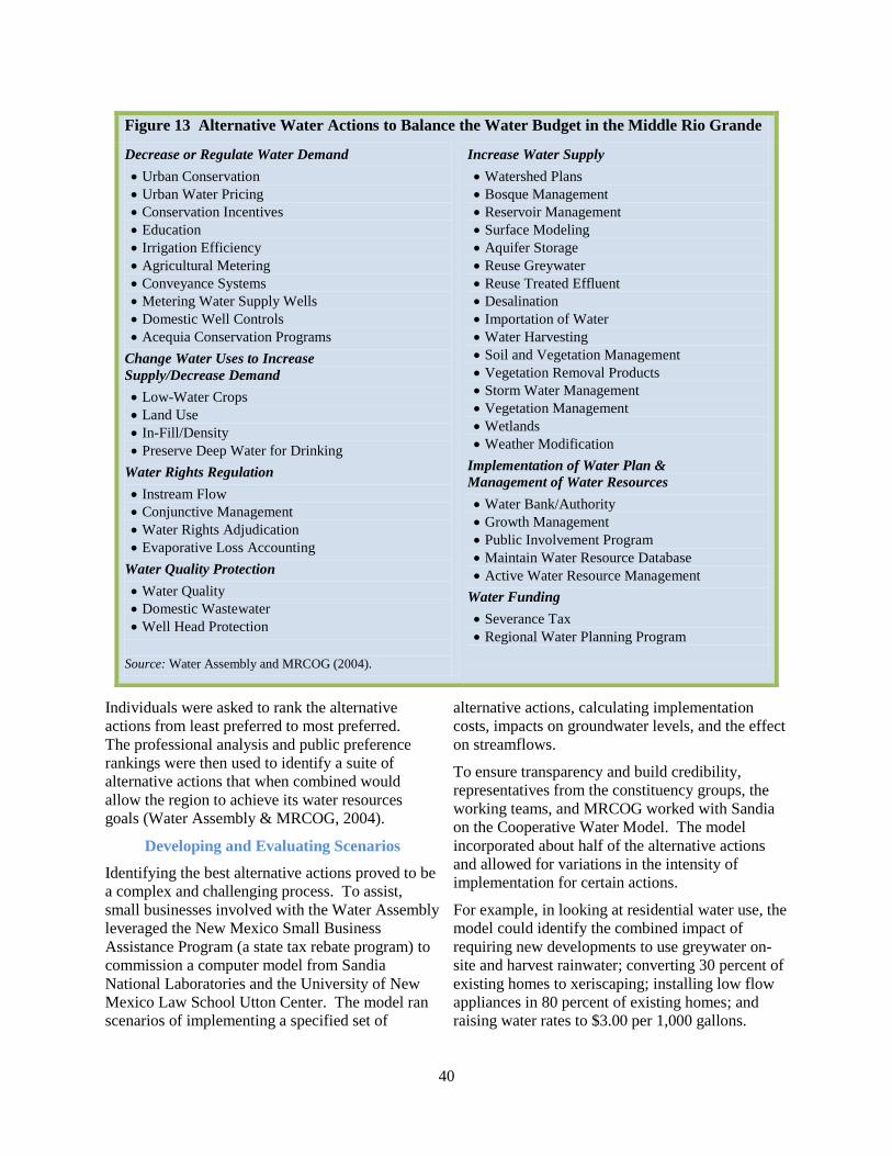
40
Individuals were asked to rank the alternative
actions from least preferred to most preferred.
The professional analysis and public preference
rankings were then used to identify a suite of
alternative actions that when combined would
allow the region to achieve its water resources
goals (Water Assembly & MRCOG, 2004).
Developing and Evaluating Scenarios
Identifying the best alternative actions proved to be
a complex and challenging process. To assist,
small businesses involved with the Water Assembly
leveraged the New Mexico Small Business
Assistance Program (a state tax rebate program) to
commission a computer model from Sandia
National Laboratories and the University of New
Mexico Law School Utton Center. The model ran
scenarios of implementing a specified set of
alternative actions, calculating implementation
costs, impacts on groundwater levels, and the effect
on streamflows.
To ensure transparency and build credibility,
representatives from the constituency groups, the
working teams, and MRCOG worked with Sandia
on the Cooperative Water Model. The model
incorporated about half of the alternative actions
and allowed for variations in the intensity of
implementation for certain actions.
For example, in looking at residential water use, the
model could identify the combined impact of
requiring new developments to use greywater on-
site and harvest rainwater; converting 30 percent of
existing homes to xeriscaping; installing low flow
appliances in 80 percent of existing homes; and
raising water rates to $3.00 per 1,000 gallons.
Figure 13 Alternative Water Actions to Balance the Water Budget in the Middle Rio Grande
Decrease or Regulate Water Demand
Urban Conservation
Urban Water Pricing
Conservation Incentives
Education
Irrigation Efficiency
Agricultural Metering
Conveyance Systems
Metering Water Supply Wells
Domestic Well Controls
Acequia Conservation Programs
Change Water Uses to Increase
Supply/Decrease Demand
Low-Water Crops
Land Use
In-Fill/Density
Preserve Deep Water for Drinking
Water Rights Regulation
Instream Flow
Conjunctive Management
Water Rights Adjudication
Evaporative Loss Accounting
Water Quality Protection
Water Quality
Domestic Wastewater
Well Head Protection
Source: Water Assembly and MRCOG (2004).
Increase Water Supply
Watershed Plans
Bosque Management
Reservoir Management
Surface Modeling
Aquifer Storage
Reuse Greywater
Reuse Treated Effluent
Desalination
Importation of Water
Water Harvesting
Soil and Vegetation Management
Vegetation Removal Products
Storm Water Management
Vegetation Management
Wetlands
Weather Modification
Implementation of Water Plan &
Management of Water Resources
Water Bank/Authority
Growth Management
Public Involvement Program
Maintain Water Resource Database
Active Water Resource Management
Water Funding
Severance Tax
Regional Water Planning Program
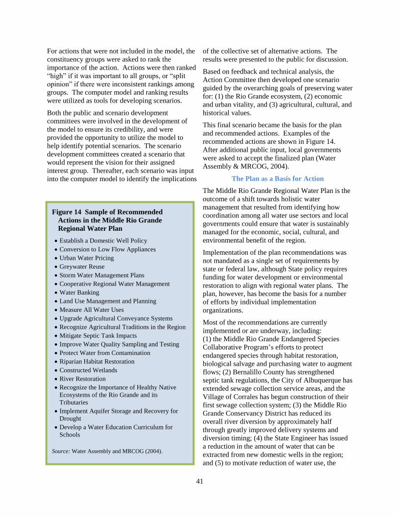
41
For actions that were not included in the model, the
constituency groups were asked to rank the
importance of the action. Actions were then ranked
“high” if it was important to all groups, or “split
opinion” if there were inconsistent rankings among
groups. The computer model and ranking results
were utilized as tools for developing scenarios.
Both the public and scenario development
committees were involved in the development of
the model to ensure its credibility, and were
provided the opportunity to utilize the model to
help identify potential scenarios. The scenario
development committees created a scenario that
would represent the vision for their assigned
interest group. Thereafter, each scenario was input
into the computer model to identify the implications
of the collective set of alternative actions. The
results were presented to the public for discussion.
Based on feedback and technical analysis, the
Action Committee then developed one scenario
guided by the overarching goals of preserving water
for: (1) the Rio Grande ecosystem, (2) economic
and urban vitality, and (3) agricultural, cultural, and
historical values.
This final scenario became the basis for the plan
and recommended actions. Examples of the
recommended actions are shown in Figure 14.
After additional public input, local governments
were asked to accept the finalized plan (Water
Assembly & MRCOG, 2004).
The Plan as a Basis for Action
The Middle Rio Grande Regional Water Plan is the
outcome of a shift towards holistic water
management that resulted from identifying how
coordination among all water use sectors and local
governments could ensure that water is sustainably
managed for the economic, social, cultural, and
environmental benefit of the region.
Implementation of the plan recommendations was
not mandated as a single set of requirements by
state or federal law, although State policy requires
funding for water development or environmental
restoration to align with regional water plans. The
plan, however, has become the basis for a number
of efforts by individual implementation
organizations.
Most of the recommendations are currently
implemented or are underway, including:
(1) the Middle Rio Grande Endangered Species
Collaborative Program’s efforts to protect
endangered species through habitat restoration,
biological salvage and purchasing water to augment
flows; (2) Bernalillo County has strengthened
septic tank regulations, the City of Albuquerque has
extended sewage collection service areas, and the
Village of Corrales has begun construction of their
first sewage collection system; (3) the Middle Rio
Grande Conservancy District has reduced its
overall river diversion by approximately half
through greatly improved delivery systems and
diversion timing; (4) the State Engineer has issued
a reduction in the amount of water that can be
extracted from new domestic wells in the region;
and (5) to motivate reduction of water use, the
Figure 14 Sample of Recommended
Actions in the Middle Rio Grande
Regional Water Plan
Establish a Domestic Well Policy
Conversion to Low Flow Appliances
Urban Water Pricing
Greywater Reuse
Storm Water Management Plans
Cooperative Regional Water Management
Water Banking
Land Use Management and Planning
Measure All Water Uses
Upgrade Agricultural Conveyance Systems
Recognize Agricultural Traditions in the Region
Mitigate Septic Tank Impacts
Improve Water Quality Sampling and Testing
Protect Water from Contamination
Riparian Habitat Restoration
Constructed Wetlands
River Restoration
Recognize the Importance of Healthy Native
Ecosystems of the Rio Grande and its
Tributaries
Implement Aquifer Storage and Recovery for
Drought
Develop a Water Education Curriculum for
Schools
Source: Water Assembly and MRCOG (2004).

42
largest municipal water supplier in the region has
implemented a “conservation” fee structure and
includes a message in the monthly bill that
compares the customer’s use with average
residential use.
Costs and Benefits
In addition to the Small Business Assistant Tax
Rebate program described above, MRCOG
received $150,000 from the State for the initial plan
development from 1999 to 2002, with local
governments providing an additional $161,353.
Starting in 2002, the State and local governments
each paid for 25 percent of the costs (equal to
$280,530 each), with the remaining 50 percent from
in-kind services.
More than 2,000 individuals (Water Assembly,
2003) were involved with the project with
volunteers providing approximately 30,000 hours
of expertise. Overall, the analysis and plan
development cost about $1.2 million (Water
Assembly & MRCOG, 2004).
The benefits from regional water planning include
the capacity to ensure that there will be sufficient
water to meet human and environmental needs by
eliminating short-term thinking to maximize more
strategic actions that will benefit the region over the
long-term.
The plan makes it clear that the benefits of planning
are to avoid the costs of not planning:
Specific risks include financial costs of
failure to meet downstream obligations,
economic costs of water shortages, drying
or quality degradation of our water supply,
impacts to the environment, land
subsidence, outside appropriation of water,
and loss of those lifestyle and cultural
attributes that make New Mexico and the
region unique (Water Assembly &
MRCOG, 2004, p. 1-2).
Exact estimates of the cumulative investment
across all organizations and the community to
reduce use, communicate, improve
environmental conditions and meet endangered
species requirements have not been tallied, but
estimates have reached $100 million. This is
significantly less than the overall cost of other
options such as increasing supply or engaging
in litigation.
For example, the estimated deficit in water
resources in the Middle Rio Grande was
approximately 50,000 acre feet. At the current
price for permanent water right transfers, the water
deficit is worth between $600-750 million. These
costs would either be borne by local municipalities,
be implemented via forced use reductions in the
municipal or agricultural sector, or be implemented
via saline water extraction and treatment.
In sum, the region has greatly benefitted from
coordination and planning efforts.
_________________
Key Contact Information
Erik Webb
Manager, Global Security and Technologies
Sandia National Laboratories
Website
www.ose.state.nm.us/isc_regional_plans12.
html.
Thanks to Erik Webb for
assisting in writing this case study.
_________________
References
Interstate Stream Commission. (1994, December).
Regional Water Planning Handbook.
http://www.ose.state.nm.us/isc_regional_plans12
.html.
Middle Rio Grande Water Assembly and Mid-
Region Council of Governments. (2004, August).
Middle Rio Grande Regional Water Plan 2000-
2050, Volume 1. http://www.ose.state.nm.us/isc_
regional_plans12.html.
Middle Rio Grande Water Assembly. (2003,
October). Abstract of the Draft of the Middle Rio
Grande Regional Water Plan 2000-2050 for
Bernalillo, Valencia & Sandoval Counties.
http://www.waterassembly.org/archives/MRG-
Plan/C-Summaries/Rio%20Grande%20
Brochure.pdf
43
Developing a Plan and Decision Support System for Integrated Water Resources Management in the Minnesota River Basin
Background: The Connection between
Water Challenges and Land Use
The Minnesota River Basin (MRB) drains an area
of 16,770 square miles within Minnesota, South
Dakota, North Dakota and Iowa. The MRB,
primarily located in the state of Minnesota, has
experienced significant changes in the hydrologic
regime due to the conversion of native prairies,
wetlands, and savannas to urban development and
agriculture (USACE, 2004).
Tile drainage of agricultural fields has been cited as
one potentially significant cause of changes to
water quality and the hydrologic regime. But
whatever the cause, increased problems associated
with flooding, erosion, drought, degraded habitat,
and poor water quality are threatening ecosystems
and agricultural livelihoods.
The impetus for today’s efforts in the MRB reach at
least as far back as 1962 with a request by the
Committee on Public Works of the House of
Representatives for an evaluation of the Minnesota
River Basin. In 2003, Congress funded the
Minnesota River Basin Reconnaissance Study to
determine if the federal government could assist
with implementing “solutions to flooding,
navigation, low flow augmentation, recreation,
ecosystem restoration, and other related water
resource problems and opportunities in the
Minnesota River Basin” (USACE, 2004, p. 1).
The Corps of Engineers – which has embraced
IWRM with goals of protecting the environment,
promoting economic development, and restoring
ecosystems to maximize their services – developed
the study with input from state and federal
agencies, cities, watershed districts, environmental
organizations, the public and other stakeholders in
the MRB.
It was determined that many of the problems in the
basin were interconnected and would require
several management approaches applied at different
scales. Therefore, the MRB Reconnaissance Study
explored potential plans for coordinated and
purposeful action within the basin and identified
three that met the objectives.
One proposal, The Integrated Watershed, Water
Quality, and Ecosystem Restoration Analysis,
emerged out of recognition that tools were
necessary to understand the costs and benefits of
management actions on both human and
environmental systems in order to plan effectively.
The study proposal called for the development of a
Decision Support System (DSS) that would allow
water managers to simulate future conditions in
order to identify, monitor and evaluate management
approaches and restoration measures that would
achieve desired results.
The DSS would integrate physical systems such as
watershed processes, water quality, and ecosystems
at various spatial levels ranging from subbasins to
the main stem with a goal of identifying the most
efficient ways to restore the ecosystem, while also
sustaining agriculture (USACE, 2004). To achieve
this, the DSS would include:
…process-based simulation models,
geographic information systems (GIS),
topographic data, agricultural and
ecological economics valuation models,
plan formulation, alternatives analysis, and
evaluation models (Project Management
Plan, 2009).
“The integrated watershed study will produce a watershed management plan and decision support
system to aid water and land managers in the basin. These tools will enable examination of existing
conditions, forecasting of future conditions and simulation of alternatives to identify ecologically
sustaining and economically and socially desirable management actions.”
U.S. Army Corps of Engineers, St. Paul District (n.d.)
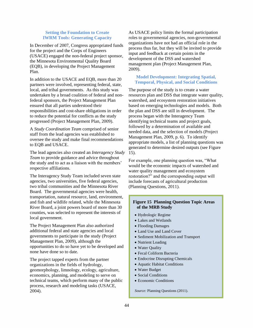
44
Setting the Foundation to Create
IWRM Tools: Generating Capacity
In December of 2007, Congress appropriated funds
for the project and the Corps of Engineers
(USACE) engaged the non-federal project sponsor,
the Minnesota Environmental Quality Board
(EQB), in developing the Project Management
Plan.
In addition to the USACE and EQB, more than 20
partners were involved, representing federal, state,
local, and tribal governments. As this study was
undertaken by a broad coalition of federal and non-
federal sponsors, the Project Management Plan
ensured that all parties understood their
responsibilities and cost-share obligations in order
to reduce the potential for conflicts as the study
progressed (Project Management Plan, 2009).
A Study Coordination Team comprised of senior
staff from the lead agencies was established to
oversee the study and make final recommendations
to EQB and USACE.
The lead agencies also created an Interagency Study
Team to provide guidance and advice throughout
the study and to act as a liaison with the members’
respective affiliations.
The Interagency Study Team included seven state
agencies, two universities, five federal agencies,
two tribal communities and the Minnesota River
Board. The governmental agencies were health,
transportation, natural resource, land, environment,
and fish and wildlife related, while the Minnesota
River Board, a joint powers board of more than 30
counties, was selected to represent the interests of
local government.
The Project Management Plan also authorized
additional federal and state agencies and local
governments to participate in the study (Project
Management Plan, 2009), although the
opportunities to do so have yet to be developed and
none have done so to date.
The project tapped experts from the partner
organizations in the fields of hydrology,
geomorphology, limnology, ecology, agriculture,
economics, planning, and modeling to serve on
technical teams, which perform many of the public
process, research and modeling tasks (USACE,
2004).
As USACE policy limits the formal participation
roles to governmental agencies, non-governmental
organizations have not had an official role in the
process thus far, but they will be invited to provide
input and feedback at certain points in the
development of the DSS and watershed
management plan (Project Management Plan,
2009).
Model Development: Integrating Spatial,
Temporal, Physical, and Social Conditions
The purpose of the study is to create a water
resources plan and DSS that integrate water quality,
watershed, and ecosystem restoration initiatives
based on emerging technologies and models. Both
the plan and DSS are still in development. The
process began with the Interagency Team
identifying technical teams and project goals,
followed by a determination of available and
needed data, and the selection of models (Project
Management Plan, 2009, p. 6). To identify
appropriate models, a list of planning questions was
generated to determine desired outputs (see Figure
15).
For example, one planning question was, “What
would be the economic impacts of watershed and
water quality management and ecosystem
restoration?” and the corresponding output will
include forecasts of agricultural production
(Planning Questions, 2011).
Figure 15 Planning Question Topic Areas
of the MRB Study
Hydrologic Regime
Lakes and Wetlands
Flooding Damages
Land Use and Land Cover
Sediment Mobilization and Transport
Nutrient Loading
Water Quality
Fecal Coliform Bacteria
Endocrine Disrupting Chemicals
Aquatic Habitat Conditions
Water Budget
Social Conditions
Economic Conditions
Source: Planning Questions (2011).
45
The challenge of creating a basin-wide model is
finding enough small watersheds representative of
the basin’s diversity with sufficient data to simulate
different conditions across the basin. To maximize
use of the study’s limited resources, the interagency
team decided to start by modeling six to eight small
watersheds considered representative of different
conditions within the basin. The goal is to evaluate
if they might sufficiently inform a basin-wide
model to make reasonable generalizations to the
rest of the basin.
Hydrologic models will be created for a range of
precipitation conditions under natural, current, and
potential future land-use patterns, which will be
used to understand sediment and nutrient transport.
After scaling the models up to larger watersheds,
the outputs will be combined with flow models of
the Minnesota River to understand influences on
water quality.
These models will be combined with models of
“future land use, urban development, climate,
geomorphic processes, the agricultural drainage
system, and watershed management” to understand
the effects on hydrologic processes and water
quality (Project Management Plan, 2009, p. 6).
After receiving input from the public, a model of
desired future conditions will be developed to
identify what changes in the inputs are necessary to
reach that target, and what management actions are
necessary to cause those changes.
Management actions to be modeled will include:
…best management practices for watershed
management, land cover changes,
modifications to the agricultural drainage
system, wetland restorations, tributary
channel restoration, reservoir water level
management, navigation traffic restrictions,
and other measures (Project Management
Plan, 2009, p. 6).
Thereafter, different scales in application of
management practices and combinations will be
simulated to understand the cumulative impacts on
the larger watershed and main stem Minnesota
River.
For example, in recent years, there has been an
increase in agricultural drainage tiling in the basin,
but it is not known exactly how this is affecting the
hydrology and water quality. The model, once
developed, will help people understand this
connection between management activities and
water resources.
The modeling is not limited to physical aspects, but
will also include a simulation of the economic
effects of management actions on agriculture and
local communities, along with a simulation of the
extent that management actions increase ecosystem
services (Project Management Plan, 2009).
Based on the models described, a decision-support
system will be developed to identify water quality,
water quantity, groundwater management, aquatic
ecosystem restoration, and watershed management
actions to achieve desired future conditions. This
model will allow users to understand the social,
economic and ecosystem benefits and impacts
associated with different decisions and allow for a
balanced approach to watershed management.
It is expected that natural resource, land and water
professionals will use the DSS tools, including
State and local government planners and managers,
tribal interests, federal authorities, and farmers and
other landowners.
Land use planners, for example, may use it to
understand interactions between floodplain
development, flooding, and water quality. Fish and
wildlife officials could use it to identify which
wetlands, if restored, will have the maximum effect
on improving water quality with minimal impacts
on agricultural and urban economies.
The goal is to make the models and DSS into
practical tools capable of helping professionals
understand the interconnectedness of the system
and manage it in a manner that balances social,
economic, and environmental priorities.
Secondary user groups may include public and
special interests affected by land and water
management decisions.
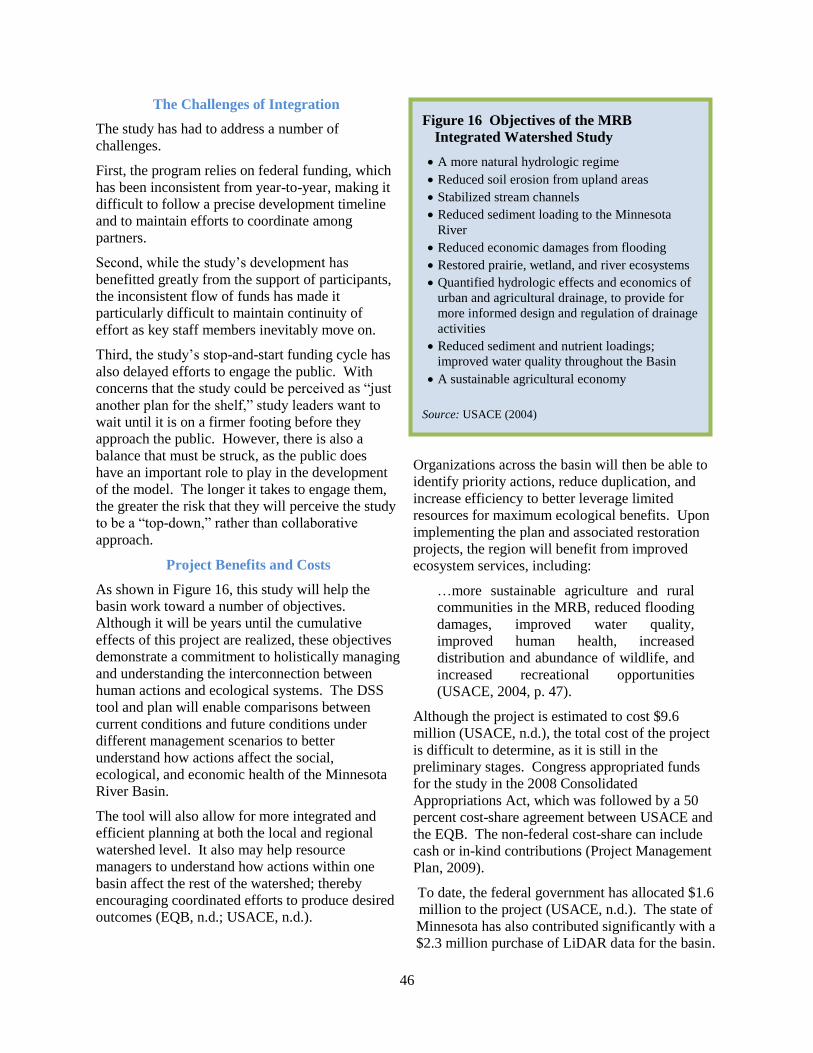
46
The Challenges of Integration
The study has had to address a number of
challenges.
First, the program relies on federal funding, which
has been inconsistent from year-to-year, making it
difficult to follow a precise development timeline
and to maintain efforts to coordinate among
partners.
Second, while the study’s development has
benefitted greatly from the support of participants,
the inconsistent flow of funds has made it
particularly difficult to maintain continuity of
effort as key staff members inevitably move on.
Third, the study’s stop-and-start funding cycle has
also delayed efforts to engage the public. With
concerns that the study could be perceived as “just
another plan for the shelf,” study leaders want to
wait until it is on a firmer footing before they
approach the public. However, there is also a
balance that must be struck, as the public does
have an important role to play in the development
of the model. The longer it takes to engage them,
the greater the risk that they will perceive the study
to be a “top-down,” rather than collaborative
approach.
Project Benefits and Costs
As shown in Figure 16, this study will help the
basin work toward a number of objectives.
Although it will be years until the cumulative
effects of this project are realized, these objectives
demonstrate a commitment to holistically managing
and understanding the interconnection between
human actions and ecological systems. The DSS
tool and plan will enable comparisons between
current conditions and future conditions under
different management scenarios to better
understand how actions affect the social,
ecological, and economic health of the Minnesota
River Basin.
The tool will also allow for more integrated and
efficient planning at both the local and regional
watershed level. It also may help resource
managers to understand how actions within one
basin affect the rest of the watershed; thereby
encouraging coordinated efforts to produce desired
outcomes (EQB, n.d.; USACE, n.d.).
Organizations across the basin will then be able to
identify priority actions, reduce duplication, and
increase efficiency to better leverage limited
resources for maximum ecological benefits. Upon
implementing the plan and associated restoration
projects, the region will benefit from improved
ecosystem services, including:
…more sustainable agriculture and rural
communities in the MRB, reduced flooding
damages, improved water quality,
improved human health, increased
distribution and abundance of wildlife, and
increased recreational opportunities
(USACE, 2004, p. 47).
Although the project is estimated to cost $9.6
million (USACE, n.d.), the total cost of the project
is difficult to determine, as it is still in the
preliminary stages. Congress appropriated funds
for the study in the 2008 Consolidated
Appropriations Act, which was followed by a 50
percent cost-share agreement between USACE and
the EQB. The non-federal cost-share can include
cash or in-kind contributions (Project Management
Plan, 2009).
To date, the federal government has allocated $1.6
million to the project (USACE, n.d.). The state of
Minnesota has also contributed significantly with a
$2.3 million purchase of LiDAR data for the basin.
Figure 16 Objectives of the MRB
Integrated Watershed Study
A more natural hydrologic regime
Reduced soil erosion from upland areas
Stabilized stream channels
Reduced sediment loading to the Minnesota
River
Reduced economic damages from flooding
Restored prairie, wetland, and river ecosystems
Quantified hydrologic effects and economics of
urban and agricultural drainage, to provide for
more informed design and regulation of drainage
activities
Reduced sediment and nutrient loadings;
improved water quality throughout the Basin
A sustainable agricultural economy
Source: USACE (2004)
47
_________________
Key Contact Information
Craig Evans
Project Co-Chair and Chief
Plan Formulation Section
U.S. Army Corps of Engineers
Kate Frantz
Project Co-Chair and Planner
Minnesota Environmental Quality Board
Rebecca Seal-Soileau
Interagency Study Team Coordinator
U.S. Army Corps of Engineers
Website
www.eqb.state.mn.us/project.html?Id=31991.
Thanks to John Wells for assisting in writing this
case study and Michael Wyatt and Dr. Rebecca
Seal-Soileau for reviewing the case.
_________________
References
Minnesota Environmental Quality Board. (n.d.).
Project: Minnesota River Integrated Watershed,
Water Quality and Ecosystem Restoration Study.
[Website]. http://www.eqb.state.mn.us/project.
html?Id=31991, accessed July 12, 2012.
Planning Questions for Modeling. (2011, March
10). http://www.eqb.state.mn.us/project.html
?Id=31991.
Project Management Plan, Minnesota River Basin
Integrated Watershed, Water Quality, and
Ecosystem Restoration Study. (2009).
http://www.eqb.state.mn.us/project.
html?Id=31991.
U.S. Army Corps of Engineers, St. Paul District.
(n.d.). Integrated Watershed Study: Minnesota
River Basin in Minnesota, South Dakota, North
Dakota and Iowa. http://www.mvp.usace.army.
mil/navigation/default.asp?pageid=1477,
accessed July 16, 2012.
U.S. Army Corps of Engineers, St. Paul District.
(2004, December). Minnesota River Basin
Reconnaisannce Study: Section 905(b) Analysis
(WRDA of 1986): Minnesota, South Dakota,
North Dakota, and Iowa. http://www.eqb.state
.mn.us/project.html?Id=31991.

48
The St. Johns River Water Supply Impact Study: Creating Tools for Integrated Water Resources Management
Introduction: A Strong Foundation for IWRM
Florida is unique in that it has not followed the
traditional approach to water management. Rather,
it has engaged in water planning at the regional
level since the Florida Water Resources Act of
1972, which established five water management
districts based on hydrologic boundaries.
Today, the water management districts oversee
water supply, water quality, flood control, and
natural systems protection and restoration
(SJRWMD, 2012b). Florida provides an ideal case
study to examine and study IWRM concepts, since
the institutional foundation was established forty
years ago.
Florida law requires that the districts manage water
so “existing water supply sources are adequate to
meet existing and projected reasonable-beneficial
needs of the local governments while sustaining
water resources and related natural systems”
(SJRWMD, 2006).
Florida’s water management districts are well-
aligned with the definition of IWRM, as they must
plan how to meet consumptive water demand
without violating minimum flows and levels – the
point at which withdrawals have a significant
adverse effect on the ecosystem (SJRWMD,
2012b).
The St. Johns River Water Management District
(SJRWMD or District) is one of Florida’s five
regional water districts, spanning all or part of 18
counties across approximately eight million acres in
the northeastern to central-eastern part of Florida
(SJRWMD, 2006).
The region has highly productive aquifers, which
have been the primary source of water for
consumptive uses.
Although Florida on average receives 53 inches of
rain annually, most is lost through evaporation. In
addition, rivers, estuaries and wetlands require
much of the remaining water to maintain the
benefits of healthy ecosystems, particularly during
times of the year when human demand is high
(SJRWMD, 2012b).
The inherently integrated organizational structure
requires that the District meet performance goals to
retain wetlands, establish ecological minimum
flows, protect groundwater and surface water
quality, minimize flood damage, and increase water
supplies for human consumption (SJRWMD,
2012a).
In 2000, the SJRWMD worked with the public and
other government agencies to complete its first
long-term District Water Supply Plan, which found
that in some areas, aquifers would not be able to
sustain growth over the 20-year planning horizon
without impairing water resources and ecosystems
(SJRWMD, 2012).
The Challenge: Increasing Supply without
Harming Ecosystems and Water Resources
In response to the need for future alternative water
sources, the District began a three-year study
exploring the possibility of withdrawing water from
the St. Johns River. The study found that it would
be economically feasible to utilize the river as a
water supply source (SJRWMD, 2012).
In 2005, the SJRWMD utilized feedback from the
public, stakeholders, governmental entities and
other parties to complete its first update to the
District Water Supply Plan (SJRWMD, 2006). The
plan again identified the St. Johns River and the
Ocklawaha River as potential sources to meet the
growing demand for water (SJRWMD, 2012).
“An overarching goal of Florida’s water policy is to realize the beneficial use of water resources,
ensuring their sustainability and providing water for all reasonable-beneficial uses and for natural
systems. To achieve this goal, the direct benefits of human water uses must be balanced against the
indirect benefits provided by natural systems. Striking an appropriate balance requires development of a
sound scientific understanding of the water requirements of natural systems.”
St. Johns River Water Management District (2012b)
49
Around the same time, a consumptive use permit to
withdraw water from the St. Johns River was
approved. It sparked some public opposition as
well as concerns from other water suppliers,
leading to uncertainty about authorizing
withdrawals in the future.
By 2006, the SJRWMD and two other regional
water management districts recognized a need for
coordination among the three districts to reduce
conflict and allow for better planning, as
groundwater supplies were declining in the region
where the districts’ borders met (SJRWMD, 2012).
The three regional water districts set additional
restrictions on consumptive use permits within this
Central Florida Coordination Area, while also
agreeing to plan and coordinate additional water
supplies to meet new water demands beyond 2013
(SJRWMD, 2012b). As a result, the District
continued to identify opportunities for water
conservation and improved aquifer management, as
well as the development of other sources such as
reclaimed water, brackish groundwater, seawater,
and surface water (SJRWMD, 2006).
Addressing the Unknown:
Overview of the Water Supply Impact Study
The SJRWMD seeks to sustainably manage and
balance the use of water in the state for both
humans and ecosystems, recognizing that natural
systems provide benefits that must be considered in
water planning. The District attempts to find this
balance through the use of science to understand
the requirements of ecosystems and focuses on both
developing data and generating public support
through education and communication (SJRWMD,
2012b).
One challenge with this and the IWRM approach is
not having the necessary information about human
and physical systems to make holistic decisions.
Although there was a desire to move forward with
the identified surface water supply projects on the
St. Johns River, there was recognition that
developing projects with such a limited
understanding of the ecosystem could potentially
lead to harm.
The SJRWMD’s Governing Board delayed project
implementation so the district could first identify
and understand the impacts of surface water
withdrawals on natural systems (SJRWMD, 2012).
Consequently, from 2007 to 2012 the District
undertook the Water Supply Impact Study (WSIS),
constructing one of the most comprehensive models
of the effects of water withdrawals on the
ecosystem.
First, the SJRWMD created a website to help the
public understand the issues and provide
information on options the District was considering
as an alternative to groundwater supplies.
Given the desire to create a rigorous and
comprehensive model, eight work groups with 81
scientists and engineers (SJRWMD, 2012b) were
established in the following areas: hydrology and
hydrodynamics, biogeochemistry, plankton, benthic
macroinvertebrates, littoral zone vegetation, fish,
wetlands vegetation, and floodplain wildlife.
The initial phase of the project involved the
creation of hydrodynamic models to understand and
identify connections among water levels, flow
rates, and the rest of the ecosystem in order to
determine the ecological impacts of potential water
withdrawals. Where information was insufficient,
efforts were made to collect more data. In
September 2008, a technical symposium, open to
the public and broadcast online, was held to receive
feedback from outside experts as well as the public
(SJRWMD, 2012).
Phase two of the study began in October 2008,
when the SJRWMD engaged the National Research
Council (NRC) to peer review the WSIS and make
recommendations to strengthen it (SJRWMD,
2012).
Over the next three years, the NRC met with the
District and held several technical review meetings
where the public was allowed to ask questions of
the NRC and provide comment. By the time the
final report was completed in 2012, the SJRWMD
had addressed almost all of the NRC’s comments.
IWRM Tools:
Addressing Complexity Through Models
Since the St. Johns River experiences tidal
influences more than 100 miles inland, the effects
of sea level change and the potential for a decrease
in river flows to change the influx of seawater were
important for the study to take into account to allow
for proper planning (SJRWMD, 2006). Other
hydrologic factors affected by water withdrawals
50
considered included salinity, nutrients, turbidity,
and residence time (SJRWMD, 2012).
The approach of the work groups was to integrate
hydrologic, water quality, and biologic datasets to
develop models of the effects of withdrawing water
from the St. Johns River and Ocklawaha River on
“aquatic grasses, listed species, commercial fish
species and their food base, wetlands and wetland
wildlife, and potential changes to the severity,
frequency and duration of algal blooms”
(SJRWMD, 2012).
As the river is not homogenous, it was divided up
into nine segments based on the geomorphology,
hydrology, hydrodynamics, water quality, soils, and
floodplain communities (SJRWMD, 2012b). As a
result, there were more than 3,360 combinations of
scenarios modeled.
The work groups characterized environmental
impacts using a five-point scale from negligible to
extreme based on the strength of the effects,
persistence, and impact on diversity.
The product of this highly rigorous modeling was
the development of a tool that could help identify
the tradeoffs between the benefits of water
withdrawal and the benefits (or harm) to the
ecosystem.
For example, withdrawing 155 million gallons per
day (mgd) or 77.5 mgd had minor or negligible
effects on the ecological factors modeled, whereas
262 mgd had moderate effects within the estuary by
altering the distribution of wetland vegetation, and
the distribution and abundance of fish and wildlife.
The WSIS also helped identify thresholds and
opportunities to mitigate impacts: One finding was
that major injury to river herrings in the planktonic
life stage would occur unless water intakes were
engineered properly. The WSIS also led to some
unexpected findings, which shows the value of
modeling these complex systems for more informed
decision-making.
For example, it was found that sea level rise would
help maintain water levels in the lower estuary,
while land-use change would increase water runoff,
thereby offsetting the effects of water withdrawals.
In addition, the completion of planned restoration
projects could limit or even eliminate reductions in
flow from the water withdrawals (SJRWMD,
2012b). As a result, the WSIS modeled physical
and human processes to help select acceptable
management actions.
This study was unique in that it took a holistic
perspective of the river ecosystem incorporating all
levels from the headwaters to the ocean, the
riverbed to the river column and all the way to the
upland part of the floodplain. The study itself,
however, was limited to how water withdrawals
affected the ecosystem. It did not integrate other
potential human actions that could affect these
environmental factors such as the effects of land
use change on water pollution, or channel dredging
on salinity (SJRWMD, 2012b).
The SJRWMD had to define the scope of the study
and acknowledge the need for adaptive
management in order to embrace the complexity of
the system. The models will be tested over time
and revised as necessary to increase accuracy as
water withdrawals increase and more data is
collected.
In the future, the model may incorporate other
issues such as the effects of land use on water
pollution. This approach aligns with IWRM, which
uses adaptive management to effectively manage
complicated systems and embrace new science
(GWP Technical Committee, 2005).
The Role and Benefits of Tools in
Integrated Water Resources Management
The Water Supply Impact Study represents an
IWRM instrument that increased SJRWMD’s
understanding of the St. Johns River and resulted in
the development of models that will allow for
scientifically informed management. The models
will be a tool for use in the future to set minimum
flow levels, as well as to evaluate potential water
withdrawals and water projects (SJRWMD, 2012b).
As the larger regional water agency with capacity
to pool resources, the District is acting at the
appropriate level of governance by facilitating local
level water planning. The WSIS model and
corresponding tools will help local water agencies
determine where and when water is available from
the St. Johns River based on water withdrawal
impacts to the entire river system, while facilitating
51
coordination with the District (SJRWMD, 2012).
In addition, the WSIS will provide a solid
foundation for the planning of larger regional or
shared cooperative projects, which some water
suppliers in the SJRWMD have expressed an
interest in building.
As with all projects, it must be recognized that the
WSIS information is not a substitute for public
involvement and coordinated decision-making;
however, these tools will allow water managers and
the public to better understand alternative options,
balancing future water development with healthy
ecosystems.
The WSIS also provided benefits beyond its
original goal of creating a tool for managing the St.
Johns River.
First, the District benefitted from staffs’ increased
understanding and knowledge of the entire river
system, as in the past, staff had worked within
subregions. This was the first time SJRWMD
brought staff together from across the District to
work on the entire river and it greatly benefitted the
agency and public to have a more holistic
perspective of the watershed and its ecosystems.
Second, the tool is also facilitating greater
coordination between USACE and SJRWMD, as
the USACE is utilizing WSIS tools to understand
salinity impacts associated with deepening the
mouth of the river channel.
Third, now that SJRWMD has set the foundation,
other regions are less intimidated by the complexity
of the project and have expressed an interest in
utilizing the model.
The models and tools could possibly be adapted to
other river systems, which will help to advance
river management in other regions, while also
providing greater resources to continue to add to,
test, and revise the model.
Costs of the Tool
The scope and depth of the WSIS required
allocation of significant resources in SJRWMD.
The total contract cost over the four-year period
was approximately $3.5 million. The contract costs
were equally distributed in three areas: data
acquisition (mostly environmental data), expert
consultants and peer review, and WSIS tool
development.
The cost of in-house staff including salaries and
benefits was about $3.5 million over the life of the
project.
_________________
Key Contact Information
Tom Bartol Water Supply Bureau Director
St. Johns River Water Management District
Mike Cullum Engineering Bureau Director
St. Johns River Water Management District
Ed Lowe Environmental Sciences Bureau Director
St. Johns River Water Management District
Website
www.sjrwmd.com/surfacewaterwithdrawals/im
pacts.html.
Thanks to Tom Bartol and David Watt for assisting in
writing this case study.
52
_________________
References
Global Water Partnership Technical Advisory
Committee. (2000, March). Integrated Water
Resources, TAC Background Papers (No. 4).
Stockholm: Global Water Partnership.
www.gwp.org/Global/GWP-CACENA_Files/
en/pdf/tec04.pdf.
Global Water Partnership Technical Committee.
(2005). Catalyzing Change: A Handbook for
Developing Integrated Water Resources
Management (IWRM) and Water Efficeincy
Strategies. http://www.unwater.org/downloads/
Catalyzing_change-final.pdf.
St. Johns River Water Management District.
(2012). [Website].
http://www.floridaswater.com, accessed July 16,
2012.
St. Johns River Water Management District.
(2012a, February 14). Consolidated Annual
Report. http://floridaswater.com/publications/
Consolidated_Annual_Report.pdf.
St. Johns River Water Management District.
(2012b, February 14). St. Johns River Water
Supply Impact Study. (Technical Publication
SJ2012-1). Palatka, FL. http://www.floridas
water.com/watersupplyimpactstudy/.
St. Johns River Water Management District.
(2006). District Water Supply Plan 2005.
(Technical Publication SJ2006-2). Palatka, FL.
http://www.sjrwmd.com/technicalreports/pdfs/T
P/SJ2006-2.pdf.
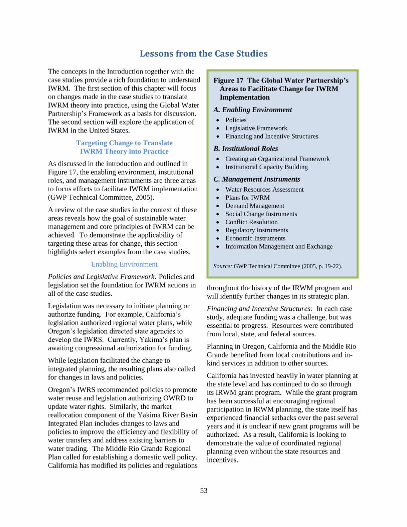
53
Lessons from the Case Studies
The concepts in the Introduction together with the
case studies provide a rich foundation to understand
IWRM. The first section of this chapter will focus
on changes made in the case studies to translate
IWRM theory into practice, using the Global Water
Partnership’s Framework as a basis for discussion.
The second section will explore the application of
IWRM in the United States.
Targeting Change to Translate
IWRM Theory into Practice
As discussed in the introduction and outlined in
Figure 17, the enabling environment, institutional
roles, and management instruments are three areas
to focus efforts to facilitate IWRM implementation
(GWP Technical Committee, 2005).
A review of the case studies in the context of these
areas reveals how the goal of sustainable water
management and core principles of IWRM can be
achieved. To demonstrate the applicability of
targeting these areas for change, this section
highlights select examples from the case studies.
Enabling Environment
Policies and Legislative Framework: Policies and
legislation set the foundation for IWRM actions in
all of the case studies.
Legislation was necessary to initiate planning or
authorize funding. For example, California’s
legislation authorized regional water plans, while
Oregon’s legislation directed state agencies to
develop the IWRS. Currently, Yakima’s plan is
awaiting congressional authorization for funding.
While legislation facilitated the change to
integrated planning, the resulting plans also called
for changes in laws and policies.
Oregon’s IWRS recommended policies to promote
water reuse and legislation authorizing OWRD to
update water rights. Similarly, the market
reallocation component of the Yakima River Basin
Integrated Plan includes changes to laws and
policies to improve the efficiency and flexibility of
water transfers and address existing barriers to
water trading. The Middle Rio Grande Regional
Plan called for establishing a domestic well policy.
California has modified its policies and regulations
throughout the history of the IRWM program and
will identify further changes in its strategic plan.
Financing and Incentive Structures: In each case
study, adequate funding was a challenge, but was
essential to progress. Resources were contributed
from local, state, and federal sources.
Planning in Oregon, California and the Middle Rio
Grande benefited from local contributions and in-
kind services in addition to other sources.
California has invested heavily in water planning at
the state level and has continued to do so through
its IRWM grant program. While the grant program
has been successful at encouraging regional
participation in IRWM planning, the state itself has
experienced financial setbacks over the past several
years and it is unclear if new grant programs will be
authorized. As a result, California is looking to
demonstrate the value of coordinated regional
planning even without the state resources and
incentives.
Figure 17 The Global Water Partnership’s
Areas to Facilitate Change for IWRM
Implementation
A. Enabling Environment
Policies
Legislative Framework
Financing and Incentive Structures
B. Institutional Roles
Creating an Organizational Framework
Institutional Capacity Building
C. Management Instruments
Water Resources Assessment
Plans for IWRM
Demand Management
Social Change Instruments
Conflict Resolution
Regulatory Instruments
Economic Instruments
Information Management and Exchange
Source: GWP Technical Committee (2005, p. 19-22).
54
Similarly, while Oregon’s IWRS was developed
with a small budget, successful implementation of
the strategy will require more resources. The
IWRS outlines a number of actions to target
funding resources. For example, the IWRS
recommends funding “communities needing
feasibility studies for water conservation, storage,
and reuse projects.”
The federal government was also a source of
funding, partnering with states in the Yakima,
DRBC, and Minnesota case studies. Funding to
implement the Yakima River Plan; however, is now
awaiting congressional authorization, while the
DRBC and Minnesota River Basin have
experienced inconsistent federal funding. Thus,
federal funding resources may be a challenge for
IWRM implementation in the future.
For all of the case studies, the success of IWRM
implementation efforts in the future will rely on
finding funding. Implementing IWRM, therefore,
will require funding from a variety of sources
possibly including private, non-profit, local, state
and federal.
An IWRM approach often requires significant data,
technical, and modeling tools in order to identify
the complex interactions between and within
physical, biological, and human systems. As
shown by the case studies, the more comprehensive
and in-depth the analysis and the greater the
number of issues addressed, the greater the cost.
Therefore, funding and information are integrally
tied together. Increasing data efficiencies will be
important to conserve limited funding resources.
Institutional Roles
Creating an Organizational Framework: The case
studies also highlighted some of the organizational
structures formed to facilitate IWRM.
Two case studies show structures wherein the
organization is responsible for holistic management
of the resource. The Delaware River Basin
Compact established the organizational structure of
the DRBC to have broad enforcement authority
between member states and the federal government.
Similarly, the state of Florida requires the St. Johns
River Water Management District to oversee water
supply, water quality, flood control, and natural
systems protection and restoration.
Other case studies highlighted the creation of
groups to support greater coordination. The
Minnesota River Basin study included local, state,
federal and tribal governments, whereas planning
activities in the Yakima River Basin and Oregon
included these as well as irrigated agriculture and
other stakeholder groups.
In contrast, the Middle Rio Grande planning
structure paired an organization representing local
governments with a nonprofit representing diverse
stakeholder interests.
California’s IRWM planning regions have
developed different organizational structures and it
is likely that much will be learned when the state
analyzes the IRWM program.
Despite the differences in structure, it is clear that
IWRM planning cannot be undertaken by one entity
alone.
Institutional Capacity Building: All of the case
studies attempted to develop greater institutional
capacity by increasing the knowledge of the public,
stakeholders, or water professionals. Several of the
case studies focused on providing tools to help
organizations and water professionals develop
greater capacity to manage the resource.
California’s program, for example, centered around
facilitating institutional capacity for regional
planning through its IRWMP program guidelines,
planning grants, dedication of state staff to working
with regional RWMGs, development of data
protocols and a climate change guidebook, and
other efforts to support regional planning.
Oregon’s IWRS recommendation for place-based
planning is likely to take a similar approach with
the state in a supporting role.
Similarly, the Minnesota River Basin, St. Johns
River Basin and Middle Rio Grande Basin case
studies involved development of tools to help water
managers and the public understand the
interconnectedness of the system and challenges
faced in balancing needs for sustainable water
management.
Management Instruments
Water Resources Assessment: Determining water
availability and needs is the foundation for any
planning effort.
55
The assessment of groundwater supplies in the
Middle Rio Grande and St. Johns River shows the
importance of investing in understanding water
resources so that consumption does not exceed
supply. The water assessments were a turning point
in both of these regions towards holistic
management of the resource.
As shown in the St. Johns River, Middle Rio
Grande, Yakima, and Minnesota case studies,
assessments can become quite complex and costly
depending on the detail of the analysis.
Understanding ecosystem needs in particular has
been a challenge for all regions and the St. Johns
River underscores the vast array of factors involved
in modeling ecosystems.
Finally, Oregon’s first three Recommended Actions
in the IWRS (see Figure 3 on page 12) point
towards the need for water resources assessments to
enhance future planning and management efforts.
Plans for IWRM: Planning is essential to
implementing IWRM. While the Oregon,
California, Middle Rio Grande, DRBC and Yakima
case studies all highlight plans, the Minnesota and
St. Johns River studies highlight actions to inform
future planning.
The IWRM approach resulted in plans that included
a suite of actions from traditional infrastructure
projects to conservation, efficiency and watershed
protection programs. The comprehensive nature of
the plans required complex modeling in order to
identify the combination of outcomes that would
achieve desired goals. Overall, plan development
involved diverse interests and incorporated
different aspects of the resource (e.g., water quality,
groundwater).
Demand Management: A primary tool was to
reduce water demand to minimize the need for new
water supply development.
At minimum, conservation or efficiency programs
were identified as demand reduction strategies.
Some case studies, such as the Middle Rio Grande,
also included other demand management tactics
such as incentives, economic tools, educational
programs, conversion to low flow appliances, and
water metering (see Figure 13 on page 40).
Social Change Instruments: To the extent that the
public was incorporated into the process and
information was more accessible, all of the case
studies could be considered to include a social
change element; however, targeted social change
instruments were less common.
Oregon and the Middle Rio Grande recommended
educational programs in schools and educating the
public on water issues. Oregon also included
training and education for future water
professionals as part of its recommended actions.
The Global Water Partnership (2005) has identified
these three components as factors that contribute to
social change.
Conflict Resolution: As noted in several of the case
studies, IWRM has emerged as a means to prevent
or reduce conflict both within and between regions.
The St. Johns River WSIS was developed to assist
with the fair distribution of water between local
water agencies and facilitated coordination between
the SJRWMD and other districts. Similarly, the
DRBC has been successful in preventing interstate
conflicts over water quality and other water issues
due to the coordination and broad policy-making
authority of its members.
The state of Oregon emphasized conflict resolution
as a guiding principle for the IWRS, while New
Mexico (Middle Rio Grande) required regional
plans to state how the plan might conflict with other
regions. A major priority in the Middle Rio Grande
case was obtaining regional collaboration to ensure
that flow obligations in the Rio Grande Compact
were met to prevent conflict.
Similarly, the California IRWM program requires
plans to discuss conflicts and gives preference to
projects that resolve conflicts. Some of the IRWM
planning regions experienced collaboration
between entities that had previously been at odds
over water issues.
Finally, the multi-objective Yakima Integrated Plan
was a step towards resolving the ongoing conflict in
the region between instream flow proponents and
consumptive water users.
In sum, IWRM is facilitating collaborative,
coordinated, multi-objective planning that satisfies
a diverse set of interests. This leads to reduced
conflicts and tensions.
56
Regulatory Instruments: “Reach environmental
outcomes with non- regulatory alternatives” is one
of Oregon’s recommended actions and reflects the
approach utilized in many of the case studies.
Although regulatory instruments were included,
water supply development, water demand
management, and voluntary programs dominated.
Examples of regulatory instruments include the
DRBC’s implementation of water quality and
groundwater protection programs, the Middle Rio
Grande’s proposed domestic well controls, and
Oregon’s recommendation for implementing ballast
water management regulations to prevent invasive
species.
In addition, the Minnesota River Basin is seeking to
understand agricultural drainage to inform the
design of regulations in the future. The St. Johns
River WSIS will be a tool for use in the future to
set minimum flow levels and make decisions in
regulating potential water withdrawals.
Economic Instruments: Economic tools were
highlighted in the California, Middle Rio Grande,
Yakima, and Oregon case studies.
In California, water pricing and grants were a water
management strategy to encourage resource
stewardship. Similarly, in the Middle Rio Grande,
a utility implemented a conservation rate structure
to encourage water use efficiency, whereas the
Yakima Integrated Plan proposed improvements to
its water-banking program. Oregon’s IWRS
recommended developing protocols to translate
streamflow restoration into credits and create
accounting strategies.
Information Management and Exchange: All of the
case studies underscore the need for data and
modeling tools in order to make scientifically
informed management decisions that take into
account economic, social, and ecological factors.
The greater the complexity in considering
ecosystems, physical systems, and human interests,
the greater the need for tools that can help to
understand the outcomes of a combination of
factors and actions.
The St. Johns River WSIS case study details the
magnitude of the task of determining the effects of
water withdrawals on ecological systems.
However, the WSIS resulted in development of a
tool that could help identify the tradeoffs between
the benefits of water withdrawal and the benefits
(or harm) to the ecosystem. The Minnesota River
Basin hopes to develop a similar tool that will assist
professionals in making informed management
decisions. The DRBC, Yakima River Basin,
Minnesota and Middle Rio Grande also enlisted the
help of models to understand the complex
interactions.
Regardless of whether it is possible to model all of
the interactions of the systems, an adaptive
management approach is necessary in order to
move forward while also taking into account new
information as it arises. This is particularly
important since complexity and uncertainty have a
tendency to create paralysis and stall progress.
IWRM as a goal-driven process is helpful to ensure
that water is managed sustainably even in the face
of extreme complexity.
While the data and information tools are important
for effective decision-making, they can also be a
practical means to create public support and
facilitate public participation in planning. As
shown in the Middle Rio Grande case study, a
water budget tool was provided to the public to help
them understand the need for action and the
difficult choices to be made in reducing water use.
Similarly, after development of a model of
scenarios, the public had the opportunity to see how
changes in different management actions affected
the overall water budget.
Therefore, opportunities exist to not only increase
the knowledge and understanding of decision-
makers but to also actively engage the public in the
decision-making process.
It is apparent that no one entity has all of the
information needed to manage water effectively,
nor, does any one entity have the resources to do
so. As noted in the California and Oregon case
studies, in order to achieve integration, better
means of collecting and sharing information is
necessary.
California has worked to develop protocols and
create an information storage system as a method of
streamlining data for compatibility and sharing it
with others to prevent duplication and increase
coordination.
Oregon’s IWRS included a number of
recommendations regarding information and data.

57
For example, one recommendation was to establish
and maintain an on‐line water‐use efficiency and
conservation clearinghouse.
Thus, it is apparent from the case studies that
implementation of IWRM also requires integrated
data management.
Targeting Change for IWRM
The case studies demonstrate how regions in the
United States have taken action to shift towards
more sustainable management. As shown by the
above examples, there are many areas that can be
targeted for change to move towards more
sustainable water management using an IWRM
approach.
Regions seeking to implement IWRM should
understand the key principles behind integrated
water resources management outlined in the next
section and then assess how actions in these key
areas can advance their goals.
Application of IWRM in the United States
Revisiting the Definition and Goals of IWRM
As outlined in the Introduction, the goal of an
IWRM approach is to holistically manage water for
economic, social and ecological purposes using an
iterative process that engages the public and
stakeholders, and increases governmental
coordination.
These seven case studies demonstrate how concepts
from IWRM are being incorporated into water
management across the United States.
Holistic Management: An analysis of the case
studies reveals that each emphasized the
importance of a holistic and integrated approach to
water management.
All of the case studies addressed water quality and
water quantity and the need to balance consumptive
use with environmental needs. Groundwater was
also considered, either due to declines in the
resource or the potential to store water in aquifers
as a water management tool.
All case studies recognized that upstream and
downstream resources are connected, particularly in
the context of water quantity and water quality.
When management jurisdiction spanned from the
headwaters to the ocean, coastal waters were
addressed, mostly in regards to water quality and
sea level change.
Land use management was also incorporated;
however, there was variability in the level of
integration with water management.
Economic, Social and Ecological Purposes: The
case studies demonstrate that integration requires
balancing ecosystem and economic needs to
accommodate different interests, resulting in a
diverse set of management approaches. Addressing
social equity is also important and the California
IRWM program provided a good example of efforts
to involve all communities in water management.
Balancing social equity, ecosystem needs and
economic purposes added complexity and required
additional data, information, and tools in order to
make informed management decisions.
Iterative Process: IWRM requires a goal-driven,
process-oriented, and iterative approach that
involves adaptive management. The case studies
show the value of being grounded by goals and an
established process to provide a focused framework
for moving forward in the face of complexity,
uncertainty and changing conditions.
Most of the plans and studies discussed are in the
initial stages of the iterative IWRM process spiral
outlined in the Introduction. The fourth phase –
involving implementing, monitoring and evaluating
– will merit further attention in the future.
Public and Stakeholder Engagement: The series of
case studies show that participation from all water
use sectors and the public is just as important as the
role of water professionals and governmental
agencies. In several case studies, organizations
went beyond soliciting public input by creating a
formal role for the public in the planning process.
In all of the instances where diverse stakeholders
and the public were a part of the process, plans and
studies not only considered a broad array of
interests and management options, but also had
broad-based support. As shown in the Yakima
River Basin, development of an inclusive and
holistic plan can result in advances that had not
been possible in the past under more narrowly
focused planning efforts.
58
Governmental Coordination: The case studies
demonstrate the importance of acting at the
appropriate level of governance to maximize
limited resources to facilitate better water
management and decision-making.
For example, in several of the case studies the
federal government provided technical assistance
and support, while states established the framework
for integrated management and attempted to
identify means to make planning and
implementation more efficient and cost effective.
In general, regions acted to solicit involvement
from diverse interests and facilitated local
participation in water planning. They were also
able to pool resources and coordinate across local
agencies to respond to local water resources needs
and management challenges.
Lessons in IWRM: Overarching Themes
Four key themes emerged from the case studies
examined on their approach to IWRM: commitment
to sustainability, adaptive management,
collaboration and information, and funding.
Commitment to Sustainability: Dedication to
sustainability is key for IWRM. Sustainability
embeds water management with the concept of
balancing economic, environmental, and social
equity needs for current and future generations.
Sustainability requires holistic management of the
entire resource in the context of a watershed or
basin.
Adaptive Management: Practicing adaptive
management is essential to facilitate progress
towards goals in the face of complexity and finite
resources.
Collaboration and Information: Coordination is
required for integration. The amount of
information needed to make decisions that consider
all interests can be costly. The greatest obstacle to
IWRM planning and implementation in the case
studies was a lack of resources, information, data,
and decision-support tools. More collaboration on
modeling tools and data sharing protocols could
allow for resource optimization.
Funding: To be successful, a concerted effort must
be made to identify funding resources as well as
potential partnerships and efficiencies.
Opportunities exist to make significant use of in-
kind services and volunteers. Incorporating the
public, stakeholders, and universities can leverage
limited resources. In addition, it encourages buy-in
and results in a plan that reflects the priorities of the
community.
The wisdom of IWRM is in the focus on the goals
and process to move towards integration and
sustainability with continued adaptation in an
iterative cycle. Therefore, an IWRM approach is as
much about the method as it is about the outcome.
Within this context, all regions in the United States
have the capacity to identify feasible steps to begin
managing water by applying concepts from IWRM.
While the examples in this report demonstrate how
states, basins, and regions have incorporated
IWRM into water management, lessons from
IWRM can also inform the federal role in water
management. From the local to national level,
water management in the United States is often
fragmented and suffers from a lack of
coordination. The case studies demonstrate
the practical value of defining a vision and strategy
that is implemented within the framework of
concepts from IWRM. In its integrated planning
efforts, the federal government can take the first
step by developing a vision and strategy for more
effective, coordinated management across sectors
and levels of government.
Building upon a Foundation of
Integrated Water Resources Management
As outlined in its position statements (AWRA,
2011, 2011a), regions across the United States are
experiencing challenges to coordinate and manage
water resources sustainably while addressing aging
infrastructure, climate change and population
growth.
These challenges are growing exponentially and
will require new and creative approaches to
overcome them.
59
To meet these challenges, AWRA’s next step is to
build upon the IWRM approach in the creation of a
national water vision and strategy.
AWRA recommends that national water
management goals, policies, programs, and plans be
organized around the concept of IWRM – the
coordinated planning, development, protection, and
management of water, land and related resources in
a manner that fosters sustainable economic activity,
improves or sustains environmental quality, ensures
public health and safety, and provides for the
sustainability of communities and ecosystems.
In the future, AWRA will continue to help refine
IWRM concepts and support IWRM as a critical
element in shaping a national water vision and
strategy.
_________________
References
American Water Resources Association. (2011,
January 21). AWRA Position Statement: Call for
a National Water Vision and Strategy.
http://www.awra.org/policy/policy-statements--
water-vision.html.
American Water Resources Association. (2011a,
January 21). AWRA Position Statement:
Integrated Water Resources Management in the
US. http://www.awra.org/policy/policy-
statements-IWRM.html.
Global Water Partnership Technical Committee.
(2005). Catalyzing Change: A Handbook for
Developing Integrated Water Resources
Management (IWRM) ) and Water Efficiency
Strategies. http://www.unwater.org/downloads/
Catalyzing_change-final.pdf.

60
Report Endorsers