Embed Size (px)
Citation preview
ASX Release
www.kaliumlakes.com.au / www.bciminerals.com.au Page 1 of 16
Monday 25 June 2018
Carnegie - Successful Palaeochannel Drilling and Evaporation Tests
Highlights
• Palaeochannel definition drilling completed at Carnegie Potash Project – potassium concentrations up to 3,820 mg/L, equivalent to a SOP grade of 8,513 mg/L.
• Drilling results will permit estimation of a Maiden Resource and Exploration Target, which is now underway.
• Higher than anticipated initial drainable porosity (specific yield) estimates on the the top 2m of the lake sediments.
• Evaporation test work has confirmed brine concentration curves suitable to produce potassium salts.
• Scoping study is in its final stages and due for completion in the coming weeks. Kalium Lakes Limited (KLL) and BCI Minerals Limited (BCI), the owners of the Carnegie Potash Project (CPP) via the Carnegie Joint Venture (CJV), are pleased to provide an update on the Scoping Study which is scheduled for completion shortly. BCI Minerals’ Managing Director, Alwyn Vorster, commented: “The Carnegie Potash Project provides another building block in the development of BCI’s industrial minerals business and has many synergies with our Mardie Project. “Exploration results to date are encouraging and we look forward to releasing the Scoping Study details in the coming weeks,” he said. Brett Hazelden, Managing Director of Kalium, said: “The Carnegie Joint Venture fits neatly into Kalium Lakes’ future development and expansion plans after the initial development of the Beyondie SOP Project. “This expansion potential will allow us to leverage the experience gained in developing the Beyondie SOP Project and to grow with the market, to become a top tier global SOP producer.” Aircore Drilling to Identify Palaeochannel and Potassium Grades The initial aircore drilling program, targeting the basal palaeochannel aquifers at Lake Carnegie, has been completed. Four exploration drill holes were completed at locations selected following interpretation of gravity data acquired earlier this year (ASX announcement: Carnegie Potash Project Prospectivity Confirmed, 11 January 2018). A truck mounted aircore rig was used to drill and sample the sediments and brine and also install monitoring bores.
www.kaliumlakes.com.au / www.bciminerals.com.au Page 2 of 16
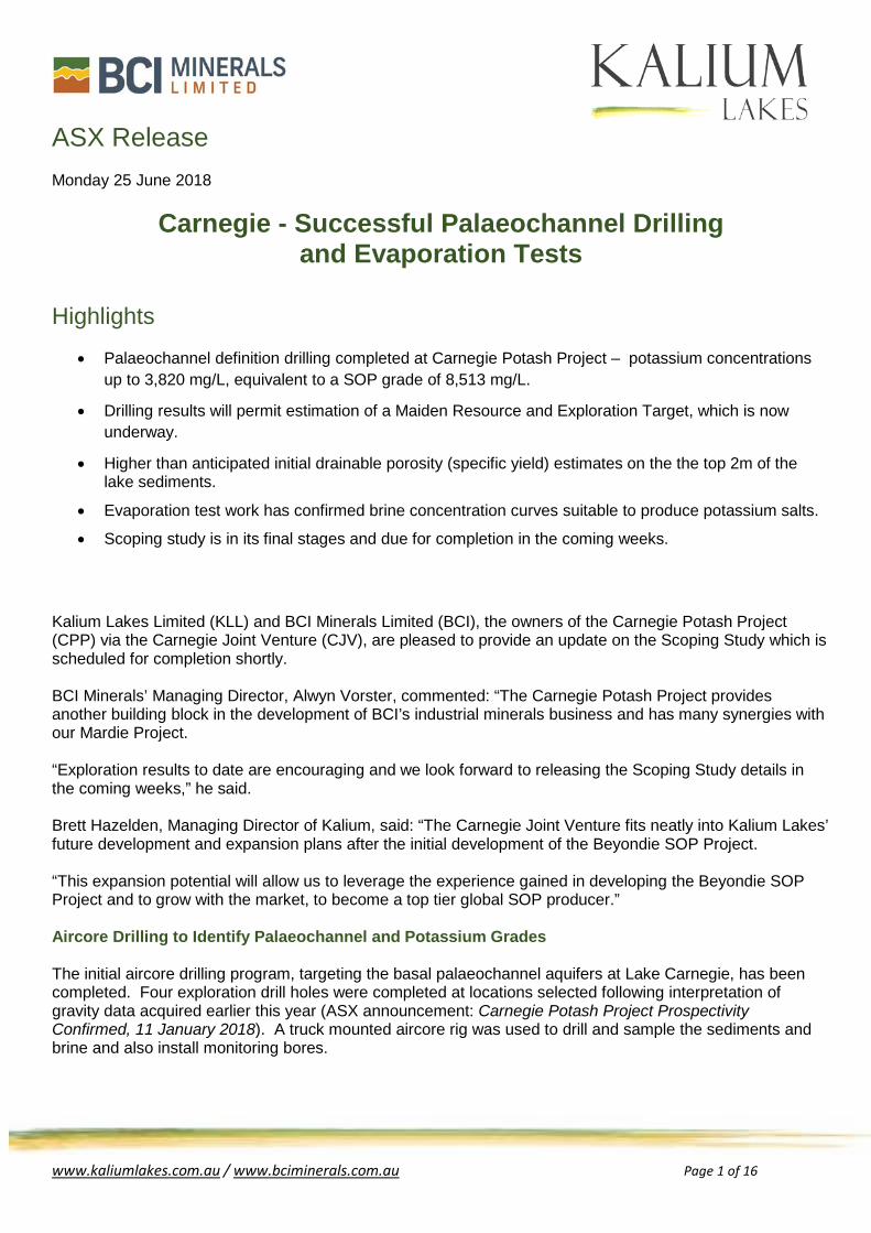
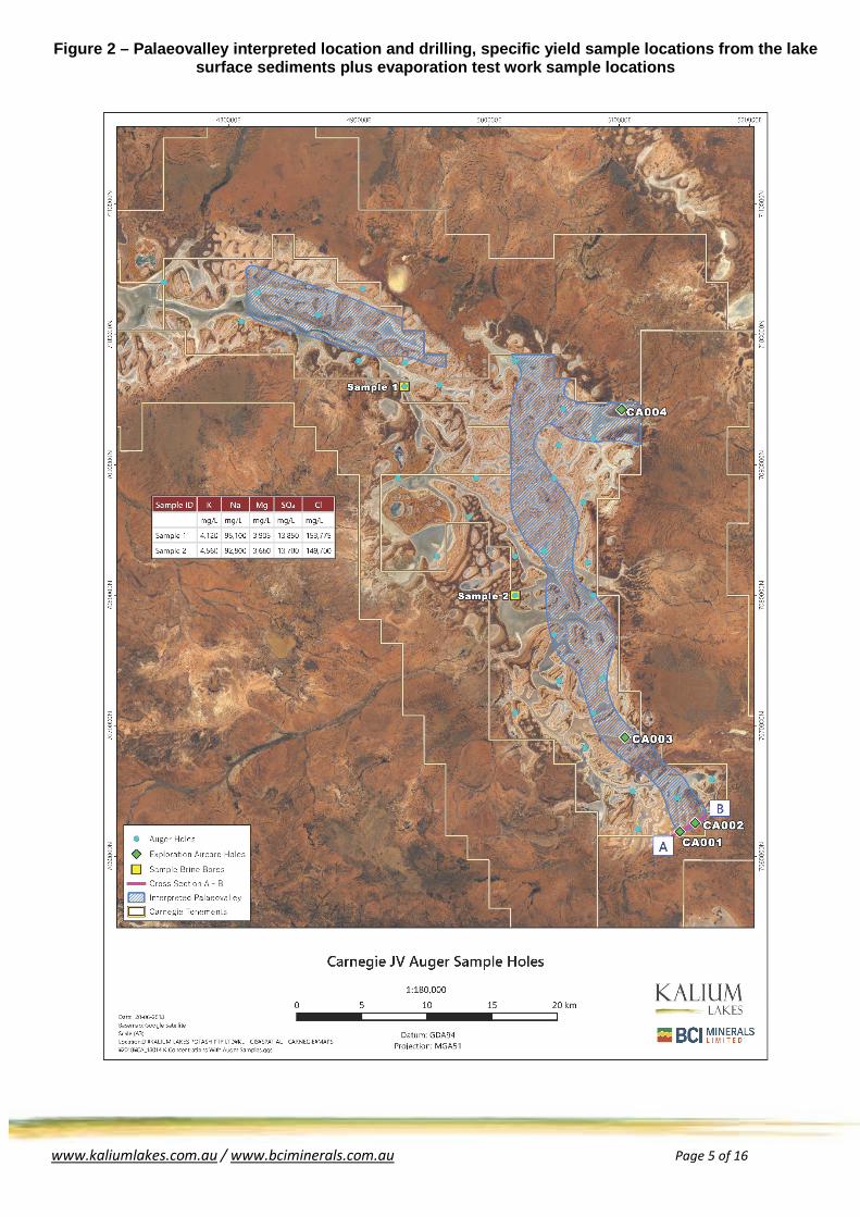
The drill holes encountered a palaeovalley sequence of a similar nature to regional examples, comprising an upper alluvial aquifer and a deep palaeochannel sand and gravel aquifer, separated by an intervening lacustrine clay aquitard. A cross section of the geology of the southern area of Lake Carnegie is presented in Figure 1 with the drilling results summarised in Tables 1 and 2 and presented in Figure 2. The current drill program has generally confirmed the initial interpretations of the gravity survey results. Upper alluvial aquifer sequences were encountered in all four drill holes. Palaeochannel sequences, containing the more highly permeable sand and gravels which will form the target aquifer of potential future deep production bores, were encountered in three of the four drill holes. Further drilling on a number of transects is required to confirm the continuation of the deep aquifer which will form part of a future Prefeasibility Study drill program. Brine samples were obtained during the drilling from airlifts and from the monitoring bores installed. The SOP grade encountered was highest at depth within the palaeochannel sand and gravel aquifer. As expected, lower grades are present in the shallow alluvial sequence as the drill holes are on the margins of the salt lake. Brine analysis is presented in Table 3 below. Figure 1 – Geological Cross Section
Palaeovalley Extent
www.kaliumlakes.com.au / www.bciminerals.com.au Page 3 of 16
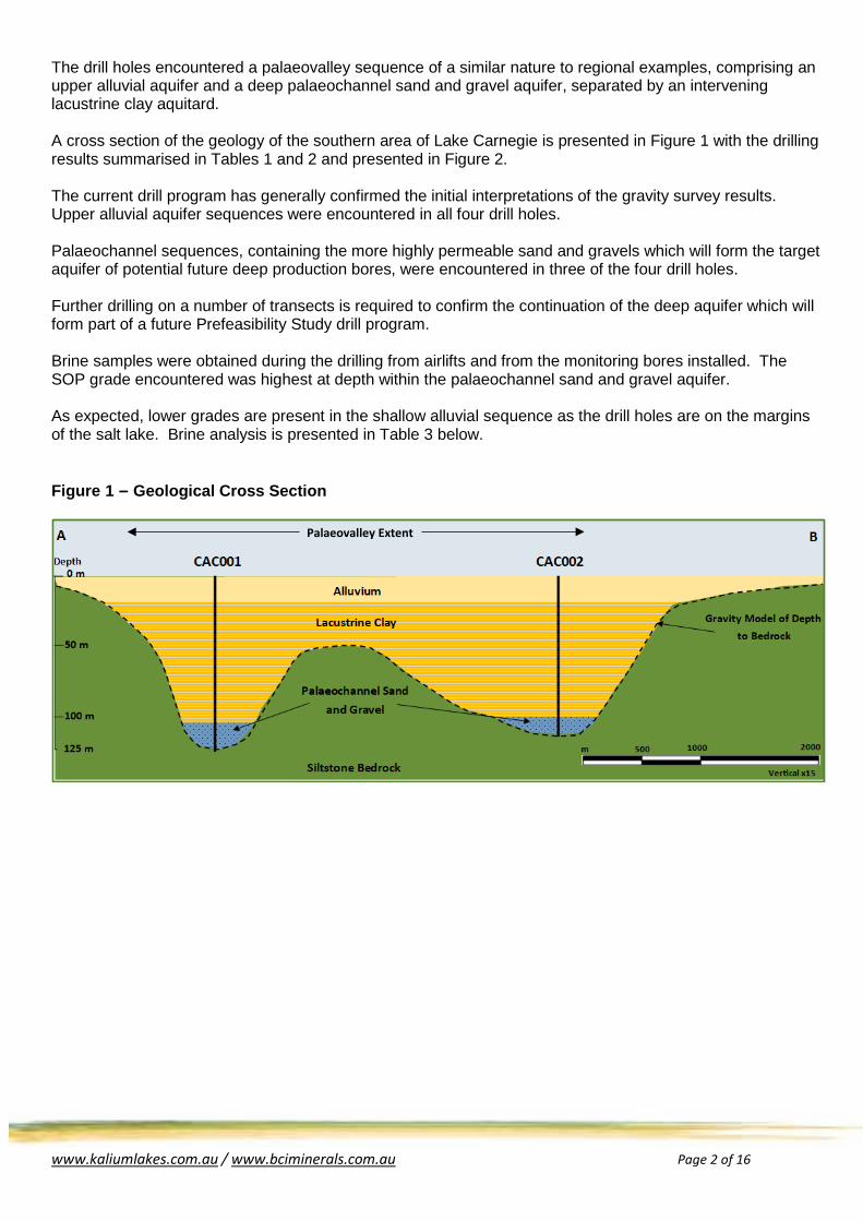
Table 1 – Aircore Drilling Lithology and Stratigraphy
ID From to Lithology Stratigraphy
CAC001
0 5 Silty Sand, Silty Clay Alluvium
5 25 Calcrete and Clay 25 84 Clay
Lacustrine clay 84 91 Silcrete and Clay 91 111 Clay 111 123 Sandy Gravel Palaeochannel sand and gravel
CAC002
0 5 Silt, Calcrete and Sand Alluvium
5 20 Sandy Clay and Calcrete 20 71 Clay with minor sandy intervals
Lacustrine clay 71 82 Clay and Silcrete 82 100 Clay 100 117 Sandy Gravel Palaeochannel sand and gravel
CAC003
0 2 Sand Alluvium
2 14 Clay, Silt and Calcrete 14 45 Clay Lacustrine clay 45 49 Silt
Weathered bedrock 49 59 Weathered Siltstone 59 63 Siltstone Bedrock
CAC004
0 8 Sandy Clay and Calcrete Alluvium
8 12 Silt and Calcrete 12 32 Clay
Lacustrine clay 32 50 Silty Clay 50 52 Gravelly Clay 52 73 Clay and Silty Clay 73 83 Sand and Gravel Palaeochannel sand and gravel 83 87 Siltstone Bedrock
Table 2 – Drill collars
Hole Number Easting* Northing* Dip (°)
Azimuth (°)
Hole Depth (m) Key Intercepts
CAC001 514639 7061885 90 0 123 12m of sand and gravel
CAC002 515819 7062553 90 0 117 17m of sand and gravel
CAC003 510430 7069111 90 0 63 Palaeochannel not encountered
CAC004 510171 7094253 90 0 87 10m of sand and gravel
*MGA Zone 51
www.kaliumlakes.com.au / www.bciminerals.com.au Page 4 of 16
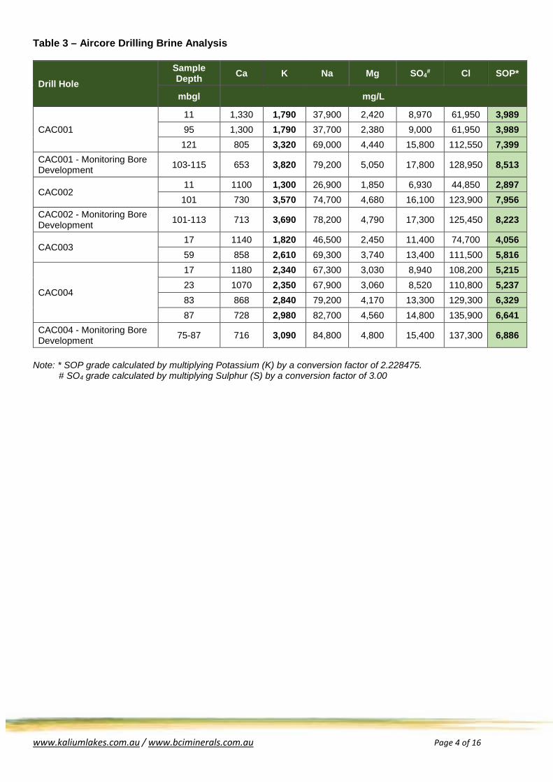
Table 3 – Aircore Drilling Brine Analysis
Drill Hole Sample Depth Ca K Na Mg SO4# Cl SOP*
mbgl mg/L
CAC001 11 1,330 1,790 37,900 2,420 8,970 61,950 3,989 95 1,300 1,790 37,700 2,380 9,000 61,950 3,989 121 805 3,320 69,000 4,440 15,800 112,550 7,399
CAC001 - Monitoring Bore Development 103-115 653 3,820 79,200 5,050 17,800 128,950 8,513
CAC002 11 1100 1,300 26,900 1,850 6,930 44,850 2,897 101 730 3,570 74,700 4,680 16,100 123,900 7,956
CAC002 - Monitoring Bore Development 101-113 713 3,690 78,200 4,790 17,300 125,450 8,223
CAC003 17 1140 1,820 46,500 2,450 11,400 74,700 4,056 59 858 2,610 69,300 3,740 13,400 111,500 5,816
CAC004
17 1180 2,340 67,300 3,030 8,940 108,200 5,215 23 1070 2,350 67,900 3,060 8,520 110,800 5,237 83 868 2,840 79,200 4,170 13,300 129,300 6,329 87 728 2,980 82,700 4,560 14,800 135,900 6,641
CAC004 - Monitoring Bore Development 75-87 716 3,090 84,800 4,800 15,400 137,300 6,886
Note: * SOP grade calculated by multiplying Potassium (K) by a conversion factor of 2.228475. # SO4 grade calculated by multiplying Sulphur (S) by a conversion factor of 3.00
www.kaliumlakes.com.au / www.bciminerals.com.au Page 5 of 16
Figure 2 – Palaeovalley interpreted location and drilling, specific yield sample locations from the lake surface sediments plus evaporation test work sample locations
www.kaliumlakes.com.au / www.bciminerals.com.au Page 6 of 16
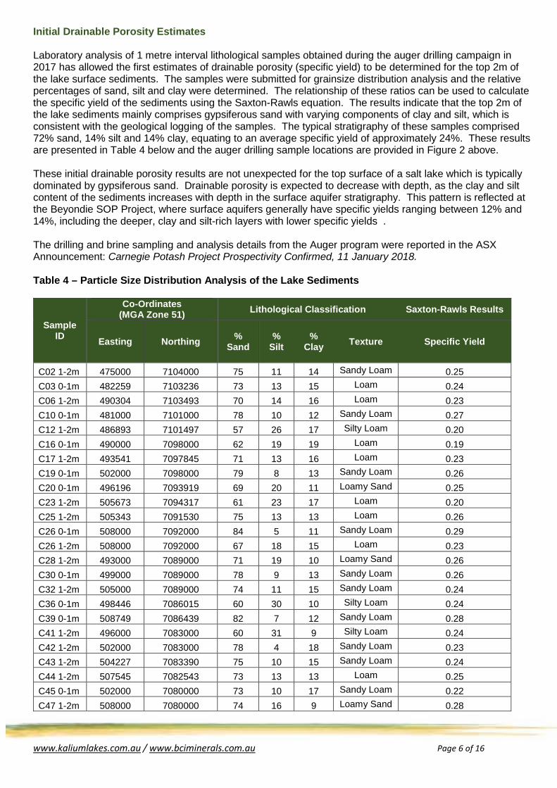
Initial Drainable Porosity Estimates Laboratory analysis of 1 metre interval lithological samples obtained during the auger drilling campaign in 2017 has allowed the first estimates of drainable porosity (specific yield) to be determined for the top 2m of the lake surface sediments. The samples were submitted for grainsize distribution analysis and the relative percentages of sand, silt and clay were determined. The relationship of these ratios can be used to calculate the specific yield of the sediments using the Saxton-Rawls equation. The results indicate that the top 2m of the lake sediments mainly comprises gypsiferous sand with varying components of clay and silt, which is consistent with the geological logging of the samples. The typical stratigraphy of these samples comprised 72% sand, 14% silt and 14% clay, equating to an average specific yield of approximately 24%. These results are presented in Table 4 below and the auger drilling sample locations are provided in Figure 2 above. These initial drainable porosity results are not unexpected for the top surface of a salt lake which is typically dominated by gypsiferous sand. Drainable porosity is expected to decrease with depth, as the clay and silt content of the sediments increases with depth in the surface aquifer stratigraphy. This pattern is reflected at the Beyondie SOP Project, where surface aquifers generally have specific yields ranging between 12% and 14%, including the deeper, clay and silt-rich layers with lower specific yields . The drilling and brine sampling and analysis details from the Auger program were reported in the ASX Announcement: Carnegie Potash Project Prospectivity Confirmed, 11 January 2018. Table 4 – Particle Size Distribution Analysis of the Lake Sediments
Sample ID
Co-Ordinates (MGA Zone 51) Lithological Classification Saxton-Rawls Results
Easting Northing % Sand
% Silt
% Clay Texture Specific Yield
C02 1-2m 475000 7104000 75 11 14 Sandy Loam 0.25 C03 0-1m 482259 7103236 73 13 15 Loam 0.24 C06 1-2m 490304 7103493 70 14 16 Loam 0.23 C10 0-1m 481000 7101000 78 10 12 Sandy Loam 0.27 C12 1-2m 486893 7101497 57 26 17 Silty Loam 0.20 C16 0-1m 490000 7098000 62 19 19 Loam 0.19 C17 1-2m 493541 7097845 71 13 16 Loam 0.23 C19 0-1m 502000 7098000 79 8 13 Sandy Loam 0.26 C20 0-1m 496196 7093919 69 20 11 Loamy Sand 0.25 C23 1-2m 505673 7094317 61 23 17 Loam 0.20 C25 1-2m 505343 7091530 75 13 13 Loam 0.26 C26 0-1m 508000 7092000 84 5 11 Sandy Loam 0.29 C26 1-2m 508000 7092000 67 18 15 Loam 0.23 C28 1-2m 493000 7089000 71 19 10 Loamy Sand 0.26 C30 0-1m 499000 7089000 78 9 13 Sandy Loam 0.26 C32 1-2m 505000 7089000 74 11 15 Sandy Loam 0.24 C36 0-1m 498446 7086015 60 30 10 Silty Loam 0.24 C39 0-1m 508749 7086439 82 7 12 Sandy Loam 0.28 C41 1-2m 496000 7083000 60 31 9 Silty Loam 0.24 C42 1-2m 502000 7083000 78 4 18 Sandy Loam 0.23 C43 1-2m 504227 7083390 75 10 15 Sandy Loam 0.24 C44 1-2m 507545 7082543 73 13 13 Loam 0.25 C45 0-1m 502000 7080000 73 10 17 Sandy Loam 0.22 C47 1-2m 508000 7080000 74 16 9 Loamy Sand 0.28
www.kaliumlakes.com.au / www.bciminerals.com.au Page 7 of 16
Sample ID
Co-Ordinates (MGA Zone 51) Lithological Classification Saxton-Rawls Results
Easting Northing % Sand
% Silt
% Clay Texture Specific Yield
C49 1-2m 505000 7077000 79 12 9 Loamy Sand 0.30 C52 0-1m 505387 7073440 76 7 17 Sandy Loam 0.23 C52 1-2m 505387 7073440 76 9 15 Sandy Loam 0.24 C53 0-1m 508706 7073663 78 6 16 Sandy Loam 0.24 C54 0-1m 502000 7071000 75 9 16 Sandy Loam 0.23 C56 0-1m 508000 7071000 83 8 9 Loamy Sand 0.30 C59 1-2m 507368 7068308 68 16 16 Loam 0.22 C62 1-2m 511000 7065000 55 29 16 Silty Loam 0.20 C64 0-1m 517110 7065903 76 9 15 Sandy Loam 0.25 C65 0-1m 511410 7062059 59 23 18 Loam 0.19 C66 0-1m 501445 7064459 72 11 17 Loam 0.22
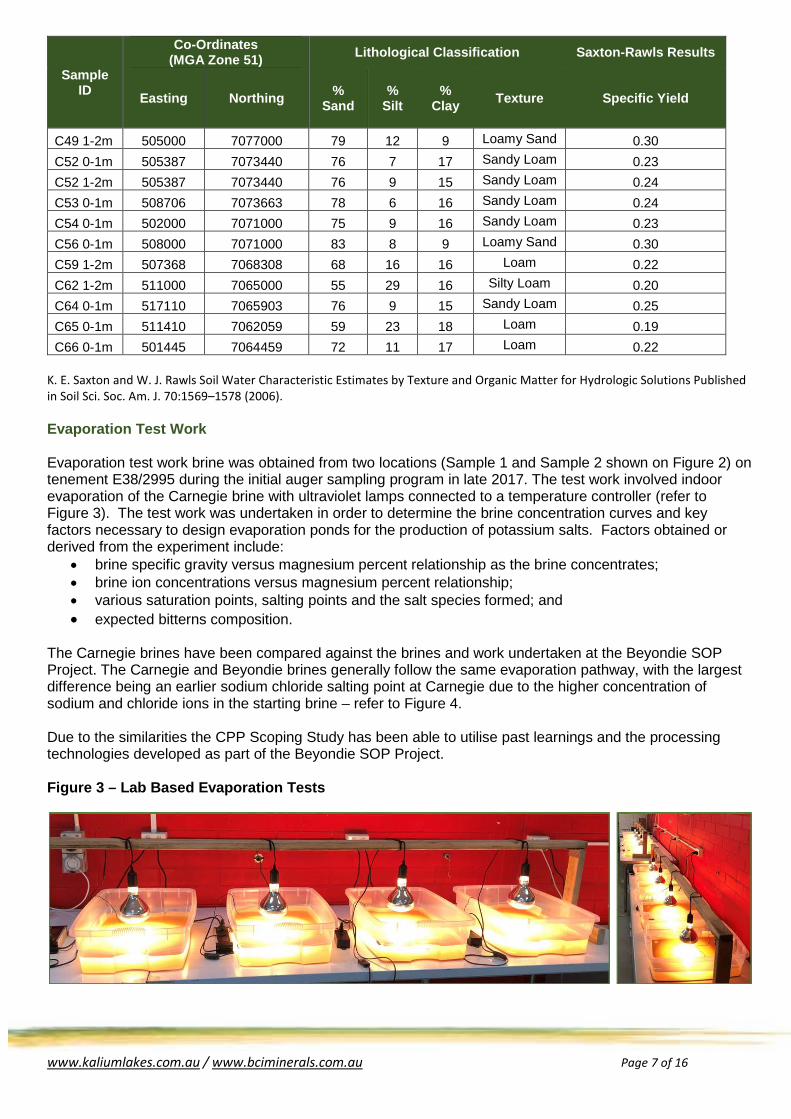
K. E. Saxton and W. J. Rawls Soil Water Characteristic Estimates by Texture and Organic Matter for Hydrologic Solutions Published in Soil Sci. Soc. Am. J. 70:1569–1578 (2006). Evaporation Test Work Evaporation test work brine was obtained from two locations (Sample 1 and Sample 2 shown on Figure 2) on tenement E38/2995 during the initial auger sampling program in late 2017. The test work involved indoor evaporation of the Carnegie brine with ultraviolet lamps connected to a temperature controller (refer to Figure 3). The test work was undertaken in order to determine the brine concentration curves and key factors necessary to design evaporation ponds for the production of potassium salts. Factors obtained or derived from the experiment include:
• brine specific gravity versus magnesium percent relationship as the brine concentrates; • brine ion concentrations versus magnesium percent relationship; • various saturation points, salting points and the salt species formed; and • expected bitterns composition.
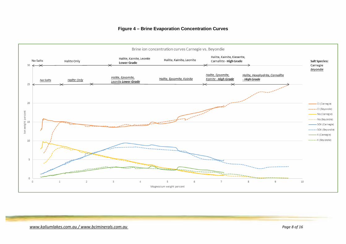
The Carnegie brines have been compared against the brines and work undertaken at the Beyondie SOP Project. The Carnegie and Beyondie brines generally follow the same evaporation pathway, with the largest difference being an earlier sodium chloride salting point at Carnegie due to the higher concentration of sodium and chloride ions in the starting brine – refer to Figure 4. Due to the similarities the CPP Scoping Study has been able to utilise past learnings and the processing technologies developed as part of the Beyondie SOP Project. Figure 3 – Lab Based Evaporation Tests
www.kaliumlakes.com.au / www.bciminerals.com.au Page 8 of 16
Figure 4 – Brine Evaporation Concentration Curves
www.kaliumlakes.com.au / www.bciminerals.com.au Page 9 of 16
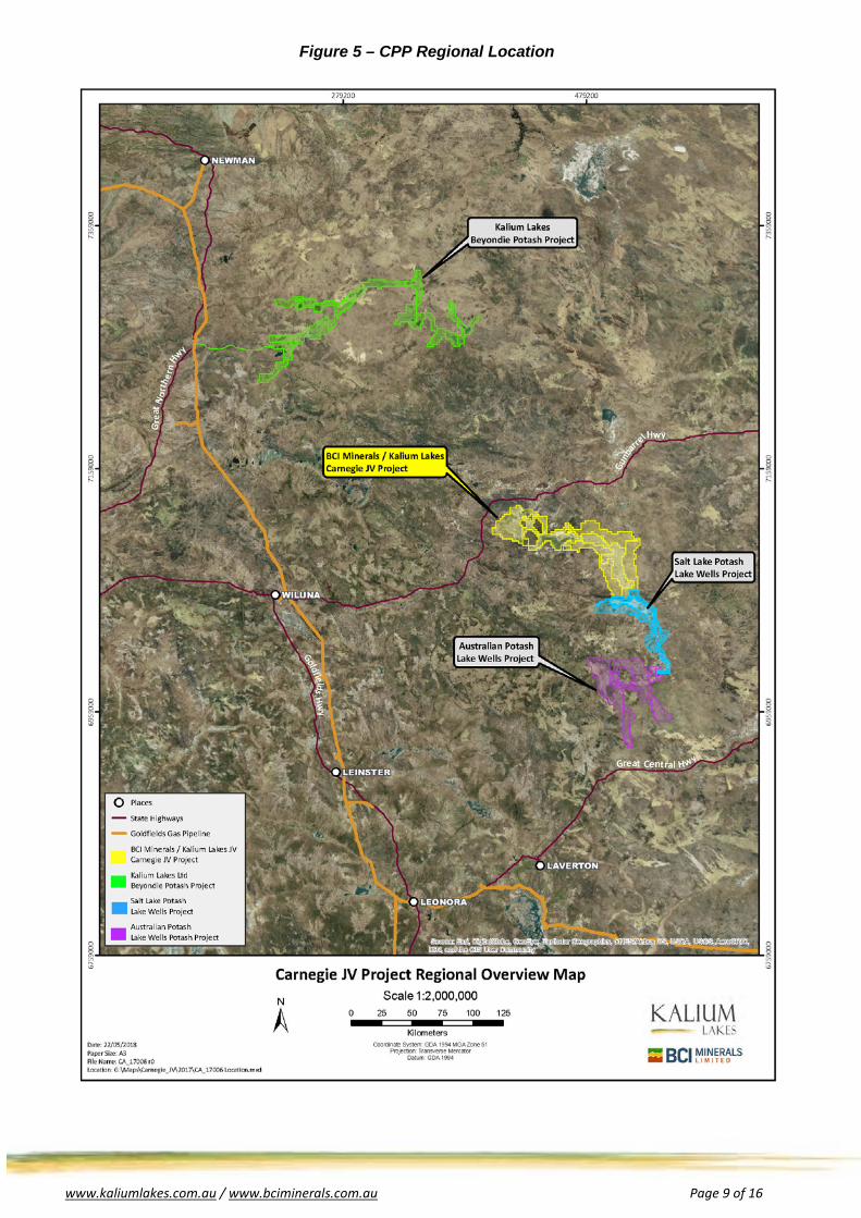
Figure 5 – CPP Regional Location
www.kaliumlakes.com.au / www.bciminerals.com.au Page 10 of 16
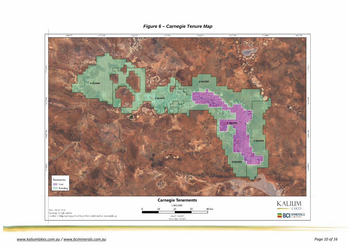
Figure 6 – Carnegie Tenure Map
www.kaliumlakes.com.au / www.bciminerals.com.au Page 11 of 16
JORC Table One Section 1 – Sampling Techniques and Data
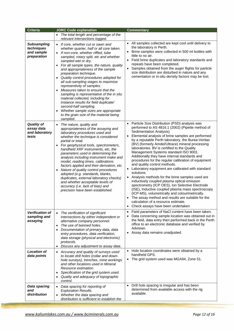
Criteria JORC Code explanation Commentary Sampling techniques
• Nature and quality of sampling (eg cut channels, random chips, or specific specialised industry standard measurement tools appropriate to the minerals under investigation, such as down hole gamma sondes, or handheld XRF instruments, etc). These examples should not be taken as limiting the broad meaning of sampling.
• Include reference to measures taken to ensure sample representivity and the appropriate calibration of any measurement tools or systems used.
• Aspects of the determination of mineralisation that are Material to the Public Report.
• In cases where ‘industry standard’ work has been done this would be relatively simple (eg ‘reverse circulation drilling was used to obtain 1 m samples from which 3 kg was pulverised to produce a 30 g charge for fire assay’). In other cases more explanation may be required, such as where there is coarse gold that has inherent sampling problems. Unusual commodities or mineralisation types (eg submarine nodules) may warrant disclosure of detailed information.
• The sampling program involved the collection of brine samples and samples of the aquifer material during drilling to define the brine and geological variation.
• Brine was obtained during drilling from the cyclone of the drill rig during airlift yields. These samples are interpreted to come from the zone above the drilling depth, although the possibility of downhole flow outside of the drill rods from shallower zones cannot be excluded.
• Brine was also obtained from airlift development of 50mm monitoring bores installed within the aircore drilled hole. These samples were obtained after approximately 1 hour of airlifting and are considered representative of the slotted zone of the monitoring bore. Notably these samples were higher grade than the samples obtained when drilling this is considered due to dilution effects from water running down the drill hole from the upper aquifer.
• Bulk lithological samples of aquifer material used for laboratory analysis were obtained from the auger flights at 1m intervals and securely bagged for transport.
• Chip tray samples were obtained from all drilling.
Drilling techniques
• Drill type (e.g. core, reverse circulation, open-hole hammer, rotary air blast, auger, Bangka, sonic, etc) and details (e.g. core diameter, triple or standard tube, depth of diamond tails, face-sampling bit or other type, whether core is oriented and if so, by what method, etc).
• Aircore drilling at 142mm diameter has been utilised for all holes in Table 2.
Drill sample recovery
• Method of recording and assessing core and chip sample recoveries and results assessed.
• Measures taken to maximise sample recovery and ensure representative nature of the samples.
• Whether a relationship exists between sample recovery and grade and whether sample bias may have occurred due to preferential loss/gain of fine/coarse material.
• Lithological samples were collected during drilling, by sampling direct from the auger flights.
• Brine samples have been collected during drilling, by sampling direct from the cyclone discharge.
• Airlifts were generally of prolonged duration to obtain representative samples, however water flowing down from the surficial aquifer during deeper airlift yields cannot be ruled out.
• Sample grade is marginally biased to the grade of brines associated with coarser material due to permeability effects.
Geologic Logging
• Whether core and chip samples have been geologically and geotechnically logged to a level of detail to support appropriate Mineral Resource estimation, mining studies and metallurgical studies.
• Whether logging is qualitative or quantitative in nature. Core (or costean, channel, etc.) photography.
• All geological samples collected during all forms of drilling are qualitatively logged by a geologist at 1 m intervals, to gain an understanding of the variability in aquifer materials hosting the brine.
• Geological logging and other hydrogeological parameter data is recorded within a database.
www.kaliumlakes.com.au / www.bciminerals.com.au Page 12 of 16
Criteria JORC Code explanation Commentary • The total length and percentage of the
relevant intersections logged. Subsampling techniques and sample preparation
• If core, whether cut or sawn and whether quarter, half or all core taken.
• If non-core, whether riffled, tube sampled, rotary split, etc and whether sampled wet or dry.
• For all sample types, the nature, quality and appropriateness of the sample preparation technique.
• Quality control procedures adopted for all sub-sampling stages to maximise representivity of samples.
• Measures taken to ensure that the sampling is representative of the in situ material collected, including for instance results for field duplicate/ second-half sampling.
• Whether sample sizes are appropriate to the grain size of the material being sampled.
• All samples collected are kept cool until delivery to the laboratory in Perth.
• Brine samples were collected in 500 ml bottles with little to no air.
• Field brine duplicates and laboratory standards and repeats have been completed.
• Samples obtained from the auger flights for particle size distribution are disturbed in nature and any cementation or in-situ density factors may be lost.
Quality of assay data and laboratory tests
• The nature, quality and appropriateness of the assaying and laboratory procedures used and whether the technique is considered partial or total.
• For geophysical tools, spectrometers, handheld XRF instruments, etc, the parameters used in determining the analysis including instrument make and model, reading times, calibrations factors applied and their derivation, etc.
• Nature of quality control procedures adopted (e.g. standards, blanks, duplicates, external laboratory checks) and whether acceptable levels of accuracy (i.e. lack of bias) and precision have been established.
• Particle Size Distribution (PSD) analysis was performed to AS 4816.1 (2002) (Pipette method of Sedimentation Analysis)
• Elemental analysis of brine samples are performed by a reputable Perth laboratory, the Burea-Veritas (BV) (formerly Amdel/Ultrace) mineral processing laboratories. BV is certified to the Quality Management Systems standard ISO 9001. Additionally they have internal standards and procedures for the regular calibration of equipment and quality control methods.
• Laboratory equipment are calibrated with standard solutions
• Analysis methods for the brine samples used are inductively coupled plasma optical emission spectrometry (ICP OES), Ion Selective Electrode (ISE), Inductive coupled plasma mass spectroscopy (ICP-MS), volumetrically and colourimetrically.
• The assay method and results are suitable for the calculation of a resource estimate.
• Check assays have been undertaken
Verification of sampling and assaying
• The verification of significant intersections by either independent or alternative company personnel.
• The use of twinned holes. • Documentation of primary data, data
entry procedures, data verification, data storage (physical and electronic) protocols.
• Discuss any adjustment to assay data.
• Field parameters of NaCl content have been taken. • Data concerning sample location was obtained out in
the field, data entry then performed back in the Perth office to an electronic database and verified by Advisian.
• Assay data remains unadjusted.
Location of data points
• Accuracy and quality of surveys used to locate drill holes (collar and down-hole surveys), trenches, mine workings and other locations used in Mineral Resource estimation.
• Specification of the grid system used. • Quality and adequacy of topographic
control.
• Hole location coordinates were obtained by a handheld GPS.
• The grid system used was MGA94, Zone 51.
Data spacing and distribution
• Data spacing for reporting of Exploration Results.
• Whether the data spacing and distribution is sufficient to establish the
• Drill hole spacing is irregular and has been determined from available access with the rig available.
www.kaliumlakes.com.au / www.bciminerals.com.au Page 13 of 16
Criteria JORC Code explanation Commentary degree of geological and grade continuity appropriate for the Mineral Resource and Ore Reserve estimation procedure(s) and classifications applied.
• Whether sample compositing has been applied.
• Further drilling and testing is required to establish Mineral Resources within the palaeochannel.
Orientation of data in relation to geological structure
• Whether the orientation of sampling achieves unbiased sampling of possible structures and the extent to which this is known, considering the deposit type.
• If the relationship between the drilling orientation and the orientation of key mineralised structures is considered to have introduced a sampling bias, this should be assessed and reported if material.
• Not applicable, considering the deposit type. • All drill holes are vertical given the flat lying structure
of a salt lake.
Sample security
• The measures taken to ensure sample security.
• Samples are labelled and transported by Advisian personnel to Perth. They are then hand delivered to BV laboratories by Advisian personnel.
Audits or reviews
The results of any audits or reviews of sampling techniques and data.
• Advisian has conducted a review of sampling techniques and data.
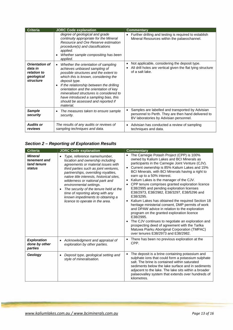
Section 2 – Reporting of Exploration Results Criteria JORC Code explanation Commentary Mineral tenement and land tenure status
• Type, reference name/number, location and ownership including agreements or material issues with third parties such as joint ventures, partnerships, overriding royalties, native title interests, historical sites, wilderness or national park and environmental settings.
• The security of the tenure held at the time of reporting along with any known impediments to obtaining a licence to operate in the area.
• The Carnegie Potash Project (CPP) is 100% owned by Kalium Lakes and BCI Minerals as participants in the Carnegie Joint Venture (CJV).
• Current ownership is 85% Kalium Lakes and 15% BCI Minerals, with BCI Minerals having a right to earn up to a 50% interest.
• Kalium Lakes is the manager of the CJV. • CPP tenure comprises granted exploration licence
E38/2995 and pending exploration licenses E38/2973, E38/2982, E38/3297, E38/5296 and E38/3295.
• Kalium Lakes has obtained the required Section 18 heritage ministerial consent, DMP permits of work and DPAW advice in relation to the exploration program on the granted exploration licence E38/2995.
• The CJV continues to negotiate an exploration and prospecting deed of agreement with the Tarlka Matuwa Piarku Aboriginal Corporation (TMPAC) over tenures E38/2973 and E38/2982.
Exploration done by other parties
• Acknowledgment and appraisal of exploration by other parties.
• There has been no previous exploration at the CPP.
Geology • Deposit type, geological setting and style of mineralisation.
• The deposit is a brine containing potassium and sulphate ions that could form a potassium sulphate salt. The brine is contained within saturated sediments below the lake surface and in sediments adjacent to the lake. The lake sits within a broader palaeovalley system that extends over hundreds of kilometres.
www.kaliumlakes.com.au / www.bciminerals.com.au Page 14 of 16
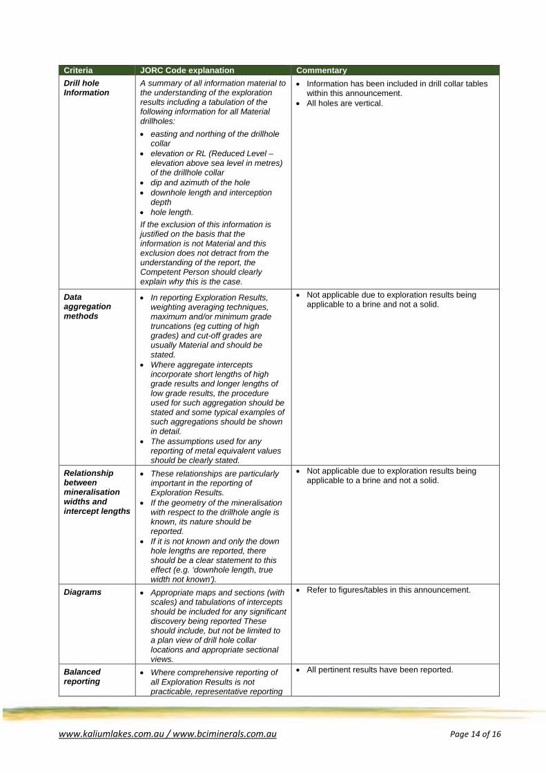
Criteria JORC Code explanation Commentary Drill hole Information
A summary of all information material to the understanding of the exploration results including a tabulation of the following information for all Material drillholes: • easting and northing of the drillhole
collar • elevation or RL (Reduced Level –
elevation above sea level in metres) of the drillhole collar
• dip and azimuth of the hole • downhole length and interception
depth • hole length. If the exclusion of this information is justified on the basis that the information is not Material and this exclusion does not detract from the understanding of the report, the Competent Person should clearly explain why this is the case.
• Information has been included in drill collar tables within this announcement.
• All holes are vertical.
Data aggregation methods
• In reporting Exploration Results, weighting averaging techniques, maximum and/or minimum grade truncations (eg cutting of high grades) and cut-off grades are usually Material and should be stated.
• Where aggregate intercepts incorporate short lengths of high grade results and longer lengths of low grade results, the procedure used for such aggregation should be stated and some typical examples of such aggregations should be shown in detail.
• The assumptions used for any reporting of metal equivalent values should be clearly stated.
• Not applicable due to exploration results being applicable to a brine and not a solid.
Relationship between mineralisation widths and intercept lengths
• These relationships are particularly important in the reporting of Exploration Results.
• If the geometry of the mineralisation with respect to the drillhole angle is known, its nature should be reported.
• If it is not known and only the down hole lengths are reported, there should be a clear statement to this effect (e.g. ‘downhole length, true width not known’).
• Not applicable due to exploration results being applicable to a brine and not a solid.
Diagrams • Appropriate maps and sections (with scales) and tabulations of intercepts should be included for any significant discovery being reported These should include, but not be limited to a plan view of drill hole collar locations and appropriate sectional views.
• Refer to figures/tables in this announcement.
Balanced reporting
• Where comprehensive reporting of all Exploration Results is not practicable, representative reporting
• All pertinent results have been reported.
www.kaliumlakes.com.au / www.bciminerals.com.au Page 15 of 16
Criteria JORC Code explanation Commentary of both low and high grades and/or widths should be practiced to avoid misleading reporting of Exploration Results.
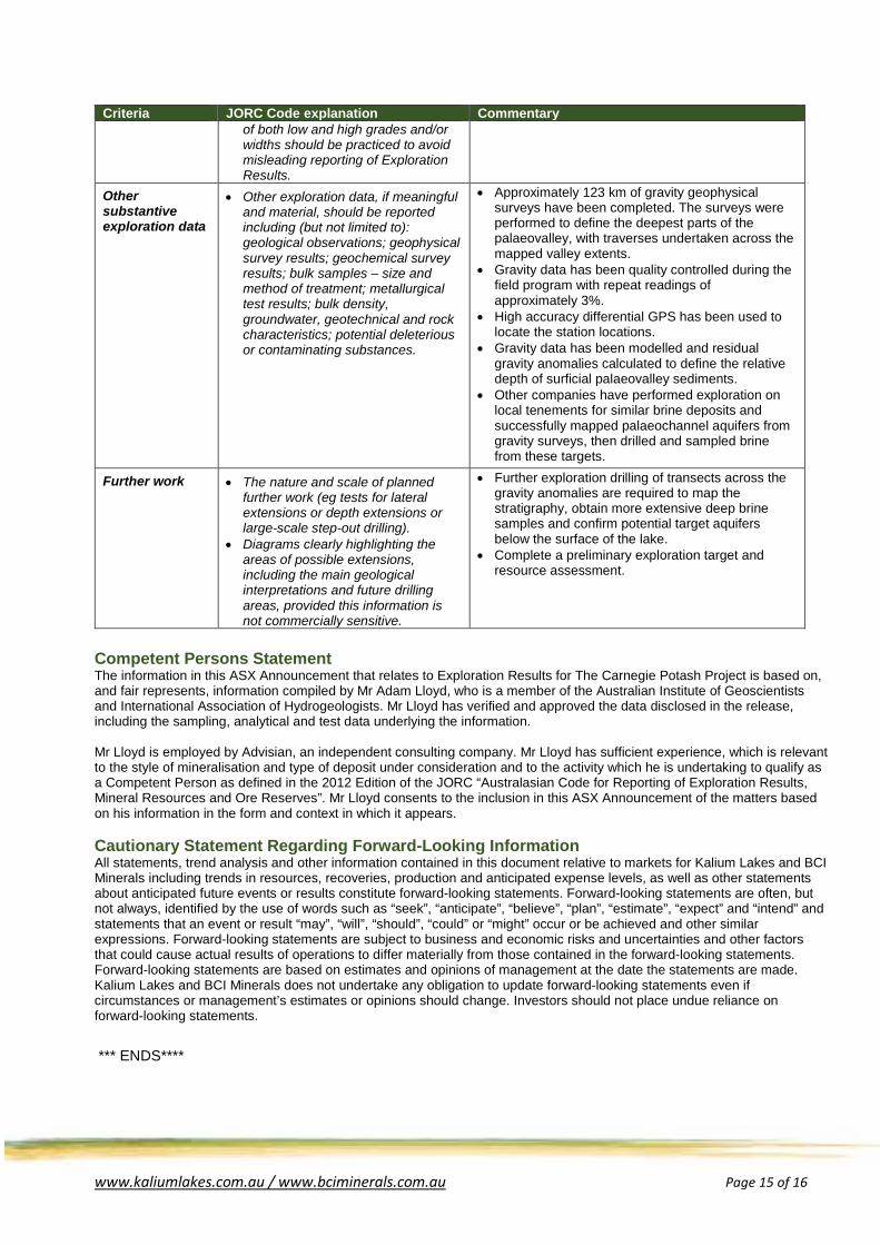
Other substantive exploration data
• Other exploration data, if meaningful and material, should be reported including (but not limited to): geological observations; geophysical survey results; geochemical survey results; bulk samples – size and method of treatment; metallurgical test results; bulk density, groundwater, geotechnical and rock characteristics; potential deleterious or contaminating substances.
• Approximately 123 km of gravity geophysical surveys have been completed. The surveys were performed to define the deepest parts of the palaeovalley, with traverses undertaken across the mapped valley extents.
• Gravity data has been quality controlled during the field program with repeat readings of approximately 3%.
• High accuracy differential GPS has been used to locate the station locations.
• Gravity data has been modelled and residual gravity anomalies calculated to define the relative depth of surficial palaeovalley sediments.
• Other companies have performed exploration on local tenements for similar brine deposits and successfully mapped palaeochannel aquifers from gravity surveys, then drilled and sampled brine from these targets.
Further work • The nature and scale of planned further work (eg tests for lateral extensions or depth extensions or large-scale step-out drilling).
• Diagrams clearly highlighting the areas of possible extensions, including the main geological interpretations and future drilling areas, provided this information is not commercially sensitive.
• Further exploration drilling of transects across the gravity anomalies are required to map the stratigraphy, obtain more extensive deep brine samples and confirm potential target aquifers below the surface of the lake.
• Complete a preliminary exploration target and resource assessment.
Competent Persons Statement The information in this ASX Announcement that relates to Exploration Results for The Carnegie Potash Project is based on, and fair represents, information compiled by Mr Adam Lloyd, who is a member of the Australian Institute of Geoscientists and International Association of Hydrogeologists. Mr Lloyd has verified and approved the data disclosed in the release, including the sampling, analytical and test data underlying the information. Mr Lloyd is employed by Advisian, an independent consulting company. Mr Lloyd has sufficient experience, which is relevant to the style of mineralisation and type of deposit under consideration and to the activity which he is undertaking to qualify as a Competent Person as defined in the 2012 Edition of the JORC “Australasian Code for Reporting of Exploration Results, Mineral Resources and Ore Reserves”. Mr Lloyd consents to the inclusion in this ASX Announcement of the matters based on his information in the form and context in which it appears. Cautionary Statement Regarding Forward-Looking Information All statements, trend analysis and other information contained in this document relative to markets for Kalium Lakes and BCI Minerals including trends in resources, recoveries, production and anticipated expense levels, as well as other statements about anticipated future events or results constitute forward-looking statements. Forward-looking statements are often, but not always, identified by the use of words such as “seek”, “anticipate”, “believe”, “plan”, “estimate”, “expect” and “intend” and statements that an event or result “may”, “will”, “should”, “could” or “might” occur or be achieved and other similar expressions. Forward-looking statements are subject to business and economic risks and uncertainties and other factors that could cause actual results of operations to differ materially from those contained in the forward-looking statements. Forward-looking statements are based on estimates and opinions of management at the date the statements are made. Kalium Lakes and BCI Minerals does not undertake any obligation to update forward-looking statements even if circumstances or management’s estimates or opinions should change. Investors should not place undue reliance on forward-looking statements.
*** ENDS****

www.kaliumlakes.com.au / www.bciminerals.com.au Page 16 of 16
Carnegie Joint Venture Profile (as at 22 June 2018)
The Carnegie Joint Venture (CJV) is focussed on the exploration and development of the Carnegie Potash Project (CPP) in Western Australia, which is located approximately 220 kilometres east-north-east of Wiluna. The CJV comprises one granted exploration licences (E38/2995) and five (5) exploration licence applications (E38/2973, E38/2982, E38/3297, E38/5296 and E38/3295) covering a total area of approximately 3,081 square kilometres. This Project is prospective for hosting a large sub-surface brine deposit which could be developed into a solar evaporation and processing operation that produces sulphate of potash (SOP). The Carnegie Project tenements are located directly north of Salt Lake Potash Limited’s (SO4) – Lake Wells tenements and Australian Potash Limited’s (APC) – Lake Wells tenements. The CJV is a Joint Venture between Kalium Lakes (KLL, 85% Interest) and BCI Minerals (BCI, 15% interest). Under the terms of the agreement BCI can earn up to a 50% interest in the CJV by predominantly sole-funding exploration and development expenditure across several stages. KLL is the manager of the CJV and will leverage their existing Intellectual Property to fast track work.
• Stage 1 - BCI can earn a 30% interest by sole funding the $1.5M Scoping Study Phase, • Stage 2 - BCI can elect to earn a further 10% interest by sole funding a further $3.5M Pre-Feasibility
Study Phase, • Stage 3 - BCI can elect to earn a further 10% interest by sole-funding a further $5.5M Feasibility Study
Phase, • By end of the Feasibility Study the CJV would have an ownership of 50% KLL and 50% BCI
For Further Information Contact:
Kalium Lakes Limited Gareth Widger Corporate Affairs Manager ABN: 98 613 656 643 ASX: KLL Unit 1, 152 Balcatta Road Balcatta, Western Australia 6021 PO Box 610 Balcatta, WA 6914 T: +61 (0)8 9240 3200 E: [email protected] W: www.kaliumlakes.com.au
BCI Minerals Limited Alwyn Vorster Managing Director ACN: 120 646 924 ASX: BCI Level 1, 15 Rheola Street West Perth, Western Australia 6005 GPO Box 2811 Perth, WA 6872 T: +61 (0)8 6311 3400 E: [email protected] W: www.bciminerals.com.au