Embed Size (px)
Citation preview

1
Referendum Version
2
Foreward
‘’The Localism Act 2012 granted powers to Parish Council’s to prepare land use planning
documents. The Act provides an opportunity for local communities to have direct input into
the development of their local area by preparing a plan for a 15-year period.
The Plan for Carlton in Lindrick has been prepared by a Local Plan Steering Group comprising
Parish and District Councillors and members of the local community. It includes proposals
which have been put forward as a result of extensive consultation with all sectors of the local
community.
The draft plan is now available for local consideration and additional suggestions prior to
submission for approval by the Bassetlaw District Council’’.
P. Goulding, Carlton in Lindrick Parish Council.

3
Contents
1 Introduction ........................................................................................................................ 4
2 Community Vision............................................................................................................. 11
3 Community Objectives ..................................................................................................... 12
4 Neighbourhood Development Planning Policies .............................................................. 14
5 Sustainable Development ................................................................................................. 15
6 Housing Development ...................................................................................................... 17
7 Housing type and mix ....................................................................................................... 19
8 Allocating Land for Development ..................................................................................... 24
9 Firbeck Colliery – Site 1..................................................................................................... 27
10 Doncaster Road – Site 2 .................................................................................................. 29
11 Land behind existing homes at Doncaster Road – Site 3 ................................................ 32
12 Residential Infill Development Opportunity ................................................................... 34
13 Employment and local business ...................................................................................... 35
14 Design Principles ............................................................................................................. 38
15 Important Views along Doncaster Road ......................................................................... 45
16 Langold Country Park ...................................................................................................... 52
17 Local Green Spaces .......................................................................................................... 57
18 Enhancing Community facilities ...................................................................................... 63
19 Neighbourhood Centres .................................................................................................. 67
20 Community Aspirations and Priority Projects ................................................................. 72
21 Implementation and Review of this Neighbourhood Plan .............................................. 73
22 Appendix 1: Community Consultation ............................................................................ 74
23 Appendix 2: Site Assessment Report .............................................................................. 75

4
1 Introduction
What is the Carlton in Lindrick Neighbourhood Plan?
1.1 This Neighbourhood Development Plan has been prepared by and for the local people of
Carlton in Lindrick Parish, which also includes the settlements of Costhorpe, Wallingwells and
Wigthorpe.
1.2 The Localism Act 2012 provides new powers for Parish Councils and community forums to
prepare land use planning documents. The Parish area, shown on Figure 1, was designated
as a Neighbourhood Plan area and Carlton in Lindrick Parish Council was designated as
a qualifying body to prepare a Neighbourhood Plan in January 2015.
Figure 1: Neighbourhood Plan Area
1.3 A Neighbourhood Plan is a new type of planning document. Working with and on behalf of
its parishioners, Carlton in Lindrick Parish Council has prepared this land use development
plan that will shape future growth across the parish. The Parish Council has assessed
the development required to enable the village to remain sustainable serving current
and future residents. When it has been ‘made’ by Bassetlaw District Council (following
rigorous consultation, independent examination and a local referendum) the policies will be
used in assessing planning applications in the Neighbourhood Plan area (figure 1).

5
1.4 The document has been prepared by the Carlton in Lindrick Neighbourhood Plan Steering
Group. Membership includes a collection of residents and local councillors and is led by the
Parish Council. The Plan runs from 2018 - 2033 and includes the whole of the Parish of Carlton
in Lindrick.
1.5 Various public consultation events have been held to gain an understanding of the views of
residents, businesses and key agencies that operate within the Parish. The consultation
feedback and the evidence from the studies undertaken have been combined and are
fundamental to the formulation of the policies within this Neighbourhood Development Plan.
Associated documents and information are available on the Parish Council website:
http://www.carlton-in-lindrickparishcouncil.org/
Why are we doing a Neighbourhood Plan?
1.6 Carlton in Lindrick is considered a small ‘Local Service Centre’ within the adopted Bassetlaw
Core Strategy and Development Management Policies DPD and does have a reasonable level
of services and facilities that cater for an increasing population.
1.7 Local Planning policy has always been formulated at District level and Bassetlaw District
Council continues to have a legal duty to provide this via its adopted Core Strategy and
Development Management Policies DPD 2011. Both this Neighbourhood Plan and District’s
planning policies must also be in general conformity with the National Planning Policy
Framework (NPPF) to meet the set of ‘basic conditions’ as stated within the Neighbourhood
Planning Regulations (amended) 2012.
1.8 This Neighbourhood Plan supports the intention of the adopted Bassetlaw Core Strategy and
Development Management Policies (2011) plan for sustainable development and seeks to,
where existing policies provide a lack of detail, supplement existing policies with local context.
1.9 During the preparation of this Neighbourhood Plan, existing planning policies have been
considered and it is not the intention of this Plan to replicate or conflict with any existing
planning policies within either the National Planning Policy Framework or the Core Strategy.
6
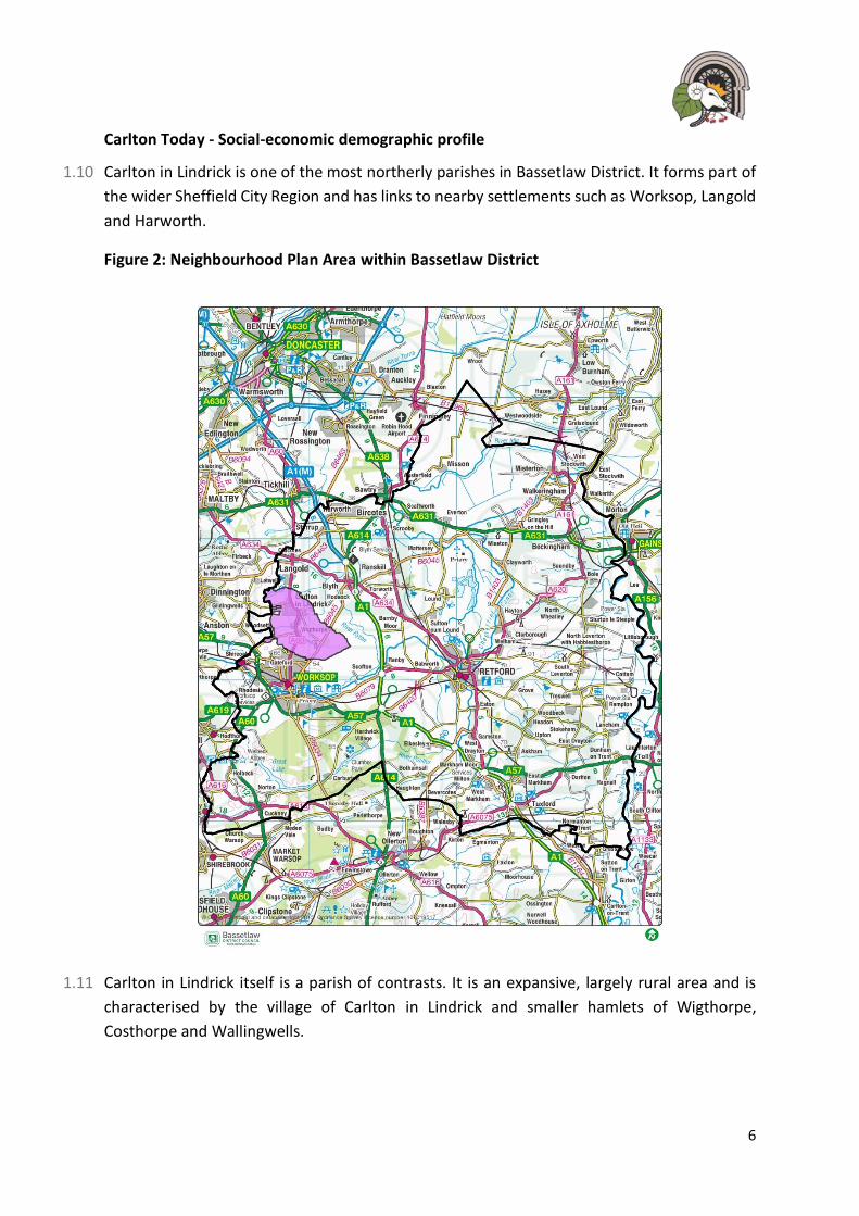
Carlton Today - Social-economic demographic profile
1.10 Carlton in Lindrick is one of the most northerly parishes in Bassetlaw District. It forms part of
the wider Sheffield City Region and has links to nearby settlements such as Worksop, Langold
and Harworth.
Figure 2: Neighbourhood Plan Area within Bassetlaw District
1.11 Carlton in Lindrick itself is a parish of contrasts. It is an expansive, largely rural area and is
characterised by the village of Carlton in Lindrick and smaller hamlets of Wigthorpe,
Costhorpe and Wallingwells.

7
1.12 While Carlton in Lindrick itself has a reasonable range of services, including schools and health
facilities, it has also lost some facilities over recent years and it mostly relies on the larger
nearby settlements such as Worksop, for major retail and other key services.
1.13 The northern most part of the parish is dominated by a vacant former colliery site. This will
need to be utilised over this plan period as it has significant regeneration potential. This is
already being realised through existing planning permissions for the redevelopment of this
site.
1.14 The area is well connected and has transport and road links to nearby settlements such as
Worksop, Doncaster and Sheffield. A recent and expanding international airport is also only 9
miles away and provides opportunity for improving the local area.
1.15 At present, however, the local economy is still recovering from its former mining economic
and employment base. Its key characteristics are that of low skilled retail, light manufacturing,
agricultural and distribution industries and employment. There is a high level of commuting
outside of the parish for employment and higher paid jobs. There is also evidence that while
relatively buoyant in terms of its low unemployment rate, it is still weighted towards
employment opportunities at the lower end of the regional and national pay scale. Similarly,
there is low demand for local retail and office space in the parish.
1.16 Carlton in Lindrick has a rich and important historic and natural environment that contributes
significantly towards the quality of life, and character, of the parish. The surrounding
countryside is an asset (in terms of its landscape and biodiversity), with a reasonable network
of footpaths and recreational opportunities offered by Langold Country Park and the various
sports and other recreational provision in the parish.
1.17 The parish has a wide range of heritage assets, including listed buildings, a conservation area
two registered park and gardens. The parish also supports local wildlife sites that reflect the
variety of its rural habitat and geology.
1.18 The quality of life available to most residents is generally perceived as good. However, there
are issues with some poor-quality housing and low paid employment within the area. Some
people do travel outside the area to seek higher paid employment opportunities.
1.19 Average house prices within the parish are lower than surrounding areas, but they are
considered as good value for money. Even so, the relatively low wage levels of many
residents’ mean that there is a lack of affordable housing provision, particularly two and
three-bedroom houses. Carlton in Lindrick, like other areas, also has a growing percentage of
older residents, which is likely to increase demand for specific types of housing (e.g.
bungalows) and a requirement for increased numbers of care-homes and sheltered
accommodation schemes.

8
1.20 It is evident that Carlton in Lindrick has significant strengths, which can be built upon. Much
of the parish is an attractive place and it has good access to a variety of places nearby. It has
many advantages that can serve to drive growth and regeneration, in appropriate locations,
including:
• A good strategic location in relation to the sub-region and more widely, in terms of
accessibility to other locations;
• A strong network of green infrastructure and attractive countryside, as well as, an
important variety of important heritage assets;
• Low house prices in comparison to other areas of the District;
• Clear regeneration opportunities;
• Opportunities for increased Tourist activity, notably through the improvement of
Langold Country Park.
1.21 There are also issues that serve to detract from the overall ‘offer’ in Carlton in Lindrick, most
notably:
• Low market demand for housing;
• A lack of a diverse and well-paid employment offer with the shortcomings, in some
areas, in relation to skills and education attainment;
• The need to enhance its retail offer and quality of the local environment;
• The need to provide additional low-cost housing and accommodation for older
people.
9
How has this Neighbourhood Plan been developed?
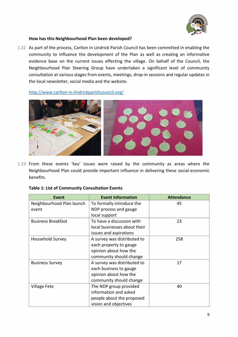
1.22 As part of the process, Carlton in Lindrick Parish Council has been committed in enabling the
community to influence the development of the Plan as well as creating an informative
evidence base on the current issues effecting the village. On behalf of the Council, the
Neighbourhood Plan Steering Group have undertaken a significant level of community
consultation at various stages from events, meetings, drop-in sessions and regular updates in
the local newsletter, social media and the website.
http://www.carlton-in-lindrickparishcouncil.org/
1.23 From these events ‘key’ issues were raised by the community as areas where the
Neighbourhood Plan could provide important influence in delivering these social-economic
benefits.
Table 1: List of Community Consultation Events
Event Event Information Attendance
Neighbourhood Plan launch event
To formally introduce the NDP process and gauge local support
45
Business Breakfast To have a discussion with local businesses about their issues and aspirations
23
Household Survey A survey was distributed to each property to gauge opinion about how the community should change
258
Business Survey A survey was distributed to each business to gauge opinion about how the community should change
17
Village Fete The NDP group provided information and asked people about the proposed vision and objectives
40
10
Event Event Information Attendance
Village Fete An update on the progress of the NDP was provided to interested people.
37
Site Allocations Public Event To enable local people to comment on the proposed development sites in the village.
150
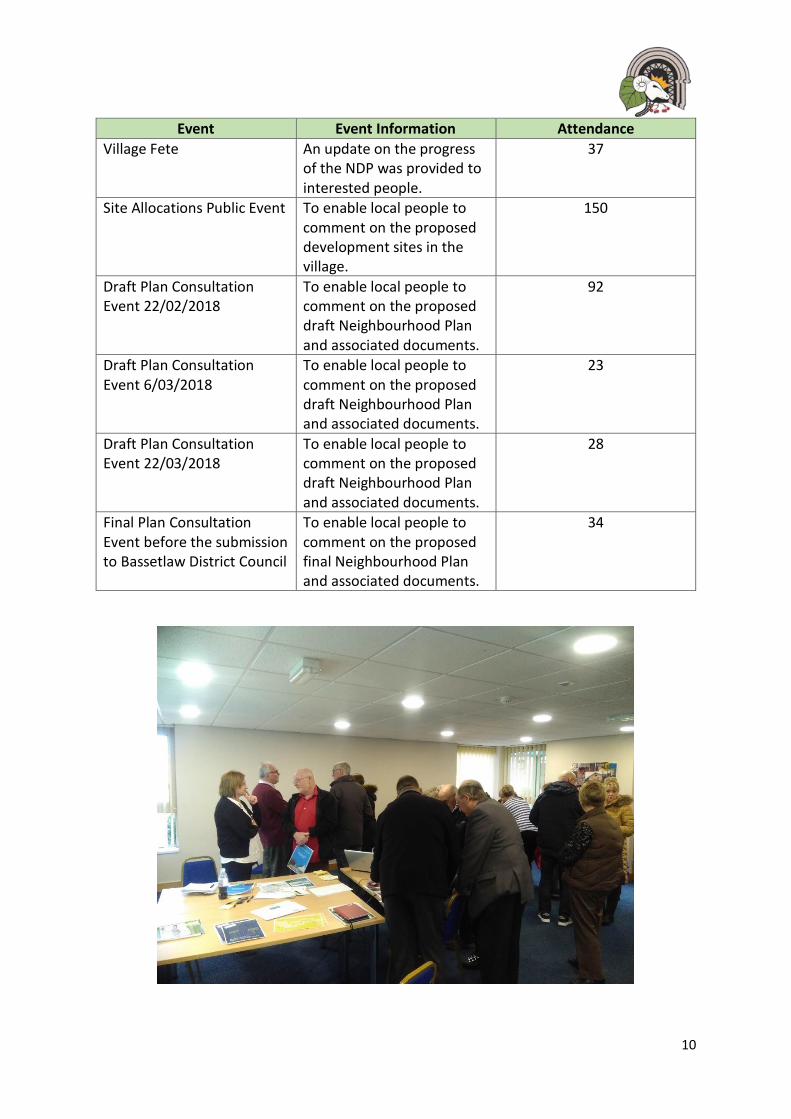
Draft Plan Consultation Event 22/02/2018
To enable local people to comment on the proposed draft Neighbourhood Plan and associated documents.
92
Draft Plan Consultation Event 6/03/2018
To enable local people to comment on the proposed draft Neighbourhood Plan and associated documents.
23
Draft Plan Consultation Event 22/03/2018
To enable local people to comment on the proposed draft Neighbourhood Plan and associated documents.
28
Final Plan Consultation Event before the submission to Bassetlaw District Council
To enable local people to comment on the proposed final Neighbourhood Plan and associated documents.
34

11
1.24 The following vision and set of community objectives outline how this Neighbourhood Plan
aims to build on these advantages and address the issues of concern to deliver growth and
improve the area in a way it will benefit existing, as well as, new residents to the area.
2 Community Vision
By 2033, Carlton in Lindrick will be a better place to live, with a strong sense of identity and community spirit.
The village will have benefited from a regenerated Firbeck Colliery Site and other developments that have provided a greater mix of properties, encouraged further local employment opportunities and support the continued sustainability of the area.
New developments will have ‘raised the bar’ in terms of design and support our local facilities, assets and local heritage.
The village will be a greener place with improved access to useable and pleasant areas of woodland and open space.
Our important views along Doncaster Road will be persevered and retained.
12
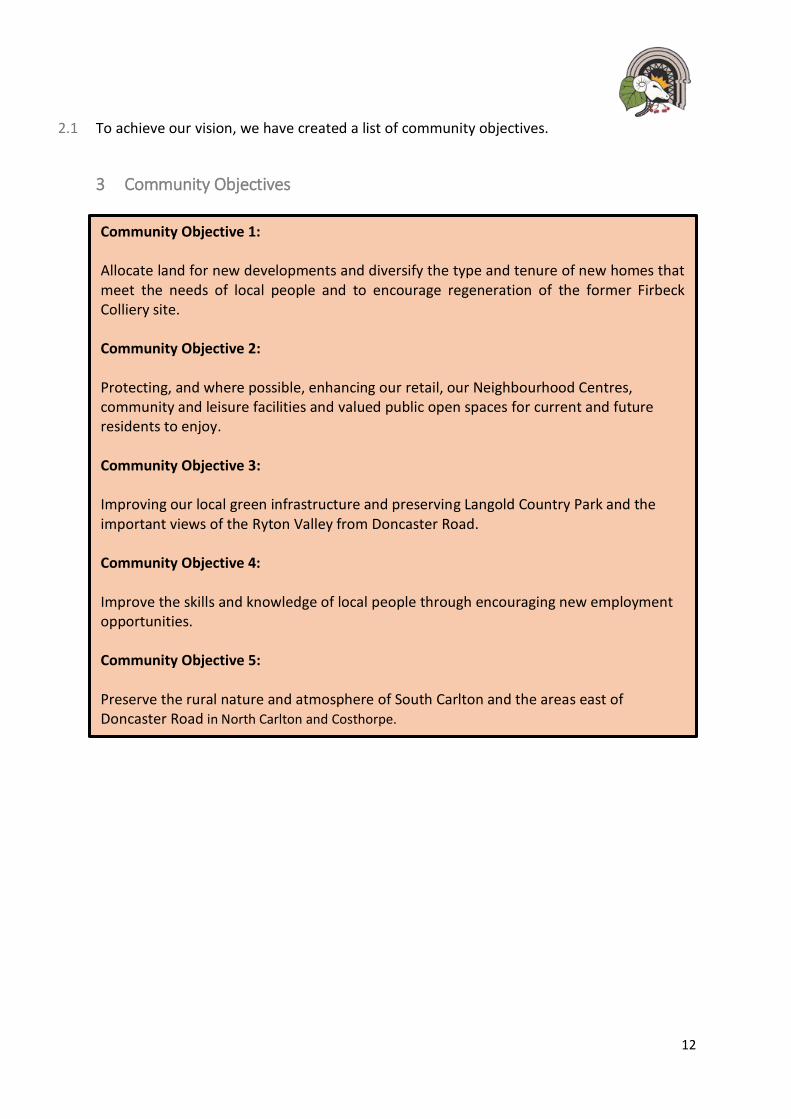
2.1 To achieve our vision, we have created a list of community objectives.
3 Community Objectives
Community Objective 1: Allocate land for new developments and diversify the type and tenure of new homes that meet the needs of local people and to encourage regeneration of the former Firbeck Colliery site. Community Objective 2: Protecting, and where possible, enhancing our retail, our Neighbourhood Centres, community and leisure facilities and valued public open spaces for current and future residents to enjoy. Community Objective 3: Improving our local green infrastructure and preserving Langold Country Park and the important views of the Ryton Valley from Doncaster Road. Community Objective 4: Improve the skills and knowledge of local people through encouraging new employment opportunities. Community Objective 5: Preserve the rural nature and atmosphere of South Carlton and the areas east of Doncaster Road in North Carlton and Costhorpe.
13
Consulting the Community: Statement of Intent
3.1 This Plan reflects the community’s need to have a greater involvement and influence in the
future growth of the plan areas. The importance of pre-application consultation is endorsed
in paragraph 188 of the National Planning Policy Framework.
3.2 The local community want their extensive local knowledge about this area to help inform the
preparation of future planning applications. Furthermore, these proposals must consider the
issues and concerns of the community across the Parish and recommends consultation on
minor proposals.
3.3 Ensuring the community are involved at an early stage in the process will be of benefit to all
parties as issues can be discussed and resolved early in the development of a scheme.
3.4 The requirements necessary to constitute, community consultation’ are set out in the
Statement of Intent below.
Statement of Intent
Those submitting proposals for development are encouraged to actively engage in
consultation with local people and other stakeholders. Engagement with the Parish
Council will be welcomed.
In consulting with the community, it will be considered best practice for the applicant to
follow the guidelines set out in Appendix 1.

14
4 Neighbourhood Development Planning Policies
4.1 The Neighbourhood Plan Policies will be used to aid the delivery of development in Carlton in
Lindrick up to 2033. They are formulated based on the community objectives and vision and
will contribute to the delivery of the growth requirements as stated within the District’s
adopted Core Strategy and Development Management Policies DPD 2011. When
development is proposed within this Neighbourhood Area, decisions will be made using the
policies contained in this Neighbourhood Plan alongside those contained in the District’s
Adopted Local Development Plan.
List of Planning Policies
Policy 1: Sustainable Development
Policy 2: Housing Mix and Type
Policy 3: Allocation of land at Firbeck Colliery (Site 1)
Policy 4: Allocation of land at Doncaster Road (Site 2)
Policy 5: Allocation of land behind existing properties along Doncaster Road (Site 3)
Policy 6: Residential Infill Development
Policy 7: Enabling Employment Opportunities
Policy 8: Development and Design Principles
Policy 9: Carlton Conservation Area
Policy 10: Important Views
Policy 11: Langold Country Park
Policy 12: Local Green Spaces
Policy 13: Enhancing our Community Facilities
Policy 14: Neighbourhood Centres

15
5 Sustainable Development
5.1 The Government’s overarching objective of achieving sustainable development, is clearly
defined within the National Planning Policy Framework with the role for Neighbourhood
Development Plans as a key delivery vehicle being clearly identified. Sustainable development
is development that meets the needs of the present without compromising the ability of
future generations to meet their own needs and involves seeking positive improvements in
the quality of the built, natural and historic environment, as well as in people’s quality of life.
5.2 The Government has defined, through the NPPF, what sustainable development means in
practice. This confirms that there are three dimensions to sustainable development that
should not be undertaken in isolation, because they are mutually dependent. The three roles
are:
• an economic role – contributing to building a strong, responsive and competitive
economy, by ensuring that sufficient land of the right type is available in the right
places and at the right time to support growth and innovation; and by identifying
and coordinating development requirements, including the provision of
infrastructure;
• a social role – supporting strong, vibrant and healthy communities, by providing the
supply of housing required to meet the needs of present and future generations; and
by creating a high quality-built environment, with accessible local services that
respect the community’s needs and support its health, social and cultural well-being;
and
• an environmental role – contributing to protecting and enhancing our natural, built
and historic environment; and, as part of this, helping to improve biodiversity, use
natural resources prudently, minimise waste and pollution, and mitigate and adapt
to climate change including moving to a low carbon economy.
5.3 Carlton in Lindrick already has many sustainable attributes. With established schools, a range
of recreational facilities and several local shops, the village enjoys a strong sense of
community cohesion. Situated within easy reach of the facilities and services offered in
Worksop yet still a village with a rural context and agricultural history, the community are
keen to retain this character and protect its rural setting. There is also a desire to see the
village grow in a balanced manner to meet the wider employment, recreational and social
needs of a growing population.
5.4 When commenting on development proposals, the Parish Council will take a positive
approach that reflects the presumption in favour of sustainable development. The Parish
Council will work proactively with applicants to find joint solutions, wherever possible, to
secure development that improves the economic, social and environmental conditions for the
whole parish.
16
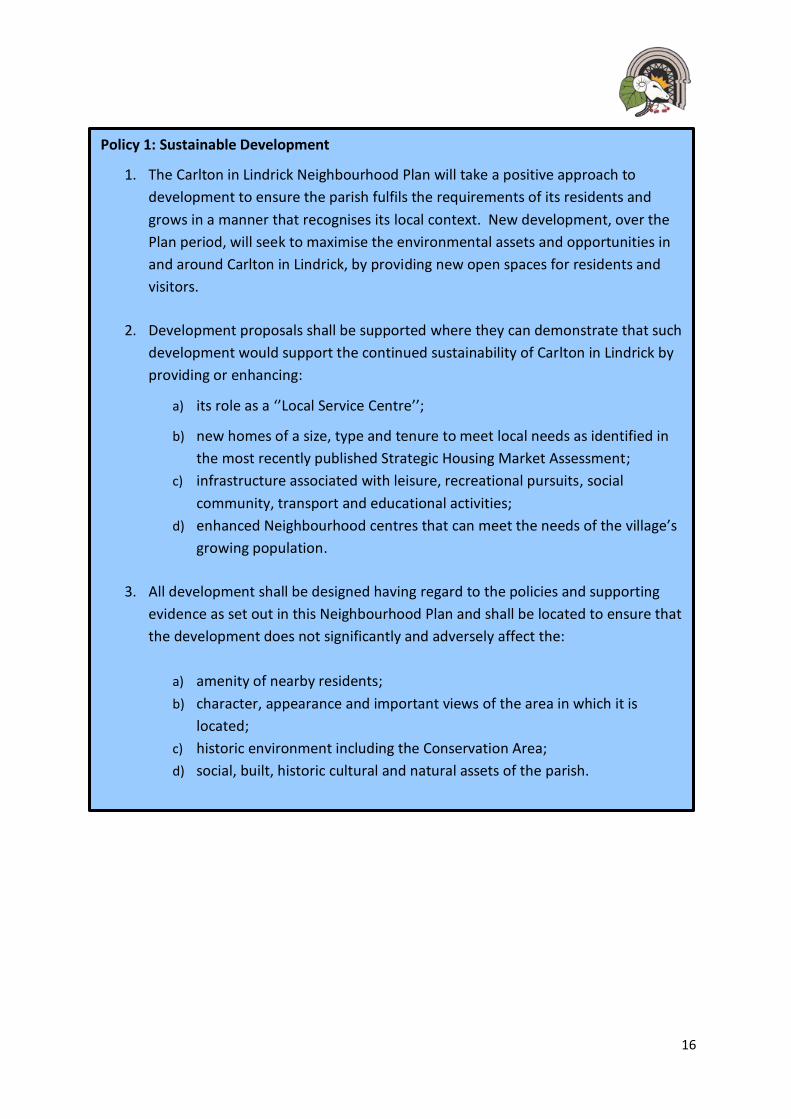
Policy 1: Sustainable Development
1. The Carlton in Lindrick Neighbourhood Plan will take a positive approach to
development to ensure the parish fulfils the requirements of its residents and
grows in a manner that recognises its local context. New development, over the
Plan period, will seek to maximise the environmental assets and opportunities in
and around Carlton in Lindrick, by providing new open spaces for residents and
visitors.
2. Development proposals shall be supported where they can demonstrate that such
development would support the continued sustainability of Carlton in Lindrick by
providing or enhancing:
a) its role as a ‘’Local Service Centre’’;
b) new homes of a size, type and tenure to meet local needs as identified in
the most recently published Strategic Housing Market Assessment;
c) infrastructure associated with leisure, recreational pursuits, social
community, transport and educational activities;
d) enhanced Neighbourhood centres that can meet the needs of the village’s
growing population.
3. All development shall be designed having regard to the policies and supporting
evidence as set out in this Neighbourhood Plan and shall be located to ensure that
the development does not significantly and adversely affect the:
a) amenity of nearby residents;
b) character, appearance and important views of the area in which it is
located;
c) historic environment including the Conservation Area;
d) social, built, historic cultural and natural assets of the parish.

17
6 Housing Development
6.1 Sustainable development is that of providing an appropriate mix of development that suits
the needs of the local population where there is access to services, whilst minimising the
impacts on the local environment and existing infrastructure.
6.2 As the plan area has seen considerable changes on the traffic on local roads and the impact
of the population growth on its services and infrastructure. These matters have featured
heavily in the community consultation that has both underpinned and informed this Plan.
6.3 In addressing the future scale of the Plan area and the location and type of housing that would
be appropriate the following principles have been applied:
• Ensuring that new housing development sits appropriately in relation to the built-up settlement of Carlton in Lindrick;
• Seeking to ensure that new housing development sits appropriately within its wider landscape setting and in relation to its proximity to and visibility from the Conservation Area;
• Seeking to ensure that new residential developments appropriately contribute to meeting the needs of residents;
• Seeking to ensure that new residential developments make appropriate and proportionate contributions towards the provision of new or improved local infrastructure;
• Seeking to ensure that all new developments are located and designed to operate effectively within the local highway network and do not detrimentally affect the free and safe flow of traffic on the network; and
• Seeking to ensure that the Plan area makes an appropriate and meaningful contribution to meeting the objectively-assessed housing needs of Bassetlaw District.
Assessing our general housing requirements
6.4 The Plan recognises its wider context within the existing Bassetlaw Core Strategy. The Core
Strategy was adopted in 2011 and stated that, collectively, both Carlton and Langold should
receive 4% growth (268 homes) through to 2031. This growth was projected to be delivered
through existing planning permissions at that time. However, since the adoption of the Core
Strategy there has been no major housing development within Carlton in Lindrick.
6.5 The adopted Core Strategy pre-dates the NPPF. On this basis, the District Council is now
preparing a new Local Plan that will run for 15-20 years once adopted in 2020.
6.6 As the information provided by the Core Strategy is some 8 years old, the Parish Council is
committed to guide future developments and regeneration in the best possible locations as
identified in the following policies.

18
Local Housing and accommodation Needs
6.7 The community is anxious to ensure that all new housing developments fully respect the
housing needs of the wider community. Whilst Carlton has grown significantly in the last fifty
years or so, it has retained a strong sense of community spirit and cohesion. In this context
many residents who moved to the village in the 1970s to 1990s are now both older and in
need or smaller or more specialist housing. Their children are also finding it difficult to find
appropriately sized or priced housing in the village and there has been a decline in the
younger population as people seek cheaper housing and better employment prospects in
other areas such as Worksop, Doncaster or Sheffield.
6.8 To understand the scale and significance of these issues, the Parish Council commissioned an
independent ‘Housing Needs Assessment’ to undertake an analysis of current resident’s
needs over the plan period. Its report was published in February 2016. Its key findings of the
type, range and size of housing required were as follows:
22% of respondents were interested in downsizing in the next 2-10 years.
The top two types of accommodation required were identified as:
• Semi-detached dwellings (2-3-bedroom); and
• 2-bedroom Bungalows.
Preferred new housing types
6.9 The top three types of supported housing required were identified as:
• Independent accommodation with care support;
• Private sheltered housing;
• Housing Association Sheltered Accommodation.
19
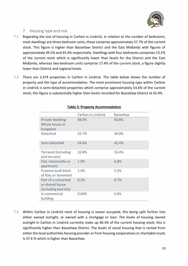
7 Housing type and mix
7.1 Regarding the size of housing in Carlton in Lindrick, in relation to the number of bedrooms,
most dwellings are three-bedroom units; these comprise approximately 57.7% of the current
stock. This figure is higher than Bassetlaw District and the East Midlands with figures of
approximately 49.5% and 45.4% respectively. Dwellings with four bedrooms comprises 13.2%
of the current stock which is significantly lower than levels for the District and the East
Midlands, whereas two-bedroom units comprise 17.4% of the current stock, a figure slightly
lower than District and regional levels.
7.2 There are 2,474 properties in Carlton in Lindrick. The table below shows the number of
property and the type of accommodation. The most prominent housing type within Carlton
in Lindrick is semi-detached properties which comprise approximately 54.6% of the current
stock; this figure is substantially higher than levels recorded for Bassetlaw District at 42.4%.
Table 3: Property Accommodation
Carlton in Lindrick Bassetlaw
Private dwelling: Whole house or bungalow
98.0%
92.8%
Detached 32.7%
34.0%
Semi-detached 54.6%
42.4%
Terraced (including end-terrace)
10.8%
16.4%
Flat, maisonette or apartment:
1.9%
6.8%
Purpose-built block of flats or tenement
1.4%
5.5%
Part of a converted or shared house (including bed-sits)
0.2%
0.7%
In commercial building
0.04% 0.6%
7.3 Within Carlton in Lindrick most of housing is owner occupied, this being split further into
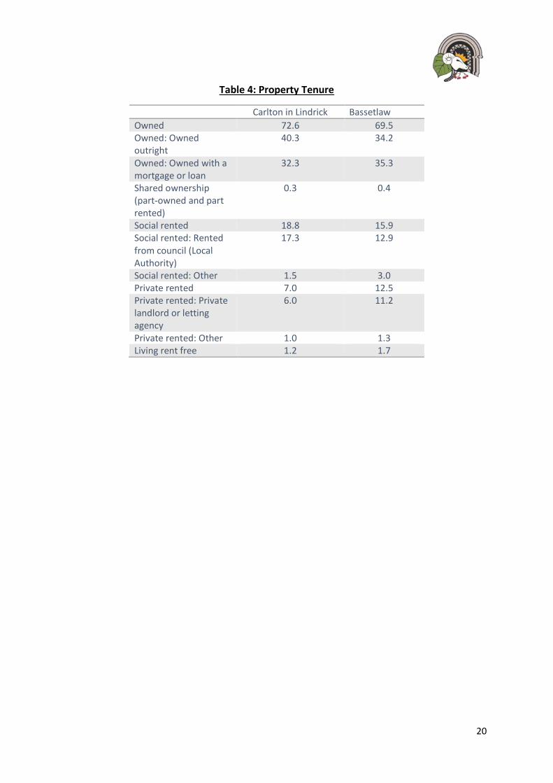
either owned outright, or owned with a mortgage or loan. The levels of housing owned
outright in Carlton in Lindrick currently make up 40.3% of the current housing stock; this is
significantly higher than Bassetlaw District. The levels of social housing that is rented from
either the local authorities housing provider or from housing cooperatives or charitable trusts
is 37.6 % which is higher than Bassetlaw.
20
Table 4: Property Tenure
Carlton in Lindrick Bassetlaw
Owned 72.6 69.5 Owned: Owned outright
40.3 34.2
Owned: Owned with a mortgage or loan
32.3 35.3
Shared ownership (part-owned and part rented)
0.3 0.4
Social rented 18.8 15.9 Social rented: Rented from council (Local Authority)
17.3 12.9
Social rented: Other 1.5 3.0 Private rented 7.0 12.5 Private rented: Private landlord or letting agency
6.0 11.2
Private rented: Other 1.0 1.3 Living rent free 1.2 1.7
21
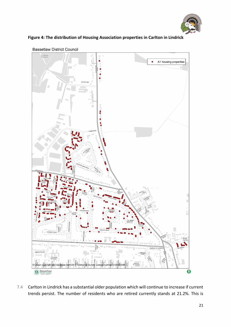
Figure 4: The distribution of Housing Association properties in Carlton in Lindrick
7.4 Carlton in Lindrick has a substantial older population which will continue to increase if current
trends persist. The number of residents who are retired currently stands at 21.2%. This is

22
higher than the national figure which stands at 17.8% and it is slightly higher than that of
Bassetlaw District of 20.9%. The table below identifies the rate of change amongst the
population over the past 15 years.
Table 4: Local, regional and national age profile comparisons
Age group Carlton-in-Lindrick Bassetlaw England
0-15 -17.8% -6.2% 1.2%
16-24 -4.3% 15.4% 17.2%
25-44 -20.1% -9.6% 1.4%
45-64 2.7% 15.6% 15.2%
65-84 20.2% 17.9% 9.1%
85 and over 74.4% 34.4% 23.7%
7.5 Through public consultation, people raised the issue of a lack of a mix of properties within
new developments. Residents expressed views that additional accommodation for elderly
people will be needed. This included a mix of private bungalows, sheltered accommodation
and assisted care facilities.

23
Policy 2: Housing Type and Mix on Allocated Sites
1. Proposals for residential developments of more than 5 dwellings should be expected to provide a mixture of dwelling types on allocated sites or other major (as defined by national policy) housing developments to meet housing needs. On these sites, subject to being part of a wider mix, the provision of housing that meets a range of community requirements, including smaller 2 and 3 bedroomed properties, retirement housing, extra care housing and other housing for the elderly, those with special or supported needs and those wishing to build their own home, will be supported.
Affordable Housing on Allocated Sites
2. New developments on the identified housing allocations should provide, at least,
15% of the units proposed as ‘’affordable housing units in line with the Bassetlaw
Core Strategy.
3. To support a mixed and successful development, the affordable housing must be
fully integrated in with the market housing units and must not be clustered into a
single area of the site.
24
8 Allocating Land for Development
8.1 The Parish Council were keen to encourage development in the most appropriate locations.
To achieve this, the steering group asked Bassetlaw District Council to provide the details of
all the land that was submitted as part of the emerging Local Plan process late 2016. This
consultation gave land owners, developers and the local community the opportunity to
submit land to be considered for future allocation.
8.2 In September 2017, the Neighbourhood Plan group, along with Bassetlaw District Council,
undertook an assessment of each site through an agreed site assessment criterion (which can
be viewed in Appendix 2).
8.3 The sites were scored according to their availability and suitability. Sites that scored
negatively were discounted and only the sites that were considered suitable for development
were taken forward as proposed allocations. This document was then sent to all relevant
statutory consultees and agencies for their input.
8.4 The community played a significant role and the site assessment criteria as it included a level
of community support. An event was held within the Civic Centre during October 2017 where
over 150 people attended to ‘have their say’ on the proposed sites and the information
provided by the statutory consultees.
8.5 The information identified within the site assessment is also supported by a draft
Sustainability Appraisal - which looks at whether there could be negative impacts to the
environment by the policies proposed in the Neighbourhood Plan.
8.6 In addition, there are several existing planning permissions within the parish of Carlton in
Lindrick, some of which are allocated within this Plan as it is expected that these will be
delivered over the plan period.
8.7 During March and April 2018, over 300 people came to view and discuss the contents and
proposals within the draft Neighbourhood Plan. Three public events were held, and members
of the steering group undertook a presentation and provided time for residents to ask
questions and encouraged to provide comments and feedback about the proposals.

25
Table 5: Existing Planning Permissions and potential allocations in Carlton in Lindrick (sites
over 10 units)
Site name Permitted units through
existing planning
permissions
Additional units through
the Neighbourhood Plan
Firbeck Colliery (Site 1) 400 0
Peppers, Blyth Road (180)** 0
Doncaster Road (Site 2) 0 150
Land at Highfield House
(Site 3)
0 10
Total 400 160
Overall Total 560
** The recently approved Peppers mixed use development, which includes around 180
new homes. Due to its location and close proximity to Worksop, this housing figure of 180
homes will not contribute towards the housing requirement for Carlton in Lindrick over
the Plan period as confirmed by Bassetlaw District Council.

26
Proposals Map: Settlement Boundary and Allocations
Site 1
Site 2
Site 3

27
9 Firbeck Colliery – Site 1
9.1 Firbeck Colliery site lies to the north of the parish and adjacent to the neighbouring parish of
Langold. The site covers 6.61 hectares and is near nearby services and facilities linked by a
series of footpaths and the main A60/ Doncaster Road.
9.2 The site has been vacant for over 40 years and has been the main emphasis for
redevelopment within the area. The District Council has identified this site as the focus for
housing development and regeneration over the period of the Local Development Plan.
9.3 The site has been subject to various planning permissions but, due to viability, there has been
no delivery of this development and the site remains vacant and disused. Outline planning
permission was granted by Bassetlaw District Council for 400 homes in late 2017. A reserve
matters application is yet to be submitted to Bassetlaw District Council.
9.4 During the public consultation, it became clear that the community strongly support the
redevelopment of this site to become a well-integrated part of the community. This
Neighbourhood Plan supports this view and allocates the site as the focus for development
and regeneration of its plan period. The development is expected to contribute towards the
regeneration of the site and wider settlement by improving the site environmentally and
providing a suitable range of property types and tenures to support a sustainable community.
Map 1: Firbeck Colliery Development Site
28
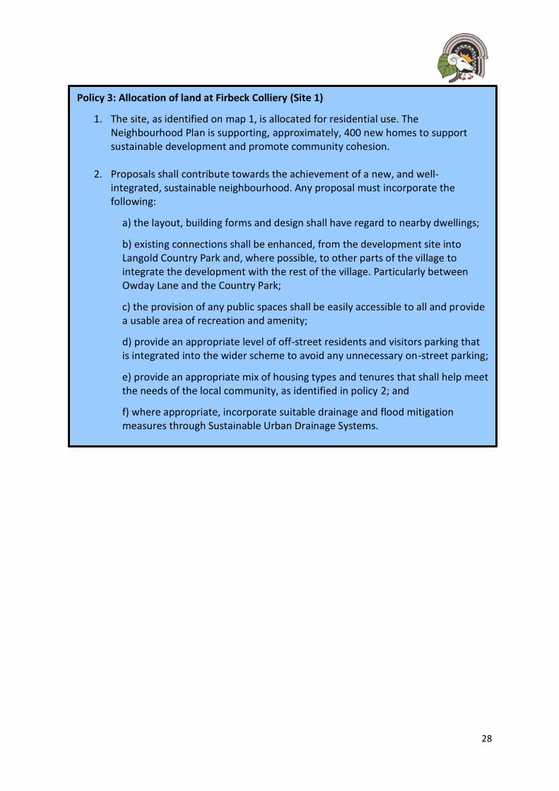
Policy 3: Allocation of land at Firbeck Colliery (Site 1)
1. The site, as identified on map 1, is allocated for residential use. The Neighbourhood Plan is supporting, approximately, 400 new homes to support sustainable development and promote community cohesion.
2. Proposals shall contribute towards the achievement of a new, and well-integrated, sustainable neighbourhood. Any proposal must incorporate the following:
a) the layout, building forms and design shall have regard to nearby dwellings;
b) existing connections shall be enhanced, from the development site into Langold Country Park and, where possible, to other parts of the village to integrate the development with the rest of the village. Particularly between Owday Lane and the Country Park;
c) the provision of any public spaces shall be easily accessible to all and provide a usable area of recreation and amenity;
d) provide an appropriate level of off-street residents and visitors parking that is integrated into the wider scheme to avoid any unnecessary on-street parking;
e) provide an appropriate mix of housing types and tenures that shall help meet the needs of the local community, as identified in policy 2; and
f) where appropriate, incorporate suitable drainage and flood mitigation measures through Sustainable Urban Drainage Systems.

29
10 Doncaster Road – Site 2
10.1 Site 2 – Land East of Doncaster Road lies to the east of the village of Carlton in Lindrick. The
site covers 5.19 hectares and is near nearby services and facilities linked by neighbouring
residential areas and footpaths along the main A60/ Doncaster Road.
10.2 The site is currently an agricultural area of land bounded by hedging and residential properties
to the South.
10.3 As part of the Neighbourhood Planning process, land around the Parish was considered to
accommodate future growth. The Neighbourhood Plan Site Allocations Report identified this
site a ‘’suitable’’ for future development due to few planning constraints and the availability
of nearby infrastructure.
10.4 During the public consultation, it became clear that community had several concerns
regarding the large site being entirely developed. The concerns voiced were mainly issues
regarding infrastructure capacity, loss of agricultural land, loss of wildlife, impact on the
existing landscape and views across the Ryton Valley.
10.5 As part of the site allocation process, it was agreed that developing the large site would have
a detrimental impact on the issues raised by the community and a smaller area should be
considered and was discussed with the landowner.
10.6 This Neighbourhood Plan allocates a part of the original site area as the focus for
development. The development is expected to contribute towards providing a range of new
homes and infrastructure for the wider community over the plan period. Policy 4 sets out a
comprehensive series of requirements for the development of the site. They include various
highways related matters. Planning applications for the development of the site should be
accompanied by a Transport Assessment to assess the suitability of the design and the
operation of the proposal concerned.

30
Map 2: Allocation of Land East of Doncaster Road

31
Policy 4: Allocation of land at Doncaster Road (Site 2) Site Allocations Ref LAA0076))
1. The site, as identified on map 2, is allocated for residential use. The Neighbourhood Plan is supporting, approximately, 150 new homes to support sustainable development and promote community cohesion. Proposals for development on this allocation will be supported where they can satisfactorily demonstrate, to the Local Planning Authority, that any proposal will not have a detrimental impact on the following issues raised by the local community, including:
a) residential privacy and amenity to existing properties along Pinfold Drive; b) existing highway network on to Doncaster Road; c) local environmental assets and identified ‘’important views’’ on, through, or adjacent to, the site – notably Local Green Space 5; and d) existing capacity of the local primary schools and health centres.
2. Proposals shall contribute towards the achievement of a new, and well-
integrated, sustainable neighbourhood. Any proposal must incorporate the following:
a) vehicular access shall only be provided off Doncaster Road; b) provide pedestrian and cycle access to LGS 5 off Pinfold Drive; c) the height and scale of new properties adjacent to the existing properties
along Pinfold Drive; d) mitigate any loss of local biodiversity and wildlife that may be affected by
the proposal by providing green spaces that will help the enhancement of local wildlife habitats;
e) take advantage of local topography, landscape views, native trees, hedgerows and site orientation;
f) appropriate boundary treatments and screening through the creation of a ‘’green landscaped buffer’’ between the development site and the open countryside to the north and east of the site between the site and those existing properties on Pinfold Drive;
g) provide an appropriate level of ‘’usable’’ public open space that should take opportunities to connect to existing spaces, footpath networks and local facilities;
h) provide an appropriate level of off-street residents and visitors parking that is integrated into the wider scheme to avoid any unnecessary on-street parking;
i) provide an appropriate mix of housing types and tenures, including affordable housing, that shall help meet the needs of the local community, as identified in policy 2;
j) where appropriate, incorporate suitable drainage and flood mitigation measures through Sustainable Urban Drainage Systems.
32
11 Land behind existing homes at Doncaster Road – Site 3
11.1 Site 3 – Land behind Doncaster Road lies to the east of the village of Carlton in Lindrick. The
site covers 0.71 hectares and is near nearby services and facilities linked by neighbouring
residential areas and footpaths along the main A60/ Doncaster Road.
11.2 The site is currently a redundant area of land bounded by hedging and residential properties
to the west and south.
11.3 As part of the Neighbourhood Planning process, land around the Parish was considered to
accommodate future growth. The Neighbourhood Plan Site Allocations Report identified this
site a ‘’suitable’’ for future development due to few planning constraints and the availability
of nearby infrastructure such as the highway network.
11.4 During the public consultation, it became clear that community had several concerns
regarding the large site being entirely developed. The concerns voiced were mainly issues
regarding access to the existing road network and impact on traffic congestion.
11.5 As part of the site allocation process, it was agreed that developing the site would have a
detrimental impact on the issues raised by the community and a ‘’cap’’ on the number of
properties should be considered.
Map 2a: Allocation of land behind existing properties along Doncaster Road
33
Policy 5: Allocation of land at Doncaster Road (Site 3) Site Allocations Ref LAA00162))
1. The site, as identified on map 2a, is allocated for residential use. The Neighbourhood Plan is supporting, approximately, 10 new homes to support sustainable development and promote community cohesion. Proposals for development on this allocation will be supported where they can satisfactorily demonstrate, to the Local Planning Authority, that any proposal will not have a detrimental impact on the following issues raised by the local community, including:
a) residential privacy and amenity to existing properties along Doncaster Road; b) adversely impacting the existing highway network on to Doncaster Road; c) existing capacity of the local primary schools and health centres.
2. Proposals shall contribute towards the achievement of a new, and well-
integrated, sustainable neighbourhood. Any proposal must incorporate the following:
a) vehicular access shall only be provided off Doncaster Road; b) the height and scale of new properties adjacent to the existing properties
along Doncaster Road; c) mitigate any loss of local biodiversity and wildlife that may be affected by
the proposal by providing green spaces that will help the enhancement of local wildlife habitats;
d) provide an appropriate level of off-street residents and visitors parking that is integrated into the wider scheme to avoid any unnecessary on-street parking;
e) provide an appropriate mix of housing types and tenures, including affordable housing, that shall help meet the needs of the local community, as identified in policy 2; and
f) where appropriate, incorporate suitable drainage and flood mitigation measures through Sustainable Urban Drainage Systems.

34
12 Residential Infill Development Opportunity
12.1 It is possible that, over the Plan period, sites within the existing village will come forward for
development. The cumulative effect of this can change the character of the area.
12.2 Limited infill development may be acceptable within the built-up area of the village provided
it preserves the character of the village. Regard should be given to the scale and character of
the area when assessing development proposals.
12.3 Not all gaps are appropriate for infilling. Early on in this neighbourhood plan process the
community identified the protection of green spaces as a key issue. Part of the character of
Carlton in Lindrick is the open spaces and other breaks between buildings that exist due to
the scale and massing of existing properties. Infill development will not be desirable if it
erodes the historic character of the village.
12.4 Given the local need for smaller market properties, downsizing for an ageing population and
the likelihood that some of these sites may be in the centre of the village close to local
amenities, some infill development may be appropriate.
12.5 Smaller dwellings - suitable for older people or those with mobility issues will be particularly
supported in the village. Equally, smaller properties in the centre of the village would also be
suitable for young people looking to own or rent their first home.
Policy 6: Residential Infill Development
1 Residential development on infill sites will be supported where the proposals
meet the following criteria;
a) the scheme is located within the existing settlement boundary, as identified on
the proposals map, of Carlton in Lindrick;
b) the scheme is in-keeping with the character of the area, particularly in relation
to historic development patterns and building plot sizes, scale and height;
c) the scheme does not detract from the setting of a Listed Building,
Conservation Area or any identified non-designated heritage assets (see
Conservation Area Appraisal);
d) building lines and boundary treatments should reflect the positive
characteristics of the area; any planting shall include native species; and
e) the proposal does not cause any adverse impact on the existing highway
network.
35
13 Employment and local business
13.1 A key part of the approach adopted in this Plan is to secure the long-term sustainability of
Carlton and the wider parish. In recent years several major businesses have closed and Carlton
in Lindrick has lost some of its service and facilities. The community is now looking to the
future and recognise that the national and local economies are changing.
13.2 Although there are employment opportunities and a low unemployment rate, it has been
highlighted that the parish is affected by a low wage economy and this is continuing to cause
issues with affordability and issues with people leaving the area to find higher paid
employment and a lack of new businesses coming to the area.
13.3 This section of the Plan sets out to provide a positive context within which businesses can
established and grow within the parish.
13.4 In addition, it is also recognised that to support the local economy, there must be investment
in training and improving the local skill base. It is important that new developments for
employment encourage the diversification of the local skill base and where possible seek to
improve this through training programs and working with the local education authority and
nearby education establishments.
13.5 Carlton has two distinct areas of employment land1 identified within the Bassetlaw Core
Strategy. These are Lawn Road industrial estate and Blyth Road between Carlton and
Worksop. They offer a wide range of employment including light industry, storage and
distribution. There is also an area of existing employment at the Peppers Site off Blyth Road
adjacent to Worksop. This area has recently been granted outline planning permission for
additional employment space and some residential development.
13.6 In addition, the village has two small Neighbourhood Centres (providing more retail
employment) within the Core Strategy that seek to preserve, within Core Strategy policy CS5
– Carlton in Lindrick and Langold, the retail and community facility presence within these
areas.
13.7 Other employment sectors are available in the area including, employment within the
agricultural, the local tourism, hospitality and retail sectors which are adequately covered
within Core Strategy.
13.8 There is also an element of small businesses such as local cottage industries and home
working which is something this neighbourhood plan seeks to encourage.
13.9 It is estimated that Carlton in Lindrick provides around:
1 Lawn Road Industrial estate and Carlton Forest industrial estate.

36
• 50 home working jobs
• 250 ancillary jobs
• 175 jobs in light manufacturing
13.10 These businesses provide both employment and a wider community and social function. This
section includes a positive policy to support the development of new businesses in the Plan
area. In accordance with the approach set out in the NPPF, support will be given to the
following enterprises and projects:
• business proposals that support the sustainability of the Plan area and involve the sensitive conversion of existing buildings and the development of well-designed new buildings.
• proposals that promote the development and diversification of agriculture and other land based rural businesses.
• proposals that support sustainable rural tourism and leisure developments that benefit businesses in rural areas, communities and visitors.
13.11 The business community recognises the importance of high speed Broadband access within
the Plan area. It will assist existing local businesses to prosper. It will also provide further
opportunities for the establishment of businesses for persons working from home.
13.12 The business community also recognises the importance of smaller businesses in sustaining
the vitality and viability of the community during the working day and in reducing the levels
of commuting to nearby larger towns and cities. In some cases, businesses operating from the
owner’s home do not need planning permission.
13.13 During the consultation period, some of the comments received from the residents were as
follows:
“All additional employment opportunities should be promoted.”
“All warehousing and distribution should be kept away from the village.”
“An area for small technology companies to set up starter business.”
“Any [employment opportunities] would be welcomed. Local businesses should be attracted to the areas with local people employed.”
“More jobs will boost the local economy. Without jobs Carlton will become a
place to live rather than a community.”
13.14 The response to the community questionnaire showed that two thirds of residents that
responded were in favour of further employment opportunities being developed in the parish

37
and was followed up with a question seeking to understand the community’s views on the
type of business development that they considered appropriate for the area, ranging between
Office, Retail, Manufacturing, Agriculture and Storage/ Distribution.
13.15 At the time of producing this Neighbourhood Plan, a large employment development has
been granted outline planning application on the edge of the parish adjacent to the built-up
area of Worksop along Thievesdale Lane. The proposal is significant in providing local jobs and
encouraging apprenticeships and training opportunities with North Nottinhamshire College
in Worksop.
Policy 7: Enabling Employment Opportunities
1. Proposals that generate new business and employment opportunities, will be supported subject to the following criteria:
a) the proposal is located within, or directly adjacent to, the existing built up area of Carlton in Lindrick or on, or directly adjoining, the areas of employment at Lawn Road, Hundred Acre Lane and the Peppers Site on Blyth Road;
b) the proposal respects the character and appearance of the immediate locality in terms of its height, scale, design and massing; and
c) the proposal does not cause an unreasonable impact from noise, smell, vibrations, glare and dust on the amenity of nearby residential properties.
2. Proposals that support the employment of local people within Carlton in Lindrick and supports improving and diversifying local skills, through further education, apprenticeships and training, will be strongly supported.
Rural Diversification in the open Countryside
3. Proposals for rural enterprise, including farm diversification, will be supported
subject to the following criteria:
a) the rural location of the enterprise is justifiable to maintain or enhance the rural
economy;
b) the location of the enterprise is suitable in terms of accessibility;
c) the location of the enterprise would not result in conflict with neighbouring land
uses; and
d) the development is of a size and scale commensurate with the proposed use
and with the rural character and location.
38
14 Design Principles
14.1 To design successful places, all new development should meet the aspiration for quality and
sustainability in their design and layout. In short, good design is inseparable from good
planning and place making.
14.2 High quality sustainable design is design that is of a notable standard, which, by its nature,
will sustain over the longer term, is adaptable, and it is fit for purpose in the 21st Century.
14.3 A fundamental part of achieving high quality sustainable design, and ultimately high quality
sustainable places, is the need to develop a thorough understanding of the local character
and the qualities that contribute to local distinctiveness.
14.4 All new development must make a positive contribution to the character and appearance of
the environment within which it is located, having regard to its local context, and should not
impact negatively upon the amenity of the local community.
14.5 It is important to consider development proposals on their merits and on a case-by-case basis
according to what they are proposing. The purpose of this policy is to establish what aspects
or features of local character are considered important and contribute towards the local
distinctiveness of either the vicinity of a proposed development site, or in the context of the
wider neighbourhood area.
Character and Distinctiveness
14.6 Carlton in Lindrick was, historically, a linear settlement, with built form sitting shallow to the
main lines of movement, and with the village core clustering around the junction between
Doncaster Road and Greenway. The lanes that run to the east do so along local depressions,
with Hodsock Lane cutting against the gentle slope in the landform. North Carlton was built
to provide accommodation for the local Coal Mine; Firbeck Colliery through the Mid-20th
Century. The development of this area created a large extension to the existing historic part
of the village and identifies more with an urban settlement structure – like those in other
former mining communities.
14.7 The shape of the historic settlement in South Carlton is tightly associated with the underlying
topography, the linear form being a direct result of the shape of the underlying landform.
14.8 This gives rise to a pattern with two distinct aspects; linear, ribbon development along what
can be termed ‘global integrators’, this is streets that link beyond the settlement to the wider
area, and nucleated development for the newer part of the village that has a deformed grid
of interconnecting streets, but not streets that link beyond the local area.
14.9 One area that breaks the settlement pattern in an unusual way is the much newer
development east of Doncaster Road, taking in Pinfold Drive, Greenfields Way and Plough
39
Drive etc. Here, the streets still align with the topography in a similar way to streets in the
rest of the settlement, but the location is unusual, with housing extending deeper into the
open countryside to the east and development sitting entirely to this side of the Doncaster
Road.
14.10 The local topography shows that the development here occupies something of a plateau, with
the land falling away more sharply from the Doncaster Road the further north you go. Indeed,
development along the eastern side of Doncaster Road only occurs in places that are within
5m AOD of the level of the main street, which helps explain the gaps in development. This
gives a strong rationale in retaining these gaps; they are integral to the character of the
settlement as they express how the settlement relates to the local topography.
14.11 The existing built up area of Carlton in Lindrick takes in a tightly confined, relatively new area
of housing clustered to the west of the Doncaster Road and the old historic village, now a
conservation area - that shows remnants of being a linear settlement.
14.12 Industrial development can be seen on the north-western edge of the village, to the back of
Rotherham Baulk. Functionally, the area of Costhorpe falls within the settlement, as it has
coalesced with the main settlement to the south. Further along Doncaster Road, sporadic
runs of housing can be found, and these were probably originally associated with the
industrial development to the west.
14.13 The southern extent of the settlement is tightly bound to the rear gardens of the houses on
Windsor Road, and beyond that are fields and woodland. To the west, some farm buildings
can be found extending into the open countryside but again, the main settlement stops
abruptly along the back edge of houses to Knaton Road and Windsor Road as it loops
northwards.
14.14 A key characteristic of places, often overlooked, is the role that street geometry and forward
visibility has in helping to distinguish one place from another. Some villages are characterised
by their narrow, winding lanes and compact feel, whilst others offer long views along their
streets.
14.15 Long Lane and Rotherham Baulk show up as having good sight lines and this helps users
understand that these are important for getting in and around the village. Back streets such
as Richmond Road or Willow Avenue have the shortest sight lines, denoting their local rather
than global function.
14.16 In this way, a pattern emerges; long sight lines are to be found on streets that take you either
to other places entirely or to other parts of the village, very short sight lines denote only local
movement. This is an important element for understand street character in Carlton in
Lindrick.

40
14.17 Carlton in Lindrick is home to a large conservation area, comprised of six different character
areas. Most of the conservation area is open space associated with the great halls and large
houses found here, although there are also dense areas of historical built form plus a village
green.
Map 3: Heritage Assets
14.18 An aspect covered in detailing within the Conservation Area Appraisal,2 prepared by
Bassetlaw District Council, is the role of geology and landscape in influencing the settlement
form, supporting many of the observations made in the previous section of this report relating
to how newer parts of the village relate to their underlying landform.
14.19 The character areas within the conservation area appraisal demonstrate the importance of
repeated elements in helping to generate a coherent built environment; too much variation
or no unifying features would make it impossible to define character areas or manage them
in a clear way; this is an important lesson for new development should it occur, and designers
are encouraged to think about creating the conservation areas of tomorrow. It may be that
2 http://www.bassetlaw.gov.uk/everything-else/planning-building/conservation-heritage/conservation-areas.aspx
41
elements of the conservation area can be embedded within new development and used to
anchor additions to the village to the overall character of the area.
Map 4: Conservation Area Character Areas
14.20 The Conservation Area Appraisal identifies the unique and important characteristics of each
character area and provides a ‘summary of special interest’ to inform developments of the
locally important issues to consider when preparing a planning application. There are also
unregistered historic park and gardens which contribute positively towards the historic
environment.

42
Policy 8: Development and Design Principles
1 All new development must achieve high quality design, in accordance with local and national guidance, that contributes positively to the local landscape and townscape, and supports equality and adaptability for future changing needs. Development proposals shall demonstrate how they have considered the following design principles:
a) development shall complement and be well integrated with neighbouring properties in the immediate locality in terms of scale, density, massing, separation, layout, materials and access;
b) architectural design shall reflect high quality standards and, where possible, reflect positive local design references in both the natural and built environment and reflect and reinforce local distinctiveness;
c) the height of new buildings shall be in-keeping with the height of neighbouring properties and demonstrate how heights of the development will not be over-bearing or dominant in the existing street-scene;
d) development shall seek to retain existing mature hedging and established trees to provide for biodiversity. Any existing mature trees or hedging that are unavoidably removed, shall be replaced elsewhere on the site;
e) development shall consider, and where possible, retain or enhance any ‘’important’’ views, as identified on map 6, both within the settlement and out towards the open countryside;
f) development affecting the transitional edges between the existing built up settlement of Carlton in Lindrick and the open countryside shall be softened by native landscaping or the inclusion of public open space to complement the character of the adjacent or surrounding countryside;
g) parking on development sites shall provide adequate off-street parking spaces to avoid clutter and unnecessary on-street parking. Where on-street parking forms part of a developments design, it shall be appropriately designed into the street-scene by the provision of parking bays or areas to avoid unnecessary on-street parking and traffic congestion;
h) where a development is providing garages, these shall be large enough to accommodate a modern family sized car;

43
i) the setting of a heritage asset is an important aspect of its special architectural or historic interest and proposals must preserve or enhance the setting of a heritage asset. Where appropriate, regard shall be given to any approved characterisation study or appraisal of the heritage asset.
j) Where appropriate, proposals shall provide open space, sport and recreation
uses that:
a) are accessible and inclusive to all;
b) Safeguard and enhance the natural environment;
c) Conserve and enhance any designated and non-designated heritage
assets.
k) the siting and layout of open space, within new developments, will be key to
connecting existing and new communities to the existing green infrastructure
network and adjoining countryside;
l) where appropriate, Sustainable Urban Drainage Systems shall be integrated into
the wider public open space and provide an easily accessible area for informal
recreation and amenity.

44
Policy 9: Carlton in Lindrick Conservation Area
1. Development within the Carlton Conservation Area and its setting, including alterations and extensions to existing buildings, will be supported, if it is in accordance with other statutory and local plan policies and the following principles: a) development shall be designed to sustain significant views that contribute to
the character or appearance of the Conservation Area. These views include (but not limited to) the ‘’important historic views’’ as shown in the Conservation Area Appraisal and applications shall include an assessment of the impact of the proposal on the positive qualities of such views, explaining the rationale of design choices used;
b) development shall respect existing plot boundaries, ratios and the historic or traditional forms and grain of development;
c) developments shall respect the predominantly materials used in the area, which consist of either local Magnesian Limestone or red brick with clay pantiles or natural slate;
d) existing green spaces, including private gardens, shall be protected from unsympathetic development where this would have an adverse impact on the spacious character of the existing site and the area;
e) developments shall take inspiration from the existing predominant boundary treatments appropriate to the immediate buildings and wider character of that part of the Conservation Area concerned;
f) development that affects positive buildings (as identified on map 3) and their positive contribution to the street-scene must not undermine the significance of that contribution.
45
15 Important Views along Doncaster Road
15.1 One of the key features of Carlton in Lindrick is its relationship with its wider landscape setting
and the long views over the Ryton Valley that can be found when moving through the village.
15.2 The green gaps in around the area are integral to the character of the village, serving to both
bring the countryside into the more built up areas and as important wildlife corridors that
connect habitats and spaces in the wider landscape. They also help to keep Carlton in Lindrick
as a distinct settlement, allowing it to have its own sense of place and providing easily
accessible amenity space for residents and visitors. Tis approach is captured in the first
component of Policy 10. Its overall objective is to preserve the open views towards the Ryton
Valley and the wider open countryside.
15.3 Managing these spaces in a way that does not critically weaken this important set of functions
is paramount in the maintenance of the identity of the area; any new development within
these gaps will have to be carefully designed to avoid damaging these spaces, and it may be
prudent to keep development away from these spaces all together unless it can be adequately
demonstrated that harm can be minimised.
15.4 The gaps along Doncaster Road allow for long views onto the relatively undeveloped flood
plains to the east, and these form an important part of the character of this area of the village.
Where development to the east has occurred in the past, it has harmed the relationship
between the settlement pattern and the underlying topography.
15.5 Closing these gaps entirely would remove a key character-forming element from the village,
harming its identity. Should new development be allowed here, then it should be done so in
a way that does not harm this aspect of the village’s character and the views across the Ryton
Valley.
15.6 There are two major areas in which these views are available, both along Doncaster Road Gap
North and Gap South.
15.7 The land falls away towards the east, and people moving along the Doncaster Road are
presented with an open setting, long views over the lowland towards the river, and with only
sporadic structures visible in the landscape such as Blyth church tower. Much of this area is
functional floodplain, which explains why it remains relatively undeveloped.
15.8 The northern most of these gaps in the development line can be found in an area roughly
opposite the entrance to the former Firbeck Colliery site situated to the north west of the
village. Field boundary hedgerows obscure some of the near-ground view from the street, but
the backdrop of green fields and hedgerow trees is visible, as are views onto copses and other
patches of woodland trees. Very far views of the Trent Valley and Cottam Power Station are
also available from this space.

46
15.9 Entirely closing this gap along the street by adding ribbon development would damage the
character of this part of Doncaster Road; the gaps and views are as much a part of its character
as the built form.
2. Views Southeast over Ryton Valley and Doncaster
Road
1. Views Northeast towards Hodsock Grange
47
15.10 Two other views on Doncaster Road can be found starting at the Riddell Arms public house to
the south and extending to bus stop on the southbound carriageway of the A60 / Doncaster
Road. The other is located opposite the old Firbeck Colliery entrance and adjacent to Guest
Villas on Doncaster Road.
15.11 Here, panoramic views to the east open as you travel from the south, giving the impression
of emerging from the urbanised core of Carlton in Lindrick onto the river plains that make up
this part of Nottinghamshire. Far views are available over the hedgerow, and the oblique
views along the road reveal that the sporadic development here remains shallow to the
street, with the back gardens providing a soft, green transition into the open countryside.
15.12 This is in stark contrast to the newer development along Pinfold Drive and Greenfields Way,
which extends deep into the green space to the east of the village and does so with a dense,
more urban form. Planting to the edges of this development help to soften the views onto it,
but it is notably out of character in terms of the way it sits in relation to the topography of
the area and the patterns of development for the rest of the village.
15.13 This gap in the building line and the relationship with the wider landscape setting generates
an important characteristic of Carlton in Lindrick, revealing how the village has grown on the
higher ground to the west and allowing for long views which are a key part of the user
experience of visiting the area. Where new development has been allowed into the fields
along the eastern edge of the Doncaster Road, it has weakened the distinctiveness of the
village, harming its character.
3. Views towards, and beyond, Highfield Villas, Doncaster
Road

48
5. Views East over Ryton Valley and countryside
4. Views East over Ryton Valley and countryside

49
6. Views East over Ryton Valley
50
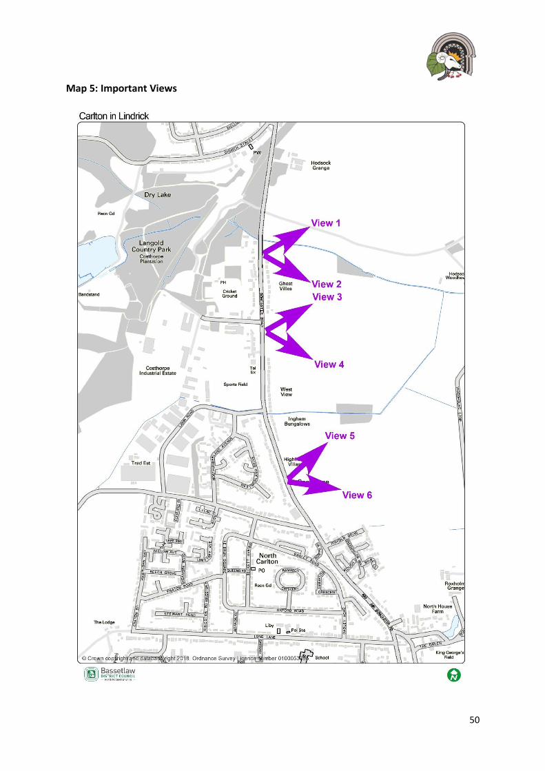
Map 5: Important Views

51
Policy 10: Important Views along Doncaster Road
1. The following views (as identified on map 5) are designated as Important Views: a) View 1: Views Northeast towards Hodsock Grange;
b) View 2: Views Southeast over Ryton Valley and Doncaster;
c) View 3: Views towards, and beyond, Highfield Villas, Doncaster;
d) View 4: Views East over Ryton Valley and countryside;
e) View 5: Views East over Ryton Valley and countryside; and
f) View 6: Views East over Ryton Valley.
2. Development that would detract from the purpose of these important open
views, which is to preserve the open views towards the Ryton Valley and open countryside and rural character of land along Doncaster Road, shall not be supported.
3. Proposals to conserve, protect and/ or otherwise enhance the views for the
benefit of the communities, for leisure, recreation use, and of provision as a
haven for wildlife, will be strongly supported.
Setting of a designated Heritage Asset
4. Regard shall be given to the setting and significance of Blyth Church tower and
Hodsock Grange which are visible from parts of Doncaster Road. Any
development proposals in this area shall identify the ‘’zone of influence’’ and
consider how such views can be enhanced through the proposal.

52
16 Langold Country Park
16.1 Green Infrastructure is a network of green spaces such as parks, recreation grounds,
allotments, canals or rivers, and the connections between these spaces which can deliver a
range of environmental, economic, health and wellbeing benefits for the local community.
The Green Infrastructure network may comprise of spaces in both public and private
ownership, with or without public access. Green Infrastructure in the plan area includes public
parks (Langold Country Park), community gardens, and amenity greenspaces – including play
areas, communal spaces within housing areas, cemeteries, churchyards, ditches, cycle routes,
pedestrian paths, rights of way and bridleways; natural and semi-natural greenspaces and
woodland.
16.2 Green infrastructure can offer a wide range of direct and indirect benefits for a community,
this includes; reducing climate change, improving the quality of a place, improving health and
social wellbeing, protecting and enhancing biodiversity, providing opportunities for local food
production and protecting and enhancing landscape character. It is important that this
Neighbourhood Plan where ever possible encourages the protection and enhancement of
Green Infrastructure in Carlton in Lindrick.
16.3 Within Bassetlaw District Council’s Green Infrastructure Plan May 2010, the vision states:
‘‘In 2026 green infrastructure will be an integral part of the development process, ensuring that people and places in Bassetlaw benefit from a strong network of multifunctional green spaces. Strong connectivity within and between…rural villages and the wider countryside will minimise habitat fragmentation and contribute to green and attractive places where people enjoy living, working and visiting.’’
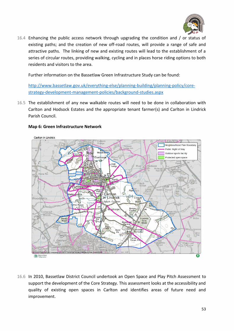
53
16.4 Enhancing the public access network through upgrading the condition and / or status of
existing paths; and the creation of new off-road routes, will provide a range of safe and
attractive paths. The linking of new and existing routes will lead to the establishment of a
series of circular routes, providing walking, cycling and in places horse riding options to both
residents and visitors to the area.
Further information on the Bassetlaw Green Infrastructure Study can be found:
http://www.bassetlaw.gov.uk/everything-else/planning-building/planning-policy/core-
strategy-development-management-policies/background-studies.aspx
16.5 The establishment of any new walkable routes will need to be done in collaboration with
Carlton and Hodsock Estates and the appropriate tenant farmer(s) and Carlton in Lindrick
Parish Council.
Map 6: Green Infrastructure Network
16.6 In 2010, Bassetlaw District Council undertook an Open Space and Play Pitch Assessment to
support the development of the Core Strategy. This assessment looks at the accessibility and
quality of existing open spaces in Carlton and identifies areas of future need and
improvement.
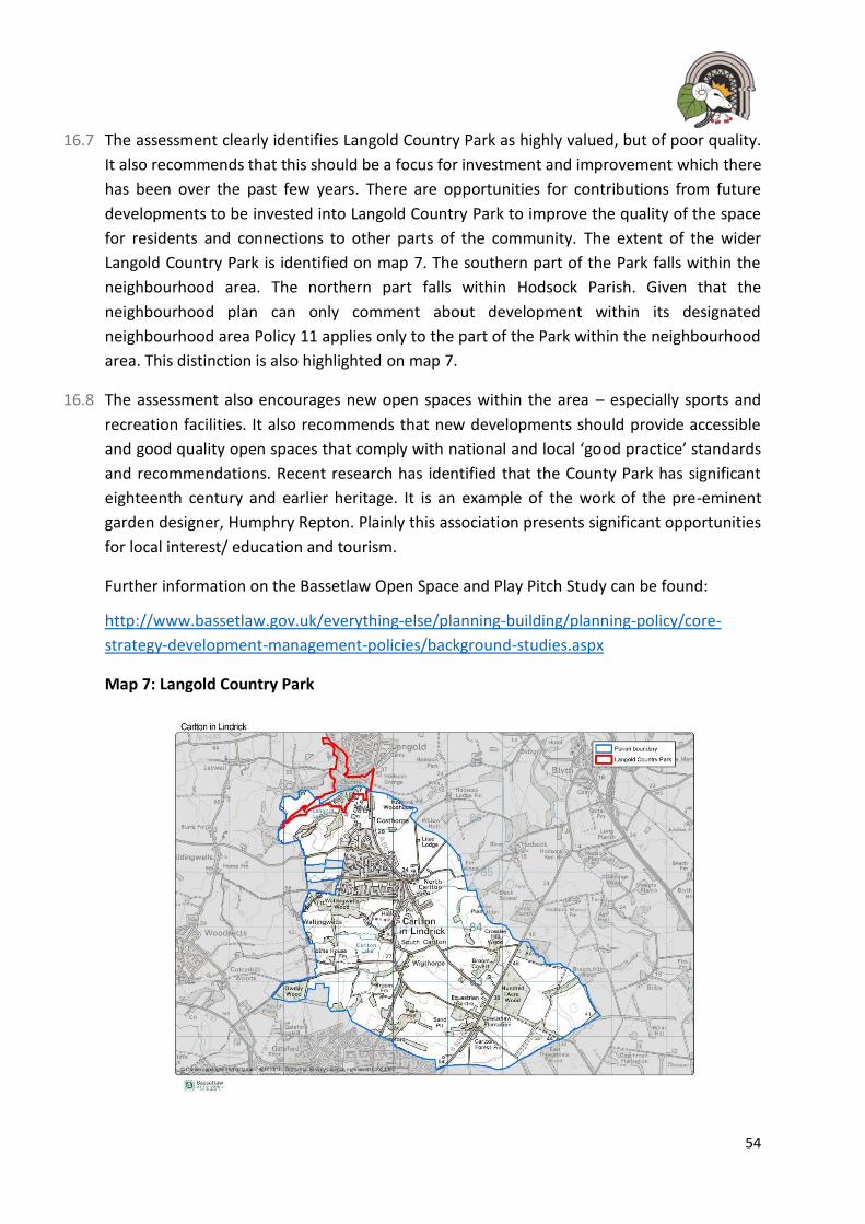
54
16.7 The assessment clearly identifies Langold Country Park as highly valued, but of poor quality.
It also recommends that this should be a focus for investment and improvement which there
has been over the past few years. There are opportunities for contributions from future
developments to be invested into Langold Country Park to improve the quality of the space
for residents and connections to other parts of the community. The extent of the wider
Langold Country Park is identified on map 7. The southern part of the Park falls within the
neighbourhood area. The northern part falls within Hodsock Parish. Given that the
neighbourhood plan can only comment about development within its designated
neighbourhood area Policy 11 applies only to the part of the Park within the neighbourhood
area. This distinction is also highlighted on map 7.
16.8 The assessment also encourages new open spaces within the area – especially sports and
recreation facilities. It also recommends that new developments should provide accessible
and good quality open spaces that comply with national and local ‘good practice’ standards
and recommendations. Recent research has identified that the County Park has significant
eighteenth century and earlier heritage. It is an example of the work of the pre-eminent
garden designer, Humphry Repton. Plainly this association presents significant opportunities
for local interest/ education and tourism.
Further information on the Bassetlaw Open Space and Play Pitch Study can be found:
http://www.bassetlaw.gov.uk/everything-else/planning-building/planning-policy/core-
strategy-development-management-policies/background-studies.aspx
Map 7: Langold Country Park
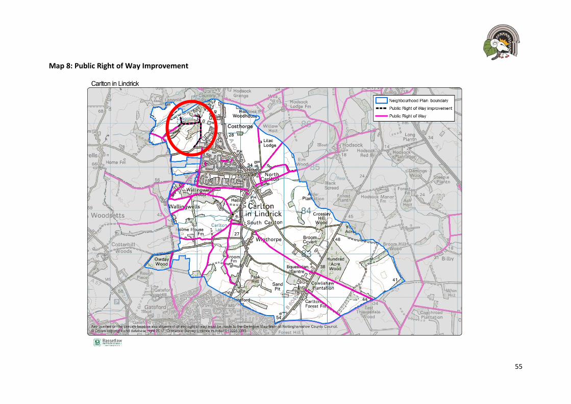
55
Map 8: Public Right of Way Improvement

56
Policy 11: Langold County Park
1. Where appropriate, development proposals on site or adjacent to Langold Country Park, as identified on map 7, will be supported where they deliver the long-term aim of creating an easily accessible and attractive pedestrian and cycle corridor connecting the Park with the rest of the village. Proposals should seek to improve connectivity between the Park and other areas of the village.
2. Development proposals will be supported where they incorporate attractive street furniture, signage and surfacing to improve general connectivity and sense of place in the area.

57
17 Local Green Spaces
17.1 There are number of key public open spaces within the Parish that are not protected, but
form part of the wider green infrastructure to the area and this Neighbourhood Plan seeks to
protect the following through a Local Green Space designation.
The National Planning Policy Framework gives Neighbourhood Plans powers to designate certain areas as Local Green Spaces. The designation gives these spaces the same protection as green belt policy. The Green Infrastructure Project Proposal identified several areas that meet the eligibility criteria in the NPPF (see paragraphs 76-78). The criteria require a Local Green Space to:
- Be in reasonable proximity to the community it serves; - Be demonstrably special to the local community and holds local significance; - Be local in character and is not an extensive tract of land; - Not have previous planning permission(s) within which the Local Green Space
could not be accommodated; and
- Not to be allocated for development within the District Council’s Local Plan.
17.2 It has been suggested, through public consultation and discussions within the Neighbourhood Plan Steering group, that the following sites should be designated as Local Green Spaces as these spaces are currently unprotected and valued for their visual and recreational amenity. The sites identified below are those that are not owned by the Parish Council and have the potential to be developed in the future. Proposals for associated buildings, spaces and fixtures and fittings may come forward within the plan period where they would enhance the six spaces for public use. This will be a matter for the District Council to assess on a case-by-case basis. Whilst built development would conflict with Local Green Space designation there may well be exceptional circumstances that would allow such proposals to achieve planning permission. Open space at Beckett Avenue

58
Open space at the Civic Centre
Open space at Dadley Road

59
Table 6: Proposed Local Green Space Justification
Open Space Area (Ha) Landscape Quality
Historical Quality
Recreational Quality
Ecological Quality
Why it should be protected?
1 Allotments 0.12
Forms part of the wider green infrastructure for Carlton in Lindrick
N/A Informal growing spaces for residents to grow their own food.
Provides a haven for local wildlife such as birds and insects.
The site is considered community assets and is regularly used by local people. There are plans for expansion due to local demand.
3 Lambert Memorial
Ground 0.13
Forms part of the wider green infrastructure for Carlton in Lindrick
Forms part of the military history for the parish.
Regularly used for amenity, rest and tranquillity.
Has some trees and grassed area that is used by local wildlife.
This area is highly valued by the local community and is currently unprotected.
5 Dadley Road 0.20
Forms part of the wider green infrastructure for Carlton in Lindrick
N/A Used frequently as an amenity green space and seating area. Local children often use it in the summer for informal play
Has some trees and grassed area that is used by local wildlife.
It is an important space within an existing development that is used by local people. Children often use it for informal Ply and sport activities.

60
Open Space Area (Ha) Landscape Quality
Historical Quality
Recreational Quality
Ecological Quality
Why it should be protected?
and sport activity.
6 The Grange 0.09
Forms part of the wider green infrastructure for Carlton in Lindrick
N/A Used frequently as an amenity green space and seating area
Largely open grassland
It is an important space within an existing development that is used by local people.
7. Land behind Civic Centre
1.09
Forms part of the wider green infrastructure for Carlton in Lindrick
N/A Used regularly by local families and children for play and informal sport recreation
Largely open grassland
It is an important space within an existing development that is used by local people. Children often use it for informal Ply and sport activities.
8. Beckett Avenue
0.83
Forms part of the wider green infrastructure for Carlton in Lindrick
N/A Used frequently as an amenity green space and seating area
Largely open grassland
It is an important space within an existing development that is used by local people. Children often use it for informal Ply and sport activities.
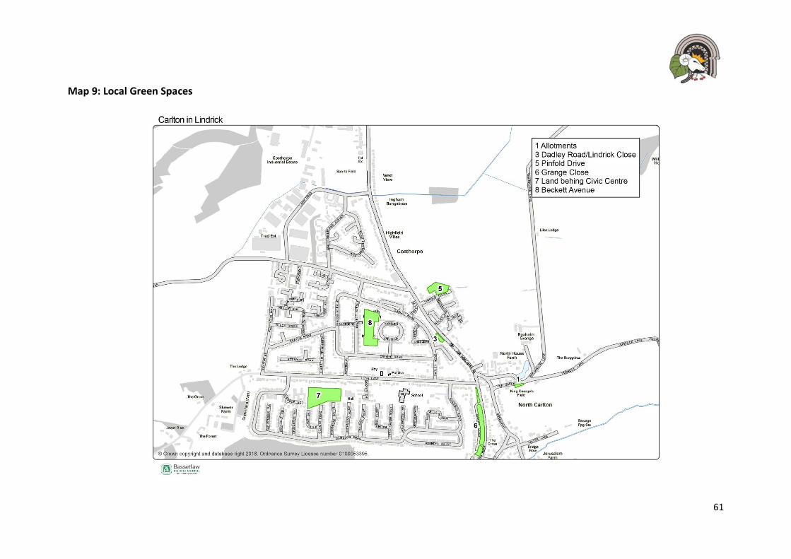
61
Map 9: Local Green Spaces

62
Open space at Lambert Gardens
Policy 12: Local Green Space
1. The following areas as shown on map 9 are designated as Local Green Spaces:
a) LGS1: Allotments;
b) LGS3: Dadley Road/ Lindrick Close;
c) LGS5: Pinfold Drive;
d) LGS6: Grange Close;
e) LGS7: Land behind the Civic Centre; and
f) LGS8: Beckett Avenue.
2. New development will not be supported on land designated as Local Green Space
except in very special circumstances.
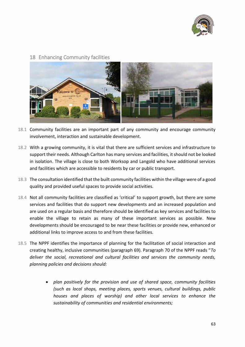
63
18 Enhancing Community facilities
18.1 Community facilities are an important part of any community and encourage community
involvement, interaction and sustainable development.
18.2 With a growing community, it is vital that there are sufficient services and infrastructure to
support their needs. Although Carlton has many services and facilities, it should not be looked
in isolation. The village is close to both Worksop and Langold who have additional services
and facilities which are accessible to residents by car or public transport.
18.3 The consultation identified that the built community facilities within the village were of a good
quality and provided useful spaces to provide social activities.
18.4 Not all community facilities are classified as ‘critical’ to support growth, but there are some
services and facilities that do support new developments and an increased population and
are used on a regular basis and therefore should be identified as key services and facilities to
enable the village to retain as many of these important services as possible. New
developments should be encouraged to be near these facilities or provide new, enhanced or
additional links to improve access to and from these facilities.
18.5 The NPPF identifies the importance of planning for the facilitation of social interaction and
creating healthy, inclusive communities (paragraph 69). Paragraph 70 of the NPPF reads “To
deliver the social, recreational and cultural facilities and services the community needs,
planning policies and decisions should:
• plan positively for the provision and use of shared space, community facilities
(such as local shops, meeting places, sports venues, cultural buildings, public
houses and places of worship) and other local services to enhance the
sustainability of communities and residential environments;
64
• guard against the unnecessary loss of valued facilities and services, particularly
where this would reduce the community’s ability to meet its day-to-day needs;
• ensure that established shops, facilities and services can develop and modernise
in a way that is sustainable, and retained for the benefit of the community; and
• ensure an integrated approach to considering the location of housing, economic
uses and community facilities and services.”
18.6 The key services and facilities within the Parish are identified as:
• The Primary Schools – Kingston Park Academy/ Ramsden Primary School;
• The Coop Food store;
• Carlton Social Club;
• Civic Centre;
• Youth Centre;
• Shop and Post Office;
• St John’s Church;
• Library
18.7 The community supports the development of additional community facilities and believes
new developments can bring new or enhanced facilities in the village. Through the
consultation it was recognised that the village had some good quality facilities such as the
Civic Centre and Youth Centre.
18.8 During the consultation period, some of the comments received from the residents were as
follows:
‘The Civic Centre needs protecting’
‘Community services and events in the village need protecting’
‘Concerned that the library will close’
‘Carlton could do with some more things for younger people’
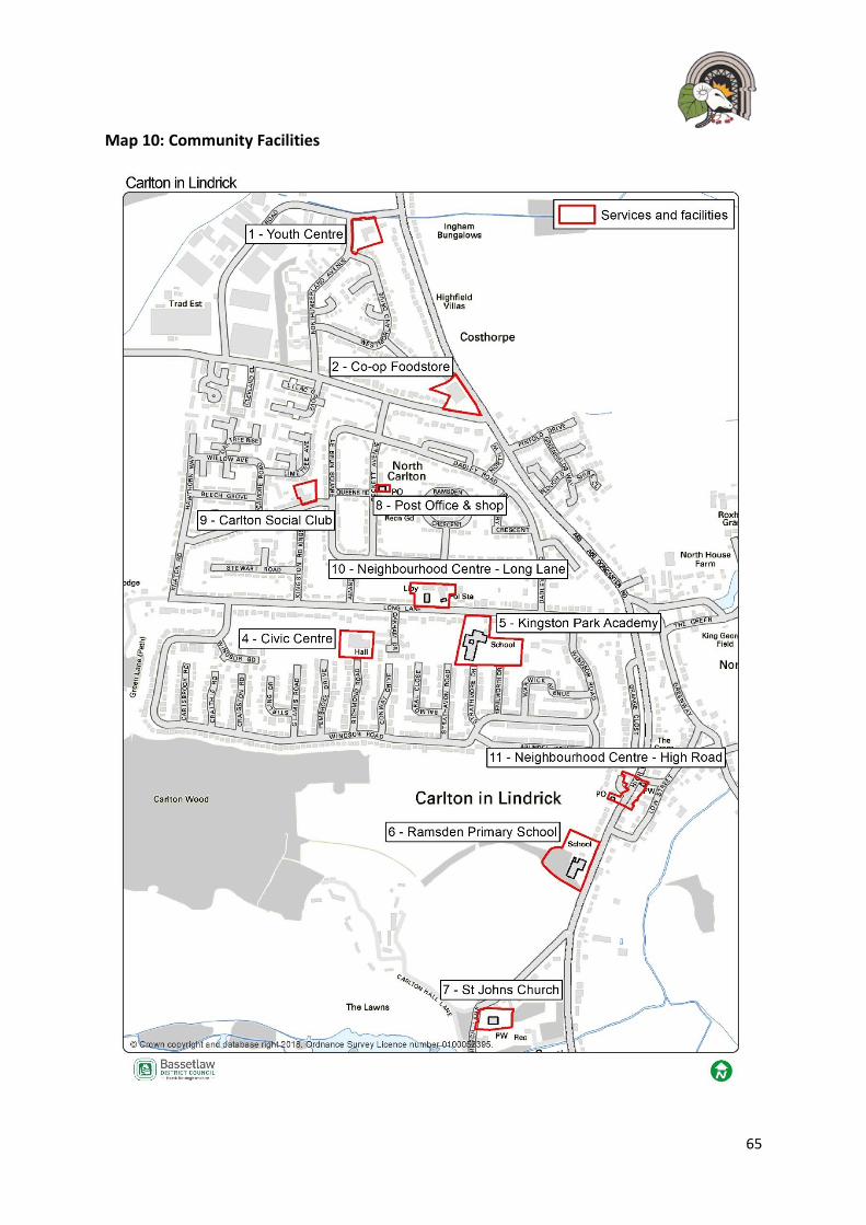
65
Map 10: Community Facilities

66
Policy 13: Enhancing Community Facilities
Existing Facilities
1 The existing facilities shown on map 10 outside the two designated neighbourhood
centres will be safeguarded for community purposes throughout the plan period.
Proposals for their redevelopment or change of use to other purposes will not be
supported unless alternative community facilities are proposed as part of the
development concerned or that it can be demonstrated that the existing use is
unviable.
New Facilities as part of wider development proposals
2. Where new community facilities are deemed necessary as part of a wider
development proposals (such as the development of the identified allocated sites
in this Plan), developers will be expected to provide such relevant facilities either
directly onsite and/ or offsite, through a financial contribution, either alone or
cumulatively with other developers.
3. Opportunities to incorporate community facilities within, or directly adjacent to,
the development site should be sought in the first instance. Offsite provision may
be acceptable as an alternative if:
a) there is insufficient space available onsite/ directly adjacent to the site; or
b) Incorporation of the facility onsite/ directly adjacent to the site would not be
financially viable; or
c) It would be more appropriate to contribute (in whole or part) to the
establishment or expansion of a facility elsewhere to meet wider demand or
combine existing facilities.
67
19 Neighbourhood Centres
19.1 The Neighbourhood Plan Steering Group, the Parish Council and the community believe it is
vital to protect and enhance the existing retail services and facilities within the village. These
services and facilities provide valuable amenities for residents within Carlton and
neighbouring communities. During consultation, residents wanted to encourage a broader
level of retail provision within the area. It was also highlighted that there are issues with
accessibility, through a lack of reliable public transport to access services and retail in
Worksop or Doncaster. Residents were also concerned about an increasing number of hot
food take-aways which could impact the vitality of the area.
19.2 Retail provision is an important asset to the village and it is important that the existing retail
provision is protected and enhanced to support a growing and sustainable community. The
Bassetlaw Retail and Leisure Study (2017) undertook a ‘health check’ on the identified
Neighbourhood Centres and identified a range of retail provision with no vacant units
indicating a healthy retail situation within the village.
19.3 Within the Neighbourhood Centres, development proposals will be encouraged where the
schemes are shown to make a positive contribution to the retail experience including how the
development supports other policies within this Neighbourhood Plan. Local people expressed
support for new facilities and retail offer within the village. However, people also raised
concern about the lack of choice in shops and the increase in hot food takeaways which are
often shut during the daytime and cause the area to be unsightly with metal shutters.
19.4 People wanted to see the areas attractiveness improved and the regeneration of the shop
fronts, paving and signage to encourage use and new businesses into the area.
Neighbourhood Centre (1) – at Long Lane was an area that was identified by residents that
needed improvements. Urbanised shop frontages, litter and inadequate lighting were all
raised during public consultation.
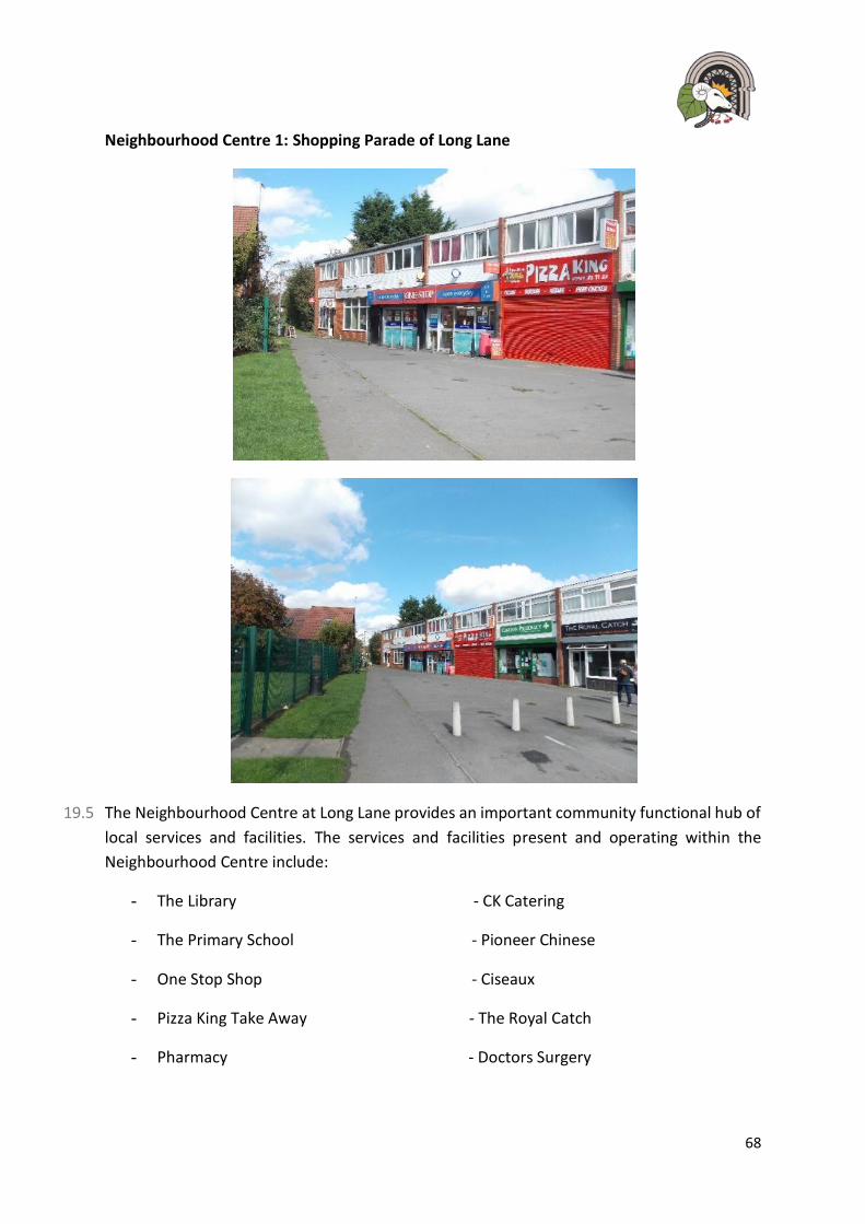
68
Neighbourhood Centre 1: Shopping Parade of Long Lane
19.5 The Neighbourhood Centre at Long Lane provides an important community functional hub of
local services and facilities. The services and facilities present and operating within the
Neighbourhood Centre include:
- The Library - CK Catering
- The Primary School - Pioneer Chinese
- One Stop Shop - Ciseaux
- Pizza King Take Away - The Royal Catch
- Pharmacy - Doctors Surgery
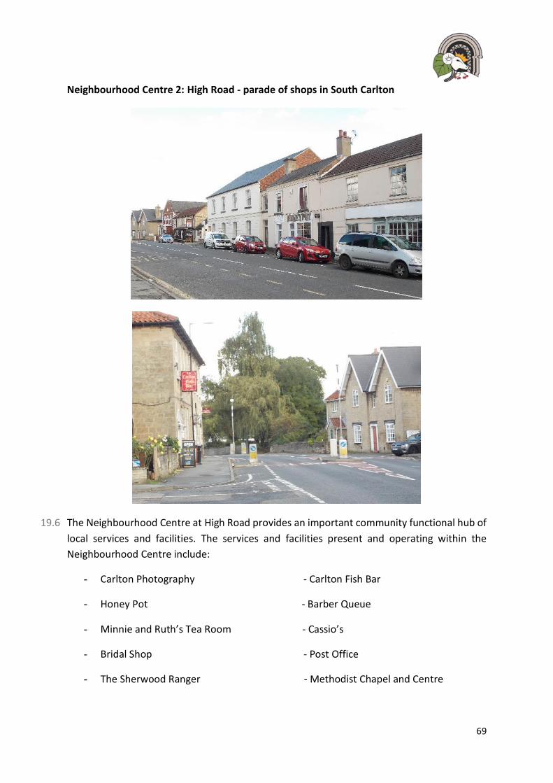
69
Neighbourhood Centre 2: High Road - parade of shops in South Carlton
19.6 The Neighbourhood Centre at High Road provides an important community functional hub of
local services and facilities. The services and facilities present and operating within the
Neighbourhood Centre include:
- Carlton Photography - Carlton Fish Bar
- Honey Pot - Barber Queue
- Minnie and Ruth’s Tea Room - Cassio’s
- Bridal Shop - Post Office
- The Sherwood Ranger - Methodist Chapel and Centre
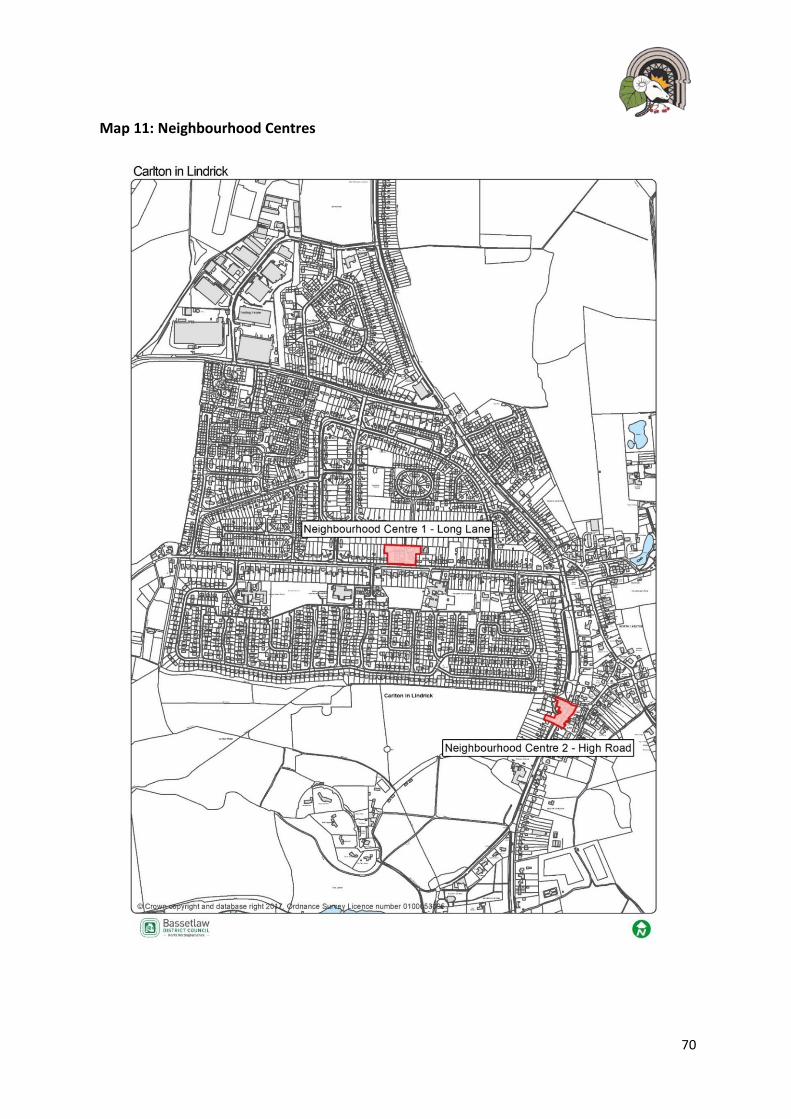
70
Map 11: Neighbourhood Centres
71
Policy 14: Neighbourhood Centres
1. Proposals involving the change of use, at ground floor level, of these retail
facilities, including A1, A2, A3, A4 and A5 to non-retail uses, within the
Neighbourhood Centre, as identified on map 11, will not be supported unless it
can be demonstrated, to the satisfaction of the Local Planning Authority, that
there is no longer a need for the facility or the premises are unsuitable or not
economically viable** for the continued provision of a retail facility.
2. New retail facilities will be supported where they are providing a mix of retail
provision within that specific centre and contribute towards the continued
vitality of the Neighbourhood Centre.
3. Development for the provision, alteration or replacement of shop fronts and
signs in the High Road Neighbourhood Centre will be supported provided:
a) they do not require the loss of an existing shop front with a historic value;
b) the design, colour, materials and details of the alterations to and
replacements of shop fronts and signage sustain or enhance the character
of the building and surrounding shop frontages and are in-keeping with the
Carlton Conservation Area.
4. Proposals that seek to improve the public realm of the Neighbourhood Centres
shall be supported where the materials contribute towards the improvement of
wider public amenity and enhance the character of the area.
**Applicants will be expected to demonstrate, to the Council’s satisfaction, that all
reasonable efforts have been to sell and let the site or premises for its existing use(s) or
another community use at a realistic price for, at least, a 12-month period.

72
20 Community Aspirations and Priority Projects
20.1 The Neighbourhood Plan aims to achieve community priorities and recognises not all of these
can be delivered through planning policies. Throughout the consultation period, the
community identified several projects that they would like to see delivered through this
Neighbourhood Plan. These projects are closely link to Community Infrastructure Levy
priorities and are to be delivered over the longer term and therefore are aspirational.
Community Aspiration 1: Improvements to Doncaster Road/ Long Lane junction
A significant number of residents highlighted the need to improve the traffic flow and pedestrian safety at the Long Lane/ Doncaster Road junction. It was stated that during peak times of the day, there could be significant hold ups and there have been issues with public safety.
Residents suggested that some monies received from CIL could be used to improve these issues and make the area safer for users.
Community Aspiration 2: Regeneration of the vacant site at Warwick Avenue
An area on Warwick Avenue has laid redundant for a few years and residents have indicated that this could be an area to see redevelopment to contribute to the regeneration of the area.
Community Aspiration 3: Improved Langold Country Park
Many people wanted to see Langold Country Park improved to increase usage and maximise its potential.
Upgrading the play facilities for children
Improving the car parks and public conveniences
Increase the level of attractions within the Park
Improve the access to and from the Park
Community Aspiration 4: Improved skills and training opportunities for residents
To further improve the social-economic issues identified within the social profile, it is believed that opportunities for increased choice and awareness of new training programs should be supported. This could be through new developments, but also through the collaboration between nearby education facilities, developers and the wider community.

73
21 Implementation and Review of this Neighbourhood Plan
21.1 The policies in this Plan will be implemented by Bassetlaw District Council as part of their
development management process. Where applicable Carlton in Lindrick Parish will also be
actively involved. Whilst Bassetlaw District Council will be responsible for development
management, Carlton in Lindrick Parish Council will use the Neighbourhood Plan to frame its
representations on submitted planning applications.
21.2 The use of section 106 agreements for Affordable Housing, planning conditions and the
Community Infrastructure Levy by Bassetlaw District Council will be expected to assist in
delivering the objectives of this Plan.
21.3 The Parish Council will use this and other funds as leverage to secure funding from other
programmes, for example the Lottery and other Government initiatives as they become
available.
21.4 As the Neighbourhood Plan will become part of a hierarchy of planning documents the Parish
Council will also look to District and County Council investment programmes where a policy
and/or project can be shown to be delivering District and County objectives.
21.5 The impact of the Neighbourhood Plan policies on influencing the shape and direction of
development across the Plan area will be monitored by the Parish Council. If it is apparent
that any policy in this Plan has unintended consequences or is ineffective it will be reviewed.
21.6 Any amendments to the Plan will only be made following consultation with Bassetlaw District
Council, residents and other statutory stakeholders as required by legislation.
21.7 The Neighbourhood Planning Act 2017 now requires all ‘made’ Neighbourhood Plans to be
reviewed every 5 years and the Parish Council will monitor the Neighbourhood Plan to make
sure it is working effectively and is up-to-date with any changes to national or local planning
policy.

74
22 Appendix 1: Community Consultation
22.1 An underlying principle in this Neighbourhood Plan is to have local people actively involved
in ongoing consultation on important planning issues. Many of our policies expressly call for
community involvement designed to understand local views about development proposals
before planning applications are submitted.
Pre- Application Consultation should involve the following:
a) An explanation of how a broad cross-section of local people, both in the immediate area likely to be affected by the development proposals and in the wider neighbourhood, was consulted on the development proposals in a timely fashion.
b) The means used to involve and engage with local people in consultation, using a range
of ways in which input, and comments could be provided. For example, a variety of publicity and the opportunity to provide web-based comments as well as attending events in person.
c) A record of the views expressed by local people and the relevant Parish Council.
d) An explanation of how the proposals being submitted following this Consultation have
addressed the views of and any issues or concerns raised by local people and the Parish Council.

75
23 Appendix 2: Site Assessment Report
Please see separately attached document.

76
Thank you for taking the time to read Carlton’s Neighbourhood Plan.
If you require further information about the Neighbourhood Plan then please contact:
Carlton Parish Council
Civic Centre
Long Lane
Carlton in Lindrick
S81 9AP
Alternatively, you can email:
You can also find out more information about Neighbourhood Planning at:
www.locality.org/neighbourhoodplanning
www.bassetlaw.gov.uk
November 2018