Embed Size (px)
Citation preview
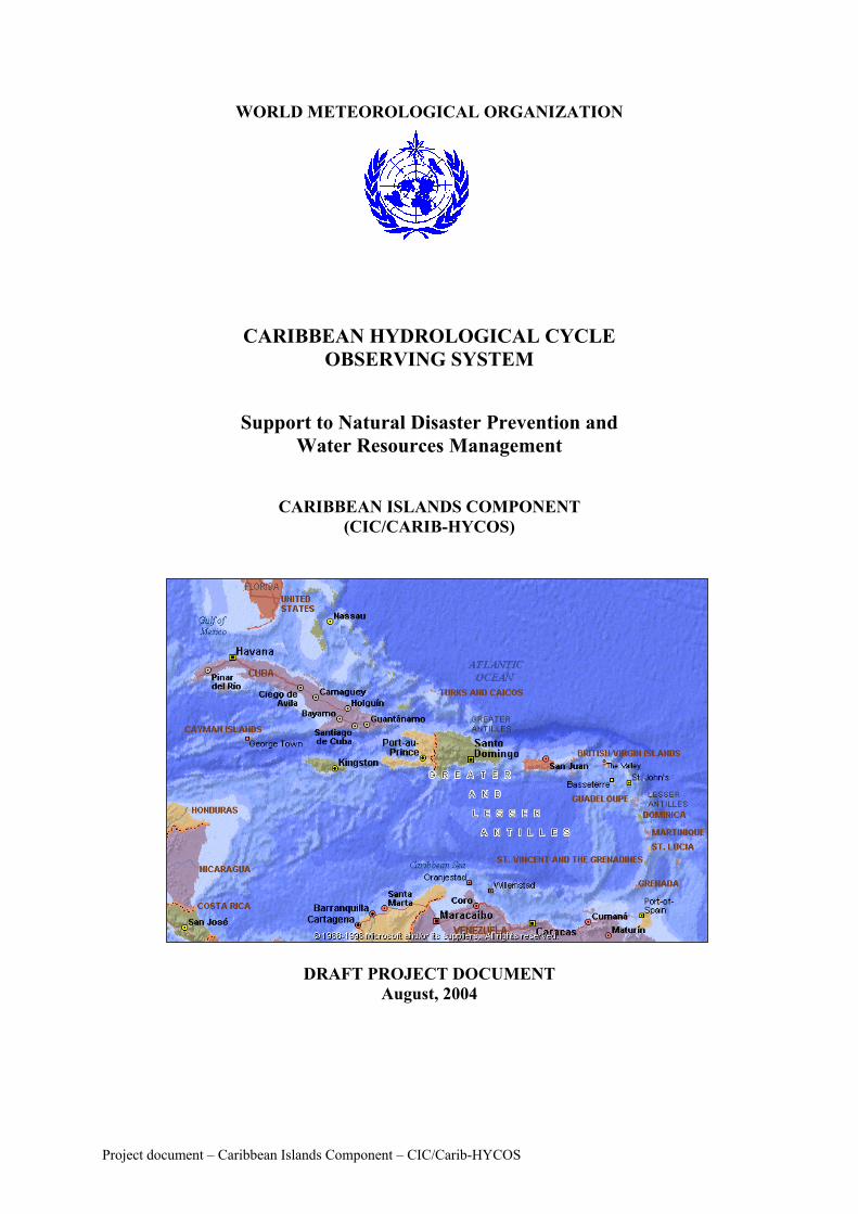
WORLD METEOROLOGICAL ORGANIZATION
CARIBBEAN HYDROLOGICAL CYCLE OBSERVING SYSTEM
Support to Natural Disaster Prevention and Water Resources Management
CARIBBEAN ISLANDS COMPONENT (CIC/CARIB-HYCOS)
DRAFT PROJECT DOCUMENT
August, 2004
Project document – Caribbean Islands Component – CIC/Carib-HYCOS
SUMMARY 1. GENERAL CONTEXT.......................................................................................................... 1
1.1. Partner countries............................................................................................................. 1 1.2. Thematic context ............................................................................................................. 1 1.3. Geographical context....................................................................................................... 2 1.4. Socio-economic context .................................................................................................. 3 1.5. The water resources......................................................................................................... 3 1.6. Demand ........................................................................................................................... 4
2. PROJECT OBJECTIVES ...................................................................................................... 5 2.1. Development objectives ................................................................................................. 5 2.2. Immediate objectives....................................................................................................... 5
3. PROJECT COMPONENTS................................................................................................... 6 3.1. Project components ......................................................................................................... 6
3.1.1. COMPONENT I – Disaster mitigation .................................................................... 7 3.1.1.1 SUB-COMPONENT A – Flood forecasting and warning ................................. 7 3.1.1.2 SUB-COMPONENT B – Drought forecasting ................................................. 8
3.1.2 COMPONENT II – Water-related knowledge base.................................................. 9 3.1.2.1 SUB-COMPONENT C – Water resources assessment..................................... 9 3.1.2.2 . SUB-COMPONENT D - Groundwater assessment and monitoring ............. 10 3.1.2.3. SUB-COMPONENT E - Water quality assessment and monitoring............. 11 3.1.2.4. SUB-COMPONENT F - Water resources databases ...................................... 11
3.1.3. COMPONENT III – Regional Co-operation ......................................................... 12 3.2. Regional computer network .......................................................................................... 13 3.3. Regional water resources databank ............................................................................... 13 3.4. Carib-HYCOS Internet site ........................................................................................... 13 3. 5. Strengthening the institutional capacity of the national agencies ................................ 14 3.6. Promotion of research activities .................................................................................... 14
4. INSTITUTIONAL ASPECTS ............................................................................................. 14 4.1. National Hydrological Services .................................................................................... 14 4.2. The Technical Assistance (French Research Institute for Development - IRD)........... 15 4.3. Project governance, procedures & implementation ...................................................... 15
4.3.1. The Project Steering Committee (PSC) ................................................................ 17 4.3.2. The Executing Agency .......................................................................................... 17 4.3.3. The National Hydrological Services (NHS)........................................................... 17 4.3.4. The Project Regional Centre (PRC) ....................................................................... 18 4.3.5. The Supervising Agency (WMO) .......................................................................... 19
4.4. Project implementation ................................................................................................. 19 4.4.1. Project rationale...................................................................................................... 19 4.4.2. The means .............................................................................................................. 20
4.4.2.1. At the Project Regional Centre (PRC) and the Project Management ............. 20 Unit (PMU) .................................................................................................................. 20
Human resources: ..................................................................................................... 20 Equipment ................................................................................................................ 21
4.4.2.2. In the National Hydrological Services ............................................................ 21 Human resources ...................................................................................................... 21 Equipment ................................................................................................................ 21
5. PROJECT COST.................................................................................................................. 22
Project document – Caribbean Islands Component – CIC/Carib-HYCOS
6. BENEFITS AND SUSTAINABILITY OF THE PROJECT............................................... 25 7. INNOVATIVE ASPECTS AND REPLICABILITY .......................................................... 26 8. RISKS AND CONDITIONS ............................................................................................... 27
8.1. Hypotheses at different levels ....................................................................................... 27 8.2. Risks and risk-avoidance stategies................................................................................ 27 8.3. Regional co-operation ................................................................................................... 28 8.4. Protection of the environment ....................................................................................... 28 8.5. Socio-cultural aspects.................................................................................................... 28 8.6. Institutional capacity and management ......................................................................... 29
9. PROJECT PROGRESS AND EX POST ASSESSMENT .................................................. 29 9.1. Project progress ............................................................................................................. 29 9.2. Ex post evaluation criteria............................................................................................. 30
9.2.1. Progress criteria...................................................................................................... 30 9.2.2. Final evaluation ...................................................................................................... 30
LIST OF ACRONYMS............................................................................................................ 31 ANNEX 1 - PROGRAMMME OF ACTIVITIES ................................................................... 32 ANNEX 2 - TERMS OF REFERENCE FOR THE REGIONAL CENTRE (RC).................. 37 ANNEX 3 - TRAINING PROGRAMME PROPOSAL .......................................................... 39 ANNEX 4 - DATABASE SOFTWARE SPECIFICATIONS................................................. 41 ANNEX 5 - CARIB-HYCOS WEBSITE ................................................................................ 43 ANNEX 6 - PROJECT CO-ORDINATOR ............................................................................. 45
Project document – Caribbean Islands Component – CIC/Carib-HYCOS
1. GENERAL CONTEXT 1.1. Partner countries The Caribbean archipelago consists of a chain of islands stretching from the Bahamas in the North to Trinidad and Tobago in the South and border the Caribbean Sea to the North and to the East.. Politically the archipelago is subdivided in twenty states and territories. Barbados, Cuba, Dominican Republic, French Antilles (Guadeloupe and Martinique), Haïti, Jamaïca, Trinidad and Tobago expressed interest in participating in the Caribbean Island Component of Carib-HYCOS (Carib-HYCOS/CIC). 1.2. Thematic context To reconcile the needs for good quality freshwater with environmental protection is one of the greatest challenges humanity is facing at the beginning of the 21st century. The most obvious way to success is through improving water management. The Agenda 21 (UNCED, 1992) Chapter 18 on freshwater and the report of the International Conference on Water and the Environment (ICWE, 1992) on which it was based, recognize that knowledge of the water cycle (quantity and quality) is the essential basis for efficient water management. Water assessment, monitoring and management is dependent on the existence of reliable water resources information systems both at national and regional levels, covering not only the collection and analysis of data but also the exchange and dissemination of these data and related information to the users, ranking from the general public to decision makers. Moreover, Chapter 18, the ICWE report and the WMO/UNESCO report on water resources assessment (1991) stress that, in many regions of the world, these information systems are not functioning adequately or do not exist at all. In 1994 The UN Genersal Assembly adopted the Declaration of Barbados and the relevan Programme of Action, for addressing the issues related to the sustainable development of Small Islands Developing States. Among the priorities identified in Programme of action are: the establishment and strengthening of disaster preparedness schemes, the integration of such schemes in the national development planning process, the strengthening of the monitoring the resource so as to respond to natural and environmental hazards, including droughts and floods. In response to the international community demands, the World Meteorological Organization (WMO), in association with international development partners including the World Bank, the European Commission, the French Development Agency and the Government of Netherlands, cooperated to promote the World Hydrological Cycle Observing System (WHYCOS), based on a global network of reference stations with real-time satellite based data transmission to enable the development of consistent, high quality and constantly updated distributed national, regional and international data bases on river flow, water quality and certain climatic variables. The development objective of WHYCOS is to provide a scientific basis for water resources assessment and integrated, intersectoral and intercountry water resources development and management. It facilitates collaboration among regional groupings of Members, and uses the data transmission capabilities of WMO’s World Weather Watch system to provide near real-time information on the status of the water resource at selected key locations. WHYCOS is a response to recommendations of the United Nations Conference on Environment and Development (UNCED-1992), and the UN Commission on Sustainable
Project document – Caribbean Islands Component – CIC/Carib-HYCOS 1
Development (CSD), which in 1994 and later on in 1998, called for the strengthening of efforts towards a comprehensive assessment of freshwater resources. The above objective is achieved by means of a basic regional network of Data Collection Platforms (DCPs) installed at benchmark hydrological stations and equipped with automatic sensors for the measurement and transmission in real-time of water quantity and quality and meteorological variables. These data are transmitted through the GOES Data Collection System. The data would be received, in real-time, by the participating countries and regional and sub-regional centres either through existing segments of the Global Telecommunication System (GTS) of WMO or/and Direct Readout Stations (DRSs) to be installed as necessary. Other means of real time data transmission, such as VHF radio or telephone (landlines or cellular systems) can also be considered, in accordance to the constraints and facilities available in each country. Generally the stations would be selected from existing ones, which might be upgraded to meet the standard agreed upon for the regional network by the participating countries. The stations would be selected mainly on the basis of their national and regional interest. The concept is being implemented through a two-pronged, fully integrated approach whereby WHYCOS provides the framework and general guidance, and a series of HYCOSs provide the implementation at the basin or regional level in support of the specific needs of the end-users of the information. There is a significant capacity-building component to each HYCOS. A number of HYCOS projects are already being implemented while others are under different stage of development or implementation. The WHYCOS regional components, including the CARIB-HYCOS (CIC) are intended to act as a tool for the improvement of collection, dissemination and use of high quality, standardized and consistent hydrological information at national, river basin, regional and international levels. Both the quantity of water available and its quality are important and the data collected should be available to users from a database accessed through international communication networks (Internet) for the benefit of the different socio-economic sectors. The WHYCOS initiative provides an ideal basis and a framework for cooperation in water resources monitoring, assessment and integrated water resources development and management at community, river basin, national, regional continental and global levels. It will contribute to knowledge of hydrological processes in their interaction with climate and the environment, and will encourage intersectoral sharing of water resources data and information for sustainable development. 1.3. Geographical context The Caribbean archipelago consists of a chain of islands stretching from the Bahamas in the North to Trinidad and Tobago in the South. The island countries include Antigua and Barbuda, Barbados, the Bahamas, the British Caribbean Territories (Anguilla, British Virgin Islands, Cayman Islands, Montserrat, Turks and Caicos Islands), Cuba, Dominica, Dominican Republic, French Antilles (Guadeloupe and Martinique), Grenada, Haiti, Jamaica, the Netherlands Antilles and Aruba, Puerto Rico (USA), St. Kitts and Nevis, St. Lucia, St. Vincent and the Grenadines, Trinidad and Tobago and the US Virgin Islands.. Except for Grenada, St. Kitts and Nevis, and St. Vincent and the Grenadines, all other island countries hold membership in WMO Region IV. Barbados, Cuba, Dominican Republic, the French Antilles (Guadeloupe and Martinique), Haïti, Jamaïca, Trinidad and Tobago have been
Project document – Caribbean Islands Component – CIC/Carib-HYCOS 2
identified at present, as countries which has good opportunities for a successful development of the project, having in mind the development of National Hydrological Services and the most urging country needs Overall, the islands of the Caribbean are characterised by:
• The fact that the majority of their populations are concentrated on the coastal belt; • A high concentration of economic and recreational activities, and settlement in a
relatively small area; • An urban population increasing much faster than the national average; • Coastal aquifers increasingly subject to salt water intrusion and contamination from
human wastes and industrial effluent; • Small streams; • A fragile environment; • Agricultural production of monoculture crops of sugar or bananas; • High dependence upon tourism; • High vulnerability to natural hazards and limited capacity to recover from disasters; • Water management issues dominated by concerns of domestic water supply and
recreational uses. Thus, the Caribbean is characterised by a very high degree of stress on the environment, both from the pressures of economic activity and human development on a limited area of land and from its limited capacity to absorb or to recover quickly from disasters caused by hurricanes, storm surges, floods, earthquakes and pollution. The islands find themselves on the front line of the effects of global warming such as the rise in sea level. 1.4. Socio-economic context The Caribbean Islands range from large islands like Cuba – 110,860 km2 - with a population of 11 million and a diversity of water resource management issues, to small islands like Barbados – 430 km2 - with a population of 262,000, limited surface water resources, and groundwater resources that are now almost fully allocated. Many of the islands have high population densities, are vulnerable to natural disasters and are already experiencing water shortages and groundwater pollution. In 1995 the total population of the Caribbean Islands was approximately 38 million. Caribbean countries also face structural problems. These include insufficient economic diversification away from agriculture, and high levels of unemployment. The GDP of the countries in the Caribbean varies from US $3.5 billion (the Bahamas) to US $171 million (St. Kitts and Nevis). Annual GNP is also highly variable from country to country ranging from a low of $230 per person per year in Haiti to $8,770 per person per year in Antigua and Barbuda. 1.5. The water resources Except for Barbados, the Bahamas, Antigua, Barbuda and parts of the Netherlands Antilles, which already use desalinised water, rainfall is the sole source of water in the region. Trinidad is currently developing its desalination capabilities primarily for industrial use. Other Caribbean countries get their water from rainfall, surface water and groundwater.
Project document – Caribbean Islands Component – CIC/Carib-HYCOS 3
The region is highly dependent on rainfall to feed surface water intakes and replenish ground water reserves. Rainfall distribution patterns vary significantly and rainfall patterns change causing droughts that limit stream flow and reservoir storage, or increase flooding. The rivers in the Windward Islands (Dominica, St Lucia, St Vincent and the Grenadines and Grenada) are small with steep gradients and during the dry season flows are fairly small with insignificant changes in water levels, but during the rainy season the situation is completely different: from June to November intense rainfalls can occur from tropical cyclones and these normally tranquil streams can rage with highly turbid flows of high velocity as they transport immense volumes of water to the sea. In the Leeward Islands (Antigua-Barbuda, Anguilla, Montserrat, British Virgin Islands and St. Kitts-Nevis) and in the Northern Caribbean Turks and Caicos Islands conditions are semi arid, with no rivers but only ghuts that flow after heavy showers a few times a year; these islands depend for their water supply on ground water resources. In many countries the annual per capita freshwater availability is less than 1000 cubic meters -the threshold used to define scarcity. Geological conditions differ in the islands and therefore further complicate water resources management. Urbanization is posing a serious problem to countries with a heavy reliance on groundwater, as recharge areas are reduced and groundwater levels are lowering. Most Caribbean countries have limited means to expand the supply of water whilst maintaining its quality, and to expand water supply services to meet the ever-increasing need of industry and population. It has been indicated that the majority of the countries are already experiencing or are approaching a situation where estimated water demand equals or exceeds maximum annual renewal of freshwater resources. Pollution of water resources is a major environmental problem in most islands. The major causes of water quality degradation are pollution from high population densities especially in cities, changes in land use, leachates from agricultural chemicals, inappropriate disposal of waste, and pollution by human activities such as mining, agriculture, manufacturing, and industry. It should be noted that the final outlet for the stream flows is the Caribbean Sea, a real receptacle for all kinds of pollutants. 1.6. Demand As regards the economic status, it is impossible to assure the long-term sustainability of a hydrological information system if it does not clearly meet the needs of which the users are aware, and the benefits clearly exceed the costs and the benefits of other possible expenditures. The major areas of high water demand in the Caribbean islands are agriculture, tourism, industry, and urbanization. In most of the islands, tourism as a lead strategy is receiving fresh impetus and is generating efforts by the governments to encourage local and foreign investment in the industry. Of particular concern is the implicit increase in water demand caused by a rapidly expanding tourism sector that also will cause increased
Project document – Caribbean Islands Component – CIC/Carib-HYCOS 4
problems of waste disposal and water quality deterioration, including the discharge of pollutants to the Caribbean Sea and the related ecological effects (corraloïd massifs). It is also expected that the water demand in the manufacturing sector will increase. In agriculture the focus is on food security but also on production of export-crops. Demand for irrigation water will therefore increase to satisfy the needs of further expansion of plantations. This will require more efficient use of water through adequate management of watersheds and the use of appropriate water supply technologies. Population increase could also have an impact on water demand but the annual growth rate in the region is expected to remain below 1.4 per cent, and this is considered to be relatively modest. However, increasing urbanization will also result in a higher water demand, and increased urban waste could pose a threat to water quality unless adequate waste disposal and treatment facilities are provided. 2. PROJECT OBJECTIVES 2.1. Development objectives The proposed Caribbean Island Component of CARIB/HYCOS (CIC–CARIB/HYCOS) would have the following development objectives:
• Reduce the loss of human life and material damage caused by natural disasters, through the introduction of modern flood forecasting and warning systems, thus enhancing natural disaster mitigation capabilities;
• Support sustainable development and integrated management of water, based on an improved knowledge base of water resources, both as regards quantity, quality and use, resulting in a strengthening of water management capabilities;
• Create a knowledge base on outflow, in terms of quantity and quality, to the Caribbean Sea, which will allow a better understanding of the environment, and the potential alterability of the coralloid massifs,
• Increase the exchange of information and experience, particularly during natural disasters, by fostering regional co-operation in water resources concerns;
• Develop technological capabilities (including training and technology transfer) appropriate to the circumstances and realities of each country, by promoting institutional capacity building.
2.2. Immediate objectives
• Assist, as required, the NMHSs of the participating countries in the modernization and strengthening of their activities related to water resources , so as to provide them with more reliable systems and data for the issuance of more accurate short, medium and long-term forecasts and, in general, of all products required to meet the needs and requirements of the public and the economic sectors most heavily dependent on water and the environment;
• Promote co-operation among the participating countries and the rest of the
Caribbean Basin countries, by means of:
Project document – Caribbean Islands Component – CIC/Carib-HYCOS 5
o Better knowledge of regional hydrometeorological phenomena and climatological and environmental trends, in particular during severe events such as floods and droughts;
o Relevant information on outflow to the Caribbean Sea in terms of discharges but also in terms of pollutants;
o Regional institutional capacity-building, including training and technology transfer.
• Promote the exchange of information, technology and experience among the participating countries, by means of:
o Development of a regional data base, easily accessible via Internet by all
participants, containing data, metadata and other water related information o Organization of seminars and workshops for improving the skills and
knowledge of the staff of the NHSs involved
3. PROJECT COMPONENTS 3.1. Project components Based on the overall concept of WMO’s WHYCOS, the Caribbean Islands Component (CIC) of CARIB/HYCOS project proposal has been developed to address the above concerns, taking into account the particular situation of the island countries. The project would comprise a number of components in each participating country that together, through regional co-ordination, will assist in building national capacities to obtain and manage information about their water resources and enhance disaster mitigation. The conceptual framework is common for all participating countries. The following general considerations would be implicit in the development and implementation of the project:
• To take into account the infrastructure and capabilities that already exist in the region, and to build on the assistance and support (bi- and multilateral) that already has been or is being provided to a number of participating countries;
• To use as far as possible a common regional approach to common problems, both for flood and drought forecast and for the global context of outflow to the Caribbean Sea;
• To address immediate and specific needs as well as make provision for medium and long-term requirements;
• To aim to provide benefits that are sufficiently tangible so that post-project sustainability is probable;
• To ensure the Project is implemented as far as possible by Caribbean island NHS themselves, with guidance and support from international experts where necessary.
The project would be structured in a number of main components; this would have the advantage of allowing the components, although closely related, to be executed individually. COMPONENT I – Disaster mitigation
SUB-COMPONENT A – Flood forecasting and warning SUB-COMPONENT B – Drought forecasting
Project document – Caribbean Islands Component – CIC/Carib-HYCOS 6
COMPONENT II – Water-related knowledge base SUB-COMPONENT C – Water resources assessment SUB-COMPONENT D - Groundwater assessment and monitoring SUB-COMPONENT E - Water quality assessment and monitoring SUB-COMPONENT F - Water resources databases
COMPONENT III – Regional Co-operation
3.1.1. COMPONENT I – Disaster mitigation
3.1.1.1 SUB-COMPONENT A – Flood forecasting and warning For many of the islands of the Caribbean, disaster mitigation with respect to hurricanes has high priority. A number of these countries have therefore already established flood forecasting and warning systems based on data from real-time stations, either via radio relay or satellite telemetry. On the other hand and with few exceptions, the island nations in the Caribbean are mountainous, with numerous small watersheds. While these countries would benefit from a real-time DCPs-based hydro-meteorological network of stations strategically located in each country as envisaged in the overall WHYCOS concept, the above situation would mean that a great number of DCP stations would be needed for flood forecasting and warning purposes, the cost of which would be prohibitive for most countries. In the initial stage, it is believed that a few strategically located real-time stations would be most beneficial as a warning system for extreme hydrological events. By using compatible satellite-transmitting stations and associated computer hardware and software, the local warning stations would become part of a regional network that in addition, could be used to support regional and global-change research. A regional meteorological/climatological data bank developed as part of CARIB-HYCOS would be an important tool for predicting extreme hydrological events (see Component II below). It is therefore proposed to establish a regional real-time hazard alert network with DCPs installed at selected stations and equipped with automatic sensors for hydrological, meteorological and other variables as required. These data would be transmitted through the GOES Data Collection System (DCS) or by radio relay or telephone. The data would be received, in real-time, by the participating countries, and also at regional and sub-regional centres (see Component III below) either through existing segments of the Global Telecommunication System (GTS) of WMO or/and Direct Readout Stations (DRSs) to be installed as required. The criteria for selection of river basins, observing sites and parameters to be monitored would be established at an early stage. The maximum synergy will be sought with the goals of the other components requiring the improvement of the observing network in order to maximize the value of the information collected at each site. Because of the highly variable terrain and small basins typical of the region, the network density would need to be optimized depending on the needs of the users, and maximum use made of information that would be representative and transferable to other locations. There is also a need to focus on water quality, pollution transport and other environmental information (see also Component II below). It is foreseen that most of the CIC/CARIB-HYCOS real-time stations would be located at existing sites by upgrading the existing stations to meet the WHYCOS
Project document – Caribbean Islands Component – CIC/Carib-HYCOS 7
requirements. Non real-time data would be obtained from other stations using more conventional methods. The stations would be selected mainly on the basis of their national and regional interest and they would be operated by the national teams, as part of their normal national operational hydrometeorological duties. The second step is the real-time transmission of data and their subsequent input into a flood forecasting model. This is particularly important in the islands countries, because rivers are so short that forecasting lead-times in many cases cannot be more than a few hours (except in the larger islands). It is therefore proposed that at the same time, the flood forecasting procedures be strengthened or applied where needed and also extended to other islands/basins where required. In summary, this component will develop, as far as possible, a regional approach to flood forecasting and warning, through the development and improvement of techniques and models which will be modified and adapted as necessary to the specific local conditions of the participating islands, and through appropriate training of national staff, also in the form of on-the-job training in the Regional Centre. As a general rule it will include:
• Based on existing and planned installations and on national needs for forecasting and warning, design and installation of a regional real-time hazard alert network with DCPs installed at selected stations and equipped with automatic sensors for hydrological, meteorological and other variables as required;
• Identification of additional national/regional needs for hydrometeorological hazard mitigation, including the necessary field observing stations, data transmission equipment, and base stations;
• Development or application of improved flood forecasting models/procedures where required;
• Training staff in the operation and maintenance of the system; • Training of the staff in developing forecasting models and procedures and adapting to
the different national contexts. • Revision and strengthening of arrangements for conveying forecasts to the civil
protection authorities and the public as required (review of the information transmission chain, review and improvement of the content and presentation of the forecasts);
• Investigation of complementary approaches to flood mitigation .
3.1.1.2 SUB-COMPONENT B – Drought forecasting Given the susceptibility of all countries in the region to periodic droughts associated with ENSO and other systems, the ability to forecast droughts would be of tremendous benefit in helping countries to take appropriate measures to mitigate the impact of such events. For instance, it would enable the introduction of water-use restrictions in advance of drought onset, so that the need to import water from other sources would be reduced. This sub-component would develop a common approach to drought forecasting by: Analysing meteorological and hydrological drought statistics, using available rainfall, river flow, groundwater level, and other available data, in relation to long-term variations in climatic indices to:
Project document – Caribbean Islands Component – CIC/Carib-HYCOS 8

• Analyse the impacts of recent droughts in island countries on water resources and water users, and develop appropriate approaches to mitigate and manage impacts that take account of climatic variability.
• Develop a simple procedure to generate timely and accessible forecasts of monthly rainfall and streamflow, drought onset and severity at regional and local levels.
• Propose the installation of any additional observing stations that are required to provide data input for the forecasting procedure developed in the previous step.
• Design and implement a consistent approach to, and format for, delivery of drought forecasts, and for interactions between meteorological services, disaster managers and water managers.
• Prepare public education and awareness programme materials on climate variability and drought, in appropriate languages and formats.
Observing stations would not need to provide real-time data, since onset of drought is a rather slow process. Standard synoptic or climate stations, with at least daily reporting, can provide the necessary meteorological information if they are located where the forecasts are required. On the other hand, hydrological stations tend to be visited infrequently (monthly or even quarterly), and this frequency is insufficient for drought forecasting purposes. Real or near real-time data retrieval using radio (as for flood forecasting) or satellite (as for national water resources assessment) is therefore desirable. The number of additional stations required in each island country is expected to be small, since existing stations and other Sub-components A and C should provide adequate coverage in most localities of interest.
3.1.2 COMPONENT II – Water-related knowledge base The growing populations and increased water use for development purposes are placing growing pressure on limited water resources in a number of the Caribbean Island countries. However in many cases the capacity, or information, necessary to carry out comprehensive water resources assessments on which to base socio-economic development alternatives is lacking. The lack of data also results in an inadequate water-management capability. The goal of this component is therefore to improve the information and knowledge base not only of each individual country, but also to contribute in a meaningful way, to global and regional studies, such as the impact of climate change on water resources, sea level rise and discharge of pollutants to the coastal zones and to the sea. It is proposed that the objective of an enhanced local water management capability be achieved through (i) availability of real-time field data from an expanded system of strategically located DCPs; (ii) the development of a database of historical local data at national level and regional levels, including all data related to water resources management : quantity, quality, surface water and groundwater; (iii) access to remote computer software and hardware, and expertise, and the capability to download software; and (iv) inter-island collaboration on the specific difficulties linked with small, complex, watersheds. The main sub-components of this component are:
3.1.2.1 SUB-COMPONENT C – Water resources assessment This sub-component is designed to provide near-real time data retrieval and archiving using DCPs and meteorological satellites. It will complement existing activity by providing new
Project document – Caribbean Islands Component – CIC/Carib-HYCOS 9
stations or upgrading existing stations where additional data are needed. These stations should be on major watercourses, and be intended as long-term, benchmark or baseline stations which represent the hydrologic regime of significant parts of each country, and allow each country to meet at least part of its basic needs for surface water resources assessment. It is obvious that this network would also include stations selected for the regional real-time hazard alert network described under Sub-component A above. The sub-component would:
• Review existing networks for water resources assessment purposes and choose the locations at which upgraded, new or additional DCPs should be installed having also in mind the data requirement of the other components (flood, drought, quality monitoring) so as to optimize network layout.;
• Review or establish arrangements for data transmission to national meteorological and/or hydrological services;
• Identify needs for any necessary ancillary installations (e.g. gauging cableway, weirs, staff gauge);
• Install, where required, base station facilities at National Meteorological and/or Hydrological Services, and establishing communication networks (using the WMO’s Global Telecommunication System and Internet) to transmit the data from the satellite receiving station to each service;
• Develop and implement procedures for quality control of incoming data and operating systems, and develop procedures for data input into national archives;
• Review arrangements regarding the establishment/strengthening of a regional communication network between all participating services, to provide email, file/document transfer, database access and electronic fora;
• Providing a water quantity data module in the national water resources database system (as part of the Water Resources Database: Sub-component F);
• Train staff in maintenance, quality control, and operation of all system components listed above.
3.1.2.2 . SUB-COMPONENT D - Groundwater assessment and monitoring
This sub-component is closely linked to the previous one on water resources assessment. Many of the island countries reported that this is an area where information availability and technical capability need to be enhanced. Knowledge of the extent and sustainable yield of the resource is a major need, requiring reconnaissance/exploration techniques rather than monitoring over a period of time. Nevertheless, monitoring of trends, for instance to identify excessive abstraction rates, is desirable in many places, but currently extremely uncommon. Aquifer quality and contamination are of increasing concern. This sub-component will again use a common, regional approach to capacity building in groundwater assessment and monitoring, by:
• Reviewing and identifying national needs for continuous monitoring of groundwater level and quality (especially salinity), and defining required instrumentation (water level and salinity sensor, data logger, power supply);
• Review the results of hydrolgeological studies, reconnaissance and exploration works carried out in the recent years;
Project document – Caribbean Islands Component – CIC/Carib-HYCOS 10
• Providing a groundwater data module in the national water resources database system (as part of the Water Resources Database: Sub-component F); in this module, beyond the observational data, may also be included information drawn from the hydrolgeological studies, reconnaissance and exploration works carried out in the recent years;
• Developing/improving procedures for quality control of incoming data, and for data input into national databases;
• Training of staff in groundwater assessment and monitoring.
3.1.2.3. SUB-COMPONENT E - Water quality assessment and monitoring A number of countries have reported that water quality degradation, particularly in groundwater aquifers, is a major concern, and an area in which information availability and technical capability need to be enhanced. Baseline information, impact assessment, and trend monitoring are all required. Network design is a critical component of the sub-project, to ensure that the precise needs of each country are met as economically as possible. Under this component the following activities are geared to capacity building in the assessment and monitoring of water quality and chemistry, with the purpose of strengthening already existing national installations and monitoring programmes, by:
• Reviewing and specifying, as required, national needs for assessment and monitoring of water quality, and defining appropriate national sampling networks (locations, frequencies, determinants), sampling equipment and laboratory facilities;
• Providing a water quality data module in the national databases (as part of the Water Resources Database: Sub-component F);
• Developing and implementing procedures for quality control of incoming data, and developing procedures for data input into national databases;
• Training staff in water quality/chemistry assessment and monitoring.
3.1.2.4. SUB-COMPONENT F - Water resources databases Needs have been expressed for improvements in the area of database management. The areas in which improvement is required include quality assurance, computer hardware, exchange of data between databases operated by different agencies, database integration, the provision of new or much improved databases for groundwater and water quality data, long-term data security and avoiding the loss of existing data, and facilities for data retrieval/access. This water resources database sub-component meshes closely with the preceding sub-components, and has similarly been included in other regional WHYCOS projects. It is proposed that the national databases be linked to a regional database, as a backup to national databases, and that this option be further investigated during the design phase. In fact, the hydrological data collected in the English-speaking Caribbean countries are already being processed by, and stored at, the Caribbean Institute for Meteorology and Hydrology (CMHI) in Barbados. Specific arrangement will be established with the NHSs and other agencies generating and providing data to the regional data base, in order to ensure that raw data are regularly validated and injected into the data bank.
Project document – Caribbean Islands Component – CIC/Carib-HYCOS 11
It is proposed that this sub-component include:
• Comprehensive reviewing and analysis of the needs of the participating countries, leading to design (or selection) of a data structure, database, database management system, and software that would meet those needs;
• Developing/improving and introducing procedures for quality assurance and archiving of incoming data;
• Developing/improving procedures for basic analysis, summary and presentation of hydrological data and statistics, and preparing basic products such as water resources assessments for particular river basins;
• Training staff in the use and maintenance of all components of the database management system, in particular quality control, data retrieval and archiving.
3.1.3. COMPONENT III – Regional Co-operation
The need for regional co-operation and collaboration has been emphasized by a number of the countries. In particular the sharing of information and implementation of regional education and training programmes need to be enhanced. Attention would deserve also the development and exchange of common tools for forecasting and water management, as well as promoting the pooling of human resources and skill in order to achieve common goals. Furthermore, improved communication and real-time data outputs would also improve the storm warning and the associated emergency response capabilities of the countries involved. While regional co-operation is well established in the field of meteorology, it is, with a few exceptions, currently non-existent in the realm of hydrology. The necessity and potential benefits of regional co-operation in water resources assessment, monitoring and management of common water resource problems is not yet well understood by the national services. Yet hydrological and meteorological phenomena occur over large areas which are not limited by national borders. Co-operation in the sharing of information and perhaps the pooling of expertise for special projects would benefit the relatively small data observation and interpretation services typical of the Caribbean islands.. In the broadest sense, improvement in regional co-operation on integrated water resources management and environmental issues among the countries of the Caribbean is a major goal. Progress in this area is thus likely to have a substantial impact on regional social and economic development extending beyond the realm of water resources concerns. Regional co-operation and participation should therefore be maximised in all aspects of the implementation of this component of CIC/CARIB-HYCOS in areas that include data collection, installation and maintenance of field equipment, pollution control, water-resources management, administration, computer programming, Internet site design, ground-to-ground and ground-to-satellite communications, disaster mitigation in flash floods and landslides, chemistry, physics and economics. Finally, it is expected that CIC/CARIB-HYCOS would also be an important catalyst in the co-ordination of both ongoing and planned assistance provided by bilateral and multi-lateral agencies to the Caribbean island countries in the water sector, and particularly in those areas related with water resources assessment and hazard mitigation.
Project document – Caribbean Islands Component – CIC/Carib-HYCOS 12
To implement this co-ordination, it is proposed to establish a Regional Centre (RC) to assist in the implementation of the Project in the region (see also section below). Its main responsibility would be liaison and co-ordination, through monitoring, networking, training and assistance to countries in the implementation of CIC/CARIB-HYCOS. The Centre would also assist, as required, in the co-ordination of existing or planned bilateral and multilateral assistance in the fields of disaster mitigation and water resources assessment. In addition to its role in the implementation of the Project as described below, the RC would also be instrumental in the development of, amongst others, the activities described below. 3.2. Regional computer network It is proposed to establish a regional computer network for the monitoring of regional water resources through networking between CIC/CARIB-HYCOS and the national agencies responsible for hydrology and meteorology, and other existing information networks and data bases at a national, regional and global levels. This will provide the region with a medium for easy and fast dissemination and exchange of data and information in the field of water resources, a pre-requisite for any efficient and cost-effective operational regional monitoring system. This information system would be easily accessible for all end users, from the general public to decision-makers; This network would be based on, and be closely linked with, the Sub-components of Component II. 3.3. Regional water resources databank It is proposed to develop either a centralized or distributed regional water resources data bank, depending the choice of the participating countries, which will serve such objectives as: monitoring the operation and the management of the regional network of key stations; disseminating the data to different primary and secondary users at the national, regional and global levels; and preparing products for better integrated and sustainable national/regional monitoring and management of the water resources. This databank would also be based on, and closely linked with, the Sub-components of Component II. 3.4. Carib-HYCOS Internet site In order to foster a unifying "sense of place" tied to hydrological concerns, it is proposed to develop a CARIB-HYCOS Internet site. The site would display maps and articles on regional water-related issues and other subjects, along with real-time hydrological and weather data obtained from DCPs. The modality of access to the real time data will be agreed among the participating countries, in light of the spirit of WMO resolution 25 Cg-XIII – Exchange of Hydrological data and Products. The site would need to embrace all three of the languages of the islands: English, Spanish and French. Annex 5 lists some ideas for the content of the proposed CARIB-HYCOS Internet site.
Project document – Caribbean Islands Component – CIC/Carib-HYCOS 13
3. 5. Strengthening the institutional capacity of the national agencies The RC would assist, as required, in the institutional strengthening of the national agencies responsible for water resources, including the development of efficient public relations systems capable of promoting the activities of these agencies, the identification of users’ needs notably in terms of flood forecast and warning systems to ensure that the right information is received at the right place at the right time, the development of cost-recovery systems to ensure sustainable services, and the implementation of staff education and training programmes. In the context of the above, one important goal for CARIB-HYCOS will be to bring about inter-island study exchange programmes, conferences, and workshops. The promotion of regional training activities by the RC is considered to be an important goal. Annex 3 provides a proposal for the training programme, to be refined during the implementation of the project in order to respond to the emerging needs. 3.6. Promotion of research activities The practical necessity of dealing with small, complex watersheds, coupled with limited available economic resources and, in some cases, an urgent need to achieve practical results, provides a strong incentive to develop methods to reap maximum benefit from networks comprised of limited numbers of data collection platforms. This applies to disaster mitigation relating to both flash floods and water-triggered landslides, as well as to water resources management. The general awareness of the destructive power of hurricanes will also encourage efforts to contribute significantly to long-term global weather-prediction research projects and investigation of climate-change trends. The drought-forecasting sub-component mentioned under Component I above is very relevant in this regard. This project can contribute only in part to the expansion and improvement of research activities in the region. Its major contribution in this specific area will be support the countries to better focus their specific needs and develop plans and projects for addressing them in a subsequent phase. 4. INSTITUTIONAL ASPECTS 4.1. National Hydrological Services The National Hydrological Services (NHS) of Caribbean Sea Basin countries will be the main actors in the Carib-HYCOS project. They are already mandated to maintain the hydrological network, and to collect and process raw data. These government institutions will draw up an agreement to share data acquired in the framework of the project to allow the construction of the regional database and of a Hydrological Information System derived from the database. The situation of the NHS varies considerably from one country to another one in terms of human resources, equipment, and so on, and NHS often lack financial resources. The project will ensure the development of institutional and technological capabilities that are appropriate to the circumstances and to the real situation of each country by promoting institutional
Project document – Caribbean Islands Component – CIC/Carib-HYCOS 14
capacity building, including training, technology transfer, and adequate data processing to allow attractively designed publications of data for end users. Besides achieving the immediate objective (constructing an information system), good visibility of NHS products should have a positive impact on project sustainability, since if governments show more interest in the NHS, an increase in allocations will probably result. This project should offer good opportunities for improving the relationships, at both national and regional levels, between the Hydrological and Meteorological Services, and with recognized International Organisations such as the Caribbean Intitute for Meteorology and Hydrology. 4.2. The Technical Assistance (French Research Institute for Development - IRD) The Technical Assistance will provide support and advice to the Regional Centre and to the NHSs of the participating countries in the various scientific and technical domains addressed by the project, notably installation and maintenance of observing network, management and maintenance of hydrological data bases, development of Internet products, improvement of forecasting and information products. The implementation and monitoring of hydrological networks will use the IRD expertise. IRD has agreed to put at the disposal of the Carib-HYCOS project technical staff with a wide range of competencies in operational hydrology, monitoring observatories and managing database. Through their involvement in the Observatories & Engineering Unit (OBHI), IRD hydrologists already have considerable experience in the management of HYCOS projects. Currently, the OBHI Unit is working closely with WMO in the implementation of the Volta-HYCOS and Niger-HYCOS components. 4.3. Project governance, procedures & implementation The project will be executed by the human resources and equipment of the Executing Agency (IRD), the agencies in Martinique, and the NHS in the participating countries with guidance from the Supervising Agency (WMO). A Project Steering Committee (PSC) will be established with a representative from each participating country, executing agency, supervising agency and donors . The Executing Agency will provide assistance to the National implementing Agencies in the participating countries (NHSs) to ensure successful field implementation of the project . It will also host the Regional Centre, and set up the Project Management Unit (PMU) to be in charge of project implementation. The PMU should include the project coordinator, a hydrologist engineer, a database engineer and/or electronic-transmission engineer, and an administrative secretary.
Project document – Caribbean Islands Component – CIC/Carib-HYCOS 15
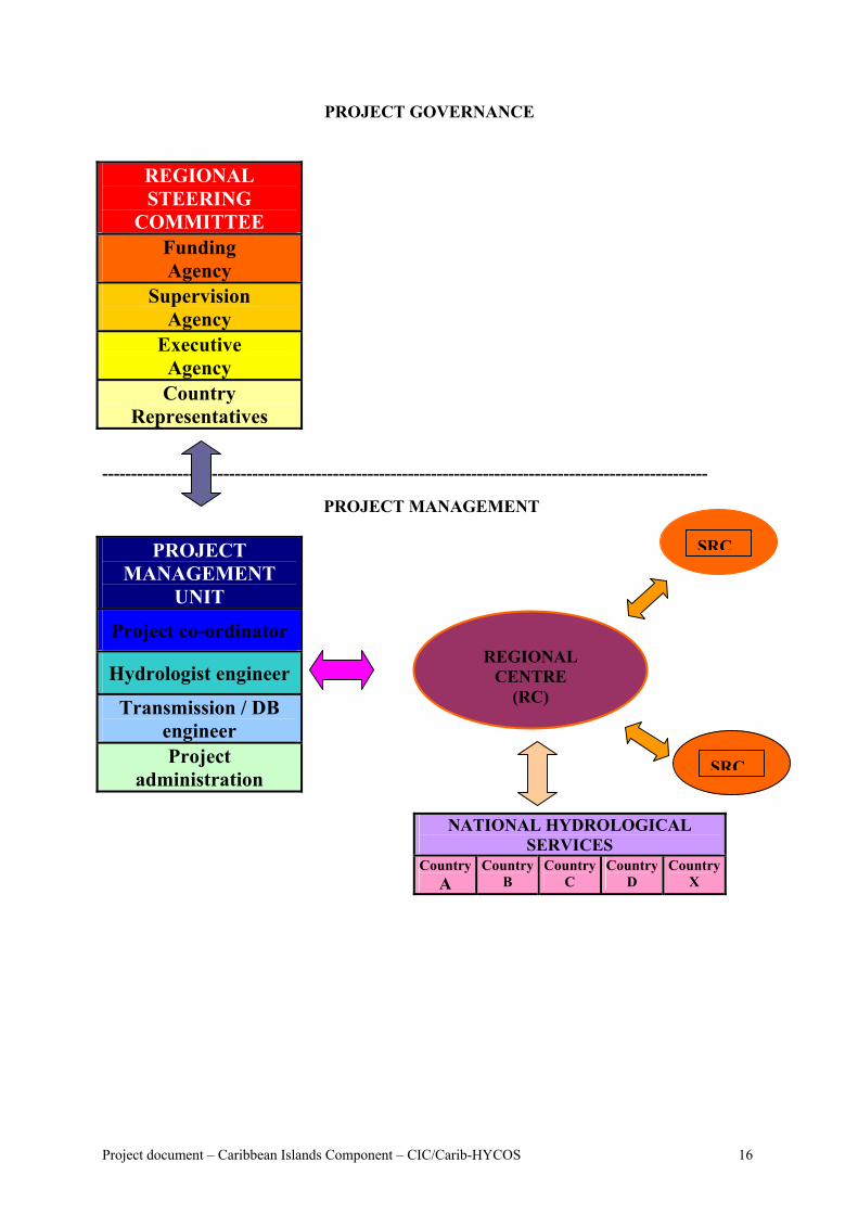
PROJECT GOVERNANCE
REGIONAL STEERING
COMMITTEE Funding Agency
Supervision Agency
Executive Agency Country
Representatives ---------------------------------------------------------------------------------------------------------
PROJECT MANAGEMENT
PROJECT MANAGEMENT
UNIT
Project co-ordinator
Hydrologist engineer
Transmission / DB engineer Project
administration
REGIONAL
CENTRE (RC)
NATIONAL HYDROLOGICALSERVICES
CountryA
Country B
Country C
Country D
Cou
Project document – Caribbean Islands Component – CIC/Carib-HYCOS
SRC
nX
SRC
try
16
4.3.1. The Project Steering Committee (PSC) The Project Steering Committee will be the superior Authority of the project. It will ensure project coherence and oversee project strategy and policy. It will rule on possible changes in project implementation, and approve the annual activities plan and relative budget To ensure the efficiency of the Steering Committee, it is desirable that the representative of each country be named for the entire duration of the project.
Responsibilities of the Project Steering Committee
• To ensure project coherence and to oversee project strategy and policy; • To manage possible conflicts between participating countries and/or institutions; • To approve annual activities plan and relative budget; • To approve possible changes in the project document and implementation plan; • To evaluate project progress and results; • To collaborate and cooperate with other regional organisations and/or projects.
4.3.2. The Executing Agency
The Executive Agency will be in charge of the management, implementation, administration and financial aspects of the project. The main capacities of the Executing Agency should be its ability to manage multilateral co-operation projects and its credibility in the participating countries, institutions, funding agencies, etc.
Responsibilities of the Executing Agency
• To plan project implementation activities; • To act as coordinator for project activities and budget management; • To prepare and present the financial reports to the Project Steering Committee. • To set up the Regional Centre and the Project Management Unit ; • To Provide assistance to the NHSs for their field activities for the implementation
of the project that should include also improvement of the hydrological stations network, training, etc.;
• To act as coordinator for activities undertaken with other water resources projects in the region;
• To prepare documents for invitation to tenders; • To manage equipment tenders and consultants; • To ensure office management; • To prepare project progress reports in collaboration with the Supervising Agency.
4.3.3. The National Hydrological Services (NHS)
The NHS have the responsibility in project implementation at the national level and at regional level in providing the required data to the regional database. They will act as National implementing Agency to implement the project activities in their country. To ensure
Project document – Caribbean Islands Component – CIC/Carib-HYCOS 17
the success and sustainability of the project, it is important that an agreement be signed between each country and the Executing Agency defining each country’s responsibilities in the project. This agreement should state that, at least as far as the reference hydrological stations defined in the framework of the project are concerned, the countries agree to exchange real-time acquired data, as well as historical data required for implementation of the regional database and the Hydrological Information System.
Responsibilities of the National Implementing Agencies (NHSs)
• To provide adequate staff for the project activities in the countries; • To provide adequate support to the Regional Centre for its missions, to equipment
providers, etc.; • To Carry out installations work and other project activities in the field, with the
support of the PRC and PMU when required; • To make logistic arrangements for easy implementation of the project
(authorization for field installations, customs clearence, , etc.; • To ensure monitoring and maintenance of equipment; • To ensure the project sustainability after the Project life time. • To provide the PRC with the hydrological data and information needed to meet the
project objectives; • To provide government institutions, end users, etc. with the hydrological
information and hydrological products supplied by the project.
4.3.4. The Project Regional Centre (PRC)
The establishment of the proposed PRC “follows in the footsteps” of several regional components of WHYCOS, and can draw on the expertise that has been developed in their design, implementation and trouble-shooting. Their experience indicates the need for a regional centre or focal point to oversee implementation, make arrangements for joint activities such as training events, provide advice and assistance, and facilitate inter-communication between participants and stakeholders. In the context of the Caribbean islands, the Regional Centre would also be a focal point for communication with the other regional bodies through which Caribbean island countries habitually communicate. It will also host the regional data base and the Project Management Unit.
Responsibilities of the Project Regional Centre
• To act as focal point for co-ordination of project activities carried out by participating countries.;
• To oversee implementation, and make arrangements for joint activities; • To host and manage the Regional Database and associated activities such as
information dissemination, hydrological products supply, Website implementation and maintenance;
• To ensure activities such as training, support for DCP network maintenance, etc.; • To host the Project Management Unit (PMU) • To improve regional co-operation in matters concerning water resources
management; • To set up a local centre of competence and expertise.
Project document – Caribbean Islands Component – CIC/Carib-HYCOS 18
4.3.5. The Supervising Agency (WMO)
It is proposed that WMO act as Supervising Agency for the Carib-HYCOS project. WMO will report to the Project Steering Committee on project progress by means of periodical technical reports. WMO will ensure that the Carib-HYCOS project is guided by the WHYCOS Guidelines prepared by WMO and in consistent with the fundamental objectives of the WHYCOS program and with other HYCOS components. The WMO representative will be a member of the Project Steering Committee.
Responsibilities of the Supervising Agency
• To prepare the project draft document • To assist in securing funds, • To participate in the formulation of the detailed project document, action plan,
budget • To provide technical support the Executing Agency, • To advice in writing of documents for invitation for tenders for equipment, etc.,
and to participate in their selection; • To ensure links with the Meteorological community using the Satellite
Transmission System (GOES W satellite) and data exchange via the Website; • To ensure linkage with other WHYCOS components and with the Caribbean
Institute of Meteorology and Hydrology • To support the project implementation by the way of periodic assessment missions
and participation in the Project Steering Committee meetings. • To prepare periodical progress report to the Project Steering Committee.
4.4. Project implementation
4.4.1. Project rationale To meet the project objectives, participating countries, which will be the primary beneficiaries of the project products, need to be involved in all stages of the activities. In particular, all raw data must be collected by the countries that are mandated for data acquisition, data processing and control. It is of great importance that long-term series of reliable data are made available, for example to study the impact of climate change on water resources. This information will be needed by the PRC to build a relevant Hydrological Information System, which will be put at the disposal of the end users. In the same way as other HYCOS projects, the Carib-HYCOS project will be implemented for a three year period made up of two distinct phases:
• An inception phase which will last six months. During this phase, in close co-operation with the NHS, the project co-ordinator under the guidance of IRD and WMO will prepare define the detailed project implementation including the location of the stations, the specifications for equipment and the design of installations,
Project document – Caribbean Islands Component – CIC/Carib-HYCOS 19
levelling surveys, computing needs (hardware and software), and training programmes and the detailed project budget with the cost of activities. At the same time, a detailed time table of activities will be set up, and criteria will be established for the assessment of the progress of the different activities. At the end of the inception phase the first Regional Steering Committee meeting will be held at the PRC to validate the detailed programme of project implementation and approve the detailed project document with the budget.
• The implementation phase which will last thirty months, and should start as soon
as funding arrangements are made available after the first Project Steering Committee meeting.
4.4.2. The means
The implementation of the Carib-HYCOS project will require the mobilisation of human resources and technical means both in the PRC PMU and in the NHSs in participating countries.
4.4.2.1. At the Project Regional Centre (PRC) and the Project Management Unit (PMU)
Human resources:
• A co-ordinator, Head of the Project Management Unit (senior hydrologist) with a large experience in international project management. His/her experience will cover the main themes relevant to the projects, notably surface and groundwater, water quality and quantity issues. o He/she will be in charge of project implementation, and bi- and multilateral
relations in close collaboration with the Steering Committee and the Supervising Agency,
o He/she will be responsible for coordination with other water resources projects, will promote synergies, and will also create links with regional organisations,
o He/she will represent the project at national, regional and international levels. o He/she will be responsible of managing the project budget.
• A telemetry system engineer to be in charge of equipment design, field installation and
maintenance.
• A computer engineer to be in charge of database implementation and maintenance. He/she will also be in charge of the Website. This engineer could be recruited from the participating countries.
• A hydrologist to be in charge of database and Hydrological Information System input.
He/she will also be involved in field operations and training,
• An assistant to be in charge of project administration. The delivery of services by private companies or consultants will be possible for certain specific needs.
Project document – Caribbean Islands Component – CIC/Carib-HYCOS 20
Equipment The PRC should be equipped with up-to-date computer facilities :
• A database server with a network computer allowing multiple connections to the database; The use of an ORACLE database systems is recommended as data volume will rapidly increase, and also to ensure high data integrity;
• High speed Internet connection; • Desktop computers and laptops; • UPS power supply; • Hydrometeorological database software (ORACLE system); • Up-to-date computer software package (e.g. Windows XP); • Video projector.
For training activities, the PRC should be equipped with:
• Full gauging equipment, including Acoustic Doppler Current Profiler; • Levelling survey equipment.
4.4.2.2. In the National Hydrological Services
Human resources
• A hydrologist engineer will be the focal point of the project, and will be responsible for project implementation at the national level. He will report to the PRC on the progress of activities as well as on any difficulties encountered. He will be involved in the definition of hydrological products and production, and in training needs,
• A data processor will be in charge of the national database. He will work closely with
the PRC on updating the regional database,
• A team of hydrologists will be in charge of station network maintenance and monitoring, initial data processing, and of all activities carried out in the framework of the NHS activities;
• Computer assistance, which would be provided by a private company.
Equipment
• Desktop computers and/or laptops with printers, scanner, etc.; • High-speed Internet connection, UPS power supply; • Hydrometeorological database software (ORACLE system); • Up-to-date computer software package (e.g. Windows XP); • Full gauging equipment, but given the cost of ADCP, , only one will be purchased for
all the participating countries, at least during the first project phase. It will be stored at the PRC, and dispatched to the countries concerned for measurement campaigns;
• Levelling survey equipment.
Project document – Caribbean Islands Component – CIC/Carib-HYCOS 21
5. PROJECT COST The total cost estimate of the project for a three year period is 3 million Euros. This initial cost estimate includes only global estimates. A detailed cost evaluation with expense headings will be made during the inception phase. The final expenses table will be approved during the first Regional Steering Committee meeting. For example, the exact number of hydrometric stations included in the project, the location and type of equipment required (e.g. runoff stations or groundwater stations, hydrometric or rainfall stations, etc.) will only be decided during the Inception phase. The present document gives a reasonable cost estimate based on the “Preliminary project document proposal” (November 2000). Based on the cost of a standard HYCOS Data Collecting Platform (DCP) fitted with GOES W satellite telemetry, the Carib-HYCOS project would provide partner countries with a total of 40 to 50 stations. Today there are different ways to acquire data and different data telemetering systems. Each has its own advantages and disadvantages. The final choice will be made country by country, and station by station during the inception phase. The costs quoted here are probably the highest . The main budgetary headings have been defined with respect to three funding options (see tables 5.1 & 5.2 (except RC staff and office):
• OPTION 1: total funding 1 800 000 € • OPTION 2 : intermediate funding 1 360 000 € • OPTION 3 : low funding 1 000 000 €
In addition, two options have been retained for the project co-ordinator:
• The co-ordinator is financed by the technical assistance (IRD); • The co-ordinator is an engineer from Martinique financed by the project budget. The
salary is included in the item “RC running” see table 5.2.
Project document – Caribbean Islands Component – CIC/Carib-HYCOS 22
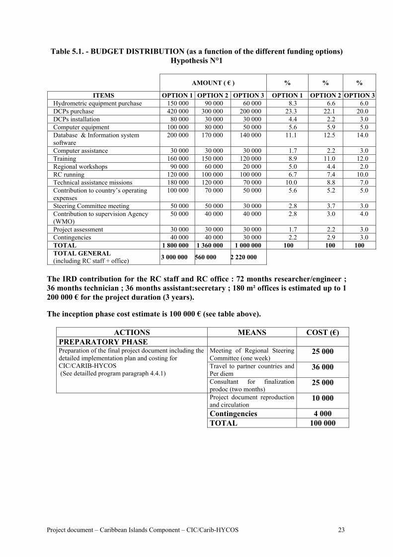
Table 5.1. - BUDGET DISTRIBUTION (as a function of the different funding options) Hypothesis N°1
AMOUNT ( € ) % % %
ITEMS OPTION 1 OPTION 2 OPTION 3 OPTION 1 OPTION 2 OPTION 3Hydrometric equipment purchase 150 000 90 000 60 000 8.3 6.6 6.0 DCPs purchase 420 000 300 000 200 000 23.3 22.1 20.0 DCPs installation 80 000 30 000 30 000 4.4 2.2 3.0 Computer equipment 100 000 80 000 50 000 5.6 5.9 5.0 Database & Information system software
200 000 170 000 140 000 11.1 12.5 14.0
Computer assistance 30 000 30 000 30 000 1.7 2.2 3.0 Training 160 000 150 000 120 000 8.9 11.0 12.0 Regional workshops 90 000 60 000 20 000 5.0 4.4 2.0 RC running 120 000 100 000 100 000 6.7 7.4 10.0 Technical assistance missions 180 000 120 000 70 000 10.0 8.8 7.0 Contribution to country’s operating expenses
100 000 70 000 50 000 5.6 5.2 5.0
Steering Committee meeting 50 000 50 000 30 000 2.8 3.7 3.0 Contribution to supervision Agency (WMO)
50 000 40 000 40 000 2.8 3.0 4.0
Project assessment 30 000 30 000 30 000 1.7 2.2 3.0 Contingencies 40 000 40 000 30 000 2.2 2.9 3.0 TOTAL 1 800 000 1 360 000 1 000 000 100 100 100 TOTAL GENERAL (including RC staff + office) 3 000 000 560 000 2 220 000
The IRD contribution for the RC staff and RC office : 72 months researcher/engineer ; 36 months technician ; 36 months assistant:secretary ; 180 m² offices is estimated up to 1 200 000 € for the project duration (3 years). The inception phase cost estimate is 100 000 € (see table above).
ACTIONS MEANS COST (€) PREPARATORY PHASE
Meeting of Regional Steering Committee (one week)
25 000
Travel to partner countries and Per diem
36 000
Preparation of the final project document including the detailed implementation plan and costing for CIC/CARIB-HYCOS (See detailled program paragraph 4.4.1)
Consultant for finalization prodoc (two months)
25 000
Project document reproduction and circulation
10 000
Contingencies 4 000 TOTAL 100 000
Project document – Caribbean Islands Component – CIC/Carib-HYCOS 23
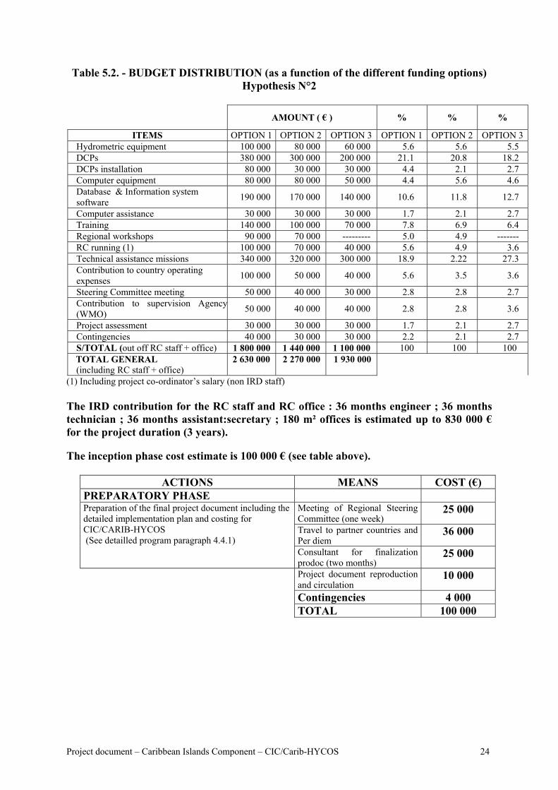
Table 5.2. - BUDGET DISTRIBUTION (as a function of the different funding options) Hypothesis N°2
AMOUNT ( € ) % % %
ITEMS OPTION 1 OPTION 2 OPTION 3 OPTION 1 OPTION 2 OPTION 3Hydrometric equipment 100 000 80 000 60 000 5.6 5.6 5.5 DCPs 380 000 300 000 200 000 21.1 20.8 18.2 DCPs installation 80 000 30 000 30 000 4.4 2.1 2.7 Computer equipment 80 000 80 000 50 000 4.4 5.6 4.6 Database & Information system software 190 000 170 000 140 000 10.6 11.8 12.7
Computer assistance 30 000 30 000 30 000 1.7 2.1 2.7 Training 140 000 100 000 70 000 7.8 6.9 6.4 Regional workshops 90 000 70 000 --------- 5.0 4.9 ------- RC running (1) 100 000 70 000 40 000 5.6 4.9 3.6 Technical assistance missions 340 000 320 000 300 000 18.9 2.22 27.3 Contribution to country operating expenses 100 000 50 000 40 000 5.6 3.5 3.6
Steering Committee meeting 50 000 40 000 30 000 2.8 2.8 2.7 Contribution to supervision Agency(WMO) 50 000 40 000 40 000 2.8 2.8 3.6
Project assessment 30 000 30 000 30 000 1.7 2.1 2.7 Contingencies 40 000 30 000 30 000 2.2 2.1 2.7 S/TOTAL (out off RC staff + office) 1 800 000 1 440 000 1 100 000 100 100 100 TOTAL GENERAL (including RC staff + office)
2 630 000 2 270 000 1 930 000
(1) Including project co-ordinator’s salary (non IRD staff) The IRD contribution for the RC staff and RC office : 36 months engineer ; 36 months technician ; 36 months assistant:secretary ; 180 m² offices is estimated up to 830 000 € for the project duration (3 years). The inception phase cost estimate is 100 000 € (see table above).
ACTIONS MEANS COST (€) PREPARATORY PHASE
Meeting of Regional Steering Committee (one week)
25 000
Travel to partner countries and Per diem
36 000
Preparation of the final project document including the detailed implementation plan and costing for CIC/CARIB-HYCOS (See detailled program paragraph 4.4.1)
Consultant for finalization prodoc (two months)
25 000
Project document reproduction and circulation
10 000
Contingencies 4 000 TOTAL 100 000
Project document – Caribbean Islands Component – CIC/Carib-HYCOS 24
6. BENEFITS AND SUSTAINABILITY OF THE PROJECT The Caribbean island nations would benefit from a real-time hydro-meteorological network of stations strategically located in each country as proposed by the CIC/CARIB-HYCOS project. A few strategically located real-time stations would be most beneficial as a warning system for extreme hydrologic events and as a data base for the study of regional and global climate change. By using compatible satellite-transmitting stations and associated computer hardware and software, the local warning stations would become part of a regional network that could be used to support regional and global-change research. A regional meteorological/climatological data bank developed as part of CARIB-HYCOS would be an important tool for predicting extreme hydrologic events. With respect to the disaster mitigation component of the Project, in terms of fatalities and human suffering, the toll of hurricanes and of hurricane-triggered floods and landslides goes beyond amounts that can be tallied in monetry value. By the same token, the value of enhanced disaster-mitigation capability associated with the implementation of the Project, in terms of averting fatalities and reducing human suffering, is very great indeed. Moreover, projected potential benefits from the implementation of a HYCOS for the island-nations on the Caribbean rim, great as they may be, are likely to pale by comparison with benefits that will result from enhanced communication between the islands. Where historically there frequently has been virtually no island-to-island communication, dialogue will be initiated with the sharing of hydrological data, and with collaboration in developing technology and means of organizing local networks aimed at maximising useful results. A wealth of spin-off benefits is anticipated. Nevertheless, the direct economic benefits of CARIB-HYCOS are likely to be substantial. As time passes and the nations of the Caribbean region become more highly developed, and as population-densities rise, the increasingly vital role of the Project in disaster mitigation will add further to measurable economic benefits to be derived. As regards the water resources management component of the Project, the island countries are facing a number of problems such as fresh water scarcity, drought, desertification, pollution, sectoral water management, etc. Representatives of these countries in many fora have expressed the view that the current tremendous national efforts might not be enough to succeed in sustainable socio-economic development, without putting them into a regional perspective and therefore benefiting from the added value provided by a collaborative approach, as proposed by CIC/CARIB-HYCOS. It is expected that the project would provide the participating countries and the region with tools to:
• Rationalise the use of water resources in the region, a key factor in development and prevention of water usage conflicts;
• Create a clear regional awareness that monitoring of water resources in quantity and quality benefits regional development and improved management and, in particular, pollution control;
• Better understand the regional hydrological phenomena and trends which require larger scale observation networks;
• Modernize the regions' water resources agencies; • Improve co-operation among the regions' national water agencies; • Sustain research programmes which are demand-driven by regional development issues;
Project document – Caribbean Islands Component – CIC/Carib-HYCOS 25
• Integrate water resources agencies into the regions' development decision making, thereby providing the opportunity for integrated water resources development and management;
• Promote and facilitate the standardization of hydrological measurements and regional compatibility among national hydrological system;
• Promote and facilitate the real-time circulation of water and environment data throughout the region.
As regards the Project’s sustainability, experience in many developing countries indicates that it is impossible to assure the long-term sustainability of a development project. In the water resources sector, many projects have been implemented but have had little or no lasting effect. A range of reasons can be identified, including the frequent loss of key staff, the higher priority placed by governments on other areas of expenditure, government restructuring, inadequate budget provisions for ongoing operation and maintenance of hydrological services. However, projects are more likely to be maintained if they clearly meet a need of which the government is aware, and the benefits of post-project expenditure clearly exceed the costs and the benefits of other possible expenditures. A benefit-cost analysis has not been carried out for CIC/CARIB-HYCOS, but numerous such analyses of hydrological information indicate benefit-cost ratios commonly in the order of 6:1 or better. Such figures carry little weight with decision-makers in developing countries, however, who are much more concerned about immediate social and economic problems. It should be recognized that Governments are increasingly aware of the importance of water-related issues, particularly in the context of contamination of water resources and the impacts of extreme events. It also suggests that an integrative project like this one has a place, by bringing greater efficiency through adopting a regional rather than national approach. The ownership of data, and its exchange, remains a matter of concern for the countries. Given the trend to move to cost recovery through the sale of data or products there is little motivation to provide data at no cost to third parties. Therefore, to the degree possible beneficiaries of information on a real-time basis should be included in the planning/implementation of the project. (e.g. electricity generating utilities, those who manage private aqueducts, or companies operating under some sort of license which involves water use, such as beer breweries, and the tourism industry). In conclusion, perhaps the single most important long-term effect of CIC/CARIB-HYCOS is in the breaking down of national barriers to an integrated approach to water resources management. The sharing of information, the establishment of regional centres of excellence in the region, and the implementation of regional training and educational programs would be a huge improvement in the way the Caribbean region faces water resources issues in this new millennium. 7. INNOVATIVE ASPECTS AND REPLICABILITY The project proposes to build an accurate Hydrological & Environmental Information System for the whole Caribbean Sea Basin. Internet capacities will be largely used for data and information dissemination. This project should not only prove the benefits of using technologies such as DCPs, telemetry, and the Internet and of regional co-operation in terms
Project document – Caribbean Islands Component – CIC/Carib-HYCOS 26
of water resources for both Authorities and stakeholders, but, in addition, should create a basis for profitable collaboration between countries. Since it is part of the WHYCOS global program, the replicability of the project is obvious. 8. RISKS AND CONDITIONS 8.1. Hypotheses at different levels The project achievement is related to few hypothesis, from which the most important are :
• The GOES satellite telemetering system is available for the Project; • The executive agency is able to make the necessary changes to the Project in the case
of unpredictable events that can affect the outcome of the Project; • The executive agency establish good working relations with the NHS and other
partner institutions; • The identified NHS teams are available for the planned project activities as needed, • The Authorities of the partner countries support their NHS in carrying out the project
activities; • The NHS staff who benefit from training programmes provided in the framework of
the project, keep the same position in the Service for the duration of the project. 8.2. Risks and risk-avoidance stategies
• Risk 1: insufficient co-operation between the NHS and the Regional Centre in project implementation;
Strategy: IRD has a long history of co-operation with NHS all around the world.
IRD has set up a large number of hydrological observatories and is involved in the implementation of several different HYCOS projects;
• Risk 2: NHS and RC staff could spend too much time on other activities than the
Carib-HYCOS project, and consequently not be sufficiently available for the project. Strategy: NHS managers are fully involved in the definition of the project, and
should be able to estimate the work time of their staff. The RC will be provided with permanent technical co-operation staff, with NHS staff for specific needs and with consultants if required.
• Risk 3: The NHS will not have enough money to set up DCPs that respect HYCOS
standards in a short time.
Strategy: During the inception phase an assessment of existing networks and activities is planned. The project will provide the NHS with the required technical aid to ensure the field installations are up to standard. The project will define a development plan for the installation and maintenance of DCPs, and a training programme will be organized.
Project document – Caribbean Islands Component – CIC/Carib-HYCOS 27
• Risk 4: There will not be enough money to replace equipment damaged by vandalism or natural hazards (e.g. flood damages)
Strategy: DCP spare parts are budgeted in the Project and the budget also
includes a “contingencies” heading. The development plan for field installations precludes damage by vandalism.
• Risk 5: The countries will not agree on data and information exchange.
Strategy: Acceptance of free access to data/information for research and/or
educational activities in the framework of the HYCOS project is an essential basis of the WHYCOS program. An agreement between the WMO and each partner country should be signed to this effect (respectively WMO Resolution 40 and Resolution 25 for meteorological data exchange and hydrological data exchange). It should be noted that the project will mainly provide information on water resources and little or no raw data.
8.3. Regional co-operation Regional co-operation forms the basis of the HYCOS projects. As mentioned in sub-paragraph 3.1.3: “The need for regional co-operation and collaboration has been emphasized by a number of the countries. In particular the sharing of information and implementation of regional training and education programmes would need to be enhanced.” The directors of the NHS are involved in the Project through the Regional Steering Committee. The commitment of the countries to co-operate is a guarantee of the success of the Project. 8.4. Protection of the environment The Carib-HYCOS project is probably the first integrated project on water resources in the Caribbean Sea Basin. The sharing of information on water resources and on particular events (floods and droughts) by partner countries but also the global approach to liquid and solid fluxes to the Caribbean Sea should allow a better knowledge and understanding of the environmental difficulties that prevail in the region. 8.5. Socio-cultural aspects As mentioned in paragraph 1.3 “The Caribbean Islands range from large islands like Cuba – 110,860 km2 - with a population of 11 million and a diversity of water resource management issues, to small islands like Barbados – 430 km2 - with a population of 262,000, limited surface water resources, and groundwater resources that are now almost fully allocated. Many of the islands have high population densities, are vulnerable to natural disasters and are already experiencing water shortages and groundwater pollution. In 1995 the total population of the Caribbean Islands was approximately 38 million.
Project document – Caribbean Islands Component – CIC/Carib-HYCOS 28
Caribbean countries are facing structural problems. These include insufficient economic diversification away from agriculture, and high levels of unemployment.” We can assume that the Carib-HYCOS Project will benefit most of the population of the countries concerned. The benefits will be most significant for the poorest members of the population as they are often the most sensitive to disasters (floods), to agricultural shortages (droughts) and sanitation difficulties. From a socio-cultural point of view, women and children will be the primary beneficiaries. 8.6. Institutional capacity and management WMO is the specialized agency of the United Nation System for matters related to weather, climat and water. The WHYCOS programme is a major component of its programme for Hydrology and Water resources – Basic Systems. Since 1993 WMO has launched a number of regional components of WHYCOS. Three components (MED-HYCOS, AOC-HYCOS and SADC-HYCOS phase I) have already been completed, while Volta-HYCOS, Niger-HYCOS, SADC-HYCOS phase II and IGAD-HYCOS are about to start. In the development and implementation of all these projects, as well as many other projects in the field of hydrology and water management, WMO has earned a considerable experience that will be transferred to Carib-HYCOS / CIC. WMO will facilitate, when required, the communication with National Meteorological Services and the transfer of precipitation and other data required for hydrological purposes. IRD is a French Public Science and Technology research institute under the joint authority of the French Ministry of Research and the French Foreign Ministry. IRD has been managing research programs in more than 40 countries around the world for more than 50 years. In the specific field of hydrological observatories, IRD has a very long experience in tropical areas, and the OBHI Unit has been the major partner of WMO in the implementation of HYCOS components since 1995. 9. PROJECT PROGRESS AND EX POST ASSESSMENT 9.1. Project progress At the end of the Project, three basic elements should have been implemented:
• A Hydrological Information System in the Caribbean Sea Basin which should have enabled the following achievements: o Hydrological data acquisition and transmission updating system; o Implementation / strengthening of national and regional databases; o Strengthening of national and regional capabilities in water resources
management; o Installation of up-to-date tools enabling partner countries to communicate between
themselves and to disseminate information ( Internet); o Implementation of institutional capacity building programs.
• A forecasting system for floods and droughts for improved water management.
Project document – Caribbean Islands Component – CIC/Carib-HYCOS 29
• A system which will enhance the value of hydrological products used by the Authorities, stakeholders, and end users.
As already mentioned, the Hydrological Information System will use Internet as one of its main tools. Internet is linked with high development in all countries. In addition, Internet is probably the most useful tool for information dissemination in real time to a wide public. It also provides good facilities for recording project progress, and should motivate NHS staff. The Hydrological Information System in the Caribbean island area will be a powerful tool for water resources management and environmental protection, mainly for Caribbean Sea fluxes (liquid and solid) as it will enable an integrated approach. 9.2. Ex post evaluation criteria The progress of the Project will be checked by the Supervision Agency (WMO). WMO will write annual reports based on the bi-annual progress reports written by the Project co-ordinator, and send them to the Regional Steering Committee. These documents will report on technical and financial aspects, using progress criteria agreed on by the core parties during the inception phase. These reports will be transmitted to all countries and partners. They will state the progress of the Project and describe the difficulties encountered in all aspects of the Project.
9.2.1. Progress criteria The programme of activities will include a list of progress criteria and tools for checking progress. A schedule will be drawn up to check project progress which will be assessed by the Regional Steering Committee.
9.2.2. Final evaluation An evaluation will be carried out two months before the end of the Project by an independent expert. A one-month assignment will be carried out at the RC and in some partner countries. The evaluation report will be sent to the Regional Steering Committee, the Supervision Agency (WMO) and the funding Agencies.
Project document – Caribbean Islands Component – CIC/Carib-HYCOS 30
LIST OF ACRONYMS CIMH Caribbean Institute for Meteorology and Hydrology DCP Data Collection Plattform DCS Data Collection System DRSs Direct Readout Stations GTS Global Telecommunication System IRD Institut de Recherche pour le Développement MAE French Ministry for Foreign Affairs NHSs National Hydrological Services NMHSs National Meteorological and Hydrological Services NMSs National Meteorological Services OBHI Hydrological Observatories and Engineering Unit RC Regional Centre SADC-HYCOS South African Development Co-operation HYCOS UN United nations UNCED UN Conference on Environment and Development UNCSD Commission on Sustainable Development WHYCOS World Hydrological Cycle Observing System WMO World Meteorological Organization
Project document – Caribbean Islands Component – CIC/Carib-HYCOS 31
Carib-HYCOS - PROJECT DOCUMENT
ANNEX 1 - PROGRAMMME OF ACTIVITIES
Project document – Caribbean Islands Component – CIC/Carib-HYCOS 32
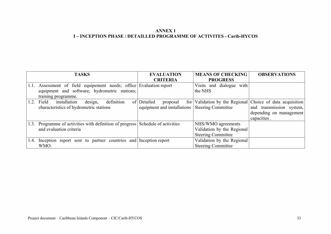
ANNEX 1 I – INCEPTION PHASE / DETAILLED PROGRAMME OF ACTIVITES - Carib-HYCOS
TASKS EVALUATION MEANS OF CHECKING PROGRESS CRITERIA
OBSERVATIONS
1.1. Assessment of field equipement needs; office equipment and software; hydrometric stations; training programme.
Evaluation report Visits and dialogue with the NHS
1.2. Field installation design, definition ofcharacteristics of hydrometric stations
Detailed proposal forequipment and installations
Validation by the Regional Steering Committee
Choice of data acquisition and transmission system, depending on management capacities .
1.3. Programme of activities with definition of progress and evaluation criteria
Schedule of activities NHS/WMO agreements Validation by the Regional Steering Committee
1.4. Inception report sent to partner countries and WMO.
Inception report Validation by the Regional Steering Committee
Project document – Caribbean Islands Component – CIC/Carib-HYCOS 33
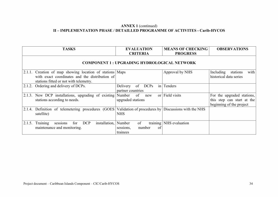
ANNEX 1 (continued) II – IMPLEMENTATION PHASE / DETAILLED PROGRAMME OF ACTIVITES - Carib-HYCOS
TASKS EVALUATION MEANS OF CHECKING PROGRESS CRITERIA
OBSERVATIONS
COMPONENT 1 : UPGRADING HYDROLOGICAL NETWORK
2.1.1. Creation of map showing location of stations
with exact coordinates and the distribution of stations fitted or not with telemetry.
Maps Approval by NHS Including stations with historical data series
2.1.2. Ordering and delivery of DCPs. Delivery of DCPs in partner countries
Tenders
2.1.3. New DCP installations, upgrading of existing stations according to needs.
Number of new orupgraded stations
Field visits For the upgraded stations, this step can start at the beginning of the project
2.1.4. Definition of telemetering procedures (GOES satellite)
Validation of procedures by NHS
Discussions with the NHS
2.1.5. Training sessions for DCP installation,maintenance and monitoring.
Number of trainingsessions, number of trainees
NHS evaluation
Project document – Caribbean Islands Component – CIC/Carib-HYCOS 34
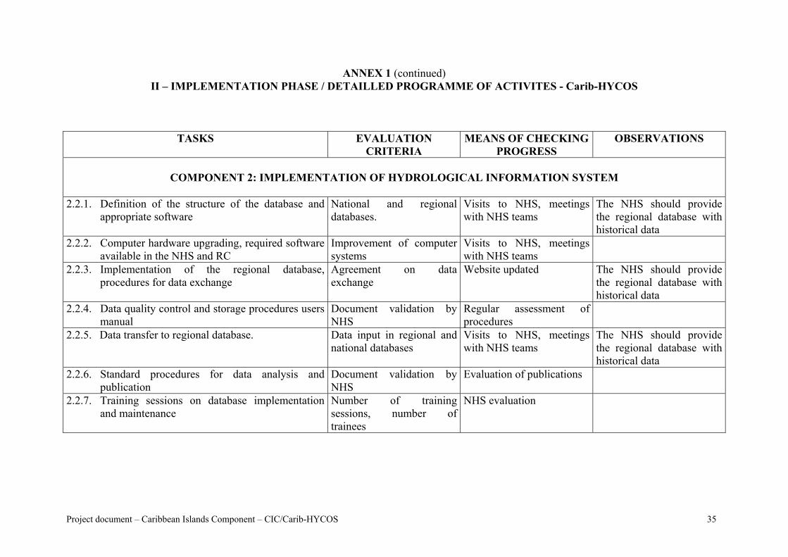
ANNEX 1 (continued) II – IMPLEMENTATION PHASE / DETAILLED PROGRAMME OF ACTIVITES - Carib-HYCOS
TASKS EVALUATIONCRITERIA
MEANS OF CHECKING PROGRESS
OBSERVATIONS
COMPONENT 2: IMPLEMENTATION OF HYDROLOGICAL INFORMATION SYSTEM
2.2.1. Definition of the structure of the database and
appropriate software National and regionaldatabases.
Visits to NHS, meetings with NHS teams
The NHS should provide the regional database with historical data
2.2.2. Computer hardware upgrading, required software available in the NHS and RC
Improvement of computer systems
Visits to NHS, meetings with NHS teams
2.2.3. Implementation of the regional database,procedures for data exchange
Agreement on dataexchange
Website updated The NHS should provide the regional database with historical data
2.2.4. Data quality control and storage procedures users manual
Document validation byNHS
Regular assessment of procedures
2.2.5. Data transfer to regional database. Data input in regional and national databases
Visits to NHS, meetings with NHS teams
The NHS should provide the regional database with historical data
2.2.6. Standard procedures for data analysis and publication
Document validation byNHS
Evaluation of publications
2.2.7. Training sessions on database implementation and maintenance
Number of trainingsessions, number of trainees
NHS evaluation
Project document – Caribbean Islands Component – CIC/Carib-HYCOS 35
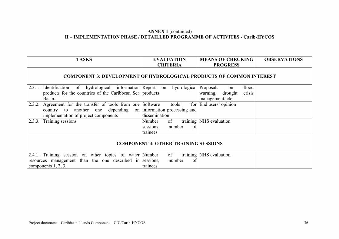
ANNEX 1 (continued) II – IMPLEMENTATION PHASE / DETAILLED PROGRAMME OF ACTIVITES - Carib-HYCOS
TASKS EVALUATIONCRITERIA
MEANS OF CHECKING PROGRESS
OBSERVATIONS
COMPONENT 3: DEVELOPMENT OF HYDROLOGICAL PRODUCTS OF COMMON INTEREST
2.3.1. Identification of hydrological information
products for the countries of the Caribbean Sea Basin.
Report on hydrologicalproducts
Proposals on flood warning, drought crisis management, etc.
2.3.2. Agreement for the transfer of tools from one country to another one depending onimplementation of project components
Software tools forinformation processing and dissemination
End users’ opinion
2.3.3. Training sessions Number of trainingsessions, number of trainees
NHS evaluation
COMPONENT 4: OTHER TRAINING SESSIONS
2.4.1. Training session on other topics of water resources management than the one described in components 1, 2, 3.
Number of trainingsessions, number of trainees
NHS evaluation
Project document – Caribbean Islands Component – CIC/Carib-HYCOS 36
Carib-HYCOS - PROJECT DOCUMENT
ANNEX 2 - TERMS OF REFERENCE FOR THE REGIONAL CENTRE (RC)
Project document – Caribbean Islands Component – CIC/Carib-HYCOS 37
ANNEX 2 TERMS OF REFERENCE FOR THE REGIONAL CENTRE (RC)
The Regional Centre is the structure dedicated for the project implementation. The RC is the regional focal point for the coordination of the activities implemented by the partner countries in the countries concerned. It will promote regional co-operation in terms of water resources assessment and monitoring; it will also be a regional centre of competence and expertise. The executive Unit will be set up by the executive agency to help the RC in the execution of the different tasks planned in the ToR. The specific tasks of the Regional Centre will be: training activities, co-ordination of monitoring of the networks, and support to the NHS who will need some help with National project activities (e.g. DCP maintenance, database). In particular, the RC will be responsible for the following activities:
• To define and validate, in close collaboration with the countries concerned, the network of reference hydrometric stations, equipment required for the specific objective of each station (flood forecast, WR management, water quality,etc.) with respect to management constraints (telemetry or not);,
• To define with the equipment manufacturer (or an expert) standard rules for installing the equipment, and to organize training sessions for hydrometric network monitoring and maintenance;
• To support the NHS when needed in field installation and equipment maintenance; • To implement a regional database, and support, if required, the implementation of
national databases; • To implement a regional computer network for data exchange and dissemination
between partner countries using Internet technologies; • To implement and promote the Carib-HYCOS Website; • To support research activities, mainly with regional research programmes; • To assess capacity building needs and to organize training sessions to strengthen
regional competences. Training programmes should be focused in particular on the following items: o DCP installation and maintenance, o data processing and quality control, o database implementation and management, o Internet technologies, o development of hydrological products in accordance with national and regional
interests.
Project document – Caribbean Islands Component – CIC/Carib-HYCOS 38
Carib-HYCOS - PROJECT DOCUMENT
ANNEX 3 - TRAINING PROGRAMME PROPOSAL
Project document – Caribbean Islands Component – CIC/Carib-HYCOS 39
ANNEX 3 TRAINING PROGRAMME PROPOSAL
1. General objective The objective of the training programme proposed in the framework of the Carib-HYCOS Project is to set up a regional training structure in operational hydrology. The proposed programme should allow the implementation of defined modules, the training of regional trainers and the first regular training sessions to be carried out. The training sessions will be organized in different modules to target NHS managers and NHS teams. Some modules will target the teams in charge of field measurements and primary data processing, others will target engineers with a programme based on water resources management, advanced data processing and data dissemination. Each module will be made up of two parts: theory and hands-on exercises carried out in the field. The first operational hydrology sessions will be for future local trainers who will subsequently organize sessions in their own Service. Each training course will provide trainees with a full documentation on theoretical aspects and hands-on exercises, as well as field forms for measurements and equipment maintenance. These training sessions will be carried out at the RC but also in secondary RCs (SRCs) in one Spanish speaking country and in one English speaking country. A draft proposal for training programme is given below. However it should be noted that this programme will be discussed and approved by the countries concerned, and course content will be based on their specific needs. The mean duration of a module will be 5 days with from 10 to 15 trainees. 2. Proposed programme N° 1 HYDROMETRY: water levels, discharge measurements, levelling survey... N° 2 ADCP DISCHARGE MEASUREMENT N° 3 RATING CURVES CALIBRATION N° 4 INTRODUCTION TO ELECTRONICS N° 5 DCP INSTALLATION AND MAINTENANCE, TELEMETRY N° 6 DATABASE MANAGEMENT
N° 7 HYDROLOGICAL INFORMATION SYSTEM - DEVELOPMENT AND MAINTENANCE
N° 8 WEBSITE IMPLEMENTATION AND MAINTENANCE N° 9 HYDROLOGICAL EXPERTISE N° 10 INTEGRATED WATER RESOURCES MANAGEMENT
Project document – Caribbean Islands Component – CIC/Carib-HYCOS 40
Carib-HYCOS - PROJECT DOCUMENT
ANNEX 4 - DATABASE SOFTWARE SPECIFICATIONS
Project document – Caribbean Islands Component – CIC/Carib-HYCOS 41
ANNEX 4 DATABASE SOFTWARE SPECIFICATIONS
The software should allow hydro-meteorological data retrieval and management usually provided by hydro-meteorological networks, including telemetry procedures. This software should be available in English, French, Spanish, and should comply with the following specifications:
• Allow full data retrieving and processing, including water quality data, ground water data, etc.;
• Allow data processing using different measurement units (metric system, English unit system);
• Allow processing of all data parameters (e.g. discharge measurement, rating curves, information on stations);,
• Allow data storage on a server with multi simultaneous connections from client PCs; • Allow real time data processing (e.g. from telemetering stations) or deferred
processing (e.g. data sent to the NHS or RC on paper or by email); • Allow automatic DCP data retrieval using any telemetering system (e.g. satellite,
radio, phone (cellular or land lines); • Allow data quality check by accurate graphic means; • Allow distributed database management at national and regional levels using Internet
connections; • Allow accurate means of data and information dissemination (e.g. year books, website
input); • Allow data processing (statistical analysis, flood characteristics, etc.); • Provide a cartographic module for station locations; • Ensure a high level of data integrity and archive security; • Propose client-server architecture or single computer.
Project document – Caribbean Islands Component – CIC/Carib-HYCOS 42
Carib-HYCOS - PROJECT DOCUMENT
ANNEX 5 - CARIB-HYCOS WEBSITE
Project document – Caribbean Islands Component – CIC/Carib-HYCOS 43
ANNEX 5 CARIB-HYCOS WEBSITE
This website will be a tool for project progress evaluation, for data and information dissemination, and a Web portal on water resources in the Caribbean area. The main headings should be:
• General information on the main catchments; • Hydrological and meteorological situations; • Groundwater situation; • Extreme situations (floods, droughts, hurricanes); • Water quality; • Information of the Caribbean Sea Basin ; • Main regional stakeholders (National Hydro-meteorological Services, Regional
Institutions); • Training information; • Information on water resources projects at national and regional levels; • Technology (DCPs, telemetry, using satellite or phone);, • Research programmes on water resources;, • Hydrology documentation and publications, • Legal aspects related to water resources management; • Environmental issues in the Caribbean Sea Basin; • Most useful websites for project activities and partners.
Project document – Caribbean Islands Component – CIC/Carib-HYCOS 44
Carib-HYCOS - PROJECT DOCUMENT
ANNEX 6 - PROJECT CO-ORDINATOR
Project document – Caribbean Islands Component – CIC/Carib-HYCOS 45
ANNEX 6 PROJECT CO-ORDINATOR
The hydrologist engineer who will be named co-ordinator of the Carib-HYCOS Project will be in charge of the Regional Centre and Executive Unit management. He will supervise all activities, mainly in data acquisition and data processing, and will act as the interface between the RC and the NHS. He should have a good background in the field of hydrology and related matters. A good knowledge of databases, information systems, and new communication technologies (Internet) would be an important asset. He should be able, in close co-operation with partner NHSs, to define the hydrological products and to supervise their development. He should be at ease co-operating with management of teams from different countries, and should speak good French and/or Spanish in addition to English, as this would be a great advantage for this project. He must be interested in new technologies for data acquisition and transmission to be able to oversee all aspects of the project in the shortest possible time. The expert should have a few years experience in the management of international projects. This project would be an opportunity for a young engineer with a good background and a high level of motivation to prove his competence in project management. In this case, he would be supported by a senior hydrologist who would intervene by means of temporary assignments.
Project document – Caribbean Islands Component – CIC/Carib-HYCOS 46