Embed Size (px)
Citation preview
PUBLIC DISCLOSURE AUTHORISED
CARIBBEAN DEVELOPMENT BANK
TECHNICAL ASSISTANCE - GEOMATICS CAPACITY ENHANCEMENT FOR DISASTER RISK MANAGEMENT
COMMONWEALTH OF THE BAHAMAS
Papers BD 98/16 and
98/16 Corr. 1
Considered at the Two Hundred and Seventy-Fourth Meeting
of the Board of Directors on December 8, 2016
DECEMBER 2016
This Document is being made publicly available in accordance with the Bank’s Information Disclosure Policy. The Bank does not accept responsibility for the accuracy or completeness of the Document.
Division Chief Ms. Merlyn P. Combie Economic Infrastructure Division Portfolio Manager Mr. William Ashby Economic Infrastructure Division

Any designation or demarcation of, or reference to, a particular territory or geographic area in this Document is not intended to imply any opinion or judgment on the part of the Bank as to the legal or other status of any territory or area or as to the delimitation of frontiers or boundaries.
PUBLIC DISCLOSURE AUTHORISED
CARIBBEAN DEVELOPMENT BANK
TWO HUNDRED AND SEVENTY-FOURTH MEETING OF THE BOARD OF DIRECTORS
TO BE HELD IN BARBADOS
DECEMBER 8, 2016
PAPER BD 98/16 and
PAPER BD 98/16 Corr.1
TECHNICAL ASSISTANCE - GEOMATICS CAPACITY ENHANCEMENT FOR DISASTER RISK MANAGEMENT – COMMONWEALTH OF THE BAHAMAS
1. APPLICATION 1.01 By correspondence dated March 24, 2016, the Government of the Commonwealth of The Bahamas (GOCB) applied to the Caribbean Development Bank (CDB) for a technical assistance (TA) loan to assist in financing a project to enhance its capacity to utilise spatial data for Disaster Risk Management (DRM). GOCB proposes to improve the quality and coverage of spatial data available for selected islands of The Bahamas and develop a Disaster Risk Management Information System (DRMIS) to improve decision-making as part of its programme of improvements to the country’s spatial data infrastructure. The beneficiaries of this project will be the Government and people of The Bahamas. 1.02 The total cost of this project is estimated at four million, one hundred and thirteen thousand, eight hundred United States dollars (USD4,113,800) of which CDB’s contribution will be a loan not exceeding the equivalent of two million, eight hundred and ninety-three thousand United States dollars (USD2,893,000) from its Ordinary Capital Resources (OCR). Counterpart funding, equivalent to one million, two hundred and twenty thousand, eight hundred United States dollars (USD1,220,800) will be met by GOCB. 2. BACKGROUND 2.01 The Commonwealth of The Bahamas is an archipelago of 700 islands covering a total area of 13,940 square kilometres. In 2010, the population census recorded a population of 351,461, with a slightly higher proportion of females (51.6%) than males (48.4%). The mid-year 2015 population estimate was recorded at 387,5491, an increase of 36,088 or 10.3% in 5 years. New Providence (Nassau), where 70% of the population reside, and to a lesser extent Grand Bahama, which accounts for 15% of the population, are the main centres of opportunity and services. The remaining 15% of the population are dispersed across the other 17 inhabited Family Islands2. The terrain of the islands is generally flat, with the highest point (Mount Alvernia on Cat Island) having an elevation of 63 metres (m) above sea level. The economy of The Bahamas is driven mainly by tourism and offshore banking. 2.02 Overall, the country has one of the highest per capita incomes in the Caribbean, (estimated at $21,414 in 2013, down from $23,209 in 2012). However, there is income inequality and the country’s Gini Coefficient which was estimated at 0.424 in 2013, down from 0.57 in 2011. While poverty is not entrenched,
1 UN Estimate (July 1, 2015). 2 Department of Statistics (2010): Census of Population and Housing 2010. Ministry of Finance, GOCB.
- 2 - there are pockets across the country, especially in the Family Islands, where formal employment opportunities are limited. Poverty also exists in geographic pockets across New Providence. In 2013, the poverty head count was estimated at an average of 12.5%3, up from 9.3% in 20014. The distribution of poverty was estimated at 12.6% in New Providence, in Grand Bahama at 9.7% and in the Family Islands at 17.2%. The poverty rate among the male population was slightly higher, 13.2%, than poverty among the female population at 12.4% but households headed by women were more likely to be poor, at a rate of 9.7%, than households headed by men at 7.9%. 2.03 The geographic location and geological characteristics of The Bahamas make the country vulnerable to multiple natural hazards, including hurricanes5, storm surge, floods, tsunamis, and droughts. This high vulnerability to natural hazards is exacerbated by the country’s spatial development patterns as the majority of economic/commercial infrastructure development and settlement patterns are located in coastal areas, in many instances in low-lying, reclaimed marshland, placing the population and economic activity in the islands at considerable risk. The Bahamas is considered to be at risk from the impacts of climate variability and change due largely to its low elevation. A recent study carried out by CARIBSAVE6 indicated that a potential 1 m sea level rise (SLR) places 90% of port infrastructure, 38% of airport infrastructure, 36% of the major tourism properties, and 14% of road networks at risk. With a 2 m SLR, 50% of major tourism resorts would be impacted. The study also found that with 100 m of erosion (resulting from approximately 1 m SLR), 70% of the major tourism resorts and 80% of sea turtle nesting sites would be impacted. The spill over effects on the livelihoods of different groups of men and women resulting from the reduction in coastal and marine economic activity, especially on low income earners, would influence poverty levels, labour force participation rates, health status and productivity of the population. 2.04 An essential component of building resilience to natural hazard and climate risks in The Bahamas is the assessment and mapping of hazard risks, vulnerability to these hazards, and dissemination of the appropriate information to stakeholders. However, this process is being hampered by the lack of high quality and reliable geo-spatial data and information. Topographic surveys of The Bahamas were conducted by the United Kingdom (UK) Ordnance Survey during the 1960s, resulting in the publication of a series of 1:25,000 maps of Cat Island, Eleuthera, Grand Bahama, Abaco and New Providence. The Department of Lands and Surveys (DLS) assumed responsibility for mapping in 1972, and topographic maps were prepared for all of the islands based on the 1967 surveys. The DLS maps provide 1:25,000 scale coverage of all islands, except Bimini, for which 1:10,000 scale maps were prepared. DLS subsequently issued 1:10,000 scale maps for most islands, and 1:2,500 scale maps for Nassau and other built-up areas. A number of land use and land ownership maps were also prepared during the 1970s. 2.05 Several of the maps are often out-of-stock at DLS, compounding the challenges presented by reliance on outdated mapping, where land use has likely changed, and by the wide contour intervals which limit the practical application of the maps. These factors present a significant constraint to planning and infrastructure development, particularly on the Family Islands, as such spatial information is a fundamental tool to support planning and decision-making at national, local and community scales. GOCB recognised
3 Department of Statistics (2014): Household and Expenditure Survey 2013. The Commonwealth of Bahamas. Ministry of Finance GOCB. 4 Department of Statistics (2004): Bahamas Living Condition Survey. The Commonwealth of Bahamas. Ministry of Finance GOCB. 5 The Bahamas has been affected by several of significant storms including the 1866 Great Bahamas hurricane, the 1926 Nassau hurricane, the 1928 Okeechobee hurricane, the 1929 and 1932 Bahamas hurricanes and the 1947 Fort Lauderdale hurricane. More recently, major impacts have been felt from Hurricanes Andrew in 1992, Floyd in 1999, Frances in 2004, Sandy in 2012 and Joaquin in 2015. 6 The CARIBSAVE Climate Change Risk Profile for The Bahamas was funded by the UK Department for International Development and the Australian Agency for International Development.
- 3 - that an enhanced geomatics7 capacity was necessary to provide tools for physical planning and disaster risk management and has embarked on a programme to strengthen its geographic information systems (GIS). GIS is a technological tool for supporting intelligent decisions. It integrates hardware, software, and data for capturing, managing, analysing, and displaying all forms of geographically referenced information. GIS is used to visualise, interrogate, analyse and interpret data in ways that reveal relationships, patterns, and trends in the form of maps, globes, reports, and charts. In GIS, physical, demographic and other information about the real world is collected and stored as thematic layers. Through the overlay of these layers and analysis of the attributes they contain, the use of GIS leads to better strategic insight and improved decision making and more effective allocation of resources. GIS can help with risk management and analysis by identifying and displaying the areas that are likely to be prone to natural or man-made disasters. When these characteristics of vulnerability are identified, preventive measures can be developed. Similarly, these tools can be used as part of the assessment of vulnerability to climate change impacts, and the development of adaptation measures.
2.06 The Bahamas Spatial Data Infrastructure Act, 2014 (the BSDI Act) was passed to institute a system for the creation, collection and management of geospatial data in The Bahamas. Through the BSDI Act, The Bahamas National Geographic Information Systems Centre (BNGISC) was designated as the technical focal point within GOCB for the management of geospatial data on The Bahamas. The BSDI Act also established the BSDI Programme comprising the policy, institutional and technical framework for the access, exchange and use of spatial data. BNGISC is the co-ordinating entity for GOCB’s Spatial Data Infrastructure, with responsibilities that include ensuring access to spatial information and spatial data services across different sectors. The BSDI Act also created the Geospatial Advisory Council (GAC) to provide geospatial advice to GOCB and BNGISC and to monitor the operations of BNGISC. GAC is composed of the heads of about twenty-three GOCB ministries and agencies including, among others, the Ministry of Finance; the Department of Physical Planning; the DLS; the National Emergency Management Agency (NEMA); The Bahamas Environment, Science and Technology Commission (BEST); and the utility companies. BNGISC evolved from a unit within the Ministry of Works in the 1980s8, and is currently a department within the Ministry of Environment and Housing (MOEH). 2.07 BNGISC is a member of the Disaster Preparedness Committee of NEMA, more specifically, Emergency Support Function no. 5 (ESF-5). The purpose of ESF-5 is to collect, analyse, process and disseminate information about a potential or actual incident and conduct planning activities in support of operations. While NEMA has overall responsibility for disaster management, BNGISC is expected to provide TA with respect to Planning: What if scenarios, modelling; Response - evacuation routing, shelter management; Mitigation - pinpointing susceptible areas; and Recovery - damage assessment. Effective performance of this function requires maps, critical facility information, evacuation studies, demographics and data such as shelter capacity, evacuation routes, etc. Analysis of this complex data is best supported by strong geomatics capabilities. 2.08 Since its establishment, BNGISC has been involved in desktop mapping of infrastructure (roads, airports) on selected islands using satellite imagery. GOCB has engaged consultants to upgrade its geospatial
7 Geomatics is defined as the modern discipline which integrates the tasks of gathering, storing, processing, modeling, analysing, and delivering spatially referenced or location information. It encompasses the disciplines of surveying, hydrography, mapping, remote sensing and geographic information systems. http://www.nrcan.gc.ca/earth-sciences/geomatics/10776 [accessed July 14, 2016]. 8 The Inter-American Development Bank (IDB) provided support to GOCB in 1998 to develop a national geographic data policy; install the technical infrastructure to manage geo-data resources within BNGISC; train personnel. A total of 116 persons from the Government were trained. Under the IDB-funded Land Use, Policy and Administration Project (2004 to 2010), under which the BSDI Act was drafted, 181 technicians from 22 agencies were trained in areas related to fundamentals of GIS. http://www.iadb.org/Document.cfm?id=35292629 [accessed July 6, 2016].
- 4 - data library and to place the library within GOCB’s cloud environment. It is intended that all GOCB agencies, including offices on the Family Islands, benefit from access to this improved library, and that the public, have access to non-confidential data and information within a framework consistent with the security and other requirements of the BSDI Act. BNGIS has also mapped areas impacted by Hurricane Joaquin in 2015. The effectiveness of the organisation is constrained by weaknesses that include:
(a) A lack of topographic data, base mapping information and ortho-imagery.
(b) Vacancies within BNGISC, including the Deputy Director, Cartographic Specialist, GIS Analysts (2 no.) and GIS Technicians (2 no.). Recruitment of 2 GIS Technicians is in progress, and they are expected to be engaged by September 2016. Internal recruitment of the Deputy Director is ongoing, and that position is also expected to be filled by September 2016, creating a GIS Technician vacancy. It will be necessary that the vacant Cartographic Specialist and any vacant GIS Technician positions be filled in order for BNGISC to be able to provide its intended services as the BSDI is upgraded. The Organisation Chart for BNGISC is shown in Appendix 1.
(c) Lack of specialised tools and equipment to provide support for disaster management.
2.09 Addressing the gaps that limit the capacity of BNGISC to utilise its GIS capabilities to support development planning and disaster management through the provision and analysis of up-to-date geospatial information is expected to significantly improve GOCB’s capacity to make evidence-based decisions. This will enhance the efficiency of institutions involved in physical planning and disaster risk management. A key partner to BNGISC is the Lands and Surveys Department. Under the Lands and Surveys Act, the Surveyor General of The Bahamas is the sole authority for the preparation and publication of official topographical and general maps of The Bahamas. 3. PROPOSAL 3.01 It is proposed that CDB provide a TA Loan, of an amount not exceeding USD2,893,000 from its OCR, to assist GOCB in meeting the cost of enhancements to the geomatics capacity of BNGISC. The project scope comprises:
(a) high resolution Light Detection and Ranging (LiDAR) surveys; the acquisition of aerial
imagery; the production of Digital Terrain Models (DTMs); and topographical maps for the following islands and surrounding cays: New Providence; Eleuthera; Exuma; Long Island; Cat Island; and Bimini. The selection of the islands has been based on factors that include, among others, population, vulnerability to climate-related impacts and the extent of current and proposed economic development and settlement patterns;
(b) independent Quality Assurance/Quality Control (QA/QC) monitoring for the surveys and imagery acquisition and processing of DTM and topographical maps;
(c) production of stormwater flood risk maps and storm surge inundation maps for the project islands;
(d) development of a DRMIS to assist in the performance of its ESF-5 functions.
Establishment of the DRMIS will allow for population of the system with hazard risk data as part of the future work programme of BNGISC; and
- 5 -
(e) acquisition of equipment and other Information and Communication Technologies (ICTs) to support the development of the BSDI.
3.02 The Draft Terms of Reference (TOR) for the non-consulting services to conduct the LiDAR surveys, collect ortho-imagery and develop the associated base maps and topographical maps are presented at Appendix 2 and Appendix 3 presents the Draft TOR for a QA/QC Consultant. Flood and storm surge hazard maps will be produced through consulting services under the TOR at Appendix 4, and the TOR for development of DRMIS is at Appendix 5. Equipment needed to support the enhancement of BSDI has been identified through an assessment undertaken by BNGISC staff. GOCB will finance the procurement of equipment to enhance its BSDI capabilities, including to facilitate access to data from its offices on the Family Islands. An Indicative List is shown at Appendix 6. However, the DRMIS Consultant will assess the equipment and other ICT needs of BNGISC to inform its procurement by GOCB and prepare the related technical specifications. 3.03 The proposed TA project is consistent with:
(a) CDB’s Strategic Objectives of: (i) supporting inclusive and sustainable growth and
development; and (ii) promoting good governance within its Borrowing member Countries.
(b) CDB’s Corporate Priorities of: (i) promoting environmental sustainability; and (ii) strengthening evidence-based policymaking.
(c) CDB’s TA Policy and Operational Strategy of commitment to strengthening the synergies between TA operations and the Bank’s investment lending.
(d) CDB’s Gender Equality Policy and Operational Strategy.
(e) CDB’s Climate Resilience Strategy.
(f) GOCB’s BSDI policies, including that BSDI assist decision making in relation to policies and activities that may have a direct or indirect impact on the environment.
(g) Sustainable Development Goals 13 (SDG 13)9.
3.04 Based on the Performance Rating System at Appendix 7, the Project has been assessed as highly satisfactory with a score of 3.25, out of a maximum of 4 points. 4. OUTCOME 4.01 The expected outcome of the TA, is enhanced capacity of GOCB to make evidence-based decisions in respect of DRM, climate change adaptation and physical planning through geomatics capabilities. A Design and Monitoring Framework for the Project is presented at Appendix 8. 5. JUSTIFICATION
5.01 The development of a strong spatial data infrastructure is important for reducing the impact of disasters on The Bahamas. The BSDI, which is coordinated by the BNGISC, does not have the required capacity to provide support for disaster management agencies. Its systems lack the capability to provide 9 SDG 13 - Take urgent action to combat climate change and its impacts.
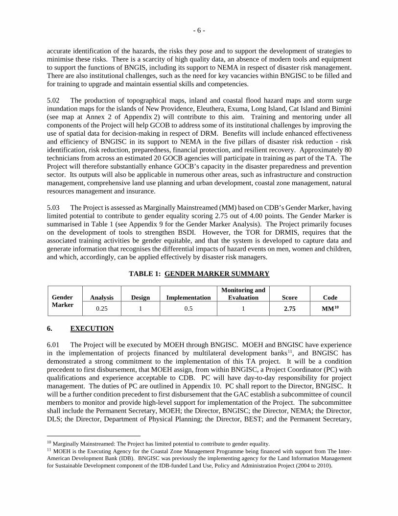
- 6 - accurate identification of the hazards, the risks they pose and to support the development of strategies to minimise these risks. There is a scarcity of high quality data, an absence of modern tools and equipment to support the functions of BNGIS, including its support to NEMA in respect of disaster risk management. There are also institutional challenges, such as the need for key vacancies within BNGISC to be filled and for training to upgrade and maintain essential skills and competencies. 5.02 The production of topographical maps, inland and coastal flood hazard maps and storm surge inundation maps for the islands of New Providence, Eleuthera, Exuma, Long Island, Cat Island and Bimini (see map at Annex 2 of Appendix 2) will contribute to this aim. Training and mentoring under all components of the Project will help GCOB to address some of its institutional challenges by improving the use of spatial data for decision-making in respect of DRM. Benefits will include enhanced effectiveness and efficiency of BNGISC in its support to NEMA in the five pillars of disaster risk reduction - risk identification, risk reduction, preparedness, financial protection, and resilient recovery. Approximately 80 technicians from across an estimated 20 GOCB agencies will participate in training as part of the TA. The Project will therefore substantially enhance GOCB’s capacity in the disaster preparedness and prevention sector. Its outputs will also be applicable in numerous other areas, such as infrastructure and construction management, comprehensive land use planning and urban development, coastal zone management, natural resources management and insurance. 5.03 The Project is assessed as Marginally Mainstreamed (MM) based on CDB’s Gender Marker, having limited potential to contribute to gender equality scoring 2.75 out of 4.00 points. The Gender Marker is summarised in Table 1 (see Appendix 9 for the Gender Marker Analysis). The Project primarily focuses on the development of tools to strengthen BSDI. However, the TOR for DRMIS, requires that the associated training activities be gender equitable, and that the system is developed to capture data and generate information that recognises the differential impacts of hazard events on men, women and children, and which, accordingly, can be applied effectively by disaster risk managers.
TABLE 1: GENDER MARKER SUMMARY
Gender Marker
Analysis Design Implementation Monitoring and
Evaluation Score Code
0.25 1 0.5 1 2.75 MM10
6. EXECUTION 6.01 The Project will be executed by MOEH through BNGISC. MOEH and BNGISC have experience in the implementation of projects financed by multilateral development banks11, and BNGISC has demonstrated a strong commitment to the implementation of this TA project. It will be a condition precedent to first disbursement, that MOEH assign, from within BNGISC, a Project Coordinator (PC) with qualifications and experience acceptable to CDB. PC will have day-to-day responsibility for project management. The duties of PC are outlined in Appendix 10. PC shall report to the Director, BNGISC. It will be a further condition precedent to first disbursement that the GAC establish a subcommittee of council members to monitor and provide high-level support for implementation of the Project. The subcommittee shall include the Permanent Secretary, MOEH; the Director, BNGISC; the Director, NEMA; the Director, DLS; the Director, Department of Physical Planning; the Director, BEST; and the Permanent Secretary,
10 Marginally Mainstreamed: The Project has limited potential to contribute to gender equality. 11 MOEH is the Executing Agency for the Coastal Zone Management Programme being financed with support from The Inter-American Development Bank (IDB). BNGISC was previously the implementing agency for the Land Information Management for Sustainable Development component of the IDB-funded Land Use, Policy and Administration Project (2004 to 2010).
- 7 - Ministry of Works and Urban Development, all of whom are members of GAC. The subcommittee will be chaired by the Permanent Secretary, MOEH. The Director, BNGISC shall serve as secretary to the subcommittee, which shall be required to meet at least once every three months. 6.02 To enhance the sustainability of the benefits of the Project, it will be a condition of the Loan that by January 31, 2018, GOCB fill any vacant GIS Technician positions and the vacant Cartographic Specialist position within BNGISC. BNGISC staff will work closely with the contractor and consultants to ensure knowledge transfer. The proposed timing provides a realistic period within which GOCB would be able to recruit suitable candidates. It will also provide any staff joining BNGISC adequate time to participate in, and develop a strong understanding of, the development of DRMIS, and thereby contribute to the ownership of the Project outputs within BNGIS.
6.03 CDB will facilitate a Project Launch Workshop (PLW) to review the implementation arrangements, train the PC and supporting staff within BNGISC in the use of CDB’s fiduciary management and procurement systems, and discuss project supervision issues with stakeholders. PLW is scheduled for the second quarter of 2017, and arrangements will be finalised in consultation with GOCB. CDB will be kept informed of the Project’s progress by reports submitted by the consultants, through the PC and the PC’s progress reports. The Project has an estimated duration of 20 calendar months. The Draft Project Implementation Schedule is presented in Appendix 11. It is expected that the first disbursement from the Loan will be made by June 30, 2017 and that the Loan will be fully disbursed by December 31, 2018.
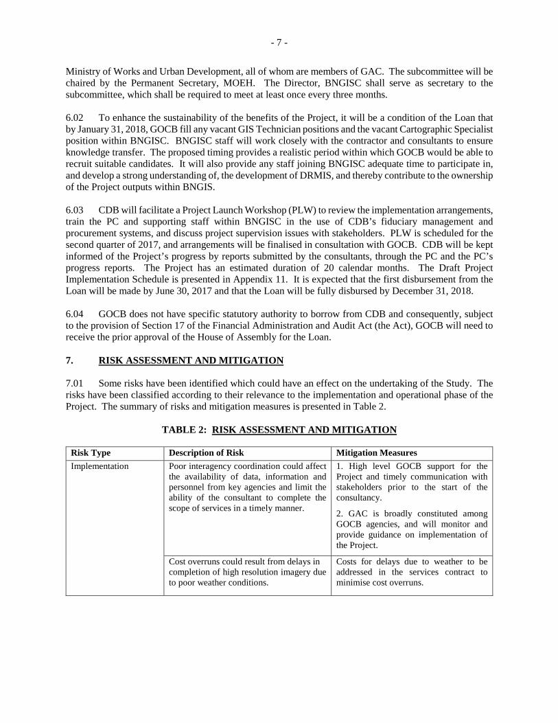
6.04 GOCB does not have specific statutory authority to borrow from CDB and consequently, subject to the provision of Section 17 of the Financial Administration and Audit Act (the Act), GOCB will need to receive the prior approval of the House of Assembly for the Loan. 7. RISK ASSESSMENT AND MITIGATION 7.01 Some risks have been identified which could have an effect on the undertaking of the Study. The risks have been classified according to their relevance to the implementation and operational phase of the Project. The summary of risks and mitigation measures is presented in Table 2.
TABLE 2: RISK ASSESSMENT AND MITIGATION Risk Type Description of Risk Mitigation Measures Implementation Poor interagency coordination could affect
the availability of data, information and personnel from key agencies and limit the ability of the consultant to complete the scope of services in a timely manner.
1. High level GOCB support for the Project and timely communication with stakeholders prior to the start of the consultancy.
2. GAC is broadly constituted among GOCB agencies, and will monitor and provide guidance on implementation of the Project.
Cost overruns could result from delays in completion of high resolution imagery due to poor weather conditions.
Costs for delays due to weather to be addressed in the services contract to minimise cost overruns.
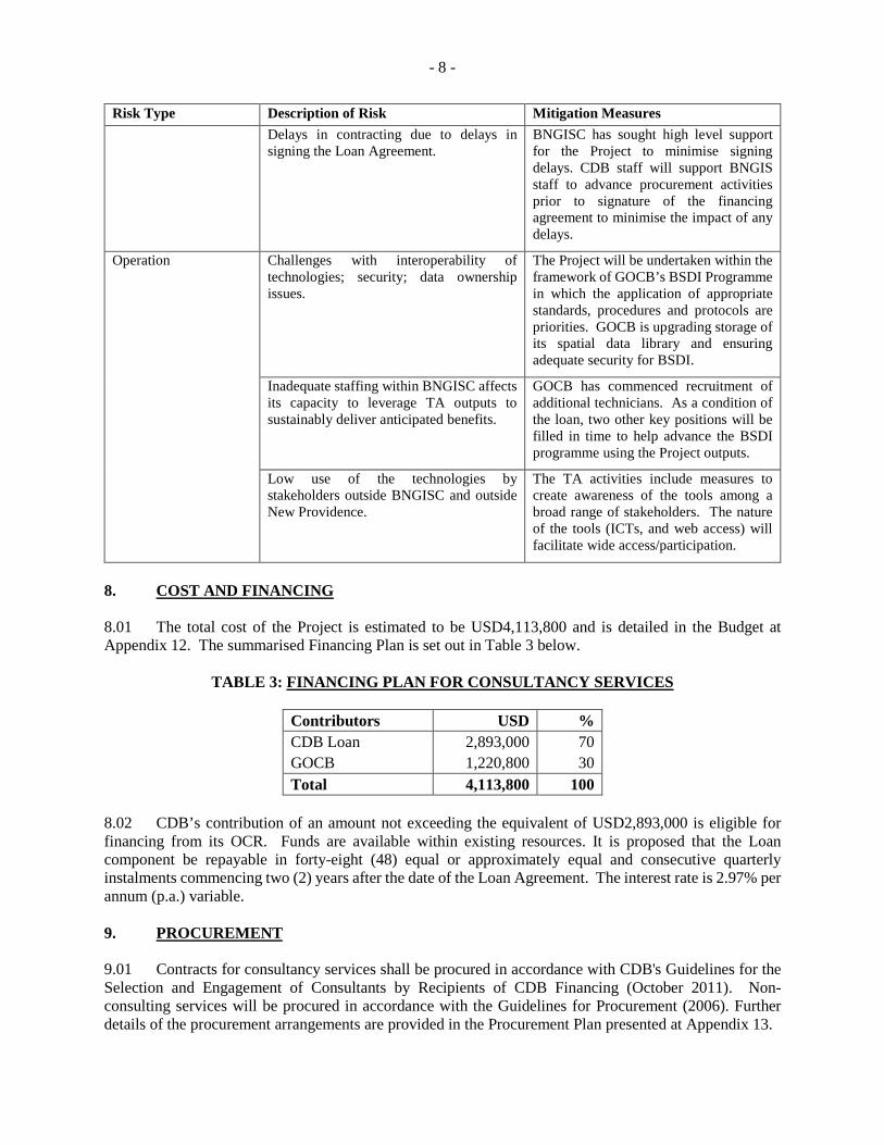
- 8 -
Risk Type Description of Risk Mitigation Measures Delays in contracting due to delays in signing the Loan Agreement.
BNGISC has sought high level support for the Project to minimise signing delays. CDB staff will support BNGIS staff to advance procurement activities prior to signature of the financing agreement to minimise the impact of any delays.
Operation Challenges with interoperability of technologies; security; data ownership issues.
The Project will be undertaken within the framework of GOCB’s BSDI Programme in which the application of appropriate standards, procedures and protocols are priorities. GOCB is upgrading storage of its spatial data library and ensuring adequate security for BSDI.
Inadequate staffing within BNGISC affects its capacity to leverage TA outputs to sustainably deliver anticipated benefits.
GOCB has commenced recruitment of additional technicians. As a condition of the loan, two other key positions will be filled in time to help advance the BSDI programme using the Project outputs.
Low use of the technologies by stakeholders outside BNGISC and outside New Providence.
The TA activities include measures to create awareness of the tools among a broad range of stakeholders. The nature of the tools (ICTs, and web access) will facilitate wide access/participation.
8. COST AND FINANCING 8.01 The total cost of the Project is estimated to be USD4,113,800 and is detailed in the Budget at Appendix 12. The summarised Financing Plan is set out in Table 3 below.
TABLE 3: FINANCING PLAN FOR CONSULTANCY SERVICES
Contributors USD % CDB Loan 2,893,000 70 GOCB 1,220,800 30 Total 4,113,800 100
8.02 CDB’s contribution of an amount not exceeding the equivalent of USD2,893,000 is eligible for financing from its OCR. Funds are available within existing resources. It is proposed that the Loan component be repayable in forty-eight (48) equal or approximately equal and consecutive quarterly instalments commencing two (2) years after the date of the Loan Agreement. The interest rate is 2.97% per annum (p.a.) variable. 9. PROCUREMENT 9.01 Contracts for consultancy services shall be procured in accordance with CDB's Guidelines for the Selection and Engagement of Consultants by Recipients of CDB Financing (October 2011). Non-consulting services will be procured in accordance with the Guidelines for Procurement (2006). Further details of the procurement arrangements are provided in the Procurement Plan presented at Appendix 13.
- 9 - 10. RECOMMENDATION 10.01 It is recommended that CDB approve a loan to GOCB from CDB’s OCR of an amount not exceeding the equivalent of two million, eight hundred and ninety-three thousand United States dollars (USD2,893,000) (the Loan) to assist GOCB in financing consultancy services for enhancements to the geomatics capacity of BNGISC (the Project), on CDB's standard terms and conditions and on the following terms and conditions:
(1) Repayment:
(a) Repayment of the Loan shall be made in forty-eight (48) equal or approximately
equal and consecutive quarterly instalments commencing two (2) years after the date of the Loan Agreement.
(2) Interest:
(a) Interest shall be payable quarterly at the rate of two decimal nine seven percent
(2.97%) p.a. on the amount of the Loan withdrawn and outstanding from time to time.
(3) Commitment Charge: A commitment charge at the rate of one percent (1%) p.a. shall be
payable on the amount of the Loan unwithdrawn from time to time. Such charge shall accrue from the sixtieth (60th) day after the date of the Loan Agreement and shall be payable quarterly.
(4) Disbursement:
(a) The first disbursement of the Loan shall be made by June 30, 2017 and the Loan shall be fully disbursed by December 31, 2018, or such later dates as CDB may specify in writing.
(b) Except as CDB may otherwise agree:
(i) the Loan shall be used to meet the cost of the items allocated for financing
by CDB as shown in the budget for the Project set out at Appendix 12 (the Budget) up to the respective limits specified therein;
(ii) total disbursements shall not exceed in the aggregate seventy per cent
(70%) of the cost of the Project. (c) The Loan shall not be used to finance, directly or indirectly, any part of the cost of
the Project which consists of identifiable taxes or duties.
(5) Procurement: (a) Procurement shall be in accordance with the procedures set out and/or referred to
in the agreement between CDB and GOCB providing for the Loan, or such other procedures as CDB may from time to time specify in writing.
- 10 -
(b) The Procurement Plan is set out at Appendix 13. Any revisions to the Procurement Plan shall require CDB’s prior approval in writing.
(6) Conditions Precedent to First Disbursement: GOCB shall have:
(a) assigned the PC referred to in sub-paragraph 6(b)(v) below.
(b) established the sub-committee of GAC as referred to in sub-paragraph 6(b)(vi) below.
(c) provided CDB with evidence acceptable to CDB that GOCB has received House of Assembly approval for the Loan.
(7) Other Conditions:
(a) Except as CDB may otherwise agree, GOCB shall implement the Project through
BNGISC of MOEH.
(b) GOCB shall: (i) contribute to the Project an amount of not less than the equivalent of one
million, two hundred and twenty-two thousand, eight hundred United States dollars (USD1,220,800) which shall be expended in a timely manner on the components of the Project designated for financing by GOCB as shown in the Budget, unless CDB shall otherwise specify in writing;
(ii) carry out the Project at all times with due diligence and efficiency, with
management personnel whose qualifications and experience are acceptable to CDB, and in accordance with sound technical, environmental, financial and managerial standards and practices;
(iii) institute and maintain organisational, administrative, accounting and
auditing arrangements acceptable to CDB; (iv) for the duration of the project, assign from within BNGISC, a member of
staff with qualifications and experience acceptable to CDB as the PC. The PC shall have day to day responsibility for the Project and perform the functions in accordance with the duties outlined at Appendix 10. The qualifications and experience of any person subsequently assigned as PC for the Project shall be acceptable to CDB;
(v) for the duration of the Project, establish and maintain the GAC sub-
committee in accordance with paragraph 6.01 of this Report; (vi) by January 31, 2018 or such later date as CDB may otherwise agree, fill
all vacant GIS Technician positions and the vacant Cartographic Specialist position within BNGISC;
- 11 -
(vii) in accordance with the procurement procedures applicable to the Loan, select and engage consultant(s) and service providers to carry out the services set out in the TORs at Appendices 2 to 5; and
(viii) except as CDB may otherwise agree, furnish or cause to be furnished to
CDB, the reports to be provided by the consultant(s), service providers and the PC in accordance with the TORs at Appendices 2 to 5 and 10, in the forms specified or in such form or forms as CDB may require, not later than the times/periods specified therein for so doing.
SUPPORTING DOCUMENTATION Appendix 1: - Organisation Chart - Bahamas National Geographic Information Services Centre Appendix 2: - Draft Terms of Reference - Surveys, Digital Terrain Modelling and Topographical
Mapping Appendix 3: - Draft Terms of Reference - Quality Assurance for Review of Lidar Survey, Imagery,
Digital Terrain Model and Topographic Base Model Appendix 4: - Draft Terms of Reference – Consultancy Services to undertake Storm Water Flooding
and Storm Surge Inundation Mapping Appendix 5: - Draft Terms of Reference – Development of a Disaster Risk Management Information
System Appendix 6: - Indicative List of Equipment for The Bahamas Spatial Data Infrastructure Support Appendix 7: - Performance Rating System Appendix 8: - Design and Monitoring Framework Appendix 9: - Gender Marker Analysis Appendix 10: - Draft Terms of Reference – Project Coordinator Appendix 11 - Draft Project Implementation Schedule Appendix 12: - Budget Appendix 13: - Procurement Plan
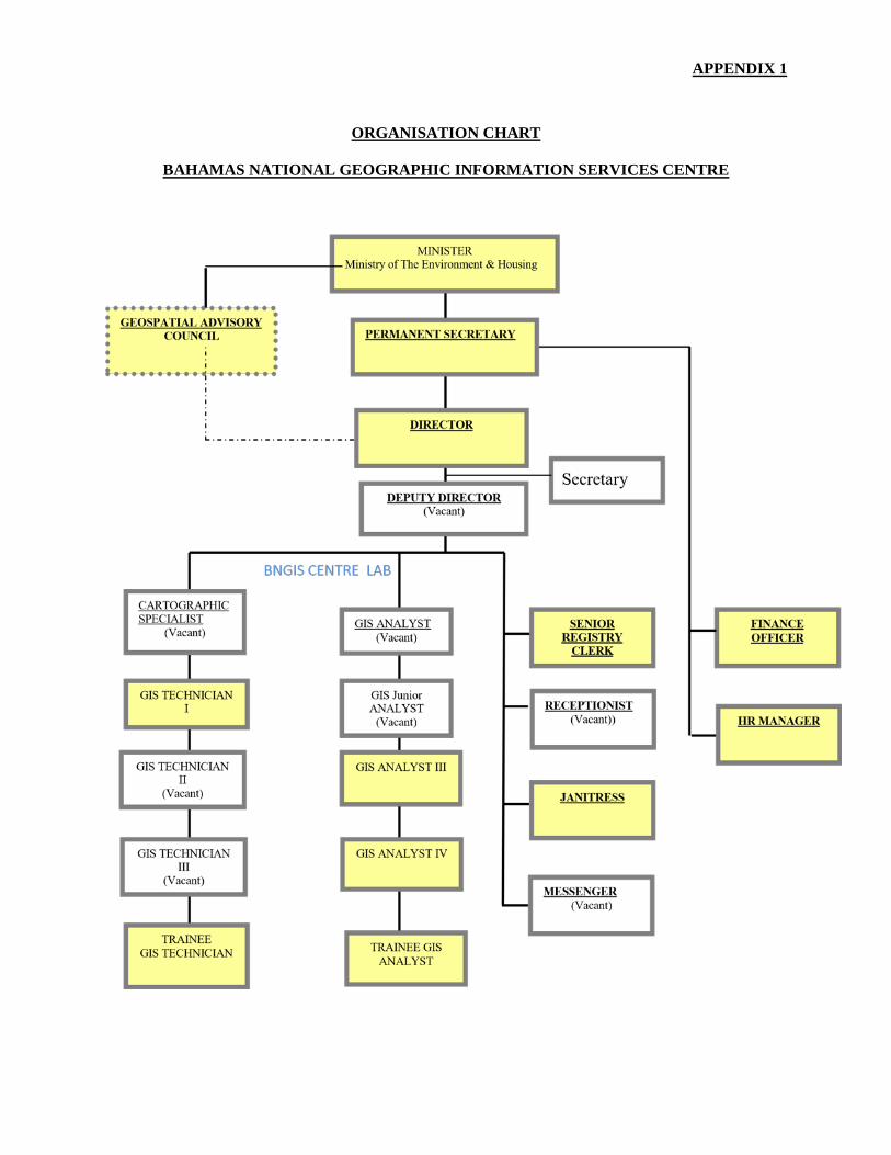
APPENDIX 1
ORGANISATION CHART
BAHAMAS NATIONAL GEOGRAPHIC INFORMATION SERVICES CENTRE
APPENDIX 2
DRAFT TERMS OF REFERENCE
SURVEYS, DIGITAL TERRAIN MODELLING AND TOPOGRAPHICAL MAPPING 1. BACKGROUND
1.01 The Commonwealth of The Bahamas is an archipelago of 700 islands located in the Western Atlantic Ocean, just to the South East of Florida, and North East of Cuba. The island chain covers a total area of 13,940 square kilometres. New Providence and Grand Bahama, contain 70% and 14% respectively of the total population of 353658. Other islands such Andros, Bimini, Great Abaco, Eleuthera, Cat Island, San Salvador Island, and Exuma are sparsely populated but contribute significantly to tourism. The terrain of the islands is generally flat, with the highest point (Mount Alvernia on Cat Island) having an elevation of 63 metres (m). The economy of The Bahamas is driven mainly by tourism and offshore banking. 1.02 The geographic location and geological characteristics of The Bahamas make the country vulnerable to multiple natural hazards, including hurricanes1, storm surge, floods, tsunamis, droughts and earthquakes. This high vulnerability to natural hazards is exacerbated by the country’s spatial development patterns as the majority of infrastructure and settlements is located on, or near the coast. The Bahamas is considered to be at risk from the impacts of climate variability and change due largely to its low elevation. A recent study carried out by CARIBSAVE indicate that 1 m sea level rise (SLR) places 90% of seaport lands, 38% of airport lands, 36% of the major tourism properties, and 14% of road networks at risk. With a 2 m SLR, 50% of major tourism resorts would be impacted2. The study also found that with 100 m of erosion (resulting from approx. 1 m SLR), 70% of the major tourism resorts and 80% of sea turtle nesting sites would be impacted. 1.03 An essential component of building resilience to natural hazard and climate risks is to have the capacity to identify hazards, reduce hazard risks, respond to hazard occurrence in a timely manner, and recover from disasters. The availability of current geospatial information is essential in that regard. 2. OBJECTIVE 2.01 The objective of the services is to conduct Light Detection and Ranging (LiDAR) surveys, produce high resolution aerial photography of selected islands in The Bahamas (and their surrounding cays), namely Bimini, Exuma, Eleuthera, Long Island, Cat Island and New Providence and Topographic Mapping including Digital Terrain Models (DTM), Contours and Ortho-rectified imagery for these islands. The photography is required to produce 20 cm resolution ortho-imagery and an accurate digital terrain (elevation) model. The data should be geo-referenced to the Universal Transverse Mercator Grid System, Zone 17 or 18 (where applicable), WGS 84 Datum. 3. SCOPE OF WORK 3.01 In the conduct of this work, the contractors shall cooperate fully with The Bahamas National Geographic Information Systems Centre (BNGISC) and key stakeholders including agencies of the Government of the Commonwealth of The Bahamas (GOCB) involved in the development and implementation of the project. The contractors will be required to adopt a participatory approach, including
1 The Bahamas has been affected by several of significant storms including the 1866 Great Bahamas hurricane, the 1926 Nassau hurricane, the 1928 Okeechobee hurricane, the 1929 and 1932 Bahamas hurricanes and the 1947 Fort Lauderdale hurricane. More recently, major impacts have been felt from Hurricanes Andrew in 1992, Floyd in 1999, Frances in 2004, and Joaquin in 2015. 2 Beach assets will be affected much earlier than erosion damages induced erosion damages to infrastructure; indeed, once erosion is damaging infrastructure, it means the beach, a vital tourism asset, has essentially disappeared.
APPENDIX 2 Page 2
wide stakeholder consultation throughout the conduct of the assignment. This should include beneficiary consultation to discuss designs with stakeholders. The contractors will conduct a Stakeholder Analysis at the start of the services. The services are to be conducted in accordance with the specifications in Annexes 1 and 2 to these Terms of Reference (TOR). 3.02 The scope of services includes, but is not limited to:
(a) Researching, collecting and analysing existing and historic topographic data, land use, information regarding the national geographic information systems, aerial imagery, and other data to characterise the project islands.
(b) Acquiring ortho-imagery/aerial photography for the project islands and their surrounding cays at 20 cm resolution.
(c) Producing DTM with 1 ft, 2 ft and 10 ft contour intervals (to be finalised through consultation with GOCB stakeholders).
(d) Producing Digital Topographic Mapping for the Islands and surrounding cays.
(e) Producing ortho-rectified imagery for the Islands.
(f) Reporting on all raw data collected in formats that can be used in common digital databases and/or Geographic Information Systems (GIS).
(g) Mentoring the designated staff of GOCB agencies throughout the conduct of the assignment and formal training in the methodologies used to conduct the services and in the use of the systems, data, maps etc. produced.
4. IMPLEMENTATION ARRANGEMENTS 4.01 The Contractor will report to the Project Coordinator (PC) within The Bahamas National Geographic Information Systems Centre (BNGISC). While BNGISC will assist in facilitating the work of the Contractor, the Contractor will be responsible for the collection of all data and information required for the successful completion of the services. PC will act as the liaison for consultations between the Contractor and the relevant GOCB agencies and other key stakeholders throughout the duration of the assignment. 5. QUALIFICATIONS AND EXPERIENCE
5.01 The minimum qualifications of the members of the consulting team shall include Masters Degrees in the relevant disciplines and minimum of 10 years’ relevant experience, or Bachelor’s degrees in the disciplines identified and a minimum of 15 years’ relevant experience. The team should also possess experience in the areas of surveying, GIS, disaster risk management, engineering and physical planning. Professional qualifications in the relevant areas such as surveying, engineering, etc. will be required.
6. REPORTING REQUIREMENTS 6.01 The Contractor(s) will be required to submit the following reports to GOCB and the Caribbean Development Bank (CDB), within the time periods indicated:
APPENDIX 2 Page 3
(a) An Inception Report describing the approaches, methodologies and time-lines proposed to
be taken to prepare and deliver the scope of works outlined within two weeks of the start of the services. GOCB and CDB will provide comments on this report within two weeks of receipt of the report and the contractors will adjust the ongoing work according to the comments received.
(b) Monthly summary reports on the progress of the services including, among other things, copies of the data acquired, the results of work activities undertaken; constraints; challenges experienced; schedule changes, etc.
(c) A Draft Final Report upon completion of the services including all work products produced. These shall include, in respect of all project islands:
(i) Ortho-rectified imagery;
(ii) DTMs; and
(iii) Topographical maps.
(d) A Final Report incorporating the comments of GOCB and CDB within one month of receipt of those comments.
6.02 All reports should be submitted to GOCB and CDB both in hard-copy (1 copy each) and in electronic format. Maps and drawings should also be submitted electronically and in hard-copy. Reports should be submitted in Microsoft Word and/or Microsoft Excel formats as appropriate, drawings should be submitted as CAD files, and maps as well as raw data in GIS formats. All data collected or produced during the consultancy shall be submitted to GOCB with the Draft Final Report. 7. DURATION 7.01 It is estimated that the services will be performed over a period of 12 months. 8. MANPOWER, SCHEDULING AND COSTS 8.01 In estimating person-month requirements and costs of the services, the Contractors should ensure that the proposal takes full account of all fees and direct expenses required to fulfil the above requirements and the following items:
(a) contractor’s remuneration;
(b) contractor’s out-of-pocket expenses;
(c) support staff services;
(d) equipment hire;
(e) communications costs;
(f) contract documentation production costs;
(g) supervision costs; and
(h) survey costs.
APPENDIX 2 Page 4
9. COMMENTS BY THE CONTRACTORS 9.01 The contractors are encouraged to make comments on, and suggestions for, improvements to these TOR. The financial implications, if any, of these recommendations should be indicated separately in the Financial Proposal. 10. INPUTS FROM THE CLIENT 10.01 The following services and facilities will be provided by the Client:
(a) Office Accommodation: BNGISC will provide desk space for the Contractors. The Contractors will be required to provide their own computers.
(b) Access: BNGISC will arrange for access by the Contractor(s) to key GOCB officials in
the stakeholder agencies.
(c) Data: BNGISC will provide the contractors with copies of the existing GOCB laws, regulations, policies, etc. pertaining to storm-water management, disaster management, planning, environmental management and climate change.
(d) Support Staff: BNGISC personnel will accompany the Contractors on local field visits,
meetings, etc., to the extent required.
BUDGET (USD)
This information is withheld in accordance with one or more of the exceptions to disclosure under the Bank’s Information Disclosure Policy.
ANNEX 1 TO APPENDIX 2
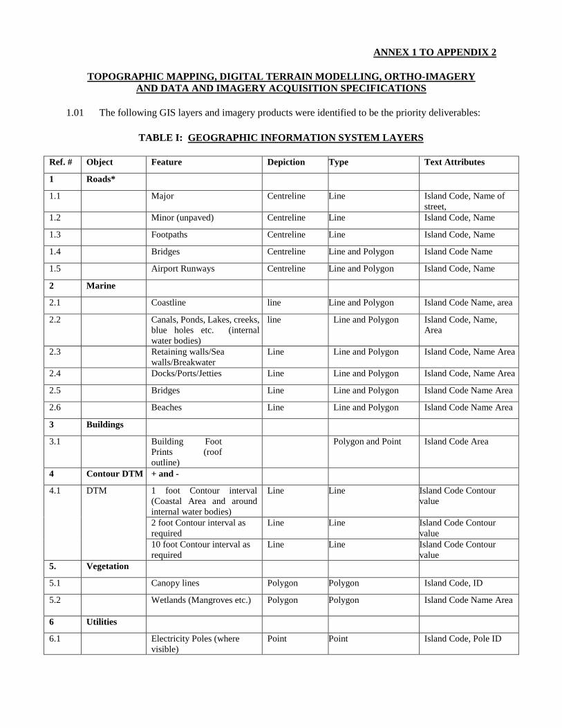
TOPOGRAPHIC MAPPING, DIGITAL TERRAIN MODELLING, ORTHO-IMAGERY AND DATA AND IMAGERY ACQUISITION SPECIFICATIONS
1.01 The following GIS layers and imagery products were identified to be the priority deliverables:
TABLE I: GEOGRAPHIC INFORMATION SYSTEM LAYERS
Ref. # Object Feature Depiction Type Text Attributes
1 Roads*
1.1 Major Centreline Line Island Code, Name of street,
1.2 Minor (unpaved) Centreline Line Island Code, Name
1.3 Footpaths Centreline Line Island Code, Name
1.4 Bridges Centreline Line and Polygon Island Code Name
1.5 Airport Runways Centreline Line and Polygon Island Code, Name
2 Marine
2.1 Coastline line Line and Polygon Island Code Name, area
2.2 Canals, Ponds, Lakes, creeks, blue holes etc. (internal water bodies)
line Line and Polygon Island Code, Name, Area
2.3 Retaining walls/Sea walls/Breakwater
Line Line and Polygon Island Code, Name Area
2.4 Docks/Ports/Jetties Line Line and Polygon Island Code, Name Area
2.5 Bridges Line Line and Polygon Island Code Name Area
2.6 Beaches Line Line and Polygon Island Code Name Area
3 Buildings
3.1 Building Foot Prints (roof outline)
Polygon and Point Island Code Area
4 Contour DTM + and -
4.1 DTM
1 foot Contour interval (Coastal Area and around internal water bodies)
Line Line Island Code Contour value
2 foot Contour interval as required
Line Line Island Code Contour value
10 foot Contour interval as required
Line Line Island Code Contour value
5. Vegetation
5.1 Canopy lines Polygon Polygon Island Code, ID
5.2 Wetlands (Mangroves etc.)
Polygon Polygon Island Code Name Area
6 Utilities
6.1 Electricity Poles (where visible)
Point Point Island Code, Pole ID
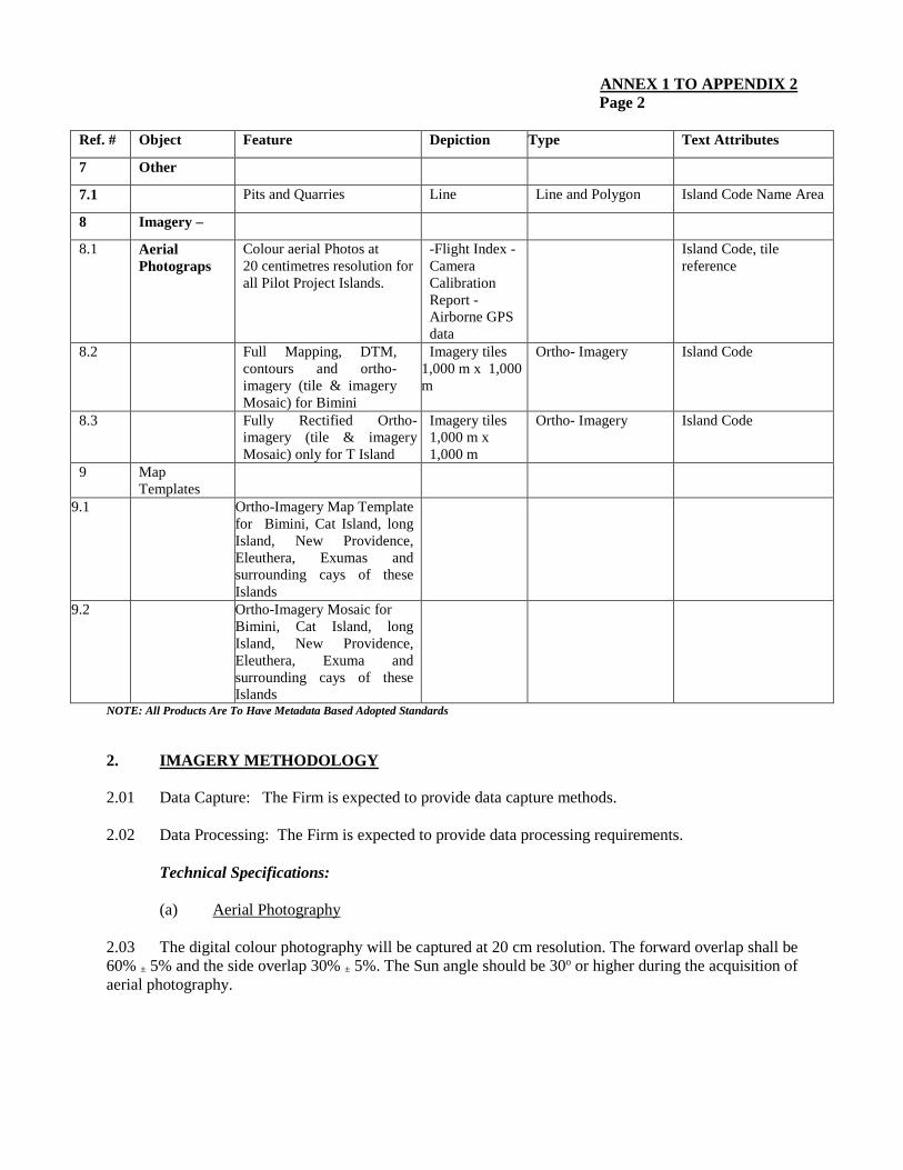
ANNEX 1 TO APPENDIX 2 Page 2
Ref. # Object Feature Depiction Type Text Attributes
7 Other
7.1 Pits and Quarries Line Line and Polygon Island Code Name Area
8 Imagery –
8.1 Aerial Photograps
Colour aerial Photos at 20 centimetres resolution for all Pilot Project Islands.
-Flight Index -Camera Calibration Report - Airborne GPS data
Island Code, tile reference
8.2 Full Mapping, DTM, contours and ortho-imagery (tile & imagery Mosaic) for Bimini
Imagery tiles 1,000 m x 1,000 m
Ortho- Imagery Island Code
8.3 Fully Rectified Ortho-imagery (tile & imagery Mosaic) only for T Island
Imagery tiles 1,000 m x 1,000 m
Ortho- Imagery Island Code
9 Map Templates
9.1 Ortho-Imagery Map Template for Bimini, Cat Island, long Island, New Providence, Eleuthera, Exumas and surrounding cays of these Islands
9.2 Ortho-Imagery Mosaic for Bimini, Cat Island, long Island, New Providence, Eleuthera, Exuma and surrounding cays of these Islands
NOTE: All Products Are To Have Metadata Based Adopted Standards
2. IMAGERY METHODOLOGY 2.01 Data Capture: The Firm is expected to provide data capture methods. 2.02 Data Processing: The Firm is expected to provide data processing requirements.
Technical Specifications: (a) Aerial Photography
2.03 The digital colour photography will be captured at 20 cm resolution. The forward overlap shall be 60% ± 5% and the side overlap 30% ± 5%. The Sun angle should be 30o or higher during the acquisition of aerial photography.
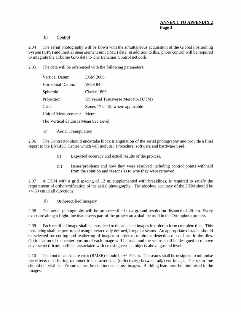
ANNEX 1 TO APPENDIX 2 Page 3
(b) Control
2.04 The aerial photography will be flown with the simultaneous acquisition of the Global Positioning System (GPS) and inertial measurement unit (IMU) data. In addition to this, photo control will be required to integrate the airborne GPS data to The Bahamas Control network. 2.05 The data will be referenced with the following parameters:
Vertical Datum: EGM 2008
Horizontal Datum: WGS 84
Spheroid: Clarke 1866
Projection: Universal Transverse Mercator (UTM)
Grid: Zones 17 or 18, where applicable
Unit of Measurement: Metre
The Vertical datum is Mean Sea Level. (c) Aerial Triangulation
2.06 The Contractor should undertake block triangulation of the aerial photography and provide a final report to the BNGISC Centre which will include: Procedure, software and hardware used:
(i) Expected accuracy and actual results of the process.
(ii) Issues/problems and how they were resolved including control points withheld
from the solution and reasons as to why they were removed.
2.07 A DTM with a grid spacing of 12 m, supplemented with breaklines, is required to satisfy the requirement of orthorectification of the aerial photography. The absolute accuracy of the DTM should be +/- 50 cm in all directions.
(d) Orthorectified Imagery
2.08 The aerial photography will be orth-orectified to a ground resolution distance of 20 cm. Every exposure along a flight line that covers part of the project area shall be used in the Orthophoto process. 2.09 Each rectified image shall be mosaiced to the adjacent images in order to form complete tiles. This mosaicing shall be performed using interactively defined, irregular seams. An appropriate distance should be selected for cutting and feathering of images in order to minimise detection of cut lines in the tiles. Optimisation of the center portion of each image will be used and the seams shall be designed to remove adverse rectification effects associated with crossing vertical objects above ground level.
2.10 The root mean square error (RMSE) should be +/- 50 cm. The seams shall be designed to minimise the effects of differing radiometric characteristics (reflectivity) between adjacent images. The seam line should not visible. Features must be continuous across images. Building lean must be minimised in the images.
ANNEX 1 TO APPENDIX 2 Page 4
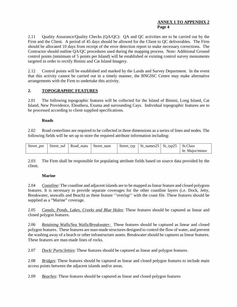
2.11 Quality Assurance/Quality Checks (QA/QC): QA and QC activities are to be carried out by the Firm and the Client. A period of 45 days should be allowed for the Client to QC deliverables. The Firm should be allocated 10 days from receipt of the error detection report to make necessary corrections. The Contractor should outline QA/QC procedures used during the mapping process. Note: Additional Ground control points (minimum of 5 points per Island) will be established or existing control survey monuments targeted in order to rectify Bimini and Cat Island Imagery. 2.12 Control points will be established and marked by the Lands and Survey Department. In the event that this activity cannot be carried out in a timely manner, the BNGISC Centre may make alternative arrangements with the Firm to undertake this activity. 2. TOPOGRAPHIC FEATURES
2.01 The following topographic features will be collected for the Island of Bimini, Long Island, Cat Island, New Providence, Eleuthera, Exuma and surrounding Cays. Individual topographic features are to be processed according to client supplied specifications.
Roads
2.02 Road centerlines are required to be collected in three dimensions as a series of lines and nodes. The following fields will be set up to store the required attribute information including: Street_pre Street_suf Road_statu Street_nam Street_typ St_names25 St_typ25
St.Class Ie. Major/minor
2.03 The Firm shall be responsible for populating attribute fields based on source data provided by the client.
Marine
2.04 Coastline: The coastline and adjacent islands are to be mapped as linear feature and closed polygons features. It is necessary to provide separate coverages for the other coastline layers (i.e. Dock, Jetty, Breakwater, seawalls and Beach) as these feature ‘’overlap’’ with the coast file. These features should be supplied as a “Marine” coverage.
2.05 Canals, Ponds, Lakes, Creeks and Blue Holes: These features should be captured as linear and closed polygon features. 2.06 Retaining Walls/Sea Walls/Breakwater: These features should be captured as linear and closed polygon features. These features are man-made structures designed to control the flow of water, and prevent the washing away of a beach or other infrastructure assets. Breakwater should be captures as linear features. These features are man-made lines of rocks.
2.07 Dock/ Ports/Jetties: These features should be captured as linear and polygon features. 2.08 Bridges: These features should be captured as linear and closed polygon features to include main access points between the adjacent islands and/or areas.
2.09 Beaches: These features should be captured as linear and closed polygon features
ANNEX 1 TO APPENDIX 2 Page 5
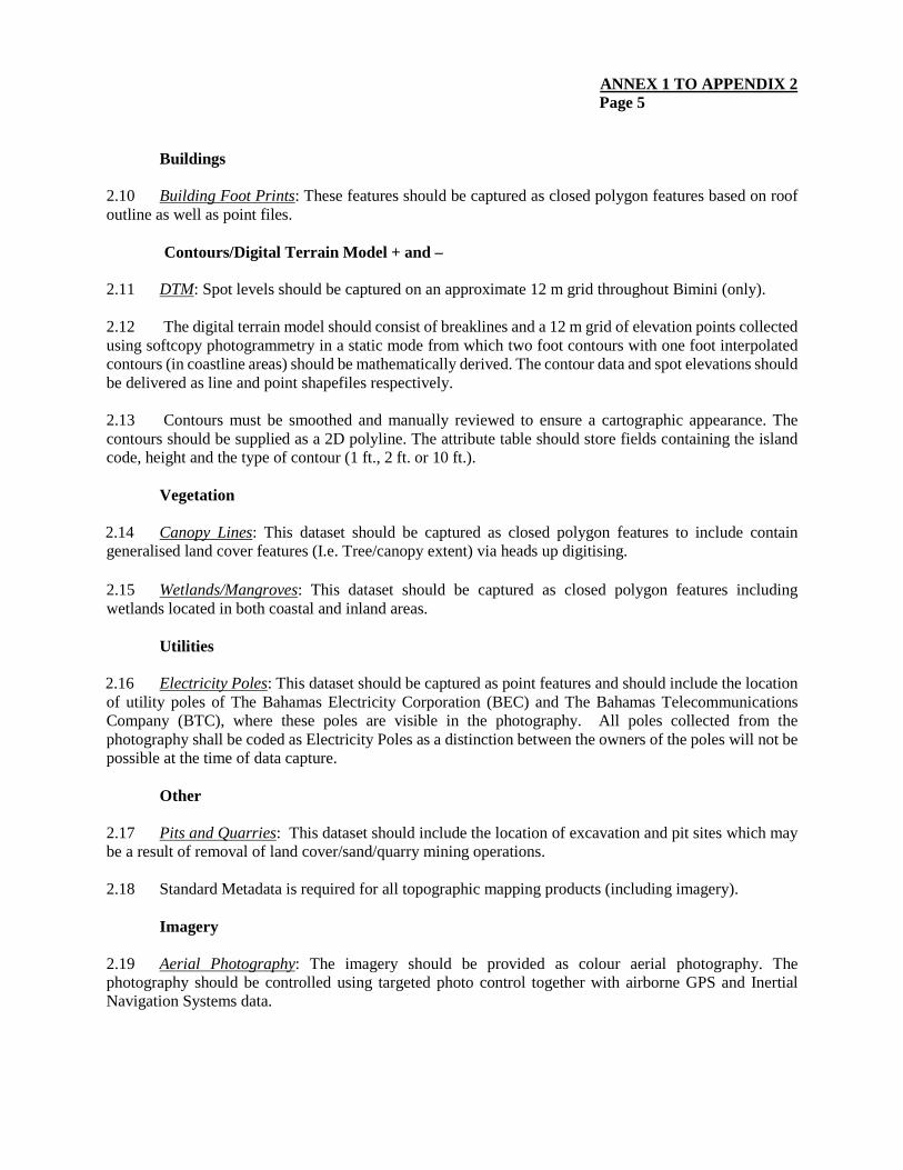
Buildings
2.10 Building Foot Prints: These features should be captured as closed polygon features based on roof outline as well as point files.
Contours/Digital Terrain Model + and –
2.11 DTM: Spot levels should be captured on an approximate 12 m grid throughout Bimini (only). 2.12 The digital terrain model should consist of breaklines and a 12 m grid of elevation points collected using softcopy photogrammetry in a static mode from which two foot contours with one foot interpolated contours (in coastline areas) should be mathematically derived. The contour data and spot elevations should be delivered as line and point shapefiles respectively. 2.13 Contours must be smoothed and manually reviewed to ensure a cartographic appearance. The contours should be supplied as a 2D polyline. The attribute table should store fields containing the island code, height and the type of contour (1 ft., 2 ft. or 10 ft.).
Vegetation
2.14 Canopy Lines: This dataset should be captured as closed polygon features to include contain generalised land cover features (I.e. Tree/canopy extent) via heads up digitising. 2.15 Wetlands/Mangroves: This dataset should be captured as closed polygon features including wetlands located in both coastal and inland areas.
Utilities
2.16 Electricity Poles: This dataset should be captured as point features and should include the location of utility poles of The Bahamas Electricity Corporation (BEC) and The Bahamas Telecommunications Company (BTC), where these poles are visible in the photography. All poles collected from the photography shall be coded as Electricity Poles as a distinction between the owners of the poles will not be possible at the time of data capture.
Other
2.17 Pits and Quarries: This dataset should include the location of excavation and pit sites which may be a result of removal of land cover/sand/quarry mining operations.
2.18 Standard Metadata is required for all topographic mapping products (including imagery).
Imagery
2.19 Aerial Photography: The imagery should be provided as colour aerial photography. The photography should be controlled using targeted photo control together with airborne GPS and Inertial Navigation Systems data.
ANNEX 1 TO APPENDIX 2 Page 6
2.20 This contract will capture aerial photographs at 20 cm resolution for all Pilot Project Islands (New Providence, Cat, Long, Eleuthera, Exuma, Bimini and any surrounding cays of these islands). The firm is to provide to the Client digital (calibrated) images in tiff format and a digital copy of the Aerial Flight Lines with image numbers (beginning and end of lines) in ESRI Shape file and pdf format. The digital data should support a mapping scale of 1:2000. The maximum cloud coverage permitted is 5% over the project areas.
2.21 Rectified Ortho-Imagery: The aerial photography will be ortho-rectified imagery (Tile and Mosaic) to a ground resolution of 20cm for the Islands included in this contract. Tiles will be grid size determined by the BNGISC with appropriate names based on XY coordinates. 2.22 Each rectified image shall be mosaicked to the adjacent images in order to form complete tiles. This mosaicking shall be performed using interactively defined, irregular seams. An appropriate distance should be selected for cutting and feathering of images in order to minimise detection of cut lines in the tiles. Optimisation of the center portion of each image will be used and the seams shall be designed to remove adverse rectification effects associated with crossing vertical objects above ground level.
Map Templates
2.23 Ortho-Imagery Map Template: To assist the BNGISC with the preparation of printed maps for Bimini and Cat Island, the firm is expected to develop map templates for the following sheet sizes and map scales:
Sheet Size Map Scales A1 or as required Pre-defined scales or user defined scales in the range of 1:1,000,000. A2 or as required Pre-defined scales or user defined scales in the range of 1:125,000. A3 or as required Pre-defined scales or user defined scales in the range of 1:10,000.
2.24 All map scales may be plotted at any of the set sheet sizes in either landscape or portrait orientation.
(a) Ortho-Imagery Map Templates Requirement.
(b) “Subtitle - Name of Island”.
(c) Produced by “Name of Company producing Imagery” Date Scale (place in the lower-right corner of the map sheet. Add additional information about the produced map as required).
(d) Produced for “The Bahamas National Geographic Information Systems Centre, Nassau, The Bahamas
(e) Additional features: As required by the Client
2.25 Ortho-Imagery Mosaic: The production of Ortho-Imagery mosaics shall be provided for all Pilot Project areas New Providence, Cat Island, Long Island, Eleuthera, Exuma, Bimini and cays surrounding these islands.
ANNEX 1 TO APPENDIX 2 Page 7
3. ACQUISITION ORDER OF PRIORITY
3.01 The following Islands are to be prioritised for completion in the following order, Bimini, Cat Island, New Providence, Long Island, Exuma and Eleuthera.
Mapping Note: The Datum to be used is WGS 84.
4. SUMMARY OF DELIVERABLES
(i) Digital Aerial Photography (20 cm resolution)for New Providence, Eleuthera, Long Island, Cat Island, Exuma and surrounding Cays and Bimini. - Flight Index
- GPS and IMU data for each exposure station
(ii) Photo Control (if provided by Contractor) - Location and Descriptions of all photo control points if other than existing targeted
control monuments
- Listing of coordinates of all photo control points
(iii) Aerial Triangulation for Bimini, Cat Island, Long Island, New Providence - LPS Block File
(iv) Elevation Data
- DTM in Terrain model in ASCII format for Bimini, Cat Island, long Island, New
Providence, Eleuthera, Exuma and surrounding Cays
- Raster elevation model in tif and img formats for Bimini, Cat Island, Long Island
(v) Topographic Mapping (aa) Digital files containing the mapping of Topographic features as set out in
Section 2.
(bb) Contours interpolated 1’ contours 2’ and 10’ as determined by the BNGISC in Arc GIS shapefile format
(vi) Ortho-imagery
(aa) 20 cm ortho-rectified tiles in tif, img and MrSID (compression 20:1) formats for
all Islands and surrounding cays
(bb) 20 cm mosaic of the project area in MrSID format compression 20:1 for all Islands and surrounding cays
ANNEX 2 TO APPENDIX 2
TOPOGRAPGHIC MAPPING, DIGITAL TERRAIN MODEL AND ORTHO-IMAGERY ISLANDS
Ref # Island Name Geographic Coordinate
1 Cat Island 2423N07530W 2 Eleuthera 2510N07614W 3 Long Island 2315N07504W 4 New Providence 2505N07733W 5 Bimini 2542N07915W 6 Exuma 2330N07545W
- Pilot Project Sites
ANNEX 3 TO APPENDIX 2
DATA ACQUISITION PROGRAM FOR THE DELIVERY
OF RECTIFIED ORTHO-IMAGERY, TOPOGRAPHIC MAPPING AND DIGITAL TERRAIN MODEL TO SUPPORT HAZARD/SENSITIVITY MAPPING PILOT PROJECT
Order of Priority Island Name Geographic
Coordinates
Coastline Length (approximate)
Metres (geodetic)
Metres (planimetric)
1 Bimini 2542N07915W 93,660.51 93,835.79
2 Cat Island 2423N07530W 368,521.06 368,387.15
3
New Providence and surrounding Cays
2505N07733W 176,011.64 176,069.00
4
Long Island 2315N07504W 723,561.78 723,275.12
5 Eleuthera 2510N07614W 757,714.48 757,618.77
6 Exuma and surrounding Cays
2330N07545W
APPENDIX 3
DRAFT TERMS OF REFERENCE
QUALITY ASSURANCE FOR REVIEW OF LIGHT DETECTION AND RANGING SURVEY, IMAGERY, DIGITAL TERRAIN MODEL AND
TOPOGRAPHIC BASE MODEL
1. BACKGROUND 1.01 The Commonwealth of The Bahamas is an archipelago of 700 islands located in the Western Atlantic Ocean, just to the South East of Florida, and North East of Cuba. The island chain covers a total area of 13,940 square kilometres. New Providence and Grand Bahama, contain 70% and 14% respectively of the total population of 353,658. Other islands such Andros, Bimini, Great Abaco, Eleuthera, Cat Island, San Salvador Island, and Exuma are sparsely populated but contribute significantly to tourism. The terrain of the islands is generally flat, with the highest point (Mount Alvernia on Cat Island) having an elevation of 63 metres (m). The economy of The Bahamas is driven mainly by tourism and offshore banking. 1.02 The geographic location and geological characteristics of The Bahamas make the country vulnerable to multiple natural hazards, including hurricanes1, storm surge, floods, tsunamis, droughts and earthquakes. This high vulnerability to natural hazards is exacerbated by the country’s spatial development patterns as the majority of infrastructure and settlements is located on, or near the coast. The Bahamas is considered to be at risk from the impacts of climate variability and change due largely to its low elevation. A recent study carried out by CARIBSAVE indicate that 1 m sea level rise (SLR) places 90% of seaport lands, 38% of airport lands, 36% of the major tourism properties, and 14% of road networks at risk. With a 2 m SLR, 50% of major tourism resorts would be impacted.2 The study also found that with 100 m of erosion (resulting from approx. 1 m SLR), 70% of the major tourism resorts and 80% of sea turtle nesting sites would be impacted. 1.03 An essential component of building resilience to natural hazard and climate risks is to have the capacity to identify hazards, reduce hazard risks, respond to hazard occurrence in a timely manner, and recover from disasters. The availability of current geospatial information is essential in that regard. The Government of the Commonwealth of The Bahamas intends to procure services for the Light Detection and Ranging (LiDAR) surveys, Ortho-imagery, Digital Terrain Modelling (DTM) and the production of topographic maps, flood risk maps, and storm surge risk maps for New Providence, Eleuthera, Exuma Long Island, Cat Island and Bimini. Accordingly, the Government of the Commonwealth of The Bahamas (GOCB) also intends to engage the services of a consultant to perform Quality Assurance (QA) functions in respect of the aforementioned surveys, imagery, DTM and mapping. 2. OBJECTIVE 2.01 The specific objective of the QA Consultancy is to ensure the accuracy of the acquired LiDAR products, imagery and mapping produced for the project islands.
1 The Bahamas has been affected by several of significant storms including the 1866 Great Bahamas hurricane, the 1926 Nassau hurricane, the 1928 Okeechobee hurricane, the 1929 and 1932 Bahamas hurricanes and the 1947 Fort Lauderdale hurricane. More recently, major impacts have been felt from Hurricanes Andrew in 1992, Floyd in 1999, Frances in 2004, and Joaquin in 2015. 2 Beach assets will be affected much earlier than erosion damages induced erosion damages to infrastructure; indeed, once erosion is damaging infrastructure, it means the beach, a vital tourism asset, has essentially disappeared.
APPENDIX 3 Page 2
3. SCOPE OF SERVICES 3.01 In the conduct of this work, the consultants shall cooperate fully with Bahamas National Geographic Information Systems Centre (BNGISC) and key stakeholders including GOCB agencies involved in the development and implementation of the Project. The consultants shall be solely responsible for the collection, analysis and interpretation of all data required to perform the services; the timely completion of the reports; and for the accuracy and completeness of the findings and recommendations. All important data and calculations shall be presented in sufficient detail to permit verification and later updating. The consultancy must be conducted in accordance with provisions of The Bahamas Spatial Data Infrastructure Act 2014 (BSDI Act). The services will include all activities necessary to accomplish the stated objective, including, but not limited to, the following:
(a) Technical review and quality control testing of expected deliverables received from the aerial photography and LiDAR data capture, topographic mapping, DTM contractor including associated tabular data and metadata;
(b) Additional advice and recommendations to the BNGISC in relation to the products resulting from the aerial photography and LiDAR data capture, topographic mapping and DTM contract;
(c) Assistance in preparing correspondence and technical comments to the aerial photography and LiDAR data capture, topographic mapping and DTM contractor as required in relation to the quality control of the contract;
4. COMMENTS BY THE CONSULTANTS 4.01 The Consultant(s) are required to make any comments on, and suggestions for, improvements to these Terms of Reference. The financial implications, if any, of these recommendations should be indicated in the Financial Proposal. 5. OUTPUTS/DELIVERABLES 5.01 The Consultant(s) will present six copies of each report, five copies to the Client and one copy to CDB of Quality Control Reports for each of the project islands for: (a) the aerial photography and LiDAR data capture; (b) the Topographic Mapping [digital vector geographic information system(GIS) data]); and (c) the DTM. 6. IMPLEMENTATION ARRANGEMENTS 6.01 The Consultant will report to the Project Coordinator (PC) within BNGISC. While BNGISC will assist in facilitating the work of the Consultant, the Consultant will be responsible for the collection of all data and information required for the successful completion of the consultancy. PC will act as the liaison for consultations between the Consultant and the relevant GOCB agencies and other key stakeholders throughout the duration of the assignment.
APPENDIX 3 Page 3
7. QUALIFICATIONS AND EXPERIENCE 7.01 The consultancy team will include professionals with a minimum, a Bachelor’s degree in Photogrammetry, Survey and Mapping, GIS/Geomatics, Cartography, Geography or a related discipline relevant to the assignment. The Consultant will have at least fifteen years professional work experience in photogrammetry and digital mapping with specific experience in the quality control of aerial photography and digital vector map data for GIS. The consultant must have access to facilities and equipment to view photo prints and interrogate digital topographic map data and DTM in GIS format. 8. DURATION OF THE CONSULTANCY 8.01 The consultancy is expected to be conducted over a period of approximately 12 months.
BUDGET (USD)
This information is withheld in accordance with one or more of the exceptions to disclosure under the Bank’s Information Disclosure Policy.
APPENDIX 4
DRAFT TERMS OF REFERENCE
CONSULTANCY SERVICES TO UNDERTAKE STORM WATER FLOODING AND STORM SURGE INUNDATION MAPPING
1. BACKGROUND
1.01 The Commonwealth of The Bahamas is an archipelago of 700 islands located in the Western Atlantic Ocean, just to the South East of Florida, and North East of Cuba. The island chain covers a total area of 13,940square kilometres. New Providence and Grand Bahama, contain 70% and 14% respectively of the total population of 353,658. Other islands such Andros, Bimini, Great Abaco, Eleuthera, Cat Island, San Salvador Island, and Exuma are sparsely populated but contribute significantly to tourism. The terrain of the islands is generally low-lying, with the highest point (Mount Alvernia on Cat Island) having an elevation of 63 metres (m). The economy of The Bahamas is driven mainly by tourism and offshore banking. 1.02 The geographic location and geological characteristics of The Bahamas make the country vulnerable to multiple natural hazards, including hurricanes1, storm surge, floods, tsunamis, droughts and earthquakes. This high vulnerability to natural hazards is exacerbated by the country’s spatial development patterns as the majority of infrastructure and settlements is located on, or near the coast. The Bahamas is considered to be at risk from the impacts of climate variability and change due largely to its low elevation. A recent study carried out by CARIBSAVE indicate that 1 m sea level rise (SLR) places 90% of seaport lands, 38% of airport lands, 36% of the major tourism properties, and 14% of road networks at risk. With a 2 m SLR, 50% of major tourism resorts would be impacted.2 The study also found that with 100 m of erosion (resulting from approx. 1 m SLR), 70% of the major tourism resorts and 80% of sea turtle nesting sites would be impacted. 1.03 Periods of heavy rainfall in The Bahamas are characterised by frequent flooding. The islands are characterised by wetland or marshy areas which are low-lying, with a tendency to flood when the water table rises in the rainy season. Between June and November each year, access to many centres providing social and economic services on many islands is frequently restricted due to flooding. The island of New Providence is the main population centre, providing the majority of the country’s social, economic and administrative services. The Department of Meteorology has a long record of rainfall data for New Providence. Similarly, storm surge associated with tropical storms and hurricanes is one of the greatest threats to life and property in The Bahamas, causing frequent damage to infrastructure and disrupting access to economic and social services, particularly on the Family Islands. The National Oceanic and Atmospheric Administration (NOAA) of the United States of America maintains a storm surge model - the Sea, Lake, and Overland Surges from Hurricanes (SLOSH) model – which includes The Bahamas. Terrestrial and coastal flood events also result in significant environmental impacts, including groundwater contamination and damage to sanitation systems. Accordingly the Government of the Commonwealth of The Bahamas (GOCB) wishes to prepare stormwater flood hazard maps and storm surge inundation maps for the islands of New Providence, Eleuthera, Exuma, Long Island, Cat Island and Bimini.
1 The Bahamas has been affected by several of significant storms including the 1866 Great Bahamas hurricane, the 1926 Nassau hurricane, the 1928 Okeechobee hurricane, the 1929 and 1932 Bahamas hurricanes and the 1947 Fort Lauderdale hurricane. More recently, major impacts have been felt from Hurricanes Andrew in 1992, Floyd in 1999, Frances in 2004, and Joaquin in 2015. 2 Beach assets will be affected much earlier than erosion damages induced erosion damages to infrastructure; indeed, once erosion is damaging infrastructure, it means the beach, a vital tourism asset, has essentially disappeared.
APPENDIX 4 Page 2
2. OBJECTIVE 2.01 The objective of the services is to produce flood hazard maps for New Providence and storm surge inundation maps for the for the islands of New Providence, Eleuthera, Exuma, Long Island, Cat Island and Bimini through the collection and analysis of data available GOCB and other sources. The maps are to be prepared in accordance with the protocols of The Bahamas Spatial Data Infrastructure, available from The Bahamas National Geographic Information Services Centre (BNGISC). The Geographic Information Systems (GIS)-based hazard maps will inform GOCB’s disaster risk management (DRM) functions. Consideration of projected climate change impacts on The Bahamas will be a key requirement for the analysis of the data and the production of the maps. Knowledge transfer to technical staff of GOCB agencies will also be a key requirement. 3. SCOPE OF WORK 3.01 The Consultancy will be guided by the following elements of flood risk management: prevention; protection; preparedness; emergency response; and recovery. In the conduct of this work, the contractors shall cooperate fully BNGISC and other principal stakeholders including, among others, GOCB agencies such as the National Emergency Management Agency (NEMA), The Bahamas Environment, Science and Technology Commission, the Department of Meteorology, and the Lands and Surveys Department. The consultants will be required to adopt a participatory approach, including wide stakeholder consultation throughout the conduct of the assignment. This should include beneficiary consultations with stakeholders. The contractors will conduct a Stakeholder Analysis at the start of the services. Topographical data for the services will be obtained from BNGISC as a product of ongoing Light Detection and Ranging (LiDAR) surveys, acquisition of aerial imagery and processing of Digital Terrain Models. The activities and costs for meeting all other data needs are to be included in these services. The scope of services includes, but is not limited to:
(a) Researching, collecting and analysing existing and historic topographic data, land use, hydrological, meteorological, geographic information systems, existing aerial imagery, and hazard event data to characterise the current hazards and vulnerabilities of the catchments on New Providence and to define their principle hydraulic attributes. The analysis should include updated mapping of critical infrastructure and key land uses upstream, along and downstream of the major drainage features. The attributes of major drainage channels including depth, width, and tributaries should be captured.
(b) Collecting any topographic data in the field necessary to inform the consultancy that would not be available from LiDAR surveys being conducted by BNGISC.
(c) Undertaking reconnaissance necessary validate data provided by others.
(d) Reporting on all data collected and information produced in formats that can be used in common digital databases and/or GIS and other hazard vulnerability assessments.
(e) Collecting and analysing relevant rainfall data, reviewing existing rainfall intensity-duration-frequency (IDF) curves for The Bahamas and proximate locations, consulting with relevant authorities, including the Caribbean Institute for Meteorology and Hydrology, and developing rainfall IDF curves for return periods of 2, 5, 10, 25, 50, 100, 150 years and otherwise, as may be directed by GOCB in respect of its requirements for considerations of climate change.
APPENDIX 4 Page 3
(f) Considering and factoring available historic precipitation data, catchment surface area,
slope, soil conditions, and other existing catchment model data; develop and/or apply relevant hydraulic models to characterise day-to-day and storm-water runoff (1-in-5, 10, 25, 50,100, 150 year events, etc.).
(g) Researching and applying the projections for climate change impacts on The Bahamas to all aspects of the services.
(h) Preparing flood-vulnerability maps at minimum 1:5000 scale or of a useful size relative to the catchment, as determined in consultation with GOCB end-users; showing predicted water levels for 1-in-5, 10, 25, 50, 100, 150 year flood events and current socio-economic development activities, key facilities, and populations at risk in the flood zones identified.
(i) For the purposes of public communication, preparing flood risk maps showing levels of risk: areas with frequently occurring flood events; areas with less frequently occurring flood events; and areas with very rare flood events or other such indications of risk as may accord with current recommended best practices.
(j) For New Providence, identifying and prioritising cost effective, site specific storm-water management options with the objective of safely handling extreme flows, reducing flooding/channel over-topping and optimising drainage. Such options may include new or modification/rehabilitation of existing measures. This exercise should include consideration of land ownership and land values, in the context of securing easements or land space for drainage infrastructure and improvements.
(k) Conducting participatory stakeholder meetings during the Project to determine the perspectives, concerns, needs, and preferred options of key stakeholders with regard to vulnerability reduction, maintenance and land use. Stakeholders to be consulted shall include business groups and vulnerable groups.
(l) Advising on a practical, cost-effective community and household-level public education strategy for flood disaster preparedness, safety and response. The strategy should include, but not be limited to, community maintenance measures, best-building practices, soil and water conservation.
(m) Critically reviewing past practices, and in consultation with NEMA and other key stakeholders, identifying and developing, a practical plan for flood emergency response and management for GOCB.
(n) Reporting all data collected and information produced in formats that can be used in common digital databases and/or GIS.
(o) Developing an appropriate methodology for undertaking the storm surge modelling. This should include: mapping guidelines; analysis of the climatology of the study areas i.e.: relevant storm data – location, intensity, wind speed and flooding patterns; topographic and bathymetric meteorological parameters – pressure, wind speeds; tidal variations; sea level rise; etc.
(p) Develop an appropriate methodology for undertaking the storm surge modelling and review available storm surge models for the study area as inputs for storm surge mapping;
APPENDIX 4 Page 4
(q) Supplement available open-source storm-surge data for The Bahamas through the conduct
of storm surge modelling for the project islands;
(r) Producing 1:5000 storm surge risks maps for each study site. The maps should include storm surge risk at present and storm surge risk maps taking into consideration projected impacts of climate change and climate variability (2030, 2050, 2080, 2100) from sources acceptable to GOCB authorities. The maps will show the possible height of water for a given storm category, e.g.: 1 ft., 3 ft. 6ft. and 9ft. (to be finalised in consultation with GOCB).
(s) Develop guidelines for the use of the storm surge maps for engineering, physical and economic planning decision-making.
(t) Develop a GIS data model for holding all the data for easy use by the client. The GIS model should be designed to facilitate user-friendly access to data by stakeholders, including users from other GOCB agencies and the public.
(u) Mentoring the designated staff of GOCB agencies throughout the conduct of the assignment and formal training in the methodologies used to conduct the services and in the use of the systems, data, maps, etc., produced.
4. IMPLEMENTATION ARRANGEMENTS 4.01 The consultants will report to the Project Coordinator (PC) within BNGISC. While BNGISC will assist in facilitating the work of the Contractor, the Contractor will be responsible for the collection of all data and information required for the successful completion of the services. PC will act as the liaison for consultations between the Contractor and the relevant GOCB agencies and other key stakeholders throughout the duration of the assignment. 5. QUALIFICATIONS AND EXPERIENCE 5.01 The minimum qualifications of the members of the consulting team shall include Masters Degrees in the areas of environmental engineering, civil engineering, drainage and/or hydraulic engineering and minimum of 10 years’ relevant experience, or Bachelors degrees in the disciplines identified and a minimum of 15 years relevant experience. Key experts will be in the areas of hydrology, coastal engineering, cartography and GIS, climate vulnerability assessment and DRM. The team should also possess suitable experience in the areas that include surveying, physical planning, and training. Professional qualifications in the applicable area will also be required. 6. REPORTING REQUIREMENTS 6.01 The Consultant(s) will be required to submit the following reports to GOCB and CDB, within the time periods indicated:
(a) An Inception Report describing the approaches, methodologies and time-lines proposed to be taken to prepare and deliver the scope of works outlined within two weeks of the start of the consultancy. GOCB and CDB will provide comments on this report within two weeks of receipt of the report and the Consultants will adjust the ongoing work according to the comments received.
APPENDIX 4 Page 5
(b) An Interim Progress Report two months of the start of the consultancy.
(c) A Draft Final Report within four months of the start of the consultancy. The Report should include the outputs of the:
GOCB and CDB will provide comments on this report within three weeks of receiving the report.
(d) A Final Report incorporating the comments of GOCB and CDB within one month of receipt of those comments.
6.03 All Reports should be submitted to GOCB and CDB both in hard-copy (1 copy each) and in electronic format. Maps and drawings should also be submitted electronically and in hard-copy. Reports should be submitted in Microsoft Word and/or Microsoft Excel formats as appropriate, and maps as well as raw data in GIS formats. All data collected or produced during the consultancy shall be submitted to GOCB with the Draft Final Report. 7. DURATION 7.01 It is estimated that the services will be performed on a part time basis over a period of 6 months, utilising approximately 5 person-months of effort. 8. INPUTS FROM THE CLIENT 8.01 The following services and facilities will be provided by the Client:
(a) Office Accommodation: BNGISC will provide desk space for the Consultants. The Consultants will be required to provide their own computers.
(b) Access: BNGISC will arrange for access by the Consultant(s) to key GOCB officials in
the stakeholder agencies. (c) Data: EMS will provide the consultants with copies of the existing GOCB laws,
regulations, policies, etc. pertaining to storm-water management, disaster management, planning, environmental management and climate change.
(d) Support Staff: BNGISC personnel will accompany the Consultants on local field visits,
meetings, etc., to the extent required.

APPENDIX 4 Page 6
BUDGET
(USD)
This information is withheld in accordance with one or more of the exceptions to disclosure under the Bank’s Information Disclosure Policy.
APPENDIX 5
DRAFT TERMS OF REFERENCE
DEVELOPMENT OF A DISASTER RISK MANAGEMENT INFORMATION SYSTEM 1. BACKGROUND
1.01 The Commonwealth of The Bahamas is an archipelago of 700 islands located in the Western Atlantic Ocean, just to the South East of Florida, and North East of Cuba. The island chain covers a total area of 13,940square kilometres. New Providence and Grand Bahama, contain 70% and 14% respectively of the total population of 353,658. Other islands such Andros, Bimini, Great Abaco, Eleuthera, Cat Island, San Salvador Island, and Exuma are sparsely populated but contribute significantly to tourism. The terrain of the islands is generally flat, with the highest point (Mount Alvernia on Cat Island) having an elevation of 63 metres (m). The economy of The Bahamas is driven mainly by tourism and offshore banking. 1.02 The geographic location and geological characteristics of The Bahamas make the country vulnerable to multiple natural hazards, including hurricanes1, storm surge, floods, tsunamis, droughts and earthquakes. This high vulnerability to natural hazards is exacerbated by the country’s spatial development patterns as the majority of infrastructure and settlements is located on, or near the coast. The Bahamas is considered to be at risk from the impacts of climate variability and change due largely to its low elevation. A recent study carried out by CARIBSAVE indicate that 1 m sea level rise (SLR) places 90% of seaport lands, 38% of airport lands, 36% of the major tourism properties, and 14% of road networks at risk. With a 2 m SLR, 50% of major tourism resorts would be impacted.2 The study also found that with 100 m of erosion (resulting from approx. 1 m SLR), 70% of the major tourism resorts and 80% of sea turtle nesting sites would be impacted. 1.03 To enhance its capacity to manage the impacts of natural hazards, climate change and other emergencies, the Government of the Commonwealth of The Bahamas (GOCB) proposes to develop a Disaster Risk Management Information System (DRMIS). DRMIS will support the planning, organising, coordinating and implementing of measures to prevent or mitigate the risk of any disaster or its severity or impact. The system will support capacity-building and disaster preparedness and response, providing information required for assessing the severity or magnitude of any disaster and planning evacuation, rescue and relief, rehabilitation and reconstruction. DRMIS will be the geographic information systems (GIS)-based, and must be compatible with The Bahamas Spatial Data Infrastructure. The tool will be hosted by The Bahamas National Geographic Information Services Centre (BNGISC), which is a member of the Disaster Preparedness Committee of the National Emergency Management Agency (NEMA) - Emergency Support Function #5 (ESF 5). DRMIS will utilise base maps, information on hazards, and other disaster risk management data available from BNGISC, NEMA and other GOCB agencies; aerial imagery; satellite surveys; and other sources, such as the Sea, Lake, and Overland Surges from Hurricanes (SLOSH) models covering The Bahamas, available from the National Oceanic and Atmospheric Administration (NOAA) of the United States of America. DRMIS will allow planners, emergency managers and other stakeholders to visualise information related to an event and more effectively perform their functions, including managing recovery and cleanup efforts in the aftermath of natural or manmade disasters, and facilitate information dissemination in an automated spatial environment.
1 The Bahamas has been affected by several of significant storms including the 1866 Great Bahamas hurricane, the 1926 Nassau hurricane, the 1928 Okeechobee hurricane, the 1929 and 1932 Bahamas hurricanes and the 1947 Fort Lauderdale hurricane. More recently, major impacts have been felt from Hurricanes Andrew in 1992, Floyd in 1999, Frances in 2004, and Joaquin in 2015. 2 Beach assets will be affected much earlier than erosion damages induced erosion damages to infrastructure; indeed, once erosion is damaging infrastructure, it means the beach, a vital tourism asset, has essentially disappeared.
APPENDIX 5 Page 2
2. OBJECTIVE 2.02 The objective of the consulting services is to produce a user-friendly, functional DRMIS to assist BNGISC in the performance of its disaster risk management functions. Interoperability of technologies, security and data ownership issues will be among the considerations addressed. 3. SCOPE OF SERVICES 3.01 In the conduct of this work, the consultants shall cooperate fully with BNGISC and key stakeholders including GOCB agencies involved in the development and implementation of the Project. The consultants will be required to adopt a participatory approach, including wide stakeholder consultation throughout the conduct of the assignment. This should include beneficiary consultation to discuss designs with stakeholders. To system shall be designed to facilitate access by the public to non-confidential data, within a framework consistent with the requirements of The Bahamas Spatial Data Infrastructure (BSDI). 3.02 The Consultancy will be guided by the following elements of flood risk management: prevention; protection; preparedness; emergency response; and recovery. The scope of services includes, but is not limited to:
(a) Conduct a Stakeholder Analysis and a User Needs Assessment through consultation with key stakeholders.
(b) Design/Create and populate a GIS Emergency Management Relational Database with existing and new data adhering to BSDI standards (ESRI ArcGIS Server / SQL Server format, data management processes, metadata requirements, etc.);
(c) Identify data sources and data gaps and develop a strategy for the acquisition of missing data.
(d) Conduct a start-up seminar with stakeholders to explain each aspect of the Project, discuss the procedures, expected applications and products, training plans, etc.
(e) Provide a Quality Assurance and Quality Control plan, describing issues of quality of the spatial data being compiled and of applications to be developed and describe how QA/QC will be incorporated into the consulting services.
(f) Develop and integrate a multi-user DRMIS application leveraging BSDI and Central Geospatial Repository. DRMIS must provide immediate access to comprehensive information related to pre-disaster and post-disaster situation, at fingertips, facilitate easy data integration, allow easy updating of spatial and non-spatial data and be cost effective and low maintenance.
(g) Install the database and portal application within the BSDI computing environment following Information Technology (IT)/BSDI standards for implementing production applications (i.e. through a beta testing, staging/user acceptance testing and ‘go live’ production IT methodology).
(h) Deliver User Manuals and Training Guides for DRMIS.
(i) Conduct formal training of BNGISC staff and other GOCB officials on DRMIS (estimate 80 no.) (separate training for Executive, Technical and Train the Trainers), in spatial
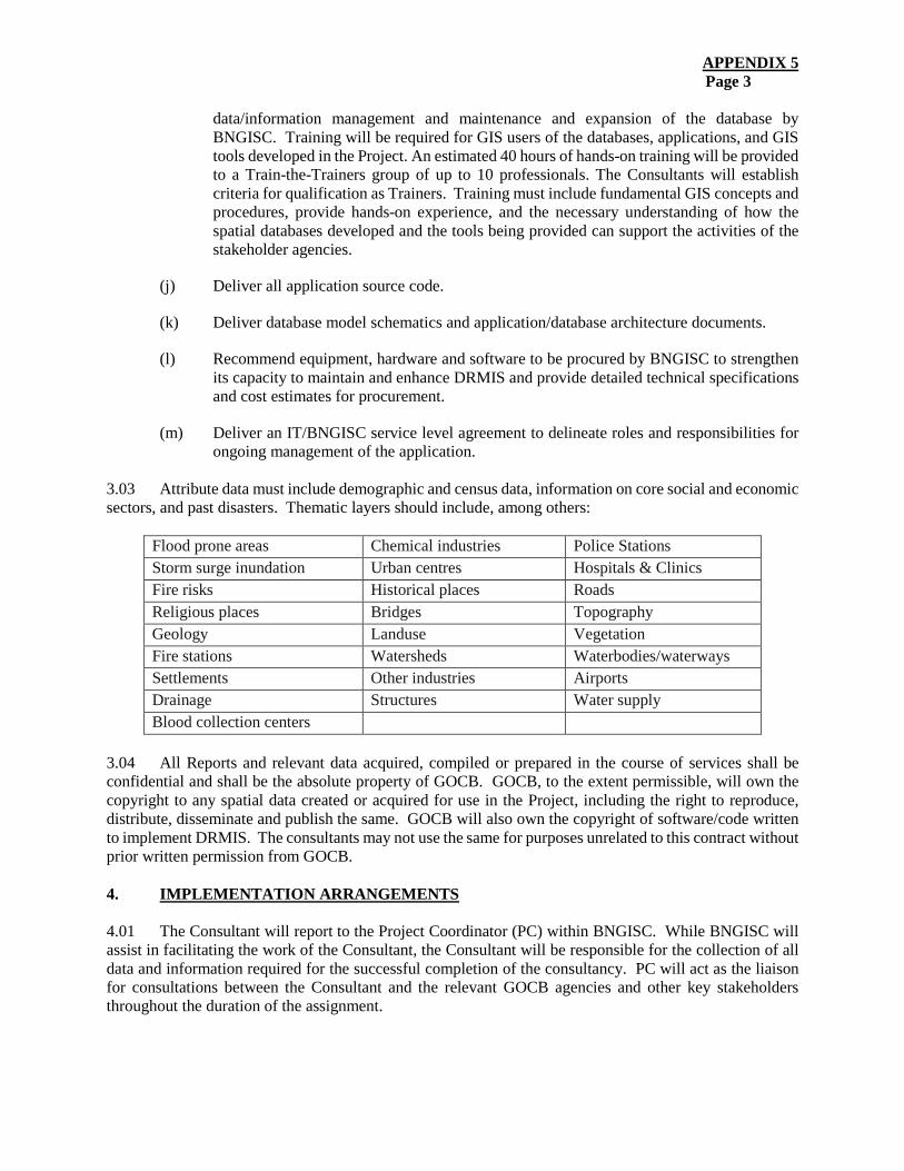
APPENDIX 5 Page 3
data/information management and maintenance and expansion of the database by BNGISC. Training will be required for GIS users of the databases, applications, and GIS tools developed in the Project. An estimated 40 hours of hands-on training will be provided to a Train-the-Trainers group of up to 10 professionals. The Consultants will establish criteria for qualification as Trainers. Training must include fundamental GIS concepts and procedures, provide hands-on experience, and the necessary understanding of how the spatial databases developed and the tools being provided can support the activities of the stakeholder agencies.
(j) Deliver all application source code.
(k) Deliver database model schematics and application/database architecture documents.
(l) Recommend equipment, hardware and software to be procured by BNGISC to strengthen its capacity to maintain and enhance DRMIS and provide detailed technical specifications and cost estimates for procurement.
(m) Deliver an IT/BNGISC service level agreement to delineate roles and responsibilities for ongoing management of the application.
3.03 Attribute data must include demographic and census data, information on core social and economic sectors, and past disasters. Thematic layers should include, among others:
Flood prone areas Chemical industries Police Stations Storm surge inundation Urban centres Hospitals & Clinics Fire risks Historical places Roads Religious places Bridges Topography Geology Landuse Vegetation Fire stations Watersheds Waterbodies/waterways Settlements Other industries Airports Drainage Structures Water supply Blood collection centers
3.04 All Reports and relevant data acquired, compiled or prepared in the course of services shall be confidential and shall be the absolute property of GOCB. GOCB, to the extent permissible, will own the copyright to any spatial data created or acquired for use in the Project, including the right to reproduce, distribute, disseminate and publish the same. GOCB will also own the copyright of software/code written to implement DRMIS. The consultants may not use the same for purposes unrelated to this contract without prior written permission from GOCB. 4. IMPLEMENTATION ARRANGEMENTS 4.01 The Consultant will report to the Project Coordinator (PC) within BNGISC. While BNGISC will assist in facilitating the work of the Consultant, the Consultant will be responsible for the collection of all data and information required for the successful completion of the consultancy. PC will act as the liaison for consultations between the Consultant and the relevant GOCB agencies and other key stakeholders throughout the duration of the assignment.
APPENDIX 5 Page 4
5. QUALIFICATIONS AND EXPERIENCE 5.01 The minimum qualifications of the key members of the consulting team shall include Masters Degrees in the relevant disciplines and minimum of 10 years’ relevant experience, or Bachelor’s degrees in the disciplines identified and a minimum of 15 years’ relevant experience. Key experts will be as follows: a GIS Analyst; a DRM Specialist; a Climate Specialist; and a Training Specialist. The team may include additional members, including a GIS Technician. 6. REPORTING REQUIREMENTS / DELIVERABLES 6.01 The Consultant(s) will be required to submit the following Reports to GOCB and the Caribbean Development Bank (CDB), within the time periods indicated:
(a) An Inception Report describing the approaches, methodologies and time-lines proposed to be taken to prepare and deliver the scope of works outlined within two weeks of the start of the consultancy. GOCB and CDB will provide comments on this Report within two weeks of receipt of the report and the consultants will adjust the ongoing work according to the comments received.
(b) A Needs Assessment and User Requirements Report within six weeks of the start of the consultancy. GOCB and CDB will provide comments on this report within two weeks of receipt of the report.
(c) An Applications Design Report including the technical specifications for DRMIS within four weeks of the receipt of comments on the Needs Assessment and User Requirements Report. Also, to be included in this Report are the Data Dictionary and Metadata information developed for the digital data produced. GOCB and CDB will provide comments on this Report within two weeks of receipt of the Report.
(d) A Draft Final Report within three months of the receipt of comments on the Application Design Report will include, among other things, a description of activities carried out during the development of the Project, analysis from the seminars and workshops, and recommendations for recommended follow-up activities.
(e) A Final Report within two weeks of comments on the Draft Final Report.
6.02 Databases required for the functioning of DRMIS. 6.03 Hardware and software for two GIS workstations and updated GIS software licenses to support DRMIS. 6.04 All Reports should be submitted to GOCB and CDB both in hard-copy (1 copy each) and in electronic format. Maps and drawings should also be submitted electronically and in hard-copy. Reports should be submitted in Microsoft Word and/or Microsoft Excel formats as appropriate, and maps as well as raw data in GIS formats. All data collected or produced during the consultancy shall be submitted to GOCB with the Draft Final Report. 7. DURATION 7.01 It is estimated that the services will be performed over a period of eight months.
APPENDIX 5 Page 5
8. MANPOWER, SCHEDULING AND COSTS 8.01 In estimating person-month requirements and costs of the services, the Consultants should ensure that the proposal takes full account of all fees and direct expenses required to fulfil the above requirements and the following items:
(a) consultant’s remuneration; (b) consultant’s out-of-pocket expenses;
(c) support staff services;
(d) equipment hire;
(e) communications costs;
(f) contract documentation production costs;
(g) supervision costs; and
(h) survey costs.
9. COMMENTS BY THE CONSULTANTS 9.01 The Consultant(s) are encouraged to make comments on, and suggestions for, improvements to these Terms of Reference. The financial implications, if any, of these recommendations should be indicated separately in the Financial Proposal. 10. INPUTS FROM THE CLIENT 10.01 The following services and facilities will be provided by the Client:
(a) Office Accommodation: BNGISC will provide desk space for the Consultant(s). The Consultants will be required to provide their own computers.
(b) Access: BNGISC will arrange for access by the Consultant(s) to key GOCB officials in
the stakeholder agencies.
(c) Data: BNGISC will provide the consultants with copies of the existing GOCB laws, regulations, policies, etc. pertaining to storm-water management, disaster management, planning, environmental management and climate change.
(d) Support Staff: BNGISC personnel will accompany the Consultants on local field visits,
meetings, etc., to the extent required.

APPENDIX 5 Page 6
BUDGET
(USD)
This information is withheld in accordance with one or more of the exceptions to disclosure under the Bank’s Information Disclosure Policy.
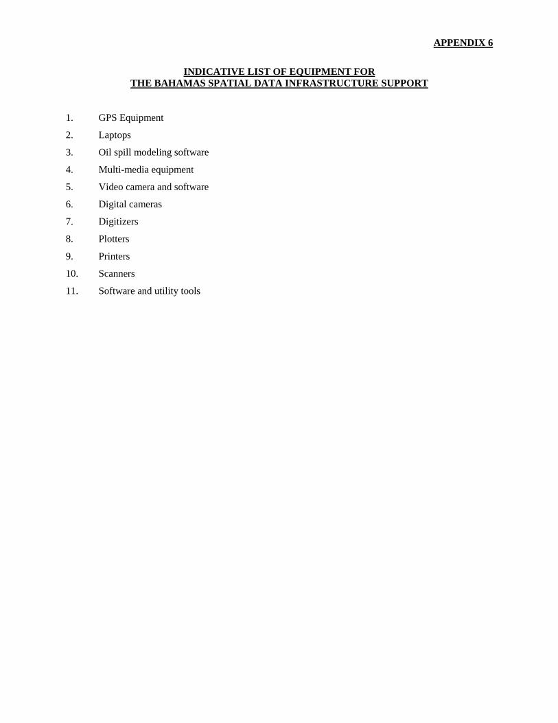
APPENDIX 6
INDICATIVE LIST OF EQUIPMENT FOR THE BAHAMAS SPATIAL DATA INFRASTRUCTURE SUPPORT
1. GPS Equipment
2. Laptops
3. Oil spill modeling software
4. Multi-media equipment
5. Video camera and software
6. Digital cameras
7. Digitizers
8. Plotters
9. Printers
10. Scanners
11. Software and utility tools
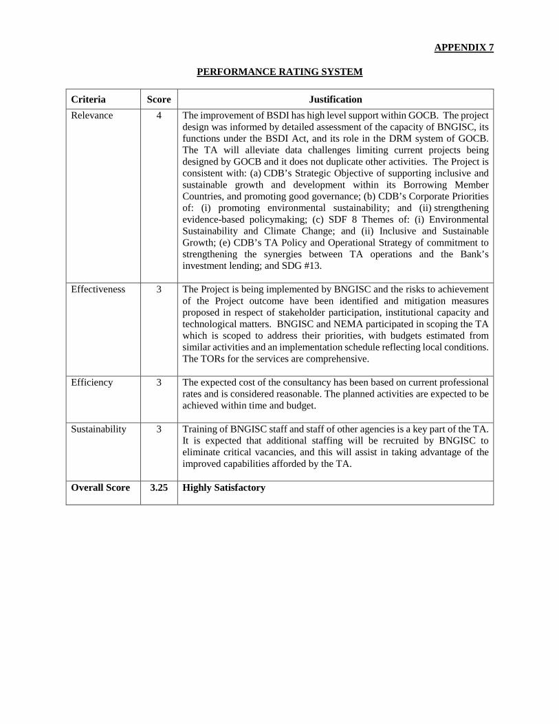
APPENDIX 7
PERFORMANCE RATING SYSTEM
Criteria Score Justification Relevance 4 The improvement of BSDI has high level support within GOCB. The project
design was informed by detailed assessment of the capacity of BNGISC, its functions under the BSDI Act, and its role in the DRM system of GOCB. The TA will alleviate data challenges limiting current projects being designed by GOCB and it does not duplicate other activities. The Project is consistent with: (a) CDB’s Strategic Objective of supporting inclusive and sustainable growth and development within its Borrowing Member Countries, and promoting good governance; (b) CDB’s Corporate Priorities of: (i) promoting environmental sustainability; and (ii) strengthening evidence-based policymaking; (c) SDF 8 Themes of: (i) Environmental Sustainability and Climate Change; and (ii) Inclusive and Sustainable Growth; (e) CDB’s TA Policy and Operational Strategy of commitment to strengthening the synergies between TA operations and the Bank’s investment lending; and SDG #13.
Effectiveness 3 The Project is being implemented by BNGISC and the risks to achievement of the Project outcome have been identified and mitigation measures proposed in respect of stakeholder participation, institutional capacity and technological matters. BNGISC and NEMA participated in scoping the TA which is scoped to address their priorities, with budgets estimated from similar activities and an implementation schedule reflecting local conditions. The TORs for the services are comprehensive.
Efficiency 3 The expected cost of the consultancy has been based on current professional rates and is considered reasonable. The planned activities are expected to be achieved within time and budget.
Sustainability 3 Training of BNGISC staff and staff of other agencies is a key part of the TA. It is expected that additional staffing will be recruited by BNGISC to eliminate critical vacancies, and this will assist in taking advantage of the improved capabilities afforded by the TA.
Overall Score 3.25 Highly Satisfactory
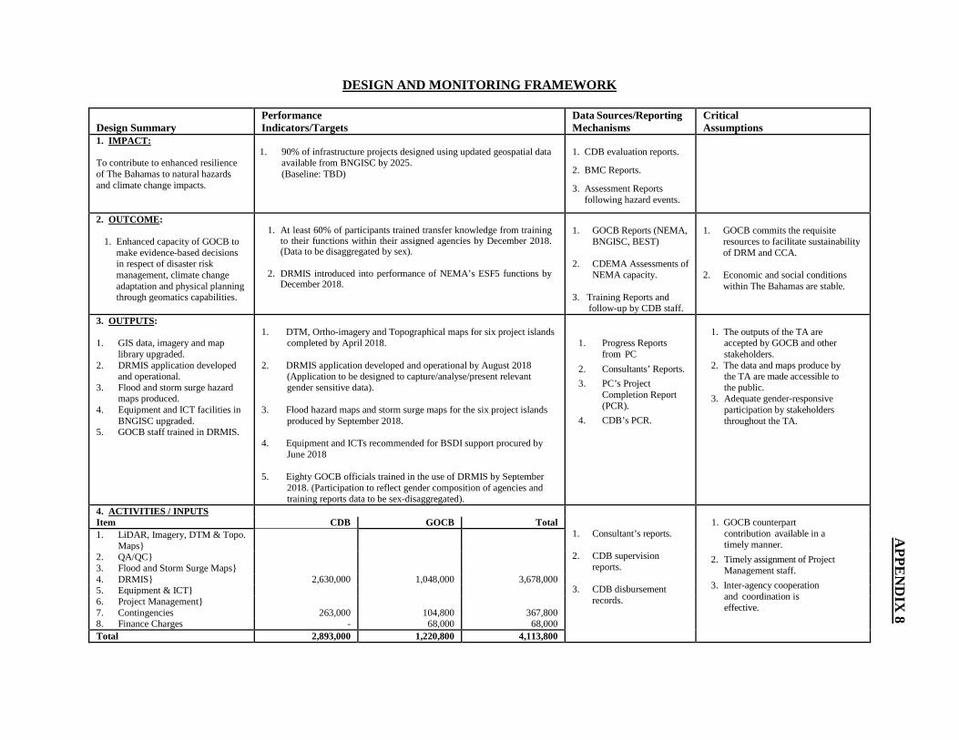
DESIGN AND MONITORING FRAMEWORK
Design Summary Performance Indicators/Targets
Data Sources/Reporting Mechanisms
Critical Assumptions
1. IMPACT:
To contribute to enhanced resilience of The Bahamas to natural hazards and climate change impacts.
1. 90% of infrastructure projects designed using updated geospatial dataavailable from BNGISC by 2025.(Baseline: TBD)
1. CDB evaluation reports.
2. BMC Reports.
3. Assessment Reportsfollowing hazard events.
2. OUTCOME:
1. Enhanced capacity of GOCB to make evidence-based decisions in respect of disaster risk management, climate change adaptation and physical planning through geomatics capabilities.
1. At least 60% of participants trained transfer knowledge from trainingto their functions within their assigned agencies by December 2018. (Data to be disaggregated by sex).
2. DRMIS introduced into performance of NEMA’s ESF5 functions byDecember 2018.
1. GOCB Reports (NEMA, BNGISC, BEST)
2. CDEMA Assessments of NEMA capacity.
3. Training Reports and follow-up by CDB staff.
1. GOCB commits the requisite resources to facilitate sustainability of DRM and CCA.
2. Economic and social conditionswithin The Bahamas are stable.
3. OUTPUTS:
1. GIS data, imagery and maplibrary upgraded.
2. DRMIS application developedand operational.
3. Flood and storm surge hazardmaps produced.
4. Equipment and ICT facilities inBNGISC upgraded.
5. GOCB staff trained in DRMIS.
1. DTM, Ortho-imagery and Topographical maps for six project islands completed by April 2018.
2. DRMIS application developed and operational by August 2018(Application to be designed to capture/analyse/present relevantgender sensitive data).
3. Flood hazard maps and storm surge maps for the six project islands produced by September 2018.
4. Equipment and ICTs recommended for BSDI support procured by June 2018
5. Eighty GOCB officials trained in the use of DRMIS by September 2018. (Participation to reflect gender composition of agencies andtraining reports data to be sex-disaggregated).
1. Progress Reportsfrom PC
2. Consultants’ Reports. 3. PC’s Project
Completion Report(PCR).
4. CDB’s PCR.
1. The outputs of the TA are accepted by GOCB and other stakeholders.
2. The data and maps produce by the TA are made accessible to the public.
3. Adequate gender-responsive participation by stakeholders throughout the TA.
4. ACTIVITIES / INPUTS
1. Consultant’s reports.
2. CDB supervisionreports.
3. CDB disbursementrecords.
1. GOCB counterpart contribution available in a timely manner.
2. Timely assignment of Project Management staff.
3. Inter-agency cooperationand coordination iseffective.
Item CDB GOCB Total 1. LiDAR, Imagery, DTM & Topo.
Maps}2. QA/QC} 3. Flood and Storm Surge Maps} 4. DRMIS} 2,630,000 1,048,000 3,678,000 5. Equipment & ICT}6. Project Management} 7. Contingencies 263,000 104,800 367,800 8. Finance Charges - 68,000 68,000 Total 2,893,000 1,220,800 4,113,800
APPE
ND
IX 8
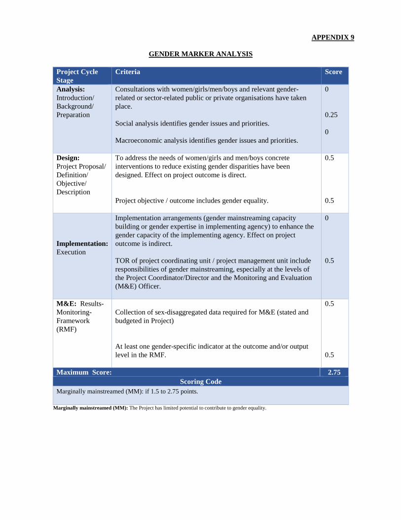
APPENDIX 9
GENDER MARKER ANALYSIS
Project Cycle Stage
Criteria Score
Analysis: Introduction/ Background/ Preparation
Consultations with women/girls/men/boys and relevant gender-related or sector-related public or private organisations have taken place.
Social analysis identifies gender issues and priorities.
Macroeconomic analysis identifies gender issues and priorities.
0
0.25
0
Design: Project Proposal/ Definition/ Objective/ Description
To address the needs of women/girls and men/boys concrete interventions to reduce existing gender disparities have been designed. Effect on project outcome is direct.
Project objective / outcome includes gender equality.
0.5
0.5
Implementation: Execution
Implementation arrangements (gender mainstreaming capacity building or gender expertise in implementing agency) to enhance the gender capacity of the implementing agency. Effect on project outcome is indirect.
TOR of project coordinating unit / project management unit include responsibilities of gender mainstreaming, especially at the levels of the Project Coordinator/Director and the Monitoring and Evaluation (M&E) Officer.
0
0.5
M&E: Results- Monitoring- Framework (RMF)
Collection of sex-disaggregated data required for M&E (stated and budgeted in Project)
At least one gender-specific indicator at the outcome and/or output level in the RMF.
0.5
0.5
Maximum Score: 2.75 Scoring Code
Marginally mainstreamed (MM): if 1.5 to 2.75 points.
Marginally mainstreamed (MM): The Project has limited potential to contribute to gender equality.
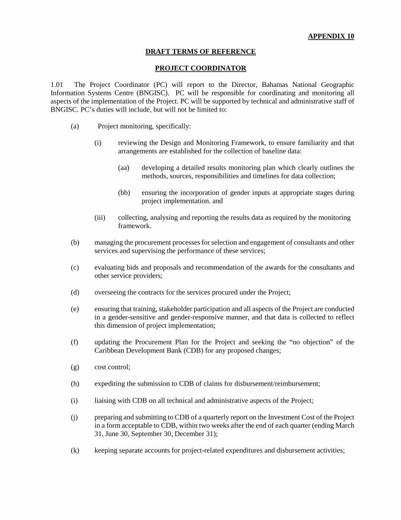
APPENDIX 10
DRAFT TERMS OF REFERENCE
PROJECT COORDINATOR
1.01 The Project Coordinator (PC) will report to the Director, Bahamas National Geographic Information Systems Centre (BNGISC). PC will be responsible for coordinating and monitoring all aspects of the implementation of the Project. PC will be supported by technical and administrative staff of BNGISC. PC’s duties will include, but will not be limited to:
(a) Project monitoring, specifically:
(i) reviewing the Design and Monitoring Framework, to ensure familiarity and that arrangements are established for the collection of baseline data:
(aa) developing a detailed results monitoring plan which clearly outlines the methods, sources, responsibilities and timelines for data collection;
(bb) ensuring the incorporation of gender inputs at appropriate stages during project implementation. and
(iii) collecting, analysing and reporting the results data as required by the monitoring framework.
(b) managing the procurement processes for selection and engagement of consultants and other services and supervising the performance of these services;
(c) evaluating bids and proposals and recommendation of the awards for the consultants and other service providers;
(d) overseeing the contracts for the services procured under the Project;
(e) ensuring that training, stakeholder participation and all aspects of the Project are conducted in a gender-sensitive and gender-responsive manner, and that data is collected to reflect this dimension of project implementation;
(f) updating the Procurement Plan for the Project and seeking the “no objection” of the Caribbean Development Bank (CDB) for any proposed changes;
(g) cost control;
(h) expediting the submission to CDB of claims for disbursement/reimbursement;
(i) liaising with CDB on all technical and administrative aspects of the Project;
(j) preparing and submitting to CDB of a quarterly report on the Investment Cost of the Project in a form acceptable to CDB, within two weeks after the end of each quarter (ending March 31, June 30, September 30, December 31);
(k) keeping separate accounts for project-related expenditures and disbursement activities;
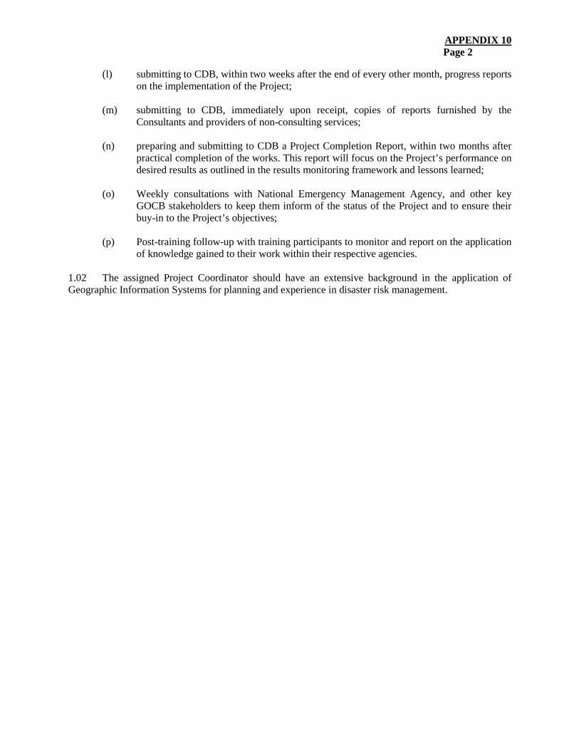
APPENDIX 10 Page 2
(l) submitting to CDB, within two weeks after the end of every other month, progress reports on the implementation of the Project;
(m) submitting to CDB, immediately upon receipt, copies of reports furnished by the Consultants and providers of non-consulting services;
(n) preparing and submitting to CDB a Project Completion Report, within two months after practical completion of the works. This report will focus on the Project’s performance on desired results as outlined in the results monitoring framework and lessons learned;
(o) Weekly consultations with National Emergency Management Agency, and other key GOCB stakeholders to keep them inform of the status of the Project and to ensure their buy-in to the Project’s objectives;
(p) Post-training follow-up with training participants to monitor and report on the application of knowledge gained to their work within their respective agencies.
1.02 The assigned Project Coordinator should have an extensive background in the application of Geographic Information Systems for planning and experience in disaster risk management.
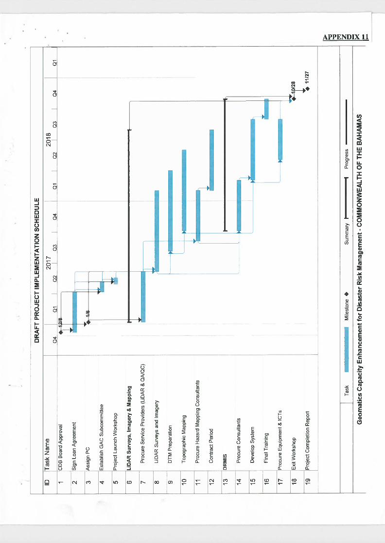
IDT
ask
Nam
e
1C
DB
Boa
rdA
ppro
val
2S
ign
Loa
nA
gre
emen
t
3A
ssig
nP
C
Esta
bIis
hG
AC
Subco
mm
itte
e
5P
roje
ctL
aunc
hW
ork
shop
6L
iDA
RS
urv
eys,
Imag
ery
&M
appi
ng
7P
rocu
reS
ervic
eP
rovid
ers
(LID
AR
&Q
AIQ
C)
-8
LiD
AR
Surv
eys
and
Imag
ery
9D
TM
Pre
par
atio
n
10T
opogra
phic
Map
ping
11P
rocu
reH
azar
dM
appi
ngC
onsu
ltan
ts
12C
ontr
act
Per
iod
13D
RM
IS
14P
rocu
reC
onsu
ltan
ts
15D
evel
opS
yst
em
16F
inal
Tra
inin
g
17P
rocure
Equ
ipm
ent
&IC
Ts
18E
xit
Work
shop
19P
roje
ctC
ompl
etio
nR
epor
t
04DR
AFT
PR
OJE
CT
IMPL
EM
EN
TA
TIO
NS
CH
ED
UL
E
2017
Qi
Q2
Q3
04
010
2
I
2018
03Q
4I
Qi
128
•11
127
Tas
kM
iles
tone
•S
um
mar
yI
IP
rogre
ss
Geo
mat
ics
Cap
acit
yE
nh
ance
men
tfo
rD
isas
ter
Ris
kM
anag
emen
t-
CO
MM
ON
WE
AL
TH
OF
TH
EB
AH
AM
AS

APPENDIX 12
BUDGET (USD)
Item CDB GOCB Total 1. LiDAR, Imagery and Topo. Maps } 2. QA/QC } 3. Flood and Storm Surge Hazard Maps} 4. DRMIS } 2,630,000 1,048,000 3,678,000 5. Equipment and ICTs } 6. Project Management }
Sub-total 2,630,000 1,048,000 3,678,000
7. Contingencies 263,000 104,800 367,800 8. Finance Charges - 68,000 68,000
Total 2,893,000 1,220,800 4,113,800 Percentage 70 30 100
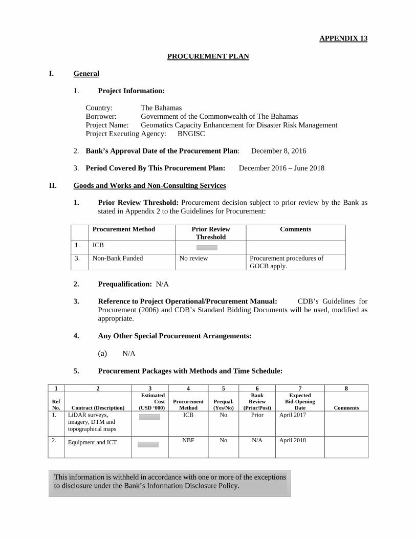
APPENDIX 13
PROCUREMENT PLAN I. General
1. Project Information:
Country: The Bahamas Borrower: Government of the Commonwealth of The Bahamas Project Name: Geomatics Capacity Enhancement for Disaster Risk Management Project Executing Agency: BNGISC
2. Bank’s Approval Date of the Procurement Plan: December 8, 2016 3. Period Covered By This Procurement Plan: December 2016 – June 2018
II. Goods and Works and Non-Consulting Services
1. Prior Review Threshold: Procurement decision subject to prior review by the Bank as stated in Appendix 2 to the Guidelines for Procurement:
Procurement Method Prior Review
Threshold Comments
1. ICB
3. Non-Bank Funded No review Procurement procedures of GOCB apply.
2. Prequalification: N/A 3. Reference to Project Operational/Procurement Manual: CDB’s Guidelines for
Procurement (2006) and CDB’s Standard Bidding Documents will be used, modified as appropriate.
4. Any Other Special Procurement Arrangements:
(a) N/A
5. Procurement Packages with Methods and Time Schedule:
1 2 3 4 5 6 7 8
Ref No. Contract (Description)
Estimated Cost
(USD ‘000) Procurement
Method Prequal. (Yes/No)
Bank Review
(Prior/Post)
Expected Bid-Opening
Date Comments 1. LiDAR surveys,
imagery, DTM and topographical maps
ICB No Prior April 2017
2. Equipment and ICT
NBF No N/A April 2018
This information is withheld in accordance with one or more of the exceptions to disclosure under the Bank’s Information Disclosure Policy.
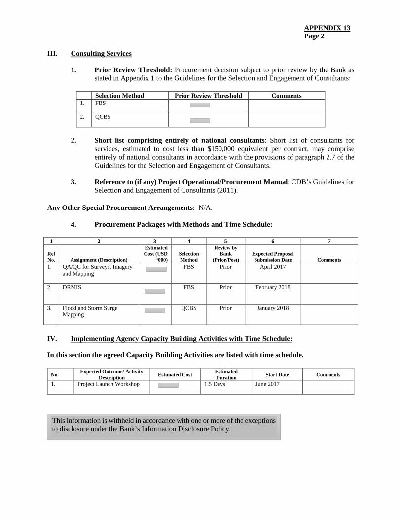
APPENDIX 13 Page 2
III. Consulting Services
1. Prior Review Threshold: Procurement decision subject to prior review by the Bank as stated in Appendix 1 to the Guidelines for the Selection and Engagement of Consultants:
Selection Method Prior Review Threshold Comments 1. FBS
2. QCBS
2. Short list comprising entirely of national consultants: Short list of consultants for
services, estimated to cost less than $150,000 equivalent per contract, may comprise entirely of national consultants in accordance with the provisions of paragraph 2.7 of the Guidelines for the Selection and Engagement of Consultants.
3. Reference to (if any) Project Operational/Procurement Manual: CDB’s Guidelines for
Selection and Engagement of Consultants (2011). Any Other Special Procurement Arrangements: N/A.
4. Procurement Packages with Methods and Time Schedule:
1 2 3 4 5 6 7
Ref No. Assignment (Description)
Estimated Cost (USD
‘000) Selection Method
Review by Bank
(Prior/Post) Expected Proposal Submission Date Comments
1. QA/QC for Surveys, Imagery and Mapping
FBS Prior April 2017
2. DRMIS
FBS Prior February 2018
3. Flood and Storm Surge Mapping
QCBS Prior January 2018
IV. Implementing Agency Capacity Building Activities with Time Schedule:
In this section the agreed Capacity Building Activities are listed with time schedule.
No. Expected Outcome/ Activity Description Estimated Cost Estimated
Duration Start Date Comments
1. Project Launch Workshop
1.5 Days June 2017
This information is withheld in accordance with one or more of the exceptions to disclosure under the Bank’s Information Disclosure Policy.
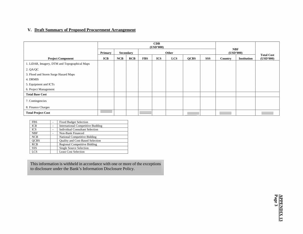
V. Draft Summary of Proposed Procurement Arrangement
Project Component
CDB (USD’000)
NBF (USD’000)
Total Cost (USD’000)
Primary Secondary Other
ICB NCB RCB FBS ICS LCS QCBS SSS Country Institution
1. LiDAR, Imagery, DTM and Topographical Maps
2. QA/QC 3. Flood and Storm Surge Hazard Maps 4. DRMIS 5. Equipment and ICTs 6. Project Management
Total Base Cost
7. Contingencies
8. Finance Charges
Total Project Cost
FBS - Fixed Budget Selection ICB - International Competitive Budding ICS - Individual Consultant Selection NBF - Non-Bank Financed NCB National Competitive Bidding QCBS Quality and Cost-Based Selection RCB Regional Competitive Bidding SSS Single Source Selection LCS Least Cost Selection
APPE
ND
IX 13
Page 3
This information is withheld in accordance with one or more of the exceptions to disclosure under the Bank’s Information Disclosure Policy.