Embed Size (px)
Citation preview

Capital Metro Downtown Multimodal
StationStakeholder Briefing
December 11, 2015
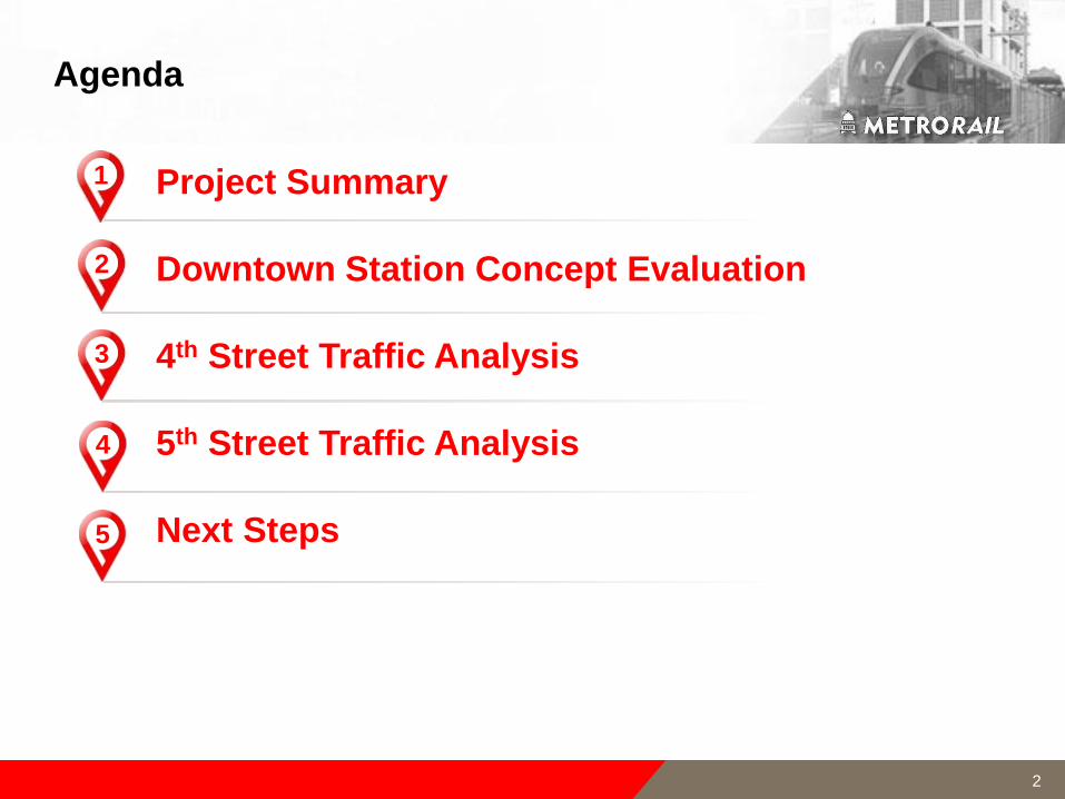
Agenda
Project Summary
Downtown Station Concept Evaluation
4th Street Traffic Analysis
5th Street Traffic Analysis
Next Steps
1
2
3
4
5
2

Project Summary
3
Downtown Multimodal Station
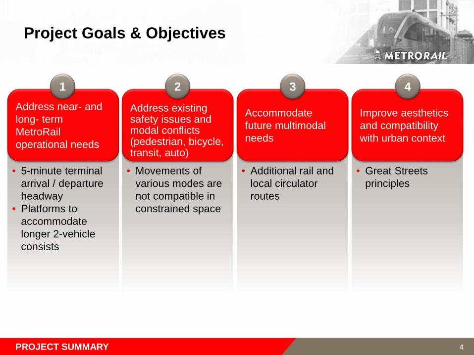
Project Goals & Objectives
• 5-minute terminal arrival / departure headway
• Platforms to accommodate longer 2-vehicle consists
Address near- and long- term MetroRailoperational needs
• Movements of various modes are not compatible in constrained space
Address existing safety issues and modal conflicts (pedestrian, bicycle, transit, auto)
• Additional rail and local circulator routes
Accommodate future multimodal needs
• Great Streets principles
Improve aesthetics and compatibility with urban context
1 2 3 4
PROJECT SUMMARY 4
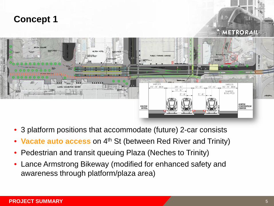
Concept 1
• 3 platform positions that accommodate (future) 2-car consists • Vacate auto access on 4th St (between Red River and Trinity)• Pedestrian and transit queuing Plaza (Neches to Trinity)• Lance Armstrong Bikeway (modified for enhanced safety and
awareness through platform/plaza area)
PROJECT SUMMARY 5

Concept 2
• 3 platform positions that accommodate (future) 2-car consists • Shared-use auto/bicycle access on 4th St (Sabine to Neches)• Pedestrian and transit queuing Plaza (Neches to Trinity)• Lance Armstrong Bikeway (modified for enhanced safety and
awareness through platform/plaza area)
PROJECT SUMMARY 6
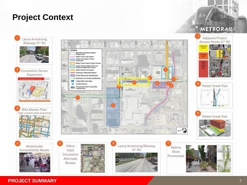
Project Context
PROJECT SUMMARY 7
Downtown Station Concept Evaluation
Downtown Multimodal Station
8
9
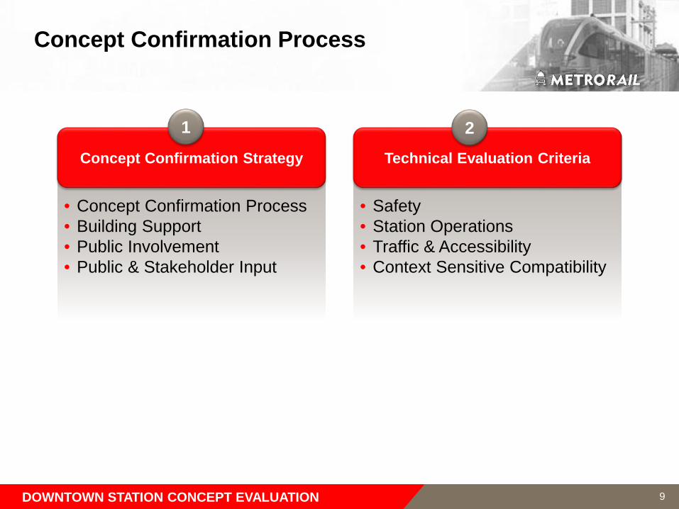
Concept Confirmation Process
• Concept Confirmation Process• Building Support• Public Involvement• Public & Stakeholder Input
Concept Confirmation Strategy
• Safety• Station Operations• Traffic & Accessibility• Context Sensitive Compatibility
Technical Evaluation Criteria
1 2
DOWNTOWN STATION CONCEPT EVALUATION
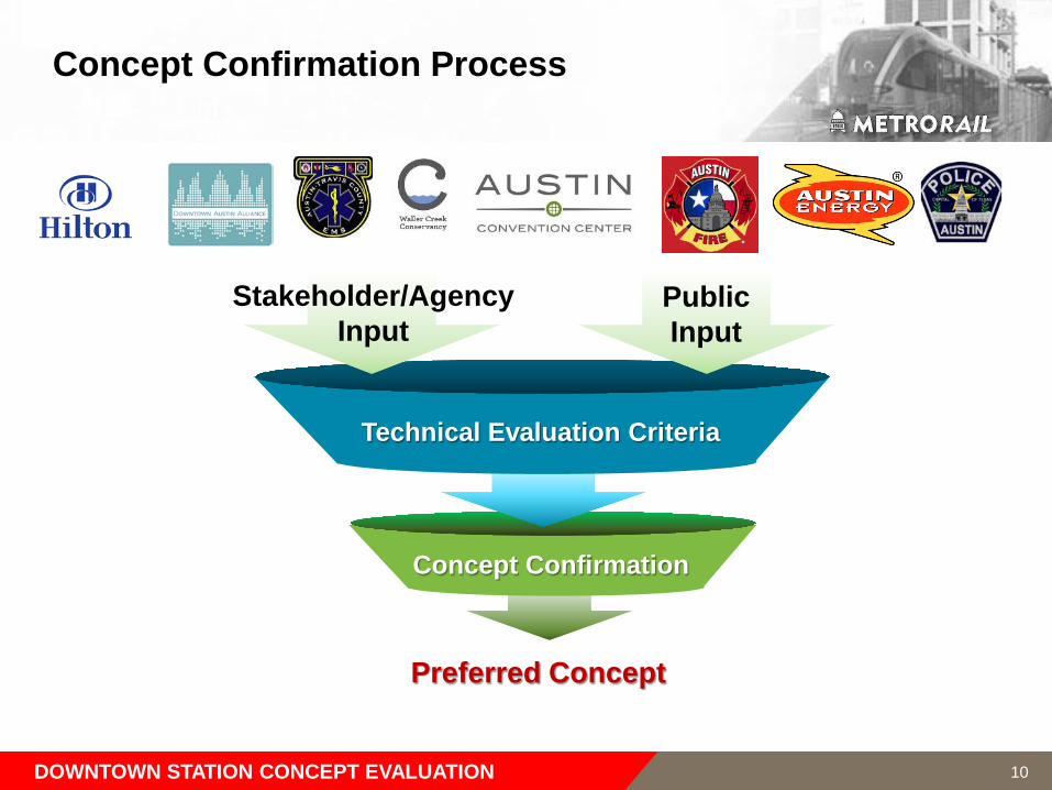
Concept Confirmation
Concept Confirmation Process
DOWNTOWN STATION CONCEPT EVALUATION
Technical Evaluation Criteria
Public Input
Stakeholder/Agency Input
Preferred Concept
10
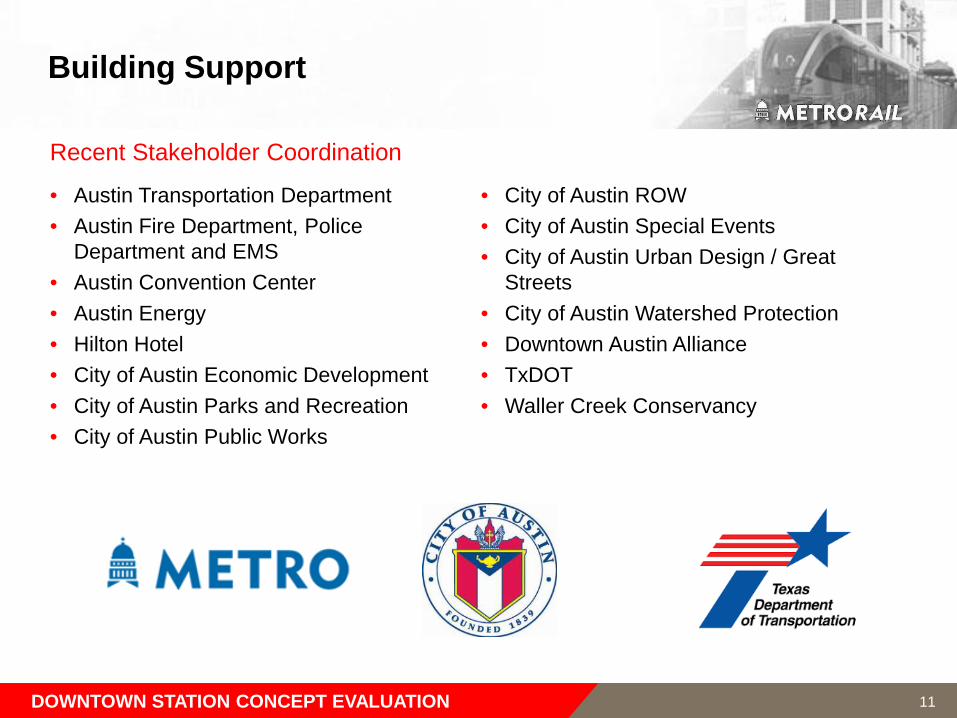
Building Support
• Austin Transportation Department• Austin Fire Department, Police
Department and EMS • Austin Convention Center• Austin Energy• Hilton Hotel• City of Austin Economic Development• City of Austin Parks and Recreation• City of Austin Public Works
• City of Austin ROW• City of Austin Special Events • City of Austin Urban Design / Great
Streets• City of Austin Watershed Protection• Downtown Austin Alliance• TxDOT• Waller Creek Conservancy
Recent Stakeholder Coordination
DOWNTOWN STATION CONCEPT EVALUATION 11
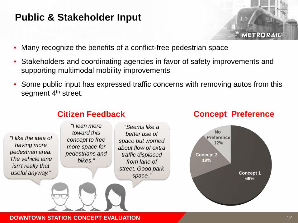
Public & Stakeholder Input
• Many recognize the benefits of a conflict-free pedestrian space
• Stakeholders and coordinating agencies in favor of safety improvements and supporting multimodal mobility improvements
• Some public input has expressed traffic concerns with removing autos from this segment 4th street.
Concept Preference
No Preference
12%
Concept 169%
Concept 219%
Citizen Feedback
DOWNTOWN STATION CONCEPT EVALUATION
“I like the idea of having more
pedestrian area. The vehicle lane isn’t really that useful anyway.”
“I lean more toward this
concept to free more space for pedestrians and
bikes.”
“Seems like a better use of
space but worried about flow of extra
traffic displaced from lane of
street. Good park space.”
12
13
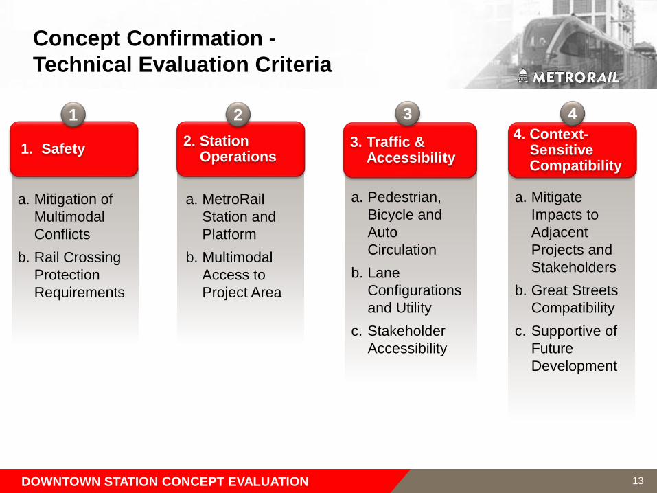
Concept Confirmation -Technical Evaluation Criteria
1. Safety
a. Mitigation of Multimodal Conflicts
b. Rail Crossing Protection Requirements
2. Station Operations
a. MetroRail Station and Platform
b. Multimodal Access to Project Area
3. Traffic & Accessibility
4. Context-Sensitive Compatibility
a. Pedestrian, Bicycle and Auto Circulation
b. Lane Configurations and Utility
c. Stakeholder Accessibility
a. Mitigate Impacts to Adjacent Projects and Stakeholders
b. Great Streets Compatibility
c. Supportive of Future Development
1 2 3 4
DOWNTOWN STATION CONCEPT EVALUATION
14
Technical Evaluation – Safety
Evaluation Metric DescriptionConcept 1
(Vacate Auto Access on 4th)
Concept 2 (Restricted Auto Access on 4th)
Multimodal conflict mitigation
Minimize pedestrian / bicycle conflicts through platform boarding area
Minimize pedestrian / auto conflicts
Minimize bicycle / auto conflicts
Emergency access / egressSupports efficient access / egress to/from platform area Supports efficient access / egress to/from adjacent facilities
Rail crossing protectionMinimize train control / signalization needs
Minimize intersection crossing protection needs
Concept 1 is preferred:
• Reduces potential automobile conflicts with pedestrians and bicycles
• Allows wider boarding areas and pedestrian passage at platforms in front of Convention Center and Hilton Austin
DOWNTOWN STATION CONCEPT EVALUATION
15
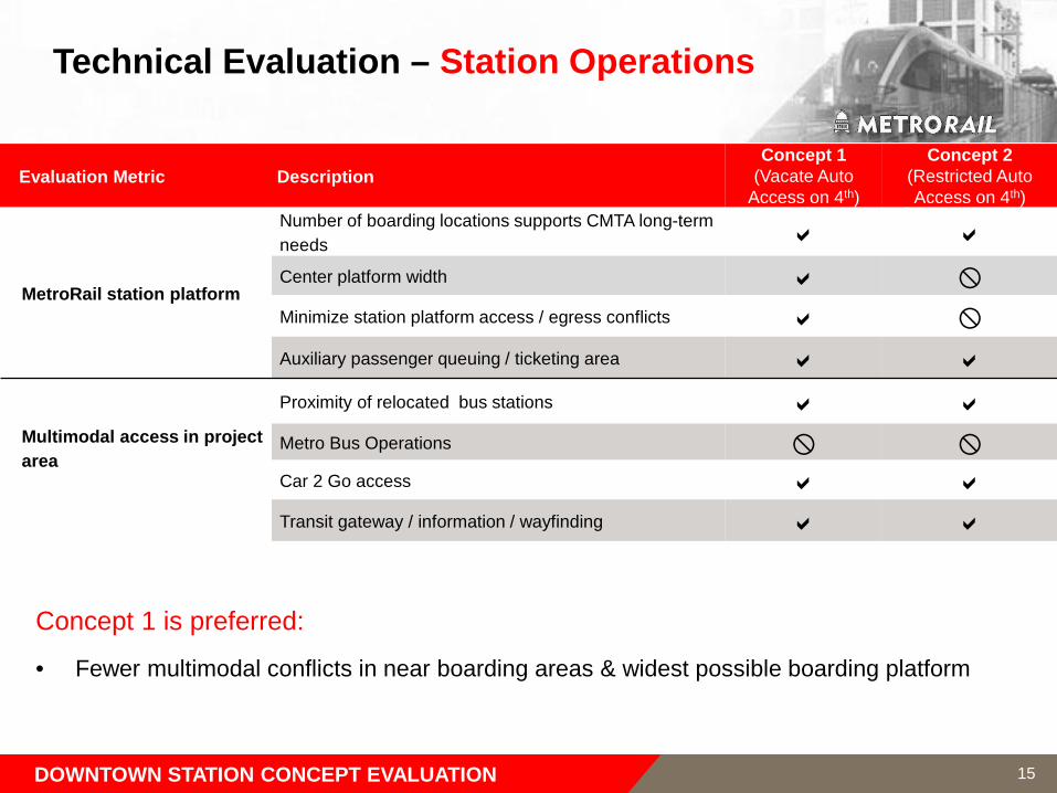
Technical Evaluation – Station Operations
Evaluation Metric DescriptionConcept 1
(Vacate Auto Access on 4th)
Concept 2 (Restricted Auto Access on 4th)
MetroRail station platform
Number of boarding locations supports CMTA long-term needs
Center platform width
Minimize station platform access / egress conflicts
Auxiliary passenger queuing / ticketing area
Multimodal access in project area
Proximity of relocated bus stations
Metro Bus Operations
Car 2 Go access
Transit gateway / information / wayfinding
Concept 1 is preferred:
• Fewer multimodal conflicts in near boarding areas & widest possible boarding platform
DOWNTOWN STATION CONCEPT EVALUATION
16
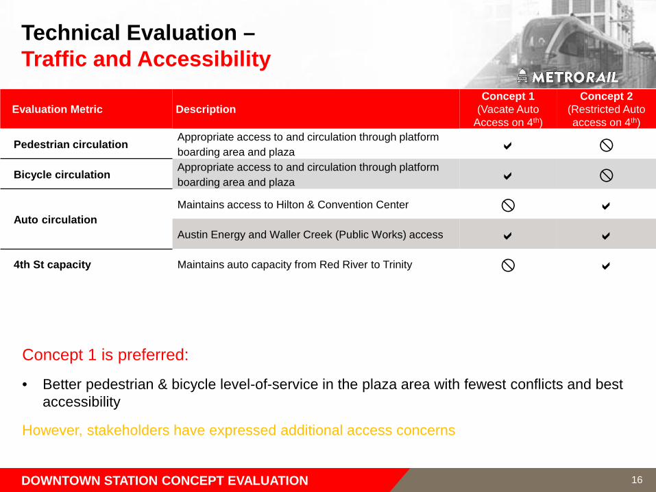
Technical Evaluation –Traffic and Accessibility
Evaluation Metric DescriptionConcept 1
(Vacate Auto Access on 4th)
Concept 2 (Restricted Auto access on 4th)
Pedestrian circulation Appropriate access to and circulation through platform boarding area and plaza
Bicycle circulation Appropriate access to and circulation through platform boarding area and plaza
Auto circulationMaintains access to Hilton & Convention Center
Austin Energy and Waller Creek (Public Works) access
4th St capacity Maintains auto capacity from Red River to Trinity
Concept 1 is preferred:
• Better pedestrian & bicycle level-of-service in the plaza area with fewest conflicts and best accessibility
However, stakeholders have expressed additional access concerns
DOWNTOWN STATION CONCEPT EVALUATION
17
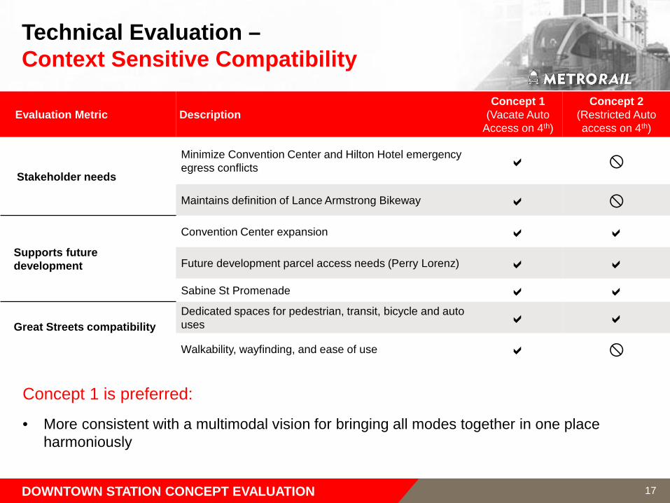
Technical Evaluation –Context Sensitive Compatibility
Evaluation Metric DescriptionConcept 1
(Vacate Auto Access on 4th)
Concept 2 (Restricted Auto access on 4th)
Stakeholder needs
Minimize Convention Center and Hilton Hotel emergency egress conflicts
Maintains definition of Lance Armstrong Bikeway
Supports future development
Convention Center expansion
Future development parcel access needs (Perry Lorenz)
Sabine St Promenade
Great Streets compatibilityDedicated spaces for pedestrian, transit, bicycle and auto uses
Walkability, wayfinding, and ease of use
Concept 1 is preferred:
• More consistent with a multimodal vision for bringing all modes together in one place harmoniously
DOWNTOWN STATION CONCEPT EVALUATION
18
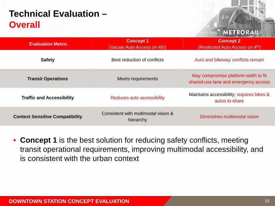
Technical Evaluation –Overall
Evaluation Metric Concept 1 (Vacate Auto Access on 4th)
Concept 2 (Restricted Auto Access on 4th)
Safety Best reduction of conflicts Auto and bikeway conflicts remain
Transit Operations Meets requirementsMay compromise platform width to fit
shared-use lane and emergency access
Traffic and Accessibility Reduces auto accessibilityMaintains accessibility; requires bikes &
autos to share
Context Sensitive Compatibility Consistent with multimodal vision & hierarchy
Diminishes multimodal vision
• Concept 1 is the best solution for reducing safety conflicts, meeting transit operational requirements, improving multimodal accessibility, and is consistent with the urban context
DOWNTOWN STATION CONCEPT EVALUATION
DOWNTOWN STATION CONCEPT EVALUATION
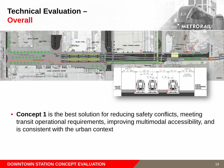
Technical Evaluation –Overall
• Concept 1 is the best solution for reducing safety conflicts, meeting transit operational requirements, improving multimodal accessibility, and is consistent with the urban context
19

4th Street Traffic Evaluation
20
Downtown Multimodal Station
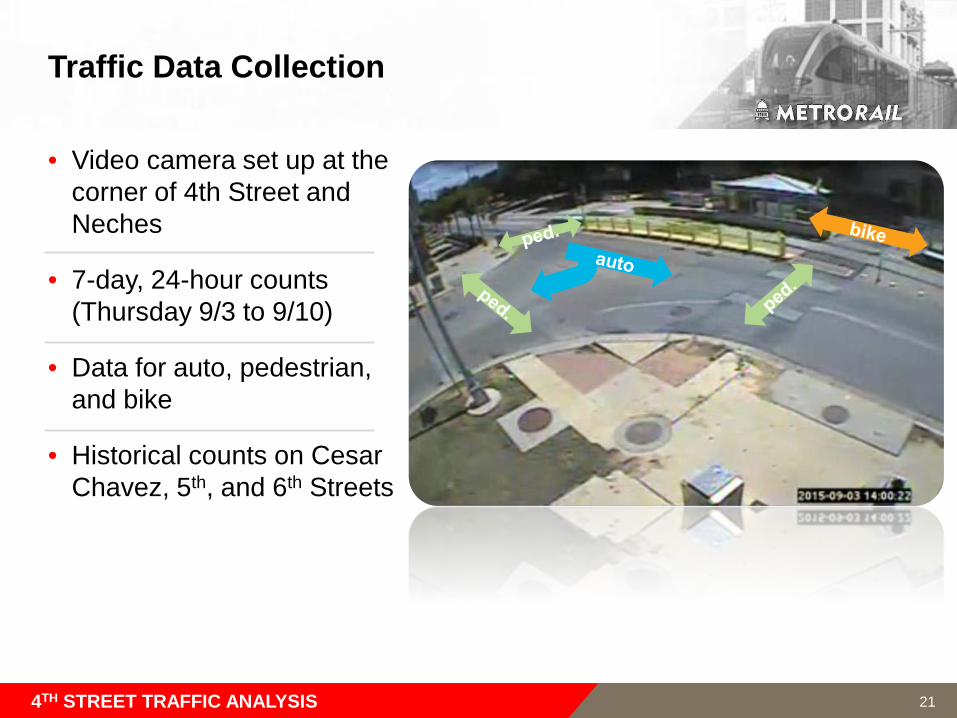
Traffic Data Collection
• Video camera set up at the corner of 4th Street and Neches
• 7-day, 24-hour counts (Thursday 9/3 to 9/10)
• Data for auto, pedestrian, and bike
• Historical counts on Cesar Chavez, 5th, and 6th Streets
4TH STREET TRAFFIC ANALYSIS 21
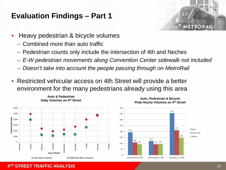
Evaluation Findings – Part 1
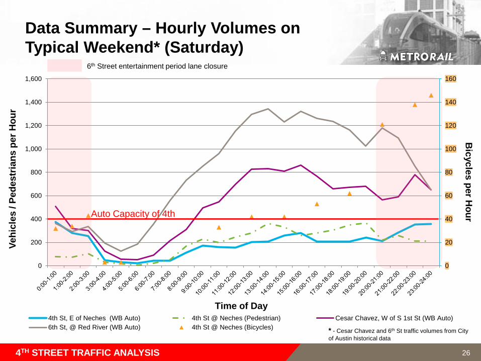
• Heavy pedestrian & bicycle volumes– Combined more than auto traffic– Pedestrian counts only include the intersection of 4th and Neches – E-W pedestrian movements along Convention Center sidewalk not included – Doesn’t take into account the people passing through on MetroRail
• Restricted vehicular access on 4th Street will provide a better environment for the many pedestrians already using this area
4TH STREET TRAFFIC ANALYSIS
Auto, Pedestrian & Bicycle Peak Hourly Volumes on 4th Street
Auto & PedestrianDaily Volumes on 4th Street
22
0
10
20
30
40
50
60
70
80
90
100
0
200
400
600
800
1,000
1,200
1,400
4th St, E of Neches (WB Auto) 4th St @ Neches (Pedestrian) Cesar Chavez, W of S 1st St (WB Auto)
6th St, W of IH 35 (WB Auto) 4th St @ Neches (Bicycles)
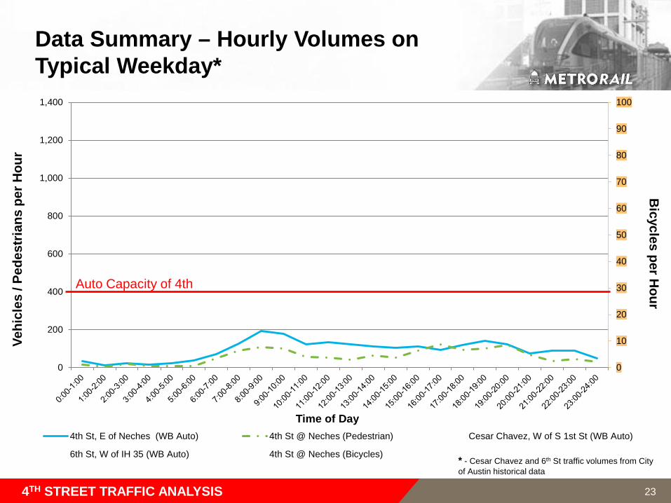
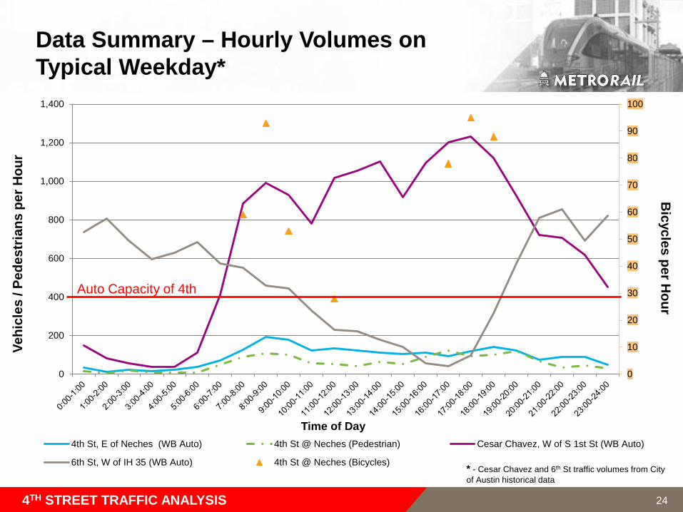
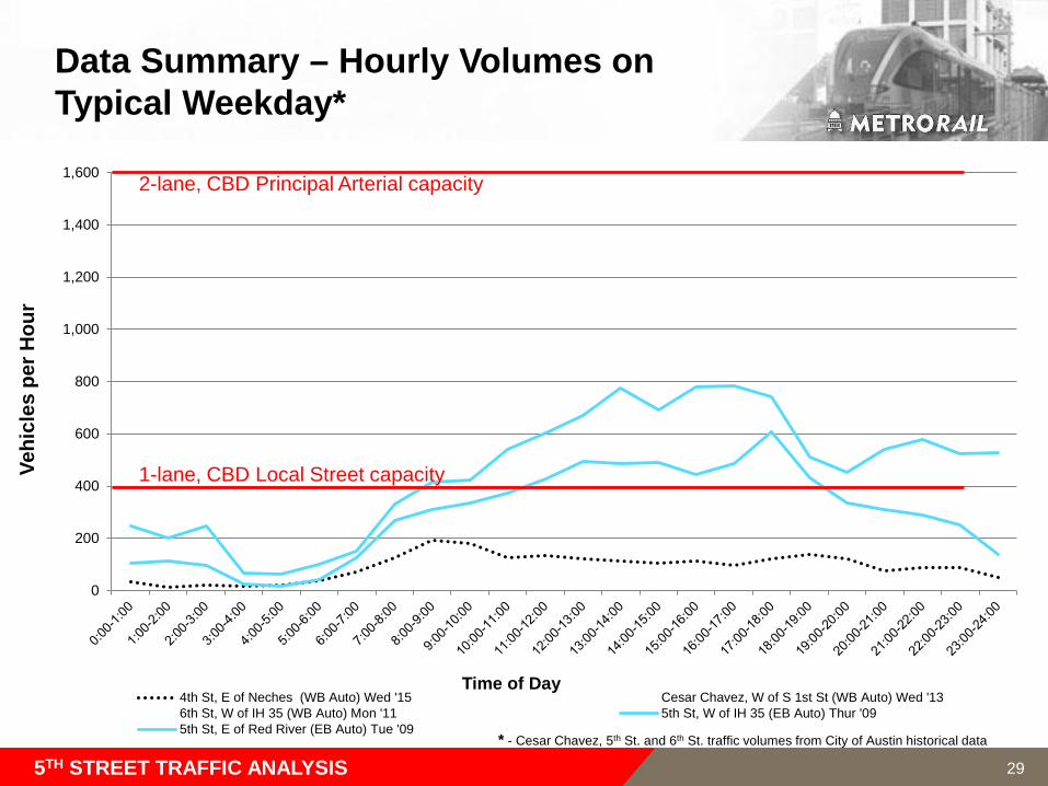
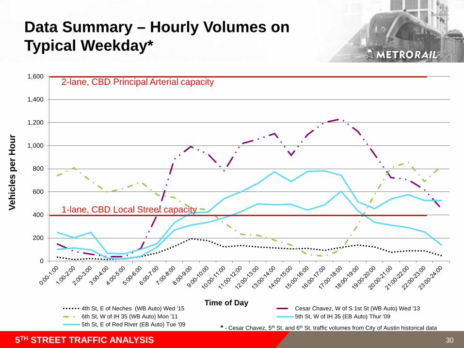
Data Summary – Hourly Volumes onTypical Weekday*
4TH STREET TRAFFIC ANALYSIS
Vehi
cles
/ Pe
dest
rians
per
Hou
rB
icycles per Hour
Time of Day
Auto Capacity of 4th
* - Cesar Chavez and 6th St traffic volumes from City of Austin historical data
23
0
10
20
30
40
50
60
70
80
90
100
0
200
400
600
800
1,000
1,200
1,400
4th St, E of Neches (WB Auto) 4th St @ Neches (Pedestrian) Cesar Chavez, W of S 1st St (WB Auto)
6th St, W of IH 35 (WB Auto) 4th St @ Neches (Bicycles)
Data Summary – Hourly Volumes onTypical Weekday*
4TH STREET TRAFFIC ANALYSIS
Vehi
cles
/ Pe
dest
rians
per
Hou
rB
icycles per Hour
Time of Day
Auto Capacity of 4th
* - Cesar Chavez and 6th St traffic volumes from City of Austin historical data
24
0
20
40
60
80
100
120
140
160
0
200
400
600
800
1,000
1,200
1,400
1,600
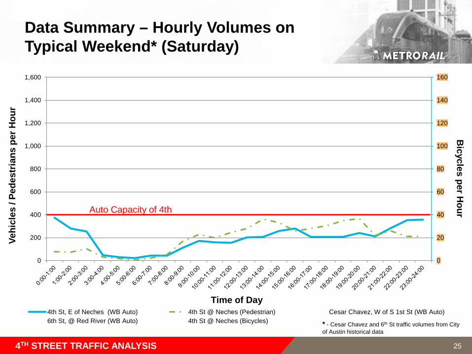
4th St, E of Neches (WB Auto) 4th St @ Neches (Pedestrian) Cesar Chavez, W of S 1st St (WB Auto)6th St, @ Red River (WB Auto) 4th St @ Neches (Bicycles)
Time of Day
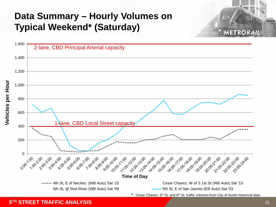
Data Summary – Hourly Volumes on Typical Weekend* (Saturday)
4TH STREET TRAFFIC ANALYSIS
Auto Capacity of 4th
Vehi
cles
/ Pe
dest
rians
per
Hou
rB
icycles per Hour
* - Cesar Chavez and 6th St traffic volumes from City of Austin historical data
25
0
20
40
60
80
100
120
140
160
0
200
400
600
800
1,000
1,200
1,400
1,600
4th St, E of Neches (WB Auto) 4th St @ Neches (Pedestrian) Cesar Chavez, W of S 1st St (WB Auto)6th St, @ Red River (WB Auto) 4th St @ Neches (Bicycles)
Time of Day
Data Summary – Hourly Volumes on Typical Weekend* (Saturday)
4TH STREET TRAFFIC ANALYSIS
Auto Capacity of 4th
Vehi
cles
/ Pe
dest
rians
per
Hou
rB
icycles per Hour
* - Cesar Chavez and 6th St traffic volumes from City of Austin historical data
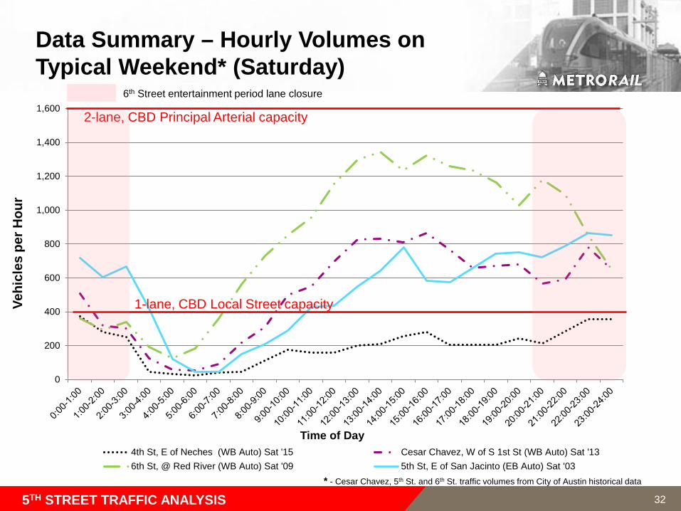
6th Street entertainment period lane closure
26
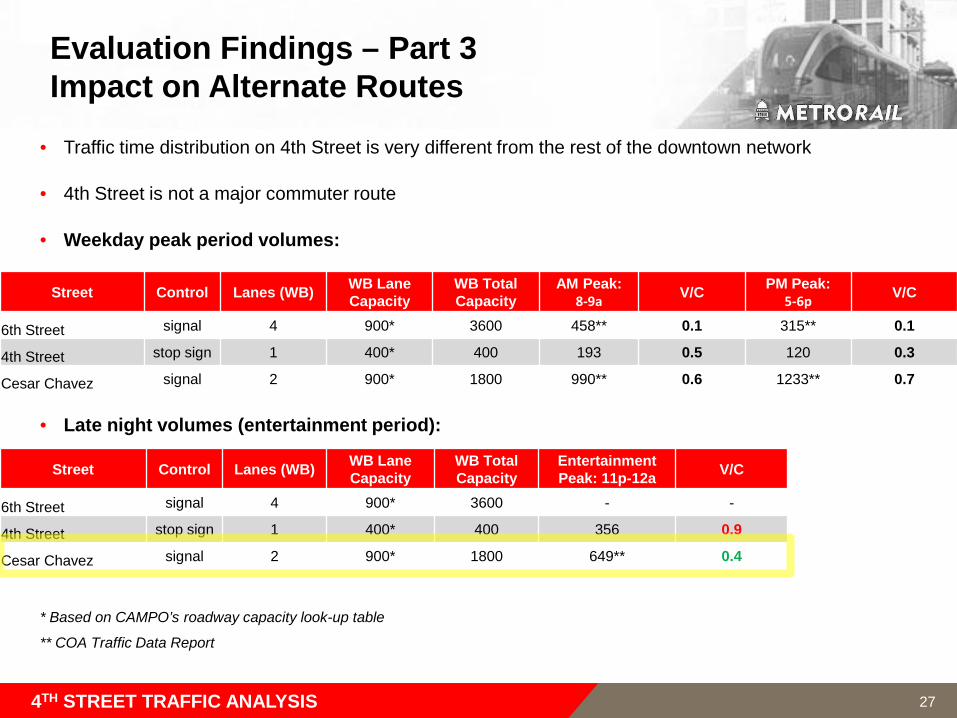
Evaluation Findings – Part 3Impact on Alternate Routes
• Traffic time distribution on 4th Street is very different from the rest of the downtown network
• 4th Street is not a major commuter route
• Weekday peak period volumes:
• Late night volumes (entertainment period):
* Based on CAMPO’s roadway capacity look-up table
** COA Traffic Data Report
4TH STREET TRAFFIC ANALYSIS
Street Control Lanes (WB) WB Lane Capacity
WB Total Capacity
AM Peak:8-9a V/C PM Peak:
5-6p V/C
6th Street signal 4 900* 3600 458** 0.1 315** 0.1
4th Street stop sign 1 400* 400 193 0.5 120 0.3
Cesar Chavez signal 2 900* 1800 990** 0.6 1233** 0.7
Street Control Lanes (WB) WB Lane Capacity
WB Total Capacity
Entertainment Peak: 11p-12a V/C
6th Street signal 4 900* 3600 - -
4th Street stop sign 1 400* 400 356 0.9
Cesar Chavez signal 2 900* 1800 649** 0.4
27

5th Street Traffic Analysis
Downtown Multimodal Station
28
0
200
400
600
800
1,000
1,200
1,400
1,600
4th St, E of Neches (WB Auto) Wed '15 Cesar Chavez, W of S 1st St (WB Auto) Wed '136th St, W of IH 35 (WB Auto) Mon '11 5th St, W of IH 35 (EB Auto) Thur '095th St, E of Red River (EB Auto) Tue '09
Data Summary – Hourly Volumes onTypical Weekday*
5TH STREET TRAFFIC ANALYSIS
Vehi
cles
per
Hou
r
Time of Day
2-lane, CBD Principal Arterial capacity
1-lane, CBD Local Street capacity
* - Cesar Chavez, 5th St. and 6th St. traffic volumes from City of Austin historical data
29
0
200
400
600
800
1,000
1,200
1,400
1,600
4th St, E of Neches (WB Auto) Wed '15 Cesar Chavez, W of S 1st St (WB Auto) Wed '136th St, W of IH 35 (WB Auto) Mon '11 5th St, W of IH 35 (EB Auto) Thur '095th St, E of Red River (EB Auto) Tue '09
Data Summary – Hourly Volumes onTypical Weekday*
5TH STREET TRAFFIC ANALYSIS
Vehi
cles
per
Hou
r
Time of Day
2-lane, CBD Principal Arterial capacity
1-lane, CBD Local Street capacity
* - Cesar Chavez, 5th St. and 6th St. traffic volumes from City of Austin historical data
30
0
200
400
600
800
1,000
1,200
1,400
1,600
4th St, E of Neches (WB Auto) Sat '15 Cesar Chavez, W of S 1st St (WB Auto) Sat '136th St, @ Red River (WB Auto) Sat '09 5th St, E of San Jacinto (EB Auto) Sat '03
Data Summary – Hourly Volumes onTypical Weekend* (Saturday)
5TH STREET TRAFFIC ANALYSIS
Vehi
cles
per
Hou
r
Time of Day
2-lane, CBD Principal Arterial capacity
1-lane, CBD Local Street capacity
* - Cesar Chavez, 5th St. and 6th St. traffic volumes from City of Austin historical data
31
0
200
400
600
800
1,000
1,200
1,400
1,600
4th St, E of Neches (WB Auto) Sat '15 Cesar Chavez, W of S 1st St (WB Auto) Sat '136th St, @ Red River (WB Auto) Sat '09 5th St, E of San Jacinto (EB Auto) Sat '03
Data Summary – Hourly Volumes onTypical Weekend* (Saturday)
5TH STREET TRAFFIC ANALYSIS
Vehi
cles
per
Hou
r
Time of Day
2-lane, CBD Principal Arterial capacity
1-lane, CBD Local Street capacity
6th Street entertainment period lane closure
* - Cesar Chavez, 5th St. and 6th St. traffic volumes from City of Austin historical data
32
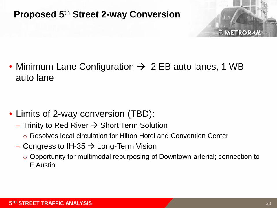
Proposed 5th Street 2-way Conversion
• Minimum Lane Configuration 2 EB auto lanes, 1 WB auto lane
• Limits of 2-way conversion (TBD):– Trinity to Red River Short Term Solutiono Resolves local circulation for Hilton Hotel and Convention Center
– Congress to IH-35 Long-Term Visiono Opportunity for multimodal repurposing of Downtown arterial; connection to
E Austin
5TH STREET TRAFFIC ANALYSIS 33
34
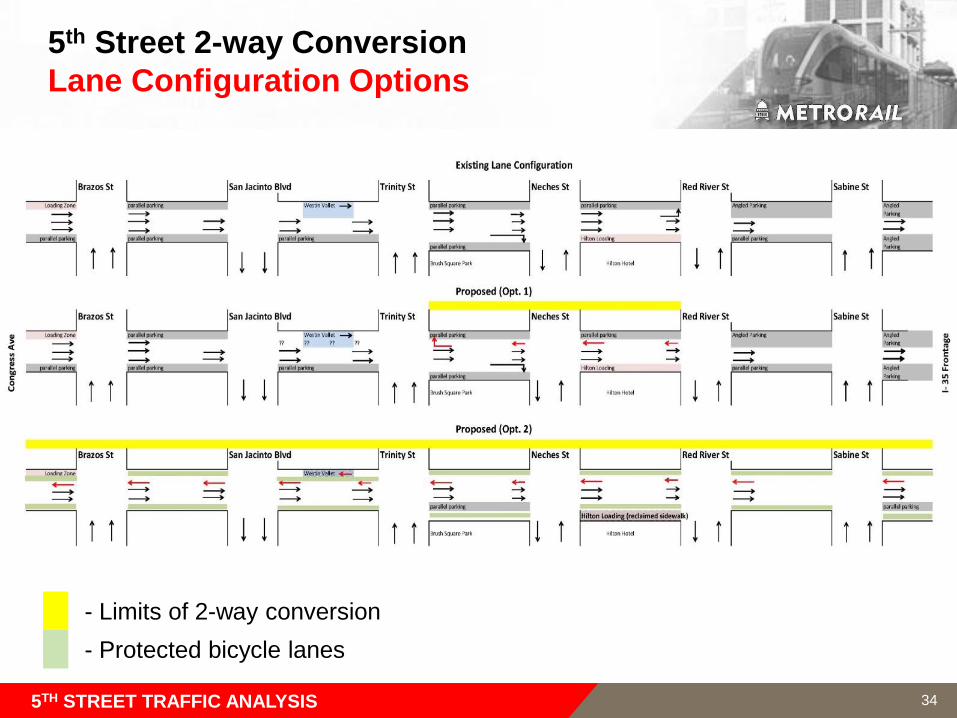
5th Street 2-way ConversionLane Configuration Options
- Limits of 2-way conversion- Protected bicycle lanes
5TH STREET TRAFFIC ANALYSIS
5th Street 2-Way ConversionTraffic and Accessibility
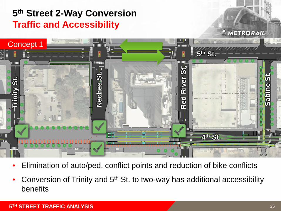
• Elimination of auto/ped. conflict points and reduction of bike conflicts
• Conversion of Trinity and 5th St. to two-way has additional accessibility benefits
• Concept 1
Nec
hes
St.
Red
Riv
er S
t.
Sabi
ne S
t.
Trin
ity S
t.
5th St.
4th St.
5TH STREET TRAFFIC ANALYSIS 35
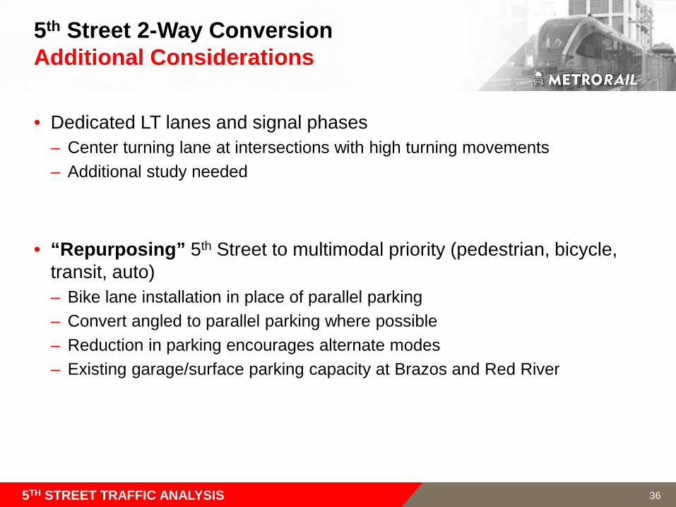
5th Street 2-Way Conversion Additional Considerations
• Dedicated LT lanes and signal phases– Center turning lane at intersections with high turning movements– Additional study needed
• “Repurposing” 5th Street to multimodal priority (pedestrian, bicycle, transit, auto)– Bike lane installation in place of parallel parking– Convert angled to parallel parking where possible – Reduction in parking encourages alternate modes– Existing garage/surface parking capacity at Brazos and Red River
5TH STREET TRAFFIC ANALYSIS 36
Next Steps
37
Downtown Multimodal Station
38
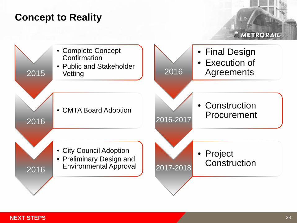
Concept to Reality
NEXT STEPS
2015
• Complete Concept Confirmation
• Public and Stakeholder Vetting
2016• CMTA Board Adoption
2016
• City Council Adoption• Preliminary Design and
Environmental Approval
2016
• Final Design• Execution of
Agreements
2016-2017
• Construction Procurement
2017-2018
• Project Construction
38