Embed Size (px)
Citation preview
59
CAPE YORK HISTORICAL EXPEDITION 1973
1883 Route Retraced by Horsemen By MALCOLM M. REA
[Read at a meeiing of The Sociciy, 18 April 1974)
(All rights reserved)
[Mr. Rcii concciveO. orgniniscri ^nd JfJ Ihe 7-nioii evpcdjlion from Fiiirview, Norlh Queens(,inri, lo Thiir^d^y island in June/Tiily, 1^73, The p;\Tiy followed (he HIecirIc Telegnph line route e 'pfored by Juhn R. Br^rifoi'd ^nd hh party of seven men 9ft year^ liefore Mr. RcB [ Hj^lorical Officer, I'liblic Relatione Seciion, Aii rTJilian Post Office and Secretary, Pofii Office Hi^Joiical Society of Queensland He ii 44 ye^fi old, niairied \vllh five childreif and live^ at Tarrasindi. Eri&J>ane).
PROLOGUE (Btrtdford^s Expedilion) In Ihe early eighties oi the fast century, Sir Thomas
Mdiwryilh's government look n very serious view o£ the commercial and striilcgic imporianoc of Torres Sirait and of the necessiiy for Icfcgraphio communication between the SlrEiit and Ihe Capiial^ The Queensland Government, ihrotigh the Post and Tefegiaph Depaitment^ had already btiilt Ihousands of miles of electric telegraph lines in the Stale' [he most northern was Ihe Cooklown-Maylown route opened on 25 April 1876. On I July lK7(i, a hue was buiU from Junction Creek (Ml. Surprise) to Palmervilie via May-lovvn. Thus, the goldfields were in lelegraphic conlacJ with Cooktown, the nearest porl and with the southern capilal via Junction Creek. Townsville and Charters Towers
The hne [Q the Gulf, Cardwell to Notmanlon and Norman MoiLlh fnow Karumba) had been operating sinoe 1871/72 (completed Oelober 1871 and opened to traffic 3 January 18721. Cape York Peninsula, remote, har^h, hostile and Jfirgejy unexplored was one of Ihe last fronlieri which challenged nian^s conquesl by "the singJe thread of life'' — the BJeciric Telegraph.
Also by Ihe 1880^s Torres Sirait was a sea lane frequently iL3ed by steaniers to carry mail, passengers and freight to England via the Sue/ Canal (opened 1H69). The Russian scare also had grcai bearing on Ihe importance of Thursday
70
Island and Cape York. It was essential to build a line to Ihe lop, so thought Government officials, but first a roule had to be explored.
The Post and Telegraph Department selected John Richard Bradford, Inspector of Lines and Mail Rome Services for the job. U was a wise decision as Bradford was an experienced bushman and had been "employed in surveying, and supervising the construclion of lelegraph lines, JD different parts of Queensland , , . on the line from Cooktown to Palmervilie and Maytown from October 1874 to July 1876"^. The plan was to examine ihe country between the Cook town-Palmervilie Line and the tip of Cape York Peninsula.
Upon receiving his commission, Bradford sailed for Cooktown from Brisbane in May 1SS3. Obtaining provisions and horses and increasing his party lo seven men — five white men, a Chinese and an aborigine, the expedition set out on 9 June tor Laura Telegraph Station, 66 miles from Cooktown. After arriving, several days were spent there. Their camp was then moved to ''The Lagoon" on '^The Blacksoil" [now Fairview Telegraph Station) the point where ihe new line was to branch off from Ihe existing Cooklown-Palmerville line,' 15 miles from Laura,
The party left the Lagoon or Blacksoil on 18 June 1S83 travelling norlh 55 degrees west. At each camp site on their journey northwards, a tree was marked wiih a broad arrow over Ihe leiier B under wh[ch was the number of Ihe camp in Koman numerals. They made 50 such camps, the lasl one being nine miles north of Somerset ^here the famous Frank Jardine resided (311 miles from Coen or 460 miles from Fairview).
Their journey commenced on 18 June 13^83, was ijuccess-fuJly completed 'lo Somerset) on 29 AugusI 1883, 83 days later. Of Ihe original 36 horses only 13 reached Somerset After sending his men, except Healy his seeond-in-command, back 10 Cooktown on ihe Gympie, J^radford and Healy crossed to Thursday Island by boat (after spending Ihe night at Roko, a fishing station) the next morning Sunday, 2 September 1883. The two men oblained information locally on Ihe soundings, bottom, currents, shortest route^ tide and prevailing winds of the passage for cable laying operations. With their epic journey fully complete, Bradford and Healy left for Brisbane on the s.s. Corea on 5 September 1883.
Bradford's detailed report to his superiors was followed by the calhng of tenders in 3 884 for dre conitruclion of a
' '1
lelegraph line from Fairview near Laura lo Cape York and Thursday Island.
The telegraph line was erected on iron poles (Oppen-heiiner type) by two teams of contractors during the peiiod July 1884 and October 1886 or even later. Stations were opened al Fairview, Musgrave, Coen, Mein, Moreton, McDonnell, Palerson (later named Cape York) and Thursday Island by 1887. The mainland buildings were constructed as fortresses to withstand native attack and up to 25 years later were used intermittently for defence.''
The completed line provided more than communication with a strategic outpost of civilisation or comfort to the cattlemen and miners who followed the explorers.
It meant Australia uniquely, was spanned from Cape York in Ihe far north lo Hobart, Tasmania at the southern extremity of the conlinent, more than 2.5O0 miles away. The constrnctJon of this overland lelegraph line with undersea cable near both ends was an engineering feat of which Australians can be justly proud. Our communication pioneers were men of iron will, resourcefulness, courage and foresight.
1973 EXPEDITION Their story has never been fully told. This was one of
the important reasons behind my decision, about five years ago, to follow the trail that John Richard Bradford blazed in Cape York Peninsula. Study, preparation, organisation and a thousand other things look months and years lo accomplish. However, by 9 June 1973, a 7-man party was ready to leave Brisbane for l_aura in North Queensland.
EQUIPMENT Pack and riding saddles, hobbles, bells, bridles, haliers,
harness repair kits, provisions for two months, bedding, fire-iitms and ammunilion, fishing gear, photographic equipment and films; portable telephone and radio transceiver, diaries, niapi, medical pack and philatelic mail inade up a truck and trailer load for road transpoii to Cape York Peninsula.
MEMBERS AND QUAUFICATIONS The expedition members consisted of men selected by
me from more than liO applicants scattered over most of the Stales of AtEstralia, Their qualifications included the ability lo ride, experience with horses, initiative, resourcefulness, camping and outdoors experience, inlerest in Cape
72
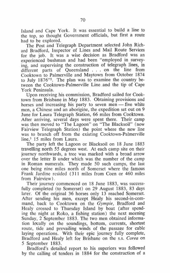
^C2'*i^i, i^^S" •
Boiling the billy on the Cape York trail. Left to right: Bob Greenfield, Ted Knauer, Ron Berry, Dick Lakey, Bob. Anthony,
Jim Green. Photo: M. Rea
York and the purpose of the expedition, medical and dental health plus special talents required for the expedition. As well, each member had to be available for a minimum of six weeks and share one-seventh of the total cost of the expedition. The party comprised myself as Leader, Robert Anthony, 48, from Tweed Heads, professional still and movie cameraman (assigned with my approval by a film making company in Brisbane), Ron Berry, 53, Proprietor, Caravan Park in the Snowy Mountains, N.S.W., in charge of fishing and supplies; E. W. (Ted) Knauer, 57, Post Office Linesman, in charge of firearms and hunting; Bob Greenfield, 36, Technical Assistant Tropical Agronomy, C.S.I.R.O., Brisbane, in charge botanical specimen coUections, pack gear and stock; Richard Lakey, 21, Geologist, also in charge stock and Jim Green, 52, Signwriter, Queensland Government Railways, qualified cook also in charge saddlery repairs. Each man's responsibilities overlapped in some aspect of the total daily work.
COLOUR SLIDES In order to illustrate the progress of our "Cape York
Historical Expedition 1973" I have brought along about one hundred 35 mm colour slides. These photographs were
73
taken by me mostly from horseback. I shall explain each one in chronological order.
Slide I—The yellow Datsun truck displaying the name of the Expedition and members and advertisements of several sponsors who assisted with provisions and goods, was owned and used by Ron Berry. He drove it from the Snowy Mountains to Brisbane where we loaded it with provisions and equipment.
Slide 2 — Here Ron stands near the vehicle parked in front of my house at Tarragindi a few days before we departed on Saturday, 9 June 1973. We used this vehicle and Ted Knauer's Holden and trailer to transport men and material.
Slide 3 — This shows the Hinchinbrook Passage and Island from the Bruce Highway (No. 1) south of Ingham. Jim Green and Ted Knauer view the picturesque scenery from the roadside while we climbed higher for photographic advantage.
Slide 4 — Tall sugar cane in flower near Cairns with the heavily timbered Great Dividing Range in the background can be seen from the Bruce Highway.
Slide 5 — The main street of Mareeba with its wide streets and centre line of beautiful trees was pleasant during the warm midday.
Slide 6 —Wolfram Hotel at Mt. Carbine on Highway 87. 19 miles from Mt. Molloy. The galvanised iron hotel appears to be the only inhabited building in the vicinity. It's obvious Mt. Carbine has seen better days. We photographed a few of the old buildings nearby just for the record.
Slide 7 — Looking across the rugged ranges which dissect the Kennedy Highway. The feeling of remoteness and isolation begins in country like this.
Slide 8 — This one shows one of the many cattle trucks which passed our two vehicles leaving clouds of thick dust. For safety sake, we often pulled to the side of the road and allowed the dust to settle before proceeding. The gravel road was extremely rough and narrow. r
Slide 9 — Looking toward the ranges near Laura, with the road snaking through the bush and disappearing into ridges on the horizon. We were getting close to our destination by this time and looked forward to seeing Laura. Ron Berry was the only member of the vehicular party to have been there before.
Slide 10 — Lakeland Downs built up by Mr. Clive Foyster was of interest to us. We stopped there for an hour and saw houses, workshops, a general store, a school, motel and farms. The settlement appeared to be a thriving community. The stop provided us with a good stretch for our legs even though we were anxious to move on.
Slide i /—Aboriginal cave paintings at the famous Split Rock Gallery on the Palmerville road near Laura. It is alleged the aborigines practised cannibalism on Chinese labourers and miners who travelled the road during the gold-bearing days of the Palmer River.
74
The ant hill near the paintings is claimed to have been used as an oven. Whatever the reason for the paintings to be located on this high rise subplateau, they are most intriguing and should be preserved for all time.
Slide 12 — After a long tiring journey of 1,440 miles by road from Brisbane, the party finally arrived at Laura. The Non-official Post Office and store run by the Gostelows was one of the few buildings at Laura. The galvanised iron building was the main centre of commerce in the area although the "pub" next door rivalled the Post Office. Mrs. Gostelow gave great co-operation to the party especially with the mail and telephone service.
Slide 13 — Here some of the boys socialise with locals in front of the hotel made of galvanised iron. Seats were found on the ground or on the very low level verandah.
Slide 14 — On Saturday, 16 June 1973, we arranged for the philatelic mail to be postmarked with the special pictorial postmark at Laura Post Office. Fortunately, we were able to hire 12 horses from Mr. Graham Elmes, a local Station Owner (Olivale Cattle Station—seven riding and five pack animals. Horses for hire were extremely scarce at the time as the late wet season meant a late muster for the stockmen. We started our journey to follow Bradford's trail from the same spot he did 90 years before. The date was Monday, 18 June 1973 at 4.00 p.m. It was late in the day as the horses previously had broken down the yard gate and escaped
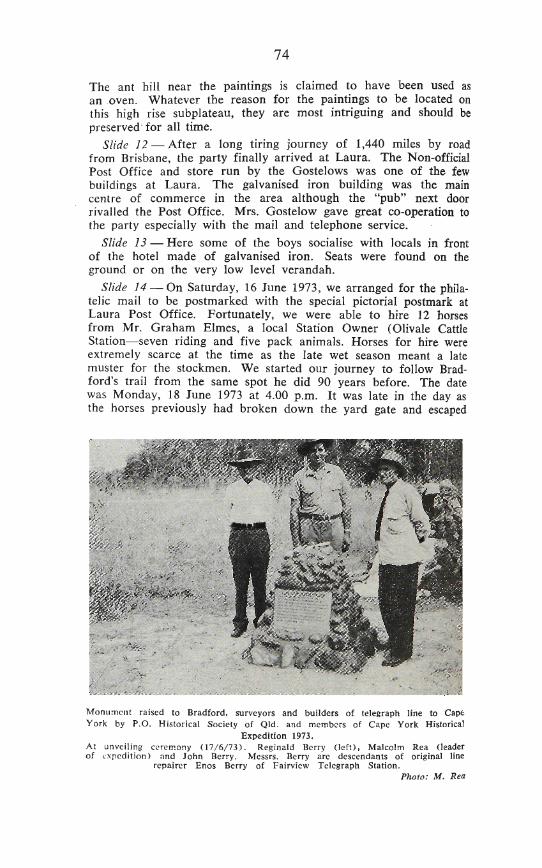
Monument raised to Bradford, surveyors and builders of telegraph line to Cape York by P.O. Historical Society of Qld. and members of Cape York Historical
Expedition 1973. At unveiling cerem.ony (17/6/73). Reginald Berry (left), Malcolm Rea (leader of Lxpcdition) and John Berry. Messrs. Berry are descendants of original line
repairer Enos Berry of Fairview Telegraph Station. Pholo: M. Rea
7»
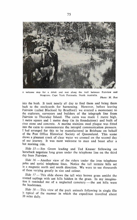
A welcome stop for a drink and rest along the trail between Fairview and Musgrave, Cape York Peninsula, North Australia.
Photo: M. Rea
into the bush. It took nearly all day to find them and bring them back to the stockyards for harnessing. However, before leaving Fairview (called Blacksoil by Bradford) we erected a monument to the explorers, surveyors and builders of the telegraph line from Fairview to Thursday Island. The cairn was made 1 metre high, 1 metre square and 1 metre deep (in its foundations) and built of river stone and concrete. A marine stainless steel plaque was fitted into the cairn to commemorate the intrepid communication pioneers. I had arranged for this to be manufactured in Brisbane on behalf of the Post Office Historical Society of Queensland. This scene shows a pleasant creek of clear water we crossed on the second day of our journey. It was most welcome to man and beast after a hot morning ride.
Slide 15 — Jim Green leading and Ted Knauer following on horseback negotiate long grass under the telephone line on the third day from Fairview.
Slide 16 — Another view of the riders under the iron telephone poles and aerial telephone lines. Notice the tall termite hills set in a magnetic north and south direction. We were to see thousands of these varying greatly in size and colour.
Slide 17 — This slide shows the tall wiry brown grass amidst the stunted saplings with ant hills hidden in the grass. In my imagination it reminded me of a neglected cemetery — the ant hills were the headstones.
Slide 18 — This view of the pack animals following in single file IS typical of the manner in which the expedition travelled about 20 miles daily.
76
Slide 19 — Midday break meant a camp around a fire seated on a log. Hot drinks or cool water from the creeks washed down small dampers or bannocks (as cook Jim Green of Scottish origin called them). A half to an hour break refreshed men and animals and the next 10-12 miles, before making camp for the night, didn't seem as difficult as before lunch.
Slide 20 — The marvel of modern communication is illustrated. Assisted by linesman Ted Knauer, I've pulled down with a rope, two wires of the overhead telephone line. Hooking on a portable telephone carried in a pack bag, I wound the handle to a coded number of turns and within seconds contacted Laura Telephone Exchange and Brisbane was soon on the line. On this occasion, Wednesday, 20 June 1973, at 12.30 p.m., I telephoned the Board Room in the Brisbane G.P.O. where a monthly meeting of the Post Office Historical Society of Queensland was in progress. What a surprise it was to everyone. After reporting on the erection of the plaque at Fairview and our progress, I spoke briefly to about a dozen members before terminating the call. During the call, it rained slightly.
Slide 21 — That afternoon we arrived at the Hann River. The bridge and road are shown in this slide. We camped a few hundred yards off the road in Kalinga Station after obtaining permission from the owner, by using our portable telephone on his aerial telephone line.
Slide 22 — As you can see from this slide, the Hann River is only a small stream of water in the winter but during the wet season like most of the Cape Rivers, swells to an incredible size. We caught a few fish and they were a welcome addition to our diet.
Slide 23 — The next major river course crossed was the Morehead which like the Hann flows into Princess Charlotte Bay. At this picturesque spot, we were fortunate to find stockyards and a drover's camp site. Our photographer took some extremely colourful movie scenes on the morning we departed. The slide shows us harnessing up the horses with a small lagoon in the background. This camp site was one of the prettiest in our entire journey. Had we no schedule to keep, everyone would have voted for a few days rest at this spot.
Slide 24 — A typical fresh water creek crossing along the telephone line. Some bushmen note that "blue water is new water" and I can vouch for the sweetness of this water which lay in shallow pools surrounded by white sand. Water courses such as this are distinctive of the Cape topography.
Slide 25—The date was 22 June 1973 and we were close to Musgrave Station. The low range or stony ridge ahead is a little south of Musgrave. We decided to push on in spite of the distance travelled to this spot. Thus we arrived at Musgrave just on dark after a long day having ridden a distance of 22 miles or more.
77
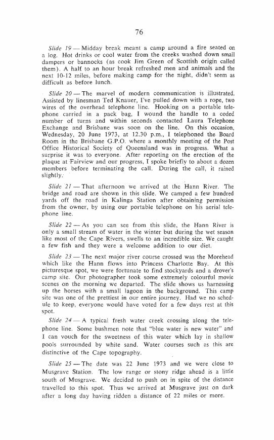
Musgrave Telegraph Station 1896, showing gun ports at front and rear of building. Photo: Courtesy Public Relations. Australian Post Office, Brisbane.
Slide 26 — Mr. and Mrs. Jim Hale who own the building (and surrounding property) seen in this slide, welcomed us. They made a camp site available for our use about half a mile to the rear of the station. This building at Musgrave, although altered by having the front verandah enclosed with glass louvres, is the only one of its kind still intact in this State and in Australia. It was opened as an Electric Telegraph Repeater and Repair Station on 23 December 1886. J3un ports were located on the front and rear corners of the building so that wild blacks could be discouraged from getting too close. Water tanks were located underneath the house to prevent waste or damage by aborigines. Internal stairs provided access from the ground floor to first floor levels for utility and security. The whole building was constructed with a wooden frame, galvanised iron sheeting and supported on high wooden stumps set in iron bases to prevent termite attack.
Slide 27 — This view taken from the north side shows the present existing external water tanks and the old roof mounted ventilators. IT IS MY STRONG RECOMMENDATION THAT THIS UNIQUE AND TYPICALLY QUEENSLAND BUILDING ONCE OWNED BY THE COLONIAL POST AND TELEGRAPH DEPARTMENT, THE FEDERAL P.M.G. DEPARTMENT AND NOW BY THE HALES SHOULD BE PRESERVED AT ALL COST FOR OUR POSTERITY AS ONE OF THE PRIZES OF OUR NATIONAL HERITAGE.
78
SicwarE Rivers several lime^ ilie Expt^ilion arrived a| Cc/in abotit 70 miles from Musgrave. Here i a panoriimic view of iliiii ^e[(lc-mcn and [he liilis which surround it.
SUde .?J~This i the main slrccl of Coen looking toward Ibt Au&iralian Inland MiShiOn Hospital on Ihe hiJI. The non-ol'ficlal Posi Office and Store owned hy Mr:*, Irene Taylor is ihe large galvanised iron building on Che rjghl, Coen was [o prove ii was one of (he mosl inlereslirg places in our enihe journeyr
Slide i4—Thi^ is a closc-iip of Ihe POiE Office and ihe public iclephonc cabinel wilh Mrs. Williams (daa^hler of Mr^. I. Taylor), non-official Poslmislrcss in fronl of the bifilding. Mrs. WilJiams was very friendly, effiucnl and most co-opcralive. The Cocd people were E>:iremely interested in our ex|Tedinon and helped ILI considerably. We hired a new pl nC ot 12 hncses fToni Mrs, 'laylor for ihe next slage lo Morelon. Mr, Elisie^ of Laura planned to colled his hoises when iiesi visjiing Coen during (he annual races which were only a few weeks away,
5!/d^ SS^HzTG I sland near the road leading north oui of ihe cUlenienL The aign post says — Cape York, Weipa, Hospital amJ
Police.
Sl'd^ 3^ — These small sJoekyards are localcd behind Mri. Taylors Po i Office Slore. The small housed in Ihe baekgroimd have cemeiil floors and galvanised iron roofs. They house abODginal families whose Arashing was "persil" white. There are more aborigines ihan whiles al Coen. The flal-lopped monnlain is Mounl While, which IS pari of Che Mcllwraith Range. Coen al the lime was very dry wilh warm days and cool nights.
Slids 37—Tdis house in ihe main sireet of Coeri is claimed Jo be the original lelegraph stalion from Mein which i about 60 rnile^ north o£ Coen. The builriing was bought privately many years ago, greatly altered and finally erecied on this site. Ii is hard lo imagine it in Ihe same form as the Margrave building we saw earlier.
Slide 3H—Tliii lall chimney lowering over Ihe btish, is located at the ahanrioncd Great Norlhcrn Gold Mine aboal Iwo miles from Ihe Coen setllemenl past ihe raeecoiirse. Some of (he rusted machinery IS s(fll there reminiscenl of earlier days. The gold mining lease No. 24 for (his mine was apphed for on 19 September l?OI and forfrilcd for non-payment of rent in 1914, so the mine ha^ been abandoned for (JO years.
Sifde S9—John Harris, the Jo ; ! publican (Exchange Hotel), had driven us in his landrovcr lo Ibc Great Northern Mine Later he drove a few miles along the northern road lo the abandoned Ml. Wilson Mine. The huge mclal drive wheel in the picture was carried In two pieces by horse leam^ in early days and assembled al Ihe mine. Wiih all ihe tinfeneed mine shafts in ihis area, I certainly wuuldn^ walk there after dark. The Mines Dcparlment have no record of this mine and presumably it operated before Ihe (urn of ifie cenliiry. WD fell more like (ourl^ls, while viewing Ehe« intei-e ling places, than expedilion members.
79
Musgrave Station 1973, showing alterations to building. Original wooden telegraph pole far left near steel telephone pole.
Photo: M. Rea
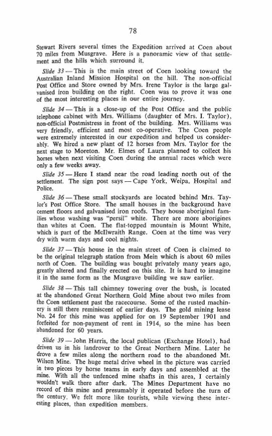
Slide 28 — In front of the building is located this wooden telegraph pole probably erected 16 March 1887 as it has the date stamped in the pole about 7 feet above the ground. My finger is pointing to the date. Unfortunately some years ago, a vandal fired a bullet into the pole in the centre of the impression. Thankfully Mr. and Mrs. Hale realise the historic value of their property and care for their "living museum."
Slide 29 — In front of the house yard is an air-strip (and even a small cemetery). Whilst we were at Musgrave, this helicopter en-route from New Guinea to Cairns stopped for fuel, as did a Cessna aircraft with an aerial mineral survey team aboard. Mr. and Mrs. Hale are kept busy with a fairly regular stream of aircraft, government officials, survey teams and tourists who replenish fuel stocks at their station. Our stay was an enjoyable one especially with cold drinks and home-made bread.
Slide 30 — Near our camp was this hot sulphur pool and here we see Jim Green, Dick Lakey and Ron Berry enjoying the therapeutic benefits of their ablutions. The only problem was a foot of mud and decayed leaves on the bottom of the pool. However care in ingress and egress ensured little disturbance of the sediment.
Slide 31 — These old trucks dumped nearby were relics of the I920's and must have travelled thousands of miles over impossible roads before their final demise. What tales they could tell if they could speak.
Slide 32 — We left Musgrave on 24 June and camped at this pleasant spot — a tributary of the Annie River, having crossed many flowing creeks in the 20 miles. After crossing the Stewart and Little
78
Stewart Rivers several times the Expedition arrived at Coen about 70 miles from Musgrave. Here is a panoramic view of that settlement and the hills which surround it.
Slide 33 — This is the main street of Coen looking toward the Australian Inland Mission Hospital on the hill. The non-official Post Office and Store owned by Mrs. Irene Taylor is the large galvanised iron building on the right. Coen was to prove it was one of the most interesting places in our entire journey.
Slide 34 — This is a close-up of the Post Office and the public telephone cabinet with Mrs. Williams (daughter of Mrs. I. Taylor), non-official Postmistress in front of the building. Mrs. Williams was very friendly, efficient and most co-operative. The Coen people were extremely interested in our expedition and helped us considerably. We hired a new plant of 12 horses from Mrs. Taylor for the next stage to Moreton. Mr. Elmes of Laura planned to collect his horses when next visiting Coen during the annual races which were only a few weeks away.
Slide 35 — Here I stand near the road leading north out of the settiement. The sign post says — Cape York, Weipa, Hospital and Police.
Slide 36 — These small stockyards are located behind Mrs. Taylor's Post Office Store. The small houses in the background have cement floors and galvanised iron roofs. They house aboriginal families whose washing was "persil" white. There are more aborigines than whites at Coen. The flat-topped mountain is Mount White, which is part of the Mcllwraith Range. Coen at the time was very dry with warm days and cool nights.
Slide 37 — This house in the main street of Coen is claimed to be the original telegraph station from Mein which is about 60 miles north of Coen. The building was bought privately many years ago, greatly altered and finally erected on this site. It is hard to imagine it in the same form as the Musgrave building we saw earlier.
Slide 38 — This tall chimney towering over the bush, is located at the abandoned Great Northern GoM Mine about two miles from the Coen settlement past the racecourse. Some of the rusted machinery is still there reminiscent of earlier days. The gold mining lease No. 24 for this mine was applied for on 19 September 1901 and forfeited for non-payment of rent in 1914, so the mine has been abandoned for 60 years.
Slide 39 — John Harris, the local publican (Exchange Hotel), had driven us in his landrover to the Great Northern Mine. Later he drove a few miles along the northern road to the abandoned Mt. Wilson Mine. The huge metal drive wheel in the picture was carried in two pieces by horse teams in early days and assembled at the mine. With all the unfenced mine shafts in this area, I certainly wouldn't walk there after dark. The Mines Department have no record of this mine and presumably it operated before the turn of the century. We felt more like tourists, while viewing these interesting places, than expedition members.
80
Slide 40 — After spending an enjoyable four days at Coen, Bob Greenfield's poisoned hand had healed considerably and we had obtained the hire of 12 horses. We were now ready to move northwards again. The youngsters seen in this view sitting on the stockyard rails, came down to see us leave as it was a Saturday (20 June 1973). Horses to them are like motor bikes and cars to their city cousins.
Slide 41 — Mrs. Taylor's aboriginal stockmen assisted with the harnessing and loading of the stock, and the handling of several difficult pack-horses. However, after some bucking and "high spirit-edness" the animals settled down and with one of the aboriginal stockmen in lead we reluctantly said goodbye to many newly made friends.
Slide 42 — The familiar iron telegraph poles soon appeared to direct our party toward Mein, the next Telegraph Repeater Station site northwards.
Slide 43 — However, before leaving Coen we filled our water bottles and ourselves with the sweet water of the sandy bottomed Coen River. Bob Anthony seems to be enjoying his cup of "nectar."
Slide 44 — Across the river the party and pack-horses followed the road uphill to the top of the bank. A few dogs gave us a noisy welcome as we rode along the road.
Slide 45 — On the northern side of the river we passed these $17,000 houses being built by the State Government for Aboriginal families. When completed they will be the finest in the Cape. However, some doubted the wisdom of the project fearing insufficient numbers of socialised aborigines were available to handle modern houses.
Slide 46—Miles along the line we saw huge ant hills like this one up to 20 feet in height. Ted Knauer, rifle cradled in his arm, poses nearby.
Slide 47 — We saw small conical shaped ones like these about 2 to 8 feet in height.
Slide 48 — At one place a couple of days north of Coen, we travelled through very deep sand making the going difficult for the horses. We met a local cattleman in this sandy country droving about 100 head of stock to market.
Slide 49 — As we approached the Archer River the country changed to granite and many boulders similar to those in South-east Queensland were seen. This balancing rock reminded us of similar sights on the Queensland/New South Wales border near Stanthorpe and Wallangarra.
Slide 50 — This is the road crossing of the Archer River — at the time inaccessible by four-wheel vehicles. Our plans were to stay a day for rest and recreation at the Archer but the weather was poor — it was about the time Brisbane was being battered by high winds and rain.
Slide 51 — However, we camped near a small lagoon with plenty of feed for the stock on the south side of the river. Here the horses are seen resting and grazing while we take shifts in "horse tailing" or "catching up" our diaries or laundry.
81
Slide 52 — This is our camp at the Archer. The sun came out for brief tantalising moments while the high wind buffeted our makeshift tents. That night most of us slept wet as the driving rain poured under the waterproof covers into our sleeping bags.
Slide 53 — These huge steel poles carry the weight of the telephone lines across the Archer and replace the earlier used wooden poles. During the rainy season the i-mile wide river bed is covered with 40 feet or more of roaring flood waters which almost reach the base of these poles.
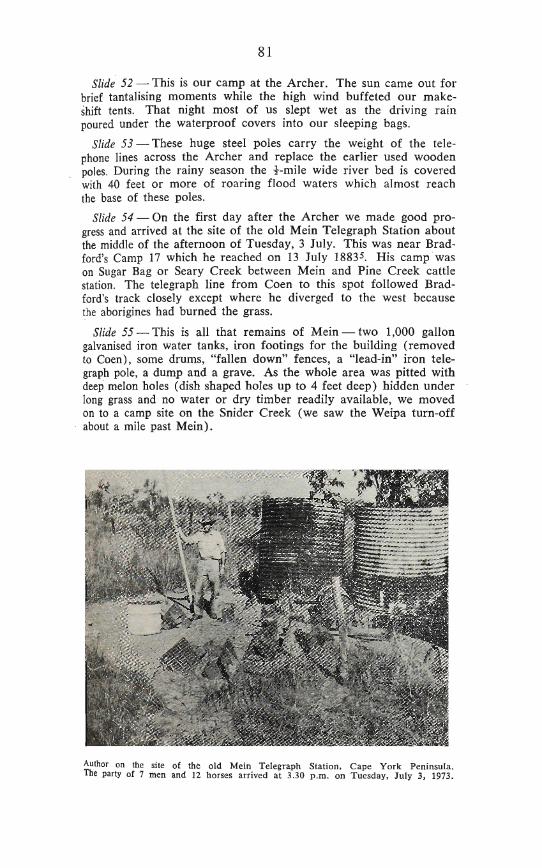
Slide 54 — On the first day after the Archer we made good progress and arrived at the site of the old Mein Telegraph Station about the middle of the afternoon of Tuesday, 3 July. This was near Bradford's Camp 17 which he reached on 13 July 1883^. His camp was on Sugar Bag or Seary Creek between Mein and Pine Creek cattle station. The telegraph line from Coen to this spot followed Bradford's track closely except where he diverged to the west because the aborigines had burned the grass.
Slide 55—^This is all that remains of Mein — two 1,000 gallon galvanised iron water tanks, iron footings for the building (removed to Coen), some drums, "fallen down" fences, a "lead-in" iron telegraph pole, a dump and a grave. As the whole area was pitted with deep melon holes (dish shaped holes up to 4 feet deep) hidden under long grass and no water or dry timber readily available, we moved on to a camp site on the Snider Creek (we saw the Weipa turn-off about a mile past Mein).
Author on the site of the old Mein Telegraph Station, Cape York Peninsula. The party of 7 men and 12 horses arrived at 3.30 p.m. on Tuesday, July 3, 1973.
82
Slide 56 — After leaving our very pleasant camp at Snider Creek where we had clear pools for drinking and bathing, we travelled about seven miles and came upon these open plains. Treeless, they stretched for miles on both sides of the line as far as the eye could see. Tall blue/green grass covered the entire area to a height of three feet or more. The few cattle we saw, were literally "rolling fat"; while wild plain turkey soared overhead disturbed by our noisy cavalcade.
Slide 57 — Ant nests high in these ti-trees (Melaleuca viridi flora) provided an interesting diversion as we rode many monotonous miles along the bush track. These green tree ants (Oecophylla smarag-dina)^ make their nest in a house of leaves. Teams of ants, using their strong jaws, pull the green leaves together for the construction of the walls of their high level home. While these leaves are held in place, edge to edge, other ants carry the white grubs (which later turn into ants) from their nest and use them to weld the leaves together. This is done by a silk-like sticky substance exuded by the grubs. The leaves are then held in place until the silk adhesive drys. In this manner a large number of leaves are used to form a waterproof nest.
Slide 58 — This beautiful scene of cabbage tree gums, tall grass and blue skies unfortunately was somewhat offset by the deep "melon holes"* hidden in the grass which made going difficult and dangerous. Instead of viewing the beauty around us we had to keep our eyes fixed on the grass track ahead to prevent the horses stumbling. Fortunately, we had no serious accidents along this section of the line (south of Moreton) even though the horses' hoofs often broke through the surface or slipped into hidden holes.
Slide 59 — After about seven miles, the country changed from grassy plains to open forest and we reached our destination—Batavia Downs Cattle Station —for the day at about 3.30 p.m. In this slide, the men and horses are spread out across the unused airstrip a short distance from the station buildings. A swim in the lagoon, fresh clothes, hot damper made in the cookhouse and a brief exploration around the uninhabited buildings was very refreshing and stimulating. The property, owned by the Duda Brothers (U.S.A.), is used as an outstation infrequently by station hands so we made ourselves at home. (I believe present plans are to restore it to a main station). Sleeping in a bed that night wasn't hard to take, even though a bat kept disturbing me with its fluttering wings and "radar" squeaks.
Slide 60 — The next stage to Moreton was most uninteresting country — mainly undulating sandy plans and iron stone ridges. However, large ant hills such as this one (with me and Benzine standing in front) provided brief diversions or stimulated discussion about their height. Water was very scarce along this stretch of the line.
* These dish-shaped depressions are caused by topsoil collapsing into "limestone solution cavities," i.e. limestone underneath the soil dissolves in water especially during the wet season leaving a cavity into which topsoil subsides.7
Expedition leader poses near large "magnetic" ant-hill a few miles north of Batavia Downs Cattle Station, about 16 miles from Moreton. Horse is "Benzine" from Coen.
Photo: M. Rea
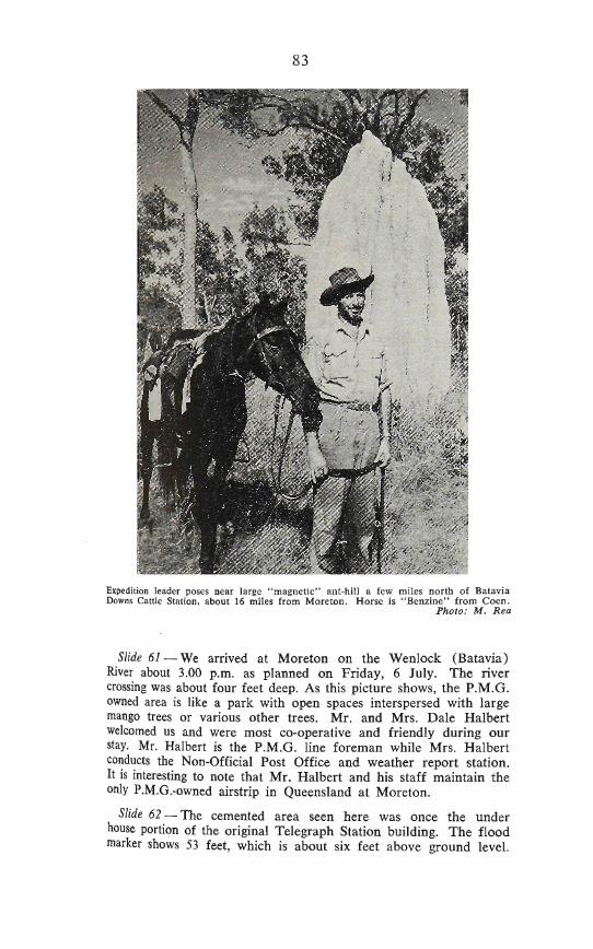
Slide 61—We arrived at Moreton on the Wenlock (Batavia) River about 3.00 p.m. as planned on Friday, 6 July. The river crossing was about four feet deep. As this picture shows, the P.M.G. owned area is like a park with open spaces interspersed with large mango trees or various other trees. Mr. and Mrs. Dale Halbert welcomed us and were most co-operative and friendly during our stay. Mr. Halbert is the P.M.G. line foreman while Mrs. Halbert conducts the Non-Official Post Office and weather report station. It is interesting to note that Mr. Halbert and his staff maintain the only P.M.G.-owned airstrip in Queensland at Moreton.
Slide 62 — The cemented area seen here was once the under house portion of the original Telegraph Station building. The flood marker shows 53 feet, which is about six feet above ground level.
" 84
During the lasl wcl senson ihe nearby Wcniocfc Rivei rose to about four to five feel Over ihls site and the Haiberts" were ca(ehrTig f]^ where (his P.M,G, duck is standing.
Slide 6S — While al Moreton we eamped undcmcalh this high-sel linemana bouse (I'.M G slaff residence) which was located a few hundred yards from the Pos( Office and near —
Sliiie 64— ihi^ grave. The headslone and rails are made of hardwood and painted white. We coifl'l not discover who war buried there althoogh locals believe il was a Jlttfe giTl ^nd a lineman speared. by blacks many years ago.
Slide 65—Here I'm checking our maps againsl the distances shown on Ihe Morelon sign posis, i.e.:
Bamaga 120 miles Bramwcll 22 miles The Top 147 miles Coen 120 miles
I calculated we had Itavelled l?0 nijles from Coen lo Moreton in six days on an average of si;< hours riding lime daily.
Slide 66 —The expedition members waited at Moreton far a few days in order lo contact MT ft. Heinemann, owner of Bramwell Cattle Station, 21 miles noith of Moieton. Our plan was to finalise ihe hiring of a plant of horses for our final stage of the fourney to the lop. Mr. Heinemann was away mustering stock and it was uOl kno*n exiictly when he would relurn, bu( he wa^ cxpecled at any (imc. Tn rhe meantime, Mrs. Heinemann invited us out to ee Ihe Sifllionr On rhe way wc saw ihese two swamp black snakes fighting on [he roadway. They were so engrossed in their tomba( thai I wa^ able to creep lo wiibin a few feel of them for this photograph. They were piobahly Blifck Whip snakes (OcmuT.^jr ohvitiea\^ and were in lerritorial conflict or perhaps pre-maling behaviour.
Siide 67 — After negotiating Ihe very rough and Iwisly roads lo Ihe property, our veliicle turned inlo the "house paddock" ^eci here. The huge led ant-hills guard the entrance like siFeni sentincbr The hoube, typically high-^e( on ironl^ark slumps with galvanised iron walls and roof was none the less cool during the day and taitly Warm a! night. Eating is done on the ground floor level which is •jcmenlcd, while quests and owners sleep up^lair^ A tour of the hou^c, gardens, stockyards, was of greal interest to each of US. H vviLi obvious to ui (hat Mis Heinemann enjoyed having visitors at her home which is one of the most northern privately owned ataironh in Australia.
Slide 68-—The next day. Mr Heinensann arrived back with his mustered stock and by negotiations we were able lo hire \5 hordes from him. However, before the^e animals could be "rounded up we bad a day or so lo wail There is no rush in Ihat country. What tan't be done loday i done tomorrow. As a result, I saw no one with hyper-(en&ion sympioms. Therefore we decided lo spend an eniii-e day assiMing the Heineraann's culf, earmark and brand, ibe
§3
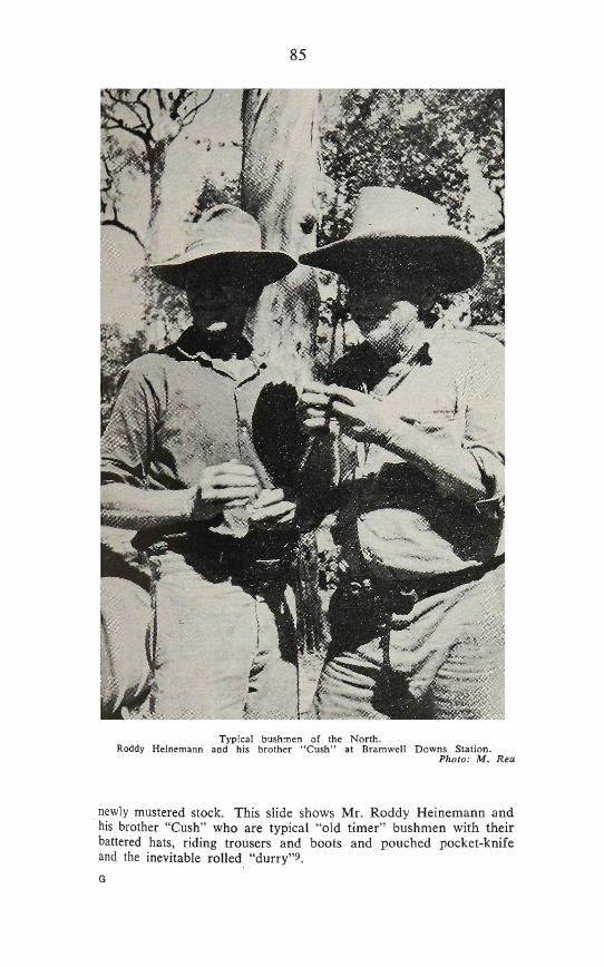
Typical bushmen of the North. Roddy Heinemann and his brother "Cush" at Bramwell Downs Station.
Photo: M. Rea
newly mustered stock. This slide shows Mr. Roddy Heinemann and his brother "Cush" who are typical "old timer" bushmen with their battered hats, riding trousers and boots and pouched pocket-knife and the inevitable rolled "durry"^.
86
Slide 69 — Here are some of the huge beasts mustered into the stockyards. They were a mixture of several breeds—probably early Short Horn and Devon and later Hereford, Brahman and Drought-master'".
Slide 70 — The aboriginal stockmen have this young steer down for branding and earmarking. Some interesting sequences for the movie documentary were shot during these activities.
Slide 71 —- The larger animals were run into this crush for branding. Some of them were quite wild and difficult to handle. We soon learned it was unwise to stand in the main yard with the stock as many will charge without any provocation. So we sat up on the rails.
Slide 72 — After completion of the day's work we returned to Moreton. The next morning, Tuesday, 10 July 1973, we farewelled the Halberts at 7.15 a.m. and rode our horses the 22 miles to Bramwell, arriving at 1.30 p.m. Upon arriving we received an invitation from the Heinemanns' to stay the night as their guests. This proved to be an enjoyable experience and the following moming this photograph was taken of the entire household. Reluctantly we farewelled our new friends and again headed northwards.
Slide 73 — Ted Knauer pulls down the telephone line north of Moreton for me to make a telephone call to Mr. W. G. Hagen, retired Telephone Foreman Mechanic who was celebrating his 100th birthday in Brisbane with members of the Post Office Historical Society of Queensland. The date was 10 July. Although almost deaf, he was able to hear my voice clearly and later told me he really enjoyed receiving the call. (Mr. Hagen is now deceased).
Slide 74 — This bark "hut" was used by drovers to keep their camp-fire dry during wet weather. We made our camp 17 nearby on the North Alice Creek. It rained all night and made this camp somewhat miserable especially as the next day two or three horses misbehaved badly. The light rain continued all day.
Slide 75 — However, we reached the Dalhunty River by 11.30 a.m. in spite of our handicaps. The Manager and Head Stockman of Comalco Station were waiting (by pre-arrangement) to spray our animals for cattle ticks. Comalco have endeavoured to keep their large pastoral holdings tick free and request that all stock travelling the perimeter be sprayed.
Slide 76 — This view of the beautiful Dalhunty River with its rocky bottom is unforgettable. Bradford was at this spot on 31 July 1883.
Slide 77 — After leaving the Dalhunty we passed through heath country with its low "turkey bush" stretching for miles. White magnetic ant hills protruded at intervals above these bushes to give the termite portals a "fairy castle" appearance. Finally we came to the Skardon River (called Cockatoo Creek locally), the site of the old McDonnell Telegraph Station. The Skardon River is, in my estimation, one of the most beautiful rivers I've ever seen in my life. All that remains of a large station building (located on the north bank), fruit trees and garden are a few wooden stumps, and water tanks as seen in this slide. My horse is standing in the middle
87
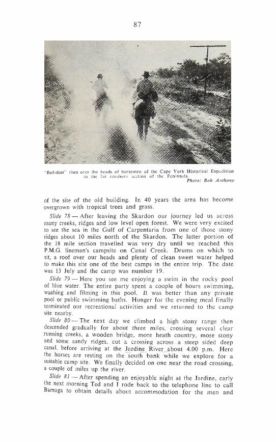
"Eull-dust" rises over the heads of horsemen of the Cape York Historical Expedition in ihe far i^orihern section of the Peninsula.
Photo: Bob Anthony
of the site of the old building. In 40 years the area has become overgrown with tropical trees and grass.
Slide 78 — After leaving the Skardon our journey led us across many creeks, ridges and low level open forest. We were very excited to see the sea in the Gulf of Carpentaria from one of those stony ridges about 10 miles north of the Skardon. The latter portion of the 18 mile section travelled was very dry until we reached this P.M.G. lineman's campsite on Canal Creek. Drums on which to sit, a roof over our heads and plenty of clean sweet water helped to make this site one of the best camps in the entire trip. The date was 13 July and the camp was number 19.
Slide 79 — Here you see me enjoying a swim in the rocky pool of blue water. The entire party spent a couple of hours swimming, washing and filming in this pool. It was better than any private pool or public swimming baths. Hunger for the evening meal finally terminated our recreational activities and we retm-ned to the camp site nearby.
Slide 80 — The next day we climbed a high stony range then descended gradually for about three miles, crossing several clear running creeks, a wooden bridge, more heath country, more stony and some sandy ridges, cut a crossing across a steep sided deep canal, before arriving at the Jardine River about 4.00 p.m. Here the horses are resting on the south bank while we explore for a suitable camp site. We finally decided on one near the road crossing, a couple of miles up the river.
Slide 81 — After spending an enjoyable night at the Jardine, early the next morning Ted and I rode back to the telephone line to call Bamaga to obtain details about accommodation for the men and
88
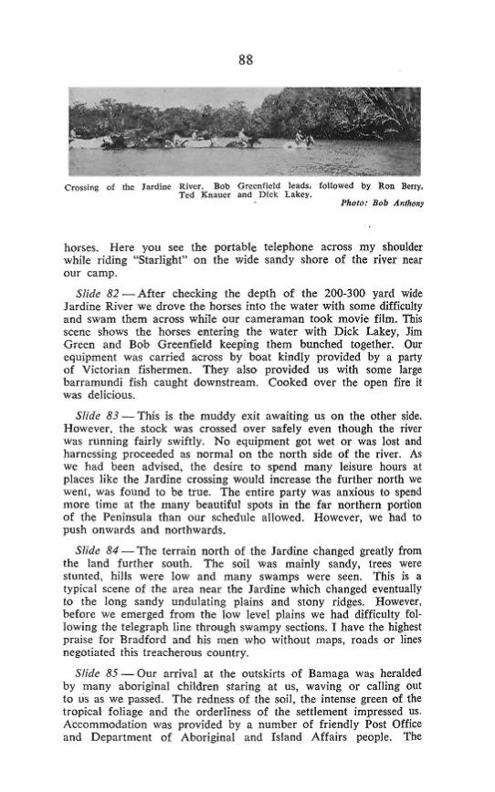
Crnj inft oJ Ibc J rilin^ Kliicr Bab nr cnFipfil leaili, CoHo d by Pon Bcjcy.
horses. Here you see Ihe porlable telephone across my shoulder while riding "Starligbl" On the wide sandy ihore of (he river near our camp.
S/iife S2—After ebeeking The depth of Ihe 200-30D yard wide Jardine River We drove the horses into the waler wiib some difficiiUy and ^wam Ihcm across while our cameraman look movje film. TIJIS scene shows the horses entering ihe water wiih Dick Latey, Jim Green and Bob Greenfield keeping them bunched together. Our cquipmcnl was carried across by boat kindly piovided by a party of Viclorian fishermen. They also provided us wiih some large bariamuiidi fish caught downslream. Cooked over the open fire il was delicious.
Slide S3—This is (he muddy exii awaidng us on the o(her side. However, the stock was crnissed over safely even though the river was running fairly iwiftly. No equipment ^ t we( or was losi and harnessing proceeded as normal on the norlh side of the river. As We had been advised, Ihe dc! irc to spend many leisure hours al places like ihe Jardine crossing would increase Ihe further norlh we Weill, was found lo be irue. The entire parly was anxious to spend more time al ihe many beaulifiif spols in Ihe far northern portion of the Peninsula Chan our schedule allowed. However, wc had to push onwards and northwards.
,S/ i i; S4 — The terrain norlh of Ihc Jardine changed greatly from the land further south. The soil was mainly sandy, trees were Blunted, hills were low and many swamps were seen. This is a (ypical scene of ihe area neai ihe Jardine which changed eventually to the long sandy undulating plains and stony ridges. However, before we emerged from the low level plains we had difficulty following Ihe telegraph line through swampy sections. I have ihe highest praise for Bradfoid and his men who wjlhoul maps, road^ or lines negotiated this treacherous couniry.
Slide ^^ — Our arrival al ihe oulskifts of Bamaga was heralded by many aboiiginal children siaring al us, waving or calling out to us as we passed The redness of ihe soil, the intense green of the tropical foliage and (he orderliness of (he selllemea( impressed us. Accommodation was provided by a number of friendly P05( Office and DepaiimenI of Aboriginal and Island Affairs people. The
89
Deparlmenl of Aboriginal and Island Affairs paddocked the horses and provided a stockman. This is a line-up of the expedition in front of Mr. Pegg's residence opposite Ihe Slate Governmenl Motel.
Slide S6—Our journey was nol finished a( Bamaga. We s(ill had annlher 15 miles (o reach the site of Ihe Cape York Telegraph Station. The final Elage of the mainland journey began on Monday, (6 July. Here we see Ihc expcdllioi) proceeding afong ihc north road out of Bamaga past ihe Kindergarten, bakery, linlcher, open air ntovie Ihcatre and private houses. Dozens of Aboriginal and Islander people Stood in froni of shops or houses to see us pass-
SSide S7—TiOin this view we see the old telegraph line now inoperative (as a radio telephone system operates between Bamaga and Thursday Island) cutting through Ihe jungle. Fortunately the swathe ctil by linemen either side of Ihe line was still rideable although gi'ass and bushes were \ip lo six feel in heighl. Once over the firsi hill we eoiild see ihe blue ocean from (here and were txcLted at the prospect of reaching our deslinaiioo later ihal day, ODC hazard cncounlered was the vicious yellowish-green wasps (Rop^iidia rofiti'id/}^^ which make a ball shaped paper nest in the trees. Mosl of us were slung as our horses pushed aside bushes and lall
Shde ^ ^ ^ T h e pole line was very difficult to follow from about four niites noiih of Bamaga as it zigzagged across ridges through the bush, because (he wire had been dismantled years ago and vegetation grown Up belween the poles. Several times we lost the direction of the line and Only after scouting the area, relocated the thin irnn poles. This slide shows Dick Lakey following the pole route.
Slide S9 — Finally after viewing some World War 2 army camp hires and dumps, wc emerged from a bush track on lo the beach at Purihand Bay where llie undersea cable joined the Cape York Electric Telegraph Station with Thursd&y Island. The promonlory in the distance is Ihe lip of Cape York ilself. II was the first time oar hoisca had been on a beaeh and they showed some aJaciity to moving near the water.
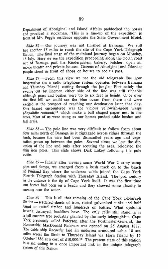
Slide ?tf —This is all ihal remains of the Cape York Telegraph Siation — scalleted sheets of iron, rusted galvanised tanks and half burnt or rotted limber and hundreds of bntlles. What cyclones haven't destroyed, bushfli'cs have. The only relic slill standing is a tall coconut tree probably pfantcd by the early telegraphists. Cape Vorb previously calJed Paterson after Ihe I'ostmaster-Gencral, the Honourable MacDonald Paterson was opened on 25 Augusi 18S7-The cable ship Hecifder laid an undersea armoured cable U sea miles across the Strait to Thursday Island via Morn Island by IS October iaS6 a( a cost of £10.000.1? The present slate of this station IS Ji sad ending to 8 once important link in Iht unique telegraph system of Ihis Nation.
90
All Ihal reiualiM ot iQe Cjpe Yorfc -TvlegHpb Slalion. Cyeitmea and IIKB BJM ccHTimlclftf Ihs ruin.
Slide 91—As water was scarce near the station sile wc turned &way and spent Ihe night lamped on a smdfl headland near a tin miner's house about a mile along (he beach. This was the lasl uighT we were lo spend together in camp (No. 22) and if was befitting I think, ihat a bright moon should illuminate Ihe scene of ^ long while sandy beach with gentle waves breaking on the shore. As I lay in my blankets on the ground. I rellecled upon Ihc exigencies and difficulties of Ihe trek and realised we had travelled over 450 miles wilhoul a Serious mishap or loss. Il was wi|h delight and satisfaction Ihat 1 gazed again upon Ihe shining beach and ihe dark islands in the distance. Indeed ihc magie scene conjured up by the soft moon-light was a sight I'll never forget. The night had hardly gone when this beautiful vjew of the islands and Ihc sea emerged wiih Ihe rising s n. Il was nature's grand finale to Jhe beautiful scenes presented (o us as each act was unfolded ihroughoui the entire cxpC' dilion.
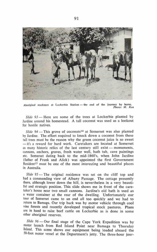
Slide 92 —Our return fOirJicy by horseback across country between several ranges lo Lockerbie CalCle Station'"^ where Fiank Jardine spent Ills lasl days was rough in places. These aboriginal stockmen took charge of our horses while harness and equipmeni was placed in (rucks lo be taken back (o Bamaga Due lo the courtesy of Ihe Department of Aboriginaf and Island Affairs, who control the large resei'vc of the northern Peninsula area, the Manager. Mr, Shane 0'CoTiJ)or and several of his staff conducted us on a (our of inspecHon of Lockerbie and Somerset.
n
Abraiatnal ^loftaiicn ,il lrOc*rsJ&ie SiBllon — Uic end ol Ihc iournty ty hnr^e. Phflt--- M- lira
Slide 9i — Kere are some of ihe trees at Lockerbie planted by Jardine around his homestead. A tai l coconut was used as a lookout fur ho^lilc natives.
Slide 94 — This grove of coconnlsi ' ' at Somerset was also planted by lardine. The effort required to knock down a coconut f rom these lall trees must be Ihe reason why Ihc green coconut juice is so sweet — il's a rewjrd for hard work. Caretakers are located at Somerset as many historic relics of Ihe last century still exi^t — monuments, tjnnon^, ancliors, graves, fresh water wel l , baih tub, cave paintings etc. Somerset dating back to ihe mid-1 fi<>ll's, when John la rd inc {father of Frank and A l i ck ( was appointed the f i rst Governmenl Resideni'^ mu^i be one of the mosl interesting and beautiful places in Aublralia
Sftc fi 95 — T h e original residence was set on the c l i f f top and had il commanding view of Albany Passage The collage presenlly there, a[(hough lower down the h i l l , is nevertheless in a very heauii-fnl and sJtftlcgic position. This slide shows me in f ront o f (he care-ijii;cr's house near Iwo small cannons. Jardine's o ld bath is used as a water container at the rear o f ihe dwel l ing. Unfor tunate ly our tour o l Somerset CEime to an end all too quickly and wc had to return to Bamaga. Our tr ip back was by motor vehicle through cool vine forests and rcccnlly developed tropical stock pastures. Plans are in hand to raise beef caide on Lockerbie as is done in some olhcr aboriginal reserves
Slidi' y ^ ^ O u r f inal slage of the Cape Y o r k Expedit ion was by motor launch f rom Red Island Point near Bamaga to Thifrsday Island. This scene shows our equipment being loaded aboard the 50'fool motor vessel at ihe Department's je l ly . The three-hour jour-
92
ney took us through the sapphire-blue waters of Endeavour Strait between Possession (Cook's landing spot) and Entrance Islands, the Boat Channel and between Prince of Wales and Horn Islands to Thursday Island.
Slide 97 — Here we see Thursday Island from the launch just before we docked at 3.40 p.m. on Wednesday, 18 July 1973. We had reached the end of our journey exactly 29 days after setting out from Fairview on horseback on Monday, 18 June 1973.
The expedition had been successful — * we'd travelled more than 450 miles by horseback
along the route of the Electric Telegraph line. * our journey had captured the imagination and in
terest of thousands of Australians especially Queenslanders, through mass media publicity.
* we'd built a monument to Bradford and his men, the surveyors and those who erected the Cape York telegraph line.
* we'd documented our experiences on film and paper.
* gained great personal satisfaction from our very rewarding experiences.
* proved that the 20th Century man has as indomitable and adventurous spirit as his 19th Century counterparts.
POSTSCRIPT The party members returned by air to Cairns where the
motor vehicles were collected.
REFERENCES A N D ACKNOWLEDGMENTS
1. JACK, Robert Logan — "Northmost Australia" The Cape York Telegraph Line 1883-7 Chapter 88, page 662.
2. BRADFORD, John R,. — "The Cape York Expedition of 1883" p.1016 read ' before Royal Historical Society of Queensland 27 June, 1937.
3. JACK, Robert Logan — "Northmost Australia" The Cape York Telegraph Line 1S83-87 P.655.
4. "Thursday Island" archival box. Post Office Historical Archives, A.P.O. Administrative Centre, 131 Barry Parade, Fortitude Valley, Qld.
5. JACK, Robert Logan — "Northmost Australia — The Cape York Telegraph Line 1883-87" p.655.
6. MONTEITH, G. B.Sc. — Curator of Insects, University of Queensland, St. Lucia, Brisbane, Qld. (provided scientific names and other details).
7. WILSON, M. M. Dr. — Department of Geology and Mineralogy, University of Queensland, St. Lucia, Brisbane, Qld. (provided explanations of cause of "melon holes") .
93
8. COVACEVICH, Jeanette A. — Curator, Reptiles and Amphibians, Qld. Museum, Brisbane, May, 1974.
9. Australian slang term for cigarette.
10. 'WYTHES, Jennifer Miss — Beef Cattle Husbandry Officer, Department of Primary Industries, Brisbane, Qld.
11. MONTEITH, G. B,Sc. — Curator of Insects, University of Quensland, St. Lucia, Brisbane, Qld.
12. Report of the Post and Telegraph Department of Queensland for the year 1887 ^presented to both Houses of Parliament by command (2 July, 1888) by John Donaldson, Postmaster-General p.25. (Paterson-Thursday Island link actually opened 25 August, 1887).
13. JACK, Robert Logan;,;—"Northmost Australia"!—Somerset and its background Ch. 47 — "Frank Jardine . . . took up Bertie Haugh in 1887, afterwards started two outstations, Lockerbie, on the Laradunya Creek and Galloway on Black Gin Creek" p.345.
14. JACK,, Robert Loganl;—"Northmost Au3tralial"\:—^ Somerset and its background Ch. 47. "Mr. Frank Jardine planted coconut trees on an area at Somerset itself" P.342.
15. Ibid —pages 340-341—John Jardine First Resident 1863-1865. BYERLEY, Frederick J., Engineer of Roads, Northern Division of Queensland
"Narrative of the Overland Expedition of the Messrs. Jardine from Rockhampton to Cape York, North Queensland" 1867. Introduction page 11.


![Charles Sheeler [1883 – 1965]](https://img.pdfslide.us/doc/110x75/568138cf550346895da08a26/charles-sheeler-1883-1965.jpg)