Embed Size (px)
Citation preview

Officers:
SESIA - VAL GRANDE GEOPARK
Candidate Member 2012
APPLICATION DOSSIER
Piemonte, Italy
30 November 2012

2
A – Identification of the Area
1. Sesia – Val Grande Geopark
The name of the area proposed for inclusion in the European and Global UNESCO Network
of Geoparks is the SESIA - VAL GRANDE GEOPARK. The name represents the wish of
two neighbouring territories, with cores in two Alpine valleys, the Val Grande, and the Sesia
Valley to join into a single Geopark. The two territories share the same geological heritage
and the same desire to protect and increase the value of their natural and cultural heritage.
2. Surface area, physical and human geography characteristics of the
proposed Geopark
The area proposed as a Geopark is located on the north-east of Piemonte Region, NW Italy,
and encompasses areas of the Verbano Cusio Ossola (VCO), Biella, Novara and Vercelli
Provinces (Figure 1).
Figure 1. Location of the proposed Sesia-Val Grande Geopark shown in green.

3
The municipalities that make up the territory of the Geopark are 85, for a total surface of
213’959 hectares and a population of 152’813 inhabitants (Annex 4).
This large area is bordered to the west by Valle d'Aosta and the massif of Monte Rosa (4634
m.), to the north by the Ossola and Vigezzo valleys and the Swiss border, to the east and
south by Lake Maggiore and, south of Vercelli, by the Po plain. The proposed Geopark
includes the Val Grande National Park, two regional parks, (Alta Valsesia and Monte
Fenera), now under the jurisdiction of the Management of Protected Areas of the Sesia
Valley, and the Special Nature Reserves of S.Monte of Varallo and of Sanctuary of Ghiffa.
In the north, the proposed Geopark includes the entire territory of the Val Grande National
Park plus surrounding territories for a total of 26 municipalities. In the south the proposed
Geopark covers most of the mountain range of the Sesia Valley basin over an area of about
800 km2, including the whole Sesia Valley and portions of neighbouring territories such as
Valsessera, Prealpi Biellesi, Val Strona and Alte Colline Novaresi.
The Val Grande National Park, located between Ossola valley and Lake Maggiore (Figure
2), is the largest wilderness area in Italy, and also an outdoor museum of the ancient
civilization of the Alps. Abandonment of the alpine summer pastures and the end of the
practice of deforestation led to the return of this area to wilderness; nature became the
master. The richness and variety of the vegetation represent one of the greatest attractions
of the area, with dense woods and a diverse flora. A unique valley dominated by silence,
where nature is the queen. The code IT 1140011 identifies a vast portion of the territory of
Val Grande National Park (11,971 hectares out of 14,598 – i.e. 29,581 acres out of 36,073)
as a crucial point of the Natura 2000 Network, the environmental preservation network
promoted by the European Union to protect both habitats and endangered animal and
vegetal species, that are typical of the European biosphere. The National Park was
established as a Site of Community Importance (SCI) and a Special Protection Zone (SPZ)
of the Natura 2000 Network because it preserves ten priority habitats in its territory.
Val Grande also preserves history: a long tale of a mountain civilization told by the places
and the people of the villages surrounding this area among Ossola, Verbano, Val Vigezzo,
Valle Intrasca, and Val Cannobina. Two different rocks mark its historical heritage: the pink
marble of the Cathedral of Milano and the talc-bearing serpentinites (“pietra ollare”, locally
“laugera”). The pink marble has been quarried in Ossola Valley exclusively for the Cathedral
of Milano, since the fourteen century. The talc-bearing serpentinites’ name “pietra ollare”
derives from “olla”= pot. Pots were easily carved with a knife in this soft rock. Traces of
where the pots were carved out are well visible and many finds are presented at the
Archeological Museum of the Park in Malesco.
The harsh and rocky mountains surrounding Val Grande have always protected the
environmental integrity of the valley. In 1967, the area of the Pedum rocky massif was
established as a Strict Nature Reserve: the first one in the Italian Alps. The final step leading
to the creation of the National Park was taken in the second half of the 1980s, thanks to the
Local Authorities and the intervention of the Regione Piemonte and the Department of the
Environment.
In the Sesia area, leaders of 59 municipalities have endorsed the establishment of the
Geopark (Figure. 2) and consider its creation to be a significant component of their strategy
for economic development of the valley, complementing the attractions provided by the
natural environment of the valley and its rich cultural heritage, which spans thousands of

4
years beginning with sites of Palaeolithic habitation at the regional park of Monte Fenera.
The proposed Geopark in this area is readily accessible to tourists visiting Monte Rosa, the
Walser villages of Alagna, Rimella and Fobello, and the artistic masterpieces of the
UNESCO Heritage Site of Sacro Monte in Varallo.
The upper part of the Sesia area is dominated by the Monte Rosa massif, (4634 m.) which
provides one of the most appealing natural environments of the Western Alps. This part of
the proposed Geopark contains at its highest altitudes the Parco Naturale dell'Alta Valsesia,
the highest natural park of Europe. Human settlement in this country dates to the 13th
century Walser population, the heritage of which has been enshrined in the preservation of
Walser traditional buildings and the celebration of their culture. Activities are dominated by
tourism, mainly during the skiing season at Alagna, the highest village of the Sesia Valley,
whereas most tributary valleys and villages therein are generally bypassed by the main flow
of tourists, their locations in beautiful wilderness notwithstanding. Beside tourism, activities
include traditional food production (i.e. cheese). At lower elevations, the Sesia area consists
of mountains less than 2000 meters high that are drained by the Sesia River and its
tributaries, among which Sessera and Mastallone Rivers are the most important. The cultural
heritage dates to Palaeolithic habitation of caves at the Monte Fenera Regional Park and
includes a rich history of resistance extending from medieval times. Approaching the Po
plain, current human activity is devoted to medium-sized manufacturing industries and to the
food industry, especially the production of cheese and wine, both of which are of remarkably
high quality. The textile industry, which had been important in the past, is now largely
abandoned. Tourist activity, historically minor in the lower Sesia Valley, has been dominated
by the attraction the Sacromonte di Varallo, a middle-age sanctuary included in the World
Heritage List of UNESCO in 2003, but includes tourism related to sports, among which
rafting and other fluvial activities are the most important, followed by biking, scrambling and
climbing.
The proposed Geopark is less than 100 km from Milano and 100 km from Turin (Figure 1). It
is easily accessible by motorways and several state and district roads. The area has a good
railway accessibility through international railways (Simplon line: Milano-Geneve-Basel and
the Paris-Trieste) and local railways (the Domodossola-Novara, the Domodossola-Locarno
(CH), the Varallo-Novara and Santia’ Arona lines). The Turin–Milan high-speed railway line,
that is part of Corridor 5 of the European Union's Trans-European high-speed rail network,
will also be a useful access to the territory of the park. The cities on the Lake Maggiore
(Verbania, Cannero e Cannobio), which are included in the proposed Geopark, are
connected by Italian and Swiss coastal lines across the lake.
5
Figure 2. Map of the proposed Geopark showing the locations of the Canavese segment of the Insubric Line and proposed geo sites. National and regional parks within the proposed Geopark are shown in shades of green. The Sesia supervolcano and its plumbing system are shown with a grey pattern.
3. Organization in charge and management structure (description, function
and organigram) of the proposed Geopark
This request for admission of the Sesia - Val Grande Geopark to the European and Global
Geopark Unesco Network of Geoparks is submitted jointly by the Val Grande National Park
(Ente Parco Nazionale Val Grande) and the geo-touristic Association Supervulcano Valsesia
(Associazione Geoturistica Supervulcano Valsesia ONLUS). This strong partnership have

6
been established and formalized by a protocol of agreement approved by the two institutions
and the Ministry of Environment (Annex 5).
In order to define the management structure of the Geopark and coordinate their actions
within the framework of this agreement, the parties agreed to establish with special and
subsequent acts a Committee to manage the Geopark, which will operate at the
headquarters of the Associazione (piazza Mazzini, 19 Borgosesia, Italy)
The Committee is appointed every 4 years and will consist of the following membership:
two members identified by the Park
two members identified by the Associazione
one member appointed in turns by the Park and by the Association, with the role of
coordinator of the Committee. For the next term this member will be designated by
the Associazione
The technical coordination of activities and the operational headquarters of the Geopark are
entrusted, in the first four years, to the Val Grande National Park and its Director.
At the end of each four-year period the Parties will decide whether to alternate responsibility
in the roles of Coordinator of the Committee and Technical Coordinator, and alternate
offices.
The management Committee is responsible for:
renewing the nomination dossier for the recognition of the proposed Geopark in
European and Global Network of Geoparks of UNESCO, in accordance with the rules
established by the European Geoparks Network;
updating and coordination of the Action Plan for the management of the Geopark;
the proposal of the Geopark identification logo, after recognition in the European
network.
The actions of the Plan will be conducted by the Association and Park Authority and other
stakeholders as part of their management plans and in accordance with their respective
budgetary availability.
The Park and the Association agree that the present Agreement is valid till the Geopark is
recognised. The possible renewal of the same Agreement will intervene following the
formalization of wish by the legal representatives of the two entities. Tacit renewal is
excluded.
The area that is proposed to the European and Global UNESCO network of the Geoparks
includes, as above mentioned, 85 municipalities, three parks and the UNESCO Heritage
Sites of Sacramonte di Varallo and Ghiffa. The whole area proposed as part of the Sesia -
Val Grande Geopark includes a total surface of 213’959 hectares, for a total range of
152’813 inhabitants. The populated areas are quite completely external to the National Park,
located on the valley floors or on the coastal urban centre.
Details on the submitting parties
The Val Grande National Park (www.parcovalgrande.it) was established in 1992 with
decree of the Italian Environment Ministry. Its mission focuses on the recovery, maintenance
and development of the natural, environmental, geological, scientific, cultural and historical
heritage of the territory of the Val Grande. A decree by the President of the Republic on 23

7
November 1993 established the “Ente di Gestione (Body of Management). Consistent with
its mission, the Val Grande National Park has promoted an active protection of wilderness,
the spreading of an environmental culture, and sustainable development of local
communities since its institution. Since 2007 the geological heritage has become also a
strategic target of the activities of the park with the production of a new geological study and
mapping of the park’s area and the implementation of thematic project (i.e. geologic trails,
and a geology section in the eco-museum Malesco) with other partners. In order to achieve
these targets, the Performance Plan of the park (2012-2014) establishes the following
strategic lines:
Conservation and protection of natural, environmental, landscaping and
geological heritage
Conservation and improvement of historical, cultural, tradition and distinctiveness
heritage
Socio-economic development
Environmental education and scientific research.
Improvement and expansion of facilities for tourists and promotion of sustainable
tourism (CETS).
Territorial maintenance and protection of water quality
Efficiency of management structure
The Val Grande National Park is a Public Administration (Ente Pubblico non Economico)
managed by a Board of Directors composed of all the Public Administrations involved: the
Ministry of Environment (Ministero dell’Ambiente), the Ministry of Agriculture( Ministero
dell’Agricoltura) , the Region of Piedmont (Regione Piemonte), Scientific Institutions such as
the Depth of Earth sciences of the University of Milano, and the Institute of Ecosystem Study
of the National Research Council, Environmentalist Associations, the Province of Verbano
Cusio Ossola (Provincia del Verbano Cusio Ossola), Comunità Montana Valli dell’Ossola
and Comunità Montana del Verbano (Local public administration) and the municipalities of
Aurano, Beura Cardezza, Caprezzo, Cossogno, Intragna, Cursolo Orasso, Malesco,
Miazzina, Premosello, San Bernardino V., Santa Maria Maggiore, Trontano, Vogogna.
The Associazione Geoturistica Supervulcano Valsesia (www.supervulcano.it/home.html)
includes among its members 59 municipalites, including the major towns of the Sesia Valley,
Borgosesia and Varallo, the Comunità Montana Valsesia, the Comunità Montana Val
Sessera, Valle di Mosso e Prealpi Biellesi, the Ente di Gestione delle Aree Protette della
Valle Sesia, (which comprises the Parco Naturale dell'Alta Val Sesia and the Parco Naturale
del Monte Fenera) the Università di Trieste, Southern Methodist University in Dallas, Texas,
and local associations including the Alpine Club of Varallo, the Società Valsesiana di
Cultura, and the Confraternita ex-allievi Liceo Scientifico di Borgosesia. Participating
communities are adopting important outcrops in their vicinity which will be maintained for
public access. The Associazione will coordinate activities of the local communities, schedule
guided park tours, sponsor public lectures and provide didactic materials and informational
content for signs and placards at outcrops and displays at the Carlo Conti Museum of
Archaeology and Paleontology in Borgosesia. This organizational structure is based on more
than 2 years of experience with geo-tourism in the valley detailed below, and is designed to
optimize local community engagement, while providing expertise in park management
through direct participation of the Parco Naturale dell'Alta Val Sesia and the Parco Naturale

8
del Monte Fenera, and scientific input from The University of Trieste and Southern Methodist
University.
Although the Associazione Geoturistica Supervulcano Valsesia was only recently created in
response to widespread public interest the geology of the valley, significant activities have
already been conducted. Public lectures and world-class field-trip stops along 30 km of the
Sesia and Sessera Rivers have already generated a spirit of unity and cooperation among
communities in the valley and draw visitors to dozens of communities that are otherwise
overlooked by tourists. Since the first public conference in Borgosesia, in October 2009,
which was attended by over 500 persons, 25 sponsored public lectures have fully filled
lecture halls in the valley, and the geology of the valley has been incorporated into the
curriculum of the local schools. A popular booklet containing a simplified explanation of the
geology and a field trip guide published by the Associazione in 2012 has already sold more
than 800 copies. In 2010, a course was held to educate geological guides capable of leading
excursions along the plumbing system of the supervolcano, and to date 18 field excursions
(Fig. 2) organized in collaboration with the Associazione Nazionale di Geologia e Turismo
have been attracted hundreds of participants. In 2012, the Associazione Geoturistica
Supervulcano Valsesia gave logistical support to field excursions organized in the valley for
students of geology by the Universities of Modena, Ferrara, Trieste, Grenoble, Gottingen
(further groups come independently from Kiel, Bern, Zurich). An exhibit recently completed in
the Carlo Conti Museum of Archaeology and Paleontology in Borgosesia prominently
features the geology of the valley.
4. Application contact person
As mentioned before, the application is submitted jointly by Val Grande National Park and the Geo-touristic Association Supervolcano Valsesia.
The protocol of agreement (Annex 5), signed in November 2012, provides the following
operational structure:
a Management Committee consisting of five persons appointed by both entities and chaired by a Coordinator;
a Technical Coordinator of the activity of the Geopark;
The terms shall last four years and the coordinators shall be alternated by agreement of the
parties.
For the first four years, responsible persons and contacts are as follows:
Authority: Sesia – Val Grande Geopark
Villa Biraghi, Piazza Pretorio 6
28805 Vogogna VB Italy
Coordinator of the Management Committee:
Edoardo Dellarole
c/o Associazione Geoturistica Supervulcano ONLUS
Piazza Mazzini 19
13011 Borgosesia (VC) Italy

9
Technical Coordinator:
Tullio Bagnati
c/o Ente Parco Nazionale Val Grande
Villa Biraghi, Piazza Pretorio 6
28805 Vogogna (VB) Italy
Contact Person
The contact person in charge is the Technical Coordinator of the proposed Geopark
Authority:
Tullio Bagnati
Director National Park Val Grande
Tel. : +39 0324 87540
Fax: +39 0324 878573
e-mail: [email protected]
The application is submitted jointly by Val Grande National Park and Geo-touristic Association Supervulcano Valsesia:
Identity Card of the Val Grande National Park
Authority: Ente Parco Nazionale Val Grande
Administrative office: Villa Biraghi, p.za Pretorio 6, 28805 Vogogna (VB) Italy
Municipalities (13): Aurano, Beura Cardezza, Caprezzo, Cossogno, Intragna, Cursolo
Orasso, Malesco, Miazzina, Premosello, San Bernardino V., Santa
Maria Maggiore, Trontano, Vogogna.
Park Plan: Del. Con. Direttivo n.40/1999
Performance Plan: Decreto Presidente, n. 38, 21/12/2011
Management Committee: 13 members: Ministry of Environment (2), Ministry of Agriculture (1),
Scientific Institution (2), Local community (5), Environmentalist
Association (2), President (1).
Executive Committee: Pierleonardo Zaccheo (president)
Director: Tullio Bagnati
Referring person: Tullio Bagnati (director)
Tel. 0324/87540 - Fax 0324/878573
http://www.parcovalgrande.it

10
Identity Card of the Associazione Supervulcano Valsesia
Authority: Associazione Geoturistica Supervulcano Valsesia ONLUS
Administrative office: Piazza Mazzini, 19 – 13011 Borgosesia (VC) Italy
Charter Members: Comunità Montana Valsesia e Comunità Montana Valsessera Valle di
Mosso e Prealpi Biellesi, Comuni di Borgosesia, Prato Sesia e
Varallo, CAI sezione di Varallo, Confraternita degli ex-allievi del Liceo
Scientifico G. Ferrari di Borgosesia, Società Valsesiana di Cultura e
Università di Trieste, dipartimento di Geoscienze.
Municipalities (60):
Estabilishment: 14/11/2011
Scientific Committee: Silvano Sinigoi (director)
Executive Committee: Alice Freschi (President) Marinella Merlo (Vicepresident) Luciano
Castaldi (secretary), Luca Manuelli (treasurer )
Referring person: Edoardo Dellarole
Tel. +39 349 1554731
http://www.supervulcano.it

11
B – Geological Heritage
Figure 3. Regional setting of the proposed Sesia-Val Grande Geopark. The proposed park includes significant parts of the Ivrea-Verbano Zone and the Serie dei Laghi, and part of the Sesia Zone; modified after Brack et al, 2010

12
1. Location of the proposed Geopark
The proposed Sesia-Val Grande Geopark is located in northwest Italy where it sits astride
the Canavese segment of the Insubric Line, a 1-km-thick mylonite belt that is a major
tectonic boundary in the Alps (Figure 3). North and west of the Insubric Line, the Austro-
Alpine domain consists of piles of nappes, which were assembled and affected by a
metamorphic overprint reaching upper amphibolite facies during the Alpine orogeny. South
and east of the Insubric Line, rocks of the South-Alpine Domain were not affected by this
metamorphic event and preserve an older history despite experiencing substantial Alpine
tectonic deformation. These rocks originally belonged to the northern margin of the Adriatic
plate, and within them an exceptional record of metamorphic and igneous events are
preserved within a virtually intact section through the pre-Alpine crust that is the focus of the
proposed Geopark.
2. General geological description of the proposed Geopark: From the lower
crust to the Permian Supervolcano
Geologic relations in the proposed Sesia-Val Grande Geopark are internationally renown
and of world-class scientific significance. Accessible outcrops display the effects of dramatic
geologic processes that shaped the continental crust through a wide range of crustal levels,
from high-grade metamorphism, magmatism, anatexis and ductile deformation at depths as
great as 25 to 30 km to the explosive eruption of a supervolcano at the surface of the earth
282 million years ago. For more than 40 years, this area has served scientists as an
unprecedented crustal reference section in which geophysical observations and physical
processes may be interpreted in the context of geology that is observable on the ground
(Fountain, 1976, Kissling 2012, and references therein). As a Geopark, this area will be
available to people of all backgrounds and ages to explore geologic processes that molded
the evolving crust of a continent and produced the spectacular features that are preserved in
accessible outcrops. For example, visitors may stand on fragments of the subcontinental
mantle and trace clinopyroxene dikes that are the trails basaltic melts. They may visit the
contact between an enormous gabbro intrusion in the deep crust to observe granitic
segregations formed by partial melting of the adjacent crustal rocks. And they may visit the
roots and the roof of a granitic pluton and marvel at the chaotic breccias produced by the
explosive, caldera-forming super-eruption.
In addition to presenting to the public the world’s most accessible reference section for the
continental crust, the proposed Geopark will introduce the public to processes that operate
on a global scale. Outstanding examples of plate-boundary deformation and tectonics are
found within the proposed Geopark because it encompasses the Canavese Line, a 1-km-
thick mylonite belt that forms the westernmost segment of the Insubric Line, the major
tectonic boundary separating the Austro-Alpine Domain to the north from the South-Alpine
Domain (African Plate) to the south. Stacked European and African nappes (slices of rocks)
which formed the Alpine belt during the collision of Europe and Africa are beautifully
exposed along the lower Ossola Valley, and northwest of the Canavese Line, the public may
visit exposures of high-pressure and ultra-high-pressure metamorphic rocks, and fragments
of ophiolites derived from the Tethys Ocean and obducted during the Alpine event. And
because it extends from the Po Plain to the high Alps, the proposed Geopark will provide
visitors with opportunities to also observe a record of climate change as recorded by

13
Pleistocene geomorphology, recent glacial retreat, and patterns of human habitation dating
to the Paleolithic.
The most distinguishing features of the proposed Geopark are outcrops within the South-
Alpine Domain. Collectively these rocks form the Massiccio dei Laghi (Boriani et al.,
1990a,b), which comprises two principal lithotectonic units, the Ivrea-Verbano Zone and the
Serie dei Laghi, separated by the Cossato-Mergozzo-Brissago (CMB) and Pogallo lines.
This terrane has been the object of intense and continuing scientific interest for decades
because within it an association of accessible lower-, middle- and upper-crustal rocks
constitutes an unprecedented model for interpreting the geophysics of the continental crust.
Its scientific importance cannot be overstated, and the Massiccio dei Laghi has been the
target of countless geologic fields by universities and professional societies. The number of
scientific papers referencing the Ivrea-Verbano Zone alone has increased exponentially
since 1970 and now exceeds 2,500. The following geologic description is focused on the
Massiccio dei Laghi because collectively the relationships observable within it will provide
geotourists with a unique exposure to processes that shaped the crust upon which they live.
The Massiccio dei Laghi: a window to depth
The Massiccio dei Laghi presents a spectacular cross section through the continental crust,
from the lower crustal Ivrea–Verbano Zone to the middle– and upper-crustal Serie dei Laghi.
This assembly of lower- and upper-crustal rocks can be observed over 50 km in a SW-NE
direction, with an average width of about 25 km, and is considered worldwide as a model for
a magmatically underplated and extended crustal section (Rutter et al., 1993; Schnetger,
1994; Quick et al., 1994; Henk et al., 1997). Many authors have interpreted this terrane as a
coherent Lower Paleozoic continental section that was tilted to the present subvertical
position during the Alpine orogeny, while others favor a model of trans-tensional
emplacement of the Ivrea-Verbano Zone, in which this lower crustal unit may be seen as the
exposed roots of an early Permian pull-apart basin (Boriani & Giobbi, 2004). These differing
interpretations notwithstanding, the rock association exposed in the Massiccio dei Laghi
represents an unprecedented opportunity for visitors to “walk through” the earth’s continental
crust, observing the mineralogy, textures and structures formed at different depths.
The Ivrea-Verbano Zone
Because of its accessibility and beautiful exposures of lower-crustal rocks, this area has
been subjected to substantial structural, petrological, geochemical and petrophysical study
by geoscientists from Italy, USA, Switzerland, Germany, Britain, Austria, France, Spain and
Japan, and has been described in more than 2500 published papers during the past 40
years (Figure 4).

14
Figure 4. Total publications referring to the Ivrea-Verbano Zone.
The Ivrea-Verbano Zone mainly consists of a metamorphosed volcano-sedimentary
sequence, referred to as the Kinzigite Formation, and gabbroic to dioritic intrusive rocks,
referred to as the Mafic Complex (Figure 5). The metamorphic rocks are mainly
metamorphosed shales and graywacke (the so-called kinzigites and stronalites), with minor
quartzites, thin meta-carbonate horizons and interlayered metabasites (Sills and Tarney,
1984). Mantle peridotite lenses, tectonically interfingered with the metasedimentary rocks
(Quick et al., 1995), occur in the northwestern part of the Ivrea-Verbano Zone, near the
Canavese Line (e.g. Balmuccia in the Sesia valley and Finero in the Cannobina valley,
among the proposed Geosites).
The metamorphic grade in the Ivrea-Verbano Zone increases towards the northwest, from
upper amphibolite facies adjacent to the Serie dei Laghi, to granulite facies near the
northwestern boundary of the Ivrea-Verbano Zone at the Canavese Line (Peyronel Pagliani
and Boriani, 1967; R.Schmid, 1967; Zingg, 1983). The deep crustal rocks of the Ivrea-
Verbano Zone were juxtaposed against the middle- to upper-crustal Serie dei Laghi by
faulting along Cossato-Mergozzo-Brissago (CMB) Line (Boriani and Sacchi, 1973), which
had effectively ceased before the beginning of the Permian igneous activity.
15
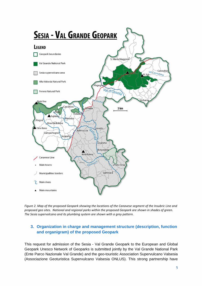
Figure 5. Geologic map showing the principal components of the the Ivrea-Verbano Zone in the vicinity of the Sesia Valley.
The Sesia Magmatc System
The Sesia Magmatic System, which cuts through this crustal section, constitutes a unique
geologic reference section that not only allows scientists to interpret geophysical
observations beneath active calderas in the context of geology observable on the ground,
but also opens the door to people of all backgrounds and ages to explore geologic
processes beneath a fossil supervolcano that is analogous to the famous active Yellowstone
and Campi Flegrei calderas. It is a bimodal suite of basic and silicic volcanic and plutonic
rocks that are part of a large Late Carboniferous to Early Permian igneous province that
developed across Europe from Spain to Scandinavia in association with an extensive crustal
rifting (Wilson et al 2004). At upper- to mid-crustal levels, the Sesia Magmatic system
includes the Sesia Supervolcano and relics of a bimodal volcanic field of basaltic andesite
and rhyolite, the voluminous Valle Mosso granite with volumetrically less significant basaltic
to andesitic dikes and sills within it, and small intrusions of gabbro to granite along the
projection of the CMB Line. At the deepest crustal levels, the Sesia Magmatic System is
represented by the Mafic Complex of the Ivrea-Verbano Zone and by anatectic granitic rocks
produced by partial melting of the Kinzigite Formation.

16
Figure 6. Geologic map showing the relationships of the principal units of the Sesia Magmatic System,
including the Sesia Caldera, the Valle Mosso Granite, small granitic intrusions in the Kinzigite Formation, and the Mafic Complex (Quick et al., 2009)
The Sesia Supervolcano is one of the most significant and impressive components of the
Sesia Magmatic System. Partially covered by younger sedimentary deposits of the Po plain,
it is a huge rhyolitic caldera with a diameter exceeding 15 km. The estimated volume of
ignimbrite erupted exceeded 300 km3, making the caldera-forming event a “super eruption”
(Quick et al., 2009). The Sesia Valley offers excellent exposures of volcanic megabreccia
(proposed geosite n°24), a deposit characteristic of large calderas, in which blocks of pre-
caldera volcanic and metamorphic country rocks are contained in the welded rhyolitic
ignimbrite that fills the caldera. A portion of the caldera wall is preserved along which
ignimbrite contains enormous landslide blocks of schist that have slid into the erupting
caldera from the adjacent Serie di Laghi basement (proposed geosite n°26). Also
preserved is the base of the caldera, which is intruded by coeval granitic rocks of the Valle
Mosso Granite (Zezza, 1984). Ages on volcanic rocks indicate that volcanism lasted
approximately 6 million years, beginning about 288 Ma and culminating in the caldera-
forming eruption at about 282 Ma (Quick et al., 2009). Deposited on the caldera ignimbrite is

17
the karstic Triassic marine carbonate of Monte Fenera, which hosts caverns utilized by
Paleolithic inhabitants of the Sesia Valley.
The 6 km-thick Valle Mosso granite, which underlies and intrudes these volcanic rocks,
consists of a fine-grained to granophyric “epizonal” facies with miarolitic cavities near the
volcanic rocks and grades downward into a medium to coarse-grained “mesozonal facies”.
Major-element, trace-element and isotopic geochemistry and field relations indicate that it is
a single, compositionally zoned pluton that was the source of the overlying silicic volcanic
rocks. Inclusions of volcanic rock are contained within the granite near its roof, consistent
with upward intrusion of the pluton into its volcanic pile. Mafic enclaves, produced by
intrusions of the mafic component of the bimodal igneous suite are locally abundant at the
deepest levels of the pluton.
The deepest rocks of the Sesia Magmatic System include the 8-km-thick Mafic Complex of
the Ivrea-Verbano Zone (Figure 5 - 6; Rivalenti et al., 1975, 1981; Quick et al., 1992, 1994,
2003; Voshage et al., 1990; Sinigoi et al., 1994, 1996, 2010, 2011 and references therein),
which intruded the deep crust around 288 Ma ago (Peressini et al., 2007). Textures and
structures displayed in excellent outcrops indicate that synmagmatic deformation (proposed
geosites n°17 and 22) accompanied the growth of this enormous intrusion, consistent with a
gross arcuate fabric revealed by detailed mapping (Quick et al., 1992; 1994; 2003). The
contact between the Mafic Complex and the Kinzigite Formation (proposed geosite n°21) is
magmatic (Quick et al., 1994). During its growth, the Mafic Complex assimilated significant
amounts of crustal material (Voshage et al., 1990; Sinigoi et al., 1995, 1996, 2011). Relicts
of largely digested crustal layers, incorporated into the Mafic Complex and stretched during
its growth (proposed geosite n°18), are clearly visible in the field. Also visible in the field is
the intrusive contact of the Mafic Complex (proposed geosite n°21) along which heat
released by the crystallizing Mafic Complex drove anatexis of the Kinzigite Formation,
producing migmatites within 1 to 2 km from the intrusion (Snoke et al. 1999; Barboza and
Bergantz 2000). Residual melt from the Mafic Complex and silicic melt generated by
anatexis migrated to higher crustal levels where they crystallized small granitic sills and
stocks (proposed geosite n°23) and the Valle Mosso Granite at higher crustal levels, and
erupted to form the bi-modal volcanic complex at the top of the section.
The Serie dei Laghi
The Serie dei Laghi is composed of four main units (Boriani et al., 1990b), the Strona-Ceneri
Zone, the Strona-Ceneri Border Zone, Orthogneisses, and the Scisti dei Laghi. Remnants of
the Permian volcano–sedimentary cover of the Serie dei Laghi occur near Arosio in
Switzerland (Reinhard, 1964), where they lie horizontally over the Strona–Ceneri rocks.
The Strona-Ceneri Zone is an amphibolite-facies metapsammitic sequence which comprises
fine-grained massive gneisses (Gneiss Minuti) as well as medium to coarse-grained
gneisses (Cenerigneisses). The Gneiss Minuti (Hornfelsgneise in the Swiss literature due to
their granoblastic texture) are finely layered metasandstones with abundant calc-silicate
lenses (beautifully exposed along the Cadorna road; proposed geosite n°8). Near the
orthogneiss bodies they contain thin meta-aplites and metapegmatites. The Cenerigneisses
(proposed geosite n° 9) are coarse-grained to conglomeratic gneisses containing a diversity
of clasts, including calc-silicate nodules similar to those occurring in the Gneiss Minuti.
These nodules are zoned (with Grt, Px, Hbl and Bt from core to rim; Boriani and Clerici

18
Risari, 1970) and are interpreted as the metamorphic product of dolomite concretions, typical
of many arenitic deposits (Figure 7).
Figure 7. Folded lens of calc-silicate in a Cenerigneiss
Petrography, geochemistry and field relations of the Strona-Ceneri metasediments support
the interpretation of Gneiss Minuti and Cenerigneisses respectively as well sorted deposits
from turbidity currents and as mass flow turbidites, deposited in an accretionary prism
(Boriani et al., 1997; Caironi et al., 2004). Near the orthogneiss lenses, the Cenerigneisses
acquire an augen texture due to the increasing presence of K-feldspar porphyroclasts; they
could be the product of “melt infiltration and infiltration metasomatism” related to the
Ordovician intrusions (Pinarelli et al., 2008).
The Strona-Ceneri Border Zone (Giobbi Origoni et al., 1997) forms a continuous horizon,
one to several hundreds of meters thick, between the Strona-Ceneri Zone and the Scisti dei
Laghi. It mainly consists of banded amphibolites, with lenses of ultramafites, metagabbros
and garnet bearing amphibolites (retrogressed eclogites) and minor intercalations of
paragneisses. The banded amphibolites (Giobbi Mancini et al., 2003) consist of cm-scale
alternating dark (fine-grained amphibolites) and leucocratic layers (leptynites). They
represent an example of LAG (Leptynite - Amphibolite Group), an association which is
widespread throughout the Hercynian belt in Europe; it is formed by tuffites of alternate mafic
and acidic composition deposited in a marine environment. Like the Cenerigneiss, the
amphibolites grade into Bt - Hbl augengneiss towards the contacts with the Ordovician
granitoids, suggesting the same infiltration mechanism (Pinarelli et al., 2008).
Banded and feldspar-bearing amphibolites are well exposed at Ponte Nivia (proposed
geosite n°7) and along the Cadorna road (proposed geosite n°6).
The orthogneisses form large lens-shaped bodies accompanied by meta-pegmatite, meta-
aplite and augen gneisses, mainly located within or close to the SCBZ. They range in
composition from tonalite to granite (Pezzotta and Pinarelli, 1994) and show a calcalkaline
affinity and mainly metaluminous character (Caironi, 1994; Boriani et al., 1995 with
references). They were emplaced in the Ordovician around 450 – 460 Ma (Köppel and
Grünenfelder, 1971; Boriani et al., 1982/83) and suffered the same Variscan regional
metamorphism as their country rocks, recorded by mineral ages of 311 – 325 Ma (Boriani et
al., 1995). The orthogneisses are well exposed along the Cadorna road at Ospedaletto and
Mt Vadà.

19
The Scisti dei Laghi occur over a large area from Lago d’Orta to Lago Maggiore, near
Verbania and, on the eastern shore of the lake, near Luino, were they are cut by the Val
Colla-Cremosina fault. This unit corresponds to the Giumello gneise” in the Swiss literature
(Reinhard, 1964). The Scisti dei Laghi consist of alternating micaschist and paragneisses,
strongly foliated, with isoclinal folds. They contain typical quartz rods. A beautiful exposure of
these micaschists is in the bed of the S.Bernardino river (proposed geosite n°5).
The CMB and Pogallo Lines
The contact between Ivrea-Verbano Zone and Serie dei Laghi occurs through an important
subvertical tectonic lineament (Boriani et al., 1990a): the Cossato-Mergozzo- Brissago Line
(CMB), characterised by the simultaneous occurrence of three distinctive features: high-T
mylonites, basic-to acidic dykes and stocks (the «Appinite Suite») and migmatites. The line
is dissected by later discontinuities, among which the most important is the Pogallo Line.
The Pogallo Line is characterised by amphibolite to greenschist facies mylonites. The
amphibolite facies mylonites related to the Pogallo Line may be observed in Val Pogallo
(proposed geosite n°12).
A swarm of mainly mafic small stocks and dykes is intruded in a belt along the CMB Line.
They are called Appinites after the Appin County in Scotland where similar rocks occur
(although of different age). Between the Sesia and the Ossola valleys Appinites mostly form
stocks of gabbrodioritic to granitic composition which, in some cases (Quarna, Alzo -
Roccapietra), are strictly connected with the large granitic plutons occurring more to the
south. Appinites also occur in the IV zone, although less abundant than in the Serie dei
Laghi. In Val Cannobina (proposed geosites n° 10 and 11) the fine grained dykes show
chilled margins (a grain size decrease) towards the contact with the country rocks,
suggesting that the latter were cold enough to induce rapid cooling of the magma. The dykes
are mostly concordant with the CMB mylonitic foliation, but some small dykes are subparallel
to the Pogallo fault. The best estimates on the intrusion age of the Appinites are an U-Pb
age of 285 ± 5 (Köppel and Grünenfelder, 1978-79) on a monazite from a dyke near
Mergozzo and an U-Pb upper intercept of 275-285 Ma on discordant zircons (Mulch et al.,
2002).
The Canavese Line
The Canavese Line is the westernmost stretch of the Insubric Line (Figure 3), a major alpine
lineament that marks the boundary between the Central Alps, consisting of intricated
refolded basement nappes (Milnes, 1974), and the Southern Alps with S-vergent thrusts
(Laubscher, 1985). The Insubric Line accommodated a vertical uplift on the order of 10 to 20
km, since it juxtaposes the Alpine metamorphic rocks of the Central Alps with the pre-Alpine
metamorphosed basement of the Southern Alps and its volcano - sedimentary cover (Niggli
and Zwart, 1973; Frey et al., 1974).
In the area of the proposed Geopark, the Canavese Line consists of a 1 km thick greenschist
facies mylonite belt. The mylonite sare derived (from S to N) from: a) Ivrea-Verbano rocks; b)
Permo - Mesozoic cover rocks (Canavese Zone); and c) the Sesia Zone (Central Alps).
The progressive mylonitization of the Ivrea-Verbano rocks is well documented in Val Loana)
the rocks are transformed into greenschist facies mylonites and phyllonites containing

20
amphibolite-facies mineral relics (diopside and actinolite in the impure marble exposed at
Lago del Marmo). The metasedimentary sequence of the Canavese Zone, including quartz-
mica-rich clastic sediments (Permo-Triassic), dolomites (Triassic), and silicious limestones
(lower Jurassic?), is dismembered and often imbricated with or folded into the Ivrea-
Verbano-derived mylonites and thin ophiolitic lenses; members of this sequence may be
observed in Val Loana. The phyllonites derived from the Sesia rocks (mostly orthogneisses)
are exposed near the castle of Vogogna (proposed geosite n°13).
Literature
Barboza, S.A. and Bergantz, G.W., 2000. Metamorphism and anatexis in the Mafic Complex contact aureole. Ivrea Zone, northern Italy. J. Petrol., 41, 8: 1307-1327.
Boriani, A. and Peyronel Pagliani, G., 1968. Rapporti tra le plutoniti erciniche e le metamorfiti del «Massiccio dei Laghi» nella zona del M. Cerano (bassa Val d’Ossola). Rend. Soc. It. Mineral. Petrol., 24: 3-36.
Boriani, A. and Clerici Risari, E., 1970. The xenoliths of «Cenerigneiss». Rend. Soc. It. Mineral. Petrol., 26: 503-515.
Boriani, A. and Sacchi, R., 1973. Geology of the junction between the Ivrea-Verbano and Strona-Ceneri Zones. Mem. Ist. Geol. Mineral. Padova, 28: 1-36.
Boriani, A., Bigioggero, B. and Origoni Giobbi, E., 1977. Metamorphism, tectonic evolutionand tentative stratigraphy of the Serie dei Laghi geological map the Verbania area (Northern Italy). Mem. Ist. Geol. Mineral. Univ. Padova, 32: l-25.
Boriani, A., Origoni Giobbi, E. and Del Moro, A., 1982-83. Composition, level of intrusion and age of the «Serie dei Laghi» orthogneisses (Northern Italy - Ticino, Switzerland). Rend. Soc. It. Mineral. Petrol., 38: 191-205.
Boriani, A. and Rivalenti, G., 1984. Crosta profonda e significato delle rocce basiche e ultrabasiche dell’Ivrea-Verbano in un secolo di studi. Cento anni di geologia Italiana, Vol. Giub., I Centenario Soc. Geol. It., 113-131.Boriani, A., Burlini, L. and Sacchi, R., 1990a. The Cossato-Mergozzo- Brissago line and the Pogallo line (Southern Alps, N-Italy) and their relationships with the late-Hercynian magmatic and metamorphic events. Tectonophysics, 182: 91-102.
Boriani, A., Giobbi Origoni, E., Borghi, A. and Caironi, V., 1990b. The evolution of «Serie dei Laghi» (Strona Ceneri and Scisti dei Laghi), Southern Alps, N-Italy and Ticino, Switzerland. Tectonophysics, 182: 103-118.
Boriani, A. and Burlini, L., 1995. Carta Geologica della Valle Cannobina. Scala 1:25.000.Comunità Montana Valle Cannobina, Dipartimento di Scienze della Terra dell’Università degli Studi di Milano, Centro di Studio per la Geodinamica Alpina e Quaternaria del CNR-Milano.Grafiche Diodoro, Milano.
Boriani, A., Giobbi Origoni, E. and Pinarelli, L., 1995. Paleozoic evolution of southern Alpine crust (northern Italy) as indicated by contrasting granitoid suites. Lithos, 35: 47-63.
Boriani, A., Caironi, V., Colombo, A. and Giobbi Origoni E., 1997. The Cenerigneiss: a controversial metamorphic rock (Southern Alps, Italy and Ticino, CH). EUG 9, p. 677.
Boriani, A. and Villa, I., 1997. Geochronology of regional metamorphism in the Ivrea-Verbano Zone and Serie dei Laghi, Italian Alps. Schweiz. Mineral. Petrogr. Mitt., 77: 381-401.
Boriani, A., Giobbi Mancini, E., 2004. Does the basement of western southern Alps display a tilted section through the continental crust? A review and discussion. Periodico di Mineralogia, 73: 5-22.
Brack P., Ulmer P., Schmid S., 2010, A crustal magmatic system from the Earth mantle to the Permian surface – Field trip to the area of lower Valsesia and val d’Ossola (massiccio dei Laghi, Southern Alps, Northern Italy); Swiss Bull. Angew. Geol. 15/2, 3-21.
Caironi, V., 1994. The zircon tipology method in the study of metamorphic rocks: the orthogneisses of the Eastern Serie dei Laghi (Southern Alps). Rend. Fis. Acc. Lincei, s.9, 4: 37-58.
Caironi V., Colombo A. & Tunesi A., 2004. Geochemical approach to characterization and source identification of the protoliths of metasedimentary rocks: an example from the Southern Alps. Special Issue 2: A showcase of the Italian research in metamorphic petrology. Per. Mineral., 73, 109-118.
Fountain, D.M., 1976. The Ivrea-Verbano and Strona-Ceneri Zones, Northern Italy: a cross section of the continental crust - New evidence from seismic velocities of rock samples. Tectonophysics, 33: 145-165.
Frey, M., Hunziker, J.C., Frank, W., Bocquet, G.V., Dal Piaz, G.V., Jäger, E. and Niggli, E., 1974. Alpine metamorphism of the Alps - A review. Schweiz. Mineral. Petrogr. Mitt., 54: 247-290.

21
Giobbi Mancini, E., Boriani, A., Villa, I., 2003. Pre-Alpine ophiolites in the basement of Southern Alps: the presence of a bimodal association (LAG- Leptyno-Amphibolitic Group) in the Serie dei Laghi (N-Italy, Ticino-CH). Atti dell’Accademia Nazionale dei Lincei. Rendiconti della Classe di Scienze Fisiche, Matematiche e Naturali,. vol. 14, s.9: 79-99.
Giobbi Origoni, E., Zappone, A., Boriani, A., Bocchio, R., Morten, L. (1997). Relics of pre- Alpine ophiolites in the Serie dei Laghi (Western Southern Alps). Schweiz. Mineral. Petrogr. Mitt.,77: 187-207.
Henk, A., Franz, L., Teufel, S. and Onken, O., 1997. Magmatic Underplating, Extension, and Crustal Reequilibration: Insights from a Cross-Section through the Ivrea Zone and Strona-Ceneri Zone, Northern Italy. Geology, 105: 367-377.
Hunziker, J.C., 1974. Rb-Sr and K-Ar age determination and the alpine tectonic history of the Western Alps. Mem. Ist. Geol Mineral. Univ. Padova, 31: l-54.
Kissling E., Bousquet R., Ford M., Schmid S, (2012).Formation of the arc of the Western Alps and Alps-Apennines transitionin the light of new geophysical data on the lithospheric architecture around the Ligurian knot, Geophysical Research Abstracts, Vol. 14, EGU2012-8432, EGU General Assembly 2012
Köppel, V. and Grünenfelder, M, 1971. A study of inherited and newly formed zircons from paragneisses and granitised sediments of the Strona-Ceneri Zone (Southern Alps). Schweiz. Mineral. Petrol. Mitt., 51 (2-3): 385-410.
Köppel, V. and Grünenfelder, M., 1978/79. Monazite and zircon U-Pb ages from the Ivrea and Ceneri Zones. Abstract 2. Symp. Ivrea-Verbano, Varallo. Mem. Sci. Geol., 33: 257.
Laubscher, H.P., 1985. Large-scale, thin skinned thrusting in the Southern Alps: Kinematic models. Bull. Geol. Soc. Am., 96: 710-718.
Milnes, A.G., 1974. Structure of the Pennine Zone (Central Alps): a new working hypothesis. Geol. Soc. Am. Bull., 85: 1727-1732.
Mulch, A., Rosenau, M., Doerr, W. and Handy, M.R., 2002. The age and structure of dikes along the tectonic contact of the Ivrea-Verbano and Strona-Ceneri Zones (southern Alps, Northern Italy, Switzerland). Schweiz. Mineral. Petrogr. Mitt., 82: 55-76.
Niggli, E. and Zwart, H.J., 1973. Metamorphic map of the Alps, scale 1: 1000000, sheet 17 of the Metamorphic Map of Europe. Leiden/UNESCO, Paris.
Peressini, G., Quick, J. E., Sinigoi, S., Hofmann, A. W., Fanning, M., 2007. Duration of a Large Mafic Intrusion and Heat Transfer in the Lower Crust: a SHRIMP U/Pb Zircon Study in the Ivrea-Verbano Zone (Western Alps, Italy). Journal of Petrology 48, 1185-1218. 10.1093/petrology/egm014.
Peyronel Pagliani, G. and Boriani, A., 1967. Metamorfismo crescente nelle metamorfiti del «Massiccio dei Laghi» nella zona bassa Val d’Ossola – Verbania. Rend. Soc. Mineral. It., 23: 351- 397.
Pezzotta, F. and Pinarelli, L., 1994. The magmatic evolution of Ordovician metagranitoids of the Serie dei Laghi (Southern Alps): inferences from petrological geochemical and Sr and Nd isotope data. Per. Mineral., 63: 127-147.
Pinarelli, L., Boriani, A., Bergomi, M.A., Giobbi Mancini, E., 2008. Pre-metamorphic melt infiltration in metasediments: geochemical, isotopic (Sr, Nd, and Pb), and field evidence from Serie dei Laghi (Southern Alps, Italy). Mineralogy and Petrology, 93 (3): 153-182.
Quick, J. E., Denlinger, R. P., 1992. The possible role of ductile deformation in the formation of layered gabbros in ophiolites. Ofioliti 17, 249-253.
Quick J.E., Sinigoi S, Negrini L, Demarchi G, Mayer A, 1992. Synmagmatic deformation in the underplated igneous complex of the Ivrea-Verbano Zone. Geology 20:613-616, doi:10.1130/0091-7613(1992)020<0613:SDITUI>2.3.CO;2
Quick, J. E., Sinigoi, S. and Mayer, A., 1994. Emplacement dynamics of a large mafic intrusion in the lower crust, Ivrea-Verbano Zone, northern Italy. Geophys. Res., 99: 21559-21573.
Quick, J. E., Sinigoi, S. and Mayer, A., 1995. Emplacement of mantle peridotite in the lower continental crust, Ivrea-Verbano Zone, northwest Italy. Geology, 23: 739-742.
Quick, J. E., Sinigoi, S., Negrini, L., Demarchi, G., and Mayer, A., 1992. Synmagmatic deformation in the underplated igneous complex of the Ivrea-Verbano Zone. Geology, 20: 613-616.
Quick JE, Sinigoi S, Snoke AW, Kalakay TJ, Mayer A, Peressini G., 2003. Geologic map of the Southern Ivrea-Verbano Zone, Northwestern Italy. U.S. Geological Survey
Quick, J. E., Sinigoi, S., Peressini, G., Demarchi, G., Wooden, J. L., Sbisà, A., 2009. Magmatic plumbing of a large Permian caldera exposed to a depth of 25 km. Geology 37, 603-606. 10.1130/G30003A.1.
Reinhard, B., 1964. Über das Grundgebirge des Sottoceneri in Süd-Tessin und die darin auftretenden Ganggesteine. Beitr. Geol. Karte Schweiz, NF 117: 89 pp

22
Rivalenti, G., Garuti, G. and Rossi, A., 1975. The origin of the Ivrea-Verbano basic formation (western Italian Alps) – whole rock geochemistry. Boll. Soc. Geol. It., 94: 1149-1186.
Rivalenti, G., Garuti, G., Rossi, A., Siena, F. and Sinigoi, S., 1981. Existence of different peridotite types and of a layered igneous complex in the Ivrea Zone of the Western Alps. J. Petrol., 22: 127-153.
Rivalenti, G., Rossi, A., Siena, F. and Sinigoi, S., 1984. The Layered Series of the Ivrea- Verbano igneous complex. Western Alps, Italy. Tscher. Mineral. Petrogr. Mitt., 33: 77-99.
Rutter, E.H., Brodie, K.H. and Evans, P., 1993. Structural geometry, lower crustal magmatic underplating and lithospheric stretching in the Ivrea-Verbano Zone, northern Italy. J. Struct. Geol.,15: 647-662.
Rutter, E.H., Brodie, K., James, T. and Burlini, L., 2007. Large-scale folding in the upper part of the Ivrea-Verbano zone, NW Italy. Journal of Structural Geology 29: 1-17.
Schmid, R., 1967. Zur Petrographie und Struktur der Zone Ivrea-Verbano zwischen Valle d’Ossola und Val Grande (Prov. Novara, Italien). Schweiz. Mineral. Petrogr. Mitt., 47: 935-1117.
Schmid, S.M., 1993. Ivrea Zone and Adjacent Southern Alpine Basement. In: Pre-Mesozoic Geology in the Alps (eds. J.F. von Raumer and F. Neubauer), Springer- Verlag, Berlin, Heidelberg, 567-583.
Schnetger B., 1994. Partial melting during the evolution of the amphibolite- to granulite-facies gneisses of the Ivrea Zone, northern Italy. Chem. Geol., 113: 71-101. Sills, J.D. and Tarney, J., 1984. Petrogenesis and tectonic significance of amphibolites interlayered with metasedimentary gneisses in the Ivrea zone, Alps, northwest Italy. Tectonophysics, 107: 187- 206.
Sinigoi, S., Quick, J.E., Clemens-Knott, D., Mayer, A., Demarchi, G., Mazzucchelli, M., Negrini, L. and Rivalenti G., 1994. Chemical evolution of a large mafic intrusion in the lower crust, Ivrea-Verbano Zone, northern Italy. Geophys, Res., 99: B11: 21575-21590.
Sinigoi, S., Quick, J. E., Mayer, A., Demarchi, G., 1995. Density-controlled assimilation of underplated crust, Ivrea-Verbano Zone, Italy. Earth and Planetary Science Letters 129, 183-191. 10.1016/0012-821X(94)00230-V.
Sinigoi, S., Quick, J. E., Mayer, A., Budhan, J., 1996. Influence of stretching and density contrasts on the chemical evolution of continental magmas: an example from the Ivrea-Verbano Zone. Contributions to Mineralogy and Petrology 123, 238-250. 10.1007/s004100050153.
Sinigoi, S., Quick, J.E., Demarchi, G., Peressini, G., 2010. The Sesia magmatic system. In: Beltrando, M., Peccerillo, A., Mattei, M., Conticelli, S., Doglioni, C., (Eds), Journal of the Virtual Explorer, The Virtual Explorer Pty Ltd., Clear Range, NSW, Australia, 36, 1-33.
Sinigoi, S., Quick, J. E., Demarchi, G., Klötzli, U., 2011. The role of crustal fertility in the generation of large silicic magmatic systems triggered by intrusion of mantle magma in the deep crust. Contribution to Mineralogy and Petrology, 162, 691-707.
Snoke, A.W., Kalakai, T. J., Quick, J.E. and Sinigoi, S., 1999. Development of deep-crustal shear zone in response to syntectonic intrusion of mafic magma into the lower crust, Ivrea-Verbanozone, Italy. Earth Planet. Sci. Lett., 166: 31-45.
Voshage, H., Hofmann, A.W., Mazzucchelli, M., Rivalenti, G., Sinigoi, S., Raczek, A. and Demarchi, G., 1990. Isotopic evidence from the Ivrea zone for a hybrid lower crust formed by magmatic underplating. Nature, 291: 731-736.
Wilson, M., Neumann, E. R., Davies, G. R., Timmerman, M. J., Heeremans, M., Larsen, B. T., 2004. Permo-Carboniferous magmatism and rifting in Europe: introduction. In: Permo-Carboniferous Magmatism and Rifting in Europe (edited by Wilson, M., Neumann, E.R., Davies, G.R., Timmerman, M.J., Heeremans, M., Larsen, B.T.) 223. Geological Society of London , Special Publications, London, 1-10. 10.1144/GSL.SP.2004.223.01.01
Zezza, U., Meloni, S., and Oddone, M., 1984, Rareearth and large-ion-lithophile element fractionation in late Hercynian granite massif of the Biellese Area (southern Alps, Italy): Rendiconti della Società Italiana di Mineralogia e Petrologia, v. 39, p. 509–521.
Zingg, A., 1983. The Ivrea and Strona-Ceneri zones (Southern Alps, Ticino and N-Italy) - A review.
Schweizerische Mineralogische und Petrographische Mitteilungen 63, 361-392.
Zingg, A., Handy, M.R., Hunziker, J.C. and Schmid, S.M., 1990. Tectonometamorphic history of the
Ivrea-Zone and its relationship to the crustal evolution of the Southern Alps. Tectonophysics, 182,
169-192.

23
3. Listing and description of geological sites within the proposed Geopark, in
terms of their international, national, regional or local value
The locations of the following geosites are shown in Figure 8
I= international value; N= national value; R= regional value
1. CHURCH OF ALBO (I): One of the main units of the Ivrea-Verbano Zone
2. CANDOGLIA (I): quarries of the pink marble of the Cathedral of Milano
3. PREMOSELLO (I): contact between continental mantle and lower continental crust
4. FINERO (I): one of the most studied mafic - ultramafic body of the world
5. BED OF THE SAN BERNARDINO RIVER (N): Scisti dei Laghi, an important Italian
metamorphic unit
6. CADORNA ROAD: PIAN D’ARLA – OSPEDALETTO (I): the Leptynite –
Amphibolite Group is very widespread in the European Hercynian belts
7. PONTE NIVIA (I): the Leptynite – Amphibolite Group is very widespread in the
European Hercynian belts
8. CADORNA ROAD: P. FOLUNGO - MT. BAVARIONE (I): this is a complete section
of the Strona-Ceneri Zone, a unit that has been investigated by many European
scientists
9. PONTE CASLETTO (I): Cenerigneisses are a good example of metasediments with
very complex evolution
10. SPOCCIA – ORASSO (I): the relations between the CMB line and the mafic
Intrusion; the Appinite suite may be compared with similar rocks in Scotland.
11. ROAD PONTE SPOCCIA – SPOCCIA (I): the relations between the CMB line and
the mafic Intrusion; the Appinite suite may be compared with similar rocks in
Scotland.
12. POGALLO VALLEY (I): the Pogallo line
13. CASTLE OF VOGOGNA (I): mylonites of the Insubric (Canavese) line
14. PREMOSELLO – VOGOGNA (I): “fossil earthquakes
15. SCOPETTA - old bridge over the Sesia river (I): Mylonite of the Insubric Line.
16. BALMUCCIA (I): one of the best preserved mantle peridotites in the world.
17. VOCCA Near the village of Isola(I): High-temperature deformation of gabbro.
18. VOCCA near the bridge on the Gavala stream(I): Crustal rocks incorporated in the
Mafic Complex.
19. ANICETI – VARALLO (I): The upper Mafic Complex where igneous structures are
best preserved.
20. BOCCIOLARO (I): mingled diorite and mafic enclaves crops transition between
main gabbro and Diorites.
21. CREVOLA-VARALLO (I): Mafic Complex – Kinzigite Formation contact.
22. VALSESSERA- LA FRERA (R): synmagmatic normal faults cross-cutting
recrystallized and foliated gabbro.
23. Under the bridge of AGNONA (I): Mingling of mafic and acidic rocks boundary of
lower and upper crust.
24. PRATO SESIA (I): Caldera Megabreccia.
25. PIANCONE(I): paragneiss layers, with norites, quartz-norites, charnockites and
restitic paragneiss septa.
26. GARGALLO (I): caldera fill and caldera wall.

24
27. MONTE ROSA massif and its glaciers (N): granitic massif, glaciers and related
landforms.
28. MONTE ROSA GOLD MINES (I): gold veins and ancient mining structures.
29. STOFFUL (R): talc-bearing serpentinites “pietra ollare”.
30. CIMALEGNA (N): high mountain geological-pedological track.
31. WOLD – FUN D’EKKU (R): glaciological track.
32. BOCCIOLETO (R): peculiar landform and genesis of the Giavine rock Tower.
33. UNIPIANO(R): Varallo: paleo-valleybottom during the last glaciation.
Fig. 8 Locations of the following geosites
25
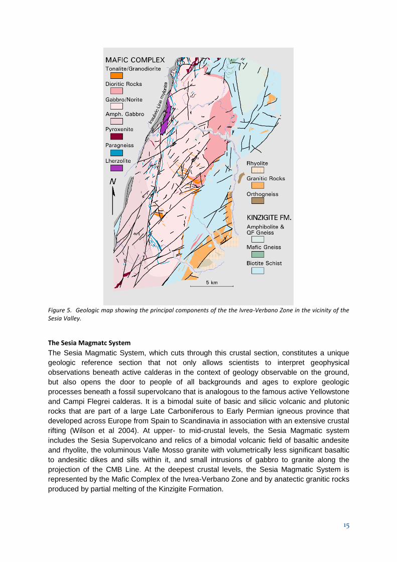
The following geosites under preparation at present or for future development
I= international interest; N= national interest; R= regional interest, Local interest
- BETTOLE (R): Limestone quarry and lime furnace, contact with Permian vulcanite.
- ARA “Giardino delle Grotte” (R): Magiaca river inside the limestone caves.
- MONTE FENERA (N): peculiar limestone “island” in the NW Alps, significant karst
structures.
- MONTE FENERA CAVES (I): : complex karst system with relevant paleontological
and archeological finds.
- PIEVE VERGONTE (R): Val Toppa gold mine
- ORNAVASSO (R): Quarries of the pink marble.
- VAL LOANA (near “Le cascine”) (L): Talc-bearing serpentinites “pietra ollare”.
- VAL LOANA (L): Limestones of the Canavese Zone.
- VAL LOANA (lago del Marmo) (R): Marble of the Ivrea-Verbano Zone.
- NIBBIO (N): Amphibolites of the Ivrea-Verbano Zone.
- PIAN D’ARLA (R): “Scisti dei Laghi” and view of Mt Zeda.
- CADORNA ROAD (M.Vadà) (N): Augengneiss.
- OSPEDALETTO (N) : Orthogneiss.
- MERGOZZO (I): White and green granites – granite ecomuseum.
- BALMUCCIA – VOCCA (beneath Cima Lavaggio) (I): Contact between mantle
peridotite and Mafic Complex.
- DINELLI (along the Sesia river canyon): Pseudotachylite breccia.
- VOCCA-VALMAGGIA (R): abandoned nickel mines.
- GAMBERARO (N): Granitic dykes inside the kinzigite formation.
- ROCCAPIETRA (N): White Granites and CMB Line.
- VAL STRONA DI STRONA (R): Roof of the Mafic Complex.
- VALDUGGIA (R): Scisti dei Laghi is an important Italian metamorphic unit.
- MT. CAPIO (R): nickel ore mines inside the Mafic Complex.
- CAMPELLO MONTI (L): Nickel ore mines.
- VALLE MOSSO (N): lower contact of Valle Mosso granite intruded by mafic dykes.
- SAN BONOMIO (N): upper Valle Mosso granite whic intruded the volcanic rocks.
- RIMELLA (L): soapstone “pietra ollare” quarry.
- CAMPERTOGNO (R): fingering between alluvial deposits and debris fan.
- BOCCORIO (R): grey-green paragneiss with albite, two-mica end epidote.
- STOLEMBERG (N) : contact between the Monte Rosa micaschyst and eclogites-
amphibolites.
- SCOPELLO (N): metamorphic rocks rich in glaucofane in Blueschist-eclogitic facies.
- RASSA (L): Alpe Massucco white marble quarry.
- MADONNA DELLA NEVE (L): Mignamitized Kinzigite Formation with petroglyphs.
- LOCARNO (L): Pink Marble quarry.
- PIODE – PIETRE GROSSE (L): huge blocks of landslide.
- VARALLO – CILIMO (R): Ophilcalcite quarry on a huge glacial boulder.
- VAL D’OTRO: one of the most beautiful hanging valley from last glaciation.
- VARALLO – CIVIASCO (R): marble and para-schyst in the kinzigite formation.
- PIODE-MOLLIA-RASSA (L): orthogenesis and metagranites with large feldspars
crystal.

26
- ISOLELLO (R): contact between the second dioritic-kinzigtic zone and the Sesia
Lanzo zone.
- RIVA VALDOBBIA (Val Vogna) (L): well preserved outcrops of the second dioritic-
kinzigtic zone.
- VARALLO (Sacro Monte): paleo-valleybottom during the last glaciation.
- LAGO di SANT’AGOSTINO: spill way channel.
- ALAGNA: abandoned Mn mine.
- BALMUCCIA: geomorphological evidence of the Insubric Line.
- RIMELLA (I): one of the best outcrops of mylonites of the insubric line.
- PONTE DELLA GULA: canyon inside the diorite formation and well preserved diorite
outcrops.
4. Details on the interest of these sites
Val Grande
The proposed geosites are grouped according to the main geological themes. Here we give
a brief description of the proposed geosites with more detailed descriptions provided in
Annex 6: List and detailed description of existing and proposed geosites.
Ivrea-Verbano Zone. Although the Ivrea Verbano Zone is much better exposed in the Sesia
area, some interesting outcrops may also be found in the Valgrande area. Typical kinzigites
containing lenses and pods of pegmatite, due to incipient partial melting, may be easily
observed in an outcrop near the church of Albo (geosite n°1). In the nearby village of
Candoglia (geosite n°2), the famous pink marble used for the cathedral of Milan is exposed
in thin intercalations within the kinzigites; the main quarry (Cava Madre) may be visited only
asking permission to the Fabbriceria del Duomo, owner of the quarry. The same marble may
be also seen at Ornavasso. At Premosello, at the foot of the mountain slope in the western
part of the village, an extraordinary outcrop (geosite n°3) shows the contact between
lithospheric mantle rocks and the lower continental crust. The mantle is represented by a
serpentinized peridotite, in the lower part of the outcrop; the lower crust is represented by a
mafic granulite, in the upper part of the outcrop. The contact surface represents the
Mohorovicic discontinuity, i.e. the crust / mantle transition. At the northern tip of the Ivrea-
Verbano Zone, the famous Finero Complex (geosite n° 4, Figure 9) represents one of the
mantle peridotite lenses tectonically interfingered with the metasediments. It consists of a
peridotite slice enveloped into an intrusive magmatic sequence of mafic and ultramafic
rocks. The main peridotite is well exposed in a quarry at Ponte Creves, whereas the mafic
rocks crop out on the footpath from Ponte Creves to Provola.
Serie dei Laghi. Most of the territory of the existing Valgrande National Park is formed by
these rocks. The metapelitic unit Scisti dei Laghi may be observed near Santino, in the bed
of the S.Bernardino river (geosite n° 5). In this outcrop, the micaschists display original
sedimentary features, such as alternate clay rich and arenaceous layers and typical quartz
rods; multiple phases of plastic folding may also be observed. The different rock types
forming the Strona-Ceneri Zone may be observed along a cross section following the
Cadorna road, an old military road. The main horizon of the Strona-Ceneri Border Zone may
be observed between Pian d’Arla and Ospedaletto. On an excellent outcrop (geosite n° 6)
we can observe the banded amphibolites: this association of dark and light layers forms the
typical “Leptynite - Amphibolite Group”, widespread throughout the Hercynian belt in Europe.
27
This association derives from the metamorphism of alternating mafic and acidic volcanic
pyroclastic rocks deposited as tuffites in a marine environment. Similar amphibolites, grading
into K-feldspar bearing varieties on approaching the orthogneisses, may be observed in
another locality outside this itinerary (Ponte Nivia; geosite n° 7). Leaving the cars at Passo
Folungo and walking on the road along the western slope of Mt Bavarione (geosite n° 8), we
first meet the augengneisses, which are here strongly laminated (flaser gneiss). Then we
find the Gneiss Minuti, with beautiful similar folds and calc-silicate nodules. In the last ten of
meters before reaching the southern tip of the road the outcropping rock (here the
Cenerigneiss) is mostly transformed by pre-glacial weathering processes in a coarse
residual sand. The spectacular characters of the Cenerigneiss are better observed outside
this area, at Ponte Casletto, in the bed of the Valgrande creek near Cicogna (geosite n° 9).
Rocks related to fault zones.
Cossato - Mergozzo - Brissago Line. Mylonites related to the CMB line are exposed on the
Spoccia - Orasso footpath (Val Cannobina; geosite n° 10). The schistose rocks with
subvertical attitude are intruded by nearly concordant mafic dykes (Appinite). A similar
situation is observed on the road Ponte Spoccia - Spoccia (geosite n° 11), were the mafic
dykes often show chilled margins, indicating rapid cooling of the magma against the much
colder country rocks.
Pogallo Line. The mylonites related to the Pogallo Line (geosite n° 12) are very fine-grained
dark rocks, in which are visible small white, more-or-less flattened lens-like crystals; the
latter are minerals which behaved in a brittle way inside the plastic matrix during
mylonitization. The mule track along the Pogallo valley also crosses the Gneiss Minuti,
Cenerigneiss and orthogneiss before reaching the mylonites.
Canavese Line. Phyllonites related to this line are exposed near the Vogogna castle (geosite
n° 13); they probably derive from orthogneisses of the Sesia Zone; the widespread
occurrence of chlorite indicates temperatures around 450° during mylonitization.
A peculiar rock also related to a fault is the pseudotachilite, which can be observed at the
foot of the slope at the municipal border between Premosello and Vogogna (geosite n° 14).
Pseudotachylites are considered “fossil earthquakes”: they are found along seismogenetic
faults and are the product of instantaneous quenching of a melt formed by heat generated
by extreme friction along a fault. The appearance of the melt reduces friction to zero,
producing the earthquake. The melt injected in fractures forms glass veins cementing the
brecciated original rock (in this outcrop the rock is a mafic granulite belonging to the Ivrea-
Verbano Zone).
Supervolcano plumbing system
Ten out of the twelve geosites proposed for this area are stops of the classical one-day
excursion along the exposed plumbing system of the fossil supervolcano, a “journey from the
centre of the earth,” which leads visitors to observe igneous and metamorphic rocks that
were formed or recrystallized at depths as deep as 25 kilometres beneath the caldera at the
time when the volcanic field was active. These rocks are tectonically bounded by the
mylonites of the Insubric Line, which is well exposed at geosite n°15. From this point, visitors
travel progressively upward through the crustal section to increasingly more shallow crustal

28
levels, finally arriving at the megabreccia which constitutes the caldera fill of the Sesia
Supervolcano. At geosite n°16, visitors stand on outcrops of the famous Balmuccia
peridotite, one of the best-preserved outcrops of mantle rocks in the world, where a network
of pyroxenite dikes record a complex story of multiple events of partial melting and
generation of basaltic magma (of unknown age). Continuing up section, visitors enter the
huge Mafic Complex, which intruded the deep crust at around 288 Ma. Gabbroic rocks of the
Mafic Complex exposed at geosite n°17 were penetratively deformed at very high
temperature (hypersolidus) conditions, during the growth of the igneous body. Layers of
crustal rocks were incorporated in the Mafic Complex and melted extensively, resulting in the
strongly depleted granulites observable at geosite n°18. At higher crustal levels, gabbroic
rocks at geosite n°19 preserve igneous structures and underwent only minor high-T
deformations because they were located in the roof of the growing Mafic Complex. At
geosite n°21 visitors can see the primary contact between the Mafic Complex and the
country rocks, along which a spectacular migmatite was formed by melting of the country
rocks in amphibolites facies, but under conditions of lower temperature with less complete
removal of anatectic melt than at geosite n°18. Continuing up section, the excursion cross-
cuts the upper-crustal section, reaching geosite n°23, where mingled granitic and gabbro-
dioritic rocks (“appinites”) were intruded along the CMB Line. The classical excursion ends at
geosite n°24, were visitors can see a spectacular outcrop of the megabreccia produced by
the super-eruption of more than 300 km3 of ignimbrite accompanying caldera collapse at
about 282 Ma.
The visit of additional geosites requires a second day excursion. Compelling examples of
synmagmatic deformation at the lowermost levels of the Mafic Complex can be seen in Val
Sessera at geosite n°25 and the caldera wall can be observed in proximity of Gargallo at
geosite n°26. Possible geosites of outstanding quality in Val Sessera, Valle Mosso and Val
Strona di Postua are not described here due to limitations on the length of the dossier, but
are frequently visited by groups of students and researchers in geology.
Additional Stops
Seven geosites(n°27 to n°33) in which the main scientific interest is the geomorphology,
pedology and mining activity are located in the area of Alta Valsesia, and are described in
detail in Annex 6
Fig 9 Students of the Earth Science Department of ETH Zurich visiting an outcrop of peridotites in Finero
29
C - Geoconservation
1. Current or potential pressure on the proposed Geopark
A vulnerability analysis has been performed to determine the potential threats that could
impact the proposed Geopark area. The territory could be impacted by the potentially
conflicting forces generated by population growth, changing economic conditions, tourist
activities, and its remarkable natural and historical heritage. The main human sources of
potential threat are industrial activity, urbanization, mining activity and tourism.
Industrial threats. The main industrial activities are located near the biggest towns in the
area (e.g. Borgosesia, Varallo, Verbania). No important increases in industrial activity have
occurred in the last 10 years, and consequently, no significant threats to the geo-heritage
are expected from industrial activities.
Urbanization threats. In the proposed Geopark and its vicinity, growth of local towns has
been quite limited and has not caused a significant impact. However, the resettlement of
people to large metropolitan centers, and consequent abandonment of more rural areas
represents a general depopulation problem for the region. It is hoped that creation of the
proposed Geopark will help mitigate the phenomenon of resettlement to large metropolitan
centers by increasing sustainable activity in the Geopark and its vicinity through cultural
tourism and responsible development of the natural and historical heritage.
Mining and quarrying threats. Quarrying and mining was an important economic activity in
the proposed Geopark and its vicinity for centuries. At present, all of the mines and most of
the quarries are closed and the land rehabilitated. In the Verbano area, the only two quarries
that are still operational, though with limited production, are the granite quarry of Mergozzo
and the historical marble quarry of Candoglia, the last totally devoted to the maintenance of
the Cathedral of Milano. Consequently, few threats to geosites are posed by mining
activities. Other mining activities are in Beura-Cardezza and Trontano. Establishment of the
Geopark would encourage evaluation of the impacts and the potential future for mining and
quarrying in the area in light of a program of balanced, sustainable and cultural
development. To this end, the creation of one or more mining heritage centers or museums
is under consideration.
Tourism threats: This is one of the largest contributors to the territorial economy and is
directly dependent on the remarkable quality of the surrounding environment. Tourist activity
is predominantly nature based, consisting mainly of skiing, hiking, lakeside watersports,
climbing, rafting, and complimented by gastronomic and spa holidays. The two main tourist
areas are the Monte Rosa Massif and Lake Maggiore. By adding geotourism to its offering,
the Sesia-Val Grande area will attract additional visitors and potentially increase this
potential threat to the territory. This noted, the threats introduced by increased tourism can
be controlled with appropriate planning, and it should be emphasized that one of the main
goals of the Geopark is to redirect the touristic flux to the areas in need of sustainable
economic development. Furthermore, it would be highly desirable to reshaped the seasonal
peaks of tourist activity to minimize the disruptive effects of surges in numbers of tourists,
and it is anticipated that creation of the proposed Geopark will contribute to minimizing the
negative effects of peaks of tourism followed by periods of little or no tourist activity.

30
2. Current status in terms of protection of geological sites within the
proposed Geopark
Protection measures have been classified to determine the level of protection in place or
required by heritage and geosite sites. Our proposed conservation scheme has four levels
that range from “level 4,” corresponding to full protection, to “level 1,” corresponding to no
protection (see Annex 7).
A few areas within the proposed Geopark are fully protected (level 4) with limited and
registered access requirements to ensure preservation of natural and/or cultural heritage.
These areas are highly monitored and patrolled. These are the Monte Fenera caves and
selected areas in the Val Grande National Park.
Today, nature dominates the proposed Geopark area. A significant part of the area and its
geosites are currently protected by international, national, regional or territorial regulations
(level 3), and patrolled by park personnel. These include one National Park (Val Grande),
three regional parks (Alta Valsesia, Alta Val Strona, Monte Fenera), one special reserve
(Sacro Monte di Varallo) (see Figure 2 for locations).
Outside the national and regional park areas, the geosites are protected by provincial and
municipal regulations (level 2). All the municipalities and local entities (e.g. Comunità
Montana Valsesia, Comunità Montana Valsessera, Comunità Collinare) have signed the
Geopark cooperation agreement and the fundamental values protocol. This agreement is
essential to the aspiring Geopark because it demonstrates the full involvement of all the
potential political and administrative stakeholders, and this is a necessary starting point for
future enhancement and development. County and sub-regional organizations, cultural
entities and non-governmental organizations (NGOs), on their own levels, also contribute to
the enhancement of the geological heritage and its protection. The concept of development
of the economy and tourism while preserving unique natural and cultural values in an
integrated way is included in the development strategy of the area in conjunction with the
foundation of Geoparks.
Comparing the vulnerability assessment with the protection assessment, it is possible to
determine where potential conservation gaps arise. This allows prioritization of sites for
protection such that sites with the highest vulnerability and lowest protection receive priority
attention. This information is reported inside our geosites classification scheme, which is fully
compatible with the National Institute for the Protection and Environmental Research (Istituto
Superiore per la Protezione e la Ricerca Ambientale- ISPRA) classification method. Our
strategy will enhance the quality of information incorporated in our database, and will permit
us to monitor the classification of our territorial inventory when our sites are incorporated in
the national inventory.
3. Data on the management and maintenance of these sites
The ownership status of the geosites of the aspiring Sesia-Val Grande Geopark varies
throughout the territory. Sites may be privately owned, owned by a town or village, or by the
parks authority. Each geosite is managed by the relevant stakeholder in partnership with the

31
parks and Geopark management. The level of legal protection required for the site
determines who is responsible for managing it in field. The task of stewarding nationally
protected areas is delegated to the National and Regional Park Directorate. Sites at regional
level are protected by county or sub-regional entities, locally protected areas are managed
by local municipalities. Associations and NGOs also take part in the preservation activities at
several managerial levels.
Over a number of years the parks, municipalities and associations have been working with
their partners, supported by various studies and programs, to establish action and
management plans to develop geosites. The current activity of documenting geoheritage on
a district to district basis is designed to increase public awareness and to facilitate effective
management and preservation. Sites with Regional, National or International status
sometimes prescribe site specific management requirements.
The proposed Geopark will enhance the standard of management by bringing together the
different stakeholders under the umbrella of its own Associazione. The co-ordination is
paramount for an effective network’s establishment. It is expected that after the initial period
the Geopark organization will also take part in the field management activities in the case of
some sites where a direct responsibility is missing. When new sites are developed,
management will be assigned to the administration body of the Geopark until a responsible
management entity is identified.
The organizational structure of the Geopark top and our strategy for cooperation are detailed
in Chapter A.3 and in Annex 5.
4. Listing and description of non-geological sites and how they are integrated
into the proposed Geopark
Annex 8 lists sites of cultural, ethnographic and anthropological interest within the proposed
Geopark. Included are significant features and sites of value from the point of view of nature,
art, history and culture, such as Val Grande National Park, the Natural Parks of Alta Valsesia
and Monte Fenera, and Sacromonte di Varallo, which is a middle-age sanctuary that is a
UNESCO World Heritage Site.
Within the proposed Geopark lies a landscape of considerable quality with expansive
forested areas, numerous and diverse microhabitats, and high biodiversity. Among the 60
Sites of Community Importance (SCI) in the System of Protected Areas of the Piemonte
Region that have been identified as the protected areas in Natura 2000 Network, the
environment preservation network promoted and created by the European Union to protect
both the habitats and the animal and vegetal species, 12 are included in the area covered by
the proposed Geopark and are listed in the following table.

32
Val Grande National Park, a few steps from Maggiore Lake, is the largest wilderness area in
Italy. The harsh and rocky mountains surrounding Val Grande have always protected the
environmental integrity of the valley. In 1967, the area of the Pedum rocky massif (Figure 2)
was transformed into the first Strict Nature Reserve in the Italian Alps. The word "wilderness"
suggests wild and uncontaminated spaces far from the presence of man. However, Val
Grande is not only this. Here the traces of the human presence are evident: mule tracks,
summer grazing pastures, terraced soil, and abandoned cable bear witness to the intense
presence of man during the past centuries. "Wilderness" in Val Grande means an
abandoned place with neither roads nor permanent or seasonal settlements, where nature is
progressively reclaiming the land. The places and the people of the villages surrounding this
area (including Ossola, Verbano, Val Vigezzo, Valle Intrasca, and Cannobina) tell the long
tale of mountain civilization.
Geology, environment and culture are closely linked in the Sesia Valley. The Natural Park of
Alta Valsesia presents one of the most dramatic and appealing natural environments of the
Western Alps, and the community of Alagna has within it some of the best preserved 13th
century traditional Walser buildings. At lower elevations in the valley, a UNESCO World-
Heritage Site, Sacromonte di Varallo was constructed on the contact between the Mafic
Complex and metamorphic rocks of the Kinzigite Formation, utilizing building materials
derived from both geologic units. This use of local lithologies for construction is characteristic
and obvious in the villages and mountain huts throughout the valley. From the high vantage
point of Sacromonte di Varallo, one has an impressive view over the Sesia Valley, extending
from the Balmuccia peridotite to the Sesia Supervolcano, where resting on ignimbrite of the
caldera, karstic dolomite of the Natural Park of Monte Fenera contains the only known
Palaeolithic human settlement along the central-western Alps.
It is important to emphasize that the administrations of all the non-geological sites and
municipalities that are identified in this proposal support the Sesia-Val Grande candidature
as a Geopark.
Number Name
IT1120003 MONTE FENERA IT1120006 VAL MASTALLONE IT1120016 LAGHETTO DI SANT'AGOSTINO IT1120028 ALTA VAL SESIA IT1130002 VAL SESSERA IT1140001 FONDO TOCE IT1140003 CAMPELLO MONTI IT1140006 GRETO T.TE TOCE TRA DOMODOSSOLA E VILLADOSSOLA IT1140011 PARCO NAZIONALE VAL GRANDE IT1140013 LAGO DI MERGOZZO E MONT’ORFANO IT1140017 FIUME TOCE IT1140020 ALTA VAL STRONA E SEGNARA
33
D - Economic Activity & Business Plan (including detailed financial information)
1. Economic activity in the proposed Geopark
The territory of the future Geopark is composed of 85 municipalities geographically related to
two main areas: one set in the valley of the Sesia River, and the other located between Lake
Maggiore and the Ossola area.
Although this territory includes very heterogeneous and very diverse forms of economy, one
can recognize the basic dynamics of socio-economic development that through the years
(especially since the late nineteenth century with the industrial revolution and the rise of
tourism) has resulted in a dualism between areas with stronger economy consolidated
(especially in the lower areas of Valsesia, Val Sessera, Toce and in the urban areas) and the
inland and / or secondary valleys with a prevalent subsistence mountain economy.
Prominent roles in the historical and industrial background of the territory have been played
by the steel and engineering industry (mainly based in the industrial areas of Roccapietra
and mid-Ossola), the textiles and wool industry, with high-end world-renown companies, the
home furnishing industry mainly based in the district of Strona and Cusio, and the chemical
industry (in Ossola and Verbania).
Tourism has deep roots in the territory and this industry in the area of the Geopark presents
the same dualism with strong areas related to the origin of the modern tourism (especially
the upper Valsesia, the cities on the banks of Lake Maggiore and the Val Vigezzo) and
inland areas to with smaller touristic flows and fewer infrastructures.
Traditional economies still survive, including sheep breeding and farming with the production
of genuine and quality local products, wine production (it is worth citing the famous wine
“Gattinara”, which takes its name from the city and is produced from grapes grown entirely
within the Sesia Supervolcano), and handicraft production.
Tourist attractions within the territory are already well established and include:
- Naturalistic and specialized attractions
- Sport and outdoor activities
- Cultural and religious attractions
- Wine and food
The upper Valsesia is strongly linked to summer and winter tourism. Mera and Alagna are
two ski resorts particularly relevant for the winter tourism (Alagna, in particular, is sought-
after as a cool destination for mountain lovers). Both resorts belong to Monterosa Ski area,
one of the biggest ski areas in Europe.
In past decades, tourism in the Sesia Valley has been linked to the mountain environment
and, more recently, to the river. Valsesia offered a very broad variety of sporting
opportunities, all of them strongly integrated with the environment and the territory. These
comprise, among others, all the winter sports, the river sports, mountain biking, downhill
skiing, paragliding, hiking and climbing at all levels of difficulty.
For several disciplines, Valsesia hosts high level athletic competitions, which has increased
the valley’s international visibility. Along the Sesia River, there are canoeing, kayaking, white
34
water rafting and canyoning schools that convey a strong sense of respect for the
environment in which these sports are practiced.
The area is also rich in goods and finery of great cultural and historical value, recognized
and appreciated by many historians and art critics (as described in chapter C4), which is
already represented, especially with the Sacro Monte of Varallo, in the UNESCO list of
World Heritage Sites as well as other Holy Mounts in Domodossola and Ghiffa.
In the North-East of the territory, it is possible to recognize the influences of tourism focused
on nature, especially stimulated by the wilderness of the National Park of Val Grande, to the
mature and established tourism in the urban areas overlooking Lake Maggiore.
The tourism industry of the region involves all four sectors mentioned above and has
developed mainly due to tourist attractions stimulated by the attractions of the lake and of
the mountain. The facilities of Lake Maggiore have always demonstrated capability to
respond to national and international tourist surges with modern facilities. The immediate
hinterland of the National Park offers a variety of trails and services (visitor centers,
information points, museums, hostel, etc.) that are increasingly sought after by tourists at the
lake for supplementary activities of hiking, water sports, mountain biking, downhill,
paragliding, climbing, Nordic walking, etc.
In recent years, the more mature and structured tourism sector has had room for certification
and recognition at national and international levels. For instance, Alagna Valsesia, Varallo,
Vogogna, Mergozzo, Cannero Riviera, Cannobio and Malesco have achieved the
certification of “Bandiera Arancione”, an important tourism and environmental quality mark
released by the Italian Touring Club, which rewards those places that propose a tourism
offer based on quality and environmental sustainability. Cannobio is also a certified EMAS
town, while the territory of the National Park (13 towns) is currently a candidate for the
certification released by EUROPARC by the European Charter for Sustainable Tourism in
Protected Areas.
A strategy of sustainable development for the territory implies the adoption of a long-run
vision that identifies a coordination of the growth of three fundamental divisions – (1)
environmental, (2) social and cultural, and (3) economic – and which encourages
collaboration and coordination between local organizations and individuals.
The initiatives undertaken to form a new, coherent Geopark by the Association of of Valsesia
Supervolcano and the ValGrande National Park have been critical to developing a positive
dialogue within the territory, as fundamental instruments of knowledge and acceptance.
2. Existing and planned facilities for the proposed Geopark (e.g. geo-
education, geo-tourism, tourism infrastructure etc)
Among principal goals of the Geopark are the active protection and the preservation of the territory and its environmental heritage and promotion of environmental education. From this perspective, the different local groups are acting in a structured way to increase the development and public awareness of the geologic, geomorphologic, environmental and cultural heritage of the area through community awareness, tourism development, and development of school curriculum. Among the main achievements, it is worth citing the following accomplishments:

35
- Thematic paths and organized visits to the geosites; - Production of illustrative materials; - Information points and guest quarters; - Museums and collateral initiatives; - Projects of environmental education proposed to schools, with the purpose of
spreading the knowledge of the natural environment and consequent comprehension of the importance of its protection;
- Popular and didactic activities targeted to adults, dedicated to natural, wildlife, botanical, historical and cultural themes, including the comprehension of the landscape from a geologic and geomorphologic perspective;
- Development and maintenance of a wide network of trails, including thematic routes, and numerous bicycle lanes, which facilitate access throughout the territory and enhance an appreciation for its natural heritage;
- Collaboration with local associations in creation of new didactic and popular activities to increase appreciation for scientific research, with the aim of increasing awareness, preservation and sustainable development of the region’s resources.
The services cited so far belong to the geologic-naturalistic sphere and reflect the scientific value of the Geopark; however, the territory also has structures and services for promoting its history, culture and traditions. The Geopark and its stakeholders plan to build on existing resources and synergies, and critically analyze its performance. Based on accomplishments and experiences to date, the following lines of actions are planned:
- Thematic trails (related to geo-environment, nature, landscape, mining, etc.); - Glaciological paths; - Design, realization and prints of geo-tourism books, information and illustrative
materials according to the different targets of visitors and the different promotional channels;
- Design and creation of projects of environmental education, starting from the contents and info in the museums and from the Geolab (geologic laboratory);
- A visitors center in Valsesia; - Creation of new info points in the new areas to be developed with geo-touristic paths; - Offer of didactic activities for universities; - Creation of specific sections on the website related to the activities of the Geopark ; - Design and creation of a mascot for the future Geopark; - Publishing of this dossier for the involvement of the community, stakeholders and the
general public; - Design and realization of a development of part of the “geoalpine track”. - Creation of a MOOC (Massive On-line Open Course) on the evolution of the earth’s
crust.
3. Analysis of geo-tourism potential of the proposed Geopark
Analysis of the macro-environment
There are many factors that affect the macro-environmental processes of strategic management. In particular, the present analysis involves the political, economic, social and technological factors that characterize and/or influence the object of the analysis, be it a company, an institution, a project or a territory.
Among political and economic factors, it is to be considered that Italy is now facing a
difficult period of its history, which has led to drastic cuts to public expenses and a new
private politic devoted to economic and financial savings. However, at local levels, the
initiatives linked to the development of the territory and its heritage have not been reduced,

36
thanks mainly to fundraising activities and/or the use of European and private funds. More
than ever before, tourism represents an important source of economic sustainability in the
area of the Geopark; indeed, the public institutions and the private initiatives continue to co-
exists and to collaborate in synergy to bring added value to visitors.
Regarding the social factors linked to the cultural sphere, the perceived level of welfare and
safety and the growth rate of the population, the area of the proposed Geopark presents
conditions of substantial welfare, consistent participation and sense of community. Related
to this, there is an evident and widespread desire to preserve the local heritage and build the
bases for a sustainable future that respects the environment and local traditions.
As far as the technological factors are concerned, there are several institutions, both
public and private, in the region of the proposed Geopark that consider research and quality
as integral parts of the products and services offered to the final consumer. It is worth citing
the presence of a certain risk of being content of the traditions of excellence, without
orientation toward future innovation, mainly because the growth rate of the population and
the percentage of people under 30 are not consistent. However, it is the young population
that is most interested in the implementation of strategies that ensure a more prosperous
future for the whole region. This demographic is increasingly open to realities beyond the
traditional limits set by previous generations.
Analysis of the competitive context: Porter analysis
Direct competitors. If we want to contextualize the proposed Geopark into the local
business framework in order to analyze its competitiveness and potential, it must be noted
that direct “competitors” (with a similar type of product) can only be other Geoparks in the
Italian territory or, more broadly, beyond the country borders. To date, there are no direct
“competitors” near the proposed Geopark and the network of Geoparks on the Italian
territory is already fairly well developed and efficient. The unique characteristics of the
proposed Geopark, combined with its potential for attracting tourism to the region, are
strengths that meet the needs of different kinds of visitors. For this reason, we argue that
there is no threat of direct competition.
Suppliers. Considering the product (in this case, the combined experience of the services
provided by the proposed Geopark), it is clear that the proposed Geopark is naturally
equipped with a set of environmental and geological resources that cannot be changed.
However, there is another set of elements that combine to form what will amount to the final,
intended tourist experience. Among these we find, for example, sign posting infrastructure,
cleaning and maintenance of the sites, site accessibility, and consulting services by guides
or professional geologists during trips, exhibitions and conferences. In our case, the risk of
corrupting the relationship between the proposed Geopark and the various personalities or
organizations working to provide resources for the realization of the final product is quite low.
Several are, in fact, the public or private entities that are direct stakeholders of the proposed
Geopark and, thus, have aligned interests. The only significant risk is a shortage of funds
that would not allow proper infrastructure development and maintenance in the regions
covered by the proposed Geopark and, consequently, in the geological sites. This could
lead, in the worst case, to misunderstandings and disagreements between the parties and
the diminishing quality of the final product.

37
Customers. Two groups have been considered as the "core" of the local geotourism
experience:
1. Expert visitors: the professional geologists and students of this discipline that are a
qualified and expert segment of the proposed Geopark community;
2. Amateur visitors: groups that are not working with geology in everyday life, but that
for a number of reasons could be interested in becoming engaged and visiting the
proposed Geopark.
The proposed Geopark offers interesting prospects for both groups. The first group is
naturally attracted by the geological and environmental allure of the proposed Geopark as it
is rich in sites of rare scientific value, while the latter lends itself to the spirit of discovery and
adventure.
Potential entrants, i.e. those who may enter the market in which the proposed Geopark
operates. This would consider recently recognized Geoparks and Parks that seek to enter
the Geopark Network in the near future. However, we find the risk quite nil.
Providers of substitute goods. Maintaining the dualism between expert visitor and
“amateur” visitor, the experts are generally interested in the core characteristics of the
“product Geopark”, namely its geological heritage. Therefore, it is a very focused and
specialized group with a high degree of interest in what is new and unique. For this group,
the proposed Geopark sees no aggressive competitors that could distract this type of visitor.
This contrasts with the ‘amateur’ visitor, which is potentially much more difficult to reach and
easier to lose. Constant and well organized efforts of marketing, public relations and
customer relationship management are critical to ensuring efficient and effective
communication with this slice of current or potential visitors. The proposed Geopark should
compete with all the other tourist attractions in the area that are not related to geology and
environment. In fact, the proposed Geopark potentially fulfills a variety of needs such as the
desire for knowledge, entertainment, satisfaction of curiosity about what is new, and contact
with nature. Therefore, if the final experience offered to the visitor is not competitive and well
integrated with other attractions in the area, the proposed Geopark will surely lose against all
pre-existing nature trails, bike paths, museums, artistic attractions, and sports packages,
which have been the core strength of the region’s attraction so far.
Analysis of the internal and external factors: SWOT analysis
After a first analytic phase, the business planning and development process demands a
thorough and self-critical analysis of the strengths and weaknesses of the proposed
Geopark, as well as the opportunities and the threats that may intervene during its existence
influencing certain dynamics. For this reason, we will now proceed with the so-called SWOT
(Strengths, Weaknesses, Opportunities, Threats) analysis, which is a useful excercise in
support of decisions that must be made in the process of launching and developing the
Geopark.

38
STRENGTHS
- Context of high environmental,
historical, artistic and cultural
value
- Quality of air and water, wide
variety of wildlife
- Richness, variety and uniqueness
of the geotopes
- Low levels of efficient
management of pollutants
- Potential for the production of
energy from renewable sources
- Low level of criminal activity,
marginalization and poverty
- Supply of essential public
services
- Respect for the values and
attachment to the traditions and
the region
- Propensity for accommodation
capacity with constant research of
alternatives for the diversification
of tourism
- Consistent presence of
accomodation facilities
- Presence and mutual integration
of structures and institutions in the
territory (GAL, museums, info
points, reserves, etc.)
- Presence of a National Park and
Regional Parks
- Geographic location and
accessibility
- Good infrastructure systems
- Production of hand-crafted and
local goods
- Presence of a strong industrial
network with high-end finished
goods
- Strong integration between public
and private, with rooted care
towards the themes of
environment and territory
- Local economy highly linked to
tourism, especially outdoor
- High number of involved entities
WEAKNESSES
- Preparation and maintenance of the
geosites still in development phase
- Low level of knowledge of geologic
subjects at local level and low brand
awareness of the proposed Geopark
- Low attention to date toward
investments in technology of
telecommunications
- Critical demographic for progressive
aging of the population and
decreasing birthrate
- Inexperience to act in synergy by the
local public entities
- Differences in cultural backgrounds
and internal relations between
certain areas of the proposed
Geopark
- Number of entities involved

39
OPPORTUNITIES
- New investments linked to the
tourism sector (spa, entertainment
centers, etc.) for more attractive
product, with increased and renewed
accommodation capacity
- Potential connection of areas with
strong and mature tourism industries
- Development of economies through
integration of different financial
sources
- Processes of development and
synergic growth of tourism linked to
wine and food, sport and nature, art
and culture, together with more
specialized geo-tourism
- The geologic heritage as an added
element for a new positioning of the
territory
- Tourist events and offers available all
year
- Creation of an “identity brand” linked
to the unique qualities of the areas of
the proposed Geopark
THREATS
- Overcoming bureaucratic constraints
- Employment at risk
- Unpredictability of the weather
- Managing the processes of
development
- Cuts to public funds and lack of
funds for the realization of projects,
with consequent diffuse de-
motivation
- Risk-adverse investment
4. Overview and policies for the sustainable development
Geo-tourism and economy
Positioning is, in general terms, the entirety of distinctive characteristics that define the
territory for the visitor. Positioning strategies are carried on with the aim of identification of
new opportunities of development, of creation of competitive advantage, and of development
of new products/services through the so-called innovations of product or of process.
Generally, positioning changes according to the phase in the life cycle of the geotouristic
destination. The Geopark is now facing the organizational and managerial phases needed to
give a certain unity to a wide territory. The positioning of a product (or in this case of sites of
touristic interest) depends also on the macro-environment in which it is located or it has
visibility.
In both the macro areas of our case – Valsesia and the ValGrande National Park - the
candidacy of a Geopark with the characteristics of uniqueness and high geologic and
environmental value, is well integrated with the general strategy of the public organizations
involved. For instance, in Valsesia a strategy of improvement and development of a kind of
tourism of excellence, is to be seen as a “package” with a bundle of remarkable resources,
all of them employed in synergy in order to deliver to the tourist an experience of high
experiential value.

40
The way to reach this desired positioning in the mind of the visitor or potential visitor is
characterized by two main stages:
- production and allocation of high quality goods and services, with constant care for
professionalism and value;
- adequate communication in the phase of pre-fruition and care for customer
relationship with the territory in the phase of post-fruition by the visitor
There are a lot of marketing strategies and none of them fits perfectly for all cases. Each
territory has specific intrinsic characteristics that must be used to assemble a coherent
development plan with the available resources trying to exceed the goals. A comprehensive
marketing strategy takes into account the so-called four "Ps", i.e. Product, Price, Place and
Promotion. All factors should be combined to be effective. The entities involved are currently
addressing a phase of design of a proper marketing strategy consistent with their purposes.
On the one hand there is a process of assessment, positioning and integration of the various
segments of the internal offer; on the other hand there is the estimation of the potentialities
of the local entities already driving the current touristic offer (Holy Mounts, National and
Regional Parks, etc.)
Geo-education
There is a shared desire to offer the visitor a tour of high experiential value at an affordable
price. In addition, the Geopark intends to make accessible to the public scientific knowledge
through the maintenance the infrastructures for the access to the sites, in addition to the
sites themselves, as well as through an accurate promotion and development of didactic
materials to communicate the uniqueness of the local heritage to different utilizing a wide
range of tools including printed materials, displays at geosites, museum displays, public
lectures, trained guides, and the internet.
When defining the overall education strategy, it is necessary to consider that the Geopark
has potentially two types of visitors: the qualified visitor and the generic visitor (for "qualified"
it is meant a professional or highly passionate figure of geology and environmental heritage).
In short, professionals in the field of geology will be the core target of more highly
specialized and dedicated activities and educational materials, while for those who approach
geology for the first times it will be necessary to design initiatives to raise awareness of the
geologic discipline and to encourage a more experiential visit to the territory of the Geopark.
Regarding the initiatives of protection and enhancement of the Geopark, they are part of a
broader and more complex strategy to protect the natural and cultural heritage of the area.
Geo-heritage
The goals are active protection of the geological heritage, promotion of its scientific study, to
give impetus to environmental educational activities in the field of Earth Sciences, to
encourage geotourism as a new form of tourism awareness, and employment growth in
ecotourism. In addition to this, the Geopark will involve the local population by increasing the
knowledge and awareness of the significant geologic and geomorphologic value of the area,
and will promote socio-economic and cultural growth in cooperation with local authorities,
tour operators and other organizations, with focus on the popularization and communication.
This is the context of future activities aimed at enhancing the tourist experience through a
constant search for improvement of accessibility and usability of the sites. As for managerial
matters, it will be crucial to continue the coexistence of the “bottom up” model used by the

41
Association of the Supervolcano and the “top-down” model adopted by the Val Grande
National Park.
The goal for the future Geopark is to act as a promoter of actions aimed to enhance the
excellence of not only geologic and geomorphologic, but also historical and cultural heritage,
which are consistent with the principles of active protection agreed to by all participants,
public and private, operating in the area.
The proposed Geopark is intended to play an important role in the local communities, and
this is currently in a growth phase. The activities organized so far involve the community
through, for example, services to schools in order to raise awareness upon the
environmental heritage of the area, the creation of exhibitions and conferences, and
popularization through books expressly published on the geologic, environmental and
cultural resources of the region. In the near future, we will develop activities related to the
local territory and its heritage, such as an open photo contest at the geological sites or the
surrounding areas
5. Policies for, and examples of, community empowerment (involvement
and consultation) in the proposed Geopark
The application process has already engaged a large number of communities, disseminating
knowledge, establishing collaborative relationships, and building interest and a set of skills.
This is now a strong foundation for a increasing and strengthening local community
involvement in order to take effective actions for the implementation of the Geopark and to
raise awareness of the values that are intended to be protect and promoted.
The two managerial models adopted by the Association of the Supervolcano and by the
ValGrande National Park will be utilized in concert. The “bottom-up” process and networking
strategy developed in Valsesia will be merged with the inclusive process adopted by the
National Park with local administrations. Networking and the development of the local
community will be implemented as resources of the Geopark, mainly through the
subscription of the Charter of Principles and by operating an official Protocol of Agreement
(Annex 5).
The goals regarding the involvement of the local community will be pursued mainly through:
the organization of a Board of Management of the Geopark
cultural activities (such as implementing common events, social learning, local
knowledge, etc.
The implementation of a technological platform will be based on web 2.0 (use of social
networks and communication of events, projects, educational initiatives, ect.)
6. Policies for, and examples of, public and stakeholder awareness in the
proposed Geopark.
42
Val Grande National Park and the Association Supervolcano Valsesia have, within their territories, recognition and awareness among different participants and stakeholders, ranging from individual local authorities, associations, cultural institutions, other public entities and centers of excellence in research and business. With the recognition of the status of Geopark, the process of building this awareness will have to be continued internally and beyond the boundaries of the area. This process has already started along the following lines:
Community involvement with organized tours that show and let people appreciate not only the geologic heritage, but also the gastronomic, historical and cultural
Involvement of stakeholders in the planning and implementation of various activities
Adequade visibility on the local press and on the media
Educative role of the Geopark through events for schools or aimed to attract a wider audience than the qualified one
Increase the awareness of the main subjects involved in the territory with informative activities and best practices sharing with other Geoparks
Organization of exhibitions and conferences
Creation of a website in Italian and English
In general, the activities of the Geopark are closely related to the well-being and economic growth of the local area, and are carried on with the goal of raising awareness of the region’s heritage.

43
E – Interest and arguments for joining the GGN
This proposal for candidature to the UNESCO European and World Network of Geoparks
has been enthusiastically welcomed by all local communities and the international scientific
community. This is evidenced by the letters of official support (a list of which is in included in
Annex 3) signed by local authorities, universities, research centers and by various
organizations working in the field of scientific research, tourism and natural conservation.
These stakeholders universally endorse and wish to implement the goals of the GGN. In this
section, we summarize the basis of our interest in and arguments for joining the GGN.
Greater detail on these points is provided elsewhere in this dossier.
The scientific significance of the proposed Sesia-Val Grande Geopark is beyond dispute. As
the world’s most accessible and complete exposed section through the continental crust, the
Ivrea-Verbano Zone and Serie dei Laghi have been the focus of increasing international
scientific attention for more than 40 years, and these terranes continue to be the targets of
active research programs and the frequent destinations of fieldtrips by universities and
professional societies. We believe that the widely recognized scientific significance of the
proposed Sesia-Val Grande Geopark will make it a poster child for demonstrating to the
scientific community at large that it is vital to engage the public and communicate to them
the value and relevance of scientific research.
Although parts of the proposed Geopark are extremely rugged, we emphasize that most of
our geosites are readily accessible along major roads. These geosites display impressive
and evocative relationships that are readily apparent to professional geologists and lay
persons alike, and collectively, they present a coherent picture of the composition of the
continental crust and the processes involved in its evolution. The very distribution of these
geosites places visitors in direct contact with the environmental and cultural heritage of the
region, and the more adventurous and vigorous visitors also have an opportunity to follow
the geologic story into dramatic wilderness areas such as the Val Grande National Park via
networks of trails.
Beyond providing an opportunity to “walk through the continental crust,” the proposed
Geopark is a potential launching pad for public discourse on environmental change and the
challenges it could present. Many of the geologic features discussed in this dossier were
produced in Permian to Triassic time, a period during which the planet experience rapid
global warming that was likely a contributing factor to the largest mass extinction on record.
A visit to the Sesia Supervolcano opens the opportunity to discuss the global effects of super
eruptions which can induce sudden decreases in global temperature through the injection of
massive amounts of dust and aerosols into the atmosphere. Modern climate trends can also
be addressed. A visit to Alagna allows visitors to view the last glacial vestiges of the great
Pleistocene ice masses that are documented by the geomorphology of the valleys in the
proposed Geopark. Lastly, the valleys contain a dramatic history of human impact on the
environment, and have established wilderness areas that are natural laboratories for tracking
the environmental recovery of areas that are allowed to return to nature.

44
This proposal is the direct result of a growing interest by local communities and their
inhabitants in their geologic heritage. This expanding awareness compliments a widespread
and long-standing interest in the region’s environmental and cultural heritage. It has
developed from the “bottom up” and the “top down” simultaneously, resulting from both an
increasing awareness by the general population of the geologic significance of their region
and a desire of Park and community leaders to bring together the geologic, environmental
and cultural heritage of the region. Establishment of a Geopark is viewed by all parties
involved as the most effective strategy to promote this fusion of geology, environment and
culture, and there now exists a remarkable and unprecedented synergy between the
scientific and local communities in this effort.
The proposed Sesia-Val Grande Geopark is consistent with the goal of the GGN to foster
community cooperation. The planning effort has brought together 85 municipalities
communites in a spirit of cooperation. Only two years ago, many of these communities had
little or no interaction. The public’s attention has been captured in the course of a significant,
broad-based planning effort, with the result that there is now a developing regional identity
based on a common geologic heritage. Establishment of the Sesia-Val Grande Geopark will
foster the continued cooperation of these communities and the continuance of this newly
found appreciation for their geologic heritage.
In line with the goals of the GGN, sustainable economic development is one of the primary
objectives for creation of the Sesia-Val Grande Geopark. Community leaders agree that the
Geopark will help support the agritourism and orther local industries through increased
tourism. It will be especially beneficial to areas that are currently “off the beaten track” as
tourists head to established attractions at Lake Maggiore or Monte Rosa. The creation of a
Geopark will also help moderate the extreme seasonal variation that occurs in tourism in the
region, and thereby contribute to the economic stability of local businesses.
The local communities are committed to the success of the Geopark. In the course of
preparing this dossier, the participating communities have performed a serious self-critical
examination, and are well aware that they must continue to collaborate and improve the
administrative organization for the Geopark. They must invest resources to continue to
develop their geosites, and prepare management strategies to support increased geotourism
and prepare for its environmental impact. In addition to identifying the challenges they face,
communities are keenly aware of the opportunities that a Geopark will provide to encourage
regional cooperation, foster sustainable economic development, and enhance public
awareness of the geologic heritage of the area and of the importance of the earth sciences
in general.
Significant progress has already been made in preparation to realize these goals. Entities
within the proposed Geopark have a strong record in providing environmental education
through the management of information points, visitor centers, themed guest quarters, and
organization of activites such as summer day trips with expert naturalists accompanied by

45
mountain guides and evening lectures, and creation of accessible, self-guided trails.
Environmental curriculum exists in our schools to increase awareness of the environment
and understand the need for environmental protection. Augmenting this background, we
now have two years of experience in promoting public education on the geologic heritage of
our proposed Geopark, with accomplishments detailed in this dossier that include
development of new school curriculum, numerous public lectures, geotours with trained
guides, and publication of educational materials. Looking to the future, we plan to
aggressively explore new methods of communication and education, such as creation of a
MOOC based on the Sesia-Val Grande Geopark as one example, and we will facilitate
continued scientific research in the Geopark.
In closing, certification of the Sesia-Val Grande as European and Global UNESCO Geopark
will empower our communities and people to expand their efforts to understand and
communicate the region’s geologic heritage in concert with the its environmental and
cultural heritage. We are dedicated to investing in the success of our Geopark and we look
forward to collaborating with other Geoparks in an effort to increase understanding,
appreciation, and preservation of this planet’s geologic and environmental resources.

46
Realised by
Tullio Bagnati
Director Val Grande National Park
Attilio Boriani
Professor, University of Milan, Italy
Valeria Caironi
Senior Researcher, University of Milan, Italy
Edoardo Dellarole
GeoTouristic association Supervulcano Valsesia
Alice Freschi
President GeoTouristic association Supervulcano Valsesia
Marco Giardino
Senior Researcher, University of Torino, Italy
Elena Mattasoglio
GeoTouristic association Supervulcano Valsesia
Marinella Merlo
Vice-president GeoTouristic association Supervulcano Valsesia
Matteo Narcetti
GeoTouristic association Supervulcano Valsesia
James Quick
Associate Vice-president and Dean of Graduate Studies, Southern Methodist University,
Dallas, Texas, USA
Silvano Sinigoi
Professor, University of Trieste, Italy
Alba Zappone
Senior Researcher, Swiss Federal Institute of Technology, Zurich, Switzerland