Embed Size (px)
Citation preview
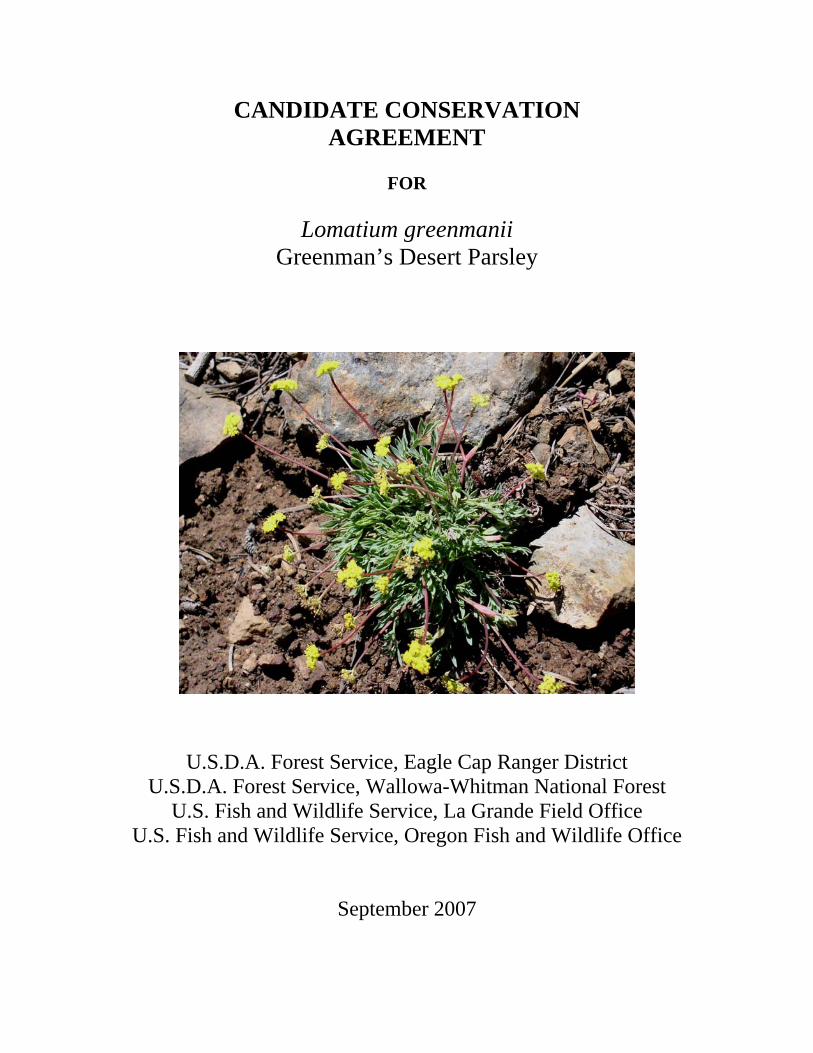
CANDIDATE CONSERVATION AGREEMENT
FOR
Lomatium greenmanii
Greenman’s Desert Parsley
U.S.D.A. Forest Service, Eagle Cap Ranger District U.S.D.A. Forest Service, Wallowa-Whitman National Forest
U.S. Fish and Wildlife Service, La Grande Field Office U.S. Fish and Wildlife Service, Oregon Fish and Wildlife Office
September 2007

ii


iv

v
Table of Contents EXECUTIVE SUMMARY ...............................................................................................1
I. INTRODUCTION .................................................................................................... 1 II. SPECIES INVOLVED ........................................................................................... 2
Lomatium greenmanii (Greenman’s desert parsley)................................................... 2 III. GOALS AND OBJECTIVES ............................................................................... 2 IV. INVOLVED PARTIES/COOPERATORS ......................................................... 3 V. AUTHORITY .......................................................................................................... 3 VI. Lomatium greenmanii DISTRIBUTION AND STATUS ................................... 4 VII. EXISTING CONDITIONS ................................................................................. 6
A. MANAGEMENT HISTORY ............................................................................. 6 1. Management and Conservation Plans ............................................................. 6 2. Studies/Research ................................................................................................ 6 3. Monitoring.......................................................................................................... 7
B. EXISTING AND POTENTIAL THREATS ..................................................... 8 1. Recreation impacts ............................................................................................ 8 2. Natural/manmade threats (grazing, fire, hybridization, disease, etc.) .......... 11 3. Invasive plant introduction and establishment .............................................. 13 4. Forest Service Management Actions.............................................................. 13 5. Operational activities of the Wallowa Lake Tramway................................... 14 6. Monitoring impacts ......................................................................................... 14
C. 1999 CONSERVATION AGREEMENT IMPLEMENTATION ................ 14 VIII. CONSERVATION ACTION ITEMS ............................................................ 14
A. USDA Forest Service Administrative Responsibilities .................................. 14 B. USDA Forest Service Management Responsibilities and Actions Items: .... 15 C. U.S. Fish and Wildlife Service Responsibilities: ............................................ 18
IX. AGREEMENT TERMS...................................................................................... 19 X. LITERATURE CITED......................................................................................... 21 Appendix A. Maps of the three Lomatium greenmanii populations within the Wallowa-Whitman National Forest. Appendix B. Current Status of Conservation Actions for Greenman’s Lomatium (Lomatium greenmanii) defined in the 1999 Conservation Agreement. Appendix C. Associated Species Composition – Lomatium greenmanii. Appendix D. Research, Monitoring and Predictive Habitat Modeling.

1
EXECUTIVE SUMMARY
Implementation of this Candidate Conservation Agreement (CCA) will identify and eliminate, or significantly reduce, threats to the three populations of Lomatium greenmanii and its habitat. Successful implementation of conservation actions should prevent the species from becoming threatened or endangered within the foreseeable future, precluding the need to list under the Endangered Species Act. Specific conservation action items are provided in section VIII of this agreement. The current status of Conservation Actions for L. greenmanii as defined in the 1999 Conservation Agreement is provided in Appendix B. I. INTRODUCTION Lomatium greenmanii (Greenman’s desert parsley) is endemic to subalpine meadows and rocky outcrops in the Wallowa Mountains of northeast Oregon. Currently, there are three documented populations: Mount Howard, Ruby Peak and Redmont Peak. All three occur within the Eagle Cap Ranger District of the Wallowa Whitman National Forest (WWNF). The largest population, consisting of several subpopulations, is found at the summit of Mount Howard and vicinity. Mount Howard is easily accessible by a recreational tram facility (Wallowa Lake Tramway) that transports over 30,000 visitors per year to the summit of Mount Howard. In addition to the tram facilities, numerous trails have been developed within habitat occupied by the species. Due to its extreme rarity and accessibility to humans, L. greenmanii is vulnerable to threats from recreational activities including trampling from hikers and operations of the Wallowa Lake Tramway. Lomatium greenmanii is a former Federal Candidate Species and is currently considered a Species of Concern by the U.S. Fish and Wildlife Service. L. greenmanii is listed as endangered by the State of Oregon and is a Forest Service sensitive species. In addition, L. greenmanii is ranked as a G1/S1 species (critically imperiled) by NatureServe (NatureServe 2006). In 1999, the WWNF developed a Conservation Strategy to address threats and to recommend conservation actions that would protect the Lomatium greenmanii populations on Mount Howard and Ruby Peak. In the same year, the U.S. Fish and Wildlife Service and the U.S.D.A. Forest Service signed a Conservation Agreement for L. greenmanii to implement those actions. The original Conservation Agreement expired on September 23, 2004. The L. greenmanii population on Redmont Peak was not discovered until the summer of 2000 and therefore, was not included in the Conservation Strategy or original Conservation Agreement. The primary purpose of this CCA is to ensure the long-term conservation of Lomatium greenmanii through implementation of conservation actions and minimization of threats through an adaptive management process. This CCA promotes the implementation of the conservation action items identified in the Conservation Strategy for Greenman’s desert parsley (Lomatium greenmanii) (WWNF 1999). In addition, conservation action items have been developed for threats not previously identified in the former agreement and for
2
the protection of the recently discovered Redmont Peak population. This agreement will focus on actions to protect and enhance habitat for Lomatium greenmanii and identifies the commitments of the U.S.D.A. Forest Service and the U.S. Fish and Wildlife Service to ensure the long-term conservation of L. greenmanii. II. SPECIES INVOLVED Lomatium greenmanii (Greenman’s desert parsley) Lomatium greenmanii is a member of the parsley family (Apiaceae). The plant was first collected by William C. Cusick on August 4, 1900, from the “head of Keystone Creek, 9000 ft, in the Wallowa Mountains of northeastern Oregon. Cusick’s collection, which serves as the type specimen, was described as L. greenmanii in 1938 in a monographic study of the genus (Mathias 1938). The species was known only from the type locality when described. Keystone Creek is an Oregon place name not found on current maps and efforts to determine the type locality have not been successful. Lomatium greenmanii is a low-growing perennial herb ranging from 3 to 10 centimeters (1 to 4 inches) in height. Plants produce several glabrous, bright green, pinnately dissected leaves. Numerous small, bright yellow flowers are clustered in compound umbels at the ends of flowering stems. Fruits are schizocarps, initially green, drying brown and approximately 0.5 centimeters (0.2 inches) in length. Lomatium greenmanii occurs between approximately 2,365 and 2,620 meters (7,759 to 8,596 feet) in the Wallowa Mountains of northeast Oregon (Wallowa County). The subalpine habitats occupied by this species consist of meadows or rocky outcroppings dotted with islands of Abies lasiocarpa-Pinus albicaulis (subalpine fir-whitebark pine). In addition, sympatric species include a heterogeneous mix of boreal, northwest regional and locally endemic species of perennial herbs, mosses and lichens (see Appendix C). III. GOALS AND OBJECTIVES The goal of this Conservation Agreement is to attain the long-term conservation of Lomatium greenmanii with proactive management of the species and the habitat upon which it depends and to implement actions that ensure the long-term viability of the species. The primary conservation and management objectives for L. greenmanii follow.
1. Protect the three known populations and occupied habitat of Lomatium greenmanii to maintain its current geographic range.
2. Maintain the biological and ecological integrity of the Lomatium greenmanii
populations and promote the long-term viability of these populations on the Wallowa-Whitman National Forest.

3
3. Gain additional biological and ecological information pertaining to Lomatium greenmanii through monitoring and research to determine whether conservation measures taken on behalf of the species are maintaining population trends and viability.
4. Continue to develop new interpretive opportunities to educate the public, user
groups, forest personnel, and permittees on the uniqueness of Lomatium greenmanii and the importance of its conservation.
5. Survey high potential habitat to determine existence of additional populations of
Lomatium greenmanii. Develop measures to protect newly discovered populations.
6. Work with the Wallowa Lake Tramway to implement measures that would reduce
or eliminate impacts to populations of Lomatium greenmanii. IV. INVOLVED PARTIES/COOPERATORS U.S. Forest Service U.S. Forest Service Wallowa-Whitman National Forest HCNRA/Eagle Cap District, WWNF P.O. Box 907 88401 Highway 82 Baker City, Oregon 97814 Enterprise, Oregon 97828 541-523-6391 541-426-4978 U.S. Fish and Wildlife Service U.S. Fish and Wildlife Service Oregon Fish and Wildlife Office La Grande Field Office 2600 S.E. 98th Ave 3502 Highway 30 Portland, Oregon 97266 La Grande, Oregon 97850 503-231-6179 541-962-8584 V. AUTHORITY
The authority for this Agreement rests with the U.S.D.A. Forest Service and the U.S. Fish and Wildlife Service pursuant to the Endangered Species Act of 1973, as amended (ESA) and the National Forest Management Act (1976). The National Forest Management Act (NFMA) and U.S.D.A. Forest Service policy direct Forest Service to manage "habitats for all existing native and desired nonnative plants, fish, and wildlife species in order to maintain at least viable populations of such species" and to avoid actions "which may cause a species to become threatened or endangered." (FSM 2670.12.) In addition to those species listed as threatened or endangered under the ESA, or that are candidates for such listing, the U.S.D.A. Forest Service has recognized the need to implement special management direction for other rare species on the lands it administers. The Regional Forester may designate these species “sensitive.” The
4
objectives of management for such species are to ensure their continued viability throughout their range on National Forest lands and to ensure that they do not become threatened or endangered because of Forest Service actions (Forest Service Manual 2670.22; USFS 1988). Lomatium greenmanii is designated sensitive on the Regional Forester’s Sensitive Species List, Pacific Northwest Region. VI. Lomatium greenmanii DISTRIBUTION AND STATUS Currently, Lomatium greenmanii is known from only three locations in the Wallowa Mountains. All three populations are within the boundaries of the WWNF (Appendix A, Map 1). The largest population is comprised of several subpopulations on Mount Howard and vicinity (Appendix A, Map 2), followed by populations on Ruby Peak (Appendix A, Map 3) and Redmont Peak (Appendix A, Map 4). Both the Ruby Peak and Redmont Peak populations are located in the Eagle Cap Wilderness. After the initial discovery of Lomatium greenmanii in 1900, the species was not observed until 1975, when Ruth Hansen (Native Plant Society of Oregon member) discovered it on Mount Howard (WWNF 1999). It has since been well documented there and surveys of the surrounding area have extended the population to include the first saddle southeast of Mount Howard’s Summit Overlook along the trail to East Peak, Hidden Peak and Aneroid Mountain. The population of L. greenmanii located on Mount Howard and vicinity includes several thousand plants. The area occupied by these plants is approximately 225.05 hectares (ha) (556.1 acres (ac)) with an elevational range of 2,365 to 2,576 meters (m) (7,759 to 8,451 feet (ft)). Ruby Peak, which is located approximately 16 kilometers (10 miles) by air northwest of Mount Howard, has the second largest population of Lomatium greenmanii. The Ruby Peak population was discovered in 1984. The population is distributed on the saddle just west of Ruby Peak, between Ruby Peak and Murray Gap and along the ridgeline extending east toward the summit of Ruby Peak. Elevation ranges from 2,529 to 2,620 m (8,297 to 8596 ft). The population occupies an area of 15.97 ha (39.47 ac). Redmont Peak, with a population discovered in 2000, is located approximately 6.5 kilometers (4 miles) southeast from Mount Howard. The population is located east northeast of Redmont Peak at an elevation of 2,469 to 2,541 m (8,100 to 8,337 ft). This is the smallest and most cohesive population occupying an area of 2.39 ha (5.9 ac).

5
Table 1. Range of values for characteristics of known Lomatium greenmanii populations Locality Precipitation
Range Elevation Range
Aspect Range
Slope Range Geology Total Area Occupied
Mt. Howard 119–135 cm (47-53 in)
2365-2576 m 7759-8451 ft
7.14-334.5o 2.93-17.5 o TRv 225.05 ha 556.1 ac
Ruby Peak 99–104 cm (39-41 in)
2529-2620 m 8297-8596 ft
45.45-327.8 o
45.45-327.8 o Tc 15.97 ha 39.47 ac
Redmont 140–145 cm (55-57 in)
2469-2541 m 8100-8337 ft
2.59-56.1 o 12.55-17.5 o Tcg 2.39 ha 5.9 ac
TRv: Volcanic and metavolcanic rock from upper Triassic and ultramafic and mafic intrusive rocks and serpentinized equivalents from Triassic and Paleozoic. Tc: Columbia River Basalt Group and related flows from the Miocene Tcg: Grande Ronde Columbia River Basalt Group Several areas of the Wallowas have been surveyed for the presence of Lomatium greenmanii, including the East Peak saddle area from Mount Howard to Aneroid Mountain, areas within the vicinity of Mount Howard, areas within the vicinity of Ruby Peak, ridgeline to Mt. Joseph, Hurwal Divide, ridgeline to Bonneville Mountain, trail from Mirror Lake to Minam Lake, Tenderfoot Pass, Sheep Ridge, Wing Ridge, Traverse Ridge, and the ridge of Huckleberry Mountain to Goat Mountain. The search of Wing Ridge led to the discovery of the Redmont Peak population in 2000. Habitat for Lomatium greenmanii is characterized by exposed slopes and open summits, areas where the duration of snow is less than that of adjacent sites. It has been found on all aspects and slopes. Aspect data reveal ranges from 2.50 to 356.10 degrees. Populations have been documented on slopes ranging from 2.93 to 23.47 degrees. Associated species include bunch grasses and low perennial forbs (Appendix C). The altitude of the known populations ranges from 2,365 to 2,620 m (7,759 to 8,596 ft). All known populations of Lomatium greenmanii occur on soils derived from specific geologic types. These include volcanic and metavolcanic rock from the upper Triassic, ultramafic and mafic intrusive rocks and serpentinized equivalents from the Triassic and Paleozoic (Mount Howard and vicinity), Grande Ronde Columbia River Basalt Group (Redmont Peak) and Columbia River Basalt Group and related flows from the Miocene (Ruby Peak). Taubeneck (letter January 8, 1999) suggests that undiscovered populations may occur on Imnaha basalt, as the chemistry of the two basalt types and greenstone are similar. Plants occur mostly in open areas, with rocks ranging from small, gravel sized particles to larger, shale-like pieces. The habitat resembles alpine tundra, with dwarfed plants and exposed rocks (WWNF 1999). Some plants have been found within small openings and along edges of Pinus albicaulis (whitebark pine) galleries.

6
VII. EXISTING CONDITIONS A. MANAGEMENT HISTORY
1. Management and Conservation Plans In 1988, Jimmy Kagan developed the first Species Management Guide for Lomatium greenmanii (Kagan 1988). This management guide provided current information on the range, distribution and habitat requirements of the species. In addition, the management guide identified management practices consistent with the species’ needs, including the identification of essential monitoring needs. In 1989, Meinke and Kagan wrote the first status report for L. greenmanii. In 1999, the WWNF developed the first conservation strategy for L. greenmanii, which included a conservation assessment (WWNF 1999). The conservation strategy was developed to ensure the survival of the species on National Forest System Lands by implementing the conservation actions identified by the plan (WWNF 1999). Following the development of the conservation strategy, the U.S. Fish and Wildlife Service and the U.S.D.A. Forest Service signed a conservation agreement to implement those actions. The agreement outlined 15 conservation action items that the WWNF would undertake to further conservation of L. greenmanii. The 1999 conservation agreement expired on September 23, 2004. Appendix B provides a status report of the ongoing and completed conservation action items as outlined in the 1999 conservation agreement (USFWS 1999).
2. Studies/Research a) Morphologic and Molecular Studies Joanna Schultz, in collaboration with the WWNF, initiated a morphologic and molecular study to determine phylogenetic relationships between Lomatium greenmanii and other members of the genus, particularly that of L. oreganum (thought to be closely related to L. greenmanii). The morphologic study generated data from three populations of L. greenmanii (Mount Howard, Ruby Peak and Redmont Peak) and two populations of L. oreganum. Results of the morphologic study indicate that L. greenmanii and L. oreganum are significantly different and discrete morphologic characteristics define the species. More importantly, the data demonstrate significant differences exist between the L. greenmanii populations sampled. This indicates that morphologic differentiation is present among populations of L. greenmanii, most likely due to a lack of gene flow among these local populations. This phenomenon is typically observed in models of geographic speciation. Molecular studies were implemented to determine the evolutionary relationship between Lomatium greenmanii and other members of the genus. Species suggested as close relatives to L. greenmanii and other regional Lomatium taxa were included in the analysis. Results of the study determined that the closest relative to L. greenmanii is L. oreganum; both of which are distinct taxonomic entities.

7
A detailed description of the methods, analysis and results from both the morphological and genetic studies can be found in Appendix D. b) Predictive Modeling A predictive model for Lomatium greenmanii was produced to identify additional habitat suitable for the species. Geology, precipitation, slope, aspect and elevation data were obtained from all known localities supporting the species, including Mt. Howard, Ruby Peak and Redmont. By using data from known occurrences of the species, the total ground area to be searched resulted in identifying only areas of the highest probability of additional occurrence. Data were obtained from Inside Idaho and the Oregon Geospatial Clearinghouse. The method used known localities, documented as GPS coordinates, to obtain parameters of distribution. Then using data obtained from the above sites, raster calculator was employed in ARCInfo to produce a binary system. This eliminated the areas not within the desired parameters. The maps of high occurrence probability were projected in Lambert Conformal Conic and the Earth Model was NAD 1983, the Geographical Coordinate System was GCS North American 1983 (See Appendix D).
Areas of high probability of occurrence included additional habitat in the Wallowa Mountains, the Elkhorn Mountains of Oregon, adjacent to the Heath Ranger station in Idaho and in the Seven Devils Mountains of Central Idaho.
3. Monitoring The first monitoring efforts for Lomatium greenmanii were initiated by the Oregon Department of Agriculture (ODA) in 1990. Demographic monitoring was conducted on Mount Howard by ODA until 1997. Data collected from 1990 to 1997 showed a rapid decline in L. greenmanii. Kagan (1999) determined that trampling from recreational hikers on Mount Howard was responsible for the decline. A new sampling method (tape-free nested plot protocol) was initiated in 1997 and continued through 1999. Eight macroplots were established on Mount Howard and one was established on Ruby Peak. Kagan’s (1999) study results revealed “no significant differences” in most macroplots, with the exception of two study sites. Since this method did not incorporate statistical methodology and applied only qualitative assessments, no conclusions could be drawn from these surveys. In addition, the difficulty for other researchers to replicate the sampling method in subsequent years resulted in discontinuing the survey method. No survey data was collected for years 2000 through 2003. In 2004, Joanna Schultz and the WWNF implemented a new survey protocol designed to be highly systematic and replicable. Baseline data was collected in 2004. Eight permanent macroplots were established (seven on Mount Howard, one on Ruby Peak). A macroplot on Redmont Peak was established in 2005. Cover data within the macroplots was collected using the method of Daubenmire (1959). Since only two years of data have

8
been collected, no trend data have been determined. However, statistical methods have been applied to compare baseline cover data among populations and sub-populations. These data suggest no pattern of reduced or increased cover based on qualitatively assigned disturbance regimes (Appendix D). B. EXISTING AND POTENTIAL THREATS Due to its restricted range and specific habitat requirements, Lomatium greenmanii is extremely vulnerable to human disturbance. The existing and potential threats to the known populations of L. greenmanii include: 1. Recreational user impacts 2. Natural threats (grazing, fire, hybridization, disease, etc.) 3. Invasive plant introduction and establishment 4. Forest Service Management Actions (trails maintenance, fuels projects, etc.) 5. Operational activities of the Wallowa Lake Tramway 6. Monitoring impacts These threats are ranked in order, the greatest threat being recreational user impacts and monitoring impacts threat being the lowest.
1. Recreation impacts Visitation and associated trampling The construction of the Wallowa Lake Tramway (Tramway) in 1970 greatly increased visitation to Mount Howard. Currently, Mount Howard receives approximately 30,000 visitors each year. The Tramway operates under a special use permit from the WWNF, and is generally open from Memorial Day weekend through the end of September. During the early years of the Tramway, trails atop Mt. Howard were not well defined. Due to the gentle slopes of the summit of Mount Howard, people were free to traverse virtually anywhere on the mountaintop (WWNF 1999). Over time, as visitor use increased, a trail system developed. Because these trails were not “constructed” by the Forest Service or Tramway operators, they were not necessarily located in the best locations. Although trails became more defined by the 1980’s, these trails were wider, prone to erosion, and plagued with multiple side trails. Ownership of the tramway changed hands in the late 1980’s. Usage of the tramway substantially increased in the 1990’s to the current level of use of 30,000 visitors per year. Trampling has consistently been a major concern for the long-term viability of Lomatium greenmanii. Forest Service presence on Mount Howard was fairly minimal until the late 1990’s. At this time the Forest Service began implementing trail improvement projects, including the construction of rock borders along trail edges, improving drainage throughout the trail network, new trail construction/reconstruction on the Royal Purple Overlook Trail and the placement of signs. While many improvements have been made

9
there remains additional work to be completed. It has been observed that impacts occur during the early spring when visitors go off the trail to get around snow patches, thereby trampling adjacent vegetation. Additionally, when soils are saturated from snow melt and spring rains, they are subject to physical disturbance and erosion. To date these impacts have not been quantifiably studied. The placement of temporary rope fences and signs has helped encourage visitors to remain on the trails. One problem requiring attention is in the area situated between the Summit Overlook and the Highlands Overlook. While walking along this segment of the trail system, hikers can see another trail that leads to East Peak, Hidden Peak and Aneroid Mountain and they will occasionally traverse across Lomatium greenmanii habitat to access this trail. Special-event activities are held on Mount Howard each year. These special-event activities are promoted by the Tramway, but are unregulated by the Forest Service. These special-event activities may include picnics, weddings, reunions, etc. Receptions for weddings are typically held at the base of the Mount Howard at the Edelweiss building. Under the current special-use permit, the Tramway is responsible for managing special-event activities within the boundaries of their permit-use area. For “large groups” the Tramway is required to apply for additional special-use permits, although “large groups” are not defined in the current special-use permit. If areas were designated for special-event activities and “large groups” defined in the special-use permit during the next renewal process, impacts to L. greenmanii and other sensitive subalpine species could be avoided or significantly reduced. Trampling impacts to the Ruby Peak population (saddle below Ruby Peak) have not been observed. Although there is no official trail to Ruby Peak, there is an unofficial trail and it is known to be a somewhat popular and easily accessible peak to climb, too. The Ruby Peak climb is described in a regional hiking guide authored by Fred Barstad (Barstad 1996). The user-defined trail ascends up Murray Gap to the summit of Ruby Peak. Hikers have occasionally been encountered during monitoring trips to Ruby Peak. Trampling impacts to the Redmont Peak populations are thought to be generally low to non-existent. The Redmont Peak population is downslope of the peak and due to its location is not likely accessed by hikers. Hang-gliding/paragliding and associated staging area impacts Hang-gliding and paragliding are relatively new activities on Mount Howard. The staging of both activities occur at the Valley View Overlook (the northern most point of the trail system. This area supports a subpopulation of Lomatium greenmanii (WWNF 1999). Hang-gliders require an area to prepare their equipment for flight. In the late 1990’s, an area was designated for this activity. This area will be referred to as the hang-glider staging area. Leading up to the staging area, there is a patch of L. greenmanii that has been bisected by the Valley View Overlook Trail. Impacts to L. greenmanii at this site by hang-gliders are minimal. The larger threat involves the general public who want

10
to view the hang-gliders and paragliders. There has not been an area designated for viewing and people often wander off-trail into L. greenmanii habitat and trample plants. Model glider flying impacts Model glider flying is relatively new to Mount Howard. It is unclear how often or to what extent this activity occurs. It is known that from June 29 through July 4, Wallowa County hosts the “Alpine Extreme Adventure.” This event is for R/C Model Soaring and Electric powered airplane enthusiasts at locations around Wallowa County. Model gliders have the potential to impact Lomatium greenmanii habitat through their takeoff and landing. Persons flying these model gliders have the potential to impact habitat through trampling while setting up and retrieving their glider. This activity should be monitored for impacts. Off-road vehicles and associated impacts Off-road vehicles (i.e., ATVs, dirt bikes) have the potential to negatively impact habitat and the species itself by driving off designated roadways and/or introducing noxious weeds. Off-road vehicles traveling off designated roads may cause plant mortality and soil disturbance (i.e., ruts in the soil, erosion). In addition, off-road vehicles are known to spread noxious weeds. Mount Howard is easily accessible to off-road vehicles by an access road that is used by the Tramway for their operations. Occasionally, the access road is used by the Forest Service for maintenance and by firefighting personnel in the event of a wildfire. A gate was constructed and has been successful in keeping passenger vehicles from accessing Mount Howard. However, off-road vehicles can simply maneuver around the gate to gain access. This has been documented at least once in 2004 during a site visit by planning team members; tracks were found in a meadow on Mount Howard. Currently, there is a road closure behind the gate that prohibits summertime motorized-use (when snow is less than 12 inches deep). This does not restrict ATVs from using areas off of the road behind the gate since it is only a road closure. Therefore, an area closure should be considered to prevent the degradation of L. greenmanii and other subalpine plant species and their habitats. Winter recreation impacts Under special occasions the Tramway operates during the winter months. Activities on Mount Howard can include cross country skiing on 2.5 miles (4 km) of groomed trails, snowshoeing across the mountain summit and skiing/snowboarding on the wilderness slopes. In addition, snowmobiles have easy access to Mount Howard by traveling the access road to the summit. It is unknown how many snowmobiles use Mount Howard in a given season. The impacts from winter recreation are not well understood. No studies on snow compaction from skiing, snowmobiling, or trail grooming and their impacts on alpine

11
vegetation have been done on Mount Howard. Snow compaction could potentially prolong snowmelt patterns and negatively affect Lomatium greenmanii and other alpine species if a more consistent winter recreation program was implemented. Additionally, when the snow layer gets relatively thin or patchy there is a potential for negative impacts including plant and soil disturbances (i.e., snowmobiles and skiers running over exposed soil and plants). The areas supporting L. greenmanii typically are windswept and support less snow cover. It is possible that areas supporting the species may not be the ideal spot for winter recreation activities. Studies should be conducted to determine the threat level to L. greenmanii from winter recreation impacts. Potential threats to Lomatium greenmanii may occur if the Tramway decides to carry out development of additional winter recreation facilities including the development of ski lifts and trails. Potential direct effects include ground disturbance from heavy equipment and loss of habitat due to the construction of new buildings, ski runs or roads (WWNF 1999). Potential indirect effects include increased trampling from increased visitor use, as well as effects from snow management associated with ski area activities including snowmaking and grooming (WWNF 1999). Snowmaking and grooming have the potential to increase snow depths and prolong snow melt. Fragmentation of habitat is another potential problem associated with tram expansion (WWNF 1999). Horseback riding While thought to be limited, there are occasional horseback riders that will travel the access road to Mount Howard. It is unclear if the horseback riders impact Lomatium greenmanii habitat. Due to the number of visitors walking the trials on Mount Howard horseback riding should be limited to the access road and a staging area set aside for riders wanting to walk the trials or dine at the Summit Grill. Mountain Biking Mountain biking is not currently impacting Lomatium greenmanii habitat. Mountain bikes are restricted to the Tramway service road for the first five miles of the trip before intersecting with cross-country trails. There is no L. greenmanii or habitat for the species from this point downward. The Tramway manager informs all bikers of the restrictions on Mount Howard.
2. Natural/manmade threats (grazing, fire, hybridization, disease, etc.) Herbivory Grazing of the Lomatium greenmanii inflorescence by small mammals, has been observed on Mount Howard during monitoring surveys. Once small mammals consume the inflorescence, L. greenmanii cannot set seed, reducing the fitness of the individual plants and possibly limiting establishment of new plants. While plant and mammal predator-prey interaction on Mount Howard is part of the natural ecosystem, the feeding of these small mammals by the public is not. Food for these mammals (ground squirrels)

12
can be purchased at the Tramway. It is not clear if feeding these mammals is promoting their increased reproductive success (due to larger seed caches) and, therefore, promoting unnaturally high populations. Currently, there is no evidence to suggest an overall reduction in fitness of L. greenmanii due to small mammal grazing, but if future monitoring suggests that small mammals are having an affect on population sizes, then studies should be conducted to determine the extent of those impacts. Mountain goats currently do not pose a threat to any of the three known populations of Lomatium greenmanii. There could be potential threats in the future if the mountain goat populations continue to increase. The Wallowa Mountain goat herd was established with five releases (Joseph Mountain (1 release), Hurricane Creek (3 releases) and Summit Peak (1 release)) (ODFW 2003). The population remained static through the mid 1980’s, never exceeding 45 animals, but with improved kid recruitment and additional releases, the 2003 population estimate for the Wallowa Mountains was 220 goats (ODFW 2004). Dispersal into vacant habitat adjacent to traditional core use areas is occurring throughout the Wallowa Mountains (ODFW 2003). It is not known if other wild ungulates such as deer, elk or bighorn sheep pose any potential impacts such as grazing, trampling, wallowing or bedding to Lomatium greenmanii.
Fire suppression/natural succession It is currently unknown if fire suppression efforts have changed the natural succession patterns on Mount Howard. Fire suppression over the last 100 years may have allowed the expansion of shrubs and trees into the open subalpine habitat. Fire disturbance is a key process. The suppression of fire has profound effects, from altered species distributions and population viability to modified spatial patterns of habitat types and seral stages across a landscape (Cole and Landres 1996). Lomatium greenmanii grows on exposed slopes and open summits, interspersed with patches of whitebark pine (Pinus albicaulis) and subalpine fir (Abies lasiocarpa). The normal fire history in the whitebark pine habitat type predicts infrequent, low intensity fires (Agee 1993). It is more difficult to discern fire suppression impacts in ecosystems with low-frequency fire regimes (100-300 years) because these systems are likely still within the bounds of natural variation (Cole and Landres 1996). Therefore, fire suppression may not be an important factor on Mount Howard (WWNF 1999). L. greenmanii has been observed growing and reproducing in the shade of conifers. Disease Currently, there are no diseases known to affect Lomatium greenmanii. Since L. greenmanii has such a narrow distribution, a disease outbreak could impact the species to a greater extent than would such an outbreak to a wide-ranging species.

13
3. Invasive plant introduction and establishment Invasion of non-native species and disturbance species into Lomatium greenmanii habitat could pose a serious threat to the species viability. Impacts of non-native species range in severity from merely coexisting within the extant community, to displacing rare or common species and disrupting ecosystem functions (Cole and Landres 1996). Competition from invasive, non-native species can result in the loss of habitat, loss of pollinators, species composition conversion, decreased vegetation integrity, and loss or decline of threatened, endangered, proposed or candidate species viability. According to the Nature Conservancy, alien species are one of the leading threats to U.S. species and ecosystems. Indeed, non-natives have contributed to the decline of 42 percent of U.S. threatened and endangered species (Stein and Flack 1996). The only invasive plant documented on Mount Howard is Canada thistle (Cirsium arvense) located near the upper tram building, which has been treated with herbicides and hand pulling (WWNF 1999). The site is monitored by the Tramway manager so if any new plants emerge they are immediately hand-pulled. Currently, there are no known noxious weeds at the Ruby Peak and Redmont Peak populations. Mount Howard is most susceptible to invasive plant invasion due to the Tramway access road and high visitor use. Therefore, Mount Howard is surveyed on a regular basis for invasive plant invasions.
4. Forest Service Management Actions
Forest Service management actions having potential to impact Lomatium greenmanii include trail maintenance activities, fuel reduction projects, fire suppression activities and administration of special use permits other than the tramway. Trail maintenance activities have the potential to cause short- to long-term localized impacts to Lomatium greenmanii. These may include trampling by trail workers or direct impacts from relocation of trail segments. The Mount Howard Fuels Reduction Project aims to reduce fire threat to the community of Wallowa Lake. Potential impacts to Lomatium greenmanii may include scorching from the prescribed fire, emergency suppression actions if the prescribed fire escapes the fire boundaries, construction of fire lines and access to work sites by workers and equipment. Some individuals of L. greenmanii could be impacted by these actions. In the past, Mount Howard has been used as an access point for fire suppression actions in the surrounding vicinity (WWNF 1999). Fire suppression activities could impact L. greenmanii plants and habitat by trampling, as crews access a fire area; construction of fire line; driving vehicles off of the service road; establishing a fire camp; and using Mount Howard as a helicopter landing spot or a supply drop spot. In the 1999 Conservation Strategy for Greenman’s Desert Parsley (WWNF 1999), one of the specific conservation actions was to write a pre-attack and prescribed fire plan for Mount

14
Howard. This plan was to outline where fire crews and equipment could be safely staged and provide a strategy for managing fires in the area. This plan has not been completed.
5. Operational activities of the Wallowa Lake Tramway
Operational activities of the Wallowa Lake Tramway are defined as access via the service road, general facility maintenance and limited construction activities. There is potential for inadvertent impacts to Lomatium greenmanii from vehicles or machinery driving off the service road or trails. Impacts from these activities have occurred in the past. Future development by the Wallowa Lake Tramway could result in irreversible impacts to L. greenmanii. Any additional development by the Wallowa Lake Tramway should be coordinated with the Forest Service in a planning process that incorporates conservation needs for L. greenmanii.
6. Monitoring impacts
Monitoring of Lomatium greenmanii may have potential impacts to the species from trampling. Current sampling techniques include setting up a plot system using stakes and string. This involves walking within L. greenmanii habitat where trampling is likely to occur. Sometimes the monitoring itself draws attention from visitors who then walk over to observe and inquire about the activity. Surveyors make every attempt not to step on individual plants but some trampling does occur. Monitoring by the plot method or visual observation could impact some individuals. Since monitoring only occurs once or twice per year, it is not expected to cause mortality or long-term downward trends in the population. C. 1999 CONSERVATION AGREEMENT IMPLEMENTATION The 15 conservation action items outlined for implementation by the Forest Service in the 1999 Conservation Agreement, their status and effect of implementation are summarized in Appendix B. All conservation actions were either completed or are currently ongoing. The success of implementation, effectiveness of action items and need for change were considered in designing the new action items presented in this Agreement. VIII. CONSERVATION ACTION ITEMS A. USDA Forest Service Administrative Responsibilities
1. Assume primary responsibility for implementation of specific conservation actions to protect known occupied habitat for Lomatium greenmanii and ensure that the population remains viable on National Forest Lands.
2. Complete National Environmental Policy Act (NEPA) analysis for
implementation of proposed projects outside of permitted activities in occupied habitat for the protection and maintenance of Lomatium greenmanii population
15
viability and habitat. Involve the U.S. Fish and Wildlife Service and appropriate State agencies as cooperators or partners throughout the NEPA process for all projects likely to affect habitat.
3. Work with the Wallowa Lake Tramway permittee to ensure that all activities
associated with tram operations (including maintenance and associated recreational use) do not adversely affect Lomatium greenmanii habitat. The special use permit will be reviewed and modified to include specific standards and guidelines for L. greenmanii.
4. Coordinate with U.S. Fish and Wildlife Service, Dr. Joanna Schultz, Wallowa
Lake Tramway, permittees, interested parties, and the public on the conservation of Lomatium greenmanii.
B. USDA Forest Service Management Responsibilities and Actions Items: Ongoing General Conservation Actions:
5. Identify which subpopulations or core conservation areas of Lomatium greenmanii on Mount Howard are essential to the viability of the species. Eliminate human impacts or limit to minor disturbance (e.g., trail maintenance work) so not to effect patches essential to the species conservation.
6. Maintain and increase the number of interpretive signs and brochures on Mount
Howard. Continue education and interpretive program to increase awareness of the unique habitat, special plant species, sub-alpine communities, non-native plants and conservation measures of the summit area.
7. Continue trail improvement projects on Mount Howard. These improvements
projects may include trail reconstruction, lining trails with rocks to better define their edges, water drainage, slope reduction, etc. Implement seasonal trail closures as needed.
8. Issue new or modify existing special use permits incorporating applicable terms
and conditions in accordance with conservation measures outlined in this agreement.
Survey, Monitoring and Research
9. Use the Lomatium greenmanii suitable habitat predictive model (developed by
Joanna Schultz/Jeff Mathews in 2005) to survey potential habitat for L. greenmanii populations. All positive and negative survey data will be submitted to the Oregon Natural Heritage Program (ONHP) for inclusion in their database. If L. greenmanii is discovered in Idaho (i.e., Seven Devils Mountain Range); that data shall be submitted to the Idaho Conservation Data Center (ICDA).
16
10. Monitor Lomatium greenmanii populations using percent cover as an indicator
based on the method of Daubenmire (1959) at least every other year following for the duration of this agreement (2017). Use monitoring data to determine the effectiveness of Conservation Agreement actions taken on behalf of the species towards sustaining populations. Provide annual monitoring reports to U.S. Fish and Wildlife Service.
11. Continue to assess threats and use adaptive management to address and
minimize impacts.
12. Support funding, to the extent practical, of studies and scientific research specific to the biology and ecology of Lomatium greenmanii.
13. Continue cooperation with Berry Botanic Garden and the U.S. Fish and Wildlife
Service to maintain off-site seed storage program. Collect seed from the Redmont Peak population and any new populations that may be discovered. Collect additional seed from the Mount Howard and Ruby Peak populations.
Non-native plant introduction:
14. Monitor Lomatium greenmanii occupied habitat and adjacent habitat for invasive plants. Control invasive plants in Lomatium greenmanii populations. Spraying in or near populations of L. greenmanii should be evaluated on a site-specific and herbicide dependent basis prior to application to alleviate negative impact to the species and its potential pollinators and non-target, native vegetation. Continue to monitor and treat as needed the Canada thistle (Cirsium arvense) site.
15. Monitor the access road to Mount Howard to detect invasive plants, and treat as
needed.
16. Coordinate with special use permittees (e.g., Tramway), the public and user groups to reduce the risk of invasion of non-native plants and noxious weeds.
Recreational Impacts:
17. Reduce trampling of Lomatium greenmanii on Mount Howard by educating and informing the public on the importance of remaining on trails and implementing trail improvement projects.
18. Reduce impacts from hang-gliding/paragliding and public viewing to Lomatium
greenmanii and its habitat through education, improvements to the launch site and the placement of signs for the staging area and public viewing area.

17
19. Work with the Wallowa Lake Tramway to designate areas on Mount Howard that would have minimal to no impact on Lomatium greenmanii and other subalpine species for recreational and other special-event activities (e.g., picnics, weddings, reunions, etc.). Develop a map that incorporates these designated areas for future reference. Encourage the Tramway to brief large groups on the importance of visitors to remain on trails and within designated use areas.
20. Evaluate current winter use (skiing, snowshoeing). Use trail marking and
permit management to minimize impacts to Lomatium greenmanii habitat. Work with the Wallowa Lake Tramway to designate a winter recreation route.
21. Evaluate snowmobile use on Mount Howard. Incorporate National Travel
Management Policy (USDA Forest Service 2005b) into management decisions.
22. Implement management regulations for OHV use on Mount Howard. Consider implementing an area closure for motorized vehicle use on Mount Howard and vicinity during the spring/summer season or consider a permanent closure of the area.
23. Continue to limit mountain bike use to designated trails and the access road
within Lomatium greenmanii habitat and/or other sensitive subalpine meadow habitat.
24. Evaluate effects from model glider flying on Mount Howard. Determine what
areas are being used and if this activity is impacting Lomatium greenmanii.
25. Evaluate stock use on Mount Howard. Designate trails (access road) and staging areas to leave stock that is outside of Lomatium greenmanii habitat or other sensitive subalpine meadow habitat.
26. If new recreational impacts are detected or reported, use adaptive management
and educational outreach to offset impacts and minimize threats to Lomatium greenmanii and its habitat.
Natural Threats:
27. If future monitoring suggests that small mammals are having an effect on population sizes, then studies should be conducted to determine the extent of those impacts.
28. Ensure that the agency botanist (or qualified representative) be involved in the
Wildland Fire Situation Analysis (WFSA) process for fires on Mount Howard, Ruby Peak and Redmont Peak. Decisions for fire management resources (such as retardant, staging areas, helipads) should be made in coordination with a Resource Advisor with knowledge of the extent of the Lomatium greenmanii

18
population at hand. Develop special fire suppression and rehabilitation standards.
29. Ensure that the wildfire suppression resource advisor and the Burned Area
Emergency Response (BAER) Team coordinate with the agency botanist prior to any decision for actions within Lomatium greenmanii habitat.
30. Develop a pre-attack and prescribed fire (or Wildland Fire Use) plan for Mount
Howard. These plans will outline where crews and equipment can safely be staged, a strategy for managing fires in the area and a plan for prescribed fire to reduce tree cover if it is deemed necessary.
Oversight and Reporting
31. Establish an oversight technical committee to review the Conservation Assessment and Strategy and to determine the effectiveness of the conservation measures and implementation. Members of this technical team could include USDA Forest Service personnel, U.S. Fish and Wildlife Service personnel, Oregon Natural Heritage Program personnel, academic institutions, Wallowa Lake Tramway and all other interested parties.
32. Ensure that the oversight technical team meets yearly to review this CCA to
determine the effectiveness of the action items and conservation measures being implemented. Results from implementation and effectiveness monitoring will be examined. The technical team will provide input to the Line Officer for change in action items, priorities or land management practices.
33. Provide an annual report on the success of implementation of this CCA to the
U.S. Fish and Wildlife Service. Summarize implementation of measures and their effectiveness and/or outline changes or improvements where needed.
C. U.S. Fish and Wildlife Service Responsibilities:
34. Continue to assess the status of Lomatium greenmanii and determine appropriate conservation status under the Endangered Species Act.
35. Partner with the Forest Service and others to provide cost-share; pursue and
secure funding for Lomatium greenmanii conservation actions.
36. Provide support and technical assistance to the annual Lomatium greenmanii monitoring efforts.
37. Request and review annual reports from the Forest Service that summarize
annual monitoring results as well as the conservation actions implemented each year.

19
38. Participate in annual meetings with the Forest Service to review and revise, if necessary, implementation of the CCA.
39. One year before the CCA expires, work with the Forest Service to revise and
renew conservation efforts, which may include a new Conservation Agreement.
40. Work with the Forest Service and other interested parties to develop studies and research projects that further the implementation of the CCA.
41. Work with the Forest Service and others to address the threats Lomatium
greenmanii faces through implementing conservation actions outlined in this CCA.
42. Work with the Forest Service and others to develop and implement, through
adaptive management, new conservation strategies so that new or changing threats to Lomatium greenmanii are addressed.
43. Coordinate with the U.S.D.A. Forest Service, Wallowa Lake Tramway, Dr.
Joanna Schultz, other interested parties and the public concerning the conservation of Lomatium greenmanii.
IX. AGREEMENT TERMS This agreement shall become effective at the date of the last signature and will remain in effect for 10 years. It may be terminated in writing at any time the Wallowa-Whitman National Forest or the U.S. Fish and Wildlife Service authorized officers/individuals determine that it is no longer necessary. This agreement will be reviewed and amended as needed. The cooperators shall use appropriate procedures to ensure adherence to all legal requirements in analyzing changes and establishing new management direction for habitat conservation. When appropriate, this will include amendment or revision of Forest Plan or changes to the cooperators directive systems. These amendments and/or changes, in addition to a signed CCA, will provide a basis for and commitment to the new direction. IT IS MUTALLY AGREED AND UNDERSTOOD BY ALL PARTIES THAT:
1. FREEDOM OF INFORMATION ACT (FOIA). Any information furnished to the U.S.D.A. Forest Service under this CCA is subject to the Freedom of Information Act (5 U.S.C. 552).
2. PARTICIPATION IN SIMILAR ACTIVITIES. This CCA in no way restricts
any party from participating in similar activities with other public or private agencies, organizations and individuals.

20
3. RESPONSIBILITIES OF PARTIES. The U.S.D.A. Forest Service and other parties and their respective agencies and office will handle their own activities and utilize their own resources, including the expenditure of their own funds, in pursuing this CCA. Each party will carry out its separate activities in a coordinated and mutually beneficial manner.
4. PRINCIPAL CONTACTS. The principle contacts for this instrument are:
U.S.D.A. Forest Service Contact USFWS Contact
Jerry Hustafa, Botanist Gretchen Sausen Wallowa Valley Ranger District US Fish and Wildlife Service 88401 Highway 82 La Grande Field Office Enterprise, Oregon 97828 3502 Highway 30 Phone: 541-426-5576 La Grande, Oregon 97850 Fax: 541-426-5522 Phone: 541-962-8584 Fax: 541-962-8581
5. NON-FUND OBLIGATING DOCUMENT. This CCA is neither a fiscal nor a
funds obligation document. Any endeavor or transfer of anything of value involving reimbursement or contribution of funds between the parties to this instrument will be handled in accordance with applicable laws, regulations and procedures including those for Government procurement and printing. Such endeavors will be outlined in separate agreements that shall be made in writing by representatives of the parties and shall be independently authorized by appropriate statutory authority. This instrument does not provide such authority. Specifically, this instrument does not establish authority for noncompetitive award to the cooperator of any contract or other agreement. Any contract or agreement for training or other services must fully comply with all applicable requirements for competition.
6. ESTABLISHMENT OF RESPONSIBILITY. This CCA is not intended to and
does not create, any right, benefit or trust responsibility, substantive or procedural, enforceable at law or equity, by a party against the United States, its agencies, its officers or any person.
7. COMMENCEMENT/EXPIRATION/TERMINATION. This CCA is executed as
of the date of the last signature and will remain in effect for 10 years from the date of the last signature. This CCA may be extended or amended by mutual consent of the parties, by the issuance of a written modification, signed and dated by all parties, prior to any changes being performed. Any party, in writing, may terminate their participation in this CCA in whole, or in part, at any time before the date of expiration.

21
X. LITERATURE CITED. Agee, James K. 1993. Fire Ecology of Pacific Northwest Forests. Island Press,
Washington, DC. 493 pp. Barstad, Fred. 1996. Hiking Oregon’s Eagle Cap Wilderness (Regional Hiking Series).
Guilford: The Globe Pequot Press. 312 pp. Cole, David N., and Peter B. Landres. 1996. Threats to Wilderness Ecosystems: Impacts
and Research Needs. Ecological Applications, Vol. 6 No. 1. pp. 168-184. Daubenmire. R. F. 1959. 1959. A canopy coverage method of vegetation analysis.
Northwest Science. 33: 42-64. Kagan, J. S. 1988. Draft Species Management Guide for Lomatium greenmanii. Oregon
Natural Heritage Database. Unpublished report on file at Wallowa-Whitman National Forest.
Kagan, J. S. 1999. Lomatium greenmanii Monitoring Final Report. Oregon Natural
Heritage Program and The Nature Conservancy, September 1999. 7 pp. Mathias, M.E. 1938. A Revision of the Genus Lomatium. Annals of the Missouri
Botanical Garden. 25:274-275 Meinke, R. J. and J. S. Kagan. 1989. Status report for Lomatium greenmanii.
Unpublished report on file at Wallowa-Whitman National Forest Supervisor’s office.
NatureServe. 2006. NatureServe Explorer: An online encyclopedia of life [web
application]. Version 4.7. NatureServe, Arlington, Virginia. Available http://www.natureserve.org/explorer. (Accessed: March 29, 2006 ).
Oregon Department of Fish and Wildlife. 2004. Big Game Statistics: Rocky Mountain
Goats. Portland, Oregon, USA. Oregon Department of Fish and Wildlife. 2003. Oregon’s Bighorn Sheep and Rocky
Mountain Goat Management Plan. Portland, Oregon, USA. Stein, B.A. and Flack, S.R., eds. 1996. America’s Least Wanted: Alien Species
Invasions of U.S. Ecosystems. The Nature Conservancy. Taubeneck, Dr. William. January 8, 1999. Letter discussing geology of known sites and
areas of high potential habitat for Lomatium greenmanii based on rock types. Professor emeritus of geology at Oregon State University.

22
USDA Forest Service. 2005a. Final Environmental Impact Statement, Record of Decision: Pacific Northwest Region Invasive Plant Program; Preventing and Managing Invasive Plants. Pacific Northwest Region.
USDA Forest Service. 2005b. Travel Management; Designated Routes and Areas for
Motor Vehicle Use; 36 CFR Parts 212, 251, 261, and 295. Federal Register, Vol. 70, No. 216, Wednesday, November 9, 2005, Rules and Regulations
USDA Forest Service. 1988. National Forest Resource Management, Forest Service
Manual 2670: Threatened, Endangered and Sensitive Plants and Animals. U.S. Fish and Wildlife Service. 1999. Conservation Agreement: Lomatium greenmanii
(Greenman’s Desert Parsley). Unpublished document on file at the La Grande Field Office, La Grande, Oregon.
Wallowa-Whitman National Forest. 1990. Land and Resource Management Plan.
Wallowa-Whitman National Forest. USDA, Forest Service, Pacific Northwest Region.
Wallowa-Whitman National Forest. 1999. Conservation Strategy for Greenman’s desert
parsley (Lomatium greenmanii). Wallowa-Whitman National Forest. USDA, Forest Service, Pacific Northwest Region.