Embed Size (px)
Citation preview
COMINCO LTD.
CANADIAN EXPLORATION
ASSESSMENT REPORT
1998 PROSPECTING, GEOLOGICAL MAPPING AND GEOCHEMICAL SURVEYING
on the
I OXIDE PROPERTY
I CLAIMS: HOT OX 1, HOT OX 2, OXGOLD 1, OXIDE (324446)
1, OXIDE (357457), SULFIDE, PORT 15-55
OSCAR CREEKIPORCUPINE CREEK AREA \
NELSON MINING DIVISION, BRITISH COLUMBIA
,fl, NTS MAP: 82 Fl6E
LATITUDE: 49“ 15’ LONGITUDE: 117’ 09’
WORK PERFORMED: JUNE 3, 199s -AUGUST 25, 1998
OWNER/OPERATOR: UNDER OPTION FROM:
COMJNCO LTD. LLOYD ADDIE 700-409 GRANVILLE ST. ROBERT BOURDON VANCOUVER, BC, V6C lT2 1102 GORDON ROAD
A-801, NELSON, BC, VlL 3M4
DATE SUBMITTED: OCTOBER 5,199s
REPORT AUTHORS: N.P.M. O’BRIEN C.J. REID
”
TABLEOFCONTENTS
1.0 2.0 3.0 4.0 5.0 6.0 7.0 8.0
9.0
Introduction Location and Access Tenure Physical Geography History of Work Regional Geology Local Geology Results and Discussion
8.1 Prospecting and Geological Mapping 8.2 Geochemistry
Conclusions 10.0 Selected References 11.0 Cost Summary Approval Release Co-Authors’ Qualifications
Appendix 1 1997 Rock Geochemical Data Appendix 2 1998 Soil/Silt Geochemical Data
P.1 P.1 P.3 P.3 P.3 P.5 p.6 P.7 P.7 p.10 p.11 p.12 p.13 p.13 p.14-15
-.
LIST OF FIGURES AND PLATES
h
Figure 1. Property Location Map P.2 Figure 2. Property Tenure Map P.4
Plate 1. Geology and Rock Sample Location Map(l:5000) Plate 2. Soil/Stream Sediment Sample Location Map(l:2500) Plate 3. Zn (ppm) Soil/Stream Sediment Geochemistry (1:2500) Plate 4. Pb (ppm) Soil/Stream Sediment Geochemistry (1:2500)
map pocket map pocket map pocket map pocket
.-,
f-,
COMINCO LTD. CANADIAN EXPLORATION
A PROSPECTING, GEOLOGICAL, GEOCHEMICAL AND GEOPHYSICAL REPORT
on the OXIDE PROPERTY
NELSON MINING DIVISION, BRITISH COLUMBIA
- ASSESSMENT REPORT -
1.0 INTRODUCTION
Between June 3 and August 25, 1998, a prospecting, geological and geochemical program was carried out on the Oxide property by Cominco Ltd. under the supervision and direction of exploration geologtst, N.P.M. O’Brien. The program consisted of examining known mineralized showings, prospecting for new showings, line-cutting an exploration grid, geochemical soil and stream sediment sampling, and geological mapping. The purpose of the work was to identify indications of economic carbonate- hosted Zn-Pb mineralization in lower Cambrian rocks.
This report describes the work done on the Oxide property, discusses the results of this work and presents conclusions. The purpose of the report is to substantiate the program work which has been granted assessment credits, thereby tXiiling the requirements of the Mineral Tenure Act.
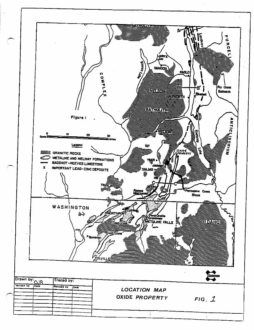
2.0 LOCATION AND ACCESS
NTS: 82 F/6E Latitude: 49’ IS’ Longitude: 117O 09’
The Oxide property is located in the Nelson Mining Division, approximately 6 km east of Ymir, BC near Jubilee Mountain on the divide between Oscar and Porcupine Creeks (Figure 1). The property can be reached from either 1) the Porcupine Creek side, by driving approximately 6 km east from Hwy. 6 along the Porcupine Creek road and walking to the north up an old swithback mine road which leads to the old Oxide workings. or 2) the Oscar Creek side, by driving approximately 5 km east along the Oscar Creek road from Ymir.
A
3.0 TENURE
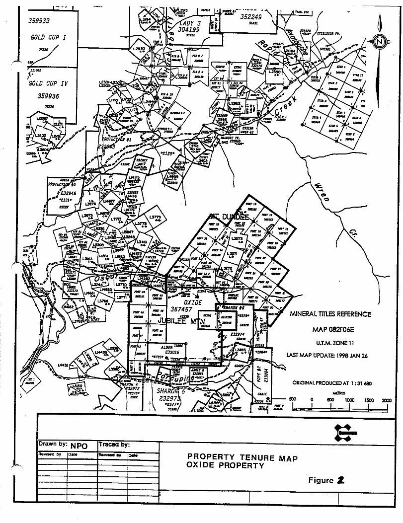
The Oxide claim group is 100% owned by Cominco Ltd., under option from Lloyd Addie and Robert Bourdon of Nelson, BC. The property consists of 46 two-post mineral claims and one 12-unit modified grid claim (Figure 2), as follows:
Name # of Units Tenure # Sulfide 1 xl 324445 Oxide 1 xl 324446
Oxgoldl 1 xl 357456 HotOx 1 1 xl 358338 HotOx 1 xl 358339 Oxide 1 x 12 357457
Port 15-55 41 x 1 360161-360203
4.0 PHYSICAL GEOGRAPHY
The Oxide property straddles the ridge between Porcupine and Oscar Creeks, extending between the summit of Jubilee Mountain (elev. 1753 m) on the west and the north-south- trending Oxide Pass on the east (Figure 3). The terrain is gentle to moderate on the Oscar Creek side of the divide and moderate to steep on the Porcupine Creek side. The area receives 2-3 m of snow each year between mid-November and early June. There is extensive overburden cover throughout the property except for a few steep areas on either side of the Oxide Pass. The depth of overburden is estimated to be ‘X-2 m throughout most of the property, except towards Oscar Creek where it may be considerably thicker. Outcrops are not common outside of the few cliff exposures and are particularly scarce in the vicinity of the old Oxide workings.
5.0 HISTORY OF WORK
The history of work at the Oxide property is summarized as follows:
1943 - limonite showing, known as the Oxide Zone, discovered and hand trenched by E.P.Haukedahl of Ymir. 1944 - two ddh’s totalling 600 completed by Leta Exploration Ltd. with inconclusive results. 1945 to 1947 - optioned to International Mining Corp.; extensive trenching on Oxide Zone completed down Porcupine Creek slope over 700’ vertical distance; drilling intersected Oxide Zone 500’ below crest of ridge; collared adit 1200’ south of and 600’ below ridge crest; drove adit on Oxide Zone for first 105’ and thereafter tested zone with cross-cuts at 135’, 400’ and 643’ from portal; underground exploration found Oxide Zone to be up to 24’ wide, containing Pb and Zn (ZdPb) in limonitic mud; attempted drill-testing down-dip extension from cross-cut with inconclusive results.
3
,-
A
1948 - optioned ground to New Jersey Zinc Exploration Ltd.; drove new adit (Internatio~ml Adit)(Figures 3 and 4) below surface cuts near crest of ridge which cross-cut Oxide Zone at 30’ to strike; sampling of adit revealed metal zonation within Oxide Zone with Zn-rich (16-17% Zn) and Pb-poor (cl% Pb) outer zone and an inner zone containing less Zn (2-3% Zn) but more Pb (l-3% Pb); drill- tested downdip extent of Oxide Zone in area of old workings with no reported results,
1950 to 1955 - 0x4 adit collared 500’ vertically below and 1,170’ SSE ofthe International Adit; 0x4 adit was driven 140’ to the northwest and due north for a further 730’ through much bad ground; the 0x4 adit was unsuccesstil in reaching or testing the downdip extension of the Oxide Zone below the level of the International Adit.
1962 -New Jersey Zinc drills two ddh’s totalling 669’; location and results of drilling were not reported; no drilling nor underground exploration has been undertaken since 1962.
1976 -small soil grid geochemical survey (2000’ x 2400’ grid; 195 samples) carried out over slope below 0x4 adit; several anomalies outlined including strong Pb + Zn anomaly (up to 730 ppm Pb and up to 3 100 ppm Zn) which is open to south and east.
1994 - property acquired by L. Addie and R. Bourdon; small amount of soil/silt/rock geochemical sampling carried out.
1997 - property acquired by Cominco Ltd.
6.0 REGIONAL GEOLOGY
The Kootenay Arc is a narrow belt of complexly deformed Lower Paleozoic rocks that extends several hundred kilometres from northern Washington state to north of Revelstoke, BC. Previous mapping efforts have defined a deformed stratigraphic succession of Cambrian to Ordovician rocks intruded primarily by granitoid rocks of the Jurassic to Cretaceous Nelson Batholith (Fyles and Hewlett, 1959; Little, 1960). In ascending order, the stratigraphic units, and corresponding major lithologies, present in the Salmo area are 1) Quartzite Range formation; white quartzites and brown micaceous quartzites, 2) Reno formation; grey micaceous quartzites, calcareous quartzites and minor limestones, 3) Laib formation, including: a) white limestones and green and brown phyllites and argillites of the Truman member, b) banded grey and white limestones/marbles of the Reeves member, c) black, calcareous or siliceous phyllites and argillites of the Emerald member, and d) grey and brown micaceous qutirtzites, grey and green phyllites and minor limestones of the Upper Laib formation, 4) Nelway formation; limestones and dolomites, and 5) Active formation; argiilites, slates, limestones. The Reeves member consists of a ductilely deformed, banded, calcareous and argillaceous
5
marble and hosts several large, probably early, stratabound replacement lead-zinc-iron deposits (e.g., Reeves MacDonald, Jersey, HB mines) as well as several small, late silver- lead-zinc-iron vein-replacement deposits (e.g., Red Rock, Pete Creek prospects) in the Salmo area (Fyles and Hewlett, 1959). The metamorphic grade of the rocks to the north of the Hidden Creek Stock, including those of the Porcupine Creek area, appears to be higher than in similar rocks present to the south in the remainder of the Salmo camp (Fyles and Hewlett, 1959; Little, 1960).
7.0 LOCAL GEOLOGY
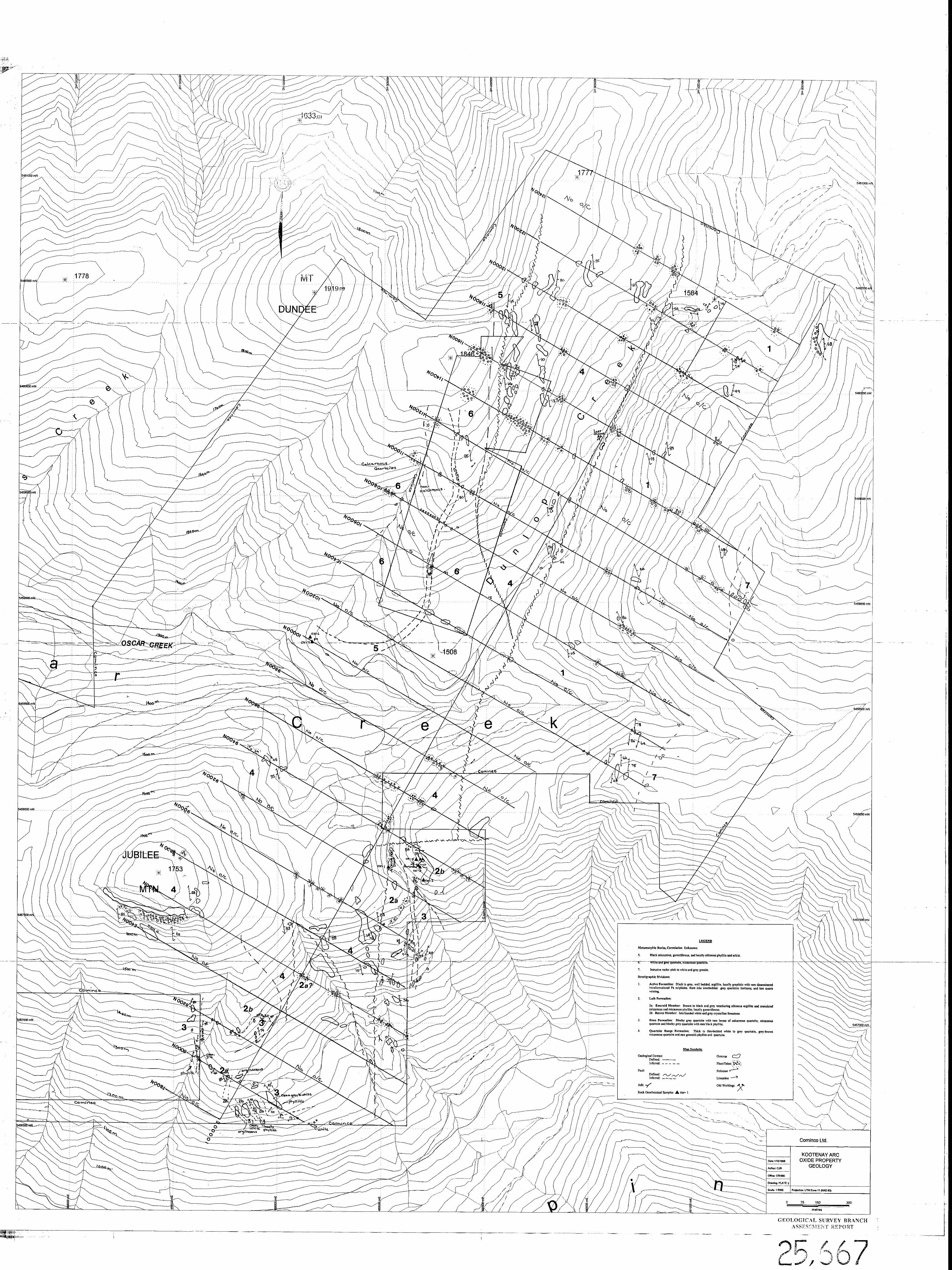
Fyles and Hewlett (1959) concluded that the Oxide property is underlain by a complexly folded and faulted assemblage of rocks, including, “ 1) black argillites and slates ofthe Active formation, grey limestone of uncertain correlation, and an assemblage of brown micaceous and white quartzite resembling the Lower Navada member of the Quartzite Range formation.” The grey limestone is medium grained and banded grey and white, closely resembling Reeves member limestone, and forms two bands. The western limestone band is in contact with black, gametiferous phyllite similar to that ofthe Emerald member. The eastern limestone band was interpreted by Fyles and Hewlett (1959) as being in fault contact with neighboring quartzites. Similarly banded limestone, probably of the Reeves member, is also present between an elevation of 3300’ and 3400’ approximately 1000’ north of the mouth of Active Creek, in contact with greenish grey phyllites and white limestone, probably of the Truman member, and grey quartzites resembling the top ofthe Reno formation (Fyles and Hewlett, 1959). Grey and black, tine-grained, silicified and hornfelsed sedimentary rocks, containing small lenses of limestone, occur immediately to the west of the identified Cambrian succession of rocks and have been referred to as part of the Mesozoic Ymir Group (Fyles and Hewlett, 1959; Little, 1960). Stratigraphic relations are not well known because of the lack of rock exposures.
Mineralization is primarily hosted by the Oxide fault, a bedding-parallel fault which strikes NIO”E, dips 70-8O”E and separates black argillites and limestones on the east from white and micaceous quartzites on the west. The fault is rarely exposed at surface but is marked by a wide zone of crushed and sheared rock. The Oxide fault is a regionally extensive structure which occupies the same structural position as the Argillite Fault with which all of the important Reeves-hosted Pb-Zn deposits in the Salmo area are spatially associated (Fyles and Hewlett, 1959). The Oxide fault contrasts with the Argillite Fault by its more brittle style of deformation and may therefore represent a post-metamorphic re-activation of a northern segment of the Argillite Fault. Structural relations throughout the property are poorly understood, although Fyles and Hewlett (1959) interpreted a shallowly south-plunging asymmetric anticline to exist southeast of the Oxide pass. Quartzites to the west of the Oxide fault are thought to be isoclinally folded or cut by bedding faults (Fyles and Hewlett, 1959).
R
Oxide Zone mineralization consists of porous, earthy limonite which is reported by McAllister (1951) to contain zinc as hemimorphite and parahopeite, and lead as
6
-.
pyromorphite and also in rare nodules of galena. The oxide material is reported to contain up to 15% Zn and up to 3% Pb (Fyles and Hewlett, 1959). Manganese oxides are also locally abundant. The Oxide Zone has been traced along strike for 460 m (1400’) and is reported by Fyles and Hewlett (1959) as varying in width but may be up to 9m (30’) in width. The lowest exposures on the south side of the ridge are about 180 m (600’) below the ridge crest.
8.0 RESULTS AND DISCUSSION
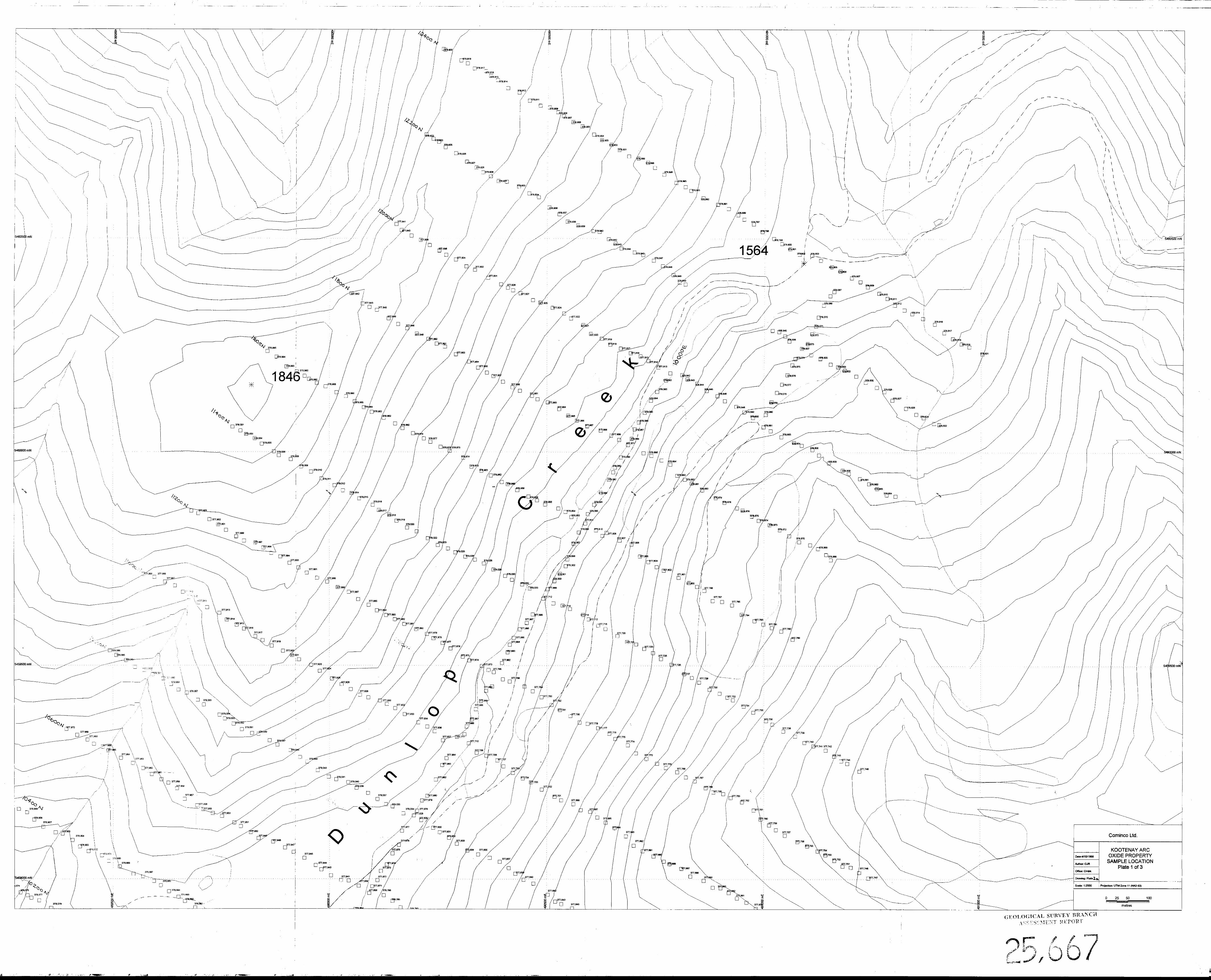
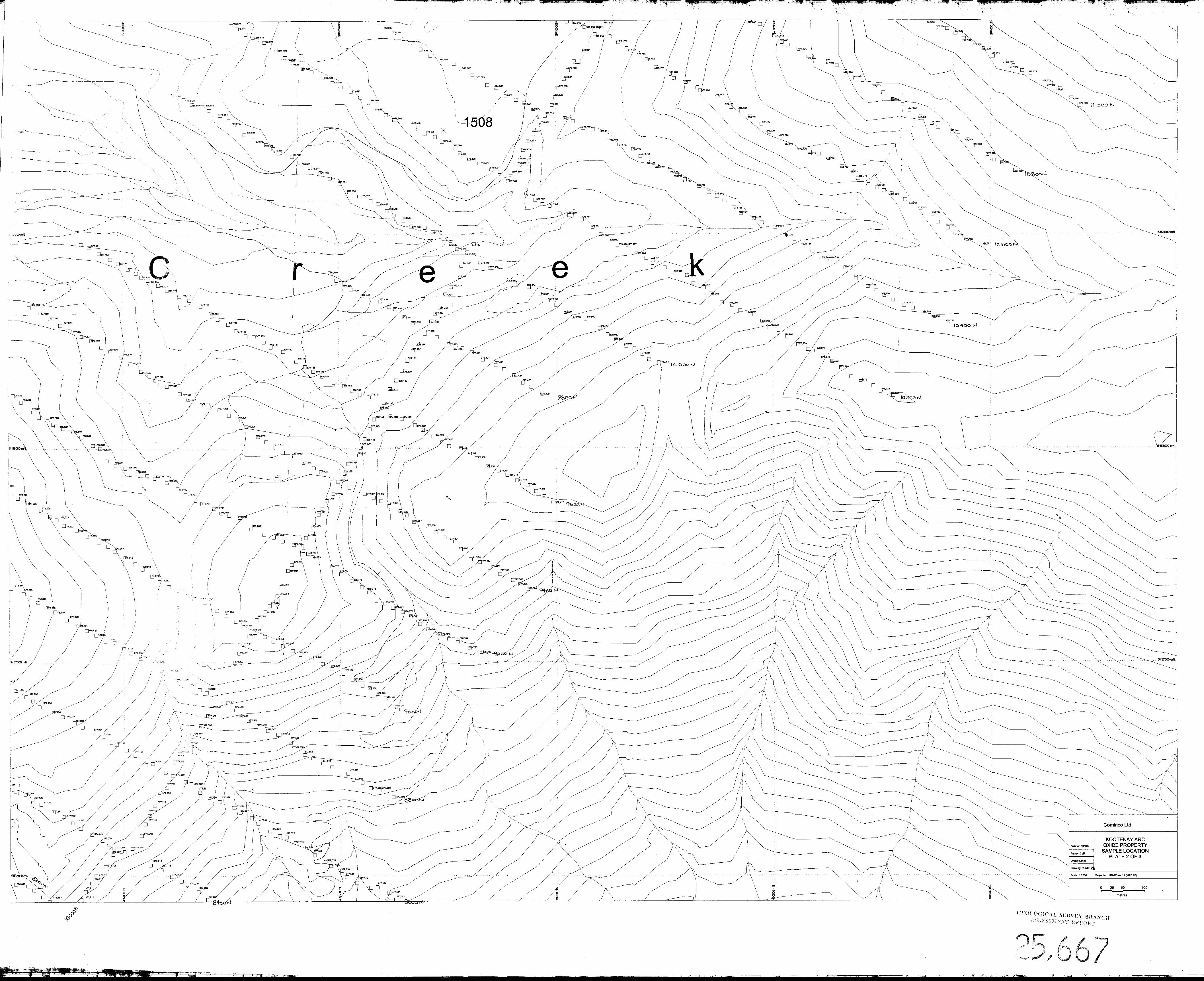
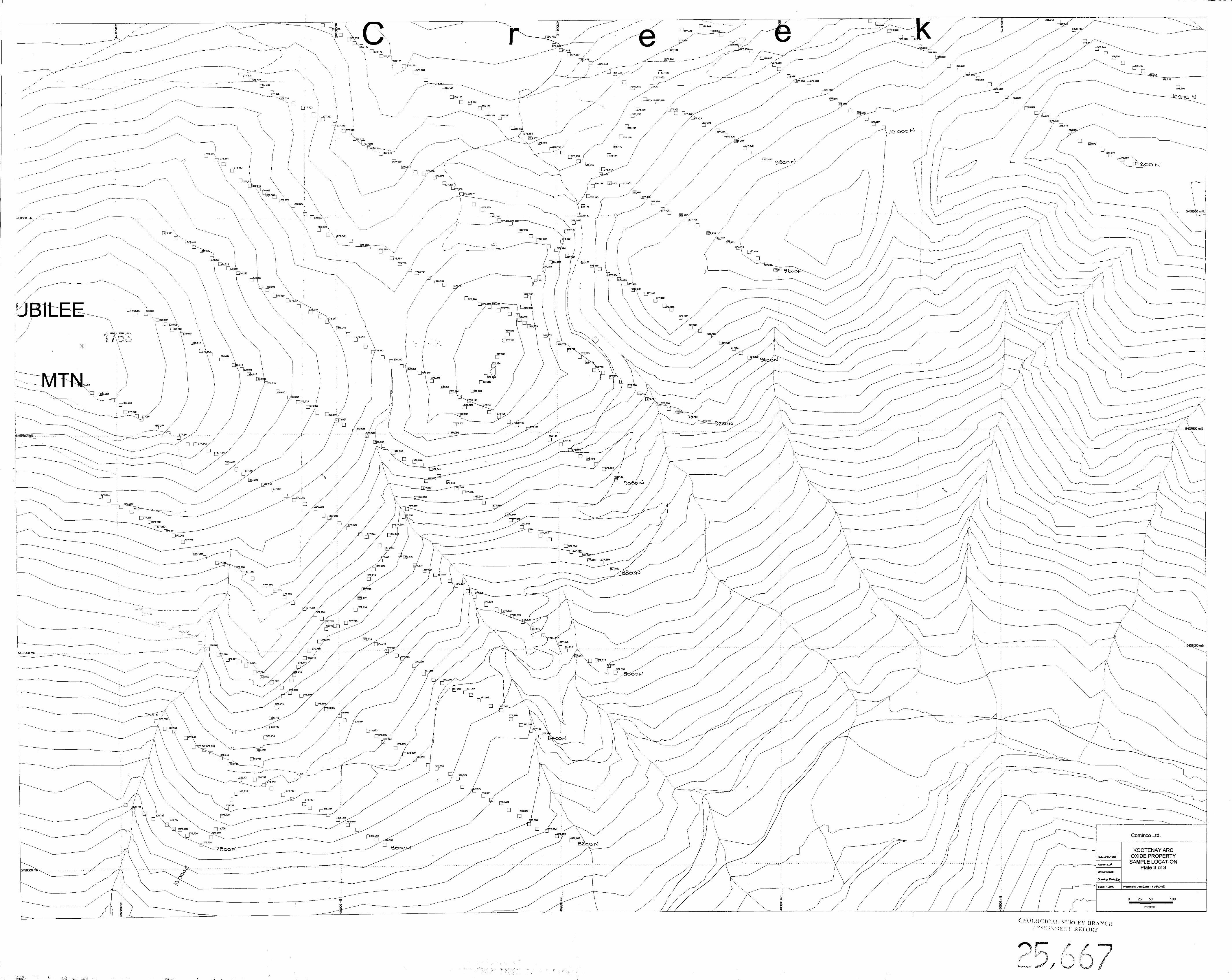
The program consisted of linecutting and tight-chaining an exploration grid (40.09 total line km), 10 man days of prospecting, 20 man days of 1:5000 scale geological mapping, and 36 man days of grid geochemical surveying (1456 soil and 4 silt geochemical samples collected and analyzed). Gridlines were cut from a northeast-trending baseline (10,OOOE) every 200 m and stations were picketed every 25 m along these lines as well as the baseline. The baseline was shifted to 10,200E at the northeast end of the grid area to avoid a small lake within Dunlop Creek. The picketed grid was used as the primary control for prospecting and mapping with topographic maps, altimeters and hip-chain used as secondary controls on location.
Property examination visits were made on June 6 and August 18, 1997, prior to Cominco acquiring the property. During these visits, 7 rock samples were collected from known showings for geochemical analysis. The analytical results are included in this report for completeness only and are not to be considered part of the 1998 program. Permission was granted by Tombstone Resources to extend some of the program’s work onto parts of their adjoining ground. In addition to a total of 6.73 km of grid lines that were cut on this neighboring ground, a total of 177 soil samples were collected. However, only the work that was performed on Cominco ground during the 1998 field program was included on the statement of work and costed in Section I 1 .O.
8.1 Prospecting and Geological Mapping
Only the grid area was mapped and prospected in detail. Results of this work are shown on Plate 1. No new base metal sulphide showings were found. The old workings (i.e., trenches and adit dumps) to the east and west of the Oxide pass were re-examined. The only evidence of Oxide Zone mineralization is found in three old adit dumps located approximately 50 m west of the pass. The adits collapsed long ago; only the remains of the timbered portal of the lowermost adit are visible. All three dumps contain pulverulent limonite, with rare galena-bearing fragments. The uppermost dump, located approximately 30 m in elevation above the lowermost dump, differs from the others in that it contains abundant porous smithsonite cobbles, A grab sample (OX-I) ofthe lowermost dump material (limonite only - no visible galena or smithsonite) returned anomalous Zn (3900 ppm), Pb (9150 ppm) and Mn (4279 ppm) ICP results; Ag and Au contents were negligable.
7
The old workings at the Last Chance prospect have been completely covered by road-fill material along the east side of Dunlop Creek and are no longer visible. There are, however, minor occurrences of stratabound, foliation-parallel laminations and thin lenses of semi-massive pyrrhotite, located between 9200E and 9500E near L10,OOON on the north side of Oscar Creek. These sulphidic rocks, which were first pointed out to the author by L. Addie in October, 1997, are hosted by siliceous, and locally gametiferous, black phyllites. Representative grab samples (0X-6,7) of these sulphidic rocks, however, were found to contain only anomalous levels of Cu (170 and 327 ppm); Pb, Zn, Ag and Au contents were negligable. More extensive pyrrhotite showings are present approximately 650 m to the northeast of these showings and are hosted by similar phyllitic rocks, probably along the same horizon. These particular sulphide showings have been worked in the past, as evidenced by the old trenches and dumps. No base metals were observed at this location.
Rocks exposed on either side of the Oxide fault, in the vicinity of the Oxide pass, commonly host steeply dipping, northerly striking, crustiform veins and breccia veins of late, epithermal-style, vuggy, comb-textured quartz which can contain pyrite and variable amounts of sphalerite and galena. High-grade grab samples (0X-2,3,5) of gossanous vein material were found to contain l.OO-3.71% Zn (assay), 3.59-36.82% Pb (assay), 140.6-621.0 g/t Ag (AAS), 20-140 ppb Au (AAS), 46-875 ppm As (ICP) and 71-532 ppm Sb (ICP). The vein quartz is also locally pinkish red after very finely disseminated hematite. Old trenches expose strongly weathered, locally gossanous parts of these veins. An old adit dump containing similar vein material is present approximately 200 m to the southeast of these trenches. Similar quartz-sulphide veins are also present at the old Bluebelle workings, located near 8300N/9900E (Plate 3). At this location, pyrite, sphalerite and galena are present as disseminations and small pods within ~10-30 cm- wide, vuggy quartz veins, hosted by micaceous quartzites near a contact with Reeves-like limestone. These veins strike WSW with steep southerly dips. There are no sulphide showings, other than these minor occurrences, in the vicinity of the Oxide Zone. A 5-20 cm thick ferricrete formation, exposed within the sides of an old trench, was observed to overlie a zone of quartz-sulphide veins hosted by banded limestone, located approximately 100 m east of the pass. A representative grab sample (0X-4) of the ferricrete was found to contain 50.85% Fe (assay), 1.09% Zn (assay), 5.14% Pb (assay), 4.5 ppm Ag (ICP), 36 ppb Au (AAS), 65 ppm As (ICP) and 9 ppm Sb (ICP).
h
The location of the Oxide fault, as inferred by this program’s mapping, agrees with the results of previous mapping efforts (e.g., Fyles and Hewlett, 1959). Also in agreement is the complicated geology present to the west of the Oxide fault along the steep, south- facing slope of the map area. There is insufficient exposure of rocks in this area to make any confident interpretations of the geology, although it can be stated that rocks resembling the Navada member of the Quartzite Range formation (brown micaceous quartzite with interlayered, thin-bedded, greyish white to white quartzite), Reno formation (grey-brown to grey micaceous quartzite with interlayered, giey to black phyllitic bed), Reeves member (medium-grained, grey and white banded limestone) and Emerald member (black, siliceous, locally gametiferous argillite and phyllite) are present in this area. The discontinuous distribution of these rocks and the changes in structural
8
A
attitudes in these rocks across these discontinuities, however, strongly suggests the presence of interfering folds and faults. On the same slope and east of the Oxide fault, however, there appears to be a shallowly north-plunging, upright, isoclinal anticline which has a core of micaceous quart&e with argillaceous partings, possibly belonging to the Reno Formation, which is overlain by medium-grained, banded grey and white limestone, resembling Reeves limestone. The limestone, which thins along the western limb of this fold, is, in turn overlain by a thick unit of black, siliceous, locally garnetiferous phyllites and argillites, inferred to belong to the Emerald member, which is truncated to the west by the Oxide fault. The anticline is further truncated to the north by a late, east-striking, dextral fault which also displaces the Oxide fault approximately 300 m to the east. The banded limestone exposed within the crest of the fold locally contains abundant siliceous bands, resembling the sulphide-associated me&-chert at the Duncan and Wigwam Zn-Pb deposits i_Muraro, 1966). Similar banded, siliceous rocks have been observed by the author within Reeves limestone in a road-cut exposure near the Reeves- MacDonald mine.
Rock exposures are rare within the the clear-cut area to the north of the Oxide pass, within the Oscar Creek basin, and, as a consequence, geological correlations between the rocks exposed in the vicinity of the pass and those exposed within the Dunlop Creek basin, mrther to the north, are tenuous. Most of the overburden cover in this area, however, appears to be colluvium rather than till or &iJ indicated by Fyles and Hewlett (1959). Fluvial deposits are restricted to the present creek beds.
- Black, carbonaceous to graphitic, generally pyritic, argillites and slates of the Active formation underlie much of the northeastern part of the grid area. Exposures of granitoid rocks are present along the most northeastern parts of the grid area. The northeastern extension of the Oxide fault is inferred to exist within the Dunlop Creek basin. The unusually straight and narrow shape of the creek bed is interpreted as an expression of the presence of this major fault. The fault is inferred to represent the northeast-striking contact between Active formation rocks which underlie the southeastern slope of the valley and identifiable Lower Cambrian rocks which underlie the northwestern slope of the valley. These Lower Cambrian rocks consist of a thick sliver of steeply east-dipping, north-striking, brown-grey-white micaceous quart&es, probably belonging to the Navada member, which is inferred to be truncated by the Oxide fault to the east and another significant fault to the west. This second fault may be a north-striking splay off of the Oxide fault and separates this quartzitic domain from a succession of interbedded grey- black phyllites, micaceous quartzites, minor green phyllites and rare calcareous quart&es. These rocks cannot be confidently correlated, although the succession is similar to that of the Reno formation and (or) Truman member in other parts of the Salmo camp (Fyles and Hewlett, 1959). In contrast, however, the black phyllites are commonly siliceous and gametiferous, resembling rocks present along the Porcupine Creek slope to the south and described by Fyles and Hewlett (1959) as belonging to the Emerald member. Furthermore, many of the mapped quartzites may instead be silica-flooded rocks, as suggested by Fyles and Hewlett (1959) further complicating local stratigraphic correlations. Surface mapping has not been able to resolve this stratigraphic dilemma.
9
8.2 Geochemistry
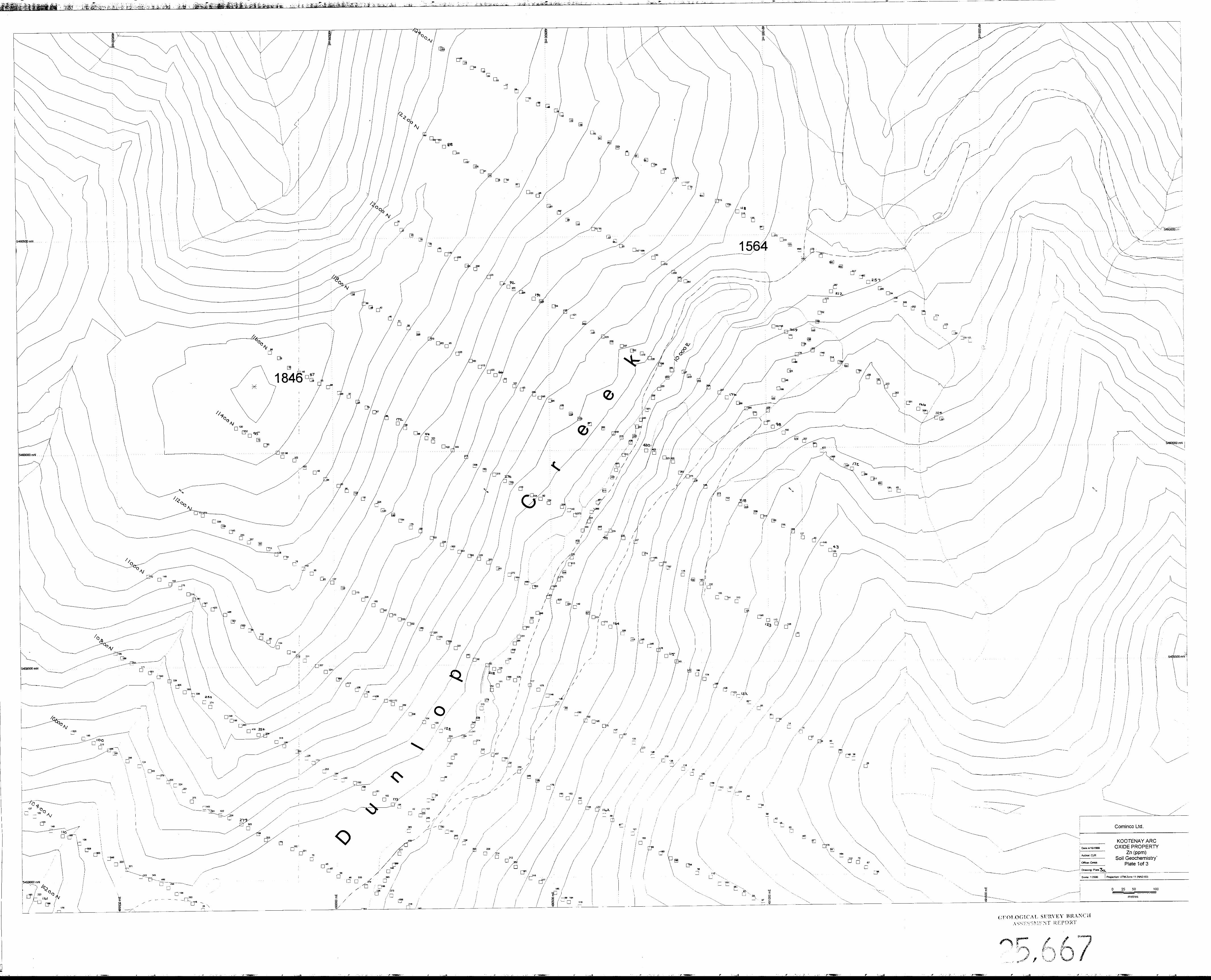
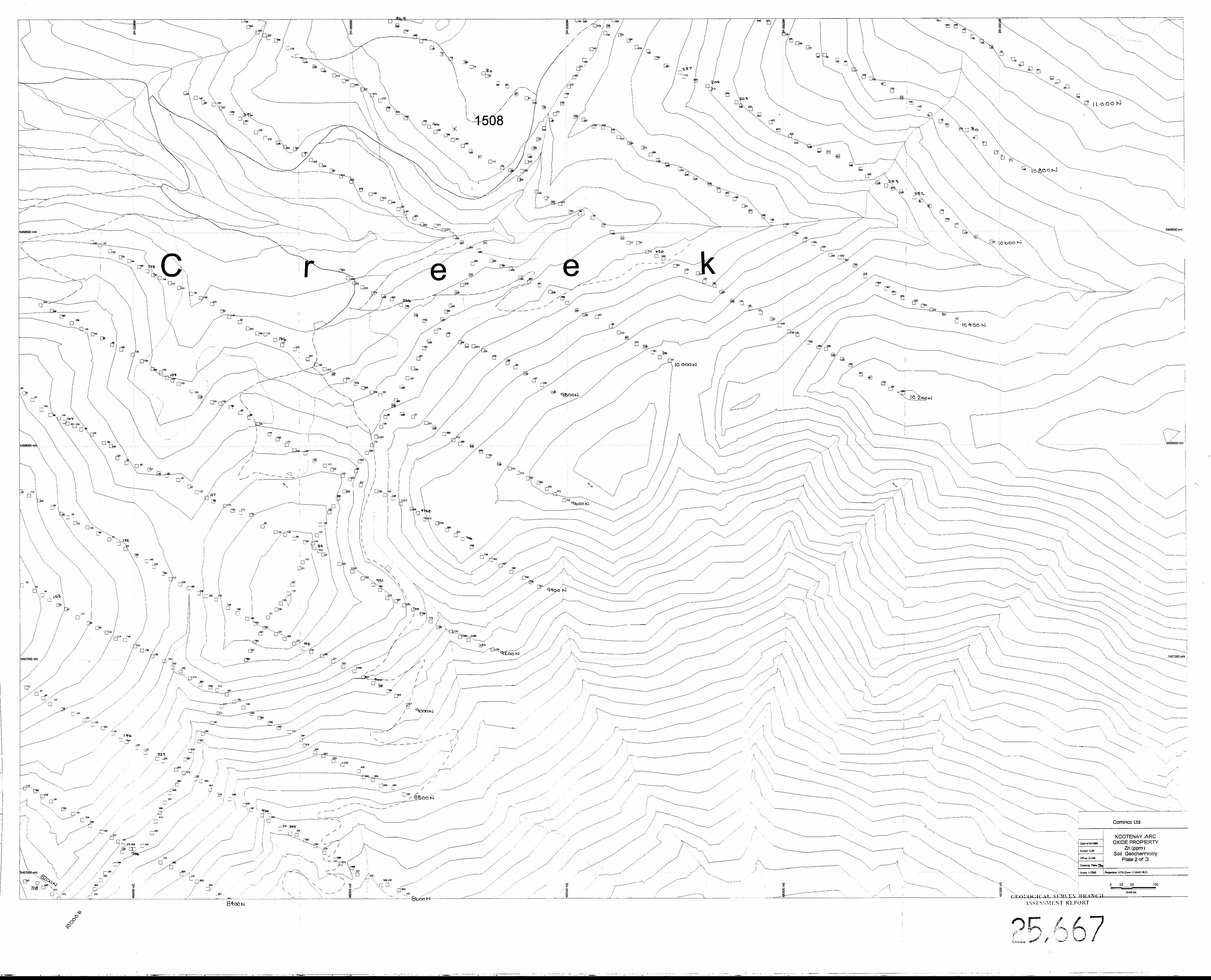
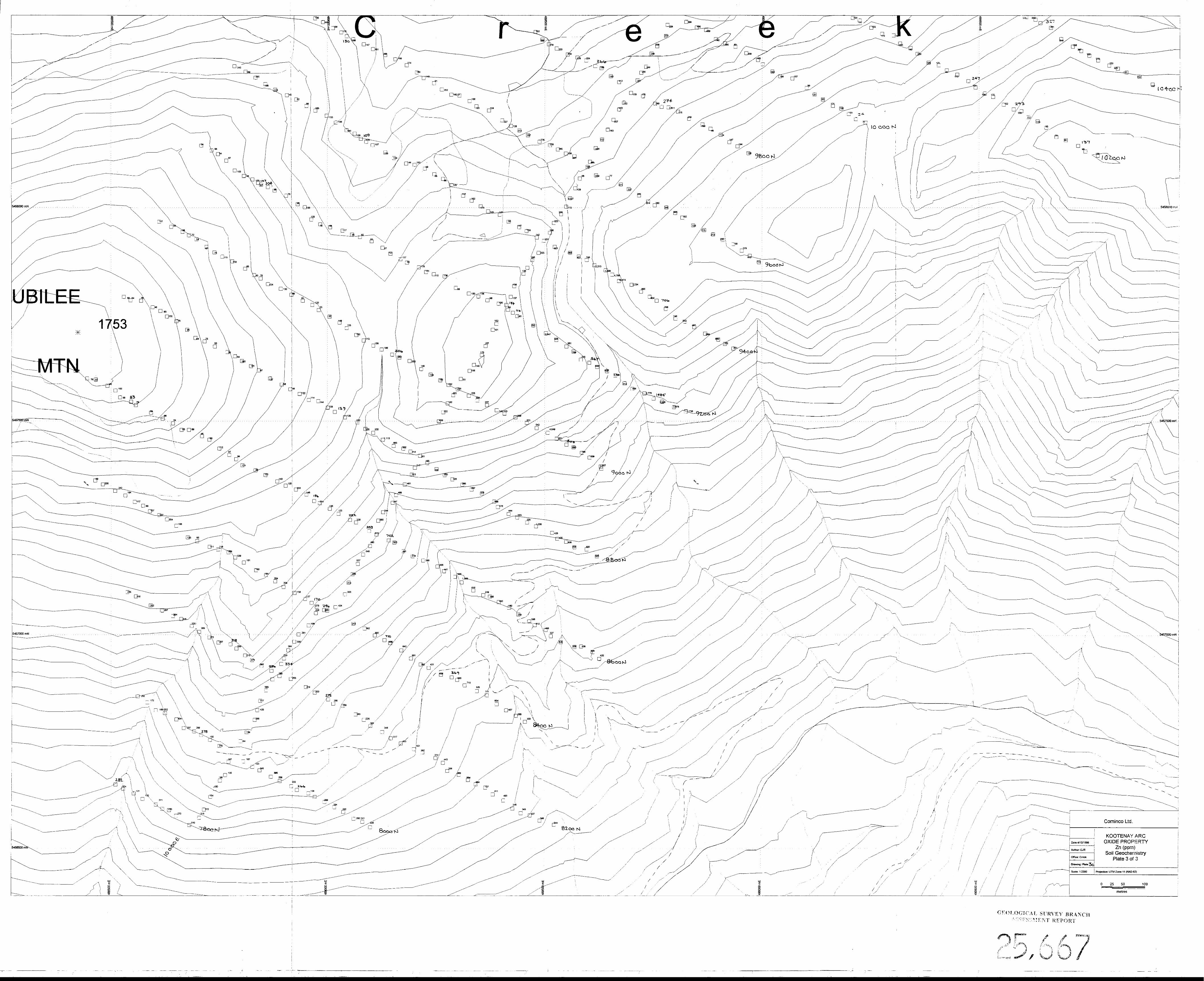
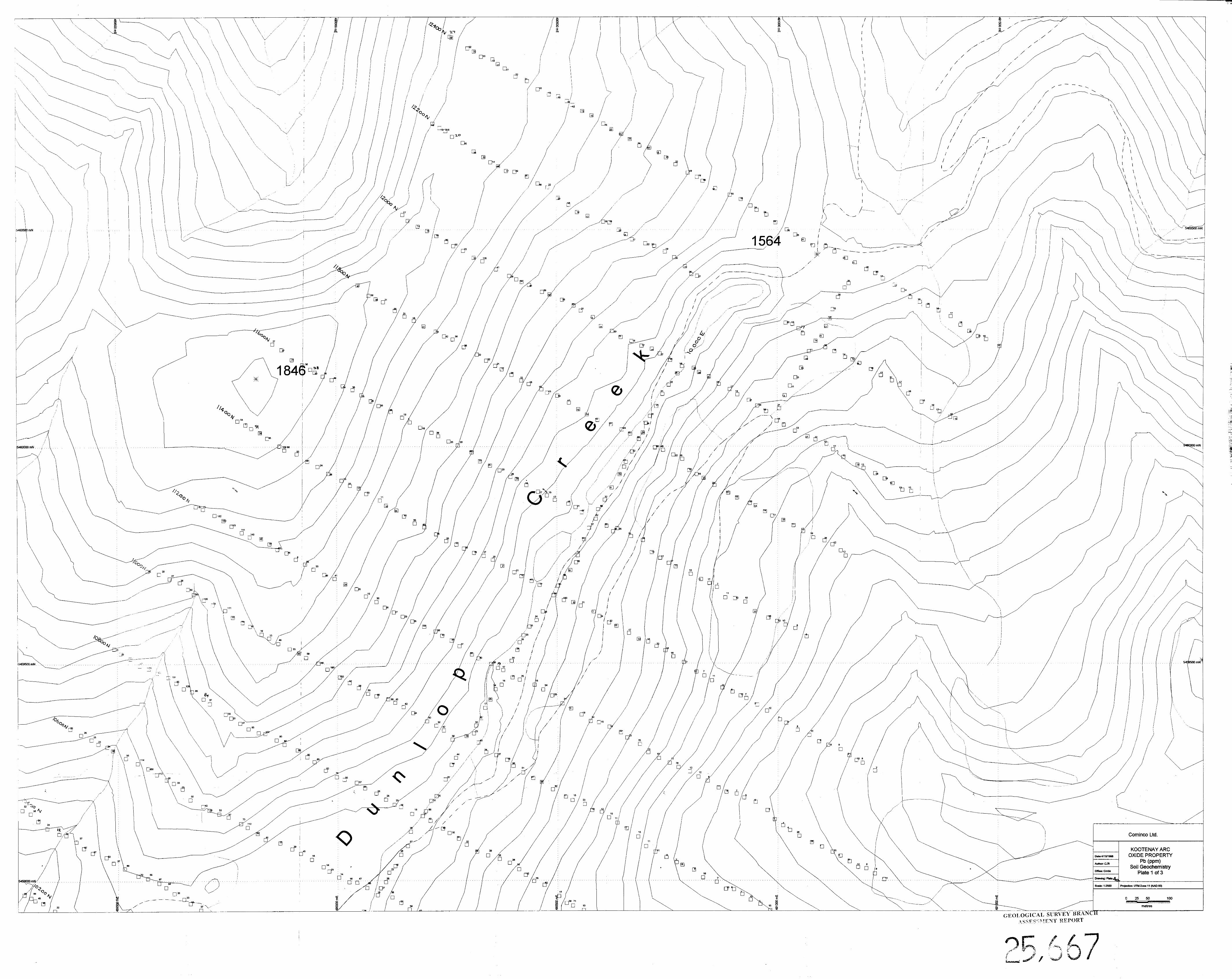
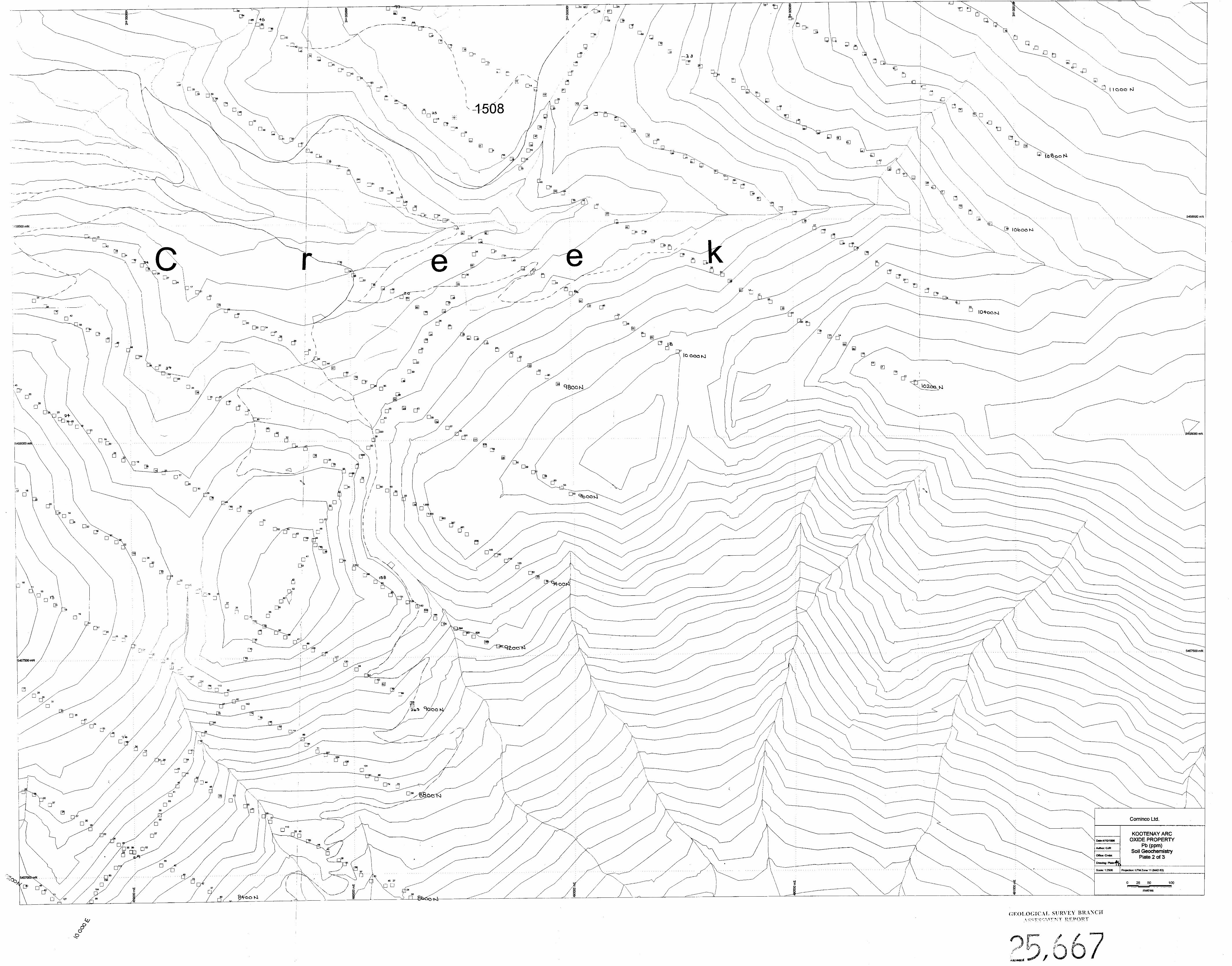
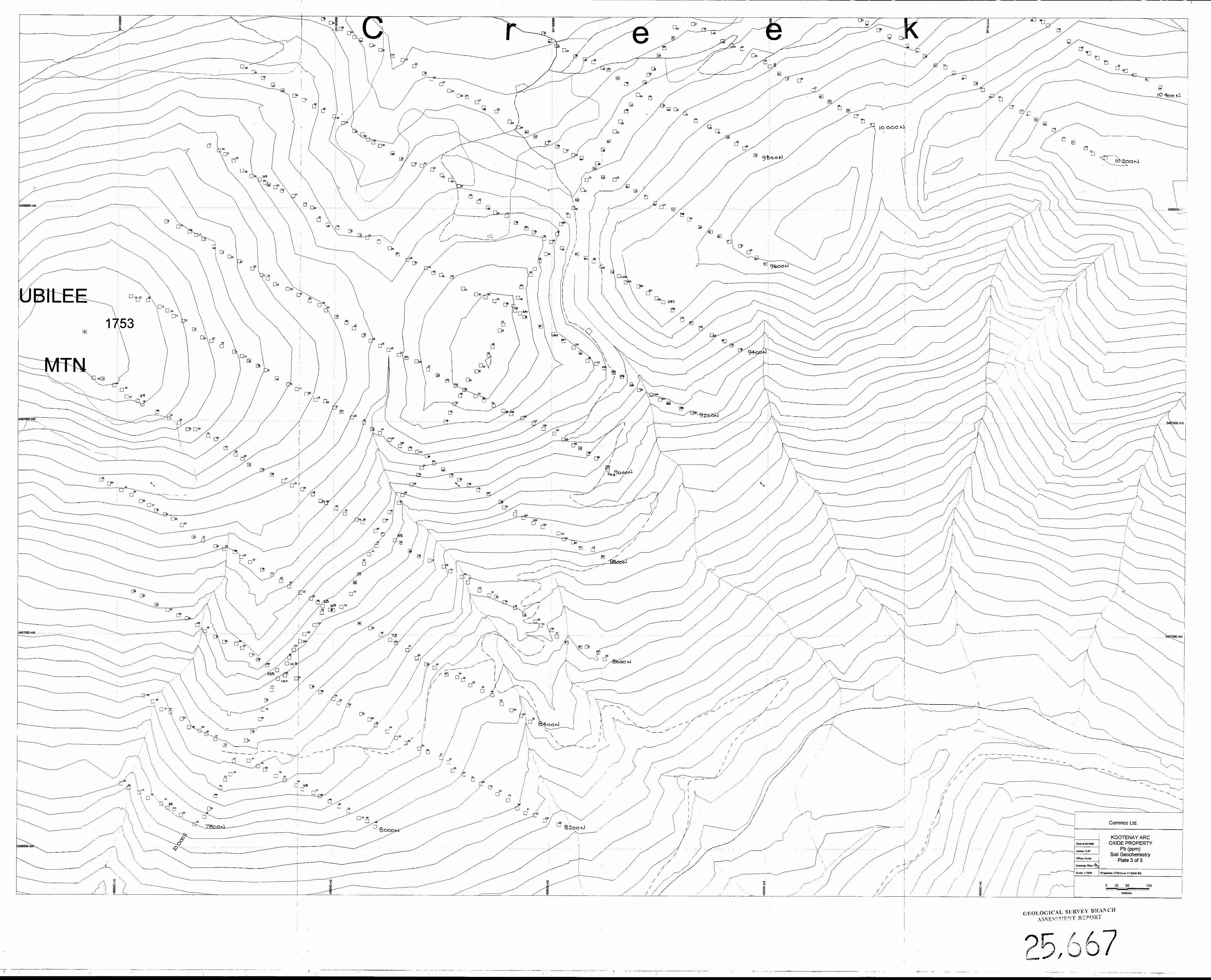
In October, 1997, a brief property visit was made to distinguish areas of thick glacial and fluvial overburden from areas of largely colluvial cover; the latter being more favourable to soil geochemistry. This investigation determined that most of the areas that were previously reported as covered by drw (Pyles and Hewlett, 1959), inferring glacial overburden, were largely covered by colluvium and, hence, favourable for soil geochemical coverage. A program of grid soil geochemistry was, therefore, designed to cover favourable areas of geology to the northeast and south of the old Oxide workings, following the trend of the Oxide fault. A total of 1456 soil and 4 silt samples were collected from this grid in 1998. Silt samples were collected whereever active streams were encountered along the grid lines. Samples were collected every 25 m along picketed, tight-chained, grid lines which were cut 200 m apart off of a baseline. Sample locations with field numbers are shown on Plate 2. Plots of Zn and Pb are shown on Plates 3 and 4 respectively. Complete geochemical and sample data are given for the soil and silt samples in Appendix 1 and for the rock samples in Appendix 2.
:-,
All samples collected during this program were sent for preparation and analysis to Cominco’s exploration research lab in Vancouver. Analytical work was performed under the supervision of Jim McLeod. Each silt and soil sample was dried and sieved with a 0.5 gram sample of the -80 mesh fraction taken for analysis. The 0.5 gram sample was then digested in hot reverse aqua regia and analyzed by induced coupled plasma (ICP) method. Each rock sample underwent two-stage pulverization to a 60% -10 mesh size fraction and then was riffled with a an approximately 250 gram sample split collected. This 250 gram sample was then ring-milled to a 90% -150 mesh size fraction. A 0.5 gram sample ofthis -150 mesh fraction was then taken for analysis. Each 0.5 gram sample was digested in hot aqua regia and analyzed by ICP method. Assayed rock samples were similarly prepared except that pulverization included a third milling stage. A precisely weighed sample between 1 to 2 grams was used for assay analysis.
Based upon the results of the soil sampling, the following comments are warranted:
1. The surface expression of the Oxide Zone is represented by a strong, discrete anomaly (X00-4,049 ppm Zn, >lOO-2,002 ppm Pb) which can be traced north- south between L9400N/25E to L8200N/675E. The anomaly is open to the south but is closed off to the north in the vicinity of the east-west fault which apparently truncates the northern extension ofthe Oxide Zone.
2. A second, very strong anomaly (>500-10,474 ppm Zn, >200-1,636 ppm Pb) is present to the east of the Oxide pass, extending Tom 955ON/lO,OOOE to L92OON/10,400-500E. It is interpreted to represent the surface expression of the quartz-sulphide veins, ferricrete and old dump material referred to in section 8.1. This anomaly is also closed off to the north and open to the south. Its broader shape is a reflection of the downslope dispersion of the metalliferous materials.
A
10
,f--
3. A moderate, discrete anomaly (>300-1611 ppm Zn) can be traced from L98OON/lO,lOOE to at least L11,8OON/1O,OOOE. This anomaly is interpreted as the surface expression of subcropping mineralization within the northern extension of the Oxide fault. This anomaly intensities and broadens in the reported vicinity of the old Last Chance workings, centred along the 10,000 E baseline between L11,4OON and Ll 1,800 N.
4. Areas underlain by Quartzite Range quartzites, as well as granites, returned consistently low soil values in Zn (<200 ppm) and Pb(<40 ppm), in contrast to areas underlain by Laib (and Reno?) formation rocks which returned generally higher soil values in Zn (200-500 ppm) and Pb (30-80 ppm).
9.0 CONCLUSIONS
Based upon the results of the work outlined above, the following conclusions can be made:
1. The Oxide Zone is a north-striking, sub-vertically dipping, fault-hosted zone ofZn+Pb-bearing limonite which has a minimum strike length of 1.4 km and a down-dip extent of at least 425 m (as inferred by differences in surface elevations). The zone is truncated to the north by a late, east-striking, dextral fault which has offset the Oxide fault (and Oxide Zone ?) 300 m to the east. The Oxide fault extends a tbrther minimum of 3 km to the north-northeast of the east- striking dextral fault and appears to contain other subcropping mineralized zones, particularly in the vicinity of the old Last Chance prospect.
2. Evidence for a preserved, unweathered sulphide protore at depth has not been established.
3. Oxide zone mineralization does not resemble the numerous quartz-sulphide epithermal veins found throughout the property, suggesting that these two different styles of mineralization are not genetically related.
4. A shallowly north-plunging, upright, isoclinal anticline is interpreted to exist in the vicinity of the Oxide pass and includes a zone of Reeves limestone which is thickened within the fold hinge and thinned along its eastern limb.
5. There are insufficient surface rock exposures as well as marker units to confidently correlate lithologic units and interpret local structures throughout the grid area, particularly within the western and northern parts of the grid area.
n
,--
10.0 SELECTED REFERENCES
Fyles, J. T. and Hewlett, C. G., 1959. Stratigraphy and structure ofthe Salmo lead-zinc area, B.C. Dept. ofMines Bulletin, 41, 162 pp.
Little, H. W., 1960. Nelson map-area, west half, British Columbia, Geol. Surv. Canada Memoir, 308.
McAllister, A. L., 1951. Ymir map-area, British Columbia, Geol. Surv. Canada Paper, 51-4.
Muraro, T. W., 1966. Metamorphism of zinc-lead deposits in southeastern British Columbia in Tectonic History and Mineral Deposits of the Western Cordillera, C.I.M.M., Spec. Vol., 8, 239-248.
A
11.0 COST SUMMARY
Labour and salaries Prospecting: June 3-7 (10 man days@$250/man/day)
Geochemistry: June 21-July 8 (36 man days@$200/man/day)
Geological Mapping/Supervision June 26-30, Aug. 21-25 (20 man days@$250/man/day)
Geochemistry
Linecutting Supplies Transportation
1283 soil/silt samples - prep+analyses (@ $9/sample) 33.36 km @ S668.7Ykm Sample bags, flagging, etc. Airfares (1 Vane-Cranbrook return fare) ATV. rental (2 weeks)
2500
7200
5000
11,547 22,3 10
840 608 800
Trucks-iirel, mileage, rentals (26 days @ $60/day) 1560 66 man days @ S80Imanlday 5280 Telephone, faxes, courier, copying 300
396 3 days @, $250/day 750
$59.091
Domicile Communications Shipping Report Writing
Approved For Release:
13
CO-AUTHOR’S QUALIFICATIONS
.-,
As author of this report, I, N.P.M. O’Brien, certify that:
I am a geologist active in mineral exploration
I am a graduate of Cambrian College of Arts and Technology with a Geological Engineering Technology Diploma
I am a graduate of the University of Waterloo with a degree of Honours Bachelor of Science.
I am a graduate of Queen’s University with a degree of Doctor of Philosophy in Geological Sciences.
I have been employed’as a technologist or geologist in both mining and exploration since 1984.
I have been continuously employed as an exploration geologist with Cominco Ltd. since 1995.
I am a member in good standing of the Society of Economic Geologists, the Canadian Institute of Mining and Metallurgy, and the Prospectors and Developers Association of Canada.
I supervised Cominco Ltd.‘s exploration on the Oxide property in 1998.
‘N.P.M. O’Brien, Ph.D. Exploration Geologist
A
14
CO-AUTHOR’S QUALIFICATIONS
,-,,
As co-author of this report, I, C.J. Reid, certify that:
I am a geologist active in mineral exploration.
I am a graduate of the University of Regina with a degree of Honours Bachelor of Science.
I have been employed as a geologist in mineral exploration since 1995.
I have been continuously employed as a exploration geologist with Cominco Ltd. Since 1995.
I am a member in good standing with the Geological Association of Canada, the Society of Economic Geologists, the Canadian Society of Petroleum Geologists, and the Prospectors and Developers Association of Canada.
I am a certified Geoscientist-in-training with the Association of Professional Engineers and Geoscientists of Saskatchewan.
I worked on Cominco Ltd.‘s exploration program at the Oxide Property in 1998.
1.5