Embed Size (px)
Citation preview
Canadian Council on Geomatics Resolution F02-12 National Standards for Integrated Surveys Status Report
Prepared by:
Jacques R. Grondin Acting Deputy Surveyor General Eastern Region
Head, Policy, Planning and Evaluation Unit Legal Surveys Division
Geomatics Canada Earth Sciences Sector
Submitted to Task Force and Surveyor General of Canada November 13, 2003
Jacques R. Grondin Page 2 08/02/2006
Table of Contents Table of Contents............................................................................................................................ 2 1.1 Introduction............................................................................................................................... 3 2.1 Canadian Council on Geomatics (CCOG) Resolution F02-12 ................................................. 3 3.1 Definitions................................................................................................................................. 4 4.1 Environmental Scan .................................................................................................................. 4
4.1.1 Canada Lands................................................................................................................. 4 4.1.2 British Columbia............................................................................................................ 6 4.1.3 Alberta............................................................................................................................ 7 4.1.4 Saskatchewan................................................................................................................. 9 4.1.5 Manitoba ...................................................................................................................... 10 4.1.6 Ontario ......................................................................................................................... 10 4.1.7 Quebec ......................................................................................................................... 12 4.1.8 Newfoundland.............................................................................................................. 13 4.1.9 New Brunswick............................................................................................................ 14 4.1.10 Nova Scotia................................................................................................................ 16 4.1.11 Prince Edward Island ................................................................................................. 16
5.1 Principles................................................................................................................................. 17 5.1.1 Synopsis of existing situation ...................................................................................... 17 5.1.2 Some Basic Principles.................................................................................................. 18 5.1.3 Administration ............................................................................................................. 18 5.1.4 Implementation ............................................................................................................ 19
6.1 DRAFT Standards................................................................................................................... 19 Appendix 1 Map of CBNs ............................................................................................................ 20 Appendix 2 Map of Distortions .................................................................................................... 21
Jacques R. Grondin Page 3 08/02/2006
Canadian Council on Geomatics Resolution F02-12 National Standards for Integrated Surveys Status Report
1.1 Introduction The purpose of this report is to provide an update on the adoption of national standards for the integration of cadastral surveys in Canada. First, the report looks at the resolution F02-12 from the 2002 meeting of the Canadian Council on Geomatics. Second, the report will provide a few brief definitions to present a clear understanding of some of the terminology used throughout the report. Third, the report will consider the situation across Canada as it relates to the control network, the availability of control monuments, the use of these monuments by the profession and what is being done from an integration perspective as seen from a few key stakeholders in each of the provinces. Fourth, the report will enunciate a number of principles that will need to be taken into consideration in order to establish sound and practical national standards for the integration of cadastral surveys. Finally, a proposed set of draft standards is provided. 2.1 Canadian Council on Geomatics (CCOG) Resolution F02-12 At its 2002 Fall Council Meeting in Victoria, British Columbia the Canadian Council on Geomatics (CCOG) passed a resolution on National Standard for Integrated Surveys as follows:
Whereas a continued interest exists to adopt a national standard for Integrated Surveys; and Whereas the Task Force for a variety of reasons has not been able to develop national standards; Be it resolved that all jurisdictions are encouraged to participate in the Task Force on Integrated Surveys; Be it further resolved that the Task Force reconsiders the recommendations of the Dr. Ballantyne Report on Integrated Land Surveys (January 2002) and create a draft set of principles and recommendations that can be used for consultation purposes with Self-governing Survey Professions; Be it further resolved that upon receipt of the Task Force’s recommendations, each jurisdiction consult with their Self-governing Survey Profession and report their findings to the Task Force; and that the findings be consolidated and that the Task Force make recommendations to the Council by next year’s annual meeting.
Although the resolution did not identify a lead, the Surveyor General of Canada, Michael O’Sullivan agreed to chair the Task Force. Initial contacts were made early in the process and a number of provincial officials agreed to sit on the Task Force. However, due to the major restructuring and resulting upheaval within Geomatics Canada and the Earth Sciences Sector the
Jacques R. Grondin Page 4 08/02/2006
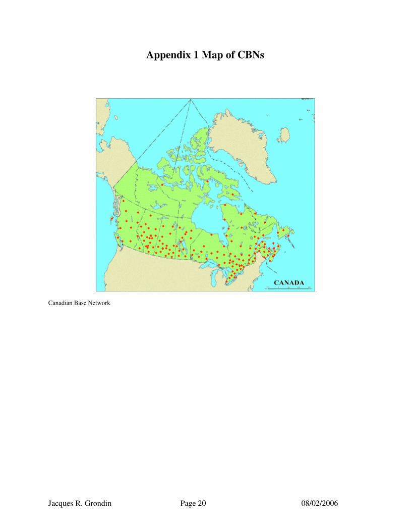
Office of the Surveyor General was severely limited in its ability to carry on the work of this Task Force. Therefore, in the past few weeks we have made an effort to examine the situation in an attempt to establish a number of principles for the integration of cadastral surveys and the creation of draft national standards. 3.1 Definitions NAD83CSRS - North American Datum 1983 Canadian Spatial Reference System (3-D coordinate system). An adjustment of the Canadian Base Network and high order GPS tied to the Canadian Active Control System (CACS). Reference ellipsoid is GRS80. These coordinates may not be compatible with NAD83 public values. (See Appendix 1 for location of CBNs) NAD83 (NAD83(Adopted)) - North American Datum 1983. (Public horizontal reference system). The horizontal control datum for the U.S., Canada, Mexico and Central America, based on the geocentric reference ellipsoid Geodetic Reference System 1980 (GRS80). Coordinates were realized through least-squares adjustment of the existing conventional networks constrained to Doppler. Sometimes referred to as NAD83 (Adopted) or NAD83 public. (See Appendix 2 for map showing the distortions between NAD83(CSRS) and NAD83(Adopted)). 4.1 Environmental Scan In his January 2002 report, Dr. Ballantyne provided a situation analysis on the integration of surveys for each of the provinces and Canada Lands. The following is a summary of that analysis as well as an update of the current situation based on conversations the Office of the Surveyor General of Canada had with a number of officials from the different provinces. Note that the territories fall under the jurisdiction of the Canada Lands Surveys Act, which is administered by the Surveyor General of Canada and therefore are considered under the situation for Canada Lands. 4.1.1 Canada Lands Coordinated Survey Areas Then: ��Canada Lands Surveys Act allows for integrated surveys through the establishment of
Coordinated Survey Areas (CSAs). ��The coordinates of the monument may act as proof of its position in the absence of contrary
evidence. ��The Manual of Instructions for the Survey of Canada Lands (as of 1996) lists eleven
Coordinated Survey Areas: o two in the Yukon Territories at Ross River and Whitehorse; o three in the Northwest Territories at Hay River, Inuvik, and Yellowknife; o two in Nunavut at Iqaluit and Rankin Inlet; and o four in National Parks at the town sites of Banff and Field, Jasper and Lake
Louise.
Jacques R. Grondin Page 5 08/02/2006
��Federally established control points use the NAD83 datum. ��The control monuments are not well maintained and are in various states of disrepair. ��In some CSA’s the CCM’s are virtually ignored in favour of using active control while in
others some CCMs are still being used. ��Conversely, in some CSA’s in Nunavut, the CCM’s are relied upon extensively. ��The control monuments are assumed errorless and any discrepancies in calculated
coordinates are to be proportionally distributed in each part of the survey. ��The plan must include the coordinate datum used, the date of the coordinates, and a listing
of coordinates for all relevant control and boundary monuments. Update: The situation regarding CSAs on Canada Lands has not changed significantly since the time of the Dr. Ballantyne report except for the fact that the deterioration mentioned above has continued at a steady if not more rapid pace. The Office of the Surveyor General is considering completely abandoning the CSAs and repealing the appropriate sections of the Act accordingly. Other Canada Lands Then: ��The Surveyor General requires that when a survey is conducted within 1 km of existing
federal or provincial survey control markers, it must be integrated to the existing control framework.
��For a subdivision survey of a parcel that was previously integrated with federal or provincial control points, new connections to the control network from the new monuments are not necessarily required.
��Where a connection is made to an existing control point, the survey plan must contain the coordinate datum used, the date of coordinates, and a listing of coordinates for relevant control and boundary monuments.
��For the majority of new land claims surveys, spatial positioning is required for all parcels unless otherwise indicated in the Statement of Work. The positions of all monuments are to be integrated within the CSRS via CACS, geodetic control markers, or any other approved control markers. Each survey shall be integrated into the CSRS according to the type of survey.
Update: The requirements for integrated surveys on Canada Lands have not changed. However, Legal Surveys Division has intensified its program to geo-reference all Canada Lands to NAD 83 CSRS using whatever feasible means available. The accuracy ranges significantly across the country. Some areas have been geo-referenced to the cm level while other areas have been geo-reference to no better than a few metres.
Jacques R. Grondin Page 6 08/02/2006
4.1.2 British Columbia Then: ��There are 47 legally established Integrated Survey Areas (ISA) located throughout the
province. ��For each ISA, the Surveyor General must file in the local land title office a plan of the
integrated survey area showing the locations and coordinate values of all control monuments.
��In an ISA, all original monuments established by a survey and all those previously established that are pertinent to the survey of a parcel must be tied to the nearest coordinate control monuments.
��Any such original monument defined by coordinates in an ISA may have the coordinates considered as evidence of its true position on the ground.
��All legal surveys completed within or partially within an ISA must be integrated with control surveys near the area under survey.
��Control surveys must be integrated with the Provincial and Federal Geodetic (Survey Control) Networks with coordinates based on the North American Datum approved by the Surveyor General.
��The official plans and consolidated coordinate listings on record in the local land title offices are using the NAD83 (CSRS) datum.
��All survey plans submitted in these areas are to be prepared using NAD83 (CSRS) derived bearings.
��There is one proposed ISA pending constitution (Williams Lake). ��Only a few municipalities are actively maintaining their physical ISA. Urban active control
systems are being implemented in the Greater Victoria and Lower Mainland areas. ��The traditional geo-referencing system consisting of survey monuments is slowly being
replaced by the use of GPS to tie to less dense HPN or to various ACS. ��The program of maintaining monuments in the ISA will be phased out over the next few
years. ��The Office of the Surveyor General recognizes that continued development and
maintenance of conventional Integrated Survey Areas is desirable in many cases. ��The Surveyor General will consider applications on a case-by-case basis from land
surveyors wishing to conduct surveys within ISA using GPS. ��Exceptions to the requirement that all land surveys within an ISA be integrated are allowed,
if various conditions are met. ��There is a requirement that at least one corner of new parcels be expressed in UTM NAD83
(CSRS) coordinates, if DGPS has been used. UTM coordinates can also be derived from recreational-grade GPS in some circumstances.
Update:
��Most towns in British Columbia with over 10,000 people are in Integrated Survey Areas. For any surveys in these areas, it is mandatory to integrate the surveys to NAD 83 (CSRS).
Jacques R. Grondin Page 7 08/02/2006
��For surveys outside any Integrated Survey Areas it is preferred that the surveyor tie to some geodetic control but there is no mandatory requirement.
��The recognized datum in BC is NAD83 CSRS. 4.1.3 Alberta Then: ��In 1999, the management of standards including those for integrated surveys was
transferred to the Alberta Land Surveyors’ Association and set out in the practice manual. ��The provincial survey control points used for integration are established under the authority
of the Director of Surveys. ��Every survey for a plan that is to be registered must be integrated with survey control if at
least two monuments found or placed by the survey are within one km of any two survey control markers.
��For all other surveys, the surveyor shall make field measurements connecting the survey to all survey control markers situated within one km of any monument found or placed by the survey.
��For deferred monumented surveys under Section 43 of the Surveys Act (RSA 1980) there must be sufficient survey control markers available near the survey to integrate the survey.
��Plans for non-monumented surveys must show all survey control markers, reference monuments, found monuments, and re-established monuments, along with their respective coordinate positions.
��The accuracy requirements for section 43 surveys have been a matter of discussion between the Alberta Land Surveyors’ Association Standards Committee and the Director of Surveys Branch. The key issues of discussion are:
o the requirement for at least two survey control markers to be within two km of surveyed corners, precluding almost all rural surveys from meeting requirements due to typical control spacing of 10 to 20 km;
o that establishing new control specifically for section 43 purposes is contrary to provincial policy unless the new control points are to be in support of High Precision Networks;
o the development of an adequate confidence region and methodology for the placement of reference markers in section 43 surveys. Existing control will only support surveys up to two km distant using the proposed confidence region.
��The practice manual recognizes that the datum for spatially referenced data in Alberta is NAD83. This datum will be used on all plans of survey submitted if the plan information relates to grid bearings or coordinates.
��With the proliferation of high precision GPS surveys, the Geodetic Control Section of the Director of Surveys adopted NAD83 (CSRS) coordinates for a subset of the Alberta Survey Control Markers (ASCM) in August 1999.
��After December 2000, only NAD83 (CSRS) coordinates will be computed for new ASCMs. ��Requirements for NAD83 coordinates will be transformed from the NAD83 (CSRS) as
required.
Jacques R. Grondin Page 8 08/02/2006
Update: ��The geodetic control network has been adjusted to NAD83 CSRS. The values for a subset
1000 markers are available, however not much use is being made of them. The values were used to control the Alliance pipeline that crossed multiple jurisdictions.
��Provincial mapping is NAD 83 (Adopted). ��The oil industry for the most part is using NAD 27. However, there is a move by the
Alberta Energy Utilities Board to make NAD 83 CSRS coordinates mandatory. ��There is no more maintenance of the rural coordinate control monuments. Municipalities
(especially the smaller ones) do require that lost or damaged monuments be replaced. This is cost shared. The province encourages the small municipalities to consider the HPN approach as opposed to just replacing destroyed markers. The larger municipalities have moved to an HPN approach. There are 21 CBN monuments in the province.
��Integrated surveys standards are contained in the practice manual of the Association of Alberta Land Surveyors.
��Government data providers are moving towards the adoption of NAD83 CSRS. ��There is an increase in the use of the CBN and HPNs and a move away from maintaining
the existing control networks. ��The mandatory implementation of the integration of all surveys comes down to
accessibility. The reality is that it can be difficult to do extra ties and justify them to the client, especially if there is a need for conventional traversing over several kilometers.
��The long-term answer would be accessibility to real time access systems. In rural areas, perhaps GPS-C could help with one metre positioning. However, surveyors are often getting results in the order of two metres with hand held units. As such, this begs the question "Are the benefits of 1 metre positioning justified by the cost of providing the infrastructure for GPS-C"?
��There is an increasing use of permanent base stations that continuously transmit real time differential corrections and collect data for post-processing applications. Larger survey firms in Alberta run several base stations throughout Alberta. Some surveyors claim to have obtained better than 2cm accuracy using their system on recent surveys within 16 km of the base station. Some surveyors also claim to be able to get 1-metre or better accuracy several hundred kilometers away from a base station.
��Unless the infrastructure is in place for quick and effective real time positioning, it will be difficult to convince the survey industry to do more than they are doing now.
��More and more surveyors are using GPS. ��Receivers are continuously getting cheaper. A good receiver is now about the same cost as
a total station (About 15K). ��Any integration standard will have to address the accuracy issue. Not a simple issue.
Mappers & GIS types tend to push for the highest possible accuracies because they are tidy people and even small discrepancies mess up "topologies" (probably not the right word, but you get my drift). But do we really need to know the position of a well site in northern Alberta to better than a metre? Surveyors tend to hold the view that accuracy standards should vary depending upon location and purpose of the survey.
��Many existing integration specs require ties to nearest control monuments. The mind set is changing, but it still exists. Obviously, GPS-C, and networks of reference stations change
Jacques R. Grondin Page 9 08/02/2006
the picture. It should not matter where/how the reference tie is made, so long as accuracy/reliability requirements are met.
��One must not confuse procedures with standards. 4.1.4 Saskatchewan Then: ��A new Act specifically referring to integrated surveys and allowing for the creation of
regulations will be in force in mid-2001. ��Section 94 of the present Land Surveys Act provides that the Minister may instruct the
Controller of Surveys to establish survey control in any area in the province for the orderly development of existing and subsequent surveys performed in accordance with the Act.
��The presence of survey control in a survey control area may be considered as evidence of the position of a lost or obliterated monument.
��No regulations have been prescribed to instruct surveyors how to deal with survey control. There is no requirement (as of March 2000) for integrated surveys. There are no current standards for Integrated Survey Areas but
��Integration of land surveys exists in Saskatchewan in three limited forms: ��survey control is in place in Saskatchewan for activities other than legal surveys, and the
latter are connected to the former to some extent. The provincial geodetic control network is administered by the Geodetic Surveys Branch of SaskGeomatics.
��Surveyors integrate their surveys on their own initiative, to some extent. Surveyors with GPS connect to control and use coordinates for subsequent legal surveys; but do not show coordinates on the legal survey plan. Some survey firms establish local control nets in conjunction with subdivision surveys. Most survey firms have the equipment and expertise to perform integrated surveys.
��The use of the provincial cadastral base is widespread, including most government departments, the utility companies, pipeline companies, mining companies, the Prairie Farm Rehabilitation Agency.
��In January 2000, SaskGeomatics stated in a press release that it is undertaking the Land Titles Automated Network Development Project (LAND Project) that will automate the province’s paper-based land titles system and integrate it with Geographic Information System (GIS) technology.
Update: ��Information Services Corporation has made a provision for Integrated Surveys in the Land
Surveys Act 2000 but they have not created any regulations nor are they promoting Integrated Surveys.
��There does not seem to be any demand for Integrated Surveys and the cost benefit is not there.
��As part of the plan approval process, they are integrating all the surveys in the cadastral base so they are getting coordinated.
��The province is slowly moving towards more use of the CBN and other high accuracy points.
Jacques R. Grondin Page 10 08/02/2006
��Saskatchewan is still using the ISS monuments but is not replacing them if they are destroyed.
��The largest user of the existing control monuments is the Oil and Gas industry. A few surveyors have established their own control network on various cadastral monuments.
��The CBN was re-measured this year and there was a small shift (15mm). Since the shift is more than a centimetre, they have not adopted the new coordinates. Adopting the new coordinates would mean that the cadastral base would have to be shifted a centimetre or so. This would be unacceptable to users. Geodetic Survey Canada is investigating the reasons for the small shift.
��Base mapping and cadastral mapping is on NAD 83 CSRS, however occasionally there are requests for NAD83 (Adopted) and NAD 27 mapping.
4.1.5 Manitoba Then: ��Integrated surveys are not addressed in provincial legislation. ��Integration of surveys is required for survey plans prepared in connection with Treaty Land
Entitlement surveys or plans prepared for the Provincial Director of Surveys. ��The Association repealed the section of the Manual dealing with integration in March 1999. ��The only provisions dealing with integration are pending. The Property Registry in its
forthcoming Instructions for Survey and Plans, has a requirement for Right of Way Plans that fall within 1.6 km of a geodetic control monument to be tied in.
��There is a recommendation that surveys be integrated only if a disproportionate amount of work would not be involved.
��The province initiated the Manitoba Spatial Reference Network (MSRN) in 1998 to provide increased access to CSRS values. The MSRN is a GPS-based network consisting of some 250 monuments, roughly on 40 km grid spacing. The MSRN is part of the NAD83 (CSRS) datum. Since June 1990, the City of Winnipeg has its own system based on NAD83. It has not been updated owing to the property mapping not being maintained.
Update: In Manitoba, there is no requirement to integrate surveys. However, for surveys on crown land (provincial) in un-surveyed territory, all parcels must be tied into two control stations. The recognized datum in Manitoba is NAD83 CSRS. 4.1.6 Ontario Then: ��The Surveys Act allows the Lieutenant Governor in Council to make regulations
establishing, governing and regulating systems of coordinate surveys. Coordinates for a point in this system are required to be based on the NAD27 datum.
��Regulation 42/96 made under the Surveyors Act prescribes and governs performance standards for the practice of cadastral surveying. It defines a coordinate survey as a survey for the purpose of establishing the location of points on the surface of the earth by
Jacques R. Grondin Page 11 08/02/2006
geographic or grid co-ordinates. Bearings for coordinate surveys must be derived from monuments. A plan for an integrated survey must include notes that indicate the distances are adjusted and that the coordinate survey represented is based on a stated projection, zone and datum. Similarly, bearings derived from a coordinate survey must be indicated on the plan as grid bearings that have been derived from horizontal control monuments with stated values.
��The Association of Ontario Land Surveyors Integrated Surveys Task Force was formed to prepare a Regulation that would require integrated surveys. The Task Force generated and presented a series of proposed amendments and a companion Interpretative Guide at the 1999 AGM of the Association.
��The amendments, which have not been adopted, provide a definition of a coordinate system related to monumented points at a given time (such as NAD27, NAD83, NAD83(CSRS)). A known control point is given to mean a stable monumented point with coordinates that are stored and made available by a federal, provincial or municipal control survey authority. The proposed amendment would require Ontario Land Surveyors undertaking a survey to integrate it with a coordinate system by determining the coordinates in the coordinate system of every angle and corner on a line or boundary. Plans submitted must note the coordinate system used and show the coordinates of at least one point related to the survey.
Update: ��Every municipality has its own requirements. ��The municipalities are not maintaining the existing monument network. ��The City of Toronto and Ryerson University are developing a website to allow users to
download RINEX V2.0 data from GPS Base stations throughout the Greater Toronto Area. ��The COSINE (COntrol Survey INformation Exchange) database contains horizontal and
vertical geodetic control survey data for the province of Ontario. Important adjuncts to these data are the reference sketch files (images) that give details on finding many of the monumented stations in Ontario. The public is now being given access to important parts of the data in the COSINE database.
��Older data is either a non-geodetic local system or NAD27 (3º and 6º TM) ��New work is being done in NAD83, 6º(UTM) ��Public Works and Government Services Canada, Real Property Geomatics services moving
to NAD83 (CSRS) ��For mapping/GIS and Engineering/Topographic Surveys conversion to NAD83 (CSRS) not
a concern. ��Integration accuracies of 1m or better may be a setback for land surveyors as this may add
additional problems and cost or restrict integration to the use of GPS because of the small number and low density of control stations with NAD83 (CSRS) coordinate values.
��Knowledge and use of GPS technology is still limited in Ontario. ��Ontario MNR COSINE program have not yet decided to move to NAD83 (CSRS) due
mainly to the lack of available resources. ��The Ministry of Transportation of Ontario has been establishing several HPN monuments in
the province.
Jacques R. Grondin Page 12 08/02/2006
4.1.7 Quebec Then: ��Quebec has about 1,800 monuments in its High Precision Network. ��Quebec has about 90,000 monuments in the official geodetic network, about half of which
have been readjusted. ��All land surveys within 500 m of a control monument must be integrated. ��Québec is:
o to add 85 monuments to the HPN, o to increase the number of control points for traditional surveys by 500, o to increase the number of active control points from five to eight.
��Cadastral Reform Program o There are some 3.4 million legal parcels in the province, with 12,000 new parcels
created each year. Parcels have been integrated to the geodetic network (système de coordonnées planes du Québec – SCOPQ) since the start of the Cadastral Reform Program in 1992.
o Cadastral reform intends to create a database containing 4 million parcels by the end of the renewal work.
Update: ��NAD83CSRS is not used. ��In certain areas, there are significant distortions between NAD83 and NAD83CSRS. For
example, it is impossible to get acceptable closures in Forillon Park using NAD 83 coordinates but with NAD83CSRS, the closures are decent.
��Cadastral Reform Program o The new Québec cadastre is fully integrated to the geodetic network (NAD83).
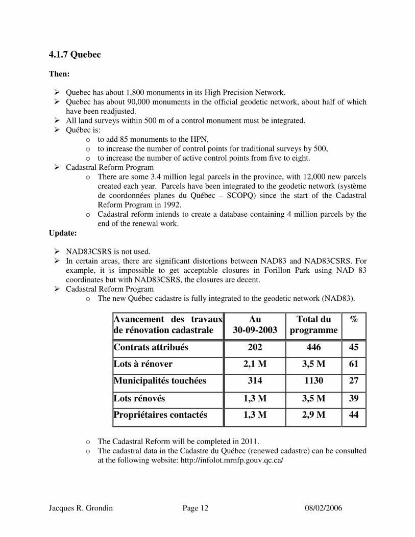
Avancement des travaux de rénovation cadastrale
Au 30-09-2003
Total du programme
%
Contrats attribués 202 446 45
Lots à rénover 2,1 M 3,5 M 61
Municipalités touchées 314 1130 27
Lots rénovés 1,3 M 3,5 M 39
Propriétaires contactés 1,3 M 2,9 M 44
o The Cadastral Reform will be completed in 2011. o The cadastral data in the Cadastre du Québec (renewed cadastre) can be consulted
at the following website: http://infolot.mrnfp.gouv.qc.ca/
Jacques R. Grondin Page 13 08/02/2006
o Some larger municipalities have implemented some years ago their own geo-reference databases. The cities of Montreal, Québec and Sherbrooke are pioneers in this field.
o Small municipalities have also been proactive. For example, the city of Bromont. ��Office of the Surveyor General of Québec
o It is not mandatory but customary to integrate to NAD83 all land surveys done on public lands. The office of the Surveyor General integrates these surveys and compiles and integrates the past surveys.
��La modernisation de l’enregistrement des droits sur le territoire public o Dans la foulée des réformes foncières entreprises sur le territoire privé (la réforme
du cadastre et la réforme de la publicité foncière), le ministère des Ressources naturelles entreprend la phase de concrétisation de la modernisation de l’enregistrement des droits sur le territoire public, par la mise en place du Registre du domaine de l’État.
o Cette base de données intégrée permettra de consigner, de conserver et de rendre publique une information foncière officielle, complète et à jour relative aux entités territoriales du domaine public et aux droits acquis ou concédés sur ces terres.
o Ce registre comportera trois volets : ��le premier volet concernera la tenure, l’autorité, l’identification, la
localisation (en référence au système québécois de référence géodésique) et la représentation des entités territoriales du domaine public;
��le second volet concernera l’enregistrement des droits accordés ou acquis en relation et des contraintes avec l’assise territoriale (en référence au système québécois de référence géodésique) sur laquelle ils porteront;
��le troisième volet concernera la consultation des données contenues au registre.
o Pour soutenir la modernisation de l’enregistrement des droits sur le territoire public et la mise en place du nouveau registre qui en découlera, la Direction générale de l’arpentage et du cadastre amorce également le développement d’un système informatique (appelé EDIT). Ce système gérera, par l’entremise d’Internet, l’enregistrement des droits et la diffusion de l’information1.
4.1.8 Newfoundland Then: ��Under authority of the Land Surveyors Act, the Association of Newfoundland Land
Surveyors provides the requirements for survey integration. ��All surveys are to be tied or referenced to the provincial monuments of the provincial
referencing system whenever possible. ��The current provincial referencing system is based on the NAD83 datum.
1 Source additionnelle “Bureau de l’arpenteur général du Québec” 2003.
Jacques R. Grondin Page 14 08/02/2006
��All plans of survey must include a straight line bearing and distance from one of the control points to a property monument, being the point of commencement of the survey, or the coordinate values (NAD83) of the point of commencement.
��All provincial control monuments tied to in the survey must have their coordinates and UTM zone number provided.
��The Geodetic Surveys program has established approximately 7,000 permanent survey markers with precise positions for the reference of topographic mapping, land surveys, and engineering surveys. The positions are integrated with the Geodetic Survey of Canada. The current method of control survey is the Global Positioning System (GPS) utilizing precise survey methods.
Update: N/A 4.1.9 New Brunswick Then: ��The Surveys Act requires that a system of coordinates for locating points on the earth be
established and maintained. The Act defines the datum and map projections to be used, and stipulates that under the coordinated survey system, the surveyor must set out bearings of boundary lines in terms of grid azimuths and distances in metres.
��Any survey plan under the coordinate survey system must describe a parcel of land using the coordinates of the parcel monuments and all coordinate values must be listed on the plan.
��Service New Brunswick (SNB) is responsible for the maintenance of the Provincial survey framework.
��Over 24,500 monuments were established in the control survey framework and are now referenced to NAD83(CSRS).
��SNB in cooperation with the Geodetic Survey Division of Geomatics Canada and the other two Maritime Provinces established the New Brunswick High Precision Network. The NBHPN is based on GPS, is referenced to NAD83(CSRS), and consists of some 130 monuments at a nominal spacing of 20 km.
��The Surveys Act provides for the establishment of integrated survey areas. The Director of Surveys must file in the Registry Office a plan setting out the coordinate monuments established. Once an integrated survey area is constituted, all subsequent surveys that establish legal monuments and parcels of land must be tied to the coordinate monuments. The City of Saint John is the only integrated survey area (ISA).
��The Director of Surveys’ Instructions allows a surveyor to tie his legal survey to control points in a variety of manners such as triangulation (two control points), trilateration (two control points), or resection (three control points), and then tying the parcel monuments to other control points not previously used in a closed traverse.
��Condominium and Air Space plans must be prepared in accordance with the Surveys Act regulations and the Director of Surveys’ instructions even if the condominium or air space project is located outside an ISA.
Jacques R. Grondin Page 15 08/02/2006
��All plans must include a table showing coordinate values for coordinate monuments used in the survey, for every monument or lot corner, and all other coordinate monuments whose position falls within the area of the plan must be shown.
��All plans of survey prepared under the Condominium Properties Act or the Air Space Act in any part of the province are done under the Director of Surveys Instructions, and must be tied to the control framework.
��In addition, the Standards Manual for New Brunswick Land Surveyors states the requirements for surveys that must be tied to survey control monuments. Any survey that cannot meet these requirements may be connected to a coordinate monument of any surveying or mapping agency (federal or provincial). When a survey is tied to the New Brunswick Coordinate System, the coordinate values of all coordinate monuments and parcel corners must be indicated on the plan of survey.
��Land surveys are integrated to the control framework under either of two models. The first model is administered under the Surveys Act. The second model is administered under the by-laws of the Association of New Brunswick Land Surveyors.
��Over 95% of surveys are now integrated. ��GPS may be used to determine coordinates of control points for a legal boundary survey. ��NAD83(CSRS) was proclaimed April 1, 1999 as the official datum for the Province.
Update: ��Service New Brunswick is responsible for:
o the inspection, physical and mathematical maintenance of the New Brunswick High Precision Network (NBHPN),
o the mathematical maintenance of the old ATS 77 conventional network, o the provision of elevation data for the NBHPN, o the provision of workshops and support in the use of coordinates and specific
computer programs, o collaboration with Geodetic Survey Division (GSD) of NRCan in the
development of the Canadian Real-Time GPS Correction Distribution Service (CDGPS).
��The major benefactor of the survey control network is Service New Brunswick. ��The fundamental network of survey monuments being used and maintained is the basis of
the property mapping on which the PLANET system, the DTM databases and the orthophoto mapping databases are based.
��The use of GPS technology has not progressed to the extent expected. However in December 2002, Service New Brunswick in a phone survey identified that 86% of the land surveyors (private & Government) producing legal surveys had access to GPS technology to meet the legal survey accuracy requirements.
��The land surveyors consider that they are still in a time of transition in moving to GPS technology.
��There is no consensus regarding the expansion of ISAs to other parts of the province. ��There is a move to explore alternatives to the maintenance of the HPN. Service New
Brunswick has already begun limiting that particular maintenance program under objections from the profession.

Jacques R. Grondin Page 16 08/02/2006
��In April 2003, Service New Brunswick accepted the recommendations outlined in the report “Potential for an Active Control System for New Brunswick”. During the next four years Service New Brunswick will establish 7 Active Control Stations and densify the existing High Precision Network (HPN) with an additional 20 stations.
��Over 98% of surveys are now integrated. 4.1.10 Nova Scotia Then: ��The Land Surveyors Regulations provide the details for the system in use including
integration of surveys with a coordinate referencing system. ��Unless hardship and extraordinary expense can be shown, each survey must be referenced
to the Nova Scotia Coordinate System via a measured bearing and distance to one or more control monuments.
��Astronomic bearings are permitted but all other bearings must be grid bearings derived from two or more monuments of the Nova Scotia Coordinate System.
��The control system contains approximately 23,000 points in the ATS77 datum framework. ��The province in cooperation with the other Maritime Provinces and the federal government
is creating the regional Maritime High Precision Network (HPN) referenced to the Canadian Base Network.
��In Nova Scotia, the HPN was established using GPS methods and currently has 153 stations with coordinates in the NAD83 (CSRS) datum.
Update: The Department of Service Nova Scotia and Municipal Relations (SNSMR) is reviewing the provincial policy with respect to spatial reference systems and map projections, including the appropriate means for formally adopting the Nova Scotia Coordinate Referencing System (NSCRS). SNSMR is also interested in identifying the technical implications of adopting and maintaining a spatial reference standard for the NSCRS with an associated official standard map projection or combination of map projections for geospatial data produced and/or accepted by the Province. To that end, it has hired Jacques Whitford Environment Limited to perform the study. 4.1.11 Prince Edward Island Then: ��The Land Survey Act recognizes the Prince Edward Island Coordinate System (PEICS) as
being the system instituted by the Geodetic Survey of Canada for defining and stating positions in the province.
��The coordinates were established to depend on and conform to the national system and were referenced using the NAD27 datum.
��PEI has a network of over 4000 reference points spanning the entire province.
Jacques R. Grondin Page 17 08/02/2006
��A pair of inter-visible monuments can be found no greater than one km from any particular property and land surveyors have always made every effort to tie in their surveys to the network.
��There is also a HPN referenced to NAD83(CSRS), consisting of 27 monuments at a spacing of 20 km.
��There are no regulations providing details for completing ties to the provincial coordinate system.
��Integrated survey areas are not a component of the survey fabric in PEI. ��Plans are not filed with the Chief Surveyor. ��Surveyors do integrate surveys and publish coordinate values for every monument.
Although there are no minimum standards on closures, land surveyors strive to achieve the highest achievable accuracy with the technology at hand (about 1:20,000).
Update: N/A 5.1 Principles 5.1.1 Synopsis of existing situation ��Monumented geodetic reference frameworks are not being maintained. ��Some provinces have installed HPNs and adjusted them to CBNs to establish
NAD83(CSRS) values. ��Some provinces have supplemented the NAD83(CSRS) coordinate databases through
transformation or readjustment of existing monumented control networks using various means. (E.g., NB re-adjusted to NAD83(CSRS) using original field observations eliminating values for areas showing any obvious significant discrepancies).
��The distortion of NAD83(CSRS)(Adopted) as represented by monumented control networks (excluding HPNs or CBNs) varies across the country but in some cases could exceed 1m. (See Appendix A)
��Some provinces are moving towards the installation of HPNs and away from the former monumented control networks, while others are not or are moving at a slower pace depending on feasibility. Some provinces are considering abandoning the maintenance of HPNs and move to the use of an ACS (e.g. NB).
��The number of survey firms possessing adequate GPS equipment is not as high as anticipated five years ago. In fact, probably less than 50% of survey firms possess the equipment necessary to cost effectively integrate surveys to sub metre accuracy relative to HPNs. However, in December 2002, Service New Brunswick determined through a telephone survey that 86% of the land surveyors performing legal surveys had access to GPS technology to meet the legal survey accuracy requirements.
��Although the cost of GPS equipment is going down, the overall cost of implementing the use of GPS has prevented a number of smaller survey firms from purchasing and getting the training in the use of GPS. However, some smaller survey firms have purchased some GPS equipment. They have purchased single frequency systems (� $10,000 for 3 receivers), allowing them to bring control to the job site.
��There are several private sector providers of Real Time Kinematic GPS updates.
Jacques R. Grondin Page 18 08/02/2006
��There is a trend towards being able to obtain better accuracy through single-point positioning using DGPS.
��High-resolution imagery is being geo-referenced to NAD83(CSRS). ��Achieving cm accuracy is still and will remain problematic in high-density urban areas. ��In most jurisdictions, it is a mandatory requirement that coordinates be published on the
plan of survey. ��The demand for more accurate spatially referenced data is continually increasing.
5.1.2 Some Basic Principles ��To be of lasting value, surveys should only be integrated to the NAD83(CSRS) as
represented by HPNs, CACS or other control monuments that have been properly integrated to NAD83(CSRS) where sub metre accuracy relative to the homogeneous NAD83(CSRS) is sought.
��HPNs should be supplemented in major urban environments by additional integrated and prominent points, such points to be parts of the built urban environment (e.g. building corners) and accessible by resection.
��Easily accessible and real time precise positioning is just around the corner. Therefore, integrated survey standards should push the technology, i.e. more difficult to achieve now, “duck soup” tomorrow.
��It makes no sense to integrate surveys relative to the now unmaintained monumented geodetic control network, unless
o the distortion relative to NAD83(CSRS) is known, and o the accuracy required is no better than the known distortion between
NAD83(CSRS) network and the other available network. ��In determining the timing of implementation a number of factors must be considered such
as: o allowing the survey profession to tool up by providing a sufficient transition
period, o the regulators must put in place the proper administrative mechanisms discussed
below. ��Integration of surveys does not alter the hierarchy of evidence for the re-establishment of
surveys monuments. Coordinate values do however present a level of mathematical evidence in proportion to their stated accuracy.
5.1.3 Administration ��Coordinates should not be published on plans or other documents recorded in the Land
Registry or Land Titles Systems. ��Coordinates should be recorded in a central public registry or database – maintained by the
appropriate Surveyor General or Director of Surveys as the case may be, or by the appropriate self-governing professional land surveying association.
��Each coordinated point should have a unique identifier for inclusion in the database. ��Coordinate database information should be available to all – free of charge. ��More than one set of coordinates per property corner should not be permitted. A dispute
resolution mechanism should be in place to resolve differences.
Jacques R. Grondin Page 19 08/02/2006
��Integrated surveys are to receive the same scrutiny, or be subjected to the same quality monitoring processes as are already in place in each jurisdiction for all surveys.
5.1.4 Implementation ��Integration of surveys to better than 1 metre accuracy relative to the NAD83(CSRS) should
be implemented only when there is sufficient and easy access to the reference frame. ��Implementation should only proceed when the profession has been given sufficient time to
gear up. ��The administrative and regulatory structure should be in place prior to implementation. ��Implementation need not take place at the same time across the country.
6.1 DRAFT Standards The following standards were developed from the above and the recommendations by Dr. Brian Ballantyne in his January 2002 report to CCOG. o When surveying any new parcel of land, the survey must be tied to NAD83(CSRS) through
the best available means if there is a reasonable availability of HPNs, CBNs or ACS monuments.
o The standard to which land surveys are integrated to NAD83 (CSRS) must be a function of parcel location and land use, with the connections qualified by the surveyor to meet the following minimum relative accuracy @ 95%:
Location Accuracy
1) High-density commercial or industrial parcel 2 cm 2) High-density residential parcel 4 cm 3) Any other urban or suburban parcel 4 cm 4) Rural parcels near urban or suburban areas. As a general principle, these
parcels would be included in areas that could reasonably be developed as part of the urban centre within the next 10 years. The outer limits of these areas would be set by the Surveyor General or Director of Surveys as the case may be, in consultation with each affected municipality.
10 cm
5) Rural Parcels outside the latter. The distinction between remote and rural areas should be set in each jurisdiction by the Surveyor General or Director of Surveys as the case may be in consultation with the professional land surveying association.
50 cm
6) Remote areas outside the latter 1 m
Jacques R. Grondin Page 20 08/02/2006
Appendix 1 Map of CBNs
Canadian Base Network
Jacques R. Grondin Page 21 08/02/2006
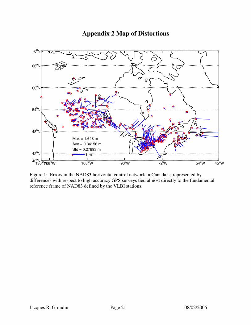
Appendix 2 Map of Distortions
130oW 126oW 108oW 90oW 72oW 54oW 45oW 40oN
42oN
48oN
54oN
60oN
66oN
70oN
Max = 1.648 mAve = 0.34156 mStd = 0.27893 m
1 m
Figure 1: Errors in the NAD83 horizontal control network in Canada as represented by differences with respect to high accuracy GPS surveys tied almost directly to the fundamental reference frame of NAD83 defined by the VLBI stations.