Embed Size (px)
Citation preview

100
Canadian Common Ground Alliance
Best Practices Version 1.0 – October 2014
Baspaly, David British Columbia Common Ground Alliance (BCCGA) Chair CCGA Executive Committee
Moreau, Nathalie
Info-Excavation L’Alliance pour la protection des infrastructures souterraines du Québec (APISQ)
Vice-Chair CCGA Executive Committee
Saedal, Derrick Public Works Department - City of Winnipeg & Manitoba Common Ground Alliance (MCGA)
Treasurer CCGA Executive Committee
Sullivan, Michael Alberta One Call (AOC) & Canadian Common Ground Alliance (CCGA) President
Douglas, Jim Ontario Regional Common Ground Alliance (ORCGA) Secretary CCGA Executive Committee
Tweedie, James Canadian Gas Association Past Chair CCGA Executive Committee
Bellissimo, Vince Canadian Construction Association Director
Bradley, Francis Canadian Electricity Association Director
Doyle, Mike Canadian Association of Geophysical Contractors Director
Durnie, Darwin Canadian Public Works Association Director
Ferguson, Travis Canadian Association of Petroleum Producers Director
Kirk, Sher Canadian One-Call Centres Committee Director
Loney, Steven TransCanada & Manitoba Common Ground Alliance (MCGA) Director
Pacheco, Elaine Canadian Energy Pipeline Association Director
Palaniuk, Randy Canadian Association of Pipeline & Utility Locating Contractors Director
Posehn, Daryl Saskatchewan Common Ground Alliance (SCGA) Director
Ramor, Brian Canadian Nursery and Landscape Association Director
Reeve, Dean SaskEnergy Incorporated & Saskatchewan Common Ground Alliance (SCGA) Director
Scott, Todd Enbridge Gas New Brunswick & Atlantic Canada Common Ground Alliance (ATLCGA) Director
Watson, Brad TransCanada & Alberta Common Ground Alliance (ABCGA) Director
Neufeld, Shannon National Energy Board Federal Champion
BoardOfDirectPage.indd 1 08/10/14 12:31 PM
CanaDIan CGa sUPPoRTeRs
2014 Board of Directors
98397_ORCGA_BestPract-TEXT-Oct2014.indd 100 16/10/14 9:42 AM
Underground Infrastructure Damage Prevention
Best Practices Version 2.0 – October 2016

Terms and Conditions of UseThe CCGA Best Practices have been developed through the commitment and consensus of a significant number of stakeholders to serve as an educational guide to promote damage prevention in Canada. It is subject to the following limitations:
• The Canadian Common Ground Alliance does not endorse any product, technology or company even though it is supported financially by its member companies and sponsors.
• The CCGA Best Practices manual is an educational guide and a general purpose tool which is not meant to replace existing standards, policies, or provincial/federal regulations or laws.
• The practice statements and descriptions outlined in each chapter of the guide represent activities that are currently followed by industry to pro-mote damage to underground infrastructure. Not all stakeholders are in a position to adopt these best practices but it is hoped that they will become universal over time.
The Canadian Common Ground Alliance (CCGA) is a non-profit organization dedicated to securing, maintaining and enhancing the integrity of Canada’s underground utility infrastructure.
Damage Prevention is a Shared ResponsibilityThis is the value upon which the CCGA was built. Whether you are a faci-lity owner or operator, locator, design professional, one-call centre contact employee, excavator, contractor or other damage prevention stakeholder, the safety of those living and working near Canada’s underground utility infrastructure, and preserving the reliability and integrity of Canada’s critical public services, is everyone’s responsibility.
CCGA VisionTo be the unified damage prevention voice for all Canadian national organi-zations and associations who share common damage prevention and public safety solutions.
CCGA MissionTo enhance public safety, and increase the integrity and reliability of Canada’s underground utility infrastructure, through the development and implementa-tion of effective and efficient damage prevention practices across Canada.
For additional information on the CCGA, or to learn how to become a member of your Regional Partner of the Canadian Common Ground Alliance, visit www.CanadianCGA.com or contact:
The Canadian Common Ground Alliance Suite 104 4242 Seventh Street SE Calgary, Alberta T2G 2Y8 Tel: 403.531.3700 Email: [email protected]

1
Canadian Common Ground Alliance
Best Practices Version 1.0 – October 2014
Introduction The Canadian Common Ground Alliance (CCGA) is an organization promoting efficient and effective damage prevention for Canada’s vital underground infrastructure. Through a unified approach and stakeholder consensus, the CCGA works to reduce damages to underground infrastructure - ensuring public safety, environmental protection, and the integrity of services by promoting effective damage prevention practices.
We are a growing organization and through the Regional Partners of the Common Ground Alliance in Canada, we represent a wide cross-section of stakeholders including:
Electrical Distribution Land Surveying Railways
Electrical Transmission Landscape/Fencing Regulator
Engineering Locator Road Builders
Equipment & Suppliers Municipal & Public Works Safety Organization
Excavator Oil & Gas Distribution Telecommunications
Homebuilder One-Call Transmission Pipeline
Insurance
For over a decade these stakeholder groups have been active in promoting “Call Before You Dig” and other good damage prevention practices through provincial regional partnerships which have come together and amalgamated under the CCGA name to provide a single voice representing the damage prevention community in Canada. The CCGA is the common voice for damage prevention issues of a national scope.
The CCGA has produced National Harmonized Best Practices based on the Ontario Regional Common Ground Alliance Best Practices, version 8.0 and the product of a collaborative effort among all Regional Partners of the Common Ground Alliance in Canada. The CCGA also acknowledges the established Common Ground Alliance Best Practices (United States) initiated by the Common Ground Study and presented to the U.S. Secretary of Transportation in June 1999. This set of National Harmonized Best Practices 1.0 - 2014, is the first but, through the commitment and consensus of its members working together towards a safer Canada, will be part of an ongoing effort to develop new damage prevention practices as well as improve existing ones. These practices represent a dynamic statement of the type of activities that CCGA believes would provide optimum levels of diligence towards preventing damage to underground infrastructure. It is understood that not all stakeholders are presently in a position to adopt all of these practices, however, it is anticipated that progress will be made towards following these practices over time.
Comments and suggestions on improving the format and content are welcome. Our intent is to make the statement of these Best Practices as easy to use as possible. If we can improve upon what you see here, your input in helping us do so would be most appreciated. All industry stakeholders are welcome to submit suggestions and to join the Best Practice Committee.
Electrical Distribution Landscape/Fencing Railway
Electrical Transmission Land Surveying Regulator
Engineering Locator Road Builders
Equipment & Suppliers Municipal & Public Works Safety Organization
Excavator Oil & Gas Distribution Telecommunications
Homebuilder One-Call Transmission Pipeline
Insurance
98397_ORCGA_BestPract-TEXT-Oct2014.indd 1 16/10/14 9:42 AM
Introduction The Canadian Common Ground Alliance (CCGA) is an organization promoting efficient and effective damage prevention for Canada’s vital underground infrastructure. Through a unified approach and stakeholder consensus, the CCGA works to reduce damages to underground infrastructure – ensuring public safety, environmental protection, and the integrity of services by pro-moting effective damage prevention practices.
The CCGA’s history is significantly different than its U.S. parent the Common Ground Alliance. In Canada, Regional Partners emerged from the “ground up” in Ontario (ORCGA), British Columbia Common Ground Alliance (BCCGA), Québec CGA (APISQ), the Alberta Common Ground Alliance (ABCGA), Saska-tchewan Regional Common Ground Alliance and more recently, the Manitoba Regional Common Ground Alliance and the Atlantic Canada Common Ground Alliance. Recognizing that each Regional Partner shared common national issues, the CCGA began as an ad hoc committee in 2006 to address those issues from a national perspective. Over the course of only a few years, it became clear that the CCGA required more structure to maintain momentum on key issues and in 2009, a governance model was introduced and accepted by the Committee. In late 2009, and in accordance with the approved go-vernance model, the CCGA held its first election to secure an “Executive” - a Chair, Vice-Chair and Secretary.
The CCGA’s primary role is to manage damage prevention issues of national interest that Regional Partners consider best addressed in a spirit of shared responsibility through a single voice.
We are a growing organization and through the Regional Partners of the Common Ground Alliance in Canada (see the inside back cover), we repre-sent a wide cross-section of stakeholders including:
For over a decade these stakeholder groups have been active in promoting damage prevention practices through provincial regional partnerships which have come together and amalgamated under the CCGA name to provide a single voice representing the damage prevention community in Canada. The CCGA is the common voice for damage prevention issues of a national scope.
The CCGA has produced National Harmonized Best Practices based on the Ontario Regional Common Ground Alliance Best Practices, version 8.0 and the product of a collaborative effort among all Regional Partners of the Com-
Construction
Electrical Distribution and Transmission
Emergency services
Engineering and Land Surveying
Equipment manufacturing and Suppliers
Excavator
Gas & Oil Distribution and Transmission
Government/Regulators
Insurance
Landowners
Landscape/Fencing
Locator
Municipal and Public Works
One-Call
Railways
Road Builders
Telecommunications
Canadian Common Ground AllianceBest Practices Version 2.0 – October 2016 1

Canadian Common Ground Alliance Best Practices Version 1.0 – October 2014
Participation at this level is not restricted to CCGA members.
In order to facilitate the maintaining & governance of these CCGA Best Practices, a procedure has been created to guide the submission of potential changes via a process that provides the oversight & approval of the CCGA Board of Directors as well as both the National & Regional Common Ground Alliance Best Practices Committees. A form for the submission of potential changes to the CCGA Best Practices can be found in Appendix D of this document & the change procedure, the “Harmonized Best Practices Process; CCGA BP Process V 1.0 – 2014” is available on the CCGA website.
To participate in the CCGA Best Practices work or to participate in any committee meeting, please check the CCGA website (CanadianCGA.com) to learn the scope of the various CCGA Committees. The meeting dates and contact names and numbers are listed for each committee. If you have any general inquiries about the CCGA, please feel free to contact the CCGA at the following:
The Canadian Common Ground Alliance 4242 Seventh Street SE Suite 104 Calgary, Alberta T2G 2Y8
Tel: 403.531.3700 Email: [email protected] Web: www.CanadianCGA.com
2
Canadian Common Ground AllianceBest Practices Version 1.0 – October 2014
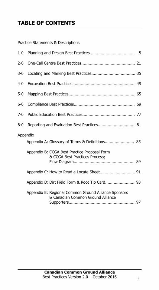
TABLE OF CONTENTS
Practice Statements & Descriptions
1-0 Planning and Design Best Practices………………………..5
2-0 One-Call Centre Practices…………………...................21
3-0 Locating and Marking Best Practices…………………….35
4-0 Excavation Best Practices………………………………….…51
5-0 Mapping Best Practices………………………………………..65
6-0 Compliance Best Practices…………………………………..69
7-0 Public Education Best Practices……………………………75
8-0 Reporting and Evaluation Best Practices……… …….79
Appendix A: Glossary of Terms & Definitions
Appendix B: CCGA Best Practice Proposal Form &CCGA Best Practices Process; Flow Diagram
Appendix C: How to Read a Locate Sheet
Appendix D: DIRT Field Form & Root Tip Card
Appendix E: Regional Common Ground Alliance Sponsors& Canadian Common Ground AllianceSupporters
98397_ORCGA_BestPract-TEXT-Oct2014.indd 2 16/10/14 9:42 AM
mon Ground Alliance in Canada. The CCGA also acknowledges the establi-shed Common Ground Alliance Best Practices (United States) initiated by the Common Ground Study and presented to the U.S. Secretary of Transportation in June 1999.
This set of National Harmonized Best Practices 2.0 - 2016, which has been updated through the commitment and consensus of its members working together towards a safer Canada, is part of an ongoing effort to develop new damage prevention practices as well as improve existing ones. These prac-tices represent a dynamic statement of the type of activities that CCGA be-lieves would provide optimum levels of diligence towards preventing damage to underground infrastructure. It is understood that not all stakeholders are presently in a position to adopt all of these practices, however, it is antici-pated that progress will be made towards following these practices over time.
Comments and suggestions on improving the format and content are wel-come. Our intent is to make the statement of these Best Practices as easy to use as possible. If we can improve upon what you see here, your input in helping us do so would be most appreciated.
Participation at this level is not restricted to CCGA members. In order to facilitate the maintaining & governance of these CCGA Best Practices, a procedure has been created to guide the submission of potential changes via a process that provides the oversight & approval of the CCGA Board of Directors as well as both the National & Regional Common Ground Alliance Best Practices Committees. A form for the submission of potential changes to the CCGA Best Practices can be found in Appendix D of this document & the change procedure, the “Harmonized Best Practices Process; CCGA BP Process V 2.0 – 2016” is available on the CCGA website.
To participate in the CCGA Best Practices work or to participate in any com-mittee meeting, please check the CCGA website (CanadianCGA.com) to learn the scope of the various CCGA Committees. If you have any general inquiries about the CCGA, please feel free to contact the CCGA at the following:
Email: [email protected]
Web: www.CanadianCGA.com
Canadian Common Ground AllianceBest Practices Version 2.0 – October 20162
Canadian Common Ground Alliance Best Practices Version 1.0 – October 2014
Participation at this level is not restricted to CCGA members.
In order to facilitate the maintaining & governance of these CCGA Best Practices, a procedure has been created to guide the submission of potential changes via a process that provides the oversight & approval of the CCGA Board of Directors as well as both the National & Regional Common Ground Alliance Best Practices Committees. A form for the submission of potential changes to the CCGA Best Practices can be found in Appendix D of this document & the change procedure, the “Harmonized Best Practices Process; CCGA BP Process V 1.0 – 2014” is available on the CCGA website.
To participate in the CCGA Best Practices work or to participate in any committee meeting, please check the CCGA website (CanadianCGA.com) to learn the scope of the various CCGA Committees. The meeting dates and contact names and numbers are listed for each committee. If you have any general inquiries about the CCGA, please feel free to contact the CCGA at the following:
The Canadian Common Ground Alliance 4242 Seventh Street SE Suite 104 Calgary, Alberta T2G 2Y8
Tel: 403.531.3700 Email: [email protected] Web: www.CanadianCGA.com
2
Canadian Common Ground AllianceBest Practices Version 1.0 – October 2014
TABLE OF CONTENTS
Practice Statements & Descriptions
1-0 Planning and Design Best Practices………………………..5
2-0 One-Call Centre Practices…………………...................21
3-0 Locating and Marking Best Practices…………………….35
4-0 Excavation Best Practices………………………………….…51
5-0 Mapping Best Practices………………………………………..65
6-0 Compliance Best Practices…………………………………..69
7-0 Public Education Best Practices……………………………75
8-0 Reporting and Evaluation Best Practices……… …….79
Appendix A: Glossary of Terms & Definitions
Appendix B: CCGA Best Practice Proposal Form &CCGA Best Practices Process; Flow Diagram
Appendix C: How to Read a Locate Sheet
Appendix D: DIRT Field Form & Root Tip Card
Appendix E: Regional Common Ground Alliance Sponsors& Canadian Common Ground AllianceSupporters
98397_ORCGA_BestPract-TEXT-Oct2014.indd 2 16/10/14 9:42 AM
Practice Statements & Descriptions
1-0 Planning and Design Best Practices..................................... 5
2-0 One-Call Centre Best Practices............................................ 21
3-0 Locating and Marking Best Practices.................................... 35
4-0 Excavation Best Practices................................................... 49
5-0 Mapping Best Practices...................................................... 65
6-0 Compliance Best Practices.................................................. 69
7-0 Public Education Best Practices........................................... 77
8-0 Reporting and Evaluation Best Practices.............................. 81
Appendix
Appendix A: Glossary of Terms & Definitions........................ 85
Appendix B: CCGA Best Practice Proposal Form & CCGA Best Practices Process; Flow Diagram.................................................. 89
Appendix C: How to Read a Locate Sheet............................. 91
Appendix D: Dirt Field Form & Root Tip Card........................ 93
Appendix E: Regional Common Ground Alliance Sponsors & Canadian Common Ground Alliance Supporters....................................................... 97
TABLE OF CONTENTS
Canadian Common Ground AllianceBest Practices Version 2.0 – October 2016 3

Canadian Common Ground Alliance
Best Practices Version 1.0 – October 2014
4
Canadian Common Ground Alliance
Best Practices Version 1.0 – October 2014
1-0 Planning and Design Best Practices
1-1: Planning Utility Corridors
Practice Statement: Designers and planners should evaluate all applicable factors when determining the placement of underground utilities. Ideally speaking, existing utility corridors should be used to the fullest extent, and, for entirely new installations, consideration should be given to the creation of a common utility corridor for the current, and future placement of all utilities.
Practice Description: Pre-planning for utility placement within current or proposed utility corridors is vital to the overall safe operation of that corridor. Planners and designers should research, examine and evaluate the size, and location of the area to be utilized, and determine the type and running line location of the utilities that must utilize the corridor. In the case of existing corridors, the information developed must be assessed in the context of the proposed installation to determine the safest, most efficient, and most effective configuration. In the case of entirely new installations in proposed corridors, the information developed must be assessed in the context of a common corridor configuration that accommodates all of the utilities involved. Consideration should be given to issues such as safety, setbacks, future operations and maintenance, preservation of boundaries, clearances and future expansion.
Planning practices, such as joint trenching and the development of Utilidors, should be considered as options for maximizing the effectiveness of the available area. Similarly, standardized line locations could be adopted that promote the safest, most efficient, and most effective installations.
Consideration should be given to the development of provincially consistent standards for the planning, design, and construction of common utility corridors. This should incorporate minimum guidelines for sizes/spacing between utilities in corridors, protection of property bars, and the consistent standard placement of utilities within the Right of Way.
Benefits:
The use of common utility corridors would result in the following benefits:
1. Accurate information as to the location of underground utilities in a particular geographic area.
2. Safe, efficient, and effective installation, placement, operation and maintenance and of underground utilities.
3. Efficient and effective utilization of land.
4. Easy identification and location of underground utilities in future development projects.
5. Damage Prevention.
98397_ORCGA_BestPract-TEXT-Oct2014.indd 4 16/10/14 9:42 AM
Canadian Common Ground AllianceBest Practices Version 2.0 – October 20164

1-0 Planning and Design Best Practices
1 P
lann
ing
and
Des
ign

Canadian Common Ground Alliance
Best Practices Version 1.0 – October 2014
5
Canadian Common Ground Alliance
Best Practices Version 1.0 – October 2014
1-0 Planning and Design Best Practices
1-1: Planning Utility Corridors
Practice Statement: Designers and planners should evaluate all applicable factors when determining the placement of underground utilities. Ideally speaking, existing utility corridors should be used to the fullest extent, and, for entirely new installations, consideration should be given to the creation of a common utility corridor for the current, and future placement of all utilities.
Practice Description: Pre-planning for utility placement within current or proposed utility corridors is vital to the overall safe operation of that corridor. Planners and designers should research, examine and evaluate the size, and location of the area to be utilized, and determine the type and running line location of the utilities that must utilize the corridor. In the case of existing corridors, the information developed must be assessed in the context of the proposed installation to determine the safest, most efficient, and most effective configuration. In the case of entirely new installations in proposed corridors, the information developed must be assessed in the context of a common corridor configuration that accommodates all of the utilities involved. Consideration should be given to issues such as safety, setbacks, future operations and maintenance, preservation of boundaries, clearances and future expansion.
Planning practices, such as joint trenching and the development of Utilidors, should be considered as options for maximizing the effectiveness of the available area. Similarly, standardized line locations could be adopted that promote the safest, most efficient, and most effective installations.
Consideration should be given to the development of provincially consistent standards for the planning, design, and construction of common utility corridors. This should incorporate minimum guidelines for sizes/spacing between utilities in corridors, protection of property bars, and the consistent standard placement of utilities within the Right of Way.
Benefits:
The use of common utility corridors would result in the following benefits:
1. Accurate information as to the location of underground utilities in a particular geographic area.
2. Safe, efficient, and effective installation, placement, operation and maintenance and of underground utilities.
3. Efficient and effective utilization of land.
4. Easy identification and location of underground utilities in future development projects.
5. Damage Prevention.
98397_ORCGA_BestPract-TEXT-Oct2014.indd 5 16/10/14 9:42 AM
Canadian Common Ground Alliance
Best Practices Version 1.0 – October 2014
4
Canadian Common Ground Alliance
Best Practices Version 1.0 – October 2014
1-0 Planning and Design Best Practices
1-1: Planning Utility Corridors
Practice Statement: Designers and planners should evaluate all applicable factors when determining the placement of underground utilities. Ideally speaking, existing utility corridors should be used to the fullest extent, and, for entirely new installations, consideration should be given to the creation of a common utility corridor for the current, and future placement of all utilities.
Practice Description: Pre-planning for utility placement within current or proposed utility corridors is vital to the overall safe operation of that corridor. Planners and designers should research, examine and evaluate the size, and location of the area to be utilized, and determine the type and running line location of the utilities that must utilize the corridor. In the case of existing corridors, the information developed must be assessed in the context of the proposed installation to determine the safest, most efficient, and most effective configuration. In the case of entirely new installations in proposed corridors, the information developed must be assessed in the context of a common corridor configuration that accommodates all of the utilities involved. Consideration should be given to issues such as safety, setbacks, future operations and maintenance, preservation of boundaries, clearances and future expansion.
Planning practices, such as joint trenching and the development of Utilidors, should be considered as options for maximizing the effectiveness of the available area. Similarly, standardized line locations could be adopted that promote the safest, most efficient, and most effective installations.
Consideration should be given to the development of provincially consistent standards for the planning, design, and construction of common utility corridors. This should incorporate minimum guidelines for sizes/spacing between utilities in corridors, protection of property bars, and the consistent standard placement of utilities within the Right of Way.
Benefits:
The use of common utility corridors would result in the following benefits:
1. Accurate information as to the location of underground utilities in a particular geographic area.
2. Safe, efficient, and effective installation, placement, operation and maintenance and of underground utilities.
3. Efficient and effective utilization of land.
4. Easy identification and location of underground utilities in future development projects.
5. Damage Prevention.
98397_ORCGA_BestPract-TEXT-Oct2014.indd 4 16/10/14 9:42 AM
Canadian Common Ground AllianceBest Practices Version 2.0 – October 2016 5
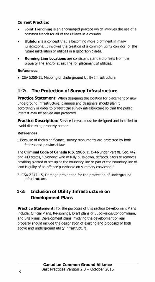
Current Practice:
• Joint Trenching is an encouraged practice which involves the use of acommon trench for all of the utilities in a corridor.
• Utilidors is a concept that is becoming more prominent in manyjurisdictions. It involves the creation of a common utility corridor for thefuture installation of utilities in a geographic area.
• Running Line Locations are consistent standard offsets from theproperty line and/or street line for placement of utilities.
References:
• CSA S250-11, Mapping of Underground Utility Infrastructure
1-2: The Protection of Survey InfrastructurePractice Statement: When designing the location for placement of new underground infrastructure, planners and designers should plan it accordingly in order to protect the survey infrastructure so that the public interest may be served and protected
Practice Description: Service laterals must be designed and installed to avoid disturbing property corners.
References:
1. Because of their significance, survey monuments are protected by bothfederal and provincial law.
The Criminal Code of Canada R.S. 1985, c. C-46 under Part XI, Sec. 442 and 443 states, "Everyone who wilfully pulls down, defaces, alters or removes anything planted or set up as the boundary line or part of the boundary line of land is guilty of an offence punishable on summary conviction."
1-3: Inclusion of Utility Infrastructure onDevelopment Plans
Practice Statement: For the purposes of this section Development Plans include; Official Plans, Re-zonings, Draft plans of Subdivision/Condominium, and Site Plans. Development plans involving the development of real property should include the designation of existing and proposed of both above and underground utility infrastructure.
6
Canadian Common Ground Alliance Best Practices Version 1.0 - October 2014
2. CSA Z247-15, Damage prevention for the protection of underground m minfrastructure.
Canadian Common Ground AllianceBest Practices Version 2.0 – October 20166

Canadian Common Ground Alliance
Best Practices Version 1.0 – October 2014
Current Practice:
Joint Trenching is an encouraged practice which involves the use of a common trench for all of the utilities in a corridor.
Utilidors is a concept that is becoming more prominent in many jurisdictions. It involves the creation of a common utility corridor for the future installation of utilities in a geographic area.
Running Line Locations are consistent standard offsets from the property line and/or street line for placement of utilities.
References:
CSA S250-11, Mapping of Underground Utility Infrastructure
1-2: The Protection of Survey Infrastructure
Practice Statement: When designing the location for placement of new utility plant, planners and designers should plan it accordingly in order to protect the survey infrastructure so that the public interest may be served and protected
Practice Description: Service laterals must be designed and installed to avoid disturbing property corners.
References:
1. Because of their significance, survey monuments are protected by both federal and provincial law.
The Criminal Code of Canada R.S. 1985, c. C-46 under Part XI, Sec. 442 and 443 states, “Everyone who wilfully pulls down, defaces, alters or removes anything planted or set up as the boundary line or part of the boundary line of land is guilty of an offence punishable on summary conviction.”
2. City of Winnipeg Survey Infrastructure Clearance Program winnipeg.ca/PPD/surveys.stm#legal%20survey
The City of Winnipeg coined the phrase “Survey Infrastructure” which placed the survey fabric on par with the other municipal infrastructures such as, sewer and water, hydro/electrical and gas, etc., which are recognized as being important and for which protection is provided.
1-3: Inclusion of Utility Infrastructure on Development Plans
Practice Statement: For the purposes of this section Development Plans include; Official Plans, Re-zonings, Draft plans of Subdivision/Condominium, and Site Plans. Development plans involving the development of real property should include the designation of existing and proposed of both above and underground utility infrastructure.
7
Canadian Common Ground Alliance
Best Practices Version 1.0 – October 2014
Practice Description: Various items are required on the Development Plans filed prior to the development of lands. Where a Development Plan is to be filed, the items required should include the location[s] of both above and underground facilities traversing the land described on the Development Plan. Identification of the location[s] of both above and underground facilities on the Development Plan would provide notice to developers and the public about the existence of infrastructure facilities, and would alert facility owners/operators of the need to establish communication with the developers to facilitate planning for the lands which complements the utility infrastructure. Facility and utility owners should maintain timely and accurate records of all abandoned and out-of-service plant, and this information should be identified on Development Plans along with the existing, future, and proposed facilities.
Benefits: The requirement that utility infrastructure locations be identified on the Draft and Site Plans is shared with the underground facility owners/ operators should ensure that facility owners/operators are fully aware of development which will impact on their facilities well in advance of the commencement of excavation activity. It should also facilitate the optimal use of the land being developed, and maintain the integrity of the utility infrastructure.
References:
CSA S250-11, Mapping of Underground Utility Infrastructure
1-4: Gathering Information for Design Purposes
Practice Statement: The designer/engineer should use all reasonable and available means of obtaining information about utility facilities in the area to be developed.
Practice Description: During the planning or preliminary design phase of a project, all available information should be gathered from the facility owners/operators, including maps of existing, abandoned, and out-of-service facilities, as-built of facilities in the area, proposed projects, and schedules of work in the area. The methods of gathering information should include contacting a One-Call Centre, facility owners/operators, property owners, Public Utility Commission (PUCs), and government (municipal, provincial, and federal) departments and agencies. They also include a review of the site for above ground evidence of underground utilities, e.g. permanent signs or markers, manhole covers, vent pipes, power and communication pedestals, and valve covers. The facility owner/operator provides the locations of his/her underground facilities by other means, such as by marking preliminary design drawings or providing facility records to the designer. This latter option for gathering the required information should be pursued purposefully by the designer. The information gathered by these methods is used by the designer for purposes of route selection and preliminary neighbourhood impacts, or in the evaluation of different design possibilities.
98397_ORCGA_BestPract-TEXT-Oct2014.indd 7 16/10/14 9:42 AM
Current Practice:
• Joint Trenching is an encouraged practice which involves the use of acommon trench for all of the utilities in a corridor.
• Utilidors is a concept that is becoming more prominent in manyjurisdictions. It involves the creation of a common utility corridor for thefuture installation of utilities in a geographic area.
• Running Line Locations are consistent standard offsets from theproperty line and/or street line for placement of utilities.
References:
• CSA S250-11, Mapping of Underground Utility Infrastructure
1-2: The Protection of Survey InfrastructurePractice Statement: When designing the location for placement of new underground infrastructure, planners and designers should plan it accordingly in order to protect the survey infrastructure so that the public interest may be served and protected
Practice Description: Service laterals must be designed and installed to avoid disturbing property corners.
References:
1. Because of their significance, survey monuments are protected by bothfederal and provincial law.
The Criminal Code of Canada R.S. 1985, c. C-46 under Part XI, Sec. 442 and 443 states, "Everyone who wilfully pulls down, defaces, alters or removes anything planted or set up as the boundary line or part of the boundary line of land is guilty of an offence punishable on summary conviction."
1-3: Inclusion of Utility Infrastructure onDevelopment Plans
Practice Statement: For the purposes of this section Development Plans include; Official Plans, Re-zonings, Draft plans of Subdivision/Condominium, and Site Plans. Development plans involving the development of real property should include the designation of existing and proposed of both above and underground utility infrastructure.
6
Canadian Common Ground Alliance Best Practices Version 1.0 - October 2014
2. CSA Z247-15, Damage prevention for the protection of underground m minfrastructure.
Canadian Common Ground AllianceBest Practices Version 2.0 – October 2016 7
Canadian Common Ground Alliance
Best Practices Version 1.0 – October 2014
During the detailed design phase of a project, it is necessary to developdetailed information on the locations of utility facilities in the project area in order to ensure accuracy, and minimize the possibility of utility conflicts. This detailed information can be obtained through a survey of utility infrastructure and the methods utilized should be documented.
Benefits: Gathering underground facility information and incorporating this information in the planning and design phase minimizes the hazards, cost, and work to produce the final project. Safety is enhanced, unexpected facility conflicts are eliminated, and facility relocations are minimized.
Current Practice:
Project owners utilize some basic practices when performing a survey of utility infrastructure. For effective results the steps should be performed in sequence. However it is not necessary to complete all steps depending on the level of information required. The steps are as follows:
1. Use all available existing utility facility records to obtain information about locations of existing and proposed underground facilities in the entire construction project area;
2. Visit the job site to correlate the information already gathered about existing utility facilities with above ground features;
3. Use appropriate instruments to determine the approximate horizontal locations of the underground facilities identified; and
4. Use test holes to positively determine the exact location of existing underground facilities. At this point, horizontal and vertical control measurements may be taken. Test holes are used to positively locate and identify an underground facility by exposing the facility by a non-destructive means, e.g. vacuum excavation.
References:
CSA S250-11, Mapping of Underground Utility Infrastructure
1-5: Subsurface Utility Engineering (SUE)
Practice Statement: The project owner should consider the use of Subsurface Utility Engineering (SUE) techniques as a structured method of gathering and depicting utility information for design purposes.
Practice Description: SUE is applied during the design phase to locate, identify, and characterize all existing utility infrastructure (and other relevant non-utility features) found within a given project. SUE is applied in a structured manner, in accordance with practices and Quality Levels found in ASCE 38-02 Standard Guideline for the Collection and Depiction of Existing Subsurface Utility Data. Although the Standard is more detailed and comprehensive, the following is a brief summary of the Quality Levels defined therein: Quality Level D – information gathered solely from existing utility
8
Canadian Common Ground Alliance
Best Practices Version 1.0 – October 2014
records which will provide an overall sense of the congestion of utilities, but is limited in terms of comprehensiveness and accuracy.
The four (4) Quality Levels are:
1. Quality Level D – information gathered solely from existing utility records which will provide an overall sense of the congestion of utilities, but is limited in terms of comprehensiveness and accuracy. Use of Quality Level D information should be limited to project planning and route selection activities;
2. Quality Level C – information gathered from surveying above ground facilities such as manholes, valve boxes, and pedestals which is used to augment the information gathered in Level D;
3. Quality Level B – involves ‘designating’ or the use of surface geophysical techniques to determine the existence and horizontal position of facilities, including those identified in Level C. Two-dimensional mapping information is obtained. The data obtained is usually sufficient for excavation planning. The data obtained can facilitate decisions with respect to the placement of new structures or facilities to avoid conflicts with existing facilities; and
4. Quality Level A – involves ‘locating’ or the use of non-destructive excavation devices at critical locations to determine the precise horizontal and vertical position of existing facilities, as well as the type, size, condition, material, and other characteristics. When surveyed and mapped, precise plan and profile information is available for use in making final design decisions. The SUE engineer guarantees the accuracy of the Level A information.
References:
CSA S250-11, Mapping of Underground Utility Infrastructure
1-6: Identifying Existing Facilities in Planning and Design
Practice Statement: Designers should indicate existing utility facilities on drawings during planning and design.
Practice Description: During the planning and preliminary design phase of a project, existing facilities, such as hydro/electric, gas, telecommunications, CATV, water mains and sewers should be shown on preliminary design plans. The planning documents should include possible routes for the project together with known underground facility information. The facility owners/operators should be given the opportunity to provide appropriate comments.
During the detailed design phase of a project, utility facility information is shown on the plans. The method used to gather information should be noted on the plans by the project owner so that the designer and the
98397_ORCGA_BestPract-TEXT-Oct2014.indd 8 16/10/14 9:42 AM
Canadian Common Ground AllianceBest Practices Version 2.0 – October 20168
Canadian Common Ground Alliance
Best Practices Version 1.0 – October 2014
During the detailed design phase of a project, it is necessary to developdetailed information on the locations of utility facilities in the project area in order to ensure accuracy, and minimize the possibility of utility conflicts. This detailed information can be obtained through a survey of utility infrastructure and the methods utilized should be documented.
Benefits: Gathering underground facility information and incorporating this information in the planning and design phase minimizes the hazards, cost, and work to produce the final project. Safety is enhanced, unexpected facility conflicts are eliminated, and facility relocations are minimized.
Current Practice:
Project owners utilize some basic practices when performing a survey of utility infrastructure. For effective results the steps should be performed in sequence. However it is not necessary to complete all steps depending on the level of information required. The steps are as follows:
1. Use all available existing utility facility records to obtain information about locations of existing and proposed underground facilities in the entire construction project area;
2. Visit the job site to correlate the information already gathered about existing utility facilities with above ground features;
3. Use appropriate instruments to determine the approximate horizontal locations of the underground facilities identified; and
4. Use test holes to positively determine the exact location of existing underground facilities. At this point, horizontal and vertical control measurements may be taken. Test holes are used to positively locate and identify an underground facility by exposing the facility by a non-destructive means, e.g. vacuum excavation.
References:
CSA S250-11, Mapping of Underground Utility Infrastructure
1-5: Subsurface Utility Engineering (SUE)
Practice Statement: The project owner should consider the use of Subsurface Utility Engineering (SUE) techniques as a structured method of gathering and depicting utility information for design purposes.
Practice Description: SUE is applied during the design phase to locate, identify, and characterize all existing utility infrastructure (and other relevant non-utility features) found within a given project. SUE is applied in a structured manner, in accordance with practices and Quality Levels found in ASCE 38-02 Standard Guideline for the Collection and Depiction of Existing Subsurface Utility Data. Although the Standard is more detailed and comprehensive, the following is a brief summary of the Quality Levels defined therein: Quality Level D – information gathered solely from existing utility
9
Canadian Common Ground Alliance
Best Practices Version 1.0 – October 2014
records which will provide an overall sense of the congestion of utilities, but is limited in terms of comprehensiveness and accuracy.
The four (4) Quality Levels are:
1. Quality Level D – information gathered solely from existing utility records which will provide an overall sense of the congestion of utilities, but is limited in terms of comprehensiveness and accuracy. Use of Quality Level D information should be limited to project planning and route selection activities;
2. Quality Level C – information gathered from surveying above ground facilities such as manholes, valve boxes, and pedestals which is used to augment the information gathered in Level D;
3. Quality Level B – involves ‘designating’ or the use of surface geophysical techniques to determine the existence and horizontal position of facilities, including those identified in Level C. Two-dimensional mapping information is obtained. The data obtained is usually sufficient for excavation planning. The data obtained can facilitate decisions with respect to the placement of new structures or facilities to avoid conflicts with existing facilities; and
4. Quality Level A – involves ‘locating’ or the use of non-destructive excavation devices at critical locations to determine the precise horizontal and vertical position of existing facilities, as well as the type, size, condition, material, and other characteristics. When surveyed and mapped, precise plan and profile information is available for use in making final design decisions. The SUE engineer guarantees the accuracy of the Level A information.
References:
CSA S250-11, Mapping of Underground Utility Infrastructure
1-6: Identifying Existing Facilities in Planning and Design
Practice Statement: Designers should indicate existing utility facilities on drawings during planning and design.
Practice Description: During the planning and preliminary design phase of a project, existing facilities, such as hydro/electric, gas, telecommunications, CATV, water mains and sewers should be shown on preliminary design plans. The planning documents should include possible routes for the project together with known underground facility information. The facility owners/operators should be given the opportunity to provide appropriate comments.
During the detailed design phase of a project, utility facility information is shown on the plans. The method used to gather information should be noted on the plans by the project owner so that the designer and the
98397_ORCGA_BestPract-TEXT-Oct2014.indd 9 16/10/14 9:42 AM
Canadian Common Ground Alliance
Best Practices Version 1.0 – October 2014
During the detailed design phase of a project, it is necessary to developdetailed information on the locations of utility facilities in the project area in order to ensure accuracy, and minimize the possibility of utility conflicts. This detailed information can be obtained through a survey of utility infrastructure and the methods utilized should be documented.
Benefits: Gathering underground facility information and incorporating this information in the planning and design phase minimizes the hazards, cost, and work to produce the final project. Safety is enhanced, unexpected facility conflicts are eliminated, and facility relocations are minimized.
Current Practice:
Project owners utilize some basic practices when performing a survey of utility infrastructure. For effective results the steps should be performed in sequence. However it is not necessary to complete all steps depending on the level of information required. The steps are as follows:
1. Use all available existing utility facility records to obtain information about locations of existing and proposed underground facilities in the entire construction project area;
2. Visit the job site to correlate the information already gathered about existing utility facilities with above ground features;
3. Use appropriate instruments to determine the approximate horizontal locations of the underground facilities identified; and
4. Use test holes to positively determine the exact location of existing underground facilities. At this point, horizontal and vertical control measurements may be taken. Test holes are used to positively locate and identify an underground facility by exposing the facility by a non-destructive means, e.g. vacuum excavation.
References:
CSA S250-11, Mapping of Underground Utility Infrastructure
1-5: Subsurface Utility Engineering (SUE)
Practice Statement: The project owner should consider the use of Subsurface Utility Engineering (SUE) techniques as a structured method of gathering and depicting utility information for design purposes.
Practice Description: SUE is applied during the design phase to locate, identify, and characterize all existing utility infrastructure (and other relevant non-utility features) found within a given project. SUE is applied in a structured manner, in accordance with practices and Quality Levels found in ASCE 38-02 Standard Guideline for the Collection and Depiction of Existing Subsurface Utility Data. Although the Standard is more detailed and comprehensive, the following is a brief summary of the Quality Levels defined therein: Quality Level D – information gathered solely from existing utility
8
Canadian Common Ground Alliance
Best Practices Version 1.0 – October 2014
records which will provide an overall sense of the congestion of utilities, but is limited in terms of comprehensiveness and accuracy.
The four (4) Quality Levels are:
1. Quality Level D – information gathered solely from existing utility records which will provide an overall sense of the congestion of utilities, but is limited in terms of comprehensiveness and accuracy. Use of Quality Level D information should be limited to project planning and route selection activities;
2. Quality Level C – information gathered from surveying above ground facilities such as manholes, valve boxes, and pedestals which is used to augment the information gathered in Level D;
3. Quality Level B – involves ‘designating’ or the use of surface geophysical techniques to determine the existence and horizontal position of facilities, including those identified in Level C. Two-dimensional mapping information is obtained. The data obtained is usually sufficient for excavation planning. The data obtained can facilitate decisions with respect to the placement of new structures or facilities to avoid conflicts with existing facilities; and
4. Quality Level A – involves ‘locating’ or the use of non-destructive excavation devices at critical locations to determine the precise horizontal and vertical position of existing facilities, as well as the type, size, condition, material, and other characteristics. When surveyed and mapped, precise plan and profile information is available for use in making final design decisions. The SUE engineer guarantees the accuracy of the Level A information.
References:
CSA S250-11, Mapping of Underground Utility Infrastructure
1-6: Identifying Existing Facilities in Planning and Design
Practice Statement: Designers should indicate existing utility facilities on drawings during planning and design.
Practice Description: During the planning and preliminary design phase of a project, existing facilities, such as hydro/electric, gas, telecommunications, CATV, water mains and sewers should be shown on preliminary design plans. The planning documents should include possible routes for the project together with known underground facility information. The facility owners/operators should be given the opportunity to provide appropriate comments.
During the detailed design phase of a project, utility facility information is shown on the plans. The method used to gather information should be noted on the plans by the project owner so that the designer and the
98397_ORCGA_BestPract-TEXT-Oct2014.indd 8 16/10/14 9:42 AM
Canadian Common Ground AllianceBest Practices Version 2.0 – October 2016 9
Canadian Common Ground Alliance
Best Practices Version 1.0 – October 2014
contractor both know the quality of the information included on the plans.The facilities shown should include active, abandoned, out-of-service, future use, and proposed facilities. The design plans should include a summary showing the proposed facility route or excavation. The design plans should be provided to affected facility owners/operators in order to provide an opportunity for final comment/clarification.
Benefits: Providing complete underground facility information and including this information on design drawings reduces safety hazards, simplifies coordination, and minimizes final project costs.
Current Practice:
A potential practice is described below:
At 30% Design Review
A utility coordination meeting is set up for the Project Manager to meet with all utilities having facilities within the boundaries of the project, as well as potential utilities that may wish to place facilities within the limits of the project. Plan design drawings and cross sections are circulated to the utility companies prior to the meeting highlighting potential conflicts. During the meeting the following issues are addressed:
Ensure that all utilities have been correctly identified on the base drawings
Identify Areas of conflict Discuss Potential Solutions Discuss the Region’s project timing Address relocation restrictions such as property acquisition, stream or
railway crossings Discuss additional test pitting that may be required as well as level of
detail required (i.e. SUE)
Minutes should be prepared by the project Manager or his/her consultant and circulated to all attendees for verification.
At 60% Design Review
At the second utility coordination meeting, the utility companies should be bringing to the table a drawing (supplied originally by the Region) showing how each utility will be addressing their relocates. Each facility’s location should be based on Regional standard offsets and comments made at first meeting. This meeting should accomplish the following:
Approval in principle is given for the overall co-ordination plan General timing required for relocation Date confirmed for receipt by Region for final drawings for approval and
Municipal consent Project timing update General estimate
10
Canadian Common Ground Alliance
Best Practices Version 1.0 – October 2014
Minutes should be prepared by the project Manager or his/her consultantand circulated to all attendees.
At 90% Design Review
By this point in time, the utility relocation plans have been submitted and approved, cost sharing estimates (in accordance with the governing agreements) have been submitted and approved, written notification to each utility mandating relocation (in accordance with the governing agreements) has been given and notification time has passed. All land acquisition has been secured by the Region, and all utilities should be on site relocating their facilities.
If the utility can only move during the reconstruction contract, a relocation timing window must be established to co-ordinate works and provide for a separation of time and distance between contractors.
At Pre-Tender Meeting
Calls are made to each utility confirming progress on site and ensuring relocation complete prior to Region’s contractor on site.
References:
CSA S250-11, Mapping of Underground Utility Infrastructure
DESIGN PROCESS
1-7: Utility Coordination
Practice Statement: Project owners and facility owners/operators should regularly communicate and coordinate with each other concerning current and future projects. Consideration should be given to the establishment of Utility Coordinating Committees (UCCs) mandated to deal with specific projects as well as issues of concern.
Practice Description: Project Owners should circulate design drawings to facility owners/operators for the purpose of allowing the facility owner/ operator to identify the location of their infrastructure, and potential conflicts. The design drawings should contain sufficient information of the proposed work to allow the facility owner to understand the scope of the work and the impact of such work on their structures. Where relocation of facilities will be required, a realistic schedule should be developed that allows time for the design, construction and budget approval of the relocated facilities.
Utility coordinating committees provide a mechanism through which win-win solutions can be developed for problems associated with the management of the public and private infrastructure projects within the public road allowance. These problems are generally due to poor
98397_ORCGA_BestPract-TEXT-Oct2014.indd 10 16/10/14 9:42 AM
Canadian Common Ground AllianceBest Practices Version 2.0 – October 201610

Canadian Common Ground Alliance
Best Practices Version 1.0 – October 2014
contractor both know the quality of the information included on the plans.The facilities shown should include active, abandoned, out-of-service, future use, and proposed facilities. The design plans should include a summary showing the proposed facility route or excavation. The design plans should be provided to affected facility owners/operators in order to provide an opportunity for final comment/clarification.
Benefits: Providing complete underground facility information and including this information on design drawings reduces safety hazards, simplifies coordination, and minimizes final project costs.
Current Practice:
A potential practice is described below:
At 30% Design Review
A utility coordination meeting is set up for the Project Manager to meet with all utilities having facilities within the boundaries of the project, as well as potential utilities that may wish to place facilities within the limits of the project. Plan design drawings and cross sections are circulated to the utility companies prior to the meeting highlighting potential conflicts. During the meeting the following issues are addressed:
Ensure that all utilities have been correctly identified on the base drawings
Identify Areas of conflict Discuss Potential Solutions Discuss the Region’s project timing Address relocation restrictions such as property acquisition, stream or
railway crossings Discuss additional test pitting that may be required as well as level of
detail required (i.e. SUE)
Minutes should be prepared by the project Manager or his/her consultant and circulated to all attendees for verification.
At 60% Design Review
At the second utility coordination meeting, the utility companies should be bringing to the table a drawing (supplied originally by the Region) showing how each utility will be addressing their relocates. Each facility’s location should be based on Regional standard offsets and comments made at first meeting. This meeting should accomplish the following:
Approval in principle is given for the overall co-ordination plan General timing required for relocation Date confirmed for receipt by Region for final drawings for approval and
Municipal consent Project timing update General estimate
11
Canadian Common Ground Alliance
Best Practices Version 1.0 – October 2014
Minutes should be prepared by the project Manager or his/her consultantand circulated to all attendees.
At 90% Design Review
By this point in time, the utility relocation plans have been submitted and approved, cost sharing estimates (in accordance with the governing agreements) have been submitted and approved, written notification to each utility mandating relocation (in accordance with the governing agreements) has been given and notification time has passed. All land acquisition has been secured by the Region, and all utilities should be on site relocating their facilities.
If the utility can only move during the reconstruction contract, a relocation timing window must be established to co-ordinate works and provide for a separation of time and distance between contractors.
At Pre-Tender Meeting
Calls are made to each utility confirming progress on site and ensuring relocation complete prior to Region’s contractor on site.
References:
CSA S250-11, Mapping of Underground Utility Infrastructure
DESIGN PROCESS
1-7: Utility Coordination
Practice Statement: Project owners and facility owners/operators should regularly communicate and coordinate with each other concerning current and future projects. Consideration should be given to the establishment of Utility Coordinating Committees (UCCs) mandated to deal with specific projects as well as issues of concern.
Practice Description: Project Owners should circulate design drawings to facility owners/operators for the purpose of allowing the facility owner/ operator to identify the location of their infrastructure, and potential conflicts. The design drawings should contain sufficient information of the proposed work to allow the facility owner to understand the scope of the work and the impact of such work on their structures. Where relocation of facilities will be required, a realistic schedule should be developed that allows time for the design, construction and budget approval of the relocated facilities.
Utility coordinating committees provide a mechanism through which win-win solutions can be developed for problems associated with the management of the public and private infrastructure projects within the public road allowance. These problems are generally due to poor
98397_ORCGA_BestPract-TEXT-Oct2014.indd 11 16/10/14 9:42 AM
Canadian Common Ground Alliance
Best Practices Version 1.0 – October 2014
contractor both know the quality of the information included on the plans.The facilities shown should include active, abandoned, out-of-service, future use, and proposed facilities. The design plans should include a summary showing the proposed facility route or excavation. The design plans should be provided to affected facility owners/operators in order to provide an opportunity for final comment/clarification.
Benefits: Providing complete underground facility information and including this information on design drawings reduces safety hazards, simplifies coordination, and minimizes final project costs.
Current Practice:
A potential practice is described below:
At 30% Design Review
A utility coordination meeting is set up for the Project Manager to meet with all utilities having facilities within the boundaries of the project, as well as potential utilities that may wish to place facilities within the limits of the project. Plan design drawings and cross sections are circulated to the utility companies prior to the meeting highlighting potential conflicts. During the meeting the following issues are addressed:
Ensure that all utilities have been correctly identified on the base drawings
Identify Areas of conflict Discuss Potential Solutions Discuss the Region’s project timing Address relocation restrictions such as property acquisition, stream or
railway crossings Discuss additional test pitting that may be required as well as level of
detail required (i.e. SUE)
Minutes should be prepared by the project Manager or his/her consultant and circulated to all attendees for verification.
At 60% Design Review
At the second utility coordination meeting, the utility companies should be bringing to the table a drawing (supplied originally by the Region) showing how each utility will be addressing their relocates. Each facility’s location should be based on Regional standard offsets and comments made at first meeting. This meeting should accomplish the following:
Approval in principle is given for the overall co-ordination plan General timing required for relocation Date confirmed for receipt by Region for final drawings for approval and
Municipal consent Project timing update General estimate
10
Canadian Common Ground Alliance
Best Practices Version 1.0 – October 2014
Minutes should be prepared by the project Manager or his/her consultantand circulated to all attendees.
At 90% Design Review
By this point in time, the utility relocation plans have been submitted and approved, cost sharing estimates (in accordance with the governing agreements) have been submitted and approved, written notification to each utility mandating relocation (in accordance with the governing agreements) has been given and notification time has passed. All land acquisition has been secured by the Region, and all utilities should be on site relocating their facilities.
If the utility can only move during the reconstruction contract, a relocation timing window must be established to co-ordinate works and provide for a separation of time and distance between contractors.
At Pre-Tender Meeting
Calls are made to each utility confirming progress on site and ensuring relocation complete prior to Region’s contractor on site.
References:
CSA S250-11, Mapping of Underground Utility Infrastructure
DESIGN PROCESS
1-7: Utility Coordination
Practice Statement: Project owners and facility owners/operators should regularly communicate and coordinate with each other concerning current and future projects. Consideration should be given to the establishment of Utility Coordinating Committees (UCCs) mandated to deal with specific projects as well as issues of concern.
Practice Description: Project Owners should circulate design drawings to facility owners/operators for the purpose of allowing the facility owner/ operator to identify the location of their infrastructure, and potential conflicts. The design drawings should contain sufficient information of the proposed work to allow the facility owner to understand the scope of the work and the impact of such work on their structures. Where relocation of facilities will be required, a realistic schedule should be developed that allows time for the design, construction and budget approval of the relocated facilities.
Utility coordinating committees provide a mechanism through which win-win solutions can be developed for problems associated with the management of the public and private infrastructure projects within the public road allowance. These problems are generally due to poor
98397_ORCGA_BestPract-TEXT-Oct2014.indd 10 16/10/14 9:42 AM
Canadian Common Ground AllianceBest Practices Version 2.0 – October 2016 11
Canadian Common Ground Alliance
Best Practices Version 1.0 – October 2014
communication and coordination between the key parties involved in the design and construction of the public and private infrastructure works in the public road allowance. The impact of this poor communication and coordination is often significant and results in increases in project costs, project construction delays and difficult working relationships due to the need to relocate existing infrastructure. The frequency of these problems and their potential impact on project budgets increases with the density of the infrastructure, the demand for occupancy and space within the road allowance, and poor quality as-built records of existing public and private infrastructure. An active utility coordinating committee mitigates the frequency and financial impact of these problems through improved communication procedures, improved coordination of planned capital works / operation works and improved working relationships.
The key factors in the success of a UCC are:
The committee be founded and guided by the spirit of cooperation;
The committee operate under a Terms of Reference or Charter approved by the committee members;
The member organizations be committed to the responsibilities of the committee; and
Strong leadership, planning ability and implementation skills are necessary skills of the designated representatives of each member organization.
Benefits: Regular communication between utility owners/operators, municipalities, consulting engineers and contractors improves the level of information concerning current and future projects, and contributes to the identification and resolution of issues of mutual concern.
Communications Protocol
Principles for effective communication in joint utility coordination
Communications among project owners and facility owners/operators should reflect the following:
Timeliness – Communication among the stakeholders in any project should emphasize the importance of timeliness. Project progress can be facilitated through attention being placed on the time required to respond to requests for information and/or approvals. Conversely inadequate attention to time can lead to significant project delays. The stakeholders should be aware of the time required for responding to such requests, and should incorporate those time lines into the overall project schedule.
Response Times – Once the time requirements for the collection and compilation of information, completion of design and/or the securing of approvals have been identified, response times should fall within the time parameters established.
Scope – The exact nature of the request must be clearly stated, and understood by both the requester and the responder. If the requested
12
Canadian Common Ground Alliance
Best Practices Version 1.0 – October 2014
information, design and/or approval cannot be provided within the overall response time established, this fact should be communicated.
Frequency – The communication should be regular and on-going so that the needs of both parties are fully understood.
Stages
Communications between project owners and facility owners/operators should take place at each of the following stages:
Long Range Planning – The point at which the ‘strategic, long-term’ capital plan is being developed, and approved.
Multi-Year Program – The point at which the multi-year capital plan is finalized and approved. Multi-year time frames vary according to the project owner’s overall planning framework but, for the purposes of this protocol, multi-year is a minimum of two years and a maximum of five years.
Project Design Initiation – The point at which the project owner/facility owner/operator is able to define the scope of the project, including the likely starting time for construction.
Detailed Design – The point at which the exact details of the project have been defined and the construction documents are ready for tender.
Current Year Program – The point at which the current year program is approved and financed for program construction.
Construction – During the construction period in order to respond to any circumstances or situations, e.g. where design alterations need to be made.
References:
CSA S250-11, Mapping of Underground Utility Infrastructure
1-8: Underground Facilities should be Locatable
Practice Statement: The presence and type of underground facilities should be readily locatable, and may be identified through such devices as tone-able pipes, cables, tracer wire, or locator balls and may also include permanent above and/or below ground markers.
Practice Description: No underground facilities should be installed that cannot be readily found at a later date. Existing methods for locating utilities include using geophysical methods for tone-able facilities and those with tracer wire, or the use of permanent locator ball systems. A combination of above and below ground markers could also be used to identify and locate underground facilities. The above ground markers are to identify facilities, and not to circumvent the need to locate facilities prior to excavation. Above ground markers should be developed in the design phase of a project, and should include the company name, type of facility, and emergency contact. The location and types of markers should be specified in the construction plans. (APWA colour standards)
98397_ORCGA_BestPract-TEXT-Oct2014.indd 12 16/10/14 9:42 AM
Canadian Common Ground AllianceBest Practices Version 2.0 – October 201612

Canadian Common Ground Alliance
Best Practices Version 1.0 – October 2014
communication and coordination between the key parties involved in the design and construction of the public and private infrastructure works in the public road allowance. The impact of this poor communication and coordination is often significant and results in increases in project costs, project construction delays and difficult working relationships due to the need to relocate existing infrastructure. The frequency of these problems and their potential impact on project budgets increases with the density of the infrastructure, the demand for occupancy and space within the road allowance, and poor quality as-built records of existing public and private infrastructure. An active utility coordinating committee mitigates the frequency and financial impact of these problems through improved communication procedures, improved coordination of planned capital works / operation works and improved working relationships.
The key factors in the success of a UCC are:
The committee be founded and guided by the spirit of cooperation;
The committee operate under a Terms of Reference or Charter approved by the committee members;
The member organizations be committed to the responsibilities of the committee; and
Strong leadership, planning ability and implementation skills are necessary skills of the designated representatives of each member organization.
Benefits: Regular communication between utility owners/operators, municipalities, consulting engineers and contractors improves the level of information concerning current and future projects, and contributes to the identification and resolution of issues of mutual concern.
Communications Protocol
Principles for effective communication in joint utility coordination
Communications among project owners and facility owners/operators should reflect the following:
Timeliness – Communication among the stakeholders in any project should emphasize the importance of timeliness. Project progress can be facilitated through attention being placed on the time required to respond to requests for information and/or approvals. Conversely inadequate attention to time can lead to significant project delays. The stakeholders should be aware of the time required for responding to such requests, and should incorporate those time lines into the overall project schedule.
Response Times – Once the time requirements for the collection and compilation of information, completion of design and/or the securing of approvals have been identified, response times should fall within the time parameters established.
Scope – The exact nature of the request must be clearly stated, and understood by both the requester and the responder. If the requested
13
Canadian Common Ground Alliance
Best Practices Version 1.0 – October 2014
information, design and/or approval cannot be provided within the overall response time established, this fact should be communicated.
Frequency – The communication should be regular and on-going so that the needs of both parties are fully understood.
Stages
Communications between project owners and facility owners/operators should take place at each of the following stages:
Long Range Planning – The point at which the ‘strategic, long-term’ capital plan is being developed, and approved.
Multi-Year Program – The point at which the multi-year capital plan is finalized and approved. Multi-year time frames vary according to the project owner’s overall planning framework but, for the purposes of this protocol, multi-year is a minimum of two years and a maximum of five years.
Project Design Initiation – The point at which the project owner/facility owner/operator is able to define the scope of the project, including the likely starting time for construction.
Detailed Design – The point at which the exact details of the project have been defined and the construction documents are ready for tender.
Current Year Program – The point at which the current year program is approved and financed for program construction.
Construction – During the construction period in order to respond to any circumstances or situations, e.g. where design alterations need to be made.
References:
CSA S250-11, Mapping of Underground Utility Infrastructure
1-8: Underground Facilities should be Locatable
Practice Statement: The presence and type of underground facilities should be readily locatable, and may be identified through such devices as tone-able pipes, cables, tracer wire, or locator balls and may also include permanent above and/or below ground markers.
Practice Description: No underground facilities should be installed that cannot be readily found at a later date. Existing methods for locating utilities include using geophysical methods for tone-able facilities and those with tracer wire, or the use of permanent locator ball systems. A combination of above and below ground markers could also be used to identify and locate underground facilities. The above ground markers are to identify facilities, and not to circumvent the need to locate facilities prior to excavation. Above ground markers should be developed in the design phase of a project, and should include the company name, type of facility, and emergency contact. The location and types of markers should be specified in the construction plans. (APWA colour standards)
98397_ORCGA_BestPract-TEXT-Oct2014.indd 13 16/10/14 9:42 AM
Canadian Common Ground Alliance
Best Practices Version 1.0 – October 2014
communication and coordination between the key parties involved in the design and construction of the public and private infrastructure works in the public road allowance. The impact of this poor communication and coordination is often significant and results in increases in project costs, project construction delays and difficult working relationships due to the need to relocate existing infrastructure. The frequency of these problems and their potential impact on project budgets increases with the density of the infrastructure, the demand for occupancy and space within the road allowance, and poor quality as-built records of existing public and private infrastructure. An active utility coordinating committee mitigates the frequency and financial impact of these problems through improved communication procedures, improved coordination of planned capital works / operation works and improved working relationships.
The key factors in the success of a UCC are:
The committee be founded and guided by the spirit of cooperation;
The committee operate under a Terms of Reference or Charter approved by the committee members;
The member organizations be committed to the responsibilities of the committee; and
Strong leadership, planning ability and implementation skills are necessary skills of the designated representatives of each member organization.
Benefits: Regular communication between utility owners/operators, municipalities, consulting engineers and contractors improves the level of information concerning current and future projects, and contributes to the identification and resolution of issues of mutual concern.
Communications Protocol
Principles for effective communication in joint utility coordination
Communications among project owners and facility owners/operators should reflect the following:
Timeliness – Communication among the stakeholders in any project should emphasize the importance of timeliness. Project progress can be facilitated through attention being placed on the time required to respond to requests for information and/or approvals. Conversely inadequate attention to time can lead to significant project delays. The stakeholders should be aware of the time required for responding to such requests, and should incorporate those time lines into the overall project schedule.
Response Times – Once the time requirements for the collection and compilation of information, completion of design and/or the securing of approvals have been identified, response times should fall within the time parameters established.
Scope – The exact nature of the request must be clearly stated, and understood by both the requester and the responder. If the requested
12
Canadian Common Ground Alliance
Best Practices Version 1.0 – October 2014
information, design and/or approval cannot be provided within the overall response time established, this fact should be communicated.
Frequency – The communication should be regular and on-going so that the needs of both parties are fully understood.
Stages
Communications between project owners and facility owners/operators should take place at each of the following stages:
Long Range Planning – The point at which the ‘strategic, long-term’ capital plan is being developed, and approved.
Multi-Year Program – The point at which the multi-year capital plan is finalized and approved. Multi-year time frames vary according to the project owner’s overall planning framework but, for the purposes of this protocol, multi-year is a minimum of two years and a maximum of five years.
Project Design Initiation – The point at which the project owner/facility owner/operator is able to define the scope of the project, including the likely starting time for construction.
Detailed Design – The point at which the exact details of the project have been defined and the construction documents are ready for tender.
Current Year Program – The point at which the current year program is approved and financed for program construction.
Construction – During the construction period in order to respond to any circumstances or situations, e.g. where design alterations need to be made.
References:
CSA S250-11, Mapping of Underground Utility Infrastructure
1-8: Underground Facilities should be Locatable
Practice Statement: The presence and type of underground facilities should be readily locatable, and may be identified through such devices as tone-able pipes, cables, tracer wire, or locator balls and may also include permanent above and/or below ground markers.
Practice Description: No underground facilities should be installed that cannot be readily found at a later date. Existing methods for locating utilities include using geophysical methods for tone-able facilities and those with tracer wire, or the use of permanent locator ball systems. A combination of above and below ground markers could also be used to identify and locate underground facilities. The above ground markers are to identify facilities, and not to circumvent the need to locate facilities prior to excavation. Above ground markers should be developed in the design phase of a project, and should include the company name, type of facility, and emergency contact. The location and types of markers should be specified in the construction plans. (APWA colour standards)
98397_ORCGA_BestPract-TEXT-Oct2014.indd 12 16/10/14 9:42 AM
Canadian Common Ground AllianceBest Practices Version 2.0 – October 2016 13

Canadian Common Ground Alliance
Best Practices Version 1.0 – October 2014
Examples of Practice:
1. In planning the designer should obtain a list of affected facilities and contact the facility owner for design and encroachment information. The design should include, as specified by the facility owner/operator, marker locations for each encroachment during and after construction.
2. In the installation of additional underground facilities, the designer should obtain a list of affected facilities, and should include a detailed marker system to effectively mark the underground facilities. Examples of a detailed marker system include tracer wires on non-metallic facilities and electronic or surface markers for facilities at excessive depths.
Benefits: The design includes provisions to aid in future locates. In addition, an effective marker system will assist facility owners/operators or first responders to an area involving more than one underground facility or an incident near underground facilities.
References:
CSA S250-11, Mapping of Underground Utility Infrastructure
1-9: Follow All Applicable Codes, Regulations, and Facility Owner/Operator Standards
Practice Statement: When planning and designing the installation of new or replacement facilities, the designer should ensure compliance with all
federal and provincial statutes, regulations, codes, standards, and guidelines
municipal by-laws
owner/operator standards, and
Best Practices.
Practice Description: The designer of a facility project should consider standards and practices and comply with codes, and regulations applicable to that particular facility, and adjacent facilities. As a matter of practice the designer should circulate the design to the appropriate stakeholders within the right-of-way to ensure compliance. Stakeholder review is facilitated by the level of detail which accompanies the design. Regulations, codes, standards and other design documents generally specify depth of cover, and horizontal and vertical clearances between adjacent facilities.
The designer should consider the protection and temporary support of adjacent facilities, and any interference with existing cathodic protection and grounding systems. Consequently, the designer has to provide specifications on safety measures to be taken and procedures for emergency notification and repairs in the case of any damage to an adjacent facility. Designers and facility owners should make all parties aware of new and revised standards and codes that may affect the project.
14
Canadian Common Ground Alliance
Best Practices Version 1.0 – October 2014
Benefits: By reviewing applicable regulations, codes, and standards, the designer minimizes potential conflicts/damages, and facilitates future locates.
References:
CSA S250-11, Mapping of Underground Utility Infrastructure
1-10: Constructability Review
Practice Statement: Although constructability reviews should occur throughout the design stage, prior to the finalization of the design, the project should be subjected to a constructability review. The participants in this process should include a constructor, the project designer/engineer, and the project owner. Other participants could include the facility owners/ operators affected by the project. This process should result in a final design which can be circulated as appropriate for approvals.
Practice Description: This practice will allow the designer/engineer, constructor, project owner, and facility owners/operators to assess the constructability of the project design, assess project alternatives, review proposed schedules, and to facilitate smoother, less costly, more efficient and safer construction.
Benefits: The application of constructability reviews will result in more efficient construction, more effective design, reduced costs, and improved safety.
PRE-BID/BID
1-11: Use of Qualified Contractors
Practice Statement: Qualified contractors should be used to excavate on and near underground facilities.
Practice Description: Contractors that excavate on and near underground facilities should possess the qualifications necessary to conduct such activities in a manner that is both safe and reliable, and ensures a quality product. The use of qualified contractors ensures that contractors retained to work on a project are capable of performing the work required, and operate safely. By requiring contractors to be qualified, public safety is protected as is the integrity of the underground facilities in the area of the excavation. Allowing a competitive bidding process from qualified, competent, and experienced contractors should assure both quality and price, and should minimize the risk of damage to underground facilities.
Example of Practice: Most large organizations involved in capital works have developed policies to qualify contractors. These policies often involve establishing criteria in such areas as financing, insurance, occupational
98397_ORCGA_BestPract-TEXT-Oct2014.indd 14 16/10/14 9:42 AM
Canadian Common Ground AllianceBest Practices Version 2.0 – October 201614
Canadian Common Ground Alliance
Best Practices Version 1.0 – October 2014
Examples of Practice:
1. In planning the designer should obtain a list of affected facilities and contact the facility owner for design and encroachment information. The design should include, as specified by the facility owner/operator, marker locations for each encroachment during and after construction.
2. In the installation of additional underground facilities, the designer should obtain a list of affected facilities, and should include a detailed marker system to effectively mark the underground facilities. Examples of a detailed marker system include tracer wires on non-metallic facilities and electronic or surface markers for facilities at excessive depths.
Benefits: The design includes provisions to aid in future locates. In addition, an effective marker system will assist facility owners/operators or first responders to an area involving more than one underground facility or an incident near underground facilities.
References:
CSA S250-11, Mapping of Underground Utility Infrastructure
1-9: Follow All Applicable Codes, Regulations, and Facility Owner/Operator Standards
Practice Statement: When planning and designing the installation of new or replacement facilities, the designer should ensure compliance with all
federal and provincial statutes, regulations, codes, standards, and guidelines
municipal by-laws
owner/operator standards, and
Best Practices.
Practice Description: The designer of a facility project should consider standards and practices and comply with codes, and regulations applicable to that particular facility, and adjacent facilities. As a matter of practice the designer should circulate the design to the appropriate stakeholders within the right-of-way to ensure compliance. Stakeholder review is facilitated by the level of detail which accompanies the design. Regulations, codes, standards and other design documents generally specify depth of cover, and horizontal and vertical clearances between adjacent facilities.
The designer should consider the protection and temporary support of adjacent facilities, and any interference with existing cathodic protection and grounding systems. Consequently, the designer has to provide specifications on safety measures to be taken and procedures for emergency notification and repairs in the case of any damage to an adjacent facility. Designers and facility owners should make all parties aware of new and revised standards and codes that may affect the project.
15
Canadian Common Ground Alliance
Best Practices Version 1.0 – October 2014
Benefits: By reviewing applicable regulations, codes, and standards, the designer minimizes potential conflicts/damages, and facilitates future locates.
References:
CSA S250-11, Mapping of Underground Utility Infrastructure
1-10: Constructability Review
Practice Statement: Although constructability reviews should occur throughout the design stage, prior to the finalization of the design, the project should be subjected to a constructability review. The participants in this process should include a constructor, the project designer/engineer, and the project owner. Other participants could include the facility owners/ operators affected by the project. This process should result in a final design which can be circulated as appropriate for approvals.
Practice Description: This practice will allow the designer/engineer, constructor, project owner, and facility owners/operators to assess the constructability of the project design, assess project alternatives, review proposed schedules, and to facilitate smoother, less costly, more efficient and safer construction.
Benefits: The application of constructability reviews will result in more efficient construction, more effective design, reduced costs, and improved safety.
PRE-BID/BID
1-11: Use of Qualified Contractors
Practice Statement: Qualified contractors should be used to excavate on and near underground facilities.
Practice Description: Contractors that excavate on and near underground facilities should possess the qualifications necessary to conduct such activities in a manner that is both safe and reliable, and ensures a quality product. The use of qualified contractors ensures that contractors retained to work on a project are capable of performing the work required, and operate safely. By requiring contractors to be qualified, public safety is protected as is the integrity of the underground facilities in the area of the excavation. Allowing a competitive bidding process from qualified, competent, and experienced contractors should assure both quality and price, and should minimize the risk of damage to underground facilities.
Example of Practice: Most large organizations involved in capital works have developed policies to qualify contractors. These policies often involve establishing criteria in such areas as financing, insurance, occupational
98397_ORCGA_BestPract-TEXT-Oct2014.indd 15 16/10/14 9:42 AM
Canadian Common Ground Alliance
Best Practices Version 1.0 – October 2014
Examples of Practice:
1. In planning the designer should obtain a list of affected facilities and contact the facility owner for design and encroachment information. The design should include, as specified by the facility owner/operator, marker locations for each encroachment during and after construction.
2. In the installation of additional underground facilities, the designer should obtain a list of affected facilities, and should include a detailed marker system to effectively mark the underground facilities. Examples of a detailed marker system include tracer wires on non-metallic facilities and electronic or surface markers for facilities at excessive depths.
Benefits: The design includes provisions to aid in future locates. In addition, an effective marker system will assist facility owners/operators or first responders to an area involving more than one underground facility or an incident near underground facilities.
References:
CSA S250-11, Mapping of Underground Utility Infrastructure
1-9: Follow All Applicable Codes, Regulations, and Facility Owner/Operator Standards
Practice Statement: When planning and designing the installation of new or replacement facilities, the designer should ensure compliance with all
federal and provincial statutes, regulations, codes, standards, and guidelines
municipal by-laws
owner/operator standards, and
Best Practices.
Practice Description: The designer of a facility project should consider standards and practices and comply with codes, and regulations applicable to that particular facility, and adjacent facilities. As a matter of practice the designer should circulate the design to the appropriate stakeholders within the right-of-way to ensure compliance. Stakeholder review is facilitated by the level of detail which accompanies the design. Regulations, codes, standards and other design documents generally specify depth of cover, and horizontal and vertical clearances between adjacent facilities.
The designer should consider the protection and temporary support of adjacent facilities, and any interference with existing cathodic protection and grounding systems. Consequently, the designer has to provide specifications on safety measures to be taken and procedures for emergency notification and repairs in the case of any damage to an adjacent facility. Designers and facility owners should make all parties aware of new and revised standards and codes that may affect the project.
14
Canadian Common Ground Alliance
Best Practices Version 1.0 – October 2014
Benefits: By reviewing applicable regulations, codes, and standards, the designer minimizes potential conflicts/damages, and facilitates future locates.
References:
CSA S250-11, Mapping of Underground Utility Infrastructure
1-10: Constructability Review
Practice Statement: Although constructability reviews should occur throughout the design stage, prior to the finalization of the design, the project should be subjected to a constructability review. The participants in this process should include a constructor, the project designer/engineer, and the project owner. Other participants could include the facility owners/ operators affected by the project. This process should result in a final design which can be circulated as appropriate for approvals.
Practice Description: This practice will allow the designer/engineer, constructor, project owner, and facility owners/operators to assess the constructability of the project design, assess project alternatives, review proposed schedules, and to facilitate smoother, less costly, more efficient and safer construction.
Benefits: The application of constructability reviews will result in more efficient construction, more effective design, reduced costs, and improved safety.
PRE-BID/BID
1-11: Use of Qualified Contractors
Practice Statement: Qualified contractors should be used to excavate on and near underground facilities.
Practice Description: Contractors that excavate on and near underground facilities should possess the qualifications necessary to conduct such activities in a manner that is both safe and reliable, and ensures a quality product. The use of qualified contractors ensures that contractors retained to work on a project are capable of performing the work required, and operate safely. By requiring contractors to be qualified, public safety is protected as is the integrity of the underground facilities in the area of the excavation. Allowing a competitive bidding process from qualified, competent, and experienced contractors should assure both quality and price, and should minimize the risk of damage to underground facilities.
Example of Practice: Most large organizations involved in capital works have developed policies to qualify contractors. These policies often involve establishing criteria in such areas as financing, insurance, occupational
98397_ORCGA_BestPract-TEXT-Oct2014.indd 14 16/10/14 9:42 AM
Canadian Common Ground Alliance
Best Practices Version 1.0 – October 2014
Examples of Practice:
1. In planning the designer should obtain a list of affected facilities and contact the facility owner for design and encroachment information. The design should include, as specified by the facility owner/operator, marker locations for each encroachment during and after construction.
2. In the installation of additional underground facilities, the designer should obtain a list of affected facilities, and should include a detailed marker system to effectively mark the underground facilities. Examples of a detailed marker system include tracer wires on non-metallic facilities and electronic or surface markers for facilities at excessive depths.
Benefits: The design includes provisions to aid in future locates. In addition, an effective marker system will assist facility owners/operators or first responders to an area involving more than one underground facility or an incident near underground facilities.
References:
CSA S250-11, Mapping of Underground Utility Infrastructure
1-9: Follow All Applicable Codes, Regulations, and Facility Owner/Operator Standards
Practice Statement: When planning and designing the installation of new or replacement facilities, the designer should ensure compliance with all
federal and provincial statutes, regulations, codes, standards, and guidelines
municipal by-laws
owner/operator standards, and
Best Practices.
Practice Description: The designer of a facility project should consider standards and practices and comply with codes, and regulations applicable to that particular facility, and adjacent facilities. As a matter of practice the designer should circulate the design to the appropriate stakeholders within the right-of-way to ensure compliance. Stakeholder review is facilitated by the level of detail which accompanies the design. Regulations, codes, standards and other design documents generally specify depth of cover, and horizontal and vertical clearances between adjacent facilities.
The designer should consider the protection and temporary support of adjacent facilities, and any interference with existing cathodic protection and grounding systems. Consequently, the designer has to provide specifications on safety measures to be taken and procedures for emergency notification and repairs in the case of any damage to an adjacent facility. Designers and facility owners should make all parties aware of new and revised standards and codes that may affect the project.
15
Canadian Common Ground Alliance
Best Practices Version 1.0 – October 2014
Benefits: By reviewing applicable regulations, codes, and standards, the designer minimizes potential conflicts/damages, and facilitates future locates.
References:
CSA S250-11, Mapping of Underground Utility Infrastructure
1-10: Constructability Review
Practice Statement: Although constructability reviews should occur throughout the design stage, prior to the finalization of the design, the project should be subjected to a constructability review. The participants in this process should include a constructor, the project designer/engineer, and the project owner. Other participants could include the facility owners/ operators affected by the project. This process should result in a final design which can be circulated as appropriate for approvals.
Practice Description: This practice will allow the designer/engineer, constructor, project owner, and facility owners/operators to assess the constructability of the project design, assess project alternatives, review proposed schedules, and to facilitate smoother, less costly, more efficient and safer construction.
Benefits: The application of constructability reviews will result in more efficient construction, more effective design, reduced costs, and improved safety.
PRE-BID/BID
1-11: Use of Qualified Contractors
Practice Statement: Qualified contractors should be used to excavate on and near underground facilities.
Practice Description: Contractors that excavate on and near underground facilities should possess the qualifications necessary to conduct such activities in a manner that is both safe and reliable, and ensures a quality product. The use of qualified contractors ensures that contractors retained to work on a project are capable of performing the work required, and operate safely. By requiring contractors to be qualified, public safety is protected as is the integrity of the underground facilities in the area of the excavation. Allowing a competitive bidding process from qualified, competent, and experienced contractors should assure both quality and price, and should minimize the risk of damage to underground facilities.
Example of Practice: Most large organizations involved in capital works have developed policies to qualify contractors. These policies often involve establishing criteria in such areas as financing, insurance, occupational
98397_ORCGA_BestPract-TEXT-Oct2014.indd 15 16/10/14 9:42 AM
Canadian Common Ground Alliance
Best Practices Version 1.0 – October 2014
Examples of Practice:
1. In planning the designer should obtain a list of affected facilities and contact the facility owner for design and encroachment information. The design should include, as specified by the facility owner/operator, marker locations for each encroachment during and after construction.
2. In the installation of additional underground facilities, the designer should obtain a list of affected facilities, and should include a detailed marker system to effectively mark the underground facilities. Examples of a detailed marker system include tracer wires on non-metallic facilities and electronic or surface markers for facilities at excessive depths.
Benefits: The design includes provisions to aid in future locates. In addition, an effective marker system will assist facility owners/operators or first responders to an area involving more than one underground facility or an incident near underground facilities.
References:
CSA S250-11, Mapping of Underground Utility Infrastructure
1-9: Follow All Applicable Codes, Regulations, and Facility Owner/Operator Standards
Practice Statement: When planning and designing the installation of new or replacement facilities, the designer should ensure compliance with all
federal and provincial statutes, regulations, codes, standards, and guidelines
municipal by-laws
owner/operator standards, and
Best Practices.
Practice Description: The designer of a facility project should consider standards and practices and comply with codes, and regulations applicable to that particular facility, and adjacent facilities. As a matter of practice the designer should circulate the design to the appropriate stakeholders within the right-of-way to ensure compliance. Stakeholder review is facilitated by the level of detail which accompanies the design. Regulations, codes, standards and other design documents generally specify depth of cover, and horizontal and vertical clearances between adjacent facilities.
The designer should consider the protection and temporary support of adjacent facilities, and any interference with existing cathodic protection and grounding systems. Consequently, the designer has to provide specifications on safety measures to be taken and procedures for emergency notification and repairs in the case of any damage to an adjacent facility. Designers and facility owners should make all parties aware of new and revised standards and codes that may affect the project.
15
Canadian Common Ground Alliance
Best Practices Version 1.0 – October 2014
Benefits: By reviewing applicable regulations, codes, and standards, the designer minimizes potential conflicts/damages, and facilitates future locates.
References:
CSA S250-11, Mapping of Underground Utility Infrastructure
1-10: Constructability Review
Practice Statement: Although constructability reviews should occur throughout the design stage, prior to the finalization of the design, the project should be subjected to a constructability review. The participants in this process should include a constructor, the project designer/engineer, and the project owner. Other participants could include the facility owners/ operators affected by the project. This process should result in a final design which can be circulated as appropriate for approvals.
Practice Description: This practice will allow the designer/engineer, constructor, project owner, and facility owners/operators to assess the constructability of the project design, assess project alternatives, review proposed schedules, and to facilitate smoother, less costly, more efficient and safer construction.
Benefits: The application of constructability reviews will result in more efficient construction, more effective design, reduced costs, and improved safety.
PRE-BID/BID
1-11: Use of Qualified Contractors
Practice Statement: Qualified contractors should be used to excavate on and near underground facilities.
Practice Description: Contractors that excavate on and near underground facilities should possess the qualifications necessary to conduct such activities in a manner that is both safe and reliable, and ensures a quality product. The use of qualified contractors ensures that contractors retained to work on a project are capable of performing the work required, and operate safely. By requiring contractors to be qualified, public safety is protected as is the integrity of the underground facilities in the area of the excavation. Allowing a competitive bidding process from qualified, competent, and experienced contractors should assure both quality and price, and should minimize the risk of damage to underground facilities.
Example of Practice: Most large organizations involved in capital works have developed policies to qualify contractors. These policies often involve establishing criteria in such areas as financing, insurance, occupational
98397_ORCGA_BestPract-TEXT-Oct2014.indd 15 16/10/14 9:42 AM
Canadian Common Ground AllianceBest Practices Version 2.0 – October 2016 15

Canadian Common Ground Alliance
Best Practices Version 1.0 – October 2014
health and safety, and performance which must be met prior to participating in the bid process.
Benefits:
Quality of work;
Improved safety; and
Minimized Risk
1-12: Pre-Bid Conferences
Practice Statement: Depending on the size and scope of a project, a pre-bid conference involving all stakeholders, should be held and bids should be accepted from only those qualified contractors attending the pre-bid conference.
Practice Description: The project owner should require that all potential qualified contractors attend a pre-bid conference involving the facility owners/operators whose facilities might be affected by the proposed excavation and project design. The pre-bid conference should address, as a minimum, the requirements of the project in relation to the protection, support, and safe maintenance of the facilities during the excavation and construction. Pre-bid conference proceedings should be recorded and minutes circulated to all those in attendance.
Examples of Practice: Pre-bid conferences normally involve the project owner, the project design staff, the facility owner/operators, and the potential contractors. During the pre-bid conference, the contractors are made aware of the special requirements of the project with respect to certification, safety, and the regulatory environment.
Benefits: Pre-bid conferences afford the opportunity for discussion among the owner, contractor, designer, and other interested parties of the many aspects of a proposed project, including:
1. Scope clarifications;
2. The review of contract documents;
3. Regulatory requirements;
4. Schedules; and
5. Damage Prevention.
Pre-bid conferences ensure that all potential participants in the project possess the same understanding of the project requirements, and complexities.
16
Canadian Common Ground Alliance
Best Practices Version 1.0 – October 2014
1-13: Contact between the Designer/Engineer and Potential Contractors during the Pre-Bid/Bid Phase
Practice Statement: Once a project design is completed, the designer/ engineer should be available to answer questions and clarify aspects during the pre-bid/bid process.
Practice Description: The designer’s continuing involvement with potential contractors during the pre-bid/bid phase ensures more effective communications between all the stakeholders. The designer will be available to communicate to the interested bidders the scope and complexity of the project and the proper understanding of the intended design.
Example of Practice: Contract documents should contain contact information for purpose of design clarification.
Benefits: This practice provides quality assurance and minimizes potential safety concerns and delays to project completion as well as the protection, support, and safe maintenance of the facilities during the excavation and construction. It also affords the designer the opportunity to relay information to potential contractors that is not readily shown on the contract drawings.
CONSTRUCTION/POST-CONSTRUCTION
1-14: Contact between the Designer and the Contractor during Construction
Practice Statement: The designer/engineer should be available during the entire construction.
Practice Description: This practice ensures that design support is available for pre-construction conferences, unforeseen conditions, site meetings, design changes, and post-construction conferences.
Benefits: Potential concerns are resolved more expeditiously, thereby minimizing subsequent modifications to the project design, costs, and completion. The designer’s progress inspections of the project are also facilitated.
Current Practice: When an undesignated or otherwise unknown underground facility and/or condition is discovered within a work area, the contractor advises the project owner and the designer. If the discovery is made during the construction locates phase of the work, the designer can assess whether or not there is an impact on the design. Such discoveries can impact on the project by requiring additional work, increasing hazards from the facility, or conflicting with the installation of the new facility.
98397_ORCGA_BestPract-TEXT-Oct2014.indd 16 16/10/14 9:42 AM
Canadian Common Ground Alliance
Best Practices Version 1.0 – October 2014
health and safety, and performance which must be met prior to participating in the bid process.
Benefits:
Quality of work;
Improved safety; and
Minimized Risk
1-12: Pre-Bid Conferences
Practice Statement: Depending on the size and scope of a project, a pre-bid conference involving all stakeholders, should be held and bids should be accepted from only those qualified contractors attending the pre-bid conference.
Practice Description: The project owner should require that all potential qualified contractors attend a pre-bid conference involving the facility owners/operators whose facilities might be affected by the proposed excavation and project design. The pre-bid conference should address, as a minimum, the requirements of the project in relation to the protection, support, and safe maintenance of the facilities during the excavation and construction. Pre-bid conference proceedings should be recorded and minutes circulated to all those in attendance.
Examples of Practice: Pre-bid conferences normally involve the project owner, the project design staff, the facility owner/operators, and the potential contractors. During the pre-bid conference, the contractors are made aware of the special requirements of the project with respect to certification, safety, and the regulatory environment.
Benefits: Pre-bid conferences afford the opportunity for discussion among the owner, contractor, designer, and other interested parties of the many aspects of a proposed project, including:
1. Scope clarifications;
2. The review of contract documents;
3. Regulatory requirements;
4. Schedules; and
5. Damage Prevention.
Pre-bid conferences ensure that all potential participants in the project possess the same understanding of the project requirements, and complexities.
16
Canadian Common Ground Alliance
Best Practices Version 1.0 – October 2014
1-13: Contact between the Designer/Engineer and Potential Contractors during the Pre-Bid/Bid Phase
Practice Statement: Once a project design is completed, the designer/ engineer should be available to answer questions and clarify aspects during the pre-bid/bid process.
Practice Description: The designer’s continuing involvement with potential contractors during the pre-bid/bid phase ensures more effective communications between all the stakeholders. The designer will be available to communicate to the interested bidders the scope and complexity of the project and the proper understanding of the intended design.
Example of Practice: Contract documents should contain contact information for purpose of design clarification.
Benefits: This practice provides quality assurance and minimizes potential safety concerns and delays to project completion as well as the protection, support, and safe maintenance of the facilities during the excavation and construction. It also affords the designer the opportunity to relay information to potential contractors that is not readily shown on the contract drawings.
CONSTRUCTION/POST-CONSTRUCTION
1-14: Contact between the Designer and the Contractor during Construction
Practice Statement: The designer/engineer should be available during the entire construction.
Practice Description: This practice ensures that design support is available for pre-construction conferences, unforeseen conditions, site meetings, design changes, and post-construction conferences.
Benefits: Potential concerns are resolved more expeditiously, thereby minimizing subsequent modifications to the project design, costs, and completion. The designer’s progress inspections of the project are also facilitated.
Current Practice: When an undesignated or otherwise unknown underground facility and/or condition is discovered within a work area, the contractor advises the project owner and the designer. If the discovery is made during the construction locates phase of the work, the designer can assess whether or not there is an impact on the design. Such discoveries can impact on the project by requiring additional work, increasing hazards from the facility, or conflicting with the installation of the new facility.
98397_ORCGA_BestPract-TEXT-Oct2014.indd 16 16/10/14 9:42 AM
Canadian Common Ground AllianceBest Practices Version 2.0 – October 201616
Canadian Common Ground Alliance
Best Practices Version 1.0 – October 2014
health and safety, and performance which must be met prior to participating in the bid process.
Benefits:
Quality of work;
Improved safety; and
Minimized Risk
1-12: Pre-Bid Conferences
Practice Statement: Depending on the size and scope of a project, a pre-bid conference involving all stakeholders, should be held and bids should be accepted from only those qualified contractors attending the pre-bid conference.
Practice Description: The project owner should require that all potential qualified contractors attend a pre-bid conference involving the facility owners/operators whose facilities might be affected by the proposed excavation and project design. The pre-bid conference should address, as a minimum, the requirements of the project in relation to the protection, support, and safe maintenance of the facilities during the excavation and construction. Pre-bid conference proceedings should be recorded and minutes circulated to all those in attendance.
Examples of Practice: Pre-bid conferences normally involve the project owner, the project design staff, the facility owner/operators, and the potential contractors. During the pre-bid conference, the contractors are made aware of the special requirements of the project with respect to certification, safety, and the regulatory environment.
Benefits: Pre-bid conferences afford the opportunity for discussion among the owner, contractor, designer, and other interested parties of the many aspects of a proposed project, including:
1. Scope clarifications;
2. The review of contract documents;
3. Regulatory requirements;
4. Schedules; and
5. Damage Prevention.
Pre-bid conferences ensure that all potential participants in the project possess the same understanding of the project requirements, and complexities.
17
Canadian Common Ground Alliance
Best Practices Version 1.0 – October 2014
1-13: Contact between the Designer/Engineer and Potential Contractors during the Pre-Bid/Bid Phase
Practice Statement: Once a project design is completed, the designer/ engineer should be available to answer questions and clarify aspects during the pre-bid/bid process.
Practice Description: The designer’s continuing involvement with potential contractors during the pre-bid/bid phase ensures more effective communications between all the stakeholders. The designer will be available to communicate to the interested bidders the scope and complexity of the project and the proper understanding of the intended design.
Example of Practice: Contract documents should contain contact information for purpose of design clarification.
Benefits: This practice provides quality assurance and minimizes potential safety concerns and delays to project completion as well as the protection, support, and safe maintenance of the facilities during the excavation and construction. It also affords the designer the opportunity to relay information to potential contractors that is not readily shown on the contract drawings.
CONSTRUCTION/POST-CONSTRUCTION
1-14: Contact between the Designer and the Contractor during Construction
Practice Statement: The designer/engineer should be available during the entire construction.
Practice Description: This practice ensures that design support is available for pre-construction conferences, unforeseen conditions, site meetings, design changes, and post-construction conferences.
Benefits: Potential concerns are resolved more expeditiously, thereby minimizing subsequent modifications to the project design, costs, and completion. The designer’s progress inspections of the project are also facilitated.
Current Practice: When an undesignated or otherwise unknown underground facility and/or condition is discovered within a work area, the contractor advises the project owner and the designer. If the discovery is made during the construction locates phase of the work, the designer can assess whether or not there is an impact on the design. Such discoveries can impact on the project by requiring additional work, increasing hazards from the facility, or conflicting with the installation of the new facility.
98397_ORCGA_BestPract-TEXT-Oct2014.indd 17 16/10/14 9:42 AM
Canadian Common Ground Alliance
Best Practices Version 1.0 – October 2014
health and safety, and performance which must be met prior to participating in the bid process.
Benefits:
Quality of work;
Improved safety; and
Minimized Risk
1-12: Pre-Bid Conferences
Practice Statement: Depending on the size and scope of a project, a pre-bid conference involving all stakeholders, should be held and bids should be accepted from only those qualified contractors attending the pre-bid conference.
Practice Description: The project owner should require that all potential qualified contractors attend a pre-bid conference involving the facility owners/operators whose facilities might be affected by the proposed excavation and project design. The pre-bid conference should address, as a minimum, the requirements of the project in relation to the protection, support, and safe maintenance of the facilities during the excavation and construction. Pre-bid conference proceedings should be recorded and minutes circulated to all those in attendance.
Examples of Practice: Pre-bid conferences normally involve the project owner, the project design staff, the facility owner/operators, and the potential contractors. During the pre-bid conference, the contractors are made aware of the special requirements of the project with respect to certification, safety, and the regulatory environment.
Benefits: Pre-bid conferences afford the opportunity for discussion among the owner, contractor, designer, and other interested parties of the many aspects of a proposed project, including:
1. Scope clarifications;
2. The review of contract documents;
3. Regulatory requirements;
4. Schedules; and
5. Damage Prevention.
Pre-bid conferences ensure that all potential participants in the project possess the same understanding of the project requirements, and complexities.
16
Canadian Common Ground Alliance
Best Practices Version 1.0 – October 2014
1-13: Contact between the Designer/Engineer and Potential Contractors during the Pre-Bid/Bid Phase
Practice Statement: Once a project design is completed, the designer/ engineer should be available to answer questions and clarify aspects during the pre-bid/bid process.
Practice Description: The designer’s continuing involvement with potential contractors during the pre-bid/bid phase ensures more effective communications between all the stakeholders. The designer will be available to communicate to the interested bidders the scope and complexity of the project and the proper understanding of the intended design.
Example of Practice: Contract documents should contain contact information for purpose of design clarification.
Benefits: This practice provides quality assurance and minimizes potential safety concerns and delays to project completion as well as the protection, support, and safe maintenance of the facilities during the excavation and construction. It also affords the designer the opportunity to relay information to potential contractors that is not readily shown on the contract drawings.
CONSTRUCTION/POST-CONSTRUCTION
1-14: Contact between the Designer and the Contractor during Construction
Practice Statement: The designer/engineer should be available during the entire construction.
Practice Description: This practice ensures that design support is available for pre-construction conferences, unforeseen conditions, site meetings, design changes, and post-construction conferences.
Benefits: Potential concerns are resolved more expeditiously, thereby minimizing subsequent modifications to the project design, costs, and completion. The designer’s progress inspections of the project are also facilitated.
Current Practice: When an undesignated or otherwise unknown underground facility and/or condition is discovered within a work area, the contractor advises the project owner and the designer. If the discovery is made during the construction locates phase of the work, the designer can assess whether or not there is an impact on the design. Such discoveries can impact on the project by requiring additional work, increasing hazards from the facility, or conflicting with the installation of the new facility.
98397_ORCGA_BestPract-TEXT-Oct2014.indd 16 16/10/14 9:42 AM
Canadian Common Ground AllianceBest Practices Version 2.0 – October 2016 17
Canadian Common Ground Alliance
Best Practices Version 1.0 – October 2014
1-15: As-Built Drawings Practice Statement: As-built drawings that depict the features and as-constructed location of newly installed or modified underground utilities should be specified as a contract/project deliverable and should be prepared as soon as practicable after completion of construction. Practice Description: Installation(s) should be made in accordance with the approved construction plans and any deviation from those plans should be recorded on as-built drawings. The as-built drawings should be completed as soon as practicable and retained by the owner of the utility. The information should be made available for future projects and to aid in future locates and construction. As-Built Drawings generally include:
Utility owner company name; Utility type or function; A location description of the project referenced to the title
description or geographic location; Any deviations in construction from the approved design with a reference to the construction drawing;
The horizontal and vertical locations of the centerline of the underground utility;
The level of accuracy of the horizontal and vertical locations of the underground utility;
The methodology used to measure the accuracy of the horizontal and vertical locations, e.g. geodetic survey, or relationship to topographical/physical features at the time of construction;
Extent of the object (width, height, length and diameter as applicable);
Notation of the material of the outside structure; A reference to the source of the as-built measurements by
company name, file number and date of the measurements; A north arrow, scale bar and scale ratio; Legend depicting all items on the drawing The method of construction, e.g. directional drilling.
Current Practice: During and after completion of construction and prior to final acceptance of the installation by the Owner, all “as-built” measurements should be made and recorded on as-built drawing(s). Typically these measurements note any deviation in horizontal and/or vertical alignment from the established baseline, the location of valves, access chambers, manholes, service boxes and stub connections for services. In addition they should note final invert elevations, pipe size, grade changes, any applicable structural details of manholes/chambers and any other information as deemed necessary that may affect future maintenance of the utility. All drawings should note these changes “As Recorded” with date on the drawings in a prominent location. This updated information should be circulated among the pertinent parties involved in the project as soon as practicable, (i.e. municipalities, utilities, public works authorities, Utility Coordination Committees) and those parties should update their records accordingly. In this way, utility records can be maintained as current as possible.
18
Canadian Common Ground Alliance
Best Practices Version 1.0 – October 2014
Benefits: Accurate as-built drawings serve as an integral initial information source for future projects, and minimize the risk of damage to existing underground facilities.
1-16: Sewer/Water Main Service Connections
Practice Statement: Sewer laterals and water main service connections should be installed and locatable from the main to 1.5m beyond the property line in new subdivisions.
Practice Description: For the purpose of health & safety, damage prevention and construction efficiency, sewer laterals and water service connections installed in new subdivisions should be extended from the main to 1.5m beyond the property line and plugged with a water tight plug. This allows workers installing the connections from the stubs to the homes to establish a safe stable work environment and minimizes impact to the existing facility infrastructure.
1-17: Sewer Main and Lateral Infrastructure Practice Statement: Project and facility owners should use all reasonable and available means to share sewer main and lateral information including, but no limited to, location. Project and facility owners should assess the potential risk and create an appropriate mitigation plan with regards to utilities installed by trenchless methods that may have inadvertently intersected sewer infrastructure. Practice Description: In the planning phase of a project, the designer should request all sewer main and lateral information including Foundation Drain Collectors (FDC’s) pertaining to the project area from the sewer infrastructure owners . The sewer infrastructure owners should provide the sewer main and lateral information if available. If the project owner completes private sewer locates, the project owner should forward all documentation to the sewer infrastructure owners. The sewer infrastructure owners should retain this information and make it available upon request. Benefits: Sharing information will allow both parties to effectively communicate sewer main, lateral and FDC locations so underground infrastructure can be installed without damaging sewer laterals. This initiative also provides the sewer infrastructure owners with updated information of sewer line locations. This practice should reduce the likelihood of damaging sewer mains or laterals when installing underground infrastructure. It has been found that sewer mains and laterals can be damaged during the installation process of underground infrastructure. Damage can remain undetected until a sewer cleaning process is initiated. The cleaning process can potentially lead to an incident if a utility had penetrated the sewer main or lateral during installation
98397_ORCGA_BestPract-TEXT-Oct2014.indd 18 16/10/14 9:42 AM
Canadian Common Ground AllianceBest Practices Version 1.0 – October 2014
1-15: As-Built DrawingsPractice Statement: As-built drawings that depict the features and as-constructed location of newly installed or modified underground utilitiesshould be specified as a contract/project deliverable and should be preparedas soon as practicable after completion of construction.
Practice Description: Installation(s) should be made in accordance with the approved construction plans and any deviation from those plans shouldbe recorded on as-built drawings. The as-built drawings should becompleted as soon as practicable and retained by the owner of the utility.The information should be made available for future projects and to aid infuture locates and construction.
As-Built Drawings generally include:Utility owner company name;Utility type or function;A location description of the project referenced to the titledescription or geographic location; Any deviations in constructionfrom the approved design with a reference to the constructiondrawing;The horizontal and vertical locations of the centerline of theunderground utility;The level of accuracy of the horizontal and vertical locations of theunderground utility;The methodology used to measure the accuracy of the horizontaland vertical locations, e.g. geodetic survey, or relationship totopographical/physical features at the time of construction;Extent of the object (width, height, length and diameter asapplicable);Notation of the material of the outside structure;A reference to the source of the as-built measurements bycompany name, file number and date of the measurements;A north arrow, scale bar and scale ratio;Legend depicting all items on the drawingThe method of construction, e.g. directional drilling.
Current Practice: During and after completion of construction and prior tofinal acceptance of the installation by the Owner, all “as-built” measurements should be made and recorded on as-built drawing(s).Typically these measurements note any deviation in horizontal and/or vertical alignment from the established baseline, the location of valves,access chambers, manholes, service boxes and stub connections for services. In addition they should note final invert elevations, pipe size,grade changes, any applicable structural details of manholes/chambers andany other information as deemed necessary that may affect futuremaintenance of the utility. All drawings should note these changes “AsRecorded” with date on the drawings in a prominent location. This updatedinformation should be circulated among the pertinent parties involved in theproject as soon as practicable, (i.e. municipalities, utilities, public worksauthorities, Utility Coordination Committees) and those parties shouldupdate their records accordingly. In this way, utility records can bemaintained as current as possible.
19
Canadian Common Ground Alliance Best Practices Version 1.0 – October 2014
Benefits: Accurate as-built drawings serve as an integral initial information source for future projects, and minimize the risk of damage to existing underground facilities.
1-16: Sewer/Water Main Service Connections
Practice Statement: Sewer laterals and water main service connections should be installed and locatable from the main to 1.5m beyond the property line in new subdivisions.
Practice Description: For the purpose of health & safety, damage prevention and construction efficiency, sewer laterals and water service connections installed in new subdivisions should be extended from the main to 1.5m beyond the property line and plugged with a water tight plug. This allows workers installing the connections from the stubs to the homes to establish a safe stable work environment and minimizes impact to the existing facility infrastructure.
1-17: Sewer Main and Lateral InfrastructurePractice Statement: Project and facility owners should use all reasonable and available means to share sewer main and lateral information including, but not limited to, location.
Project and facility owners should assess the potential risk and create an appropriate mitigation plan with regards to utilities installed by trenchless methods that may have inadvertently intersected sewer infrastructure.
Practice Description: In the planning phase of a project, the designer should request all sewer main and lateral information including Foundation Drain Collectors (FDC’s) pertaining to the project area from the sewer infrastructure owners . The sewer infrastructure owners should provide the sewer main and lateral information if available.
If the project owner completes private sewer locates, the project owner should forward all documentation to the sewer infrastructure owners. The sewer infrastructure owners should retain this information and make it available upon request.
Benefits: Sharing information will allow both parties to effectively communicate sewer main, lateral and FDC locations so underground infrastructure can be installed without damaging sewer laterals. This initiative also provides the sewer infrastructure owners with updated information of sewer line locations. This practice should reduce the likelihood of damaging sewer mains or laterals when installing underground infrastructure.
It has been found that sewer mains and laterals can be damaged during the installation process of underground infrastructure. Damage can remain undetected until a sewer cleaning process is initiated. The cleaning process can potentially lead to an incident if a utility had penetrated the sewer main or lateral during installation
98397_ORCGA_BestPract-TEXT-Oct2014.indd 19 16/10/14 9:42 AM
Canadian Common Ground AllianceBest Practices Version 2.0 – October 201618
Canadian Common Ground Alliance
Best Practices Version 1.0 – October 2014
1-15: As-Built Drawings Practice Statement: As-built drawings that depict the features and as-constructed location of newly installed or modified underground utilities should be specified as a contract/project deliverable and should be prepared as soon as practicable after completion of construction. Practice Description: Installation(s) should be made in accordance with the approved construction plans and any deviation from those plans should be recorded on as-built drawings. The as-built drawings should be completed as soon as practicable and retained by the owner of the utility. The information should be made available for future projects and to aid in future locates and construction. As-Built Drawings generally include:
Utility owner company name; Utility type or function; A location description of the project referenced to the title
description or geographic location; Any deviations in construction from the approved design with a reference to the construction drawing;
The horizontal and vertical locations of the centerline of the underground utility;
The level of accuracy of the horizontal and vertical locations of the underground utility;
The methodology used to measure the accuracy of the horizontal and vertical locations, e.g. geodetic survey, or relationship to topographical/physical features at the time of construction;
Extent of the object (width, height, length and diameter as applicable);
Notation of the material of the outside structure; A reference to the source of the as-built measurements by
company name, file number and date of the measurements; A north arrow, scale bar and scale ratio; Legend depicting all items on the drawing The method of construction, e.g. directional drilling.
Current Practice: During and after completion of construction and prior to final acceptance of the installation by the Owner, all “as-built” measurements should be made and recorded on as-built drawing(s). Typically these measurements note any deviation in horizontal and/or vertical alignment from the established baseline, the location of valves, access chambers, manholes, service boxes and stub connections for services. In addition they should note final invert elevations, pipe size, grade changes, any applicable structural details of manholes/chambers and any other information as deemed necessary that may affect future maintenance of the utility. All drawings should note these changes “As Recorded” with date on the drawings in a prominent location. This updated information should be circulated among the pertinent parties involved in the project as soon as practicable, (i.e. municipalities, utilities, public works authorities, Utility Coordination Committees) and those parties should update their records accordingly. In this way, utility records can be maintained as current as possible.
19
Canadian Common Ground Alliance
Best Practices Version 1.0 – October 2014
Benefits: Accurate as-built drawings serve as an integral initial information source for future projects, and minimize the risk of damage to existing underground facilities.
1-16: Sewer/Water Main Service Connections
Practice Statement: Sewer laterals and water main service connections should be installed and locatable from the main to 1.5m beyond the property line in new subdivisions.
Practice Description: For the purpose of health & safety, damage prevention and construction efficiency, sewer laterals and water service connections installed in new subdivisions should be extended from the main to 1.5m beyond the property line and plugged with a water tight plug. This allows workers installing the connections from the stubs to the homes to establish a safe stable work environment and minimizes impact to the existing facility infrastructure.
1-17: Sewer Main and Lateral Infrastructure Practice Statement: Project and facility owners should use all reasonable and available means to share sewer main and lateral information including, but no limited to, location. Project and facility owners should assess the potential risk and create an appropriate mitigation plan with regards to utilities installed by trenchless methods that may have inadvertently intersected sewer infrastructure. Practice Description: In the planning phase of a project, the designer should request all sewer main and lateral information including Foundation Drain Collectors (FDC’s) pertaining to the project area from the sewer infrastructure owners . The sewer infrastructure owners should provide the sewer main and lateral information if available. If the project owner completes private sewer locates, the project owner should forward all documentation to the sewer infrastructure owners. The sewer infrastructure owners should retain this information and make it available upon request. Benefits: Sharing information will allow both parties to effectively communicate sewer main, lateral and FDC locations so underground infrastructure can be installed without damaging sewer laterals. This initiative also provides the sewer infrastructure owners with updated information of sewer line locations. This practice should reduce the likelihood of damaging sewer mains or laterals when installing underground infrastructure. It has been found that sewer mains and laterals can be damaged during the installation process of underground infrastructure. Damage can remain undetected until a sewer cleaning process is initiated. The cleaning process can potentially lead to an incident if a utility had penetrated the sewer main or lateral during installation
98397_ORCGA_BestPract-TEXT-Oct2014.indd 19 16/10/14 9:42 AM
Canadian Common Ground Alliance
Best Practices Version 1.0 – October 2014
1-15: As-Built Drawings Practice Statement: As-built drawings that depict the features and as-constructed location of newly installed or modified underground utilities should be specified as a contract/project deliverable and should be prepared as soon as practicable after completion of construction. Practice Description: Installation(s) should be made in accordance with the approved construction plans and any deviation from those plans should be recorded on as-built drawings. The as-built drawings should be completed as soon as practicable and retained by the owner of the utility. The information should be made available for future projects and to aid in future locates and construction. As-Built Drawings generally include:
Utility owner company name; Utility type or function; A location description of the project referenced to the title
description or geographic location; Any deviations in construction from the approved design with a reference to the construction drawing;
The horizontal and vertical locations of the centerline of the underground utility;
The level of accuracy of the horizontal and vertical locations of the underground utility;
The methodology used to measure the accuracy of the horizontal and vertical locations, e.g. geodetic survey, or relationship to topographical/physical features at the time of construction;
Extent of the object (width, height, length and diameter as applicable);
Notation of the material of the outside structure; A reference to the source of the as-built measurements by
company name, file number and date of the measurements; A north arrow, scale bar and scale ratio; Legend depicting all items on the drawing The method of construction, e.g. directional drilling.
Current Practice: During and after completion of construction and prior to final acceptance of the installation by the Owner, all “as-built” measurements should be made and recorded on as-built drawing(s). Typically these measurements note any deviation in horizontal and/or vertical alignment from the established baseline, the location of valves, access chambers, manholes, service boxes and stub connections for services. In addition they should note final invert elevations, pipe size, grade changes, any applicable structural details of manholes/chambers and any other information as deemed necessary that may affect future maintenance of the utility. All drawings should note these changes “As Recorded” with date on the drawings in a prominent location. This updated information should be circulated among the pertinent parties involved in the project as soon as practicable, (i.e. municipalities, utilities, public works authorities, Utility Coordination Committees) and those parties should update their records accordingly. In this way, utility records can be maintained as current as possible.
18
Canadian Common Ground Alliance
Best Practices Version 1.0 – October 2014
Benefits: Accurate as-built drawings serve as an integral initial information source for future projects, and minimize the risk of damage to existing underground facilities.
1-16: Sewer/Water Main Service Connections
Practice Statement: Sewer laterals and water main service connections should be installed and locatable from the main to 1.5m beyond the property line in new subdivisions.
Practice Description: For the purpose of health & safety, damage prevention and construction efficiency, sewer laterals and water service connections installed in new subdivisions should be extended from the main to 1.5m beyond the property line and plugged with a water tight plug. This allows workers installing the connections from the stubs to the homes to establish a safe stable work environment and minimizes impact to the existing facility infrastructure.
1-17: Sewer Main and Lateral Infrastructure Practice Statement: Project and facility owners should use all reasonable and available means to share sewer main and lateral information including, but no limited to, location. Project and facility owners should assess the potential risk and create an appropriate mitigation plan with regards to utilities installed by trenchless methods that may have inadvertently intersected sewer infrastructure. Practice Description: In the planning phase of a project, the designer should request all sewer main and lateral information including Foundation Drain Collectors (FDC’s) pertaining to the project area from the sewer infrastructure owners . The sewer infrastructure owners should provide the sewer main and lateral information if available. If the project owner completes private sewer locates, the project owner should forward all documentation to the sewer infrastructure owners. The sewer infrastructure owners should retain this information and make it available upon request. Benefits: Sharing information will allow both parties to effectively communicate sewer main, lateral and FDC locations so underground infrastructure can be installed without damaging sewer laterals. This initiative also provides the sewer infrastructure owners with updated information of sewer line locations. This practice should reduce the likelihood of damaging sewer mains or laterals when installing underground infrastructure. It has been found that sewer mains and laterals can be damaged during the installation process of underground infrastructure. Damage can remain undetected until a sewer cleaning process is initiated. The cleaning process can potentially lead to an incident if a utility had penetrated the sewer main or lateral during installation
98397_ORCGA_BestPract-TEXT-Oct2014.indd 18 16/10/14 9:42 AM
Canadian Common Ground Alliance
Best Practices Version 1.0 – October 2014
1-15: As-Built Drawings Practice Statement: As-built drawings that depict the features and as-constructed location of newly installed or modified underground utilities should be specified as a contract/project deliverable and should be prepared as soon as practicable after completion of construction. Practice Description: Installation(s) should be made in accordance with the approved construction plans and any deviation from those plans should be recorded on as-built drawings. The as-built drawings should be completed as soon as practicable and retained by the owner of the utility. The information should be made available for future projects and to aid in future locates and construction. As-Built Drawings generally include:
Utility owner company name; Utility type or function; A location description of the project referenced to the title
description or geographic location; Any deviations in construction from the approved design with a reference to the construction drawing;
The horizontal and vertical locations of the centerline of the underground utility;
The level of accuracy of the horizontal and vertical locations of the underground utility;
The methodology used to measure the accuracy of the horizontal and vertical locations, e.g. geodetic survey, or relationship to topographical/physical features at the time of construction;
Extent of the object (width, height, length and diameter as applicable);
Notation of the material of the outside structure; A reference to the source of the as-built measurements by
company name, file number and date of the measurements; A north arrow, scale bar and scale ratio; Legend depicting all items on the drawing The method of construction, e.g. directional drilling.
Current Practice: During and after completion of construction and prior to final acceptance of the installation by the Owner, all “as-built” measurements should be made and recorded on as-built drawing(s). Typically these measurements note any deviation in horizontal and/or vertical alignment from the established baseline, the location of valves, access chambers, manholes, service boxes and stub connections for services. In addition they should note final invert elevations, pipe size, grade changes, any applicable structural details of manholes/chambers and any other information as deemed necessary that may affect future maintenance of the utility. All drawings should note these changes “As Recorded” with date on the drawings in a prominent location. This updated information should be circulated among the pertinent parties involved in the project as soon as practicable, (i.e. municipalities, utilities, public works authorities, Utility Coordination Committees) and those parties should update their records accordingly. In this way, utility records can be maintained as current as possible.
19
Canadian Common Ground Alliance
Best Practices Version 1.0 – October 2014
Benefits: Accurate as-built drawings serve as an integral initial information source for future projects, and minimize the risk of damage to existing underground facilities.
1-16: Sewer/Water Main Service Connections
Practice Statement: Sewer laterals and water main service connections should be installed and locatable from the main to 1.5m beyond the property line in new subdivisions.
Practice Description: For the purpose of health & safety, damage prevention and construction efficiency, sewer laterals and water service connections installed in new subdivisions should be extended from the main to 1.5m beyond the property line and plugged with a water tight plug. This allows workers installing the connections from the stubs to the homes to establish a safe stable work environment and minimizes impact to the existing facility infrastructure.
1-17: Sewer Main and Lateral Infrastructure Practice Statement: Project and facility owners should use all reasonable and available means to share sewer main and lateral information including, but no limited to, location. Project and facility owners should assess the potential risk and create an appropriate mitigation plan with regards to utilities installed by trenchless methods that may have inadvertently intersected sewer infrastructure. Practice Description: In the planning phase of a project, the designer should request all sewer main and lateral information including Foundation Drain Collectors (FDC’s) pertaining to the project area from the sewer infrastructure owners . The sewer infrastructure owners should provide the sewer main and lateral information if available. If the project owner completes private sewer locates, the project owner should forward all documentation to the sewer infrastructure owners. The sewer infrastructure owners should retain this information and make it available upon request. Benefits: Sharing information will allow both parties to effectively communicate sewer main, lateral and FDC locations so underground infrastructure can be installed without damaging sewer laterals. This initiative also provides the sewer infrastructure owners with updated information of sewer line locations. This practice should reduce the likelihood of damaging sewer mains or laterals when installing underground infrastructure. It has been found that sewer mains and laterals can be damaged during the installation process of underground infrastructure. Damage can remain undetected until a sewer cleaning process is initiated. The cleaning process can potentially lead to an incident if a utility had penetrated the sewer main or lateral during installation
98397_ORCGA_BestPract-TEXT-Oct2014.indd 19 16/10/14 9:42 AM
Canadian Common Ground AllianceBest Practices Version 1.0 – October 2014
1-15: As-Built DrawingsPractice Statement: As-built drawings that depict the features and as-constructed location of newly installed or modified underground utilitiesshould be specified as a contract/project deliverable and should be preparedas soon as practicable after completion of construction.
Practice Description: Installation(s) should be made in accordance with the approved construction plans and any deviation from those plans shouldbe recorded on as-built drawings. The as-built drawings should becompleted as soon as practicable and retained by the owner of the utility.The information should be made available for future projects and to aid infuture locates and construction.
As-Built Drawings generally include:Utility owner company name;Utility type or function;A location description of the project referenced to the titledescription or geographic location; Any deviations in constructionfrom the approved design with a reference to the constructiondrawing;The horizontal and vertical locations of the centerline of theunderground utility;The level of accuracy of the horizontal and vertical locations of theunderground utility;The methodology used to measure the accuracy of the horizontaland vertical locations, e.g. geodetic survey, or relationship totopographical/physical features at the time of construction;Extent of the object (width, height, length and diameter asapplicable);Notation of the material of the outside structure;A reference to the source of the as-built measurements bycompany name, file number and date of the measurements;A north arrow, scale bar and scale ratio;Legend depicting all items on the drawingThe method of construction, e.g. directional drilling.
Current Practice: During and after completion of construction and prior tofinal acceptance of the installation by the Owner, all “as-built” measurements should be made and recorded on as-built drawing(s).Typically these measurements note any deviation in horizontal and/or vertical alignment from the established baseline, the location of valves,access chambers, manholes, service boxes and stub connections for services. In addition they should note final invert elevations, pipe size,grade changes, any applicable structural details of manholes/chambers andany other information as deemed necessary that may affect futuremaintenance of the utility. All drawings should note these changes “AsRecorded” with date on the drawings in a prominent location. This updatedinformation should be circulated among the pertinent parties involved in theproject as soon as practicable, (i.e. municipalities, utilities, public worksauthorities, Utility Coordination Committees) and those parties shouldupdate their records accordingly. In this way, utility records can bemaintained as current as possible.
19
Canadian Common Ground Alliance Best Practices Version 1.0 – October 2014
Benefits: Accurate as-built drawings serve as an integral initial information source for future projects, and minimize the risk of damage to existing underground facilities.
1-16: Sewer/Water Main Service Connections
Practice Statement: Sewer laterals and water main service connections should be installed and locatable from the main to 1.5m beyond the property line in new subdivisions.
Practice Description: For the purpose of health & safety, damage prevention and construction efficiency, sewer laterals and water service connections installed in new subdivisions should be extended from the main to 1.5m beyond the property line and plugged with a water tight plug. This allows workers installing the connections from the stubs to the homes to establish a safe stable work environment and minimizes impact to the existing facility infrastructure.
1-17: Sewer Main and Lateral InfrastructurePractice Statement: Project and facility owners should use all reasonable and available means to share sewer main and lateral information including, but not limited to, location.
Project and facility owners should assess the potential risk and create an appropriate mitigation plan with regards to utilities installed by trenchless methods that may have inadvertently intersected sewer infrastructure.
Practice Description: In the planning phase of a project, the designer should request all sewer main and lateral information including Foundation Drain Collectors (FDC’s) pertaining to the project area from the sewer infrastructure owners . The sewer infrastructure owners should provide the sewer main and lateral information if available.
If the project owner completes private sewer locates, the project owner should forward all documentation to the sewer infrastructure owners. The sewer infrastructure owners should retain this information and make it available upon request.
Benefits: Sharing information will allow both parties to effectively communicate sewer main, lateral and FDC locations so underground infrastructure can be installed without damaging sewer laterals. This initiative also provides the sewer infrastructure owners with updated information of sewer line locations. This practice should reduce the likelihood of damaging sewer mains or laterals when installing underground infrastructure.
It has been found that sewer mains and laterals can be damaged during the installation process of underground infrastructure. Damage can remain undetected until a sewer cleaning process is initiated. The cleaning process can potentially lead to an incident if a utility had penetrated the sewer main or lateral during installation
98397_ORCGA_BestPract-TEXT-Oct2014.indd 19 16/10/14 9:42 AM
Canadian Common Ground AllianceBest Practices Version 2.0 – October 2016 19

Canadian Common Ground Alliance
Best Practices Version 1.0 – October 2014
1-18: Demolition Permit Application Process
Practice statement: The Municipality shall have a process requesting that the demolition permit applicant receives confirmation of all utility disconnects prior to issuing the demolition permit.
Practice Description: The Municipality shall request that the applicant makes arrangements with the appropriate utilities for the termination and capping of all the water, sewer, gas, electric, telephone, cable or other facilities/services. Furthermore, the Municipality should indicate on the demolition permit that locates should be obtained from utilities prior to the demolition beginning.
20
Canadian Common Ground Alliance
Best Practices Version 1.0 – October 2014
2-0 One-Call Centre Best Practices
2-1: Pro-active Public Awareness, Education and Damage Prevention Activities
Practice Statement: The one-call centre has a documented, pro-active public awareness, education, and damage prevention program.
Practice Description: The one-call centre promotes the need to “Call Before You Dig,” to enhance awareness of responsibilities to safeguard workers and the public and protect the integrity of the buried infrastructure, to foster a cooperative approach between the owners of buried facilities and the digging community toward the prevention of damage to buried facilities and to promote the service it provides.
Typical one-call centre activities include: promotional items; media advertising; participation at safety meetings; seminars and trade shows; contractor awareness programs; distribution of education material describing how the one-call system works; maintaining a database of active members of the local digging community; mediating and rationalizing the expectations of both the facility owners/operators and the digging community; and participation in local damage prevention or facility location and coordination committees.
2-2: Specifically Defined Geopolitical Service Area with No Overlap
Practice Statement: A one-call centre serves each province so that an excavator need only make one call for its members and a facility owner/operator need only belong to a single one-call centre.
Practice Description: One-call centre programs are designed to promote ease of use for members (facility owners/operators) and for excavators. This ease of use is enhanced when a one-call centre serves a specifically defined geopolitical area that does not coincide with the service area of another one-call centre.
There are two requirements a one-call centre program meets in order to be considered as having implemented this best practice:
The program permits an excavator to use a single point of contact to submit and follow up on a notice of intent to excavate and notify affected facility owners/ operators.
The program permits a facility owner/operator to join a single one-call centre and receive all appropriate notices.
2-3: Formal Agreements with Members
Practice Statement: Each member of the one-call centre abides by a written agreement that states the rights and the responsibilities of the one-call centre members and the one-call centre.
98397_ORCGA_BestPract-TEXT-Oct2014.indd 20 16/10/14 9:42 AM
Canadian Common Ground AllianceBest Practices Version 2.0 – October 201620
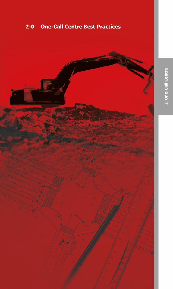
2-0 One-Call Centre Best Practices
2 O
ne-C
all C
entr
e
Canadian Common Ground AllianceBest Practices Version 1.0 – October 2014
1-18: Demolition Permit Application Process
Practice statement: The Municipality shall have a process requesting thatthe demolition permit applicant receives confirmation of all utilitydisconnects prior to issuing the demolition permit.
Practice Description: The Municipality shall request that the applicantmakes arrangements with the appropriate utilities for the termination andcapping of all the water, sewer, gas, electric, telephone, cable or otherfacilities/services. Furthermore, the Municipality should indicate on thedemolition permit that locates should be obtained from utilities prior to thedemolition beginning.
21
Canadian Common Ground Alliance Best Practices Version 1.0 – October 2014
2-0 One-Call Centre Best Practices
2-1: Pro-active Public Awareness, Education andDamage Prevention Activities
Practice Statement: The one-call centre has a documented, pro-active public awareness, education, and damage prevention program.
Practice Description: The one-call centre promotes the need to “Click or Call Before You Dig,” to enhance awareness of responsibilities to safeguard workers and the public and protect the integrity of the buried infrastructure, to foster a cooperative approach between the owners of buried facilities and the digging community toward the prevention of damage to buried facilities and to promote the service it provides.
Typical one-call centre activities include: promotional items; media advertising; participation at safety meetings; seminars and trade shows; contractor awareness programs; distribution of education material describing how the one-call system works; maintaining a database of active members of the local digging community; mediating and rationalizing the expectations of both the facility owners/operators and the digging community; and participation in local damage prevention or facility location and coordination committees.
2-2: Specifically Defined Geopolitical Service Areawith No Overlap
Practice Statement: A one-call centre serves each province so that an excavator need only make one call for its members and a facility owner/operator need only belong to a single one-call centre.
Practice Description: One-call centre programs are designed to promote ease of use for members (facility owners/operators) and for excavators. This ease of use is enhanced when a one-call centre serves a specifically defined geopolitical area that does not coincide with the service area of another one-call centre.
There are two requirements a one-call centre program meets in order to be considered as having implemented this best practice:
The program permits an excavator to use a single point of contact to submit and follow up on a notice of intent to excavate and notify affected facility owners/ operators.
The program permits a facility owner/operator to join a single one-call centre and receive all appropriate notices.
2-3: Formal Agreements with Members
Practice Statement: Each member of the one-call centre abides by a written agreement that states the rights and the responsibilities of the one-call centre members and the one-call centre.
98397_ORCGA_BestPract-TEXT-Oct2014.indd 21 16/10/14 9:42 AM
Canadian Common Ground Alliance
Best Practices Version 1.0 – October 2014
1-18: Demolition Permit Application Process
Practice statement: The Municipality shall have a process requesting that the demolition permit applicant receives confirmation of all utility disconnects prior to issuing the demolition permit.
Practice Description: The Municipality shall request that the applicant makes arrangements with the appropriate utilities for the termination and capping of all the water, sewer, gas, electric, telephone, cable or other facilities/services. Furthermore, the Municipality should indicate on the demolition permit that locates should be obtained from utilities prior to the demolition beginning.
20
Canadian Common Ground Alliance
Best Practices Version 1.0 – October 2014
2-0 One-Call Centre Best Practices
2-1: Pro-active Public Awareness, Education and Damage Prevention Activities
Practice Statement: The one-call centre has a documented, pro-active public awareness, education, and damage prevention program.
Practice Description: The one-call centre promotes the need to “Call Before You Dig,” to enhance awareness of responsibilities to safeguard workers and the public and protect the integrity of the buried infrastructure, to foster a cooperative approach between the owners of buried facilities and the digging community toward the prevention of damage to buried facilities and to promote the service it provides.
Typical one-call centre activities include: promotional items; media advertising; participation at safety meetings; seminars and trade shows; contractor awareness programs; distribution of education material describing how the one-call system works; maintaining a database of active members of the local digging community; mediating and rationalizing the expectations of both the facility owners/operators and the digging community; and participation in local damage prevention or facility location and coordination committees.
2-2: Specifically Defined Geopolitical Service Area with No Overlap
Practice Statement: A one-call centre serves each province so that an excavator need only make one call for its members and a facility owner/operator need only belong to a single one-call centre.
Practice Description: One-call centre programs are designed to promote ease of use for members (facility owners/operators) and for excavators. This ease of use is enhanced when a one-call centre serves a specifically defined geopolitical area that does not coincide with the service area of another one-call centre.
There are two requirements a one-call centre program meets in order to be considered as having implemented this best practice:
The program permits an excavator to use a single point of contact to submit and follow up on a notice of intent to excavate and notify affected facility owners/ operators.
The program permits a facility owner/operator to join a single one-call centre and receive all appropriate notices.
2-3: Formal Agreements with Members
Practice Statement: Each member of the one-call centre abides by a written agreement that states the rights and the responsibilities of the one-call centre members and the one-call centre.
98397_ORCGA_BestPract-TEXT-Oct2014.indd 20 16/10/14 9:42 AM
Canadian Common Ground AllianceBest Practices Version 2.0 – October 2016 21

Canadian Common Ground Alliance
Best Practices Version 1.0 – October 2014
Practice Description: The terms and conditions of service provided by the one-call centre and the obligations of the member are established in a legally binding standard form Service Agreement document which is signed by both parties. The purpose of the document is to simply state the legal obligations and terms of service for both parties in a standard form contract that all members must sign. This standard form agreement should not be restrictive and there should be no unreasonable barriers to facility owners/ operators signing this agreement.
2-4: One-Call Centre Governance
Practice Statement: The one-call centre is governed by a Board of Directors with input from stakeholders.
Practice Description: To ensure that a one-call centre functions to the best benefit of the entire community, it is governed by a Board of Directors with input from representatives of the stakeholders. Stakeholders are from a variety of industry types, such as facility owners/operators, contractors, designers, project owners and government representatives. Each stakeholder representative is knowledgeable in their own industry and of how it interacts with the one-call centre and all of the represented stakeholders.
2-5: Single Toll Free Number with North-American Access
Practice Statement: The one-call centre has a single toll free number with North-American access.
Practice Description: There will be only one toll free telephone number and one toll free fax number for the one-call centre to receive locate requests. These numbers have toll free North American access, meaning that a caller can telephone or fax the centre free of charge from anywhere in North America. The one-call centre will also maintain an e-mail address as an alternate means to receive locate requests.
2-6: Hours of Operation
Practice Statement: The one-call centre can process locate requests 24 hours a day, 7 days per week.
Practice Description: The one-call centre has in place a process where a caller, at any time of the day or night, every day of the year, who has a locate request can contact the one-call centre and have that request processed.
2-7: Voice Record of All Incoming Calls
Practice Statement: A voice recording is maintained of all voice transactions concerning requests to locate facilities.
22
Canadian Common Ground Alliance
Best Practices Version 1.0 – October 2014
Practice Description: Voice recording of the telephone communications for locate requests are made to ensure a precise record of the activity is retained. These records can be legally supported in court as well as used for damage investigations.
2-8: Retention of Voice Records According to Applicable Statutes
Practice Statement: Voice records of all calls concerning requests to locate facilities are kept in retention for seven years or according to applicable statutes.
Practice Description: Voice recordings are a factual record of the events that occurred between the caller and the one-call centre. These factual records must be maintained and accessible until expiry per the applicable statute of limitations in the jurisdiction in question. Since these laws may change, no specific time period is set forth as a best practice. In the absence of notice by some party to the contrary, after the expiration of the statute of limitations the records may be destroyed. The one-call centre has a procedure for processing requests for voice information.
2-9: Caller Feedback
Practice Statement: The one-call centre provides the caller with the ticket number and the names of facility owners/operators who will be notified for each locate request.
Practice Description: Providing the locate request number and the names of the facility owners/operators who will be notified enhances the efficiency of the one-call centre process. When provided the names of the facility owners/operators, the excavator knows which owners/operators will be notified in the area of the planned excavation. This helps the excavator determine if the facility owners/operators have responded to the locate request.
2-10: Printed Ticket Recall
Practice Statement: The one-call centre can provide a printed copy of any ticket for a period of time determined by applicable statutes.
Practice Description: In the event of a damage investigation, litigation, or other event, it is often necessary to have a hard copy printout of a location request ticket. The one-call centre has the ability to produce, as necessary, a copy of a location request ticket for the appropriate statutory period.
2-11: Documented Operating Procedures, Policies, and Manuals
Practice Statement: The one-call centre has documented operating procedures, human resource policies including health and safety and training manuals.
98397_ORCGA_BestPract-TEXT-Oct2014.indd 22 16/10/14 9:42 AM
Canadian Common Ground AllianceBest Practices Version 2.0 – October 201622

Canadian Common Ground AllianceBest Practices Version 1.0 – October 2014
Practice Description: The terms and conditions of service provided by theone-call centre and the obligations of the member are established in alegally binding standard form Service Agreement document which is signedby both parties. The purpose of the document is to simply state the legalobligations and terms of service for both parties in a standard form contract that all members must sign. This standard form agreement should not berestrictive and there should be no unreasonable barriers to facility owners/operators signing this agreement.
2-4: One-Call Centre Governance
Practice Statement: The one-call centre is governed by a Board of Directors with input from stakeholders.
Practice Description: To ensure that a one-call centre functions to thebest benefit of the entire community, it is governed by a Board of Directorswith input from representatives of the stakeholders. Stakeholders are from avariety of industry types, such as facility owners/operators, contractors,designers, project owners and government representatives. Each stakeholder representative is knowledgeable in their own industry and of how it interacts with the one-call centre and all of the representedstakeholders.
2-5: Single Toll Free Number with North-American Access
Practice Statement: The one-call centre has a single toll free number withNorth-American access.
Practice Description: There will be only one toll free telephone numberand one toll free fax number for the one-call centre to receive locaterequests. These numbers have toll free North American access, meaningthat a caller can telephone or fax the centre free of charge from anywherein North America. The one-call centre will also maintain an e-mail address asan alternate means to receive locate requests.
2-6: Hours of Operation
Practice Statement: The one-call centre can process locate requests 24hours a day, 7 days per week.
Practice Description: The one-call centre has in place a process where acaller, at any time of the day or night, every day of the year, who has a locaterequest can contact the one-call centre and have that request processed.
2-7: Voice Record of All Incoming Calls
Practice Statement: A voice recording is maintained of all voicetransactions concerning requests to locate facilities.
23
Canadian Common Ground Alliance Best Practices Version 1.0 – October 2014
Practice Description: Voice recording of the telephone communications for locate requests are made to ensure a precise record of the activity is retained. These records can be legally supported in court as well as used for damage investigations.
2-8: Retention of Voice and Electronic RecordsAccording to Applicable Statutes
Practice Statement: Voice records of all calls concerning requests to locate facilities are kept in retention for seven years or according to applicable statutes. Records include but are not limited to, all original requests and changes made by voice, web, app or email.
Practice Description: All records shall be maintained and accessible until expiry per the applicable statute of limitations in the jurisdiction in question. Since these laws may change, no specific time period is set forth as a best practice. In the absence of notice by some party to the contrary, after the expiration of the statute of limitations the records may be destroyed. The one-call centre shall have a procedure for processing requests for voice and electronic records.
2-9: Requester Feedback
Practice Statement: The one-call centre provides the requestor with the ticket number and the names of facility owners/operators who will be notified for each locate request.
Practice Description: Providing the locate request number and the names of the facility owners/operators who will be notified enhances the efficiency of the one-call centre process. When provided the names of the facility owners/operators, the excavator knows which owners/operators will be notified in the area of the planned excavation. This helps the excavator determine if the facility owners/operators have responded to the locate request.
2-10: Printed Ticket Recall
Practice Statement: The one-call centre can provide a printed copy of any ticket for a period of time determined by applicable statutes.
Practice Description: In the event of a damage investigation, litigation, or other event, it is often necessary to have a hard copy printout of a location request ticket. The one-call centre has the ability to produce, as necessary, a copy of a location request ticket for the appropriate statutory period.
2-11: Documented Operating Procedures, Policies,and Manuals
Practice Statement: The one-call centre has documented operating procedures, human resource policies including health and safety and training manuals.
98397_ORCGA_BestPract-TEXT-Oct2014.indd 23 16/10/14 9:42 AM
Canadian Common Ground Alliance
Best Practices Version 1.0 – October 2014
Practice Description: The terms and conditions of service provided by the one-call centre and the obligations of the member are established in a legally binding standard form Service Agreement document which is signed by both parties. The purpose of the document is to simply state the legal obligations and terms of service for both parties in a standard form contract that all members must sign. This standard form agreement should not be restrictive and there should be no unreasonable barriers to facility owners/ operators signing this agreement.
2-4: One-Call Centre Governance
Practice Statement: The one-call centre is governed by a Board of Directors with input from stakeholders.
Practice Description: To ensure that a one-call centre functions to the best benefit of the entire community, it is governed by a Board of Directors with input from representatives of the stakeholders. Stakeholders are from a variety of industry types, such as facility owners/operators, contractors, designers, project owners and government representatives. Each stakeholder representative is knowledgeable in their own industry and of how it interacts with the one-call centre and all of the represented stakeholders.
2-5: Single Toll Free Number with North-American Access
Practice Statement: The one-call centre has a single toll free number with North-American access.
Practice Description: There will be only one toll free telephone number and one toll free fax number for the one-call centre to receive locate requests. These numbers have toll free North American access, meaning that a caller can telephone or fax the centre free of charge from anywhere in North America. The one-call centre will also maintain an e-mail address as an alternate means to receive locate requests.
2-6: Hours of Operation
Practice Statement: The one-call centre can process locate requests 24 hours a day, 7 days per week.
Practice Description: The one-call centre has in place a process where a caller, at any time of the day or night, every day of the year, who has a locate request can contact the one-call centre and have that request processed.
2-7: Voice Record of All Incoming Calls
Practice Statement: A voice recording is maintained of all voice transactions concerning requests to locate facilities.
22
Canadian Common Ground Alliance
Best Practices Version 1.0 – October 2014
Practice Description: Voice recording of the telephone communications for locate requests are made to ensure a precise record of the activity is retained. These records can be legally supported in court as well as used for damage investigations.
2-8: Retention of Voice Records According to Applicable Statutes
Practice Statement: Voice records of all calls concerning requests to locate facilities are kept in retention for seven years or according to applicable statutes.
Practice Description: Voice recordings are a factual record of the events that occurred between the caller and the one-call centre. These factual records must be maintained and accessible until expiry per the applicable statute of limitations in the jurisdiction in question. Since these laws may change, no specific time period is set forth as a best practice. In the absence of notice by some party to the contrary, after the expiration of the statute of limitations the records may be destroyed. The one-call centre has a procedure for processing requests for voice information.
2-9: Caller Feedback
Practice Statement: The one-call centre provides the caller with the ticket number and the names of facility owners/operators who will be notified for each locate request.
Practice Description: Providing the locate request number and the names of the facility owners/operators who will be notified enhances the efficiency of the one-call centre process. When provided the names of the facility owners/operators, the excavator knows which owners/operators will be notified in the area of the planned excavation. This helps the excavator determine if the facility owners/operators have responded to the locate request.
2-10: Printed Ticket Recall
Practice Statement: The one-call centre can provide a printed copy of any ticket for a period of time determined by applicable statutes.
Practice Description: In the event of a damage investigation, litigation, or other event, it is often necessary to have a hard copy printout of a location request ticket. The one-call centre has the ability to produce, as necessary, a copy of a location request ticket for the appropriate statutory period.
2-11: Documented Operating Procedures, Policies, and Manuals
Practice Statement: The one-call centre has documented operating procedures, human resource policies including health and safety and training manuals.
98397_ORCGA_BestPract-TEXT-Oct2014.indd 22 16/10/14 9:42 AM
Canadian Common Ground AllianceBest Practices Version 2.0 – October 2016 23

Canadian Common Ground Alliance
Best Practices Version 1.0 – October 2014
Practice Description: The one-call centre has documented operating procedures, human resource policies including health and safety, and training manuals. Training manuals, practices, procedures, and policies are on the premises in a designated area or place, dated, and available for reference.
2-12: Documented Owner Verification of Data Submitted by Facility
Owners/Operators
Practice Statement: The one-call centre returns the geographic description data base documentation to the facility owner/operator annually and after each change for verification and approval.
Practice Description: The one-call centre can only work with the information related to the existence of buried facilities that its members provide. It is important that the one-call centre be able to produce evidence that a member’s data is accurate, according to that member. Regular verification of data is a part of the documented agreement or operating procedures between the owner or operator of buried facilities and the one-call centre. Any deletions or additions made by the member are entered into the database and documentation of the change sent back to the member for verification, prior to activation.
2-13: Flexibility for Growth and Change
Practice Statement: The operating plan of the one-call centre is sufficiently flexible to accommodate growth and change.
Practice Description: A successful one-call centre maintains flexibility to respond to changes by forming and maintaining a responsive governing organization whose Board of Directors’ and stakeholder representative composition allows adequate representation of the needs of all stakeholders.
A Board’s ability to respond to change will be enhanced by drafting bylaws and operating procedures that reflect the current environment in which the one-call centre serves. The most successful Boards review these documents on an ongoing basis to make sure they continue to reflect or respond to current conditions. These Boards conduct regular strategic planning sessions during which they review the current state of the Centre’s major systems, programs and outreach activities. Such assessments help them identify stakeholder needs for future growth and development.
Many members of Boards, stakeholder group representatives and centre management teams keep themselves informed about and involved in the one-call industry by joining associations and attending conferences or other educational events that help them to better identify new opportunities for growth and change.
24
Canadian Common Ground Alliance
Best Practices Version 1.0 – October 2014
2-14: Meeting Between the Excavator and Facility Operator(s) Initiated by One-Call Centre Notification
Practice Statement: The one-call centre has a process for receiving and transmitting requests for meetings between the excavator and the facility operator(s) for the purpose of discussing locating facilities on large or complex jobs.
Practice Description: The one-call centre relays requests for job site facility meetings for excavators who request them with facility owners/operators. If a meeting is required to show the limits and schedule of the work, the one-call centre indicates that a meeting is requested. The one-call centre requires that the excavator provide sufficient information to fully identify the boundaries of the proposed work site. A meeting request does not necessarily eliminate the need for a locate request.
2-15: One-Call Centre Accepts Notifications from Designers
Practice Statement: The one-call centre accepts design requests and has the ability to process them as designated by the facility owners/operators.
Practice Description: To facilitate damage prevention, project designers have a need for access to facility location information from facility owners/ operators. If a design request is received, the one-call centre provides a listing of facility owners/operators directly to the designer. Once the list is identified, the one-call centre processes the request as designated by each facility owner/operator.
2-16: Locate Request
Practice Statement: The one-call centre captures the following information, at a minimum, on a locate request: the caller’s name and phone number; the excavator’s/company’s name, address and phone numbers; the specific location of the excavation; the start date and time of the excavation; and the description of the excavation activity.
Practice Description: A locate request is a communication between an excavator and one-call centre personnel in which a request for locating underground facilities is processed. In addition to the minimum information required in the practice statement (above), the locate request should include any information, if available, that will help to establish the specific location of the excavation site. This additional information could include, for example:
A. More detailed information to help determine the specific location of the excavation. Such information may include:
1. Municipality/Community
2. County/Region/District/Township
3. Province
98397_ORCGA_BestPract-TEXT-Oct2014.indd 24 16/10/14 9:42 AM
Canadian Common Ground AllianceBest Practices Version 2.0 – October 201624
Canadian Common Ground Alliance
Best Practices Version 1.0 – October 2014
Practice Description: The one-call centre has documented operating procedures, human resource policies including health and safety, and training manuals. Training manuals, practices, procedures, and policies are on the premises in a designated area or place, dated, and available for reference.
2-12: Documented Owner Verification of Data Submitted by Facility
Owners/Operators
Practice Statement: The one-call centre returns the geographic description data base documentation to the facility owner/operator annually and after each change for verification and approval.
Practice Description: The one-call centre can only work with the information related to the existence of buried facilities that its members provide. It is important that the one-call centre be able to produce evidence that a member’s data is accurate, according to that member. Regular verification of data is a part of the documented agreement or operating procedures between the owner or operator of buried facilities and the one-call centre. Any deletions or additions made by the member are entered into the database and documentation of the change sent back to the member for verification, prior to activation.
2-13: Flexibility for Growth and Change
Practice Statement: The operating plan of the one-call centre is sufficiently flexible to accommodate growth and change.
Practice Description: A successful one-call centre maintains flexibility to respond to changes by forming and maintaining a responsive governing organization whose Board of Directors’ and stakeholder representative composition allows adequate representation of the needs of all stakeholders.
A Board’s ability to respond to change will be enhanced by drafting bylaws and operating procedures that reflect the current environment in which the one-call centre serves. The most successful Boards review these documents on an ongoing basis to make sure they continue to reflect or respond to current conditions. These Boards conduct regular strategic planning sessions during which they review the current state of the Centre’s major systems, programs and outreach activities. Such assessments help them identify stakeholder needs for future growth and development.
Many members of Boards, stakeholder group representatives and centre management teams keep themselves informed about and involved in the one-call industry by joining associations and attending conferences or other educational events that help them to better identify new opportunities for growth and change.
25
Canadian Common Ground Alliance
Best Practices Version 1.0 – October 2014
2-14: Meeting Between the Excavator and Facility Operator(s) Initiated by One-Call Centre Notification
Practice Statement: The one-call centre has a process for receiving and transmitting requests for meetings between the excavator and the facility operator(s) for the purpose of discussing locating facilities on large or complex jobs.
Practice Description: The one-call centre relays requests for job site facility meetings for excavators who request them with facility owners/operators. If a meeting is required to show the limits and schedule of the work, the one-call centre indicates that a meeting is requested. The one-call centre requires that the excavator provide sufficient information to fully identify the boundaries of the proposed work site. A meeting request does not necessarily eliminate the need for a locate request.
2-15: One-Call Centre Accepts Notifications from Designers
Practice Statement: The one-call centre accepts design requests and has the ability to process them as designated by the facility owners/operators.
Practice Description: To facilitate damage prevention, project designers have a need for access to facility location information from facility owners/ operators. If a design request is received, the one-call centre provides a listing of facility owners/operators directly to the designer. Once the list is identified, the one-call centre processes the request as designated by each facility owner/operator.
2-16: Locate Request
Practice Statement: The one-call centre captures the following information, at a minimum, on a locate request: the caller’s name and phone number; the excavator’s/company’s name, address and phone numbers; the specific location of the excavation; the start date and time of the excavation; and the description of the excavation activity.
Practice Description: A locate request is a communication between an excavator and one-call centre personnel in which a request for locating underground facilities is processed. In addition to the minimum information required in the practice statement (above), the locate request should include any information, if available, that will help to establish the specific location of the excavation site. This additional information could include, for example:
A. More detailed information to help determine the specific location of the excavation. Such information may include:
1. Municipality/Community
2. County/Region/District/Township
3. Province
98397_ORCGA_BestPract-TEXT-Oct2014.indd 25 16/10/14 9:42 AM
Canadian Common Ground Alliance
Best Practices Version 1.0 – October 2014
Practice Description: The one-call centre has documented operating procedures, human resource policies including health and safety, and training manuals. Training manuals, practices, procedures, and policies are on the premises in a designated area or place, dated, and available for reference.
2-12: Documented Owner Verification of Data Submitted by Facility
Owners/Operators
Practice Statement: The one-call centre returns the geographic description data base documentation to the facility owner/operator annually and after each change for verification and approval.
Practice Description: The one-call centre can only work with the information related to the existence of buried facilities that its members provide. It is important that the one-call centre be able to produce evidence that a member’s data is accurate, according to that member. Regular verification of data is a part of the documented agreement or operating procedures between the owner or operator of buried facilities and the one-call centre. Any deletions or additions made by the member are entered into the database and documentation of the change sent back to the member for verification, prior to activation.
2-13: Flexibility for Growth and Change
Practice Statement: The operating plan of the one-call centre is sufficiently flexible to accommodate growth and change.
Practice Description: A successful one-call centre maintains flexibility to respond to changes by forming and maintaining a responsive governing organization whose Board of Directors’ and stakeholder representative composition allows adequate representation of the needs of all stakeholders.
A Board’s ability to respond to change will be enhanced by drafting bylaws and operating procedures that reflect the current environment in which the one-call centre serves. The most successful Boards review these documents on an ongoing basis to make sure they continue to reflect or respond to current conditions. These Boards conduct regular strategic planning sessions during which they review the current state of the Centre’s major systems, programs and outreach activities. Such assessments help them identify stakeholder needs for future growth and development.
Many members of Boards, stakeholder group representatives and centre management teams keep themselves informed about and involved in the one-call industry by joining associations and attending conferences or other educational events that help them to better identify new opportunities for growth and change.
24
Canadian Common Ground Alliance
Best Practices Version 1.0 – October 2014
2-14: Meeting Between the Excavator and Facility Operator(s) Initiated by One-Call Centre Notification
Practice Statement: The one-call centre has a process for receiving and transmitting requests for meetings between the excavator and the facility operator(s) for the purpose of discussing locating facilities on large or complex jobs.
Practice Description: The one-call centre relays requests for job site facility meetings for excavators who request them with facility owners/operators. If a meeting is required to show the limits and schedule of the work, the one-call centre indicates that a meeting is requested. The one-call centre requires that the excavator provide sufficient information to fully identify the boundaries of the proposed work site. A meeting request does not necessarily eliminate the need for a locate request.
2-15: One-Call Centre Accepts Notifications from Designers
Practice Statement: The one-call centre accepts design requests and has the ability to process them as designated by the facility owners/operators.
Practice Description: To facilitate damage prevention, project designers have a need for access to facility location information from facility owners/ operators. If a design request is received, the one-call centre provides a listing of facility owners/operators directly to the designer. Once the list is identified, the one-call centre processes the request as designated by each facility owner/operator.
2-16: Locate Request
Practice Statement: The one-call centre captures the following information, at a minimum, on a locate request: the caller’s name and phone number; the excavator’s/company’s name, address and phone numbers; the specific location of the excavation; the start date and time of the excavation; and the description of the excavation activity.
Practice Description: A locate request is a communication between an excavator and one-call centre personnel in which a request for locating underground facilities is processed. In addition to the minimum information required in the practice statement (above), the locate request should include any information, if available, that will help to establish the specific location of the excavation site. This additional information could include, for example:
A. More detailed information to help determine the specific location of the excavation. Such information may include:
1. Municipality/Community
2. County/Region/District/Township
3. Province
98397_ORCGA_BestPract-TEXT-Oct2014.indd 24 16/10/14 9:42 AM
Canadian Common Ground AllianceBest Practices Version 2.0 – October 2016 25
Canadian Common Ground Alliance
Best Practices Version 1.0 – October 2014
4. Street address
5. Street name
6. Length and direction of the excavation and the nearest adjacent cross streets (needed to bound area of excavation or extended excavation)
7. Subdivision and lot number (for new development)
8. Latitude/Longitude: Latitude-longitude co-ordinate(s) or specific address of the dig site may be done automatically by the GIS subsystem or determined by computer assisted customer service representative. The dig site can be a point, an area or box, or a polygon. For a spatial rectangle (maximum/minimum latitude/ longitude), the dig site must be wholly within the included area.
9. Highway markers
10. Railroad or pipeline markers
11. General directions/instructions
12. Postal code
13. Distance to nearest cross-street
14. Telephone number at dig site
15. 911 address
16. Lot and concession
17. Map reference
18. Pole numbers
19. Any other pertinent references to help establish the location of the dig site
B. The intended start date and time of the excavation
C. Excavating by hand or machine
D. Type of the excavation activity (e.g. boring, blasting, trenching, etc.)
E. Whom the excavation work is being done for
F. What is the purpose of the work (i.e., what will be installed and/or built)
G. Excavation on public property
H. Excavation on private property and if so, where (front, side, rear)
I. Is the dig site pre-marked by the excavator
J. The depth of the excavation
K. Is a site meet requested
L. Does the excavator want an “outline mark and fax”
M. The status of the involved members for that request (notice, clear, suppress, cleared by look-up)
N. Additional remarks
26
Canadian Common Ground Alliance
Best Practices Version 1.0 – October 2014
2-17: Practices to Reduce Over-Notifications
Practice statement: The one-call centre employs practices designed specifically to reduce the number of notices transmitted to facility owners/ operators, in which the reported excavation site is outside the owner’s/ operator’s desired area of notification.
Practice Description: The one-call centre employs technology that allows the facility owner/operator to determine its desired area of notification by polygons. To reduce over-notifications, the technology should:
where due diligence and mapping accuracy permits, enable the call centre to define the proposed excavation site buffer to within approximately 800 feet (250 metres); and
provide the facility owner/operator the ability to identify its desired area of notification, including the member specified buffer zone, to within approximately 30 metres.
2-18: Disaster Recovery
Practice statement: The one-call centre develops, implements, and maintains an effective disaster recovery plan enabling the one-call function to continue in the event of a disaster.
Practice Description: The one-call centre develops and implements an effective disaster recovery plan enabling it to continue operations in the aftermath of a disaster affecting the facility, including communication with the local emergency services to provide safe access to the centre. Excavators and underground facility owners/operators outside of the area affected by the disaster can continue to conduct business with minimum to no delays in the services provided by the one-call centre. The disaster recovery plan makes provisions for the one-call centre to process emergency locate requests for the areas affected by the disaster.
The one-call centre (the primary centre) has a backup arrangement with another facility at a remote location (the secondary centre). This arrangement includes:
Telecommunications - alternate routing schedules are in place, ready to be activated within minutes of the primary centres’ failure.
Software and Hardware - the secondary centre has compatible hardware with the primary centre. The secondary centre always has a copy of the primary’s current software.
Database - the secondary centre receives the primary centre’s database including locate requests on a regular basis, preferably real-time.
Staffing - a portion of the secondary centre’s staff is cross-trained for the primary centre’s operation at all times.
Simulated Emergency Testing - At least once a year, on a random basis, the disaster recovery plan is implemented to verify that it is operational.
98397_ORCGA_BestPract-TEXT-Oct2014.indd 26 16/10/14 9:42 AM
Canadian Common Ground AllianceBest Practices Version 2.0 – October 201626

Canadian Common Ground Alliance
Best Practices Version 1.0 – October 2014
4. Street address
5. Street name
6. Length and direction of the excavation and the nearest adjacent cross streets (needed to bound area of excavation or extended excavation)
7. Subdivision and lot number (for new development)
8. Latitude/Longitude: Latitude-longitude co-ordinate(s) or specific address of the dig site may be done automatically by the GIS subsystem or determined by computer assisted customer service representative. The dig site can be a point, an area or box, or a polygon. For a spatial rectangle (maximum/minimum latitude/ longitude), the dig site must be wholly within the included area.
9. Highway markers
10. Railroad or pipeline markers
11. General directions/instructions
12. Postal code
13. Distance to nearest cross-street
14. Telephone number at dig site
15. 911 address
16. Lot and concession
17. Map reference
18. Pole numbers
19. Any other pertinent references to help establish the location of the dig site
B. The intended start date and time of the excavation
C. Excavating by hand or machine
D. Type of the excavation activity (e.g. boring, blasting, trenching, etc.)
E. Whom the excavation work is being done for
F. What is the purpose of the work (i.e., what will be installed and/or built)
G. Excavation on public property
H. Excavation on private property and if so, where (front, side, rear)
I. Is the dig site pre-marked by the excavator
J. The depth of the excavation
K. Is a site meet requested
L. Does the excavator want an “outline mark and fax”
M. The status of the involved members for that request (notice, clear, suppress, cleared by look-up)
N. Additional remarks
27
Canadian Common Ground Alliance
Best Practices Version 1.0 – October 2014
2-17: Practices to Reduce Over-Notifications
Practice statement: The one-call centre employs practices designed specifically to reduce the number of notices transmitted to facility owners/ operators, in which the reported excavation site is outside the owner’s/ operator’s desired area of notification.
Practice Description: The one-call centre employs technology that allows the facility owner/operator to determine its desired area of notification by polygons. To reduce over-notifications, the technology should:
where due diligence and mapping accuracy permits, enable the call centre to define the proposed excavation site buffer to within approximately 800 feet (250 metres); and
provide the facility owner/operator the ability to identify its desired area of notification, including the member specified buffer zone, to within approximately 30 metres.
2-18: Disaster Recovery
Practice statement: The one-call centre develops, implements, and maintains an effective disaster recovery plan enabling the one-call function to continue in the event of a disaster.
Practice Description: The one-call centre develops and implements an effective disaster recovery plan enabling it to continue operations in the aftermath of a disaster affecting the facility, including communication with the local emergency services to provide safe access to the centre. Excavators and underground facility owners/operators outside of the area affected by the disaster can continue to conduct business with minimum to no delays in the services provided by the one-call centre. The disaster recovery plan makes provisions for the one-call centre to process emergency locate requests for the areas affected by the disaster.
The one-call centre (the primary centre) has a backup arrangement with another facility at a remote location (the secondary centre). This arrangement includes:
Telecommunications - alternate routing schedules are in place, ready to be activated within minutes of the primary centres’ failure.
Software and Hardware - the secondary centre has compatible hardware with the primary centre. The secondary centre always has a copy of the primary’s current software.
Database - the secondary centre receives the primary centre’s database including locate requests on a regular basis, preferably real-time.
Staffing - a portion of the secondary centre’s staff is cross-trained for the primary centre’s operation at all times.
Simulated Emergency Testing - At least once a year, on a random basis, the disaster recovery plan is implemented to verify that it is operational.
98397_ORCGA_BestPract-TEXT-Oct2014.indd 27 16/10/14 9:42 AM
Canadian Common Ground Alliance
Best Practices Version 1.0 – October 2014
4. Street address
5. Street name
6. Length and direction of the excavation and the nearest adjacent cross streets (needed to bound area of excavation or extended excavation)
7. Subdivision and lot number (for new development)
8. Latitude/Longitude: Latitude-longitude co-ordinate(s) or specific address of the dig site may be done automatically by the GIS subsystem or determined by computer assisted customer service representative. The dig site can be a point, an area or box, or a polygon. For a spatial rectangle (maximum/minimum latitude/ longitude), the dig site must be wholly within the included area.
9. Highway markers
10. Railroad or pipeline markers
11. General directions/instructions
12. Postal code
13. Distance to nearest cross-street
14. Telephone number at dig site
15. 911 address
16. Lot and concession
17. Map reference
18. Pole numbers
19. Any other pertinent references to help establish the location of the dig site
B. The intended start date and time of the excavation
C. Excavating by hand or machine
D. Type of the excavation activity (e.g. boring, blasting, trenching, etc.)
E. Whom the excavation work is being done for
F. What is the purpose of the work (i.e., what will be installed and/or built)
G. Excavation on public property
H. Excavation on private property and if so, where (front, side, rear)
I. Is the dig site pre-marked by the excavator
J. The depth of the excavation
K. Is a site meet requested
L. Does the excavator want an “outline mark and fax”
M. The status of the involved members for that request (notice, clear, suppress, cleared by look-up)
N. Additional remarks
26
Canadian Common Ground Alliance
Best Practices Version 1.0 – October 2014
2-17: Practices to Reduce Over-Notifications
Practice statement: The one-call centre employs practices designed specifically to reduce the number of notices transmitted to facility owners/ operators, in which the reported excavation site is outside the owner’s/ operator’s desired area of notification.
Practice Description: The one-call centre employs technology that allows the facility owner/operator to determine its desired area of notification by polygons. To reduce over-notifications, the technology should:
where due diligence and mapping accuracy permits, enable the call centre to define the proposed excavation site buffer to within approximately 800 feet (250 metres); and
provide the facility owner/operator the ability to identify its desired area of notification, including the member specified buffer zone, to within approximately 30 metres.
2-18: Disaster Recovery
Practice statement: The one-call centre develops, implements, and maintains an effective disaster recovery plan enabling the one-call function to continue in the event of a disaster.
Practice Description: The one-call centre develops and implements an effective disaster recovery plan enabling it to continue operations in the aftermath of a disaster affecting the facility, including communication with the local emergency services to provide safe access to the centre. Excavators and underground facility owners/operators outside of the area affected by the disaster can continue to conduct business with minimum to no delays in the services provided by the one-call centre. The disaster recovery plan makes provisions for the one-call centre to process emergency locate requests for the areas affected by the disaster.
The one-call centre (the primary centre) has a backup arrangement with another facility at a remote location (the secondary centre). This arrangement includes:
Telecommunications - alternate routing schedules are in place, ready to be activated within minutes of the primary centres’ failure.
Software and Hardware - the secondary centre has compatible hardware with the primary centre. The secondary centre always has a copy of the primary’s current software.
Database - the secondary centre receives the primary centre’s database including locate requests on a regular basis, preferably real-time.
Staffing - a portion of the secondary centre’s staff is cross-trained for the primary centre’s operation at all times.
Simulated Emergency Testing - At least once a year, on a random basis, the disaster recovery plan is implemented to verify that it is operational.
98397_ORCGA_BestPract-TEXT-Oct2014.indd 26 16/10/14 9:42 AM
Canadian Common Ground Alliance
Best Practices Version 1.0 – October 2014
4. Street address
5. Street name
6. Length and direction of the excavation and the nearest adjacent cross streets (needed to bound area of excavation or extended excavation)
7. Subdivision and lot number (for new development)
8. Latitude/Longitude: Latitude-longitude co-ordinate(s) or specific address of the dig site may be done automatically by the GIS subsystem or determined by computer assisted customer service representative. The dig site can be a point, an area or box, or a polygon. For a spatial rectangle (maximum/minimum latitude/ longitude), the dig site must be wholly within the included area.
9. Highway markers
10. Railroad or pipeline markers
11. General directions/instructions
12. Postal code
13. Distance to nearest cross-street
14. Telephone number at dig site
15. 911 address
16. Lot and concession
17. Map reference
18. Pole numbers
19. Any other pertinent references to help establish the location of the dig site
B. The intended start date and time of the excavation
C. Excavating by hand or machine
D. Type of the excavation activity (e.g. boring, blasting, trenching, etc.)
E. Whom the excavation work is being done for
F. What is the purpose of the work (i.e., what will be installed and/or built)
G. Excavation on public property
H. Excavation on private property and if so, where (front, side, rear)
I. Is the dig site pre-marked by the excavator
J. The depth of the excavation
K. Is a site meet requested
L. Does the excavator want an “outline mark and fax”
M. The status of the involved members for that request (notice, clear, suppress, cleared by look-up)
N. Additional remarks
27
Canadian Common Ground Alliance
Best Practices Version 1.0 – October 2014
2-17: Practices to Reduce Over-Notifications
Practice statement: The one-call centre employs practices designed specifically to reduce the number of notices transmitted to facility owners/ operators, in which the reported excavation site is outside the owner’s/ operator’s desired area of notification.
Practice Description: The one-call centre employs technology that allows the facility owner/operator to determine its desired area of notification by polygons. To reduce over-notifications, the technology should:
where due diligence and mapping accuracy permits, enable the call centre to define the proposed excavation site buffer to within approximately 800 feet (250 metres); and
provide the facility owner/operator the ability to identify its desired area of notification, including the member specified buffer zone, to within approximately 30 metres.
2-18: Disaster Recovery
Practice statement: The one-call centre develops, implements, and maintains an effective disaster recovery plan enabling the one-call function to continue in the event of a disaster.
Practice Description: The one-call centre develops and implements an effective disaster recovery plan enabling it to continue operations in the aftermath of a disaster affecting the facility, including communication with the local emergency services to provide safe access to the centre. Excavators and underground facility owners/operators outside of the area affected by the disaster can continue to conduct business with minimum to no delays in the services provided by the one-call centre. The disaster recovery plan makes provisions for the one-call centre to process emergency locate requests for the areas affected by the disaster.
The one-call centre (the primary centre) has a backup arrangement with another facility at a remote location (the secondary centre). This arrangement includes:
Telecommunications - alternate routing schedules are in place, ready to be activated within minutes of the primary centres’ failure.
Software and Hardware - the secondary centre has compatible hardware with the primary centre. The secondary centre always has a copy of the primary’s current software.
Database - the secondary centre receives the primary centre’s database including locate requests on a regular basis, preferably real-time.
Staffing - a portion of the secondary centre’s staff is cross-trained for the primary centre’s operation at all times.
Simulated Emergency Testing - At least once a year, on a random basis, the disaster recovery plan is implemented to verify that it is operational.
98397_ORCGA_BestPract-TEXT-Oct2014.indd 27 16/10/14 9:42 AM
Canadian Common Ground AllianceBest Practices Version 2.0 – October 2016 27
Canadian Common Ground Alliance
Best Practices Version 1.0 – October 2014
2-19: Remote User Interface
Practice statement: The one-call centre provides users a means of direct, electronic entry of locate requests of comparable ticket quality to that where an operator assists information entry.
Practice Description: The one-call centre has interactive data communications sufficient to permit remote data entry for qualified members and excavators. The remote interface validates the input information and allows the user to make corrections if necessary. This correction is accomplished by referencing the same geographic database used at the one-call centre when taking a voiced-in request. This process ensures that the ticket quality is maintained for all tickets.
2-20: Accept Multiple Reference Points for Locate Requests
Practice statement: The one-call centre is able to accept multiple types of points of reference to define the exact location of an excavation site (i.e. latitude/longitude, highway/railroad/pipeline markers, address, street and cross street, etc.).
Practice Description: The one-call centre’s locate request taking processes and computer system are designed to accept and process multiple types of reference points used by callers to (1) describe the location of their work and (2) define the excavation site. Examples of different types of reference points include: highway markers, railroad or pipeline markers, valid address or street-cross street, latitude/longitude, municipality, community, county, region, township and mail address (postal code) boundaries, etc.
All stakeholders involved in the one-call process receive a corresponding benefit when the call centre is able to define the excavation site as specifically as possible. The facility operator’s job of determining the existence of a potential conflict is expedited, field personnel can find and mark the affected area much easier, and the excavator receives timely markings covering the area of excavation. Standardizing on a limited set of criteria reduces the flexibility of the system to serve the excavator and facility owner/operator. The one-call centre invests in systems and processes that permit inclusion of a variety of types of reference points in defining the excavation site. The one-call centre takes steps to link these reference points to the database used to register the facility operator’s desired area of notification, thereby assisting in reducing over-notification.
2-21: One-Call Centre Security
Practice Statement: The one-call centre provides appropriate physical and systems security, fire protection and electrical protection to protect the one-call centre and its critical components.
28
Canadian Common Ground Alliance
Best Practices Version 1.0 – October 2014
Practice Description: The one-call centre needs protection from natural disasters and other threats. Since the one-call centre is a critical link in the communication chain between the excavating community and facilities, it is important that the one-call centre does whatever it can to provide adequate security, taking into account that it may well need to be operational in times of natural disasters or in the face of other threats. Security components could include:
Physical security for the building and its employees through locked operations areas, lighting, employee key cards, guard patrols.
Physical security for critical systems components. This may include locating the facilities in locked enclosures and restricting access to necessary personnel.
General fire protection for the one-call centre personnel and property.
Specialized fire protection for critical systems components.
Specialized theft protection for critical systems components.
Telephone demarcation points in a protected area within the One-Call Centre.
Passwords and protections to limit access to computers and other systems.
Offsite storage of duplicate data base and necessary system software.
2-22: Hardware Designed to Tolerate a Single Point of Failure
Practice Statement: The one-call centre uses fault tolerant hardware for its critical path operations, such as ticket taking, database access, and ticket delivery.
Practice Description: A fault tolerant system can withstand any single hardware malfunction without any interruption or degradation of service. These systems have the ability to identify the malfunctioning hardware component and permit its replacement while remaining online and processing its normal applications. These fault tolerant systems maximize the probability that the call centre will be able to properly process an excavation request in the event of a failure or malfunction.
2-23: One-Call Quality Standards Practice Statement: The one-call centre establishes performance standards for the operation of the centre for the purpose of promoting accuracy, cost effectiveness and efficiency.
Practice Description:
A. Customer Quality of Service Performance Measurements – It is best practice in the one-call centre industry to monitor the quality of service provided to the customer calling the centre. Key measurements include:
98397_ORCGA_BestPract-TEXT-Oct2014.indd 28 16/10/14 9:42 AM
Canadian Common Ground Alliance Best Practices Version 1.0 – October 2014
2-19: Remote User Interface
Practice statement: The one-call centre provides users a means of direct, electronic entry of locate requests of comparable ticket quality to that where an operator assists information entry.
Practice Description: The one-call centre has interactive data communications sufficient to permit remote data entry for qualified members and excavators. The remote interface validates the input information and allows the user to make corrections if necessary. This correction is accomplished by referencing the same geographic database used at the one-call centre when taking a voiced-in request. This process ensures that the ticket quality is maintained for all tickets.
2-20: Accept Multiple Reference Points for LocateRequests
Practice statement: The one-call centre is able to accept multiple types of points of reference to define the exact location of an excavation site (i.e. latitude/longitude, legal land descriptions, highway/railroad/pipeline markers, address, street and cross street, etc.).
Practice Description: The one-call centre’s locate request taking processes and computer system are designed to accept and process multiple types of reference points used by callers to (1) describe the location of their work and (2) define the excavation site. Examples of different types of reference points include: highway markers, railroad or pipeline markers, valid address or street-cross street, latitude/longitude, municipality, community, county, region, township and mail address (postal code) boundaries, etc.
All stakeholders involved in the one-call process receive a corresponding benefit when the call centre is able to define the excavation site as specifically as possible. The facility operator’s job of determining the existence of a potential conflict is expedited, field personnel can find and mark the affected area much easier, and the excavator receives timely markings covering the area of excavation. Standardizing on a limited set of criteria reduces the flexibility of the system to serve the excavator and facility owner/operator. The one-call centre invests in systems and processes that permit inclusion of a variety of types of reference points in defining the excavation site. The one-call centre takes steps to link these reference points to the database used to register the facility operator’s desired area of notification, thereby assisting in reducing over-notification.
2-21: One-Call Centre Security
Practice Statement: The one-call centre provides appropriate physical and systems security, fire protection and electrical protection to protect the one-call centre and its critical components.
28
Canadian Common Ground AllianceBest Practices Version 1.0 – October 2014
Practice Description: The one-call centre needs protection from natural disasters and other threats. Since the one-call centre is a critical link in thecommunication chain between the excavating community and facilities, it isimportant that the one-call centre does whatever it can to provide adequatesecurity, taking into account that it may well need to be operational in timesof natural disasters or in the face of other threats. Security componentscould include:
Physical security for the building and its employees through lockedoperations areas, lighting, employee key cards, guard patrols.
Physical security for critical systems components. This may includelocating the facilities in locked enclosures and restricting access tonecessary personnel.
General fire protection for the one-call centre personnel and property.
Specialized fire protection for critical systems components.
Specialized theft protection for critical systems components.
Telephone demarcation points in a protected area within the One-Call Centre.
Passwords and protections to limit access to computers and othersystems.
Offsite storage of duplicate data base and necessary system software.
2-22: Hardware Designed to Tolerate a Single Point of Failure
Practice Statement: The one-call centre uses fault tolerant hardware for its critical path operations, such as ticket taking, database access, and ticketdelivery.
Practice Description: A fault tolerant system can withstand any singlehardware malfunction without any interruption or degradation of service.These systems have the ability to identify the malfunctioning hardwarecomponent and permit its replacement while remaining online andprocessing its normal applications. These fault tolerant systems maximizethe probability that the call centre will be able to properly process an excavation request in the event of a failure or malfunction.
2-23: One-Call Quality StandardsPractice Statement: The one-call centre establishes performancestandards for the operation of the centre for the purpose of promotingaccuracy, cost effectiveness and efficiency.
Practice Description:
A. Customer Quality of Service Performance Measurements – It is bestpractice in the one-call centre industry to monitor the quality of serviceprovided to the customer calling the centre. Key measurements include:
98397_ORCGA_BestPract-TEXT-Oct2014.indd 28 16/10/14 9:42 AM
Canadian Common Ground Alliance
Best Practices Version 1.0 – October 2014
2-19: Remote User Interface
Practice statement: The one-call centre provides users a means of direct, electronic entry of locate requests of comparable ticket quality to that where an operator assists information entry.
Practice Description: The one-call centre has interactive data communications sufficient to permit remote data entry for qualified members and excavators. The remote interface validates the input information and allows the user to make corrections if necessary. This correction is accomplished by referencing the same geographic database used at the one-call centre when taking a voiced-in request. This process ensures that the ticket quality is maintained for all tickets.
2-20: Accept Multiple Reference Points for Locate Requests
Practice statement: The one-call centre is able to accept multiple types of points of reference to define the exact location of an excavation site (i.e. latitude/longitude, highway/railroad/pipeline markers, address, street and cross street, etc.).
Practice Description: The one-call centre’s locate request taking processes and computer system are designed to accept and process multiple types of reference points used by callers to (1) describe the location of their work and (2) define the excavation site. Examples of different types of reference points include: highway markers, railroad or pipeline markers, valid address or street-cross street, latitude/longitude, municipality, community, county, region, township and mail address (postal code) boundaries, etc.
All stakeholders involved in the one-call process receive a corresponding benefit when the call centre is able to define the excavation site as specifically as possible. The facility operator’s job of determining the existence of a potential conflict is expedited, field personnel can find and mark the affected area much easier, and the excavator receives timely markings covering the area of excavation. Standardizing on a limited set of criteria reduces the flexibility of the system to serve the excavator and facility owner/operator. The one-call centre invests in systems and processes that permit inclusion of a variety of types of reference points in defining the excavation site. The one-call centre takes steps to link these reference points to the database used to register the facility operator’s desired area of notification, thereby assisting in reducing over-notification.
2-21: One-Call Centre Security
Practice Statement: The one-call centre provides appropriate physical and systems security, fire protection and electrical protection to protect the one-call centre and its critical components.
28
Canadian Common Ground Alliance
Best Practices Version 1.0 – October 2014
Practice Description: The one-call centre needs protection from natural disasters and other threats. Since the one-call centre is a critical link in the communication chain between the excavating community and facilities, it is important that the one-call centre does whatever it can to provide adequate security, taking into account that it may well need to be operational in times of natural disasters or in the face of other threats. Security components could include:
Physical security for the building and its employees through locked operations areas, lighting, employee key cards, guard patrols.
Physical security for critical systems components. This may include locating the facilities in locked enclosures and restricting access to necessary personnel.
General fire protection for the one-call centre personnel and property.
Specialized fire protection for critical systems components.
Specialized theft protection for critical systems components.
Telephone demarcation points in a protected area within the One-Call Centre.
Passwords and protections to limit access to computers and other systems.
Offsite storage of duplicate data base and necessary system software.
2-22: Hardware Designed to Tolerate a Single Point of Failure
Practice Statement: The one-call centre uses fault tolerant hardware for its critical path operations, such as ticket taking, database access, and ticket delivery.
Practice Description: A fault tolerant system can withstand any single hardware malfunction without any interruption or degradation of service. These systems have the ability to identify the malfunctioning hardware component and permit its replacement while remaining online and processing its normal applications. These fault tolerant systems maximize the probability that the call centre will be able to properly process an excavation request in the event of a failure or malfunction.
2-23: One-Call Quality Standards Practice Statement: The one-call centre establishes performance standards for the operation of the centre for the purpose of promoting accuracy, cost effectiveness and efficiency.
Practice Description:
A. Customer Quality of Service Performance Measurements – It is best practice in the one-call centre industry to monitor the quality of service provided to the customer calling the centre. Key measurements include:
98397_ORCGA_BestPract-TEXT-Oct2014.indd 28 16/10/14 9:42 AM
Canadian Common Ground AllianceBest Practices Version 2.0 – October 201628
Canadian Common Ground Alliance
Best Practices Version 1.0 – October 2014
2-19: Remote User Interface
Practice statement: The one-call centre provides users a means of direct, electronic entry of locate requests of comparable ticket quality to that where an operator assists information entry.
Practice Description: The one-call centre has interactive data communications sufficient to permit remote data entry for qualified members and excavators. The remote interface validates the input information and allows the user to make corrections if necessary. This correction is accomplished by referencing the same geographic database used at the one-call centre when taking a voiced-in request. This process ensures that the ticket quality is maintained for all tickets.
2-20: Accept Multiple Reference Points for Locate Requests
Practice statement: The one-call centre is able to accept multiple types of points of reference to define the exact location of an excavation site (i.e. latitude/longitude, highway/railroad/pipeline markers, address, street and cross street, etc.).
Practice Description: The one-call centre’s locate request taking processes and computer system are designed to accept and process multiple types of reference points used by callers to (1) describe the location of their work and (2) define the excavation site. Examples of different types of reference points include: highway markers, railroad or pipeline markers, valid address or street-cross street, latitude/longitude, municipality, community, county, region, township and mail address (postal code) boundaries, etc.
All stakeholders involved in the one-call process receive a corresponding benefit when the call centre is able to define the excavation site as specifically as possible. The facility operator’s job of determining the existence of a potential conflict is expedited, field personnel can find and mark the affected area much easier, and the excavator receives timely markings covering the area of excavation. Standardizing on a limited set of criteria reduces the flexibility of the system to serve the excavator and facility owner/operator. The one-call centre invests in systems and processes that permit inclusion of a variety of types of reference points in defining the excavation site. The one-call centre takes steps to link these reference points to the database used to register the facility operator’s desired area of notification, thereby assisting in reducing over-notification.
2-21: One-Call Centre Security
Practice Statement: The one-call centre provides appropriate physical and systems security, fire protection and electrical protection to protect the one-call centre and its critical components.
29
Canadian Common Ground Alliance
Best Practices Version 1.0 – October 2014
Practice Description: The one-call centre needs protection from natural disasters and other threats. Since the one-call centre is a critical link in the communication chain between the excavating community and facilities, it is important that the one-call centre does whatever it can to provide adequate security, taking into account that it may well need to be operational in times of natural disasters or in the face of other threats. Security components could include:
Physical security for the building and its employees through locked operations areas, lighting, employee key cards, guard patrols.
Physical security for critical systems components. This may include locating the facilities in locked enclosures and restricting access to necessary personnel.
General fire protection for the one-call centre personnel and property.
Specialized fire protection for critical systems components.
Specialized theft protection for critical systems components.
Telephone demarcation points in a protected area within the One-Call Centre.
Passwords and protections to limit access to computers and other systems.
Offsite storage of duplicate data base and necessary system software.
2-22: Hardware Designed to Tolerate a Single Point of Failure
Practice Statement: The one-call centre uses fault tolerant hardware for its critical path operations, such as ticket taking, database access, and ticket delivery.
Practice Description: A fault tolerant system can withstand any single hardware malfunction without any interruption or degradation of service. These systems have the ability to identify the malfunctioning hardware component and permit its replacement while remaining online and processing its normal applications. These fault tolerant systems maximize the probability that the call centre will be able to properly process an excavation request in the event of a failure or malfunction.
2-23: One-Call Quality Standards Practice Statement: The one-call centre establishes performance standards for the operation of the centre for the purpose of promoting accuracy, cost effectiveness and efficiency.
Practice Description:
A. Customer Quality of Service Performance Measurements – It is best practice in the one-call centre industry to monitor the quality of service provided to the customer calling the centre. Key measurements include:
98397_ORCGA_BestPract-TEXT-Oct2014.indd 29 16/10/14 9:42 AM
Canadian Common Ground Alliance
Best Practices Version 1.0 – October 2014
2-19: Remote User Interface
Practice statement: The one-call centre provides users a means of direct, electronic entry of locate requests of comparable ticket quality to that where an operator assists information entry.
Practice Description: The one-call centre has interactive data communications sufficient to permit remote data entry for qualified members and excavators. The remote interface validates the input information and allows the user to make corrections if necessary. This correction is accomplished by referencing the same geographic database used at the one-call centre when taking a voiced-in request. This process ensures that the ticket quality is maintained for all tickets.
2-20: Accept Multiple Reference Points for Locate Requests
Practice statement: The one-call centre is able to accept multiple types of points of reference to define the exact location of an excavation site (i.e. latitude/longitude, highway/railroad/pipeline markers, address, street and cross street, etc.).
Practice Description: The one-call centre’s locate request taking processes and computer system are designed to accept and process multiple types of reference points used by callers to (1) describe the location of their work and (2) define the excavation site. Examples of different types of reference points include: highway markers, railroad or pipeline markers, valid address or street-cross street, latitude/longitude, municipality, community, county, region, township and mail address (postal code) boundaries, etc.
All stakeholders involved in the one-call process receive a corresponding benefit when the call centre is able to define the excavation site as specifically as possible. The facility operator’s job of determining the existence of a potential conflict is expedited, field personnel can find and mark the affected area much easier, and the excavator receives timely markings covering the area of excavation. Standardizing on a limited set of criteria reduces the flexibility of the system to serve the excavator and facility owner/operator. The one-call centre invests in systems and processes that permit inclusion of a variety of types of reference points in defining the excavation site. The one-call centre takes steps to link these reference points to the database used to register the facility operator’s desired area of notification, thereby assisting in reducing over-notification.
2-21: One-Call Centre Security
Practice Statement: The one-call centre provides appropriate physical and systems security, fire protection and electrical protection to protect the one-call centre and its critical components.
28
Canadian Common Ground Alliance
Best Practices Version 1.0 – October 2014
Practice Description: The one-call centre needs protection from natural disasters and other threats. Since the one-call centre is a critical link in the communication chain between the excavating community and facilities, it is important that the one-call centre does whatever it can to provide adequate security, taking into account that it may well need to be operational in times of natural disasters or in the face of other threats. Security components could include:
Physical security for the building and its employees through locked operations areas, lighting, employee key cards, guard patrols.
Physical security for critical systems components. This may include locating the facilities in locked enclosures and restricting access to necessary personnel.
General fire protection for the one-call centre personnel and property.
Specialized fire protection for critical systems components.
Specialized theft protection for critical systems components.
Telephone demarcation points in a protected area within the One-Call Centre.
Passwords and protections to limit access to computers and other systems.
Offsite storage of duplicate data base and necessary system software.
2-22: Hardware Designed to Tolerate a Single Point of Failure
Practice Statement: The one-call centre uses fault tolerant hardware for its critical path operations, such as ticket taking, database access, and ticket delivery.
Practice Description: A fault tolerant system can withstand any single hardware malfunction without any interruption or degradation of service. These systems have the ability to identify the malfunctioning hardware component and permit its replacement while remaining online and processing its normal applications. These fault tolerant systems maximize the probability that the call centre will be able to properly process an excavation request in the event of a failure or malfunction.
2-23: One-Call Quality Standards Practice Statement: The one-call centre establishes performance standards for the operation of the centre for the purpose of promoting accuracy, cost effectiveness and efficiency.
Practice Description:
A. Customer Quality of Service Performance Measurements – It is best practice in the one-call centre industry to monitor the quality of service provided to the customer calling the centre. Key measurements include:
98397_ORCGA_BestPract-TEXT-Oct2014.indd 28 16/10/14 9:42 AM
Canadian Common Ground Alliance
Best Practices Version 1.0 – October 2014
2-19: Remote User Interface
Practice statement: The one-call centre provides users a means of direct, electronic entry of locate requests of comparable ticket quality to that where an operator assists information entry.
Practice Description: The one-call centre has interactive data communications sufficient to permit remote data entry for qualified members and excavators. The remote interface validates the input information and allows the user to make corrections if necessary. This correction is accomplished by referencing the same geographic database used at the one-call centre when taking a voiced-in request. This process ensures that the ticket quality is maintained for all tickets.
2-20: Accept Multiple Reference Points for Locate Requests
Practice statement: The one-call centre is able to accept multiple types of points of reference to define the exact location of an excavation site (i.e. latitude/longitude, highway/railroad/pipeline markers, address, street and cross street, etc.).
Practice Description: The one-call centre’s locate request taking processes and computer system are designed to accept and process multiple types of reference points used by callers to (1) describe the location of their work and (2) define the excavation site. Examples of different types of reference points include: highway markers, railroad or pipeline markers, valid address or street-cross street, latitude/longitude, municipality, community, county, region, township and mail address (postal code) boundaries, etc.
All stakeholders involved in the one-call process receive a corresponding benefit when the call centre is able to define the excavation site as specifically as possible. The facility operator’s job of determining the existence of a potential conflict is expedited, field personnel can find and mark the affected area much easier, and the excavator receives timely markings covering the area of excavation. Standardizing on a limited set of criteria reduces the flexibility of the system to serve the excavator and facility owner/operator. The one-call centre invests in systems and processes that permit inclusion of a variety of types of reference points in defining the excavation site. The one-call centre takes steps to link these reference points to the database used to register the facility operator’s desired area of notification, thereby assisting in reducing over-notification.
2-21: One-Call Centre Security
Practice Statement: The one-call centre provides appropriate physical and systems security, fire protection and electrical protection to protect the one-call centre and its critical components.
29
Canadian Common Ground Alliance
Best Practices Version 1.0 – October 2014
Practice Description: The one-call centre needs protection from natural disasters and other threats. Since the one-call centre is a critical link in the communication chain between the excavating community and facilities, it is important that the one-call centre does whatever it can to provide adequate security, taking into account that it may well need to be operational in times of natural disasters or in the face of other threats. Security components could include:
Physical security for the building and its employees through locked operations areas, lighting, employee key cards, guard patrols.
Physical security for critical systems components. This may include locating the facilities in locked enclosures and restricting access to necessary personnel.
General fire protection for the one-call centre personnel and property.
Specialized fire protection for critical systems components.
Specialized theft protection for critical systems components.
Telephone demarcation points in a protected area within the One-Call Centre.
Passwords and protections to limit access to computers and other systems.
Offsite storage of duplicate data base and necessary system software.
2-22: Hardware Designed to Tolerate a Single Point of Failure
Practice Statement: The one-call centre uses fault tolerant hardware for its critical path operations, such as ticket taking, database access, and ticket delivery.
Practice Description: A fault tolerant system can withstand any single hardware malfunction without any interruption or degradation of service. These systems have the ability to identify the malfunctioning hardware component and permit its replacement while remaining online and processing its normal applications. These fault tolerant systems maximize the probability that the call centre will be able to properly process an excavation request in the event of a failure or malfunction.
2-23: One-Call Quality Standards Practice Statement: The one-call centre establishes performance standards for the operation of the centre for the purpose of promoting accuracy, cost effectiveness and efficiency.
Practice Description:
A. Customer Quality of Service Performance Measurements – It is best practice in the one-call centre industry to monitor the quality of service provided to the customer calling the centre. Key measurements include:
98397_ORCGA_BestPract-TEXT-Oct2014.indd 29 16/10/14 9:42 AM
Canadian Common Ground Alliance
Best Practices Version 1.0 – October 2014
2-19: Remote User Interface
Practice statement: The one-call centre provides users a means of direct, electronic entry of locate requests of comparable ticket quality to that where an operator assists information entry.
Practice Description: The one-call centre has interactive data communications sufficient to permit remote data entry for qualified members and excavators. The remote interface validates the input information and allows the user to make corrections if necessary. This correction is accomplished by referencing the same geographic database used at the one-call centre when taking a voiced-in request. This process ensures that the ticket quality is maintained for all tickets.
2-20: Accept Multiple Reference Points for Locate Requests
Practice statement: The one-call centre is able to accept multiple types of points of reference to define the exact location of an excavation site (i.e. latitude/longitude, highway/railroad/pipeline markers, address, street and cross street, etc.).
Practice Description: The one-call centre’s locate request taking processes and computer system are designed to accept and process multiple types of reference points used by callers to (1) describe the location of their work and (2) define the excavation site. Examples of different types of reference points include: highway markers, railroad or pipeline markers, valid address or street-cross street, latitude/longitude, municipality, community, county, region, township and mail address (postal code) boundaries, etc.
All stakeholders involved in the one-call process receive a corresponding benefit when the call centre is able to define the excavation site as specifically as possible. The facility operator’s job of determining the existence of a potential conflict is expedited, field personnel can find and mark the affected area much easier, and the excavator receives timely markings covering the area of excavation. Standardizing on a limited set of criteria reduces the flexibility of the system to serve the excavator and facility owner/operator. The one-call centre invests in systems and processes that permit inclusion of a variety of types of reference points in defining the excavation site. The one-call centre takes steps to link these reference points to the database used to register the facility operator’s desired area of notification, thereby assisting in reducing over-notification.
2-21: One-Call Centre Security
Practice Statement: The one-call centre provides appropriate physical and systems security, fire protection and electrical protection to protect the one-call centre and its critical components.
29
Canadian Common Ground Alliance
Best Practices Version 1.0 – October 2014
Practice Description: The one-call centre needs protection from natural disasters and other threats. Since the one-call centre is a critical link in the communication chain between the excavating community and facilities, it is important that the one-call centre does whatever it can to provide adequate security, taking into account that it may well need to be operational in times of natural disasters or in the face of other threats. Security components could include:
Physical security for the building and its employees through locked operations areas, lighting, employee key cards, guard patrols.
Physical security for critical systems components. This may include locating the facilities in locked enclosures and restricting access to necessary personnel.
General fire protection for the one-call centre personnel and property.
Specialized fire protection for critical systems components.
Specialized theft protection for critical systems components.
Telephone demarcation points in a protected area within the One-Call Centre.
Passwords and protections to limit access to computers and other systems.
Offsite storage of duplicate data base and necessary system software.
2-22: Hardware Designed to Tolerate a Single Point of Failure
Practice Statement: The one-call centre uses fault tolerant hardware for its critical path operations, such as ticket taking, database access, and ticket delivery.
Practice Description: A fault tolerant system can withstand any single hardware malfunction without any interruption or degradation of service. These systems have the ability to identify the malfunctioning hardware component and permit its replacement while remaining online and processing its normal applications. These fault tolerant systems maximize the probability that the call centre will be able to properly process an excavation request in the event of a failure or malfunction.
2-23: One-Call Quality Standards Practice Statement: The one-call centre establishes performance standards for the operation of the centre for the purpose of promoting accuracy, cost effectiveness and efficiency.
Practice Description:
A. Customer Quality of Service Performance Measurements – It is best practice in the one-call centre industry to monitor the quality of service provided to the customer calling the centre. Key measurements include:
98397_ORCGA_BestPract-TEXT-Oct2014.indd 29 16/10/14 9:42 AM
Canadian Common Ground AllianceBest Practices Version 2.0 – October 2016 29

Canadian Common Ground Alliance
Best Practices Version 1.0 – October 2014
1. Speed of Answer
Process – Most call centres route incoming calls through an ACD (automatic call distributor) either via an on-premise PBX or a Centrex at the telephone company’s central office. Both of these devices provide reports that identify, on the average, how long a caller had to wait before they were answered. This measurement is called average speed of answer (ASA) and is normally captured on a half hourly basis and accumulated for the day.
Service Level – An objective service level should be set based on customer satisfaction and economics. An ASA objective of 30 seconds or less is recommended.
2. Abandoned Calls
Process – The PBX or Centrex also provides this data. It will normally identify the number of calls abandoned and how long the callers waited before they hung up.
Service Level – An objective service level should be set based on percentage of calls. An abandonment rate of less than 5% by callers that waited more than 60 seconds is a reasonable objective.
3. Busy Signals
Process – The one-call centre is equipped with sufficient incoming lines to minimize busy signals.
Service Level – The performance level for busy signals received by callers into the one-call centre does not exceed 1% of the total incoming call volume.
4. Customer Satisfaction
Process - A fundamental principal in measuring quality is that “the customer defines quality.” Periodic customer satisfaction surveys of callers are conducted.
Service Level – An objective service level is set based on percentage of caller’s responses. An objective of 99% customer satisfaction is recommended.
B. Locate Request Content
The one-call centre has in place a quality of service plan that includes measurements of accuracy, productivity, and defects in locate request tickets.
C. Relational Database Quality and System Functionality
The geographic, relational database and the system that uses it confirms the hierarchical relationship between the street address, street, municipality, county or region.
30
Canadian Common Ground Alliance
Best Practices Version 1.0 – October 2014
D. Locate Request Delivery
The one-call centre establishes the following minimum criteria for quality of locate request delivery. Transmission audit reports are sent to receiving locations daily.
1. Average emergency ticket transmission time (< 5 minutes)
2. Average priority notice ticket transmission time (< 15 minutes)
3. Average standard ticket transmission time (< 30 minutes)
4. The ticket information should be transmitted in an electronic data format that allows the receiving equipment to parse/extract the data.
E. Ratio of Incoming Locate Requests to Outgoing Ticket Transmission The one-call centre monitors the ratio of incoming locate requests to outgoing ticket transmissions. This data assists in evaluating the centre’s marketing, education, mapping, budgeting, and cost performance.
2-24: One-Call Centre Mapping
Practice statement: The one-call centre maintains a current street centreline mapping database and updates it as new/revised map data becomes available to the centre.
Practice Description: The One-Call Centre utilizes various official mapping sources to maintain an accurate and up to date street centerline base map for the centre. This map is continuously updated with new street names and addressed segments as well as current and past place names for various political entities. The centre online base map is refreshed at least twice a year and more frequently in areas of rapid growth.
2-25: One-Call Centre is the Interface between Excavators and Registered Facility Owners for the Purpose of Receiving Locate Requests
Practice statement: The one-call centre is the interface between the digging community (all excavators) and registered owners of buried facilities for the purpose of receiving locate requests.
Practice Description: The one-call centre makes every effort through its damage prevention promotional and educational activities to ensure that all excavators are aware of digging dangers and the necessity of requesting locates through the one-call centre prior to excavating. The one-call centre promotes the benefits of membership to all facility owners. The one-call centre implements the one-call best practices to ensure the locate request process established by the one-call centre, provides an effective interface between the excavator and registered facility owners.
98397_ORCGA_BestPract-TEXT-Oct2014.indd 30 16/10/14 9:42 AM
Canadian Common Ground AllianceBest Practices Version 2.0 – October 201630
Canadian Common Ground Alliance
Best Practices Version 1.0 – October 2014
1. Speed of Answer
Process – Most call centres route incoming calls through an ACD (automatic call distributor) either via an on-premise PBX or a Centrex at the telephone company’s central office. Both of these devices provide reports that identify, on the average, how long a caller had to wait before they were answered. This measurement is called average speed of answer (ASA) and is normally captured on a half hourly basis and accumulated for the day.
Service Level – An objective service level should be set based on customer satisfaction and economics. An ASA objective of 30 seconds or less is recommended.
2. Abandoned Calls
Process – The PBX or Centrex also provides this data. It will normally identify the number of calls abandoned and how long the callers waited before they hung up.
Service Level – An objective service level should be set based on percentage of calls. An abandonment rate of less than 5% by callers that waited more than 60 seconds is a reasonable objective.
3. Busy Signals
Process – The one-call centre is equipped with sufficient incoming lines to minimize busy signals.
Service Level – The performance level for busy signals received by callers into the one-call centre does not exceed 1% of the total incoming call volume.
4. Customer Satisfaction
Process - A fundamental principal in measuring quality is that “the customer defines quality.” Periodic customer satisfaction surveys of callers are conducted.
Service Level – An objective service level is set based on percentage of caller’s responses. An objective of 99% customer satisfaction is recommended.
B. Locate Request Content
The one-call centre has in place a quality of service plan that includes measurements of accuracy, productivity, and defects in locate request tickets.
C. Relational Database Quality and System Functionality
The geographic, relational database and the system that uses it confirms the hierarchical relationship between the street address, street, municipality, county or region.
31
Canadian Common Ground Alliance
Best Practices Version 1.0 – October 2014
D. Locate Request Delivery
The one-call centre establishes the following minimum criteria for quality of locate request delivery. Transmission audit reports are sent to receiving locations daily.
1. Average emergency ticket transmission time (< 5 minutes)
2. Average priority notice ticket transmission time (< 15 minutes)
3. Average standard ticket transmission time (< 30 minutes)
4. The ticket information should be transmitted in an electronic data format that allows the receiving equipment to parse/extract the data.
E. Ratio of Incoming Locate Requests to Outgoing Ticket Transmission The one-call centre monitors the ratio of incoming locate requests to outgoing ticket transmissions. This data assists in evaluating the centre’s marketing, education, mapping, budgeting, and cost performance.
2-24: One-Call Centre Mapping
Practice statement: The one-call centre maintains a current street centreline mapping database and updates it as new/revised map data becomes available to the centre.
Practice Description: The One-Call Centre utilizes various official mapping sources to maintain an accurate and up to date street centerline base map for the centre. This map is continuously updated with new street names and addressed segments as well as current and past place names for various political entities. The centre online base map is refreshed at least twice a year and more frequently in areas of rapid growth.
2-25: One-Call Centre is the Interface between Excavators and Registered Facility Owners for the Purpose of Receiving Locate Requests
Practice statement: The one-call centre is the interface between the digging community (all excavators) and registered owners of buried facilities for the purpose of receiving locate requests.
Practice Description: The one-call centre makes every effort through its damage prevention promotional and educational activities to ensure that all excavators are aware of digging dangers and the necessity of requesting locates through the one-call centre prior to excavating. The one-call centre promotes the benefits of membership to all facility owners. The one-call centre implements the one-call best practices to ensure the locate request process established by the one-call centre, provides an effective interface between the excavator and registered facility owners.
98397_ORCGA_BestPract-TEXT-Oct2014.indd 31 16/10/14 9:42 AM
Canadian Common Ground Alliance
Best Practices Version 1.0 – October 2014
1. Speed of Answer
Process – Most call centres route incoming calls through an ACD (automatic call distributor) either via an on-premise PBX or a Centrex at the telephone company’s central office. Both of these devices provide reports that identify, on the average, how long a caller had to wait before they were answered. This measurement is called average speed of answer (ASA) and is normally captured on a half hourly basis and accumulated for the day.
Service Level – An objective service level should be set based on customer satisfaction and economics. An ASA objective of 30 seconds or less is recommended.
2. Abandoned Calls
Process – The PBX or Centrex also provides this data. It will normally identify the number of calls abandoned and how long the callers waited before they hung up.
Service Level – An objective service level should be set based on percentage of calls. An abandonment rate of less than 5% by callers that waited more than 60 seconds is a reasonable objective.
3. Busy Signals
Process – The one-call centre is equipped with sufficient incoming lines to minimize busy signals.
Service Level – The performance level for busy signals received by callers into the one-call centre does not exceed 1% of the total incoming call volume.
4. Customer Satisfaction
Process - A fundamental principal in measuring quality is that “the customer defines quality.” Periodic customer satisfaction surveys of callers are conducted.
Service Level – An objective service level is set based on percentage of caller’s responses. An objective of 99% customer satisfaction is recommended.
B. Locate Request Content
The one-call centre has in place a quality of service plan that includes measurements of accuracy, productivity, and defects in locate request tickets.
C. Relational Database Quality and System Functionality
The geographic, relational database and the system that uses it confirms the hierarchical relationship between the street address, street, municipality, county or region.
30
Canadian Common Ground Alliance
Best Practices Version 1.0 – October 2014
D. Locate Request Delivery
The one-call centre establishes the following minimum criteria for quality of locate request delivery. Transmission audit reports are sent to receiving locations daily.
1. Average emergency ticket transmission time (< 5 minutes)
2. Average priority notice ticket transmission time (< 15 minutes)
3. Average standard ticket transmission time (< 30 minutes)
4. The ticket information should be transmitted in an electronic data format that allows the receiving equipment to parse/extract the data.
E. Ratio of Incoming Locate Requests to Outgoing Ticket Transmission The one-call centre monitors the ratio of incoming locate requests to outgoing ticket transmissions. This data assists in evaluating the centre’s marketing, education, mapping, budgeting, and cost performance.
2-24: One-Call Centre Mapping
Practice statement: The one-call centre maintains a current street centreline mapping database and updates it as new/revised map data becomes available to the centre.
Practice Description: The One-Call Centre utilizes various official mapping sources to maintain an accurate and up to date street centerline base map for the centre. This map is continuously updated with new street names and addressed segments as well as current and past place names for various political entities. The centre online base map is refreshed at least twice a year and more frequently in areas of rapid growth.
2-25: One-Call Centre is the Interface between Excavators and Registered Facility Owners for the Purpose of Receiving Locate Requests
Practice statement: The one-call centre is the interface between the digging community (all excavators) and registered owners of buried facilities for the purpose of receiving locate requests.
Practice Description: The one-call centre makes every effort through its damage prevention promotional and educational activities to ensure that all excavators are aware of digging dangers and the necessity of requesting locates through the one-call centre prior to excavating. The one-call centre promotes the benefits of membership to all facility owners. The one-call centre implements the one-call best practices to ensure the locate request process established by the one-call centre, provides an effective interface between the excavator and registered facility owners.
98397_ORCGA_BestPract-TEXT-Oct2014.indd 30 16/10/14 9:42 AM
Canadian Common Ground Alliance
Best Practices Version 1.0 – October 2014
1. Speed of Answer
Process – Most call centres route incoming calls through an ACD (automatic call distributor) either via an on-premise PBX or a Centrex at the telephone company’s central office. Both of these devices provide reports that identify, on the average, how long a caller had to wait before they were answered. This measurement is called average speed of answer (ASA) and is normally captured on a half hourly basis and accumulated for the day.
Service Level – An objective service level should be set based on customer satisfaction and economics. An ASA objective of 30 seconds or less is recommended.
2. Abandoned Calls
Process – The PBX or Centrex also provides this data. It will normally identify the number of calls abandoned and how long the callers waited before they hung up.
Service Level – An objective service level should be set based on percentage of calls. An abandonment rate of less than 5% by callers that waited more than 60 seconds is a reasonable objective.
3. Busy Signals
Process – The one-call centre is equipped with sufficient incoming lines to minimize busy signals.
Service Level – The performance level for busy signals received by callers into the one-call centre does not exceed 1% of the total incoming call volume.
4. Customer Satisfaction
Process - A fundamental principal in measuring quality is that “the customer defines quality.” Periodic customer satisfaction surveys of callers are conducted.
Service Level – An objective service level is set based on percentage of caller’s responses. An objective of 99% customer satisfaction is recommended.
B. Locate Request Content
The one-call centre has in place a quality of service plan that includes measurements of accuracy, productivity, and defects in locate request tickets.
C. Relational Database Quality and System Functionality
The geographic, relational database and the system that uses it confirms the hierarchical relationship between the street address, street, municipality, county or region.
31
Canadian Common Ground Alliance
Best Practices Version 1.0 – October 2014
D. Locate Request Delivery
The one-call centre establishes the following minimum criteria for quality of locate request delivery. Transmission audit reports are sent to receiving locations daily.
1. Average emergency ticket transmission time (< 5 minutes)
2. Average priority notice ticket transmission time (< 15 minutes)
3. Average standard ticket transmission time (< 30 minutes)
4. The ticket information should be transmitted in an electronic data format that allows the receiving equipment to parse/extract the data.
E. Ratio of Incoming Locate Requests to Outgoing Ticket Transmission The one-call centre monitors the ratio of incoming locate requests to outgoing ticket transmissions. This data assists in evaluating the centre’s marketing, education, mapping, budgeting, and cost performance.
2-24: One-Call Centre Mapping
Practice statement: The one-call centre maintains a current street centreline mapping database and updates it as new/revised map data becomes available to the centre.
Practice Description: The One-Call Centre utilizes various official mapping sources to maintain an accurate and up to date street centerline base map for the centre. This map is continuously updated with new street names and addressed segments as well as current and past place names for various political entities. The centre online base map is refreshed at least twice a year and more frequently in areas of rapid growth.
2-25: One-Call Centre is the Interface between Excavators and Registered Facility Owners for the Purpose of Receiving Locate Requests
Practice statement: The one-call centre is the interface between the digging community (all excavators) and registered owners of buried facilities for the purpose of receiving locate requests.
Practice Description: The one-call centre makes every effort through its damage prevention promotional and educational activities to ensure that all excavators are aware of digging dangers and the necessity of requesting locates through the one-call centre prior to excavating. The one-call centre promotes the benefits of membership to all facility owners. The one-call centre implements the one-call best practices to ensure the locate request process established by the one-call centre, provides an effective interface between the excavator and registered facility owners.
98397_ORCGA_BestPract-TEXT-Oct2014.indd 31 16/10/14 9:42 AM
Canadian Common Ground Alliance
Best Practices Version 1.0 – October 2014
1. Speed of Answer
Process – Most call centres route incoming calls through an ACD (automatic call distributor) either via an on-premise PBX or a Centrex at the telephone company’s central office. Both of these devices provide reports that identify, on the average, how long a caller had to wait before they were answered. This measurement is called average speed of answer (ASA) and is normally captured on a half hourly basis and accumulated for the day.
Service Level – An objective service level should be set based on customer satisfaction and economics. An ASA objective of 30 seconds or less is recommended.
2. Abandoned Calls
Process – The PBX or Centrex also provides this data. It will normally identify the number of calls abandoned and how long the callers waited before they hung up.
Service Level – An objective service level should be set based on percentage of calls. An abandonment rate of less than 5% by callers that waited more than 60 seconds is a reasonable objective.
3. Busy Signals
Process – The one-call centre is equipped with sufficient incoming lines to minimize busy signals.
Service Level – The performance level for busy signals received by callers into the one-call centre does not exceed 1% of the total incoming call volume.
4. Customer Satisfaction
Process - A fundamental principal in measuring quality is that “the customer defines quality.” Periodic customer satisfaction surveys of callers are conducted.
Service Level – An objective service level is set based on percentage of caller’s responses. An objective of 99% customer satisfaction is recommended.
B. Locate Request Content
The one-call centre has in place a quality of service plan that includes measurements of accuracy, productivity, and defects in locate request tickets.
C. Relational Database Quality and System Functionality
The geographic, relational database and the system that uses it confirms the hierarchical relationship between the street address, street, municipality, county or region.
31
Canadian Common Ground Alliance
Best Practices Version 1.0 – October 2014
D. Locate Request Delivery
The one-call centre establishes the following minimum criteria for quality of locate request delivery. Transmission audit reports are sent to receiving locations daily.
1. Average emergency ticket transmission time (< 5 minutes)
2. Average priority notice ticket transmission time (< 15 minutes)
3. Average standard ticket transmission time (< 30 minutes)
4. The ticket information should be transmitted in an electronic data format that allows the receiving equipment to parse/extract the data.
E. Ratio of Incoming Locate Requests to Outgoing Ticket Transmission The one-call centre monitors the ratio of incoming locate requests to outgoing ticket transmissions. This data assists in evaluating the centre’s marketing, education, mapping, budgeting, and cost performance.
2-24: One-Call Centre Mapping
Practice statement: The one-call centre maintains a current street centreline mapping database and updates it as new/revised map data becomes available to the centre.
Practice Description: The One-Call Centre utilizes various official mapping sources to maintain an accurate and up to date street centerline base map for the centre. This map is continuously updated with new street names and addressed segments as well as current and past place names for various political entities. The centre online base map is refreshed at least twice a year and more frequently in areas of rapid growth.
2-25: One-Call Centre is the Interface between Excavators and Registered Facility Owners for the Purpose of Receiving Locate Requests
Practice statement: The one-call centre is the interface between the digging community (all excavators) and registered owners of buried facilities for the purpose of receiving locate requests.
Practice Description: The one-call centre makes every effort through its damage prevention promotional and educational activities to ensure that all excavators are aware of digging dangers and the necessity of requesting locates through the one-call centre prior to excavating. The one-call centre promotes the benefits of membership to all facility owners. The one-call centre implements the one-call best practices to ensure the locate request process established by the one-call centre, provides an effective interface between the excavator and registered facility owners.
98397_ORCGA_BestPract-TEXT-Oct2014.indd 31 16/10/14 9:42 AM
Canadian Common Ground AllianceBest Practices Version 2.0 – October 2016 31

Canadian Common Ground Alliance
Best Practices Version 1.0 – October 2014
2-26: All Buried Facility Owners are Members of the One-Call Centre
Practice Statement: All buried facility owners are members of the one-call centre and register the location of their notification areas with the one-call centre.
Practice Description: The one-call centre uses a comprehensive marketing strategy to make all facility owners aware of the benefits of membership in the one-call centre. The process to join is simple and barrier free. The services offered by the one-call centre are cost effective and meet the needs of facility owners.
2-27: Excavators Contact the One-Call Centre Before Excavating
Practice Statement: Excavators contact the one-call centre to request locates prior to excavating.
Practice Description: The one-call centre educates excavators of the necessity to contact the one-call centre before they dig. The one-call centre employs best practices to ensure access to the centre at all times and by a variety of methods (phone, fax, e-mail, remote entry) to ensure that the locate request process is efficient and effective.
2-28: One-call Centre Advises Excavators to Contact Non-Members Directly
Practice Statement: The one-call centre will advise excavators on every request that not all facility owners are members of one-call centre and that the excavator must contact non-members directly to obtain locates prior to excavating.
Practice Description: The centre advises excavators on the status for members only for the dig site location. Until all facility owners are members of the one-call centre, the one-call centre will advise every excavator for their request that they must contact non-members directly before they excavate.
2-29: One-Call Centre Accepts Locate Requests in Both Official Languages
Practice statement: The one-call centre accepts locate requests in English or French and subscribes to a translation service for other common languages.
Practice Description: The one-call centre maintains sufficient bilingual staff on duty at the centre to accept locate requests in either English or French. The centre will subscribe to a translation service to assist with the communication of locate requests by excavators using other common languages. The ticket documentation will always be processed in English.
32
Canadian Common Ground Alliance
Best Practices Version 1.0 – October 2014
2-30: One-Call Centre is the Interface between Excavators and Registered Facility Owners for the Purpose of Updating the status of Locate completions
Practice statement: The one-call centre is the interface between the digging community (all excavators) and registered owners of buried facilities for the purpose of updating the status of locate completions by members.
Practice Description: The one-call centre provides the means via its web site for members to post the status of their locate notifications on an individual ticket basis. The centre will accept requests from excavators to reissue the notification to members who have not completed their locate by the work to begin date on the original request.
2-31: One-Call Centre reminds excavators digging on private property that they should advise the centre if they are aware of any private lines situated on the property
Practice statement: The one-call centre reminds excavators digging on private property that they should advise the centre if they are aware of any private lines situated on the property and that it is the responsibility of the property owner to ensure that their private lines are located prior to excavation.
Practice Description: The one-call centre includes a reminder to excavators digging on private property that they should make the centre aware of any private lines that exist on the property. The centre will advise the excavator that it is responsibility of the excavator to ensure that any private lines on the property are located prior to excavation. The centre will note this information in the remarks section of the notification to members. The members may then take whatever action they deem necessary with the excavator when private lines are known to be buried in the vicinity of the excavation site.
2-32: The One-Call Centre is the interface between excavators and registered facility owners for the purpose of reporting buried facilities not originally identified on the locate sheet.
Practice statement: The one-call centre will receive calls from the excavator reporting the discovery of unidentified facilities found within the excavation area.
Practice Description: The one-call centre receives detailed verbal description of plant that has been discovered from the excavator. This information is then dispatched / forwarded to the registered facility owners. This type of request triggers an emergency notification.
98397_ORCGA_BestPract-TEXT-Oct2014.indd 32 16/10/14 9:42 AM
Canadian Common Ground Alliance
Best Practices Version 1.0 – October 2014
2-26: All Buried Facility Owners are Members of the One-Call Centre
Practice Statement: All buried facility owners are members of the one-call centre and register the location of their notification areas with the one-call centre.
Practice Description: The one-call centre uses a comprehensive marketing strategy to make all facility owners aware of the benefits of membership in the one-call centre. The process to join is simple and barrier free. The services offered by the one-call centre are cost effective and meet the needs of facility owners.
2-27: Excavators Contact the One-Call Centre Before Excavating
Practice Statement: Excavators contact the one-call centre to request locates prior to excavating.
Practice Description: The one-call centre educates excavators of the necessity to contact the one-call centre before they dig. The one-call centre employs best practices to ensure access to the centre at all times and by a variety of methods (phone, fax, e-mail, remote entry) to ensure that the locate request process is efficient and effective.
2-28: One-call Centre Advises Excavators to Contact Non-Members Directly
Practice Statement: The one-call centre will advise excavators on every request that not all facility owners are members of one-call centre and that the excavator must contact non-members directly to obtain locates prior to excavating.
Practice Description: The centre advises excavators on the status for members only for the dig site location. Until all facility owners are members of the one-call centre, the one-call centre will advise every excavator for their request that they must contact non-members directly before they excavate.
2-29: One-Call Centre Accepts Locate Requests in Both Official Languages
Practice statement: The one-call centre accepts locate requests in English or French and subscribes to a translation service for other common languages.
Practice Description: The one-call centre maintains sufficient bilingual staff on duty at the centre to accept locate requests in either English or French. The centre will subscribe to a translation service to assist with the communication of locate requests by excavators using other common languages. The ticket documentation will always be processed in English.
32
Canadian Common Ground Alliance
Best Practices Version 1.0 – October 2014
2-30: One-Call Centre is the Interface between Excavators and Registered Facility Owners for the Purpose of Updating the status of Locate completions
Practice statement: The one-call centre is the interface between the digging community (all excavators) and registered owners of buried facilities for the purpose of updating the status of locate completions by members.
Practice Description: The one-call centre provides the means via its web site for members to post the status of their locate notifications on an individual ticket basis. The centre will accept requests from excavators to reissue the notification to members who have not completed their locate by the work to begin date on the original request.
2-31: One-Call Centre reminds excavators digging on private property that they should advise the centre if they are aware of any private lines situated on the property
Practice statement: The one-call centre reminds excavators digging on private property that they should advise the centre if they are aware of any private lines situated on the property and that it is the responsibility of the property owner to ensure that their private lines are located prior to excavation.
Practice Description: The one-call centre includes a reminder to excavators digging on private property that they should make the centre aware of any private lines that exist on the property. The centre will advise the excavator that it is responsibility of the excavator to ensure that any private lines on the property are located prior to excavation. The centre will note this information in the remarks section of the notification to members. The members may then take whatever action they deem necessary with the excavator when private lines are known to be buried in the vicinity of the excavation site.
2-32: The One-Call Centre is the interface between excavators and registered facility owners for the purpose of reporting buried facilities not originally identified on the locate sheet.
Practice statement: The one-call centre will receive calls from the excavator reporting the discovery of unidentified facilities found within the excavation area.
Practice Description: The one-call centre receives detailed verbal description of plant that has been discovered from the excavator. This information is then dispatched / forwarded to the registered facility owners. This type of request triggers an emergency notification.
98397_ORCGA_BestPract-TEXT-Oct2014.indd 32 16/10/14 9:42 AM
Canadian Common Ground AllianceBest Practices Version 2.0 – October 201632

Canadian Common Ground Alliance
Best Practices Version 1.0 – October 2014
2-26: All Buried Facility Owners are Members of the One-Call Centre
Practice Statement: All buried facility owners are members of the one-call centre and register the location of their notification areas with the one-call centre.
Practice Description: The one-call centre uses a comprehensive marketing strategy to make all facility owners aware of the benefits of membership in the one-call centre. The process to join is simple and barrier free. The services offered by the one-call centre are cost effective and meet the needs of facility owners.
2-27: Excavators Contact the One-Call Centre Before Excavating
Practice Statement: Excavators contact the one-call centre to request locates prior to excavating.
Practice Description: The one-call centre educates excavators of the necessity to contact the one-call centre before they dig. The one-call centre employs best practices to ensure access to the centre at all times and by a variety of methods (phone, fax, e-mail, remote entry) to ensure that the locate request process is efficient and effective.
2-28: One-call Centre Advises Excavators to Contact Non-Members Directly
Practice Statement: The one-call centre will advise excavators on every request that not all facility owners are members of one-call centre and that the excavator must contact non-members directly to obtain locates prior to excavating.
Practice Description: The centre advises excavators on the status for members only for the dig site location. Until all facility owners are members of the one-call centre, the one-call centre will advise every excavator for their request that they must contact non-members directly before they excavate.
2-29: One-Call Centre Accepts Locate Requests in Both Official Languages
Practice statement: The one-call centre accepts locate requests in English or French and subscribes to a translation service for other common languages.
Practice Description: The one-call centre maintains sufficient bilingual staff on duty at the centre to accept locate requests in either English or French. The centre will subscribe to a translation service to assist with the communication of locate requests by excavators using other common languages. The ticket documentation will always be processed in English.
33
Canadian Common Ground Alliance
Best Practices Version 1.0 – October 2014
2-30: One-Call Centre is the Interface between Excavators and Registered Facility Owners for the Purpose of Updating the status of Locate completions
Practice statement: The one-call centre is the interface between the digging community (all excavators) and registered owners of buried facilities for the purpose of updating the status of locate completions by members.
Practice Description: The one-call centre provides the means via its web site for members to post the status of their locate notifications on an individual ticket basis. The centre will accept requests from excavators to reissue the notification to members who have not completed their locate by the work to begin date on the original request.
2-31: One-Call Centre reminds excavators digging on private property that they should advise the centre if they are aware of any private lines situated on the property
Practice statement: The one-call centre reminds excavators digging on private property that they should advise the centre if they are aware of any private lines situated on the property and that it is the responsibility of the property owner to ensure that their private lines are located prior to excavation.
Practice Description: The one-call centre includes a reminder to excavators digging on private property that they should make the centre aware of any private lines that exist on the property. The centre will advise the excavator that it is responsibility of the excavator to ensure that any private lines on the property are located prior to excavation. The centre will note this information in the remarks section of the notification to members. The members may then take whatever action they deem necessary with the excavator when private lines are known to be buried in the vicinity of the excavation site.
2-32: The One-Call Centre is the interface between excavators and registered facility owners for the purpose of reporting buried facilities not originally identified on the locate sheet.
Practice statement: The one-call centre will receive calls from the excavator reporting the discovery of unidentified facilities found within the excavation area.
Practice Description: The one-call centre receives detailed verbal description of plant that has been discovered from the excavator. This information is then dispatched / forwarded to the registered facility owners. This type of request triggers an emergency notification.
98397_ORCGA_BestPract-TEXT-Oct2014.indd 33 16/10/14 9:42 AM
Canadian Common Ground Alliance
Best Practices Version 1.0 – October 2014
2-26: All Buried Facility Owners are Members of the One-Call Centre
Practice Statement: All buried facility owners are members of the one-call centre and register the location of their notification areas with the one-call centre.
Practice Description: The one-call centre uses a comprehensive marketing strategy to make all facility owners aware of the benefits of membership in the one-call centre. The process to join is simple and barrier free. The services offered by the one-call centre are cost effective and meet the needs of facility owners.
2-27: Excavators Contact the One-Call Centre Before Excavating
Practice Statement: Excavators contact the one-call centre to request locates prior to excavating.
Practice Description: The one-call centre educates excavators of the necessity to contact the one-call centre before they dig. The one-call centre employs best practices to ensure access to the centre at all times and by a variety of methods (phone, fax, e-mail, remote entry) to ensure that the locate request process is efficient and effective.
2-28: One-call Centre Advises Excavators to Contact Non-Members Directly
Practice Statement: The one-call centre will advise excavators on every request that not all facility owners are members of one-call centre and that the excavator must contact non-members directly to obtain locates prior to excavating.
Practice Description: The centre advises excavators on the status for members only for the dig site location. Until all facility owners are members of the one-call centre, the one-call centre will advise every excavator for their request that they must contact non-members directly before they excavate.
2-29: One-Call Centre Accepts Locate Requests in Both Official Languages
Practice statement: The one-call centre accepts locate requests in English or French and subscribes to a translation service for other common languages.
Practice Description: The one-call centre maintains sufficient bilingual staff on duty at the centre to accept locate requests in either English or French. The centre will subscribe to a translation service to assist with the communication of locate requests by excavators using other common languages. The ticket documentation will always be processed in English.
32
Canadian Common Ground Alliance
Best Practices Version 1.0 – October 2014
2-30: One-Call Centre is the Interface between Excavators and Registered Facility Owners for the Purpose of Updating the status of Locate completions
Practice statement: The one-call centre is the interface between the digging community (all excavators) and registered owners of buried facilities for the purpose of updating the status of locate completions by members.
Practice Description: The one-call centre provides the means via its web site for members to post the status of their locate notifications on an individual ticket basis. The centre will accept requests from excavators to reissue the notification to members who have not completed their locate by the work to begin date on the original request.
2-31: One-Call Centre reminds excavators digging on private property that they should advise the centre if they are aware of any private lines situated on the property
Practice statement: The one-call centre reminds excavators digging on private property that they should advise the centre if they are aware of any private lines situated on the property and that it is the responsibility of the property owner to ensure that their private lines are located prior to excavation.
Practice Description: The one-call centre includes a reminder to excavators digging on private property that they should make the centre aware of any private lines that exist on the property. The centre will advise the excavator that it is responsibility of the excavator to ensure that any private lines on the property are located prior to excavation. The centre will note this information in the remarks section of the notification to members. The members may then take whatever action they deem necessary with the excavator when private lines are known to be buried in the vicinity of the excavation site.
2-32: The One-Call Centre is the interface between excavators and registered facility owners for the purpose of reporting buried facilities not originally identified on the locate sheet.
Practice statement: The one-call centre will receive calls from the excavator reporting the discovery of unidentified facilities found within the excavation area.
Practice Description: The one-call centre receives detailed verbal description of plant that has been discovered from the excavator. This information is then dispatched / forwarded to the registered facility owners. This type of request triggers an emergency notification.
98397_ORCGA_BestPract-TEXT-Oct2014.indd 32 16/10/14 9:42 AM
Canadian Common Ground Alliance
Best Practices Version 1.0 – October 2014
2-26: All Buried Facility Owners are Members of the One-Call Centre
Practice Statement: All buried facility owners are members of the one-call centre and register the location of their notification areas with the one-call centre.
Practice Description: The one-call centre uses a comprehensive marketing strategy to make all facility owners aware of the benefits of membership in the one-call centre. The process to join is simple and barrier free. The services offered by the one-call centre are cost effective and meet the needs of facility owners.
2-27: Excavators Contact the One-Call Centre Before Excavating
Practice Statement: Excavators contact the one-call centre to request locates prior to excavating.
Practice Description: The one-call centre educates excavators of the necessity to contact the one-call centre before they dig. The one-call centre employs best practices to ensure access to the centre at all times and by a variety of methods (phone, fax, e-mail, remote entry) to ensure that the locate request process is efficient and effective.
2-28: One-call Centre Advises Excavators to Contact Non-Members Directly
Practice Statement: The one-call centre will advise excavators on every request that not all facility owners are members of one-call centre and that the excavator must contact non-members directly to obtain locates prior to excavating.
Practice Description: The centre advises excavators on the status for members only for the dig site location. Until all facility owners are members of the one-call centre, the one-call centre will advise every excavator for their request that they must contact non-members directly before they excavate.
2-29: One-Call Centre Accepts Locate Requests in Both Official Languages
Practice statement: The one-call centre accepts locate requests in English or French and subscribes to a translation service for other common languages.
Practice Description: The one-call centre maintains sufficient bilingual staff on duty at the centre to accept locate requests in either English or French. The centre will subscribe to a translation service to assist with the communication of locate requests by excavators using other common languages. The ticket documentation will always be processed in English.
33
Canadian Common Ground Alliance
Best Practices Version 1.0 – October 2014
2-30: One-Call Centre is the Interface between Excavators and Registered Facility Owners for the Purpose of Updating the status of Locate completions
Practice statement: The one-call centre is the interface between the digging community (all excavators) and registered owners of buried facilities for the purpose of updating the status of locate completions by members.
Practice Description: The one-call centre provides the means via its web site for members to post the status of their locate notifications on an individual ticket basis. The centre will accept requests from excavators to reissue the notification to members who have not completed their locate by the work to begin date on the original request.
2-31: One-Call Centre reminds excavators digging on private property that they should advise the centre if they are aware of any private lines situated on the property
Practice statement: The one-call centre reminds excavators digging on private property that they should advise the centre if they are aware of any private lines situated on the property and that it is the responsibility of the property owner to ensure that their private lines are located prior to excavation.
Practice Description: The one-call centre includes a reminder to excavators digging on private property that they should make the centre aware of any private lines that exist on the property. The centre will advise the excavator that it is responsibility of the excavator to ensure that any private lines on the property are located prior to excavation. The centre will note this information in the remarks section of the notification to members. The members may then take whatever action they deem necessary with the excavator when private lines are known to be buried in the vicinity of the excavation site.
2-32: The One-Call Centre is the interface between excavators and registered facility owners for the purpose of reporting buried facilities not originally identified on the locate sheet.
Practice statement: The one-call centre will receive calls from the excavator reporting the discovery of unidentified facilities found within the excavation area.
Practice Description: The one-call centre receives detailed verbal description of plant that has been discovered from the excavator. This information is then dispatched / forwarded to the registered facility owners. This type of request triggers an emergency notification.
98397_ORCGA_BestPract-TEXT-Oct2014.indd 33 16/10/14 9:42 AM
Canadian Common Ground Alliance
Best Practices Version 1.0 – October 2014
2-26: All Buried Facility Owners are Members of the One-Call Centre
Practice Statement: All buried facility owners are members of the one-call centre and register the location of their notification areas with the one-call centre.
Practice Description: The one-call centre uses a comprehensive marketing strategy to make all facility owners aware of the benefits of membership in the one-call centre. The process to join is simple and barrier free. The services offered by the one-call centre are cost effective and meet the needs of facility owners.
2-27: Excavators Contact the One-Call Centre Before Excavating
Practice Statement: Excavators contact the one-call centre to request locates prior to excavating.
Practice Description: The one-call centre educates excavators of the necessity to contact the one-call centre before they dig. The one-call centre employs best practices to ensure access to the centre at all times and by a variety of methods (phone, fax, e-mail, remote entry) to ensure that the locate request process is efficient and effective.
2-28: One-call Centre Advises Excavators to Contact Non-Members Directly
Practice Statement: The one-call centre will advise excavators on every request that not all facility owners are members of one-call centre and that the excavator must contact non-members directly to obtain locates prior to excavating.
Practice Description: The centre advises excavators on the status for members only for the dig site location. Until all facility owners are members of the one-call centre, the one-call centre will advise every excavator for their request that they must contact non-members directly before they excavate.
2-29: One-Call Centre Accepts Locate Requests in Both Official Languages
Practice statement: The one-call centre accepts locate requests in English or French and subscribes to a translation service for other common languages.
Practice Description: The one-call centre maintains sufficient bilingual staff on duty at the centre to accept locate requests in either English or French. The centre will subscribe to a translation service to assist with the communication of locate requests by excavators using other common languages. The ticket documentation will always be processed in English.
33
Canadian Common Ground Alliance
Best Practices Version 1.0 – October 2014
2-30: One-Call Centre is the Interface between Excavators and Registered Facility Owners for the Purpose of Updating the status of Locate completions
Practice statement: The one-call centre is the interface between the digging community (all excavators) and registered owners of buried facilities for the purpose of updating the status of locate completions by members.
Practice Description: The one-call centre provides the means via its web site for members to post the status of their locate notifications on an individual ticket basis. The centre will accept requests from excavators to reissue the notification to members who have not completed their locate by the work to begin date on the original request.
2-31: One-Call Centre reminds excavators digging on private property that they should advise the centre if they are aware of any private lines situated on the property
Practice statement: The one-call centre reminds excavators digging on private property that they should advise the centre if they are aware of any private lines situated on the property and that it is the responsibility of the property owner to ensure that their private lines are located prior to excavation.
Practice Description: The one-call centre includes a reminder to excavators digging on private property that they should make the centre aware of any private lines that exist on the property. The centre will advise the excavator that it is responsibility of the excavator to ensure that any private lines on the property are located prior to excavation. The centre will note this information in the remarks section of the notification to members. The members may then take whatever action they deem necessary with the excavator when private lines are known to be buried in the vicinity of the excavation site.
2-32: The One-Call Centre is the interface between excavators and registered facility owners for the purpose of reporting buried facilities not originally identified on the locate sheet.
Practice statement: The one-call centre will receive calls from the excavator reporting the discovery of unidentified facilities found within the excavation area.
Practice Description: The one-call centre receives detailed verbal description of plant that has been discovered from the excavator. This information is then dispatched / forwarded to the registered facility owners. This type of request triggers an emergency notification.
98397_ORCGA_BestPract-TEXT-Oct2014.indd 33 16/10/14 9:42 AM
Canadian Common Ground AllianceBest Practices Version 2.0 – October 2016 33

Canadian Common Ground Alliance
Best Practices Version 1.0 – October 2014
34
Canadian Common Ground Alliance
Best Practices Version 1.0 – October 2014
3-0 Locating and Marking Best Practices
3-1: Use of Records Practice Statement: Locators utilize on-site facility records at all times.
Practice Description: Facility locators use on-site records at all times. Facility records can indicate approximate location, number of facilities and access points for buried facilities within a requested area. The use of facility owner/ operator supplied records is an effective method of identifying facilities as part of the locating process.
When as-built/as-constructed records are not available on-site but there exists an electromagnetic or alternative technique to physically locate the facility, the locate should be completed by the available technique and verified where possible with the facility owner/operator.
When records are not available on-site and electromagnetic techniques cannot be used (example; no tracer wire) or when as-built/as-constructed records are available on-site but there exists no electromagnetic or alternative technique to physically locate the facility, it may be necessary to delay the completion of the locate while archives are accessed, requiring immediate notification of all parties. It can be useful for the locator to have a locate process checklist to prompt the use of records at all times when on site.
3-2: Record Corrections
Practice Statement: If a locator becomes aware of an error or omission, then the locator provides information for the updating of records that are in error or to add new facilities.
Practice Description: During the course of a locating activity, a locator may become aware of errors, damages to electromagnetic facilities or omissions. Methods should be in place to notify a facility owner/operator of that error, damage or omission. The observations are submitted to the appropriate person or department. The method and timing of notification is determined by the facility owner/operator and includes the following information:
Name (and company if contracted),
Contact phone number of the individual(s) submitting change,
Location (either address or reference points),
Size and type of facility,
Nature of the error, damage or omission, and
Sketch of the change in relation to the other facilities.
Errors, omissions and damages, may include, but are not limited to, missing or non-existent records, misdrawn records, damaged or nonexistent electromagnetic facilities to physically locate the facility, changes to
98397_ORCGA_BestPract-TEXT-Oct2014.indd 34 16/10/14 9:42 AM
Canadian Common Ground AllianceBest Practices Version 2.0 – October 201634

3-0 Locating and Marking Best Practices
3 L
ocat
ing
and
Mar
king

Canadian Common Ground Alliance
Best Practices Version 1.0 – October 2014
35
Canadian Common Ground Alliance
Best Practices Version 1.0 – October 2014
3-0 Locating and Marking Best Practices
3-1: Use of Records Practice Statement: Locators utilize on-site facility records at all times.
Practice Description: Facility locators use on-site records at all times. Facility records can indicate approximate location, number of facilities and access points for buried facilities within a requested area. The use of facility owner/ operator supplied records is an effective method of identifying facilities as part of the locating process.
When as-built/as-constructed records are not available on-site but there exists an electromagnetic or alternative technique to physically locate the facility, the locate should be completed by the available technique and verified where possible with the facility owner/operator.
When records are not available on-site and electromagnetic techniques cannot be used (example; no tracer wire) or when as-built/as-constructed records are available on-site but there exists no electromagnetic or alternative technique to physically locate the facility, it may be necessary to delay the completion of the locate while archives are accessed, requiring immediate notification of all parties. It can be useful for the locator to have a locate process checklist to prompt the use of records at all times when on site.
3-2: Record Corrections
Practice Statement: If a locator becomes aware of an error or omission, then the locator provides information for the updating of records that are in error or to add new facilities.
Practice Description: During the course of a locating activity, a locator may become aware of errors, damages to electromagnetic facilities or omissions. Methods should be in place to notify a facility owner/operator of that error, damage or omission. The observations are submitted to the appropriate person or department. The method and timing of notification is determined by the facility owner/operator and includes the following information:
Name (and company if contracted),
Contact phone number of the individual(s) submitting change,
Location (either address or reference points),
Size and type of facility,
Nature of the error, damage or omission, and
Sketch of the change in relation to the other facilities.
Errors, omissions and damages, may include, but are not limited to, missing or non-existent records, misdrawn records, damaged or nonexistent electromagnetic facilities to physically locate the facility, changes to
98397_ORCGA_BestPract-TEXT-Oct2014.indd 35 16/10/14 9:42 AM
Canadian Common Ground Alliance
Best Practices Version 1.0 – October 2014
34
Canadian Common Ground Alliance
Best Practices Version 1.0 – October 2014
3-0 Locating and Marking Best Practices
3-1: Use of Records Practice Statement: Locators utilize on-site facility records at all times.
Practice Description: Facility locators use on-site records at all times. Facility records can indicate approximate location, number of facilities and access points for buried facilities within a requested area. The use of facility owner/ operator supplied records is an effective method of identifying facilities as part of the locating process.
When as-built/as-constructed records are not available on-site but there exists an electromagnetic or alternative technique to physically locate the facility, the locate should be completed by the available technique and verified where possible with the facility owner/operator.
When records are not available on-site and electromagnetic techniques cannot be used (example; no tracer wire) or when as-built/as-constructed records are available on-site but there exists no electromagnetic or alternative technique to physically locate the facility, it may be necessary to delay the completion of the locate while archives are accessed, requiring immediate notification of all parties. It can be useful for the locator to have a locate process checklist to prompt the use of records at all times when on site.
3-2: Record Corrections
Practice Statement: If a locator becomes aware of an error or omission, then the locator provides information for the updating of records that are in error or to add new facilities.
Practice Description: During the course of a locating activity, a locator may become aware of errors, damages to electromagnetic facilities or omissions. Methods should be in place to notify a facility owner/operator of that error, damage or omission. The observations are submitted to the appropriate person or department. The method and timing of notification is determined by the facility owner/operator and includes the following information:
Name (and company if contracted),
Contact phone number of the individual(s) submitting change,
Location (either address or reference points),
Size and type of facility,
Nature of the error, damage or omission, and
Sketch of the change in relation to the other facilities.
Errors, omissions and damages, may include, but are not limited to, missing or non-existent records, misdrawn records, damaged or nonexistent electromagnetic facilities to physically locate the facility, changes to
98397_ORCGA_BestPract-TEXT-Oct2014.indd 34 16/10/14 9:42 AM
Canadian Common Ground AllianceBest Practices Version 2.0 – October 2016 35

Canadian Common Ground Alliance
Best Practices Version 1.0 – October 2014
referenced surface features, changes during construction at the job site, repair or abandonment of facilities and delays in posting new records. Failure to note errors or omissions when found could result in damages to the facility at a later date. Additionally, 3.1, Use of Records must be considered in conjunction with this Best Practice.
3-3: Colour Code
Practice Statement: Buried utilities should be marked using the APWA Uniform Colour Code. Practice Description: The uniform colour code developed by the American Public Works Association (APWA) for marking buried utilities is used and understood by contractors, locators and utility owners throughout the North American Continent. These colours are endorsed by the Canadian Standards Association in CSA S250-11 and specified by Ontario's Electrical Safety Authority (ESA) and should be used to mark all buried utilities.
These colours are related to specific types of underground facilities as follows: Colour Type of Facility/Indicator Red - Electric power lines, cables, conduits and lighting cables
Yellow - Gas, oil, steam, petroleum or gaseous materials
Orange - Communication, alarm or signal lines, cables or
conduit
Blue - Potable Water
Green - Sewers and drain lines
Pink - Temporary survey markings
Purple - Reclaimed water, irrigation and slurry lines
White - Proposed excavation
3-4: Locating Multiple Facilities Practice Statement: A single, qualified locator used for multiple facilities.
Practice Description: It should be noted that this best practice does not suggest that all facilities be located by a single locator, but rather that conditions may exist in which locating multiple facilities with a single locator may reduce the likelihood of errors and resulting damage (e.g., multiple facilities with the same owner or multiple facilities that are marked with the same or similar colour codes).
36
Canadian Common Ground Alliance
Best Practices Version 1.0 – October 2014
This practice is currently being employed by a number of facility owners toenhance safety and is employed when determined to be advantageous by the facility owner/operator. The use of a single locator to mark multiple facilities may provide several advantages to both the facility and the excavating communities. Among these advantages are:
More responsive service to the excavation community,
Better communication with the excavating community (fewer points of contact),
Improved safety due to less traffic on the road,
Improved worker safety,
Reduced environmental impact, and
Maps of multiple facilities.
The use of a single locator to carry out locate requests for multiple facilities may simplify communications, with fewer links needed between excavator and locator.
3-5: Training
Practice Statement: Locators are properly trained and training is documented.
Practice Description: Minimum training guidelines and practices are adopted for locator training. These guidelines and practices include the following:
Understanding System Design/Prints/Technology
Understanding Construction Standards and Practices for all Types of Facilities
Equipment Training and Techniques
Plant Recognition Training
Theory of Locating
Daily Operations
Facility Owner/Excavator Relationships and Image
Workplace Safety Insurance Act and Occupational Health & Safety Act requirements
Understanding of company safety procedures
Written and Field Testing
Field Training
Refresher Training
Documentation of all training is maintained to ensure that facility locators have been properly trained.
98397_ORCGA_BestPract-TEXT-Oct2014.indd 36 16/10/14 9:42 AM
Canadian Common Ground AllianceBest Practices Version 2.0 – October 201636

Canadian Common Ground Alliance
Best Practices Version 1.0 – October 2014
referenced surface features, changes during construction at the job site, repair or abandonment of facilities and delays in posting new records. Failure to note errors or omissions when found could result in damages to the facility at a later date. Additionally, 3.1, Use of Records must be considered in conjunction with this Best Practice.
3-3: Colour Code
Practice Statement: Buried utilities should be marked using the APWA Uniform Colour Code. Practice Description: The uniform colour code developed by the American Public Works Association (APWA) for marking buried utilities is used and understood by contractors, locators and utility owners throughout the North American Continent. These colours are endorsed by the Canadian Standards Association in CSA S250-11 and specified by Ontario's Electrical Safety Authority (ESA) and should be used to mark all buried utilities.
These colours are related to specific types of underground facilities as follows: Colour Type of Facility/Indicator Red - Electric power lines, cables, conduits and lighting cables
Yellow - Gas, oil, steam, petroleum or gaseous materials
Orange - Communication, alarm or signal lines, cables or
conduit
Blue - Potable Water
Green - Sewers and drain lines
Pink - Temporary survey markings
Purple - Reclaimed water, irrigation and slurry lines
White - Proposed excavation
3-4: Locating Multiple Facilities Practice Statement: A single, qualified locator used for multiple facilities.
Practice Description: It should be noted that this best practice does not suggest that all facilities be located by a single locator, but rather that conditions may exist in which locating multiple facilities with a single locator may reduce the likelihood of errors and resulting damage (e.g., multiple facilities with the same owner or multiple facilities that are marked with the same or similar colour codes).
37
Canadian Common Ground Alliance
Best Practices Version 1.0 – October 2014
This practice is currently being employed by a number of facility owners toenhance safety and is employed when determined to be advantageous by the facility owner/operator. The use of a single locator to mark multiple facilities may provide several advantages to both the facility and the excavating communities. Among these advantages are:
More responsive service to the excavation community,
Better communication with the excavating community (fewer points of contact),
Improved safety due to less traffic on the road,
Improved worker safety,
Reduced environmental impact, and
Maps of multiple facilities.
The use of a single locator to carry out locate requests for multiple facilities may simplify communications, with fewer links needed between excavator and locator.
3-5: Training
Practice Statement: Locators are properly trained and training is documented.
Practice Description: Minimum training guidelines and practices are adopted for locator training. These guidelines and practices include the following:
Understanding System Design/Prints/Technology
Understanding Construction Standards and Practices for all Types of Facilities
Equipment Training and Techniques
Plant Recognition Training
Theory of Locating
Daily Operations
Facility Owner/Excavator Relationships and Image
Workplace Safety Insurance Act and Occupational Health & Safety Act requirements
Understanding of company safety procedures
Written and Field Testing
Field Training
Refresher Training
Documentation of all training is maintained to ensure that facility locators have been properly trained.
98397_ORCGA_BestPract-TEXT-Oct2014.indd 37 16/10/14 9:42 AM
Canadian Common Ground Alliance
Best Practices Version 1.0 – October 2014
referenced surface features, changes during construction at the job site, repair or abandonment of facilities and delays in posting new records. Failure to note errors or omissions when found could result in damages to the facility at a later date. Additionally, 3.1, Use of Records must be considered in conjunction with this Best Practice.
3-3: Colour Code
Practice Statement: Buried utilities should be marked using the APWA Uniform Colour Code. Practice Description: The uniform colour code developed by the American Public Works Association (APWA) for marking buried utilities is used and understood by contractors, locators and utility owners throughout the North American Continent. These colours are endorsed by the Canadian Standards Association in CSA S250-11 and specified by Ontario's Electrical Safety Authority (ESA) and should be used to mark all buried utilities.
These colours are related to specific types of underground facilities as follows: Colour Type of Facility/Indicator Red - Electric power lines, cables, conduits and lighting cables
Yellow - Gas, oil, steam, petroleum or gaseous materials
Orange - Communication, alarm or signal lines, cables or
conduit
Blue - Potable Water
Green - Sewers and drain lines
Pink - Temporary survey markings
Purple - Reclaimed water, irrigation and slurry lines
White - Proposed excavation
3-4: Locating Multiple Facilities Practice Statement: A single, qualified locator used for multiple facilities.
Practice Description: It should be noted that this best practice does not suggest that all facilities be located by a single locator, but rather that conditions may exist in which locating multiple facilities with a single locator may reduce the likelihood of errors and resulting damage (e.g., multiple facilities with the same owner or multiple facilities that are marked with the same or similar colour codes).
36
Canadian Common Ground Alliance
Best Practices Version 1.0 – October 2014
This practice is currently being employed by a number of facility owners toenhance safety and is employed when determined to be advantageous by the facility owner/operator. The use of a single locator to mark multiple facilities may provide several advantages to both the facility and the excavating communities. Among these advantages are:
More responsive service to the excavation community,
Better communication with the excavating community (fewer points of contact),
Improved safety due to less traffic on the road,
Improved worker safety,
Reduced environmental impact, and
Maps of multiple facilities.
The use of a single locator to carry out locate requests for multiple facilities may simplify communications, with fewer links needed between excavator and locator.
3-5: Training
Practice Statement: Locators are properly trained and training is documented.
Practice Description: Minimum training guidelines and practices are adopted for locator training. These guidelines and practices include the following:
Understanding System Design/Prints/Technology
Understanding Construction Standards and Practices for all Types of Facilities
Equipment Training and Techniques
Plant Recognition Training
Theory of Locating
Daily Operations
Facility Owner/Excavator Relationships and Image
Workplace Safety Insurance Act and Occupational Health & Safety Act requirements
Understanding of company safety procedures
Written and Field Testing
Field Training
Refresher Training
Documentation of all training is maintained to ensure that facility locators have been properly trained.
98397_ORCGA_BestPract-TEXT-Oct2014.indd 36 16/10/14 9:42 AM
Canadian Common Ground AllianceBest Practices Version 2.0 – October 2016 37

Canadian Common Ground Alliance
Best Practices Version 1.0 – October 2014
3-6: Locator and Public Safety Practice Statement: Locates are performed safely.
Practice Description: It is the responsibility of the owner/operator and locator to establish when and how the underground facility will be identified. All hazards associated with performing a locate are identified. Appropriate measures conforming to federal, provincial, local and industry standards are established. Employees are made aware of these hazards and properly trained in worker safety standards.
The following items should be considered as part of assessing and mitigating hazards on the job site when performing a locate:
Communication between locator and other personnel at the job site
Locator should be aware of safety requirements and written emergency procedures to be followed on the project where applicable or establish his/her own.
Traffic control considerations, including vehicular movement and pedestrian activity
Trip and fall hazards
Sources or energy (overhead and other)
Environmental factors
3-7: Locate Quality
Practice Statement: A visual inspection is completed during the locating process.
Practice Description: This inspection includes the following:
All facilities within a facility owner/operator’s service area (to evaluate the scope of the locate request),
Identification of access points,
Identification of potential hazards, and
Assurance that plant facilities shown on available records match those of the site.
The primary reason for a visual inspection is to determine if there are facilities placed that are not on record. It is very important that visual inspections be completed in areas of new construction, where records may not indicate the presence of a facility. The visual inspection is necessary because the time it takes for a facility placed in the field to be placed on permanent records varies by facility owner/operator and location. Evidence of a facility not on record includes, but is not limited to, poles, dips, enclosures, pedestals (including new cables found within the pedestals), valves, meters, risers, and manholes.
38
Canadian Common Ground Alliance
Best Practices Version 1.0 – October 2014
3-8: Excavation Site Conditions Practice Statement: Facilities are adequately identified for conditions.
Practice Description: Facility locators match markings to the existing and expected surface conditions. Markings may include one or any combination of the following: paint, chalk, flags, stakes, brushes or offsets. Paint marks will be a length of 30 cm to 90 cm and approximately 3 cm wide. Proper training for all facility locators includes properly identifying the varying surface and environmental conditions that exist in the field and what marking methods should be used.
Conditions that can affect markings are rain, snow, vegetation, high traffic, construction, etc.
Field marks should be placed at a minimum of 3 m intervals and at any directional changes. When placing marks in the field, the centre line of the facility is to be marked. Facility structures greater than 40 cm/16 inches should have the edges of the facility marked denoting the width of the plant or structure in addition to the centre line. See examples below:
3-9: Locate Status Practice Statement: Positive response is provided to facility locate requests.
Practice Description: All facility locate requests result in a positive response from the facility owner/operator to the excavator. A positive response, agreeable to all parties, may include one or more of the following:
Markings or documentation left at the job site, call back, email, fax or automated response system or other electronic media transmission.
A positive response allows the excavator to know whether all facility owners/operators have marked the requested area prior to the beginning of the excavation.
3-10: Multiple Facilities in “Joint Use” Trench
Practice Statement: Multiple facilities in a “joint-use” trench are marked individually and with corridor markers.
Practice Description: In general, the number of facilities marked on the surface equal the number of facilities buried below. All facilities within the same trench should be individually marked and identified. In situations
98397_ORCGA_BestPract-TEXT-Oct2014.indd 38 16/10/14 9:42 AM
Canadian Common Ground Alliance
Best Practices Version 1.0 – October 2014
3-6: Locator and Public Safety Practice Statement: Locates are performed safely.
Practice Description: It is the responsibility of the owner/operator and locator to establish when and how the underground facility will be identified. All hazards associated with performing a locate are identified. Appropriate measures conforming to federal, provincial, local and industry standards are established. Employees are made aware of these hazards and properly trained in worker safety standards.
The following items should be considered as part of assessing and mitigating hazards on the job site when performing a locate:
Communication between locator and other personnel at the job site
Locator should be aware of safety requirements and written emergency procedures to be followed on the project where applicable or establish his/her own.
Traffic control considerations, including vehicular movement and pedestrian activity
Trip and fall hazards
Sources or energy (overhead and other)
Environmental factors
3-7: Locate Quality
Practice Statement: A visual inspection is completed during the locating process.
Practice Description: This inspection includes the following:
All facilities within a facility owner/operator’s service area (to evaluate the scope of the locate request),
Identification of access points,
Identification of potential hazards, and
Assurance that plant facilities shown on available records match those of the site.
The primary reason for a visual inspection is to determine if there are facilities placed that are not on record. It is very important that visual inspections be completed in areas of new construction, where records may not indicate the presence of a facility. The visual inspection is necessary because the time it takes for a facility placed in the field to be placed on permanent records varies by facility owner/operator and location. Evidence of a facility not on record includes, but is not limited to, poles, dips, enclosures, pedestals (including new cables found within the pedestals), valves, meters, risers, and manholes.
39
Canadian Common Ground Alliance
Best Practices Version 1.0 – October 2014
3-8: Excavation Site Conditions Practice Statement: Facilities are adequately identified for conditions.
Practice Description: Facility locators match markings to the existing and expected surface conditions. Markings may include one or any combination of the following: paint, chalk, flags, stakes, brushes or offsets. Paint marks will be a length of 30 cm to 90 cm and approximately 3 cm wide. Proper training for all facility locators includes properly identifying the varying surface and environmental conditions that exist in the field and what marking methods should be used.
Conditions that can affect markings are rain, snow, vegetation, high traffic, construction, etc.
Field marks should be placed at a minimum of 3 m intervals and at any directional changes. When placing marks in the field, the centre line of the facility is to be marked. Facility structures greater than 40 cm/16 inches should have the edges of the facility marked denoting the width of the plant or structure in addition to the centre line. See examples below:
3-9: Locate Status Practice Statement: Positive response is provided to facility locate requests.
Practice Description: All facility locate requests result in a positive response from the facility owner/operator to the excavator. A positive response, agreeable to all parties, may include one or more of the following:
Markings or documentation left at the job site, call back, email, fax or automated response system or other electronic media transmission.
A positive response allows the excavator to know whether all facility owners/operators have marked the requested area prior to the beginning of the excavation.
3-10: Multiple Facilities in “Joint Use” Trench
Practice Statement: Multiple facilities in a “joint-use” trench are marked individually and with corridor markers.
Practice Description: In general, the number of facilities marked on the surface equal the number of facilities buried below. All facilities within the same trench should be individually marked and identified. In situations
Greater Than 40cm/16”
40cm/16” or less Greater Than 40cm/16”
40cm/16” or less
G M G M B T B T
98397_ORCGA_BestPract-TEXT-Oct2014.indd 39 16/10/14 9:42 AM
Canadian Common Ground AllianceBest Practices Version 2.0 – October 201638
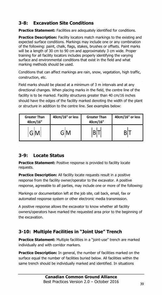
Canadian Common Ground Alliance
Best Practices Version 1.0 – October 2014
3-6: Locator and Public Safety Practice Statement: Locates are performed safely.
Practice Description: It is the responsibility of the owner/operator and locator to establish when and how the underground facility will be identified. All hazards associated with performing a locate are identified. Appropriate measures conforming to federal, provincial, local and industry standards are established. Employees are made aware of these hazards and properly trained in worker safety standards.
The following items should be considered as part of assessing and mitigating hazards on the job site when performing a locate:
Communication between locator and other personnel at the job site
Locator should be aware of safety requirements and written emergency procedures to be followed on the project where applicable or establish his/her own.
Traffic control considerations, including vehicular movement and pedestrian activity
Trip and fall hazards
Sources or energy (overhead and other)
Environmental factors
3-7: Locate Quality
Practice Statement: A visual inspection is completed during the locating process.
Practice Description: This inspection includes the following:
All facilities within a facility owner/operator’s service area (to evaluate the scope of the locate request),
Identification of access points,
Identification of potential hazards, and
Assurance that plant facilities shown on available records match those of the site.
The primary reason for a visual inspection is to determine if there are facilities placed that are not on record. It is very important that visual inspections be completed in areas of new construction, where records may not indicate the presence of a facility. The visual inspection is necessary because the time it takes for a facility placed in the field to be placed on permanent records varies by facility owner/operator and location. Evidence of a facility not on record includes, but is not limited to, poles, dips, enclosures, pedestals (including new cables found within the pedestals), valves, meters, risers, and manholes.
39
Canadian Common Ground Alliance
Best Practices Version 1.0 – October 2014
3-8: Excavation Site Conditions Practice Statement: Facilities are adequately identified for conditions.
Practice Description: Facility locators match markings to the existing and expected surface conditions. Markings may include one or any combination of the following: paint, chalk, flags, stakes, brushes or offsets. Paint marks will be a length of 30 cm to 90 cm and approximately 3 cm wide. Proper training for all facility locators includes properly identifying the varying surface and environmental conditions that exist in the field and what marking methods should be used.
Conditions that can affect markings are rain, snow, vegetation, high traffic, construction, etc.
Field marks should be placed at a minimum of 3 m intervals and at any directional changes. When placing marks in the field, the centre line of the facility is to be marked. Facility structures greater than 40 cm/16 inches should have the edges of the facility marked denoting the width of the plant or structure in addition to the centre line. See examples below:
3-9: Locate Status Practice Statement: Positive response is provided to facility locate requests.
Practice Description: All facility locate requests result in a positive response from the facility owner/operator to the excavator. A positive response, agreeable to all parties, may include one or more of the following:
Markings or documentation left at the job site, call back, email, fax or automated response system or other electronic media transmission.
A positive response allows the excavator to know whether all facility owners/operators have marked the requested area prior to the beginning of the excavation.
3-10: Multiple Facilities in “Joint Use” Trench
Practice Statement: Multiple facilities in a “joint-use” trench are marked individually and with corridor markers.
Practice Description: In general, the number of facilities marked on the surface equal the number of facilities buried below. All facilities within the same trench should be individually marked and identified. In situations
Greater Than 40cm/16”
40cm/16” or less Greater Than 40cm/16”
40cm/16” or less
G M G M B T B T
98397_ORCGA_BestPract-TEXT-Oct2014.indd 39 16/10/14 9:42 AM
Canadian Common Ground Alliance
Best Practices Version 1.0 – October 2014
3-6: Locator and Public Safety Practice Statement: Locates are performed safely.
Practice Description: It is the responsibility of the owner/operator and locator to establish when and how the underground facility will be identified. All hazards associated with performing a locate are identified. Appropriate measures conforming to federal, provincial, local and industry standards are established. Employees are made aware of these hazards and properly trained in worker safety standards.
The following items should be considered as part of assessing and mitigating hazards on the job site when performing a locate:
Communication between locator and other personnel at the job site
Locator should be aware of safety requirements and written emergency procedures to be followed on the project where applicable or establish his/her own.
Traffic control considerations, including vehicular movement and pedestrian activity
Trip and fall hazards
Sources or energy (overhead and other)
Environmental factors
3-7: Locate Quality
Practice Statement: A visual inspection is completed during the locating process.
Practice Description: This inspection includes the following:
All facilities within a facility owner/operator’s service area (to evaluate the scope of the locate request),
Identification of access points,
Identification of potential hazards, and
Assurance that plant facilities shown on available records match those of the site.
The primary reason for a visual inspection is to determine if there are facilities placed that are not on record. It is very important that visual inspections be completed in areas of new construction, where records may not indicate the presence of a facility. The visual inspection is necessary because the time it takes for a facility placed in the field to be placed on permanent records varies by facility owner/operator and location. Evidence of a facility not on record includes, but is not limited to, poles, dips, enclosures, pedestals (including new cables found within the pedestals), valves, meters, risers, and manholes.
38
Canadian Common Ground Alliance
Best Practices Version 1.0 – October 2014
3-8: Excavation Site Conditions Practice Statement: Facilities are adequately identified for conditions.
Practice Description: Facility locators match markings to the existing and expected surface conditions. Markings may include one or any combination of the following: paint, chalk, flags, stakes, brushes or offsets. Paint marks will be a length of 30 cm to 90 cm and approximately 3 cm wide. Proper training for all facility locators includes properly identifying the varying surface and environmental conditions that exist in the field and what marking methods should be used.
Conditions that can affect markings are rain, snow, vegetation, high traffic, construction, etc.
Field marks should be placed at a minimum of 3 m intervals and at any directional changes. When placing marks in the field, the centre line of the facility is to be marked. Facility structures greater than 40 cm/16 inches should have the edges of the facility marked denoting the width of the plant or structure in addition to the centre line. See examples below:
3-9: Locate Status Practice Statement: Positive response is provided to facility locate requests.
Practice Description: All facility locate requests result in a positive response from the facility owner/operator to the excavator. A positive response, agreeable to all parties, may include one or more of the following:
Markings or documentation left at the job site, call back, email, fax or automated response system or other electronic media transmission.
A positive response allows the excavator to know whether all facility owners/operators have marked the requested area prior to the beginning of the excavation.
3-10: Multiple Facilities in “Joint Use” Trench
Practice Statement: Multiple facilities in a “joint-use” trench are marked individually and with corridor markers.
Practice Description: In general, the number of facilities marked on the surface equal the number of facilities buried below. All facilities within the same trench should be individually marked and identified. In situations
98397_ORCGA_BestPract-TEXT-Oct2014.indd 38 16/10/14 9:42 AM
Canadian Common Ground Alliance
Best Practices Version 1.0 – October 2014
3-6: Locator and Public Safety Practice Statement: Locates are performed safely.
Practice Description: It is the responsibility of the owner/operator and locator to establish when and how the underground facility will be identified. All hazards associated with performing a locate are identified. Appropriate measures conforming to federal, provincial, local and industry standards are established. Employees are made aware of these hazards and properly trained in worker safety standards.
The following items should be considered as part of assessing and mitigating hazards on the job site when performing a locate:
Communication between locator and other personnel at the job site
Locator should be aware of safety requirements and written emergency procedures to be followed on the project where applicable or establish his/her own.
Traffic control considerations, including vehicular movement and pedestrian activity
Trip and fall hazards
Sources or energy (overhead and other)
Environmental factors
3-7: Locate Quality
Practice Statement: A visual inspection is completed during the locating process.
Practice Description: This inspection includes the following:
All facilities within a facility owner/operator’s service area (to evaluate the scope of the locate request),
Identification of access points,
Identification of potential hazards, and
Assurance that plant facilities shown on available records match those of the site.
The primary reason for a visual inspection is to determine if there are facilities placed that are not on record. It is very important that visual inspections be completed in areas of new construction, where records may not indicate the presence of a facility. The visual inspection is necessary because the time it takes for a facility placed in the field to be placed on permanent records varies by facility owner/operator and location. Evidence of a facility not on record includes, but is not limited to, poles, dips, enclosures, pedestals (including new cables found within the pedestals), valves, meters, risers, and manholes.
39
Canadian Common Ground Alliance
Best Practices Version 1.0 – October 2014
3-8: Excavation Site Conditions Practice Statement: Facilities are adequately identified for conditions.
Practice Description: Facility locators match markings to the existing and expected surface conditions. Markings may include one or any combination of the following: paint, chalk, flags, stakes, brushes or offsets. Paint marks will be a length of 30 cm to 90 cm and approximately 3 cm wide. Proper training for all facility locators includes properly identifying the varying surface and environmental conditions that exist in the field and what marking methods should be used.
Conditions that can affect markings are rain, snow, vegetation, high traffic, construction, etc.
Field marks should be placed at a minimum of 3 m intervals and at any directional changes. When placing marks in the field, the centre line of the facility is to be marked. Facility structures greater than 40 cm/16 inches should have the edges of the facility marked denoting the width of the plant or structure in addition to the centre line. See examples below:
3-9: Locate Status Practice Statement: Positive response is provided to facility locate requests.
Practice Description: All facility locate requests result in a positive response from the facility owner/operator to the excavator. A positive response, agreeable to all parties, may include one or more of the following:
Markings or documentation left at the job site, call back, email, fax or automated response system or other electronic media transmission.
A positive response allows the excavator to know whether all facility owners/operators have marked the requested area prior to the beginning of the excavation.
3-10: Multiple Facilities in “Joint Use” Trench
Practice Statement: Multiple facilities in a “joint-use” trench are marked individually and with corridor markers.
Practice Description: In general, the number of facilities marked on the surface equal the number of facilities buried below. All facilities within the same trench should be individually marked and identified. In situations
Greater Than 40cm/16”
40cm/16” or less Greater Than 40cm/16”
40cm/16” or less
G M G M B T B T
98397_ORCGA_BestPract-TEXT-Oct2014.indd 39 16/10/14 9:42 AM
Canadian Common Ground Alliance
Best Practices Version 1.0 – October 2014
3-6: Locator and Public Safety Practice Statement: Locates are performed safely.
Practice Description: It is the responsibility of the owner/operator and locator to establish when and how the underground facility will be identified. All hazards associated with performing a locate are identified. Appropriate measures conforming to federal, provincial, local and industry standards are established. Employees are made aware of these hazards and properly trained in worker safety standards.
The following items should be considered as part of assessing and mitigating hazards on the job site when performing a locate:
Communication between locator and other personnel at the job site
Locator should be aware of safety requirements and written emergency procedures to be followed on the project where applicable or establish his/her own.
Traffic control considerations, including vehicular movement and pedestrian activity
Trip and fall hazards
Sources or energy (overhead and other)
Environmental factors
3-7: Locate Quality
Practice Statement: A visual inspection is completed during the locating process.
Practice Description: This inspection includes the following:
All facilities within a facility owner/operator’s service area (to evaluate the scope of the locate request),
Identification of access points,
Identification of potential hazards, and
Assurance that plant facilities shown on available records match those of the site.
The primary reason for a visual inspection is to determine if there are facilities placed that are not on record. It is very important that visual inspections be completed in areas of new construction, where records may not indicate the presence of a facility. The visual inspection is necessary because the time it takes for a facility placed in the field to be placed on permanent records varies by facility owner/operator and location. Evidence of a facility not on record includes, but is not limited to, poles, dips, enclosures, pedestals (including new cables found within the pedestals), valves, meters, risers, and manholes.
39
Canadian Common Ground Alliance
Best Practices Version 1.0 – October 2014
3-8: Excavation Site Conditions Practice Statement: Facilities are adequately identified for conditions.
Practice Description: Facility locators match markings to the existing and expected surface conditions. Markings may include one or any combination of the following: paint, chalk, flags, stakes, brushes or offsets. Paint marks will be a length of 30 cm to 90 cm and approximately 3 cm wide. Proper training for all facility locators includes properly identifying the varying surface and environmental conditions that exist in the field and what marking methods should be used.
Conditions that can affect markings are rain, snow, vegetation, high traffic, construction, etc.
Field marks should be placed at a minimum of 3 m intervals and at any directional changes. When placing marks in the field, the centre line of the facility is to be marked. Facility structures greater than 40 cm/16 inches should have the edges of the facility marked denoting the width of the plant or structure in addition to the centre line. See examples below:
3-9: Locate Status Practice Statement: Positive response is provided to facility locate requests.
Practice Description: All facility locate requests result in a positive response from the facility owner/operator to the excavator. A positive response, agreeable to all parties, may include one or more of the following:
Markings or documentation left at the job site, call back, email, fax or automated response system or other electronic media transmission.
A positive response allows the excavator to know whether all facility owners/operators have marked the requested area prior to the beginning of the excavation.
3-10: Multiple Facilities in “Joint Use” Trench
Practice Statement: Multiple facilities in a “joint-use” trench are marked individually and with corridor markers.
Practice Description: In general, the number of facilities marked on the surface equal the number of facilities buried below. All facilities within the same trench should be individually marked and identified. In situations
Greater Than 40cm/16”
40cm/16” or less Greater Than 40cm/16”
40cm/16” or less
G M G M B T B T
98397_ORCGA_BestPract-TEXT-Oct2014.indd 39 16/10/14 9:42 AM
Canadian Common Ground AllianceBest Practices Version 2.0 – October 2016 39
Canadian Common Ground Alliance
Best Practices Version 1.0 – October 2014
where two facilities share the same colour code (such as telephone and CATV) both facilities should be identified and the marks placed parallel, but with enough separation so that they may be readily identified. In circumstances where the total number of lines buried in the same trench by a single facility owner/operator may not be readily known, a corridor marker is used. The corridor mark indicates the width of the facility.
3-11: Locate Method Preference
Practice Statement: When locating electro-magnetically, active/conductive locating is preferable to passive/inductive locating.
Practice Description: The preferred method of actively applying a signal onto a facility is to use direct connection. Direct connection is the process of connecting a direct lead from the transmitter to the target facility and connecting a ground lead from the transmitter to a ground point in order to complete a circuit. This process provides the strongest signal on the line and is less likely to spill to adjacent facilities than other methods of applying a signal. This method allows a greater range of frequency and power output options. It is good practice to use the lowest frequency possible at the lowest power output possible to complete the locate. If direct connection is not possible, use of an induction clamp (coupler) is the most effective method of applying a locate signal onto the target conductor. This method is more limiting for the choices of frequency and power outputs than direct connection. Using an induction clamp is not as effective at transmitting a signal as direct connection, can only be used within certain frequency ranges, and must use a higher power output. The least preferred method is induction or broadcast mode on a transmitter. This usually results in a weak signal that will spill to any conductor in the area.
When using any of the above three methods, the locator should trace the entire line from the point of signal application through the proposed work area.
Origin/Rational
It is very important that locators do not apply a signal application to a line, walk out to the work area and begin locating. This can lead to picking up signal on facilities other than the target line. Tracing continuously from the point of signal application to the end of the work area improves the accuracy of the locate.
Notable exceptions may include utility "Transmission" situations, where signal application opportunities may be limited (e.g. fiber optic networks, transmission pipelines and long distance power conductors). In these situations, to ensure that a reliable locate is achieved, attention should be paid to ensure a suitable signal launch is achieved. Subsequently, careful reference to distant locate signal characteristics should be made.
40
Canadian Common Ground Alliance
Best Practices Version 1.0 – October 2014
3-12: Facility Identification Practice Statement: The facility owner/operator is identified.
Practice Description: The owner/operator of a facility is identified by markings at the time the facility is located. This practice facilitates a positive response for all located facilities within the requested area.
In situations where two facilities share the same colour code (such as telephone or CATV) both facilities should be identified. During completion of the locate the facility material type and size, when available, should be identified on the locate form.
3-13: Communications Practice Statement: Communication is established amongst all parties.
Practice Description: Call centers, facility owners/operators and excavators all have clearly defined processes to facilitate communication between all parties. If the complexity of a project or its duration is such that a clear and precise understanding of the excavation site is not easily conveyed in writing on a locate request, then a pre-location meeting is scheduled. This pre-location meeting is on-site to establish the scope of the excavation. If requested by either party, written documentation between the excavator and the locator should include:
Date, Name, Company,
Contact numbers for all parties,
List and the limits of the dig areas to be excavated,
Schedule for both marking and excavating the areas, and
Follow up agreements that might be necessary.
Any changes to the areas that are to be located are in writing and include all parties responsible for the excavation and marking of the excavation sites. Locators also schedule site meetings if the complexity of the markings requires further explanation.
3-14: Locate Report Practice Statement: A written report which may be referred to as the Locate Report or Buried Plant Locate Report or Locate Sheet should be issued by the locator in order to provide details and instructions for the locate and to confirm that the locate has been completed.
Practice Description: In order to complete the locate process it is necessary to provide sufficient information that parties relying on this for excavation purposes will be able to correctly interpret the marks in the field and be aware of the instructions, warnings and limitations of the locate. This information should be provided in a Locate Report that is legible and that groups similar types of information in a logical and consistent order.
98397_ORCGA_BestPract-TEXT-Oct2014.indd 40 16/10/14 9:42 AM
Canadian Common Ground Alliance
Best Practices Version 1.0 – October 2014
where two facilities share the same colour code (such as telephone and CATV) both facilities should be identified and the marks placed parallel, but with enough separation so that they may be readily identified. In circumstances where the total number of lines buried in the same trench by a single facility owner/operator may not be readily known, a corridor marker is used. The corridor mark indicates the width of the facility.
3-11: Locate Method Preference
Practice Statement: When locating electro-magnetically, active/conductive locating is preferable to passive/inductive locating.
Practice Description: The preferred method of actively applying a signal onto a facility is to use direct connection. Direct connection is the process of connecting a direct lead from the transmitter to the target facility and connecting a ground lead from the transmitter to a ground point in order to complete a circuit. This process provides the strongest signal on the line and is less likely to spill to adjacent facilities than other methods of applying a signal. This method allows a greater range of frequency and power output options. It is good practice to use the lowest frequency possible at the lowest power output possible to complete the locate. If direct connection is not possible, use of an induction clamp (coupler) is the most effective method of applying a locate signal onto the target conductor. This method is more limiting for the choices of frequency and power outputs than direct connection. Using an induction clamp is not as effective at transmitting a signal as direct connection, can only be used within certain frequency ranges, and must use a higher power output. The least preferred method is induction or broadcast mode on a transmitter. This usually results in a weak signal that will spill to any conductor in the area.
When using any of the above three methods, the locator should trace the entire line from the point of signal application through the proposed work area.
Origin/Rational
It is very important that locators do not apply a signal application to a line, walk out to the work area and begin locating. This can lead to picking up signal on facilities other than the target line. Tracing continuously from the point of signal application to the end of the work area improves the accuracy of the locate.
Notable exceptions may include utility "Transmission" situations, where signal application opportunities may be limited (e.g. fiber optic networks, transmission pipelines and long distance power conductors). In these situations, to ensure that a reliable locate is achieved, attention should be paid to ensure a suitable signal launch is achieved. Subsequently, careful reference to distant locate signal characteristics should be made.
40
Canadian Common Ground Alliance
Best Practices Version 1.0 – October 2014
3-12: Facility Identification Practice Statement: The facility owner/operator is identified.
Practice Description: The owner/operator of a facility is identified by markings at the time the facility is located. This practice facilitates a positive response for all located facilities within the requested area.
In situations where two facilities share the same colour code (such as telephone or CATV) both facilities should be identified. During completion of the locate the facility material type and size, when available, should be identified on the locate form.
3-13: Communications Practice Statement: Communication is established amongst all parties.
Practice Description: Call centers, facility owners/operators and excavators all have clearly defined processes to facilitate communication between all parties. If the complexity of a project or its duration is such that a clear and precise understanding of the excavation site is not easily conveyed in writing on a locate request, then a pre-location meeting is scheduled. This pre-location meeting is on-site to establish the scope of the excavation. If requested by either party, written documentation between the excavator and the locator should include:
Date, Name, Company,
Contact numbers for all parties,
List and the limits of the dig areas to be excavated,
Schedule for both marking and excavating the areas, and
Follow up agreements that might be necessary.
Any changes to the areas that are to be located are in writing and include all parties responsible for the excavation and marking of the excavation sites. Locators also schedule site meetings if the complexity of the markings requires further explanation.
3-14: Locate Report Practice Statement: A written report which may be referred to as the Locate Report or Buried Plant Locate Report or Locate Sheet should be issued by the locator in order to provide details and instructions for the locate and to confirm that the locate has been completed.
Practice Description: In order to complete the locate process it is necessary to provide sufficient information that parties relying on this for excavation purposes will be able to correctly interpret the marks in the field and be aware of the instructions, warnings and limitations of the locate. This information should be provided in a Locate Report that is legible and that groups similar types of information in a logical and consistent order.
98397_ORCGA_BestPract-TEXT-Oct2014.indd 40 16/10/14 9:42 AM
Canadian Common Ground AllianceBest Practices Version 2.0 – October 201640
Canadian Common Ground Alliance
Best Practices Version 1.0 – October 2014
where two facilities share the same colour code (such as telephone and CATV) both facilities should be identified and the marks placed parallel, but with enough separation so that they may be readily identified. In circumstances where the total number of lines buried in the same trench by a single facility owner/operator may not be readily known, a corridor marker is used. The corridor mark indicates the width of the facility.
3-11: Locate Method Preference
Practice Statement: When locating electro-magnetically, active/conductive locating is preferable to passive/inductive locating.
Practice Description: The preferred method of actively applying a signal onto a facility is to use direct connection. Direct connection is the process of connecting a direct lead from the transmitter to the target facility and connecting a ground lead from the transmitter to a ground point in order to complete a circuit. This process provides the strongest signal on the line and is less likely to spill to adjacent facilities than other methods of applying a signal. This method allows a greater range of frequency and power output options. It is good practice to use the lowest frequency possible at the lowest power output possible to complete the locate. If direct connection is not possible, use of an induction clamp (coupler) is the most effective method of applying a locate signal onto the target conductor. This method is more limiting for the choices of frequency and power outputs than direct connection. Using an induction clamp is not as effective at transmitting a signal as direct connection, can only be used within certain frequency ranges, and must use a higher power output. The least preferred method is induction or broadcast mode on a transmitter. This usually results in a weak signal that will spill to any conductor in the area.
When using any of the above three methods, the locator should trace the entire line from the point of signal application through the proposed work area.
Origin/Rational
It is very important that locators do not apply a signal application to a line, walk out to the work area and begin locating. This can lead to picking up signal on facilities other than the target line. Tracing continuously from the point of signal application to the end of the work area improves the accuracy of the locate.
Notable exceptions may include utility "Transmission" situations, where signal application opportunities may be limited (e.g. fiber optic networks, transmission pipelines and long distance power conductors). In these situations, to ensure that a reliable locate is achieved, attention should be paid to ensure a suitable signal launch is achieved. Subsequently, careful reference to distant locate signal characteristics should be made.
41
Canadian Common Ground Alliance
Best Practices Version 1.0 – October 2014
3-12: Facility Identification Practice Statement: The facility owner/operator is identified.
Practice Description: The owner/operator of a facility is identified by markings at the time the facility is located. This practice facilitates a positive response for all located facilities within the requested area.
In situations where two facilities share the same colour code (such as telephone or CATV) both facilities should be identified. During completion of the locate the facility material type and size, when available, should be identified on the locate form.
3-13: Communications Practice Statement: Communication is established amongst all parties.
Practice Description: Call centers, facility owners/operators and excavators all have clearly defined processes to facilitate communication between all parties. If the complexity of a project or its duration is such that a clear and precise understanding of the excavation site is not easily conveyed in writing on a locate request, then a pre-location meeting is scheduled. This pre-location meeting is on-site to establish the scope of the excavation. If requested by either party, written documentation between the excavator and the locator should include:
Date, Name, Company,
Contact numbers for all parties,
List and the limits of the dig areas to be excavated,
Schedule for both marking and excavating the areas, and
Follow up agreements that might be necessary.
Any changes to the areas that are to be located are in writing and include all parties responsible for the excavation and marking of the excavation sites. Locators also schedule site meetings if the complexity of the markings requires further explanation.
3-14: Locate Report Practice Statement: A written report which may be referred to as the Locate Report or Buried Plant Locate Report or Locate Sheet should be issued by the locator in order to provide details and instructions for the locate and to confirm that the locate has been completed.
Practice Description: In order to complete the locate process it is necessary to provide sufficient information that parties relying on this for excavation purposes will be able to correctly interpret the marks in the field and be aware of the instructions, warnings and limitations of the locate. This information should be provided in a Locate Report that is legible and that groups similar types of information in a logical and consistent order.
98397_ORCGA_BestPract-TEXT-Oct2014.indd 41 16/10/14 9:42 AM
Canadian Common Ground Alliance
Best Practices Version 1.0 – October 2014
where two facilities share the same colour code (such as telephone and CATV) both facilities should be identified and the marks placed parallel, but with enough separation so that they may be readily identified. In circumstances where the total number of lines buried in the same trench by a single facility owner/operator may not be readily known, a corridor marker is used. The corridor mark indicates the width of the facility.
3-11: Locate Method Preference
Practice Statement: When locating electro-magnetically, active/conductive locating is preferable to passive/inductive locating.
Practice Description: The preferred method of actively applying a signal onto a facility is to use direct connection. Direct connection is the process of connecting a direct lead from the transmitter to the target facility and connecting a ground lead from the transmitter to a ground point in order to complete a circuit. This process provides the strongest signal on the line and is less likely to spill to adjacent facilities than other methods of applying a signal. This method allows a greater range of frequency and power output options. It is good practice to use the lowest frequency possible at the lowest power output possible to complete the locate. If direct connection is not possible, use of an induction clamp (coupler) is the most effective method of applying a locate signal onto the target conductor. This method is more limiting for the choices of frequency and power outputs than direct connection. Using an induction clamp is not as effective at transmitting a signal as direct connection, can only be used within certain frequency ranges, and must use a higher power output. The least preferred method is induction or broadcast mode on a transmitter. This usually results in a weak signal that will spill to any conductor in the area.
When using any of the above three methods, the locator should trace the entire line from the point of signal application through the proposed work area.
Origin/Rational
It is very important that locators do not apply a signal application to a line, walk out to the work area and begin locating. This can lead to picking up signal on facilities other than the target line. Tracing continuously from the point of signal application to the end of the work area improves the accuracy of the locate.
Notable exceptions may include utility "Transmission" situations, where signal application opportunities may be limited (e.g. fiber optic networks, transmission pipelines and long distance power conductors). In these situations, to ensure that a reliable locate is achieved, attention should be paid to ensure a suitable signal launch is achieved. Subsequently, careful reference to distant locate signal characteristics should be made.
40
Canadian Common Ground Alliance
Best Practices Version 1.0 – October 2014
3-12: Facility Identification Practice Statement: The facility owner/operator is identified.
Practice Description: The owner/operator of a facility is identified by markings at the time the facility is located. This practice facilitates a positive response for all located facilities within the requested area.
In situations where two facilities share the same colour code (such as telephone or CATV) both facilities should be identified. During completion of the locate the facility material type and size, when available, should be identified on the locate form.
3-13: Communications Practice Statement: Communication is established amongst all parties.
Practice Description: Call centers, facility owners/operators and excavators all have clearly defined processes to facilitate communication between all parties. If the complexity of a project or its duration is such that a clear and precise understanding of the excavation site is not easily conveyed in writing on a locate request, then a pre-location meeting is scheduled. This pre-location meeting is on-site to establish the scope of the excavation. If requested by either party, written documentation between the excavator and the locator should include:
Date, Name, Company,
Contact numbers for all parties,
List and the limits of the dig areas to be excavated,
Schedule for both marking and excavating the areas, and
Follow up agreements that might be necessary.
Any changes to the areas that are to be located are in writing and include all parties responsible for the excavation and marking of the excavation sites. Locators also schedule site meetings if the complexity of the markings requires further explanation.
3-14: Locate Report Practice Statement: A written report which may be referred to as the Locate Report or Buried Plant Locate Report or Locate Sheet should be issued by the locator in order to provide details and instructions for the locate and to confirm that the locate has been completed.
Practice Description: In order to complete the locate process it is necessary to provide sufficient information that parties relying on this for excavation purposes will be able to correctly interpret the marks in the field and be aware of the instructions, warnings and limitations of the locate. This information should be provided in a Locate Report that is legible and that groups similar types of information in a logical and consistent order.
98397_ORCGA_BestPract-TEXT-Oct2014.indd 40 16/10/14 9:42 AM
Canadian Common Ground Alliance
Best Practices Version 1.0 – October 2014
where two facilities share the same colour code (such as telephone and CATV) both facilities should be identified and the marks placed parallel, but with enough separation so that they may be readily identified. In circumstances where the total number of lines buried in the same trench by a single facility owner/operator may not be readily known, a corridor marker is used. The corridor mark indicates the width of the facility.
3-11: Locate Method Preference
Practice Statement: When locating electro-magnetically, active/conductive locating is preferable to passive/inductive locating.
Practice Description: The preferred method of actively applying a signal onto a facility is to use direct connection. Direct connection is the process of connecting a direct lead from the transmitter to the target facility and connecting a ground lead from the transmitter to a ground point in order to complete a circuit. This process provides the strongest signal on the line and is less likely to spill to adjacent facilities than other methods of applying a signal. This method allows a greater range of frequency and power output options. It is good practice to use the lowest frequency possible at the lowest power output possible to complete the locate. If direct connection is not possible, use of an induction clamp (coupler) is the most effective method of applying a locate signal onto the target conductor. This method is more limiting for the choices of frequency and power outputs than direct connection. Using an induction clamp is not as effective at transmitting a signal as direct connection, can only be used within certain frequency ranges, and must use a higher power output. The least preferred method is induction or broadcast mode on a transmitter. This usually results in a weak signal that will spill to any conductor in the area.
When using any of the above three methods, the locator should trace the entire line from the point of signal application through the proposed work area.
Origin/Rational
It is very important that locators do not apply a signal application to a line, walk out to the work area and begin locating. This can lead to picking up signal on facilities other than the target line. Tracing continuously from the point of signal application to the end of the work area improves the accuracy of the locate.
Notable exceptions may include utility "Transmission" situations, where signal application opportunities may be limited (e.g. fiber optic networks, transmission pipelines and long distance power conductors). In these situations, to ensure that a reliable locate is achieved, attention should be paid to ensure a suitable signal launch is achieved. Subsequently, careful reference to distant locate signal characteristics should be made.
41
Canadian Common Ground Alliance
Best Practices Version 1.0 – October 2014
3-12: Facility Identification Practice Statement: The facility owner/operator is identified.
Practice Description: The owner/operator of a facility is identified by markings at the time the facility is located. This practice facilitates a positive response for all located facilities within the requested area.
In situations where two facilities share the same colour code (such as telephone or CATV) both facilities should be identified. During completion of the locate the facility material type and size, when available, should be identified on the locate form.
3-13: Communications Practice Statement: Communication is established amongst all parties.
Practice Description: Call centers, facility owners/operators and excavators all have clearly defined processes to facilitate communication between all parties. If the complexity of a project or its duration is such that a clear and precise understanding of the excavation site is not easily conveyed in writing on a locate request, then a pre-location meeting is scheduled. This pre-location meeting is on-site to establish the scope of the excavation. If requested by either party, written documentation between the excavator and the locator should include:
Date, Name, Company,
Contact numbers for all parties,
List and the limits of the dig areas to be excavated,
Schedule for both marking and excavating the areas, and
Follow up agreements that might be necessary.
Any changes to the areas that are to be located are in writing and include all parties responsible for the excavation and marking of the excavation sites. Locators also schedule site meetings if the complexity of the markings requires further explanation.
3-14: Locate Report Practice Statement: A written report which may be referred to as the Locate Report or Buried Plant Locate Report or Locate Sheet should be issued by the locator in order to provide details and instructions for the locate and to confirm that the locate has been completed.
Practice Description: In order to complete the locate process it is necessary to provide sufficient information that parties relying on this for excavation purposes will be able to correctly interpret the marks in the field and be aware of the instructions, warnings and limitations of the locate. This information should be provided in a Locate Report that is legible and that groups similar types of information in a logical and consistent order.
98397_ORCGA_BestPract-TEXT-Oct2014.indd 41 16/10/14 9:42 AM
Canadian Common Ground Alliance
Best Practices Version 1.0 – October 2014
where two facilities share the same colour code (such as telephone and CATV) both facilities should be identified and the marks placed parallel, but with enough separation so that they may be readily identified. In circumstances where the total number of lines buried in the same trench by a single facility owner/operator may not be readily known, a corridor marker is used. The corridor mark indicates the width of the facility.
3-11: Locate Method Preference
Practice Statement: When locating electro-magnetically, active/conductive locating is preferable to passive/inductive locating.
Practice Description: The preferred method of actively applying a signal onto a facility is to use direct connection. Direct connection is the process of connecting a direct lead from the transmitter to the target facility and connecting a ground lead from the transmitter to a ground point in order to complete a circuit. This process provides the strongest signal on the line and is less likely to spill to adjacent facilities than other methods of applying a signal. This method allows a greater range of frequency and power output options. It is good practice to use the lowest frequency possible at the lowest power output possible to complete the locate. If direct connection is not possible, use of an induction clamp (coupler) is the most effective method of applying a locate signal onto the target conductor. This method is more limiting for the choices of frequency and power outputs than direct connection. Using an induction clamp is not as effective at transmitting a signal as direct connection, can only be used within certain frequency ranges, and must use a higher power output. The least preferred method is induction or broadcast mode on a transmitter. This usually results in a weak signal that will spill to any conductor in the area.
When using any of the above three methods, the locator should trace the entire line from the point of signal application through the proposed work area.
Origin/Rational
It is very important that locators do not apply a signal application to a line, walk out to the work area and begin locating. This can lead to picking up signal on facilities other than the target line. Tracing continuously from the point of signal application to the end of the work area improves the accuracy of the locate.
Notable exceptions may include utility "Transmission" situations, where signal application opportunities may be limited (e.g. fiber optic networks, transmission pipelines and long distance power conductors). In these situations, to ensure that a reliable locate is achieved, attention should be paid to ensure a suitable signal launch is achieved. Subsequently, careful reference to distant locate signal characteristics should be made.
41
Canadian Common Ground Alliance
Best Practices Version 1.0 – October 2014
3-12: Facility Identification Practice Statement: The facility owner/operator is identified.
Practice Description: The owner/operator of a facility is identified by markings at the time the facility is located. This practice facilitates a positive response for all located facilities within the requested area.
In situations where two facilities share the same colour code (such as telephone or CATV) both facilities should be identified. During completion of the locate the facility material type and size, when available, should be identified on the locate form.
3-13: Communications Practice Statement: Communication is established amongst all parties.
Practice Description: Call centers, facility owners/operators and excavators all have clearly defined processes to facilitate communication between all parties. If the complexity of a project or its duration is such that a clear and precise understanding of the excavation site is not easily conveyed in writing on a locate request, then a pre-location meeting is scheduled. This pre-location meeting is on-site to establish the scope of the excavation. If requested by either party, written documentation between the excavator and the locator should include:
Date, Name, Company,
Contact numbers for all parties,
List and the limits of the dig areas to be excavated,
Schedule for both marking and excavating the areas, and
Follow up agreements that might be necessary.
Any changes to the areas that are to be located are in writing and include all parties responsible for the excavation and marking of the excavation sites. Locators also schedule site meetings if the complexity of the markings requires further explanation.
3-14: Locate Report Practice Statement: A written report which may be referred to as the Locate Report or Buried Plant Locate Report or Locate Sheet should be issued by the locator in order to provide details and instructions for the locate and to confirm that the locate has been completed.
Practice Description: In order to complete the locate process it is necessary to provide sufficient information that parties relying on this for excavation purposes will be able to correctly interpret the marks in the field and be aware of the instructions, warnings and limitations of the locate. This information should be provided in a Locate Report that is legible and that groups similar types of information in a logical and consistent order.
98397_ORCGA_BestPract-TEXT-Oct2014.indd 41 16/10/14 9:42 AM
Canadian Common Ground AllianceBest Practices Version 2.0 – October 2016 41

Canadian Common Ground Alliance Best Practices Version 1.0 – October 2014
While the exact appearance, formatting, inclusions, exclusions and order of elements may vary in a Locate Report these should be similar to and consistent with the following generic format, even in emergency situations where all information provided is hand written.
Primary locate sheet illustrated in Fig.1 should always be placed first and contain the following information (refer to www.canadiancga.com for full size version, and Appendix C – How To Read a Locate Sheet):
Figure 1 Primary Locate Sheet
1. Title “Primary Locate Sheet” [must be added at top left/center of sheet].
Name and address of locate service provider (LSP) providing locate. LSP
contact information [minimum of 2]. LSP logo.
2. Page number and total number of pages [must be added at top right of
sheet].
3. Request number or unique identifier of the locate.
42
Canadian Common Ground AllianceBest Practices Version 1.0 – October 2014
4. Request type, e.g. Std., Emerg.
5. Names of Utility Owners that the LSP has been requested to locate.
6. Excavation date as originally requested.
7. Revised excavation date, if agreed to.
8. Category or classification of party requesting the locate.
9. Name of person submitting locate request.
10. Name of company or party requesting locate [acceptable entries
include homeowner, tenant, self-employed and similar designations].
11. Contact phone number for party requesting the locate.
12. Fax number or email address for party requesting the locate.
13. Address where excavation is to take place [highway marker, survey
plan or GPS coordinates acceptable where street address not available].
14. Name of municipality where excavation is to take place.
15. Date the original locate request was made.
16. Type of intended work or method of excavation.
17. Request for a site meeting prior to locate, with agreed date if
applicable.
18. Dig area description by party requesting locate.
19. Remarks or additional description of work provided by party requesting
locate.
20. Method of field marking area where excavation will take place.
21. General warnings and cautions on use and validity of locate [should be
positioned on sheet to divide information provided at time of request
from information provided by locator].
22. Utility and site records available to locator at time of locate.
23. Site specific warnings and cautions issued by locator.
24. Remarks about circumstances affecting locate issued by locator.
25. Site specific warnings and cautions from utility owners.
26. Method used by locator to field mark utility positions.
27. List of documents or additional information attached to locate report.
28. Name or ID# of locator. Date of issue. Start and end time of locate.
Notice of expiry date or period.
29. Method used to deliver locate report to party requesting locate. Name
and signature of person receiving locate report.
30. Regulatory warnings about use of locate information [should be
positioned at bottom of sheet].
98397_ORCGA_BestPract-TEXT-Oct2014.indd 42 16/10/14 9:42 AM
Canadian Common Ground AllianceBest Practices Version 2.0 – October 201642
Canadian Common Ground Alliance
Best Practices Version 1.0 – October 2014
While the exact appearance, formatting, inclusions, exclusions and order of elements may vary in a Locate Report these should be similar to and consistent with the following generic format, even in emergency situations where all information provided is hand written.
Primary locate sheet illustrated in Fig.1 should always be placed first and contain the following information (refer to www.orcga.com for full size version, and Appendix C – How To Read a Locate Sheet):
Figure 1 Primary Locate Sheet
1. Title “Primary Locate Sheet” [must be added at top left/center of sheet].
Name and address of locate service provider (LSP) providing locate. LSP
contact information [minimum of 2]. LSP logo.
2. Page number and total number of pages [must be added at top right of
sheet].
3. Request number or unique identifier of the locate.
43
Canadian Common Ground Alliance
Best Practices Version 1.0 – October 2014
4. Request type, e.g. Std., Emerg.
5. Names of Utility Owners that the LSP has been requested to locate.
6. Excavation date as originally requested.
7. Revised excavation date, if agreed to.
8. Category or classification of party requesting the locate.
9. Name of person submitting locate request.
10. Name of company or party requesting locate [acceptable entries
include homeowner, tenant, self-employed and similar designations].
11. Contact phone number for party requesting the locate.
12. Fax number or email address for party requesting the locate.
13. Address where excavation is to take place [highway marker, survey
plan or GPS coordinates acceptable where street address not available].
14. Name of municipality where excavation is to take place.
15. Date the original locate request was made.
16. Type of intended work or method of excavation.
17. Request for a site meeting prior to locate, with agreed date if
applicable.
18. Dig area description by party requesting locate.
19. Remarks or additional description of work provided by party requesting
locate.
20. Method of field marking area where excavation will take place.
21. General warnings and cautions on use and validity of locate [should be
positioned on sheet to divide information provided at time of request
from information provided by locator].
22. Utility and site records available to locator at time of locate.
23. Site specific warnings and cautions issued by locator.
24. Remarks about circumstances affecting locate issued by locator.
25. Site specific warnings and cautions from utility owners.
26. Method used by locator to field mark utility positions.
27. List of documents or additional information attached to locate report.
28. Name or ID# of locator. Date of issue. Start and end time of locate.
Notice of expiry date or period.
29. Method used to deliver locate report to party requesting locate. Name
and signature of person receiving locate report.
30. Regulatory warnings about use of locate information [should be
positioned at bottom of sheet].
98397_ORCGA_BestPract-TEXT-Oct2014.indd 43 16/10/14 9:42 AM
Canadian Common Ground Alliance Best Practices Version 1.0 – October 2014
While the exact appearance, formatting, inclusions, exclusions and order of elements may vary in a Locate Report these should be similar to and consistent with the following generic format, even in emergency situations where all information provided is hand written.
Primary locate sheet illustrated in Fig.1 should always be placed first and contain the following information (refer to www.canadiancga.com for full size version, and Appendix C – How To Read a Locate Sheet):
Figure 1 Primary Locate Sheet
1. Title “Primary Locate Sheet” [must be added at top left/center of sheet].
Name and address of locate service provider (LSP) providing locate. LSP
contact information [minimum of 2]. LSP logo.
2. Page number and total number of pages [must be added at top right of
sheet].
3. Request number or unique identifier of the locate.
42
Canadian Common Ground AllianceBest Practices Version 1.0 – October 2014
4. Request type, e.g. Std., Emerg.
5. Names of Utility Owners that the LSP has been requested to locate.
6. Excavation date as originally requested.
7. Revised excavation date, if agreed to.
8. Category or classification of party requesting the locate.
9. Name of person submitting locate request.
10. Name of company or party requesting locate [acceptable entries
include homeowner, tenant, self-employed and similar designations].
11. Contact phone number for party requesting the locate.
12. Fax number or email address for party requesting the locate.
13. Address where excavation is to take place [highway marker, survey
plan or GPS coordinates acceptable where street address not available].
14. Name of municipality where excavation is to take place.
15. Date the original locate request was made.
16. Type of intended work or method of excavation.
17. Request for a site meeting prior to locate, with agreed date if
applicable.
18. Dig area description by party requesting locate.
19. Remarks or additional description of work provided by party requesting
locate.
20. Method of field marking area where excavation will take place.
21. General warnings and cautions on use and validity of locate [should be
positioned on sheet to divide information provided at time of request
from information provided by locator].
22. Utility and site records available to locator at time of locate.
23. Site specific warnings and cautions issued by locator.
24. Remarks about circumstances affecting locate issued by locator.
25. Site specific warnings and cautions from utility owners.
26. Method used by locator to field mark utility positions.
27. List of documents or additional information attached to locate report.
28. Name or ID# of locator. Date of issue. Start and end time of locate.
Notice of expiry date or period.
29. Method used to deliver locate report to party requesting locate. Name
and signature of person receiving locate report.
30. Regulatory warnings about use of locate information [should be
positioned at bottom of sheet].
98397_ORCGA_BestPract-TEXT-Oct2014.indd 42 16/10/14 9:42 AM
Canadian Common Ground AllianceBest Practices Version 2.0 – October 2016 43
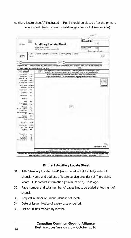
Canadian Common Ground Alliance Best Practices Version 1.0 – October 2014
Auxiliary locate sheet(s) illustrated in Fig. 2 should be placed after the primary locate sheet (refer to www.canadiancga.com for full size version):
Figure 2 Auxiliary Locate Sheet
31. Title “Auxiliary Locate Sheet” [must be added at top left/center of
sheet]. Name and address of locate service provider (LSP) providing
locate. LSP contact information [minimum of 2]. LSP logo.
32. Page number and total number of pages [must be added at top right of
sheet].
33. Request number or unique identifier of locate.
34. Date of issue. Notice of expiry date or period.
35. List of utilities marked by locator.
44
Canadian Common Ground AllianceBest Practices Version 1.0 – October 2014
36. Written description of limits of locate, i.e. area covered by this sheet of
locate report.
37. Instructions on use and validity of locate. Specific warning by locator
that limits of locate have been altered since original request.
38. Legend describing symbols used on sketch.
39. Instructions on excavation methods in vicinity of locate marks.
40. Sketch of marks placed by locator.
41. Directional indicator, e.g. north arrow, to provide orientation of sketch.
42. Warning sketch is not to scale.
43. Warning auxiliary sheet is only valid in combination with primary locate
sheet.
44. Regulatory warnings about use of locate information [should be
positioned at bottom of sheet]
Instructions sheet, an example is illustrated in Fig. 3, should be placed afterthe auxiliary locate sheets (refer to ccga.com for full size version):
FIGURE 3 Disclaimer
45. Title of sheet, e.g. “Instructions” or “Disclaimer” [should beplace at top of sheet with instructions from utility owners and/orregulators below].
98397_ORCGA_BestPract-TEXT-Oct2014.indd 44 16/10/14 9:42 AM
Canadian Common Ground AllianceBest Practices Version 2.0 – October 201644
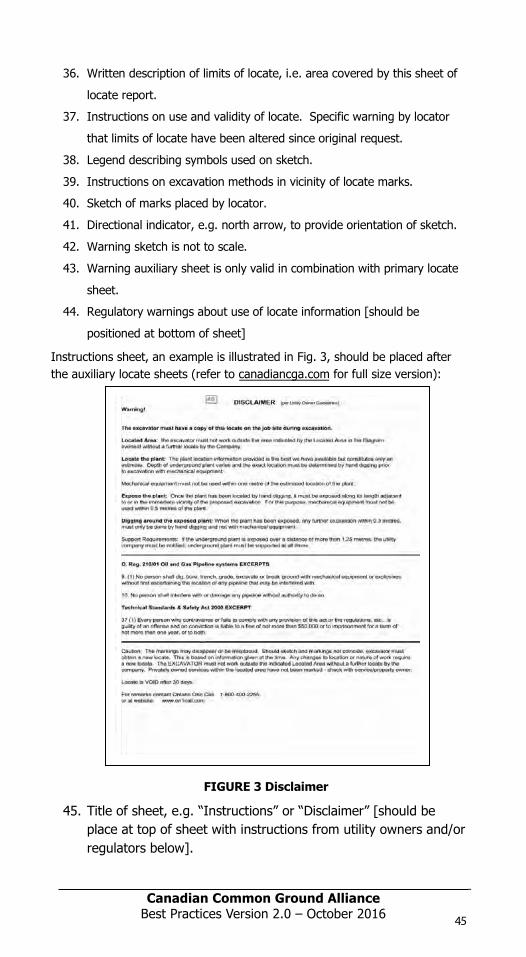
Canadian Common Ground AllianceBest Practices Version 1.0 – October 2014
Auxiliary locate sheet(s) illustrated in Fig. 2 should be placed after the primarylocate sheet (refer to www.orcga.com for full size version):
Figure 2 Auxiliary Locate Sheet
31. Title “Auxiliary Locate Sheet” [must be added at top left/center of
sheet]. Name and address of locate service provider (LSP) providing
locate. LSP contact information [minimum of 2]. LSP logo.
32. Page number and total number of pages [must be added at top right of
sheet].
33. Request number or unique identifier of locate.
34. Date of issue. Notice of expiry date or period.
35. List of utilities marked by locator.
45
Canadian Common Ground Alliance Best Practices Version 1.0 – October 2014
36. Written description of limits of locate, i.e. area covered by this sheet of
locate report.
37. Instructions on use and validity of locate. Specific warning by locator
that limits of locate have been altered since original request.
38. Legend describing symbols used on sketch.
39. Instructions on excavation methods in vicinity of locate marks.
40. Sketch of marks placed by locator.
41. Directional indicator, e.g. north arrow, to provide orientation of sketch.
42. Warning sketch is not to scale.
43. Warning auxiliary sheet is only valid in combination with primary locate
sheet.
44. Regulatory warnings about use of locate information [should be
positioned at bottom of sheet]
Instructions sheet, an example is illustrated in Fig. 3, should be placed after the auxiliary locate sheets (refer to canadiancga.com for full size version):
FIGURE 3 Disclaimer
45. Title of sheet, e.g. “Instructions” or “Disclaimer” [should beplace at top of sheet with instructions from utility owners and/orregulators below].
98397_ORCGA_BestPract-TEXT-Oct2014.indd 45 16/10/14 9:42 AM
Canadian Common Ground Alliance Best Practices Version 1.0 – October 2014
Auxiliary locate sheet(s) illustrated in Fig. 2 should be placed after the primary locate sheet (refer to www.canadiancga.com for full size version):
Figure 2 Auxiliary Locate Sheet
31. Title “Auxiliary Locate Sheet” [must be added at top left/center of
sheet]. Name and address of locate service provider (LSP) providing
locate. LSP contact information [minimum of 2]. LSP logo.
32. Page number and total number of pages [must be added at top right of
sheet].
33. Request number or unique identifier of locate.
34. Date of issue. Notice of expiry date or period.
35. List of utilities marked by locator.
44
Canadian Common Ground AllianceBest Practices Version 1.0 – October 2014
36. Written description of limits of locate, i.e. area covered by this sheet of
locate report.
37. Instructions on use and validity of locate. Specific warning by locator
that limits of locate have been altered since original request.
38. Legend describing symbols used on sketch.
39. Instructions on excavation methods in vicinity of locate marks.
40. Sketch of marks placed by locator.
41. Directional indicator, e.g. north arrow, to provide orientation of sketch.
42. Warning sketch is not to scale.
43. Warning auxiliary sheet is only valid in combination with primary locate
sheet.
44. Regulatory warnings about use of locate information [should be
positioned at bottom of sheet]
Instructions sheet, an example is illustrated in Fig. 3, should be placed afterthe auxiliary locate sheets (refer to ccga.com for full size version):
FIGURE 3 Disclaimer
45. Title of sheet, e.g. “Instructions” or “Disclaimer” [should beplace at top of sheet with instructions from utility owners and/orregulators below].
98397_ORCGA_BestPract-TEXT-Oct2014.indd 44 16/10/14 9:42 AM
Canadian Common Ground AllianceBest Practices Version 2.0 – October 2016 45
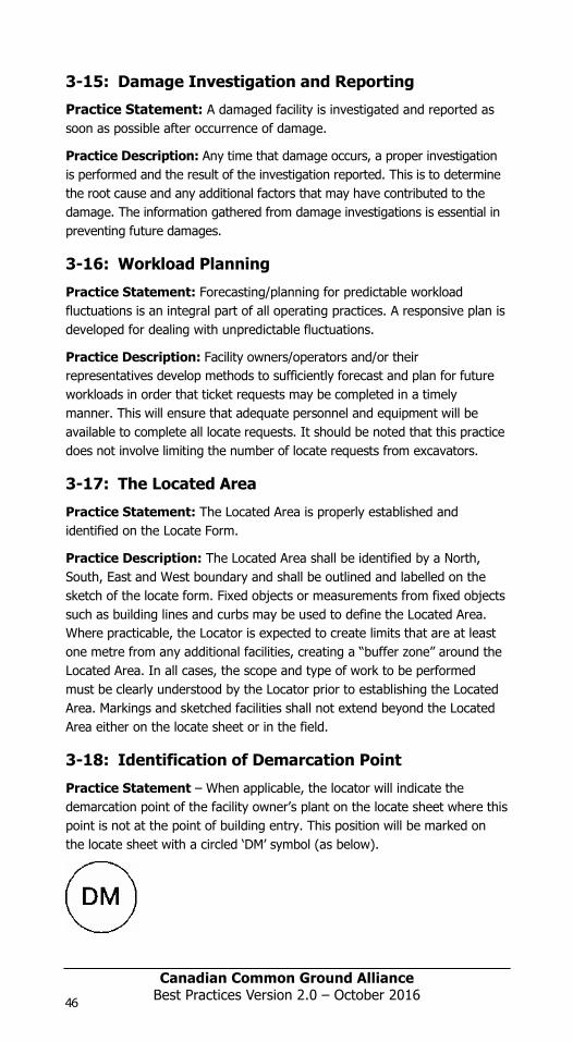
Canadian Common Ground Alliance
Best Practices Version 1.0 – October 2014
3-15: Damage Investigation and Reporting
Practice Statement: A damaged facility is investigated and reported as soon as possible after occurrence of damage.
Practice Description: Any time that damage occurs, a proper investigation is performed and the result of the investigation reported. This is to determine the root cause and any additional factors that may have contributed to the damage. The information gathered from damage investigations is essential in preventing future damages.
3-16: Workload Planning
Practice Statement: Forecasting/planning for predictable workload fluctuations is an integral part of all operating practices. A responsive plan is developed for dealing with unpredictable fluctuations.
Practice Description: Facility owners/operators and/or their representatives develop methods to sufficiently forecast and plan for future workloads in order that ticket requests may be completed in a timely manner. This will ensure that adequate personnel and equipment will be available to complete all locate requests. It should be noted that this practice does not involve limiting the number of locate requests from excavators.
3-17: The Located Area
Practice Statement: The Located Area is properly established and identified on the Locate Form.
Practice Description: The Located Area shall be identified by a North, South, East and West boundary and shall be outlined and labelled on the sketch of the locate form. Fixed objects or measurements from fixed objects such as building lines and curbs may be used to define the Located Area. Where practicable, the Locator is expected to create limits that are at least one metre from any additional facilities, creating a “buffer zone” around the Located Area. In all cases, the scope and type of work to be performed must be clearly understood by the Locator prior to establishing the Located Area. Markings and sketched facilities shall not extend beyond the Located Area either on the locate sheet or in the field.
3-18: Identification of Demarcation Point
Practice Statement – When applicable, the locator will indicate the demarcation point of the facility owner’s plant on the locate sheet where this point is not at the point of building entry. This position will be marked on the locate sheet with a circled ‘DM’ symbol (as below).
46
Canadian Common Ground Alliance
Best Practices Version 1.0 – October 2014
Practice Description - When locating and marking the underground plant ofthe facility owner, the locator shall indicate the demarcation point of the facility being located on the locate sheet. This symbol (as above) shall be placed on top of, or as near as reasonable to, the actual physical demarcation point of the facility being located. The demarcation point is the limit of utility owned facilities. The excavator should be aware that customer or privately owned facilities may exist beyond this point. The symbol and definition should be clearly shown in the legend on the locate sheet.
3-19: Alternate Locate Agreements
Practice Statement: Alternate Locate Agreements (ALA’s) may be used providing the Facility owner and Excavator agree on the terms and conditions.
Practice Description: Alternate Locate Agreements (ALA’s) are contractual agreements between a Facility owner and an Excavator that allows the Excavator to proceed with their excavation work without receiving a traditional field locate. The Facility owner determines the terms and conditions of the ALA, including the depth, location, method of excavation and/or type of excavation. The intent of an ALA is to ensure underground facilities are protected from damage by limiting the scope of work to the point that a field locate is not required, thus reducing demand on existing locate providers and eliminating wait times and administration for Excavators. The details of such an agreement must be stated in writing and available on the project for review upon request of the regulator, or Facility owner’s representative. Such an agreement must be communicated in writing as well to the JHSC or Health & Safety representative on the project where applicable. It is the responsibility of the Excavator to ensure that all Facility owners are requested to locate and mark their service. It is also the Excavator’s responsibility to ensure that an ALA, where applicable and implemented, will not impede any safe operations regarding the other utilities not covered by that ALA and that the Health and Safety of the workers and Public Safety are safeguarded at all times. It is the Excavator’s duty to ensure that the excavation work is carried out in compliance with the legislative requirements and in accordance with the ALA as stipulated between the Excavator and the Facility owner in question when and where applicable. It is the Facility owner’s duty to ensure that the ALA terms and conditions will provide a level of safety equivalent to the standard locate process.
3-20: Marking of Newly Installed Facilities
Practice Statement: Markings are placed immediately after construction to identify the location of newly installed facilities.
Practice Description: Newly installed facilities are often at risk as Locators and Excavators may not be aware of the recent installation, especially if the installation has taken place immediately before or after the
98397_ORCGA_BestPract-TEXT-Oct2014.indd 46 16/10/14 9:42 AM
Canadian Common Ground AllianceBest Practices Version 2.0 – October 201646

Canadian Common Ground Alliance
Best Practices Version 1.0 – October 2014
3-15: Damage Investigation and Reporting
Practice Statement: A damaged facility is investigated and reported as soon as possible after occurrence of damage.
Practice Description: Any time that damage occurs, a proper investigation is performed and the result of the investigation reported. This is to determine the root cause and any additional factors that may have contributed to the damage. The information gathered from damage investigations is essential in preventing future damages.
3-16: Workload Planning
Practice Statement: Forecasting/planning for predictable workload fluctuations is an integral part of all operating practices. A responsive plan is developed for dealing with unpredictable fluctuations.
Practice Description: Facility owners/operators and/or their representatives develop methods to sufficiently forecast and plan for future workloads in order that ticket requests may be completed in a timely manner. This will ensure that adequate personnel and equipment will be available to complete all locate requests. It should be noted that this practice does not involve limiting the number of locate requests from excavators.
3-17: The Located Area
Practice Statement: The Located Area is properly established and identified on the Locate Form.
Practice Description: The Located Area shall be identified by a North, South, East and West boundary and shall be outlined and labelled on the sketch of the locate form. Fixed objects or measurements from fixed objects such as building lines and curbs may be used to define the Located Area. Where practicable, the Locator is expected to create limits that are at least one metre from any additional facilities, creating a “buffer zone” around the Located Area. In all cases, the scope and type of work to be performed must be clearly understood by the Locator prior to establishing the Located Area. Markings and sketched facilities shall not extend beyond the Located Area either on the locate sheet or in the field.
3-18: Identification of Demarcation Point
Practice Statement – When applicable, the locator will indicate the demarcation point of the facility owner’s plant on the locate sheet where this point is not at the point of building entry. This position will be marked on the locate sheet with a circled ‘DM’ symbol (as below).
47
Canadian Common Ground Alliance
Best Practices Version 1.0 – October 2014
Practice Description - When locating and marking the underground plant of the facility owner, the locator shall indicate the demarcation point of the facility being located on the locate sheet. This symbol (as above) shall be placed on top of, or as near as reasonable to, the actual physical demarcation point of the facility being located. The demarcation point is the limit of utility owned facilities. The excavator should be aware that customer or privately owned facilities may exist beyond this point. The symbol and definition should be clearly shown in the legend on the locate sheet.
3-19: Alternate Locate Agreements
Practice Statement: Alternate Locate Agreements (ALA’s) may be used providing the Facility owner and Excavator agree on the terms and conditions.
Practice Description: Alternate Locate Agreements (ALA’s) are contractual agreements between a Facility owner and an Excavator that allows the Excavator to proceed with their excavation work without receiving a traditional field locate. The Facility owner determines the terms and conditions of the ALA, including the depth, location, method of excavation and/or type of excavation. The intent of an ALA is to ensure underground facilities are protected from damage by limiting the scope of work to the point that a field locate is not required, thus reducing demand on existing locate providers and eliminating wait times and administration for Excavators. The details of such an agreement must be stated in writing and available on the project for review upon request of the regulator, or Facility owner’s representative. Such an agreement must be communicated in writing as well to the JHSC or Health & Safety representative on the project where applicable. It is the responsibility of the Excavator to ensure that all Facility owners are requested to locate and mark their service. It is also the Excavator’s responsibility to ensure that an ALA, where applicable and implemented, will not impede any safe operations regarding the other utilities not covered by that ALA and that the Health and Safety of the workers and Public Safety are safeguarded at all times. It is the Excavator’s duty to ensure that the excavation work is carried out in compliance with the legislative requirements and in accordance with the ALA as stipulated between the Excavator and the Facility owner in question when and where applicable. It is the Facility owner’s duty to ensure that the ALA terms and conditions will provide a level of safety equivalent to the standard locate process.
3-20: Marking of Newly Installed Facilities
Practice Statement: Markings are placed immediately after construction to identify the location of newly installed facilities.
Practice Description: Newly installed facilities are often at risk as Locators and Excavators may not be aware of the recent installation, especially if the installation has taken place immediately before or after the
98397_ORCGA_BestPract-TEXT-Oct2014.indd 47 16/10/14 9:42 AM
Canadian Common Ground Alliance
Best Practices Version 1.0 – October 2014
3-15: Damage Investigation and Reporting
Practice Statement: A damaged facility is investigated and reported as soon as possible after occurrence of damage.
Practice Description: Any time that damage occurs, a proper investigation is performed and the result of the investigation reported. This is to determine the root cause and any additional factors that may have contributed to the damage. The information gathered from damage investigations is essential in preventing future damages.
3-16: Workload Planning
Practice Statement: Forecasting/planning for predictable workload fluctuations is an integral part of all operating practices. A responsive plan is developed for dealing with unpredictable fluctuations.
Practice Description: Facility owners/operators and/or their representatives develop methods to sufficiently forecast and plan for future workloads in order that ticket requests may be completed in a timely manner. This will ensure that adequate personnel and equipment will be available to complete all locate requests. It should be noted that this practice does not involve limiting the number of locate requests from excavators.
3-17: The Located Area
Practice Statement: The Located Area is properly established and identified on the Locate Form.
Practice Description: The Located Area shall be identified by a North, South, East and West boundary and shall be outlined and labelled on the sketch of the locate form. Fixed objects or measurements from fixed objects such as building lines and curbs may be used to define the Located Area. Where practicable, the Locator is expected to create limits that are at least one metre from any additional facilities, creating a “buffer zone” around the Located Area. In all cases, the scope and type of work to be performed must be clearly understood by the Locator prior to establishing the Located Area. Markings and sketched facilities shall not extend beyond the Located Area either on the locate sheet or in the field.
3-18: Identification of Demarcation Point
Practice Statement – When applicable, the locator will indicate the demarcation point of the facility owner’s plant on the locate sheet where this point is not at the point of building entry. This position will be marked on the locate sheet with a circled ‘DM’ symbol (as below).
46
Canadian Common Ground Alliance
Best Practices Version 1.0 – October 2014
Practice Description - When locating and marking the underground plant ofthe facility owner, the locator shall indicate the demarcation point of the facility being located on the locate sheet. This symbol (as above) shall be placed on top of, or as near as reasonable to, the actual physical demarcation point of the facility being located. The demarcation point is the limit of utility owned facilities. The excavator should be aware that customer or privately owned facilities may exist beyond this point. The symbol and definition should be clearly shown in the legend on the locate sheet.
3-19: Alternate Locate Agreements
Practice Statement: Alternate Locate Agreements (ALA’s) may be used providing the Facility owner and Excavator agree on the terms and conditions.
Practice Description: Alternate Locate Agreements (ALA’s) are contractual agreements between a Facility owner and an Excavator that allows the Excavator to proceed with their excavation work without receiving a traditional field locate. The Facility owner determines the terms and conditions of the ALA, including the depth, location, method of excavation and/or type of excavation. The intent of an ALA is to ensure underground facilities are protected from damage by limiting the scope of work to the point that a field locate is not required, thus reducing demand on existing locate providers and eliminating wait times and administration for Excavators. The details of such an agreement must be stated in writing and available on the project for review upon request of the regulator, or Facility owner’s representative. Such an agreement must be communicated in writing as well to the JHSC or Health & Safety representative on the project where applicable. It is the responsibility of the Excavator to ensure that all Facility owners are requested to locate and mark their service. It is also the Excavator’s responsibility to ensure that an ALA, where applicable and implemented, will not impede any safe operations regarding the other utilities not covered by that ALA and that the Health and Safety of the workers and Public Safety are safeguarded at all times. It is the Excavator’s duty to ensure that the excavation work is carried out in compliance with the legislative requirements and in accordance with the ALA as stipulated between the Excavator and the Facility owner in question when and where applicable. It is the Facility owner’s duty to ensure that the ALA terms and conditions will provide a level of safety equivalent to the standard locate process.
3-20: Marking of Newly Installed Facilities
Practice Statement: Markings are placed immediately after construction to identify the location of newly installed facilities.
Practice Description: Newly installed facilities are often at risk as Locators and Excavators may not be aware of the recent installation, especially if the installation has taken place immediately before or after the
98397_ORCGA_BestPract-TEXT-Oct2014.indd 46 16/10/14 9:42 AM
Canadian Common Ground AllianceBest Practices Version 2.0 – October 2016 47

Canadian Common Ground Alliance
Best Practices Version 1.0 – October 2014
completion of a locate. Markings such as paint and or special flags warning that new facilities have been installed should be placed as soon as the construction is completed. This practice increases the chances of the Excavator or Locator being made aware of the installation which can reduce the chances of the facilities being damaged.
3-21: Requirements for a Valid Locate
Practice Statement: A valid locate requires that the marks on the ground are sufficient for the purpose required; there is a completed locate report by an authorized party; the conditions of the locate have not changed; and the locate has not expired.
Practice Description: The primary components of a locate, except in the case of a clearance or alternate locate agreement (ALA), are the marks on the ground and the corresponding locate report that together correctly identify the position of underground infrastructure. For a locate to be valid the marks must be preserved and be sufficiently observable for their intended purpose. Since it is the owner’s responsibility to mark its underground infrastructure and issue appropriate instructions, warnings and limitations to the excavating party, a locate is not considered to be valid unless it has been issued by the owner or a party authorized to act on the owner’s behalf. For each portion of area to be excavated, the marking process must be complete and the located area defined and documented in the form of a locate report for that portion of the locate to be considered valid. If circumstances occur that cause a change after the locate report has been issued, such as the introduction of new underground infrastructure within the located area, or if a surface feature used for offset measurements is altered, those portions of the located area affected by the change are no longer considered valid. The validity of the locate expires as stated on the locate report. A locate report must contain sufficient information and instructions so that parties relying on it will be able to correctly interpret the marks in the field and identify the limits of the located area. Locate reports are usually generated by using templates or pre-printed forms and it may not always be possible or appropriate to complete every part of these forms. However, except in the case of a clearance or ALA, the following minimum information is necessary for the locate to be considered valid:
• Name of the party who requested the locate
• Address or coordinates of the excavation site
• Request number or unique identifier of the locate
• Limits of the located area
• Underground infrastructure marked or cleared
• Method of marking
• Locate sketch
48
Canadian Common Ground Alliance
Best Practices Version 1.0 – October 2014
• Date that the locate report is issued
• Date or period after which the locate will expire
• Total number of pages issued
• Name or ID# of the party issuing the locate report
Validity of the locate is also affected by one or more of the following conditions:
1. Marks on the ground conflict with the locate report – if the marks on the ground do not match the sketch or other information contained in the locate report then that portion within the located area affected by this condition is no longer valid.
2. Discovery of an error – if there is an error or omission that affects the accuracy, identification or interpretation of the marks then that portion within the located area affected by this condition is no longer valid.
3. Unlocated underground infrastructure – the presence of underground infrastructure that has not been marked or cannot be marked until it is found by excavation creates a circumstance where the limits of the located area should be adjusted to exclude the portion of area affected by this condition. If this is not done then that portion within the located area affected by this condition is no longer valid.
4. Clearances – in situations where a dig area is clear of an owner’s underground infrastructure there will be no marks on the ground and a valid locate requires only a locate report in the form of a written statement to this effect.
5. Alternate Locate Agreement – in situations where an ALA has been issued there will be no marks on the ground and a valid locate requires only that the conditions for the ALA have been met and the ALA has not expired.
3-22: Quality Assurance
Practice Statement: Underground facility owners/operators should have a Quality Assurance (QA) program in place for assessing the accuracy of locating and marking facilities.
Practice Description: The process of conducting QA audits on locates is a critical component to the protection of underground facilities. The recommended components listed below are meant to provide general guidelines for auditing the work of locators. The QA program is a valuable component in the damage investigation process.
• Conduct random field audits
• Check accuracy of markings against minimum tolerances
• Check accuracy and completeness of the locate report
98397_ORCGA_BestPract-TEXT-Oct2014.indd 48 16/10/14 9:42 AM
Canadian Common Ground AllianceBest Practices Version 2.0 – October 201648
Canadian Common Ground AllianceBest Practices Version 1.0 – October 2014
completion of a locate. Markings such as paint and or special flags warningthat new facilities have been installed should be placed as soon as theconstruction is completed. This practice increases the chances of theExcavator or Locator being made aware of the installation which can reducethe chances of the facilities being damaged.
3-21: Requirements for a Valid Locate
Practice Statement: A valid locate requires that the marks on theground are sufficient for the purpose required; there is a completed locatereport by an authorized party; the conditions of the locate have not changed; and the locate has not expired.
Practice Description: The primary components of a locate, except inthe case of a clearance or alternate locate agreement (ALA), are the markson the ground and the corresponding locate report that together correctlyidentify the position of underground infrastructure. For a locate to be validthe marks must be preserved and be sufficiently observable for their intended purpose. Since it is the owner’s responsibility to mark itsunderground infrastructure and issue appropriate instructions, warnings andlimitations to the excavating party, a locate is not considered to be validunless it has been issued by the owner or a party authorized to act on theowner’s behalf. For each portion of area to be excavated, the markingprocess must be complete and the located area defined and documented in the form of a locate report for that portion of the locate to be consideredvalid. If circumstances occur that cause a change after the locate reporthas been issued, such as the introduction of new underground infrastructurewithin the located area, or if a surface feature used for offset measurementsis altered, those portions of the located area affected by the change are nolonger considered valid. The validity of the locate expires as stated on thelocate report. A locate report must contain sufficient information andinstructions so that parties relying on it will be able to correctly interpret themarks in the field and identify the limits of the located area. Locate reportsare usually generated by using templates or pre-printed forms and it maynot always be possible or appropriate to complete every part of these forms.However, except in the case of a clearance or ALA, the following minimuminformation is necessary for the locate to be considered valid:
• Name of the party who requested the locate
• Address or coordinates of the excavation site
• Request number or unique identifier of the locate
• Limits of the located area
• Underground infrastructure marked or cleared
• Method of marking
• Locate sketch
49
Canadian Common Ground Alliance Best Practices Version 1.0 – October 2014
• Date that the locate report is issued
• Date or period after which the locate will expire
• Total number of pages issued
• Name or ID# of the party issuing the locate report
Validity of the locate is also affected by one or more of the following conditions:
1. Marks on the ground conflict with the locate report – if the marks on theground do not match the sketch or other information contained in the locatereport then that portion within the located area affected by this condition isno longer valid.
2. Discovery of an error – if there is an error or omission that affects theaccuracy, identification or interpretation of the marks then that portionwithin the located area affected by this condition is no longer valid.
3. Unlocated underground infrastructure – the presence of undergroundinfrastructure that has not been marked or cannot be marked until it isfound by excavation creates a circumstance where the limits of the locatedarea should be adjusted to exclude the portion of area affected by thiscondition. If this is not done then that portion within the located areaaffected by this condition is no longer valid.
4. Clearances – in situations where a dig area is clear of an owner’sunderground infrastructure there will be no marks on the ground and a validlocate requires only a locate report in the form of a written statement to thiseffect.
5. Alternate Locate Agreement – in situations where an ALA has been issuedthere will be no marks on the ground and a valid locate requires only thatthe conditions for the ALA have been met and the ALA has not expired.
3-22: Quality Assurance
Practice Statement: Underground facility owners/operators should have a Quality Assurance (QA) program in place for assessing the accuracy of locating and marking facilities.
Practice Description: The process of conducting QA audits on locates is a critical component to the protection of underground facilities. The recommended components listed below are meant to provide general guidelines for auditing the work of locators. The QA program is a valuable component in the damage investigation process.
• Conduct random field audits
• Check accuracy of markings against minimum tolerances
• Check accuracy and completeness of the locate report
98397_ORCGA_BestPract-TEXT-Oct2014.indd 49 16/10/14 9:42 AM
Canadian Common Ground Alliance
Best Practices Version 1.0 – October 2014
completion of a locate. Markings such as paint and or special flags warning that new facilities have been installed should be placed as soon as the construction is completed. This practice increases the chances of the Excavator or Locator being made aware of the installation which can reduce the chances of the facilities being damaged.
3-21: Requirements for a Valid Locate
Practice Statement: A valid locate requires that the marks on the ground are sufficient for the purpose required; there is a completed locate report by an authorized party; the conditions of the locate have not changed; and the locate has not expired.
Practice Description: The primary components of a locate, except in the case of a clearance or alternate locate agreement (ALA), are the marks on the ground and the corresponding locate report that together correctly identify the position of underground infrastructure. For a locate to be valid the marks must be preserved and be sufficiently observable for their intended purpose. Since it is the owner’s responsibility to mark its underground infrastructure and issue appropriate instructions, warnings and limitations to the excavating party, a locate is not considered to be valid unless it has been issued by the owner or a party authorized to act on the owner’s behalf. For each portion of area to be excavated, the marking process must be complete and the located area defined and documented in the form of a locate report for that portion of the locate to be considered valid. If circumstances occur that cause a change after the locate report has been issued, such as the introduction of new underground infrastructure within the located area, or if a surface feature used for offset measurements is altered, those portions of the located area affected by the change are no longer considered valid. The validity of the locate expires as stated on the locate report. A locate report must contain sufficient information and instructions so that parties relying on it will be able to correctly interpret the marks in the field and identify the limits of the located area. Locate reports are usually generated by using templates or pre-printed forms and it may not always be possible or appropriate to complete every part of these forms. However, except in the case of a clearance or ALA, the following minimum information is necessary for the locate to be considered valid:
• Name of the party who requested the locate
• Address or coordinates of the excavation site
• Request number or unique identifier of the locate
• Limits of the located area
• Underground infrastructure marked or cleared
• Method of marking
• Locate sketch
48
Canadian Common Ground Alliance
Best Practices Version 1.0 – October 2014
• Date that the locate report is issued
• Date or period after which the locate will expire
• Total number of pages issued
• Name or ID# of the party issuing the locate report
Validity of the locate is also affected by one or more of the following conditions:
1. Marks on the ground conflict with the locate report – if the marks on the ground do not match the sketch or other information contained in the locate report then that portion within the located area affected by this condition is no longer valid.
2. Discovery of an error – if there is an error or omission that affects the accuracy, identification or interpretation of the marks then that portion within the located area affected by this condition is no longer valid.
3. Unlocated underground infrastructure – the presence of underground infrastructure that has not been marked or cannot be marked until it is found by excavation creates a circumstance where the limits of the located area should be adjusted to exclude the portion of area affected by this condition. If this is not done then that portion within the located area affected by this condition is no longer valid.
4. Clearances – in situations where a dig area is clear of an owner’s underground infrastructure there will be no marks on the ground and a valid locate requires only a locate report in the form of a written statement to this effect.
5. Alternate Locate Agreement – in situations where an ALA has been issued there will be no marks on the ground and a valid locate requires only that the conditions for the ALA have been met and the ALA has not expired.
3-22: Quality Assurance
Practice Statement: Underground facility owners/operators should have a Quality Assurance (QA) program in place for assessing the accuracy of locating and marking facilities.
Practice Description: The process of conducting QA audits on locates is a critical component to the protection of underground facilities. The recommended components listed below are meant to provide general guidelines for auditing the work of locators. The QA program is a valuable component in the damage investigation process.
• Conduct random field audits
• Check accuracy of markings against minimum tolerances
• Check accuracy and completeness of the locate report
98397_ORCGA_BestPract-TEXT-Oct2014.indd 48 16/10/14 9:42 AM
Canadian Common Ground AllianceBest Practices Version 2.0 – October 2016 49
Canadian Common Ground Alliance
Best Practices Version 1.0 – October 2014
• Measure timeliness as defined by Regulations.
• Check the legibility of the completed locate report
• Verify the most up-to-date records were used to complete the locate
• Check evidence of communication with the excavator when required
(e.g. altering dig area)
• Communicate results of the audit to applicable personnel
• Analyze audit results for trends
50
Canadian Common Ground Alliance
Best Practices Version 1.0 – October 2014
4-0 Excavation Best Practices
4-1: One-Call Facility Locate Request Practice Statement: The excavator requests the location of underground facilities at each site by notifying the facility owner/operator through the one-call system. Unless otherwise specified in law, the excavator calls the one-call center at least four working days prior to beginning excavation procedures.
Practice Description: Increased participation in a one-call notification system provides for improved communication between excavators and facility operators necessary to reduce damage.
To avoid unnecessary waste of resources, a project and/or portion of the work for which a locate has been requested for and not yet provided, has been cancelled, deferred for an extended period of time, or just altered in the queue of execution, then that locate request should be cancelled.
4-2: Privately Owned Facility Awareness
Practice Statement - Prior to excavating, the excavator must be aware that privately owned buried facilities may exist within the work area and should request the private facility owner (e.g. landowner) to locate his/her underground facilities.
Practice Description - Privately owned underground facilities may not be marked by representatives of the public facility owners beyond the demarcation point of each facility (e.g. Private Property). The private facility owner is responsible for identifying the location of these buried facilities. Identification activities may include, but are not limited to: provision of maps, provision of engineering drawings from previous workings and/or retaining or authorizing the deployment of a private locator.
4-3: White Lining
Practice Statement: When the excavation site cannot be clearly and adequately identified on the locate ticket, the excavator designates the route and/or area to be excavated using white pre-marking prior to the arrival of the locator
Practice Description: The route of the excavation is marked with white paint, flags, stakes, or a combination of these to outline the dig site prior to notifying the one-call and before the locator arrives on the job. Pre-marking allows the excavators to accurately communicate to facility owners/operators or their locator where excavation is to occur. The 1997 safety study “Protecting Public Safety through Excavation Damage Prevention” by the NTSB reached the conclusion that pre-marking is a practice that helps prevent excavation damage.
98397_ORCGA_BestPract-TEXT-Oct2014.indd 50 16/10/14 9:42 AM
Canadian Common Ground AllianceBest Practices Version 2.0 – October 201650
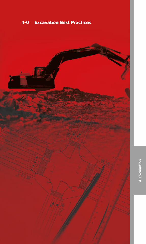
4-0 Excavation Best Practices
4 E
xcav
atio
n

Canadian Common Ground AllianceBest Practices Version 1.0 – October 2014
• Measure timeliness as defined by Regulations.
• Check the legibility of the completed locate report
• Verify the most up-to-date records were used to complete the locate
• Check evidence of communication with the excavator when required
(e.g. altering dig area)
• Communicate results of the audit to applicable personnel
• Analyze audit results for trends
51
Canadian Common Ground Alliance Best Practices Version 1.0 – October 2014
4-0 Excavation Best Practices
4-1: One-Call Facility Locate RequestPractice Statement: The excavator requests the location of underground facilities at each site by notifying the facility owner/operator through the one-call system. Unless otherwise specified in law, the excavator contacts the one-call center at least five working days prior to beginning excavation procedures.
Practice Description: Increased participation in a one-call notification system provides for improved communication between excavators and facility operators necessary to reduce damage.
To avoid unnecessary waste of resources, a project and/or portion of the work for which a locate has been requested for and not yet provided, has been cancelled, deferred for an extended period of time, or just altered in the queue of execution, then that locate request should be cancelled.
4-2: Privately Owned Facility Awareness
Practice Statement - Prior to excavating, the excavator must be aware that privately owned buried facilities may exist within the work area and should request the private facility owner (e.g. landowner) to locate his/her underground facilities.
Practice Description - Privately owned underground facilities may not be marked by representatives of the public facility owners beyond the demarcation point of each facility (e.g. Private Property). The private facility owner is responsible for identifying the location of these buried facilities. Identification activities may include, but are not limited to: provision of maps, provision of engineering drawings from previous workings and/or retaining or authorizing the deployment of a private locator.
4-3: White Lining
Practice Statement: As a method of reducing damages to underground infrastructure, pre-marking of the boundaries of the work area using white paint or equivalent (or alternate colour during the winter as noted on the locate request) by the excavator should be completed prior to locating.Note: Electronic or virtual pre-marking can be an alternative.
Practice Description: The route of the excavation is marked with white paint, flags, stakes, or a combination of these to outline the dig site prior to notifying the one-call and before the locator arrives on the job. Pre-marking allows the excavators to accurately communicate to facility owners/operators or their locator where excavation is to occur. The 1997 safety study “Protecting Public Safety through Excavation Damage Prevention” by the NTSB reached the conclusion that pre-marking is a practice that helps prevent excavation damage.
98397_ORCGA_BestPract-TEXT-Oct2014.indd 51 16/10/14 9:42 AM
Canadian Common Ground Alliance
Best Practices Version 1.0 – October 2014
• Measure timeliness as defined by Regulations.
• Check the legibility of the completed locate report
• Verify the most up-to-date records were used to complete the locate
• Check evidence of communication with the excavator when required
(e.g. altering dig area)
• Communicate results of the audit to applicable personnel
• Analyze audit results for trends
50
Canadian Common Ground Alliance
Best Practices Version 1.0 – October 2014
4-0 Excavation Best Practices
4-1: One-Call Facility Locate Request Practice Statement: The excavator requests the location of underground facilities at each site by notifying the facility owner/operator through the one-call system. Unless otherwise specified in law, the excavator calls the one-call center at least four working days prior to beginning excavation procedures.
Practice Description: Increased participation in a one-call notification system provides for improved communication between excavators and facility operators necessary to reduce damage.
To avoid unnecessary waste of resources, a project and/or portion of the work for which a locate has been requested for and not yet provided, has been cancelled, deferred for an extended period of time, or just altered in the queue of execution, then that locate request should be cancelled.
4-2: Privately Owned Facility Awareness
Practice Statement - Prior to excavating, the excavator must be aware that privately owned buried facilities may exist within the work area and should request the private facility owner (e.g. landowner) to locate his/her underground facilities.
Practice Description - Privately owned underground facilities may not be marked by representatives of the public facility owners beyond the demarcation point of each facility (e.g. Private Property). The private facility owner is responsible for identifying the location of these buried facilities. Identification activities may include, but are not limited to: provision of maps, provision of engineering drawings from previous workings and/or retaining or authorizing the deployment of a private locator.
4-3: White Lining
Practice Statement: When the excavation site cannot be clearly and adequately identified on the locate ticket, the excavator designates the route and/or area to be excavated using white pre-marking prior to the arrival of the locator
Practice Description: The route of the excavation is marked with white paint, flags, stakes, or a combination of these to outline the dig site prior to notifying the one-call and before the locator arrives on the job. Pre-marking allows the excavators to accurately communicate to facility owners/operators or their locator where excavation is to occur. The 1997 safety study “Protecting Public Safety through Excavation Damage Prevention” by the NTSB reached the conclusion that pre-marking is a practice that helps prevent excavation damage.
98397_ORCGA_BestPract-TEXT-Oct2014.indd 50 16/10/14 9:42 AM
Canadian Common Ground AllianceBest Practices Version 2.0 – October 2016 51
Canadian Common Ground Alliance
Best Practices Version 1.0 – October 2014
4-4: Locate Reference Number
Practice Statement: The excavator receives and maintains a reference number from the one-call center that verifies the locate was requested.
Practice Description: All calls from excavators processed by the one-call center receive a unique message reference number, which is contained on all locate request messages. The excavator records this number; it is proof of notification to the members. The computer generated request identifies the date, time, and sequence number of the locate request.
Each locate request ticket (notification) is assigned a unique number with that one-call center, the requestor and the facility owner/operator. This number separates this ticket from all other tickets so that it can be archived and recalled upon request with the details of that request only.
4-5: Pre-Excavation Meeting
Practice Statement: When necessary, the excavator or the locator may request a pre-excavating meeting at the jobsite just prior to the actual marking of facility locations. Such pre-excavating meetings are important for major, or unusual, excavations.
Practice Description: The meeting will facilitate communications, coordinate the marking with actual excavation, and assure identification of high priority facilities. An on-site pre-excavation meeting between the excavator, the facility owners/operators and locators (where applicable) is recommended on major or large projects. This include projects such as road, sewer, water, or other projects that cover a large area, progress from one area to the next, or that are located near critical or high priority facilities. Potential facilities include, but are not limited to, high-pressure gas, high voltage electric, fibre optic communication, and major pipe or water lines.
4-6: Facility Relocations
Practice Statement: The excavator coordinates work with the affected facility owner/operator and the project owner where temporary or permanent interruption of a facility owner/operator’s service is required.
Practice Description: Any temporary or permanent interruption requires the active participation by the facility owner/operator and the excavator to ensure protection of facilities through a joint preplanning meeting or conference calls.
4-7: Locate Requests
Practice Statement: Every excavator on the job has an appropriate locate form before excavating.
Practice Description: Often, there are several excavators on a job site performing work. The construction schedule may dictate different types of
52
Canadian Common Ground Alliance
Best Practices Version 1.0 – October 2014
work requiring excavation from different specialty contractors simultaneously. It is preferable for each excavator to obtain their own individual locate before excavating to ensure that the specific areas have been appropriately marked by any affected underground facility owner/ operator. However, where a single locate is relied upon by multiple users on the same project, it is the responsibility of the excavator to ensure that the locate is appropriate for the intended excavation, giving due consideration to the limits of the located area, depth of excavation, ticket life, and the existence of any facilities installed since the locate was performed.
4-8: One-Call Access (24x7)
Practice Statement: The excavator has access to the one-call centre 24 hours per day, 7 days a week (24x7).
Practice Description: Utilities service the public needs 24x7 and thus should be protected the same amount of time. Certain conditions exist which require excavators to work during off-hours (city/road congestion, off peak utility service hours). While most excavators are on the job site during regular work hours, the ability to call in future work locations after five p.m. allows more flexibility to schedule work, not to mention getting around peak hours of locate requests at the one-call center.
4-9: Positive Response
Practice Statement: The excavator is notified in writing by the underground facility owner/operator of the tolerance zone of the underground facility by marking, flagging, or other acceptable methods at the work site shown on a locate sheet provided to the excavator, or is notified verbally and in writing, if possible, that an “all clear” situation exists. This takes place within three working days of the notification to the facility owner/operator of the locate request or a mutually agreed upon date between the locator and the excavator.
Practice Description: If the one-call centre or a facility owner/operator determines that the excavation or demolition is not near any of its existing underground facilities, it notifies the excavator that no conflict exists and that the excavation or demolition area is “clear.” This notification from the One-Call Centre or the facility owner/operator will include a written “all clear” response. If an excavator has knowledge of the existence of an underground facility and has received an “all clear,” response, the excavator should notify the One-Call Centre and the facility owner/operator if known, that a conflict does indeed exist. The One-Call Centre and the facility owner/operator should make marking these facilities a priority before excavation begins.
Positive response is a term used to describe the two types of action to be taken by a facility owner/operator after it has received notification of intent to excavate.
98397_ORCGA_BestPract-TEXT-Oct2014.indd 52 16/10/14 9:42 AM
Canadian Common Ground AllianceBest Practices Version 2.0 – October 201652

Canadian Common Ground AllianceBest Practices Version 1.0 – October 2014
4-4: Locate Reference Number
Practice Statement: The excavator receives and maintains a referencenumber from the one-call center that verifies the locate was requested.
Practice Description: All calls from excavators processed by the one-callcenter receive a unique message reference number, which is contained onall locate request messages. The excavator records this number; it is proof of notification to the members. The computer generated request identifiesthe date, time, and sequence number of the locate request.
Each locate request ticket (notification) is assigned a unique number withthat one-call center, the requestor and the facility owner/operator. Thisnumber separates this ticket from all other tickets so that it can be archivedand recalled upon request with the details of that request only.
4-5: Pre-Excavation Meeting
Practice Statement: When necessary, the excavator or the locator mayrequest a pre-excavating meeting at the jobsite just prior to the actualmarking of facility locations. Such pre-excavating meetings are important for major, or unusual, excavations.
Practice Description: The meeting will facilitate communications,coordinate the marking with actual excavation, and assure identification ofhigh priority facilities. An on-site pre-excavation meeting between theexcavator, the facility owners/operators and locators (where applicable) is recommended on major or large projects. This include projects such asroad, sewer, water, or other projects that cover a large area, progress from one area to the next, or that are located near critical or high priorityfacilities. Potential facilities include, but are not limited to, high-pressuregas, high voltage electric, fibre optic communication, and major pipe or water lines.
4-6: Facility Relocations
Practice Statement: The excavator coordinates work with the affectedfacility owner/operator and the project owner where temporary orpermanent interruption of a facility owner/operator’s service is required.
Practice Description: Any temporary or permanent interruption requiresthe active participation by the facility owner/operator and the excavator toensure protection of facilities through a joint preplanning meeting orconference calls.
4-7: Locate Requests
Practice Statement: Every excavator on the job has an appropriate locateform before excavating.
Practice Description: Often, there are several excavators on a job siteperforming work. The construction schedule may dictate different types of
53
Canadian Common Ground Alliance Best Practices Version 1.0 – October 2014
work requiring excavation from different specialty contractors simultaneously. It is preferable for each excavator to obtain their own individual locate before excavating to ensure that the specific areas have been appropriately marked by any affected underground facility owner/ operator. However, where a single locate is relied upon by multiple users on the same project, it is the responsibility of the excavator to ensure that the locate is appropriate for the intended excavation, giving due consideration to the limits of the located area, depth of excavation, ticket life, and the existence of any facilities installed since the locate was performed.
4-8: One-Call Access (24x7)
Practice Statement: The excavator has access to the one-call centre 24 hours per day, 7 days a week (24x7).
Practice Description: Utilities service the public needs 24x7 and thus should be protected the same amount of time. Certain conditions exist which require excavators to work during off-hours (city/road congestion, off peak utility service hours). While most excavators are on the job site during regular work hours, the ability to access (phone, internet, or other methods) in future work locations after five p.m. allows more flexibility to schedule work, not to mention getting around peak hours of locate requests at the one-call center.
4-9: Positive Response
Practice Statement: The excavator is notified in writing by the underground facility owner/operator of the tolerance zone of the underground facility by marking, flagging, or other acceptable methods at the work site shown on a locate sheet provided to the excavator, or is notified verbally and in writing, if possible, that an “all clear” situation exists. This takes place within three working days of the notification to the facility owner/operator of the locate request or a mutually agreed upon date between the locator and the excavator.
Practice Description: If the one-call centre or a facility owner/operator determines that the excavation or demolition is not near any of its existing underground facilities, it notifies the excavator that no conflict exists and that the excavation or demolition area is “clear.” This notification from the One-Call Centre or the facility owner/operator will include a written “all clear” response. If an excavator has knowledge of the existence of an underground facility and has received an “all clear,” response, the excavator should notify the One-Call Centre and the facility owner/operator if known, that a conflict does indeed exist. The One-Call Centre and the facility owner/operator should make marking these facilities a priority before excavation begins.
Positive response is a term used to describe the two types of action to be taken by a facility owner/operator after it has received notification of intent to excavate.
98397_ORCGA_BestPract-TEXT-Oct2014.indd 53 16/10/14 9:42 AM
Canadian Common Ground Alliance
Best Practices Version 1.0 – October 2014
4-4: Locate Reference Number
Practice Statement: The excavator receives and maintains a reference number from the one-call center that verifies the locate was requested.
Practice Description: All calls from excavators processed by the one-call center receive a unique message reference number, which is contained on all locate request messages. The excavator records this number; it is proof of notification to the members. The computer generated request identifies the date, time, and sequence number of the locate request.
Each locate request ticket (notification) is assigned a unique number with that one-call center, the requestor and the facility owner/operator. This number separates this ticket from all other tickets so that it can be archived and recalled upon request with the details of that request only.
4-5: Pre-Excavation Meeting
Practice Statement: When necessary, the excavator or the locator may request a pre-excavating meeting at the jobsite just prior to the actual marking of facility locations. Such pre-excavating meetings are important for major, or unusual, excavations.
Practice Description: The meeting will facilitate communications, coordinate the marking with actual excavation, and assure identification of high priority facilities. An on-site pre-excavation meeting between the excavator, the facility owners/operators and locators (where applicable) is recommended on major or large projects. This include projects such as road, sewer, water, or other projects that cover a large area, progress from one area to the next, or that are located near critical or high priority facilities. Potential facilities include, but are not limited to, high-pressure gas, high voltage electric, fibre optic communication, and major pipe or water lines.
4-6: Facility Relocations
Practice Statement: The excavator coordinates work with the affected facility owner/operator and the project owner where temporary or permanent interruption of a facility owner/operator’s service is required.
Practice Description: Any temporary or permanent interruption requires the active participation by the facility owner/operator and the excavator to ensure protection of facilities through a joint preplanning meeting or conference calls.
4-7: Locate Requests
Practice Statement: Every excavator on the job has an appropriate locate form before excavating.
Practice Description: Often, there are several excavators on a job site performing work. The construction schedule may dictate different types of
52
Canadian Common Ground Alliance
Best Practices Version 1.0 – October 2014
work requiring excavation from different specialty contractors simultaneously. It is preferable for each excavator to obtain their own individual locate before excavating to ensure that the specific areas have been appropriately marked by any affected underground facility owner/ operator. However, where a single locate is relied upon by multiple users on the same project, it is the responsibility of the excavator to ensure that the locate is appropriate for the intended excavation, giving due consideration to the limits of the located area, depth of excavation, ticket life, and the existence of any facilities installed since the locate was performed.
4-8: One-Call Access (24x7)
Practice Statement: The excavator has access to the one-call centre 24 hours per day, 7 days a week (24x7).
Practice Description: Utilities service the public needs 24x7 and thus should be protected the same amount of time. Certain conditions exist which require excavators to work during off-hours (city/road congestion, off peak utility service hours). While most excavators are on the job site during regular work hours, the ability to call in future work locations after five p.m. allows more flexibility to schedule work, not to mention getting around peak hours of locate requests at the one-call center.
4-9: Positive Response
Practice Statement: The excavator is notified in writing by the underground facility owner/operator of the tolerance zone of the underground facility by marking, flagging, or other acceptable methods at the work site shown on a locate sheet provided to the excavator, or is notified verbally and in writing, if possible, that an “all clear” situation exists. This takes place within three working days of the notification to the facility owner/operator of the locate request or a mutually agreed upon date between the locator and the excavator.
Practice Description: If the one-call centre or a facility owner/operator determines that the excavation or demolition is not near any of its existing underground facilities, it notifies the excavator that no conflict exists and that the excavation or demolition area is “clear.” This notification from the One-Call Centre or the facility owner/operator will include a written “all clear” response. If an excavator has knowledge of the existence of an underground facility and has received an “all clear,” response, the excavator should notify the One-Call Centre and the facility owner/operator if known, that a conflict does indeed exist. The One-Call Centre and the facility owner/operator should make marking these facilities a priority before excavation begins.
Positive response is a term used to describe the two types of action to be taken by a facility owner/operator after it has received notification of intent to excavate.
98397_ORCGA_BestPract-TEXT-Oct2014.indd 52 16/10/14 9:42 AM
Canadian Common Ground AllianceBest Practices Version 2.0 – October 2016 53
Canadian Common Ground Alliance Best Practices Version 1.0 – October 2014
The facility owner/operator is required to 1) mark its underground facilities with stakes, paint or flags or 2) notify the excavator that the facility owner/operator has no underground facilities in the area of excavation. This process allows the excavator to begin work on time or in a timely manner.
The excavator should maintain written records of all locates requested and received.
4-10: Facility Owner/Operator Failure to Respond
Practice Statement: If the facility owner/operator fails to respond to the excavator’s timely request for a locate (e.g. within the time specified by provincial requirements) or if the facility owner/operator notifies the excavator that the underground facility cannot be marked within the time frame and a mutually agreeable date for marking cannot be arrived at, the excavator re-calls the one-call center. The one-call center contacts the facility owner/operator to ascertain the nature of the delay and heightens the locate status to an overdue locate. Where practicable, the facility owner/ operator will respond with the locate and supporting documentation within 2 hours.
Practice Description: It is determined that the facility owner/operator and the excavator will partner together to ensure facilities are marked in an acceptable time frame to allow for underground facility protection.
4-11: Locate Verification
Practice Statement: Prior to excavation, excavators verify the limits of the locate markings correspond with the limits of the proposed excavation. The excavator, to the best of their ability, checks for readily visible, unmarked facilities. If a locate is found to be incomplete, inaccurate, or any other discrepancies are found, the excavator may call the locator directly. If the locate is not corrected within 4 hours, the excavator can escalate the locate to the One Call Center as an overdue locate.
Practice Description: Upon arrival at the excavation site prior to beginning the excavation, the excavator ensures that the limits of the locate are clearly identified on the locate. The excavator verifies that all facilities have been marked, reviewing colour codes if in doubt. The excavator checks for readily visible signs of underground facilities, such as pedestals, risers, meters, new trench lines and service feeds from buildings and homes. Where readily visible evidence of unmarked facilities exists, the excavator contacts the project owner to get them located. Use of a pre-excavation checklist is recommended by insurers and practiced by responsible excavating contractors.
4-12: Work Site Review with Company Personnel
Practice Statement: Prior to starting work, the excavator reviews the location of underground facilities with site personnel. Any locate documentation is kept on the project site.
54
Canadian Common Ground AllianceBest Practices Version 1.0 – October 2014
Practice Description: Sharing information and safety issues during an on-site meeting between the excavator and his excavating crews will help toavoid confusion and needless damage to underground facilities.
4-13: Contact Names and Numbers
Practice Statement: The excavator’s designated competent person ateach job site has access to the names and phone numbers of all facilityowner/ operator contacts and the one-call center. Such names and numbersshall be displayed on the locate sheet.
Practice Description: Situations arise on the job site that requireimmediate notification of the facility owner/operator, one-call center or localemergency personnel. To avoid costly delays, the excavator ensures thedesignated job site personnel have all appropriate names and phonenumbers.
4-14: Facility Avoidance
Practice Statement: The excavator uses reasonable care to avoiddamaging underground facilities.
Practice Description: Foremost on any construction project is safety. Excavators using caution around underground facilities significantlycontribute to safe excavation of existing facilities.
4-15: Federal and Provincial Regulations
Practice Statement: The excavator adheres to all applicable federal andprovincial occupational health and safety legislation and regulations.
Practice Description: It is important to include reference to worker safetyand training in the best practices. Excavators are required to comply with federal and provincial occupational safety and health requirements to protectemployees from injury and illness. These regulations include reference totraining each employee in how to recognize and avoid unsafe conditions andthe regulations applicable to his/her work environment to control or eliminateany hazards or exposures to illness or injury. Therefore, the excavator’s crew,as part of its safety training, is informed of regulations applicable to theprotection of underground facilities, workers and the public.
4-16: Marking Preservation
Practice Statement: The excavator, where practical, protects andpreserves the staking, marking, or other designations for undergroundfacilities until no longer required for proper and safe excavation. Theexcavator stops excavating and notifies the one-call center for re-marks ifany facility mark is removed or no longer visible.
98397_ORCGA_BestPract-TEXT-Oct2014.indd 54 16/10/14 9:42 AM
Canadian Common Ground AllianceBest Practices Version 2.0 – October 201654
Canadian Common Ground Alliance
Best Practices Version 1.0 – October 2014
The facility owner/operator is required to 1) mark its underground facilities with stakes, paint or flags or 2) notify the excavator that the facility owner/operator has no underground facilities in the area of excavation. This process allows the excavator to begin work on time or in a timely manner.
The excavator should maintain written records of all locates requested and received.
4-10: Facility Owner/Operator Failure to Respond
Practice Statement: If the facility owner/operator fails to respond to the excavator’s timely request for a locate (e.g. within the time specified by provincial requirements) or if the facility owner/operator notifies the excavator that the underground facility cannot be marked within the time frame and a mutually agreeable date for marking cannot be arrived at, the excavator re-calls the one-call center. The one-call center contacts the facility owner/operator to ascertain the nature of the delay and heightens the locate status to an overdue locate. Where practicable, the facility owner/ operator will respond with the locate and supporting documentation within 2 hours.
Practice Description: It is determined that the facility owner/operator and the excavator will partner together to ensure facilities are marked in an acceptable time frame to allow for underground facility protection.
4-11: Locate Verification
Practice Statement: Prior to excavation, excavators verify the limits of the locate markings correspond with the limits of the proposed excavation. The excavator, to the best of their ability, checks for readily visible, unmarked facilities. If a locate is found to be incomplete, inaccurate, or any other discrepancies are found, the excavator may call the locator directly. If the locate is not corrected within 4 hours, the excavator can escalate the locate to the One Call Center as an overdue locate.
Practice Description: Upon arrival at the excavation site prior to beginning the excavation, the excavator ensures that the limits of the locate are clearly identified on the locate. The excavator verifies that all facilities have been marked, reviewing colour codes if in doubt. The excavator checks for readily visible signs of underground facilities, such as pedestals, risers, meters, new trench lines and service feeds from buildings and homes. Where readily visible evidence of unmarked facilities exists, the excavator contacts the project owner to get them located. Use of a pre-excavation checklist is recommended by insurers and practiced by responsible excavating contractors.
4-12: Work Site Review with Company Personnel
Practice Statement: Prior to starting work, a competent person reviews the location of underground facilities with site personnel. Any locate documentation is kept on the project site.
55
Canadian Common Ground Alliance
Best Practices Version 1.0 – October 2014
Practice Description: Sharing information and safety issues during an on-site meeting between the excavator and his excavating crews will help to avoid confusion and needless damage to underground facilities.
4-13: Contact Names and Numbers
Practice Statement: The excavator’s designated competent person at each job site has access to the names and phone numbers of all facility owner/ operator contacts and the one-call center. Such names and numbers shall be displayed on the locate sheet.
Practice Description: Situations arise on the job site that require immediate notification of the facility owner/operator, one-call center or local emergency personnel. To avoid costly delays, the excavator ensures the designated job site personnel have all appropriate names and phone numbers.
4-14: Facility Avoidance
Practice Statement: The excavator uses reasonable care to avoid damaging underground facilities.
Practice Description: Foremost on any construction project is safety. Excavators using caution around underground facilities significantly contribute to safe excavation of existing facilities.
4-15: Federal and Provincial Regulations
Practice Statement: The excavator adheres to all applicable federal and provincial occupational health and safety legislation and regulations.
Practice Description: It is important to include reference to worker safety and training in the best practices. Excavators are required to comply with federal and provincial occupational safety and health requirements to protect employees from injury and illness. These regulations include reference to training each employee in how to recognize and avoid unsafe conditions and the regulations applicable to his/her work environment to control or eliminate any hazards or exposures to illness or injury. Therefore, the excavator’s crew, as part of its safety training, is informed of regulations applicable to the protection of underground facilities, workers and the public.
4-16: Marking Preservation
Practice Statement: The excavator, where practical, protects and preserves the staking, marking, or other designations for underground facilities until no longer required for proper and safe excavation. The excavator stops excavating and notifies the one-call center for re-marks if any facility mark is removed or no longer visible.
98397_ORCGA_BestPract-TEXT-Oct2014.indd 55 16/10/14 9:42 AM
Canadian Common Ground Alliance Best Practices Version 1.0 – October 2014
The facility owner/operator is required to 1) mark its underground facilities with stakes, paint or flags or 2) notify the excavator that the facility owner/operator has no underground facilities in the area of excavation. This process allows the excavator to begin work on time or in a timely manner.
The excavator should maintain written records of all locates requested and received.
4-10: Facility Owner/Operator Failure to Respond
Practice Statement: If the facility owner/operator fails to respond to the excavator’s timely request for a locate (e.g. within the time specified by provincial requirements) or if the facility owner/operator notifies the excavator that the underground facility cannot be marked within the time frame and a mutually agreeable date for marking cannot be arrived at, the excavator re-calls the one-call center. The one-call center contacts the facility owner/operator to ascertain the nature of the delay and heightens the locate status to an overdue locate. Where practicable, the facility owner/ operator will respond with the locate and supporting documentation within 2 hours.
Practice Description: It is determined that the facility owner/operator and the excavator will partner together to ensure facilities are marked in an acceptable time frame to allow for underground facility protection.
4-11: Locate Verification
Practice Statement: Prior to excavation, excavators verify the limits of the locate markings correspond with the limits of the proposed excavation. The excavator, to the best of their ability, checks for readily visible, unmarked facilities. If a locate is found to be incomplete, inaccurate, or any other discrepancies are found, the excavator may call the locator directly. If the locate is not corrected within 4 hours, the excavator can escalate the locate to the One Call Center as an overdue locate.
Practice Description: Upon arrival at the excavation site prior to beginning the excavation, the excavator ensures that the limits of the locate are clearly identified on the locate. The excavator verifies that all facilities have been marked, reviewing colour codes if in doubt. The excavator checks for readily visible signs of underground facilities, such as pedestals, risers, meters, new trench lines and service feeds from buildings and homes. Where readily visible evidence of unmarked facilities exists, the excavator contacts the project owner to get them located. Use of a pre-excavation checklist is recommended by insurers and practiced by responsible excavating contractors.
4-12: Work Site Review with Company Personnel
Practice Statement: Prior to starting work, the excavator reviews the location of underground facilities with site personnel. Any locate documentation is kept on the project site.
54
Canadian Common Ground AllianceBest Practices Version 1.0 – October 2014
Practice Description: Sharing information and safety issues during an on-site meeting between the excavator and his excavating crews will help toavoid confusion and needless damage to underground facilities.
4-13: Contact Names and Numbers
Practice Statement: The excavator’s designated competent person ateach job site has access to the names and phone numbers of all facilityowner/ operator contacts and the one-call center. Such names and numbersshall be displayed on the locate sheet.
Practice Description: Situations arise on the job site that requireimmediate notification of the facility owner/operator, one-call center or localemergency personnel. To avoid costly delays, the excavator ensures thedesignated job site personnel have all appropriate names and phonenumbers.
4-14: Facility Avoidance
Practice Statement: The excavator uses reasonable care to avoiddamaging underground facilities.
Practice Description: Foremost on any construction project is safety. Excavators using caution around underground facilities significantlycontribute to safe excavation of existing facilities.
4-15: Federal and Provincial Regulations
Practice Statement: The excavator adheres to all applicable federal andprovincial occupational health and safety legislation and regulations.
Practice Description: It is important to include reference to worker safetyand training in the best practices. Excavators are required to comply with federal and provincial occupational safety and health requirements to protectemployees from injury and illness. These regulations include reference totraining each employee in how to recognize and avoid unsafe conditions andthe regulations applicable to his/her work environment to control or eliminateany hazards or exposures to illness or injury. Therefore, the excavator’s crew,as part of its safety training, is informed of regulations applicable to theprotection of underground facilities, workers and the public.
4-16: Marking Preservation
Practice Statement: The excavator, where practical, protects andpreserves the staking, marking, or other designations for undergroundfacilities until no longer required for proper and safe excavation. Theexcavator stops excavating and notifies the one-call center for re-marks ifany facility mark is removed or no longer visible.
98397_ORCGA_BestPract-TEXT-Oct2014.indd 54 16/10/14 9:42 AM
Canadian Common Ground AllianceBest Practices Version 2.0 – October 2016 55
Canadian Common Ground Alliance
Best Practices Version 1.0 – October 2014
Practice Description: During long complex projects, the marks for underground facilities may need to be in place far longer than the locating method is durable. Paint, staking and other marking techniques last only as long as the weather and other variables allow. When a mark is no longer visible, but work continues around the facility, the excavator requests a re-mark to ensure the protection of the facility.
4-17: Excavation Observer
Practice Statement: The excavator has an observer to assist the equipment operator when operating excavation equipment around known underground facilities.
Practice Description: The observer is a worker who is watching the excavation activity to warn the equipment operator while excavating around a utility to prevent damaging that buried facility. This is common practice among excavators and large facility owners/operators.
4-18: Excavation Tolerance Zone
Practice Statement: The excavator observes a tolerance zone which is comprised of the width of 1 metre from the centerline of a located cable or conduit and 1 metre from either side of the outside edge of the underground facility on a horizontal plane. This practice is not intended to pre-empt any existing provincial or federal requirements.
Practice Description: (See Practice Description for #4-19 following.)
4-19: Excavation within Tolerance Zone
Practice Statement: When excavation is to take place within the specified tolerance zone, the excavator exercises such reasonable care as may be necessary for the protection of any underground facility in or near the excavation area. Methods to consider, based on certain climate or geographical conditions, include: hand digging when practical, vacuum excavation methods, pneumatic hand tools, other mechanical methods with the approval of the facility owner/operator, or other technical methods that may be developed. Hand digging and non-invasive methods are not required for pavement removal.
Practice Description: Safe, prudent, non-invasive methods that manually expose a facility are considered “safe excavation practices”. Some guides for excavation in the vicinity of utilities specifically allow for the use of power excavating equipment for the removal of pavement and sidewalk but not curbs or base materials. Differing geologic conditions and weather related factors must be taken into consideration when using types of excavation within the tolerance zone.
56
Canadian Common Ground Alliance
Best Practices Version 1.0 – October 2014
4-20: Unidentified Facilities
Practice Statement: The excavator notifies the facility owner/operator directly or through the one-call system if an inaccurately marked or unidentified underground facility is found. Following this notification, the excavator may continue work if the excavation can be performed without damaging the facility.
Practice Description: When an excavator finds an inaccurately marked or unidentified facility, excavation stops in the vicinity of the facility and notification takes place. If excavation continues, the excavator plans the excavation to avoid damage and interference with other facilities and protects facilities from damage.
4-21: Exposed Facility Protection
Practice Statement: Excavators support and protect exposed underground facilities from damage.
Practice Description: Protection of exposed underground facilities is as important as preventing damage to the facility when digging around the utility. Protecting exposed underground facilities helps to insure that the utility is not damaged and at the same time protect employees working in the vicinity of the exposed facility.
Exposed facilities can shift, separate, or be damaged when they are no longer supported or protected by the soil around them. Excavators support or brace exposed facilities and protect them from moving or shifting which could result in damage to the facility. This can be accomplished in different ways, for example, by shoring the facility from below or by providing a timber support with hangers across the top of an excavation to insure that the facility does not move or bend. In addition, workers are instructed not to climb on, strike, or attempt to move exposed facilities which could damage protective coatings; bend conduit; separate pipe joints; damage cable insulation; damage fibre optics; or in some way affect the integrity of the facility.
4-22: Relocate Request Practice Statement: The excavator calls the Provincial One Call Center to request a relocate ticket based on the validity period of the locate. The locate validity period is critical to all parties in protecting underground facilities. The locate validity period is determined by the facility owner and is suggested to be in 30 calendar day increments from date the locate was completed as noted on the locate sheet. The facility owner will clearly identify the length and conditions of the validity period of the locate, unless otherwise specified by provincial or federal law. If the excavation is not
98397_ORCGA_BestPract-TEXT-Oct2014.indd 56 16/10/14 9:42 AM
Canadian Common Ground Alliance
Best Practices Version 1.0 – October 2014
Practice Description: During long complex projects, the marks for underground facilities may need to be in place far longer than the locating method is durable. Paint, staking and other marking techniques last only as long as the weather and other variables allow. When a mark is no longer visible, but work continues around the facility, the excavator requests a re-mark to ensure the protection of the facility.
4-17: Excavation Observer
Practice Statement: The excavator has an observer to assist the equipment operator when operating excavation equipment around known underground facilities.
Practice Description: The observer is a worker who is watching the excavation activity to warn the equipment operator while excavating around a utility to prevent damaging that buried facility. This is common practice among excavators and large facility owners/operators.
4-18: Excavation Tolerance Zone
Practice Statement: The excavator observes a tolerance zone which is comprised of the width of 1 metre from the centerline of a located cable or conduit and 1 metre from either side of the outside edge of the underground facility on a horizontal plane. This practice is not intended to pre-empt any existing provincial or federal requirements.
Practice Description: (See Practice Description for #4-19 following.)
4-19: Excavation within Tolerance Zone
Practice Statement: When excavation is to take place within the specified tolerance zone, the excavator exercises such reasonable care as may be necessary for the protection of any underground facility in or near the excavation area. Methods to consider, based on certain climate or geographical conditions, include: hand digging when practical, vacuum excavation methods, pneumatic hand tools, other mechanical methods with the approval of the facility owner/operator, or other technical methods that may be developed. Hand digging and non-invasive methods are not required for pavement removal.
Practice Description: Safe, prudent, non-invasive methods that manually expose a facility are considered “safe excavation practices”. Some guides for excavation in the vicinity of utilities specifically allow for the use of power excavating equipment for the removal of pavement and sidewalk but not curbs or base materials. Differing geologic conditions and weather related factors must be taken into consideration when using types of excavation within the tolerance zone.
56
Canadian Common Ground Alliance
Best Practices Version 1.0 – October 2014
4-20: Unidentified Facilities
Practice Statement: The excavator notifies the facility owner/operator directly or through the one-call system if an inaccurately marked or unidentified underground facility is found. Following this notification, the excavator may continue work if the excavation can be performed without damaging the facility.
Practice Description: When an excavator finds an inaccurately marked or unidentified facility, excavation stops in the vicinity of the facility and notification takes place. If excavation continues, the excavator plans the excavation to avoid damage and interference with other facilities and protects facilities from damage.
4-21: Exposed Facility Protection
Practice Statement: Excavators support and protect exposed underground facilities from damage.
Practice Description: Protection of exposed underground facilities is as important as preventing damage to the facility when digging around the utility. Protecting exposed underground facilities helps to insure that the utility is not damaged and at the same time protect employees working in the vicinity of the exposed facility.
Exposed facilities can shift, separate, or be damaged when they are no longer supported or protected by the soil around them. Excavators support or brace exposed facilities and protect them from moving or shifting which could result in damage to the facility. This can be accomplished in different ways, for example, by shoring the facility from below or by providing a timber support with hangers across the top of an excavation to insure that the facility does not move or bend. In addition, workers are instructed not to climb on, strike, or attempt to move exposed facilities which could damage protective coatings; bend conduit; separate pipe joints; damage cable insulation; damage fibre optics; or in some way affect the integrity of the facility.
4-22: Relocate Request Practice Statement: The excavator calls the Provincial One Call Center to request a relocate ticket based on the validity period of the locate. The locate validity period is critical to all parties in protecting underground facilities. The locate validity period is determined by the facility owner and is suggested to be in 30 calendar day increments from date the locate was completed as noted on the locate sheet. The facility owner will clearly identify the length and conditions of the validity period of the locate, unless otherwise specified by provincial or federal law. If the excavation is not
98397_ORCGA_BestPract-TEXT-Oct2014.indd 56 16/10/14 9:42 AM
Canadian Common Ground AllianceBest Practices Version 1.0 – October 2014
Practice Description: During long complex projects, the marks for underground facilities may need to be in place far longer than the locating method is durable. Paint, staking and other marking techniques last only aslong as the weather and other variables allow. When a mark is no longervisible, but work continues around the facility, the excavator requests a re-mark to ensure the protection of the facility.
4-17: Excavation Observer
Practice Statement: The excavator has an observer to assist theequipment operator when operating excavation equipment around known underground facilities.
Practice Description: The observer is a worker who is watching theexcavation activity to warn the equipment operator while excavating arounda utility to prevent damaging that buried facility. This is common practiceamong excavators and large facility owners/operators.
4-18: Excavation Tolerance Zone
Practice Statement: The excavator observes a tolerance zone which iscomprised of the width of 1 metre from the centerline of a located cable orconduit and 1 metre from either side of the outside edge of theunderground facility on a horizontal plane. This practice is not intended topre-empt any existing provincial or federal requirements.
Practice Description: (See Practice Description for #4-19 following.)
4-19: Excavation within Tolerance Zone
Practice Statement: When excavation is to take place within the specifiedtolerance zone, the excavator exercises such reasonable care as may benecessary for the protection of any underground facility in or near the excavation area. Methods to consider, based on certain climate orgeographical conditions, include: hand digging when practical, vacuum excavation methods, pneumatic hand tools, other mechanical methods withthe approval of the facility owner/operator, or other technical methods that may be developed. Hand digging and non-invasive methods are not requiredfor pavement removal.
Practice Description: Safe, prudent, non-invasive methods that manuallyexpose a facility are considered “safe excavation practices”. Some guides for excavation in the vicinity of utilities specifically allow for the use of power excavating equipment for the removal of pavement and sidewalk but notcurbs or base materials. Differing geologic conditions and weather relatedfactors must be taken into consideration when using types of excavation within the tolerance zone.
57
Canadian Common Ground Alliance Best Practices Version 1.0 – October 2014
4-20: Unidentified Facilities
Practice Statement: The excavator notifies the facility owner/operator directly or through the one-call system if an inaccurately marked or unidentified underground facility is found. Following this notification, the excavator may continue work if the excavation can be performed without damaging the facility.
Practice Description: When an excavator finds an inaccurately marked or unidentified facility, excavation stops in the vicinity of the facility and notification takes place. If excavation continues, the excavator plans the excavation to avoid damage and interference with other facilities and protects facilities from damage.
4-21: Exposed Facility Protection
Practice Statement: Excavators support and protect exposed underground facilities from damage and those methods comply with the requirements set by the infrastructure owners.
Practice Description: Protection of exposed underground facilities is as important as preventing damage. Protecting exposed underground facilities helps to ensure that the utility is not damaged and as the same time protect employees working in the vicinity of the exposed facility. Exposed facilities can shift, separate, or be damaged when they are no longer supported or protected by the soil around them. Excavators support or brace facilities and protect them from moving or shifting. This can be accomplished in different ways, for example, by shoring the facility from below or by providing adequate support. Workers are also instructed not to climb on, strike, or attempt to move facilities while exposed.
4-22: Relocate RequestPractice Statement: The excavator calls the Provincial One Call Center to request a relocate ticket based on the validity period of the locate. The locate validity period is critical to all parties in protecting underground facilities. The locate validity period is determined by the facility owner and is suggested to be in 30 calendar day increments from date the locate was completed as noted on the locate sheet. The facility owner will clearly identify the length and conditions of the validity period of the locate, unless otherwise specified by provincial or federal law. If the excavation is not completed according to the validity period and corresponding conditions, the excavator must call the One Call Centre for a relocate. One utility should be identified per locate sheet to avoid congestion and address variable locate validity periods.
98397_ORCGA_BestPract-TEXT-Oct2014.indd 57 16/10/14 9:42 AM
Canadian Common Ground AllianceBest Practices Version 2.0 – October 201656
Canadian Common Ground AllianceBest Practices Version 1.0 – October 2014
Practice Description: During long complex projects, the marks for underground facilities may need to be in place far longer than the locating method is durable. Paint, staking and other marking techniques last only aslong as the weather and other variables allow. When a mark is no longervisible, but work continues around the facility, the excavator requests a re-mark to ensure the protection of the facility.
4-17: Excavation Observer
Practice Statement: The excavator has an observer to assist theequipment operator when operating excavation equipment around known underground facilities.
Practice Description: The observer is a worker who is watching theexcavation activity to warn the equipment operator while excavating arounda utility to prevent damaging that buried facility. This is common practiceamong excavators and large facility owners/operators.
4-18: Excavation Tolerance Zone
Practice Statement: The excavator observes a tolerance zone which iscomprised of the width of 1 metre from the centerline of a located cable orconduit and 1 metre from either side of the outside edge of theunderground facility on a horizontal plane. This practice is not intended topre-empt any existing provincial or federal requirements.
Practice Description: (See Practice Description for #4-19 following.)
4-19: Excavation within Tolerance Zone
Practice Statement: When excavation is to take place within the specifiedtolerance zone, the excavator exercises such reasonable care as may benecessary for the protection of any underground facility in or near the excavation area. Methods to consider, based on certain climate orgeographical conditions, include: hand digging when practical, vacuum excavation methods, pneumatic hand tools, other mechanical methods withthe approval of the facility owner/operator, or other technical methods that may be developed. Hand digging and non-invasive methods are not requiredfor pavement removal.
Practice Description: Safe, prudent, non-invasive methods that manuallyexpose a facility are considered “safe excavation practices”. Some guides for excavation in the vicinity of utilities specifically allow for the use of power excavating equipment for the removal of pavement and sidewalk but notcurbs or base materials. Differing geologic conditions and weather relatedfactors must be taken into consideration when using types of excavation within the tolerance zone.
57
Canadian Common Ground Alliance Best Practices Version 1.0 – October 2014
4-20: Unidentified Facilities
Practice Statement: The excavator notifies the facility owner/operator directly or through the one-call system if an inaccurately marked or unidentified underground facility is found. Following this notification, the excavator may continue work if the excavation can be performed without damaging the facility.
Practice Description: When an excavator finds an inaccurately marked or unidentified facility, excavation stops in the vicinity of the facility and notification takes place. If excavation continues, the excavator plans the excavation to avoid damage and interference with other facilities and protects facilities from damage.
4-21: Exposed Facility Protection
Practice Statement: Excavators support and protect exposed underground facilities from damage and those methods comply with the requirements set by the infrastructure owners.
Practice Description: Protection of exposed underground facilities is as important as preventing damage. Protecting exposed underground facilities helps to ensure that the utility is not damaged and as the same time protect employees working in the vicinity of the exposed facility. Exposed facilities can shift, separate, or be damaged when they are no longer supported or protected by the soil around them. Excavators support or brace facilities and protect them from moving or shifting. This can be accomplished in different ways, for example, by shoring the facility from below or by providing adequate support. Workers are also instructed not to climb on, strike, or attempt to move facilities while exposed.
4-22: Relocate RequestPractice Statement: The excavator calls the Provincial One Call Center to request a relocate ticket based on the validity period of the locate. The locate validity period is critical to all parties in protecting underground facilities. The locate validity period is determined by the facility owner and is suggested to be in 30 calendar day increments from date the locate was completed as noted on the locate sheet. The facility owner will clearly identify the length and conditions of the validity period of the locate, unless otherwise specified by provincial or federal law. If the excavation is not completed according to the validity period and corresponding conditions, the excavator must call the One Call Centre for a relocate. One utility should be identified per locate sheet to avoid congestion and address variable locate validity periods.
98397_ORCGA_BestPract-TEXT-Oct2014.indd 57 16/10/14 9:42 AM
Canadian Common Ground Alliance
Best Practices Version 1.0 – October 2014
Practice Description: During long complex projects, the marks for underground facilities may need to be in place far longer than the locating method is durable. Paint, staking and other marking techniques last only as long as the weather and other variables allow. When a mark is no longer visible, but work continues around the facility, the excavator requests a re-mark to ensure the protection of the facility.
4-17: Excavation Observer
Practice Statement: The excavator has an observer to assist the equipment operator when operating excavation equipment around known underground facilities.
Practice Description: The observer is a worker who is watching the excavation activity to warn the equipment operator while excavating around a utility to prevent damaging that buried facility. This is common practice among excavators and large facility owners/operators.
4-18: Excavation Tolerance Zone
Practice Statement: The excavator observes a tolerance zone which is comprised of the width of 1 metre from the centerline of a located cable or conduit and 1 metre from either side of the outside edge of the underground facility on a horizontal plane. This practice is not intended to pre-empt any existing provincial or federal requirements.
Practice Description: (See Practice Description for #4-19 following.)
4-19: Excavation within Tolerance Zone
Practice Statement: When excavation is to take place within the specified tolerance zone, the excavator exercises such reasonable care as may be necessary for the protection of any underground facility in or near the excavation area. Methods to consider, based on certain climate or geographical conditions, include: hand digging when practical, vacuum excavation methods, pneumatic hand tools, other mechanical methods with the approval of the facility owner/operator, or other technical methods that may be developed. Hand digging and non-invasive methods are not required for pavement removal.
Practice Description: Safe, prudent, non-invasive methods that manually expose a facility are considered “safe excavation practices”. Some guides for excavation in the vicinity of utilities specifically allow for the use of power excavating equipment for the removal of pavement and sidewalk but not curbs or base materials. Differing geologic conditions and weather related factors must be taken into consideration when using types of excavation within the tolerance zone.
56
Canadian Common Ground Alliance
Best Practices Version 1.0 – October 2014
4-20: Unidentified Facilities
Practice Statement: The excavator notifies the facility owner/operator directly or through the one-call system if an inaccurately marked or unidentified underground facility is found. Following this notification, the excavator may continue work if the excavation can be performed without damaging the facility.
Practice Description: When an excavator finds an inaccurately marked or unidentified facility, excavation stops in the vicinity of the facility and notification takes place. If excavation continues, the excavator plans the excavation to avoid damage and interference with other facilities and protects facilities from damage.
4-21: Exposed Facility Protection
Practice Statement: Excavators support and protect exposed underground facilities from damage.
Practice Description: Protection of exposed underground facilities is as important as preventing damage to the facility when digging around the utility. Protecting exposed underground facilities helps to insure that the utility is not damaged and at the same time protect employees working in the vicinity of the exposed facility.
Exposed facilities can shift, separate, or be damaged when they are no longer supported or protected by the soil around them. Excavators support or brace exposed facilities and protect them from moving or shifting which could result in damage to the facility. This can be accomplished in different ways, for example, by shoring the facility from below or by providing a timber support with hangers across the top of an excavation to insure that the facility does not move or bend. In addition, workers are instructed not to climb on, strike, or attempt to move exposed facilities which could damage protective coatings; bend conduit; separate pipe joints; damage cable insulation; damage fibre optics; or in some way affect the integrity of the facility.
4-22: Relocate Request Practice Statement: The excavator calls the Provincial One Call Center to request a relocate ticket based on the validity period of the locate. The locate validity period is critical to all parties in protecting underground facilities. The locate validity period is determined by the facility owner and is suggested to be in 30 calendar day increments from date the locate was completed as noted on the locate sheet. The facility owner will clearly identify the length and conditions of the validity period of the locate, unless otherwise specified by provincial or federal law. If the excavation is not
98397_ORCGA_BestPract-TEXT-Oct2014.indd 56 16/10/14 9:42 AM
Canadian Common Ground Alliance
Best Practices Version 1.0 – October 2014
Practice Description: During long complex projects, the marks for underground facilities may need to be in place far longer than the locating method is durable. Paint, staking and other marking techniques last only as long as the weather and other variables allow. When a mark is no longer visible, but work continues around the facility, the excavator requests a re-mark to ensure the protection of the facility.
4-17: Excavation Observer
Practice Statement: The excavator has an observer to assist the equipment operator when operating excavation equipment around known underground facilities.
Practice Description: The observer is a worker who is watching the excavation activity to warn the equipment operator while excavating around a utility to prevent damaging that buried facility. This is common practice among excavators and large facility owners/operators.
4-18: Excavation Tolerance Zone
Practice Statement: The excavator observes a tolerance zone which is comprised of the width of 1 metre from the centerline of a located cable or conduit and 1 metre from either side of the outside edge of the underground facility on a horizontal plane. This practice is not intended to pre-empt any existing provincial or federal requirements.
Practice Description: (See Practice Description for #4-19 following.)
4-19: Excavation within Tolerance Zone
Practice Statement: When excavation is to take place within the specified tolerance zone, the excavator exercises such reasonable care as may be necessary for the protection of any underground facility in or near the excavation area. Methods to consider, based on certain climate or geographical conditions, include: hand digging when practical, vacuum excavation methods, pneumatic hand tools, other mechanical methods with the approval of the facility owner/operator, or other technical methods that may be developed. Hand digging and non-invasive methods are not required for pavement removal.
Practice Description: Safe, prudent, non-invasive methods that manually expose a facility are considered “safe excavation practices”. Some guides for excavation in the vicinity of utilities specifically allow for the use of power excavating equipment for the removal of pavement and sidewalk but not curbs or base materials. Differing geologic conditions and weather related factors must be taken into consideration when using types of excavation within the tolerance zone.
56
Canadian Common Ground Alliance
Best Practices Version 1.0 – October 2014
4-20: Unidentified Facilities
Practice Statement: The excavator notifies the facility owner/operator directly or through the one-call system if an inaccurately marked or unidentified underground facility is found. Following this notification, the excavator may continue work if the excavation can be performed without damaging the facility.
Practice Description: When an excavator finds an inaccurately marked or unidentified facility, excavation stops in the vicinity of the facility and notification takes place. If excavation continues, the excavator plans the excavation to avoid damage and interference with other facilities and protects facilities from damage.
4-21: Exposed Facility Protection
Practice Statement: Excavators support and protect exposed underground facilities from damage.
Practice Description: Protection of exposed underground facilities is as important as preventing damage to the facility when digging around the utility. Protecting exposed underground facilities helps to insure that the utility is not damaged and at the same time protect employees working in the vicinity of the exposed facility.
Exposed facilities can shift, separate, or be damaged when they are no longer supported or protected by the soil around them. Excavators support or brace exposed facilities and protect them from moving or shifting which could result in damage to the facility. This can be accomplished in different ways, for example, by shoring the facility from below or by providing a timber support with hangers across the top of an excavation to insure that the facility does not move or bend. In addition, workers are instructed not to climb on, strike, or attempt to move exposed facilities which could damage protective coatings; bend conduit; separate pipe joints; damage cable insulation; damage fibre optics; or in some way affect the integrity of the facility.
4-22: Relocate Request Practice Statement: The excavator calls the Provincial One Call Center to request a relocate ticket based on the validity period of the locate. The locate validity period is critical to all parties in protecting underground facilities. The locate validity period is determined by the facility owner and is suggested to be in 30 calendar day increments from date the locate was completed as noted on the locate sheet. The facility owner will clearly identify the length and conditions of the validity period of the locate, unless otherwise specified by provincial or federal law. If the excavation is not
98397_ORCGA_BestPract-TEXT-Oct2014.indd 56 16/10/14 9:42 AM
Canadian Common Ground AllianceBest Practices Version 1.0 – October 2014
Practice Description: During long complex projects, the marks for underground facilities may need to be in place far longer than the locating method is durable. Paint, staking and other marking techniques last only aslong as the weather and other variables allow. When a mark is no longervisible, but work continues around the facility, the excavator requests a re-mark to ensure the protection of the facility.
4-17: Excavation Observer
Practice Statement: The excavator has an observer to assist theequipment operator when operating excavation equipment around known underground facilities.
Practice Description: The observer is a worker who is watching theexcavation activity to warn the equipment operator while excavating arounda utility to prevent damaging that buried facility. This is common practiceamong excavators and large facility owners/operators.
4-18: Excavation Tolerance Zone
Practice Statement: The excavator observes a tolerance zone which iscomprised of the width of 1 metre from the centerline of a located cable orconduit and 1 metre from either side of the outside edge of theunderground facility on a horizontal plane. This practice is not intended topre-empt any existing provincial or federal requirements.
Practice Description: (See Practice Description for #4-19 following.)
4-19: Excavation within Tolerance Zone
Practice Statement: When excavation is to take place within the specifiedtolerance zone, the excavator exercises such reasonable care as may benecessary for the protection of any underground facility in or near the excavation area. Methods to consider, based on certain climate orgeographical conditions, include: hand digging when practical, vacuum excavation methods, pneumatic hand tools, other mechanical methods withthe approval of the facility owner/operator, or other technical methods that may be developed. Hand digging and non-invasive methods are not requiredfor pavement removal.
Practice Description: Safe, prudent, non-invasive methods that manuallyexpose a facility are considered “safe excavation practices”. Some guides for excavation in the vicinity of utilities specifically allow for the use of power excavating equipment for the removal of pavement and sidewalk but notcurbs or base materials. Differing geologic conditions and weather relatedfactors must be taken into consideration when using types of excavation within the tolerance zone.
57
Canadian Common Ground Alliance Best Practices Version 1.0 – October 2014
4-20: Unidentified Facilities
Practice Statement: The excavator notifies the facility owner/operator directly or through the one-call system if an inaccurately marked or unidentified underground facility is found. Following this notification, the excavator may continue work if the excavation can be performed without damaging the facility.
Practice Description: When an excavator finds an inaccurately marked or unidentified facility, excavation stops in the vicinity of the facility and notification takes place. If excavation continues, the excavator plans the excavation to avoid damage and interference with other facilities and protects facilities from damage.
4-21: Exposed Facility Protection
Practice Statement: Excavators support and protect exposed underground facilities from damage and those methods comply with the requirements set by the infrastructure owners.
Practice Description: Protection of exposed underground facilities is as important as preventing damage. Protecting exposed underground facilities helps to ensure that the utility is not damaged and as the same time protect employees working in the vicinity of the exposed facility. Exposed facilities can shift, separate, or be damaged when they are no longer supported or protected by the soil around them. Excavators support or brace facilities and protect them from moving or shifting. This can be accomplished in different ways, for example, by shoring the facility from below or by providing adequate support. Workers are also instructed not to climb on, strike, or attempt to move facilities while exposed.
4-22: Relocate RequestPractice Statement: The excavator calls the Provincial One Call Center to request a relocate ticket based on the validity period of the locate. The locate validity period is critical to all parties in protecting underground facilities. The locate validity period is determined by the facility owner and is suggested to be in 30 calendar day increments from date the locate was completed as noted on the locate sheet. The facility owner will clearly identify the length and conditions of the validity period of the locate, unless otherwise specified by provincial or federal law. If the excavation is not completed according to the validity period and corresponding conditions, the excavator must call the One Call Centre for a relocate. One utility should be identified per locate sheet to avoid congestion and address variable locate validity periods.
98397_ORCGA_BestPract-TEXT-Oct2014.indd 57 16/10/14 9:42 AM
Canadian Common Ground AllianceBest Practices Version 2.0 – October 2016 57

Canadian Common Ground Alliance Best Practices Version 1.0 – October 2014
Practice Description: Requesting a locate or refreshing the locate ticket recognizes that markings are temporary and provides notification to facility owners/operators of ongoing excavation when a job is requested to started or has not been completed as planned. Any excavation that covers a large area and will progress from one area to the next over a period of time is broken into segments as agreed to between the excavator, facility owner/operator and/or the locator in order to coordinate the marking with actual excavation. The possibility exists that new facilities have been installed in the area where the excavation is to be conducted after the original notification and marking.
Many facility owners/operators do not perform their own locates and utilize the services of a contracted facility locator. These contracted facility locators may not be aware of work planned in the near future. By excavators refreshing the locate ticket, the contract locator has another opportunity to identify newly placed facilities. This practice also gives the facility owner/operator another chance to identify the location of their facilities and to avoid a possible damage and disruption of service should something have been marked incorrectly or missed on a previous locate.
4-23: Facility Damage NotificationPractice Statement: An excavator discovering or causing damage to underground facilities notifies the facility owner/operator as identified on the locate form. All breaks, leaks, nicks, dents, gouges, grooves, or other damages to facility lines, conduits, coatings or cathodic protection will be reported immediately.
Practice Description: The possibility of facility failure or endangerment of the surrounding population dramatically increases when a facility has been damaged. While the facility may not immediately fail, the underground facility owner/operator should have the opportunity to inspect the damage and make appropriate repairs.
4-24: Notification of Emergency Personnel
Practice Statement: If the damage results in the escape of any flammable, toxic, or corrosive gas or liquid or endangers life, health, property or the environment, the excavator responsible immediately notifies the appropriate authorities and the facility owner/operator.
The excavator takes reasonable measures to protect workers and others in immediate danger; the general public; property, and the environment.
58
Canadian Common Ground AllianceBest Practices Version 1.0 – October 2014
Practice Description: This practice minimizes the danger to life, health orproperty by notifying the proper authorities to handle the emergencysituation. In these situations, local authorities are able to evacuate asappropriate and command substantial resources unavailable to theexcavator or underground facility owner/operator.
The excavator takes reasonable measures based on their knowledge,training, resources, experience and understanding of the situation to protectworkers, the public, property and the environment until help arrives. Theexcavator responsible remains on site to convey any pertinent information toresponders that may help them to safely mitigate the situation.
4-25: Emergency Excavation
Practice Statement: In the case of an emergency excavation, theexcavator notifies the one-call center and facility owner/operator andrequests an emergency locate.
Practice Description: Provincial regulations require excavators to requestlocates including emergency situations.
An Emergency excavator locate request is defined as a loss of essential service by a utility and an excavator work crew is on site or dispatched, or there is an imminent safety hazard requiring a locate response by facilityowners within two (2) hours.”
4-26: Backfilling
Practice Statement: When backfilling, all facilities should be protectedfrom damage and unintended movement by following facility standards.
Practice Description: The excavator should provide suitable beddingmaterial to surround and protect the facility(s). The backfill should becomprised of “clean material” (free from trash or debris), with the removalof large rocks, sharp objects, and large chunks of hard packed clay whichcould potentially penetrate the bedding material and damage the facility(s).All backfill should be compacted to prevent undesired displacement of both the backfill material and the facility(s).
4-27: Notification of Installation/Construction Changes
Practice Statement: After installing underground facilities a contractor should notify the facility owner/operator if the as-built placement differsfrom the placement shown on the construction drawings.
Practice Description: In order for a facility owner/operator to maintain accurate records of its underground facilities, contractors who have installedthese facilities should be required to notify the facility owner/operator of theas-built location of the underground facilities. In particular it is important to identify changes in the planned alignment of the underground facilities;
98397_ORCGA_BestPract-TEXT-Oct2014.indd 58 16/10/14 9:42 AM
Canadian Common Ground Alliance
Best Practices Version 1.0 – October 2014
completed according to the validity period and corresponding conditions, the excavator must call the One Call Centre for a relocate. One utility should be identified per locate sheet to avoid congestion and address variable locate validity periods. Practice Description: Requesting a locate or refreshing the locate ticket recognizes that markings are temporary and provides notification to facility owners/operators of ongoing excavation when a job is requested to started or has not been completed as planned. Any excavation that covers a large area and will progress from one area to the next over a period of time is broken into segments as agreed to between the excavator, facility owner/operator and/or the locator in order to coordinate the marking with actual excavation. The possibility exists that new facilities have been installed in the area where the excavation is to be conducted after the original notification and marking.
Many facility owners/operators do not perform their own locates and utilize the services of a contracted facility locator. These contracted facility locators may not be aware of work planned in the near future. By excavators refreshing the locate ticket, the contract locator has another opportunity to identify newly placed facilities. This practice also gives the facility owner/operator another chance to identify the location of their facilities and to avoid a possible damage and disruption of service should something have been marked incorrectly or missed on a previous locate.
4-23: Facility Damage Notification Practice Statement: An excavator discovering or causing damage to underground facilities notifies the facility owner/operator as identified on the locate form. All breaks, leaks, nicks, dents, gouges, grooves, or other damages to facility lines, conduits, coatings or cathodic protection will be reported immediately.
Practice Description: The possibility of facility failure or endangerment of the surrounding population dramatically increases when a facility has been damaged. While the facility may not immediately fail, the underground facility owner/operator should have the opportunity to inspect the damage and make appropriate repairs.
4-24: Notification of Emergency Personnel
Practice Statement: If the damage results in the escape of any flammable, toxic, or corrosive gas or liquid or endangers life, health, property or the environment, the excavator responsible immediately notifies the appropriate authorities and the facility owner/operator.
The excavator takes reasonable measures to protect workers and others in immediate danger; the general public; property, and the environment.
58
Canadian Common Ground Alliance
Best Practices Version 1.0 – October 2014
Practice Description: This practice minimizes the danger to life, health or property by notifying the proper authorities to handle the emergency situation. In these situations, local authorities are able to evacuate as appropriate and command substantial resources unavailable to the excavator or underground facility owner/operator.
The excavator takes reasonable measures based on their knowledge, training, resources, experience and understanding of the situation to protect workers, the public, property and the environment until help arrives. The excavator responsible remains on site to convey any pertinent information to responders that may help them to safely mitigate the situation.
4-25: Emergency Excavation
Practice Statement: In the case of an emergency excavation, the excavator notifies the one-call center and facility owner/operator and requests an emergency locate.
Practice Description: Provincial regulations require excavators to request locates including emergency situations.
An Emergency excavator locate request is defined as a loss of essential service by a utility and an excavator work crew is on site or dispatched, or there is an imminent safety hazard requiring a locate response by facility owners within two (2) hours.”
4-26: Backfilling
Practice Statement: When backfilling, all facilities should be protected from damage and unintended movement by following facility standards.
Practice Description: The excavator should provide suitable bedding material to surround and protect the facility(s). The backfill should be comprised of “clean material” (free from trash or debris), with the removal of large rocks, sharp objects, and large chunks of hard packed clay which could potentially penetrate the bedding material and damage the facility(s). All backfill should be compacted to prevent undesired displacement of both the backfill material and the facility(s).
4-27: Notification of Installation/Construction Changes
Practice Statement: After installing underground facilities a contractor should notify the facility owner/operator if the as-built placement differs from the placement shown on the construction drawings. Practice Description: In order for a facility owner/operator to maintain accurate records of its underground facilities, contractors who have installed these facilities should be required to notify the facility owner/operator of the as-built location of the underground facilities. In particular it is important to identify changes in the planned alignment of the underground facilities;
98397_ORCGA_BestPract-TEXT-Oct2014.indd 58 16/10/14 9:42 AMCanadian Common Ground Alliance
Best Practices Version 2.0 – October 201658
Canadian Common Ground Alliance
Best Practices Version 1.0 – October 2014
completed according to the validity period and corresponding conditions, the excavator must call the One Call Centre for a relocate. One utility should be identified per locate sheet to avoid congestion and address variable locate validity periods. Practice Description: Requesting a locate or refreshing the locate ticket recognizes that markings are temporary and provides notification to facility owners/operators of ongoing excavation when a job is requested to started or has not been completed as planned. Any excavation that covers a large area and will progress from one area to the next over a period of time is broken into segments as agreed to between the excavator, facility owner/operator and/or the locator in order to coordinate the marking with actual excavation. The possibility exists that new facilities have been installed in the area where the excavation is to be conducted after the original notification and marking.
Many facility owners/operators do not perform their own locates and utilize the services of a contracted facility locator. These contracted facility locators may not be aware of work planned in the near future. By excavators refreshing the locate ticket, the contract locator has another opportunity to identify newly placed facilities. This practice also gives the facility owner/operator another chance to identify the location of their facilities and to avoid a possible damage and disruption of service should something have been marked incorrectly or missed on a previous locate.
4-23: Facility Damage Notification Practice Statement: An excavator discovering or causing damage to underground facilities notifies the facility owner/operator as identified on the locate form. All breaks, leaks, nicks, dents, gouges, grooves, or other damages to facility lines, conduits, coatings or cathodic protection will be reported immediately.
Practice Description: The possibility of facility failure or endangerment of the surrounding population dramatically increases when a facility has been damaged. While the facility may not immediately fail, the underground facility owner/operator should have the opportunity to inspect the damage and make appropriate repairs.
4-24: Notification of Emergency Personnel
Practice Statement: If the damage results in the escape of any flammable, toxic, or corrosive gas or liquid or endangers life, health, property or the environment, the excavator responsible immediately notifies the appropriate authorities and the facility owner/operator.
The excavator takes reasonable measures to protect workers and others in immediate danger; the general public; property, and the environment.
59
Canadian Common Ground Alliance
Best Practices Version 1.0 – October 2014
Practice Description: This practice minimizes the danger to life, health or property by notifying the proper authorities to handle the emergency situation. In these situations, local authorities are able to evacuate as appropriate and command substantial resources unavailable to the excavator or underground facility owner/operator.
The excavator takes reasonable measures based on their knowledge, training, resources, experience and understanding of the situation to protect workers, the public, property and the environment until help arrives. The excavator responsible remains on site to convey any pertinent information to responders that may help them to safely mitigate the situation.
4-25: Emergency Excavation
Practice Statement: In the case of an emergency excavation, the excavator notifies the one-call center and facility owner/operator and requests an emergency locate.
Practice Description: Provincial regulations require excavators to request locates including emergency situations.
An Emergency excavator locate request is defined as a loss of essential service by a utility and an excavator work crew is on site or dispatched, or there is an imminent safety hazard requiring a locate response by facility owners within two (2) hours.”
4-26: Backfilling
Practice Statement: When backfilling, all facilities should be protected from damage and unintended movement by following facility standards.
Practice Description: The excavator should provide suitable bedding material to surround and protect the facility(s). The backfill should be comprised of “clean material” (free from trash or debris), with the removal of large rocks, sharp objects, and large chunks of hard packed clay which could potentially penetrate the bedding material and damage the facility(s). All backfill should be compacted to prevent undesired displacement of both the backfill material and the facility(s).
4-27: Notification of Installation/Construction Changes
Practice Statement: After installing underground facilities a contractor should notify the facility owner/operator if the as-built placement differs from the placement shown on the construction drawings. Practice Description: In order for a facility owner/operator to maintain accurate records of its underground facilities, contractors who have installed these facilities should be required to notify the facility owner/operator of the as-built location of the underground facilities. In particular it is important to identify changes in the planned alignment of the underground facilities;
98397_ORCGA_BestPract-TEXT-Oct2014.indd 59 16/10/14 9:42 AM
Canadian Common Ground Alliance Best Practices Version 1.0 – October 2014
Practice Description: Requesting a locate or refreshing the locate ticket recognizes that markings are temporary and provides notification to facility owners/operators of ongoing excavation when a job is requested to started or has not been completed as planned. Any excavation that covers a large area and will progress from one area to the next over a period of time is broken into segments as agreed to between the excavator, facility owner/operator and/or the locator in order to coordinate the marking with actual excavation. The possibility exists that new facilities have been installed in the area where the excavation is to be conducted after the original notification and marking.
Many facility owners/operators do not perform their own locates and utilize the services of a contracted facility locator. These contracted facility locators may not be aware of work planned in the near future. By excavators refreshing the locate ticket, the contract locator has another opportunity to identify newly placed facilities. This practice also gives the facility owner/operator another chance to identify the location of their facilities and to avoid a possible damage and disruption of service should something have been marked incorrectly or missed on a previous locate.
4-23: Facility Damage NotificationPractice Statement: An excavator discovering or causing damage to underground facilities notifies the facility owner/operator as identified on the locate form. All breaks, leaks, nicks, dents, gouges, grooves, or other damages to facility lines, conduits, coatings or cathodic protection will be reported immediately.
Practice Description: The possibility of facility failure or endangerment of the surrounding population dramatically increases when a facility has been damaged. While the facility may not immediately fail, the underground facility owner/operator should have the opportunity to inspect the damage and make appropriate repairs.
4-24: Notification of Emergency Personnel
Practice Statement: If the damage results in the escape of any flammable, toxic, or corrosive gas or liquid or endangers life, health, property or the environment, the excavator responsible immediately notifies the appropriate authorities and the facility owner/operator.
The excavator takes reasonable measures to protect workers and others in immediate danger; the general public; property, and the environment.
58
Canadian Common Ground AllianceBest Practices Version 1.0 – October 2014
Practice Description: This practice minimizes the danger to life, health orproperty by notifying the proper authorities to handle the emergencysituation. In these situations, local authorities are able to evacuate asappropriate and command substantial resources unavailable to theexcavator or underground facility owner/operator.
The excavator takes reasonable measures based on their knowledge,training, resources, experience and understanding of the situation to protectworkers, the public, property and the environment until help arrives. Theexcavator responsible remains on site to convey any pertinent information toresponders that may help them to safely mitigate the situation.
4-25: Emergency Excavation
Practice Statement: In the case of an emergency excavation, theexcavator notifies the one-call center and facility owner/operator andrequests an emergency locate.
Practice Description: Provincial regulations require excavators to requestlocates including emergency situations.
An Emergency excavator locate request is defined as a loss of essential service by a utility and an excavator work crew is on site or dispatched, or there is an imminent safety hazard requiring a locate response by facilityowners within two (2) hours.”
4-26: Backfilling
Practice Statement: When backfilling, all facilities should be protectedfrom damage and unintended movement by following facility standards.
Practice Description: The excavator should provide suitable beddingmaterial to surround and protect the facility(s). The backfill should becomprised of “clean material” (free from trash or debris), with the removalof large rocks, sharp objects, and large chunks of hard packed clay whichcould potentially penetrate the bedding material and damage the facility(s).All backfill should be compacted to prevent undesired displacement of both the backfill material and the facility(s).
4-27: Notification of Installation/Construction Changes
Practice Statement: After installing underground facilities a contractor should notify the facility owner/operator if the as-built placement differsfrom the placement shown on the construction drawings.
Practice Description: In order for a facility owner/operator to maintain accurate records of its underground facilities, contractors who have installedthese facilities should be required to notify the facility owner/operator of theas-built location of the underground facilities. In particular it is important to identify changes in the planned alignment of the underground facilities;
98397_ORCGA_BestPract-TEXT-Oct2014.indd 58 16/10/14 9:42 AM
Canadian Common Ground Alliance
Best Practices Version 1.0 – October 2014
completed according to the validity period and corresponding conditions, the excavator must call the One Call Centre for a relocate. One utility should be identified per locate sheet to avoid congestion and address variable locate validity periods. Practice Description: Requesting a locate or refreshing the locate ticket recognizes that markings are temporary and provides notification to facility owners/operators of ongoing excavation when a job is requested to started or has not been completed as planned. Any excavation that covers a large area and will progress from one area to the next over a period of time is broken into segments as agreed to between the excavator, facility owner/operator and/or the locator in order to coordinate the marking with actual excavation. The possibility exists that new facilities have been installed in the area where the excavation is to be conducted after the original notification and marking.
Many facility owners/operators do not perform their own locates and utilize the services of a contracted facility locator. These contracted facility locators may not be aware of work planned in the near future. By excavators refreshing the locate ticket, the contract locator has another opportunity to identify newly placed facilities. This practice also gives the facility owner/operator another chance to identify the location of their facilities and to avoid a possible damage and disruption of service should something have been marked incorrectly or missed on a previous locate.
4-23: Facility Damage Notification Practice Statement: An excavator discovering or causing damage to underground facilities notifies the facility owner/operator as identified on the locate form. All breaks, leaks, nicks, dents, gouges, grooves, or other damages to facility lines, conduits, coatings or cathodic protection will be reported immediately.
Practice Description: The possibility of facility failure or endangerment of the surrounding population dramatically increases when a facility has been damaged. While the facility may not immediately fail, the underground facility owner/operator should have the opportunity to inspect the damage and make appropriate repairs.
4-24: Notification of Emergency Personnel
Practice Statement: If the damage results in the escape of any flammable, toxic, or corrosive gas or liquid or endangers life, health, property or the environment, the excavator responsible immediately notifies the appropriate authorities and the facility owner/operator.
The excavator takes reasonable measures to protect workers and others in immediate danger; the general public; property, and the environment.
59
Canadian Common Ground Alliance
Best Practices Version 1.0 – October 2014
Practice Description: This practice minimizes the danger to life, health or property by notifying the proper authorities to handle the emergency situation. In these situations, local authorities are able to evacuate as appropriate and command substantial resources unavailable to the excavator or underground facility owner/operator.
The excavator takes reasonable measures based on their knowledge, training, resources, experience and understanding of the situation to protect workers, the public, property and the environment until help arrives. The excavator responsible remains on site to convey any pertinent information to responders that may help them to safely mitigate the situation.
4-25: Emergency Excavation
Practice Statement: In the case of an emergency excavation, the excavator notifies the one-call center and facility owner/operator and requests an emergency locate.
Practice Description: Provincial regulations require excavators to request locates including emergency situations.
An Emergency excavator locate request is defined as a loss of essential service by a utility and an excavator work crew is on site or dispatched, or there is an imminent safety hazard requiring a locate response by facility owners within two (2) hours.”
4-26: Backfilling
Practice Statement: When backfilling, all facilities should be protected from damage and unintended movement by following facility standards.
Practice Description: The excavator should provide suitable bedding material to surround and protect the facility(s). The backfill should be comprised of “clean material” (free from trash or debris), with the removal of large rocks, sharp objects, and large chunks of hard packed clay which could potentially penetrate the bedding material and damage the facility(s). All backfill should be compacted to prevent undesired displacement of both the backfill material and the facility(s).
4-27: Notification of Installation/Construction Changes
Practice Statement: After installing underground facilities a contractor should notify the facility owner/operator if the as-built placement differs from the placement shown on the construction drawings. Practice Description: In order for a facility owner/operator to maintain accurate records of its underground facilities, contractors who have installed these facilities should be required to notify the facility owner/operator of the as-built location of the underground facilities. In particular it is important to identify changes in the planned alignment of the underground facilities;
98397_ORCGA_BestPract-TEXT-Oct2014.indd 59 16/10/14 9:42 AM
Canadian Common Ground AllianceBest Practices Version 2.0 – October 2016 59
Canadian Common Ground Alliance
Best Practices Version 1.0 – October 2014
these changes can be horizontal and/or vertical deviations from the planned alignment. The facility owner/operator should establish standards that require notification if a deviation is beyond specified tolerances (e.g. vertical deviation ≥150 mm, horizontal deviation ≥300 mm). It is the facility owner/operator's responsibility to take appropriate action to update and maintain its mapping records (As-built drawings) so that accurate locates can be provided in the future.
4-28: Vacuum Excavation Definition
Practice Statement: Vacuum excavation is defined as a mechanical means of soil extraction through vacuum when using water or air jet devices for breaking ground. This method of excavation is commonly referred to as “soft excavation technology” and is commonly accepted as being equivalent or safer than hand digging within the “tolerance zone” around underground facilities.
Practice Description: Vacuum excavation may be used to excavate safely around utilities if the equipment has been designed and engineered for excavating. The equipment is used following the manufacturer’s recommended practices, documented procedures and meets facility owner guidelines. Only competent and qualified workers shall operate vacuum excavation equipment.
4-29: Operator Competency – Vacuum Excavating
Practice Statement: Vacuum excavation equipment shall only be operated by a “competent worker” as defined by OH&S regulations for Construction Projects. The operator must have knowledge, training and experience to perform the work, be familiar with the OH&S Act and the regulations that apply to the work and have knowledge of all potential or actual danger to health and safety in the work place. It is a best practice that workers have training recognized by the industry, defined work practices and manufacturer’s recommended procedures specific to the equipment they are operating.
Practice Description: Vacuum excavation equipment operators should have also completed at a minimum the training outlined by the “IHSA Safe Practice Guide for Excavating With Hydrovacs in the Vicinity of Underground Electrical Plant” and training specific to any known facilities in the area of excavation.
4-30: Safe Operation of Vacuum Excavation Equipment
Practice Statement: Vacuum excavation can be used to excavate safely around utilities if the equipment has been designed and engineered for vacuum excavating according to the manufacturer. Equipment must be operated in accordance with recognized practices and procedures that provide necessary levels of worker and public safety and prevent damage to underground utilities.
60
Canadian Common Ground Alliance
Best Practices Version 1.0 – October 2014
Practice Description: Excavators shall have as a minimum:
A documented company Safety Program in place which can be made available for review on request by a representative of a facility owner.
Written vacuum excavation Job Procedures must be in place and made available for review on request by a representative of a facility owner.
The contractor’s equipment specifications and or job procedures must comply with applicable regulations.
4-31: Frozen Ground Excavation
Practice Statement: A preferred method for excavating within the tolerance zone around any underground utility in frozen ground is to use a hydrovac designed and built for this purpose.
Practice Description: Conventional excavation methods in frozen ground pose a risk to buried facilities if the facility is surrounded by frozen ground. The use of conventional mechanical excavation equipment can not only damage plant via direct contact but can also move frozen ground encasing plant; potentially causing damage.
The best practice for excavating in the tolerance zone in frozen ground is to use a hydrovac with heated water not exceeding 45 degrees C at the wand tip. This is currently the practice used by many vacuum excavators.
4-32: Utility Owner Acceptance of Vacuum Excavation Practices
Practice Statement: Each utility has a specific criterion for safe excavating practices. Some utilities view Vacuum Excavation as the equivalent to hand digging when exposing their utility and others have restrictions on their use. It is recommended excavators contact the utility owners to determine the extent of their restrictions for the use of this method of excavation around their plant.
Practice Description: Every excavator who wishes to utilize vacuum excavation as a method to excavate within the “tolerance zone” of any underground plant should contact the owner of the utility to determine the specific criteria they deem acceptable prior to starting the excavation. Some utilities will accept this practice as the equivalent to hand digging; others may have very specific procedures and operating criteria that need to be followed.
Utility owners generally recognize the benefits for damage prevention by utilizing this process. Utility owners should work together to establish a common set of standards, process and procedures that can be accepted by all damage prevention stake holders.
98397_ORCGA_BestPract-TEXT-Oct2014.indd 60 16/10/14 9:42 AM
Canadian Common Ground AllianceBest Practices Version 2.0 – October 201660

Canadian Common Ground Alliance
Best Practices Version 1.0 – October 2014
these changes can be horizontal and/or vertical deviations from the planned alignment. The facility owner/operator should establish standards that require notification if a deviation is beyond specified tolerances (e.g. vertical deviation ≥150 mm, horizontal deviation ≥300 mm). It is the facility owner/operator's responsibility to take appropriate action to update and maintain its mapping records (As-built drawings) so that accurate locates can be provided in the future.
4-28: Vacuum Excavation Definition
Practice Statement: Vacuum excavation is defined as a mechanical means of soil extraction through vacuum when using water or air jet devices for breaking ground. This method of excavation is commonly referred to as “soft excavation technology” and is commonly accepted as being equivalent or safer than hand digging within the “tolerance zone” around underground facilities.
Practice Description: Vacuum excavation may be used to excavate safely around utilities if the equipment has been designed and engineered for excavating. The equipment is used following the manufacturer’s recommended practices, documented procedures and meets facility owner guidelines. Only competent and qualified workers shall operate vacuum excavation equipment.
4-29: Operator Competency – Vacuum Excavating
Practice Statement: Vacuum excavation equipment shall only be operated by a “competent worker” as defined by OH&S regulations for Construction Projects. The operator must have knowledge, training and experience to perform the work, be familiar with the OH&S Act and the regulations that apply to the work and have knowledge of all potential or actual danger to health and safety in the work place. It is a best practice that workers have training recognized by the industry, defined work practices and manufacturer’s recommended procedures specific to the equipment they are operating.
Practice Description: Vacuum excavation equipment operators should have also completed at a minimum the training outlined by the “IHSA Safe Practice Guide for Excavating With Hydrovacs in the Vicinity of Underground Electrical Plant” and training specific to any known facilities in the area of excavation.
4-30: Safe Operation of Vacuum Excavation Equipment
Practice Statement: Vacuum excavation can be used to excavate safely around utilities if the equipment has been designed and engineered for vacuum excavating according to the manufacturer. Equipment must be operated in accordance with recognized practices and procedures that provide necessary levels of worker and public safety and prevent damage to underground utilities.
61
Canadian Common Ground Alliance
Best Practices Version 1.0 – October 2014
Practice Description: Excavators shall have as a minimum:
A documented company Safety Program in place which can be made available for review on request by a representative of a facility owner.
Written vacuum excavation Job Procedures must be in place and made available for review on request by a representative of a facility owner.
The contractor’s equipment specifications and or job procedures must comply with applicable regulations.
4-31: Frozen Ground Excavation
Practice Statement: A preferred method for excavating within the tolerance zone around any underground utility in frozen ground is to use a hydrovac designed and built for this purpose.
Practice Description: Conventional excavation methods in frozen ground pose a risk to buried facilities if the facility is surrounded by frozen ground. The use of conventional mechanical excavation equipment can not only damage plant via direct contact but can also move frozen ground encasing plant; potentially causing damage.
The best practice for excavating in the tolerance zone in frozen ground is to use a hydrovac with heated water not exceeding 45 degrees C at the wand tip. This is currently the practice used by many vacuum excavators.
4-32: Utility Owner Acceptance of Vacuum Excavation Practices
Practice Statement: Each utility has a specific criterion for safe excavating practices. Some utilities view Vacuum Excavation as the equivalent to hand digging when exposing their utility and others have restrictions on their use. It is recommended excavators contact the utility owners to determine the extent of their restrictions for the use of this method of excavation around their plant.
Practice Description: Every excavator who wishes to utilize vacuum excavation as a method to excavate within the “tolerance zone” of any underground plant should contact the owner of the utility to determine the specific criteria they deem acceptable prior to starting the excavation. Some utilities will accept this practice as the equivalent to hand digging; others may have very specific procedures and operating criteria that need to be followed.
Utility owners generally recognize the benefits for damage prevention by utilizing this process. Utility owners should work together to establish a common set of standards, process and procedures that can be accepted by all damage prevention stake holders.
98397_ORCGA_BestPract-TEXT-Oct2014.indd 61 16/10/14 9:42 AM
Canadian Common Ground Alliance
Best Practices Version 1.0 – October 2014
these changes can be horizontal and/or vertical deviations from the planned alignment. The facility owner/operator should establish standards that require notification if a deviation is beyond specified tolerances (e.g. vertical deviation ≥150 mm, horizontal deviation ≥300 mm). It is the facility owner/operator's responsibility to take appropriate action to update and maintain its mapping records (As-built drawings) so that accurate locates can be provided in the future.
4-28: Vacuum Excavation Definition
Practice Statement: Vacuum excavation is defined as a mechanical means of soil extraction through vacuum when using water or air jet devices for breaking ground. This method of excavation is commonly referred to as “soft excavation technology” and is commonly accepted as being equivalent or safer than hand digging within the “tolerance zone” around underground facilities.
Practice Description: Vacuum excavation may be used to excavate safely around utilities if the equipment has been designed and engineered for excavating. The equipment is used following the manufacturer’s recommended practices, documented procedures and meets facility owner guidelines. Only competent and qualified workers shall operate vacuum excavation equipment.
4-29: Operator Competency – Vacuum Excavating
Practice Statement: Vacuum excavation equipment shall only be operated by a “competent worker” as defined by OH&S regulations for Construction Projects. The operator must have knowledge, training and experience to perform the work, be familiar with the OH&S Act and the regulations that apply to the work and have knowledge of all potential or actual danger to health and safety in the work place. It is a best practice that workers have training recognized by the industry, defined work practices and manufacturer’s recommended procedures specific to the equipment they are operating.
Practice Description: Vacuum excavation equipment operators should have also completed at a minimum the training outlined by the “IHSA Safe Practice Guide for Excavating With Hydrovacs in the Vicinity of Underground Electrical Plant” and training specific to any known facilities in the area of excavation.
4-30: Safe Operation of Vacuum Excavation Equipment
Practice Statement: Vacuum excavation can be used to excavate safely around utilities if the equipment has been designed and engineered for vacuum excavating according to the manufacturer. Equipment must be operated in accordance with recognized practices and procedures that provide necessary levels of worker and public safety and prevent damage to underground utilities.
60
Canadian Common Ground Alliance
Best Practices Version 1.0 – October 2014
Practice Description: Excavators shall have as a minimum:
A documented company Safety Program in place which can be made available for review on request by a representative of a facility owner.
Written vacuum excavation Job Procedures must be in place and made available for review on request by a representative of a facility owner.
The contractor’s equipment specifications and or job procedures must comply with applicable regulations.
4-31: Frozen Ground Excavation
Practice Statement: A preferred method for excavating within the tolerance zone around any underground utility in frozen ground is to use a hydrovac designed and built for this purpose.
Practice Description: Conventional excavation methods in frozen ground pose a risk to buried facilities if the facility is surrounded by frozen ground. The use of conventional mechanical excavation equipment can not only damage plant via direct contact but can also move frozen ground encasing plant; potentially causing damage.
The best practice for excavating in the tolerance zone in frozen ground is to use a hydrovac with heated water not exceeding 45 degrees C at the wand tip. This is currently the practice used by many vacuum excavators.
4-32: Utility Owner Acceptance of Vacuum Excavation Practices
Practice Statement: Each utility has a specific criterion for safe excavating practices. Some utilities view Vacuum Excavation as the equivalent to hand digging when exposing their utility and others have restrictions on their use. It is recommended excavators contact the utility owners to determine the extent of their restrictions for the use of this method of excavation around their plant.
Practice Description: Every excavator who wishes to utilize vacuum excavation as a method to excavate within the “tolerance zone” of any underground plant should contact the owner of the utility to determine the specific criteria they deem acceptable prior to starting the excavation. Some utilities will accept this practice as the equivalent to hand digging; others may have very specific procedures and operating criteria that need to be followed.
Utility owners generally recognize the benefits for damage prevention by utilizing this process. Utility owners should work together to establish a common set of standards, process and procedures that can be accepted by all damage prevention stake holders.
98397_ORCGA_BestPract-TEXT-Oct2014.indd 60 16/10/14 9:42 AM
Canadian Common Ground Alliance
Best Practices Version 1.0 – October 2014
these changes can be horizontal and/or vertical deviations from the planned alignment. The facility owner/operator should establish standards that require notification if a deviation is beyond specified tolerances (e.g. vertical deviation ≥150 mm, horizontal deviation ≥300 mm). It is the facility owner/operator's responsibility to take appropriate action to update and maintain its mapping records (As-built drawings) so that accurate locates can be provided in the future.
4-28: Vacuum Excavation Definition
Practice Statement: Vacuum excavation is defined as a mechanical means of soil extraction through vacuum when using water or air jet devices for breaking ground. This method of excavation is commonly referred to as “soft excavation technology” and is commonly accepted as being equivalent or safer than hand digging within the “tolerance zone” around underground facilities.
Practice Description: Vacuum excavation may be used to excavate safely around utilities if the equipment has been designed and engineered for excavating. The equipment is used following the manufacturer’s recommended practices, documented procedures and meets facility owner guidelines. Only competent and qualified workers shall operate vacuum excavation equipment.
4-29: Operator Competency – Vacuum Excavating
Practice Statement: Vacuum excavation equipment shall only be operated by a “competent worker” as defined by OH&S regulations for Construction Projects. The operator must have knowledge, training and experience to perform the work, be familiar with the OH&S Act and the regulations that apply to the work and have knowledge of all potential or actual danger to health and safety in the work place. It is a best practice that workers have training recognized by the industry, defined work practices and manufacturer’s recommended procedures specific to the equipment they are operating.
Practice Description: Vacuum excavation equipment operators should have also completed at a minimum the training outlined by the “IHSA Safe Practice Guide for Excavating With Hydrovacs in the Vicinity of Underground Electrical Plant” and training specific to any known facilities in the area of excavation.
4-30: Safe Operation of Vacuum Excavation Equipment
Practice Statement: Vacuum excavation can be used to excavate safely around utilities if the equipment has been designed and engineered for vacuum excavating according to the manufacturer. Equipment must be operated in accordance with recognized practices and procedures that provide necessary levels of worker and public safety and prevent damage to underground utilities.
61
Canadian Common Ground Alliance
Best Practices Version 1.0 – October 2014
Practice Description: Excavators shall have as a minimum:
A documented company Safety Program in place which can be made available for review on request by a representative of a facility owner.
Written vacuum excavation Job Procedures must be in place and made available for review on request by a representative of a facility owner.
The contractor’s equipment specifications and or job procedures must comply with applicable regulations.
4-31: Frozen Ground Excavation
Practice Statement: A preferred method for excavating within the tolerance zone around any underground utility in frozen ground is to use a hydrovac designed and built for this purpose.
Practice Description: Conventional excavation methods in frozen ground pose a risk to buried facilities if the facility is surrounded by frozen ground. The use of conventional mechanical excavation equipment can not only damage plant via direct contact but can also move frozen ground encasing plant; potentially causing damage.
The best practice for excavating in the tolerance zone in frozen ground is to use a hydrovac with heated water not exceeding 45 degrees C at the wand tip. This is currently the practice used by many vacuum excavators.
4-32: Utility Owner Acceptance of Vacuum Excavation Practices
Practice Statement: Each utility has a specific criterion for safe excavating practices. Some utilities view Vacuum Excavation as the equivalent to hand digging when exposing their utility and others have restrictions on their use. It is recommended excavators contact the utility owners to determine the extent of their restrictions for the use of this method of excavation around their plant.
Practice Description: Every excavator who wishes to utilize vacuum excavation as a method to excavate within the “tolerance zone” of any underground plant should contact the owner of the utility to determine the specific criteria they deem acceptable prior to starting the excavation. Some utilities will accept this practice as the equivalent to hand digging; others may have very specific procedures and operating criteria that need to be followed.
Utility owners generally recognize the benefits for damage prevention by utilizing this process. Utility owners should work together to establish a common set of standards, process and procedures that can be accepted by all damage prevention stake holders.
98397_ORCGA_BestPract-TEXT-Oct2014.indd 61 16/10/14 9:42 AM
Canadian Common Ground Alliance
Best Practices Version 1.0 – October 2014
these changes can be horizontal and/or vertical deviations from the planned alignment. The facility owner/operator should establish standards that require notification if a deviation is beyond specified tolerances (e.g. vertical deviation ≥150 mm, horizontal deviation ≥300 mm). It is the facility owner/operator's responsibility to take appropriate action to update and maintain its mapping records (As-built drawings) so that accurate locates can be provided in the future.
4-28: Vacuum Excavation Definition
Practice Statement: Vacuum excavation is defined as a mechanical means of soil extraction through vacuum when using water or air jet devices for breaking ground. This method of excavation is commonly referred to as “soft excavation technology” and is commonly accepted as being equivalent or safer than hand digging within the “tolerance zone” around underground facilities.
Practice Description: Vacuum excavation may be used to excavate safely around utilities if the equipment has been designed and engineered for excavating. The equipment is used following the manufacturer’s recommended practices, documented procedures and meets facility owner guidelines. Only competent and qualified workers shall operate vacuum excavation equipment.
4-29: Operator Competency – Vacuum Excavating
Practice Statement: Vacuum excavation equipment shall only be operated by a “competent worker” as defined by OH&S regulations for Construction Projects. The operator must have knowledge, training and experience to perform the work, be familiar with the OH&S Act and the regulations that apply to the work and have knowledge of all potential or actual danger to health and safety in the work place. It is a best practice that workers have training recognized by the industry, defined work practices and manufacturer’s recommended procedures specific to the equipment they are operating.
Practice Description: Vacuum excavation equipment operators should have also completed at a minimum the training outlined by the “IHSA Safe Practice Guide for Excavating With Hydrovacs in the Vicinity of Underground Electrical Plant” and training specific to any known facilities in the area of excavation.
4-30: Safe Operation of Vacuum Excavation Equipment
Practice Statement: Vacuum excavation can be used to excavate safely around utilities if the equipment has been designed and engineered for vacuum excavating according to the manufacturer. Equipment must be operated in accordance with recognized practices and procedures that provide necessary levels of worker and public safety and prevent damage to underground utilities.
61
Canadian Common Ground Alliance
Best Practices Version 1.0 – October 2014
Practice Description: Excavators shall have as a minimum:
A documented company Safety Program in place which can be made available for review on request by a representative of a facility owner.
Written vacuum excavation Job Procedures must be in place and made available for review on request by a representative of a facility owner.
The contractor’s equipment specifications and or job procedures must comply with applicable regulations.
4-31: Frozen Ground Excavation
Practice Statement: A preferred method for excavating within the tolerance zone around any underground utility in frozen ground is to use a hydrovac designed and built for this purpose.
Practice Description: Conventional excavation methods in frozen ground pose a risk to buried facilities if the facility is surrounded by frozen ground. The use of conventional mechanical excavation equipment can not only damage plant via direct contact but can also move frozen ground encasing plant; potentially causing damage.
The best practice for excavating in the tolerance zone in frozen ground is to use a hydrovac with heated water not exceeding 45 degrees C at the wand tip. This is currently the practice used by many vacuum excavators.
4-32: Utility Owner Acceptance of Vacuum Excavation Practices
Practice Statement: Each utility has a specific criterion for safe excavating practices. Some utilities view Vacuum Excavation as the equivalent to hand digging when exposing their utility and others have restrictions on their use. It is recommended excavators contact the utility owners to determine the extent of their restrictions for the use of this method of excavation around their plant.
Practice Description: Every excavator who wishes to utilize vacuum excavation as a method to excavate within the “tolerance zone” of any underground plant should contact the owner of the utility to determine the specific criteria they deem acceptable prior to starting the excavation. Some utilities will accept this practice as the equivalent to hand digging; others may have very specific procedures and operating criteria that need to be followed.
Utility owners generally recognize the benefits for damage prevention by utilizing this process. Utility owners should work together to establish a common set of standards, process and procedures that can be accepted by all damage prevention stake holders.
98397_ORCGA_BestPract-TEXT-Oct2014.indd 61 16/10/14 9:42 AM
Canadian Common Ground AllianceBest Practices Version 2.0 – October 2016 61
Canadian Common Ground Alliance
Best Practices Version 1.0 – October 2014
4-33: Protection of Survey Infrastructure
Practice Statement: Every excavator is responsible for recognizing and ensuring the integrity of survey infrastructure.
Practice Description: Every excavator should recognize the importance of not disturbing monumented boundaries. Utility infrastructure must be installed to avoid disturbing survey infrastructure. Survey infrastructure may include iron bars, iron pipes, wood posts, cut stone monuments, rock mounds, rock bars and building corners.
References:
1. Because of their significance, survey monuments are protected by both federal and provincial law.
The Criminal Code of Canada R.S. 1985, c. C-46 under Part XI, Sec. 442 and 443 states, “Everyone who willfully pulls down, defaces, alters or removes anything planted or set up as the boundary line or part of the boundary line of land is guilty of an offence punishable on summary conviction.”
4-34: Excavation and Public Safety Practice Statement: Excavations are performed safely.
Practice Description: It is the responsibility of the owner/operator and Excavator to establish when and how the excavation will be performed. All hazards associated with excavating are identified. Appropriate measures conforming to federal, provincial, local and industry standards are established. Employees are made aware of these hazards and properly trained in worker safety standards. Appropriate safeguards are put in place to protect the public.
The following items should be considered as part of the above.
Soil classification
Traffic control, including passing vehicles and pedestrians
Construction vehicular movement
Trip and fall hazards
Adjacent structures and/or facilities
Maintaining clear distances on top of excavations for materials and equipment
Sources of energy (overhead and other)
Environmental factors
62
Canadian Common Ground Alliance
Best Practices Version 1.0 – October 2014
4-35: Pre Demolition Verification Process
Practice Statement: The Excavator/Demolition Contractor shall have a process to verify all utility disconnects and their termination points, prior to demolition.
Practice Description: The Excavator/Demolition Contractor shall receive and review the demolition permit and ensure that all utilities have been capped or terminated. Furthermore, the Contractor shall verify the termination points as required (may include utility locates, site inspection, obtaining confirmation/as built drawings from utilities)
4-36: Trenchless Excavation
Practice Statement: To prevent damages to existing facilities when using Trenchless Excavation. Trenchless Excavation is a type of subsurface construction work that requires few trenches or non-continuous trenches. Trenchless Excavation includes such construction methods as tunneling, micro tunneling (MTM), horizontal directional drilling (HDD) also known as directional boring, pipe ramming (PR), pipe jacking (PJ), pneumatic piercing, horizontal auger boring (HAB) and other methods for the installation of pipelines and cables below the ground with minimal excavation. Practice Description: Create a bore plan considering all affected facilities prior to excavation. Request the location of underground facilities within the work area including, but not limited to, the position of the excavation equipment, the entrance pit, trenchless excavation path and the exit pit. Physically expose all existing located facilities, both vertically and horizontally, according to the facility owner’s specifications.
The excavation equipment operator or other competent person shall review the utility locates and perform a site specific inspection, including walking the entire proposed trenchless excavation path, prior to commencing work. Findings shall be communicated to all relevant parties.
Proximity to all facilities should be considered at all times during the installation process. The excavation equipment operator or competent person shall maintain the bore path and confirm the minimum clearances established by any affected facility owner. The installation process includes the pilot bore, all pre-reaming passes and the final product installation. Means of tracking trenchless excavations include electronic locating/guidance devices, pipe lasers, water levels, etc.
When existing facilities are known to be present but are not exposed as a result of local conditions, the facility owner and the excavator shall meet to agree on how to safely proceed with the excavation. The trenchless excavation operations shall stop if an abnormal condition, unknown substructure, or other hidden hazard is encountered. The trenchless
98397_ORCGA_BestPract-TEXT-Oct2014.indd 62 16/10/14 9:42 AM
Canadian Common Ground Alliance
Best Practices Version 1.0 – October 2014
4-33: Protection of Survey Infrastructure
Practice Statement: Every excavator is responsible for recognizing and ensuring the integrity of survey infrastructure.
Practice Description: Every excavator should recognize the importance of not disturbing monumented boundaries. Utility infrastructure must be installed to avoid disturbing survey infrastructure. Survey infrastructure may include iron bars, iron pipes, wood posts, cut stone monuments, rock mounds, rock bars and building corners.
References:
1. Because of their significance, survey monuments are protected by both federal and provincial law.
The Criminal Code of Canada R.S. 1985, c. C-46 under Part XI, Sec. 442 and 443 states, “Everyone who willfully pulls down, defaces, alters or removes anything planted or set up as the boundary line or part of the boundary line of land is guilty of an offence punishable on summary conviction.”
4-34: Excavation and Public Safety Practice Statement: Excavations are performed safely.
Practice Description: It is the responsibility of the owner/operator and Excavator to establish when and how the excavation will be performed. All hazards associated with excavating are identified. Appropriate measures conforming to federal, provincial, local and industry standards are established. Employees are made aware of these hazards and properly trained in worker safety standards. Appropriate safeguards are put in place to protect the public.
The following items should be considered as part of the above.
Soil classification
Traffic control, including passing vehicles and pedestrians
Construction vehicular movement
Trip and fall hazards
Adjacent structures and/or facilities
Maintaining clear distances on top of excavations for materials and equipment
Sources of energy (overhead and other)
Environmental factors
62
Canadian Common Ground Alliance
Best Practices Version 1.0 – October 2014
4-35: Pre Demolition Verification Process
Practice Statement: The Excavator/Demolition Contractor shall have a process to verify all utility disconnects and their termination points, prior to demolition.
Practice Description: The Excavator/Demolition Contractor shall receive and review the demolition permit and ensure that all utilities have been capped or terminated. Furthermore, the Contractor shall verify the termination points as required (may include utility locates, site inspection, obtaining confirmation/as built drawings from utilities)
4-36: Trenchless Excavation
Practice Statement: To prevent damages to existing facilities when using Trenchless Excavation. Trenchless Excavation is a type of subsurface construction work that requires few trenches or non-continuous trenches. Trenchless Excavation includes such construction methods as tunneling, micro tunneling (MTM), horizontal directional drilling (HDD) also known as directional boring, pipe ramming (PR), pipe jacking (PJ), pneumatic piercing, horizontal auger boring (HAB) and other methods for the installation of pipelines and cables below the ground with minimal excavation. Practice Description: Create a bore plan considering all affected facilities prior to excavation. Request the location of underground facilities within the work area including, but not limited to, the position of the excavation equipment, the entrance pit, trenchless excavation path and the exit pit. Physically expose all existing located facilities, both vertically and horizontally, according to the facility owner’s specifications.
The excavation equipment operator or other competent person shall review the utility locates and perform a site specific inspection, including walking the entire proposed trenchless excavation path, prior to commencing work. Findings shall be communicated to all relevant parties.
Proximity to all facilities should be considered at all times during the installation process. The excavation equipment operator or competent person shall maintain the bore path and confirm the minimum clearances established by any affected facility owner. The installation process includes the pilot bore, all pre-reaming passes and the final product installation. Means of tracking trenchless excavations include electronic locating/guidance devices, pipe lasers, water levels, etc.
When existing facilities are known to be present but are not exposed as a result of local conditions, the facility owner and the excavator shall meet to agree on how to safely proceed with the excavation. The trenchless excavation operations shall stop if an abnormal condition, unknown substructure, or other hidden hazard is encountered. The trenchless
98397_ORCGA_BestPract-TEXT-Oct2014.indd 62 16/10/14 9:42 AM
Canadian Common Ground AllianceBest Practices Version 2.0 – October 201662

Canadian Common Ground AllianceBest Practices Version 1.0 – October 2014
4-33: Protection of Survey Infrastructure
Practice Statement: Every excavator is responsible for recognizing andensuring the integrity of survey infrastructure.
Practice Description: Every excavator should recognize the importance ofnot disturbing monumented boundaries. Utility infrastructure must be installedto avoid disturbing survey infrastructure. Survey infrastructure may includeiron bars, iron pipes, wood posts, cut stone monuments, rock mounds, rockbars and building corners.
References:
1. Because of their significance, survey monuments are protected byboth federal and provincial law.
The Criminal Code of Canada R.S. 1985, c. C-46 under Part XI, Sec. 442 and 443 states, “Everyone who willfully pulls down, defaces,alters or removes anything planted or set up as the boundary line or part of the boundary line of land is guilty of an offence punishable onsummary conviction.”
4-34: Excavation and Public Safety Practice Statement: Excavations are performed safely.
Practice Description: It is the responsibility of the owner/operator andExcavator to establish when and how the excavation will be performed. Allhazards associated with excavating are identified. Appropriate measuresconforming to federal, provincial, local and industry standards areestablished. Employees are made aware of these hazards and properlytrained in worker safety standards. Appropriate safeguards are put in placeto protect the public.
The following items should be considered as part of the above.
Soil classification
Traffic control, including passing vehicles and pedestrians
Construction vehicular movement
Trip and fall hazards
Adjacent structures and/or facilities
Maintaining clear distances on top of excavations for materials andequipment
Sources of energy (overhead and other)
Environmental factors
63
Canadian Common Ground Alliance Best Practices Version 1.0 – October 2014
4-35: Pre Demolition Verification Process
Practice Statement: The Excavator/Demolition Contractor shall have a process to verify all utility disconnects and their termination points, prior to demolition.
Practice Description: The Excavator/Demolition Contractor shall receive and review the demolition permit and ensure that all utilities have been capped or terminated. Furthermore, the Contractor shall verify the termination points as required (may include utility locates, site inspection, obtaining confirmation/as built drawings from utilities)
4-36: Trenchless Excavation
Practice Statement: To prevent damages to existing facilities when using Trenchless Excavation. Trenchless Excavation is a type of subsurface construction work that requires few trenches or non-continuous trenches. Trenchless Excavation includes such construction methods as tunneling, micro tunneling (MTM), horizontal directional drilling (HDD) also known as directional boring, pipe ramming (PR), pipe jacking (PJ), pneumatic piercing, horizontal auger boring (HAB) and other methods for the installation of pipelines and cables below the ground with minimal excavation.
Practice Description: Create a bore plan considering all affected facilities prior to excavation. Request the location of underground facilities within the work area including, but not limited to, the position of the excavation equipment, the entrance pit, trenchless excavation path and the exit pit. Physically expose all existing located facilities, both vertically and horizontally, according to the facility owner’s specifications.
The excavation equipment operator or other competent person shall review the utility locates and perform a site specific inspection, including walking the entire proposed trenchless excavation path, prior to commencing work. Findings shall be communicated to all relevant parties.
Proximity to all facilities should be considered at all times during the installation process. The excavation equipment operator or competent person shall maintain the bore path and confirm the minimum clearances established by any affected facility owner. The installation process includes the pilot bore, all pre-reaming passes and the final product installation. Means of tracking trenchless excavations include electronic locating/guidance devices, pipe lasers, water levels, etc.
When existing facilities are known to be present but are not exposed as a result of local conditions, the facility owner and the excavator shall meet to agree on how to safely proceed with the excavation. The trenchless excavation operations shall stop if an abnormal condition, unknown substructure, or other hidden hazard is encountered. The trenchless
98397_ORCGA_BestPract-TEXT-Oct2014.indd 63 16/10/14 9:42 AM
Canadian Common Ground Alliance
Best Practices Version 1.0 – October 2014
4-33: Protection of Survey Infrastructure
Practice Statement: Every excavator is responsible for recognizing and ensuring the integrity of survey infrastructure.
Practice Description: Every excavator should recognize the importance of not disturbing monumented boundaries. Utility infrastructure must be installed to avoid disturbing survey infrastructure. Survey infrastructure may include iron bars, iron pipes, wood posts, cut stone monuments, rock mounds, rock bars and building corners.
References:
1. Because of their significance, survey monuments are protected by both federal and provincial law.
The Criminal Code of Canada R.S. 1985, c. C-46 under Part XI, Sec. 442 and 443 states, “Everyone who willfully pulls down, defaces, alters or removes anything planted or set up as the boundary line or part of the boundary line of land is guilty of an offence punishable on summary conviction.”
4-34: Excavation and Public Safety Practice Statement: Excavations are performed safely.
Practice Description: It is the responsibility of the owner/operator and Excavator to establish when and how the excavation will be performed. All hazards associated with excavating are identified. Appropriate measures conforming to federal, provincial, local and industry standards are established. Employees are made aware of these hazards and properly trained in worker safety standards. Appropriate safeguards are put in place to protect the public.
The following items should be considered as part of the above.
Soil classification
Traffic control, including passing vehicles and pedestrians
Construction vehicular movement
Trip and fall hazards
Adjacent structures and/or facilities
Maintaining clear distances on top of excavations for materials and equipment
Sources of energy (overhead and other)
Environmental factors
62
Canadian Common Ground Alliance
Best Practices Version 1.0 – October 2014
4-35: Pre Demolition Verification Process
Practice Statement: The Excavator/Demolition Contractor shall have a process to verify all utility disconnects and their termination points, prior to demolition.
Practice Description: The Excavator/Demolition Contractor shall receive and review the demolition permit and ensure that all utilities have been capped or terminated. Furthermore, the Contractor shall verify the termination points as required (may include utility locates, site inspection, obtaining confirmation/as built drawings from utilities)
4-36: Trenchless Excavation
Practice Statement: To prevent damages to existing facilities when using Trenchless Excavation. Trenchless Excavation is a type of subsurface construction work that requires few trenches or non-continuous trenches. Trenchless Excavation includes such construction methods as tunneling, micro tunneling (MTM), horizontal directional drilling (HDD) also known as directional boring, pipe ramming (PR), pipe jacking (PJ), pneumatic piercing, horizontal auger boring (HAB) and other methods for the installation of pipelines and cables below the ground with minimal excavation. Practice Description: Create a bore plan considering all affected facilities prior to excavation. Request the location of underground facilities within the work area including, but not limited to, the position of the excavation equipment, the entrance pit, trenchless excavation path and the exit pit. Physically expose all existing located facilities, both vertically and horizontally, according to the facility owner’s specifications.
The excavation equipment operator or other competent person shall review the utility locates and perform a site specific inspection, including walking the entire proposed trenchless excavation path, prior to commencing work. Findings shall be communicated to all relevant parties.
Proximity to all facilities should be considered at all times during the installation process. The excavation equipment operator or competent person shall maintain the bore path and confirm the minimum clearances established by any affected facility owner. The installation process includes the pilot bore, all pre-reaming passes and the final product installation. Means of tracking trenchless excavations include electronic locating/guidance devices, pipe lasers, water levels, etc.
When existing facilities are known to be present but are not exposed as a result of local conditions, the facility owner and the excavator shall meet to agree on how to safely proceed with the excavation. The trenchless excavation operations shall stop if an abnormal condition, unknown substructure, or other hidden hazard is encountered. The trenchless
98397_ORCGA_BestPract-TEXT-Oct2014.indd 62 16/10/14 9:42 AM
Canadian Common Ground Alliance
Best Practices Version 1.0 – October 2014
4-33: Protection of Survey Infrastructure
Practice Statement: Every excavator is responsible for recognizing and ensuring the integrity of survey infrastructure.
Practice Description: Every excavator should recognize the importance of not disturbing monumented boundaries. Utility infrastructure must be installed to avoid disturbing survey infrastructure. Survey infrastructure may include iron bars, iron pipes, wood posts, cut stone monuments, rock mounds, rock bars and building corners.
References:
1. Because of their significance, survey monuments are protected by both federal and provincial law.
The Criminal Code of Canada R.S. 1985, c. C-46 under Part XI, Sec. 442 and 443 states, “Everyone who willfully pulls down, defaces, alters or removes anything planted or set up as the boundary line or part of the boundary line of land is guilty of an offence punishable on summary conviction.”
4-34: Excavation and Public Safety Practice Statement: Excavations are performed safely.
Practice Description: It is the responsibility of the owner/operator and Excavator to establish when and how the excavation will be performed. All hazards associated with excavating are identified. Appropriate measures conforming to federal, provincial, local and industry standards are established. Employees are made aware of these hazards and properly trained in worker safety standards. Appropriate safeguards are put in place to protect the public.
The following items should be considered as part of the above.
Soil classification
Traffic control, including passing vehicles and pedestrians
Construction vehicular movement
Trip and fall hazards
Adjacent structures and/or facilities
Maintaining clear distances on top of excavations for materials and equipment
Sources of energy (overhead and other)
Environmental factors
62
Canadian Common Ground Alliance
Best Practices Version 1.0 – October 2014
4-35: Pre Demolition Verification Process
Practice Statement: The Excavator/Demolition Contractor shall have a process to verify all utility disconnects and their termination points, prior to demolition.
Practice Description: The Excavator/Demolition Contractor shall receive and review the demolition permit and ensure that all utilities have been capped or terminated. Furthermore, the Contractor shall verify the termination points as required (may include utility locates, site inspection, obtaining confirmation/as built drawings from utilities)
4-36: Trenchless Excavation
Practice Statement: To prevent damages to existing facilities when using Trenchless Excavation. Trenchless Excavation is a type of subsurface construction work that requires few trenches or non-continuous trenches. Trenchless Excavation includes such construction methods as tunneling, micro tunneling (MTM), horizontal directional drilling (HDD) also known as directional boring, pipe ramming (PR), pipe jacking (PJ), pneumatic piercing, horizontal auger boring (HAB) and other methods for the installation of pipelines and cables below the ground with minimal excavation. Practice Description: Create a bore plan considering all affected facilities prior to excavation. Request the location of underground facilities within the work area including, but not limited to, the position of the excavation equipment, the entrance pit, trenchless excavation path and the exit pit. Physically expose all existing located facilities, both vertically and horizontally, according to the facility owner’s specifications.
The excavation equipment operator or other competent person shall review the utility locates and perform a site specific inspection, including walking the entire proposed trenchless excavation path, prior to commencing work. Findings shall be communicated to all relevant parties.
Proximity to all facilities should be considered at all times during the installation process. The excavation equipment operator or competent person shall maintain the bore path and confirm the minimum clearances established by any affected facility owner. The installation process includes the pilot bore, all pre-reaming passes and the final product installation. Means of tracking trenchless excavations include electronic locating/guidance devices, pipe lasers, water levels, etc.
When existing facilities are known to be present but are not exposed as a result of local conditions, the facility owner and the excavator shall meet to agree on how to safely proceed with the excavation. The trenchless excavation operations shall stop if an abnormal condition, unknown substructure, or other hidden hazard is encountered. The trenchless
98397_ORCGA_BestPract-TEXT-Oct2014.indd 62 16/10/14 9:42 AM
Canadian Common Ground AllianceBest Practices Version 2.0 – October 2016 63

Canadian Common Ground Alliance
Best Practices Version 1.0 – October 2014
excavation operations shall proceed only after a risk assessment is completed in the field. Visual confirmation of the product installation relative to existing facilities is the preferred method of proper installation clearance verification.
Horizontal Directional Drilling (HDD)
Equipment set up
Facility Locating and Equipment set back
Drill pit/receiving pit
Pilot Bore
Back Reaming
Recording – Data logging, manual maps, electronic, GPS
Pipe Jacking & Micro Tunneling
Equipment set up
Facility Locating and Equipment set back
Drill pit/receiving pit
64
Canadian Common Ground Alliance
Best Practices Version 1.0 – October 2014
5-0 Mapping Best Practices
5-1: One-Call Center Responsibilities and Use of Mapping
Practice Statement: The land base used by the One-Call Centre mapping system should be accurate and kept up to date with new information as it becomes available from source suppliers. Facility owners/operators should provide regular updates of their notification mapping coverage to ensure the most current information is utilized in the system. Ideally, the land base used is available to the public and can produce a ticket for the smallest practical geographical area utilizing latitude/longitude to describe the location.
Practice Description: The provincial land base should be the most current, precise and contain the most complete coverage available. It should be geographically correct to a reasonable degree as well being cost effective. The meta-data information should be available to permit two way conversion and/or exchange of data. A single standard geographic reference should be utilized.
There must be a process in place to keep the land base current (both graphics and attributes) with regular updates and maintenance. This process should be as automated as possible to avoid user errors while being cost effective. The database is promptly updated as information is provided or becomes available from the facility owner/operator. The system should be able to accept information in standard file format with minimal human intervention. (The graphic database refers to the member notification area coverage)
The mapping system should be able to produce a ticket for the smallest practical geographical area suitable to the member’s requirements. There needs to be flexibility within the system to handle the various sources of information contained.
Land base should be made available for public viewing (excavators, project owners, homeowners, etc.) to validate limits of dig areas. The land base and database should also available to the one-call center membership for the update of member database information.
5-2: Locator Responsibilities and Use of Mapping
Practice Statement: Locators use maps to assist in finding the excavation site and to assist in determining the general location of the buried facility. Where discrepancies occur between mapping and facilities location determined by equipment, the locator should notify the owner/operator and the one-call centre.
Practice Description: It is critical that the locators are trained in reading facilities distribution maps and associated symbology to assist in determining the location of the buried facilities. The locator utilizes both locating
98397_ORCGA_BestPract-TEXT-Oct2014.indd 64 16/10/14 9:42 AM
Canadian Common Ground AllianceBest Practices Version 2.0 – October 201664

5-0 Mapping Best Practices
5 M
appi
ng
Canadian Common Ground Alliance
Best Practices Version 1.0 – October 2014
excavation operations shall proceed only after a risk assessment is completed in the field. Visual confirmation of the product installation relative to existing facilities is the preferred method of proper installation clearance verification.
Horizontal Directional Drilling (HDD)
Equipment set up
Facility Locating and Equipment set back
Drill pit/receiving pit
Pilot Bore
Back Reaming
Recording – Data logging, manual maps, electronic, GPS
Pipe Jacking & Micro Tunneling
Equipment set up
Facility Locating and Equipment set back
Drill pit/receiving pit
65
Canadian Common Ground Alliance
Best Practices Version 1.0 – October 2014
5-0 Mapping Best Practices
5-1: One-Call Center Responsibilities and Use of Mapping
Practice Statement: The land base used by the One-Call Centre mapping system should be accurate and kept up to date with new information as it becomes available from source suppliers. Facility owners/operators should provide regular updates of their notification mapping coverage to ensure the most current information is utilized in the system. Ideally, the land base used is available to the public and can produce a ticket for the smallest practical geographical area utilizing latitude/longitude to describe the location.
Practice Description: The provincial land base should be the most current, precise and contain the most complete coverage available. It should be geographically correct to a reasonable degree as well being cost effective. The meta-data information should be available to permit two way conversion and/or exchange of data. A single standard geographic reference should be utilized.
There must be a process in place to keep the land base current (both graphics and attributes) with regular updates and maintenance. This process should be as automated as possible to avoid user errors while being cost effective. The database is promptly updated as information is provided or becomes available from the facility owner/operator. The system should be able to accept information in standard file format with minimal human intervention. (The graphic database refers to the member notification area coverage)
The mapping system should be able to produce a ticket for the smallest practical geographical area suitable to the member’s requirements. There needs to be flexibility within the system to handle the various sources of information contained.
Land base should be made available for public viewing (excavators, project owners, homeowners, etc.) to validate limits of dig areas. The land base and database should also available to the one-call center membership for the update of member database information.
5-2: Locator Responsibilities and Use of Mapping
Practice Statement: Locators use maps to assist in finding the excavation site and to assist in determining the general location of the buried facility. Where discrepancies occur between mapping and facilities location determined by equipment, the locator should notify the owner/operator and the one-call centre.
Practice Description: It is critical that the locators are trained in reading facilities distribution maps and associated symbology to assist in determining the location of the buried facilities. The locator utilizes both locating
98397_ORCGA_BestPract-TEXT-Oct2014.indd 65 16/10/14 9:42 AM
Canadian Common Ground Alliance
Best Practices Version 1.0 – October 2014
excavation operations shall proceed only after a risk assessment is completed in the field. Visual confirmation of the product installation relative to existing facilities is the preferred method of proper installation clearance verification.
Horizontal Directional Drilling (HDD)
Equipment set up
Facility Locating and Equipment set back
Drill pit/receiving pit
Pilot Bore
Back Reaming
Recording – Data logging, manual maps, electronic, GPS
Pipe Jacking & Micro Tunneling
Equipment set up
Facility Locating and Equipment set back
Drill pit/receiving pit
64
Canadian Common Ground Alliance
Best Practices Version 1.0 – October 2014
5-0 Mapping Best Practices
5-1: One-Call Center Responsibilities and Use of Mapping
Practice Statement: The land base used by the One-Call Centre mapping system should be accurate and kept up to date with new information as it becomes available from source suppliers. Facility owners/operators should provide regular updates of their notification mapping coverage to ensure the most current information is utilized in the system. Ideally, the land base used is available to the public and can produce a ticket for the smallest practical geographical area utilizing latitude/longitude to describe the location.
Practice Description: The provincial land base should be the most current, precise and contain the most complete coverage available. It should be geographically correct to a reasonable degree as well being cost effective. The meta-data information should be available to permit two way conversion and/or exchange of data. A single standard geographic reference should be utilized.
There must be a process in place to keep the land base current (both graphics and attributes) with regular updates and maintenance. This process should be as automated as possible to avoid user errors while being cost effective. The database is promptly updated as information is provided or becomes available from the facility owner/operator. The system should be able to accept information in standard file format with minimal human intervention. (The graphic database refers to the member notification area coverage)
The mapping system should be able to produce a ticket for the smallest practical geographical area suitable to the member’s requirements. There needs to be flexibility within the system to handle the various sources of information contained.
Land base should be made available for public viewing (excavators, project owners, homeowners, etc.) to validate limits of dig areas. The land base and database should also available to the one-call center membership for the update of member database information.
5-2: Locator Responsibilities and Use of Mapping
Practice Statement: Locators use maps to assist in finding the excavation site and to assist in determining the general location of the buried facility. Where discrepancies occur between mapping and facilities location determined by equipment, the locator should notify the owner/operator and the one-call centre.
Practice Description: It is critical that the locators are trained in reading facilities distribution maps and associated symbology to assist in determining the location of the buried facilities. The locator utilizes both locating
98397_ORCGA_BestPract-TEXT-Oct2014.indd 64 16/10/14 9:42 AM
Canadian Common Ground AllianceBest Practices Version 2.0 – October 2016 65
Canadian Common Ground Alliance Best Practices Version 1.0 – October 2014
equipment and mapping to provide locates. Where there is a discrepancy between the mapping and the location as determined by locating equipment, the locator must notify the facility owner/operator of the issue and also provide such feedback to the one-call centre of the issue. The facility owners should be responsible for verifying any such discrepancies as part of editing their mapping databases.
5-3: Excavator’s Responsibilities and Use of Mapping
Practice Statement: The excavator provides accurate excavation location information to the one-call centre.
Practice Description: The excavator takes responsibility for giving accurate excavation location information to the one-call center. This information includes street address, street intersection, legal description, or other acceptable one-call format and latitude/longitude if feasible. A list of requirements is found in Best Practice 2-16.
If the excavator cannot meet the above criteria, the excavator directly coordinates with the one-call center to establish the excavation area for the purposes of description on the locate form. At times, it may also be required for the excavator to coordinate with the facility locator in order to establish the location.
5-4: Facility Owner/Operator Responsibilities for Mapping Records
Practice Statement: The facility owner/operator should collect and maintain records for the location of its buried facilities.
Practice Description: The facility owner/operator should ensure that its records are of sufficient detail and accuracy, and referenced to a defined datum system (e.g. permanent physical markers, survey monuments, GPS coordinate systems, etc.), in order that the location of its buried facilities can be re-established at a later date and that subsequent users have an adequate level of confidence to:
1. determine the areas to which records apply2. correctly identify the facilities being described3. determine the spatial accuracy of the facilities' stated position4. determine the completeness of the record (e.g. all facilities shown,
only trunk lines shown, abandoned facilities not shown, etc.).
The facility owner/operator should provide the One Call Centre and associated locate service providers and design consultants with data (e.g. electronic or paper records, fiche, or other indexing of underground facilities) that will allow proper ticket creation and notification of excavation activities near the facility owner/operators’ infrastructure and allow the locator to accurately mark the underground facility.
66
Canadian Common Ground AllianceBest Practices Version 1.0 – October 2014
The mapping system standards and data specifications should beconsistently applied across the owner/operator’s facilities and communicatedto those involved in data exchange or data integration processes. Theprocess of collecting, storing and managing the mapping records should beclearly documented and whenever possible the location of buried facilitiesshould be established during the installation process when these are stillvisible and their positions can be most accurately measured and recorded.
Generally the facility owner/operator should capture the followinginformation to ensure safety and success in the planning, design,construction, documentation, location, and maintenance of their facilities:
a. horizontal and vertical position of buried facility;b. cross-sectional size of duct bank or cable trench;c. number and size of conduits, pipes, or number of direct buried
cables if not in cable trench; andd. facility's external material type that would be first encountered if
exposed.
Current Practice:• One Call accepts either digital or hard copy information of single line data.
The onus is on facility owner/operators to provide updates in the format oftheir choice
• Facility information is currently provided to locate service providers invarying formats as determined by facility owner/operators.
• Some larger municipalities have developed composite utility mappingsystems (e.g. Toronto DMOG) that display multiple utility infrastructure inthe area on an accurate common base map for use in the planning, designand construction of new infrastructure projects.
5-5: Project Owner Responsibilities and Use of Mapping
Practice Statement: The project owner provides accurate information onthe scope of work and determines the starting and ending points, ideally byproviding basic coordinates which define the centerline or area ofconstruction.
Practice Description: The project owner provides the excavator withaccurate location information on the proposed excavation area and scope ofwork This information includes: a street address, street intersection, legaldescription, a starting point, ending point and on which side of the property(North, South, East, West, front, back, rear, sides, etc.) distance fromnearest intersection or other acceptable one-call format andlatitude/longitude if feasible.
98397_ORCGA_BestPract-TEXT-Oct2014.indd 66 16/10/14 9:42 AM
Canadian Common Ground AllianceBest Practices Version 2.0 – October 201666

Canadian Common Ground Alliance Best Practices Version 1.0 – October 2014
equipment and mapping to provide locates. Where there is a discrepancy between the mapping and the location as determined by locating equipment, the locator must notify the facility owner/operator of the issue and also provide such feedback to the one-call centre of the issue. The facility owners should be responsible for verifying any such discrepancies as part of editing their mapping databases.
5-3: Excavator’s Responsibilities and Use of Mapping
Practice Statement: The excavator provides accurate excavation location information to the one-call centre.
Practice Description: The excavator takes responsibility for giving accurate excavation location information to the one-call center. This information includes street address, street intersection, legal description, or other acceptable one-call format and latitude/longitude if feasible. A list of requirements is found in Best Practice 2-16.
If the excavator cannot meet the above criteria, the excavator directly coordinates with the one-call center to establish the excavation area for the purposes of description on the locate form. At times, it may also be required for the excavator to coordinate with the facility locator in order to establish the location.
5-4: Facility Owner/Operator Responsibilities for Mapping Records
Practice Statement: The facility owner/operator should collect and maintain records for the location of its buried facilities.
Practice Description: The facility owner/operator should ensure that its records are of sufficient detail and accuracy, and referenced to a defined datum system (e.g. permanent physical markers, survey monuments, GPS coordinate systems, etc.), in order that the location of its buried facilities can be re-established at a later date and that subsequent users have an adequate level of confidence to:
1. determine the areas to which records apply2. correctly identify the facilities being described3. determine the spatial accuracy of the facilities' stated position4. determine the completeness of the record (e.g. all facilities shown,
only trunk lines shown, abandoned facilities not shown, etc.).
The facility owner/operator should provide the One Call Centre and associated locate service providers and design consultants with data (e.g. electronic or paper records, fiche, or other indexing of underground facilities) that will allow proper ticket creation and notification of excavation activities near the facility owner/operators’ infrastructure and allow the locator to accurately mark the underground facility.
66
Canadian Common Ground AllianceBest Practices Version 1.0 – October 2014
The mapping system standards and data specifications should beconsistently applied across the owner/operator’s facilities and communicatedto those involved in data exchange or data integration processes. Theprocess of collecting, storing and managing the mapping records should beclearly documented and whenever possible the location of buried facilitiesshould be established during the installation process when these are stillvisible and their positions can be most accurately measured and recorded.
Generally the facility owner/operator should capture the followinginformation to ensure safety and success in the planning, design,construction, documentation, location, and maintenance of their facilities:
a. horizontal and vertical position of buried facility;b. cross-sectional size of duct bank or cable trench;c. number and size of conduits, pipes, or number of direct buried
cables if not in cable trench; andd. facility's external material type that would be first encountered if
exposed.
Current Practice:• One Call accepts either digital or hard copy information of single line data.
The onus is on facility owner/operators to provide updates in the format oftheir choice
• Facility information is currently provided to locate service providers invarying formats as determined by facility owner/operators.
• Some larger municipalities have developed composite utility mappingsystems (e.g. Toronto DMOG) that display multiple utility infrastructure inthe area on an accurate common base map for use in the planning, designand construction of new infrastructure projects.
5-5: Project Owner Responsibilities and Use of Mapping
Practice Statement: The project owner provides accurate information onthe scope of work and determines the starting and ending points, ideally byproviding basic coordinates which define the centerline or area ofconstruction.
Practice Description: The project owner provides the excavator withaccurate location information on the proposed excavation area and scope ofwork This information includes: a street address, street intersection, legaldescription, a starting point, ending point and on which side of the property(North, South, East, West, front, back, rear, sides, etc.) distance fromnearest intersection or other acceptable one-call format andlatitude/longitude if feasible.
98397_ORCGA_BestPract-TEXT-Oct2014.indd 66 16/10/14 9:42 AM
Canadian Common Ground Alliance
Best Practices Version 1.0 – October 2014
equipment and mapping to provide locates. Where there is a discrepancybetween the mapping and the location as determined by locating equipment, the locator must notify the facility owner/operator of the issue and also provide such feedback to the one-call centre of the issue. The facility owners should be responsible for verifying any such discrepancies as part of editing their mapping databases.
5-3: Excavator’s Responsibilities and Use of Mapping
Practice Statement: The excavator provides accurate excavation location information to the one-call centre.
Practice Description: The excavator takes responsibility for giving accurate excavation location information to the one-call center. This information includes street address, street intersection, legal description, or other acceptable one-call format and latitude/longitude if feasible. A list of requirements is found in Best Practice 2-16.
If the excavator cannot meet the above criteria, the excavator directly coordinates with the one-call center to establish the excavation area for the purposes of description on the locate form. At times, it may also be required for the excavator to coordinate with the facility locator in order to establish the location.
5-4: Facility Owner/Operator Responsibilities for Mapping Records Practice Statement: The facility owner/operator should collect and maintain records for the location of its buried facilities. Practice Description: The facility owner/operator should ensure that its records are of sufficient detail and accuracy, and referenced to a defined datum system (e.g. permanent physical markers, survey monuments, GPS coordinate systems, etc.), in order that the location of its buried facilities can be re-established at a later date and that subsequent users have an adequate level of confidence to:
1. determine the areas to which records apply 2. correctly identify the facilities being described 3. determine the spatial accuracy of the facilities' stated position 4. determine the completeness of the record (e.g. all facilities shown,
only trunk lines shown, abandoned facilities not shown, etc.). The facility owner/operator should provide the One Call Centre and associated locate service providers and design consultants with data (e.g. electronic or paper records, fiche, or other indexing of underground facilities) that will allow proper ticket creation and notification of excavation activities near the facility owner/operators’ infrastructure and allow the locator to accurately mark the underground facility.
67
Canadian Common Ground Alliance
Best Practices Version 1.0 – October 2014
The mapping system standards and data specifications should be consistently applied across the owner/operator’s facilities and communicated to those involved in data exchange or data integration processes. The process of collecting, storing and managing the mapping records should be clearly documented and whenever possible the location of buried facilities should be established during the installation process when these are still visible and their positions can be most accurately measured and recorded. Generally the facility owner/operator should capture the following information to ensure safety and success in the planning, design, construction, documentation, location, and maintenance of their facilities:
a. horizontal and vertical position of buried facility; b. cross-sectional size of duct bank or cable trench; c. number and size of conduits, pipes, or number of direct buried
cables if not in cable trench; and d. facility's external material type that would be first encountered if
exposed. Current Practice: • One Call accepts either digital or hard copy information of single line data.
The onus is on facility owner/operators to provide updates in the format of their choice
• Facility information is currently provided to locate service providers in varying formats as determined by facility owner/operators.
• Some larger municipalities have developed composite utility mapping systems (e.g. Toronto DMOG) that display multiple utility infrastructure in the area on an accurate common base map for use in the planning, design and construction of new infrastructure projects.
5-5: Project Owner Responsibilities and Use of Mapping Practice Statement: The project owner provides accurate information on the scope of work and determines the starting and ending points, ideally by providing basic coordinates which define the centerline or area of construction.
Practice Description: The project owner provides the excavator with accurate location information on the proposed excavation area and scope of work This information includes: a street address, street intersection, legal description, a starting point, ending point and on which side of the property (North, South, East, West, front, back, rear, sides, etc.) distance from nearest intersection or other acceptable one-call format and latitude/longitude if feasible.
98397_ORCGA_BestPract-TEXT-Oct2014.indd 67 16/10/14 9:42 AM
Canadian Common Ground Alliance
Best Practices Version 1.0 – October 2014
equipment and mapping to provide locates. Where there is a discrepancybetween the mapping and the location as determined by locating equipment, the locator must notify the facility owner/operator of the issue and also provide such feedback to the one-call centre of the issue. The facility owners should be responsible for verifying any such discrepancies as part of editing their mapping databases.
5-3: Excavator’s Responsibilities and Use of Mapping
Practice Statement: The excavator provides accurate excavation location information to the one-call centre.
Practice Description: The excavator takes responsibility for giving accurate excavation location information to the one-call center. This information includes street address, street intersection, legal description, or other acceptable one-call format and latitude/longitude if feasible. A list of requirements is found in Best Practice 2-16.
If the excavator cannot meet the above criteria, the excavator directly coordinates with the one-call center to establish the excavation area for the purposes of description on the locate form. At times, it may also be required for the excavator to coordinate with the facility locator in order to establish the location.
5-4: Facility Owner/Operator Responsibilities for Mapping Records Practice Statement: The facility owner/operator should collect and maintain records for the location of its buried facilities. Practice Description: The facility owner/operator should ensure that its records are of sufficient detail and accuracy, and referenced to a defined datum system (e.g. permanent physical markers, survey monuments, GPS coordinate systems, etc.), in order that the location of its buried facilities can be re-established at a later date and that subsequent users have an adequate level of confidence to:
1. determine the areas to which records apply 2. correctly identify the facilities being described 3. determine the spatial accuracy of the facilities' stated position 4. determine the completeness of the record (e.g. all facilities shown,
only trunk lines shown, abandoned facilities not shown, etc.). The facility owner/operator should provide the One Call Centre and associated locate service providers and design consultants with data (e.g. electronic or paper records, fiche, or other indexing of underground facilities) that will allow proper ticket creation and notification of excavation activities near the facility owner/operators’ infrastructure and allow the locator to accurately mark the underground facility.
67
Canadian Common Ground Alliance
Best Practices Version 1.0 – October 2014
The mapping system standards and data specifications should be consistently applied across the owner/operator’s facilities and communicated to those involved in data exchange or data integration processes. The process of collecting, storing and managing the mapping records should be clearly documented and whenever possible the location of buried facilities should be established during the installation process when these are still visible and their positions can be most accurately measured and recorded. Generally the facility owner/operator should capture the following information to ensure safety and success in the planning, design, construction, documentation, location, and maintenance of their facilities:
a. horizontal and vertical position of buried facility; b. cross-sectional size of duct bank or cable trench; c. number and size of conduits, pipes, or number of direct buried
cables if not in cable trench; and d. facility's external material type that would be first encountered if
exposed. Current Practice: • One Call accepts either digital or hard copy information of single line data.
The onus is on facility owner/operators to provide updates in the format of their choice
• Facility information is currently provided to locate service providers in varying formats as determined by facility owner/operators.
• Some larger municipalities have developed composite utility mapping systems (e.g. Toronto DMOG) that display multiple utility infrastructure in the area on an accurate common base map for use in the planning, design and construction of new infrastructure projects.
5-5: Project Owner Responsibilities and Use of Mapping Practice Statement: The project owner provides accurate information on the scope of work and determines the starting and ending points, ideally by providing basic coordinates which define the centerline or area of construction.
Practice Description: The project owner provides the excavator with accurate location information on the proposed excavation area and scope of work This information includes: a street address, street intersection, legal description, a starting point, ending point and on which side of the property (North, South, East, West, front, back, rear, sides, etc.) distance from nearest intersection or other acceptable one-call format and latitude/longitude if feasible.
98397_ORCGA_BestPract-TEXT-Oct2014.indd 67 16/10/14 9:42 AM
Canadian Common Ground AllianceBest Practices Version 2.0 – October 2016 67
Canadian Common Ground Alliance
Best Practices Version 1.0 – October 2014
Current Practice:
Project owner provides information to excavator which is referenced to the call centre map.
Today, “starting and ending points” tend to be descriptions - not co-ordinates; however greater use of mapping technologies will facilitate this information being provided.
There is currently a variety of referencing methods for tying-in proposed construction (C/L, P/L, etc.) which is facility owner specific and may/may not be tied to universal survey control points.
References:
CSA S250-11, Mapping of Underground Utility Infrastructure
68
Canadian Common Ground Alliance
Best Practices Version 1.0 – October 2014
6-0 Compliance Best Practices
6-1: Public Education
Practice Statement: Public education programs are used to promote compliance.
Practice Description: The CCGA is charged to promote comprehensive and appropriate programs to educate all stakeholders about the existence and content of the damage prevention practices, laws and regulations. This education will be documented and published. This is not meant to discourage individual stakeholders from providing educational programs.
6-2: Enforcement Education
Practice Statement: Mandatory education is considered as an alternative or supplement to penalties for offenders of the damage prevention laws and regulations.
Practice Description: Once a violation of the damage prevention best practices, laws or regulations has occurred, mandatory education is an effective alternative. Mandatory education as an enforcement tool promotes compliance with damage prevention best practices.
6-3: Incentives
Practice Statement: Damage prevention programs include incentives to promote compliance with laws, regulations and best practices.
Practice Description: Incentives can include, but are not limited to, ease of access to one-call system, One Call membership and participation considerations, representation on one-call boards, reasonable enforcement of regulations, safety and liability protection, preferred access to contract designers and contractors for bidding, and insurance and overall cost benefits.
Safety and Liability Protection: Demonstrated adherence to the Best Practices will provide increased safety and liability protection for all industry members.
Preferred Access to Design and Administration Consultants: To provide incentive to consultants who demonstrate compliance to Best Practices, it is recommended that Municipalities and others who employ design and Administration Consultants ensure they build a process into their contract awarding process which accomplishes this.
This Process may include such items as:
Appropriate use of SUE
Appropriate use of pre-engineering process encompassing notification of Utilities, drawing circulation and tender document inclusions
98397_ORCGA_BestPract-TEXT-Oct2014.indd 68 16/10/14 9:42 AM
Canadian Common Ground AllianceBest Practices Version 2.0 – October 201668

6-0 Compliance Best Practices
6 C
ompl
ianc
e

Canadian Common Ground Alliance
Best Practices Version 1.0 – October 2014
Current Practice:
Project owner provides information to excavator which is referenced to the call centre map.
Today, “starting and ending points” tend to be descriptions - not co-ordinates; however greater use of mapping technologies will facilitate this information being provided.
There is currently a variety of referencing methods for tying-in proposed construction (C/L, P/L, etc.) which is facility owner specific and may/may not be tied to universal survey control points.
References:
CSA S250-11, Mapping of Underground Utility Infrastructure
69
Canadian Common Ground Alliance
Best Practices Version 1.0 – October 2014
6-0 Compliance Best Practices
6-1: Public Education
Practice Statement: Public education programs are used to promote compliance.
Practice Description: The CCGA is charged to promote comprehensive and appropriate programs to educate all stakeholders about the existence and content of the damage prevention practices, laws and regulations. This education will be documented and published. This is not meant to discourage individual stakeholders from providing educational programs.
6-2: Enforcement Education
Practice Statement: Mandatory education is considered as an alternative or supplement to penalties for offenders of the damage prevention laws and regulations.
Practice Description: Once a violation of the damage prevention best practices, laws or regulations has occurred, mandatory education is an effective alternative. Mandatory education as an enforcement tool promotes compliance with damage prevention best practices.
6-3: Incentives
Practice Statement: Damage prevention programs include incentives to promote compliance with laws, regulations and best practices.
Practice Description: Incentives can include, but are not limited to, ease of access to one-call system, One Call membership and participation considerations, representation on one-call boards, reasonable enforcement of regulations, safety and liability protection, preferred access to contract designers and contractors for bidding, and insurance and overall cost benefits.
Safety and Liability Protection: Demonstrated adherence to the Best Practices will provide increased safety and liability protection for all industry members.
Preferred Access to Design and Administration Consultants: To provide incentive to consultants who demonstrate compliance to Best Practices, it is recommended that Municipalities and others who employ design and Administration Consultants ensure they build a process into their contract awarding process which accomplishes this.
This Process may include such items as:
Appropriate use of SUE
Appropriate use of pre-engineering process encompassing notification of Utilities, drawing circulation and tender document inclusions
98397_ORCGA_BestPract-TEXT-Oct2014.indd 69 16/10/14 9:42 AM
Canadian Common Ground Alliance
Best Practices Version 1.0 – October 2014
Current Practice:
Project owner provides information to excavator which is referenced to the call centre map.
Today, “starting and ending points” tend to be descriptions - not co-ordinates; however greater use of mapping technologies will facilitate this information being provided.
There is currently a variety of referencing methods for tying-in proposed construction (C/L, P/L, etc.) which is facility owner specific and may/may not be tied to universal survey control points.
References:
CSA S250-11, Mapping of Underground Utility Infrastructure
68
Canadian Common Ground Alliance
Best Practices Version 1.0 – October 2014
6-0 Compliance Best Practices
6-1: Public Education
Practice Statement: Public education programs are used to promote compliance.
Practice Description: The CCGA is charged to promote comprehensive and appropriate programs to educate all stakeholders about the existence and content of the damage prevention practices, laws and regulations. This education will be documented and published. This is not meant to discourage individual stakeholders from providing educational programs.
6-2: Enforcement Education
Practice Statement: Mandatory education is considered as an alternative or supplement to penalties for offenders of the damage prevention laws and regulations.
Practice Description: Once a violation of the damage prevention best practices, laws or regulations has occurred, mandatory education is an effective alternative. Mandatory education as an enforcement tool promotes compliance with damage prevention best practices.
6-3: Incentives
Practice Statement: Damage prevention programs include incentives to promote compliance with laws, regulations and best practices.
Practice Description: Incentives can include, but are not limited to, ease of access to one-call system, One Call membership and participation considerations, representation on one-call boards, reasonable enforcement of regulations, safety and liability protection, preferred access to contract designers and contractors for bidding, and insurance and overall cost benefits.
Safety and Liability Protection: Demonstrated adherence to the Best Practices will provide increased safety and liability protection for all industry members.
Preferred Access to Design and Administration Consultants: To provide incentive to consultants who demonstrate compliance to Best Practices, it is recommended that Municipalities and others who employ design and Administration Consultants ensure they build a process into their contract awarding process which accomplishes this.
This Process may include such items as:
Appropriate use of SUE
Appropriate use of pre-engineering process encompassing notification of Utilities, drawing circulation and tender document inclusions
98397_ORCGA_BestPract-TEXT-Oct2014.indd 68 16/10/14 9:42 AM
Canadian Common Ground AllianceBest Practices Version 2.0 – October 2016 69

Canadian Common Ground Alliance Best Practices Version 1.0 – October 2014
Vetting contractors through a preferred access process
Inclusion of appropriate contract language that recognizes the CCGCA’s Best Practices and requests compliance
They will also ensure that their contracts include incentives and/or penalties regarding performance requirements.
Preferred Access to Contract Bidding: To provide incentive to excavators to demonstrate compliance to Best Practices, it is recommended that Municipalities and others who hire excavation contractors ensure they build a process into their contract awarding process which accomplishes this. They will also ensure that their contracts include incentives and/or penalties regarding performance requirements.
Insurance Benefits: To provide incentive to follow best practices, it is recommended that the insurance companies develop a system which allows them to provide financial incentives to companies with a demonstrated positive safety culture.
Reasonable Enforcement of Regulations: Reasonable enforcement of regulations refers to actions by enforcement authority officials and enforcement processes, both of which aim to fairly arrive at rational outcomes, such as education and penalties that correspond to the gravity of the violation and demonstrated safety culture, without imposing unnecessarily high transaction costs on any participant, including the enforcement authority.
Cost Benefits: best practices are always thought to be the best alternative and as such have an inherent cost benefit
6-4: Penalties
Practice Statement: Compliance programs include penalties for violations of the damage prevention laws or regulations.
Practice Description: Within the context of Regulations, there are specific provisions for enforcement for failure to comply with the damage prevention laws and regulations.
A penalty system includes education as an alternative or supplement to other penalties (see above).
A penalty system also uses a tiered structure to distinguish violations by the level of severity or repeat offences (e.g. Legal Orders, Tickets, Administrative Penalties, Prosecution Fines, Imprisonment).
A penalty system does not allow any violator or class of violators to be shielded from the consequences of a violation (i.e. all stakeholders should be accountable).
70
Canadian Common Ground AllianceBest Practices Version 1.0 – October 2014
6-5: Enforcement by Existing Authority
Practice Statement: An authority is specified through statutes and given the resources to enforce the law.
Practice Description: Enforcement authorities have the resources to enforce the laws and regulations. Experience has demonstrated thatenforcement of the laws and regulations that did not identify aspecific authority have not been effective.
Characteristics of such an authority include:
A process for receiving reports of violations from any stakeholder;
An operating budget source other than fine revenue, excluding finesas a source of income for the authority;
Stakeholder involvement in periodic review and modification of enforcement processes;
Resources to respond to notifications of alleged violationsin a timely manner;
A method of investigating alleged violations prior to issuing a notice of probable violation;
An initial informal means of contesting a notice of violation; and
A published violation review process and violation assessment considerations.
6-6: Structured Review Process
Practices Statement: A structured review process is used toimpartially adjudicate alleged violations.
Practice Description: It is important that review processes are constructedto avoid abuses of authority and prevent any individual, industry,stakeholder or agency from exercising undue power or influence over theprocess. A structured review process must be outlined in writing which indicates:
who receives reports of alleged violations,
who investigates the reports,
possible outcomes of the investigation,
who conducts 1st tier (informal) hearings,
possible outcomes of 1st tier hearings, and
appeal rights following a 2nd tier (formal) hearing.
98397_ORCGA_BestPract-TEXT-Oct2014.indd 70 16/10/14 9:42 AM
Canadian Common Ground AllianceBest Practices Version 2.0 – October 201670

Canadian Common Ground Alliance Best Practices Version 1.0 – October 2014
Vetting contractors through a preferred access process
Inclusion of appropriate contract language that recognizes the CCGCA’s Best Practices and requests compliance
They will also ensure that their contracts include incentives and/or penalties regarding performance requirements.
Preferred Access to Contract Bidding: To provide incentive to excavators to demonstrate compliance to Best Practices, it is recommended that Municipalities and others who hire excavation contractors ensure they build a process into their contract awarding process which accomplishes this. They will also ensure that their contracts include incentives and/or penalties regarding performance requirements.
Insurance Benefits: To provide incentive to follow best practices, it is recommended that the insurance companies develop a system which allows them to provide financial incentives to companies with a demonstrated positive safety culture.
Reasonable Enforcement of Regulations: Reasonable enforcement of regulations refers to actions by enforcement authority officials and enforcement processes, both of which aim to fairly arrive at rational outcomes, such as education and penalties that correspond to the gravity of the violation and demonstrated safety culture, without imposing unnecessarily high transaction costs on any participant, including the enforcement authority.
Cost Benefits: best practices are always thought to be the best alternative and as such have an inherent cost benefit
6-4: Penalties
Practice Statement: Compliance programs include penalties for violations of the damage prevention laws or regulations.
Practice Description: Within the context of Regulations, there are specific provisions for enforcement for failure to comply with the damage prevention laws and regulations.
A penalty system includes education as an alternative or supplement to other penalties (see above).
A penalty system also uses a tiered structure to distinguish violations by the level of severity or repeat offences (e.g. Legal Orders, Tickets, Administrative Penalties, Prosecution Fines, Imprisonment).
A penalty system does not allow any violator or class of violators to be shielded from the consequences of a violation (i.e. all stakeholders should be accountable).
70
Canadian Common Ground AllianceBest Practices Version 1.0 – October 2014
6-5: Enforcement by Existing Authority
Practice Statement: An authority is specified through statutes and given the resources to enforce the law.
Practice Description: Enforcement authorities have the resources to enforce the laws and regulations. Experience has demonstrated thatenforcement of the laws and regulations that did not identify aspecific authority have not been effective.
Characteristics of such an authority include:
A process for receiving reports of violations from any stakeholder;
An operating budget source other than fine revenue, excluding finesas a source of income for the authority;
Stakeholder involvement in periodic review and modification of enforcement processes;
Resources to respond to notifications of alleged violationsin a timely manner;
A method of investigating alleged violations prior to issuing a notice of probable violation;
An initial informal means of contesting a notice of violation; and
A published violation review process and violation assessment considerations.
6-6: Structured Review Process
Practices Statement: A structured review process is used toimpartially adjudicate alleged violations.
Practice Description: It is important that review processes are constructedto avoid abuses of authority and prevent any individual, industry,stakeholder or agency from exercising undue power or influence over theprocess. A structured review process must be outlined in writing which indicates:
who receives reports of alleged violations,
who investigates the reports,
possible outcomes of the investigation,
who conducts 1st tier (informal) hearings,
possible outcomes of 1st tier hearings, and
appeal rights following a 2nd tier (formal) hearing.
98397_ORCGA_BestPract-TEXT-Oct2014.indd 70 16/10/14 9:42 AM
Canadian Common Ground AllianceBest Practices Version 1.0 – October 2014
Vetting contractors through a preferred access process
Inclusion of appropriate contract language that recognizes the CCGCA’sBest Practices and requests compliance
They will also ensure that their contracts include incentives and/orpenalties regarding performance requirements.
Preferred Access to Contract Bidding: To provide incentive to excavatorsto demonstrate compliance to Best Practices, it is recommended thatMunicipalities and others who hire excavation contractors ensure theybuild a process into their contract awarding process which accomplishesthis. They will also ensure that their contracts include incentives and/orpenalties regarding performance requirements.
Insurance Benefits: To provide incentive to follow best practices, it isrecommended that the insurance companies develop a system which allows them to provide financial incentives to companies with ademonstrated positive safety culture.
Reasonable Enforcement of Regulations: Reasonable enforcement of regulations refers to actions by enforcement authority officials andenforcement processes, both of which aim to fairly arrive at rational outcomes, such as education and penalties that correspond to thegravity of the violation and demonstrated safety culture, withoutimposing unnecessarily high transaction costs on any participant, including the enforcement authority.
Cost Benefits: best practices are always thought to be the bestalternative and as such have an inherent cost benefit
6-4: Penalties
Practice Statement: Compliance programs include penalties for violationsof the damage prevention laws or regulations.
Practice Description: Within the context of Regulations, there are specificprovisions for enforcement for failure to comply with the damage prevention laws and regulations.
A penalty system includes education as an alternative or supplement to other penalties (see above).
A penalty system also uses a tiered structure to distinguish violations by thelevel of severity or repeat offences (e.g. Legal Orders, Tickets, AdministrativePenalties, Prosecution Fines, Imprisonment).
A penalty system does not allow any violator or class of violators to beshielded from the consequences of a violation (i.e. all stakeholders shouldbe accountable).
71
Canadian Common Ground Alliance Best Practices Version 1.0 – October 2014
6-5: Enforcement by Existing Authority
Practice Statement: An authority is specified through statutes and given the resources to enforce the law.
Practice Description: Enforcement authorities have the resources to enforce the laws and regulations. Experience has demonstrated that enforcement of the laws and regulations that did not identify a specific authority have not been effective.
Characteristics of such an authority include:
A process for receiving reports of violations from any stakeholder;
An operating budget source other than fine revenue, excluding fines as a source of income for the authority;
Stakeholder involvement in periodic review and modification of enforcement processes;
Resources to respond to notifications of alleged violations in a timely manner;
A method of investigating alleged violations prior to issuing a notice of probable violation;
An initial informal means of contesting a notice of violation; and
A published violation review process and violation assessment considerations.
6-6: Structured Review Process
Practices Statement: A structured review process is used to impartially adjudicate alleged violations.
Practice Description: It is important that review processes are constructed to avoid abuses of authority and prevent any individual, industry, stakeholder or agency from exercising undue power or influence over the process. A structured review process must be outlined in writing which indicates:
who receives reports of alleged violations,
who investigates the reports,
possible outcomes of the investigation,
who conducts 1st tier (informal) hearings,
possible outcomes of 1st tier hearings, and
appeal rights following a 2nd tier (formal) hearing.
98397_ORCGA_BestPract-TEXT-Oct2014.indd 71 16/10/14 9:42 AM
Canadian Common Ground AllianceBest Practices Version 2.0 – October 2016 71
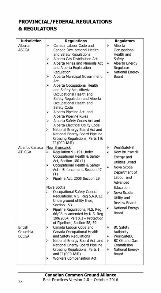
Canadian Common Ground Alliance
Best Practices Version 1.0 – October 2014
PROVINCIAL/FEDERAL REGULATIONS & REGULATORS
Jurisdiction Regulations Regulators Alberta ABCGA
Canada Labour Code and Canada Occupational Health and Safety Regulations
Alberta Gas Distribution Act Alberta Mines and Minerals Act
and Alberta Exploration Regulation
Alberta Municipal Government Act
Alberta Occupational Health and Safety Act, Alberta Occupational Health and Safety Regulation and Alberta Occupational Health and Safety Code
Alberta Pipeline Act and Alberta Pipeline Rules
Alberta Safety Codes Act and Alberta Electrical Utility Code
National Energy Board Act and National Energy Board Pipeline Crossing Regulations, Parts I & II (PCR I&II)
Alberta Occupational Health and Safety
Alberta Energy Regulator
National Energy Board
Atlantic Canada ATLCGA
New Brunswick Regulation 91-191 Under
Occupational Health & Safety Act, Section 180 (1)
Occupational Health & Safety Act – Enforcement, Section 47 (1)
Pipeline Act, 2005 Section 29 Nova Scotia
Occupational Safety General Regulations, N.S. Reg 53/2013: Underground utility lines, Section 153
Pipeline Regulations, N.S. Reg. 66/98 as amended by N.S. Reg 199/2004, Part XII – Protection of Pipelines, Section 58, 59
WorkSafeNB New Brunswick
Energy and Utilities Broad
Nova Scotia Department of Labour and Advanced Education
Nova Scotia Utility and Review Board
National Energy Board
British Columbia BCCGA
Canada Labour Code and Canada Occupational Health and Safety Regulations
National Energy Board Act and National Energy Board Pipeline Crossing Regulations, Parts I and II (PCR I&II)
Workers Compensation Act
BC Safety Authority
WorkSafeBC BC Oil and Gas
Commission National Energy
Board
72
Canadian Common Ground Alliance
Best Practices Version 1.0 – October 2014
Occupational Health and Safety Regulation
Oil and Gas Activities Act, Pipeline Regulation, Pipeline Crossing Regulation
Manitoba MCGA
Manitoba has The Gas Pipeline Act, Regulation 140/92 (recently amended with M.R. 213/2014)
Workplace Safety and Health 217/2007, Part 26
National Energy Board Act and National Energy Board Pipeline Crossing Regulations, Parts I and II
Public Utilities Board
Manitoba Workplace Safety & Health
National Energy Board
Ontario ORCGA
ON Regulations 22/04 – Electrical Distribution Safety, subsection 113(1) of Part V111 of Electricity Act, 1998
ON Regulations 210/01 – Oil and Gas Pipeline Systems – made under the TSSA 2000
OH&S Act & Regulations (R.S.O. 1990 chapter 0.1). Construction Projects (O. Reg 213/91) S228.1
Technical Standards & Safety Authority (TSSA)
Electrical Safety Authority (ESA)
Ministry of Labour (MOL)
National Energy Board
Quebec Info-Excavation
Code de sécurité pour les travaux de construction – Quebec Safety Code for the construction industry (Fines mentioned in rules 236 & 237)
o 3.15.1 – Diggings, excavations and trenches
o 3.18.1 – Demolition (work with high risk)
National Energy Board Act and National Energy Board Pipeline Crossing Regulations, Parts I & II (PCR I&II)
CSST (Commission de la santé et de la sécurité du travail)
National Energy Board
Saskatchewan SCGA
The Saskatchewan Employment Act
The Occupational Health and Safety Regulations, 1996
The Pipelines Act, 1998 The Power Corporation Act The SaskEnergy Act The Saskatchewan
Telecommunications Act
Ministry of Labour Relations and Workplace Safety, Occupational Health and Safety Division
Ministry of the Economy
National Energy Board
Federal CCGA
NEB Act Onshore Pipeline Regulations
(OPR) Pipeline Crossing Regulations,
Parts I & II (PCR I&II)
National Energy Board
98397_ORCGA_BestPract-TEXT-Oct2014.indd 72 16/10/14 9:42 AM
Canadian Common Ground AllianceBest Practices Version 2.0 – October 201672
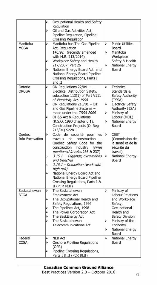
Canadian Common Ground Alliance
Best Practices Version 1.0 – October 2014
PROVINCIAL/FEDERAL REGULATIONS & REGULATORS
Jurisdiction Regulations Regulators Alberta ABCGA
Canada Labour Code and Canada Occupational Health and Safety Regulations
Alberta Gas Distribution Act Alberta Mines and Minerals Act
and Alberta Exploration Regulation
Alberta Municipal Government Act
Alberta Occupational Health and Safety Act, Alberta Occupational Health and Safety Regulation and Alberta Occupational Health and Safety Code
Alberta Pipeline Act and Alberta Pipeline Rules
Alberta Safety Codes Act and Alberta Electrical Utility Code
National Energy Board Act and National Energy Board Pipeline Crossing Regulations, Parts I & II (PCR I&II)
Alberta Occupational Health and Safety
Alberta Energy Regulator
National Energy Board
Atlantic Canada ATLCGA
New Brunswick Regulation 91-191 Under
Occupational Health & Safety Act, Section 180 (1)
Occupational Health & Safety Act – Enforcement, Section 47 (1)
Pipeline Act, 2005 Section 29 Nova Scotia
Occupational Safety General Regulations, N.S. Reg 53/2013: Underground utility lines, Section 153
Pipeline Regulations, N.S. Reg. 66/98 as amended by N.S. Reg 199/2004, Part XII – Protection of Pipelines, Section 58, 59
WorkSafeNB New Brunswick
Energy and Utilities Broad
Nova Scotia Department of Labour and Advanced Education
Nova Scotia Utility and Review Board
National Energy Board
British Columbia BCCGA
Canada Labour Code and Canada Occupational Health and Safety Regulations
National Energy Board Act and National Energy Board Pipeline Crossing Regulations, Parts I and II (PCR I&II)
Workers Compensation Act
BC Safety Authority
WorkSafeBC BC Oil and Gas
Commission National Energy
Board
72
Canadian Common Ground Alliance
Best Practices Version 1.0 – October 2014
Occupational Health and Safety Regulation
Oil and Gas Activities Act, Pipeline Regulation, Pipeline Crossing Regulation
Manitoba MCGA
Manitoba has The Gas Pipeline Act, Regulation 140/92 (recently amended with M.R. 213/2014)
Workplace Safety and Health 217/2007, Part 26
National Energy Board Act and National Energy Board Pipeline Crossing Regulations, Parts I and II
Public Utilities Board
Manitoba Workplace Safety & Health
National Energy Board
Ontario ORCGA
ON Regulations 22/04 – Electrical Distribution Safety, subsection 113(1) of Part V111 of Electricity Act, 1998
ON Regulations 210/01 – Oil and Gas Pipeline Systems – made under the TSSA 2000
OH&S Act & Regulations (R.S.O. 1990 chapter 0.1). Construction Projects (O. Reg 213/91) S228.1
Technical Standards & Safety Authority (TSSA)
Electrical Safety Authority (ESA)
Ministry of Labour (MOL)
National Energy Board
Quebec Info-Excavation
Code de sécurité pour les travaux de construction – Quebec Safety Code for the construction industry (Fines mentioned in rules 236 & 237)
o 3.15.1 – Diggings, excavations and trenches
o 3.18.1 – Demolition (work with high risk)
National Energy Board Act and National Energy Board Pipeline Crossing Regulations, Parts I & II (PCR I&II)
CSST (Commission de la santé et de la sécurité du travail)
National Energy Board
Saskatchewan SCGA
The Saskatchewan Employment Act
The Occupational Health and Safety Regulations, 1996
The Pipelines Act, 1998 The Power Corporation Act The SaskEnergy Act The Saskatchewan
Telecommunications Act
Ministry of Labour Relations and Workplace Safety, Occupational Health and Safety Division
Ministry of the Economy
National Energy Board
Federal CCGA
NEB Act Onshore Pipeline Regulations
(OPR) Pipeline Crossing Regulations,
Parts I & II (PCR I&II)
National Energy Board
98397_ORCGA_BestPract-TEXT-Oct2014.indd 72 16/10/14 9:42 AM
Canadian Common Ground Alliance
Best Practices Version 1.0 – October 2014
PROVINCIAL/FEDERAL REGULATIONS & REGULATORS
Jurisdiction Regulations Regulators Alberta ABCGA
Canada Labour Code and Canada Occupational Health and Safety Regulations
Alberta Gas Distribution Act Alberta Mines and Minerals Act
and Alberta Exploration Regulation
Alberta Municipal Government Act
Alberta Occupational Health and Safety Act, Alberta Occupational Health and Safety Regulation and Alberta Occupational Health and Safety Code
Alberta Pipeline Act and Alberta Pipeline Rules
Alberta Safety Codes Act and Alberta Electrical Utility Code
National Energy Board Act and National Energy Board Pipeline Crossing Regulations, Parts I & II (PCR I&II)
Alberta Occupational Health and Safety
Alberta Energy Regulator
National Energy Board
Atlantic Canada ATLCGA
New Brunswick Regulation 91-191 Under
Occupational Health & Safety Act, Section 180 (1)
Occupational Health & Safety Act – Enforcement, Section 47 (1)
Pipeline Act, 2005 Section 29 Nova Scotia
Occupational Safety General Regulations, N.S. Reg 53/2013: Underground utility lines, Section 153
Pipeline Regulations, N.S. Reg. 66/98 as amended by N.S. Reg 199/2004, Part XII – Protection of Pipelines, Section 58, 59
WorkSafeNB New Brunswick
Energy and Utilities Broad
Nova Scotia Department of Labour and Advanced Education
Nova Scotia Utility and Review Board
National Energy Board
British Columbia BCCGA
Canada Labour Code and Canada Occupational Health and Safety Regulations
National Energy Board Act and National Energy Board Pipeline Crossing Regulations, Parts I and II (PCR I&II)
Workers Compensation Act
BC Safety Authority
WorkSafeBC BC Oil and Gas
Commission National Energy
Board
73
Canadian Common Ground Alliance
Best Practices Version 1.0 – October 2014
Occupational Health and Safety Regulation
Oil and Gas Activities Act, Pipeline Regulation, Pipeline Crossing Regulation
Manitoba MCGA
Manitoba has The Gas Pipeline Act, Regulation 140/92 (recently amended with M.R. 213/2014)
Workplace Safety and Health 217/2007, Part 26
National Energy Board Act and National Energy Board Pipeline Crossing Regulations, Parts I and II
Public Utilities Board
Manitoba Workplace Safety & Health
National Energy Board
Ontario ORCGA
ON Regulations 22/04 – Electrical Distribution Safety, subsection 113(1) of Part V111 of Electricity Act, 1998
ON Regulations 210/01 – Oil and Gas Pipeline Systems – made under the TSSA 2000
OH&S Act & Regulations (R.S.O. 1990 chapter 0.1). Construction Projects (O. Reg 213/91) S228.1
Technical Standards & Safety Authority (TSSA)
Electrical Safety Authority (ESA)
Ministry of Labour (MOL)
National Energy Board
Quebec Info-Excavation
Code de sécurité pour les travaux de construction – Quebec Safety Code for the construction industry (Fines mentioned in rules 236 & 237)
o 3.15.1 – Diggings, excavations and trenches
o 3.18.1 – Demolition (work with high risk)
National Energy Board Act and National Energy Board Pipeline Crossing Regulations, Parts I & II (PCR I&II)
CSST (Commission de la santé et de la sécurité du travail)
National Energy Board
Saskatchewan SCGA
The Saskatchewan Employment Act
The Occupational Health and Safety Regulations, 1996
The Pipelines Act, 1998 The Power Corporation Act The SaskEnergy Act The Saskatchewan
Telecommunications Act
Ministry of Labour Relations and Workplace Safety, Occupational Health and Safety Division
Ministry of the Economy
National Energy Board
Federal CCGA
NEB Act Onshore Pipeline Regulations
(OPR) Pipeline Crossing Regulations,
Parts I & II (PCR I&II)
National Energy Board
98397_ORCGA_BestPract-TEXT-Oct2014.indd 73 16/10/14 9:42 AM
Canadian Common Ground AllianceBest Practices Version 2.0 – October 2016 73

Canadian Common Ground Alliance
Best Practices Version 1.0 – October 2014
74
Canadian Common Ground Alliance
Best Practices Version 1.0 – October 2014
7-0 Public Education Best Practices
7-1: Know the Target Audience and Their Needs
Practice Statement: In order to effectively promote damage prevention and influence/improve damage prevention habits, it is necessary to identify the target audience, establish what their education and awareness needs are, and to create a communications package that is tailored to those needs.
Practice Description: The fundamental reason for conducting education and awareness campaigns is to try to influence people to change their behaviour to reduce utility damage and increase public safety.
The organizations and individuals who could benefit from damage prevention education and awareness are extensive and diverse. To identify the target audience:
Examine damage data and trends Categorize incidents by: frequency & severity Rank and prioritize incidents To effectively communicate educational objectives: Clearly identify the issues and root causes. Describe new behaviour and establish what it would take to change
behaviour Reinforce changes in behaviour.
7-2: Develop and Use a Marketing Plan
Practice Statement: Develop a marketing plan that will take in to account the training needs of the target audience, available resources, communications media and timeframes.
Practice Description: A strategic marketing plan enables better implementation, control and continuity of advertising and promotional programs. The plan sets realistic goals and allocates sufficient resources required to achieve them. It also accommodates the need to track and analyze results.
7-3: Practice Project Management
Practice Statement: Practice Project management when executing the marketing plan.
Practice Description: Effective Project management consists of:
Goal setting Resource management Task identification Timelines
98397_ORCGA_BestPract-TEXT-Oct2014.indd 74 16/10/14 9:42 AM
Canadian Common Ground AllianceBest Practices Version 2.0 – October 201674

7-0 Public Education Best Practices
7 P
ublic
Edu
cati
on

Canadian Common Ground Alliance
Best Practices Version 1.0 – October 2014
74
Canadian Common Ground Alliance
Best Practices Version 1.0 – October 2014
7-0 Public Education Best Practices
7-1: Know the Target Audience and Their Needs
Practice Statement: In order to effectively promote damage prevention and influence/improve damage prevention habits, it is necessary to identify the target audience, establish what their education and awareness needs are, and to create a communications package that is tailored to those needs.
Practice Description: The fundamental reason for conducting education and awareness campaigns is to try to influence people to change their behaviour to reduce utility damage and increase public safety.
The organizations and individuals who could benefit from damage prevention education and awareness are extensive and diverse. To identify the target audience:
Examine damage data and trends Categorize incidents by: frequency & severity Rank and prioritize incidents To effectively communicate educational objectives: Clearly identify the issues and root causes. Describe new behaviour and establish what it would take to change
behaviour Reinforce changes in behaviour.
7-2: Develop and Use a Marketing Plan
Practice Statement: Develop a marketing plan that will take in to account the training needs of the target audience, available resources, communications media and timeframes.
Practice Description: A strategic marketing plan enables better implementation, control and continuity of advertising and promotional programs. The plan sets realistic goals and allocates sufficient resources required to achieve them. It also accommodates the need to track and analyze results.
7-3: Practice Project Management
Practice Statement: Practice Project management when executing the marketing plan.
Practice Description: Effective Project management consists of:
Goal setting Resource management Task identification Timelines
98397_ORCGA_BestPract-TEXT-Oct2014.indd 74 16/10/14 9:42 AM
Canadian Common Ground Alliance
Best Practices Version 1.0 – October 2014
75
Canadian Common Ground Alliance
Best Practices Version 1.0 – October 2014
7-0 Public Education Best Practices
7-1: Know the Target Audience and Their Needs
Practice Statement: In order to effectively promote damage prevention and influence/improve damage prevention habits, it is necessary to identify the target audience, establish what their education and awareness needs are, and to create a communications package that is tailored to those needs.
Practice Description: The fundamental reason for conducting education and awareness campaigns is to try to influence people to change their behaviour to reduce utility damage and increase public safety.
The organizations and individuals who could benefit from damage prevention education and awareness are extensive and diverse. To identify the target audience:
Examine damage data and trends Categorize incidents by: frequency & severity Rank and prioritize incidents To effectively communicate educational objectives: Clearly identify the issues and root causes. Describe new behaviour and establish what it would take to change
behaviour Reinforce changes in behaviour.
7-2: Develop and Use a Marketing Plan
Practice Statement: Develop a marketing plan that will take in to account the training needs of the target audience, available resources, communications media and timeframes.
Practice Description: A strategic marketing plan enables better implementation, control and continuity of advertising and promotional programs. The plan sets realistic goals and allocates sufficient resources required to achieve them. It also accommodates the need to track and analyze results.
7-3: Practice Project Management
Practice Statement: Practice Project management when executing the marketing plan.
Practice Description: Effective Project management consists of:
Goal setting Resource management Task identification Timelines
98397_ORCGA_BestPract-TEXT-Oct2014.indd 75 16/10/14 9:42 AM
Canadian Common Ground Alliance
Best Practices Version 1.0 – October 2014
75
Canadian Common Ground Alliance
Best Practices Version 1.0 – October 2014
7-0 Public Education Best Practices
7-1: Know the Target Audience and Their Needs
Practice Statement: In order to effectively promote damage prevention and influence/improve damage prevention habits, it is necessary to identify the target audience, establish what their education and awareness needs are, and to create a communications package that is tailored to those needs.
Practice Description: The fundamental reason for conducting education and awareness campaigns is to try to influence people to change their behaviour to reduce utility damage and increase public safety.
The organizations and individuals who could benefit from damage prevention education and awareness are extensive and diverse. To identify the target audience:
Examine damage data and trends Categorize incidents by: frequency & severity Rank and prioritize incidents To effectively communicate educational objectives: Clearly identify the issues and root causes. Describe new behaviour and establish what it would take to change
behaviour Reinforce changes in behaviour.
7-2: Develop and Use a Marketing Plan
Practice Statement: Develop a marketing plan that will take in to account the training needs of the target audience, available resources, communications media and timeframes.
Practice Description: A strategic marketing plan enables better implementation, control and continuity of advertising and promotional programs. The plan sets realistic goals and allocates sufficient resources required to achieve them. It also accommodates the need to track and analyze results.
7-3: Practice Project Management
Practice Statement: Practice Project management when executing the marketing plan.
Practice Description: Effective Project management consists of:
Goal setting Resource management Task identification Timelines
98397_ORCGA_BestPract-TEXT-Oct2014.indd 75 16/10/14 9:42 AM
Canadian Common Ground AllianceBest Practices Version 2.0 – October 2016 75

Canadian Common Ground Alliance
Best Practices Version 1.0 – October 2014
7-4: Create an Effective Damage Prevention Message
Practice Statement: When promoting damage prevention, create a message that is understood and retained.
Practice Description: An effective message should motivate the targeted audience to positive action. The objective is to put desired behaviours into practice quickly, easily, and repeatedly.
7-5: Promote the Damage Prevention Message
Practice Statement: Promoting the damage prevention message by finding creative ways to influence the target audience to:
Listen attentively to the message Remember what they heard Change their behaviour.
Multiple stakeholders with similar goals and messages can partner together to reduce costs and maximize impact.
Practice Description: Promoting the damage prevention message can be done through a variety of means and media. Mailings involve delivering a specific message to a particular target audience (e.g. - specific geographic area, market sector, or demographic category).
Professionally designed messages can be effective at securing the attention of a broader target audience. (e.g. newspaper advertising, trade journal ads, brochures, sponsorships, transit system signs, news and weather reports)
Where possible take advantage of free media, such as public service announcements made by newspaper, radio, television and available websites.
Promotional items present a method of promoting key messages and are branding opportunities.
7-6: Establish Strategic Relationships
Practice Statement: Develop strategic working relationships to assist in the promotion of damage prevention.
Practice Description: Strategic relationships can be developed with others who have shared or similar issues, interests, and needs. These could include industry associations, equipment manufacturers and trade groups. Other stakeholders can include government agencies, emergency responders and media.
76
Canadian Common Ground Alliance
Best Practices Version 1.0 – October 2014
7-7: Measure Results and Strive to Improve
Practice Statement: Critically review the results and outcomes of the marketing plan initiatives. Identify what works well and what does not. Implement lessons learned and strive for continuous program improvement.
Practice Description: Determine the effective elements of the marketing plan to establish the framework for future plans. Gauge target audience response to structured training and awareness initiatives. This can be done through surveying the intended target audience (via direct mail, telephone etc.) to determine if behaviours have changed, and to what extent. Changes in damage statistics are another means to determine if a change in behaviour for a general area or a specific operator has been effectively produced by the marketing plan delivery.
Identify and address gaps in the marketing plan. Modify the program accordingly and strive to improve to achieve the program goal(s).
98397_ORCGA_BestPract-TEXT-Oct2014.indd 76 16/10/14 9:42 AM
Canadian Common Ground Alliance
Best Practices Version 1.0 – October 2014
7-4: Create an Effective Damage Prevention Message
Practice Statement: When promoting damage prevention, create a message that is understood and retained.
Practice Description: An effective message should motivate the targeted audience to positive action. The objective is to put desired behaviours into practice quickly, easily, and repeatedly.
7-5: Promote the Damage Prevention Message
Practice Statement: Promoting the damage prevention message by finding creative ways to influence the target audience to:
Listen attentively to the message Remember what they heard Change their behaviour.
Multiple stakeholders with similar goals and messages can partner together to reduce costs and maximize impact.
Practice Description: Promoting the damage prevention message can be done through a variety of means and media. Mailings involve delivering a specific message to a particular target audience (e.g. - specific geographic area, market sector, or demographic category).
Professionally designed messages can be effective at securing the attention of a broader target audience. (e.g. newspaper advertising, trade journal ads, brochures, sponsorships, transit system signs, news and weather reports)
Where possible take advantage of free media, such as public service announcements made by newspaper, radio, television and available websites.
Promotional items present a method of promoting key messages and are branding opportunities.
7-6: Establish Strategic Relationships
Practice Statement: Develop strategic working relationships to assist in the promotion of damage prevention.
Practice Description: Strategic relationships can be developed with others who have shared or similar issues, interests, and needs. These could include industry associations, equipment manufacturers and trade groups. Other stakeholders can include government agencies, emergency responders and media.
76
Canadian Common Ground Alliance
Best Practices Version 1.0 – October 2014
7-7: Measure Results and Strive to Improve
Practice Statement: Critically review the results and outcomes of the marketing plan initiatives. Identify what works well and what does not. Implement lessons learned and strive for continuous program improvement.
Practice Description: Determine the effective elements of the marketing plan to establish the framework for future plans. Gauge target audience response to structured training and awareness initiatives. This can be done through surveying the intended target audience (via direct mail, telephone etc.) to determine if behaviours have changed, and to what extent. Changes in damage statistics are another means to determine if a change in behaviour for a general area or a specific operator has been effectively produced by the marketing plan delivery.
Identify and address gaps in the marketing plan. Modify the program accordingly and strive to improve to achieve the program goal(s).
98397_ORCGA_BestPract-TEXT-Oct2014.indd 76 16/10/14 9:42 AM
Canadian Common Ground AllianceBest Practices Version 2.0 – October 201676
Canadian Common Ground Alliance
Best Practices Version 1.0 – October 2014
7-4: Create an Effective Damage Prevention Message
Practice Statement: When promoting damage prevention, create a message that is understood and retained.
Practice Description: An effective message should motivate the targeted audience to positive action. The objective is to put desired behaviours into practice quickly, easily, and repeatedly.
7-5: Promote the Damage Prevention Message
Practice Statement: Promoting the damage prevention message by finding creative ways to influence the target audience to:
Listen attentively to the message Remember what they heard Change their behaviour.
Multiple stakeholders with similar goals and messages can partner together to reduce costs and maximize impact.
Practice Description: Promoting the damage prevention message can be done through a variety of means and media. Mailings involve delivering a specific message to a particular target audience (e.g. - specific geographic area, market sector, or demographic category).
Professionally designed messages can be effective at securing the attention of a broader target audience. (e.g. newspaper advertising, trade journal ads, brochures, sponsorships, transit system signs, news and weather reports)
Where possible take advantage of free media, such as public service announcements made by newspaper, radio, television and available websites.
Promotional items present a method of promoting key messages and are branding opportunities.
7-6: Establish Strategic Relationships
Practice Statement: Develop strategic working relationships to assist in the promotion of damage prevention.
Practice Description: Strategic relationships can be developed with others who have shared or similar issues, interests, and needs. These could include industry associations, equipment manufacturers and trade groups. Other stakeholders can include government agencies, emergency responders and media.
76
Canadian Common Ground Alliance
Best Practices Version 1.0 – October 2014
7-7: Measure Results and Strive to Improve
Practice Statement: Critically review the results and outcomes of the marketing plan initiatives. Identify what works well and what does not. Implement lessons learned and strive for continuous program improvement.
Practice Description: Determine the effective elements of the marketing plan to establish the framework for future plans. Gauge target audience response to structured training and awareness initiatives. This can be done through surveying the intended target audience (via direct mail, telephone etc.) to determine if behaviours have changed, and to what extent. Changes in damage statistics are another means to determine if a change in behaviour for a general area or a specific operator has been effectively produced by the marketing plan delivery.
Identify and address gaps in the marketing plan. Modify the program accordingly and strive to improve to achieve the program goal(s).
98397_ORCGA_BestPract-TEXT-Oct2014.indd 76 16/10/14 9:42 AM
Canadian Common Ground Alliance
Best Practices Version 1.0 – October 2014
7-4: Create an Effective Damage Prevention Message
Practice Statement: When promoting damage prevention, create a message that is understood and retained.
Practice Description: An effective message should motivate the targeted audience to positive action. The objective is to put desired behaviours into practice quickly, easily, and repeatedly.
7-5: Promote the Damage Prevention Message
Practice Statement: Promoting the damage prevention message by finding creative ways to influence the target audience to:
Listen attentively to the message Remember what they heard Change their behaviour.
Multiple stakeholders with similar goals and messages can partner together to reduce costs and maximize impact.
Practice Description: Promoting the damage prevention message can be done through a variety of means and media. Mailings involve delivering a specific message to a particular target audience (e.g. - specific geographic area, market sector, or demographic category).
Professionally designed messages can be effective at securing the attention of a broader target audience. (e.g. newspaper advertising, trade journal ads, brochures, sponsorships, transit system signs, news and weather reports)
Where possible take advantage of free media, such as public service announcements made by newspaper, radio, television and available websites.
Promotional items present a method of promoting key messages and are branding opportunities.
7-6: Establish Strategic Relationships
Practice Statement: Develop strategic working relationships to assist in the promotion of damage prevention.
Practice Description: Strategic relationships can be developed with others who have shared or similar issues, interests, and needs. These could include industry associations, equipment manufacturers and trade groups. Other stakeholders can include government agencies, emergency responders and media.
77
Canadian Common Ground Alliance
Best Practices Version 1.0 – October 2014
7-7: Measure Results and Strive to Improve
Practice Statement: Critically review the results and outcomes of the marketing plan initiatives. Identify what works well and what does not. Implement lessons learned and strive for continuous program improvement.
Practice Description: Determine the effective elements of the marketing plan to establish the framework for future plans. Gauge target audience response to structured training and awareness initiatives. This can be done through surveying the intended target audience (via direct mail, telephone etc.) to determine if behaviours have changed, and to what extent. Changes in damage statistics are another means to determine if a change in behaviour for a general area or a specific operator has been effectively produced by the marketing plan delivery.
Identify and address gaps in the marketing plan. Modify the program accordingly and strive to improve to achieve the program goal(s).
98397_ORCGA_BestPract-TEXT-Oct2014.indd 77 16/10/14 9:42 AM
Canadian Common Ground Alliance
Best Practices Version 1.0 – October 2014
7-4: Create an Effective Damage Prevention Message
Practice Statement: When promoting damage prevention, create a message that is understood and retained.
Practice Description: An effective message should motivate the targeted audience to positive action. The objective is to put desired behaviours into practice quickly, easily, and repeatedly.
7-5: Promote the Damage Prevention Message
Practice Statement: Promoting the damage prevention message by finding creative ways to influence the target audience to:
Listen attentively to the message Remember what they heard Change their behaviour.
Multiple stakeholders with similar goals and messages can partner together to reduce costs and maximize impact.
Practice Description: Promoting the damage prevention message can be done through a variety of means and media. Mailings involve delivering a specific message to a particular target audience (e.g. - specific geographic area, market sector, or demographic category).
Professionally designed messages can be effective at securing the attention of a broader target audience. (e.g. newspaper advertising, trade journal ads, brochures, sponsorships, transit system signs, news and weather reports)
Where possible take advantage of free media, such as public service announcements made by newspaper, radio, television and available websites.
Promotional items present a method of promoting key messages and are branding opportunities.
7-6: Establish Strategic Relationships
Practice Statement: Develop strategic working relationships to assist in the promotion of damage prevention.
Practice Description: Strategic relationships can be developed with others who have shared or similar issues, interests, and needs. These could include industry associations, equipment manufacturers and trade groups. Other stakeholders can include government agencies, emergency responders and media.
77
Canadian Common Ground Alliance
Best Practices Version 1.0 – October 2014
7-7: Measure Results and Strive to Improve
Practice Statement: Critically review the results and outcomes of the marketing plan initiatives. Identify what works well and what does not. Implement lessons learned and strive for continuous program improvement.
Practice Description: Determine the effective elements of the marketing plan to establish the framework for future plans. Gauge target audience response to structured training and awareness initiatives. This can be done through surveying the intended target audience (via direct mail, telephone etc.) to determine if behaviours have changed, and to what extent. Changes in damage statistics are another means to determine if a change in behaviour for a general area or a specific operator has been effectively produced by the marketing plan delivery.
Identify and address gaps in the marketing plan. Modify the program accordingly and strive to improve to achieve the program goal(s).
98397_ORCGA_BestPract-TEXT-Oct2014.indd 77 16/10/14 9:42 AM
Canadian Common Ground AllianceBest Practices Version 2.0 – October 2016 77

Canadian Common Ground Alliance
Best Practices Version 1.0 – October 2014
78
Canadian Common Ground Alliance
Best Practices Version 1.0 – October 2014
8-0 Reporting and Evaluation Best Practices
8-1: Reporting Information
Practice Statement: All stakeholders have the opportunity to report information.
Practice Description: Facility owners/operators, locators, excavators, or those contracted by the owner /operator, can report information on incidents that could have, or did lead to a damaged underground facility.
8-2: Standardized information Practice Statement: Standardized information is reported.
Practice Description: The requested data is standardized and consists of essential information that can be analyzed to determine what events could, or did lead to a damaged facility. Collected data may include damage information, downtime and near-misses.
8-3: Non-compliant Stakeholder Practice Statement: Identify the non-compliant stakeholder
Practice Description: It is important to identify the non-compliant stakeholder so that this group/sector can be targeted with education and training.
8-4: Accuracy of Information Practice Statement: Person reporting provides detailed information.
Practice Description: If all of the requested data is not available, the person reporting the information provides the most complete information possible.
8-5: Changes in Reporting Information Practice Statement: Requested information may change.
Practice Description: The information required to be reported will be revised, as needed, to adapt to the changes in the regulation or statutes, the evolution of industry technology, and the awareness of root causes.
8-6: Process for Collecting Data Practice Statement: A standardized form for collecting data is adopted.
Practice Description: Data is to be collected using a standardized form that contains a list of the standardized questions that will be adopted or developed by facility owners/operators, locators, excavators, or those contracted by the owner/operator. All anonymous data collected will be uploaded for geographical and general assessment & analysis.
98397_ORCGA_BestPract-TEXT-Oct2014.indd 78 16/10/14 9:42 AM
Canadian Common Ground AllianceBest Practices Version 2.0 – October 201678

8-0 Reporting and Evaluation Best Practices
8 R
epor
ting
and
Ev
alua
tion

Canadian Common Ground Alliance
Best Practices Version 1.0 – October 2014
78
Canadian Common Ground Alliance
Best Practices Version 1.0 – October 2014
8-0 Reporting and Evaluation Best Practices
8-1: Reporting Information
Practice Statement: All stakeholders have the opportunity to report information.
Practice Description: Facility owners/operators, locators, excavators, or those contracted by the owner /operator, can report information on incidents that could have, or did lead to a damaged underground facility.
8-2: Standardized information Practice Statement: Standardized information is reported.
Practice Description: The requested data is standardized and consists of essential information that can be analyzed to determine what events could, or did lead to a damaged facility. Collected data may include damage information, downtime and near-misses.
8-3: Non-compliant Stakeholder Practice Statement: Identify the non-compliant stakeholder
Practice Description: It is important to identify the non-compliant stakeholder so that this group/sector can be targeted with education and training.
8-4: Accuracy of Information Practice Statement: Person reporting provides detailed information.
Practice Description: If all of the requested data is not available, the person reporting the information provides the most complete information possible.
8-5: Changes in Reporting Information Practice Statement: Requested information may change.
Practice Description: The information required to be reported will be revised, as needed, to adapt to the changes in the regulation or statutes, the evolution of industry technology, and the awareness of root causes.
8-6: Process for Collecting Data Practice Statement: A standardized form for collecting data is adopted.
Practice Description: Data is to be collected using a standardized form that contains a list of the standardized questions that will be adopted or developed by facility owners/operators, locators, excavators, or those contracted by the owner/operator. All anonymous data collected will be uploaded for geographical and general assessment & analysis.
98397_ORCGA_BestPract-TEXT-Oct2014.indd 78 16/10/14 9:42 AM
Canadian Common Ground Alliance
Best Practices Version 1.0 – October 2014
79
Canadian Common Ground Alliance
Best Practices Version 1.0 – October 2014
8-0 Reporting and Evaluation Best Practices
8-1: Reporting Information
Practice Statement: All stakeholders have the opportunity to report information.
Practice Description: Facility owners/operators, locators, excavators, or those contracted by the owner /operator, can report information on incidents that could have, or did lead to a damaged underground facility.
8-2: Standardized information Practice Statement: Standardized information is reported.
Practice Description: The requested data is standardized and consists of essential information that can be analyzed to determine what events could, or did lead to a damaged facility. Collected data may include damage information, downtime and near-misses.
8-3: Non-compliant Stakeholder Practice Statement: Identify the non-compliant stakeholder
Practice Description: It is important to identify the non-compliant stakeholder so that this group/sector can be targeted with education and training.
8-4: Accuracy of Information Practice Statement: Person reporting provides detailed information.
Practice Description: If all of the requested data is not available, the person reporting the information provides the most complete information possible.
8-5: Changes in Reporting Information Practice Statement: Requested information may change.
Practice Description: The information required to be reported will be revised, as needed, to adapt to the changes in the regulation or statutes, the evolution of industry technology, and the awareness of root causes.
8-6: Process for Collecting Data Practice Statement: A standardized form for collecting data is adopted.
Practice Description: Data is to be collected using a standardized form that contains a list of the standardized questions that will be adopted or developed by facility owners/operators, locators, excavators, or those contracted by the owner/operator. All anonymous data collected will be uploaded for geographical and general assessment & analysis.
98397_ORCGA_BestPract-TEXT-Oct2014.indd 79 16/10/14 9:42 AM
Canadian Common Ground AllianceBest Practices Version 2.0 – October 2016 79
Canadian Common Ground Alliance
Best Practices Version 1.0 – October 2014
8-7: Training Process for Collecting Data Practice Statement: Training is provided.
Practice Description: Training and education on how to complete and submit the data is made available.
8-8: Common Database in Place
Practice Statement: A recommended organization is identified to receive and maintain the data.
Practice Description: A common database is maintained. The Canadian CGA regional partners Virtual Private DIRT (VPD) is currently the recommended organization database.
References: DIRT Field Form – Appendix D.
8-9: Data Evaluation Process Practice Statement: A committee evaluates the data.
Practice Description: The Reporting and Evaluating committee, with representation from all interested stakeholders, performs evaluation of the data.
8-10: Purpose of Data Collection
Practice Statement: Data is used to improve damage prevention efforts and to elevate underground damage awareness.
Practice Description: The reported data is used to assess and improve underground damage prevention efforts. The reported data is not to be used to penalize or punish. Rather, it is used to elevate underground damage awareness through recommended training and education.
8-11: Data Analysis Practice Statement: Data is summarized by key components.
Practice Description: The reported data is summarized by key components and made available to all industry stakeholders.
8-12: Root Cause Practice Statement: Root causes are identified.
Practice Description: Root causes of damages or near misses are
identified. References: Root Tip Card see appendix D.
8-13: Quantifying Results Practice Statement: Results are quantified against a standardized risk factor.
Practice Description: Results are quantified against a standardized risk
80
Canadian Common Ground Alliance
Best Practices Version 1.0 – October 2014
factor. The risk factor considers a stakeholder’s exposure to potentialdamage. This risk factor may be based on factors such as the number of kilometers of line installed or the number of locate notification tickets. For example, a risk factor may compare how many underground damages occurred in a certain period of time versus the total number of locate tickets issued during the same period.
8-14: Results Comparison Practice Statement: Performance levels and trends are assessed.
Practice Description: Performance levels and trends are assessed against other organizations within the Canadian CGA regional partners or other similar CGA affiliated organizations. Upon these assessments recommendations to address the trends will be used to facilitate key messages.
Reference:
CGA DIRT cga-dirt.com
Canadian CGA Regional Virtual Private DIRT
98397_ORCGA_BestPract-TEXT-Oct2014.indd 80 16/10/14 9:42 AM
Canadian Common Ground AllianceBest Practices Version 2.0 – October 201680

Canadian Common Ground Alliance
Best Practices Version 1.0 – October 2014
8-7: Training Process for Collecting Data Practice Statement: Training is provided.
Practice Description: Training and education on how to complete and submit the data is made available.
8-8: Common Database in Place
Practice Statement: A recommended organization is identified to receive and maintain the data.
Practice Description: A common database is maintained. The Canadian CGA regional partners Virtual Private DIRT (VPD) is currently the recommended organization database.
References: DIRT Field Form – Appendix D.
8-9: Data Evaluation Process Practice Statement: A committee evaluates the data.
Practice Description: The Reporting and Evaluating committee, with representation from all interested stakeholders, performs evaluation of the data.
8-10: Purpose of Data Collection
Practice Statement: Data is used to improve damage prevention efforts and to elevate underground damage awareness.
Practice Description: The reported data is used to assess and improve underground damage prevention efforts. The reported data is not to be used to penalize or punish. Rather, it is used to elevate underground damage awareness through recommended training and education.
8-11: Data Analysis Practice Statement: Data is summarized by key components.
Practice Description: The reported data is summarized by key components and made available to all industry stakeholders.
8-12: Root Cause Practice Statement: Root causes are identified.
Practice Description: Root causes of damages or near misses are
identified. References: Root Tip Card see appendix D.
8-13: Quantifying Results Practice Statement: Results are quantified against a standardized risk factor.
Practice Description: Results are quantified against a standardized risk
80
Canadian Common Ground Alliance
Best Practices Version 1.0 – October 2014
factor. The risk factor considers a stakeholder’s exposure to potentialdamage. This risk factor may be based on factors such as the number of kilometers of line installed or the number of locate notification tickets. For example, a risk factor may compare how many underground damages occurred in a certain period of time versus the total number of locate tickets issued during the same period.
8-14: Results Comparison Practice Statement: Performance levels and trends are assessed.
Practice Description: Performance levels and trends are assessed against other organizations within the Canadian CGA regional partners or other similar CGA affiliated organizations. Upon these assessments recommendations to address the trends will be used to facilitate key messages.
Reference:
CGA DIRT cga-dirt.com
Canadian CGA Regional Virtual Private DIRT
98397_ORCGA_BestPract-TEXT-Oct2014.indd 80 16/10/14 9:42 AM
Canadian Common Ground Alliance
Best Practices Version 1.0 – October 2014
8-7: Training Process for Collecting Data Practice Statement: Training is provided.
Practice Description: Training and education on how to complete and submit the data is made available.
8-8: Common Database in Place
Practice Statement: A recommended organization is identified to receive and maintain the data.
Practice Description: A common database is maintained. The Canadian CGA regional partners Virtual Private DIRT (VPD) is currently the recommended organization database.
References: DIRT Field Form – Appendix D.
8-9: Data Evaluation Process Practice Statement: A committee evaluates the data.
Practice Description: The Reporting and Evaluating committee, with representation from all interested stakeholders, performs evaluation of the data.
8-10: Purpose of Data Collection
Practice Statement: Data is used to improve damage prevention efforts and to elevate underground damage awareness.
Practice Description: The reported data is used to assess and improve underground damage prevention efforts. The reported data is not to be used to penalize or punish. Rather, it is used to elevate underground damage awareness through recommended training and education.
8-11: Data Analysis Practice Statement: Data is summarized by key components.
Practice Description: The reported data is summarized by key components and made available to all industry stakeholders.
8-12: Root Cause Practice Statement: Root causes are identified.
Practice Description: Root causes of damages or near misses are
identified. References: Root Tip Card see appendix D.
8-13: Quantifying Results Practice Statement: Results are quantified against a standardized risk factor.
Practice Description: Results are quantified against a standardized risk
81
Canadian Common Ground Alliance
Best Practices Version 1.0 – October 2014
factor. The risk factor considers a stakeholder’s exposure to potentialdamage. This risk factor may be based on factors such as the number of kilometers of line installed or the number of locate notification tickets. For example, a risk factor may compare how many underground damages occurred in a certain period of time versus the total number of locate tickets issued during the same period.
8-14: Results Comparison Practice Statement: Performance levels and trends are assessed.
Practice Description: Performance levels and trends are assessed against other organizations within the Canadian CGA regional partners or other similar CGA affiliated organizations. Upon these assessments recommendations to address the trends will be used to facilitate key messages.
Reference:
CGA DIRT cga-dirt.com
Canadian CGA Regional Virtual Private DIRT
98397_ORCGA_BestPract-TEXT-Oct2014.indd 81 16/10/14 9:42 AM
Canadian Common Ground AllianceBest Practices Version 2.0 – October 2016 81

Canadian Common Ground Alliance
Best Practices Version 1.0 – October 2014
82
Canadian Common Ground Alliance
Best Practices Version 1.0 – October 2014
Appendix A: Glossary of Terms & Definitions – Abandoned Line or Facility: Any underground or submerged line or facility no longer in use or not in use at the present time. – Accurate or Accuracy: the closeness of results of observations, calculations, or estimates compared to the true value. – Alternate Locate Agreement (ALA): A contractual agreement between a facility owner and an excavator that allows the excavator to proceed with their excavation work without receiving a traditional field locate. – American Society of Civil Engineers (ASCE). – Attributes: numbers, abbreviations, and words that describe the physical and spatial properties of the underground utility infrastructure used to provide an aesthetic and useful map display. – As-built: A representation of the as-constructed situation showing the position and features of components as actually put in place. – Backfill: The act of filling the void created by excavating or the material used to fill the void. – Canadian Radio-television & Telecommunication Commission (CRTC) – Canadian Standards Association (CSA) – Cathodic Protection: The process of arresting corrosion on a buried or submerged structure by electrically reversing the natural chemical reaction. This includes, but is not limited to, installation of a sacrificial anode bed, use of a rectifier based system, or any combination of these or other similar systems. Wiring is installed between the buried or submerged structure and all anodes and rectifiers; wiring is also installed to test stations which are used to measure the effectiveness of the cathodic protection system. – Commission for Environmental Cooperation (CEC) – Compliance: Adherence to acts and regulations. – Control Survey Monuments (horizontal): Existing survey monuments with published coordinates that are geographically referenced with high accuracy. – Control Survey Monuments (vertical): Existing survey monuments, commonly referred to as benchmarks, with published elevations that are accurately referenced to a known vertical datum (mathematical reference plane). – Damage: Any impact, stress and/or exposure that results in the need to repair an underground facility due to a weakening or the partial or complete destruction of the facility, including, but not limited to, the protective coating, lateral support, cathodic protection or the housing for the line, device or facility.
98397_ORCGA_BestPract-TEXT-Oct2014.indd 82 16/10/14 9:42 AM
Canadian Common Ground AllianceBest Practices Version 2.0 – October 201682
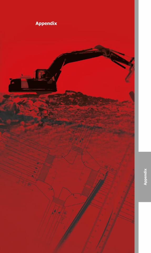
Appendix
App
endi
x
Canadian Common Ground Alliance
Best Practices Version 1.0 – October 2014
82
Canadian Common Ground Alliance
Best Practices Version 1.0 – October 2014
Appendix A: Glossary of Terms & Definitions – Abandoned Line or Facility: Any underground or submerged line or facility no longer in use or not in use at the present time. – Accurate or Accuracy: the closeness of results of observations, calculations, or estimates compared to the true value. – Alternate Locate Agreement (ALA): A contractual agreement between a facility owner and an excavator that allows the excavator to proceed with their excavation work without receiving a traditional field locate. – American Society of Civil Engineers (ASCE). – Attributes: numbers, abbreviations, and words that describe the physical and spatial properties of the underground utility infrastructure used to provide an aesthetic and useful map display. – As-built: A representation of the as-constructed situation showing the position and features of components as actually put in place. – Backfill: The act of filling the void created by excavating or the material used to fill the void. – Canadian Radio-television & Telecommunication Commission (CRTC) – Canadian Standards Association (CSA) – Cathodic Protection: The process of arresting corrosion on a buried or submerged structure by electrically reversing the natural chemical reaction. This includes, but is not limited to, installation of a sacrificial anode bed, use of a rectifier based system, or any combination of these or other similar systems. Wiring is installed between the buried or submerged structure and all anodes and rectifiers; wiring is also installed to test stations which are used to measure the effectiveness of the cathodic protection system. – Commission for Environmental Cooperation (CEC) – Compliance: Adherence to acts and regulations. – Control Survey Monuments (horizontal): Existing survey monuments with published coordinates that are geographically referenced with high accuracy. – Control Survey Monuments (vertical): Existing survey monuments, commonly referred to as benchmarks, with published elevations that are accurately referenced to a known vertical datum (mathematical reference plane). – Damage: Any impact, stress and/or exposure that results in the need to repair an underground facility due to a weakening or the partial or complete destruction of the facility, including, but not limited to, the protective coating, lateral support, cathodic protection or the housing for the line, device or facility.
98397_ORCGA_BestPract-TEXT-Oct2014.indd 82 16/10/14 9:42 AM
Canadian Common Ground Alliance
Best Practices Version 1.0 – October 2014
83
Canadian Common Ground Alliance
Best Practices Version 1.0 – October 2014
Appendix A: Glossary of Terms & Definitions – Abandoned Line or Facility: Any underground or submerged line or facility no longer in use or not in use at the present time. – Accurate or Accuracy: the closeness of results of observations, calculations, or estimates compared to the true value. – Alternate Locate Agreement (ALA): A contractual agreement between a facility owner and an excavator that allows the excavator to proceed with their excavation work without receiving a traditional field locate. – American Society of Civil Engineers (ASCE). – Attributes: numbers, abbreviations, and words that describe the physical and spatial properties of the underground utility infrastructure used to provide an aesthetic and useful map display. – As-built: A representation of the as-constructed situation showing the position and features of components as actually put in place. – Backfill: The act of filling the void created by excavating or the material used to fill the void. – Canadian Radio-television & Telecommunication Commission (CRTC) – Canadian Standards Association (CSA) – Cathodic Protection: The process of arresting corrosion on a buried or submerged structure by electrically reversing the natural chemical reaction. This includes, but is not limited to, installation of a sacrificial anode bed, use of a rectifier based system, or any combination of these or other similar systems. Wiring is installed between the buried or submerged structure and all anodes and rectifiers; wiring is also installed to test stations which are used to measure the effectiveness of the cathodic protection system. – Commission for Environmental Cooperation (CEC) – Compliance: Adherence to acts and regulations. – Control Survey Monuments (horizontal): Existing survey monuments with published coordinates that are geographically referenced with high accuracy. – Control Survey Monuments (vertical): Existing survey monuments, commonly referred to as benchmarks, with published elevations that are accurately referenced to a known vertical datum (mathematical reference plane). – Damage: Any impact, stress and/or exposure that results in the need to repair an underground facility due to a weakening or the partial or complete destruction of the facility, including, but not limited to, the protective coating, lateral support, cathodic protection or the housing for the line, device or facility.
98397_ORCGA_BestPract-TEXT-Oct2014.indd 83 16/10/14 9:42 AM
Canadian Common Ground AllianceBest Practices Version 2.0 – October 2016 83
Canadian Common Ground Alliance
Best Practices Version 1.0 – October 2014
– Damage Reporting: The immediate reporting to appropriate authorities and the facility owner/operator of any damage made or discovered in the course of excavation or demolition work. – Daylighting: The exposure of underground utility infrastructure by minimally intrusive excavation practices to ascertain precise horizontal and vertical position or other attributes. (Note: may also be referred to as “potholing” or “test pitting".) – Demarcation Point: The demarcation point (DM) is the point at which the Facility Owner’s ownership of a distribution system, including connection assets, ends. Privately owned infrastructure may continue from this point that is not owned by or known to the Facility owner. – Demolition Work: The intentional, partial or complete destruction by any means of a structure served by, or adjacent, to an underground line or facility. – Depth: The vertical distance below grade. – Designer: Any architect, engineer or other person who prepares or issues a drawing or blueprint for a construction project or other activity that requires excavation or demolition work. – Electronic Mapping Data: Geospatial data that is in a format that can be stored, edited, retrieved, viewed and shared electronically. – Emergency: A sudden or unforeseen occurrence involving a clear and imminent danger to life, health, or property; the interruption of essential utility services; or the blockage of transportation facilities that requires immediate action. – Excavate or Excavation: An operation using equipment or explosives to move earth, rock or other material below existing grade. (Note: Excavation can include augering, blasting, boring, coring, digging, ditching, dredging, drilling, driving-in, grading, plowing-in, pulling-in, ripping, scraping, trenching and vacuuming). – Event: The occurrence of an underground infrastructure damage, near miss or downtime. – Excavator: Any person proposing to or engaging in excavation or demolition work for himself or for another person. – Facility Owner/Operator: Any person, utility, municipality, authority, or other person or entity who owns, operates or controls the operation of an underground line/facility. – Facility: See Utility Infrastructure. – Geospatial Data: Data that identifies the geographic location (latitude/longitude) and characteristics of natural or constructed features and boundaries on the earth. Also includes facility location information and notification areas.
84
Canadian Common Ground Alliance
Best Practices Version 1.0 – October 2014
– Geographic Information System (GIS): An organized collection of software and data that is geographically referenced and used to capture, store, update, maintain, analyze, and display geographically referenced information. – Geographically Referenced: a point on or near the Earth's surface that is defined horizontally by latitude and longitude or a defined coordinate system. – Global Positioning System (GPS) and Global Navigation Satellite System (GNSS): Systems of satellites, ground stations, and receivers used to determine geographically referenced positions on the earth. – Grade (noun): The surface elevation. – Grade (verb): The act of changing the surface elevation. – Grounding Systems: A system of one or more ground conductors or ground rods providing a low resistance path to earth ground potential through a mechanical connection to structures, conductors and equipment. – Infrastructure Health and Safety Association (IHSA) – Joint Trench: A trench containing two or more underground infrastructures that are buried together by design or agreement. – Land Base: Electronic mapping data that depicts features of the surface of the earth and is tied to real-world geographic coordinates, such as latitude and longitude. – Latitude (Lat): Distance measured north or south of the equator. – Locate (verb): The process of an underground plant owner/operator or their agent providing information to an excavator which enables them to determine the location of a facility. – Locate (noun): The provision of location information by an underground facility owner (or their agent) in the form of ground surface markings and/or facility location documentation, such as drawings, mapping, numeric descriptions or other written documentation. – Locate Form: Accompanying documentation for a locate which is completed by the party providing the locate. A locate form may or may not contain the specific facility location details and/or drawings, but should in all cases contain administrative aspects of the locate such as when, when, why completed, and who completed it. – Locate Request: A communication between an excavator and the facility owner/operator or their agent (usually the One Call Centre) in which a request for locating underground facilities is processed.
98397_ORCGA_BestPract-TEXT-Oct2014.indd 84 16/10/14 9:42 AM
Canadian Common Ground AllianceBest Practices Version 2.0 – October 201684

Canadian Common Ground Alliance
Best Practices Version 1.0 – October 2014
– Damage Reporting: The immediate reporting to appropriate authorities and the facility owner/operator of any damage made or discovered in the course of excavation or demolition work. – Daylighting: The exposure of underground utility infrastructure by minimally intrusive excavation practices to ascertain precise horizontal and vertical position or other attributes. (Note: may also be referred to as “potholing” or “test pitting".) – Demarcation Point: The demarcation point (DM) is the point at which the Facility Owner’s ownership of a distribution system, including connection assets, ends. Privately owned infrastructure may continue from this point that is not owned by or known to the Facility owner. – Demolition Work: The intentional, partial or complete destruction by any means of a structure served by, or adjacent, to an underground line or facility. – Depth: The vertical distance below grade. – Designer: Any architect, engineer or other person who prepares or issues a drawing or blueprint for a construction project or other activity that requires excavation or demolition work. – Electronic Mapping Data: Geospatial data that is in a format that can be stored, edited, retrieved, viewed and shared electronically. – Emergency: A sudden or unforeseen occurrence involving a clear and imminent danger to life, health, or property; the interruption of essential utility services; or the blockage of transportation facilities that requires immediate action. – Excavate or Excavation: An operation using equipment or explosives to move earth, rock or other material below existing grade. (Note: Excavation can include augering, blasting, boring, coring, digging, ditching, dredging, drilling, driving-in, grading, plowing-in, pulling-in, ripping, scraping, trenching and vacuuming). – Event: The occurrence of an underground infrastructure damage, near miss or downtime. – Excavator: Any person proposing to or engaging in excavation or demolition work for himself or for another person. – Facility Owner/Operator: Any person, utility, municipality, authority, or other person or entity who owns, operates or controls the operation of an underground line/facility. – Facility: See Utility Infrastructure. – Geospatial Data: Data that identifies the geographic location (latitude/longitude) and characteristics of natural or constructed features and boundaries on the earth. Also includes facility location information and notification areas.
84
Canadian Common Ground Alliance
Best Practices Version 1.0 – October 2014
– Geographic Information System (GIS): An organized collection of software and data that is geographically referenced and used to capture, store, update, maintain, analyze, and display geographically referenced information. – Geographically Referenced: a point on or near the Earth's surface that is defined horizontally by latitude and longitude or a defined coordinate system. – Global Positioning System (GPS) and Global Navigation Satellite System (GNSS): Systems of satellites, ground stations, and receivers used to determine geographically referenced positions on the earth. – Grade (noun): The surface elevation. – Grade (verb): The act of changing the surface elevation. – Grounding Systems: A system of one or more ground conductors or ground rods providing a low resistance path to earth ground potential through a mechanical connection to structures, conductors and equipment. – Infrastructure Health and Safety Association (IHSA) – Joint Trench: A trench containing two or more underground infrastructures that are buried together by design or agreement. – Land Base: Electronic mapping data that depicts features of the surface of the earth and is tied to real-world geographic coordinates, such as latitude and longitude. – Latitude (Lat): Distance measured north or south of the equator. – Locate (verb): The process of an underground plant owner/operator or their agent providing information to an excavator which enables them to determine the location of a facility. – Locate (noun): The provision of location information by an underground facility owner (or their agent) in the form of ground surface markings and/or facility location documentation, such as drawings, mapping, numeric descriptions or other written documentation. – Locate Form: Accompanying documentation for a locate which is completed by the party providing the locate. A locate form may or may not contain the specific facility location details and/or drawings, but should in all cases contain administrative aspects of the locate such as when, when, why completed, and who completed it. – Locate Request: A communication between an excavator and the facility owner/operator or their agent (usually the One Call Centre) in which a request for locating underground facilities is processed.
98397_ORCGA_BestPract-TEXT-Oct2014.indd 84 16/10/14 9:42 AM
Canadian Common Ground AllianceBest Practices Version 1.0 – October 2014
– Damage Reporting: The immediate reporting to appropriate authoritiesand the facility owner/operator of any damage made or discovered in thecourse of excavation or demolition work.
– Daylighting: The exposure of underground utility infrastructure byminimally intrusive excavation practices to ascertain precise horizontal andvertical position or other attributes. (Note: may also be referred to as“potholing” or “test pitting".)
– Demarcation Point: The demarcation point (DM) is the point at whichthe Facility Owner’s ownership of a distribution system, including connectionassets, ends. Privately owned infrastructure may continue from this pointthat is not owned by or known to the Facility owner.
– Demolition Work: The intentional, partial or complete destruction byany means of a structure served by, or adjacent, to an underground line orfacility.
– Depth: The vertical distance below grade.
– Designer: Any architect, engineer or other person who prepares or issuesa drawing or blueprint for a construction project or other activity thatrequires excavation or demolition work.
– Electronic Mapping Data: Geospatial data that is in a format that canbe stored, edited, retrieved, viewed and shared electronically.
– Emergency: A sudden or unforeseen occurrence involving a clear andimminent danger to life, health, or property; the interruption of essentialutility services; or the blockage of transportation facilities that requiresimmediate action.
– Excavate or Excavation: An operation using equipment or explosives tomove earth, rock or other material below existing grade. (Note: Excavationcan include augering, blasting, boring, coring, digging, ditching, dredging,drilling, driving-in, grading, plowing-in, pulling-in, ripping, scraping,trenching and vacuuming).
– Event: The occurrence of an underground infrastructure damage, nearmiss or downtime.
– Excavator: Any person proposing to or engaging in excavation ordemolition work for himself or for another person.
– Facility Owner/Operator: Any person, utility, municipality, authority, orother person or entity who owns, operates or controls the operation of anunderground line/facility.
– Facility: See Utility Infrastructure.
– Geospatial Data: Data that identifies the geographic location(latitude/longitude) and characteristics of natural or constructed featuresand boundaries on the earth. Also includes facility location information andnotification areas.
Canadian Common Ground Alliance Best Practices Version 1.0 – October 2014
– Geographic Information System (GIS): An organized collection of software and data that is geographically referenced and used to capture, store, update, maintain, analyze, and display geographically referenced information.
– Geographically Referenced: a point on or near the Earth's surface that is defined horizontally by latitude and longitude or a defined coordinatesystem.
– Global Positioning System (GPS) and Global Navigation Satellite System (GNSS): Systems of satellites, ground stations, and receivers used to determine geographically referenced positions on the earth.
– Grade (noun): The surface elevation.
– Grade (verb): The act of changing the surface elevation.
– Grounding Systems: A system of one or more ground conductors or ground rods providing a low resistance path to earth ground potential through a mechanical connection to structures, conductors and equipment.
– Infrastructure Health and Safety Association (IHSA)
– Joint Trench: A trench containing two or more underground infrastructures that are buried together by design or agreement.
– Land Base: Electronic mapping data that depicts features of the surface of the earth and is tied to real-world geographic coordinates, such as latitude and longitude.
– Latitude (Lat): Distance measured north or south of the equator.
– Limite of locate: The North, South, East and West boundaries or other coordinates of the located area.
– Locate (verb): The process of an underground plant owner/operator or their agent providing information to an excavator which enables them to determine the location of a facility.
– Locate (noun): The provision of location information by an underground facility owner (or their agent) in the form of ground surface markings and/or facility location documentation, such as drawings, mapping, numeric descriptions or other written documentation.
– Locate Form: Accompanying documentation for a locate which is completed by the party providing the locate. A locate form may or may not contain the specific facility location details and/or drawings, but should in all cases contain administrative aspects of the locate such as when, when, why completed, and who completed it.
– Locate Request: A communication between an excavator and the facility owner/operator or their agent (usually the One Call Centre) in which a request for locating underground facilities is processed.
85
98397_ORCGA_BestPract-TEXT-Oct2014.indd 85 16/10/14 9:42 AM
Canadian Common Ground AllianceBest Practices Version 2.0 – October 2016 85

Canadian Common Ground Alliance Best Practices Version 1.0 – October 2014
– Locate Ticket: A locate request document created by the One-Call Centre or a facility owner/operator marked with a unique identification number.
– Locator: A person whose job is to locate underground infrastructure.
– Longitude (Long): Distance measured east or west from the prime meridian reference (Greenwich).
– LSP: Locate Service Provider - a person authorized by the underground infrastructure owner to locate and mark its underground facilities.
– Map: A to-scale visual representation of geographically referenced features on or near the Earth's surface.
– Mapping: The act or operation of making a map.
– Marks or Markings: Surface marking indicating the presence of underground infrastructure including but not limited to highly visible paint and/or labeled stakes or flags to indicate the approximate location of buried facilities within the Located area.
– Ministry of Environmental & Energy (MOEE)
– National Best Practice Committee (NBPC)
– Near Miss: An event where damage did not occur, but a clear potential for damage was identified.
– Notifications: Ticket data transmitted to underground infrastructure owners. (New 06/2014)
– Notification Area: The geographic limits of coverage where a facility owner/operator has facilities and wishes notification of excavation activities.
– One Call Centre: A system which provides a single point of contact to notify facility owners/operators of proposed excavation activities.
– Person: Any individual or legal entity, public or private.
– Plant: See Utility Infrastructure.
– Practicable: where possible in practice having due regard to limiting circumstances.
– Regional Best Practice Committee (RBPC)
– Subsurface Utility Engineering (SUE): A term used in CI/ASCE 38-02 Standard Guideline for the Collection and Depiction of Existing Subsurface Utility Data that refers to an engineering process for assessing the quality of underground utility information provided by a map, plan or record.
– Survey Infrastructure: Property boundary monuments and control survey monuments.
86
Canadian Common Ground AllianceBest Practices Version 1.0 – October 2014
–Ticket: All data required from an excavator to transmit a valid notificationto the underground infrastructure owner.
– Tolerance Zone: The space in which a facility is located, and in whichspecial care is to be taken.
– Underground: Beneath the ground surface or submerged, includingwhere exposed by temporary excavation.
– Utility: a private, publicly, or cooperatively owned entity whose purposeis to deliver a commodity or service such as communications,television/internet, power, electricity, light, heat, gas, oil, water, steam, andwaste collection.
– Utility Infrastructure: a cable, line, pipe, conduit, or structure used togather, store, or convey products or services. (Note: may also be referred toas "facility" or "plant".)
– Vacuum Excavation: A means of soil extraction through vacuum wherewater or air jet devices are commonly used for breaking the ground.
98397_ORCGA_BestPract-TEXT-Oct2014.indd 86 16/10/14 9:42 AM
Canadian Common Ground AllianceBest Practices Version 2.0 – October 201686
Canadian Common Ground Alliance Best Practices Version 1.0 – October 2014
– Locate Ticket: A locate request document created by the One-Call Centre or a facility owner/operator marked with a unique identification number.
– Locator: A person whose job is to locate underground infrastructure.
– Longitude (Long): Distance measured east or west from the prime meridian reference (Greenwich).
– LSP: Locate Service Provider - a person authorized by the underground infrastructure owner to locate and mark its underground facilities.
– Map: A to-scale visual representation of geographically referenced features on or near the Earth's surface.
– Mapping: The act or operation of making a map.
– Marks or Markings: Surface marking indicating the presence of underground infrastructure including but not limited to highly visible paint and/or labeled stakes or flags to indicate the approximate location of buried facilities within the Located area.
– Ministry of Environmental & Energy (MOEE)
– National Best Practice Committee (NBPC)
– Near Miss: An event where damage did not occur, but a clear potential for damage was identified.
– Notifications: Ticket data transmitted to underground infrastructure owners. (New 06/2014)
– Notification Area: The geographic limits of coverage where a facility owner/operator has facilities and wishes notification of excavation activities.
– One Call Centre: A system which provides a single point of contact to notify facility owners/operators of proposed excavation activities.
– Person: Any individual or legal entity, public or private.
– Plant: See Utility Infrastructure.
– Practicable: where possible in practice having due regard to limiting circumstances.
– Regional Best Practice Committee (RBPC)
– Subsurface Utility Engineering (SUE): A term used in CI/ASCE 38-02 Standard Guideline for the Collection and Depiction of Existing Subsurface Utility Data that refers to an engineering process for assessing the quality of underground utility information provided by a map, plan or record.
– Survey Infrastructure: Property boundary monuments and control survey monuments.
86
Canadian Common Ground AllianceBest Practices Version 1.0 – October 2014
–Ticket: All data required from an excavator to transmit a valid notificationto the underground infrastructure owner.
– Tolerance Zone: The space in which a facility is located, and in whichspecial care is to be taken.
– Underground: Beneath the ground surface or submerged, includingwhere exposed by temporary excavation.
– Utility: a private, publicly, or cooperatively owned entity whose purposeis to deliver a commodity or service such as communications,television/internet, power, electricity, light, heat, gas, oil, water, steam, andwaste collection.
– Utility Infrastructure: a cable, line, pipe, conduit, or structure used togather, store, or convey products or services. (Note: may also be referred toas "facility" or "plant".)
– Vacuum Excavation: A means of soil extraction through vacuum wherewater or air jet devices are commonly used for breaking the ground.
98397_ORCGA_BestPract-TEXT-Oct2014.indd 86 16/10/14 9:42 AM
Canadian Common Ground AllianceBest Practices Version 1.0 – October 2014
– Locate Ticket: A locate request document created by the One-CallCentre or a facility owner/operator marked with a unique identificationnumber.
– Locator: A person whose job is to locate underground infrastructure.
– Longitude (Long): Distance measured east or west from the primemeridian reference (Greenwich).
– Map: A to-scale visual representation of geographically referencedfeatures on or near the Earth's surface.
– Mapping: The act or operation of making a map.
– Ministry of Environmental & Energy (MOEE)
– National Best Practice Committee (NBPC)
– Near Miss: An event where damage did not occur, but a clear potentialfor damage was identified.
– Notifications: Ticket data transmitted to underground infrastructureowners. (New 06/2014)
– Notification Area: The geographic limits of coverage where a facilityowner/operator has facilities and wishes notification of excavation activities.
– One Call Centre: A system which provides a single point of contact tonotify facility owners/operators of proposed excavation activities.
– Person: Any individual or legal entity, public or private.
– Plant: See Utility Infrastructure.
– Practicable: where possible in practice having due regard to limitingcircumstances.
– Regional Best Practice Committee (RBPC)
– Subsurface Utility Engineering (SUE): A term used in CI/ASCE 38-02Standard Guideline for the Collection and Depiction of Existing SubsurfaceUtility Data that refers to an engineering process for assessing the quality ofunderground utility information provided by a map, plan or record.
– Survey Infrastructure: Property boundary monuments and controlsurvey monuments.
– Technical Standards & Safety Act (TSSA)
– Test Holes: Exposure of a facility by safe excavation practices used toascertain the precise horizontal and vertical position of underground lines orfacilities.
Canadian Common Ground Alliance Best Practices Version 1.0 – October 2014
–Technical Standards & Safety Act (TSSA)
–Test Holes: Exposure of a facility by safe excavation practices used to ascertain the precise horizontal and vertical position of underground lines or facilities.
–Ticket: All data required from an excavator to transmit a valid notification to the underground infrastructure owner.
–Tolerance Zone: The space in which a facility is located, and in which special care is to be taken.
– Underground: Beneath the ground surface or submerged, including where exposed by temporary excavation.
– Utility: a private, publicly, or cooperatively owned entity whose purposeis to deliver a commodity or service such as communications,television/internet, power, electricity, light, heat, gas, oil, water, steam, andwaste collection.
– Utility Infrastructure: a cable, line, pipe, conduit, or structure used togather, store, or convey products or services. (Note: may also be referred toas "facility" or "plant".)
– Vacuum Excavation: A means of soil extraction through vacuum wherewater or air jet devices are commonly used for breaking the ground.
87
98397_ORCGA_BestPract-TEXT-Oct2014.indd 87 16/10/14 9:42 AM
Canadian Common Ground AllianceBest Practices Version 2.0 – October 2016 87

Canadian Common Ground Alliance
Best Practices Version 1.0 – October 2014
Appendix B: CCGA Best Practice Proposal Form & CCGA Best Practices Process; Flow Diagram
Best Practices Committee Proposal Form – New/Rev. Best Practice TRANSACTION RECORD
Purpose: Describe the purpose of the proposed practice.
Origin/Rationale: Briefly describe the origin/rationale behind the practice proposal. Include any examples of existing practices. References: Provide references for any existing practices cited in Origin/Rationale.
Name:
Date:
Affiliation:
Phone:
E-Mail:
Canadian Common Ground Alliance
Best Practices Version 1.0 – October 2014
88
98397_ORCGA_BestPract-TEXT-Oct2014.indd 88 16/10/14 9:42 AM
Canadian Common Ground AllianceBest Practices Version 2.0 – October 201688
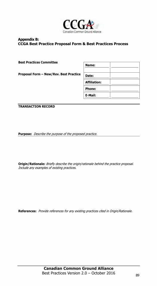
Canadian Common Ground Alliance
Best Practices Version 1.0 – October 2014
Appendix B: CCGA Best Practice Proposal Form & CCGA Best Practices Process; Flow Diagram
Best Practices Committee Proposal Form – New/Rev. Best Practice TRANSACTION RECORD
Purpose: Describe the purpose of the proposed practice.
Origin/Rationale: Briefly describe the origin/rationale behind the practice proposal. Include any examples of existing practices. References: Provide references for any existing practices cited in Origin/Rationale.
Name:
Date:
Affiliation:
Phone:
E-Mail:
Canadian Common Ground Alliance
Best Practices Version 1.0 – October 2014
88
98397_ORCGA_BestPract-TEXT-Oct2014.indd 88 16/10/14 9:42 AM
Canadian Common Ground Alliance
Best Practices Version 1.0 – October 2014
Appendix B: CCGA Best Practice Proposal Form & CCGA Best Practices Process; Flow Diagram
Best Practices Committee Proposal Form – New/Rev. Best Practice TRANSACTION RECORD
Purpose: Describe the purpose of the proposed practice.
Origin/Rationale: Briefly describe the origin/rationale behind the practice proposal. Include any examples of existing practices. References: Provide references for any existing practices cited in Origin/Rationale.
Name:
Date:
Affiliation:
Phone:
E-Mail:
Canadian Common Ground Alliance
Best Practices Version 1.0 – October 2014
89
Appendix B:CCGA Best Practice Proposal Form & Best Practices Process
Best Practices Committee
Proposal Form – New/Rev. Best Practice
TRANSACTION RECORD
Purpose: Describe the purpose of the proposed practice.
Origin/Rationale: Briefly describe the origin/rationale behind the practice proposal. Include any examples of existing practices.
References: Provide references for any existing practices cited in Origin/Rationale.
Name:
Date:
Affiliation:
Phone:
E-Mail:
Canadian Common Ground AllianceBest Practices Version 1.0 – September 2014
98397_ORCGA_BestPract-TEXT-Oct2014.indd 89 16/10/14 9:42 AM
Canadian Common Ground AllianceBest Practices Version 2.0 – October 2016 89
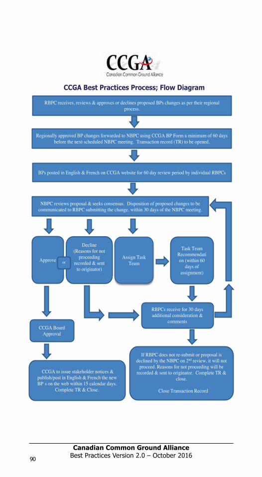
Canadian Common Ground Alliance
Best Practices Version 1.0 – October 2014
CCGA Best Practices Process; Flow Diagram
RBPC receives, reviews & approves or declines proposed BPs changes as per their regional process.
Regionally approved BP changes forwarded to NBPC using CCGA BP Form a minimum of 60 days before the next scheduled NBPC meeting.
Transaction record (TR) to be opened.
BPs posted in English & French on CCGA website for 60 day review period by individual RBPCs
NBPC reviews proposal & seeks consensus. Disposition of proposed changes to be communicated to RBPC submitting the change, within 30 days of the NBPC meeting.
Approve Decline
(Reasons for not
proceeding recorded &
sent to originator)
Assign Task Team
Task Team Recommendatio
n (within 60 days of
assignment)
CCGA Board Approval
RBPCs receive for 30 days additional consideration &
comments
or
90
CCGA Best Practices Process; Flow Diagram
RBPC receives, reviews & approves or declines proposed BPs changes as per their regional process.
Regionally approved BP changes forwarded to NBPC using CCGA BP Form a minimum of 60 days before the next scheduled NBPC meeting. Transaction record (TR) to be opened.
BPs posted in English & French on CCGA website for 60 day review period by individual RBPCs
NBPC reviews proposal & seeks consensus. Disposition of proposed changes to be communicated to RBPC submitting the change, within 30 days of the NBPC meeting.
Approve
Decline (Reasons for not
proceeding recorded & sent
to originator)
Assign Task Team
CCGA to issue stakeholder notices & publish/post in English & French the new BPÕs on the web within 15 calendar days.
Complete TR & Close.
Task TeamRecommendation (within 60
days of assignment)
CCGA Board Approval
RBPCs receive for 30 days additional consideration &
comments
If RBPC does not re-submit or proposal is declined by the NBPC on 2nd review, it will not
proceed. Reasons for not proceeding will be recorded & sent to originator. Complete TR &
close.
Close Transaction RecordA
or B
98397_ORCGA_BestPract-TEXT-Oct2014.indd 90 16/10/14 9:42 AM
Canadian Common Ground AllianceBest Practices Version 2.0 – October 201690
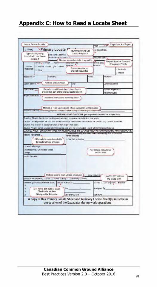
Canadian Common Ground Alliance
Best Practices Version 1.0 – October 2014
CCGA Best Practices Process; Flow Diagram
RBPC receives, reviews & approves or declines proposed BPs changes as per their regional process.
Regionally approved BP changes forwarded to NBPC using CCGA BP Form a minimum of 60 days before the next scheduled NBPC meeting.
Transaction record (TR) to be opened.
BPs posted in English & French on CCGA website for 60 day review period by individual RBPCs
NBPC reviews proposal & seeks consensus. Disposition of proposed changes to be communicated to RBPC submitting the change, within 30 days of the NBPC meeting.
Approve Decline
(Reasons for not
proceeding recorded &
sent to originator)
Assign Task Team
Task Team Recommendatio
n (within 60 days of
assignment)
CCGA Board Approval
RBPCs receive for 30 days additional consideration &
comments
or
90
CCGA Best Practices Process; Flow Diagram
RBPC receives, reviews & approves or declines proposed BPs changes as per their regional process.
Regionally approved BP changes forwarded to NBPC using CCGA BP Form a minimum of 60 days before the next scheduled NBPC meeting. Transaction record (TR) to be opened.
BPs posted in English & French on CCGA website for 60 day review period by individual RBPCs
NBPC reviews proposal & seeks consensus. Disposition of proposed changes to be communicated to RBPC submitting the change, within 30 days of the NBPC meeting.
Approve
Decline (Reasons for not
proceeding recorded & sent
to originator)
Assign Task Team
CCGA to issue stakeholder notices & publish/post in English & French the new BPÕs on the web within 15 calendar days.
Complete TR & Close.
Task TeamRecommendation (within 60
days of assignment)
CCGA Board Approval
RBPCs receive for 30 days additional consideration &
comments
If RBPC does not re-submit or proposal is declined by the NBPC on 2nd review, it will not
proceed. Reasons for not proceeding will be recorded & sent to originator. Complete TR &
close.
Close Transaction RecordA
or B
98397_ORCGA_BestPract-TEXT-Oct2014.indd 90 16/10/14 9:42 AM
Canadian Common Ground Alliance
Best Practices Version 1.0 – October 2014
CCGA Best Practices Process; Flow Diagram
RBPC receives, reviews & approves or declines proposed BPs changes as per their regional process.
Regionally approved BP changes forwarded to NBPC using CCGA BP Form a minimum of 60 days before the next scheduled NBPC meeting.
Transaction record (TR) to be opened.
BPs posted in English & French on CCGA website for 60 day review period by individual RBPCs
NBPC reviews proposal & seeks consensus. Disposition of proposed changes to be communicated to RBPC submitting the change, within 30 days of the NBPC meeting.
Approve Decline
(Reasons for not
proceeding recorded &
sent to originator)
Assign Task Team
Task Team Recommendatio
n (within 60 days of
assignment)
CCGA Board Approval
RBPCs receive for 30 days additional consideration &
comments
or
91
Canadian Common Ground Alliance
Best Practices Version 1.0 – October 2014
Appendix C: How to Read a Locate Sheet
Canadian Common Ground Alliance
Best Practices Version 1.0 – October 2014
Appendix C: How to Read a Locate Sheet
98397_ORCGA_BestPract-TEXT-Oct2014.indd 91 16/10/14 9:42 AM
Canadian Common Ground AllianceBest Practices Version 2.0 – October 2016 91

Canadian Common Ground Alliance
Best Practices Version 1.0 – October 2014
92
Canadian Common Ground Alliance
Best Practices Version 1.0 – October 2014
Appendix D: DIRT Field Form & Root Cause Tip Card
Canadian Common Ground Alliance
Best Practices Version 1.0 – October 2014
98397_ORCGA_BestPract-TEXT-Oct2014.indd 92 16/10/14 9:42 AM
Canadian Common Ground AllianceBest Practices Version 2.0 – October 201692

Canadian Common Ground Alliance
Best Practices Version 1.0 – October 2014
92
Canadian Common Ground Alliance
Best Practices Version 1.0 – October 2014
Appendix D: DIRT Field Form & Root Cause Tip Card
Canadian Common Ground Alliance
Best Practices Version 1.0 – October 2014
98397_ORCGA_BestPract-TEXT-Oct2014.indd 92 16/10/14 9:42 AM
93
Canadian Common Ground Alliance
Best Practices Version 1.0 – October 2014
Appendix D: DIRT Field Form & Root Cause Tip Card
93
Damage Information Reporting Tool (DIRT) Field Form
Electric Engineer/Design Equipment Manufacturer
Excavator Insurance Liquid Pipeline Locator Natural Gas OneCall Center Private Water Public Works Railroad Road Builders State Regulator Telecommunications Unknown/Other
:
(MM/DD/YYYY) Public: City Street State Highway County Road Interstate Highway PublicOther Private: Private Business Private Land Owner Private Easement Pipeline Power /Transmission Line Dedicated Public Utility Easement Federal Land Railroad Data not collected Unknown/Other
Cable Television Electric Natural Gas Liquid Pipeline Sewer (Sanitary Sewer) Steam Telecommunications Water Unknown/Other
Distribution Gathering Service/Drop Transmission Unknown/Other
Unknown Yes No
Unknown Yes No
Contractor County Developer Farmer Municipality Occupant Railroad State Utility Data not collected Unknown/Other
Auger Backhoe/Trackhoe Boring Drilling Directional Drilling Explosives Farm Equipment Grader/Scraper Hand Tools Milling Equipment Probing Device Trencher Vacuum Equipment Data Not Collected Unknown/Other
Agriculture Cable Television Curb/Sidewalk Bldg. Construction Bldg. Demolition Drainage Driveway Electric Engineering/Survey Fencing Grading Irrigation Landscaping Liquid Pipeline Milling Natural Gas Pole Public Transit Auth. Railroad Maint. Road Work Sewer (San/Storm) Site Development Steam Storm Drain/Culvert Street Light Telecommunication Traffic Signal Traffic Sign Water Waterway Improvement Data Not Collected Unknown/Other
Yes (If Yes, Part F is required) No (If No, Skip Part F) If Yes, which OneCall Center If Yes, please provide the ticket number
Utility Owner Contract Locator Data Not Collected Unknown/Other
Yes No Data Not Collected Unknown/Other
Yes No Data Not Collected Unknown/Other
Canadian Common Ground Alliance
Best Practices Version 1.0 – October 2014
98397_ORCGA_BestPract-TEXT-Oct2014.indd 93 16/10/14 9:42 AM
Canadian Common Ground AllianceBest Practices Version 2.0 – October 2016 93

Canadian Common Ground Alliance
Best Practices Version 1.0 – October 2014
Introduction The Canadian Common Ground Alliance (CCGA) is an organization promoting efficient and effective damage prevention for Canada’s vital underground infrastructure. Through a unified approach and stakeholder consensus, the CCGA works to reduce damages to underground infrastructure - ensuring public safety, environmental protection, and the integrity of services by promoting effective damage prevention practices.
We are a growing organization and through the Regional Partners of the Common Ground Alliance in Canada, we represent a wide cross-section of stakeholders including:
Electrical Distribution Land Surveying Railways
Electrical Transmission Landscape/Fencing Regulator
Engineering Locator Road Builders
Equipment & Suppliers Municipal & Public Works Safety Organization
Excavator Oil & Gas Distribution Telecommunications
Homebuilder One-Call Transmission Pipeline
Insurance
For over a decade these stakeholder groups have been active in promoting “Call Before You Dig” and other good damage prevention practices through provincial regional partnerships which have come together and amalgamated under the CCGA name to provide a single voice representing the damage prevention community in Canada. The CCGA is the common voice for damage prevention issues of a national scope.
The CCGA has produced National Harmonized Best Practices based on the Ontario Regional Common Ground Alliance Best Practices, version 8.0 and the product of a collaborative effort among all Regional Partners of the Common Ground Alliance in Canada. The CCGA also acknowledges the established Common Ground Alliance Best Practices (United States) initiated by the Common Ground Study and presented to the U.S. Secretary of Transportation in June 1999. This set of National Harmonized Best Practices 1.0 - 2014, is the first but, through the commitment and consensus of its members working together towards a safer Canada, will be part of an ongoing effort to develop new damage prevention practices as well as improve existing ones. These practices represent a dynamic statement of the type of activities that CCGA believes would provide optimum levels of diligence towards preventing damage to underground infrastructure. It is understood that not all stakeholders are presently in a position to adopt all of these practices, however, it is anticipated that progress will be made towards following these practices over time.
Comments and suggestions on improving the format and content are welcome. Our intent is to make the statement of these Best Practices as easy to use as possible. If we can improve upon what you see here, your input in helping us do so would be most appreciated. All industry stakeholders are welcome to submit suggestions and to join the Best Practice Committee.
94
Canadian Common Ground Alliance
Best Practices Version 1.0 – October 2014
Canadian Common Ground Alliance
Best Practices Version 1.0 – October 2014
Yes No
Unknown Less than 1 hour 1 hour 2 hours 3 or more hours Exact Value ______
Unknown $0 $1 to 500 $501 to 1,000 $1,001 to 2,500 $2,501 to 5,000 $5,001 to 25,000 $25,001 to 50,000 $50,001 and over Exact Value ______
Yes No (i.e. near miss)
Yes No Data Not Collected Unknown/Other
Unknown Less than 1 hour 1 to 2 hrs 2 to 4 hrs 4 to 8 hrs 8 to 12 hrs 12 to 24 hrs 1 to 2 days 2 to 3 days 3 or more days Data Not Collected Exact Value _______
Unknown 0 1 2 to 10 11 to 50 51 or more Exact Value _______
Unknown $0 $1 to 500 $501 to 1,000 $1,001 to 2,500 $2,501 to 5,000
$5,001 to 25,000 $25,001 to 50,000 $50,001 and over Exact Value ______
Unknown 0 1 2 to 9 10 to 19 20 to 49 50 to 99 100 or more Exact Value _______
Unknown 0 1 2 to 9 10 to 19 20 to 49 50 to 99 100 or more Exact Value _______
No notification made to the OneCall Center │ Facility could not be found or located Notification to onecall center made, but not sufficient │ Facility marking or location not sufficient Wrong information provided to One Call Center │ Facility was not located or marked
│ │ Incorrect facility records/maps │
Failure to maintain marks │ OneCall Center error Failure to support exposed facilities │ Abandoned facility Failure to use hand tools where required │ Deteriorated facility Failure to testhole (pothole) │ Previous damage Improper backfilling practices │ Data Not Collected Failure to maintain clearance │ Other Other insufficient excavation practices │
98397_ORCGA_BestPract-TEXT-Oct2014.indd 94 16/10/14 9:42 AM
Canadian Common Ground AllianceBest Practices Version 2.0 – October 201694

Canadian Common Ground Alliance
Best Practices Version 1.0 – October 2014
Introduction The Canadian Common Ground Alliance (CCGA) is an organization promoting efficient and effective damage prevention for Canada’s vital underground infrastructure. Through a unified approach and stakeholder consensus, the CCGA works to reduce damages to underground infrastructure - ensuring public safety, environmental protection, and the integrity of services by promoting effective damage prevention practices.
We are a growing organization and through the Regional Partners of the Common Ground Alliance in Canada, we represent a wide cross-section of stakeholders including:
Electrical Distribution Land Surveying Railways
Electrical Transmission Landscape/Fencing Regulator
Engineering Locator Road Builders
Equipment & Suppliers Municipal & Public Works Safety Organization
Excavator Oil & Gas Distribution Telecommunications
Homebuilder One-Call Transmission Pipeline
Insurance
For over a decade these stakeholder groups have been active in promoting “Call Before You Dig” and other good damage prevention practices through provincial regional partnerships which have come together and amalgamated under the CCGA name to provide a single voice representing the damage prevention community in Canada. The CCGA is the common voice for damage prevention issues of a national scope.
The CCGA has produced National Harmonized Best Practices based on the Ontario Regional Common Ground Alliance Best Practices, version 8.0 and the product of a collaborative effort among all Regional Partners of the Common Ground Alliance in Canada. The CCGA also acknowledges the established Common Ground Alliance Best Practices (United States) initiated by the Common Ground Study and presented to the U.S. Secretary of Transportation in June 1999. This set of National Harmonized Best Practices 1.0 - 2014, is the first but, through the commitment and consensus of its members working together towards a safer Canada, will be part of an ongoing effort to develop new damage prevention practices as well as improve existing ones. These practices represent a dynamic statement of the type of activities that CCGA believes would provide optimum levels of diligence towards preventing damage to underground infrastructure. It is understood that not all stakeholders are presently in a position to adopt all of these practices, however, it is anticipated that progress will be made towards following these practices over time.
Comments and suggestions on improving the format and content are welcome. Our intent is to make the statement of these Best Practices as easy to use as possible. If we can improve upon what you see here, your input in helping us do so would be most appreciated. All industry stakeholders are welcome to submit suggestions and to join the Best Practice Committee.
94
Canadian Common Ground Alliance
Best Practices Version 1.0 – October 2014
Canadian Common Ground Alliance
Best Practices Version 1.0 – October 2014
Yes No
Unknown Less than 1 hour 1 hour 2 hours 3 or more hours Exact Value ______
Unknown $0 $1 to 500 $501 to 1,000 $1,001 to 2,500 $2,501 to 5,000 $5,001 to 25,000 $25,001 to 50,000 $50,001 and over Exact Value ______
Yes No (i.e. near miss)
Yes No Data Not Collected Unknown/Other
Unknown Less than 1 hour 1 to 2 hrs 2 to 4 hrs 4 to 8 hrs 8 to 12 hrs 12 to 24 hrs 1 to 2 days 2 to 3 days 3 or more days Data Not Collected Exact Value _______
Unknown 0 1 2 to 10 11 to 50 51 or more Exact Value _______
Unknown $0 $1 to 500 $501 to 1,000 $1,001 to 2,500 $2,501 to 5,000
$5,001 to 25,000 $25,001 to 50,000 $50,001 and over Exact Value ______
Unknown 0 1 2 to 9 10 to 19 20 to 49 50 to 99 100 or more Exact Value _______
Unknown 0 1 2 to 9 10 to 19 20 to 49 50 to 99 100 or more Exact Value _______
No notification made to the OneCall Center │ Facility could not be found or located Notification to onecall center made, but not sufficient │ Facility marking or location not sufficient Wrong information provided to One Call Center │ Facility was not located or marked
│ │ Incorrect facility records/maps │
Failure to maintain marks │ OneCall Center error Failure to support exposed facilities │ Abandoned facility Failure to use hand tools where required │ Deteriorated facility Failure to testhole (pothole) │ Previous damage Improper backfilling practices │ Data Not Collected Failure to maintain clearance │ Other Other insufficient excavation practices │
98397_ORCGA_BestPract-TEXT-Oct2014.indd 94 16/10/14 9:42 AM
Canadian Common Ground Alliance
Best Practices Version 1.0 – October 2014
Introduction The Canadian Common Ground Alliance (CCGA) is an organization promoting efficient and effective damage prevention for Canada’s vital underground infrastructure. Through a unified approach and stakeholder consensus, the CCGA works to reduce damages to underground infrastructure - ensuring public safety, environmental protection, and the integrity of services by promoting effective damage prevention practices.
We are a growing organization and through the Regional Partners of the Common Ground Alliance in Canada, we represent a wide cross-section of stakeholders including:
Electrical Distribution Land Surveying Railways
Electrical Transmission Landscape/Fencing Regulator
Engineering Locator Road Builders
Equipment & Suppliers Municipal & Public Works Safety Organization
Excavator Oil & Gas Distribution Telecommunications
Homebuilder One-Call Transmission Pipeline
Insurance
For over a decade these stakeholder groups have been active in promoting “Call Before You Dig” and other good damage prevention practices through provincial regional partnerships which have come together and amalgamated under the CCGA name to provide a single voice representing the damage prevention community in Canada. The CCGA is the common voice for damage prevention issues of a national scope.
The CCGA has produced National Harmonized Best Practices based on the Ontario Regional Common Ground Alliance Best Practices, version 8.0 and the product of a collaborative effort among all Regional Partners of the Common Ground Alliance in Canada. The CCGA also acknowledges the established Common Ground Alliance Best Practices (United States) initiated by the Common Ground Study and presented to the U.S. Secretary of Transportation in June 1999. This set of National Harmonized Best Practices 1.0 - 2014, is the first but, through the commitment and consensus of its members working together towards a safer Canada, will be part of an ongoing effort to develop new damage prevention practices as well as improve existing ones. These practices represent a dynamic statement of the type of activities that CCGA believes would provide optimum levels of diligence towards preventing damage to underground infrastructure. It is understood that not all stakeholders are presently in a position to adopt all of these practices, however, it is anticipated that progress will be made towards following these practices over time.
Comments and suggestions on improving the format and content are welcome. Our intent is to make the statement of these Best Practices as easy to use as possible. If we can improve upon what you see here, your input in helping us do so would be most appreciated. All industry stakeholders are welcome to submit suggestions and to join the Best Practice Committee.
95
Canadian Common Ground Alliance
Best Practices Version 1.0 – October 2014
Canadian Common Ground Alliance
Best Practices Version 1.0 – October 2014
Root Cause Tip Card
LOCATING PRACTICES NOT SUFFICIENT
Type of facility or lack of records prevented locating of facility.
Example: Plastic pipelines installed without tracer wire.
Includes all areas where marking was insufficient.
Example: Locator marked the work zone, but missed a service.
Locator misread the ticket and did not locate the entire work zone.
Locator did not use records or interpreted the records incorrectly.
Locator did not tone correctly.
Facility was outside the tolerance zone.
No locating or marking was completed prior to excavation activities.
Example: The facility owner received a notification but did not markor locate.
Incorrect facility records or maps led to an incorrect locate.
Example: Records do not accurately reflect current plant status.
ONE-CALL NOTIFICATION PRACTICES NOT SUFFICIENT
Excavator did not call the One-Call Center.
The Excavator contacted the notification center, but did not provide
sufficient information, or the excavator did not provide sufficient notification
time according to requirements and guidelines.
Example: Excavator was excavating outside of the located area
Wrong information provided to theOne-Call Center
No notification made to theOne-Call Center
Incorrect facility records/maps
Facility was not located or marked
Facility marking or location notsufficient
Facility could not be found or located
Notification to One-Call Center made,but not sufficient
Damage occurred because an excavator provided the wrongexcavation information to the notification centre. Example: Excavator indicated the wrong dig site.
RootCauseTipCrd-Oct2014-2pg.pdf 1 03/10/14 11:05 AM
98397_ORCGA_BestPract-TEXT-Oct2014.indd 95 16/10/14 9:42 AM
Canadian Common Ground AllianceBest Practices Version 2.0 – October 2016 95

Canadian Common Ground Alliance
Best Practices Version 1.0 – October 2014
Sponsors to follow
Canadian Common Ground Alliance
Best Practices Version 1.0 – October 2014
96
Failure to maintain marks
Failure to support exposed facilities
Failure to use hand tools where required
Failure to test-hole (pot-hole)
Improper backfilling practices
Other insufficient excavation practices
EXCAVATION PRACTICES NOT SUFFICIENT
MISCELLANEOUS ROOT CAUSES
The marks deteriorated or were lost and the excavator failed to request that
they be restored/refreshed.
Facility damage due to lack of support in accordance with generally
accepted engineering practices or guidelines.
Failure to verify physical location of the facility when working within
tolerance zone as defined by accepted practices or guidelines.
Damage caused by improper materials (ex. Large/sharp rocks) in the
backfill or improper compaction of the backfill.
Excavator failed to maintain clearance (defined by applicable guidelines,law, and facility owners) from underground facilities when using power/mechanical equipment.
Excavator errors that do not fall under one of the above.
Abandoned facility
One-Call Centre error
Deteriorated facility
Previous damage
Data not collected
Includes all issues related to tticket transmission failures, et al.
he center such as incorrectly entered data,
Example: This would include damages that occurred because the center’s database registry had not been updated to reflect correct location of underground facilities.
Damage related to abandoned facilities. Select a more specific root cause. Example: The abandoned facility may have been located, instead of the
active facility. This does NOT include when an abandoned facility is thought to have been locted, but it is found to be active after the excavation exposed the facility or damaged it.
Those situations in which an excavation disrupts the soil around the facilityresulting in damage, failure or interruption of service. However, thedeterioration and not the excavation caused the facility damage.
Damage occurred during previous excavation. Example: Pipe coating was damaged during a previous excavation and
was not reported.
Damage occurred, but Root Cause was not identified.
Example: Damage Investigator did not indicate a Root Cause.
RootCauseTipCrd-Oct2014-2pg.pdf 2 03/10/14 11:05 AM
98397_ORCGA_BestPract-TEXT-Oct2014.indd 96 16/10/14 9:42 AM
Canadian Common Ground AllianceBest Practices Version 2.0 – October 201696

Canadian Common Ground Alliance
Best Practices Version 1.0 – October 2014
Sponsors to follow
Canadian Common Ground Alliance
Best Practices Version 1.0 – October 2014
96
Failure to maintain marks
Failure to support exposed facilities
Failure to use hand tools where required
Failure to test-hole (pot-hole)
Improper backfilling practices
Other insufficient excavation practices
EXCAVATION PRACTICES NOT SUFFICIENT
MISCELLANEOUS ROOT CAUSES
The marks deteriorated or were lost and the excavator failed to request that
they be restored/refreshed.
Facility damage due to lack of support in accordance with generally
accepted engineering practices or guidelines.
Failure to verify physical location of the facility when working within
tolerance zone as defined by accepted practices or guidelines.
Damage caused by improper materials (ex. Large/sharp rocks) in the
backfill or improper compaction of the backfill.
Excavator failed to maintain clearance (defined by applicable guidelines,law, and facility owners) from underground facilities when using power/mechanical equipment.
Excavator errors that do not fall under one of the above.
Abandoned facility
One-Call Centre error
Deteriorated facility
Previous damage
Data not collected
Includes all issues related to tticket transmission failures, et al.
he center such as incorrectly entered data,
Example: This would include damages that occurred because the center’s database registry had not been updated to reflect correct location of underground facilities.
Damage related to abandoned facilities. Select a more specific root cause. Example: The abandoned facility may have been located, instead of the
active facility. This does NOT include when an abandoned facility is thought to have been locted, but it is found to be active after the excavation exposed the facility or damaged it.
Those situations in which an excavation disrupts the soil around the facilityresulting in damage, failure or interruption of service. However, thedeterioration and not the excavation caused the facility damage.
Damage occurred during previous excavation. Example: Pipe coating was damaged during a previous excavation and
was not reported.
Damage occurred, but Root Cause was not identified.
Example: Damage Investigator did not indicate a Root Cause.
RootCauseTipCrd-Oct2014-2pg.pdf 2 03/10/14 11:05 AM
98397_ORCGA_BestPract-TEXT-Oct2014.indd 96 16/10/14 9:42 AM
Annexe E : Regional Common Ground Alliance Sponsors & Canadian Common Ground Alliance Supporters
Platinum
Gold
Silver
Bronze
Alberta
Atlantic
Canadian Common Ground Alliance
Best Practices Version 1.0 – October 2014
Sponsors to follow
Canadian Common Ground Alliance
Best Practices Version 1.0 – October 2014
97
GOLD
GOLD
SILVER
SILVER
BRONZE
BRONZE
aTlanTIC CGa
bRITIsH ColUMbIa CGa
albeRTa CGa
PLATINUM
PLATINUM
Appendix E: Regional Common Ground Alliance Sponsors & Canadian Common Ground Alliance Supporters
98397_ORCGA_BestPract-TEXT-Oct2014.indd 97 16/10/14 9:42 AM
Canadian Common Ground Alliance
Best Practices Version 1.0 – October 2014
Sponsors to follow
Canadian Common Ground Alliance
Best Practices Version 1.0 – October 2014
97
GOLD
GOLD
SILVER
SILVER
BRONZE
BRONZE
aTlanTIC CGa
bRITIsH ColUMbIa CGa
albeRTa CGa
PLATINUM
PLATINUM
Appendix E: Regional Common Ground Alliance Sponsors & Canadian Common Ground Alliance Supporters
98397_ORCGA_BestPract-TEXT-Oct2014.indd 97 16/10/14 9:42 AM
Canadian Common Ground AllianceBest Practices Version 2.0 – October 2016 97

Platinum
Gold
Silver
Bronze
British Columbia
Canadian Common Ground AllianceBest Practices Version 2.0 – October 201698

Gold
Silver
Bronze
Ontario
Canadian Common Ground AllianceBest Practices Version 2.0 – October 2016 99
Gold
Silver
Bronze
Quebec
Canadian Common Ground AllianceBest Practices Version 2.0 – October 2016100

Canadian Common Ground Alliance
Best Practices Version 1.0 – October 2014
Sponsors to follow
99
Canadian Common Ground Alliance
Best Practices Version 1.0 – October 2014
Sponsors to follow
GOLD
GOLD
SILVER
SILVER
BRONZE
BRONZE
sasKaTCHeWan CGa
QUebeC CGa
ManIToba CGa
98397_ORCGA_BestPract-TEXT-Oct2014.indd 99 16/10/14 9:42 AM
Canadian Common Ground Alliance
Best Practices Version 1.0 – October 2014
Sponsors to follow
99
Canadian Common Ground Alliance
Best Practices Version 1.0 – October 2014
Sponsors to follow
GOLD
GOLD
SILVER
SILVER
BRONZE
BRONZE
sasKaTCHeWan CGa
QUebeC CGa
ManIToba CGa
98397_ORCGA_BestPract-TEXT-Oct2014.indd 99 16/10/14 9:42 AM
Gold
Silver
Bronze
Manitoba
Saskatchewan
100
Canadian Common Ground Alliance
Best Practices Version 1.0 – October 2014
Baspaly, David British Columbia Common Ground Alliance (BCCGA) Chair CCGA Executive Committee
Moreau, Nathalie
Info-Excavation L’Alliance pour la protection des infrastructures souterraines du Québec (APISQ)
Vice-Chair CCGA Executive Committee
Saedal, Derrick Public Works Department - City of Winnipeg & Manitoba Common Ground Alliance (MCGA)
Treasurer CCGA Executive Committee
Sullivan, Michael Alberta One Call (AOC) & Canadian Common Ground Alliance (CCGA) President
Douglas, Jim Ontario Regional Common Ground Alliance (ORCGA) Secretary CCGA Executive Committee
Tweedie, James Canadian Gas Association Past Chair CCGA Executive Committee
Bellissimo, Vince Canadian Construction Association Director
Bradley, Francis Canadian Electricity Association Director
Doyle, Mike Canadian Association of Geophysical Contractors Director
Durnie, Darwin Canadian Public Works Association Director
Ferguson, Travis Canadian Association of Petroleum Producers Director
Kirk, Sher Canadian One-Call Centres Committee Director
Loney, Steven TransCanada & Manitoba Common Ground Alliance (MCGA) Director
Pacheco, Elaine Canadian Energy Pipeline Association Director
Palaniuk, Randy Canadian Association of Pipeline & Utility Locating Contractors Director
Posehn, Daryl Saskatchewan Common Ground Alliance (SCGA) Director
Ramor, Brian Canadian Nursery and Landscape Association Director
Reeve, Dean SaskEnergy Incorporated & Saskatchewan Common Ground Alliance (SCGA) Director
Scott, Todd Enbridge Gas New Brunswick & Atlantic Canada Common Ground Alliance (ATLCGA) Director
Watson, Brad TransCanada & Alberta Common Ground Alliance (ABCGA) Director
Neufeld, Shannon National Energy Board Federal Champion
BoardOfDirectPage.indd 1 08/10/14 12:31 PM
CanaDIan CGa sUPPoRTeRs
2014 Board of Directors
98397_ORCGA_BestPract-TEXT-Oct2014.indd 100 16/10/14 9:42 AM
Canadian CGA Supporters
Canadian Common Ground AllianceBest Practices Version 2.0 – October 2016 101

CCGA 2016 Board of Directors
Moreau, Nathalie Info-Excavation (Québec CGA)
Chair 2016-2017 Executive Committee
Baspaly, David British Columbia Common Ground Alliance (BCCGA)
Past Chair 2014-2015 Executive Committee
Reeve, Dean ATCO Pipelines & Liquids Global Business Unit
Vice-Chair Executive Committee
Ferguson, Travis Canadian Association of Petroleum Producers (CAPP)
Treasurer Executive Committee
Scott, ToddEnbridge Gas New Brunswick & Atlantic Canada Common Ground Alliance
Secretary Executive Committee
Sullivan, Michael Canadian Common Ground Alliance (CCGA) President
Tweedie, James Canadian Gas Association Director 2013 Past Chair
Saedal, Derrick Public Works Department City of Winnipeg Director
Munro, Ian Ontario Regional Common Ground Alliance (ORCGA) Director
Loney, Steven TransCanada Corporation & Manitoba Common Ground Alliance Director
Bakker, Dylan Saskatchewan Common Ground Alliance (SCGA) Director
Wilson, Luis Saskatchewan Common Ground Alliance (SCGA) Director
Watson, Brad Alberta Common Ground Alliance (ABCGA) Director
Kirk, Sher Canadian One-Call Centres Committee Director
Smyth, Patrick Canadian Energy Pipeline Association Director
Neufeld, Shannon National Energy Board Federal Champion
Doyle, Mike Canadian Association of Geophysical Contractors Director
Durnie, Darwin American Public Works Association Director
Ramor, Brian Canadian Nursery and Landscape Association Director
Palaniuk, Randy Canadian Association of Pipeline & Utility Locating Contractors Director
Bradley, Francis Canadian Electricity Association Director
Elliott, Leslie North American Telecommunications Damage Prevention Council Director
Bellissimo, Vince Canadian Construction Association (CCA) Director
Peterson, Tanis The Railway Association of Canada Director
Kraayenbrink, Rick The Canadian Association of Energy Pipeline Landowner Associations Director
Tetreault, Michelle Alberta Common Ground Alliance (ABCGA) Director
Canadian Common Ground AllianceBest Practices Version 2.0 – October 2016102

100
Canadian Common Ground Alliance
Best Practices Version 1.0 – October 2014
Baspaly, David British Columbia Common Ground Alliance (BCCGA) Chair CCGA Executive Committee
Moreau, Nathalie
Info-Excavation L’Alliance pour la protection des infrastructures souterraines du Québec (APISQ)
Vice-Chair CCGA Executive Committee
Saedal, Derrick Public Works Department - City of Winnipeg & Manitoba Common Ground Alliance (MCGA)
Treasurer CCGA Executive Committee
Sullivan, Michael Alberta One Call (AOC) & Canadian Common Ground Alliance (CCGA) President
Douglas, Jim Ontario Regional Common Ground Alliance (ORCGA) Secretary CCGA Executive Committee
Tweedie, James Canadian Gas Association Past Chair CCGA Executive Committee
Bellissimo, Vince Canadian Construction Association Director
Bradley, Francis Canadian Electricity Association Director
Doyle, Mike Canadian Association of Geophysical Contractors Director
Durnie, Darwin Canadian Public Works Association Director
Ferguson, Travis Canadian Association of Petroleum Producers Director
Kirk, Sher Canadian One-Call Centres Committee Director
Loney, Steven TransCanada & Manitoba Common Ground Alliance (MCGA) Director
Pacheco, Elaine Canadian Energy Pipeline Association Director
Palaniuk, Randy Canadian Association of Pipeline & Utility Locating Contractors Director
Posehn, Daryl Saskatchewan Common Ground Alliance (SCGA) Director
Ramor, Brian Canadian Nursery and Landscape Association Director
Reeve, Dean SaskEnergy Incorporated & Saskatchewan Common Ground Alliance (SCGA) Director
Scott, Todd Enbridge Gas New Brunswick & Atlantic Canada Common Ground Alliance (ATLCGA) Director
Watson, Brad TransCanada & Alberta Common Ground Alliance (ABCGA) Director
Neufeld, Shannon National Energy Board Federal Champion
BoardOfDirectPage.indd 1 08/10/14 12:31 PM
CanaDIan CGa sUPPoRTeRs
2014 Board of Directors
98397_ORCGA_BestPract-TEXT-Oct2014.indd 100 16/10/14 9:42 AM