Embed Size (px)
Citation preview

CAMPBELL HEIGHTS
LOCAL AREA PLAN REVIEW
APPROVED BY CITY COUNCIL ON
SURREY DECEMBER 11, 2000 CITY OF PARKS
u----
PLEASE NOTE:
The City of Surrey does not warrant the accuracy or completeness of the information contained in this document or any use of this document by the user. The information contained in this document is relevant only to the date of first printing and may not incorporate subsequent amendments. It is the responsibility of the user of this document to contact the Planning & Development Department regarding any amendments pertaining to this document.
Campbell Heights - Local Area Plan Review
This is a consolidated document including the following reports:
1. Campbell Heights Local Area Plan Review, Surrey Planning &
Development Department, October 2000.
2. Campbell Heights - Local Area Plan Review, Corporate Report No. CO 18, from General Manager, Planning & Development and Considered by City Council on December 11, 2000.
3. Synopsis of Engineering Servicing and Financing Issues for the Campbell
Heights Industrial Area, Based on Corporate Report No. C017 fromGeneral Manager, Engineering and Considered by City Council on December 11, 2000.
4. Campbell Heights Servicing Study Executive Summary Report, New East . Consulting Services Ltd., July 2000.
5. Extract of Minutes of Regular Council Meeting on December 11, 2000.
Note:
The City of Surrey does not warrant the accuracy or completeness of the information contained in this document or any use of this document by the user. The information contained in this document is relevant only to the date of first printing and may not incorporate subsequent amendments. It is the responsibility of the user of this document to contact the Planning & Development Department regarding any amendments pertaining to this document.
- - -------------------------------
Campbell Heights - Local Area Plan Review
TABLE OF CONTENTS
1. I NTRODUCTI 0 N....................................................................................1
2. OBJECTIVES OF THE LOCAL AREA PLAN REVIEW ...............................5
3. LOCAL AREA PLAN REVIEW PROCESS.............................................. 5
4. PLAN N I N G 0 BJ E CTIVES ................................................................ 7
5. PLANNING OPPORTUNITIES AND CONSTRAINTS .............................. 8
5.1 The Plan Area.............................................................................................. 8
5.2 Plan n i ng Opportunities ....................................................................................1 0
5.3 PI an n i ng Constraints... ................................................................................. 14
6. PLAN AND POLICIES.....................................................................................14
6.1 Econom ic Pol icies .. .........................................................................................15
6.1.1 Economic Development Objectives........................................................15 6.1.2 Economic and Market Analysis..............................................................15 6.1.3 Federal Government, Province and City as Catalysts ............................17
6.2. Land Use Policies ...............................................................................................17
6.2.1 Technology Park .....................................................................................176.2.2 Business Park and Office Development..................................................19 6.2.3 Business Park or Live/Work . .................................................................20 6.2.4 Commercial and Retail Services .............................................................20 6.2.5 Child Care Facilities ...............................................................................21 6.2.6 Interface with Adjacent Agricultural Designated Lands
and Residential Areas .............................................................................21 6.2.7 Residential Areas Outside Campbell Heights.........................................23 6.2.8 Other Community Services.....................................................................23
6.3 Environmental Policies .......................................................................................25
6.3.1 Watercourses.......................................................................................... 25 6.3.2 Other Environmentally Sensitive Areas................................................. 28
11 City of Surrey Planning & Development Department October 2000

Campbell Heights - Local Area Plan Review
6.4 Parks and Recreation Policies .............................................................. 29
6.4.1 Public Parks .......................................................................................... 30 6.4.2 Other Recreational Facilities ................................................................. 30
6.5 Development Policies ....................................................................................... 31
6.5.1 Design Guidelines ........................... ".................................................... 31 6.5.2 Amenity Contributions. ............................................. ,........................... 44 6.5.3 Land Use Patterns in Transition............................................................46 6.5.4 Soil Salvage ..........................................................................................46
6.6 Circulation Pol icies.......................................................................................... 46
6.6.1 Major Road Network ............................................................................. 46 6.6.2 Walking and Cycling Pathway System .................................................. 47 6.6.3 Public Transit ........................................................................................ 47
7. SERVICING PLAN, PHASING PLAN AND FINANCING OPTIONS ...... 48
8. EM P LO YM E NT ................................................................................ 48
9. PLAN IMPLEMENTATION..................................................................... 48
9.1 Zoning By-law Amendments ............................................................................. 48
9.2 Technology Park Zone ....................................................................................... 48
9.3 Pre-zon i ng ........................................................................................................ 49
9.4 Policies and Design Guidelines.......................................................................... 49
9.5 Official Community Plan Amendments ............................................................. 50
9.6 Marketing Directions and Initiatives .................................................................50
10. CO N CLUSION ... ................................................................................. 52
City of Surrey Planning & Development Department
October 2000
III

Campbell Heights - Local Area Plan Review
FIGURES AND TABLES
Figure 1 Official Community Plan Designations and Agricultural Land Reserve Boundaries......................................... ,........................................2
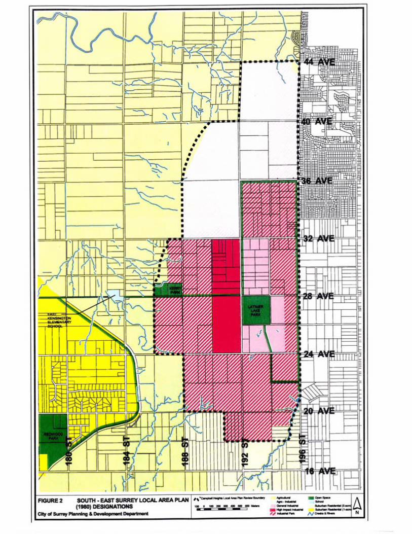
Figure 2 South-East Surrey Local Area Plan (1980) Designations....................... 3
Figure 3 Zoning Map............................................................................................. 4
Figure 4 Local Area Plan Review Process ....................... , ............................................. 6
Figure 5 Campbell Heights and its Regional Context ........................................... 9
Figure 6 Campbell Heights and its Natural Amenities ........................................ 11
Figure "7 Campbell Heights Land Ownership ........................................................................................ , .... 12
Figure 8 Existing Land Uses in Campbell Heights.................... " ..................................... 13
Figure 9 Campbell Heights Land Use Concept Plan .......................................... 18
Figure 10 Interface with Residential Areas along 196 Street................................ 22
Figure 11 Campbell Heights High Environmentally Sensitive Areas .................... 26
Figure 12 Proposed Official Community Plan Amendments................................. 51
Table 1 Land Area, Projected Floor Area, Projected No. of Live/Work Units and Employment Estimates by Land Use Designation ............... 24
Table 2 Amenity Contributions by Land Use Category '"'''''''''''''''''''''''''''''''''' 45
City of Surrey Planning & Development Department
October 2000
IV
CAMPBELL HEIGHTS - LOCAL AREA PLAN REVIEW
1. INTRODUCTION
The Campbell Heights area comprises about 798 hectares (1,971 acres) of land in the south-east part of Surrey. It is located south of 44 Avenue, east of 186 Street, north of 18 Avenue, and west of the Surrey/Langley border along 196 Street. The area lies outside the Agricultural Land Reserve (Figure 1).
The area is designated Industrial, except for some lands at the periphery which are designated Agricultural, in the Official Community Plan (Figure 1). The Industrial designation for most properties in the area has been in place since 1966 when the Surrey Official Community Plan By-law No. 2465 was adopted.
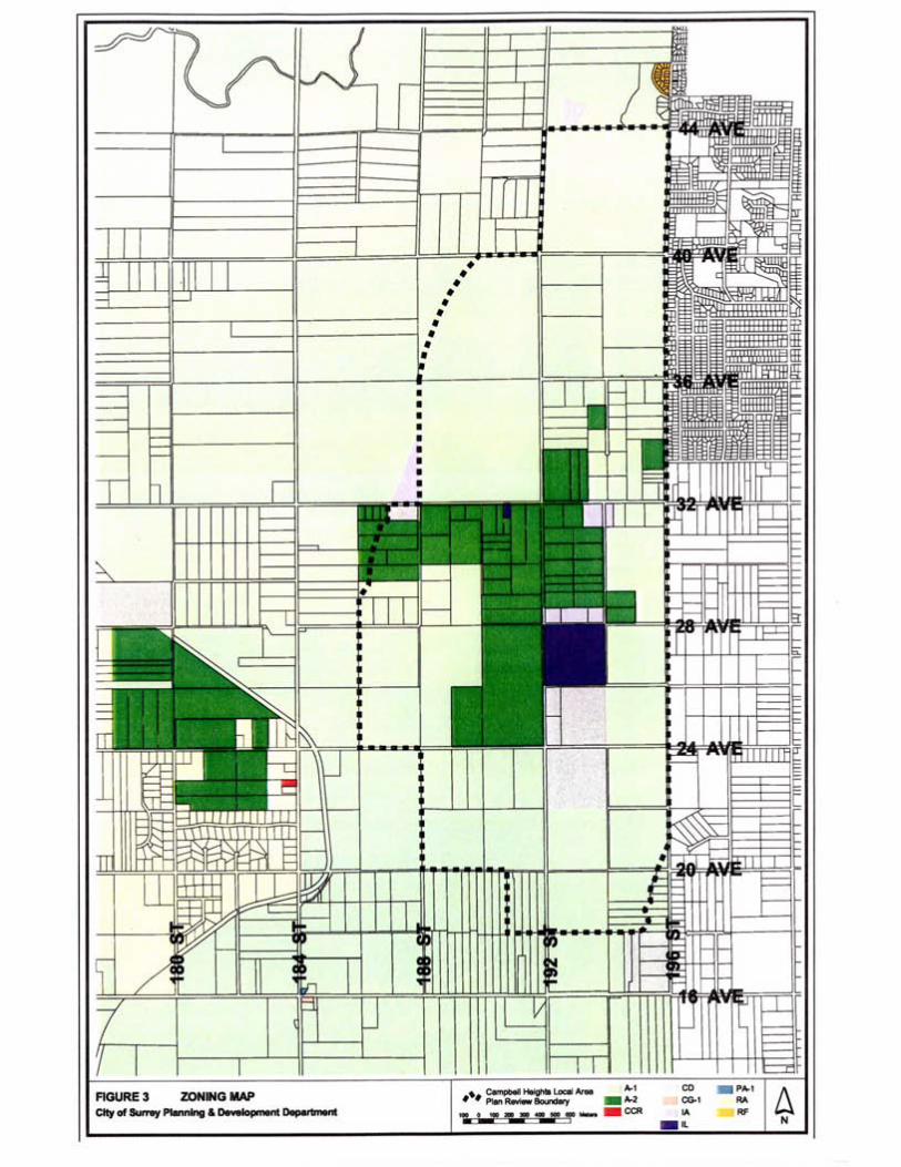
The Campbell Heights area is covered by the South-East Surrey Local Area Plan which was prepared in 1980. The Plan envisages business park and industrial development in this area to provide employment opportunities for the growing workforce. The Plan designates the centre ofthe area for high-impact industrial development, surrounded by general industrial uses to the east, agro-industrial enterprises to the north, and industrial parks in the remaining area (Figure 2). The great majority of the land in the area is still zoned General Agriculture (A-1) and Intensive Agriculture (A-2) (Figure 3). Industrial development has not taken place mainly due to a lack of engineering services.
The South-East Surrey Plan was formulated twenty years ago. With the rapid development of the City in the past ten years and the recent interest in business development catering to high-tech industries in Campbell Heights, it is considered appropriate to review the local area planning policies and land use concept for the area to reflect the present economic trends and to meet the economic development objectives of the City.
City of Surrey Planning & Development Department
October 2000


Campbell Heights - Local Area Plan Review
2. OBJECTIVES OF THE LOCAL AREA PLAN REVIEW
The objectives of the Local Area Plan Review for Campbell Heights are:
1. To review and refine land use, economic and other development policies for the area so as to position it favourably in the global market for the promotion and attraction of high-tech businesses;
2. To formulate a land use concept plan in parallel with a servicing strategy, including a major road layout, a phasing plan and financing options;
3. To identify environmentally sensitive areas for protection; and
4. To prepare design guidelines including measures to provide an appropriate interface with adjacent land uses such as the Agricultural Land Reserve and current and proposed land uses in Langley Township immediately to the east.
3. LOCAL AREA PLAN REVIEW PROCESS
The Local Area Plan Review was undertaken by the Planning & Development Department, the Engineering Department and an Engineering Consultant. The process which commenced in January 2000 is illustrated in Figure 4.
To facilitate departmental consultation, an inter-agency working group was formed to discuss issues and provide input on plan options. The participating agencies included Industry Canada, Public Works and Government Services Canada, B.C. Assets and Land Corporation, Ministry of Forests, Land Reserve Commission, B.C. Hydro, Ministry ofTransportation and Highways, Greater Vancouver Regional District, Township of Langley Planning & Development Department, Surrey Parks, Recreation & Culture, Engineering, Fire, and Planning & Development Departments, and Surrey Economic Development Office. A total of 4 working group meetings were held between February and June 2000. Representatives from the development industry and Campbell Heights Properties Ltd. (Operating Engineers Realty), a private landowner in the area, were also invited to the meetings.
In addition, meetings were held with the Ministry of Environment, the Department of Fisheries and Oceans and the School District to obtain their input.
The preliminary land use concept plan was also referred to the City's Agricultural Advisory Committee for comment in March 2000.
City of Surrey Planning & Development Department
October 2000
5

----------
Campbell Heights - Local Area Plan Review
Two public open houses were held on February 17 and April 27, 2000 respectively to present information and receive community input. The public open houses were accompanied by questionnaire surveys to identify issues and solicit feedback. Both open houses were attended by over 200 residents from Surrey and Langley. A total of 72 residents responded to the first open house survey and 96 residents to the second open house survey. Comments from residents were also received through their written submissions, and telephone discussions and meetings with -staff. All input from the public was reviewed and considered carefully in the planning process, from identification of area issues, concerns, planning opportunities and constraints, through formulation of planning objectives, to evaluation of plan options and finalization of the land use concept plan.
To ensure the Local Area Plan for Campbell Heights would respond to the needs of the market, an economic and market analysis on the global, regional and local economic trends and investment market was carried out by an economic consultant to provide input to the planning process from a market perspective.
4. PLANNING OBJECTIVES
Building on the potential of Campbell Heights, the following planning objectives have been established:
. To increase the supply of serviced industrial land in the City;
. To create job opportunities for the growing workforce;
. To provide opportunities for a variety of business activities, ranging from high-tech and science-based industries, research and development activities, support industries and services, offices, to light impact industrial and warehouse uses;
. To provide adequate support services such as local commercial, recreational, accommodation and child care services to cater to the needs of the working population;
. To manage growth and to ensure adequate provision of services and facilities for development;
. To promote compatible and cohesive development in the area and high quality design with extensive green space;
. To provide an appropriate interface with adjacent residential and agricultural uses;
City of Surrey Planning & Development Department
October 2000
7

Campbell Heights - Local Area Plan Review
. To preserve and enhance the environmentally sensitive areas including
significant creeks and forested areas;
. To promote energy efficient and environmentally sensitive developments by applying sustainable development principles;
. To improve accessibility and the road network, and provide alternative modes of transportation, including walking and cycling; and
. To plan for adequate provision of services to meet the demand oftechnology and business park and other light industrial developments by determining servicing requirements for water, sanitary sewer, storm sewer, drainage facilities, other major utility infrastructure and roads, and staging and financing of service provision.
5. PLANNING OPPORTUNITIES AND CONSTRAINTS
5.1 The Plan Area
Since 1966 the City has retained the Industrial designation of the Campbell Heights area, and has kept it in the industrial land bank which is to be put into use to support the economic development of the City.
Located in the south-eastern part of Surrey, Campbell Heights comprises about 798 hectares (1,971 acres) of land encompassing 130 properties. It is endowed with many features which give it uniqueness in character and potential.
Centrally located in the Greater Vancouver Region, Surrey, being one ofthe largest and fastest growing cities, shares many of the locational and business advantages offered by the Region as an international trade centre (Figure 5). Surrey has good access to the international and regional transportation networks, including the Vancouver International Airport, secondary airports at Boundary Bay and Abbotsford, port facilities, ferries, rails, highways, roads and telecommunication systems. Campbell Heights is located within a short distance from the United States border which is significant in trade relationships and skill exchanges. In addition to University of British Columbia, Simon Fraser University and British Columbia Institute of Technology, Technical University of British Columbia, Kwantlen University College and Trinity Western University which are located in close proximity to Campbell Heights provide the necessary resources in research activities and higher education and training to a highly qualified workforce. Similar to the Greater Vancouver Region, Surrey is home to a dynamic multi-cultural population, enjoying a quality lifestyle. Amenities in Surrey include an abundance of parks, some of the Region's best golf courses, ocean
City of Surrey Planning & Development Department
October 2000
8


p ---------------------- -- ---
Campbell Heights - Local Area Plan Review
beaches, rivers, conservation areas, heritage and vibrant town centres indifferent parts of the City.
Campbell Heights is situated on a plateau at elevations between 40 and 50 metres geodetic, with a ridge descending to the lowland in the northwest, and commanding a mountain and pasture view in this direction. It offers a number of amenities including rivers and creeks at the periphery, severalwooded areas, and Latimer Lake which is popular for outdoorrecreation and particularly fishing, all of which contribute toCampbell Heights' natural beauty (Figure 6).
About 32% of the land (247 hectares or 610 acres) in Campbell Heights is owned by the City. The Provincial and the Federal Governments own about 15% (115 hectares or 284 acres) and 16% (120 hectares or 297 acres) of the land respectively. The remaining 37% (280 hectares or 693 acres) of the land is privately owned. Campbell Heights Properties Ltd. (Operating Engineers Realty) is a major stakeholder in the area, having in their ownership about one-third of the privately owned land (Figure 7).
Industrial development has not taken place in the area mainly due to a lack of services. The existing major land uses include the Provincial tree nursery operation, potato and carrot farms, turkey farms, chicken farms, mink farms, cold storage and gravel extraction (Figure 8). Other private businesses include automotive services, greenhouses, nurseries, kennels, building supplies, wood waste and recycling.
While Campbell Heights is located outside the Agricultural Land Reserve, it is bounded to the north and west by wooded areas and agricultural land in the Reserve. Immediately adjacent to Campbell Heights, on the west side of 192 Street north of 40 Avenue are two subdivisions which have a total of nine 2-hectare (5-acre) lots and very high quality houses built on some of the lots. To the south of Campbell Heights is a rural community comprised of residential uses, care facilities and agricultural operations. Beyond the eastern boundary of Campbell Heights (Le. 196 Street) is the Brookswood/Fernridge urban area of the Township of Langley, with commercial nodes on 200 Street at 24 Avenue, 32 Avenue and 40 Avenue.
5.2 Planning Opportunities
The planning opportunities that Campbell Heights offers include the following:
. Well-defined industrial area as designated in the Official Community Plan and Local Area Plan;
. Availability of large tracts of land under single ownership, thus facilitating development, especially that which requires a sizable land area, and minimizing the time taken to assemble land;
City of Surrey Planning & Development Department
October 2000
10


Campbell Heights - Local Area Plan Review
. Fairly level ground surface, except the slopes along the western ridge which provide an effective buffer from the adjacent agricultural land;
. Existing natural amenities including the wooded areas, Campbell River, Anderson Creek and other watercourses which provide habitat for a variety of wildlife species;
. Existing open space such as Latimer Lake which is a recreational amenity in the area; Accessibility to regional transportation networks, such as Highway 99, Highway 1, and Vancouver International Airport, which enhances inter- regional and international trading opportunities; Proximity to urban areas where retail services and housing are available, in addition to those available in Surrey.
5.3 Planning Constraints
On the other hand, the Local Area Plan Review must address the following planning constraints:
. Providing engineering services infrastructure; Potential conflicts between new business park development and established farming operations in the area;
. Retention of new and well maintained single family houses constructed at sporadic locations within the area;
. Interface and buffering requirements from adjacent residential areas and the Agricultural Land Reserve; Uncertainty related to the timing and location of the future Highway 1 -Highway 99 Connector which may impact vibration-sensitive industries;
.
. Existence of environmentally sensitive features requiring protection; andGroundwater table problems in some areas which may not be suitable for certain types of development.
6. PLAN AND POLICIES
Aiming at achieving the planning objectives, taking advantage of the planning
opportunities while addressing the constraints of the area, a local area plan which
incorporates a land use concept plan and related policies has been formulated for
Campbell Heights.
City of Surrey Planning & Development Department
October 2000
14

Campbell Heights - Local Area Plan Review
6.1 Economic Policies
6.1.1 Economic Development Objectives
The Local Area Plan for Campbell Heights responds to the following directives of the Official Community Plan and the Economic Action Plan of the City:
. Manage growth for orderly and economic development; Create
. jobs for local residents;
. Provide opportunities for a variety of business and employment activities;
. Increase the tax base related to industrial development;
. Improve the City's business attractiveness and its regional, national and global competitiveness;
. Facilitate business development and investment; and
. Take a proactive approach by making land available in the City so that the City is able to quickly respond to the economic trend, future demand, and changing market conditions.
By laying out the planning principles, land use designations, development policies and guidelines, servicing concepts, and marketing strategies, the Local Area Plan provides directions and a framework for development to take place in Campbell Heights while meeting the above-noted objectives.
6.1.2 Economic and Market Analysis
To ensure that the Local Area Plan will meet the needs of the market, a consultant was retained to carry out an economic analysis on the global, regional and local economic trends and investment market to provide input from a market and investment perspective. The major findings and conclusions of the economic and market analysis are summarized below:
1. To accelerate growth and development, Campbell Heights is recommended:
(a) To take the role of a knowledge-based technology park, enhanced by effective marketing. By definition, a knowledge-based technology park does the following:
. Affiliates with higher education institutions either through partnership, ownership or management to create and maintain the "knowledge base";
. Promotes research and development through institutional-industrial partnerships, and stimulates growth of new ventures;
City of Surrey Planning & Development Department
October 2000
15

Campbell Heights - Local Area Plan Review
. Facilitates the transfer of technology and business skills between institutions and industrial tenants; and Drives
. technology-led economic development for the community.
(b) To target business sectors with high growth rates in the global market place. These sectors, which typically have a high level of research and development activities, include:
. Semiconductor fabrication and electronic equipment manufacturing;
. Information technology, software and telecommunications, and particularly applications in aerial surveying and the internet;
. Biotechnology including health care and biomedical services and manufacturing, agro-biotechnology, marine pharmaceuticals, and bioinformatics.
(c) To pursue large-scale inward investment projects. The ability of Campbell Heights to offer large sites for these projects is a major advantage.
(d) To capture cross-border businesses which require input from and/or distribute output to the US. Given its proximity to the US border, Campbell Heights may potentially become a reverse labour pool from the Seattle region.
(e) To provide new start initiatives to encourage the growth ofindigenous technology companies, taking advantage of the potential of Tech BC as an incubator.
(f) To launch an aggressive marketing program carefully planned out, and based on a master development plan with dedicated marketing staff and resources.
2. While pursuing a technology park focus, the land use plan ofCampbell Heights should allow sufficient diversity of high-tech, research, office and light industrial uses, and provide resortlike amenities including a hotel/conference centre, an attractive commercial village and fitness and recreational facilities.
A number of ~arketing-related initiatives that need to be addressed before a full marketing program is designed for Campbell Heights are discussed in Section 9.6 of this report.
City of Surrey Planning & Development Department
October 2000
16
Campbell Heights - Local Area Plan Review
6.1.3 Federal Government, Province and City as Catalysts
The economic and market analysis mentioned above also concludes that improved access and servicing are required to increase the attractiveness and competitiveness of Campbell Heights for technology and business park development. But costly infrastructure installation is not recommended prior to eithersecuring a major tenant or designing a master development plan. It is considered extremely important, however, to have sufficient commitment from the Federal and Provincial Governments and any other parties involved to support the infrastructure development as soon as a major tenant is identified.
In order to ensure that infrastructure installation can commence as soon as an anchor tenant is secured and take place in tandem with the construction schedule of the tenant, all design work for the first phase infrastructure will be completed in advance.
In addition to infrastructure development, there are otheropportunities for the City, the Province and the Federal Government, as major landowners in the area, to act as catalysts in the development of Campbell Heights. By providing lands fortechnology and business park development, by attracting investments, and by facilitating the development application review process, the three levels of the Government can achieve the widereconomic development objectives which they share among themselves.
6.2. Land Use Pol icies
The Land Use Concept Plan which has been formulated for the Campbell Heights area is provided in Figure 9.
6.2.1 Technology Park (276.9 hectares/684 acres)
Three Technology Park sites have been identified on the Land Use Concept Plan (Figure 9). These sites, ranging from 80 hectares (198 acres) to 101 hectares (249 acres) are particularly favourable for large anchor tenants such as a semiconductor plant which requires a 200-acre site or a research park housing singlestorey laboratories and other low-rise buildings. A medium scale (at least 16-hectare or 40-acre) single-tenant or multi-tenant technology park development under a comprehensive design may also be located on a Technology Park designated site.
Technology Park uses are high technology, science-based industries and industries with a significant research and
City of Surrey Planning & Development Department
October 2000
17

Campbell Heights - Local Area Plan Review
development component which are carried out in a campus-like setting. Examples are the development and production of computerhardware and software, design and production of electronic and communication equipment and similar products, development and production of pharmaceuticals and medical devices, biotechnology and biomedical industries. Many Technology Park uses have specific site requirements such as low vibration levels, high airquality, and a reliable water and electricity supply. For example, the manufacturing of micro electronic components, precision instruments and medical devices typically requires an ultra-clean and vibration-free environment.
Two Technology Park sites are located in the northern part ofCampbell Heights. The site on the west side of 192 Street is solelyowned by the Province and is 95 hectares (234 acres) in size. The site on the east side of 192 Street is 101 hectares (249 acres) in size and is mostly owned by the Federal Government while the City owns about 8 hectares (20 acres) of the land. The third site is 80 hectares (198 acres) in size and is partly owned by City (about one-third) and partly held by the Operating Engineers, a majorlandowner in the area (about two-thirds). Working together, the three levels of Government play a very important role in managing and providing direction in the development of Campbell Heights.
One of the economic challenges is to respond to changing market conditions quickly and to always be prepared to meet future demands. To achieve this economic objective, flexibility has been built into the Land Use Concept Plan.
Two of the three Technology Park sites are provided with the flexibility to be developed for business park uses so as to allow fora change in target industries and the associated site requirements without an amendment to the Local Area Plan. This flexibility is particularly important as the Local Area Plan is a long-term plan and it is projected to take more than 40 years to build out the Campbell Heights area.
6.2.2 Business Park and Office Development (271 hectares! 670 acres)
To allow for a diversified industrial base, other areas have been designated for Business Park uses. These areas include the smaller private land holdings between 28 Avenue and 36 Avenue, the City-owned lands bounded by 28 Avenue, 192 Street and the 191 Street alignment, 20 Avenue and 196 Street, commonly known as Stokes Pit, and another 15-hectare (37 -acre) site to the west owned by the Operating Engineers.
City of Surrey Planning & Development Department
October 2000
19

Campbell Heights - Local Area Plan Review
While the Business Park designation allows light impact industrial, high-tech
industrial, warehouse, office and service uses, these uses are to be carried out in
enclosed buildings forming part of a comprehensively designed development.
Office buildings are encouraged along 192 Street, 32 Avenue and 28 Avenue in a
business park development. Besides serving as an interface between the Technology Park sites and the Business Park uses, the higherdesign standards of office development will enhance the streetscape in the area.
6.2.3 Business Park or LivelWork (25.8 hectares/64 acres)
Live/Work is the integration of home and workplace in a dwelling unit regulated by zoning and design controls. Office activities and services carried out by self-employed consultants, researchers, software developers, analysts, graphic designers, writers and accountants, and secretarial services are some of the uses that can be considered in a live/work environment.
The area south of 20 Avenue is designated for either business parkdevelopment or live/work development taking a cluster housing form. The live/work area could be ideal for technology incubators before they become mature and move onto the technology orbusiness park space in other parts of Campbell Heights. Development in this area may take advantage of the natural amenities of the Campbell River, while offering opportunities to preserve and enhance this significant watercourse.
6.2.4 Commercial and Retail Services (4.8 hectares/12 acres)
A commercial node including hotel and conference facilities is proposed at the intersection of 192 Street and 28 Avenue, taking advantage of as well as enhancing latimer lake as an attraction in the area. Besides providing retail, dining and other services to the working population, this node is a focal point for social interaction. Building design will promote a pedestrian environment that is connected to different parts of Campbell Heights by a linearpathway system.
A small local commercial area is proposed at the entrance of the live/work area at 192 Street south of 20 Avenue to serve the dayto-day retail and service needs of the residents.
City of Surrey Planning & Development Department
October 2000
20
-- -un
Campbell Heights - Local Area Plan Review
6.2.5 Child Care Facilities
Child care is one of the essential support services to be provided to the employees in a technology or business park development. Child care centres will be permitted in the Technology Park and Business Park designations, as well as in the commercial node at 192 Street and 28 Avenue.
6.2.6 Interface with Adjacent Agricultural Designated Lands
and Residential Areas
The Land Use Concept Plan respects the integrity and boundaries of the Agricultural Land Reserve (ALR). Development is not encouraged to encroach onto the ALR. A buffer from the edge ofthe agricultural land, made up of a minimum building setback of 30 metres (100 feet) within which a landscaped strip of a minimum width of 15 metres (50 feet) is provided, will be required of a technology park or business park development that abuts the ALR or Agricultural designated lands outside the ALR.
In order to provide an appropriate interface along 196 Street with the residential neighbourhoods in the Township of Langley, minimum building setbacks of 45 metres (150 feet) and 37.5 metres (125 feet) will be required of a technology park development and a business park development respectively. Within the respective building setbacks, a minimum 30-metre (100-foot) landscaped buffer should be provided (Figure 10). 196 Street is to be preserved as a residential street. Access to a technology park or business park development from 196 Street will not be allowed. A wider landscaped buffer should be considered where existing vegetation can be preserved.
In view of the limited lot area and lot width of the property at the north-western corner of 32 Avenue and 196 Street (19585 - 32 Avenue), two development options for this property are provided in the Plan. The first option is that it will be consolidated with the adjacent properties for a business park development with the required landscaped buffer along 196 Street provided through a major portion of this site. The second option is to develop the property for an integrated live/work use compatible with the single family uses across the street. The specific use, site layout and building design for the live/work development will be reviewed at the rezoning and development permit application stage. Alternatively, the property owner may choose to retain the existing General Agriculture (A-1) zoning of the property. In the case where the property owner decides to use or redevelop this property without consolidation with the adjacent properties, then the required building setback and landscaped buffer will be
City of Surrey Planning & Development Department
October 2000
21

Campbell Heights - Local Area Plan Review
provided as part of the business park development on the adjacent properties to the north and west.
6.2.7 Residential Areas Outside Campbell Heights
A variety of housing choices are available to the technology and business park employees in the surrounding areas. These areas include Cloverdale to the north, and Rosemary Heights and Semiahmoo Peninsula to the west in the City of Surrey, the City ofWhite Rock to the south-west and the Township of Langley to the east.
During the. Local Area Plan Review process, an area immediately south of Campbell Heights has been identified as a possible future residential area. This area, which lies outside the Agricultural Land Reserve, is about 75.7 hectares (187 acres) in size. The area is currently designated Agricultural in the Official Community Plan, and zoned for General Agriculture (A-1) uses except for a care facility which is zoned Comprehensive Development (CD). An Official Community Plan amendment and rezoning will be required if a residential development is pursued in the future.
6.2.8 Other Community Services
To provide fire protection services for new developments in Campbell Heights, the existing fire hall facilities at 2016 - 176Street will be upgraded. Fire halls in the adjacent areas will also provide back-up services. In the longer term, the Fire Department will plan for new fire hall facilities to meet the service demand from the increasing level of development in Campbell Heights. Furthermore, buildings and structures in a technology and business park development should be provided with automatic protection.
With respect to schools, the School District has confirmed that a school site is not required in the Campbell Heights area, and that the increase in student population projected for Campbell Heights will be absorbed in the existing schools of the area, including the East Kensington Elementary School and Halls Prairie Elementary School.
Table 1 summarizes the distribution of land, projected floor area and number of live/work units, and employment estimates in various land use designations in Campbell Heights.
City of Surrey Planning & Development Department
October 2000
23

Campbell Heights - Local Area Plan Review
6.3 Environmental Policies
To respond to the environmental values in the area and at the same time encourage sustainable technology and business park development to take place, the environmental management strategy for Campbell Heights focuses on the following areas:
. To protect and enhance, where practical, all areas having high environmental sensitivity as identified on Figure 11;
. To preserve and enhance the riparian ecosystems;
. To provide connectivity between the wildlife habitats in the Campbell Valley Regional Park to the south-east and the Nicomekl and Serpentine areas to the north and north-west by maintaining wildlife corridors through the Campbell Heights area; and
. To encourage, where practical, preservation of existing trees on development sites as green space which forms part of the project design.
6.3.1 Watercourses
A number of significant watercourses are located at the periphery of the Campbell Heights area (Figure 11).
Campbell River runs along the south-eastern boundary of the area towards the south-west. Several channels are found on the City-owned land in the south-east section of the site. These channels were created as a result of gravel excavation below the water table. .
On the south-western edge of Campbell Heights at 20 Avenue and 188 Street is found the headwater of one of the two creeks known as Twin Creeks, which flow south-west into the Campbell River.
Anderson Creek runs in a confined valley in the vicinity of the north-eastern boundary of Campbell Heights at 44 Avenue.
City of Surrey Planning & Development Department
October 2000
25


Campbell Heights - Local Area Plan Review
The tributaries to Campbell River and Anderson Creek are high in environmental value in that they provide functions such as supporting salmonid populations, and/or providing nutrients, food and flows to downstream populations. These ecological functions should be maintained when development takes place in the area.
Preservation and enhancement of the environmentally significant watercourses are encouraged through the following policies:
Protect and enhance the aquatic habitat and maintain fish (a) passage.
Maintain water flow and quality at an acceptable level for (b) aquatic life.
(c) Maintain a riparian setback area from the top of bank of the watercourses in accordance with the Ministry ofEnvironment and Department of Fisheries and Oceans Land Development Guidelines. Preserve and enhance the riparian corridor as an
(d) undisturbed, naturally vegetated area. On the Stokes Pit site (Le. the south-east section of
(e) Campbell Heights), consider options to realign some of the watercourses and at the same time provide fish and riparian habitat enhancement, subject to review and approval by the Ministry of Environment and Department of Fisheries and Oceans at the development application stage.
City of Surrey Planning & Development Department
October 2000
27
Campbell Heights - Local Area Plan Review
6.3.2 Other Environmentally Sensitive Areas
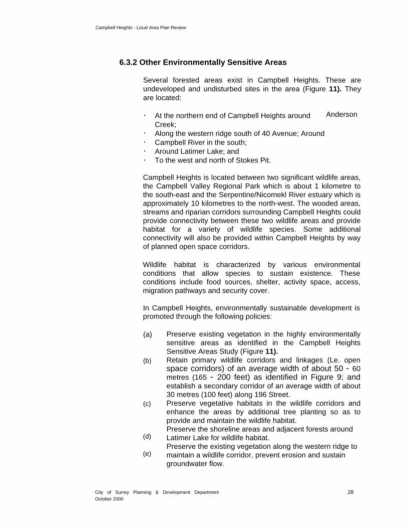
Several forested areas exist in Campbell Heights. These are undeveloped and undisturbed sites in the area (Figure 11). They are located:
. At the northern end of Campbell Heights around Anderson
Creek;. Along the western ridge south of 40 Avenue; Around . Campbell River in the south; . Around Latimer Lake; and . To the west and north of Stokes Pit.
Campbell Heights is located between two significant wildlife areas, the Campbell Valley Regional Park which is about 1 kilometre to the south-east and the Serpentine/Nicomekl River estuary which is approximately 10 kilometres to the north-west. The wooded areas, streams and riparian corridors surrounding Campbell Heights could provide connectivity between these two wildlife areas and provide habitat for a variety of wildlife species. Some additional connectivity will also be provided within Campbell Heights by way of planned open space corridors.
Wildlife habitat is characterized by various environmental conditions that allow species to sustain existence. These conditions include food sources, shelter, activity space, access, migration pathways and security cover.
In Campbell Heights, environmentally sustainable development is promoted through the following policies:
(a) Preserve existing vegetation in the highly environmentally sensitive areas as identified in the Campbell Heights Sensitive Areas Study (Figure 11).
(b) Retain primary wildlife corridors and linkages (Le. open space corridors) of an average width of about 50 - 60metres (165 - 200 feet) as identified in Figure 9; and establish a secondary corridor of an average width of about30 metres (100 feet) along 196 Street.
(c) Preserve vegetative habitats in the wildlife corridors and enhance the areas by additional tree planting so as to provide and maintain the wildlife habitat. Preserve the shoreline areas and adjacent forests around
(d) Latimer Lake for wildlife habitat. Preserve the existing vegetation along the western ridge to
(e) maintain a wildlife corridor, prevent erosion and sustain groundwater flow.
City of Surrey Planning & Development Department
October 2000
28

- --- ------
Campbell Heights - Local Area Plan
Review
(f) Design stormwater detention ponds such that they will be compatible with the ecological values and enrich the diversity of the habitat in the adjacent forested areas to be preserved.
(g) Retain, where practical, significant trees native to a development site in addition to providing high quality landscaping with focuses on native species which provide wildlife habitat.
~While preserving the environment, new development is encouraged:
.:.
to take advantage of and ~~'~~r':.J#l; ?o;
. .§ .
build on the high 'UNC: t;ftt~::;:environmental value offered ~ ~'-'", J} .;, '
. in Campbell Heights;
. to be integrated with the environmental qualities of the area; and
to be identified with the enhancement offered by the natural
environment.
6.4 Parks and Recreation Policies
The provision of amenities is part and parcel of a technology and business park development. Not only do amenities contribute to the aesthetics and sense of place of the technology and business park setting, but they also serve the recreational needs of the employees. Amenities have become an important marketing tool to attract new businesses as well as potential employees. In addition to the commercial and child care facilities and environmental features discussed in the previous sections, the following recreational amenities are proposed.
City of Surrey Planning & Development Department 29October 2000

Campbell Heights - Local Area Plan Review
6.4.1 Public Parks
There are two existing park sites in Campbell Heights (Figure 9). Latimer Lake, where trout is stocked, is popular for sport fishing. It is also an attractive place for a stroll and bike riding. This outdoorrecreational area will be retained and enhanced. It is proposed that the coniferous forest east of Latimer Lake be preserved and dedicated as park.
Kerry Park, located on 28 Avenue west of 188 Street, is an undisturbed treed site and will be retained for park use. It will be connected to other parts of Campbell Heights by way of a walking and cycling pathway system throughout the area.
6.4.2 Other Recreational Facilities
A multi-use trail will be developed to connect the existing trail system in Latimer Park with the linear open space corridors proposed in the south (Figure 9). This trail, of a width of about 7 metres (23 ft.), will be designed to accommodate walking, jogging, cycling and horseback riding along the open space corridors. The trail will also connect to the linear community park system and the Campbell Valley Regional Park in the Township of Langley. Linkages to the City's greenways in the west will be provided along 20 Avenue.
City of Surrey Planning & Development Department October 302000

Camp bell Heights - Local Area Plan Review
Opportunity also exists for the development of a linear golf course at the
periphery of the Stokes Pit site if there are development interests
expressed.
Moreover, a technology and business park development in Campbell Heights is expected to provide a workplace with extensive green space, including high quality landscaping design and treatment. In addition to its aesthetic value, this green space will serve as a passive recreational amenity for the employees.
6.5 Development Policies
6.5.1 Design Guidelines
The following Design Guidelines will apply to proposed developments in the Campbell Heights area. These Design Guidelines will complement the Development Permit Guidelines contained in the Surrey Official Community Plan (OCP) and the Land Development Guidelines of the Ministry of Environment and Department of Fisheries and Oceans. Development Permits will be required for all developments to ensure compliance with these policies and guidelines.
1. Obiectives
. To ensure that private investments in Campbell Heights are enhanced through careful planning and design.
. To ensure that Campbell Heights will be developed as a unique technology and business park precinct with high quality urban design and amenities.
. To encourage the development of a comprehensively designed technology and business park in a campus-like/park-like setting.
. To encourage urban design excellence by promoting a high level of visual identity and quality.
. To promote and encourage street beautification measures.
. To facilitate co-ordinated development among buildings, landscaping and site features.
. To integrate urban design and environmental protection into the development process by maintaining, protecting and preserving important elements of the natural environment including creeks, wildlife corridors, topographic features and trees.
. To incorporate sustainable development principles.
. To provide for a pleasant, rich and diverse pedestrian experience within Campbell Heights.
. To create an interconnected network of open spaces in Campbell Heights with linkages to the surrounding areas.
City of Surrey Planning & Development Department
October 2000
31

Campbell Heights - Local Area Plan Review
. To provide an appropriate interface with adjacent land uses such as the Agricultural Land Reserve, and current and proposed land uses in Langley Township to the east.
2. General Guidelines
. Site plans should be carefully designed to integrate the functional requirements of the project with existing site features, taking into consideration surrounding developed and undeveloped sites.
. A comprehensive design
scheme should be prepared
for the development site with
due consideration given to
architectural co-ordination
and compatibility in terms of
scale, massing and materials
amongst the
buildings on the site, as well as with the architecture of
adjacent buildings.
. Special effort should be made at the site planning stage to co-ordinate and maintain the continuity of wildlife corridors, buffers, landscaped strips, walking and cycling pathways andmulti-use trails from one development site to another.
City of Surrey Planning & Development Department 32October 2000

Campbell Heights - Local Area Plan Review
3. Technology Park
. Each technology park site should include acomprehensive design scheme, creating a campus-like setting with associatedamenities and extensive green space.
. Buildings should be designed
with a generous amount ofglazing. .
. Specially lit and landscapedidentification signs, ponds,fountains, decorative pavers,and enhanced landscapedmedians should be provided on a technology park site.
City of Surrey Planning & Development Department
October 2000
33
Campbell Heights - Local Area Plan Review
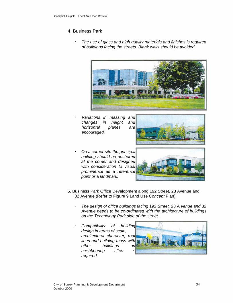
4. Business Park
. The use of glass and high quality materials and finishes is required
of buildings facing the streets. Blank walls should be avoided.
. Variations in massing and changes in height and horizontal planes are encouraged.
. On a corner site the principal building should be anchored at the comer and designed with consideration to visual prominence as a reference point or a landmark.
5. Business Park Office Development along 192 Street. 28 Avenue and 32 Avenue (Refer to Figure 9 Land Use Concept Plan)
.
. Compatibility of building design in terms of scale, architectural character, roof lines and building mass with other buildings on ne~hbouring sftes ~ required.
The design of office buildings facing 192 Street, 28 A venue and 32Avenue needs to be co-ordinated with the architecture of buildingson the Technology Park side of the street.
City of Surrey Planning & Development Department 34October 2000
m-- -------------------
Campbell Heights - Local Area Plan Review
. Glazing is encouraged on all
street facades.
. To create a
streets, minimum
are encouraged.
. Long and
buildings should be avoided.
strong
architectural edge along the
building
rear and side yard parking
non-articulated
setbacks in combination with
.building should be recognizable from the street.
. Site planning and building
gn should make provision for interesting outdoor urban spaces.
.
be co-ordinated in Ir-iNdesign on all elevations with
regard to colours, materials,
architectural form and
detailing to achieve design
harmony
and continuity. All doors and windows should be trimmed
whenever such treatment would be compatible with the
architectural style of the buildings. Painted or false detailing that
detracts from the integrity of structures should be avoided.
The exterior of
y
Ir~"",~
desi
buildings should
The main entrance to each
easil
. All exterior mechanical units or equipment including roof top units
that may be visible from the streets should be enclosed.
. Loading bays and overhead garage doors will not be permitted to
face the streets. All loading and material handling areas should be
located at the rear of the buildings.
City of Surrey Planning & Development Department October 352000

Campbell Heights - Local Area Plan Review
6. Streetscape Guidelines
. Buildings along the streets
should be designed to
include glazing and high
quality finishing materials.
. The principal building on a corner property should be located so as to anchor the corner, and be designed to be visually attractive from
both abutting streets.
. Locating parking lots at street corners should be avoided.
. Parking within the front yardsetback is generally discouraged. However, where it is proposed, it mustbe visually screened from the street by a combination ofberming and high qualitylandscaping.
. All loading, service or storage areas should be screened in relation
to the view from any public street. Screening of at least 2.5 metres
(8 ft.) in height is recommended and it should be composed of
substantial landscaping and/or materials compatible with the
materials used on the principal building on the site.
. Fences along property lines that abut streets will, in general, not be
permitted. A fence may be permitted provided that it is set back the
same distance as the principal building and substantial
landscaping is provided on the street side of the fence.
City of Surrey Planning & Development Department 36October 2000
Campbell Heights Local Area Plan Review
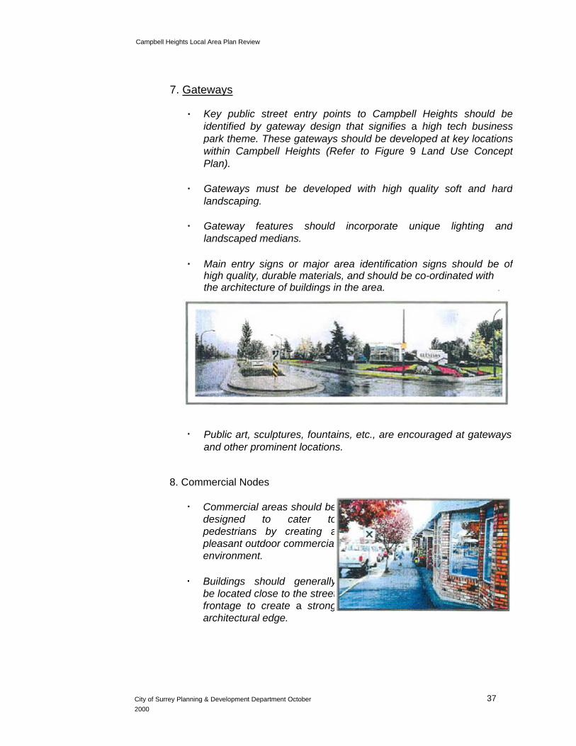
7. Gateways
. Key public street entry points to Campbell Heights should be
identified by gateway design that signifies a high tech business
park theme. These gateways should be developed at key locations
within Campbell Heights (Refer to Figure 9 Land Use Concept
Plan).
. Gateways must be developed with high quality soft and hard
landscaping.
. Gateway features should incorporate unique lighting and
landscaped medians.
. Main entry signs or major area identification signs should be ofhigh quality, durable materials, and should be co-ordinated with the architecture of buildings in the area. .
. Public art, sculptures, fountains, etc., are encouraged at gateways
and other prominent locations.
8. Commercial Nodes
. Commercial areas should be designed to cater to pedestrians by creating a pleasant outdoor commercial environment.
. Buildings should generally be located close to the street frontage to create a strong architectural edge.
City of Surrey Planning & Development Department October 372000

Campbell Heights Local Area Plan Review
. The massing, setbacks, and orientation of buildings should
reinforce a pedestrian environment.
. All commercial buildings should have their primary facades
oriented toward the street.
. Commercial buildings on comer lots should include architecturaldetailing that addresses both streets.
. Shop windows, awnings, canopies, and signage should be
designed to add life to the
streets and encourage
pedestrian activities.
. Outdoor extensions of cafes and restaurants are encouraged where the context is appropriate.
. Sidewalks adjacent to retail uses should be provided with rain
protection.
9. Sustainable Development
. New development should Ob
be designed to preserve, integrate with, and enhance important elements of the natural environment.
. Significant natural characteristics of the site such as creeks, trees, topographic features and large rocks, etc., should be integrated into the site design plan whenever possible.
City of Surrey Planning & Development Department 38
October 2000

Campbell Heights Local Area Plan Review
. Creek preservation areas ",
must be maintained in an undisturbed state, in accordance with the specifications of the Ministry of Environment and the Department of Fisheries and Oceans.
. Land located within the creek setback areas that require restoration must be improved, landscaped and planted to the specifications of and satisfaction of the Ministry of Environment and the Department of Fisheries and Oceans.
. Excessive cuts of the natural terrain of a site should be avoided. The proposed grades should follow the natural contours of the landas much as possible.
. Consideration should be given to roof top detention as one of the means to manage storm water in the building design.
. Innovative building design incorporating energy efficient measures is encouraged.
10. Landscaping
. Landscaped buffers are required to be provided as an interface between different uses (Refer to Figure 9 Land Use Concept Plan).
. A combination of a berm and high quality landscaping, incorporating preservation of existing trees, is recommended for allbuffers.
. Buffers should be designed to mitigate the visual impact of a technology park! business park development on the adjacent residential areas and Agricultural designated lands.
. Existing stands of mature trees provide visual interests and environmental values. Consideration should be given to incorporating them in the site design.
City of Surrey Planning & Development Department 39October 2000
Campbell Heights Local Area Plan Review
. A high quality landscapedfrontage is requiredpublic streets.
. Arecommended to be plto achieve a
streets.
. Blank walls facing streets are generally encouraged. Where they 11,>",
are unavoidable, substantial 11r"landscaping should be used to mitigate their visual
.
is recommended that landscaped island pl
row.
.parking rows shouldplanted with at leastshade trees. Islands end of single parkingshould be planted least one shade tree.
. A landscaped median planted with trees is ,,,recommended between long rows of parking spaces.
along
double row of trees isanted
canopy effectover side walks on public
not ~~
impacts.
ta
antedwith trees be provided for
a
betwo
at the rows
with at
Parking lots should be broken up with landscaped islands. I
every six parking spaces in
Islands at the ends of double
City of Surrey Planning & Development Department
October 2000
40

-
Campbell Heights Local Area Plan Review
. Special paving materials, such as tiles, brick, exposed aggregates, etc. should be used to identify building entrances, pedestrian pathways, plazas and seating areas.
. All unpaved areas not planted with shrubs, ground cover, or flowers should be planted with grass.
. Shrubs, flowers, and ground covers should. be grouped together in clusters rather than in individual scattered locations.
. Selection of plant materials should be based on their year-round interests as well as their form, texture and shape. The use of native species that enhance environmental qualities and provide wildlife habitat is encouraged.
. All plant materials must conform to the Development Permit Area Guidelines for Landscaping outlined in the Official Community Plan.
. Site elements such as. outdoor lighting, signage, garbage storage, and fencing should be included on the landscaping plans since they are integral elements of the landscape.
11 .Parking. To reduce visibility of
vehicles and pavement surfaces from the street, surface parking areas should be screened by the use of berming and landscaping.
. Parking lots and driveways should be designed so as to minimize conflicts between vehicles and pedestrians.
City of Surrey Planning & Development Department 41October 2000

Campbell Heights - Local Area Plan Review
. Parking spaces at the end of the row should be protected from
turning movements of other vehicles with curbed landscaped
islands.
. Handicapped parking should be located near building entrances,
and preferably abutting a landscaped island.
. Bicycle parking
and close to
entrances.
building
facilities
should be provided at grade
12. Exterior Lighting
. Lighting along pedestrian pathways is recommended and should notexceed 4 metres (13 ft.) in height. Fixtures and poles should be in a colour that complements the building architecture and parking lotlighting.
. Parking lot light standards should not to exceed 9 metres (30 ft.)
in height. Fixtures and poles should be in a colour that
complements the building architecture.
. For consistency between developments, the type of street lamps
on public streets, their height, intensity, and spacing, etc., will be
co-ordinated by the Engineering Department through the servicing
agreement process.
13. Signage
. The design of signs
should relate to the
rchitectural character of <
he buildings on the same
site.
a
t
I~.
City of Surrey Planning & Development Department October 422000

Campbell Heights - Local Area Plan Review
. Free-standing signs should be integ~ated into th~ site 11;;
landscapmg and des/gnedto complement the architecture of the buildings on the same site.
. Single-pole free-standing pylon signs are not permitted.
. The maximum height of any free-standing sign is 2.4 metres (8 ft.) above
grade. The grade at the base of the sign should not exceed the average
adjacent grade by more than 0.6 metre (2 ft.).
. Fascia signs facing the street may be permitted provided they are
integrated and/or co-ordinated with the architecture of the building and
overall design of the development.
. Standardized or corporate signage that does not relate to the building architecture is discouraged.
. Small directional signs may be used when necessary to direct
vehicular and pedestrian traffic within a particular site.
. All signs must be maintained in good condition and repair at alltimes.
14. Live/Work Areas
The following general design guidelines for the proposed live/workareas in Campbell Heights will be used to guide development, untilmore detailed design guidelines are developed upon the completion ofa study being undertaken by the Planning & Development Departmenton City-wide planning and policy considerations regarding live/work uses. Specific density, form of development, design and layout will be reviewed at the rezoning and development permit application stage.
. Live/work areas should be comprehensively designed includingarchitecturally coordinated building facades, signs, exterior lightingand landscaping.
. The site design of the development should take into consideration preservation of important elements of the natural environment, such as mature trees and watercourses.
City of Surrey Planning & Development Department October 432000

Campbell Heights - Local Area Plan Review
. Live/work areas should be designed to create an "attractive
residential look. "
. Building design and siting should provide a pleasant,
pedestrian friendly outdoor environment.
. Separate entrances to the work space and the living area
within the building should be provided.
. Adequate parking provision should be made for residents
and visitors/customers.
. Buildings, outdoor space and landscaping should be
designed and arranged to allow maximum opportunity for
informal surveillance.
. Loading areas, refuse/recycling areas and mechanical
equipment should be located out of view from public streets,
and be appropriately screened from the view of public
streets and adjacent properties.
6.5.2 Amenity Contributions
To address the amenity and service needs of new developments in the area, developers will be required to make a monetary contribution towards the provision of new police and fire protection services, park improvements, trail and pathway development on public lands and the City's greenway system in the area. In addition, live/work developments will be required to contribute towards the provision of library materials for the residents in the live/work area.
Amenity contributions will also be required when the possible future residential area south of Campbell Heights is rezoned fordevelopment, subject to an Official Community Plan amendment.
The rates of the amenity contributions are given in Table 2.
City of Surrey Planning & Development Department
October 2000
44

Camp bell Heights - Local Area Plan Review
Table 2 Amenity Contributions by Land Use Category
Technology Park,
Residential
Business Park Development or Commercial Live/Work Outside
Development Development Campbell Heights
Police Protection $205.64/acre $205.64/acre $51.42/unit
Fire Protection $888.46/acre $888.46/acre $222.11/unit
$2,127.Park & Pathway $2,127. 99/acre
$2,127.99/acr 99/acree
Development
Library Materials Not applicable $115.68/unit $115.68/unit
Total Contribution $3,222.09/acre $3,222.09/acr
$389.21/unit eplus plus
$115.68/unit $2,127.99/acre
for library for park & materials pathway
development
Notes:
. The amenity contributions are at March 1, 2000 rates which will be
adjusted annually based on Vancouver's Annual Average Consumer
Price Index.
. Amenity contributions are payable at building permit stage for industrial, commercial, institutional and multiple residential uses, and at
subdivision stage for single family and duplex zones.
City of Surrey Planning & Development Department
October 2000
45


Campbell Heights - Local Area Plan Review
Highway 10 in the north, which are within the jurisdiction of the Ministry of Transportation and Highways, are located about 2.4 kilometres (1.5 miles) away from Campbell Heights.
A study to determine the alignment and corridor requirements forthe Highway 1 - Highway 99 connector planned in the vicinity ofCampbell Heights is under way. This connector, which will furtherimprove the regional accessibility of Campbell Heights, is one ofthe major infrastructure projects for the area.
6.6.2 Walking and Cycling Pathway System
Major activity nodes in Campbell Heights include Latimer Park and the proposed commercial area at 28 Ave and 192 Street, and the multi-use trail system proposed in the southern part of Campbell Heights. These activity focuses will be connected from various parts of Campbell Heights through a walking and cycling pathway system. The walking and cycling pathways, which are about 4 metres (13 feet) wide, are proposed to be incorporated in the landscaping strips to be provided along 28 Avenue, 32 Avenue, 192 Street, 196 Street, and the section of 188 Street between 28 Avenue and 32 Avenue (Figure 9). The pathways will also connect to an existing trail system in the vicinity of Anderson Creek in the north.
The walking and cycling pathway system not only provides an alternative mode of transportation, but also serves an outdoor recreational function for the technology and business park employees and the surrounding residents.
6.6.3 Public Transit
Although public transit is not currently available in Campbell Heights, consideration will be given to providing alternative transit services when the area starts to develop. The alternative transit services identified in the Surrey Transportation Plan for low demand areas or low time periods include dial-a-bus, community bus and taxi feeder services. In the longer term, improved public transit services will be planned with Translink, to respond to the needs of the employees of the technology and business park development.
City of Surrey Planning & Development Department
October 2000
47

Campbell Heights - Local Area Plan Review
7. SERVICING PLAN, PHASING PLAN AND FINANCING
OPTIONS
A servicing and phasing plan, providing general concepts for major road improvement, traffic signalization, stormwater management, sanitary sewer, water supply and other major utility infrastructure requirements, has been prepared as part of the Local Area Plan Review for Campbell Heights. This plan, together with a discussion on service financing options, is presented in a separate report prepared by the Engineering Department.
8. EMPLOYMENT
The total employment that developments in Campbell Heights will generate is estimated to be in the range of 42,400 - 51,900 individual jobs at build-out.
It is estimated that the optional Live/Work area will house about 510 dwelling units and 765 jobs (Refer to Table 1).
9. PLAN IMPLEMENTATION
To implement the Campbell Heights Plan, the following actions are recommended.
9.1 Zoning By-law Amendments
Pursuant to Section 904 of the Local Government Act, an amendment to the Zoning By-law No. 12000 is required to implement the amenity contribution component of the Local Area Plan, and specifically to allow bonus densities in exchange for contributions towards the amenities identified in the Plan. Subject to Council's direction, an amendment bylaw will be prepared for consideration by Council.
9.2 Technology Park Zone
The existing Business Park (IB) Zone in the Zoning By-law No. 12000permits uses ranging from light impact industries, warehouses, offices, general service uses to accessory uses such as personal services, eating establishments, community service, assembly halls, etc. To cater to the requirements of high tech uses, including a more stringent selection ofpermitted uses in the zone, and to achieve the planning intent of
City of Surrey Planning & Development Department
October 2000
48

Campbell Heights - Local Area Plan Review
reserving sizeable land parcels for large users, it is recommended that a new
Technology Park zone be introduced. On the other hand, the new zone should be drafted
so as to provide maximum flexibility to facilitate technology park developments. Issues
such as mix of uses, density, building setbacks, and building height will be addressed in the new zone. Subject to Council's direction, a Technology Park zone will be drafted for consideration by Council.
9.3 Pre-zoning
To improve the attractiveness and competitiveness of Campbell Heights, and to facilitate business development and investment, one of the strategies is to pre-zone lands for development. The advantages of pre-zoning include:
. increasing the supply of zoned industrial land available for development;
. providing increased certainty to developers and the community at large; and
. shortening the approval process (Development Permit and Building Permit) by removing rezoning from the development approval process;
all of which contribute to strengthening the competitiveness of the City. This is also consistent with Council's policy to allow industrial rezoning applications to be completed without concurrent processing and approval of development permits.
It should be noted that even with the pre-zoning, Council will still retain control over the form of future development through the Development Permit approval process and the implementation of design guidelines which have been developed for Campbell Heights as part of the Local Area Plan Review.
As a subsequent step after the completion of this Plan, staff will look into the possibilities of pre-zoning some lands in Campbell Heights, such as the Provincial site, to facilitate development.
9.4 Policies and Design Guidelines
To promote sustainable development, to achieve high quality and co-ordinated design with extensive green space and to provide amenities, all development proposals will be required to comply with the policies and design guidelines which form part of the Local Area Plan for Campbell Heights. Considerations should be given to pursuing public art projects at various gateway locations.
City of Surrey Planning & Development Department 49October 2000

Campbell Heights - Local Area Plan Review
9.5 Official Community Plan Amendments
The Campbell Heights Local Area Plan Review boundaries include certain properties or portions of properties at the periphery which are designated Agricultural in the Official Community Plan. These include:
(a) 5 properties between 18 Avenue and 20 Avenue west of 192 Street which are designated Industrial Park in the South-East Surrey Local Area Plan (1980);
(b) The rear portions of 4 properties on 196 Street north of the 18 Avenue alignment which may be consolidated with the properties to the north and west for development as they are divorced from their front portions by Campbell River that straddles the properties;
The 2 westerly properties of Kerry Park; and (c)
Portions of 5 properties north of Kerry Park and west of 188 Street (d) which are situated at an elevation of about 40 metres geodetic
similar to the lands in the east, and before the land slopes down to the lowland in the west. Although the lands are outside the Industrial designation in the Official Community Plan, it is considered appropriate to include them in the Local Area Plan Review boundaries in view of their topographic characteristics.
An amendment to the Official Community Plan is required to re-designate the
above properties or portions of properties from Agricultural to Industrial (Figure
12) when these properties are rezoned for development.
9.6 Marketing Directions and Initiatives
In the Economic and Market Analysis for Campbell Heights, the consultant recommends the following actions be undertaken:
. Assign dedicated staff and resources for the marketing of Campbell Heights, including a full time marketing director with a technology background, well versed in marketing industrial properties and knowledgeable of technology park development.
. Form a technology park development corporation to provide directions in the development, financing, marketing and management ofCampbell Heights. The organization may be comprised ofrepresentatives from the Federal, Provincial and City Governments,
City of Surrey Planning & Development Department
October 2000
50

Campbell Heights - Local Area Plan Review
the financing, real estate, marketing, business and industry sectors as well as
the higher education institutions and research institutes, who are committed
to the development goals of Campbell Heights and achievement of the goals.
. Develop working relationships with a consortium of knowledge-based institutions in order to identify and cultivate interest in research and development, foster collaboration, establish partnerships with business sectors, stimulate growth of new ventures, and determine research facility requirements. The City is recommended to establish contact and enter into discussion with Tech BC, Kwantlen University College, Trinity Western University, BCIT, SFU and USC as well as chambers of commerce.
. Carry out a detailed evaluation of the target business sectors and to identify their sub-sectors as specific targets for marketing Campbell Heights in the context of the knowledge-based environment created through the working dynamics of the technology park development corporation and the consortium of higher education institutions.
. Prepare a master development plan for Campbell Heights, including site plans, development standards, a development schedule, a financing plan, an operational structure and budget, and a marketing program.
At the same time, it is recommended that the City and the Province continue with the pursuit of the semiconductor initiatives in the shorterterm.
10. CONCLUSION
A Local Area Plan which incorporates a Land Use Concept Plan, planning and development policies, design guidelines, an engineering servicing and phasing strategy, and marketing directions, has been formulated for the Campbell Heights area. The Plan lays out the planning principles and a policy framework, and provides general land use and servicing concepts for development to take place in the area.
The Plan proposes that Campbell Heights be developed as a knowledge-based technology and business park, providing an environment which attracts large anchor tenants, fosters the growth of indigenous technology companies, promotes partnerships and transfer of technology and business skills between higher education institutions and industrial tenants, and allows for a diversified industrial base. Concerted efforts and commitment from all parties concerned, including various levels ofGovernment, higher education institutions, the business sectors and the marketing team, including realtors, are required to bring the Plan to fruition.
City of Surrey Planning & Development Department
October 2000
52
- - -- -----
- 3
4. To prepare design guidelines including measures to provide an appropriate interface with adjacent land uses such as the Agricultural Land Reserve, and the current and proposed land uses in Langley Township immediately to the east.
Local Area Plan Review Process
Pursuant to Council's direction to undertake a review of the Local Area Plan for Campbell Heights, the planning process commenced in January 2000. The planning component of the Local Area Plan Review consisted of the following steps:
1. Identification of area issues and concerns;
2. Identification of planning opportunities and constraints;
3. Formulation of planning objectives;
4. Generation of plan options;
5. Evaluation of plan options;
6. Selection and refinement of the preferred plan option; and
7. Finalization of the land use concept plan and design guidelines.
In concert with the planning component, an engineering consultant, under the direction ofthe Engineering Department, undertook the analysis for and preparation of the servicing component of the Local Area Plan Review. Issues relating to servicing and financing are addressed in an accompanying report prepared by the Engineering Department.
Inter-agencv Consultation
An inter-agency working group was formed to discuss issues and provide input at
various stages of the planning process. The participating agencies included:
. Industry Canada .
. Public Works and Government Services Canada
. RC. Assets and Land Corporation
. Ministry of Forests
. Land Reserve Commission
. RC. Hydro
. Ministry of Transportation and Highways
. Greater Vancouver Regional District
. Township of Langley Planning & Development Department
. Surrey Parks, Recreation & Culture Department
. Surrey Engineering Department
. Surrey Fire Department
. Surrey Planning & Development Department
. Surrey Economic Development Office.
A total of 4 working group meetings were held between February and June 2000.
Representatives from the development industry and the Operating Engineers
Realty Section, a major private landowner in the area, were also invited to the
meetings.

-4
In addition, meetings were held with the Ministry of Environment, the Department of
Fisheries and Oceans and the School District to obtain their input. The preliminary land
use concept plan was also referred to the City's Agricultural Advisory Committee for
comment in March 2000.
During the process, two preliminary land use concepts were generated. The first option was a predominantly technology park and business park development to maximize creation of job opportunities and business development. The second option included a technology park and business park development and a residential component taking the form of live/work areas along the Surrey/Langley border north of 32 A venue and south of 20 Avenue at different densities and in different building forms.
Public Consultation
The two land use options were presented at the first public open house on February 17, 2000 together with planning information including the planning process, the Official Community Plan and Local Area Plan designations, zoning, land ownership, environmentally sensitive areas, planning opportunities and constraints and the proposed planning objectives. Over 220 residents including 45 from the Township of Langley attended the open house. Copies of a questionnaire were distributed to solicit input on area issues, concerns, planning opportunities and constraints, and comments on the planning objectives and the two preliminary land use concepts. Completed questionnaires from 72 respondents were received and analyzed to provide input to the planning process.
The second public open house was held on April 27, 2000. At this open house, the proposed land use concept plan, design guidelines, general servicing concepts, a phasing plan, amenity contribution requirements and the main findings of the first public open house survey were presented. Over 270 residents including 99 from the Township of Langley attended the open house. Copies of a questionnaire were distributed to the participants to obtain their feedback on the proposed land use and servicing concepts. 96 completed questionnaires were received. Results of the questionnaire survey were taken into consideration to finalize the Local Area Plan.
Comments from residents were also received by way of written submissions, telephone
discussions and meetings with staff throughout the planning process. All input from the
public was reviewed and carefully considered.
The major issues and concerns raised by the residents in different areas are summarized
below:
Campbell Heights Residents:
. Lack of services in the area
. Timing of development
. Impact on environmentally sensitive areas and loss of trees

- 5
Surrey Residents outside Campbell Heights:
. Increase in traffic
. Upgrading of 24 Avenue
. Altering the existing character of the area
. Loss of farmland and impact on existing farming operations in the area .Impact on environmentally sensitive areas and loss of trees
Langley Residents:
. Impact on environmentally sensitive areas and loss of trees
. Increase in traffic
. Air and noise pollution
. Changing the existing land uses in the area to industrial
. Loss of farmland and impact on existing farming operations in the area .Reduction in property value
. Width of the landscaped buffer along 196 Street (should be increased)
The issues regarding servicing requirements and timing of development are addressed in the servicing plan prepared by.the Engineering Department. While capturing large anchor tenants is required to open up Campbell Heights for development, it should be noted that the Campbell Heights Plan is a long term plan. Given the size of Campbell Heights, it is anticipated that it will take more than 20 years to build out the area.
Road improvement requirements to accommodate the increased traffic from development in Campbell Heights are provided in the servicing plan developed by the Engineering Department. The concern about upgrading of 24 A venue was raised by the Redwood Park Neighbours' Association. Staff met with representatives of the Association in May 2000 to explain why 24 A venue needed to be widened to 4 lanes in the future. It was noted that 24 Avenue has been classified and shown on the City's road network plan as an arterial road for many years. The timing of the upgrading of 24 A venue to the arterial standard (4-lane) will be determined by the growth in traffic over time. As traffic demand increases with development in the future, road upgrades in the area will be carried out in stages. However, it is anticipated that 24 A venue will be among the last of the arterial roads to be upgraded in the area.
One of the objectives of the Local Area Plan review is to identify environmentally sensitive areas for protection. To this end, an environmental study was carried out by a consultant. The Local Area Plan addresses the environmental protection requirements in the proposed Land Use Concept as well as in a set of environmental policies.
The Local Area Plan also deals with interfacing issues between new development and
existing land uses within Campbell Heights and in the adjacent agricultural and
residential areas. Results of the questionnaire survey show that most residents prefer the
landscaped buffer option, as opposed to the live/work option, along 196 Street between
32 A venue and 36 A venue. The Plan proposes a landscaped buffer along the entire
length of 196 Street, except for a small corner property on the north side of 32 Avenue
where an optional live/work use may be considered. The minimum width of the

- 6
landscaped buffer along 196 Street (the boundary between Surrey and Langley
Township) '. is proposed to be 30 metres (100 feet),
The following features of the proposed Land Use Concept Plan were well received by the public: '.
. Preservation of environmentally sensitive areas;
. Maintenance of green space;
. Retention and enhancement of Latimer Park;
. Multi-use trail system;
. Landscaped buffer provided for the adjacent residential and agricultural areas;
. The proposed development creating jobs for the residents;
. High-tech and business park uses;
. Live/work uses allowing people to live and work in the same area; and
. Promotion of high quality design through the use of design guidelines.
Economic and Market Analvsis
To ensure that the Campbell Heights Plan responds to the needs of the market and
achieves the objective of promoting and attracting high-tech industries, an economic
and market analysis on the global, regional and local economic trends and investment
market was carried out by an economic consultant to provide input to the planning
process. An executive summary of the analysis is provided in Appendix IV. (A full
report is filed with the City Clerk,) I
From the Economic and Market Analysis, it is concluded that a projection of the current industrial market trends would produce a slow land take-up rate in Campbell Heights, in the range of 5 - 25 acres per year in the first 10 years and 30 - 50 acres per year in subsequent years. Not only does this approach fall short of meeting the economic development objectives of the City, it would not be economically viable given the high upfront servicing costs required. The alternative approach that this Plan contemplates is to put emphasis on attracting large anchor users, especially in the high-tech sectors, to kick start development in Campbell Heights.
Campbell Heights' inherent strengths should enable it to take an advantageous position in
attracting high-tech industries. These strengths include:
. Well defined industrial area as designated in the Official Community Plan and Local Area Plan; .
. Availability of large sites for large land-based anchor tenants such as semiConductor manufacturing plants;
. Large development area for high-tech clusters and other support industries and serVIces;
. Fairly level ground surface and good foundation characteristics for development;
. Proximity to the US and Pacific Rim markets;
. Proximity to high quality residential developments providing housing choices for
employees; and

--- - - ---
-7
. Proximity to research resources and training opportunities offered in Tech B.C.
and other higher education institutions.
To accelerate growth and development and to take advantage of its unique site attributes and strengths, the City of Surrey should:
(a) Position Campbell Heights in the role of a knowledge-based technology park, enhanced by effective marketing. A technology park is a planned development with lands and buildings intended primarily for private and public research and development facilities, high-tech and science-based companies, and support services. By definition, a knowledge-based technology park does the following:
. Affiliates with higher education institutions either through partnership,
ownership or management to create and maintain the "knowledge base"; . Promotes research and development through institutional-industrial partnerships,
and stimulates growth of new ventures; . Facilitates the transfer of technology and business skills between institutions and
industrial tenants; and . Drives technology-led economic development for the community.
(b) Target business sectors with high growth rates in the global market place. These
sectors, which typically have a high level of research and development
activities, include:
. Semiconductor fabrication and electronic equipment manufacturing;
. Information technology, software and telecommunications, and particularly
applications in aerial surveying and the intemet; and . Biotechnology including health care and biomedical services and
manufacturing, agro-biotechnology, marine pharmaceuticals, and bio- informatics.
(c) Pursue large-scale inward investment projects for Campbell Heights. The ability of
Campbell Heights to offer large sites for these projects is a major advantage.
(d) Pursue cross-border businesses for Campbell Heights which require input from and/or
distribution of output to the US.
(e) Pursue new start initiatives for Campbell Heights to encourage the growth of
indigenous technology companies, taking advantage of the potential of Tech BC as
an incubator.
(f) Launch an aggressive marketing program carefully planned out, and based on a master development plan with dedicated marketing staff and resources.
While pursuing a technology park focus, the land use plan for Campbell Heights should allow for diversity of high-tech, research, office and light industrial uses, and provide resort-like amenities including a hotel/conference centre, an attractive commercial village and fitness and recreational facilities.

- 8
Land Use Concept Plan
The Land Use Concept Plan proposed for Camp bell Heights is attached as Appendix
V. The main features of the Plan are summarized below:
Land Uses
. Based on the plan, Campbell Heights will be predominantly a technology park
and business park development to maximize creation of job opportunities and
business development. . 3 Technology Park sites ranging from 80 hectares (198 acres) to 101 hectares (249
acres) in land area are proposed. Sites of this size are not available elsewhere in the
Region and are particularly attractive to large land-based anchor tenants in the
technology and research and development sectors. . 2 of the 3 Technology Park sites are designated for either technology park use or
business park use to provide flexibility so that changing market conditions can be
managed. This flexibility is particularly important as the Local Area Plan is a long-
term plan and it is projected that it will take more than 20 years to build out the
Campbell Heights area. . To allow for a diversified industrial base, other areas, including Stokes Pit and the
smaller private landholdings, have been designated for business park uses. . Office buildings are encouraged along 192 Street, 32 A venue and 28 A venue in a
business park development. Besides serving as an interface between the Technology
Park sites and the business park uses, the higher design standards of office
development will enhance the streetscape in the area. . A commercial node, including hotel and conference facilities, is proposed at the
intersection of 192 Street and 28 Avenue, taking advantage of as well as enhancing
Latimer Park as an attraction in the area. In addition to providing retail, dining and
other services to the working population, this node is a focal point for social
interaction.. The area south of 20 A venue is designated for either business park development or a
live/work area taking a cluster housing form. Development in this area may take
advantage of the natural amenities of the Campbell River, while offering
opportunities to preserve and enhance this significant watercourse. A small local
commercial area is proposed at the entrance to the live/work area to serve the day-
today retail and service needs of the residents.
Land Use Interface
. The Plan respects the integrity and boundaries of the Agricultural Land Reserve (ALR). Development is not allowed to encroach onto the ALR. Consistent with the Official Community Plan guidelines, a buffer (building setback) of a minimum width of 30 metres (lOO feet) comprising a minimum 15 metre (50 foot) wide landscaped strip will be maintained in a technology park or business park development abutting Agricultural designated lands.

- 9
. To provide an appropriate interface along 196 Street with the residential
neighbourhoods in Langley, minimum building setbacks of 45 metres (l50 feet) and
37.5 metres (l25 feet) wilI be required of a technology park development and a
business park development respectively. Within the respective building setbacks, a
minimum 30-metre (lOO-foot) landscaped buffer should be provided. A wider
landscaped buffer should be considered where existing vegetation can be preserved. . 196 Street is to be preserved as a residential street. Access to a technology park or
business park development from 196 Street will not be anowed.
Environmental Protection
. Significant watercourses and riparian corridors in the area will be preserved, and
enhanced through development. . Existing vegetation in highly environmentaIIy sensitive areas wilI be preserved. . Preservation of existing trees and use of native species in the landscaping design
are encouraged on development sites. . Wildlife corridors wilI be maintained through CampbeII Heights to provide
connectivity between the wildlife habitats in the Campben VaIIey Regional Park to
the south-east and the Nicomekl and Serpentine areas to the north and north-west.
Recreational Facilities
. Latimer Park wilI be preserved and enhanced as a recreational amenity in the
area. The adjacent forested area is proposed to be dedicated and/or acquired as
park and incorporated into the Latimer Park site. . A multi-use trail for walking, jogging, cycling and horseback riding is proposed in
the southern part of CampbeII Heights, with connections to the City's greenways in
the west and the linear community park and Campbell Valley Regional Park in the
Township of Langley. . Each technology and business park development in CampbeII Heights is expected to
provide a workplace with extensive green space, including high quality landscaping
design and treatment. In addition to its aesthetic value, this green space will serve as
a passive recreational amenity for the workers.
Other Features
. The arterial roads serving the area include 40 A venue, 32 A venue, 24 A venue, 16
Avenue, 192 Street and 184 Street. They will be upgraded to 4 lanes in phases, and
192 Street will be further upgraded to 6 lanes ultimately. . A pedestrian and cycling pathway system is proposed in the area to provide for
alternative modes of transportation. . A number of sites are identified for stormwater management facilities in the area. . The area south of the CampbeIl Heights Local Area Plan Review boundary outside
the Agriculture Land Reserve may be considered ~s a possible future residential
area.

- 10
. A set of design guidelines has been developed to promote high quality and co-
.ordinated developments.
Amenity contributions towards police and fire protection, park and pathway
development, and library materials will be collected at the time of development
(Appendix VI).
The distribution of land, projected floor area and number of live/work units, and employment
estimates in various land use designations are summarized in Appendix VII.
Plan Implementation
To implement the Campbell Heights Local Area Plan and to prepare the areafor development, the following actions are recommended:
1. Zoning By-law amendment
An amendment to the Zoning By-law, 1993, No. 12000 is required to enactthe amenity contribution requirements for the Campbell Heights Plan Area.
2. Technology Park Zone
The existing Business Park (IB) Zone in the Zoning By-law No. 12000 permits uses ranging from light impact industries, warehouses, offices, general service uses to accessory uses such as personal services, eating establishments, community service, assembly halls, etc. To cater to the requirements of high-tech uses and to achieve the planning intent of reserving sizeable land parcels for large users, it is recommended that a new Technology Park zone be introduced. The new zone should be drafted so as to provide maximum flexibility to facilitate technology park developments. Issues such as mix of uses including residential dormitories, density, building setbacks, and building height will be addressed in the new zone. Subject to Council's direction, a Technology Park zone will be drafted for consideration byCouncil.
3. Policies and design guidelines
To promote sustainable development and to achieve high quality and co-ordinated design with extensive green space and amenities, all development proposals will be required to comply with the policies and design guidelines which form part of the Local Area Plan for Campbell Heights. Considerations should be given to pursuing
public art projects at various gateway locations.
4. Marketing
Concurrently with the pursuit of the semiconductor industry, it is recommended that
the directions provided in the Campbell Heights Econo~c and Market Analysis be
pursued by the Economic Development Office with a view to developing and
launching a marketing program for Campbell Heights. This will involve the
establishment of a task force with dedicated staff resources (including the hiring of


Appendix III
CAMPBELL HEIGHTS LOCAL AREA PLAN
REVIEWTerms of Reference.
Background
The CampbelI Heights area comprises about 784 hectares (1,937 acres) of land located south of 44 Avenue, east of 186 Street, north of 18 Avenue, and west of the Surrey/Langley border along 196 Street. The area lies outside the Agriculrural Land Reserve (Appendix I).
The area is designated Industrial, except for a number of properties between 18 A venue and 20 Avenue to the west of 192 Street which are designated Agriculrural, in the Official Community Plan (Appendix I). The Industrial designation for most properties in the area has been in place since 1966 when the Surrey Official Community Plan By-law No. 2465was adopted.
The Campbell Heights area is covered by the South-East Surrey Plan which was prepared in 1980. The Plan envisages business park and industrial development in this area to provide employment opportunities for ~e grovv:ing workforce. The Plan designates the centre of the area for high-impact industrial development, surrounded by general industrial uses to the east, agro-industrial enterprises to the north, and industrial parks in the remaining area (Appendix II). The great majority of the land in the area is still zoned General Agriculrure (A-I) and Intensive Agriculrure (A-2). Industrial development has not taken place mainly due to a lack of engineering services.
..
The South-East Surrey Plan was formulated about 20 years ago. With the rapid development of the City in the past 10 years and the recent interest in business development SJlch as high-tech and science parks in Campbell Heights, it is considered appropriate to review the local area planning policies and land use concept for the area to reflect the present economic trend and to meet the economic development objectives of the City.
Objectives of Plan Review
The objectives of the CampbelI Heights Plan Review
are:1. To review, refine and formulate land use, economic and other development
policies for the area so as to position it favourably in a global context, particularly with respect to attracting high-technology businesses;

2. To fonnulate a land use concept plan in parallel with a servicing strategy,
including an infrastructure program, a financing strategy and a phasing
plan;3. To identify environmentally sensitive areas for protection;
and4. To prepare design guidelines including measures to provide an appropriate
interface with adjacent land uses such as the Agricultural Land Reserve and
current and proposed land uses in Langley Township immediately to the
east.Plan Area
The Plan Area will include all lands designated Industrial in the Official Community
Plan and a small area designated Agricultural in the Official Community Plan but
Industrial Park in the South-East Surrey Local Area Plan (Appendix 1).
Plan Preparation and Consultation Process
The Plan Review process will commence with an assessment of the supply and
demand of industrial land in Surrey, and will include the development and evaluation
of land use and development policies and strategies, a land use concept plan, and
design guidelines for the Plan Area. The plan preparation process will involve the
following steps: 1. Identifying area issues and concerns as well as planning opportunities
and
constraints; . I2. Setting planning goals and
objectives; 3. Generating land use and development
options; 4. Selecting the preferred land use and development
option; 5. Developing a comprehensive plan incorporating land use and development
policies, a detailed land use plan including major road layout, design
guidelines; and servicing, financing and phasing strategies.
The Plan Review process will be undertaken by the Planning & Development
Department, in conjunction with the servicing study managed by the Engineering
Department. A communication consultant will be engaged to undertake the
public consultation process.
Public infonnation meetings will be held at Steps 1 and 4 to receive pubic input, and
a final public meeting will be held before the finalized plan is presented to Council
for consideration.

- --- -------------------------------------
-- --------------- --
An internal working group will be formed, comprised of City staff from the Planning &
D~velopment Department, Engineering Department, Parks,_Recreation & Culture
Department, and Economic Development Office, representatives from the School
District, Ministry of Environment, B.C. Assets & Land Corporation, RC. Forestry and
the Federal Government as well as major landowners in the area. The working group
will meet to identify issues, review and provide comments on plan options and resolve
issues. Referral to the Agricultural Advisory Committee may be needed. A separate
economic analysis on the global, regional and local economic trends and investment
market will also be undertaken to provide input to the Plan Review process.
The plan preparation process is illustrated in Appendix ill.
The approved plan will provide the basis for the development of a marketing strategy to promote investment opportunities in the City, and particularly in Campbell Heights, focused on world-renowned high-tech companies as well as supporting business and servIces.
Plan Contents
The Campbell Heights Plan will contain the following
components: 1. A statement of planning goals and objectives;
2. Land use, economic, environme~ta1, open space and circulation
policies; 3. A land use concept plan showing specific land use and density
designations;4. Design guidelines for new development;
5. Major road layout; and
6. A servicing and financing strategy including a phasing plan.
Timeframe
It is estimated that the Plan Review process will take approximately 4 months, with various milestones to be coordinated with the schedule of the servicing study commissioned by the Engineering Department. The Plan Review will commence upon Council's approval of the planning process (Appendix Ill).
v:\wp-<locslpIonninJI!I9daIaIoct-dcc\12118IS36- ,I BA
121O1!199 15:40 PM

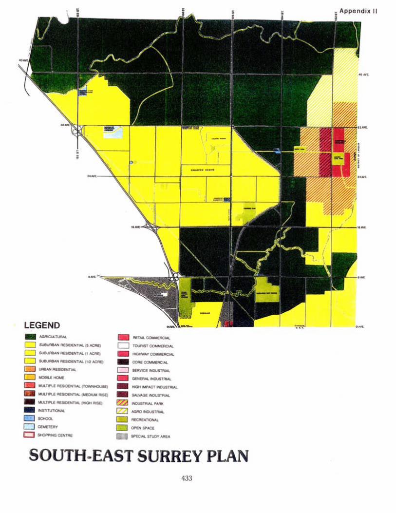


Appendix IV
E~ecutive Summary
The Campbell Heights area in the southeast part of Surrey, British Columbia includes about 800 hectares (2,000 acres) of land designated for Industrial use in the City's Official Community Plan (OCP). The majority of this land is currently zoned for agricultural uses and is not serviced for development.
There has been development interest expressed in the Campbell Heights area by a numberof organizations and the City has, therefore, commenced a comprehensive planning process to formulate a land use plan, a servicing strategy and a marketing plan for the area. Preliminary conceptual planning for the lands includes a mix of business park, technology park, office, and commercial uses. In addition, live/work and some recreational uses are being considered for a portion of the lands.
To meet economic development objectives of the City of Surrey and of the Province ofBritish Columbia, including the development of a strong industrial base, ANGLE Technology LLC has been retained to conduct an economic and market analysis to help ensure that the Campbell Heights Plan will respond to the needs of the market.
Campbell Heights' competitive advantages include among others:
. Its size, terrain, and surrounding uses make the area an attractive location for light industrial, business and technology park uses.
. The size of the individual parcels allows flexibility to accommodate large
users.
. The conceptual development plan includes high quality urban design andrecreational amenities.
. Its proximity to the US border makes it attractive to businesses that distribute to the US or rely on goods from the US.
Campbell Heights' main disadvantages are:
. Its relatively remote location and its currently limited vehicular access from a regional perspective. It is clear from the existing distribution of good quality lightindustrial and business park space that firms have generally chosen locations in more central areas with high vehicular accessibility.
. The lack of servicing and infrastructure are negative marketing factors.
. The lack of speculative development to help "kick-start" the development.
City of Surrey, Planning & Development Dept. i ANGLE Technology LLCMarket Analysis For Business And Technology Park July 2000

The report examines the real estate absorption rates and industry trends in the GreaterVancouver Regional District (GVRD) to determine potential rates of growth of Campbell Heights as an industriallbusiness park with a technology focus. The absorption analysis assumes:
. Access to both Highway 99 and Highway 1 will be significantly improved to overcome issues of remoteness and accessibility.
. The necessary zoning and servicing will be in place to permit the development ofa light industrial, business and technology park.
. Camp bell Heights will be developed to a high level of quality, similar to orsurpassing other high quality light industrial and business parks in the region.
. Land values and lease rates will be competitive.
Analysis of the total business and light industrial park market in the GVRD
Based on historic growth of industrial space in the region, it is expected that the regional light industrial and business park inventory will grow at an average annual rate between 3.0% and 4.0% over the long term. This is consistent with growth since 1991. At this rate of growth the regional inventory will grow from about 104 million sq.ft. at the end of 1999 to between 187 million and 227 million sq.ft. by the end of2019.
Surrey currently has a very limited supply of vacant, serviced land zoned for light
industrial or business park use. However, the City has a good supply of vacant land that is
designated and/or zoned for industrial use that could be serviced in the short to medium
term.
It is expected that Campbell Heights will face significant competition from other light industrial locations in Surrey as well as industrial lands in both Delta and Langley. Given this competitive context, we do not expect Campbell Heights to capture a high share oflight industrial and business park growth in Surrey over the next 10 years or so. A maximum annual land absorption of about 5 to 10 acres per year in the first five years is expected with a maximum of 15 to 25 acres per year in the following five years.
As the Campbell Heights area becomes established as a light industrial and business parklocation, and as the supply of vacant land in highly accessible parts of Surrey (as well as Delta and Langley) diminishes, Campbell Heights will achieve much higher rates of landabsorption. A verage absorption rates could reach between 30 and 50 acres per yearduring years 11 to 20.
In the broader context of this report, however, it is anticipated that accelerated rates of growth
could occur if the City of Surrey were to differentiate Campbell Heights from the
City of Surrey, Planning & Development Dept. ii ANGLE Technology LLCMarket Analysis For Business And Technology Park July 2000

---------------------------------------------------------------------------------------------------------------------------------------------------------------------------------------------------------------------------------------------------------------------------------------------------------------------------u
- - - --- --- .--
general business and industrial markets and look at the opportunity of developing a
knowledge-based, university and/or academically affiliated science and technology park.
Analysis of existing GVRD technology market
It is estimated that the GVRD contains about 11 million sq.ft. of floorspace that is
occupied by technology companies. Therefore, tech space accounts for roughly 10% of
the total GVRD business park and light industrial market (104 million sq.ft.).
The total tech market has been growing at a minimum average rate of 7% per year since
1990, with more rapid growth during 1998 and 1999 (i.e., closer to 9% or 10%). High
rates of growth are expected to continue in the technology market in the foreseeable
future. However, it should be noted that in the very long term, growth at historic rates will
be difficult to sustain and growth rates could level off.
At least 85% to 90% of the largest tech companies in the GVRD began operations in the GVRD. Very few tech firms moved to the Vancouver area after establishing theiroperations in other markets. This suggests that the GVRD tech market has not experienced substantial growth due to the relocation of firms from other parts of Canada or from other countries.
Development potential for Campbell Heights
The higher growth rates from the analysis above indicate that there is potential foraccelerated development of Campbell Heights by creating a science and technology parkcomponent for all or part of Campbell Heights and by marketing the development accordingly. However, there will still be significant competition in the GVRD in the medium term which suggests that a conservative approach to development of the area may be prudent.
From an extra-regional perspective, SurreyNancouver was compared to five othercompetitive markets in metropolitan areas in the US, UK, Sweden, and Taiwan that have comparable characteristics for access to transportation, educationlknowledge base, workforce, population, unemployment, and existing science park(s). The data from this comparative analysis suggest that a focus on Campbell Heights as a science andtechnology park is feasible and will 1) enhance its marketability, 2) accelerate its growth, and 3) help to support the economic development goals of the City of Surrey and the Province of British Columbia. In addition, the Province performed an analysis of a site inCampbell Heights and an opportunities and market evaluation of the region, andconcluded that the site was an ideal location in the GVRD to host semiconductorfabrication and equipment manufacturing facilities.
Costly infrastructural installation is not recommended, however, prior to either securing atenant or designing a master plan for the development, but instead a "fast-track" process and the necessary commitments to install the necessary infrastructure quickly should be
City of Surrey, Planning & Development Dept. iii ANGLE Technology LLCMarket Analysis For Business And Technology Park July 2000

developed. This should address the servicing and infrastructure disadvantage in the immediate future.
With regard to speculative space, it is often more effective to market a physical development
(which demonstrates real commitment by the sponsors) to prospective tenants than a concept.
However, many of today's technology companies develop rapidly. These small and medium sized
firms generally require flexible, short-term leases that will allow variable, but often fast growth.
Commercial developers should be encouraged to develop speculative multi-tenant office
buildings or incubation centers based on short term commitments.
Campbell Heights should be actively promoted based on such strengths. The City should. actively pursue such opportunities utilizing a marketing approach that directly targets -'
those markets most likely to select Surrey and the GVRD as a location for business; however, it should be recognized that many other organizations are also pursuing such opportunities and therefore the City and its development partners will need to carefully consider the sort of incentives it will offer a company to relocate or to set up a new operation in Camp bell Heights.
To take a more pro-active approach and to accelerate development, Campbell Heights will need to enhance its marketability with suitable initiatives to alter the existing dynamics. Key components to altering the dynamics include:
1. Pursuing and securing a large scale inward investment project and developing the
park initially based around this "anchor" tenant and its spin-off industries.
2. An aggressive, but carefully planned marketing strategy based on a fully masterplanned development with dedicated marketing staff and a Development Board made up of those committed philosophically and financially to the development goals.
3. Developing relationships with the local research institutes and higher education institutes to enable the development of a knowledge-based, institutionally affiliated, science, research or technology park. This may include assisting a particularorganization with the development of a research center or laboratory facility that canachieve international standing to be an originator of spin-outs and an attractor for companies working in related fields. This should also build on Tech BC's small business incubator and "graduation" requirements, and any other incubatordevelopments in the Surrey, Langley, Richmond, and Burnaby area.
4. Implementing new start initiatives to help grow indigenous technology companies. Speculative build for smaller high tech firms but with enhanced telecoms and networking capability or specialist facilities for biotech companies etc based on detailed industry market analysis would be an element of this plus factoring in potential graduates from the Tech BC incubator.
City of Surrey, Planning & Development Dept. iv ANGLE Technology LLC
Market Analysis For Business And Technology Park July 2000

--- -------------
Without these kinds of proactive initiatives, the development will not mature as rapidly as
the City might like in order to meet its economic objectives for the next ten years.
However, the City also needs to have realistic development objectives such that
development runs in parallel with demand and recognizes that a site of this size will take
many years to develop.
Marketing Campbell Heights
This report serves as an introduction to the opportunities and assets available in the City of Surrey that will allow the City to effectively market Campbell Heights. It provides a basis of understanding for the semiconductor, biotechnology, information technology (IT) and telecommunications fields as those technologies reflecting high growth in the global marketplace and also those that reflect local industrial and research strengths. Within these markets are sub-industries that will warrant closer evaluation as candidates forlocation in Surrey, but it will be necessary to assess these markets in the context of the kinds of academic relationships that the City can foster for the Campbell Heights development.
The quality of the research base is the foundation of the emerging high tech clusters, and helps to generate a skilled workforce. The City of Surrey should develop a consortium ofknowledge-based institutions to identify strengths and gauge interest and commitment in creating an environment that can serve the natural growth of start-ups. Tech BC is already serving the early needs of these start-ups, particularly for the IT -related companies. Given the areas of expertise in veterinary medicine, healthcare, agriculture and IT of Kwantlen and TWU, Surrey has an opportunity to provide a creative environment through the co-operation of these institutions and with the assistance and co-operation of BCIT, SFU and UBC. The creation of such an environment then becomes a strong marketing tool.
As the marketing team for Campbell Heights begins to gather more succinct informationfrom its university and research partners, and leverage their commercial contacts, it can begin to target more specifically those sub-industries within the industry sectors that are most appropriate for the technology park's development.
It should be noted that one of the major constraints facing technology companies these days is the lack of suitably qualified staff. Surrey should evaluate its workforce skills andavailability and use this as a key component of its marketing. Compared to many US cities, Surrey has a competitive advantage in that it has a highly skilled workforce plus the labour market is not as tight as the US. Unfortunately this is currently reflected more in a brain-drain to the US by qualified individuals who cannot find a local technology job thatpays a good wage. The development of local highly skilled jobs through an increasedfocus on technology development should help to mitigate this.
Marketing cannot be effectively undertaken, however, without I) fully defining the "product," 2)
determining the development schedule according to a master plan for the site, 3) assigning
leadership roles and support staff to marketing, 4) forming a
City of Surrey, Planning & Development Dept. v ANGLE Technology LLCMarket Analysis For Business And Technology Park July 2000
consortium, and 5) constructing a full action plan based on a marketing strategy relevant
to,this activity and reflective of specific analyses of the .commercializable intellectual
property from research centers in the region.
In this report some initial marketing steps have been outlined so that the City does notrisk losing the momentum currently provided by the semiconductor initiative. As the designated marketing team begins its research, establishes collaborations and partnerships, and advertises the broader picture of technology in Surrey, it will actually be engaging in an indirect, but significant marketing and promotion activity. Feedbackfrom this process will help to define not only the product, but also the means to furtherpromote the product.
Our findings overall, backed up by Coriolis Consulting of Vancouver, suggest that Camp bell Heights is an ideal location for industrial, research and development, high technology and business office use, especially if the project is developed and marketed as a knowledge-based technology park. If Campbell Heights is developed and marketed as a multi-use, business and technology park, regardless of affiliation, it will not see, in the immediate future, the same level of growth seen by other industrial and business parks in the region because of its current lack of servicing and infrastructure and lack of access to main highways and thoroughfares. Moreover, a marketing plan will do little to foster any real growth in Campbell Heights until the project is defined through a master plan that reflects the involvement of the universities and organizations that would need to be integral components of knowledge-based science and technology parks.
If the City of Surrey takes a proactive approach, however, and addresses infrastructure weaknesses; puts in place an effective marketing program; secures a major anchor tenantand/or leading edge research facility; and provides an environment conducive to technology industry growth, then Campbell Heights has strong potential to be developedas a technology park over the medium term.
City of Surrey, Planning & Development Dept. vi ANGLE Technology LLC
Market Analysis For Business And Technology Park July 2000


Campbell Heights - Local Area Plan Review Appendix VI
Amenity Contributions by Land Use Category
Technology Residential
Park, Business Park ' Development
or Commercial Live/Work Outside
Development Development Campbell Heiahts
Police Protection $205.64/acre $205.64/acre $51.42/unit
Fire Protection $888.46/acre $888.46/acre $222.11/unit
Park & Pathway $2,127 .99/acre $2,127.99/acre $2,127.99/acre
Development
Library Materials Not applicable $115.68/unit $115.68/unit
Total Contribution $3,222.09/acre $3,222.09/acre $389.21/unit
plus plus
$115.68/unit $2,127 .99/acre
for library for park &
materials pathway development
Notes:
. The amenity contributions are at March 1, 2000 rates which will be adjusted annually based on Vancouver's Annual Average Consumer
Price Index.
. Amenity contributions are payable at building permit stage for industrial,
commercial, institutional and multiple residential uses, and at
subdivision stage for single family and duplex zones.
City of Surrey Planning & Development Department
October 2000
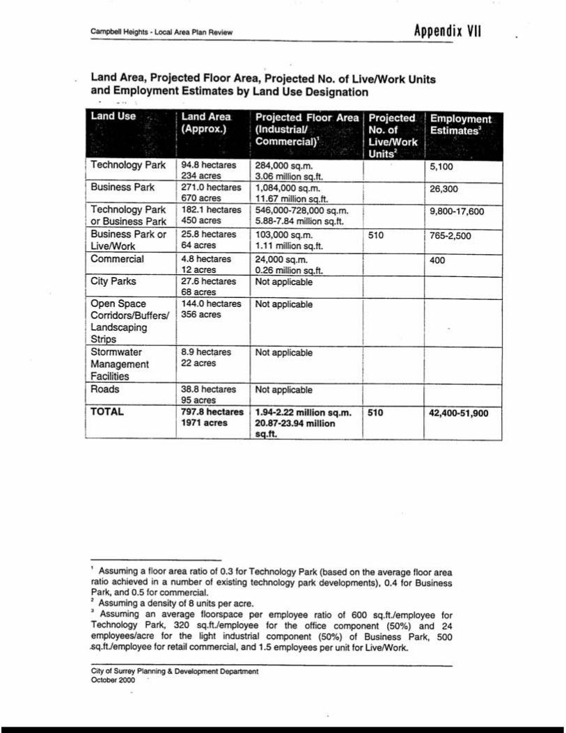

SYNOPSIS OF ENGINEERING SERVICING & FINANCING ISSUES for the CAMPBELL HEIGHTS
INDUSTRIAL AREA
INTENT
The purpose of this report is to provide an overview of the engineering servicing and financial strategies for Campbell Heights.
BACKGROUND
Campbell Heights is the last major undeveloped industrial area in the City of Surrey. Responding to Council's wish to accelerate industrial development and the considerable interest in this area from local and international companies, Land Use and Engineering Servicing Plans have been prepared.
A separate report prepared by the Planning & Development Department outlines the preferred land use for the Campbell Heights Area. This plan, which allows for Hi- Tech business park use including two potential chip plants, was used as the basis for the Engineering Study. Servicing impacts and the associated financial issues were identified and analyzed. The details ofthe engineering analysis are contained in a separate report available in the Engineering Department.
The engineering services discussed in the report relate only to major infrastructure. Localized site servicing requirements of individual developments are not analyzed in the report as responsibility for their construction rests with adjacent benefiting land owners.
DISCUSSION
Sanitary Sewer
Campbell Heights is remote from the nearest sanitary sewer system. The area will be serviced by extending a pressure sewer from Campbell Heights north wards to the GVRD sanitary sewer at 184 Street and 52 Avenue in Cloverdale. Sanitary sewer trunks will generally follow the road grid to service the industrial area. The area south of 28 A venue will be serviced by sanitary sewer trunks in the road right-of-way and a sanitary sewage lift station. The conceptual layout for the sewer servicing is shown in the attached Executive Summary.
Water
The GVRD water system bisects the Campbell Heights area. A reservoir is required to provide balancing flows to the area. A pump station will be required to deliver the water to the area at an appropriate pressure. Water distribution mains will generally follow the road grid to service the properties and are as shown in the attached Executive Summary.

-2
Transportation
The Campbell Heights area will require strong transportation links to the municipal arterial and Provincial Highway network. Currently, the area is serviced by two-lane rural roads. A transportation study was completed as part of the engineering report. Arterial and collector roads were reviewed and, where necessary, upgrades and additional elements have been identified. Substantial upgrading of the existing road network is required and is shown in the attached Executive Summary. These works are over and above what is needed for growth external to Campbell Heights. The identified road system will function together with the future Highway 1-99-D.S. Border connector roads to provide a high level of access to Campbell Heights. However, as the delivery mechanism for the Hwy. 1-99-USA Connector roads has not yet been determined their cost is not included in the overall road costs. As identified in the economic and market analysis, without the high quality access of the Hwy. 1-99-USA Connector road system, the pace of development of Campbell Heights will be impeded.
Storm Water
A comprehensive storm water study was included as part of the engineering study. Two different storm water management strategies are proposed for Campbell Heights depending on ground conditions. The core area around Latimer Lake (please see the attached Executive Summary) has a high ground water level and requires a conventional storm sewer and detention pond system. The larger area around the perimeter has conditions very conducive to ground water recharge. Here it is proposed that both the City and private systems be constructed to exfiltrate water into the ground, reducing the size of the storm sewer system and eliminating the need for detention ponds. This approach will recharge the aquifer and maintain the base flows in the streams that emanate from the base of the northwest face of the Campbell Heights slope and, subsequently, feed into the Nicomekllowlands. This is the same approach that has been used in the neighbouring area of Brookswood in Langley, which has very similar soil conditions. Extensive soils testing has been carried out to confirm the functionality of the proposed infiltration system and the initial construction will be monitored to assess performance and revise the design for future works as appropriate.
The proposed use of groundwater recharge substantially reduces the costs for drainage SerVICIng.
The Ministry of Environment and Department of Fisheries have reviewed the NCP. The proposed storm water management plan has received general support from these agencies. A more detailed review of the environmental issues is included in the report prepared by the Planning and Development Department.
Development Phasing
The sanitary sewer system is the primary limiting factor to the phasing of development. Since the sanitary sewer will discharge to the north, phasing will more than likely proceed from north to south.

--- -- ------------------- n -- - --
- 3
Regional Servicing Impacts
An area the size of Campbell Heights will have impacts on regional water and sewer servicing. Details on these regional impacts are provided in Appendix 1. Briefly summarized we will not know whether the City will need to allow for funding for sharing on additional water supply capacity until the type and rate of industrial is determined. There will be sufficient time to track the rate of development and include any necessary works in future servicing plans.
For sewer there may be the requirement for heavy water users (i.e. chip plants) to temporarily store on-site waste process water during times of heavy rainfall due to current inflow / infiltration problems combined with extensive regional capacity constraints. Such storage can be achieved by storing the clean process water in a lined open pond. Additional regional capacity is in process and is funded through the overall regional sewer DCC.
FINANCING
Context
The financing of the servicing for Campbell Heights presents unique challenges compared with other NCP's within the City both in terms of the magnitude of the costs and the
fact that there are four major land owners, three of which are the Federal, Provincial and City governments.
The following table summarizes the projected DCC revenues and construction costs for each engineering service. For water and sewer services, the DCC cost includes, where applicable, just the upsizing cost. This is in line with all other NCPs. The revenues are based on the current DCC By-law.
Projected DCC Revenues and Expenditures at Buildout
Projected Trunk
(DCC) Servicing
Costs
Projected DCC
Revenues Balance
Major Collectors 8,525,000 3,930,000 (4,595,000)
Sanitary Sewer 9,000,000 3,210,000 (5,790,000)
Water 8,800,000 3,440,000 (5,360,000)
Storm Water Management 12,860,000 24,150,000 11,290,000
TOTAL 39,185,000 (4,455,000)
This table shows that the cost of trunk DCC servicing exceeds the potential DCC collections for the area. This is owed in most part to the following:
. The existing undeveloped road network in the area.
. The isolation of Campbell Heights from the nearest sanitary servicing.
. The total lack of existing servicing in the area. Most areas of Surrey have some existing servicing which can be built upon as development proceeds.
. The requirement of a dedicated water reservoir and pump station for the area.

--
-4
The costs for arterial rods are not shown in the above table as the arterial road program is developed based on overall City needs and funded by the overall City-wide DCC. Consequently, the program cannot be looked at on a strictly NCP-by-NCP basis.
Because of the size and relative isolation of the Campbell Heights area, the servicing study did review the impact of this NCP on the City arterial road network. This analysis indicated that the arterial road costs, both within and outside the NCP boundaries, over the full 30 to 40-year build-out timeframe, is $60 million. This figure needs to be looked at in the context of the City's overall growth related arterial road works, over a similar timeframe, which is estimated to be in excess of $500 million. Consequently, Campbell Heights represents approximately one-tenth of the City's overall arterial program over the longer term.
While the costs appear large in comparison to the DCC generation, when looked at in comparison to the overall 1200 acres of developable land, the servicing costs even including the long-term arterial road costs are in the range of $100,000 per acre. This, when added to the current raw land costs, results in a final serviced land cost in line with other industrial areas. These overall servicing costs allow for two chip plants. If these plants, which are high water users and waste water generators, are not allowed for, then sewer and water costs can be reduced by $2.5 million.
Financial Strategies
In view of the above factors and significant costs involved, a different financing strategy is required for Campbell Heights compared with other NCPs. An additional factor is that the time frame involved for build-out of Campbell Heights is anticipated to be in the range of 20 to 30 years, compared with the other NCPs which are in the 5 to 15 year range. Consequently, it is proposed only to include the trunk DCC elements required for the first phase of development in the new 10 Year Servicing Plan. This first phase would include the servicing of the lands along 192 Street from 40 to 32 Avenues and the land immediately south of 32 Avenue from 192 Street to the westerly boundary of the NCP, an area of approximately 400 acres. The cost of these works and the projected DCC revenues are estimated as follows:
Projected Trunk (DCC)
Servicin2 Costs
Projected DCC
Revenues
Arterial Roads 6,700,000 5,392,000
Major Collectors 1,312,000
Sanitary Sewer 7,300,000 1,072,000
Water 5,300,000 1,148,000
Storm Water Management 2,500,000 8,064,000
TOTAL 21,800,000 17,000,000
As can be seen from the above table, for servicing to proceed there will have to be a net inflow of DCCs from other areas of Surrey into Campbell Heights. However, DCCs are operated on a municipal wide basis and it is not possible to ensure that there is a perfect balance between DCC revenues and expenditure in all areas of Surrey.

- 5
In addition to the above identified, cost of municipal services are the costs to provide electrical transmission lines for large power users such as chip plants. The costs for electrical transmission lines for heavy power users, such as a chip plant, are in the range of $17 to $25 million.
Council has approved the inclusion of the first phase works in the 1 0 Year Plan. It is also proposed that in conjunction with the Province, a major hi-tech industrial development for this area would be pursued. Once there is a commitment for a first major developer, then the financing for the first phase of servicing could be coordinated with this developer, the City, the Provincial Government, and other major land owners in the area.
CONCLUSION
The servicing plan for Campbell Heights provides a comprehensive servicing and phasing plan for the area. The engineering plan has been presented to the public and received general support. There still remain issues relating to the significant start-up costs involved, which would require a major development to be able to finance or justify such costs.
g:\2OOOlutilitysI12211034ph.doc BRE
12121100 11:15 AM
Appendix 1
Regional Servicing Issues
An area the size of Campbell Heights will impact regional water and sewer services.
Water
Based on anticipated growth projections, the regional water supply will be adequate for
one chip plant plus the development of the immediately adjacent areas, (approximately 5
million gallons a day). If this level of demand is exceeded before 2011 then the City is
responsible to cost share to help provide additional regional capacity, which could be
provided via an in-line booster station. If this level of demand is exceeded after 2011 then
the provision of extra capacity is the responsibility of the GVRD. As the determination of
whether additional supply be required will not be known until the rate of development
becomes clear, it is proposed that at the next update of the 10 Year Plan, in approximately
3 to 4 years, the need for the in-line booster will be re-evaluated and included if
necessary.
Sewer
With regard to sewer there is adequate capacity for the initial phases of development
except during periods of extremely wet weather when inflow and infiltration causes the
regional system to reach or exceed its capacity. The GVRD is in the process of providing
additional capacity and a new section of trunk is proposed from Highway #10 to King
George Highway in the next few years which will help alleviate these capacity issues.
Additionally Surrey, Langley and Langley Township are working to reduce the levels of
inflow and infiltration.
Due to these wet weather capacity concerns heavy water users such as chip plants, will
have to store waste process water during periods of heavy rainfall. This storage process
of wastewater could be achieved through on-site storage which is a feasible and practical
solution. Overall additional regional capacity is funded through the regional sewer DCC.
g:I2000lutilitysl1 0310851 ph.doc BRB
12121/00 10:36 AM


-~-~-~~
Executive Summary Report
List of Tables
Table 3.1 Summary of Peak Flows Rates and Runoff Volume .................................................. 3-3 Table 3.2 Summary of Private Exfiltration Areas Trenching Requirements. . . . . . . . . . . . . . 3-6
Table 3.3 Comparison of Estimated Runoff Volumes...., ...............................................................3-7
Table 4.1 Estimation of Developable Land - June 9, 2000 . . . . . . . . . . . . . . . .. end of Section 4 Table 4.2 Demand Projection -- Water, Sanitary, and Employment. . . . . . . .. end of Section 4
Table 5.1 Road Servicing Costs by Development Phase. . . . . . . . . . . . . . . . .. end of Section 5
Table 6.1 Water Servicing Costs By Development Phase. . . . . . . . .. . . . . . .. end of Section 6
Table 7.1 Order of Costs Estimate. . . . . . . . . . . . .. . . . . . . . . . . . . . . . . . . . .. end of Section 7
Table 9.1 On & Off Site Trunk Services by Development Phase. . . . . . . . . . .. end of Section 9
Table 9.2 DCC Collection. . . . . . . . . . . . . . . . . . . . . . . . . . . . . . . . . . . . . . . . .. end of Section 9
List of Figures
Figure 2.1 Environmentally Sensitive Areas. . . . . . . . . . . . . . . . . . . . . . . . . . . end of Section 2Figure 2.2 Potential Forested Corridors and Creek Corridors. . . . . . . . . . . . . . end of Section 2Figure 3.1 Functional Plan. . . . . . . . . . . . . . . . . . . . . . . . . . . . . . . . . . . . . . . . . end of Section 3Figure 4.1 Proposed Land Use Concept Plan - June 9, 2000 ............... end of Section 4Figure 4.2 Tentative Phasing of Development ................... . . . . . . . . . . . . . . . . . end of Section 4Figure 5.1 Recommended Lane and Signal Requirements. . . . . . . . . . . . . . . . . end of Section 5Figure 6.1 Watermain Schematic. . . . . . . . . . . . . . . . . . . . . . . . . . . . . . . . . . . . end of Section 6Figure 7.1 Alternative Routes (Sanitary System) . . . . . . . . . . . . . . . . . . . . . . . . end of Section 7Figure 7.2 Recommended System (Sanitary) . . . . . . . . . . . . . . . . . . . . . . . . . . . end of Section 7
11 1
~ ~ @

-
Executive Summary Report
CAMPBELL HEIGHTS SERVICING STUDY
EXECUTIVE SUMMARY REPORT
1.0 INTRODUCTION
The Campbell Heights area encompasses approximately 785 ha in southeastern Surrey. The area
generally lies between 18 and 44 Avenues to the south and north, and 186 and 196 Streets to the
west and east. The western boundary follows the top of a ridge which descends to the Nicomekl
River lowland plain.
The City of Surrey Official Community Plan (OCP) designates all of Campbell Heights as an
industrial area. Current land use is predominately agricultural or agro-industrial with
greenhouses, henneries, fur farms, and tree nurseries utilising approximately one-half of the land
within the study area. The remaining lands are occupied with treed areas and quarry operations.
The City of Surrey prepared an Economic Development Action Plan 1999 - 2000. One of the key recommendations of the plan was to provide pre-serviced industrial lands to overcome the
shortage that currently exists in the city. One of the areas identified for pre-servicing was
Campbell Heights. This area has attracted several foreign companies, including a semiconductor
manufacturer, whom are seeking large parcels of land. Through these recent contacts, it has
become clear that modem businesses prefer pre-serviced land to start a new operation as it
reduces the uncertainties involved in servicing and allows a new facility to commence operation
in a shorter time frame.
Prompted by the interest of a semi-conductor manufacturer seeking a large parcel of land the City
decided to devise a servicing scheme for Campbell Heights. The City retained the services of
New East Consulting Services Ltd. to prepare the servicing plan. The study was commissioned in
March 1999 but required a land use plan before it could be completed. The Terms of Reference
for the study is presented as Appendix A.
The Planning Department devised two concepts for the Campbell Heights Local Area Plan.
These were presented at a public open house on February 17, 2000 at East Kensington
Elementary School. After receiving the public and stakeholder input the Planning Department
has revised the land use plan. The revised plan was presented in a second open house on April
27,2000. Since then the proposed land use plan has been further refined to reflect the input form
various stakeholders and the public. This report is prepared to identify an order of magnitude
estimate for the servicing requirements based on the proposed land use plan.
~C:\WIN95\TEMPlintro swn.wpd 1-1
~@

Executive Summary Report
The Executive Summary Report is a distillation of the design issues and assumptions regarding a
particular facet of servicing. Complete details may be found in the Campbell Heights Servicing
Study -- Technical Report and its separately bound appendices.
The Executive Summary Report is organised into nine sections. Section 2 -- Environmental
Review is a summary of the review conducted by Gartner Lee Limited in the spring of 1999. At
that time Gartner Lee was retained by New East to identify the environmentally sensitive areas
within and around the Campbell Heights area and to prepare environmentally responsible
guidelines for land development. Section 5 -- Roads and Transportation is a summary of the
study conducted by Ward Consulting Group. Ward Consulting Group was retained by New East
. to provide transportation planning and modelling for the study area. The remaining sections of this report including storm water management strategies, land use development and
demand projection, water supply, sanitary system, non-municipal utility servicing, and overall
development costs with DCC recovery are summaries of works prepared by New East.
~1-2~
@

- - -- - -- - - - -- .- -- -- -- ---
- --- ------------------- u
Executive Summary Report
2.0 ENVIRONMENTAL REVIEW
2.1 Objectives
In the spring of 1999, Gartner Lee Limited conducted an environmental review of the Camp bell Heights area. Their report is provided in full as Appendix B of the Campbell Heights Servicing Study -- Technical Report.
The objectives of the review were to: . identify the environmental requirements of the area so that they could be incorporated into
the early planning stages,
. provide scientifically based guidance towards the land use .plan,
. optimise the biophysical characteristics of the area, and
. provide guidance toward the creation of an environmentally sound storm water management
plan.
2.2 Methodology
The review consisted of a desktop study of existing reports, aerial photography, mapping, and environmental databases. This work was augmented with a two day field review by two biologists. The field work examined the physical and biological conditions present in the area and to identified and graded the existing environmentally sensitive areas (ESA). From this information appropriate guidelines for development were devised.
2.3 Findings
2.3.1 Physical Conditions
The Campbell Heights area is situated on a plateau at elevations between 40 and 45 metres geodetic. The ground surface is fairly level and rises 20 metres above the surrounding flat clay soils which comprise the Nicomekllowland plain. The western ridge of the plateau, which constitutes the western boundary of the Campbell Heights area, slopes downward to the lowland plain at grades between 10 and 20%.
Geologically the area was formed by a large deltaic deposit of sand and gravel. This formation
contains an unconflned aquifer that is recharged,- at least in part, by the infiltration of surface
water and precipitation. The aquifer is the same aquifer used by some residents in the City of
Surrey and the Township ofLangley as a source of potable water. The aquifer also provides
baseflow for the many streams that emanate from the flanks of the plateau including the
2-1
~
~@

Executive Summary Report
Nicomekllowland watercourses. The geological setting of the Campbell Heights area and active
groundwater use make them especially sensitive to the receipt of contaminants from surface level
activities. To the south, the groundwater provides a source for watercourses leading to the
Campbell River.
2.3.2 Biological Conditions
The Campbell Heights area supports various vegetative, fish, and wildlife communities and
contains species of conservation interest. Four general vegetative communities occur: coniferous
forest, deciduous forest, mixed forest, and riparian forest. These are distributed around the study
area and provide habitat and nutrients for wildlife and enhance the quality of air and water.
The Campbell Heights area is situated between two regionally important natural areas. The
Campbell River Regional Park lies about 1 km to the southeast and the Serpentine Nicomekl
River estuary is about 10 km to the northwest. The wooded areas, riparian stream corridors and
open fields in Campbell Heights provide migration corridors for wildlife between these two large
areas.
The Campbell and Nicomekl Rivers support a variety of salmonid and non-salmonid fish species.
Although the Nicomekl is dyked with little riparian cover and heavily sedimented it provides a
corridor for fish to reach the extensive network of creeks and ditches throughout the lowlands.
Almost all of these creeks are of the highest habitat classification for both spawning and rearing
opportunities. The Campbell River, which is more pristine in character offers spawning and
rearing habitat. It also has many tributary streams that provide fish habitat.
2.3.3 Environmentally Sensitive Areas
For the purposes of this study, environmentally sensitive areas (ESA) were defmed as terrestrial
or aquatic features which perform important environmental functions and/or support important
biophysical attributes and if modified, could result in significant environmental impact. In this
respect thirteen areas, representing three levels of sensitivity (high, moderate, and low) were
identified. Figure 2.1 illustrates the locations of the areas as identified by Gartner Lee.
Areas of high sensitivity include the riparian area surrounding Anderson Creek, the groundwater
seepage areas feeding the Twin Creeks, Brooklane and Laughlin Creeks, Latimer Pond, and the
minor watercourses leading to the Campbell River. Areas identified as moderately sensitive
include all of the large wooded areas and a portion of the western ridge slope between 24 and 28
Avenues. The remaining areas were identified as having a low level of environmental sensitivity.
2-2
~ ~
@
nn - ---------------------------------- nU-
Executive Summary Report
2.4 Development Guidelines
The development guidelines recommended by Gartner Lee are intended to preserve vegetative
and riparian areas for the benefit of fish and wildlife and to enhance the quality of water and air.
Specific guidelines for the design of drainage services and the preservation of wildlife corridors
were provided and opportunities to enhance wildlife habitat were identified. Figure 2.2
illustrates the location of the potential forested and creek corridors as identified by Gartner Lee.
2.4.1 Guidelines for Environmentally Sensitive Areas
In areas defined as having a high sensitivity it is recommended that development be avoided. In
particular riparian areas should be preserved or enhanced especially for fish habitat. In
moderately sensitive areas it is important to retain vegetation with particular attention to wildlife
corridors. In areas of low sensitivity opportunities to preserve water quality, through the proper
management of storm water, and to create wildlife habitat should be undertaken. Throughout the
Campbell Heights area efforts should be made to minimise the contamination of storm water
runoff from ground level sources and to maximise the quantity of storm water exfiltrated into the
ground.
2.4.2 Guidelines for Drainage Design
It is recommended that storm water runoff from developed areas, parking lots, and road ways be
dealt with using best management practices to minimise contaminants and then exfiltrated into
the ground to replenish the aquifer. Surplus flows should be directed towards existing
watercourses. Oil, grease, and sediment separators should be used to treat runoff from roadways
and parking lots. Wherever possible the conveyance of storm water should be achieved by way
of swales and ditches.
2.4.3 Opportunities for Habitat Enhancement
A number of opportunities for habitat enhancement are available. These include improvement to the salmonid habitat in Stokes Pit by providing stream complexing for the existing constructed channels, riparian planting, creek realignment, and surface flow preservation. Interconnections between storm water management ponds would provide fish, amphibian, and wildlife corridors. Habitat values could be created in these ponds by providing aquatic and shoreline vegetation.
2-3
~ ~
@


--- --- __n-------------------------n-- - nn -------------------------- _--mU
Executive Summary Report
3.0 STORM WATER MANAGEMENT STRATEGIES
3.1 Introduction
Campbell Heights is unique area in Surrey as the soils are comprised mostly of sands and gravels
up to 40 metres in depth. This formation contains an unconfined aquifer that is recharged by the
infiltration of surface water and precipitation. The aquifer is the same aquifer used by some
residents in the City of Surrey and the Township of Langley as a source of potable water.
The aquifer also provides baseflow for the numerous lowland streams which emerge along the
length of the flank of the western ridge of the plateau. The lowland watercourses are productive
habitat for salmonids. The storm water management plan for the Campbell Heights area must
make provision for groundwater recharge to sustain these streams or they could diminish. To the
south, the groundwater provides a source for watercourses leading to the Campbell River.
Absent from the plateau area are natural watercourses and gullies. This is an indication of the
permeable nature of the soils. Latimer Pond, located near the southwest corner of 192 Street and
28 A venue, is the only waterbody in the area. . It was formed as a result of gravel extraction activities within Stokes Pit that intersected with the locally high ground water table.
At this location the ground water table is within 3 metres of the ground surface. This condition
extends over a large portion of the study area. It reaches its apex near 196 Street, south of 32
Avenue and is thought to extend from there for a radius of 1 kilometre. The ground water table
slowly fluctuates in relation to the seasonal variation in precipitation. The localised high ground
water table limits the ability to exfiltrate storm water to the ground in these areas.
Rainfall runoff from the Campbell Heights area discharges to three different watercourses. In
general, the portion of the study area south of 24 A venue and east of 188 Street drains to the
Campbell River system. The remaining portion to the north, which comprises roughly two-thirds
of the study area drains to the agricultural lands situated within the Nicomekl River lowlands
except for a 20 ha parcel in the northwest corner of the study area which discharges to Anderson
Creek. Anderson Creek is a major tributary of the Nicomekl River. The Nicomekllowlands are
drained to the Nicomekl River by way of a series of ditches leading to the Erickson Creek
pumpstation.
Whenever a rural area, such as the Campbell Heights area, is developed for industrial use, the
intensity and volume of storm water runoff increases. The increase is a direct consequence of the
increase of impervious areas created by buildings and pavement. If unchecked, the increase in
runoff can adversely impact the natural environment by changing the morphology of the
receiving waterways and by introducing contaminants such as oil, grease, sediments, etc. Other
environmental and social constraints affecting the development of a storm water management
strategy for the Campbell Heights area include the preservation of groundwater resources and
3-1
~
~@
Executive Summary Report
respecting the needs of the agricultural community.
The objectives of this storm water management plan for the Campbell Heights are to: .minimise the potential impacts to, and enhance, the natural environment, including the
ground water resource,
. limit runoff to the Nicomekllowlands to be consistent with or improve upon the design
assumptions for the Erickson Pump Station, and
. provide a convenient and safe system to convey the runoff from the minor and major storm
events within the Campbell Heights development.
3.2 Analysis and Synthesis
3.2.1 Limitations and Constraints
Significant challenges face the development of a drainage system for the area. These include the flat topography, environmental constraints, and a localised high ground water table..
The flat topography makes the design of a conventional design using piped connections and
detention ponds difficult. As depth increases along a piped run, pipes to transport storm water
flows quickly become too deep for delivery to a detention pond located on the Campbell Heights
plateau. To make such a system function, detention ponds, their outlets, and the receiving water
level need to be at increasingly lower (deeper) elevations and storm sewer sizes become
increasing large and less efficient.
The increase in impervious surfaces (buildings, roads, parking lots, etc) that accompany
development will serve to block the unusually high rate of transmission of precipitation through
the permeable soils to the underlying aquifer. If a conventional drainage system is used in the
Campbell Heights area the western portion of the aquifer could diminish. This may impact the
Nicomekl River lowland streams and resident fish populations that are reliant on ground water
seepage as a source of base flow. In addition, if a conventional system is employed then runoff
will be directed to surface water routes rather than through the soil to the aquifer as it presently
does. This will further exasperate the recharge potential to the aquifer. Therefore, a storm water
system that exfiltrated runoff to the ground is appropriate for the Campbell Heights area as it
closely mimics the current hydrologic regime.
3.2.2 Methodology
Hydrologic modelling was used to evaluate the runoff regime from the existing (predevelopment)
land use conditions and from the anticipated future land use conditions without storm water
controls. This comparison was used as the base condition and serves as an aid in determining the
3-2
~ ~
@

- - --- uu- - --- --
Executive Summary Report
appropriate size of storm water control devices. For the uncontrolled development condition it
was determined that peak storm flows and runoff volumes would increase by 600% and 400%
re:;pectively. Therefore one of the principal objectives of the storm water management plan is to
control these increases to mimic the predevelopment condition. Table 3.1 summarises the
estimated predevelopment and uncontrolled peak development conditions determined by the
hydrologic modelling.
Table 3.1 Summary of Peak Flows Rates (m3/s) and Runoff Volume (ha*m)
Area
Existing Conditions Postdevelopment Conditions % Change
Series 2yr
12 br
Syr
12 br
10yr
12 br
lOO yr
12 br
2yr
12 br
Syr
12 br
10yr
12 br
lOO yr
12 br
2yr
12 br.
Syr
12 br
10yr
12 br
lOO yr
12 br
1200 0.29 0.47 0.61 1.1 2.0 2.5 2.8 3.8 590 432 359 245
to
1000 1.1 1.7 2.1 3.6 4.2 5.1 5.8 7.8 282 200 176 117
2200 0.68 1.0 1.3 2.4 2.6 3.1 3.5 4.9 282 210 169 104
to
2000 2.5 3.6 4.4 7.3 8.2 10.1 11.3 15.3 228 181 157 110
3000 0.09 0.14 0.18 0.34 0.52 0.64 0.72 1.0 478 357 300 194
0.22 0.35 0.45 0.80 1.1 1.3 1.5 2.0 400 271 233 150
4000 0.16 0.26 0.33 0.62 0.82 1.0 1.1 1.6 413 285 233 158
0.53 0.78 0.96 1.6 1.7 2.1 2.3 3.2 221 169 140 100
5300 0.64 1.0 1.3 2.3 3.9 4.8 5.4 7.6 509 380 315 230
to
5000 2.4 3.6 4.4 7.4 8.1 9.9 11.1 15.1 238 175 152 104
6000 0.14 0.23 0.3 0.57 1.0 1.3 1.4 2.0 614 465 367 251
0.49 0.77 0.97 1.7 2.1 2.6 2.9 4.0 329 238 199 135
NB: Runoff Volumes (ha*m) are in italics
In recognition of the unique soil conditions in Campbell Heights it is thought that the exfiltration
of storm water to the permeable substrata is the most appropriate method to control
postdevelopment storm water runoff as it would mimic the natural regime. The benefits of such a
system include:
3-3
~ ~
@

Executive Summary Report
.
.
.
. maintenance of aquifer levels,
maintenance of baseflows to the Nicomekllowland watercourses,
reduction of surface runoff, and
reduction of the need for large, inefficient storm sewers.
An assessment of the exfiltration potential of the Provincial Forestry Nursery Lands was
conducted by Golder Associates Ltd. in the Spring of2000. This work was subjected to a peer
review by Piteau Associates Ltd. Both of these reports appear as appendices to the Campbell
Heights Servicing Study -- Technical Report.
In order to exfiltrate stormwater into the permeable soils the following technologies were
examined, exfiltration basins, exfiltration trenches, drainage fields, and exfiltration galleries.
Exfiltration basins are "detention pond like" structures designed to retain water so it can be
transmitted to the ground over a few hours to a couple of days. Exfiltration trenches are
subterranean systems that mayor not contain perforated or non-perorated pipe within a clear
granular backfill. In this system storm water is transmitted to the ground through the backfill.
Surplus flows can be recovered at the trench outlet and directed downstream or to another
drainage facility. Drainage fields are "septic field like" systems in which a series of branches
extend from a manifold system to distribute the storm water over a large area. These systems are
also located beneath the ground surface. The fourth system, exfiltration galleries, are similar to
trenches in concept but are "pit like" systems filled with granular material. Storm water from
several areas can be conveyed to a gallery by way of ditches or pipes.
Exfiltration basins and drainage fields were rejected from further investigation as they were
deemed to be unsuitable for the Campbell Heights area. In the case of exfiltration basins it was
thought that these would suffer from the same limitations imposed by grade as those facing
detention ponds and be at risk for clogging. Drainage fields were discounted for their
complexity, susceptibility to clogging, and fragility. Exfiltration galleries and trenches were
found to be robust, simple to install, and inexpensive. Exfiltration trenches have some
advantages over exfiltration galleries in that they form their own pipe network and spread the
zone of exfiltration over a wider area. Thus exfiltration trenches were deemed the most suitable
form of exfiltration technology for the Campbell Heights area.
The performance of an exfiltration trench is a function of the interaction of a complex set of
factors including:
. soil permeability (expressed as the coefficient of permeability, "K"),
. depth from the ground surface to the ground water table,
. trench geometry (width, length, effective water depth), and
. soil saturation conditions at the onset of a precipitation event.
The evaluations of trench performance used for the functional plan simplify this complex set of
3-4
~
~
@

Executive Summary Report
variables in a conservative manner. A more detailed assessment of trench performance is
presently being conducted as a task under the preliminary servicing design for the Provincial
Forestry Nursery lands.
An economic comparison was preformed between an exfiltration system and a hypothetical
conventional, detention pond based drainage system for Campbell Heights. It was demonstrated
that exfiltration systems provided a more cost-effective alternative as the need for large pipes and
large excavations for detention ponds were eliminated. Therefore it is expected that the reduced
costs for drainage infrastructure will be an attraction for potential developers.
As mentioned previously, the ground water table is close to the ground surface near 196 Street
south of 32 Avenue. This condition is presently thought to extend for a radius of 1 kilometre
through the Campbell Heights area. It is also known that the elevation of the ground water table
varies in proportion to seasonal precipitation events. In this area there is not enough separation
between the bottom of an exfiltration trench and the anticipated maximum ground water table to
create an effective exfiltration zone. Therefore alternative forms of storm water management,
such as detention ponds and remotely provided exfiltration zones will be required to service this
area. The extent of the high ground water table is presently being assessed as part of the
preliminary design work for the Provincial Forestry Nursery lands.
3.3 Functional Plan
The style of servicing best suited for a particular area within Campbell Heights is dependent on
the location of the maximum anticipated ground water table In recognition of this limitation
three styles of servicing have been devised for the Campbell Heights area. These are privately
provided exfiltration areas, municipally provided exfiltration areas, and municipally provided
detention areas. The functional plan is depicted in Figure 3.1.
The functional plan for exfiltration trenches includes local interconnection to the municipal
trench system. Connection points to the municipal trench system will be provided at 200 metre
intervals. The benefits of this arrangement are the provision of overflow outlets at appropriate
locations and an increase in connectivity throughout the exfiltration system. The increased
connectivity will allow water to flow freely and distribute throughout the exfiltration network.
This will compensate for unforeseen, micro-localised, soil and high ground water table conditions
not discovered during the design phase of the works. The interconnection will also help mitigate
and identify partial system failures. Furthermore, the interconnection will allow for additional
infiltration during less frequent storm events.
Developers in private exfiltration areas will be required to provide exfiltration facilities to reduce the 1 in 5 year design event postdevelopment peak flow to predevelopment levels. The
3-5
~ ~
@

Executive Swnmary Report
developer provided exfiltration facilities must be connected at their terminal end to an
appropriate connection point on the municipal system. This will help distribute water and will
provide an overflow outlet at an appropriate location. Table 3.2 provides estimates of the length
of exfiltration trench required for private exfiltration areas. The estimated trench lengths are for
trenches 1.2 metres wide with a maximum operational water depth of 1.2 metres.
Table 3.2 Summary of Private Exfiltration Areas Trenching Requirements.
Area ID Area
(ha)
Total Estimated
Trench
Requirements
(m)
Total Length of
Municipal Trench
(m)
Total Length of
Developer Provided
Trench
(m)
A6000 66.2 2,790 400 2390
A5100 66.2 2790 430 2360
A5000 &
A5200
114.5 4820 2620 2200
A4000 52.4 2030 915 1115
AllOO &
A3000
65.0 2790 1120 1670
AIOOO 64.3 2790 920 1870
AllOOO 22.0 935 640 295
The exfiltration trenches will reduce runoff volumes significantly as they will provide a direct
connection to the pervious soil layer thus increasing exfiltration volwnes. This will improve the
calculated flood levels and reduce flood duration in the Nicomekllowlands in comparison to
those calculated for the design of the Erickson Creek pumpstation. In addition it will reduce
erosion and sediment transport in the lowland watercourses thus benefiting the aquatic habitat.
Estimates of the calculated runoff volumes for the 1 in 5 year and 1 in 100 year design events are
reported in Table 3.3.
3-6
~ ~
@

~- ----------~--~--~-~ ~ ~-- ~-- ~--- - - - ----
Executive Summary Report
3.4 Order of Costs Estimate
The order of cost estimate is based on a quantities estimate obtained from schematic sketches of
a functional layout. The quantities were then multiplied by unit prices obtained from previously
tendered works for past construction projects and budget prices provided by local suppliers.
Based on the above methodology the order of costs were originally estimated to be $10.7-million
dollars. However, based on the present uncertainties surrounding the design of exfiltration
trenches and allowing for unforseen items a multiplier of 1.2 has been applied. Therefore the
estimated order of costs for the drainage system detailed in this functional plan is $ 12.9-million.
This figure compares favourably to the estimated $20.7-million for a conventional system. These
estimates do not include land and right-of-way acquisition costs.
3.5 Design Guidelines for Developers
The control of silt generated during the construction of site works and buildings must be strictly
enforced and monitored in order to protect the integrity of the exfiltration systems. Landscaping
should be done in consideration of the location of exfiltration systems to prevent the intrusion of
plant roots into the exfiltration network.
Minor Desip Storm Events (up to 1 in 5 vear return period)
Consider the provision of roof top detention storage by limiting the size and placement of roof
drains within the limits of the British Columbia Building Code.
Provide water quality devices for drainage originating from roadways, parking lots, and
hazardous goods handling areas to intercept potential contaminants (oil/grease/sedimentJetc)
prior to entering the exfiltration system.
In locations deemed, "Private Exfiltration Areas" site specific storm water management must be devised by the private developer such that runoff originating from buildings, road ways, parking lots, and open areas are exfiltrated to the soil such that the postdevelopment peak flow at the terminal end of the exfiltration trench is reduced to predevelopment levels. The terminal end of private exfiltration trenches is to be connected to the closest access point on the municipal exfiltration trench system.
Major Storm Flow
Lot grading to direct major flow to roadways. Internal roadways must be capable of containing the major flow. .
3-8
~@ ~


Executive Summary Report
of this study and with the assumption that the semi-conductor plant on the Forestry Nursery land
will lead the development, the remaining development is assumed to start generally from the
north end of the study area and progress towards the south.
Figure 4.2 show the boundaries of the three phases for the Campbell Heights area development
with the initial phase to be generally north of 3200 Avenue. Phase 2 of the development
encompasses the area south of Phase 1 to 24 A venue excluding Stokes Pit. Phase 3 includes the
remammg area.
4.3 Developable Area
The area of 64 hectares represents the gross area available within each half-mile square block. In
establishing the net developable areas, the following non-developable components have been
deducted:
. Road right-of-ways - by allowing for all designated road right-of-ways and appropriate mid
block roads. No allowance for mid-block roads has been made for the semi-conductor plants.
.. Environmentally sensitive areas - as identified on the Land Use Concept Plan. . Storm water
detention pond requirements - as initially identified under Section 3 of this
report with such detention ponds to be considered as part of the open space requirements. .Open spaces and parks of 5% of the net block area. . Other institutional use such as utilities
installations, transportation and servicing, security,
medical, and day-care facilities at 5% of net block area.
Applying these components to the individual blocks, the net developable areas were established
on block by block basis as given in Table 4.1. The average net developable area for the
industriallbusiness zone is around 60% and those for the semi-conductor sites are 80%. These
net developable areas are applied as the basis for the establishment of the necessary servicing.
4.4 Demand Projection Parameters
Based on the City of Surrey Design Criteria Manual, the specific demand projection parameters
applied to this study were as follows:
Fire Flow
The fire flow requirement of250 1/s (21,600 m3/day) is applicable to the entire industrial area at
the outset of the development (assumed to be year 2002).
4-2
~
@ ~

-- --- ---- ------------------------ ------------------------------------------ --
Executive Summary Report
IndustriallBusiness Areas
. For the purpose of overall demand projection, the average value of 60% or 38.4 hectares for
each 64-hectare block was assumed as the net developable area.
. 90 equivalent population per hectare of net developable area. This gives an equivalent
population of 3,456 persons per block.
. Average water demand of 500 litres per equivalent population per day with no seasonal
peaking expected for industrial demand.
. Average dry-day sanitary flow was assumed to be 500 litres per equivalent population per
day. Together with an infiltration rate of 11,200 litres per net developable hectare per day. . 75%
floor area ratio being the maximum allowable for IB zoning in the Surrey Zoning Bylaw
No. 12000.
. For purpose of traffic generation projection and estimate of2,133 employees per block was
assumed.
Semi-Conductor Plant Areas
The following assumptions and parameters are given by Jacobs Engineering Group, the
functional design specialist for such plants, in their report prepared for the British Columbia
Trade and Investment Ministry, revised version dated December 15, 1999:
. 24,000 m3/day water demand for each plant occupying a block
. An average sanitary flow of 20,400 m3/day per plant
. 75% floor area ratio to be applied to the net developable area
. 4,800 employees per semi-conductor plant. This gives 1,600 employees per shift with three
shifts per day
4.5 Demand Projection
Using the assumptions and parameters described in this section, projections for water demand,
sanitary flow, floor area, and employment are generated as per Table 4.2.
Wherever practicable, implementation of services should be carried out in phases. This will
allow the timing and capacity of the latter phases requirements to be evaluated based on the
usage and progress of the initial phase of development.
4-3
~ ~
@
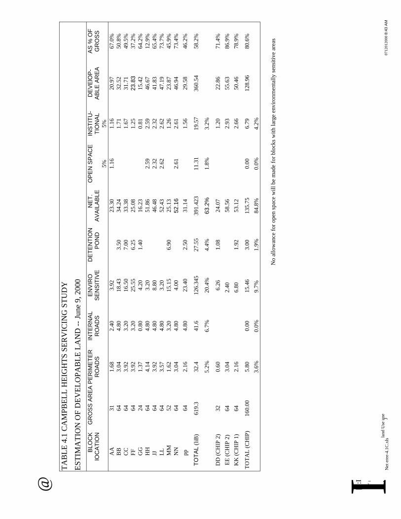
@ T
AB
LE
4.1
CA
MP
BE
LL
HE
IGH
TS
SE
RV
ICIN
G S
TU
DY
ES
TIM
AT
ION
OF
DE
VE
LO
PA
BL
E L
AN
D -
- Ju
ne
9, 2000
BLO
CK
G
RO
SS
AR
EA
PE
RIM
ET
ER
IN
TE
RN
AL
EN
VIR
O
DE
TE
NT
ION
N
ET
. O
PE
N S
PA
CE
IN
ST
ITU
- D
EV
ElO
P-
AS
% O
F
lOC
AT
ION
RO
AD
S
RO
AD
S
SE
NS
ITIV
E
PO
ND
A
VA
ILA
BLE
T
ION
AL
AB
LE
AR
EA
G
RO
SS
AA
31
1.6
8
2.4
0
3.9
2
BB
6
4
3.0
4
4.8
0
18
.43
CC
6
4
3.9
2
3.2
0
16
.50
FF
6
4
3.9
2
3.2
0
25
.55
GG
2
4
1.3
7
0.8
0
4.2
0
HH
64
4.1
4
4.8
0
3.2
0
JJ
64
3.9
2
4.8
0
8.8
0
LL
6
4
3.5
7
4.8
0
3.2
0
MM
52
1.6
2
3.2
0
15.1
5
NN
64
3.0
4
4.8
0
4.0
0
5%
5%
23
.30
1
.16
1
.16
2
0.9
7
67
.0%
3.5
03
4.2
41
.71
3
2.5
2
50
.8%
7.0
03
3.3
81
.67
3
1.7
1
49
.5%
6.2
5
25
.08
1
.25
23.8
33
7.2
%
1.4
01
6.2
30
.81
1
5.4
2
64
.2%
51
.86
2
.59
2
.59
4
6.6
7
12
.9%
46
.48
2
.32
2
.32
4
1.8
3
65
.4%
52
.43
2
.62
2
.62
4
7.1
9
73
.7%
6.9
02
5.1
31
.26
2
3.8
7
45
.9%
52.1
62
.61
2
.61
4
6.9
4
73
.4%
pp
6
4
2.1
6
4.8
0
23
.40
2
.50
3
1.1
41
.56
2
9.5
8
46
.2%
TO
TA
L (
liB
) 6
19
.3
32
.4
41
.6
12
6.3
45
2
7.5
5
39
1.4
23
1
1.3
1
19
.57
3
60
.54
5
8.2
%
5.2
%
6.7
%
20
.4%
4
.4%
63.2
%1
.8%
3
.2%
DD
(C
HIP
2)
32
0
.60
6.2
61
.08
2
4.0
7
1.2
0
22
.86
7
1.4
%
EE
(C
HIP
2)
64
3
.04
2.4
05
8.5
62
.93
5
5.6
3
86
.9%
KK
(C
HIP
1)
64
2
.16
6.8
01
.92
5
3.1
2
2.6
6
50
.46
7
8.9
%
TO
TA
L (
CH
IP)
16
0.0
0
5.8
0
0.0
0
15
.46
3
.00
1
35
.75
0
.00
6
.79
1
28
.96
8
0.6
%
3.6
%
0.0
%
9.7
%
1.9
%
84
.8%
0
.0%
4
.2%
No
all
ow
ance
for
op
en s
pac
e w
ill
be
mad
e fo
r b
lock
s w
ith
lar
ge
env
iro
nm
enta
lly
sen
siti
ve
area
s
['!:
I
~I
.la
nd
Use
un
e
N
et e
ree-
4.1
C.x
ls
J0712012000
8:4
3 A
M
I


- __________ nn -----------------u __n
Executive Summary Report
5.0 ROADS AND TRANSPORTATION
This component of the study was carried out to determine the lane requirements of all arterial and
collector roads serving the Campbell Heights area. The transportation modelling was done by
Ward Consulting Group Inc. Their complete report describing the analysis of the road network
improvements, results, and recommendations is included as Appendix E of the Campbell Heights
Servicing Study -- Technical Report.
5.1 Existing System Assessment
Campbell Heights presently has a network of two-lane rural cross-section roads designated as
arterials and collectors. There are no signalized intersections. Three intersections have all-way
stop control. The key regional roads that serve for trips to and from Campbell Heights include
Highway 10/56 Avenue, Highway 15/176 Street, and Highway 99.
Within the study area the existing arterial roads are at less than one-half capacity for the present
afternoon peak hour period. This estimate is based on a capacity of 800 vehicles per hour per
lane. The primary deficiency in the existing road network is the lack of continuity of 40 Avenue
between Highway 15 and 200 Street in Langley.
5.2 Future Traffic Background Conditions
Forecasts for future traffic demand were prepared using the current (February, 1999) version of
Translink's regional transportation model. The base network for this study's model is identical to
the GVRD's Transportation 2021 network. Included in this base network are a number of
regional transportation improvements that have been proposed including a new crossing of the
Fraser River between Langley and Maple Ridge, and extended rapid transit service from Surrey
City Centre to Newton and Guildford. It was assumed that Highway 10 between King George
Highway and 176 Street would remain as two lanes, and would be four lanes east of 176 Street.
The traffic projections for the Lower Mainland are largely based on the land use assumptions
under the current version of the GVRD Growth Management Strategy. The overall employment
and population totals for Surrey used for the traffic projections herein are consistent with the
GVRD strategy.
Even without the proposed development of the Campbell Heights area there would still be
improvements to the road network in the broader area that are required by 2021. Since these are
required regardless of the proposed Campbell Heights development they should not be attributed
5-1
~ ~
@
Executive Summary Report
to the proposed development. These improvements were assumed to be in place when
considering what additional improvements are required as a result of the development of the
Campbell Heights area.
5.3 Future Traffic Projections
The road network in the study area was redefined to include all of the planned arterial roads to
which some collector roads were added in the middle of the area. Some of the traffic projections
include a toll road connector between Highways 1 and 99. The City indicated that this toll road
connector would skirt the study area and end at 192 Street near Colebrook Road.
Full build out of the Campbell Heights area is expected to occur by the year 2040. At that time it
is estimated that employment in the area will reach 24,000 jobs. For other areas in Surrey and the
rest of the GVRD, there are no land use projections available for 2040. Similarly there is no plan
for the 2040 road network. Thus, the 2040 traffic volume forecasts are based on the surrounding
area 2021 network with only the Campbell Heights area using the 2040 conditions. As such, the
results do not represent the true 2040 conditions, but give some indication as to traffic volumes
that are likely to be encountered in the vicinity of the study area.
Future traffic projections were made for the following alternatives:
. Year 2021 a.m. peak hour without toll roads,
. Year 2040 a.m. peak hour without toll roads,
. Year 2040 a.m. with an east-west toll road, and
. Year 2040 a.m. with east-west and north-south toll roads.
5.3.1 2021 Projected Volumes -No Toll Roads
The model was run for the 2021 a.m. peak hour to determine the number of required lanes on
each of the links and also to determine where signals would likely be required. Four lanes will
be required on the following arterial roads under these conditions:
. 192 Street north of 24 Avenue to Highway 10, .184 Street north of 32 Avenue to Highway 10, . 40 Avenue from Highway 15 to 184 Street,
. 32 Avenue from 200 Street to 184 Street,
. 24 Avenue from 200 Street to Highway 15, and . 16 Avenue from 200 Street to Highway 15.
5-2
~
~
@

Executive Summary Report
Signals will be required at the intersection of all arterial roads in the vicinity of the development. These intersections include:
. Colebrook Road at 192 Street,
. 40 Avenue at 184 Street, 192 Street, 200 Street, and Highway 15, . 32 Avenue at 184 Street, 192 Street, and 200 Street, . 24 Avenue at 184 Street, 192 Street, and 200 Street, and . 16 Avenue at 192 Street, and 200 Street.
5.3.2 2040 Projected Volumes
The Campbell Heights area is expected to be built out by the year 2040. At present there is no
official regional model that projects traffic volumes to the year 2040. In order to gain some
understanding of the final build out conditions the traffic model used in this study was run
assuming year 2021 background conditions but year 2040 development conditions in Campbell
Heights. The results of this modelling should be considered speculative at best.
The year 2040 projected traffic volumes were estimated considering the effect of providing
toll roads outside the Campbell Heights area. The first modelling run considered no external
toll roads. Under these conditions it was estimated that six lane would be required on 192
Street from 40 Avenue to Highway 10.
The second modelling run considered and east-west toll road connecting Highway 1 to Highway
99. Under these conditions it was estimated that eight lanes would be required on 192 Street
north of 40 Avenue. In addition the intersection of 192 Street and 40 Avenue would require
upgrades featuring double left turn lanes. Other improvements include the provision of six lanes
for 192 Street between 32 and 40 Avenues and for 184 Street between 40 Avenue and Highway
10.
The third modelling run considered the provision of two toll roads. The routes for the toll roads
were assumed to be parallel to Highway 10 generally along Colebrook Road and diagonal from
the intersection of the two toll roads at 192 Street, diagonally to 168 Street and 8 Avenue. Under
these conditions six lanes will be required for 192 Street north of 40 Avenue and four lanes will
be required for 184 Street north of 40 Avenue.
5.4 Recommended Road Network
Based on the projections of future traffic generated by the development of the Campbell
Heights5-3
~ ~
@

Executive Summary Report
industrial area, it is recommended that: . 184 Street be constructed as a four lane road between 32 Avenue and Highway 10, . 192 Street be constructed as a four lane road between 24 Avenue and Highway 10 with a
right-of-way allowance for the possible future widening of 192 Street to a six lane facility at
some time in the future, and
. In the east-west direction, 16 Avenue, 24 Avenue, 32 Avenue, and 40 Avenue should all be
constructed as four lane roads through to the border with Langley at 196 Street.
Figure 5.1 shows the recommended road network improvements resulting from the development
of Campbell Heights, together with the base network improvements required for the broader area
beyond Campbell Heights.
Servicing costs for the recommended road network improvements have been generated using
current construction estimates. The costs have been grouped according to phase of development,
road classification (arterial/collector), and location (whether within or outside the Campbell
Heights area). These costs are presented in Table 5.1. The costs are provided by phase consistent
with the assumptions detailed in Section 4 of this report.
5-4
~ ~
@
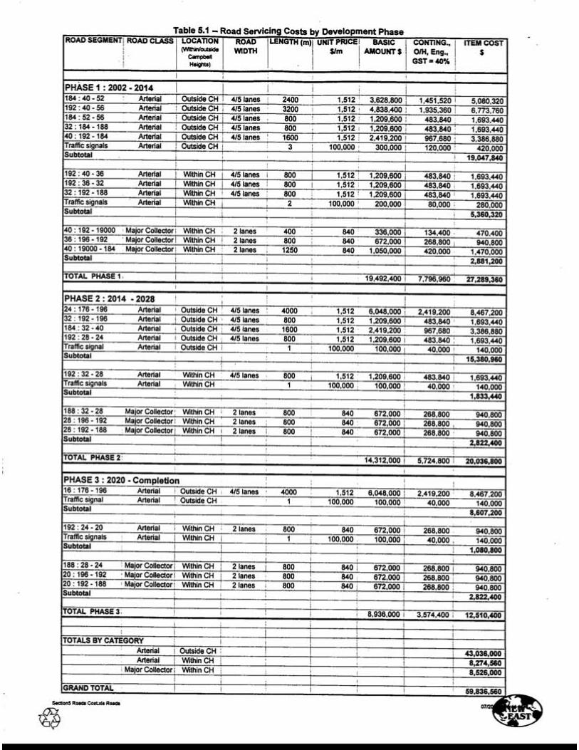
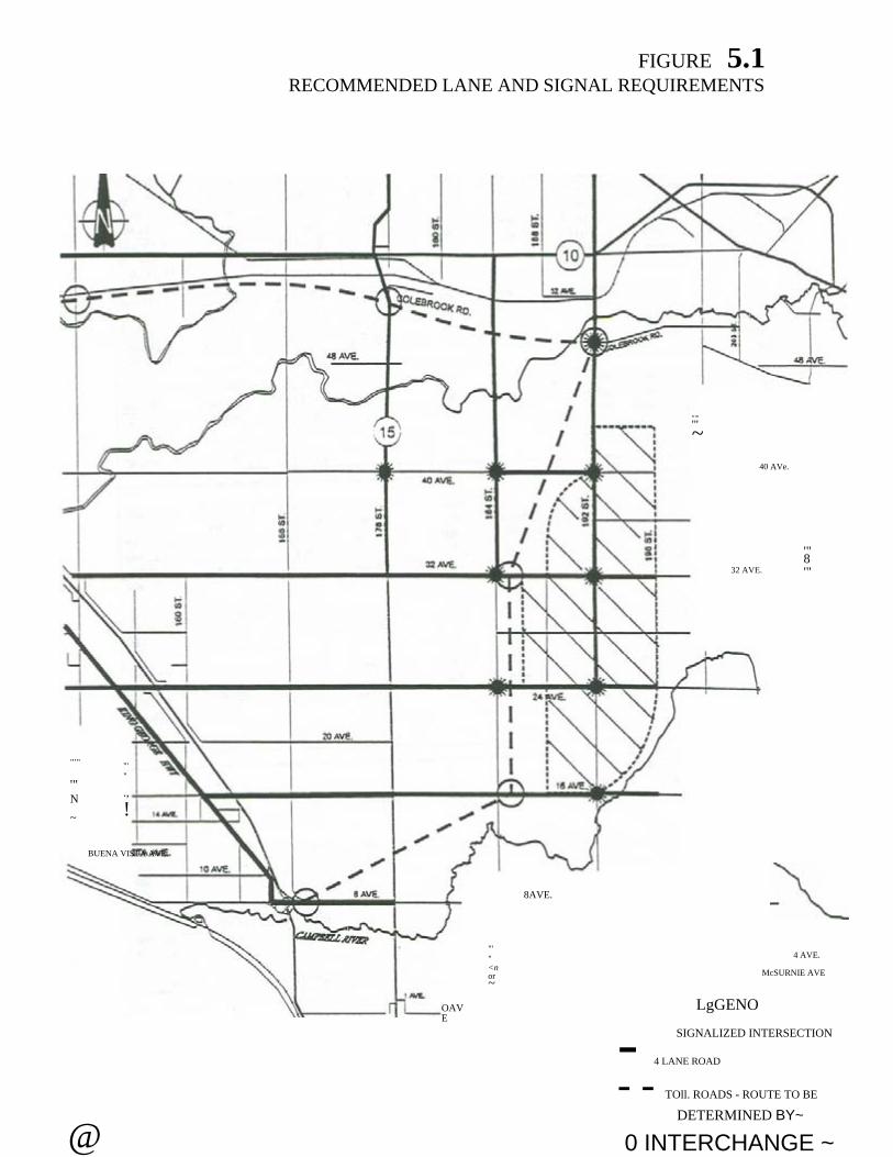
"'"
FIGURE 5.1RECOMMENDED LANE AND SIGNAL REQUIREMENTS
'"~
40 AVe.
32 AVE.
'"8'"
"'"
'"N
~
"'"
.,
!
"'"<nor~
4 AVE.
OAVE
LgGENO
"'"
BUENA VISTA AVE.
8AVE.
McSURNIE AVE
SIGNALIZED INTERSECTION - 4 LANE ROAD
- - TOll. ROADS - ROUTE TO BE
DETERMINED BY~
@ 0 INTERCHANGE ~

Executive Summary Report
6.0 WATER SUPPLY
6.1 Overview on Availability of Water Supply from Source
The City of Surrey relies on the Greater Vancouver Water District (GVWD) for its municipal
water supply. Using the Nicomekl River as a convenient geographical demarcation, areas of
Surrey to its south are provided with water from the GVWD via two trunk mains crossing the
Nicomekl River at around 144 Street and at 192 Street. The latter trunk main also supplies the
Township of Langley from a branch at 36 Avenue.
The 1989 Surrey/GVWD Water Agreement outlines the responsibilities of both parties in the
delivery of water to the south Surrey area including Campbell Heights. Under this agreement the
GVWD provides 13.5 Mgd (61,400 m3/day) via the 144 Street main and 11.1 Mgd (50,500
m3/day) via the 192 Street main with the former being at maximum delivery capacity under
current operating pressure.
The present (1999) peak day demand of South Surrey is 16.4 Mgd (74,600 m3/day). Therefore
the currently available capacity is 8.2 Mgd (37,300 m3/day). Allowing for the planned demand
growth in South Surrey, the remaining available capacity is enough for one full semi-conductor
plant plus other likely initial industrial development. Under this scenario, increase to supply
capacity from GVWD would be required between 2005 and 2010. A second semi-conductor
plant would immediately trigger the need for additional supply. The GVWD estimates that an
in-line booster pump station at a cost of$6 to $7-million would increase the supply by 7.5 Mgd
(34,000 m3/day).
6.2 Local Major Installation
Under the agreement for supply from GVWD, water is available with no guarantee of pressure.
In practice a certain level of pressure is available within the GVWD trunk system and often,
particularly during winters, the available pressure is sufficient to maintain a direct supply to the
local distribution system of the Campbell Heights area without pumping. However, in planning
of the local water distribution system, it is essential that appropriate provisions be made to cover
periods of low pressure from the GVWD sources.
For a development of this magnitude and particularly with semi-conductor manufacturing
processes totally dependent on an uninterrupted supply of water, it is essential at the planning
stage to fully establish the availability and the security of the water supply from source. A local
reservoir and pump station would provide a predetermined level of supply security.
water sum.wpd 6-1
~@ ~

- ----------------------- n __________________________ n -
Executive Summary Report
The projection of water demand for full development is at best a guideline based upon
considerable assumptions and approximations. It would therefore be prudent to implement the
installations in phases. In this respect, the reservoir and pump station should initially be built to
50% of ultimate requirements with provision for extension to full capacity. The initial phase of
work will be sufficient to meet the full industrial demand and the fire flow to around 2007 or
2008. The pace of the initial phase of development will determine the timing for providing the
remaining capacity.
6.3 Reservoir and Pump Station Capacities
To provide a reliable water supply at the extremity of the regional system, we recommend that a
local storage reservoir with a capacity equal to the greater of 6 hours of fire flow or 6 hours of
industrial demand, but not for both cumulatively. This recommendation is based on
consideration of the required lead time for discovery, communication, and remedy of problems
through source switching as well as the insufficiency of the existing supply trunk capacity to
meet fire flow. It also provides some emergency storage at this extremity of the regional trunk
water system.
It is recommended that the reliable capacity of the pump station be 200% of the
industriallbusiness average draw off plus 100% of the semi-conductor plant draw off. The pump
station capacity must also be at least equal to the required fire flow.
Based on the above strategy, the following interim and ultimate capacities corresponding to the
projected demand are recommended for the proposed reservoir and pump station:
Reservoir
Capacity, lIB
+ Semi-Cond.
Pump Station
Capacity, lIB +
Semi-Cond.
Fire Flow Suggested
Configuration
Reservoir
Ultimate 16,320 m.J 5,400 m.J 47m x 70m x 5m
Interim 8,160 m.J 5,400 m' 47m x 35m x 5m
Pump Station
Ultimate 82,560 m.J/day 250 1/s 4 x 240 1/s + 1 SIB
Interim - 41,280 m.J/day 250 1/s 2 x 240 1/s + 1 SIB
6.4 Major Installation, Land Requirements, and Layout
A reservoir and pump station of the ultimate recommended configuration will probably occupy a
site of 80 metres by 100 metres. To avoid land acquisition costs it is suggested that this reservoir
6-2
~
@ ~

_uu- - - - u - u
Executive Summary Report
and pump station facility be sited adjacent to the north-west corner of 192 Street and 32 Avenue
within the Forestry Nursery land. Since this block has been assumed as the site for a semi-
conductor plant, most of the reservoir structure could be underground leaving the roof available
for landscaping or recreational uses.
6.5 Operations Strategy
Various modes of operation have been developed. The normal modes of operation should target
at maintaining the required pressure in the distribution system with gravity supply from the
GVWD systems. In the event of inadequate supply from or the unavailability of either GVWD
sources, water will be drawn from the local reservoir via pumping to meet the deficit. It will also
be necessary to operate a pump to draw a nominal quantity from the reservoir into the
distribution system to ensure adequate turn over of the reservoir storage to prevent stagnation.
With the provision of two separate trunk feeds for electrical power and water supply for the
semi-conductor plants, it could be concluded that the provision of standby generator is not
necessary for the pump station. However, provision of standby generator should be considered
for maintaining the requisite fire flow and reservoir/pump station/valves operation during power
and water supply failure.
6.6 Grid Distribution System
In consideration of the particular demand pattern for the industrial zones, a design flow equal to
the peak hour demand is appropriate. A network of distribution system will be implemented to
provide alternative feed in the event of local problems. In addition, the proposed network should
be able to provide fire flows at extremity locations so that a fire in one area would not adversely
diminish the water available for industrial processes in other portions of the Campbell Heights
area. The minimum size pipes for the network as modelled are shown in Figure 6.1.
6.7 Order of Costs Estimates
The order of cost estimate for the grid water distribution system for the entire Campbell Heights
area is $8.36 million at year 2000 price levels. The component costing details together with the
phasing for implementation of the grid system are given in Table 6.1.
6-3
~ ~
@

TABLE 6.1
WATER SERVICING COSTS BY DEVELOPMENT PHASE
GRID WATER DISTRIBUTION SYSTEM
LOCATION BY LOCATION BY LENGTH WATER UNIT PRICE BASIC CONTING., TOTAL
NODES ROADS AMOUNT O/H, Eng., ITEM COST
GST
40%
-PHASE 1 : 2002 2014
16 - 15 192 : 40 - 36 800 375 277 221.600 88.640 310.240
15 - 14 192:36-32 800 525/675 500 400,000 160,000 560,000
9-7 196 : 40 - 36 800 375 277 221,600 88,640 310,240
7-5 196 : 36 - 32 800 375 277 221,600 88,640 310,240
17 - 8 190/188: 40 - 36 900 250 239 215,100 86,040 301,140
8-6 188 : 36 - 32 800 250 239 191,200 76,480 267,680
9 -16 40: 196 - 192 800 375 277 221,600 88,640 310,240
16 - 17 40 : 192 - 19000 400 300 266 106,400 42,560 148,960
7 -15 36: 196 - 192 800 300 266 212,800 85,120 297,920
5 -14 32: 196 - 192 800 300/375 272 217,600 87,040 304,640
14 - 6 32: 192 - 188 800 375/300 272 217,600 87,040 304,640
17 - B 40 : 19000 - 184 1250 - - - -
Total Phase 1 3,425,940
-PHASE 2 : 2014 2028
14 - 13 192: 32 - 28 800 600 527 421,600 168.640 590,240
5-3 196 : 32 - 28 800 375 277 221,600 88,640 310,240
6-4 188 : 32 - 28 800 375 277 221,600 88,640 310,240
3 -13 28: 196 - 192 800 300 266 212,800 85,120 297,920
13 -4 28 : 192 - 188 800 300 266 212,800 85,120 297,920
13 - 12 192 : 28 - 24 800 450 330 264,000 105,600 369,600
1 -12 24: 196 - 192 800 300 266 212,800 85,120 297,920
12 - 2 24 : 192 - 188 800 300 266 212,800 85,120 297,920
Total Phase 2 2,772,000
PHASE 3 : 2020 - completion
12 - 11 192 : 24 - 20 800 375 277 221,600 88,640 310,240
3 - 1 196 : 28 - 24 800 375 277 221,600 88,640 310,240
1 - 10 196 : 24 - 20 800 375 277 221,600 88,640 310,240
4-2 188 : 28 - 24 800 375 277 221,600 88,640 310,240
2 -20 188 : 24 - 20 800 375 277 221,600 88,640 310,240
10 - 11 20: 196 - 192 800 300 266 212,800 85,120 297,920
11 - 20 20: 192 - 188 800 375 277 221,600 88,640 310,240
Total Phase 3 2,159,360
TOTAL ALL 3 PHASES 8,357,300
004J~
~ter estimate-6.2C.xIs Sheet1 ~


-- --- - -- -- d -- ----------
Executive Summary Report
7.0 SANITARY SEWER SYSTEM
7.1 System Overview
The Campbell Heights area is situated on a plateau standing above the lowlands to its west. The
plateau continues into the Township of Langley. The area is generally flat with the ground
sloping gently from east to west. In the north-south direction, the highest point is along the 192
Street spine is near 32 Avenue from which the ground slopes gently towards north and south. In
general the grade of the ground is between 0.13% and 0.25% with the areas towards the
perimeters slightly steeper.
The developed areas within the City of Surrey discharge their sewage into the Greater Vancouver
Sewage and Drainage District (GVSDD) trunk systems which convey the sewage to the Annacis
Island Treatment Works for treatment. Two options are available for conveying the sewage from
the study area to the GVSDD trunk system:
Option 1 Discharge northward to the gravity section of the GVSDD Langley/ C10verdale trunk
system along 52 Avenue near 184 Street. The trunk sewer could be quite deep if all
flows were directed north by gravity.
Option 2 Discharge westward to Rosemary Heights and the future Grandview trunk. This route
would require a new trunk with the attendant costs of obtaining right-of-ways and
mitigation of disruptions on private properties. There is no planned timing for
constructing this trunk.
GVRD advised that the projected discharge could only be accommodated through:
. advancing the future upgrading of trunk systems by up to 20 years with additional costs for
one or two semi-conductor plants equivalent to $20 to $25 million net present value at 5%
discounted rate, or
. holding discharge from the semi-conductor plants during storm events with 2 to 5 years return
period or greater to account for the much increased base flows through infiltration over the
GVSDD trunk catchments during such severe storm conditions. This will require local
holding storage.
At this early preliminary stage, the requirement to provide on-site storage is a significant issue.
In light of the apparently high preliminary demand estimate, there should be a significant
incentive for industrial users to explore means for reducing the water demand and thus the waste
water quantity. Options available for consideration include recycling, treatment of waste water
to improve quality to meet criteria for occasional discharge into streams, or a cash contribution
towards off-site storage.
san sum.wpd 7-1
~@ ~

Executive Summary Report
7.2 Design Criteria for Trunk and Sub-Trunk Systems
Inconsideration of the City's design criteria and the specific demand pattern of the industries in
the area, it is concluded that a peak flow of 1,000 litres/equivalent population/day would be
appropriate for the design of the sanitary trunk and sub-trunk system. Pump station for sewage
will also designed to cope with the peak flow.
7.3 Methods of Conveyance
Because of the large area of flat terrain to be serviced, the following alternatives methods for
conveyancing the sewage flow were considered:
. Shallow gravity sewer with conventional construction,
. Shallow pressure sewer, or force main with pump station, and
. Deep gravity sewer involving trenchless technology.
To provide an initial overview, four alternative gravity routes for the trunk system to reach the
GVSDD system were developed as shown on Figure 7.1. All four of these alternative routes
assume that the area south of 20 A venue, because of the lower elevation, would be pumped to the
trunk system. The flat terrain and the distance of conveyance require deep sewers for all four
alternatives.
In common for these four alternative routes is a pr~ssure pipe to convey the sewage flow from
the industrial area to the GVSDD gravity trunk sewer at 52 Avenue. For security and operational
flexibility, a twin pipe system will be provided at shallow depth along 184 Street.
A hydraulic analysis was conducted for these to establish the sizes and grades of the component
sewers. Based on this analysis order of cost estimates for the different routes were developed
and summarised hereunder.
Route #1 Route #2 Route #3A Route #3B Route #4
Trunks $9.04M $10.22M $14.1IM $13.44M $7.67M
Sub-trunks $3.32M $3.11M $3.32M $3.32M $4.15M
Pump station $1.IOM $1.10M $1.lOM $1.IOM $1.lOM
Total $13 .46M $14.33M $18.53M $17.86M $12.92M
With Route # 1 and Route #4 selected as the more favourable gravity sewer alternatives, the
options of pumping the upstream parts of the catchment are further examined with a view of
7-2
~
~@
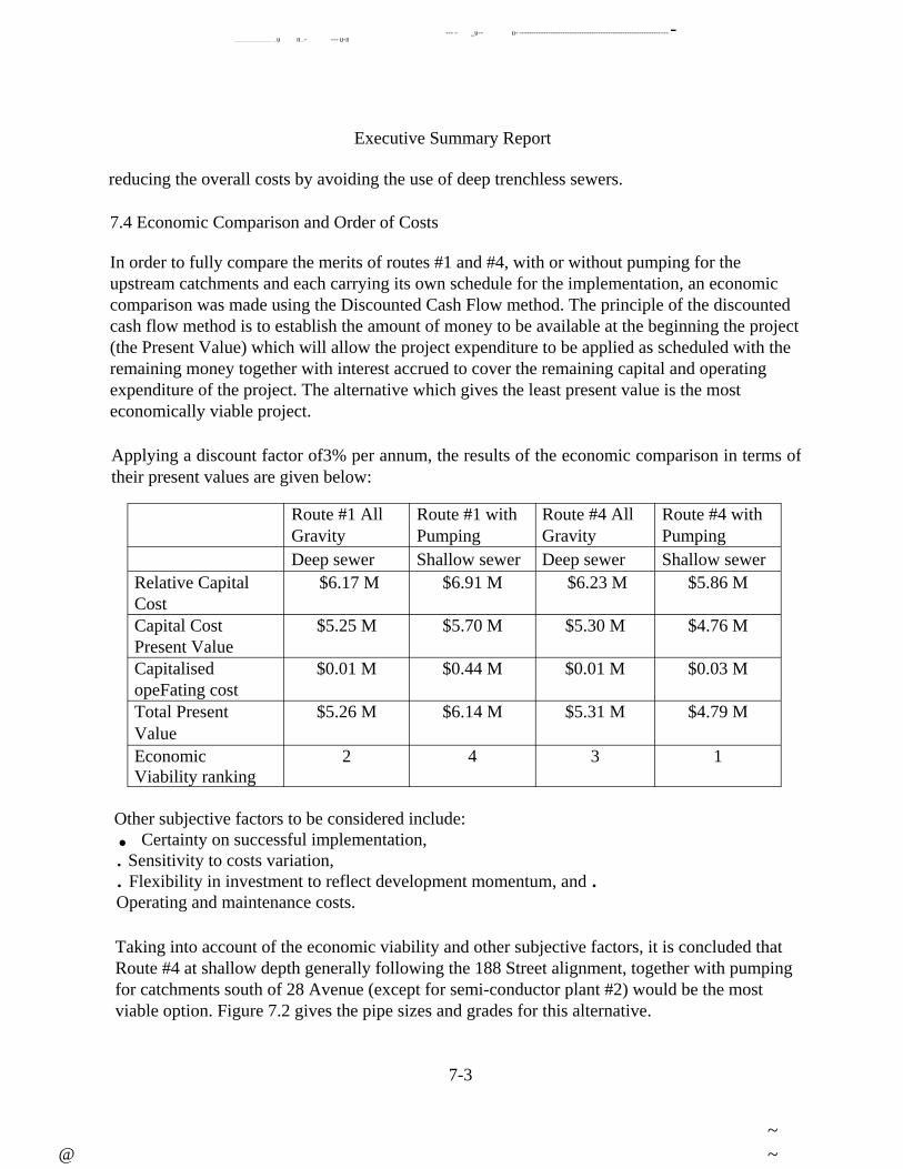
--- - _u-- u- -------------------------------------------------------------- -__________ _u n_- --- u-n
Executive Summary Report
reducing the overall costs by avoiding the use of deep trenchless sewers.
7.4 Economic Comparison and Order of Costs
In order to fully compare the merits of routes #1 and #4, with or without pumping for the
upstream catchments and each carrying its own schedule for the implementation, an economic
comparison was made using the Discounted Cash Flow method. The principle of the discounted
cash flow method is to establish the amount of money to be available at the beginning the project
(the Present Value) which will allow the project expenditure to be applied as scheduled with the
remaining money together with interest accrued to cover the remaining capital and operating
expenditure of the project. The alternative which gives the least present value is the most
economically viable project.
Applying a discount factor of3% per annum, the results of the economic comparison in terms of
their present values are given below:
Route #1 All
Gravity
Route #1 with
Pumping
Route #4 All
Gravity
Route #4 with
Pumping
Deep sewer Shallow sewer Deep sewer Shallow sewer
Relative Capital
Cost
$6.17 M $6.91 M $6.23 M $5.86 M
Capital Cost
Present Value
$5.25 M $5.70 M $5.30 M $4.76 M
Capitalised
opeFating cost
$0.01 M $0.44 M $0.01 M $0.03 M
Total Present
Value
$5.26 M $6.14 M $5.31 M $4.79 M
Economic Viability ranking
2 4 3 1
Other subjective factors to be considered include: . Certainty on successful implementation, . Sensitivity to costs variation, . Flexibility in investment to reflect development momentum, and . Operating and maintenance costs.
Taking into account of the economic viability and other subjective factors, it is concluded that Route #4 at shallow depth generally following the 188 Street alignment, together with pumping for catchments south of 28 Avenue (except for semi-conductor plant #2) would be the most viable option. Figure 7.2 gives the pipe sizes and grades for this alternative.
7-3
~
@ ~

Executive Swnmary Report
The order of cost estimate for the trunk and sub-trunk sanitary services for the entire Campbell
Heights area is $13.2-million at year 2000 price levels. The component costing details together
with the phasing for implementation of the sanitary sewer system are given in Table 7.1.
7-4
~
@ ~

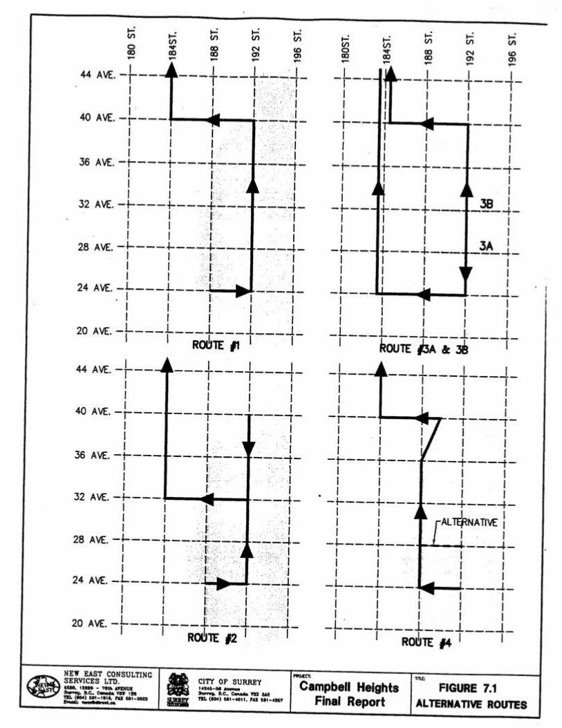


n - n - -
Executive Summary Report
8.0 NON-MUNICIPAL UTILITY SERVICES
The non-municipal utility services included in this study are electrical power, gas,
telecommunication, data communication, and public transit. The capacity of the existing
services and provision of new services for individual utilities are addressed in this section.
8.1 Electrical Power
Power Demand
The electrical supply criteria for a single semiconductor plant (full four F AB development) is 90
MW of non-interruptible power as described in the report Semiconductor Site Assessment, by
Jacobs Engineering Group, December 15, 1999. The power demand for Business Park (IB)
zoned areas, can be conservatively estimated as 75 kW per acre for industrial land use At the full
development stage (Year 2040), the power demand for two semi-conductor plants and the
remaining 365 hectares of industrial development would be 180 MW and 70 MW respectively.
Therefore a total demand of approximately 250 MW will be required.
Power Transmission
The semi-conductor facilities require non-interruptible electrical power and therefore two
transmission lines must be provided. The preferred transmission routes for the circuits are from
McLellan Station then along 184 Street and 192 Street.
Two options for providing transmission power voltage were investigated: 69 kV pole lines
located within the road right-of-way, or 230 kV transmission lines located in a dedicated right-
of-way. The economic break point for using the more expensive 230kV lines is for demands of
approximately 200 MW, provided that the demand is certain and required immediately. The 69
kV lines are the preferred choice for Campbell Heights because they cost less and provide more
flexibility for development. A single 69 kV circuit can supply about 100 MW, and additional
circuits can be added to the 69 kV lines to increase the capacity of the pole run to 300 MW.
BC Hydro has determined that two substations solely dedicated for the semi-conductor plant sites
within the Campbell Heights area are required with a third substation for the remaining industrial
properties. Each substations will require a land area footprint of approximately 0.5 ha. Land
should be reserved for these substations.
Although the transmission lines will be overhead, the local distribution system will be
underground and installation of cable ducting should be co-ordinated with BC Hydro for
placement under all newly constructed road works.
utilities sum.wpd 8-1
~ ~ @
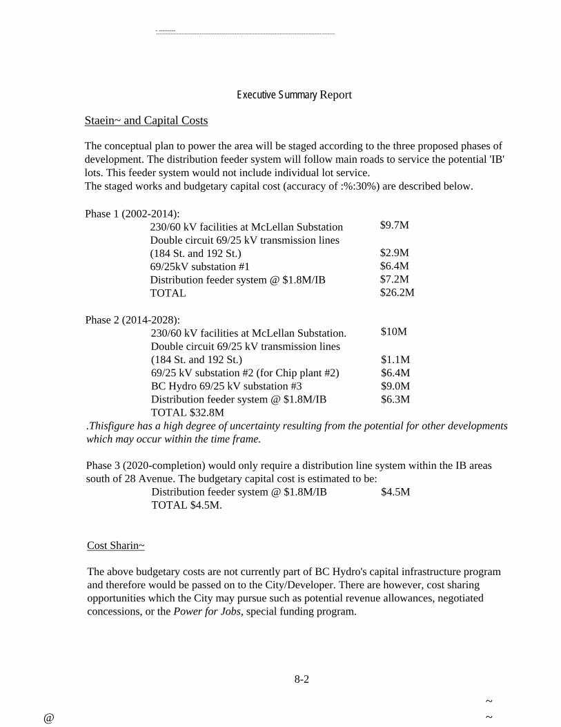
-------------------------------------------------------------------------------------------- ---------
-------
Executive Summary Report
Staein~ and Capital Costs
The conceptual plan to power the area will be staged according to the three proposed phases of development. The distribution feeder system will follow main roads to service the potential 'IB' lots. This feeder system would not include individual lot service. The staged works and budgetary capital cost (accuracy of :%:30%) are described below.
Phase 1 (2002-2014): 230/60 kV facilities at McLellan Substation $9.7M Double circuit 69/25 kV transmission lines (184 St. and 192 St.) $2.9M 69/25kV substation #1 $6.4M Distribution feeder system @ $1.8M/IB $7.2M TOTAL $26.2M
Phase 2 (2014-2028): 230/60 kV facilities at McLellan Substation. $10M Double circuit 69/25 kV transmission lines (184 St. and 192 St.) $1.1M 69/25 kV substation #2 (for Chip plant #2) $6.4M BC Hydro 69/25 kV substation #3 $9.0M Distribution feeder system @ $1.8M/IB $6.3M TOTAL $32.8M
.Thisfigure has a high degree of uncertainty resulting from the potential for other developments
which may occur within the time frame.
Phase 3 (2020-completion) would only require a distribution line system within the IB areas
south of 28 Avenue. The budgetary capital cost is estimated to be: Distribution feeder system @ $1.8M/IB $4.5M TOTAL $4.5M.
Cost Sharin~
The above budgetary costs are not currently part of BC Hydro's capital infrastructure program
and therefore would be passed on to the City/Developer. There are however, cost sharing
opportunities which the City may pursue such as potential revenue allowances, negotiated
concessions, or the Power for Jobs, special funding program.
8-2
~
@ ~

Executive Summary Report
8.2 Natural Gas Services
BC Gas was contacted regarding existing and planned future gas lines in the area. Since the
natural gas requirements are highly dependent on the individual customer demands and the type
of industry, BC Gas representatives were reluctant to speculate on the sizes and routing of pipes.
Some of the existing gas services feeding the residential areas in Campbell Heights would
require upgrading to 8 inch diameter to accommodate the increased demand. It is expected that
no additional costs for gas services would be required from the Owner/Developer as BC Gas
recovers installation costs from user rates.
8.3 Telecommunications
Currently, there are partial telephone services available from a Remote Servicing Unit
(RSU) located in Langley at 200 Street and 24 Avenue. Future telephone communications
servicing
will require additional fibre optic and copper lines from distribution centres both north and south
of the Campbell Heights area. The nearest existing distribution centre, (referred to as Central
Offices) in the north is located at Highway 10 and 176 Street. To the south of Campbell Heights
development the White Rock Central Office is located at 16 A ve and 184 Street. The nearest
fibre optic contact point is at the White Rock Central Office.
Telus planners have suggested that a total number of four Remote Servicing Units (RSU) may be
required for the full development scenario. It is proposed the sites will be centred in the
development area and all be located along the 192 Street corridor. The northern most sites would
be installed for Phase 1 of the development and are located on 192 Street at 40 A ve and 36 Ave.
Telus will recover their servicing costs through user rates.
The Phase 1 development will be serviced from two northern RSU's from the Cloverdale central
office at Highway 10 and 176 Street. The lines will be positioned along Highway 10 for
approximately 2.4 km to 192 Street thence south for 4 km along 192 Street. For the further
phases of development (Year 2008 and beyond), the remaining 2 RSUs will be installed on 192
Street at 28 Avenue and 24 Avenue and connected from the White Rock central office in the
south.
The underground ducting necessary for conveying the telecommunication lines will be 6 way
ducting for all routes. Cable ducts will be clustered beneath the newly constructed pavement
along all major streets within the area. Local lot services should also be underground. The civil
installation costs for the main ducting infrastructure are typically borne by the developer or the
City. Costs for a 6-way conduit cluster is estimated to be approximately $48/metre. The overall
length for delivery from the central offices and distribution within the Campbell Heights area is
21 km and is estimated to cost $1-million.
8-3
~ ~ @

Executive Summary Report
Total estimated costs within each phase are summarised below.
Phase Civil-Ducting
Phase 1 $460,000
Phase 2 $310,000
Phase 3 $230,000
TOTAL $1,000,000
8.4 Data Communication
A Rogers Cable TV representative was contacted for information on the requirement for cable
servicing. For most newly developed areas, Rogers installs its cables within the same conduit
clusters as Telus.
Rogers fibre optic lines are currently positioned near but not within the development area. Rogers
future plans may include extending their fibre optic system within this area however this would
be dependent on demand from potential customers. Co-axial cable will likely be placed to service
the new facilities.
The existing Rogers cable system is a hybrid fibre optics and coaxial network. Four lines
currently service the Campbell Heights area. The two way service lines are capable of digital
boxes, and internet connection.
No additional capital outlay costs would be required from the City since the installation of civil
ducting has already been accounted for and discussed in Section 8.3. There may be an
opportunity for cost recovery of the civil ducting installation by leasing space within the 6-way
conduit cluster (within the road right-of-way) to Rogers or other cable companies.
8.5 Public Transit
Currently no transit service operates in the south-east part of Surrey. The nearest transit service
to the Campbell Heights area is the #320 bus service that operates between Langley City Centre
and Surrey Central Sky Train via Highway 10, Highway 15, and Fraser Highway.
Translink considers the potential transit market to be low for the proposed industrial
development in the Campbell Heights area. The low priority status is attributed to the
anticipated high employee wages, dispersed residential locations of employees, and readily
available low cost parking. These assumptions should be further established once the more
8-4
~
@ ~

Executive Summary Report
detailed land use plan is available. Translink is currently preparing a five-year Strategic
Transportation Plan and an Area Transit Service Plan for the south Fraser Valley. It is not
anticipated that the plan will include new routes for the Campbell Heights area, however this will
be confinned when these plans which become available in mid July 2000.
8-5
~
~@

----------- ---------- - - -- - u- - --- --------------- --
Executive Summary Report
9.0 OVERALL DEVELOPMENT COSTS AND DCC RECOVERY
9.1 Overall Development Costs
The order of costs estimates for the provision of the major servicing components for the
Campbell Heights Industrial area are presented in Table 9.1.
It should be noted that these order of costs estimates are generated through application of
traditional prices over unit measures of the components without the support of preliminary
design. Nevertheless, these estimates should be representative of the overall magnitude of
investment and the likely apportionment of investment required to service the area over three
approximately equal time phases. It also allows a general comparison with the likely
Development Cost Charges that can be generated under the existing rates.
9.2 Non-Municipal Utilities
The proposed land use plan contemplates the development of two semi-conductor manufacturing
plants. These facilities require a substantial amount of electric power. To meet the demand, the
BC Hydro McLellan Substation must be upgraded and 69 kV transmission lines must be installed
to deliver the required power to the Campbell Heights area. In addition, some system redundancy
must be provided to minimise the potential for power interruption. The estimated cost to the
developer of such an installation is $25-million.
When substation upgrades and transmission line extensions are not included in BC Hydro's
planned capital works program, or when land development requires advancing planned capital
works, the developer must provide a revenue guarantee in a form acceptable to BC Hydro or
front the capital cost. These revenue guarantees are estimated to range between $2 to$1 7 -
million and are dependant upon BC Hydro's planned upgrades at the time of the location of the
two semi-conductor manufacturing plants. An assumed revenue guarantee of$17-million is
included in the above mentioned $25-million installation cost.
In addition to the substation upgrade and transmission line extension a distribution system is
required to service the IB blocks surrounding two semi-conductor manufacturing plants. The
estimated upfront cost for the distribution system is $18-million which is borne by the developer.
BC Hydro will calculate the associated net revenue as infill customers connect and will provide
the developer with a rebate after 5 years. Therefore the initial installation cost can potentially be
fully recovered if sufficient customer infill occurs within 5 years.
BC Gas will extend the gas services at its own cost to generate user revenue. For telecommunications utilities the developer must install a utility duct. The telecommunications
9-1
~
@ ~

Executive Swnmary Report
companies will supply their own facilities (cables, transformers, amplifiers, cross-connect boxes,
switching, etc.) at their own cost. These will be recovered through user rate charges.
9.3 Development Cost Charges Recovery
The likely amount of recovery of servicing costs through Development Cost Charges collection
is given in Table 9.2. These figures are provided as the overall amount for each phase and as the
amount per hectare of developable land.
The amounts and percentages of recovery for individual components are extremely low except
for storm water management. For most areas using exfiltration technology for storm water
control, the property owners are expected to provide their own exfiltration system within their
properties. It should be noted that private exfiltration systems would cost less than conventional
private drainage system.
The overall cost of servicing is high because of the general lack of suitable servicing in or
adjacent to the area and the high demand for water and waste water discharge from the semi-
conductor manufacturing facilities. Such high servicing costs would probably be partly offset by
the relatively lower land prices for unserviced land.
Since the situation for this development is unique, consideration should be given to the early
development of a District Improvement Levy to equitably recover the servicing costs. This will
also provide some economic basis for interested developers and assist with establishing equitable
land pricing.
9-2
~ ~
@


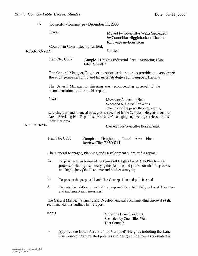
Regular Council- Public Hearing Minutes December 11, 2000
4. Council-in-Committee - December 11, 2000
It was Moved by Councillor Watts Seconded by Councillor Higginbotham That the following motions from
Council-in-Committee be ratified. RES.ROO-2959 Carried
Item No. COl7 Campbell Heights Industrial Area - Servicing Plan File: 2350-011
The General Manager, Engineering submitted a report to provide an overview ofthe engineering servicing and financial strategies for Campbell Heights.
The General Manager, Engineering was recommending approval of the
recommendations outlined in his report.
It was Moved by Councillor Hunt
Seconded by Councillor Watts
That Council approve the engineering,
servicing plan and financial strategies as specified in the Campbell Heights Industrial
Area - Servicing Plan Report as the means of managing engineering services for this
Industrial Area.
RES.ROO-2960 Carried with Councillor Bose against.
Item No. COl8 Campbell Heights - Local Area PlanReview File: 2350-011
The General Manager, Planning and Development submitted a report:
1. To provide an overview of the CampbelI Heights Local Area Plan Review
process, including a summary of the planning and public consultation process,
and highlights of the Economic and Market Analysis;
2. To present the proposed Land Use Concept Plan and policies; and
3. To seek Council's approval of the proposed Campbell Heights Local Area Plan and implementation measures.
The General Manager, Planning and Development was recommending approval of the
recommendations outlined in his report.
It was Moved by Councillor Hunt
Seconded by Councillor Watts
That Council:
1. Approve the Local Area Plan for Campbel1 Heights, induding the Land
Use Concept Plan, related policies and design guidelines as presented in
h:\pubhe:u\minutes\ 121 Wph.min.doc 1nl
12I14I/(X) (1'}:35 AM

Regular Council - Public Hearing Minutes December 11,2000
Appendix I as a means of managing development and the general
provision of services, amenities and facilities in the area;
2. Amend the South-East Surrey Local Area Plan by replacing the part related to
Campbell Heights with the Land Use Concept Plan and Policies contained in
Appendix I;
3. Authorize staff to draft an amendment to Zoning By-law, 1993,
No. 12000, as amended, to include an amenity contribution provision for the
Camp bell Heights Plan Area;
4. Authorize staff to draft a new Technology Park Zone and bring forward for By-
law Introduction the necessary amendments to the Zoning By-law and other
City By-laws in conjunction with the rezoning of the Provincial or other lands to
the new zone; and
5. Authorize staff of the Economic Development Office to follow up on the
recommendations of the CampbelI Heights Economic and Market Analysis, and
bring forward a report on the development and launching of a marketing
program for Campbell Heights.
RES.ROO-2961 Carried with Councillor Bose against.