Embed Size (px)
Citation preview
16 1
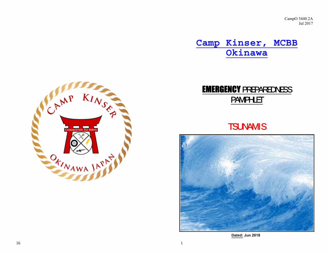
Camp Kinser, MCBB Okinawa
EMERGENCY PREPAREDNESSPAMPHLET
TSUNAMIS
Dated: Jun 2018
CampO 3440.2A Jul 2017
2
GENERAL INFORMATION
Tsunamis (pronounced soo-ná-mees), also known as seismic sea waves (mistakenly called “tidal waves”), are a series of enormous waves created by an underwater disturbance such as an earthquake, landslide, volcanic eruption, or meteorite. A tsunami can move hundreds of miles per hour in the open ocean and smash into land with waves hundreds of feet high.
From the point where a tsunami originates, waves travel outward in all directions much like waves in a pond where a rock has been thrown. Once the wave approaches the shore, it builds in height depending on the topography of the coastline and the ocean floor. There may be a series of waves, with each wave being larger than the one before. That is why one beach area a few miles away might experience a small tsunami while another beach nearby experiences a bigger tsunami.
A tsunami may be forecast to hit one side of the island yet cause tsunami-like effects on the opposite side due to the wrap-around effect.
If a major earthquake or landslide occurs close to shore, the first wave in a series could reach the beaches in only a few minutes. We may not have time to issue warnings to areas at highest risk.
Drowning is the most common cause of death associated with a tsunami. Tsunamis and the receding water are very destructive to structures in the
run-up zone. Other hazards include flooding, contamination of drinking water, and fires from gas lines or ruptured tanks.
THE TSUNAMI THREAT TO OKINAWA
Tsunamis pose the most destructive natural threat to Okinawa. They are near impossible to predict and strike with little to no warning, leaving as little as 20 minutes for us to react.
The Ryukyu Trench is about 100 kilometers (62 miles) off the East coast of Okinawa. The trench could shift and create an 8.5 magnitude earthquake that could trigger a tsunami 20 meters (66 feet) high. The wave could travel 600 miles per hour and strike Eastern Okinawa in 20 minutes.
KNOW WHERE YOU LIVE
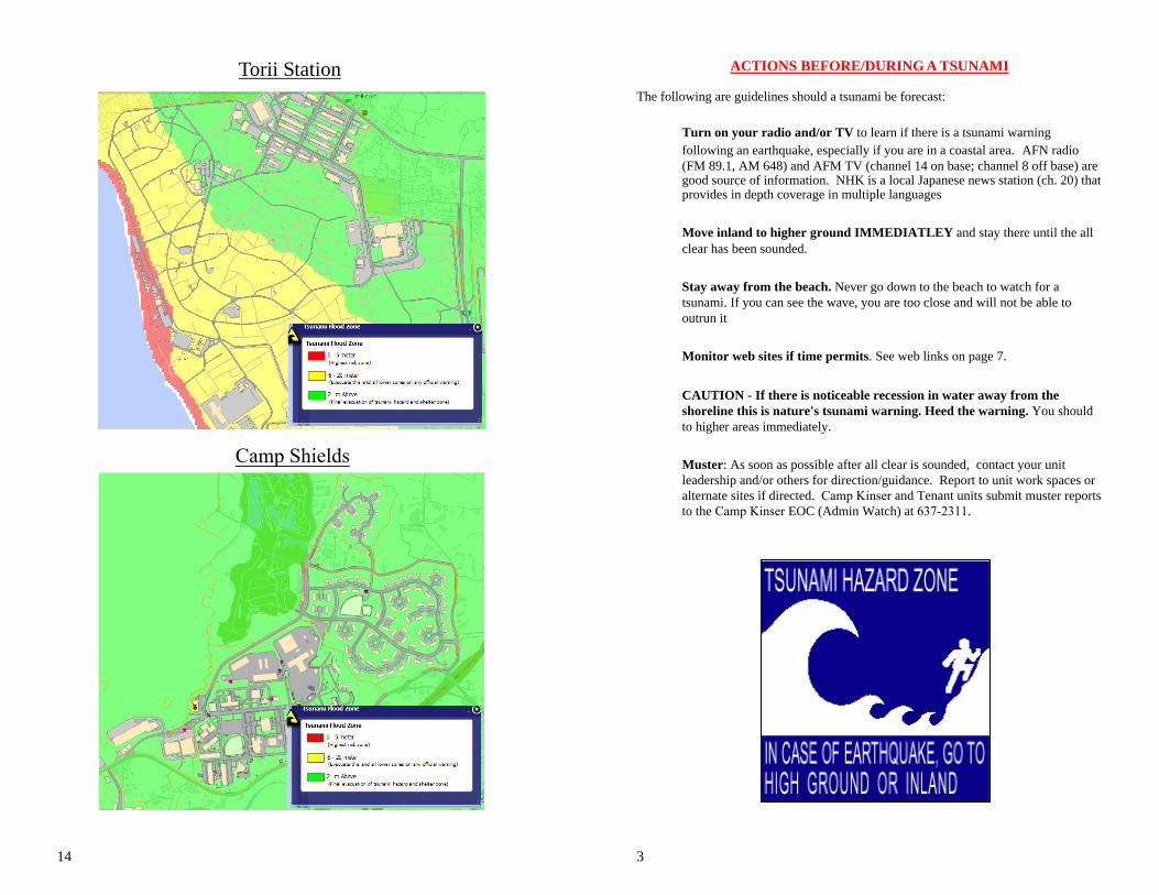
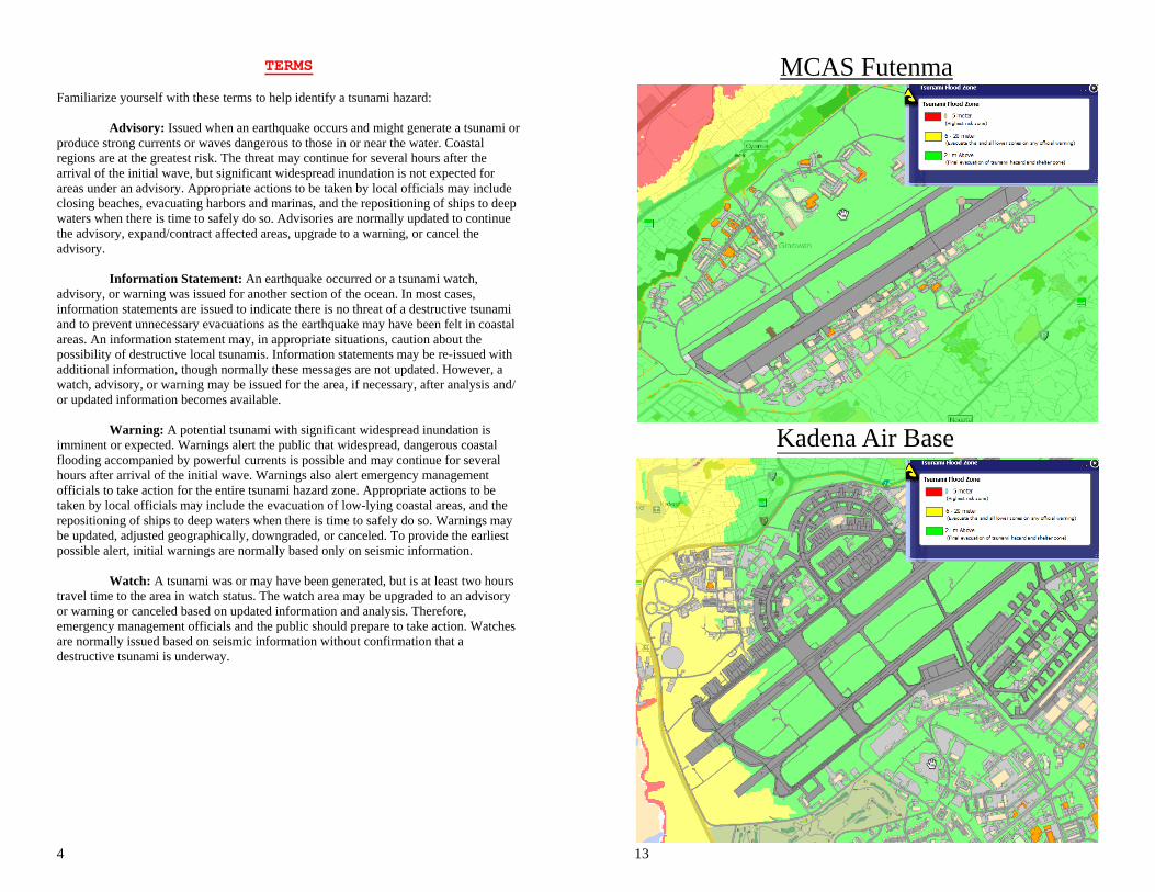
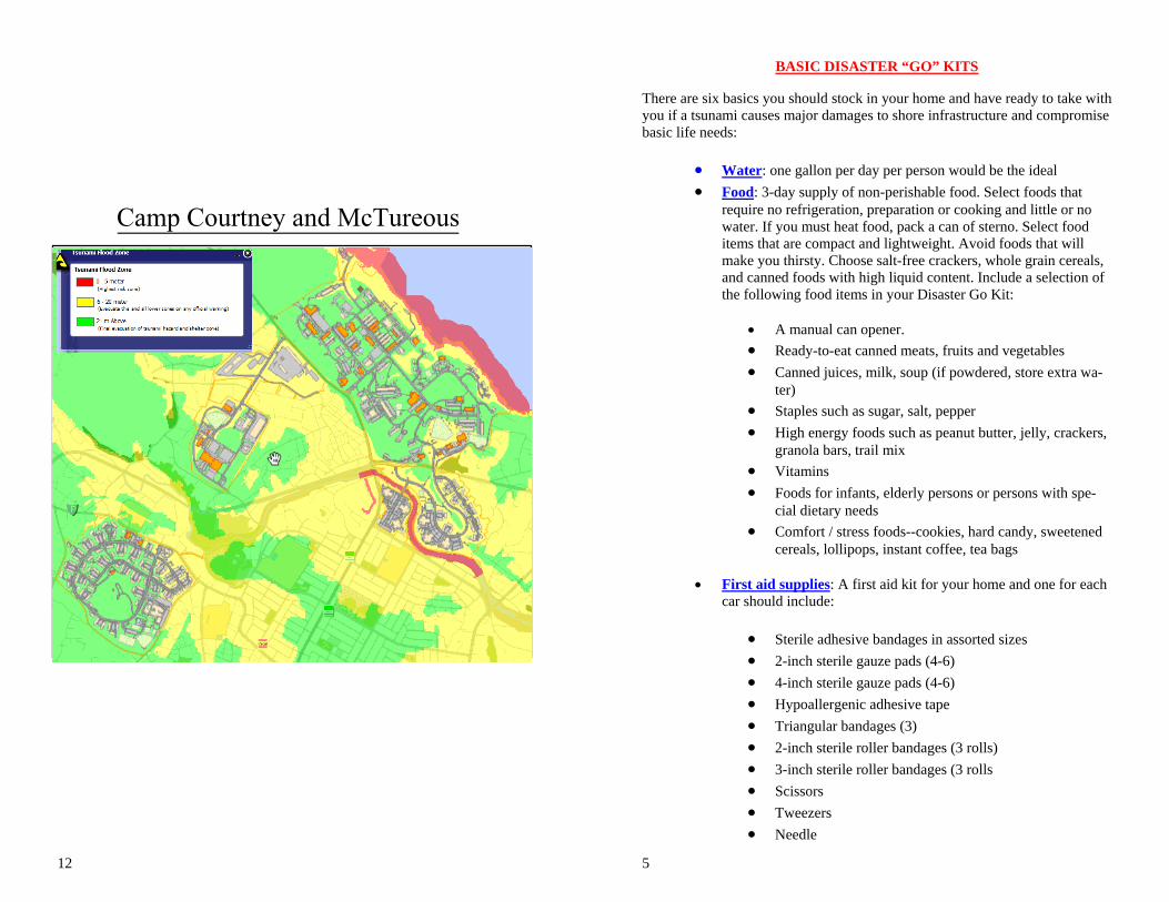
You need to know if you live in a low-lying tsunami threat area. The diagrams included in this pamphlet provide color coded maps depicting rough estimates of various elevations. Also included in the back of this pamphlet (page 7) are a list of web sites that can be used to identify potential threats to low lying areas.
15
Okinawa. Though the web site is in Japanese, it is easy to see the Ryukyu Trench and tsunami wave action expected should there be an 8.5 magnitude earthquake from the trench.
Also see Camp Kinser Order 3440.2a available through Camp Kinser Operations or the Emergency Management Office (637-1886/2311)
CAMP KINSER SPECIFIC INFORMATION
CAMP KINSER TOWERSIf personnel are in the Camp Kinser Towers or nearby when a Tsunami warning occurs, then:
- Immediately take the stairs to the 5th floor or higher.- If your Emergency Go-Bag is within reach, within 2 minutes,
then retrieve Go-Bag, recommended items are included on page 5 of this pamphlet.
- Do NOT take elevators as power outages may ensue as a result ofthe earth quakes that could trigger a Tsunami.
CAMP KINSER MULTIPLEXESIf personnel are located at or nearby the Camp Kinser Multiplexes when a Tsunami warning occurs, then:
- Immediately travel to Camp Kinser green zone, provided on page10 of this pamphlet.
- If your Emergency Go-Bag is within reach, within 2 minutes,then retrieve Go-Bag, recommended items are included on page 5 of this pamphlet.
- Proceed to training area 2, as provided shown on page 10 of thispamphlet, or to unit specific rally points aboard Camp Kinser.
CAMP KINSER COMMUNITY LOCATIONSIf located at other Camp Kinser Community Locations, such as the Education, Aquatics, and Community Centers, the Gym, Barracks, Medical, and Dental when a Tsunami warning occurs, then:
- Immediately travel to Camp Kinser green zone, provided on page10 of this pamphlet.
- If your Emergency Go-Bag is within reach, within 2 minutes,then retrieve Go-Bag, recommended items are included on page 5 of this pamphlet.
- Proceed to training area 2, as provided shown on page 10 of thispamphlet, or to unit specific rally points aboard Camp Kinser.
14
Torii Station
3
ACTIONS BEFORE/DURING A TSUNAMI
The following are guidelines should a tsunami be forecast:
Turn on your radio and/or TV to learn if there is a tsunami warning following an earthquake, especially if you are in a coastal area. AFN radio(FM 89.1, AM 648) and AFM TV (channel 14 on base; channel 8 off base) are good source of information. NHK is a local Japanese news station (ch. 20) that provides in depth coverage in multiple languages
Move inland to higher ground IMMEDIATLEY and stay there until the all clear has been sounded.
Stay away from the beach. Never go down to the beach to watch for a tsunami. If you can see the wave, you are too close and will not be able to outrun it
Monitor web sites if time permits. See web links on page 7.
CAUTION - If there is noticeable recession in water away from the shoreline this is nature's tsunami warning. Heed the warning. You should to higher areas immediately.
Muster: As soon as possible after all clear is sounded, contact your unit leadership and/or others for direction/guidance. Report to unit work spaces or alternate sites if directed. Camp Kinser and Tenant units submit muster reports to the Camp Kinser EOC (Admin Watch) at 637-2311.
Camp Shields
4
TERMS
Familiarize yourself with these terms to help identify a tsunami hazard:
Advisory: Issued when an earthquake occurs and might generate a tsunami or produce strong currents or waves dangerous to those in or near the water. Coastal regions are at the greatest risk. The threat may continue for several hours after the arrival of the initial wave, but significant widespread inundation is not expected for areas under an advisory. Appropriate actions to be taken by local officials may include closing beaches, evacuating harbors and marinas, and the repositioning of ships to deep waters when there is time to safely do so. Advisories are normally updated to continue the advisory, expand/contract affected areas, upgrade to a warning, or cancel the advisory.
Information Statement: An earthquake occurred or a tsunami watch, advisory, or warning was issued for another section of the ocean. In most cases, information statements are issued to indicate there is no threat of a destructive tsunami and to prevent unnecessary evacuations as the earthquake may have been felt in coastal areas. An information statement may, in appropriate situations, caution about the possibility of destructive local tsunamis. Information statements may be re-issued with additional information, though normally these messages are not updated. However, a watch, advisory, or warning may be issued for the area, if necessary, after analysis and/or updated information becomes available.
Warning: A potential tsunami with significant widespread inundation is imminent or expected. Warnings alert the public that widespread, dangerous coastal flooding accompanied by powerful currents is possible and may continue for several hours after arrival of the initial wave. Warnings also alert emergency management officials to take action for the entire tsunami hazard zone. Appropriate actions to be taken by local officials may include the evacuation of low-lying coastal areas, and the repositioning of ships to deep waters when there is time to safely do so. Warnings may be updated, adjusted geographically, downgraded, or canceled. To provide the earliest possible alert, initial warnings are normally based only on seismic information.
Watch: A tsunami was or may have been generated, but is at least two hours travel time to the area in watch status. The watch area may be upgraded to an advisory or warning or canceled based on updated information and analysis. Therefore, emergency management officials and the public should prepare to take action. Watches are normally issued based on seismic information without confirmation that a destructive tsunami is underway.
13
MCAS Futenma
Kadena Air Base
12 5
BASIC DISASTER “GO” KITS
There are six basics you should stock in your home and have ready to take with you if a tsunami causes major damages to shore infrastructure and compromise basic life needs:
Water: one gallon per day per person would be the ideal Food: 3-day supply of non-perishable food. Select foods that
require no refrigeration, preparation or cooking and little or nowater. If you must heat food, pack a can of sterno. Select fooditems that are compact and lightweight. Avoid foods that willmake you thirsty. Choose salt-free crackers, whole grain cereals,and canned foods with high liquid content. Include a selection ofthe following food items in your Disaster Go Kit:
A manual can opener. Ready-to-eat canned meats, fruits and vegetables Canned juices, milk, soup (if powdered, store extra wa-
ter) Staples such as sugar, salt, pepper High energy foods such as peanut butter, jelly, crackers,
granola bars, trail mix Vitamins Foods for infants, elderly persons or persons with spe-
cial dietary needs Comfort / stress foods--cookies, hard candy, sweetened
cereals, lollipops, instant coffee, tea bags
First aid supplies: A first aid kit for your home and one for eachcar should include:
Sterile adhesive bandages in assorted sizes 2-inch sterile gauze pads (4-6) 4-inch sterile gauze pads (4-6) Hypoallergenic adhesive tape Triangular bandages (3) 2-inch sterile roller bandages (3 rolls) 3-inch sterile roller bandages (3 rolls Scissors Tweezers Needle
Camp Courtney and McTureous

6
Moistened towelettes Antiseptic Thermometer Tongue blades (2) Tube of petroleum jelly or other lubricant Assorted sizes of safety pins Cleansing agent/soap Latex gloves (2 pair) Sunscreen
Non-prescription drugs
Aspirin or nonaspirin pain reliever Anti-diarrhea medication Antacid (for stomach upset) Syrup of Ipecac (use to induce vomiting if advised by
the Poison Control Center) Laxative Activated charcoal (use if advised by the Poison Control
Center)
Contact the local American Red Cross chapter to obtain a basic first aid manual.
Clothing, bedding and sanitation supplies Tools Special items
Keep the items that you would most likely need during an evacuation in easy-to-carry containers (often referred to as “go-bags”). Possible containers include a large, covered trash container; a camping backpack; or a duffle bag.
11
Camp Foster
Camp Lester
10 7
IMPORTANT TELEPHONE NUMBERS
ON BASE: Fire, Security, Medical/Ambulance: 911 Weather Information: https://shogunweather.com/Kinser Emergency Management Officer: 637-1886/2311
OFF BASE: US 911 Operator: 911-1911
Japanese Fire/Ambulance: 119 Japanese Police: 110 Japanese Coast Guard: 118 US Naval Hospital: 893-1984 Kadena Base Operator: 938-1111 Foster Base Operator: 911-5111 or 970-5555
OTHER INFORMATION
Here are some very useful web sites:
http://flood.firetree.net/: Zoom to your area of interest (i.e., White Beach). In the upper right, click on “Satellite.” In the upper left corner, click a tsunami wave height (+20m). Watch the image add a dark blue overlay to reflect areas hit by the tsunami wave height that you chose. Test the results of the “Tsunami Threat to Okinawa” mentioned previously in this pamphlet: 20 meter wave height.
Track real-time tsunami threat information on the Japan Meteorological Agency’s (JMA) web site at http://www.jma.go.jp/en/tsunami/joho.html or from the National Oceanic and Atmospheric Administration (NOAA) web site at http://www.prh.noaa.gov/ptwc
http://www.mapion.co.jp/map/admi47.html links to a Japanese web site that will give you detailed elevations. To use it, open the site, and click on an area of interest. After it zooms in, click any area (you’ll see a small red plus sign), then look in the upper right under the green pyramids to see the elevation in meters.
Learn about tsunamis and get training from the Federal Emergency Management Agency (FEMA) at http://www.fema.gov/hazard/tsunami/index.shtm
The Japanese web site at http://seis.sci.u-ryukyu.ac.jp/hazard/tsunami-okinawaIs/tsunami20110512.htm provides a depiction of the tsunami threat to
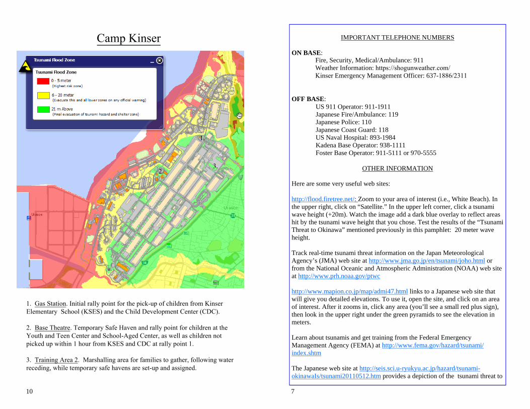
Camp Kinser
1. Gas Station. Initial rally point for the pick-up of children from KinserElementary School (KSES) and the Child Development Center (CDC).
2. Base Theatre. Temporary Safe Haven and rally point for children at theYouth and Teen Center and School-Aged Center, as well as children notpicked up within 1 hour from KSES and CDC at rally point 1.
3. Training Area 2. Marshalling area for families to gather, following waterreceding, while temporary safe havens are set-up and assigned.
1.
2.3.
8
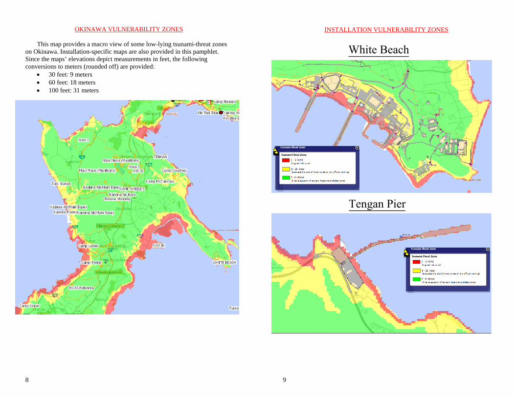
OKINAWA VULNERABILITY ZONES
This map provides a macro view of some low-lying tsunami-threat zones on Okinawa. Installation-specific maps are also provided in this pamphlet. Since the maps’ elevations depict measurements in feet, the following conversions to meters (rounded off) are provided:
30 feet: 9 meters 60 feet: 18 meters 100 feet: 31 meters
9
INSTALLATION VULNERABILITY ZONES
White Beach
Tengan Pier