Embed Size (px)
Citation preview
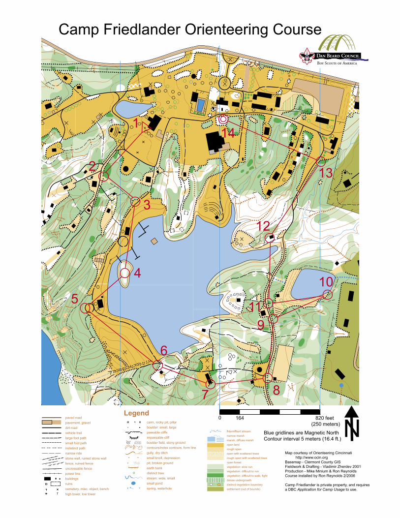
Camp Friedlander Orienteering Course
Scout instructions
Orienteering is a sport using a map and compass to find orange and white markers along a course.
The map is your main tool - it has a vast amount of information that can help you find the best route
between markers. The compass is used to orient the map, and sometimes to guide you along a
bearing. Smart orienteers often do not follow direct bearings between markers. They will use the
map to find the easiest and fastest path – often mostly along a road or trail. Each marker will be
found at the center of a numbered red circle on the map.
1) First, find the two red 12” concrete squares set in the field south of the Trailblazer Shelter and
Eagle’s Nest. They are shown as small x’s on your map. The centers of the two squares are
100 feet apart.
2) To help you measure distance along the course, pace between these markers at least 3 times at a
natural stride, stepping off on with your left foot and counting each time that your right foot
touches the ground (a “pace” is 2 steps). Calculate the length of your average pace with the
help of the table below:
Paces in 100 ft: 15 16 17 18 19 20 21 22 23 24 25
Feet / pace: 6.66 6.25 5.88 5.55 5.26 5.0 4.76 4.55 4.35 4.17 4.0
3) Using the methods shown in your Boy Scout Handbook and with a buddy, measure the
height of the center flagpole just north of the red pacing squares. Mark the flagpole height
here: __________feet.
4) Go to marker 1 (just northwest of the flagpoles, next to the Eagle’s Nest). Markers are triangular,
orange and white, and mounted on green poles. Inside each marker is a letter. Using your map
and compass, find all of the markers. Remember that metal (like the marker) will affect your
compass – step away to take a bearing. If you mostly use your map, you will find that the easiest
route to travel between markers is often NOT along the direct compass bearing. The goal is to
visit each marker, not to follow any specific path. You should not have to go through any
campsites or staff areas. At each marker, look inside and write down the letter here:
Marker 1 - _______
Marker 2 - _______
Marker 3 - _______
Marker 4 - _______
Marker 5 - _______
Marker 6 - _______
Marker 7 - _______
Marker 8 - _______
Marker 9 - _______ (see # 5 below)
Marker 10 - _______
Marker 11 - _______
Marker 12 - _______
Marker 13 - _______
Marker 14 - _______
5) What is the distance between marker 9 and marker 11? __________ feet. (There are two ways
to figure this out - one uses the map only. Try to use both methods to check yourself.)
6) Bring this sheet to your leader to show that you have completed the course. Your leader will
have the answers and a secret code to translate a message out of the marker letters.
Camp Friedlander Orienteering Course
Leader Instructions Completing this activity meets the orienteering requirement for First Class. The course is 1.25 miles long, and requires measuring both the height of a flagpole and the distance between two markers. A prepared Scout can do the activity in about one hour. This course should NOT be a Scout’s first map and compass activity. You must first teach how to use a compass to take and follow a bearing, how to orient a map, how to read a topographical map, and how to measure distances. All of this is found in the Scout Handbook, but will need some hands-on teaching for a Scout to master. This course should be a fun and challenging way for a Scout to test his new skills. Camp Friedlander is private property of the Dan Beard Council. You MUST complete an "Application for Camp Usage" (see “Forms” section of the Council website) at least 72 hours in advance, and sign in with the Campmaster or Ranger to bring your Scouts to the course. You are welcome to use the course if your unit is camping at Camp Friedlander. There is no charge to use the course. Each Scout needs BOTH the course map and Scout instructions (which serves as an answer sheet). Print these on both sides of a sheet of paper, and put this inside a gallon zip-top bag for durability. The map is much easier to use if printed in color. Scouts will also need a pencil, a map compass, and their Boy Scout Handbook. Start at the Trailblazer shelter. First have each boy read the “Scout instructions” fully. Confirm that each has all of the required materials. Buddy up the Scouts for safety, but insist that they each complete their own answer sheet. (Sending a more senior Scout as a buddy can work if the older boy will let the younger Scout work the course by himself.) Reinforce that they are not to enter any campsites or staff areas. Part of their challenge is to use the map to find the easiest way between markers - usually NOT along the direct bearing to the next marker. Ask the boys to find the pacing squares on their map, then on the ground, to demonstrate the detail and accuracy of the map. They set off independently to complete the activity at this point. ANSWERS: Center flagpole height: 34.5 feet
Marker letters 1-14: S E V R Q Y N A Q R E S H A Distance between marker 9 and marker 11: 136 feet Secret code – Have the scout write out the letters A thru M, then write letters N thru Z directly
below the first line of letters. “A” translates to “N”, N to A, B to O, O to B, etc. The marker letters spell out “FRIEDLANDER FUN” when translated.
THANK YOUS
This course was constructed and installed in February 2006 by Ron Reynolds as a Wood Badge project. It was modeled after the Camp Michaels Orienteering Course installed by Pete Watkins. Metal for the markers was cut and donated by Flaig Welding of Hebron, KY, welded by Eagle Scout Joseph Watkins, and powdercoated gratis by Jeff Cox of Powder Kote Industries in Newport, KY. The pole pounder and assistance with metalwork on the top of the poles was donated by Pete, Joseph and Craig Watkins. The base map was provided by Mike Minium and Orienteering Cincinnati. The final map was produced by Ron Reynolds with help from Brittany Reynolds. The Ku-Ni-Eh Lodge of the Order of the Arrow provided monetary assistance for purchasing materials and for initial map reproduction. Please contact Ron Reynolds at (513) 553-3114 for any problems with the course.