Embed Size (px)
Citation preview
Cambridgeshire Horizons CAMBRIDGE NORTHERN FRINGE EAST - VIABILITY OF PLANNING OPTIONS
Final Report May 2008
P1838
ROGER TYM & PARTNERS
Fairfax House 15 Fulwood Place London WC1V 6HU t (020) 7831 2711 f (020) 7831 7653 e [email protected] w www.tymconsult.com
This document is formatted for double-sided printing.
CONTENTS
1 OVERVIEW OF PROJECT........................................................................................... 1 Purpose of Study ............................................................................................................1
2 REVIEW OF PLANNING POLICY CONTEXT............................................................... 3 RSS and Strategic Housing Requirements .....................................................................3 Cambridgeshire and Peterborough Structure Plan 2003 ................................................3 South Cambridgeshire Local Development Framework – Core Strategy.........................3 Cambridge Local Plan and DPD .....................................................................................4 Cambridgeshire Minerals & Waste Plan .........................................................................5 Summary of Planning Context ........................................................................................7
3 REVIEW OF PREVIOUS PROPOSALS ....................................................................... 9 Summary of Proposals....................................................................................................9 Review of Viability......................................................................................................... 10 Conclusion of Review ................................................................................................... 15
4 TRANSPORT ISSUES ............................................................................................... 17 Introduction...................................................................................................................17 Current Access Arrangements...................................................................................... 17 Milton Bus Park & Ride Scheme................................................................................... 17 Transport Innovation Fund Proposals ........................................................................... 18 Development Proposals................................................................................................ 19 Chesterton Station and Interchange Scheme ............................................................... 21 Conclusions ..................................................................................................................22
5 GENERATING REALISTIC DEVELOPMENT OPTIONS ............................................ 25 Introduction...................................................................................................................25 Park & Ride/Driving Range Site.................................................................................... 25 Chesterton Sidings North.............................................................................................. 26 Chesterton Sidings South ............................................................................................. 28 Summary of Development Concept .............................................................................. 32
6 VIABILITY OF REVISED DEVELOPMENT CONCEPT............................................... 34 Overview.......................................................................................................................34 Office Development ...................................................................................................... 34 Industrial Development ................................................................................................. 35 Conclusions ..................................................................................................................35
7 CONCLUSIONS......................................................................................................... 36 Viability of Comprehensive Development ..................................................................... 36 Developing Realistic Planning Options ......................................................................... 36 APPENDICES Appendix 1 – Cambridge Local Plan Policy: 9/6 Northern Fringe East Appendix 2 – Llewelyn Davies Draft Area Development Framework Appendix 3 – Waste Recycling Facility

Cambridge Northern Fringe East: Viability of Planning Options
Roger Tym & Partners May 2008 1
1 OVERVIEW OF PROJECT
Purpose of Study 1.1 The development potential of the Cambridge Northern Fringe East (CNFE), which for
planning purposes includes Chesterton Sidings, has been extensively reviewed previously in reports prepared by Llewelyn Davies (LD), Atis Real, King Sturge, iCube and WSP. A TIF application has been submitted for a Park& Ride Station also. Development is no nearer being realized, largely because this is a complicated development opportunity and project viability has previously proved to be doubtful. The purpose of this study is to review previous reports, identify the key issues, define potential development options which might be implementable and assess likely project feasibility. We were appointed in mid-January. Following an initial Review Report in early February this report represents our Final Report.
1.2 In undertaking this study we have been guided by a Steering Group comprised of representatives of Cambridgeshire Horizons (CH), Cambridgeshire County Council (CCC), Cambridge City Council (City Council), South Cambridgeshire District Council (SCDC), Anglian Water Group (AWG) and Network Rail (NR). In addition, from time to time, we have liaised with representatives of these organizations on specific issues and their inputs have contributed greatly to the outcome of the study. The views expressed in this report and the conclusions reached are those of the consultants.
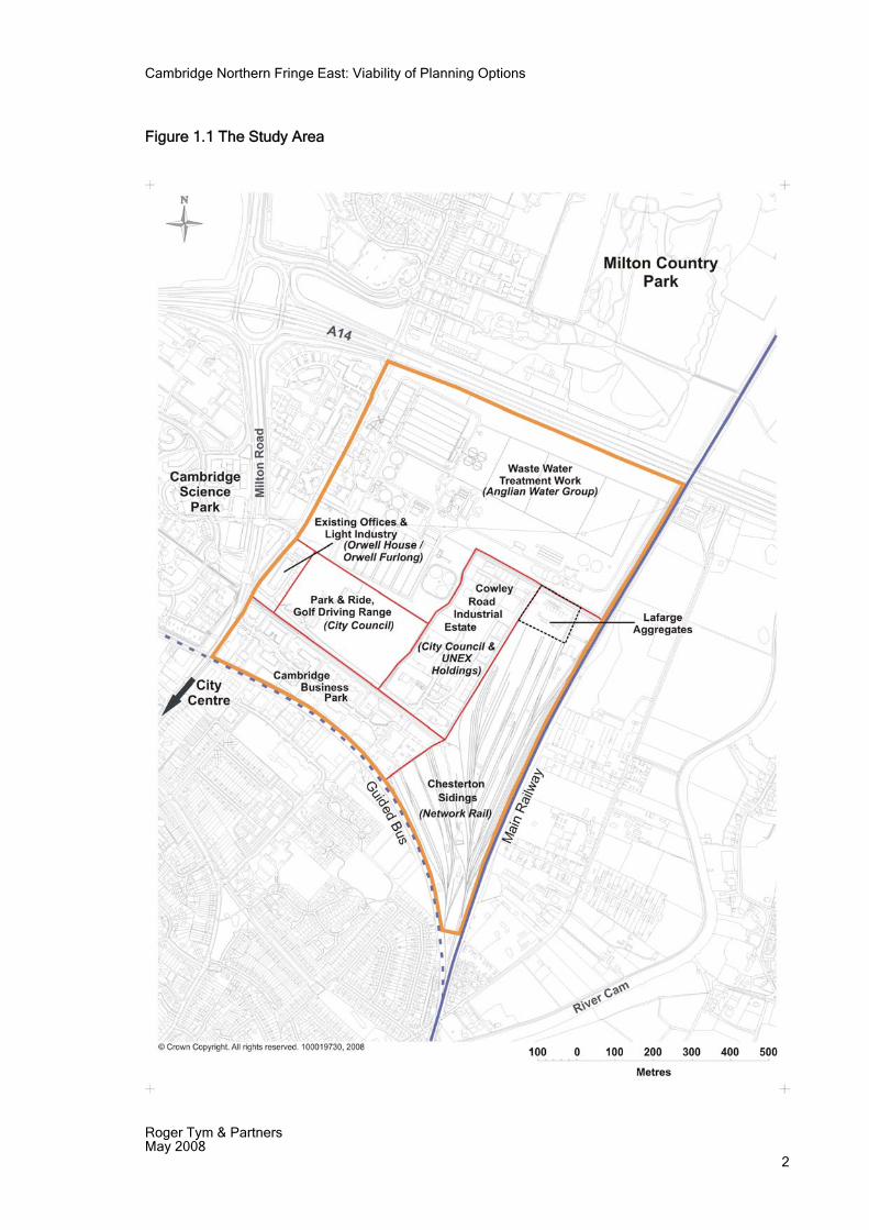
Description of Site 1.2 The CNFE site is located between the A14 and Chesterton and is bounded by the
Cambridge – Kings Lynn railway line and Milton Road. To the south, the area which we have examined is bounded by the alignment of the proposed guided bus route. The site comprises three distinct elements – see Figure 1.1. First, Chesterton Rail Sidings, second, the Anglian Water Waste water Treatment Works(WwTP), and third, existing development/active uses south of the WwTW and east of Milton Road. The overall site is well described and analysed in the LD report which we review subsequently and we do not repeat the LD appraisal here. However, key points to recognize are as follows:
Chesterton Sidings are not fully utilised, the main activities are the Lafarge aggregates site and some other infrequent movements of aggregates including reversing of an oil train for Barnwell sidings; the Lafarge operation incorporates storage of aggregates together with a concrete batching plant and a coated roadstone plant which operates on a 24 hour basis.
The WwTW is actively used and there is no operational reason to re-locate the works; there is limited spare land capacity within the AWA ownership but this is needed for potential upgrades to the works and as a buffer to adjoining development to avoid adverse impacts from odour.
i) There are four main uses between the WwTW and the route of the proposed guided bus; Cowley Road industrial estate, Cambridge Business Park, Orwell House and Orwell Furlong and the bus park&ride/driving range site owned by the City Council. The industrial estates and business park are well-embedded developments which would be costly to redevelop, especially without the relocation of the WwTW.
Cambridge Northern Fringe East: Viability of Planning Options
Roger Tym & Partners May 2008 2
Figure 1.1 The Study Area
Cambridge Northern Fringe East: Viability of Planning Options
Roger Tym & Partners May 2008 3
2 REVIEW OF PLANNING POLICY CONTEXT
RSS and Strategic Housing Requirements 2.1 RPG 6 established that the Cambridge Sub-Region (CSR) was to be a focus for
economic and housing growth, with development concentrated around Cambridge. Subsequently, the Cambridgeshire and Peterborough Structure Plan set out growth targets for the CSR. Policy P9/1 provided that 47,500 dwellings be completed within the CSR between July 1999 and March 2016. Table 9.1, which shows indicative phasing of development, indicated that the CNFE would be developed in the period 2002-2006 accompanied by provision of Chesterton Station. In broad terms the whole of the Cambridge Northern Fringe was estimated by Cambridge Horizons to provide 900 dwellings at Arbury Camp and some 1,900 at CNFE. The CNFE component of the overall CSR housing output would thus comprise about 4% of total completions in the Sub-Region.
2.2 In the event, the Structure Plan phasing programme has not been achieved, with output in the City and South Cambridgeshire falling below expectations, but being partly compensated by rapid development in the three districts in the CSR further away from Cambridge. Whilst Arbury Park is currently being developed and applications lodged for higher housing numbers than anticipated through “densification”, there has been no progress at CNFE.
2.3 In September DCLG indicated that Policy 9/1 of the Structure Plan is not to be saved. Consequently, there is no housing target for the CSR and strategic guidance is provided solely by the District level housing targets set out in the emerging RSS (The East of England Plan). Thus, potentially the CNFE will feed into the future housing supply requirements for the City (19,000) and SCDC (23,500).
Cambridgeshire and Peterborough Structure Plan 2003 2.4 The Structure Plan covers the period up to 2016 and has provided a planning context
for the preparation of the Local Plans and emerging Local Development Documents. Under the 2004 Planning and Compulsory Purchase Act, GO East has directed that only certain policies still remain in force. Of these policies, three are potentially of relevance to CNFE as follows:
Policy P7/12 concerns the Location of Waste Materials Facilities, which the policy requires should be located within or close to urban areas
Policy P8/7 Improvements to Rail Services, which proposes the bringing forward of enhancements and new infrastructure in order to increase rail use and the proportion of freight moved by rail
Policy P8/10 outlines the Transport Investment Priorities for the area. These include park and ride sites for Cambridge and interchanges on the Cambridge to Huntingdon rapid transit system. There is a proposal to undertake improvements to the A14 between Cambridge and Huntingdon, and a new rail station and interchange to be integrated with the rapid transit system at Chesterton Sidings.
South Cambridgeshire Local Development Framework – Core Strategy
2.5 The new LDF process is well advanced and the Core Strategy was declared sound in October 2006 and adopted in January 2007. The Strategy makes provision in Policy ST/2 for the provision of 20,000 new dwellings between 1999 and 2016 to be provided in South Cambridgeshire. A sequential approach to locating the dwellings is proposed in the following order:
Cambridge Northern Fringe East: Viability of Planning Options
Roger Tym & Partners May 2008 4
On the edge of Cambridge At Northstowe new town In rural centres and other villages.
2.6 Policy ST/8 deals with employment provision and seeks to ensure that an adequate supply of land is available for such use. A sites of 5.63 ha is allocated in the Cambridge Northern Fringe for employment purposes under this policy.
2.7 The Site Specific Policies DPD has a specific site proposal for Chesterton Sidings, which is the eastern part of CNFE that lies within SCDC. Policy SP/2 Chesterton Sidings proposes that, amongst other things:
The land is allocated for a mixed use development as part of a new urban neighbourhood that also encompasses the adjoining land in the city
The sidings should be capable of being developed as a stand alone scheme and one that can be integrated into the wider area.
A major multi-modal interchange is created including a new rail station linked directly with the Cambridge- Huntingdon rapid transit system
the remainder of the site is developed for residential and community use
protection of the Jersey Cudweed protected species found on the site
development is subject to adequate highway capacity being available in the A14 corridor for each phase of the development.
Cambridge Local Plan and DPD 2.8 The Cambridge Local Plan was adopted in 2006 and sets out a strategy for the
sustainable growth of the City. In the policy section of the Plan entitled Areas of Major Change, Policy 9/6 identifies the Northern Fringe as an opportunity to regenerate a significant area of poor quality, previously developed land totalling 75ha, 53ha of which falls in the City Council boundary, the remainder in South Cambridgeshire. An indicative block layout plan has been prepared by the City Council, together with proposed land uses and access arrangements (See Appendix 1). In summary the proposals are for:
35ha (approx) of housing 6ha mixed use, including up to 2ha of B class employment uses 0.5ha of retail 5,4ha of community uses 4ha for he relocation of the aggregate works Formal open space 2ha for a major waste management facility 1ha for a household waste recycling centre.
2.9 The land uses are intended to dovetail for the proposals of SCDC for a new rail station and public transport interchange on Chesterton Sidings. The main access to the whole area would be from Milton Road.
2.10 The Local Plan is now being replaced by the new LDF and a key document, the Cambridge Development Strategy Issues and Options Report was published in 2007. This Report rolls the mixed use development concept for the Cambridge Northern Fringe forward for the period 2007-2021 under Option 5. The Strategy does, however, take into account the possibility that two alternative sub options might need to be considered as follows:
Option 5a : If the waste water treatment works is relocated , this will allow a residential led form of development
Option 5b: If the waste water treatment works and rail sidings are retained, this will require an employment led form of development.
Cambridge Northern Fringe East: Viability of Planning Options
Roger Tym & Partners May 2008 5
2.11 A sustainability appraisal was carried out of the Issues and Options and for Option 5a and 5b suggested that a purely residential led scheme might fail to reduce the existing inequalities experienced in East Chesterton and that an employment led scheme might be supportive of other high tech industries located in the area and would also benefit from the proposed train station.
2.12 As part of the evidence base for their DPDs, the City Council and SCDC have jointly commissioned an employment land study for the two local authority areas. This study considered the RSS employment forecasts to 2021 and beyond as well as an assessment of current commitments and allocations. It identifies gaps in the City’s employment property market for light industrial and related activities, for B1(b) in the North Cambridge high technology sub market (identifying scope for densification of uses on St John’s land and Cambridge Science Park Phase 1) and for B1(a) offices in the City generally. CNFE is identified specifically as a potential location for the re-location of the City Council’s Mill Road Depot and for the storage of coaches/buses serving the City. The conclusions of the joint employment land study thus reinforce a presumption in favour of employment-led development on part of the CNFE site, if a housing-led development option is not feasible.
Cambridgeshire Minerals & Waste Plan 2.13 The existing Cambridgeshire and Peterborough Waste Local Plan 2003 defines the
CNFE site as having potential for a range of waste recovery and processing facilities. The two authorities are now preparing a new Waste and Minerals Development Plan (MWDP) for the period up to 2021 and, in 2006, consulted on a draft Preferred Options Plan. Two parts of this document are of relevance to CNFE – the Core Strategy and the Site Specific Policies, which are each discussed below.
2.14 The Core Strategy Report summarises the policy options that were put forward for public consultation and then presents the Councils’ preferred options that they wish to take forward, with reasons why the Councils favour a certain course of action.
2.15 The Core Strategy sits within an extensive policy framework that includes international and European agreements and directives, national legislation, regional guidance and local development plans and community strategies. With regard to waste, four scenarios were examined, Scenario 0, Do-Nothing, Scenario 1, Meet Targets( Meeting targets without energy from Waste(EfW), Scenario 2, High Minimisation and Diversion, (High reduction and diversion levels but still without recourse to EfW) and Scenario 3, Integrated Strategy with Energy Recovery. It is also important to bear in mind that the counties are also required to accommodate a proportion of London waste as set out in PPS 10. Core Strategy policies of relevance to CNFE are:
MW13: Waste Strategy. The scenario to be adopted will seek to maximize recovery and recycling which may also include EfW facilities. Such sites will be identified in the site specific proposals plan.
MW15: Relocation of the Milton Road Waste water Treatment Works. This policy provides support for the search for an alternative location for the WwTW.
MW20: Sustainable transport of minerals and waste. The policy encourages the use of rail, water, conveyor, and pipelines and existing and potential infrastructure such as rail heads will be identified in the site specific proposals plan. The text makes specific reference to the likelihood of waste from London being carried by rail.
MW21: Design of facilities. This establishes the requirement for high standards in the design of new facilities.
2.16 The Site Specific Proposals Document contains the following allocations relevant to the CNFE:
Cambridge Northern Fringe East: Viability of Planning Options
Roger Tym & Partners May 2008 6
SSP10: Sites for Waste facilities. Cambridge Northern Fringe East is identified as Site(g) under this policy and is designated as a location for waste facilities, including mixed stream recycling, single stream recycling, household waste and a bulking up transfer facility.
SSP15: An alternative site for the Milton Road WwTW is identified at Honey Hill, Horningsea/Fen Ditton, north of the A14.
SSP16: Sustainable Transport Protection Zones. CNFE is identified as an aggregates railhead.
2.17 A number of stakeholder comments on the Preferred Draft Options Report and Site Proposals for the CNFE have been made and three are of particular relevance as follows:
Lafarge, who operate the existing aggregates depot on the CNFE site, consider that the whole of Milton rail sidings should be shown as a Sustainable Transport Protection Zone, not just the existing operational area;
Anglia Water draw attention to the presence of rising mains and sewers in the area;
Cambridge City propose that in allocating waste facilities for CNFE, they should be located close to the A14. The City expresses their concern regarding the effect of waste facilities on redevelopment of the area in accordance with policy 9/6. They nevertheless consider that if the relocation of the WwTW is found to be “unrealistic”, then they have no objection to a variety of waste facilities being located in the area.
2.18 The proposal to relocate Milton Road WwTW is both relatively controversial and yet central to our study. The waste water treatment works are operated by Anglian Water Group and covers an area of a little under 40ha, which is about a half of the total CNFE area. The works serve a population equivalent of approximately 200,000 people. The plant comprises primary treatment in settlement tanks, biological treatment within parallel process streams, an activated sludge process and sludge treatment and post treatment storage. The works have been upgraded in recent years and it is understood that the plant has the capacity to increase throughput within the existing site.
2.19 Proposals to downsize or relocate the Milton Road WwTP originated from planning strategies to maximize the development potential of the Cambridge urban area and were not initiated by the owners and operators of the works, AWG. The LD Study concluded that downsizing on a scale sufficient to justify the disruption and investment required is not viable and they recommended relocation. This was partly for the reason that retaining even a reduced area for the WwTW did not obviate the need to retain a 200m buffer zone around the works in order to obviate the problems of odour.
2.20 An alternative site for the WwTW has been identified in the Minerals and Waste Plan at Honey Hill in the Green Belt, north of the A14. The selected site has been subject to public consultation but has received significant objections on a number of grounds. These include the lack of adequate justification for the relocation, the cost of relocation and impacts upon the Green Belt, the local landscape and adjoining communities. This suggests that even if an alternative site for the WwTP has been identified in a planning study, the certainty of achieving the relocation of the works is far from certain, even if such as move was found to be financially viable.
2.21 The key issue with regard to the retention of the existing WwTW (apart from the large area of land that the site occupies) is the long history of problems of odour emanating from the works. Public complaints date back a long time, although upgrading works have been carried out on a fairly constant basis to try to overcome these problems. In 2005 a specialist study was commissioned from H&M Environmental Ltd to carry out an odour survey. This survey did not detect odour release beyond the site boundary and suggested that many of the past problems had been overcome. Nevertheless
Cambridge Northern Fringe East: Viability of Planning Options
Roger Tym & Partners May 2008 7
H&M identified two areas of residual concern and proposed a number of measures that should be introduced in order to reduce the nuisance in the remaining problem areas.
2.22 The conclusions of this recent survey suggest that successful completion of mitigation works proposed in the 2005 survey should resolve any outstanding issues regarding odour from the site.
Summary of Planning Context 2.23 The Northern Fringe (East) of Cambridge currently remains a key component of the
spatial strategy for the growth of the City. A residential led, mixed use development scheme, as envisaged in the Llewelyn Davis study of 2004 (see following section), remains the preferred spatial solution of both local planning authorities, as reflected in their emerging Core Strategies. However concern over the viability and deliverability of the relocation of the WwTW persist and Cambridge City is prepared to accept that an employment led, mixed use scheme might need to be considered as the only viable option to take forward.
2.24 Furthermore, there are other competing priorities for the area. The key policies that GO East propose are retained from the current Structure Plan for the area reflect the importance that Government attaches to the role of CNFE as a location for waste materials facilities and improved transport facilities , including a new rail station and public transport interchange and Park and Ride facility.

Cambridge Northern Fringe East: Viability of Planning Options
Roger Tym & Partners May 2008 9
3 REVIEW OF PREVIOUS PROPOSALS
Summary of Proposals 3.1 Llewelyn Davis (LD) carried out a detailed study of the development potential of CNFE
as a new urban extension to Cambridge in their “Draft Area Development Framework” in January 2004. Before coming up with a preferred option, three alternative development scenarios were investigated and then refined through a number of iterations. A quick summary of these scenarios’ is useful in helping to understand the issues and assumptions involved in developing the site.
Scenario A: This proposed the redevelopment of part of the area but with the existing Waste Water Treatment Works(WwTW) and the aggregates facility retained in their existing locations. A new rail station would be constructed on the site, together with the development of a single residential neighbourhood. This option required that a 200m buffer zone is left around the WwTW, significantly reducing the area available for development. Furthermore, this scenario would require the residential, industrial and park and ride sites to share the same access road access. Scenario A was later amended by removing the rail station from the scheme.
Scenario B: This option re-located the WwTW and the aggregates facility to the northern edge of the site, the former with a much reduced area. The station would form part of an interchange with the guided bus system. Access to much of the area would be via a tunnel from the main A14 junction to the north west, so as to avoid dragging non residential traffic through the new development areas and also because of the congestion on Milton Road during the peak. A buffer zone around the WwTW would still be provided in this scenario but this is now less central to the area. Scenario B was later revised by moving the rail station further north so that it would be more central to the development.
Scenario C: In this scenario the WwTW was re-located entirely away from CNFE and the land adjoining the A14 given over to office, retail and employment uses. The aggregates facility was consolidated in the north eastern corner of the site. Residential uses were expanded to fill much of the centre of the area and the rail station centrally located to serve this new housing area.
3.2 The conclusion reached on the revised scenarios was that the residential element in Scenario A would be too tightly constrained by the provision of the station and would only work if the station proposal is excluded. The development potential of Scenario B is still limited by the need to retain a buffer zone around the WwTW. LD considered that downsizing and relocating the WwTP on the CNFE was impractical. Only Scenario C met the greater vision for the site as a new residential quarter of the City and this scenario was therefore taken forward as the basis for the development framework.
3.3 The Development Framework Plan (See Appendix 2) proposes wholesale redevelopment of the area but in 2 phases so as to allow adequate time for the relocation of the WwTW. The Main components of the framework are as follows:
Phase 1: Residential (Houses 330, Apartments 590), plus community facilities, retail units and open space
Phase 2: Residential (Houses 920, Apartments 1,690), plus a rail station, small business units, educational and community facilities and open space.
3.4 It is also noted that the residential densities assumed in the LD framework plan are at an average of 73 dwellings per ha net (dpha). This is achieved by a tight urban form and a high proportion of 4 and 5 storey flats. This relatively high density is realistic for city centre sites and those that have excellent public transport access.
Cambridge Northern Fringe East: Viability of Planning Options
Roger Tym & Partners May 2008 10
3.5 A key feature of the LD framework plan is the separation of traffic for the different land uses. Thus, in Phase 1 residential and industrial traffic are provided with separate access points off Milton Road and in Phase 2, the residential and station access is provided separately, the station and park and ride traffic access from the A14 junction via a tunnel underneath the A14 from the north. This arrangement is also incorporated in the City Core Strategy Policy 9/6 as an “indicative road link”. The implication of this arrangement is that if access to the station and park and ride via a separate tunnel from the north is not feasible, either on cost or technical grounds, the station and park and ride element of the scheme may not be implementable , since they would be incompatible with the residential character of the area. The parking for the station park and ride is proposed in the form of multi storey car parks rather than the normal surface parking, which presumably has cost implications.
Review of Viability 3.6 Both as part of the original Development Framework Plan, and subsequently, studies
were commissioned to assess the viability of the comprehensive development concept. We have reviewed the following four viability assessments:
ATIS Weatherall’s appraisal as part of the Llewelyn Davis study in 2003.
Subsequently appraisal as ATIS Real in 2006.
King Sturge Report in 2005.
Further analysis of the cost of preparing the WwTW for development undertaken by Gleeds for AWG in 2007.
The Appraisal Reports - Method
3.7 The early ATIS appraisals were undertaken in 2003 as part of the Llewelyn Davies study and focused on the deliverability of the Llewelyn Davies proposals for a comprehensive scheme covering the whole of the CNFE. They are now out of date.
3.8 The King Sturge 2005 analysis revisited the issue in the context of rising house prices and the sensitivity of generic value and cost variables. It usefully included an exploration of transactional evidence. It did not treat the Llewelyn Davies proposals as a necessary starting point but considered the prospects of securing generic forms of development on the individual landholdings.
3.9 The ATIS 2006 analysis addressed methodological deficiencies in their earlier work and considered the sensitivity of the development of each major landholding to planning requirements and abnormal costs.
3.10 The information available to us on the previous viability studies comprised key assumptions and conclusions. The detailed calculations were not provided and to that extent some of what follows is based on deduction. All of the appraisals aimed to assess the feasibility of development using residual land value models modified to include a calculation of the impact of cash flow on returns. There are methodological problems with this approach:
They normally assume that the development will be debt financed although the major housebuilders who are most likely to take on schemes of this scale tend to use more equity in financing schemes in order to reduce corporate risk in cyclical markets.
They are necessarily based on normative assumptions about the form that development might take and its value and cost. But in a competitive and rising market land a successful buyer for land will have made a more sophisticated assessment of what are possible and usually more optimistic assumptions about costs and values to justify a higher bid.
Cambridge Northern Fringe East: Viability of Planning Options
Roger Tym & Partners May 2008 11
The result is that the models systematically undervalue short term residential developments with attractive cash flow characteristics and overvalue situations like the WwTW sites at CNFE where a longer term development involves substantial preparatory investment.
They do not adequately reflect the wider problems in delivering a comprehensive and integrated redevelopment of the whole CNFE site irrespective of the outcome of the theoretical viability calculations due to the difficulty in costing risk and apportioning values and costs to individual sites.
3.11 We also have reservations about the fundamental assumptions made in the appraisals and there appear to be some significant anomalies. They seem to take insufficient account of:
The external works associated with both residential and commercial development.
The additional cost incurred when developing to the level implied by the density and sales value assumptions.
Future levels of Section 106 and affordable housing requirements and in particular the likely availability of grant towards the latter.
The Appraisal Reports – Conclusions
3.12 The conclusions of all of the reports were nuanced and are simplified in the summary that follows.
3.13 King Sturge 2005 conclusion was that the mixed use development of the whole site had a negative value of -£88m primarily because of the estimated £138m cost of relocating the WwTW. Changing the cost and value assumptions by 10% improved the outcome but did not affect their conclusion that “....a developer would not consider the project viable”.
3.14 The 2006 ATIS Report invested significant effort in testing the sensitivity of generic forms of development (i.e. not the specific scheme anticipated by Llewelyn Davies in 2003) to changes in the planning requirements, namely density, Section 106 and affordable housing contributions. It is difficult to make sense of the conclusions some of which relate to entirely improbably scenarios. (For example, that there would be no exceptional development costs). Their overall conclusion was that development was only viable if the cost of the WwTW was excluded. If it was included then substantial third party public funding would be required.
Updating the Analysis of Viability - Current Market Conditions
3.15 Taking the ATIS analysis as a starting point it is clear that development in this area is viable unless the land involved has a high current use value or if exceptional costs would be involved in development. In the context of the former, we have no means of estimating the cost of removing or replacing the aggregates plants but estimate that the existing industrial units might typically be worth around £750 per sq m, equivalent to £5.25 million per hectare on sites with a plot density of 70%. In relation to the issue of exceptional costs, the cost of remediating and preparing railway sidings for development should not be significant in the context of the overall scheme, but the cost of relocating the WwTW has been estimated at £130 million, which we assume is net of finance costs.
3.16 We used several different approaches to estimating the value of development land in the CNFE due to deficiencies in the data available and, the difficulty in making direct comparisons makes reliance upon any single approach hazardous. As a starting point we used:
Valuation Office Agency data on land values Reassessment of the valuation provided by ATIS in 2006. The known value achieved from land sales at Arbury Camp in 2004.
Cambridge Northern Fringe East: Viability of Planning Options
Roger Tym & Partners May 2008 12
3.17 The highest value starting point was the third alternative, so this was used as a benchmark and adjusted to reflect changes in the market since 2004. On this basis, the redevelopment of the WwTW remains non-viable. Changing the starting point does not change this conclusion.
Valuation Office Agency Data
3.18 Valuation Office Agency land value data is provided for ‘Cambridge’ and ‘South Cambridge’. The exact areas referred to are not defined and the number of transactions used as a basis for the estimate is usually small. We would expect that the ‘Cambridge’ area includes high value city centre sites and would be an unreliable guide to what can be achieved on the outskirts where house prices and development densities are lower. We believe that the estimate for ‘South Cambridge‘ is a better guide. Land Registry data suggests that average house prices in Cherry Hinton in South Cambridge and Chesterton are similar, which would suggest that, all other things being equal, the price of land serviced and prepared for development in the two areas would also be similar. In July 2007 the estimated value for larger sites in South Cambridge was around £3.5 million per hectare . This figure cannot be used for direct comparison with the values that might be achieved at Chesterton because it will reflect particular local circumstances but it does provide some benchmark guidance.
Arbury Camp
3.19 In terms of comparable transactions where detail is known; land at Arbury Camp that was already serviced and prepared for development to provide market housing was bought by Persimmon for a little over £6 million per hectare in 2004 on the basis that Section 106 and affordable housing obligations would be shouldered by the master developer of the overall site (Gallagher Estates). The planned density was 65 dph. On the face of it, this provides a benchmark figure for the value of land at CNFE but we have been advised that the sale was achieved at an exceptionally high price because, at the time, housebuilders were confident in the market outlook and there was a shortage of land available in and around Cambridge. That situation has now changed and anecdotal evidence suggests that land values are expected to fall at a time when more land is expected to be available for development over the coming years.
3.20 Even if the price achieved at Arbury Camp is accepted as a benchmark, it needs to be adjusted to reflect changes over time and the particular circumstances at CNFE. From the gross Arbury Camp comparator land price we need to deduct:
Land to be provided to RSL’s or others free of charge for the development of affordable housing. (It is assumed that no further developer affordable housing contribution is required and, by implication, that either Housing Corporation grant funding would be forthcoming or that SCDC’s housing policy requirements would not be met in their entirety). The free land requirement is assumed to be 0.4 hectare for each hectare of market housing.
Land required (a) to comply with the Open Space & Recreation Strategy 2006 i.e. 3.5 ha. per 1000 people; at 70 dph and 2.4 people per home this approximates to 0.6 ha. of open space required for every 1 ha of market and affordable housing; and (b) required for a primary school & other social infrastructure etc shared with land take shared by an equalisation agreement - say 0.06 ha. for every hectare of market and affordable housing; the total requirement is thus 0.66 hectare of land for each hectare developed for market and affordable housing.
3.21 In summary, for every hectare of land developed to provide market housing, a further 1.324 ha. would be needed for open space, social infrastructure and affordable housing. In other words only 43% of the overall site area could be sold at full value on the same basis that land at Arbury was sold to Persimmon.
3.22 The biggest single positive influence on land values is increasing house prices. Land Registry data suggests that house prices in Cambridge increased by around 23%
Cambridge Northern Fringe East: Viability of Planning Options
Roger Tym & Partners May 2008 13
between the average in 2004 and the end of 2007. During that time building costs have reportedly increased by around 17%, so the net improvement in margins is around 6%.
3.23 The tabulation below adjusts the price paid by Persimmon at Arbury Camp to reflect the current circumstances at CNFE and in particular the WwTW.
Table 3.1 : Adjustment To Arbury Camp Gross Land Value
Adjustment Source Result Comment
House price rises in constant terms between 2004 and 2007
Land Registry data
ADD
£900,000
Assume base price of £3400 sq m and increase of £200 sq m since 2004. 4500 sq m ha.
Additional 5 homes per hectare with land value of £46k each.
ADD
£230,000
This ignores higher costs arising from densification.
Additional substructure cost at £50 per sq m incl. profit
Spons. LESS
£250,000
Low end estimate assumes made ground.
Cost of meeting Level 4 Code @ £3586 per dwelling + 25% fees & profit
EP Report LESS
£320,000
Based on EP Report 'Scenario 3' compared with Building Regs compliant home
Allowance for additional works as per Gleeds report @309,000 per GROSS ha + 25% fees & profit
Provision LESS
£676,000
38.52 ha x £386,250 = £14,878,350 spread over 22 net ha.
Allowance for servicing, drainage and second stage site preparation incl. fees and profit.
Incl above. Incl above Remediation and basic groundworks assumed covered by WWTW relocation budget.
Allowance for Section 106 @ £18,000 per dwelling & 70 dpht
Provision LESS
£1,260,000
The allowance includes profit on the additional capital investment and assumes direct provision by developers of on site infr. excl schools. etc. 22 ha, 70 dph,
Subsidy for affordable housing
Provision Nil Free land only provided for affordable housing
3.24 The result of these adjustments is that the value of each developable hectare would be £4.624 million per net developable hectare, a somewhat higher figure than estimated by the Valuation Office Agency. Since only 43% of the land will be available for development for market housing this equates to £1.988 million per gross hectare (say £2 million per gross hectare).
ATIS 2006
3.25 An alternative basis of calculation starts with the ATIS 2006 report which suggested that serviced development plots might have fetched £5.4 million per hectare at the time it was prepared. In order to update the assumptions we have checked the current
Cambridge Northern Fringe East: Viability of Planning Options
Roger Tym & Partners May 2008 14
prices of housing stock being sold from the developments by Laing, Persimmon and Places for People at Arbury Camp and by Wimpey at Wellbrook Way. There was a great deal of variety in pricing depending on the type of unit but overall the comparison suggests that the £3,400 per sq m figure used by ATIS for appraising residential development was optimistic at the time and remains high for the forms of development anticipated. We understand that ATIS relied on figures provided by Savills in this connection.
3.26 Our deduction from the ATIS report is that they believe that land for market housing would be worth around £5.4 million per hectare gross of abnormal costs and any requirement to pay Section 106 contributions. Construction costs have risen since then and, as stated earlier, we also believe that they probably underestimated the cost of providing on site infrastructure and meeting planning requirements. On the other hand the residual value appraisal model they employed will tend to underestimate the value of land that is ready for immediate development. Without having access to their detailed workings we cannot refine their figure to take these factors into account. But in this case there is the further complication that the estimate of residential sales value made at the time seems highly optimistic in the context of current prices at neighbouring developments. On this basis we would expect values to be lower now.
Conclusions on Viability
3.27 In general terms, although the net worth of the land for residential development is severely reduced by planning requirements, it remains high enough to permit development on the sites that have low or no current use value, or which will not be subject to substantial abnormal development costs. In practical terms this means that:
Residential development on the railway land is commercially viable.
The redevelopment of industrial units in reasonable condition would probably not be viable in isolation.
The economics of redeveloping the aggregates plants and other facilities such as the park and ride would depend on whether or not it was intended to replace them. We have no cost estimate for this but would suspect that redevelopment would be viable.
The cost of relocating the WwTW was estimated at some £130m+. To this would need to be added inflation since the estimate was prepared, finance costs and the developer's return. Our analysis assumes that the WwTW site comprises 39 ha. At a value per gross hectare of £2m this would be worth £78m. It follows that at current prices the development of the WwTW is not viable and we concur with the conclusions from the earlier studies.
3.28 It is necessary to consider the potential impact of future movements in the market. The Barker Report illustrated the macro-economic forces which would drive house prices upwards at a faster rate than the normal rate of inflation in build costs over the long term. This should result in higher land values. But in the short and medium term the trend in house prices is at best flat and building costs will increase as the higher construction standards required by the Code for Sustainable Homes is implemented. It is thus difficult to predict the point at which rising land values might make the WwTW viable but preliminary analysis suggests that we could not expect this to occur for ten years or so.
Cambridge Northern Fringe East: Viability of Planning Options
Roger Tym & Partners May 2008 15
Conclusion of Review 3.29 The previous development proposal was a visionary and aspirational concept to create
a new residential quarter for Cambridge. There has been no progress towards realising this concept and on three occasions other consultants have concluded that comprehensive development in the manner envisaged is not viable due to the high costs of relocating the WwTW. Our own assessment of current market conditions confirms that the LD concept is not viable at present. It is unclear whether it would ever be viable but it is possible, based on historic evidence, that in about 10 years the value of housing land may have increased sufficiently to make the concept viable.
3.30 There have been three key changes to the planning context, however, which militate against a strategy of ‘wait and see’ until such a time as the development economics improve. In brief, these changes are as follows:
PPS3 places a far higher emphasis on practical delivery of housing than its predecessor Guidance and it would very difficult for the City Council and SCDC to demonstrate robustly that a comprehensive development concept could be implemented within the next five years. Even if it was practical to arrange the relocation of the WwTW within this period, redevelopment is patently not viable.
The joint employment land study commissioned by the City Council and SCDC has identified a shortage of sites for B1(a), B1(c) and B2 development in and around Cambridge and part of the CNFE could satisfy requirements for industrial development.
As a consequence of increased demand for rail use of the WAGN line the emerging Anglia Route Utilisation Strategy is seeking to expand rail use between London and Cambridge (see the next Section of this report). In addition, Network Rail wishes to ensure development of a gateway station at Chesterton together with the use of much of the sidings for train stabling and washing facilities.
3.31 Consequently, and quite apart from the problem of non-viability, it is no longer possible to envisage a primarily housing-led comprehensive development concept being initiated within the next five years and probably not even in the longer term. Consequently, we see no prospect of the Development Framework Plan concept ever being realised in the manner envisaged by LD.
3.32 In our view, the changed planning context, the need to accommodate a different range of uses and current market conditions all suggest that it is necessary to consider a quite different set of development options. Before we consider what the various components of an achievable option(s) might be, we turn to address the transport issues raised by development at CNFE. These are of equal importance as the planning context in shaping the form of development which can be achieved.
Cambridge Northern Fringe East: Viability of Planning Options
Roger Tym & Partners May 2008 16
Cambridge Northern Fringe East: Viability of Planning Options
Roger Tym & Partners May 2008 17
4 TRANSPORT ISSUES
Introduction 4.1 We now summarise the main transport issues that will affect the viability of the
development site. This section includes a summary of the findings of a series of CNFE access and development reports which have been produced over the past five years.
Current Access Arrangements 4.2 The development site can be accessed from Milton Road. Milton Road is a main radial
distributor road proving access to Cambridge City Centre and to major employment locations including Cambridge Science Park, Cowley Park and St Johns Innovation Park. Milton Road is connected to the A14 and A10 strategic road network to the north of the proposed development site. Cambridgeshire Highways have recently completed a scheme known as the Cambridge Northern Fringe East junction improvements in June 2007. Enhancements have been made to the following junctions:
A14/ A10 Milton Interchange;
Milton Road/ Cowley Road South Junction; and
Milton Road/ Cowley Park junction.
4.3 The improvements to the junctions were implemented because the A14 interchange and the Milton Road corridor are often heavily congested during peak travel times. Previously vehicular access to Cowley Road could only be achieved via the Milton Road/ Cowley Road North signalised T-junction. This resulted in significant queuing and delays at this junction. In addition, the extra housing planned for CNFE will generate additional network trips. The works were also designed with capacity to enable the future development of 720 dwellings at CNFE.
4.4 The enlarged Interchange and revised Milton Road junctions have been in operation since June 2007 and the scheme designers are of the opinion that the scheme has improved the flow of traffic and reduced vehicle delays at the interchange and within the Milton Road corridor. It is believed that the new layout functions well under current traffic demands and is an improvement on the previous access arrangements.
Milton Bus Park & Ride Scheme 4.5 Cambridgeshire County Council are constructing a new Park and Ride (P&R) site off
the A10 at Milton, north of the A14. This is due to be completed in summer 2008. The new P&R site will replace the existing site at Cowley Road which will enable the current site to be redeveloped as part of the CNFE. The relocation of the P&R to the A10 will bring the additional benefit of traffic congestion relief.
4.6 Initially the new site will have a capacity of 500 car parking spaces with provision for expansion to 1,000 spaces at a later date. The relocation will result in the removal of P&R associated car trips from Cowley Road and a redistribution of car trips at the A14 Milton Interchange. Approximately 500 cars use the existing P&R site per day with existing users arriving from the A10 (48%), Milton (21%), A14 (21%), and Cambridge City (7%)1. Observed arrival and departure counts at the existing P&R site show that 11% and 9% of the daily traffic movements occur in the AM and PM peak hours respectively.
1 Milton Park and Ride Transport Assessment, Sept 2006
Cambridge Northern Fringe East: Viability of Planning Options
Roger Tym & Partners May 2008 18
4.7 Based on the existing trip distribution, the relocation of the Cowley Road P&R will remove all trips arriving from or departing to the A10, Milton and the A14 from using the Milton Road/ Cowley Road North junction. Traffic that currently arrives and departs from Cambridge will remain at the junction but will redistribute from the Milton Road right and left turn lane to the ahead lane. The implication for the Cowley Road/ Milton Road north junction is that potentially a significant proportion of the daily P&R traffic will be removed from the Cowley Road North junction. This will result in increased junction capacity as the demand through the junction is reduced.
4.8 The relocation of the P&R site results in a redistribution of traffic flows on the A14 interchange. The junction assessment results provided in the Transport Assessment suggest that there will be no detrimental impact to the operation of the A14/ A10 interchange with the relocation of the P&R.
Transport Innovation Fund Proposals 4.9 In October 2007 Cambridgeshire County Council submitted an Outline Proposal for
Funding to central Government to support congestion charging via the Transport Innovation Fund (TIF). The scheme would be introduced in 2012 supplemented by a range of public transport and non-vehicular transport improvements. A bid for nearly £500 million to fund the package of transport improvements in Cambridge has been made.
4.10 The main TIF transport schemes that impact on the accessibility of the CNFE development site are:
Chesterton Rail Station. A new rail station is proposed in the south-east corner of the CNFE development site on land currently occupied by Chesterton sidings. It is proposed that all fast London services will start or call at the station along with regular stopping services from Ely. The station will be linked to the Cambridge Guided Bus with a segregated busway from Milton Road to the Station and then parallel to the railway line to Newmarket Road;
A new access road to support Chesterton Station from Cowley Road with station parking to enable access to rail services without vehicles having to travel to Cambridge station via the city centre and the congestion charging area. A rough order of magnitude cost of approximately £12 million has been set aside for this scheme which would see a completely new access road with a roundabout junction on Milton Road. An alternative northern access road was also considered from Milton and underneath the A14 but was estimated to cost some £30 million and was discounted;
Milton Park and Ride upgrade and bus priority. The new P&R currently under construction on the A10 at Milton would be expanded to 2,000 spaces. This will further reduce the amount of car traffic that crosses the A10/A14 interchange. Public transport segregation for High Quality Public Transport services will be provided along the A10 across the A10/A14 interchange and then onwards to Chesterton Station, Newmarket Road and the city centre; and
Cycling: wide ranging improvements to the cycle network. Milton will have a direct off-road facility to Cambridge Regional College and the Science Park. An off road facility will be provided along the length of the guided busway from St Ives to Newmarket Road via Chesterton Station. Cycle route will be provided through CNFE from the A14 bridge crossing to the guided busway.
4.11 Implementing the TIF transport proposals will result in significant improvements in CNFE accessibility. The demand management proposals in the form of congestion charging will reduce the amount of vehicular traffic entering the city during the AM peak period providing additional highway capacity for development at CNFE.
Cambridge Northern Fringe East: Viability of Planning Options
Roger Tym & Partners May 2008 19
Development Proposals
Cambridge Northern Fringe (East) Draft Area Development Framework, January 2004
4.12 Llewellyn Davies produced a Draft Area Development Framework for the Cambridge Northern Fringe East. The purpose of the report was to provide information to inform future consultation on the development of Cambridge Northern Fringe. The document proposes two phases of development and summaries the proposed transport access.
4.13 Phase 1: Mixed Use development including retail, community facilities, waste site, public open space and 920 residential dwellings. Phase 1 of the development would be served by car, bus, cycle and pedestrian connections as follows:
Existing Park and Ride bus services;
Extension and diversion of existing bus routes into the site via a bus only link;
Pedestrian, cycle and bus only link to Chesterton via Nuffield Road;
Pedestrian and cycle link to the river and Milton Road;
Vehicle access will be via Cowley Road/ Milton Road Junction and the Cowley Park; and
Separate access to industrial and aggregates via Cowley Road.
4.14 Phase 2: Includes additional retail, new train station and car park, offices, schools, community use, public open spaces and 2610 additional residential dwellings. The additional proposed transport infrastructure includes:
Additional pedestrian and cycle links through the development and north across the A14;
Re-routing of local bus services across the A14 on a new link through the development and then onto Milton Road;
New mainline rail station;
Cambridge Guided Bus (SuperCam);
Upgraded junction to Milton Road at Cowley Road; and
New northern access road from A14 via Tesco roundabout.
4.15 The LD report reviews the Milton Road highway network capacity finding that it was 15 to 20% overcapacity based on the Cambridgeshire County Council’s SATURN model. The report predicts that any improvements to highway capacity would be sufficient to accommodate extra traffic generated by the initial phase of development within CNFE. Phase 2, i.e. inclusion of the Anglia Water land, will generate significant volumes of traffic (30% increase on Milton Road north of Cowley Road) if access was only via Cowley Road. Therefore it is concluded that an additional access road would be required via Tesco’s roundabout, Milton and under the A14 via a new tunnel and link road. This modeling work was completed prior to the 2007 highway improvement works noted earlier.
4.16 The report also highlights the need to maximize public transport, walking and cycling trips to and from the development. If the station was to be developed with a 1,000 space car park this would have significant adverse impact on traffic volumes on Milton Road and the A14 Interchange. The report states an 8% increase to existing peak direction flows due to additional traffic associated with the new station. Concern is raised that traffic to the station will create a congested route into the development but that could be offset to some degree by relocating the existing bus P&R to a new site north of the A14 interchange (which is in fact now in progress).
Cambridge Northern Fringe East: Viability of Planning Options
Roger Tym & Partners May 2008 20
4.17 The conclusion of the LD report was that the proposed station is a flawed concept that will encourage the take up of housing in the surrounding parts of Cambridgeshire for commuting to London, and will generate peak hour traffic on already congested roads. It also asserts that, without the new station, it would not be possible to justify diversion of Guided Bus services into the development or other bus links. The development should therefore have its own bus service by extending existing local services into the site via Moss Bank. For Phase 2, buses from Milton could be diverted through the site before continuing to the City Centre. No feasibility or evaluation work is undertaken to validate these proposals.
WSP Cambridge Northern Fringe East, Draft Technical Note on Anglian Water Development Traffic Impact, January 2008
4.18 WSP have produced a draft Cambridge Northern Fringe East Technical Note assessing the traffic impact of the proposed development on the Anglian Water site. The Draft Report was prepared for Anglian Water Services Ltd (AWS) to assess the highway impact of 2,610 residential units being developed on the AWS site.
4.19 The development impact is assessed in the AM and PM 2021 peak hours assuming a baseline traffic scenario that includes the relocated Milton Park and Ride, Phase 1 CNFE development of 720 residential dwellings, 400 car parking spaces at Chesterton Station and a new northern access via Cambridge Road, Milton.
4.20 The results of the assessment indicate that the junctions with Milton Road/ Cowley Road, Cowley Park and the Science Park will operate within capacity during the 2021 weekday AM and PM peak hours. The AWS Phase 2 development will, however, overload the A14/ A10 interchange in both peak periods. It is predicted that there will be significant queuing on the Cambridge Road approach from the CNFE northern access road. Mitigation measures are proposed in the form of segregated left turn lanes from the A14 West to the A10 North, from Milton Village to the A14 East and from the A14 east to Milton Road/ Cowley Road junction. It is suggested that these junction improvements would be sufficient to ensure operation within capacity during the peak hours.
4.21 Two options for the northern access road from Cambridge Road to the AWS site were assessed. Option 1 joins Cambridge Road via the existing Tesco’s roundabout, with a tunnel underneath the A14. Option 2 joins Cambridge Road via a 3-arm signal-controlled junction to the west of Tesco’s roundabout with a bridge over the A14. Option 1 results in Tesco’s roundabout being overcapacity whereas Option 2 would operate within capacity. The study concludes that the traffic impact of the AWS site can be accommodated on the local highway network subject to improvements to the A14/ A10 interchange and new signal controlled junction on Cambridge Road for the CNFE northern access road.
iCube Chesterton Sidings: Review of Development Options, Sept 2007
4.22 This report provides a summary of the development opportunities for the CNFE excluding development of the Anglian Water site but assuming the delivery of a new rail station. The report includes two illustrative development configurations that estimate 35-40,000 sq m to 55-60,000 sq m of retail and commercial space could be accommodated on the sidings. This would require a 1,000 - 1,500 space multi-story car-park providing parking for the station and adjacent employment land uses. In addition. it proposes that future residential development could occur on the Nuffield Road allotments and on the wider CNFE development site on land outside the ownership of Network Rail.
4.23 The highway access proposals to the site include provision for:
interchange with Cambridge Guided Bus;
upgrading Cowley Road into a tree-line boulevard;
Cambridge Northern Fringe East: Viability of Planning Options
Roger Tym & Partners May 2008 21
additional access from Cowley Road in Cowley Park;
southern access from Moss Bank, Nuffield Road and Long Reach Road; and
separate access road to LaFarge site north of the proposed station.
4.24 The proposals to upgrade Cowley Road to a tree-line boulevard with multiple junctions into Cowley Park and the wider CNFE development will increase the permeability of the site for vehicular traffic. The consequence of this is the potential loss of parking in Cowley Park and an increase in vehicle turning movements on Cowley Road to the detriment of vulnerable road users.
4.25 The proposed residential development on the Nuffield Road allotments will provide southern vehicle access to the CNFE. However, this could potentially result in ‘rat-running’ traffic though the CNFE or Cowley Park to avoid the congested Milton Road corridor. A sustainable approach would be to create multiple walk/ cycle accesses into Cowley Park and Chesterton to encourage non-car site permeability. Filtered permeability would result in safe and direct routes for pedestrians and cyclists from the surrounding area, and more ‘torturous’ indirect routes for vehicles encouraging sustainable travel.
4.26 The report also proposes an option to maintain operation at the Lafarge site by separating development and Lafarge traffic. It is proposed that a link is provided from the Lafarge site to Cowley Road Industrial Estate and then across the development site to the Cowley Road/ Milton Road north junction. This would have the benefit of separating Lafarge HGV traffic from the development. It is not clear at this stage whether this separate access route is feasible.
Chesterton Station and Interchange Scheme 4.27 Chesterton Station was originally developed by Cambridgeshire County Council as a
Major Scheme through the LTP process. The County sought to deliver a new station at Chesterton for a variety of reasons:
to support the development of the Cambridge Northern Fringe and assist in the delivery of commercial and residential redevelopment opportunities afforded by the under utilised sidings;
to release operational capacity at Cambridge’s main station through the extension of terminating trains through to Chesterton; and
to provide a P&R facility north of the City which would intercept city-bound car trips and provide interchange with the Guided Bus for access into the City Centre.
4.28 The scheme was subsequently subsumed into the ‘complementary measures’ that would support the Road User Charging proposals being developed under the TIF (Transport Innovation Forum) finding stream. The station design consists of the following key elements:
highway access via Cowley Road;
a 400 space at-grade station car park to the north of the station; and
interchange with the Guided Bus scheme with passive provision for future onward construction of a guideway into the City Centre via the rail corridor.
4.29 It is important to note that the scheme:
removes rail access for the Freightliner & Lafarge but provides instead four freight sidings parallel to the main running lines for ‘freight marshalling’; and,
does not provide any stabling for passenger rolling stock apart from the south facing terminating platform (capable of accepting one 12 car train only).
Cambridge Northern Fringe East: Viability of Planning Options
Roger Tym & Partners May 2008 22
Review of iCube work for Network Rail (Dec 2007)
4.30 Given the conflicting pressures between retention of Chesterton for freight uses and wider planning policy supporting its redevelopment for residential and commercial uses, Network Rail commissioned consultants to look at potential development opportunities (iCube, September 2007 as above) which could be brought forward in tandem with retention of freight requirements. This work was commissioned from a viewpoint that:
Chesterton Station and interchange with the Guided Bus is retained in all options;
Freight rail access was both retained and expanded to provide sufficient land for future expansion including additional aggregate access, freight marshalling and waste transfer uses; and,
provision of additional stabling sidings for passenger rolling stock displaced from Cambridge station to enable redevelopment of the sidings there.
4.31 More detailed investigation as to the impacts on the station and interchange were then considered (iCube, December 2007) and resulted in changes to the composition of the site to bring forward early development to the south around the station / interchange whilst ensuring that present and future freight requirements were provided for. The key points are:
five passenger stabling sidings to accommodate 12 car rolling stock (60 vehicles) each of up to 300m in length (electrified) either with or without a north facing connection to the main line and including provision of a carriage washing facility.
Relocating rail access to the Lafarge site on the eastern side in addition to the four EWS sidings identified in the TIF scheme.
An additional siding for aggregate uses to service potential future growth and the A14 major upgrade scheme;
Another two sidings of 300m in length to service a future Waste Transfer facility, with trains accessing the site up to twice per day.
The station car park is relocated to the south of the Station in a multi-storey structure which could accommodate 900 spaces and service the associated commercial development as well as the station traffic.
4.32 Total traffic impacts of the station, freight facilities and commercial development have not been assessed. The report notes that for the Waste Transfer facility alone, it could potentially generate 170 HGV movements per week via Cowley Road / Milton Road (to a landfill site at Milton).
4.33 Both iCube Reports make reference to a Network Rail and County Council sponsored study to look at the requirement for alternative locations of rail freight sites but no further information is given. Discussions with Network Rail have suggested that this study will be finished in March 2008. Relocation of the freight facilities will be a significant cost that will need to be met by the development, though it would release more land for re-development.
Conclusions 4.34 The highways network on Milton Road and its junctions with the A14, Cowley Road
and Cowley Park historically has been congested. Upgrading works implemented last summer will have improved the position. Further improvements will result from the relocation of the bus P&R facility and implementation of the major Milton P&R scheme. It is not axiomatic that the capacity released by this relocation will be sufficient to allow development at CNFE without additional improvements to the Milton Road / A14 junction. In the next Section we consider the trip generation potential of the preferred
Cambridge Northern Fringe East: Viability of Planning Options
Roger Tym & Partners May 2008 23
development option and undertake modeling of the capacity of the Milton Road/A14 junction.
4.35 In relation to Chesterton sidings the position is more complicated than it was at the time of the Llewelyn Davies study. There are a number of potential additional demands for railway land – freight, station and park and ride, stabling facilities, waste transfer and continued use by Lafarge – many of which have been crystalised during the course of our study. In short, there is an increased requirement for activities which are bad neighbours for housing. The key to unlocking the development potential of the Sidings is a decision on the bid(s) for a new rail station at Chesterton, as this will resolve the question of continued rail freight operations.

Cambridge Northern Fringe East: Viability of Planning Options
Roger Tym & Partners May 2008 25
5 GENERATING REALISTIC DEVELOPMENT OPTIONS
Introduction 5.1 In developing options for evaluation, we have sought to ensure a high degree of
realism and to only bring forward options that we believe would be achievable. As noted above, none of the options involve the relocation of the WwTW. We have also discounted the possibility of alternative access to the area from the north off the A14 junction via a bridge or tunnel under the road as suggested by WSP in their work for AWG. This is principally due to the high cost of these options. It should be noted that the Chesterton station TIF application discounted the potential of a northern access due to the excessive costs that would be incurred.
5.2 Summarising the key conclusions of our assessment so far, the position in relation to each of the key sites shown in Figure 1.1 is as follows:
WwTW: continues in its present use for the foreseeable future until AWG judge that market conditions indicate that redevelopment would justify the re-location of the existing works.
Cambridge Business Park (8.3ha): there is currently no additional major development potential; the investment in this park and the jobs created should be supported by ‘sympathetic’ and appropriate development on adjacent sites.
Orwell House/Orwell Furlong (1ha): these office and industrial units are accessed off a small loop road called Orwell Furlong but have their frontage onto Cowley Road. The buildings are of fairly modern construction and it is assumed that they will remain in any scheme that does not require wholesale redevelopment.
Cowley Road Industrial Estate (7ha): this is a relatively dense industrial estate which is used for a mixture of manufacturing and storage; it would not be feasible to redevelop the estate for office use and consequently small scale internal improvements and rationalization should be encouraged.
Park & Ride/driving range site (6.4 ha) : this site is owned by the City Council; the park & ride facility is to be relocated to Milton and the site will be available for development.
Chesterton Sidings, North (14.3 ha): a range of rail operational uses have been identified together with continued occupation as a rail based aggregates facility, and also a rail accessed waste transfer facility.
Chesterton Sidings, South (3.8 ha): there is an outstanding TIF proposal for a gateway station and associated car park, which would interchange with the guided busway network and, associated with this proposal, it would be possible to develop just over 2 ha for B class use.
5.3 Thus; in total, there are some 24.5 ha of developable land on three sites in aggregate - the park & ride/driving range site, Chesterton Sidings North and Chesterton Sidings South. We now consider the potential development options for these sites. For all practical purposes, the range of realistic development options is more limited than might have been thought at the beginning of this study or at the time of our Review Report.
Park & Ride/Driving Range Site 5.4 Two factors influence the type of development that can be contemplated on this site.
First, the City Council’s requirement for additional industrial/warehousing and depot-type uses and second, the need to incorporate a buffer zone from the WwTW within
Cambridge Northern Fringe East: Viability of Planning Options
Roger Tym & Partners May 2008 26
which permanent occupation (either for housing or offices) is restricted. These two requirements suggest that low intensity storage or waste recycling activities would be appropriate. The following three uses have been suggested by the City and County which are compatible with a location near the WwTW, subject to liaising with AWG regarding development within the buffer zone of the WwTW and the completion of a risk assessment:
The County Council has a requirement for a site of about 1.2 – 1.4 ha for a local waste recycling facility. Appendix 3 provides an illustrative concept plan for this operation.
The City Council wishes to relocate its Mill Road depot (current site area 2.35 ha) to this site. At the time of writing this report the City is reviewing its future space requirements and consequently we have assumed as a minimum, that the existing Mill Road site size should be replicated.
Stagecoach, which operates buses for Cambridge, currently park buses on a site within the Cowley Road industrial estate; replacement parking facilities for a total of 250 – 275 buses are required, representing about 4 ha.
5.5 There are 6.4 ha available at this site; the requirement for the three identified activities amounts to some 7.6 ha assuming that the replacement Mill Road depot is no bigger than the existing facility. Clearly there is insufficient space to accommodate all these activities, but there would be if Stagecoach retained an interest in its existing Cowley Road Industrial Estate site and operated its bus storage facilities on split sites. This is the approach which we have adopted.
5.6 We allocate 2.85 hectares on the park & ride/driving range site to Stagecoach. Presumably, if the City’s replacement depot requirements increase, then the area of land identified for Stagecoach will decrease.
Chesterton Sidings North 5.7 At the outset of this study, the position was that this portion of the site would be
released for development in association with the construction of a new station in keeping with the original vision for the CNFE. That would have entailed the relocation of the existing freight operations to another location, as yet unidentified.
5.8 However, early into the study, Network Rail made us aware that they had been instructed by the Department for Transport to identify land suitable for stabling up to 60 4-car EMU trains within the Cambridge area as a result of Government commitments to purchase up to 1,300 new rail vehicles nationally as announced last year.
5.9 Separately, Cambridgeshire County Council had commissioned consultants to look at the opportunities for relocating the existing freight activities to facilitate the development of the site as per the original plans. This brought about a number of issues, some of which were conflicting:
Network Rail, and EWS through their long lease, were unlikely to be able to free up the site from freight operations unless they had identified another location on which the main operator (Lafarge) could be relocated to at no financial detriment to their operation;
Other freight operators had expressed a desire to use Chesterton Sidings to expand their own operations, principally for the supply of aggregates to the area in connection with the A14 construction project, but also generally to service a buoyant construction market;
The County Council, through its Waste & Minerals Plan, had identified Chesterton as being suitable for a rail to road waste transfer station potentially taking waste from London to land fill sites in the immediate area;
Cambridge Northern Fringe East: Viability of Planning Options
Roger Tym & Partners May 2008 27
It was not known whether Chesterton had the capacity to accommodate all of the above operational rail requirements, and even if it did, how that would affect potential development opportunities on the rest of the site and adjacent land holdings.
5.10 The position was clarified at a meeting of the Steering Group on the 20th March whereby both Network Rail and Cambridgeshire County Council (CCC) were able to clarify their respective positions with regard to requirements for passenger and freight operations on the site.
5.11 CCC reported that their study to identify alternative sites for relocating the existing freight operations had concluded that there is no suitable alternative location within the area and therefore its position at the Waste & Minerals Plan Inquiry would be that Chesterton be retained for operational rail uses.
5.12 Network Rail produced plans of a potential arrangement of sidings for stabling the required numbers of passenger trains adjacent to the station (which was in the location identified by the County’s Major Scheme submission); this also identified a potential arrangement for continued aggregate operations on the site, although not a waste transfer facility. Network Rail also reported that Chesterton was considered the most suitable location for stabling passenger stock and that it was unlikely that an alternative location within the City limits (a key determinant) would be considered.
5.13 In conclusion, the Chesterton Sidings North site will need to remain protected for rail use and cannot be released for development. However, it should be noted that in order to accommodate the stabling proposals, the aggregates works and a waste transfer facility, it would be necessary to relocate freight uses on the Freightliner site to an alternative railhead site within Cambridgeshire.
5.14 In developing realistic development options, we have reviewed the plans produced by Network Rail, in conjunction with the highway access arrangements for the rest of the site, to determine the optimum development solution whilst facilitating the delivery of Chesterton station and associated transport interchange. It is important to ensure that all operational rail requirements can be accommodated in a way that provides maximum flexibility to the rail industry. This has resulted in us advocating that the station platforms be relocated further south towards Cambridge, the benefit of which would be to provide direct access to the yard from any of the proposed three platforms at Chesterton, something that could not be accommodated by the existing location of the station as shown in Network Rail’s existing plans.
5.15 The revised layout also provides the following benefits:
20 x 250m stabling sidings each capable of accommodating 12 car passenger stock;
these are arranged such that they provide ample room for raised walkways between then trains for cleaning purposed and for locating structures to support the overhead line equipment;
reception and departure tracks at the country end of the yard to accommodate a 360m freight train;
a 360m run-round at the London end to enable freight locomotives to change ends and perform shunting manoeuvers;
a 360m aggregates siding, which could be altered to two shorter sidings if preferred.
5.16 The arrangement would require the relocation of Lafarge’s road coating plant (within the site); whilst this is not an inexpensive item, the resulting layout which has been achieved provides a much greater deal of flexibility for all rail operators. More consideration will also need to be given to mitigating the dusty aggregates operations
Cambridge Northern Fringe East: Viability of Planning Options
Roger Tym & Partners May 2008 28
in terms of keeping the adjacent passenger stabling stock clean. Network Rail has advised that this is achievable.
5.17 Once the requirement for carriage stabling and the partial relocation of the Lafarge operation have been satisfied, there remains a residual area of rail land to the south west. This totals over 2 hectares, which could be used for additional aggregates facilities and/or possibly a rail based waste transfer operation. It will be up to Network Rail and the County to agree an optimum use.
5.18 Finally, one potential benefit of relocating the platforms is that interchange with the guided busway and P&R facility is potentially closer. We have designed a shared bus and car parking access way but the access to the platforms from the busway could also take place on the over-bridge, which would obviate the need for guided buses to make a diversion into the station, although this would require additional rail facilities close to the bridge.
Chesterton Sidings South 5.19 This 3.8 hectare site is located at the eastern end of Cambridge Business Park and is
sandwiched between the route of the proposed guided busway, the WAGN rail line and the proposed gateway station and, the extension of Cowley Road which would access the gateway station. This site will have excellent strategic access by public transport (rail and guided busway) and reasonable road access from Milton Road. However, it will have poor local road access and it would not be possible to connect this site easily by road to the main housing area of Chesterton to the south on the other side of the guided busway.
5.20 The original aspiration for development at CNFE was for a major element of housing. Whilst a comprehensive residential-led development is no longer possible, we have considered the potential of some housing on this site, as it is the only remaining site within CNFE which potentially could be developed for housing. However, it became apparent that housing development would not be appropriate for the following reasons:
Housing in this location would be surrounded by commercial development and railway uses and could not be easily connected with any other housing area; consequently it would be very isolated.
Housing use would not make the best use of the strategic accessibility of this location.
The site would be exposed to quite high noise levels from the main railway nearby, cars accessing the gateway station and the rail operations in Chesterton Sidings North.
5.21 For these reasons this site was rejected as appropriate for housing and we decided to opt for office development, a use which would benefit from the good strategic public transport accessibility and complement the market perception of Cambridge Business Park. Furthermore, there is a long term demand for additional offices in Cambridge and, as we demonstrate in the next Section, office development would have the potential to generate a high value for Network Rail, thus helping to cross-subsidise the cost of developing the gateway station and the stabling facilities on Chesterton Sidings North.
5.22 We consider that a similar form of development as Cambridge Business Park would be appropriate for this site and realistic in market terms. Consequently, we envisage the development primarily of three storey ‘pavilion-style’ offices with landscaped frontages and ground level car parking. At an assumed 40 per cent plot cover it would be possible to provide some 25,000 square metres of lettable space in this format, in 11 buildings.
5.23 The market would not find a single large floorplate office building attractive, at least in the short term, so we have aimed for a maximum floorplate of about 800 square metres
Cambridge Northern Fringe East: Viability of Planning Options
Roger Tym & Partners May 2008 29
so that the building could be let in totals of 2,400 square metres of offices or separate suites of 800 square metres on each floor. We have liaised with SCDC regarding car parking standards and, taking account of the guidance in the Development Control Policies DPD and the excellent public transport accessibility of this site, we have worked to a maximum parking standard of 1 space for 50 square metres – i.e some 500 spaces in total, which would mean that about 40 per cent of employees would have a car parking space.
Transport: Non-car Access
5.24 Chesterton Sidings South has the potential to be one of the most accessible development sites in Cambridge for non-car modes. Sustainable access to the site will be a major benefit for potential employees based at the proposed offices located adjacent to the new Chesterton Rail Station and Cambridge Guided Bus Interchange.
5.25 This site also has the potential to further improve walk and cycle links into the local surrounding area. In particular, direct cycle links can be provided with Milton Road and to the Jane Coston pedestrian and cycle bridge over the A14 to Milton village.
5.26 Locating offices adjacent to Chesterton Station maximises the potential for sustainable access for employees and site visitors. In particular, the Cambridge Guided Bus will be a significant benefit, linking the site to growth areas including Northstowe, Arbury Park and Cambridge East.
5.27 In addition to the excellent rail, bus and cycle links, tenants of the offices can further reduce single-occupancy car trips by implementing a robust Travel Plan. A good template is the Cambridge Science Park Area Travel Plan (ATP) that has brought businesses together to share resources and promote sustainable travel to work, thereby reducing local traffic congestion.
5.28 The Cambridge Science Park is significantly larger than the proposed office development at CNFE but the same principles can be applied. A CNFE Office Park ATP could be established through Section 106 agreements focusing on encouraging more cycling, walking, public transport use and car sharing.
5.29 The CNFE ATP could be expanded to include the surrounding employment centres of St Johns Innovation Centre and Cambridge Business Park. Setting-up an ATP with existing local employment centres will increase the opportunity for car-sharing and the possibility of establishing a shuttle bus to and from the relocated Park and Ride site.
5.30 Overall, therefore CNFE has the potential to be highly accessible by non-car nodes. Not only will this benefit the development site employees, but may also encourage modal shift from the surrounding employment sites reducing peak period traffic movements on the local highway network. The rail station, Cambridge Guided Bus and walk and cycle links will play a significant role in encouraging sustainable travel amongst potential site users.
Local Highway Network
5.31 The local highway network currently operates at capacity during the AM and PM peak periods. Chesterton Sidings South is accessed via the A1309 Milton Road. Milton Road provides access to Cambridge City centre, the A14 strategic road network and a number of large employment sites including the Cambridge Science Park, Cambridge Business Park and the St Johns Innovation Centre that are located in the immediate surrounding area. The inbound AM peak and outbound PM peak commuter trips to Cambridge and the employment centres result in local traffic congestion on Milton Road and the A10/ A14 interchange.
5.32 As previously indicated, recent junction improvements to the A14/ A10 Milton Interchange and A1309 Milton Road have increased highway capacity and site accessibility. Currently the Cowley Road Park and Ride site is being relocated north of the A14. The relocation will result in increased junction capacity within the A1309
Cambridge Northern Fringe East: Viability of Planning Options
Roger Tym & Partners May 2008 30
Milton Road corridor. In addition, the A14 will be upgraded from two lanes to three lanes in the future, although this is unlikely to result in additional capacity improvements to the A10/ A14 interchange junction.
5.33 The CNFE will generate additional peak period vehicle tips on the local highway network. The main trip generators on the CNFE site will be the proposed railway station and the office development. The office peak vehicle generation will occur during the AM and PM peak hours, 0800-0900 and 1700-1800.
5.34 The rail station will generate most trips outside of the AM and PM peak hours as typical London commuters will likely be on a train between 0700-0800 in the morning and between 1800-1900 in the evening.
5.35 The proposals for a household waste recycling centre, bus depot and highways depot, local recycling and maintenance in support of future housing will not generate significant volumes of peak period traffic. The household waste recycling facility will generate a small volume of peak hour weekday traffic, but its busiest period is likely to be at weekends when the proposed offices are closed.
5.36 The bus depot and highways depot will not generate significant volumes of additional traffic during the peak weekday periods. The majority of vehicles are likely to leave both the bus and highway depots early in the morning, before the 0800-0900 highway peak. There will also be a spread of movements throughout the day as bus drivers finish shifts and maintenance jobs are completed.
5.37 To provide a strategic assessment of the potential impact of the CNFE development on the local highway network a capacity assessment of the A14/ A10 interchange has been undertaken. The highway capacity assessment has focused on this Interchange as the junction is critical for gaining acceptable vehicular access to the development site. If the CNFE development proposals are to be taken forward to the planning application stage a detailed local highway assessment would be required as part of a Transport Assessment Report for the proposed development.
A10/ A14 Interchange Assessment
Introduction
5.38 The main capacity ‘pinch point’ on the local highway network is the signalised A14/ A10 grade-separated roundabout. To assess the impact of the proposed developed at this junction TRANSYT models for a 2021 future year have been used. The 2021 AM and PM peak hour TRANSYT models have been used previously to assess the impact of the CNFE residential scheme and the relocation of the Cowley P& R site.
5.39 At this stage a detailed assessment has not been undertaken on the Milton Road corridor as previous assessments have shown significant operational improvements as a result of the recent junction improvements.
5.40 TRANSYT is signalised junction assessment software that is used to assess the capacity and operation of small signalised networks. The software is used to optimise signal timings and provide predictions on queuing and capacity.
5.41 The TRANSYT junction models used previously in 2005 have been updated to reflect the current junction operation. The amendments to the model include changing the Milton approach arm from signal control to give-way control and changing the assignment of traffic to match on-street lane allocations.
5.42 It is important to note that the A10/ A14 interchange operates a SCOOT signal control system that cannot be modelled effectively in TRANSYT. SCOOT signal control is an adaptive system which responds automatically to traffic fluctuations and is therefore more efficient in reducing traffic delays compared to a fixed signal plan that is assessed using the TRANSYT models. Therefore as a result of these limitations, the TRANSYT models are likely to predict longer delays than what would actually occur in reality at the junction.
Cambridge Northern Fringe East: Viability of Planning Options
Roger Tym & Partners May 2008 31
Baseline Conditions
5.43 To assess the impact of the proposed development a baseline 2021 assessment of the A14/A10 junction has been undertaken. The baseline scenario includes the relocated Cowley Road Park and Ride and Chesterton Station with 400 associated car parking spaces.
5.44 The results of the assessment show that, as expected, the A14/ A10 interchange is congested during the AM and PM peak hour. In the AM Peak Hour the main ‘pinch point’ is the signals controlling the A14 westbound off-slip and roundabout circulatory lanes due to vehicles travelling inbound to Cambridge. In the PM Peak Hour the main ‘pinch point’ is the Milton Road and A14 Eastbound off-slip junction due to vehicles travelling outbound from Cambridge.
Proposed Development
5.45 To provide an indication of the potential impact of the proposed development on the local highway network a Chesterton Sidings South 2021 AM and PM Peak Hour scenario has been tested. For the purposes of this assessment it has been assumed that the development will comprise:
25,000 sq m of B1 Offices with a parking ratio of 1 space per 50 sqm;
Bus storage depot;
Highways maintenance depot; and
Household Waste recycling facility
5.46 To estimate the number of vehicular trips generated by the proposed development, trip rates from the TRICS database has been used. TRICS is a site survey database that contains comprehensive range of sites that can be used to estimate trip generation for different land-uses.
5.47 To generate the office vehicle trips, the TRICS survey of the Cambridge Science Park has been used. The vehicle trips rates have then been factored down to take into account the non-car accessibility of the site. It has been assumed that a 20 percent reduction in vehicle trip rates can be achieved as the CNFE site will have a mainline rail station, guided-bus link and robust travel plan.
5.48 The TRICS database has also been used to predict the number of AM and PM peak hour trips generated by the household waste recycling centre. It has been assumed that the bus and highways depot will not generate any significant additional peak hour movements.
5.49 The resultant trip generation of the proposed development will only increase traffic flows through the A14/ A10 junction by four percent in the AM Peak Hour and three percent in the PM Peak hour. However due to the existing junction operating close to capacity during the AM and PM peak hours the additional trips generated by the proposed Chesterton Sidings South development have been assigned to the A14/ A10 interchange based on 2005 CNFE Transport Assessment Report.
A10/ A14 Junction Impact and Mitigation
5.50 The initial junction assessment results show that some critical circulatory links are predicted to be overcapacity with the additional development traffic that could result in additional approach arm queuing. An appropriate mitigation measure, given the scale of the predicted traffic flow increase, is to optimise the existing signal timings to the benefit of circulating traffic. This approach is considered appropriate for this development given the fact the junction has only recently undergone major highway improvement works.
5.51 In both the AM and PM Peak Hour additional junction capacity for inbound and outbound traffic can be achieved by increasing the green time for circulating traffic to
Cambridge Northern Fringe East: Viability of Planning Options
Roger Tym & Partners May 2008 32
ensure that roundabout queuing does not block the approach arms. The junction models showed that the additional circulating green time required for the CNFE traffic will result in increased queuing on the A14 off-slips and Milton Road during the PM Peak Hour. However, the results of the assessment show that the predicted queuing on the A14 off-slips will not block back onto the A14 main carriageway.
5.52 To maximise the stacking capacity of the A14 westbound off-slip it is proposed that Cambridge City traffic should queue in both lanes on approach to the 3 lane flare at the stop line. This proposal requires changing the offside approach lane allocation from Milton village only to City and Milton.
5.53 The results of the optimised junction assessments show that all circulatory links are predicted to operate within capacity. In the AM Peak Hour the A14 westbound off-slip is predicted to be over-capacity but the predictive queuing will not block back the A14 with the proposed reallocated approach lanes.
5.54 In the PM Peak hour the junction results show all circulatory links operate within capacity. The Milton Road offside lane and A14 eastbound off-slip nearside lane are predicted to be overcapacity. However, the predictive queuing will not block back to the Cowley Road north junction and the A14 main carriageway.
5.55 The strategic assessment of the CNFE development shows that the development can be accommodated within the existing A14/ A10 interchange by optimising the green time for circulating traffic. Considering that the junction currently operates under SCOOT control that is more efficient than the fixed signal control in TRANSYT, the results are likely to over-represent actual queuing and delays that may occur in reality. Therefore the mitigation proposed is considered appropriate for the scale of the proposed development.
5.56 To support any future planning applications for the development site, a detailed traffic impact assessment of the Milton Road corridor and the A14/ A10 interchange will be required as part of a Transport Assessment report to satisfy the local planning authority and the Highways Agency.
Summary of Development Concept 5.57 We have brought the different development strands together into an indicative
Framework Strategy diagram which is shown on Figure 5.1.
5.58 The three CNFE development parcels could be implemented largely independently of one another, especially the park & ride/driving range site. The uses proposed for this site and Chesterton Sidings North are compatible with the adjacent WwTW. These activities are all necessary to support the high level of housing proposed for the Cambridge Sub Region and represent a sustainable rail-based solution to accessing aggregate and waste transfer activities.
5.59 Chesterton Sidings South would be a strategically well located site for offices which would be attractive to occupiers and could potentially assist in promoting use of rail or the guided bus for work journeys. This site should be attractive to the market in the form proposed, if the release of development plots is well managed.
5.60 The development proposed on these three CNFE land parcels is not a visionary concept for a new ‘quarter’ for Cambridge as were the earlier proposals. What is suggested is practical, much needed and deliverable, however. We would recommend that special attention is given to landscaping measures so as not to detract from the ‘quality’ image of Cambridge Business Park and the offices which we propose for Chesterton Sidings South. It is particularly important to screen the waste recycling and storage uses on the park & ride/driving range site and to ensure a high standard of urban realm for Chesterton Sidings South.
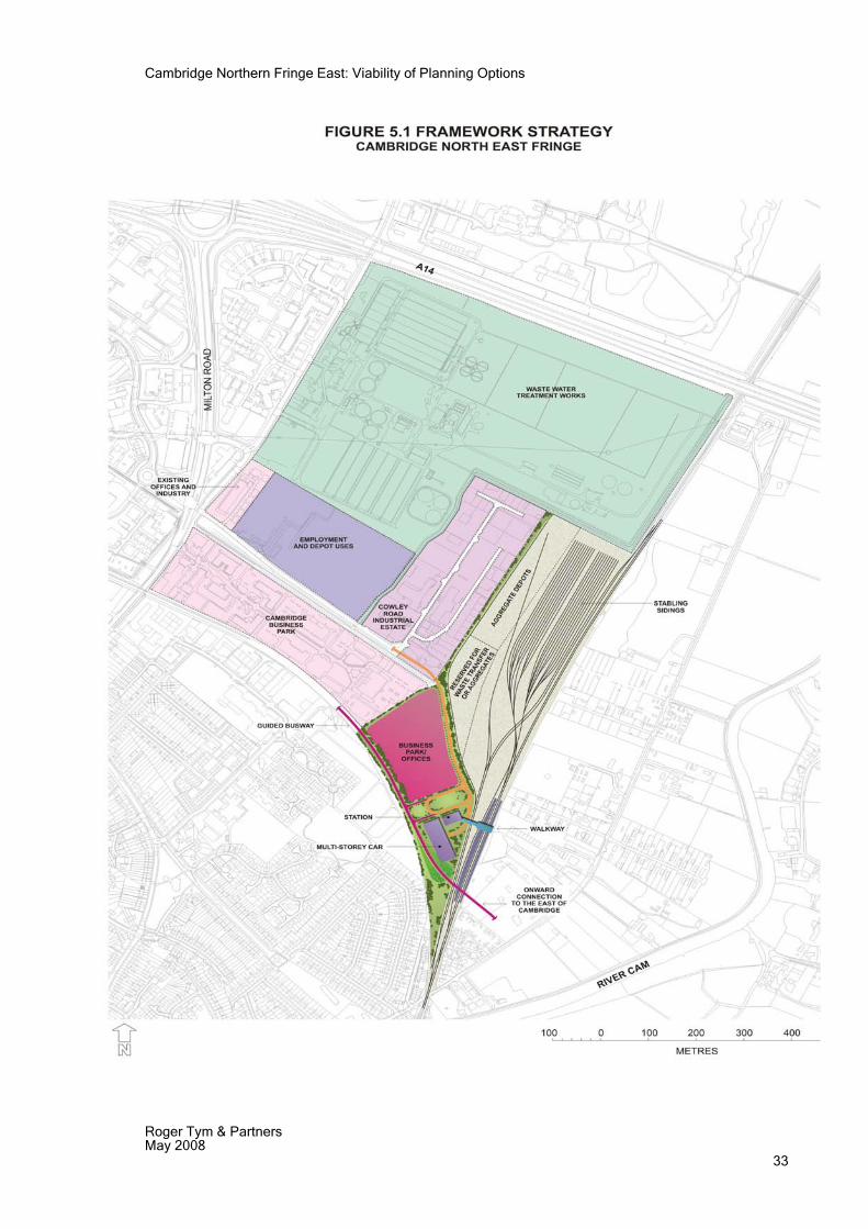
Cambridge Northern Fringe East: Viability of Planning Options
Roger Tym & Partners May 2008 33
Cambridge Northern Fringe East: Viability of Planning Options
Roger Tym & Partners May 2008 34
6 VIABILITY OF REVISED DEVELOPMENT CONCEPT
Overview 6.1 Neither the ATIS nor King Sturge reports looked in any detail at the commercial
development possibilities. It would seem that they did not view the site as a business location to compete with the City Centre or established business parks. The ATIS assessment in 2006 mooted the possibility of a 'hybrid' scheme. This is normally taken to mean low density offices or industrial space with high office content. Examples from our direct experience include units used as laboratory space on the ground floor and offices above, or a 50/50 mixture of offices and full height production or storage space within a single building. However ATIS assumed a value of £3,166 per sq m comprising a rental of £200 per sq m, a yield of 6% and buyer’s costs of 5%. This level of rent and the building cost are appropriate to low density offices rather than hybrid structures. Notwithstanding this, ATIS suggested that the economics of commercial development would be worth a second look if this could be considered in terms of planning policy.
6.2 Unsettled market conditions make it very difficult to predict how much new development might be worth overall. Investor demand has fallen steeply since mid 2007 and there is little transactional evidence to support an estimate of capital values. In January 2008 Estates Gazette reported that investors required a return of 5.75% on the best business park investments and 6.5% for 'city fringe' offices. Best quality industrial stock sold at 6% and secondary multi-let industrial schemes were priced at 6.5%. This probably reflected historic data and it is possible that prices have fallen since.
Office Development 6.3 The revised development envisages that the land around the new station should be
developed for offices. There is current evidence of office rental levels. In recent years the office market in Cambridge has failed to reach the £280 sq m levels achieved in 2000 and the best price achievable has been around £250 per sq.m. Expectations prior to the recent downturn were for this level to increase sharply. In the business parks, rents have been lower but terms were recently agreed for Napp Pharmaceuticals to take the as yet incomplete new 10,000 sq m building on Cambridge Science Park for £242 per sq m. Other recent transactions support this level.
6.4 In a competitive market location, access and ease of parking are key differentiators and any new development might suffer if it needs to compete with the established business parks offering higher parking standards and / or if it is located within the periphery of any new congestion charging zone. The potential impact of access to a new station is obviously positive but might not fully offset these other drawbacks in the eyes of a developer.
6.5 An additional challenge is that there is land and space available at the established business parks whilst the environment and amount of space available at CNFE might be too small to create an environment or profile to rival the best of them. On this basis we believe that a prudent assumption is that, to be competitive, office development would need to be marketed at a rental level that was lower than the best obtainable elsewhere. We have therefore based our conclusions on: a mid / low end quality office development which could be let and then sold at around £3,166 per sq m (taking account of buyers’ costs), which would be a competitive price in the current market.
6.6 Thus, against a value of £3,166 per square metre, we need to consider costs. Total development costs for basic air conditioned office buildings including external works, fees, marketing costs finance and developers return on capital might be in the region of
Cambridge Northern Fringe East: Viability of Planning Options
Roger Tym & Partners May 2008 35
£2500 per sq m of saleable floor space. (i.e. net internal area). If values are around the estimated level it follows that land for offices might be worth around £666 per sq m of permitted development. Based on plot densities of 12,000 sq. m. per hectare for office uses catering to this segment of the market, this equates to land values of up to £8 million per hectare. This estimate has a wide margin of error in the absence of detailed designs and takes no account of any Section 106 contributions or payments for off-site works. It also assumes that land for office development is sold in tranches large enough to meet immediate demand only – i.e land is released for development in manageable parcels.
6.7 Bidwells have reported take up of offices in Cambridge of 43,500 sq m in 2007 (37,000 in 2006) against availability of 58,000 sq m (2006 67,000 sq m in 2006). We are unaware of the quality of the available stock. There is more development in the pipeline than in recent years and this might be expected to increase rental competition from 2010 onwards. Consequently the scale of development proposed in the revised development concept is appropriate to current market conditions.
Industrial Development 6.8 The revised development concept allocates the park & ride/driving range site for the
Council recycling and depot facilities and a new facility for the bus company. If the Council or the bus company were buying this land on the open market the asking price would probably reflect the most likely alternative use i.e. B1(c) and B8.
6.9 The industrial market in Cambridge has been steadier than the office market with rents for good quality units reaching £110 per sq m. This is felt by some market commentators to be unlikely to rise in the short term. Availability is low. A good quality industrial and warehouse scheme in this location might be expected to fetch a good price, say £1,650 per sq m net of buyers costs
6.10 Total development costs for good quality industrial units might be £1,2002, so that land might be worth £450 per sq m of permitted development. Assuming a development density of 6,000 sq m per hectare it follows that land would be worth £2.7 million per hectare or more. Once again, the margin of error is significant and any restriction of B8 uses would reduce this value as would the imposition of a congestion charging scheme which includes the site.
Conclusions 6.11 As can be seen, land for B1 offices is substantially more valuable than land for
residential uses because the margin on cost and the plot ratio would be higher and the planning conditions less onerous. It follows that commercial development is viable on unused land since in each case the proceeds from development should cover remediation and demolition costs.
6.12 Since the value of the land for office development appears to exceed its value in residential use it raises the question of whether commercial development might justify replacement of the WwTW. However, we think it unlikely that large scale office development would be viable as we believe that the Bidwells figures referred to do not indicate sufficient demand for office space to justify development on that scale. Furthermore, uncertainties in the office market would make development on such a scale a highly risky proposition.
2 In both cases estimated build costs are based on current BCIS data and broadly reflect 'mean' costs for each form of development.
Cambridge Northern Fringe East: Viability of Planning Options
Roger Tym & Partners May 2008 36
7 CONCLUSIONS
Viability of Comprehensive Development 7.1 Both King Sturge and Atis Real have previously concluded that comprehensive
Development of the CNFE is not viable without a subsidy either through grant or exemption from normal Section 106 and affordable housing contributions. This is due to the high costs of relocating the WwTW. Our review of viability, based on a benchmark assessment using an Arbury Camp gross land value of £6 million per hecatare and an Atis assessment of £5.4 million per hectare adjusted for local circumstances and obvious cost differences, confirms that the viability of redeveloping the WwTW is much the same as set out in the Atis and King Sturge reports. The conclusion that comprehensive development is currently not viable remains.
7.2 In fact, it could be argued that development currently is likely to be even less viable now that Network Rail has aspirations to use the Sidings for operational purposes and the County Council wishes to establish a waste transfer facility. These activities – freight operations, aggregate works, waste transfer – create noise and dust and are environmentally unattractive neighbours for housing.
7.3 Looking ahead, both present economic conditions and forecasts for the next few years suggest that it is unlikely that the current relationship between cost price inflation and house price inflation will alter significantly. Consequently, it is safe to assume that development is unlikely to be viable for the next five years. In the next 5-10 years house price inflation would need to accelerate above cost price inflation. Historically house price inflation has grown by about 2% above cost price inflation over the last 10 years but it is uncertain when exactly market conditions night return to historical levels. For current purposes we assume that it may within 10 years.
7.4 In planning terms it is essential to be realistic about the prospects for delivery of the approximately 2,000 dwellings which are earmarked for CNFE. The re-allocation of this capacity is beyond the scope of this study, but it can be noted that additional housing is likely to come forward at Arbury Camp as a result of “densification” and there are other potential housing sites in both SCDC and the City which could be brought forward through the LDF process. Both authorities require as much certainty as possible in relation to their site allocations and housing land supply in order for their DPDs to be sound. The evidence shows that it would be very easy for objectors to argue that the development of the WwTW is not achievable within the next 5-10 years. PPS3, with its greater emphasis on practical delivery than its predecessor guidance, would not support such an approach. We would not advise the authorities to rely on the WwTW as a housing site for the foreseeable future.
7.5 Since it is improbable that comprehensive development will be viable for the next 5-10 years and other sites can be brought forward in the meantime, we do not consider that the WwTW should be identified for housing development within the next five years or until it has been demonstrated un-equivocally that redevelopment would be viable. In the meantime, there is an urgent need to plan for the shorter term development of the Sidings site in order to achieve Network Rail’s aspirations and achieve the regeneration of an underused site on the edge of Cambridge.
7.6 The recently completed employment land study, which took a long term view of land requirements, undertaken jointly for the City and SCDC indicates that there is a need for the provision of additional sites in the short term for B class development within and adjacent to Cambridge.
Developing Realistic Planning Options 7.7 In developing options for evaluation, we have sought to ensure a high degree of
realism and to only bring forward options that we believe would be achievable. As
Cambridge Northern Fringe East: Viability of Planning Options
Roger Tym & Partners May 2008 37
noted above, none of the options involve the relocation of the WwTW. We have also discounted the possibility of alternative access to the area from the north off the A14 junction via a tunnel under the road. This is for two reasons: first cost and second because if the WwTW does not relocate, then there is no corridor for the new road to pass through the area. We have borne in mind the aspirations of the various public sector stakeholders for the area, although this has needed to be tempered by the known constraints in CNFE.
7.8 There are three separate development parcels in CNFE: the park & ride/driving range site, Chesterton Sidings North and Chesterton Sidings South. There is in fact limited alternative development potential on each site. Consequently we set out what is essentially a single preferred development option. This can be summarized as follows:
Park & ride/driving range: 6.4 hectares to be developed for a local waste recycling facility adjacent to a site for the City’s relocated Mill Road Depot, with the remainder of this parcel being used as coach and bus storage by Stagecoach. This range of uses is compatible with the site’s location within the 200 metre buffer zone from the WwTW.
Chesterton Sidings North : 18.1 hectares to be used for rail related uses – stabling for 60 4-car EMU trains – a realigned aggregates depot – and additional land which could either be used for aggregates purposes or a rail accessed waste transfer station.
Chesterton Sidings South: 3.8 hectares to be used for a gateway station and car park with the remaining area developed with up to 25,000 square metres of offices.
7.9 It will be necessary to provide high standards of landscaping where appropriate and measures to limit the effects of noise and dust, in order to enhance the market perception of this accessible part of Cambridge.
7.10 There would appear to be a market for well located additional offices in Cambridge, provided that a manageable quantity is put on the market at any one time. Potential land values generated could be up to £8 million per hectare in small lots. Thus the proceeds from development of the offices proposed as part of Chesterton Sidings South could assist in the funding of the gateway station and/or the Network Rail train stabling on Chesterton Sidings North.
7.11 Our assessment of CNFE assuming 25,000 sq m of office development on Chesterton Sidings South has shown that the additional traffic can be accommodated on the local highway network. However the assessment has also shown that the A14/A10 interchange junction operates at capacity during the peak weekday travel periods. Therefore, any intensification of office on CNFE is likely to result in increased traffic generation. To accommodate a denser office development at this location a significantly higher non-car mode share to new development will need to be achieved. The implementation of a robust site or area Travel Plan in conjunction with the TIF and Cambridge Guided Bus public transport infrastructure proposals may be sufficient to accommodate a denser office development without having a significant detrimental impact on the local highway network, but this would need to be tested in more detail once a decision has been reached on the TIF station proposals. However, with regard to any future proposals to potentially increase the density of office development on St John’s land, Cambridge Business Park and the Cambridge Science Park, the local highway network will become increasingly congested. The combination of all the potential future office developments within the local area would result in the need for further physical improvement works at the A14/A10 interchange.

APPENDIX 1 Cambridge Local Plan: Policy 9/6 Northern Fringe East

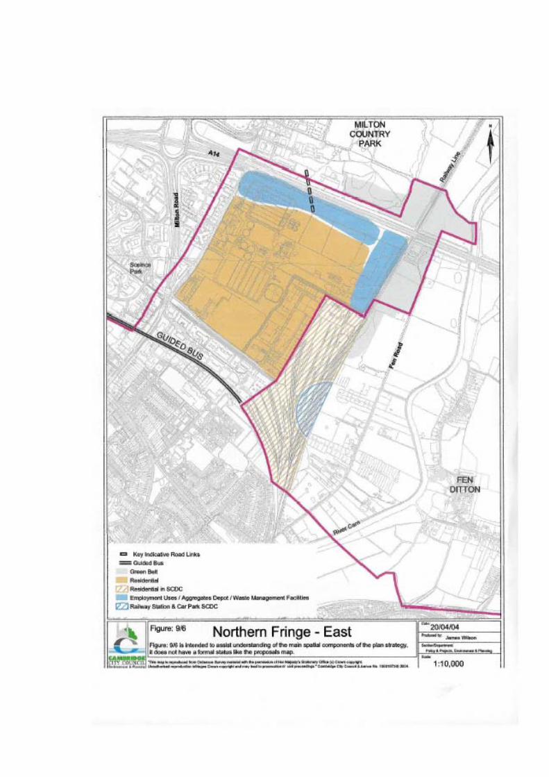

APPENDIX 2 Llewelyn Davies Draft Area Development Framework Plan 2004

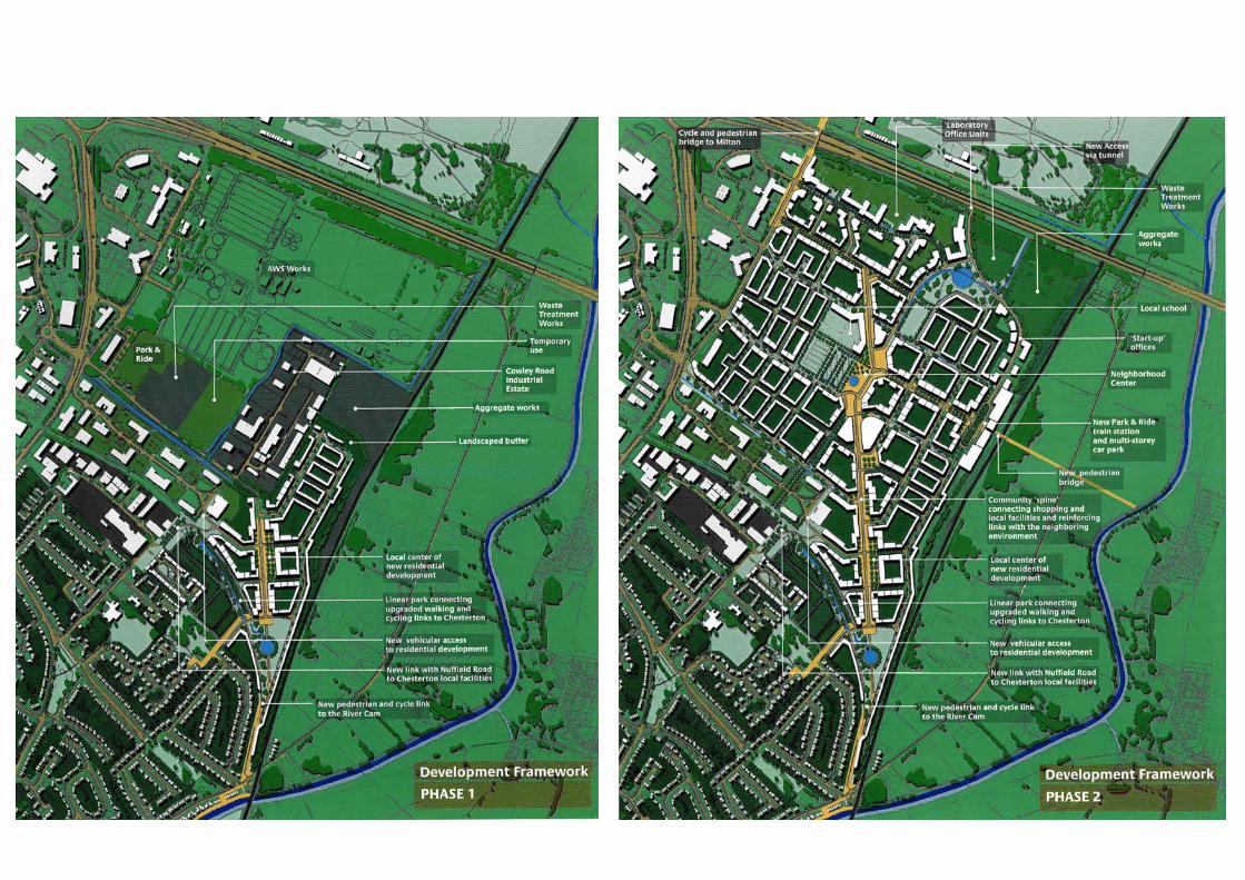


APPENDIX 3 Example of Local Waste Recycling Facility

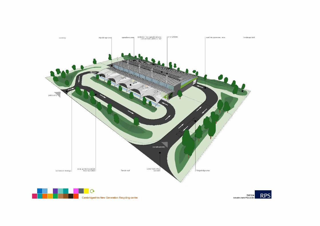
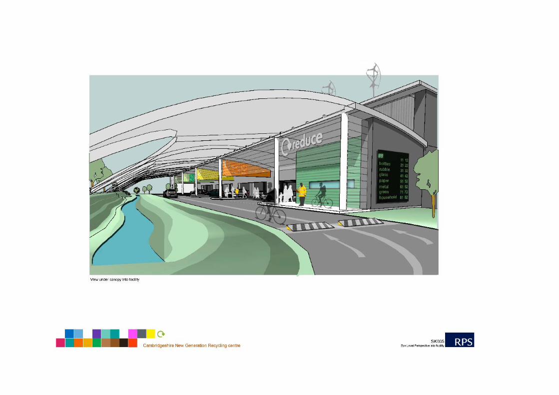


![Cambridge Northern Fringe East Area Action Plan...1 The area needs to have an overall vision, not piecemeal development. The vision is appropriate Nicky Morland [5636] 1 Whilst I think](https://img.pdfslide.us/doc/110x75/5ff7c7c34f76ab7d156a3605/cambridge-northern-fringe-east-area-action-plan-1-the-area-needs-to-have-an.jpg)