Embed Size (px)
Citation preview

SLM 31 May 2013| World Geographical Dictionary‐Cambodia 1
World Geographical Dictionary On Cambodia
Prepared by
Mak Solieng

SLM 31 May 2013| World Geographical Dictionary‐Cambodia 2
May 2013 CATEGORY A
1. Kingdom of Cambodia
Origin of the name Kambuja, the Sanskrit transcription of “Kampuchea”Population 13,395,682 (Population Census 2008)Area (km²) 181,035 km² Coordinates of longitude and latitude
10‐15°N 102‐108°E
Currency Riel Capital Phnom Penh Brief on the country Cambodia’s ancient name is Kambuja. People have been living in the area covered by
the present‐day of Cambodia since the 5th Millennium before the Christian era (BC). The ancient Kingdom of Funan (68) occupied a wider area and the society during that period was heavily influenced by Hinduism (Pre‐Angkorian). Then arose the Chenla Kingdom (550) followed by the Glorious Khmer Empire which has its golden age between the 9th and 13th Centuries (Angkorian). The period between 15th to 19th Centuries marked a continued decline in Cambodian power and territorial loss (Dark Ages of Cambodia). Cambodia became a protectorate of France in the 19th Century and the state gradually came under the French colonial rule (French Colonization). Later on in 1953, Cambodia became an independent kingdom (Kingdom of Cambodia). The Vietnam war extended to Cambodia leading to establishment of Khmer Republic and giving the rise to the Khmer Rouge who took Phnom Penh in 1975 and carried out a campaign of mass killing (Khmer Rouge Regime). Following depose of Khmer Rouge Regime, the People’s Republic of Kampuchea was established in 1979. After years of isolation, the war‐torn nation was reunited under the monarchy in 1993 and has seen gradual economic growth while rebuilding from decades of civil war. After ending Khmer Rouge existence in 1998, Cambodian people started to enjoy peace and stability and develop the national economy again. Cambodia is located in the southern part of the Indochina Peninsula in Southeast Asia. Its area (181,035 square kilometers) lies entirely within the tropics, between
SLM 31 May 2013| World Geographical Dictionary‐Cambodia 3
latitudes 10° and 15°N, and longitudes 102° and 108°E. It borders Thailand to the north and west, Laos to the northeast, and Vietnam to the east and southeast. It has a 443‐kilometer coastline along the Gulf of Thailand. The Cambodia’s landscape is characterized by:
• A large low‐lying central plain surrounded by uplands and low mountains including the Tonle Sap Great Lake and the upper reaches of the Mekong River Delta. From this central plain, the thinly forested transitional plains extend outward and rise to elevations of about 200 meters above sea level to the north, abutting a sandstone escarpment, which forms a southward‐facing cliff stretching more than 320 kilometers from west to east and rising abruptly above the plain to heights of 180 to 550 meters. This cliff marks the southern limit of the Dangrek Mountains.
• The eastern plains which extend from the east Mekong River and gradually merge with the eastern highlands (Up to over 700 m), a region of forested mountains and high plateaus that extend into Laos and Vietnam.
• The southwestern highland region formed by two distinct upland blocks, the Kravanh Mountains and the Damrey Mountains which cover much of the land area between the Tonle Sap and the Gulf of Thailand. In this remote and largely uninhabited area, Phnom Aural, Cambodia's highest peak, rises to an elevation of 1,813 meters.
• The southern coastal region adjoining the Gulf of Thailand is a narrow lowland strip, heavily wooded and sparsely populated, which is isolated from the central plain by the southwestern highlands (Up to around 1,000 m).
• The most distinctive geographical feature is the inundations absorbing capacity of the Tonle Sap Great Lake which can expand from about 2,744 km² during the dry season up to about 10 times during the rainy season ‐ essentially this is flood pulse function of the Mekong River Basin. The Great Lake and its surrounding flooded forest and plain areas have been designated as a UNESCO Biosphere Reserve.
Based on the geographical characteristics and corresponded ecosystems, six distinct terrestrial eco‐regions in Cambodia have been recognized by the Worldwide Fund for Nature. They include the Cardamom Mountains rain forest, Central Indochina dry forest, Southeast Indochina dry evergreen forest, Southern Annamites mountain rain forest, Tonle Sap freshwater swamp forest, and Tonle Sap‐Mekong peat swamp forest. At present these forests are under severe threat and require serious protection. The geographical and ecological conditions also are determinant factors of the climate and climate variability of this country. Cambodia enjoys tropical climate, which is dominated by the monsoons with temperature ranging from 21°C to 36 °C and two distinct seasons, the wet season (May‐ October) with high humidity and dry season (November‐April) when the temperature can rise up to 40 °C. The average annual rainfall varies between 1,000 to 1,500 mm. The country is not affected directly by tropical storms and this year‐round tropical climate makes Cambodia ideal for tourism development.
SLM 31 May 2013| World Geographical Dictionary‐Cambodia 4
The population of Cambodia in 2012 has increased to over 14 million. The country is divided into 24 provinces and capitals and the provinces are subdivided into 159 districts and 26 municipalities. The districts and municipalities in turn are further divided into communes and quarters. At present, Cambodia is under the process of population growth, thirst for economic development and fast land use changes.
2. Kampong Cham Province
Area (km²) 9,799 km² Population (when) 1,679,992 (Population Census 2008) Coordinates of longitude and latitude
12°00′N 105°46′E
Brief on the province The name of the province literally means “Port of Chams”. Kampong Cham is located Southeast of the country at 124 km from Phnom Penh. It borders the provinces of Kampong Chhnang to the west, Kampong Thom and Kratie to the north, Prey Veng and Kandal to the south, and shares an international border with Vietnam to the east. The topography of this province varies significantly. The province is bisected by the Mekong River which flows across north‐south. The eastern area of the Mekong consists of northern upland areas covered with forest, rubber and other cash crop plantations; and southern lowland paddy fields and areas of lowland and upland mosaic. Around the Mekong River are the river flood plains. The Western area of the Mekong consists of large lowland paddy fields extended southeastwards; and northern lowland and upland mosaic and upland areas covered with forest, rubber and other cash crop plantations. The province experiences the same tropical and monsoon climate condition with abundant rainfall ranging from 1,400 mm to 2,400 mm annually. Mekong flood is the main climate effect for this province. Kampong Cham is a privileged province for its favorable climate, geographical and ecological conditions and natural resources which suit to both rice and cash crops production. This makes Kampong Cham potential for agriculture investment and trade attractive province.

SLM 31 May 2013| World Geographical Dictionary‐Cambodia 5
Also with its relatively close distance to Phnom Penh and Vietnam, Kampong Cham has always been an important trade and transportation hub. The town is quaint and charming with its bustling Mekong River scene, the French architecture from the colonial period, and wide boulevards. This town is a jump‐off point, by roads or boats, to the provinces of Kratie, Mondulkiri, Ratanakiri, and Stung Treng.
3. Siem Reap Province
Area (km²) 10,299 km² Population (when) 896,443 (Population Census 2008) Coordinates of longitude and latitude
13°21′44″N 103°51′35″E
Brief on the province The name of the province literally means the 'Siamese defeated'. Siem Reap is the 10th largest province located in the central plain of Cambodia on eastern bank of the Great Lake. It borders with Ouddor Meanchey to the North, Preah Vihear and Kampong Thom to the East and, Banteay Meanchey to the West and the huge Tonle Sap Lake to the South. Siem Reap is the major tourist hub where it is home to the world famous temples of Angkor. The topography of the province, particularly the southern part consists of typical plain wetland area covered with extensive flooded forests which is part of the Tonle Sap Biosphere Reserve, rice fields and other agricultural plantations (Lowland Class). The northern part is an undulating area covered with deep green forests (Upland and Agro‐forest Classes). The Siem Reap River rises in Kulen Mountain meanders in the northern area crossing the Siem Reap City and drains into the Tonle Sap Lake at Phnom Kraum, location opposite to Prek Toal in Battambang province. Siem Reap also experiences year‐round tropical climate ‐ warm and humid. During the rainy season (May‐October), there is abundant rainfall (annual average is 1,494 mm) which enables the cultivation of wide variety of crops. Based on its geographical condition, Siem Reap can be impacted by two effects of flood regime; the mountain flash flood from the northern watershed, and the inundation from the Mekong. Dry season is from November to April, and the driest months are December to February. The average temperature is around 28°C. Before the year 2000, Siem Reap was simply a little town with few facilities, minor road infrastructure and little in the way of nightlife. Tourism industry catered largely to backpackers willing to brave the tortuous road from the Thai border on the tailgate of a local pick‐up truck. At time, there were a couple of large hotels and a handful of budget guesthouses. Thanks to the Angkorian temples and political stability in the country, Siem Reap gradually has turned into a boomtown over the past decade. At present, huge and expensive hotels have sprung up everywhere while budget hotels have also mushroomed, property values soared up, and tourism has become a lucrative industry.
SLM 31 May 2013| World Geographical Dictionary‐Cambodia 6
4. Tonle Sap Lake
Area (km²) 2,744 km2 (dry season) Length (km) 160 km Width (km) 36 Km (the widest part)Depth (m) 1‐2 m (dry season), 8‐11 m (wet season) Coordinates of longitude and latitude
12°53′N 104°04′E
Brief on the lake Tonle Sap Lake is the largest permanent freshwater lake in Southeast Asia. It is located in the central plains region of Cambodia. The lake is connected to the Mekong through the Tonle Sap River at Chaktomuk conjunction in Phnom Penh, about 120 km to the southwest outlet of the Lake, the phenomenon which took place as far back to 5,000 years ago. The lake is 160 km long, with an area of around 2,744 km2 in the dry season and during the wet season it can swell to five or more times this area. During 2000’s Flood which was the highest inundation year on record, the flood plain around the lake rose to a level of 10.64 m above mean sea level covering an area of 14,900 km2. The water flow of the Tonle Sap River and lake is closely related to the hydrological performance of the Mekong, which contributes 52% of the lake’s annual water (Kummu et al., 2006). The lake and its 12 main tributary rivers, the surrounded plains and uplands form a large Tonle Sab sub‐area (CNMC, 2012). The constituted provinces include Kampong Chhnang, Pursat, Battambang, Pailin, Banteay Meanchey, Ouddar Meanchey, Preh Vihear, Siem Reap, and Kampong Thom altogether enclose 44% of the Cambodia’s land area. The water level of the Lake is at its lowest in April‐May. At the starting of the flooding season in late May, part of the Mekong water flows into the Lake through the Tonle Sap River. The flow towards the Lake from the Mekong River generally continues till early October until the water level in the Lake measured at Kampong Luong exceeds the level at Phnom Penh. At this point, the flow changes its course from the Lake by flowing out to the Mekong and Bassac rivers. The lake capacity to absorb water during wet season is immense, for this reason it is well known for its important roles as “flood pulse” which serves as a buffer of the Mekong River system in flood mitigation and the source of beneficial dry season flows. The climate condition of the lake is similar to the whole country, except the win speed, which is higher at the lake site. Based on the unique characteristic of the lake system, Tonle Sap has provided very crucial hydrological, ecological and socio‐cultural function services to human, plants and animals in the whole Mekong Region. Tonle Sap Lake and the associated cultural heritage of Angkor complex contribute enormously to the Cambodia’s national identity and economy.
5. Oudong (District or Ancient City)
Area (km²) 521 km² Population (when) 119,213 (Population Census 2008) Coordinates of longitude and latitude
11°48′N 104°45′E
SLM 31 May 2013| World Geographical Dictionary‐Cambodia 7
History Oudong was an Ancient City between the 17th and 19th Century. The city's name is derived from the Sanskrit word “uttuṅga”, meaning “supreme”. It was founded by King Srei Soryopor who also was known as Borom Reachea IV in 1601 after the abandonment of Longvek City. Under the reign of King Ang Duong (1841‐1850), he constructed canals, terraces, bridges and erected hundreds of pagodas in this region. Later on Oudong was abandoned by King Norodom in 1866 in favor of Phnom Penh City. The town was extensively damaged by the Khmer Rouge during 1977, but has been restored gradually from 1990s onward. Oudong temple located on the top of the mountain and runs from the southeast to northeast with a low saddle in the middle. It is a monumental necropolis of royalty for the previous kings of Cambodia. Today, Oudong is one of the eight districts of Kampong Speu Province located at the foothill of Oudong Mountain, about 40 km northwest of Phnom Penh and on the west of Tonle Sap River. It borders to Samaki Meanchey District (Kampong Chhnang Province) to the north, Samrong Tong District to the south, Ponhea Lueu and Ang Snuol Districts (Kandal province) to the east, and Thpong District to the west. The topography consists of plain wet area mostly agricultural ecological zone with low annual rainfall (800‐1400 mm) dry season is less than four months and the annual average temperature is 28°C. Oudong has been an attractive socio‐cultural as well as tourist site for local people as well as overseas tourists.
CATEGORY B
6. Angkor Wat Temple
Area (km²) About 2 km² (1.5 km x 1.3 km) Height (m) 65 m Coordinates of longitude and latitude
13°24′45″N 103°52′0″E
History Angkor Wat is one of the Angkor Complex located in the Capital City of Angkor Civilization which controlled all of what is today Cambodia and parts of Laos and Thailand between the 9th and 13th centuries AD. The temple was built between 1130 and 1150 AD by King Suryavarman II (Reigned 1113‐1150 AD) as the king's state temple and capital city, and in dedication to God Vishnu. Angkor Wat’s design was based on Hindu Mythology “Gods live on the five-peaked Mount Meru surrounded by an ocean”. The initial design and construction of the temple took place in the first half of the 12th Century, but the bas‐relief decoration was left unfinished after the king's death. This mountain temple is about 2 km² (considered the biggest Asian pyramid), spreads over three levels to 65 m high and surrounded by enclosing walls with galleries and a moat of some 200 meters wide. The central part has on the four corners four towers in the shape of a lotus blossom. The building is made of dry
SLM 31 May 2013| World Geographical Dictionary‐Cambodia 8
(un-mortared) stone, with a core of laterite blocks and veneered with Mesozoic sandstone. It lies between the valleys of the Stung Roluos and Stung Puok (originated from Koulen and Kbal Spean Mountains at an elevation about 482 m), at 5.5 km north of the Siem Reap modern town and close to Tonle Sap Lake in northwestern Cambodia (At higher elevation): part of the construction of the site included excavation of a four meters long canal, the first piece of what was to become an extensive water control system at Angkor. Attached to the temple is the Eastern Baray water reservoir on the Siem Reap River, with a storage capacity of 60 million cubic meters. The most famous decorations of Angkor are the heavenly nymphs (Apsara), there are more than 300, each one is unique and they can be grouped into 30 different styles. The central temple complex is an 800 meters long bas‐reliefs, which describe stories of the Battle of Kurukshetra, the Army of Suryavarman II, judgment of Heaven and Hell, Churning of the Ocean of Milk, Elephant Gate, Vishnu Conquers the Demons, Khrisna and the Demon King, Battle of the Gods and the Demons and the Battle of Lanka. Different from other temples, Angkor Wat was never been abandoned, therefore has been the best preserved monument. The temple is a powerful symbol of Cambodia, a landmark, an epitome of Khmer architecture and is a source of great national pride that has factored into Cambodia's diplomatic relations with France, the United States and its neighbor Thailand. A depiction of Angkor Wat has been a part of Cambodian national flags since the introduction of the first version circa 1863. The important issues that can be observed are the changes of water resources that support atop floatation of the temple, the whole water management system; the impact of erosive effects of weathering on the temple; and its future preservation.
7. Angkor Thom Temple
Area (km²) 9 km² Population 600,000 and 1 million inhabitants (During Angkorian Time 12‐13th Century) Coordinates of longitude and latitude
13.443302°N 103.859682°E
History Approximately 30 years after the death of King Suryavarman II, a new king, Jayavarman VII (reigned 1181‐1218) restored the empire, who established a new capital (Angkor Thom) and state temple (the Bayon), a few kilometers to the north. Angkor Thom literally means “Great Angkor”, was the center of his massive building program. One inscription found in the city refers to Jayavarman VII as the groom and the city as his bride. It was the last and most enduring capital city of the Khmer empire. International research using satellite photographs and other modern techniques in 2007 concluded that Angkor had been the largest preindustrial city in the world, with an elaborate system of infrastructure connecting an urban sprawl of at least 1,000 km² to the well‐known temples at its core. There have been two different opinions made on the site selection for ancient city settlement. The conventional theories give the importance to the strategic military position and agricultural potential of the site. Alternate scholars, through computer simulations, believes that the planet‐spanning sacred geography from archaic times

SLM 31 May 2013| World Geographical Dictionary‐Cambodia 9
was the basis for selecting geographical location of the Angkor complex and the arrangement of its temples. Angkor Thom temple was established in the late 12th Century and covers larger area (9 km²) than Angkor Wat Temple, within which are located several monuments from earlier eras as well as those established by Jayavarman VII and his successors. At the center of the city is the Bayon state temple and its 54 towers and famous 216 faces of Avalokiteshvara. It was built on 3 levels: the first 2 are rectangular, while the 3rd is circular. Bayon Temple has over 1.3 Km of bas‐reliefs corresponding to more than 11,000 figures comprised of mythological, historical, and mundane scenes. Most of them depict every day's life scene of Cambodia in the 12th Century, including Cams of the Run, Linga worship, a Naval Battle, the Chams vanquished, a Military Procession, Civil War, the All‐Seeing King, Victory Parade, the Circus comes to Town, land of Plenty, the Chams retreat, the Chams Sack Angkor and the Chams enter Angkor. Water was the single critical resource around which the Khmer culture and the empire were built. Angkor was remarkable also for its extensive water management system stretching across over 1,200 km², which connected the natural lake Tonle Sap to large man‐made reservoirs (Baray) through a series of canals. Sources of permanent water tapped through the canals system included river, lake, rainwater and ground water. Traces of ancient waterworks, hidden at ground level by the thick tropical rainforest were revealed by NASA Photographs. A steady water supply and favorable rice‐ecosystem allowed for three or even four plantings of the notoriously thirsty rice crop per year, and also left enough water for ritual use. This water system enabled Angkor to flourish for six centuries despite difficulties in maintaining a state level society in the face of successive dry and monsoon region. Southeast Asia’s monsoon wet (May‐October) and dry (November‐April) seasons were climate (still are) experienced during Angkor Era. Annual rainfall in the region varies between 1180‐1850 mm, mostly in the wet season. According to recent archeological work, a flood incidence occurred at Angkor capital in early 13th Century destroying earthwork at west Baray. A century later, according to the rings of long‐lived po mu cypress trees, Angkor suffered from two decades‐long drought cycles, from 1362 to 1392, and 1415 to 1440 crippling the once‐glorious Khmer Empire. The important issues that can be observed at Angkor Thom Temple at present are the changes of the whole water management system and the ancient waterworks; the pressure on the Angkor complex ecology; the impact of erosive effects of weathering on the temples and the future preservation.
8. Angkor Borey (District or Ancient City)
Area (km²) 300 km² Population (when) 46,281 (Population Census 2008) Coordinates of longitude and latitude
10°59′42″N 104°58′29″E

SLM 31 May 2013| World Geographical Dictionary‐Cambodia 10
History Angkor Borey is a town in Takeo province situated in the area of several ruins and archaeological digs, in a fluvial‐deltaic environment. The area has been continuously inhabited for at least 2500 years and has yielded artifacts dating from the Neolithic period, the Funan period (4th/5th Century AD) and Chenla (8th century AD) as well as the later Angkorian period (9th‐15th century AD.). There are no significant temple ruins at town center but there is a very interesting little museum displaying artifacts from the area and providing information on recent archaeological digs. About 20 km from this town is Phnom Da hill, crowned by an impressive 11th Century Angkor‐era brick and sandstone temple (tower) displaying with some carvings in good condition. This probably was an upgrade of previous 7th or 8th century structure constructed by King Rudravarman in dedication to Shiva. Research by the Lower Mekong Archaeological Project since 1996 (e.g., Stark, 1998; Stark et al., 1999; Stark and Bong, 2001) suggested that the fist settlement at Angkor Borey took place in the 4th Century B.C, and continued for at least a millennium, before the seat of power moved northward in the 7th Century A.D. Record of Paleoenvironments and Human Occupation at Angkor Borei (Bishop et al., 2003) indicates that the city site founded in the 4th Century B.C lay inland of southward‐migrating mangrove forests, then substantial vegetation and hydrological changes are apparent from the 5th to 6th century A.D., indicating a period of changing land‐use practices or priorities; and the core area was progressively invaded by swamp forest and was largely dry by A.D. 1735. Systematic geo‐archaeological and palynological research is now necessary to complement this archaeological research to provide information on the geographical and environmental factors that facilitated and/or were associated with early historic human settlement and land‐use in the Mekong Delta.
9. Cardamom Mountain Range
Area (km²) 44,000 km² length (km) 300 km Width (km) Height (m) 100‐1,813 m coordinates of longitude and latitude
12.25°N103.0°E
Brief on the mountain The Kravanh Mountains, literally the "Cardamom Mountains" is mountains range in the southwest region of Cambodia. It consists of northwestern Cardamoms where located Mount Samkos (1,717 m) and Tumpor (1,563m), Central Cardamom Mountains and Mount Aural (1,813 m) and Southeastern Cardamoms or Elephant Mountain Range (Kirirom and Bokor mountains). The mountains range extends along southeast‐northwest axis from Koh Kong Province on the Gulf of Thailand to Veal Veang District in Pursat Province, continues southeast and joins with Damrei (Elephant) Mountains range. The rainfall in this mountainous region is very high with average annual between 2600 to over 3800 mm (up to 5000 m in Bokor) and overall the dry season period is less than four months. The minimum temperature in this region is lower than 16°C and the average maximum is 34°C.

SLM 31 May 2013| World Geographical Dictionary‐Cambodia 11
Early studies by Ashwell (1997) and Momberg and Weiler (1999) revealed that Cardamom mountains were covered with diverse variety of natural forests according to altitude, aspect, geology and hydrology of the areas: dry deciduous forest, semi‐deciduous forest, lowland evergreen forest, hill evergreen forest, bamboo thickets and pine forest, and also sizeable areas of natural marshes and grassland. A short period of preliminary survey conducted in 2000 by Fauna and Flora International in collaboration with the Ministry of Environment and Wildlife Protection Office concluded that the range contains a great diversity of habitats which support diverse communities of plants and animals, some unique to this range and a number of globally threatened species that are rare or extirpated elsewhere in Asia. These extraordinary biodiversity in pristine condition proved that this region is of exceptional conservation value. The mountains contain many 15th‐17th Century AD sites with exotic ceramic jars and rough‐hewn log coffins set out on remote, natural rock ledges, which are scattered around the mountains. The jar burials are a unique feature of the mountains, and are a previously unrecorded burial practice in Khmer cultural history. Local legends suggest the bones are the remains of Cambodian royalty.
10. Elephant Mountain Range
Area (km²) Around 2,000 km² length (km) 110 km width(km) Height (m) 100‐ Over 1,000 coordinates of longitude and latitude
10°37′00′′N104°03′00′′E
Brief on the mountain Damrei Mountains, literally means "Elephant Mountains", are a mountains range situated in the southwest of Cambodia in Kampong Speu and Kampot provinces). These mountains are an offshoot of the Cardamom Mountains, but occupy a much smaller area, mainly comprised of Kirirom and Bokor National Parks. It is densely wooded hills which receive rainfall averaging up to over 3,800 mm annually on their southern range, but only 1,000–1,500 mm on their northern range.
SLM 31 May 2013| World Geographical Dictionary‐Cambodia 12
Phnom Bokor is the highest mountain, at 1,081 meters above sea level, located close to the shores of the Gulf of Siam. Bokor National Park, officially called Preah Monivong National Park, comprises 1,581 km² of protected land, occupies most of the upper levels and the summits of the Damrei Mountains Range. The park has a great variety of plant species including rare orchids, particularly rich in endemic flora which provides a home to globally endangered fauna such as the tiger, chestnut‐headed partridge and green peafowl. In addition to the rainforests, the park is popular by the Popokvil spectacular waterfalls during the rainy season, cool mountain air and the abandoned French Hill Station established in 1921. Phnom Kirirom literally means "Happy Mountain", was named by King Monivong in the 1930s. The ancient name of the mountain was Phnom Vorvong Sorvong for the main two hills were connected with the Cambodian popular legend about two heroic princely brothers, Vorvong and Sorvong. Mount Kirirom lies at 675 m above sea level, and was Cambodia's first officially designated national park in 1993 with a total area of 350 km². It contains many footpaths through the forests with a number of small lakes and waterfalls and was once used as a refuge by the Khmer Rouge. Among the animals in the park, the following deserve mention: Asian elephant, deer, Gaur, Banteng, leopard, Spotted Linsang, Pileated Gibbon and tiger. Today, it is visited by many local and overseas tourists. The Damrei Mountains were, until 1975, the principal center of Cambodia's pepper‐growing industry. After the intervening years of civil war and upheavals, pepper‐growing has revived slowly beginning from the late 1990s. At present, black pepper is in significant potential for local market and exportation.
11. Kratie Province Area (km²) 11,094 km² population (when) 319,217 (Population Census 2008) coordinates of longitude and latitude
12°28′46″N 106°1′44″E
History At present, Kratie is one of Cambodia's eastern provinces with less population, who make their lives on the riverbanks of the Mekong. Kratie province still has lots of memory date back from the 8th Century. For examples, Sambo (36 km from Kratie town) which is one of the Kratie distict, was the former Royal Capital Sampheak Borak during the Chenla Era; Vihear Sasar Muayroy Pagoda built in the 16th Century;

SLM 31 May 2013| World Geographical Dictionary‐Cambodia 13
and several temples built in the 8th century such as Khvas Pi, Pram, and Koh Kring which has perfect deities, ancient halls, Khmer ancient houses, and French‐style buildings. The area near Kratie Town along the Mekong River was one of the most densely populated regions of the pre‐Angkorian era of Cambodia. Lon Nol was the province's governor in 1945. During foreign incursions and the civil wars in early 1970s, Kratie especially saw heavy fighting and was heavily bombed by the United States. Recovering unexploded ordnance and de‐mining has been a major recent initiative since 1990s. The province is bisected North‐South by the Mekong River (140 km) and its narrow floodplains. Most of the province consists of undulating uplands, including lowland/ upland mosaic and upland forested areas. Within the thick forested area, big craters from the 1970‐75 bombing, still can be seen. The climate also is warm and humid, with average annual rainfall between 1400 and 2600 mm. The dry season less than four months in the central part, and more than four months in the northern and southern parts.
12. Kampong Chhnang Province
Area (km²) 5,521 km2 population (when) 472,341 (Population Census 2008) coordinates of longitude and latitude
12°13′57″N 104°40′E
Brief on the province Kampong Chhnang literally means "Port of Pottery" is a province bordered the provinces of Kampong Thom to the north, Kampong Cham to the east, Kandal and Kampong Speu to the south, and Pursat to the west. Kampong Chhnang is the 15th largest province in Cambodia. With a population of 472,341, ranks as the 13th largest in the nation. Based on hydrological characteristics, Kampong Chhnang is one of the nine provinces that is part of the Tonle Sap Basin and Biosphere Reserve. It presents some interesting natural landscapes such as Boeung Veal Phuok Lake, and Kangrey, Kraing Romeas and Roab Bat Mountains. The province is famous for its clay pots and fish catch.
The topography of the province consists of much of flood plains from eastern to western part and a small proportion of western lowland/upland mosaic and upland forested areas (part of Cardamom Mountains). The flood plains, include also the well‐known mud plains (literally Veal Phuok) of the Tonle Sap Lake on the eastern part of the province, are covered with natural plantations (including flooded forests) and extensive lowland rice fields with high fertile and productive alluvial soils. The western most lowland/upland mosaic and upland forested areas are covered with deciduous forest, shrubland and small portion of evergreen forest. The southeastern borderline is the hillside of the highest Mountain of Cambodia, Aural Mountain.
The climate is warm and humid as all parts of the country, with higher average annual rainfall in the north/northeast (1400‐2000 mm) and lower in the west/southwest (800‐1400 mm), and overall more than four months dry season.
SLM 31 May 2013| World Geographical Dictionary‐Cambodia 14
13. Krong Serey Sophorn Area (km²) 269 km² Population (when) 90,279 (Population Census 2008) Coordinates of longitude and latitude
13°35′N 102°59′E
History Before 1986, Serey Sophorn was a district of Battambang Province. At present it is the provincial town of Banteay Meanchey Province. The official Khmer name is “Serey Sophorn” which means “ideal woman”. Beside the name “Svay Sisophon” is most commonly used by people, locals frequently refer to the town as just “Svay” or “Sisophon”. The city is 359 km from Phnom Penh through National Highway 5. It borders with Svay Chek district to the north, Mongkul Borei to the south, Preah Net Preah to the east, and O Chreuv to the west. The city separates Cambodia's National Highway 5 and National Highway 6. The topography of the district consists of extensive lowland area in the east covered by rice fields of medium to high productivity soil and small proportion of uplands in the North covered by shrublands. Two main rivers, the Mongkol Borey River and the Sisophon River flow through this provincial town. The climate condition of this city is, as the whole Banteay Meanchey Province, warm and humid. The average temperature is between 30°C and 33°C, with low annual rainfall (800‐1400 mm) and low duration dry season (more than four months), and the temperature is between 27 and 34°C.
14. Stung Takeo Origin Phnom Sruoch Catchment area (km²) 2,485 km²
SLM 31 May 2013| World Geographical Dictionary‐Cambodia 15
Length (km) 69 km Coordinates of longitude and latitude
11.116°104.368°E‐10.711°N105.123°E
Stung Takeo is 69 km long, from its source in Phnom Sruoch Mountain in Kampong Speu Province (At elevation of over 1000 meters). Its flow is contributed by several small tributaries including, Stung Tras, Stung Kat Phluk and O Nitean. From its original point, Stung Takeo River drains southerly, when reach up to the Takeo Provincial town it is named Stung Slaku river, and after travelling several kilometers it crosses the border into Vietnam's An Giang Province then joins the Bassac River at Chau Doc (This last part of the river from Takeo Town to the confluence with Bassac is named Stung Takeo). During the period of high water level, the river expands its width from 20 to 30 m and its depth reaches to 5‐6 m, the boat with capacity up to 400 tons can ply the route. While in the low water level, the river’s width reduces to 15 m and its depth to 2‐3 m, thus only 15 tons boat capacity can be navigated. The average annual rainfall in this secondary river basin ranges between 1200 mm and 1400 mm, and the length of dry season is less than four months.
SLM 31 May 2013| World Geographical Dictionary‐Cambodia 16
CATEGORY C
15. Kep Province Area (km²) 336 km² Population (when) 35,753 (Population Census 2008) Coordinates of longitude and latitude
10°29′N 104°18′E
Brief on the province Kep literally means "Saddle of the Horse", is the smallest province of Cambodia with two districts. It had been transferred from a municipality of Kampot province under Royal Decree on 22nd December 2008. Its territory is surrounded by Kompot. The western limit is 20 kilometers (12,45 miles) from Kampot downtown and the Ha Tien Vietnamese border at the east is 20 kilometers. Its southern sea limit is with Vietnam due to Koh Tral (Phu Quoc) that is in front to the Kep‐Kampot sea coastline and it is the only place Kep meets Vietnam, because its land limits are surrounded completely by Kampot. The total sea coast belonging to this province is 16 kilometers long. The topography of the province consists of coastal area and inland areas of lowland rice fields and other agricultural plantations (industrial and cash crops). There is not much typical wet plain area like in other parts of the country. As a coastal province, Kep experiences pleasant weather, with significant average annual rainfall (2000‐2600 mm) and shorter dry season duration (less than four months).
Kep used to be Cambodia's most popular and prestigious beach town but has fallen on hard times in recent years. From the early 1900s until the 1960s, Kep was a thriving resort town for the French and Cambodian elite. Kep's beaches are mostly mangrove and black rock rather than the white sands of Sihanoukville. Several islands (13) lie off the coast and become attractive tourist sites. Koh Tonsáy is just a short boat ride away. The town is well known for seafood – particularly the crab. In addition, Kep is home to an extensive national park.
16. Koh Sla Commune
Area (km²) 376 km² Population (when) 13,678 (Population Census) Coordinates of longitude and latitude
10.80°N 104.27°E
Brief on the commune The full name of this commune is Takaen Koh Sla and in the Census it is namely Takaen Commune. It is one commune of the Chhouk District in Kampot province. The commune consists mostly of lowland/upland mosaic hill side area of Boko Mountain. it is warm and humid area with high annual rainfall (1400‐over 3000 mm)

SLM 31 May 2013| World Geographical Dictionary‐Cambodia 17
and dry season is less than four months. This huge area of hills, vegetable and fruit plantations was one of the last Khmer Rouge strongholds until 1998. Today, it is the poorest area of Kampot province. The area provides an adventurous exploration trip for motors (125cc/250cc). Road conditions can vary between good and bumpy/muddy.
17. Kampong Khleang Commune
Area (km²) 210 km² Population (when) 9, 551 (Population Census, 2008) Coordinates of longitude and latitude
13.11°N104.10°E
Brief on the commune Kampong Khleang commune is located in Sotrnikum District on the northern lake‐edge about 35 km east of Siem Reap town, more remote and less tourist than Kampong Pluk. The commune consists of forest of stilted houses rising up to 10 meters in the air which appear awestruck during the dry season. During wet season the water rises up to one or two meters of the buildings. Like Kompong Pluk, Kompong Khleang is a permanent community within the flood plain of the Lake, with an economy based on fishing and surrounded by flooded forest. Kampong Khleang is significantly larger with nearly 3.5 times the population of Kompong Pluk Commune, making it the largest community on the Lake. Mangrove/inundated forests are dominant in this floating commune. Dried fishes are the specialty of this commune. The climate in this area is as the same to the overall one in the country, but the temperature is regulated by the lake water and wind environment; with low average annual rainfall (800‐1400 mm) and more than four months dry season.
18. Kampong Speu Province
Area (km²) 7,017 km² Population (when) 716,944 (Population Census 2008) Coordinates of longitude and latitude
11°27′49″N 104°30′16″E
Brief on the province Kampong Speu, literally means "Port of the Starfruit", is a province of Cambodia. It borders the provinces of Pursat and Kampong Chhnang to the north, Kampot to the south, Kandal to the east, Takeo to the southeast and Koh Kong to the west. It hosts the Ancient City “Oudong” of the previous Royal Kingdom in the 17‐19th Century. The topography of this province consists of a large area of lowland rice fields in the east and lowland/upland mosaic and upland forested areas in the west and north, including the Cambodia's highest mountain, Phnom Aural. Like the whole country, Kampong Speu province has sunshine almost year round. The average temperature is 28°C with December and January the coolest months, whereas the hottest is April. The average annual rainfall ranges between 1200 and 1400 mm and the dry season is less than four months.
SLM 31 May 2013| World Geographical Dictionary‐Cambodia 18
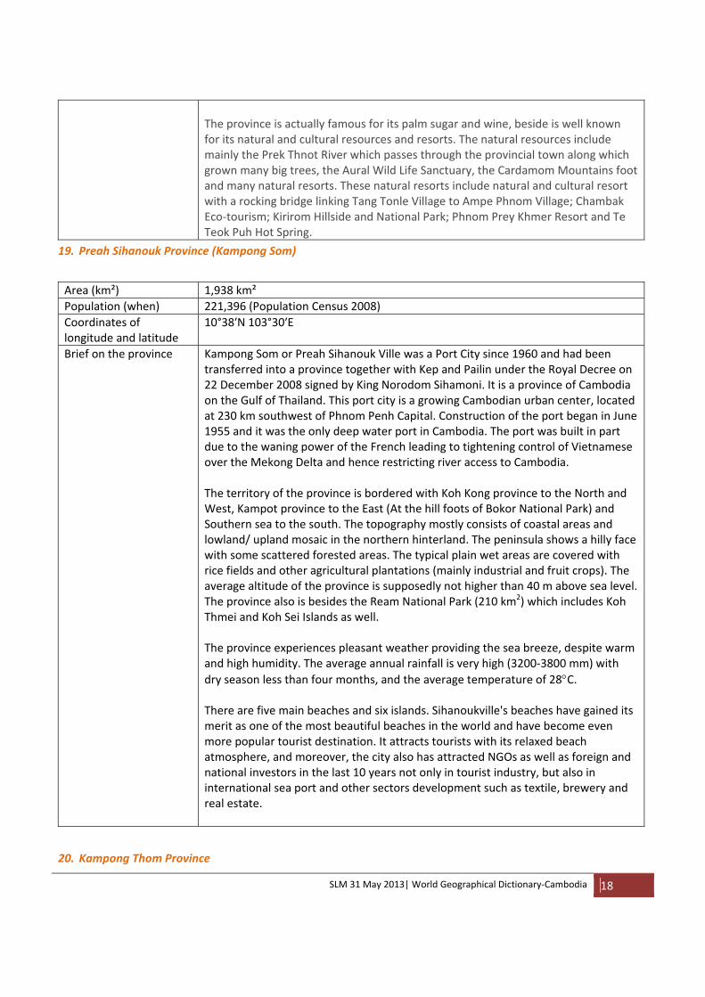
The province is actually famous for its palm sugar and wine, beside is well known for its natural and cultural resources and resorts. The natural resources include mainly the Prek Thnot River which passes through the provincial town along which grown many big trees, the Aural Wild Life Sanctuary, the Cardamom Mountains foot and many natural resorts. These natural resorts include natural and cultural resort with a rocking bridge linking Tang Tonle Village to Ampe Phnom Village; Chambak Eco‐tourism; Kirirom Hillside and National Park; Phnom Prey Khmer Resort and Te Teok Puh Hot Spring.
19. Preah Sihanouk Province (Kampong Som)
Area (km²) 1,938 km² Population (when) 221,396 (Population Census 2008) Coordinates of longitude and latitude
10°38′N 103°30′E
Brief on the province Kampong Som or Preah Sihanouk Ville was a Port City since 1960 and had been transferred into a province together with Kep and Pailin under the Royal Decree on 22 December 2008 signed by King Norodom Sihamoni. It is a province of Cambodia on the Gulf of Thailand. This port city is a growing Cambodian urban center, located at 230 km southwest of Phnom Penh Capital. Construction of the port began in June 1955 and it was the only deep water port in Cambodia. The port was built in part due to the waning power of the French leading to tightening control of Vietnamese over the Mekong Delta and hence restricting river access to Cambodia. The territory of the province is bordered with Koh Kong province to the North and West, Kampot province to the East (At the hill foots of Bokor National Park) and Southern sea to the south. The topography mostly consists of coastal areas and lowland/ upland mosaic in the northern hinterland. The peninsula shows a hilly face with some scattered forested areas. The typical plain wet areas are covered with rice fields and other agricultural plantations (mainly industrial and fruit crops). The average altitude of the province is supposedly not higher than 40 m above sea level. The province also is besides the Ream National Park (210 km2) which includes Koh Thmei and Koh Sei Islands as well. The province experiences pleasant weather providing the sea breeze, despite warm and high humidity. The average annual rainfall is very high (3200‐3800 mm) with dry season less than four months, and the average temperature of 28°C. There are five main beaches and six islands. Sihanoukville's beaches have gained its merit as one of the most beautiful beaches in the world and have become even more popular tourist destination. It attracts tourists with its relaxed beach atmosphere, and moreover, the city also has attracted NGOs as well as foreign and national investors in the last 10 years not only in tourist industry, but also in international sea port and other sectors development such as textile, brewery and real estate.
20. Kampong Thom Province

SLM 31 May 2013| World Geographical Dictionary‐Cambodia 19
Area (km²) 13,814 km² Population (when) 631,409 (Population Census 2008) Coordinates of longitude and latitude
12°42′16″N 104°53′31″E
Brief on the province Kampong Pous Thom (Port of the Great Snake) was the original name of the present Kampong Thom Province. The story around this name was that long time ago, at the dock of the Sen River next to a lake, there was a big cave inside which stayed a pair of big snakes. In that time, people who were living around that area usually saw them, and called this whole area as Kampong Pous Thom. Later on, the name was shortened to Kampong Thom only. During the French colony in Cambodia, the French ruled and divided Cambodian territory into provinces, and named them according to the spoken words of the local people. The province also hosts a number of significant Angkorian sites, including Prasat Sambor Prey Kuh and Prasat Andet temples.
Kampong Thom is Cambodia's second largest province by area. it borders Tonle Sap Lake and Kampong Chhnang Province to the West, Siem Reap Province to the Northwest, Preah Vihear Province to the North, Kampong Cham Province to the South and Kratie Province to the East. It is one of the five provinces within the Tonlé Sap Biosphere Reserve and is one of the nine provinces of the Tonle Sap Sub‐area (CNMC, 2012) for the Mekong River Basin Development Plan.
The topography of the province consists of part of the Tonle Sap floodplains in the Southwest, lowland rice fields, and lowland/ upland mosaic and upland forested areas in the Northeast. To better describe, the province can be divided into Eastern part and Western part of National Road 6. The eastern part covers 70% of the provincial area consisting of lowland rice fields, upland mosaic and forested areas (Evergreen forest) rich in water and related resources favorable for agriculture, forestry and animal husbandry; and including part of Boeng Per Wild life Sanctuary. The western part covers 30% of the total area consisting mainly of plain area which extends to the Great Lake. It is one of the best lowland and flood plain areas for rice cultivation and fishing at the subsistence as well as exportation scales. Also including in this part, the two Core Zones of the Tonle Sap Biosphere Reserve, Boeng Chhmar RAMSAR Site (14,560 hectares) and Stung Sen Protected Forest (6,355 hectares). Kampong Thom experiences warm and humid weather like the whole country, with average annual rainfall between 1400 and 2000 mm and dry season duration more than four months period.
21. Kampong Trabek District
Area (km²) 504 km² Population (when) 109,291 (Population Census 2008) Coordinates of longitude and latitude
11°09′N 105°28′E
Brief on the province Kampong Trabek, literally means “Port of Guava”, is one district of Prey Veng
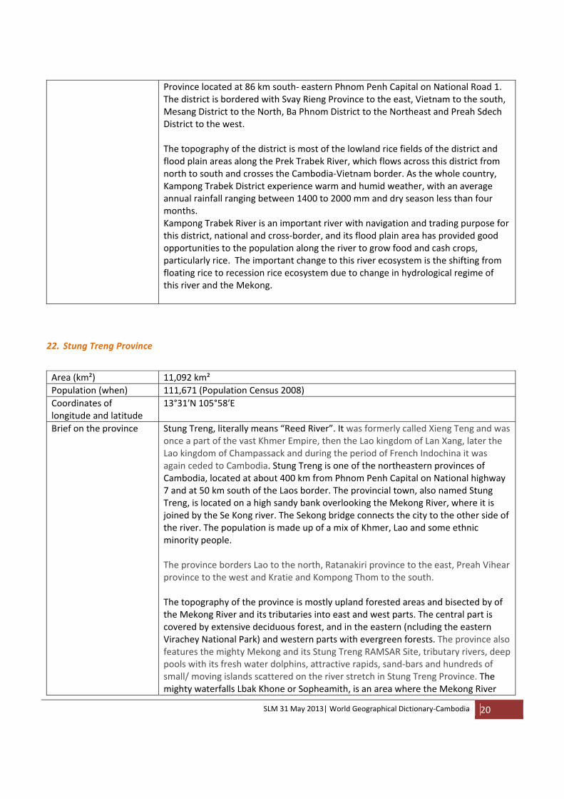
SLM 31 May 2013| World Geographical Dictionary‐Cambodia 20
Province located at 86 km south‐ eastern Phnom Penh Capital on National Road 1. The district is bordered with Svay Rieng Province to the east, Vietnam to the south, Mesang District to the North, Ba Phnom District to the Northeast and Preah Sdech District to the west. The topography of the district is most of the lowland rice fields of the district and flood plain areas along the Prek Trabek River, which flows across this district from north to south and crosses the Cambodia‐Vietnam border. As the whole country, Kampong Trabek District experience warm and humid weather, with an average annual rainfall ranging between 1400 to 2000 mm and dry season less than four months. Kampong Trabek River is an important river with navigation and trading purpose for this district, national and cross‐border, and its flood plain area has provided good opportunities to the population along the river to grow food and cash crops, particularly rice. The important change to this river ecosystem is the shifting from floating rice to recession rice ecosystem due to change in hydrological regime of this river and the Mekong.
22. Stung Treng Province Area (km²) 11,092 km² Population (when) 111,671 (Population Census 2008) Coordinates of longitude and latitude
13°31′N 105°58′E
Brief on the province Stung Treng, literally means “Reed River”. It was formerly called Xieng Teng and was once a part of the vast Khmer Empire, then the Lao kingdom of Lan Xang, later the Lao kingdom of Champassack and during the period of French Indochina it was again ceded to Cambodia. Stung Treng is one of the northeastern provinces of Cambodia, located at about 400 km from Phnom Penh Capital on National highway 7 and at 50 km south of the Laos border. The provincial town, also named Stung Treng, is located on a high sandy bank overlooking the Mekong River, where it is joined by the Se Kong river. The Sekong bridge connects the city to the other side of the river. The population is made up of a mix of Khmer, Lao and some ethnic minority people. The province borders Lao to the north, Ratanakiri province to the east, Preah Vihear province to the west and Kratie and Kompong Thom to the south. The topography of the province is mostly upland forested areas and bisected by of the Mekong River and its tributaries into east and west parts. The central part is covered by extensive deciduous forest, and in the eastern (ncluding the eastern Virachey National Park) and western parts with evergreen forests. The province also features the mighty Mekong and its Stung Treng RAMSAR Site, tributary rivers, deep pools with its fresh water dolphins, attractive rapids, sand‐bars and hundreds of small/ moving islands scattered on the river stretch in Stung Treng Province. The mighty waterfalls Lbak Khone or Sopheamith, is an area where the Mekong River
SLM 31 May 2013| World Geographical Dictionary‐Cambodia 21
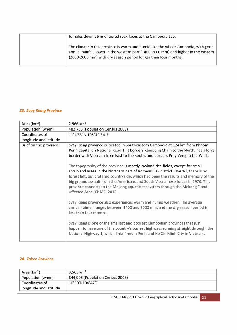
tumbles down 26 m of tiered rock‐faces at the Cambodia‐Lao. The climate in this province is warm and humid like the whole Cambodia, with good annual rainfall, lower in the western part (1400‐2000 mm) and higher in the eastern (2000‐2600 mm) with dry season period longer than four months.
23. Svay Rieng Province Area (km²) 2,966 km² Population (when) 482,788 (Population Census 2008) Coordinates of longitude and latitude
11°4′33″N 105°49′34″E
Brief on the province Svay Rieng province is located in Southeastern Cambodia at 124 km from Phnom Penh Capital on National Road 1. It borders Kampong Cham to the North, has a long border with Vietnam from East to the South, and borders Prey Veng to the West. The topography of the province is mostly lowland rice fields, except for small shrubland areas in the Northern part of Romeas Hek district. Overall, there is no forest left, but cratered countryside, which had been the results and memory of the big ground assault from the Americans and South Vietnamese forces in 1970. This province connects to the Mekong aquatic ecosystem through the Mekong Flood Affected Area (CNMC, 2012). Svay Rieng province also experiences warm and humid weather. The average annual rainfall ranges between 1400 and 2000 mm, and the dry season period is less than four months. Svay Rieng is one of the smallest and poorest Cambodian provinces that just happen to have one of the country's busiest highways running straight through, the National Highway 1, which links Phnom Penh and Ho Chi Minh City in Vietnam.
24. Takeo Province Area (km²) 3,563 km² Population (when) 844,906 (Population Census 2008) Coordinates of longitude and latitude
10°59′N104°47′E
SLM 31 May 2013| World Geographical Dictionary‐Cambodia 22
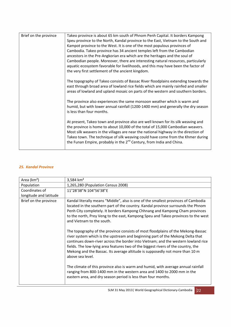
Brief on the province Takeo province is about 65 km south of Phnom Penh Capital. It borders Kampong Speu province to the North, Kandal province to the East, Vietnam to the South and Kampot province to the West. It is one of the most populous provinces of Cambodia. Takeo province has 34 ancient temples left from the Cambodian ancestors in the Pre‐Angkorian era which are the heritages and the soul of Cambodian people. Moreover, there are interesting natural resources, particularly aquatic ecosystem favorable for livelihoods, and this may have been the factor of the very first settlement of the ancient kingdom. The topography of Takeo consists of Bassac River floodplains extending towards the east through broad area of lowland rice fields which are mainly rainfed and smaller areas of lowland and upland mosaic on parts of the western and southern borders. The province also experiences the same monsoon weather which is warm and humid, but with lower annual rainfall (1200‐1400 mm) and generally the dry season is less than four months. At present, Takeo town and province also are well known for its silk weaving and the province is home to about 10,000 of the total of 15,000 Cambodian weavers. Most silk weavers in the villages are near the national highway in the direction of Takeo town. The technique of silk weaving could have come from the Khmer during the Funan Empire, probably in the 2nd Century, from India and China.
25. Kandal Province Area (km²) 3,584 km² Population 1,265,280 (Population Census 2008) Coordinates of longitude and latitude
11°28′38″N 104°56′38″E
Brief on the province Kandal literally means “Middle”, also is one of the smallest provinces of Cambodia located in the southern part of the country. Kandal province surrounds the Phnom Penh City completely. It borders Kampong Chhnang and Kampong Cham provinces to the north, Prey Veng to the east, Kampong Speu and Takeo provinces to the west and Vietnam to the south. The topography of the province consists of most floodplains of the Mekong‐Bassac river system which is the upstream and beginning part of the Mekong Delta that continues down‐river across the border into Vietnam; and the western lowland rice fields. The low‐lying area features two of the biggest rivers of the country, the Mekong and the Bassac. Its average altitude is supposedly not more than 10 m above sea level. The climate of this province also is warm and humid, with average annual rainfall ranging from 800‐1400 mm in the western area and 1400 to 2000 mm in the eastern area, and dry season period is less than four months.

SLM 31 May 2013| World Geographical Dictionary‐Cambodia 23
Kandal province is well known for its ancient history of the former capital of the Kingdom “Oudong “ which functioned under several sovereigns between 1618 and 1866 and was where a number of kings, including King Norodom, were crowned. It also is popular by trading, silk weaving and tourist attractions.
26. Kampot Province
Area (km²) 4,873 km² Population (when) 585,850 (Population Census 2008) Coordinates of longitude and latitude
10°36′N 104°10′E
Brief on the province Kampot is located in the Southwest of the country, having an eighty kilometres coastal strip with the Gulf of Thailand. It borders the provinces of Koh Kong and Kampong Speu to the north, Takeo to the east, Preah Sihanouk to the west and Kep as well as a long coastline on the Gulf of Thailand to the south. The topography of the province consists of coastal region on the southern border, eastern lowland rice fields and the western lowland and upland mosaic and upland forested areas (Evergreen forest, deciduous forest and shrublands) including Bokor National Park which is part of the Elephant Mountains range, rich in lush forests and a huge range of wildlife. The two highest points in this province are the Bokor Hill Station with 1,027m altitude and further north another hilltop with 1,050m altitude. The province also has a tropical climate ‐ warm and humid. The annual rainfall ranges between 800 to over 3,800 mm in the coastal area and the dry season is less than four months. Kampot is very well known by its coastal natural resources (beaches, islands, sea products), Bokor Hill Station, famous pepper plantations and other tourist attractions such as pre‐Angkorian ruins and caves, jungle trekking, bicycling tours, river cruises, island trips, fishing trips, isolated beaches, and some beautiful rural countryside.
27. Kampong Luong Commune
Area (km²) 14 km² Population (when) 5,828 (Population Census 2008)Coordinates of longitude and latitude
12°34′24″N104°12′30″E
History Kompong Luong literally means “Port of the King”, was used by the ancient Kings as a port for sailing, a secret stop on his way to war and as a rest and relaxation place where he could swim and recuperate without fear of ambush. Life as a small fishing village of Kampong Luong began since the ancient times. Today, it is a large floating commune comprised of five floating villages on the Tonlé

SLM 31 May 2013| World Geographical Dictionary‐Cambodia 24
Sap Lake in the northern part of Krakor District which is about 35 kilometers east of Pursat provincial town, and its distance from Krakor and national road 5 can vary from 2 to 7 km according to seasonal expansion and shrink of the lake. The average depth of the area is 0.8‐1 m during the dry season and 8‐10 m during the rainy season. Kampong Luong Port is one of the four important fish landings around the Great Lake. The site is a sand cape suitable for swimming during the dry season. The commune also has a monsoon warm and humid climate with an average annual rainfall ranging between 1400 to 2000 mm and more than four months dry season. Kampong Luong floating commune is almost entirely self‐sustaining and people almost never need to leave the water since it is a sophisticated and bustling township which can provide everything that a town on dry land can provide to its population. The majority of inhabitants here are Vietnamese ethnics and the small proportion of Khmers and Cham who are fisher‐folks, boat builders and businessmen. This floating commune has become a well‐known tourist site.
CATEGORY D
28. Koh Kong Province Area (km²) 10,090 km² Population (when) 117,481 (Population Census 2008) Coordinates of longitude and latitude
11°23′57″N 103°29′41″E
Brief on the province Koh Kong is the southwestern‐most province of Cambodia. It has a long undeveloped coastline and a mountainous, forested and largely inaccessible interior which embraces part of the Cardamom Mountains and a section of Kirirom National Park. The province consists of 8 districts, 33 communes and 133 villages. The tourist attractions of this province include eco‐tourism, waterfalls, agro‐tourism and casino. The topography of Koh Kong province consists mainly of huge mountain range, the Cardamom Mountains, covered by the extensive lush deep rainforest which is the biggest successional forested region in the whole Southeast Asia; the south and western coastal region including mangroves (Peam Krasaob National Park); and the smaller part of lowland rice areas and areas of lowland/ upland mosaic in between the coast and the mountains. The climate of Koh Kong province is influenced by the typical topographical condition described above. There is abundant rainfall in this area with average annual rainfall ranging from 2600 to 3200 mm in the southeast part and 3200‐3800 mm in the northern and western parts, and the dry season period is less than four months.
SLM 31 May 2013| World Geographical Dictionary‐Cambodia 25
The towns have developed partially, particularly since the ever longest bridge across the sea was built and all road (National Route 48) and bridges network are opened connecting provincial town of Koh Kong to Koh Kong Resorts and other important coastal economic zones and the international check point. Rapid development in this province in the last 10 years and high influx of people into this province has put great pressure on the mangrove and other natural resources in the province.
29. Aoral District Area (km²) 2,380 km² Population (when) 29,883 (Population Census 2008) Coordinates of longitude and latitude
11°41′N 104°7′E
Brief on the district Aoral is one of the 8 districts of Kampong Speu Province located at about 60 kilometers west of the provincial town. It borders Phnom Kravanh District to the north, Teok Phos and Thpong Districts to the west, Phnom Sruoch District to the south, and Pralay Commune, Tma Bang District of Koh Kong province to the east.. The topography of this district consists of much Aural mountain of 1,813 meters (the highest peak in Cambodia) and part of its wildlife Sanctuary (2,536km²) in the north and very small lowland rice area in the southern part. Aoral is a very remote district, poor and lacked of all types of infrastructures from the social, physical basic services to economic development. Access to villages within the district is difficult because they are connected by poor dirt roads and bridges. Most inhabitants’ dwelling generally is a small hut or shack. Health‐posts and schools are ill equipped to meet the needs of the minority communities living in this district. Most villagers are subsistent farmers, their living standard mainly depends on rainfed agriculture and natural resources; and their literacy level is one of the lowest in Cambodia.
30. Krong Senmonorom
Area (km²) 541 km² Population (when) 12,340 (Population Census 2008) Coordinates of longitude and latitude
12°26′11″N 107°12′16″E
Brief on the district Senmonorom, literally means “Very Pleasant”. Indeed, it is the only major and very beautiful town of Mondulkiri Province, with a total population of over 12,000, most of them are indigenous Pnong tribesmen and tribes women except at the town center where most residents come from other parts of Cambodia. It is the most remote town, but popular with NGO workers, loggers, and tourists both from overseas and local Cambodian.

SLM 31 May 2013| World Geographical Dictionary‐Cambodia 26
The topography of the town consists of highland area of altitude between 300 to over 900 m above sea level, which covered by evergreen and deciduous forests with high soil productivity. Prek Chbar and Prek Te rivers flow south‐north and east‐west respectively across this city. Sen Monorom also experiences warm and humid climate, but cooler than the lowland areas as the temperature can low down to less than 16°C, the average annual rainfall in this area is between 2000‐2600 mm and dry season period is shorter than four months. The landscape and weather of Sen Monorom between November and January is comparable to Newzearland, where the ground is filled with green grass and wild flowers and the temperature is minimum and cool north breeze. Sen Monorom is well known by the deep pure jungle with diverse variety of flora and fauna and very attractive by the hill tribes and their culture, the majestic natural mountainous forest and the forest seas’ wave, and many beautiful waterfalls around and nearby the city. Therefore, there is high potential for development investment in this area.
31. Thalaborivath District Area (km²) 2,606 km² Population (when) 30,439 (Population Census 2008) Coordinates of longitude and latitude
13°40′2″N 105°51″51″E
Brief on the district Thalaborivath is one of the five districts in Stung Treng Province, which was established since 1905. It is located just 4 km from the provincial town with a population over 30,000. It is accessible by going across the Se Kong river and Mekong river to the provincial road to Preah Vihear. It borders Siembok District to the south, Mekong River and Stung Treng Town to the east, Chhaeb District (Preah Vihear province) and Lao border to the north and Chhaeb and Chey Sen Districts (Preah Vihear province) to the west. This district is home to the historical temple, Preah Ko which was built in 6th‐7th Century by the King Jayavarman I. The topography of Thalaborivath consists of much upland with evergreen forest in the northern and western areas and lowland and upland mosaic covered by deciduous forest and agricultural plantations. The Mekong River and its aquatic ecosystem, particularly the RAMSAR Site, deep pools and fisheries resources are important features of this district.

SLM 31 May 2013| World Geographical Dictionary‐Cambodia 27
The climate of this area also is monsoon warm and humid, with an average annual temperature between 1400 and 2600 mm with more than four months dry season period.
32. Se Kong River Origin Bolovens Plateau, Annamite Mountain Range Catchment area (km²) 32,200 km² (Whole), 5,390 km² (in Cambodia) Length (km) 344 km in Laos and 155 km in Cambodia Coordinates of longitude and latitude
15.97°N107.43°E‐13.53°N105.94°E
Brief on the river and its basin
Sekong River is one of the largest Mekong tributaries and a transboundary river between Cambodia and Lao PDR. This river rises in the Annamite mountain range at an elevation between 1,000‐1,500 meters, and drains also the eastern part of the Bolovens Plateau east of Pakse. The Sekong River travels for 344 km in Laos and some 155 km in Cambodia, before meeting the Sesan near Stung Treng Provincial Town, and finally discharges into the Mekong River where the three rivers Se Kong‐Se San‐Sre Pok are confluent. Due to hydropower dam development on the upstream river, the water flow is already a modified flow. The annual flow of the Sekong is over 30 Million Cubic Meters. High flows in this river tend to start later in the year than other tributaries and maintain flows into the dry season. Risk of flooding is high in this river basin, especially in late wet season when combined with extreme climate event, e.g. Typhoon Ketsana. The aquatic ecosystem of this river basin is dominated by rivers and streams (79%). Based on the villagers’ assessment, the Se Kong River section in Cambodia hosts 25 deep pools (CEPA, 2008) which are valuable habitats and refuge of diverse fresh water fishes (214 species), reptiles, birds and aquatic plants. A number of endangered fish species such as Trey Trasak, Trey Reaj, trey Kulreang and particularly the famous Trey Pasaii are found in this river. The average annual rainfall in this river basin ranges between 2000 mm and 2600 mm, and the length of dry season is more than four months.
33. Se San River Origin Vietnam Central Highland, Annamite Mountain Range Catchment area (km²) 17,300 km² (whole), 7,960 km² (Cambodia)Length (km) 478 km (total), 278 km (Cambodia) Coordinates of longitude and latitude
14.95°N108.16°E‐13.55°N106.02°E
Brief on the river and its Sesan River is one of the largest Mekong tributaries and is transboundary between
SLM 31 May 2013| World Geographical Dictionary‐Cambodia 28
basin Cambodia and Vietnam. The Sesan river basin in Cambodia measures 7,960 km², is part of the whole 17,300 km2 basin area. This river rises in the Annamite mountain range (Vietnam Central Highland) at an elevation between 1,000‐1,500 meters and flows for over 200 km before entering Cambodia. In Cambodia, this river flows for 278 km more before discharging into the Sekong River at Stung Treng. Due to hydropower development in the upstream river, the flow in Cambodia’s part has been modified and overall, flow of this river has been less predictable in recent years. The annual flow of the Sesan is nearly 20 Million Cubic Meters. The same to Sekong River, high flows in this river tend to start later in the year and flows are maintained into the dry season. Risk of flooding is high, especially in late wet season. The aquatic ecosystem of this river basin is dominated by rivers and streams (66%). Assessment by the communities in this region (CEPA, 2008) revealed that there were 69 deep pools along the Sesan River section in Cambodia where inhabit different aquatic species (133 fish species, bird and plant), but the depths of most deep pools (68) had been reduced due to flow modification, bank erosion and sedimentation. Like the Sekong River Basin, the average annual rainfall in this river basin ranges between 2000 mm and 2600 mm, and the length of dry season is more than four months.
34. Sre Pok River Origin Central Vietnam, Annamite Mountain Range Catchment area (km²) 29,800 km² (whole), 13,171 km² (Cambodia) Length (km) 450 km (total), 250 km (in Cambodia)Coordinates of longitude and latitude
12.23°N108.24°E‐13.54°N106.26°E
Brief on the river and its basin
Sre Pok River is one of the largest Mekong tributaries and is transboundary between Cambodia and Vietnam. The Sre Pok river basin in Cambodia measures 13,171 km², is part of the whole 29,800 km2 basin area. This river rises in the Annamite mountain range (Vietnam Central Highland) at an elevation between 1,000‐1,500 meters, it flows 250 km within Cambodia territory and joins the Sesan 30 km upstream of the confluence of the Sesan with the Sekong. Due to hydropower development in the upstream river, the flow in Cambodia’s part has been modified. The annual flow of the Sekong is over 30 Million Cubic Meters. High
SLM 31 May 2013| World Geographical Dictionary‐Cambodia 29
flows in this river tend to start later in the year and maintain flows into the dry season; this is important for maintaining high Mekong flows late in wet season. Risk of flooding is high, especially in late wet season. The same to Sesan and Sekong Rivers, rivers and streams dominate the aquatic ecosystem of Sre Pok Rivear Basin. Assessment by the communities in this region (CEPA, 2008) revealed that a total of 11 deep pools with specific fish (204), bird and plants species were found along the Sre Pok River section in Cambodia; depth of those deep pools also are reduced. Like the Sekong and Sesan river basins, the average annual rainfall in this river basin ranges between 2000 mm and 2600 mm with dry season longer than four months.
35. Stung Sen River Origin Dangrek Mountain RangesCatchment area (km²) 16,465 km² Length (km) 520 km Coordinates of longitude and latitude
14°25′26″N104°41′60″E‐12°34′23″N104°28′38″E
Brief on the river and its basin
Stung Sen river is originated from the highest elevation of approximately 790 m above sea level in the upper western part of the basin at the Dangrek Mountain Ranges with a drainage area of about 16,465 km². It is 520 km long, the longest tributary of the Tonle Sap Great Lake. The river flows in the South and Southeastern direction for about half of its length before turning towards the south and south‐south‐western direction by crossing through Preah Vihear and Kampong Thom provinces and drains into the Lake at the location opposite to Chhnok Trou. The part of the basin below the district town of Sandan is subject to frequent flooding. This river basin presents high potential for development. The agricultural ecosystem is mainly rainfed, with area inside the ring road flooded from 1 to 8 m deep during the wet season period for 1 to 6 months. Protected Forest, one of the Core Zones of the Tonle Sap Biosphere is an important protected area of the basin and need for environmental integration is high for this Core Zone.
36. Stung Prek Thnot River Origin Cardamom mountains range Catchment area (km²) 6,243 km2 Length (km) 226 km Coordinates of longitude and latitude
11.47°N103°E‐12.25°N104.95°E
Brief on the river and its basin
The river originates in the Cardamom mountains at an elevation about 1,700 m, which are located in southwest part of the country. It flows west‐east direction with total length about 226 km. While flowing about two third of its total length, the Prek Tnot river crosses the Kampong Speu town and travels for another one third before discharging into the Bassac river at Takmao Town which is located about 9 km downstream of Chaktomuk.
SLM 31 May 2013| World Geographical Dictionary‐Cambodia 30
The flow of Prek Thnot River is contributed by six main tributaries. This flow regime is under the influence of Cardamom mountain ranges that are characterized by irregular rainfalls, extreme droughts, and flash floods. Generally, some parts of the river are dry during the dry season, thus there is water shortage.
37. Prek Chhlong River Origin Mountainous area nearby border between Cambodia and Vietnam Central HighlandCatchment area (km²) 5,609 km² Length (km) 301 km Coordinates of longitude and latitude
12°18′8″N107°10′37″E‐12°16′51″N105°50′52″E
Brief on the river and its basin
The river originates from the mountainous areas nearby the border between Cambodia and Vietnam Central Highland at an elevation over 1,700 m, flows from East to West with a length about 300 km by crossing through Mondulkiri, Kratie and Kampong Cham provinces and discharges into the Mekong on the left bank at Chhlong. Development is still limited as the remote upper part joint the national economic development recently. Rainfed food crops and industrial crops are mainly cultivated. Industrial development has not been significant, while Ecotourism is being developed.
38. Prek Te River Origin Mondulkiri plateauCatchment area (km²) 4,346 km² Length (km) 226 km Coordinates of longitude and latitude
12°30′42″N107°8′19″E‐12°26′30″N106°1′45″E
Brief on the river Prek Te River originates at the Mondulkiri plateau which sits on altitude about 740
SLM 31 May 2013| World Geographical Dictionary‐Cambodia 31
m (over 900 m in the upstream part) and drains a catchment of 4,346 km2. It flows east‐west by crossing Mondulkiri and Kratie provinces and drains at Kratie. Areas close to the Mekong River are prone to flood which makes the lower part of all catchment interconnected during the wet season. The important characteristics to be noted here are the high altitude watershed and significant land use changes in the last 10 years. At present, water sector development is still limited as development actions have been recently.
39. Tumpor Mountain
Height (m) 1,563 m Coordinates of longitude and latitude
12.49°N103.05°E
Brief on the mountain Tumpor mountain is the northwestern part of Cardamom Mountains range and is the third highest peak in Cambodia after mount Aural and Samkos. It is situated in the western part of Pursat province. This area is composed of a complex series of forests, granitic foothills, which have never been explored, largely because they are surrounded by mine fields. Soil productivity is low and have poor retaining capacity of water and minerals. No settlements were reported in this remote area. At present, it is only accessible by elephants for those who love adventure. So far the area has been visited by those Biologists, Conservation Specialists and Environmental experts who conducted biological surveys. They still have a lot more studies to be conducted in this area. Although Tumpor is forested area, the average annual rainfall is low (800‐1400 mm) and dry season is more than four months.
List of references
About.com guide to Angkor Civilization.
SLM 31 May 2013| World Geographical Dictionary‐Cambodia 32
Ashwell, D. A. (1997). Cambodia: a national biodiversity prospectus. Report to the United Nations Development
Programme.
Bishop, Paul; Penny, Dan; Stark, Miriam and Scott, Marian (2003). A 3.5 ka Record of Paleoenvironments and
Human Occupation at Angkor Borei, Mekong Delta, Southern Cambodia. Geoarcheology: An International
Journal, 18(3): 359‐393. Wiley Periodicals, Inc.
Buckley BM, Anchukaitis KJ, Penny D, Fletcher R, Cook ER, Sano M, Nam LC, Wichienkeeo A, Minh TT, and Hong
TM (2010). Climate as a contributing factor in the demise of Angkor, Cambodia. Proceedings of the
National Academy of Sciences 107(15):6748‐6752.
CEPA (2008). Pools and river resources of Sesan, Sekong and Sre Pok Rivers, Stung Treng province. Culture and
Environment Preservation Association, Phnom Penh.
CNMC (2012). Profile of the Cambodia Mekong Delta Sub‐area (SA‐10C). Cambodia National Mekong Committee,
Ministry of Water Resources and Meteorology, Phnom Penh.
CNMC (2012). Profile of the Cambodia Tonle Sap Sub‐area (SA‐9C). Cambodia National Mekong Committee,
Ministry of Water Resources and Meteorology, Phnom Penh.
CNMC (2012). Profile of the Cambodia Kratie Sub‐area (SA‐8C). Cambodia National Mekong Committee, Ministry
of Water Resources and Meteorology, Phnom Penh.
CNMC (2012). Profile of the Cambodia Sekong‐Sesan‐Sre Pok Sub‐area (SA‐7C). Cambodia National Mekong
Committee, Ministry of Water Resources and Meteorology, Phnom Penh.
CNMC (2012). Profile of the Cambodia Stung Treng Sub‐area (SA‐6C). Cambodia National Mekong Committee,
Ministry of Water Resources and Meteorology, Phnom Penh.
Dictionary of Archaeology.
Evans D, Pottier C, Fletcher R, Hensley S, Tapley I, Milne A, and Barbetti M. 2007. A new archaeological map of the
world’s largest preindustrial settlement complex at Angkor, Cambodia. Proceedings of the National
Academy of Sciences 104(36):14277‐14282.
Forest Administration, DANIDA and German Development Service (2003). Gene‐Ecological Zonation of Cambodia.
Cambodia Tree Seed Project, Institutional Capacity Building of the Tree Seed Sector. Forest Administration,
Phnom Penh.
FFI and MoE (2000). Biological survey of the Cardamom Mountains, Southwestern Cambodia – Interim Report.
Fauna and Flora International in collaboration with the Government of Cambodia, Ministry of
Environment and Wildlife Protection Office.
Grismer L. Lee, Thy Neang, Thou Chav, Perry L. Wood, Jr, Jamie R. Oaks, Jeremy Holden, Jesse L. Grismer, Thomas
R. Szutz, Timothy M. Youmans (2008). Additional amphibians and reptiles from the Phnom Samkos
Wildlife Sanctuary in northwester Cardamom Mountains, Cambodia, with comments on the taxonomy

SLM 31 May 2013| World Geographical Dictionary‐Cambodia 33
and the discovery of three new species. The Raffles Bulletin of Zoology February 2008 56(1): 161–175.
National University of Singapore.
Hosono T, Uchida E, Suda C, Ueno A, and Nakagawa T (2006). Salt weathering of sandstone at the Angkor
monuments, Cambodia: identification of the origins of salts using sulfur and strontium isotopes. Journal of
Archaeological Science 33(11):1541‐1551.
Kummu M. (2009). Water management in Angkor: Human impacts on hydrology and sediment transportation.
Journal of Environmental Management 90(3):1413-1421.
Kummu M., Savuth Y., Sarkkula J., Koponen J., Adamson P. and Tes S. (2006). Hydrological, Environmental and
Socio‐Economic Modeling Tools for the Lower Mekong Basin Impact Assessment: Tonle Sap Lake water
balance calculations, Technical Paper No.5. WUP‐FIN Phase II, Mekong River Commission, Phnom Penh.
Momberg, F., and H. Weiler (1999). Conservation status of the Cardamom Mountains in Southwestern Cambodia:
preliminary studies. Fauna & Flora International: Indochina Programme, Hanoi.
MoP (2009). General Population Census of Cambodia 2008 – National Report on Final Census Results. National
Institute of Statistics, Ministry of Planning, Phnom Penh.
MoP (2011). Statistical Yearbook of Cambodia 2011. National Institute of Statistics, Ministry of Planning, Phnom
Penh.
Ray, Nick; Robinson, Daniel (2008). Cambodia (6th ed.). Lonely Planet. pp. 239–240.
Uchida E, Ogawa Y, Maeda N, and Nakagawa T (2000). Deterioration of stone materials in the Angkor monuments,
Cambodia. Engineering Geology 55(1‐2):101‐112.