Embed Size (px)
Citation preview
Calypso Science Plan Amala Mahadevan, Eric D’Asaro, Dan Rudnick for the CALYPSO team
January 6, 2019
Introduction Calypso addresses the challenge of observing, understanding and predicting the three-dimensional pathways by which water from the surface ocean makes its way into the deeper ocean (Figure 1). Discovering the routes by which physical and biogeochemical tracers are transported vertically, as they are also carried horizontally by oceanic currents, is the goal of this research. An innovative set of observational techniques are being used, along with process study models, predictive models, and data synthesis, to identify coherent pathways for vertical transport and to diagnose and predict the physical processes that underlie such subduction. Objectives The ocean is essentially in geostrophic balance at scales larger than the mesoscale. At smaller scales, roughly 10 km and shorter, this balance breaks down, and ageostrophic flows may include a strong vertical component. These scales where geostrophic balance is broken have come to be known as the submesoscale, and their study has intensified over recent years. As with many active fields, questions have arisen at almost the same rate as previously unknown phenomena are described. The strong theoretical and modelling evidence for the existence of unbalanced vertical pathways has not been effectively accompanied by direct observation of those pathways. Thus, two overarching objectives drive Calypso science:
1. Diagnose the three dimensional pathways using physical and biogeochemical tracers, and dynamics from QG to primitive equation.
2. Compare these with direct Lagrangian measures of the pathways
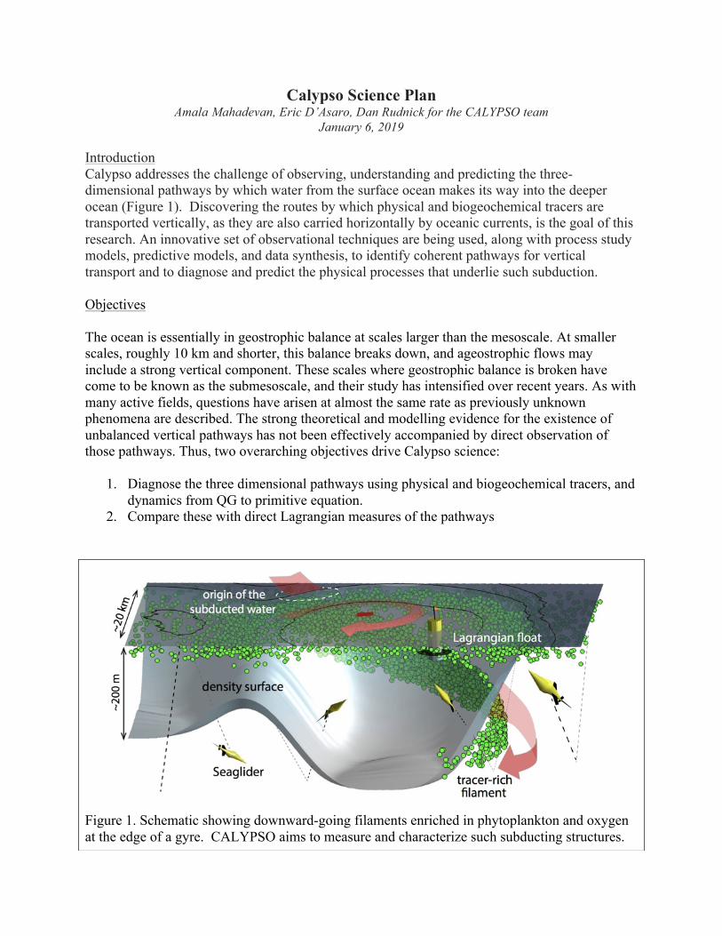
Figure 1. Schematic showing downward-going filaments enriched in phytoplankton and oxygen at the edge of a gyre. CALYPSO aims to measure and characterize such subducting structures.

More specifically, CALYPSO expects to address these, and other questions: • What is the dynamical mechanisms by which water parcels are irreversibly subducted?
What is the character of three-dimensional fluid transport structures? What are the length and time scales, and coherence of the subducted features? Where do the subducted parcels end up?
• How does the predictability of particle trajectories vary in space and time? How does the presence of submesoscale features affect Lagrangian predictability based on models that only resolve larger scales? How can the 3D Lagrangian transport structures and trajectories be related to surface features that can be discerned from altimetry and general circulation models?
• How does knowledge of trajectories in 3D help us to better grasp and parameterize scalar transport and mixing processes where strong vertical motion exists?
Figure 2. The CALYPSO operations area in the western Mediterranean. Atlantic water flowing out of the Strait of Gibraltar forms a set of gyres with strong density fronts on their cyclonic side. These fronts are likely sites for downward transport of surface water and thus the focus of CALYPSO. Experimental components include an array of gliders spanning the Almeria-Oran front for 2-3 months and focused ship surveys deploying large arrays of surface drifters that guide biological tracer measurements and Lagrangian float deployments. The figure shows output from a 1.5 km resolution real time regional operational model developed at SOCIB / IMEDEA, CALYPSO’s Spanish collaborators. Similar model output and satellite data will guide the deployments. Ship and glider operations will be coordinated and co-located as is possible.

Approach Our approach includes a comprehensive set of observations and models focussed on the Alboran Sea in the western Mediterranean (Figure 2). Here, fresher water from the Atlantic ocean flowing out of the Strait of Gibraltar into the saltier Mediterranean, forms a set of mesoscale meanders that fill the Alboran Sea. The combination of relatively small spatial scales, powerful currents and strong density contrast produce a nonlinear setting ideal for studying the interaction of mesoscale and submesoscale motions and the resulting vertical exchanges. These vertical motions are suggested by omega equation diagnoses in this region by previous investigators, including our Spanish collaborators. This work is cooperative with scientists at SOCIB (the Balearic Islands Coastal Observing and Forecasting System) and IMEDEA (Mediterranean Institute for Advanced Studies). This group brings detailed regional knowledge, a ship, gliders and an operational realtime forecasting system (e.g. Figure 2). Our overall strategy is guided by theoretical and modeling work over the last few decades. These predict that downward transport from the surface will occur on the dense side of km-scale density fronts with strong cyclonic vorticity, embedded within a larger-scale straining field. Thus in Figure 2, regions of surface convergence (blue) feeding this downward transport are found in in a thin filament on the dense and cyclonic side of the meandering velocity jet. In this model, the intensity and width of this region are set by the numerical resolution; understanding its true structure and the Lagrangian pathways emanating from it are major goals of the proposed work. To meet these goals, we will measure the structure of the mesoscale flow and the smaller scale fronts within them, emphasizing measurements of the surface density gradient, vorticity, strain and convergence, with sufficient spatial and temporal resolution to allow meaningful comparisons with theory and models. Direct and indirect measurements of vertical exchange and Lagrangian pathways will be guided by and embedded within these comprehensive Eulerian measurements. Measurements [PIs for each component- see https://calypsodri.whoi.edu/projects/ for details ] The measurement program to implement this strategy will have two major components. First, an array of ONR and SOCIB gliders will repeatedly cross the Almeria-Oran front for several months, measuring density, velocity, and chlorophyll [Rudnick, Tintore, Ruiz]. On the mesoscale, the array will measure the three-dimensional, time-evolving mesoscale structure so that the mesoscale vertical circulation can be diagnosed by omega equation and similar methods. On the submesoscale, it will resolve the associated frontal convergence and vorticity and the chlorophyll signatures of the secondary circulation. In addition, some gliders will be programmed to be neutrally buoyant, thereby becoming Lagrangian tracers and directly measuring Lagrangian trajectories within the Eulerian fields measured by the other gliders. A second, ship-based component will make intensive, adaptive measurement using a variety of tools for 2-3 weeks. Satellite altimetry [Pascual, Ruiz] and realtime model output [Tintore] (e.g. Figure 2) will define the overall circulation and suggest promising regions for more detailed study. Large (20-100) arrays of surface drifters [Centurioni, Ozgokmen, Poulain, Pratt, Rypina] will be deployed across a target region to measure the surface currents, strain, vorticity and convergence at several depths across the front. Smaller arrays of profiling floats will be embedded within the drifter array [Johnston]. Two ships will survey through this evolving and

translating array measuring velocity, temperature, salinity, chlorophyll, optical backscatter and oxygen [Mahadevan, Farrar, Johnston] in the upper 200m to complement the drifter measurements, extend them into the interior and identify downwelling water parcels from their optical and oxygen signatures, as well as rates of mixing [Griffa]. Water samples will be taken at multiple depths along- and across-front to define similar biogeochemical and genomic tracers of the circulation and subduction [Mahadevan, Allen]. Extremely detailed sections along these tracks will be made from a towed chain with temperature /salinity sensors and an ADCP [Farrar, Musgrave]. Lagrangian floats will be deployed into convergence regions defined by these measurements to trace the three-dimensional trajectories originating at the fronts [D’Asaro] with detailed REMUS surveys near the float [Shcherbina]. Finally, a small moored component will measure the inflow conditions into the region [Send]. Modelling and Analysis CALYPSO will investigate horizontal scales from the 300 km width of the Alboran Sea, to the 100m width of a density front, to the 1m outer scales of turbulence maintaining that width. A hierarchy of numerical models will be used to span such a wide range. On the basin scale, research models similar to those in Figure 1, but with sub-kilometer resolution [McWilliams, Lermusiaux, Pratt, Rypina] will simulate submesoscale instabilities and eddies not resolved in the operational model. These are expected to occur both at the strong fronts and near topography where bottom friction can greatly modify the flow. Higher resolution of the submesoscale structures will be achieved in idealized models of frontal instability and subduction [Mahadevan, Musgrave]. Large-Eddy simulations of submesoscale fronts [Sarkar, Sullivan/McWilliams] will investigate their interaction with boundary layer turbulence, which has been hypothesized to play a critical role in frontal secondary circulations. These simulation results will be used to help identify targets for the field measurements. In particular, Lagrangian analysis methods including clustering analysis and FTLE structure [Allshouse, Musgrave, Huntley, Peacock] will be used to study how surface structures, which will be well-sampled by the dense drifter arrays, can be used to predict the locations of downwelling and thereby identify coherent Lagrangian pathways from the surface into the interior. These same methods, along with more traditional tools, will be used to test whether the paths measured by the observations, both indirectly by biological and physical tracers, and directly by Lagrangian floats and gliders are well simulated by the models. Progress – 2018 Pilot observations A 1-week CALYPSO pilot program using the NRV Alliance and R/V SOCIB was conducted during May-June 2018. These measurements, along with modeling studies have revealed the following:
• Strong fronts between Atlantic and Mediterranean water masses were measured. The Almeria-Oran front was the strongest front measured during the pilot study, but similar fronts exist on the flanks of the western Gyre (Fig. 2).
• Our techniques sucessfully surveyed the mesoscale structure and measured strong submesoscale surface convergence, vorticity and subduction from both the surface and from depth. Subduction velocities up to 1 cm/s were measured, consistent with previous estimates of such strong velocities. Simulations and data suggested, however, that many of these velocities are transient, bringing water back to the surface rapidly.

• In the May-June period, a strong surface thermal cap traps outcropping isopycnals to the surface and thus limits surface subduction to 10-15m depth; the strongest subduction was found from ~50 to 150m, along the sloping isopycnals of the front.
• Although surface drifter arrays can measure the mesoscale and submesoscale structure of fronts well, the strong currents can rapidly advect them out of regions of interest.
• Access to the Algerian EEZ, denied in 2018, is critical to deploying Lagrangian assets in the Almeria-Oran front.
• The limited ability of NRV Alliance to recovery Lagrangian assets is a major liability.
New experimental priorities and plans Based on the pilot results, the 2019 and 2020 programs have been focussed as follows:
• The experimental tools tested in 2018 work well; similar approaches will be continued. • Measurements will be made in late winter (e.g. Fig. 2) when frontal isopycnals extend
from the surface to 100-200m. • Both the Western Gyre and the Almeria-Oran front are likely to have good locations for
subduction. We will plan on working in both, subject to logistical constraints. The Western Gyre provides longer runs for Lagrangian assets, is more stable and more likely to be present in winter; the A-O front is logistically better for gliders and has a stronger salinity gradient.
• Access to the Algerian EEZ is highly desirable, but sucessful operations can be conducted without this. We will work to get permissions, but plan for either scenario.


![[Peter J. Houghton, Amala Raman (Auth.)] Laborat](https://img.pdfslide.us/doc/110x75/577c832f1a28abe054b3f33a/peter-j-houghton-amala-raman-auth-laborat.jpg)