1
CALIMAS CALIMAS : : CAL CAL ibration ibration - - validation of validation of I I nterferometric nterferometric M M icrowave icrowave A A nd nd S S alinity products. alinity products. Overview and current status Overview and current status Adriano CAMPS 1,2 , Jordi FONT 2 , Ignasi CORBELLA 1 , Mercé VALL·LLOSSERA 1 , Jordi MALLORQUÍ 1 , Emilio GARCÍA 2 , Alonso HERNÁNDEZ- GUERRA 3 , Marcos PORTABELLA 4 , Alicia LAVÍN 5 , Antonio RIUS 6 , Aida FERNÁNDEZ RÍOS 7 , Joaquim BALLABRERA-POY 2 , 1 RS Lab, UPC /TSC, Campus Nord, Buiding D3, 08034 Barcelona, SPAIN 2 Institut d’Estudis Espacials de Catalunya / CRAE-UPC, SPAIN 3 Institut de Ciències del Mar CSIC, P. Marítim 37-49, 08003 Barcelona, SPAIN 4 Faculty of Marine Sciences, ULPGC, SPAIN 5 KNMI, THE NETHERLANDS 6 Instituto Español de Oceanografía, SPAIN 7 Institut d’Estudis Espacials de Catalunya / ICE-CSIC, SPAIN 8 Instituto de Investigacions Mariñas-CSIC, SPAIN Objective 1: Assessment of SMOS Calibration, Stability and Image Reconstruction Algorithms (A. Camps, UPC) a) Assessment of the accuracy of calibration techniques by noise injection, redundant space calibration (RSC) and fringe-wash function estimation. b) Assesment of instrument’s stability by looking at instrument parameters’ drift during complete orbits at different epochs. c) Improvement of image reconstruction algorithms, evaluating the impact of different visibility function windows, and instrument’s mode (dual vs. full-pol mode). d) Assessment of external calibration techniques of SMOS images to remove brightness temperature (Tb) biases. e) Study of inversion algorithms including the residual bias in Tb image and allowing convergence even with noisy data. Objective 2: Assessment of Salinity Retrieval Algorithms and Validation of SMOS Salinity Products by In Situ Oceanographic Measurements (J. Font, ICM) a) Improvement of the surface roughness effect implementation in salinity retrieval algorithms b) Development of surface drifters for SMOS salinity validation In situ measurements for SMOS OS validation : c) Canary islands region: stable area of low TB in the eastern border of the N Atlantic subtropical gyre: d) Gulf of Biscay (coastal NE Atlantic): regular monitoring of a relatively steady area e) Mediterranean sea: exploring the limits of SMOS OS retrieval f) Atlantic ocean: use of existing activities FerryBox Pride of Bilbao transect (TBC Oct 07) Objective 3: Combined assimilation of SMOS products and in situ measurements in an ocean circulation model (E. García, ICM) a) Development of assimilation techniques for drifters data and SMOS products in OPA model in the Eastern Atlantic b) Combined assimilation of salinity data during the SMOS cal/val period Longitude Latitude salinity (PSU) - Depth 5m - Time 5400j (EXP502L-ORCA05-ZICM) 45oW 35oW 25oW 15oW 5oW 15oN 25oN 35oN 45oN 35.5 36 36.5 37 37.5 Latitude (deg N) Depth (m) salinity (PSU) - [ -29.8W ] - Time 5400j (EXP502L-ORCA05-ZICM) 20 25 30 35 40 -5000 -4500 -4000 -3500 -3000 -2500 -2000 -1500 0 34.5 35 35.5 36 36.5 37 45W 20W 30N Salinity simulated by OPA model forced with monthly climatology: Surface distribution and meridional section (preliminary results) Ten years of SSS data Assimilation of SSS products in NE Atlantic Objective 4: Verification of SMOS image reconstruction and OS (and SM) retrieval using a small airborne MIRAS (SAM or SMOSillo) (A. Rius, IEEC) a) Instrument preparation and programming b) Airborne campaigns with HUT Skyvan c) Data processing and geophysical variables retrieval d) Determination of ocean surface roughness by GPS reflectometry HUT Skyvan Objective 5: Assessment of mixed pixel effects and disaggregation techniques (M. Vall·llossera , UPC) a) Inter-comparison of SMOS data over the Lleida plateau region and comparing it to model predictions using a SEPS version with a high-resolution brightness temperature generator b) Evaluation of disaggregation techniques to improve the spatial resolution of the data * Boya AGL Multidisciplinary Iberian North Atlatic Station -15 -10 -5 0 5 35 40 45 50 MINAS Drake-FIRACAM March-April 2009 (submitted) 40 km offshore North of Santander, 2500 depth 10-day avg. SSS retrieved including: T B bias removal (models + ARGO buoys) & salinity bias retrieval Sample TB retrieval with new image reconstruction algorithm Bidirectional buoy; Orbcomm; data and configuration by e-mail Cantabric sea surveys Alboran sea surveys Balearic island surveys Canary islands surveys: 15 drifters 1 moored buoy ( 4000 m depth, 500 km from coast) IEEC / ICE-CSIC HUT-2D and/or CAROLS aircraft depends on financial support Sample flight with L-band radiometer on R/C plane: h = 10- 50 m h = 50- 100 m L-band radiometer aboard R/C plane LAURA at the VAS (2006) LAURA telecommanded through Hispasat internet link Objectives: - The CALIMAS project represents a step forward in the Spanish contribution to the development of SMOS, both in the instrument side and in the scientific side - This poster summarizes & updates the activities foreseen in the frame of the SMOS CAL/CAL. Conclusions: - Most activities continue as originally foressen. - SAR data processing (?) will depend on personel availability. - New instruments available (Light-L-band radiometer h: 10-350 m, 45 min, 5 kgr.), other refurbished (LAURA) for simpler and cheaper operation. Acknowledgements: - The Spanish participation in SMOS CAL/VAL is being sponsored through MIDAS-4 and MIDAS-5 projects from the Spanish Space National Plan.

CALIMAS: CALibration - validation of Interferometric ...earth.esa.int/smos07/pres/45_poster.pdf · CALIMAS: CALibration - validation of Interferometric Microwave And Salinity products

Embed Size (px)

Citation preview

CALIMASCALIMAS: : CALCALibrationibration -- validation of validation of IInterferometricnterferometric MMicrowave icrowave AAnd nd SSalinity products. alinity products.

Overview and current statusOverview and current statusAdriano CAMPS1,2, Jordi FONT2, Ignasi CORBELLA1, Mercé VALL·LLOSSERA1, Jordi MALLORQUÍ1, Emilio GARCÍA2, Alonso HERNÁNDEZ-

GUERRA3, Marcos PORTABELLA4, Alicia LAVÍN5, Antonio RIUS6, Aida FERNÁNDEZ RÍOS7, Joaquim BALLABRERA-POY2,

1RS Lab, UPC /TSC, Campus Nord, Buiding D3, 08034 Barcelona, SPAIN2Institut d’Estudis Espacials de Catalunya / CRAE-UPC, SPAIN

3Institut de Ciències del Mar CSIC, P. Marítim 37-49, 08003 Barcelona, SPAIN4 Faculty of Marine Sciences, ULPGC, SPAIN

5KNMI, THE NETHERLANDS 6Instituto Español de Oceanografía, SPAIN

7Institut d’Estudis Espacials de Catalunya / ICE-CSIC, SPAIN 8Instituto de Investigacions Mariñas-CSIC, SPAIN

Objective 1: Assessment of SMOS Calibration, Stability and Image Reconstruction Algorithms (A. Camps, UPC)

a) Assessment of the accuracy of calibration techniques by noise injection, redundant space calibration (RSC) andfringe-wash function estimation.b) Assesment of instrument’s stability by looking at instrument parameters’ drift during complete orbits at different epochs.c) Improvement of image reconstruction algorithms, evaluating the impact of different visibility function windows, andinstrument’s mode (dual vs. full-pol mode).d) Assessment of external calibration techniques of SMOS images to remove brightness temperature (Tb) biases.e) Study of inversion algorithms including the residual bias in Tb image and allowing convergence even with noisy data.

Objective 2: Assessment of Salinity Retrieval Algorithms and Validation of SMOS Salinity Products by In Situ Oceanographic Measurements (J. Font, ICM)

a) Improvement of the surface roughness effect implementation in salinity retrieval algorithmsb) Development of surface drifters for SMOS salinity validationIn situ measurements for SMOS OS validation :c) Canary islands region: stable area of low TB in the eastern border of the N Atlantic subtropical gyre:d) Gulf of Biscay (coastal NE Atlantic): regular monitoring of a relatively steady areae) Mediterranean sea: exploring the limits of SMOS OS retrievalf) Atlantic ocean: use of existing activities

FerryBox Pride ofBilbao transect (TBC Oct 07)

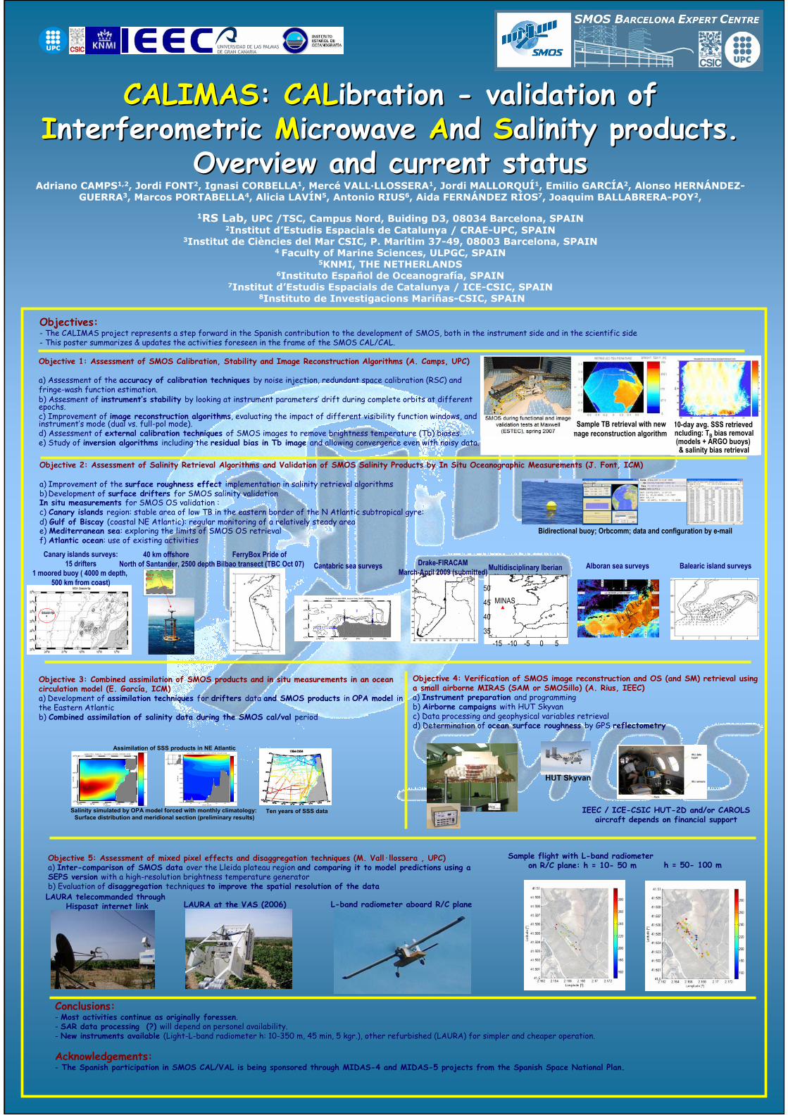
Objective 3: Combined assimilation of SMOS products and in situ measurements in an oceancirculation model (E. García, ICM)a) Development of assimilation techniques for drifters data and SMOS products in OPA model in the Eastern Atlanticb) Combined assimilation of salinity data during the SMOS cal/val period

Longitude

Latit

ude

salinity (PSU) − Depth 5m − Time 5400j (EXP502L−ORCA05−ZICM)

45oW 35oW 25oW 15oW 5oW 15oN

25oN

35oN

45oN

35.5

36

36.5

37

37.5

Latitude (deg N)

Dep

th (

m)

salinity (PSU) − [ −29.8W ] − Time 5400j (EXP502L−ORCA05−ZICM)

20 25 30 35 40−5000

−4500

−4000

−3500

−3000

−2500

−2000

−1500

−1000

−500

0

34.5

35

35.5

36

36.5

37

45oW 20oW

30oN

Salinity simulated by OPA model forced with monthly climatology: Surface distribution and meridional section (preliminary results)

Ten years of SSS data

Assimilation of SSS products in NE Atlantic

Objective 4: Verification of SMOS image reconstruction and OS (and SM) retrieval usinga small airborne MIRAS (SAM or SMOSillo) (A. Rius, IEEC)a) Instrument preparation and programmingb) Airborne campaigns with HUT Skyvanc) Data processing and geophysical variables retrievald) Determination of ocean surface roughness by GPS reflectometry

HUT Skyvan

Objective 5: Assessment of mixed pixel effects and disaggregation techniques (M. Vall·llossera , UPC)a) Inter-comparison of SMOS data over the Lleida plateau region and comparing it to model predictions using aSEPS version with a high-resolution brightness temperature generatorb) Evaluation of disaggregation techniques to improve the spatial resolution of the data

*Boya AGL

Multidisciplinary Iberian North Atlatic Station

(MINAS) at 42ºN, 13ºW

-15 -10 -5 0 535

40

45

50MINAS

Drake-FIRACAM March-April 2009 (submitted)

40 km offshoreNorth of Santander, 2500 depth

10-day avg. SSS retrievedincluding: TB bias removal(models + ARGO buoys) & salinity bias retrieval

Sample TB retrieval with newimage reconstruction algorithm

Bidirectional buoy; Orbcomm; data and configuration by e-mail

Cantabric sea surveys Alboran sea surveys Balearic island surveysCanary islands surveys:

15 drifters1 moored buoy ( 4000 m depth,

500 km from coast)

IEEC / ICE-CSIC HUT-2D and/or CAROLSaircraft depends on financial support

Sample flight with L-band radiometeron R/C plane: h = 10- 50 m h = 50- 100 m

L-band radiometer aboard R/C planeLAURA at the VAS (2006)LAURA telecommanded through

Hispasat internet link

Objectives:- The CALIMAS project represents a step forward in the Spanish contribution to the development of SMOS, both in the instrument side and in the scientific side- This poster summarizes & updates the activities foreseen in the frame of the SMOS CAL/CAL.

Conclusions:- Most activities continue as originally foressen.- SAR data processing (?) will depend on personel availability.- New instruments available (Light-L-band radiometer h: 10-350 m, 45 min, 5 kgr.), other refurbished (LAURA) for simpler and cheaper operation.

Acknowledgements:- The Spanish participation in SMOS CAL/VAL is being sponsored through MIDAS-4 and MIDAS-5 projects from the Spanish Space National Plan.