Embed Size (px)
Citation preview
292 NSS NEWS, October 1998
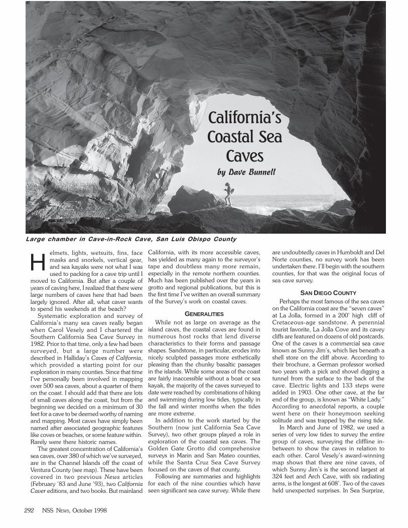
Large chamber in Cave-in-Rock Cave, San Luis Obispo County
elmets, lights, wetsuits, fins, facemasks and snorkels, vertical gear,and sea kayaks were not what I wasused to packing for a cave trip until I
moved to California. But after a couple ofyears of caving here, I realized that there werelarge numbers of caves here that had beenlargely ignored. After all, what caver wantsto spend his weekends at the beach?
Systematic exploration and survey ofCalifornia’s many sea caves really beganwhen Carol Vesely and I chartered theSouthern California Sea Cave Survey in1982. Prior to that time, only a few had beensurveyed, but a large number weredescribed in Halliday’s Caves of California,which provided a starting point for ourexploration in many counties. Since that timeI’ve personally been involved in mappingover 500 sea caves, about a quarter of themon the coast. I should add that there are lotsof small caves along the coast, but from thebeginning we decided on a minimum of 30feet for a cave to be deemed worthy of namingand mapping. Most caves have simply beennamed after associated geographic featureslike coves or beaches, or some feature within.Rarely were there historic names.
The greatest concentration of California’ssea caves, over 380 of which we’ve surveyed,are in the Channel Islands off the coast ofVentura County (see map). These have beencovered in two previous News articles(February ’83 and June ’93), two CaliforniaCaver editions, and two books. But mainland
California, with its more accessible caves,has yielded as many again to the surveyor’stape and doubtless many more remain,especially in the remote northern counties.Much has been published over the years ingrotto and regional publications, but this isthe first time I’ve written an overall summaryof the Survey’s work on coastal caves.
GENERALITIES
While not as large on average as theisland caves, the coastal caves are found innumerous host rocks that lend diversecharacteristics to their forms and passageshapes. Sandstone, in particular, erodes intonicely sculpted passages more estheticallypleasing than the chunky basaltic passagesin the islands. While some areas of the coastare fairly inaccessible without a boat or seakayak, the majority of the caves surveyed todate were reached by combinations of hikingand swimming during low tides, typically inthe fall and winter months when the tidesare more extreme.
In addition to the work started by theSouthern (now just California Sea CaveSurvey), two other groups played a role inexploration of the coastal sea caves. TheGolden Gate Grotto did comprehensivesurveys in Marin and San Mateo counties,while the Santa Cruz Sea Cave Surveyfocused on the caves of that county.
Following are summaries and highlightsfor each of the nine counties which haveseen significant sea cave survey. While there
are undoubtedly caves in Humboldt and DelNorte counties, no survey work has beenundertaken there. I’ll begin with the southerncounties, for that was the original focus ofsea cave survey.
SAN DIEGO COUNTY
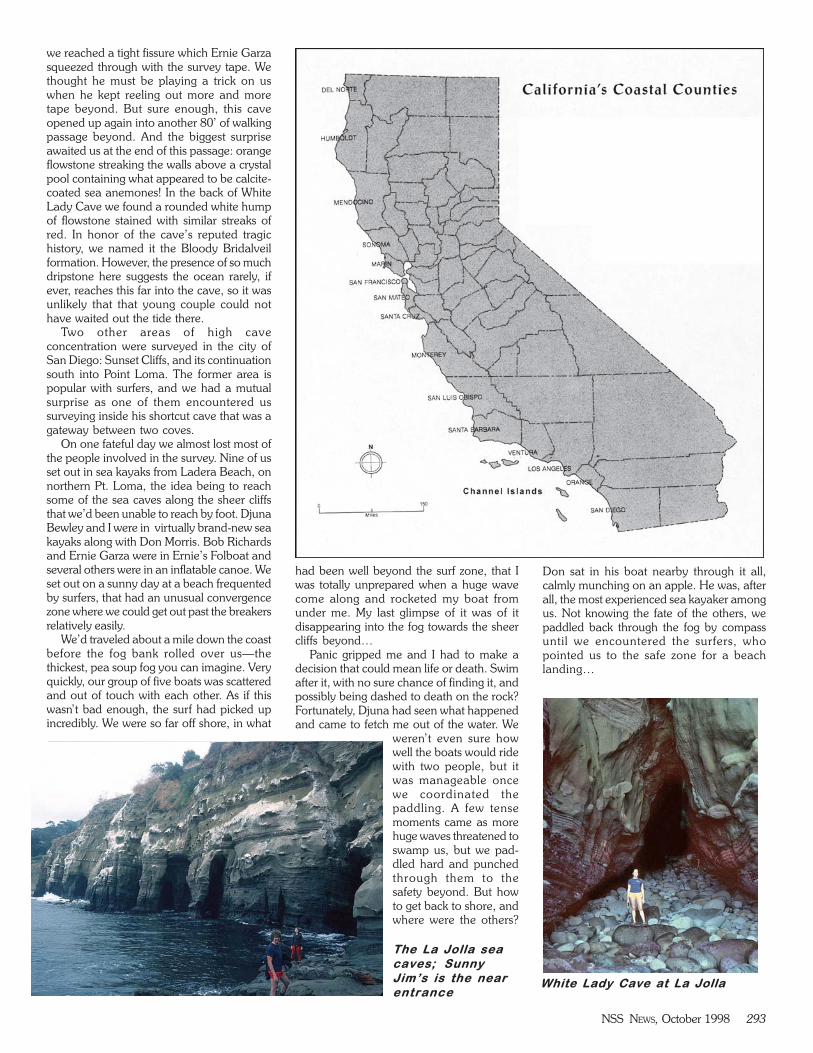
Perhaps the most famous of the sea caveson the California coast are the “seven caves”at La Jolla, formed in a 200’ high cliff ofCretaceous-age sandstone. A perennialtourist favorite, La Jolla Cove and its caveycliffs are featured on dozens of old postcards.One of the caves is a commercial sea caveknown as Sunny Jim’s, which lies beneath ashell store on the cliff above. According totheir brochure, a German professor workedtwo years with a pick and shovel digging atunnel from the surface to the back of thecave. Electric lights and 133 steps wereadded in 1903. One other cave, at the farend of the group, is known as “White Lady.”According to anecdotal reports, a couplewent here on their honeymoon seekingsolitude and was trapped by the rising tide.
In March and June of 1982, we used aseries of very low tides to survey the entiregroup of caves, surveying the cliffline in-between to show the caves in relation toeach other. Carol Vesely’s award-winningmap shows that there are nine caves, ofwhich Sunny Jim’s is the second largest at324 feet and Arch Cave, with six radiatingarms, is the longest at 608’. Two of the cavesheld unexpected surprises. In Sea Surprize,
California’s
Coastal Sea
Caves by Dave Bunnell
H
NSS NEWS, October 1998 293
we reached a tight fissure which Ernie Garzasqueezed through with the survey tape. Wethought he must be playing a trick on uswhen he kept reeling out more and moretape beyond. But sure enough, this caveopened up again into another 80’ of walkingpassage beyond. And the biggest surpriseawaited us at the end of this passage: orangeflowstone streaking the walls above a crystalpool containing what appeared to be calcite-coated sea anemones! In the back of WhiteLady Cave we found a rounded white humpof flowstone stained with similar streaks ofred. In honor of the cave’s reputed tragichistory, we named it the Bloody Bridalveilformation. However, the presence of so muchdripstone here suggests the ocean rarely, ifever, reaches this far into the cave, so it wasunlikely that that young couple could nothave waited out the tide there.
Two other areas of high caveconcentration were surveyed in the city ofSan Diego: Sunset Cliffs, and its continuationsouth into Point Loma. The former area ispopular with surfers, and we had a mutualsurprise as one of them encountered ussurveying inside his shortcut cave that was agateway between two coves.
On one fateful day we almost lost most ofthe people involved in the survey. Nine of usset out in sea kayaks from Ladera Beach, onnorthern Pt. Loma, the idea being to reachsome of the sea caves along the sheer cliffsthat we’d been unable to reach by foot. DjunaBewley and I were in virtually brand-new seakayaks along with Don Morris. Bob Richardsand Ernie Garza were in Ernie’s Folboat andseveral others were in an inflatable canoe. Weset out on a sunny day at a beach frequentedby surfers, that had an unusual convergencezone where we could get out past the breakersrelatively easily.
We’d traveled about a mile down the coastbefore the fog bank rolled over us—thethickest, pea soup fog you can imagine. Veryquickly, our group of five boats was scatteredand out of touch with each other. As if thiswasn’t bad enough, the surf had picked upincredibly. We were so far off shore, in what
had been well beyond the surf zone, that Iwas totally unprepared when a huge wavecome along and rocketed my boat fromunder me. My last glimpse of it was of itdisappearing into the fog towards the sheercliffs beyond…
Panic gripped me and I had to make adecision that could mean life or death. Swimafter it, with no sure chance of finding it, andpossibly being dashed to death on the rock?Fortunately, Djuna had seen what happenedand came to fetch me out of the water. We
weren’t even sure howwell the boats would ridewith two people, but itwas manageable oncewe coordinated thepaddling. A few tensemoments came as morehuge waves threatened toswamp us, but we pad-dled hard and punchedthrough them to thesafety beyond. But howto get back to shore, andwhere were the others?
Don sat in his boat nearby through it all,calmly munching on an apple. He was, afterall, the most experienced sea kayaker amongus. Not knowing the fate of the others, wepaddled back through the fog by compassuntil we encountered the surfers, whopointed us to the safe zone for a beachlanding…
The La Jolla sea
caves; Sunny
Jim’s is the near
entranceWhite Lady Cave at La Jolla

294 NSS NEWS, October 1998
Meanwhile, the others had managed topaddle several more miles around the tip ofPoint Loma and into Mission Bay, cold andtired but thankfully safe. Ever since then, I’vehad a healthy respect for the fog and wouldnever consider sea kayaking alone.
That was the last attempt to add to the 37caves surveyed in the county.
ORANGE COUNTY
The CSCS hasmapped nine caves inthis county, the longestbeing Thousand StepsBeach Cave (214’) nearSouth Laguna. This is avery accessible andimpressive cave formedin sand-stone, reachedfrom the public beach ofthe same name. Much of it is a 20’ high tunnelalmost 200’ long, that follows a fault. Someflowstone and small stalactites have formedinside. We entered a dry opening visible fromthe beach and exited a second seawardentrance. That gave us access to adjacentLighthouse Cove, where we mapped severalother caves including 200-foot long ArchCave.
SANTA BARBARA COUNTY
Technically, this county includes SantaCruz island and its multitude of large caves.On the mainland, all the known caves arefound at Point Sal, a small isthmus of volcanicagglomerates, and south on the VandenbergAir Force Base. We mapped three small cavesat Point Sal, the longest of which we namedMiner’s Mystery (85’). It was a two-level cave,with a dry upper level containing a series ofplanks wedged between the walls at differentlevels, like mine shoring. It wasn’t evidentthat any artificial enlargement of the cavehad been performed, and it remained amystery. At the Air Force Base we gainedaccess, with an escort, to survey some cavesat Point Arguello. We were forbidden to takephotos on the base, but one cave contained
such beautiful tidepoolsthat I couldn’t resist—andsurely the photo seen inthe color spread was nota threat to nationalsecurity! We also hiked amile during low tide andsurveyed five nice cavesat Ocean Beach Park, apublic beach access in themiddle of the base. Oneof these was over 180’long.
SAN LUIS OBISPO COUNTY
This was the birthplace of the sea cavesurvey, with 30 caves mapped during the80s. It all began in 1981 with a descriptionin Caves of California about “The Cavernsof Mystery” describing a series of large wave-cut chambers that had been commercialized.I went up with Nina Savar, a visiting friend,and spent that day looking for the caveunsuccessfully. Later that month Nina washeading up the coast and met a couple oflocals who volunteered to take her to a placethat would “blow her away”. It turned out tobe the mysterious Caverns of Mystery, notfar from where we’d searched before. Armedwith Nina’s directions, Carol Vesely and Iwent up to the town of Shell Beach toinvestigate. We were enticed by beautifulorange sandstone cliffs bearing numerousentrances, and a huge sea stack (portion of
Rafting into Emerald Cove Cave, La
Jolla
Emerald Cove
Cave, La Jolla.
Note people
climbing on leftTiger Dome Cave, Pt. Loma
Big Blowhole
Cave, Sunset
Cliffs, San Diego.
This is a classic
littoral sinkhole
formed by
collapse of a sea
cave’s roof

NSS NEWS, October 1998 295
coast cut off by erosion, sometimes collapseof sea caves) that appeared similarly riddled.Our direction took us to a large littoral sinkat the edge of a county park. This 30’-wide,50’ deep pit had a series of eroding stairsdown one edge that took us into a pair ofrooms with several seaward entrances. Thatday we made the survey’s first sea cave map,230’ long. An owner of a local antique shoplater told us there had been a commercialventure, called Dinosaur Cave. The cave wasinteresting enough and a nice find, but didnot contain the multiple chambers thatHalliday had described.
On a later trip we descended the cliffs ona cable ladder and reached the sea stack,surveying the cave that we named Cave-in-Rock. It contained a very impressive chamberover 100’ wide and colorful tidepool life inthe form of sponges, encrusting red algae,limpets, and a variety of starfish. Fittingly, itwas well endowed with batstars, which comein shades of red, orange, and purple. We
surveyed it and I took thefirst of many photographs Iwould make here over theyears. This became one ofour favorite destinationsfor grotto sea cave trips.
With so many caves inone area we decided totake the same approachwe’d taken at La Jolla, andshow all the caves on one
map. So on a later trip with Ernie Garza wetraversed a quarter mile stretch of coast justnorth of Dinosaur down to Cave-in-Rock,surveying five caves enroute. Most of thesewere large chambers, and on the map youcould see how a passage trend was followedacross a series of caves. No doubt somedayall of these caves may connect, unless thecliffs give way first.
Further up the coast at Shell Beach, wespotted a hole high up in the cliffs, at theback of a finger cove. Parking my truck aboveit and rigging to the bumper, we did our firstvertical sea cave (see back cover photo). The70-foot drop landed us in a dry passageconnecting into a water-filled room 100’ long,and the expected seaward entrance.Slickensides on the walls showed why thecove and the cave passage was so narrow.The cave mapped out to over 200’.
Further explorations ensued at CaveLanding, named for large relict sea caveswhere pirates were alleged to have hidden
their treasure. Just south of Avila StateBeach, the caves here were notable for thebeautiful and photogenic patterns in theirsandstone walls. This secluded area is alsoa nude beach, which made for interesting“ridgewalking.” Another cave here provedto have outstanding tidepool life, and waswell-known to marine biologist BobHenderson, who had found many speciesof nudibranchs (shell-less molluscs) amongthe rocks in what we named NudibranchCave.
But the story of this county wasn’t over.We’d mapped a few small caves at Montanad’Oro State Park, which has awesome foldedand twisted coastal rocks because it is in asubduction zone, where the Pacific Plate isdiving under the North American plate. Therock is the Monterey formation, composedof shales and silty sandstones dipping at 50degrees. Then I saw an aerial photo of Point
Large sea stack at
Shell Beach
housing the Cave-
in-Rock
Grotto Rock is a sea stack at Montana
d’Oro S.P. which is virtually hollow.
Below, the cave within.

296 NSS NEWS, October 1998
NSS NEWS, October 1998 297
California’s Coastal Sea Cavesphotos by Dave Bunnell
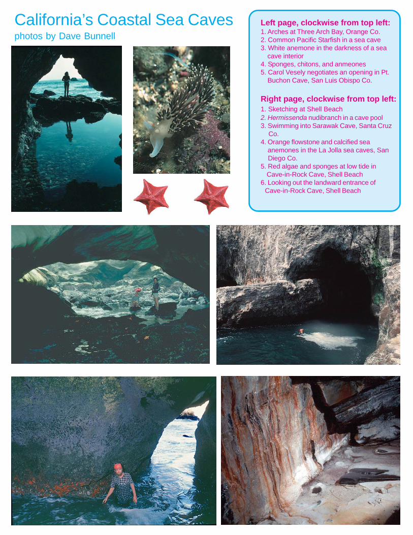
Left page, clockwise from top left:1. Arches at Three Arch Bay, Orange Co.2. Common Pacific Starfish in a sea cave3. White anemone in the darkness of a sea cave interior4. Sponges, chitons, and anmeones5. Carol Vesely negotiates an opening in Pt. Buchon Cave, San Luis Obispo Co.
Right page, clockwise from top left:1. Sketching at Shell Beach2. Hermissenda nudibranch in a cave pool3. Swimming into Sarawak Cave, Santa Cruz Co.4. Orange flowstone and calcified sea anemones in the La Jolla sea caves, San Diego Co.5. Red algae and sponges at low tide in Cave-in-Rock Cave, Shell Beach6. Looking out the landward entrance of Cave-in-Rock Cave, Shell Beach
298 NSS NEWS, October 1998
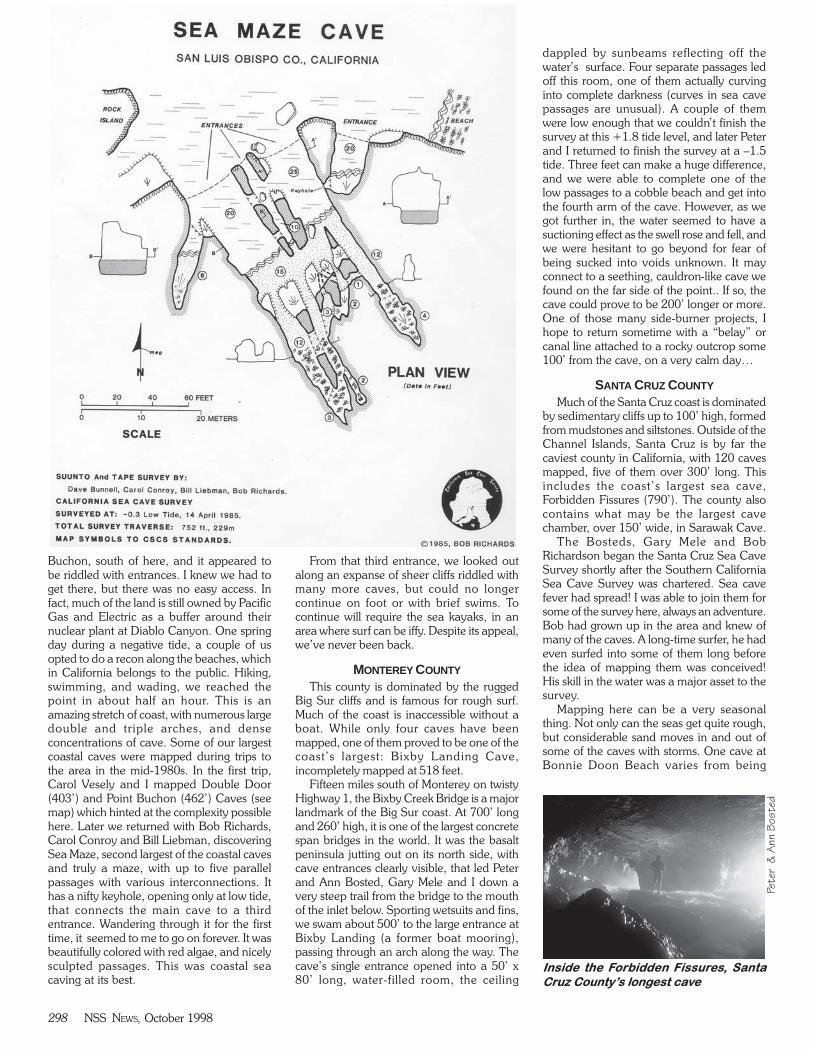
Buchon, south of here, and it appeared tobe riddled with entrances. I knew we had toget there, but there was no easy access. Infact, much of the land is still owned by PacificGas and Electric as a buffer around theirnuclear plant at Diablo Canyon. One springday during a negative tide, a couple of usopted to do a recon along the beaches, whichin California belongs to the public. Hiking,swimming, and wading, we reached thepoint in about half an hour. This is anamazing stretch of coast, with numerous largedouble and triple arches, and denseconcentrations of cave. Some of our largestcoastal caves were mapped during trips tothe area in the mid-1980s. In the first trip,Carol Vesely and I mapped Double Door(403’) and Point Buchon (462’) Caves (seemap) which hinted at the complexity possiblehere. Later we returned with Bob Richards,Carol Conroy and Bill Liebman, discoveringSea Maze, second largest of the coastal cavesand truly a maze, with up to five parallelpassages with various interconnections. Ithas a nifty keyhole, opening only at low tide,that connects the main cave to a thirdentrance. Wandering through it for the firsttime, it seemed to me to go on forever. It wasbeautifully colored with red algae, and nicelysculpted passages. This was coastal seacaving at its best.
From that third entrance, we looked outalong an expanse of sheer cliffs riddled withmany more caves, but could no longercontinue on foot or with brief swims. Tocontinue will require the sea kayaks, in anarea where surf can be iffy. Despite its appeal,we’ve never been back.
MONTEREY COUNTY
This county is dominated by the ruggedBig Sur cliffs and is famous for rough surf.Much of the coast is inaccessible without aboat. While only four caves have beenmapped, one of them proved to be one of thecoast’s largest: Bixby Landing Cave,incompletely mapped at 518 feet.
Fifteen miles south of Monterey on twistyHighway 1, the Bixby Creek Bridge is a majorlandmark of the Big Sur coast. At 700’ longand 260’ high, it is one of the largest concretespan bridges in the world. It was the basaltpeninsula jutting out on its north side, withcave entrances clearly visible, that led Peterand Ann Bosted, Gary Mele and I down avery steep trail from the bridge to the mouthof the inlet below. Sporting wetsuits and fins,we swam about 500’ to the large entrance atBixby Landing (a former boat mooring),passing through an arch along the way. Thecave’s single entrance opened into a 50’ x80’ long, water-filled room, the ceiling
dappled by sunbeams reflecting off thewater’s surface. Four separate passages ledoff this room, one of them actually curvinginto complete darkness (curves in sea cavepassages are unusual). A couple of themwere low enough that we couldn’t finish thesurvey at this +1.8 tide level, and later Peterand I returned to finish the survey at a –1.5tide. Three feet can make a huge difference,and we were able to complete one of thelow passages to a cobble beach and get intothe fourth arm of the cave. However, as wegot further in, the water seemed to have asuctioning effect as the swell rose and fell, andwe were hesitant to go beyond for fear ofbeing sucked into voids unknown. It mayconnect to a seething, cauldron-like cave wefound on the far side of the point.. If so, thecave could prove to be 200’ longer or more.One of those many side-burner projects, Ihope to return sometime with a “belay” orcanal line attached to a rocky outcrop some100’ from the cave, on a very calm day…
SANTA CRUZ COUNTY
Much of the Santa Cruz coast is dominatedby sedimentary cliffs up to 100’ high, formedfrom mudstones and siltstones. Outside of theChannel Islands, Santa Cruz is by far thecaviest county in California, with 120 cavesmapped, five of them over 300’ long. Thisincludes the coast’s largest sea cave,Forbidden Fissures (790’). The county alsocontains what may be the largest cavechamber, over 150’ wide, in Sarawak Cave.
The Bosteds, Gary Mele and BobRichardson began the Santa Cruz Sea CaveSurvey shortly after the Southern CaliforniaSea Cave Survey was chartered. Sea cavefever had spread! I was able to join them forsome of the survey here, always an adventure.Bob had grown up in the area and knew ofmany of the caves. A long-time surfer, he hadeven surfed into some of them long beforethe idea of mapping them was conceived!His skill in the water was a major asset to thesurvey.
Mapping here can be a very seasonalthing. Not only can the seas get quite rough,but considerable sand moves in and out ofsome of the caves with storms. One cave atBonnie Doon Beach varies from being
Inside the Forbidden Fissures, Santa
Cruz County’s longest cave
Peter &
Ann B
osted
NSS NEWS, October 1998 299
completely filled to a multiple-entrance“system” over 200’ long.
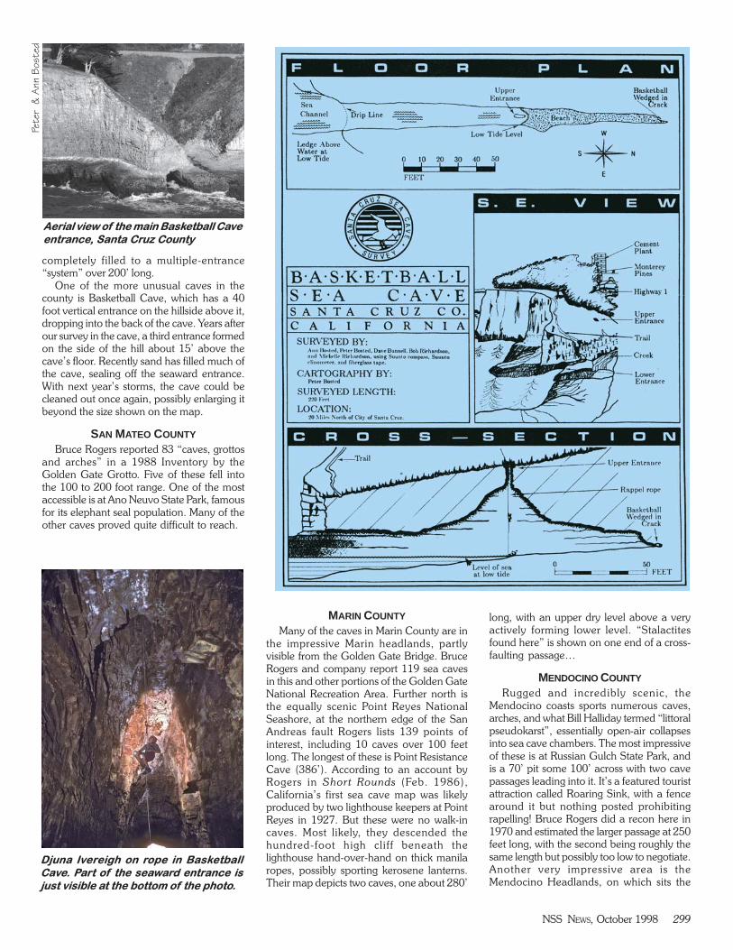
One of the more unusual caves in thecounty is Basketball Cave, which has a 40foot vertical entrance on the hillside above it,dropping into the back of the cave. Years afterour survey in the cave, a third entrance formedon the side of the hill about 15’ above thecave’s floor. Recently sand has filled much ofthe cave, sealing off the seaward entrance.With next year’s storms, the cave could becleaned out once again, possibly enlarging itbeyond the size shown on the map.
SAN MATEO COUNTY
Bruce Rogers reported 83 “caves, grottosand arches” in a 1988 Inventory by theGolden Gate Grotto. Five of these fell intothe 100 to 200 foot range. One of the mostaccessible is at Ano Neuvo State Park, famousfor its elephant seal population. Many of theother caves proved quite difficult to reach.
MARIN COUNTY
Many of the caves in Marin County are inthe impressive Marin headlands, partlyvisible from the Golden Gate Bridge. BruceRogers and company report 119 sea cavesin this and other portions of the Golden GateNational Recreation Area. Further north isthe equally scenic Point Reyes NationalSeashore, at the northern edge of the SanAndreas fault Rogers lists 139 points ofinterest, including 10 caves over 100 feetlong. The longest of these is Point ResistanceCave (386’). According to an account byRogers in Short Rounds (Feb. 1986),California’s first sea cave map was likelyproduced by two lighthouse keepers at PointReyes in 1927. But these were no walk-incaves. Most likely, they descended thehundred-foot high cliff beneath thelighthouse hand-over-hand on thick manilaropes, possibly sporting kerosene lanterns.Their map depicts two caves, one about 280’
long, with an upper dry level above a veryactively forming lower level. “Stalactitesfound here” is shown on one end of a cross-faulting passage…
MENDOCINO COUNTY
Rugged and incredibly scenic, theMendocino coasts sports numerous caves,arches, and what Bill Halliday termed “littoralpseudokarst”, essentially open-air collapsesinto sea cave chambers. The most impressiveof these is at Russian Gulch State Park, andis a 70’ pit some 100’ across with two cavepassages leading into it. It’s a featured touristattraction called Roaring Sink, with a fencearound it but nothing posted prohibitingrapelling! Bruce Rogers did a recon here in1970 and estimated the larger passage at 250feet long, with the second being roughly thesame length but possibly too low to negotiate.Another very impressive area is theMendocino Headlands, on which sits the
Peter
& A
nn B
osted
Aerial view of the main Basketball Cave
entrance, Santa Cruz County
Djuna Ivereigh on rope in Basketball
Cave. Part of the seaward entrance is
just visible at the bottom of the photo.
300 NSS NEWS, October 1998
scenic little town of Mendocino. TheHeadlands contain a number of deep-watercaves that require a kayak or boat to explore.Gary Mele, Ann Bosted, P. Greaves and DaveMcClurg surveyed Starfish Cave (334’),located in some islets off the northwest edgeof the Headlands, in 1984. This was the onlysurvey done here until Derek Hoyle and Isurveyed two others large and impressivecaves in 1993.
On a gorgeous Kodachrome day in earlyMay, Derek and I were on the road to PointArena. Just before the entrance into thelighthouse grounds, there is a pull-off onthe left. From here, two large entrances were
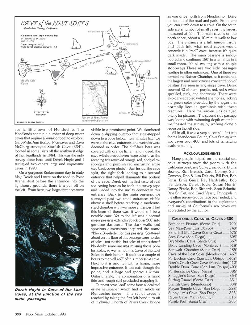
visible in a prominent point. We clambereddown a dipping outcrop that stair-steppeddown to a cove below. Ten minutes later wewere at the cave entrance, and wetsuits weredeemed in order. The cliff-face here wascovered with orange lichen, and indeed, thecave within proved even more colorful as thereceding tide revealed orange, red, and yellowsponges and purplish red encrusting algae(see back cover photo). Just inside, the cavesplit, the right fork leading to a secondentrance that helped illuminate this portionof the cave. Derek got his first taste of realsea caving here as he took the survey tapeand waded into the surf to connect in thisentrance. Back in the main passage, wesurveyed past two small entrances visibleabove a shelf before reaching a moderate-sized chamber with two more entrances. Hadthis been all there was, it would still be anotable cave. Yet to the left was a secondmajor passage extending back over 200’ intogenuine darkness. The dark walls andspacious dimensions inspired the name“Black Borehole” for this passage. Scatteredabout on the floor of this passage were hordesof soles - not the fish, but soles of tennis shoes!No doubt someone was missing those poorlost soles, so we named this Cave of the LostSoles in their honor. it took us a couple ofhours to map all 467’ of this impressive cave.Next to it is another with a larger, moreimpressive entrance. It too cuts though thepoint, and is large and spacious within.Unfortunately, the combination of a risingtide and rough surf precluded mapping it.
Our next cave ‘lead’ came from a local realestate newspaper, which had an article onMendocino caves. This set of caves isreached by taking the first left-hand turn offof Highway 1 north of Peters Creek Bridge
as you drive north from Mendocino. Driveto the end of the road and park. From hereyou can climb down to a cove. On the southside are a number of small caves, the largestmeasured at 65’. The main cave is on thenorth shore, about a 10-minute walk at lowtide. The entrance is a tall, narrow fissureand leads into what most cavers wouldconcede is a “real” cave, because it’s quitedark inside. The main passage is sandy-floored and continues 180’ to a terminus in asmall room. It’s all walking with a couplestoopways.There are two side passagesleading to other entrances. One of these wetermed the Batstar Chamber, as it containedthe largest and most diverse concentration ofbatstars I’ve seen in any single cave. Derekcounted 42 of them - purple, red, red & whitespeckled, pink, and chartreuse. There werealso dark-adapted (white) anemones, lackingthe green color provided by the algae thatnormally lives in symbiosis with thesecreatures. Here the survey was delayedbriefly for pictures...The second side passagewas floored with swimming-depth water, butwe finessed the survey by walking along aledge on the left side.
All in all, it was a very successful first tripfor the Mendocino County Cave Survey withtwo caves over 400’ and lots of tantalizingleads remaining.
ACKNOWLEDGEMENTS
Many people helped on the coastal seacave surveys over the years with theCalifornia Sea Cave Survey, including DjunaBewley, Rich Breisch, Carol Conroy, StanConston, Don & Lisa Delucia, Bill Farr, BobFariss, Ernie Garza, Ray Hardcastle, BobHenderson, Derek Hoyle, Susan Morris,Nancy Pistole, Bob Richards, Scott Schmitz,Pete Shifflet, and Carol Vesely. Principals inthe other survey groups have been noted, andeveryone’s contributions to the explorationand survey of California’s sea caves areappreciated by the author.
CALIFORNIA COASTAL CAVES >300’Forbidden Fissures (Santa Cruz) ....... 790’Sea Maze(San Luis Obispo) ............... 749'Sand Hill Bluff Cave (Santa Cruz) ...... 675'Arch Cave (San Diego) ...................... 608'Big Mother Cave (Santa Cruz) ........... 567'Bixby Landing Cave (Monterey ) ....... 518'Sarawak Chamber (Santa Cruz) ........ 485'Cave of the Lost Soles (Mendocino) .. 467'Pt. Buchon Cave (San Luis Obispo) .. 462’Peter’s Creek Cove Cave (Mendocino)412'Double Door Cave (San Luis Obispo)403'Pt. Resistance Cave (Marin) ................ 386'Smuggler’s Cave (San Diego) ............ 354'Surfing Tunnel (Santa Cruz) ............... 351'Starfish Cave (Mendocino) ................. 334'Mayan Temple Cave (San Diego) ...... 328’Sunny Jim’s Cave (San Diego) .......... 325’Reyes Cave (Marin County) ............... 315’Purple Post (Santa Cruz) .................... 305’
Derek Hoyle in Cave of the Lost
Soles, at the junction of the two
main passages

310 NSS NEWS, October 1998
Exploring California sea caves