Embed Size (px)
Citation preview
California USA Studies Weekly—Ancient America to Westward ExpansionTeacher Supplement
106
California USA Studies Weekly—Ancient America to Westward Expansion Teacher Supplement
106
Week 7Early Exploration
HSS Standards Covered: 5.2, 5.2.1, 5.2.2, 5.2.3ELA/Literacy Standards Covered: RI.5.1, RI.5.2, RI.5.3, RI.5.4, RI.5.5, RI.5.7, W.5.1, W.5.2, W.5.3, W.5.4, W.5.10, SL.5.1dELD Standards Covered: I.A.2, I.B.5, I.B.6, I.C.10, I.C.11, I.C.12, II.A.1, II.C.6Analysis Skills Covered: K5CST1, K5CST4, K5REPOV1, K5HI1
Summary of This Week’s Lesson:Students will learn about early attempts to explore and navigate the world using developments such as latitude and longitude.
Focus Question: Who were some of the first explorers to sail great distances, including all the way around the world, and what technology did they use to do it?
Literature Links“Henry the Navigator: Prince of Portuguese Exploration” by Lisa Ariganello“Vasco da Gama: Quest for the Spice Trade” by Katherine Bailey “Who Was Ferdinand Magellan?” by S.A. Kramer
Building Academic Vocabulary (BAV)
Antonio Pigafettaastronomycenturies
circumnavigateequator
Ferdinand Magellan
fleetGPS
Juan Sebastian del Canomarooned
prime meridianprimary source
Prince Henry the Navigatorscurvy
secondary source Strait of Magellan
Vasco da Gama
Teacher Planning GuideDay 1 (60 minutes) Page 1Cape Bojador: The Point of No Return• HSS Standards Covered: 5.2, 5.2.1, 5.2.2• ELA/Literacy Standards Covered: RI.5.1, RI.5.4• ELD Standards Covered: I.B.5, I.B.6, II.C.6• Analysis Skills Covered: K5CST1, K5HI1Global Positioning System• HSS Standards Covered: N/A• ELA/Literacy Standards Covered: RI.5.2, RI.5.4
Background Information: Prince Henry the Navigator Henry was the third son of Portugal’s King John. He became a fanatical Christian warrior, a Crusader, and wanted to drive the Muslims and their faith out of Europe and Africa. With his father’s permission, he and his two brothers attacked the town of Cuert in Morocco and captured it. The town was on one of Africa’s gold and spice routes, and the contents of the town sparked the business side of Henry’s imagination.
California USA Studies Weekly—Ancient America to Westward Expansion Teacher Supplement
107
California USA Studies Weekly—Ancient America to Westward ExpansionTeacher Supplement
107
Henry decided to set up a vast trading network in West Africa. He began to send expeditions along the coast of Africa for the purpose of exploration, detailed mapmaking, journal writing and trading with the natives. He also looked for a Christian king thought to have a vast empire in Africa named Prester John. He hoped that together, they could take care of the issue of Muslims in Africa once and for all. Although Henry died in 1460, the exploration did not stop. His brother, King John II, sent Bartholomeu Dias to find the southernmost point of Africa in 1487. A terrible storm pushed Dias south and east. Eventually, he realized that he had sailed past Africa. He turned around and found the cape. Dias wanted to call it the Cape of Terrors, due to the strong storms in the area, but the king decided to name it the Cape of Good Hope. These expeditions would eventually lead to a final push to the West Indies in 1498 by Vasco da Gama and the beginning of wealth and power for the Portuguese.
Lesson Suggestions: shared
BAV: horizon* The word listed above is provided to bring attention to other unfamiliar words students might encounter on this page.
Lesson Tasks• Begin by providing students with time to skim through this week’s issue. Encourage the students to make
predictions about what they might be learning this week and activate prior knowledge. • Introduce the BAV Chart blackline master that students will use throughout the week. • Read the cover page articles together as a class. • Help students fill out the BAV Chart blackline master (found on the Online Teacher Edition) as you read the
articles. o centuries, circumnavigate, Prince Henry the Navigator and GPS• Use the teacher questions to generate discussion and check for understanding. Teacher Questions, (Answers) and Cognitive Complexity Level/Relevance Level1. Why do you think people hundreds of years ago believed the Earth was flat? (When sailing on the ocean and
looking out onto the horizon, it appears you could just sail off the edge.) MODERATE/22. The article tells us that Prince Henry was not actually a navigator but just sponsored expeditions to Africa.
What does this mean? (He did not actually go on any of the expeditions, but he did pay for them.) LOW/23. Have you ever used a GPS? Where have you seen GPS in your everyday life? (Answers will vary.)
MODERATE/3
Common Misconceptions: Students may not be aware that people once believed the Earth was flat.
Differentiated Instruction for Universal AccessEnglish Learner Connection: Meet with students prior to Day 1 to introduce them to the BAV chart and words they will be learning this week.
Below/Developing Learner: Provide students with a BAV chart that has already been completed or partially completed. Gifted and Talented (GATE) Connection: Have students read this article on how GPS receivers work and write a short summary to share with the class. http://electronics.howstuffworks.com/gadgets/travel/gps.htm
Add these standards if students complete the differentiated activity above: RI.5.2, W.5.7, W.5.8
California USA Studies Weekly—Ancient America to Westward ExpansionTeacher Supplement
108
California USA Studies Weekly—Ancient America to Westward Expansion Teacher Supplement
108
Day 2 (60 minutes) Pages 2-3 LessonEarly ExplorersHSS Standards Covered: 5.2, 5.2.1, 5.2.2, 5.2.3ELA/Literacy Standards Covered: RI.5.1, RI.5.2, RI.5.4ELD Standards Covered: I.B.5, I.B.6, II.C.6Analysis Skills Covered: K5CST1, K5CST4, K5REPOV1
Background Information: Ferdinand Magellan Along the way to South America, Magellan’s men tried to mutiny, or take over the ship. He acted quickly. He had one of the ringleaders killed, and then, after they were all captured, pardoned the men but beheaded another of the leaders. The third leader and his son were marooned in the coldest part of the winter on a deserted island and were never heard from again. Magellan had no further problems with his men. Magellan died in the Philippines after befriending a native tribe. He believed God had made him invincible. He tried to take on the enemy tribe, but his men were sailors who had never fought in battle. His men fled, and he was hacked into too many pieces for his men to bury him or take him home. The spices that returned to Spain via the Victoria were enough to pay for the entire expedition and make each of the returning men rich.
Lesson Suggestions: shared
Lesson Tasks• Begin by reviewing the information discussed on Day 1. • Remind students that they will be using the BAV Chart blackline master to help them learn important
vocabulary words. • Read the main article on Pages 2-3 as a class. • Take time to use the map on Page 2 to help students better understand Magellan’s journey. • Help students fill out the BAV Chart blackline master as the article is read. o Ferdinand Magellan, fleet, marooned, Strait of Magellan, equator, Juan Sebastian del Cano, Antonio Pigafetta, primary source, and secondary source• Use the teacher questions to generate discussion and check for understanding. • Assign the Sequencing Magellan’s Journey blackline master for students to complete independently.
Teacher Questions, (Answers) and Cognitive Complexity Level/Relevance Level1. Magellan set out on his expedition with 237 sailors, and when the crew returned to Spain, there were
only 18 sailors left. What happened to the other sailors? (Some were killed in the mutiny or marooned. Others may have been killed when the people of the Philippines attacked. A storm destroyed one of the two remaining ships near the end of the journey. Many starved to death when food supplies ran low.) MODERATE/2
2. Why did Magellan decide to sail west instead of east like most explorers of the time? (Magellan thought sailing west would be faster.) LOW/2
3. Why is Pigafetta’s journal considered a primary source? (The journal is written in his own words, and he was actually there during the time of Magellan’s journey.) MODERATE/1
California USA Studies Weekly—Ancient America to Westward Expansion Teacher Supplement
109
California USA Studies Weekly—Ancient America to Westward ExpansionTeacher Supplement
109
Day 2 continuedMore Early Spanish Explorers (Mapping and Charting)HSS Standards Covered: 5.2, 5.2.1, 5.2.2, 5.2.3ELA/Literacy Standards Covered: RI.5.7, W.5.10ELD Standards Covered: I.A.2, I.B.6, II.C.6Analysis Skills Covered: K5CST4
Lesson Suggestions: independent—as homework
Cognitive Complexity Level: MODERATE/2
Differentiated Instruction for Universal AccessEnglish Learner Connection: Work with students in small groups to help them complete the Sequencing Magellan’s Journey blackline master.
Below/Developing Learner: Allow students to work with a partner to complete the Sequencing Magellan’s Journey blackline master.
Gifted and Talented (GATE) Connection: Have students choose one of the explorers mentioned in the Page 4 activity “More Early Spanish Explorers” to research. Have students share what they learned with the class.
Add these standards if students complete the differentiated activity above: W.5.7, W.5.8
Day 3 (60 minutes)Pages 2-3Vasco da Gama (1460s-1524): No Simple Feat• HSS Standards Covered: 5.2, 5.2.1, 5.2.2, 5.2.3• ELA/Literacy Standards Covered: RI.5.2, RI.5.3, RI.5.4• ELD Standards Covered: I.A.2, I.B.6, II.C.6• Analysis Skills Covered: K5HI1Latitude and Longitude (Trades and Technology)• HSS Standards Covered: N/A• ELA/Literacy Standards Covered: RI.5.4, RI.5.5• ELD Standards Covered: I.A.2, I.B.6, II.C.6• Analysis Skills Covered: K5CST4
Lesson Suggestions: shared
Lesson Tasks• Begin by reviewing the information discussed on Day 2. • Remind students that they will be using the BAV Chart blackline master to help them learn important
vocabulary words.• Read the articles on the bottom of Pages 2-3 as a class. • Help students to fill out the BAV Chart blackline master as you read. o Vasco da Gama, astronomy, scurvy and prime meridian • Use the teacher questions to generate discussion and check for understanding. • Assign the Latitude and Longitude blackline master for students to complete independently.
California USA Studies Weekly—Ancient America to Westward ExpansionTeacher Supplement
110
California USA Studies Weekly—Ancient America to Westward Expansion Teacher Supplement
110
Teacher Questions, (Answers) and Cognitive Complexity Level/Relevance Level1. The article says that da Gama’s ships were able to cross the Indian Ocean in only 23 days, but the return trip
took 123 days. Why is this? (They were able to sail with the monsoon winds pushing them along. On the way back, they were sailing against the wind, which made them go slower.) MODERATE/3
2. The article says that da Gama’s journey from Portugal to India and back is a greater distance than sailing around the Earth at the equator. How is this possible? (When you calculate to total distance sailed from Portugal to India and back, it is a longer distance than sailing around the world.) MODERATE/3
3. What do we call the parts of the Earth that are divided by the equator? What do we call the parts of the Earth that are divided by the prime meridian? (The parts of the Earth divided by the equator are called the Northern and Southern hemispheres. The parts of the Earth divided by the prime meridian are called the Eastern and Western hemispheres.) HIGH/2
Day 3 continued Page 4Crossword PuzzleLesson Suggestions: independent—as homework
Have students practice citing sources by having them highlight where in this week’s magazine they found the answer to each crossword puzzle clue.
Cognitive Complexity Level: LOW/2
Differentiated Instruction for Universal AccessEnglish Learner Connection and Below/Developing Learner: Meet with students in small groups prior to instruction on Day 3 to introduce the concept of latitude and longitude. You could use the Latitude and Longitude blackline master or other maps to help students become more familiar with the concept.
Gifted and Talented (GATE) Connection: The article about Vasco da Gama mentions that many of the sailors on his journey died of scurvy. Have students follow this link to read more about the disease and write a short summary about what they learned. http://encyclopedia.kids.net.au/page/sc/Scurvy
Add these standards if students complete the differentiated activity above: RI.5.2, W.5.7, W.5.8
Day 4 (30 minutes) Let’s Write: Writing Literacy Skills Prompts (*Indicates that prompt is featured in this week’s Student Edition)HSS Standards Covered: 5.2ELA/Literacy Standards Covered: W.5.1, W.5.2, W.5.3, W.5.4ELD Standards Covered: I.C.10, I.C.11, II.A.1
Opinion: In a paragraph or two, explain if you would rather use GPS or a regular paper map to find directions to a place. Include many details to explain your opinion and remember to check for correct spelling, punctuation, capitalization and usage.
Informative/Explanatory: This week, you learned about lines of latitude and longitude. Write a paragraph or two explaining what lines of latitude and longitude are, as well as how you can use them to find a location on a map. Be sure to check your writing for spelling, punctuation, capitalization and usage.

California USA Studies Weekly—Ancient America to Westward Expansion Teacher Supplement
111
California USA Studies Weekly—Ancient America to Westward ExpansionTeacher Supplement
111
*Narrative: Imagine you are a sailor on one of the expeditions from this week’s magazine. Which expedition did you join? How did you feel as you sailed toward the “end of the world”? Write a few journal entries. Be sure to follow your teacher’s guidelines to edit your writing for spelling, punctuation, capitalization and usage.
Day 4 continued (30 minutes) Looking Back Activities Think & Review Questions: located on Page 4 of the Student EditionAsk students to answer each question in a complete sentence.HSS Standards Covered: 5.2, 5.2.1, 5.2.3ELA/Literacy Standards Covered: RI.5.5, RI.5.7, W.5.10, SL.5.1dELD Standards Covered: I.B.6, I.C.12, II.C.6
Differentiated Instruction for Universal AccessEnglish Learner Connection and Below/Developing Learner: Help students to create a word bank or provide a graphic organizer to help them brainstorm ideas for their writing.
Day 5 (60 minutes)AssessmentTo check for understanding, distribute the weekly assessment for students to complete independently. If time allows, you may choose to assign an extension activity to conclude the lesson.
Differentiated Instruction for Universal AccessEnglish Learner Connection and Below/Developing Learner: Read questions and answer choices aloud to students and/or reduce the number of questions they are required to answer.
Digital Developments: The teacher may use this as a student product assessment and/or a replacement for the weekly assessment. MODERATE to HIGH/3-4
2.0 Technology Suggestion(s)Fakebook (http://www.classtools.net/FB/home-page)Use Fakebook to create a page for one of the explorers mentioned in this week’s article. Watch a 90-second how-to video to help you get started. Begin by entering a name at the top of the page and then proceed to add friends, posts, comments and profile information. You can save your work and edit it again later.
Homework SuggestionHave students complete the Page 4 Mapping and Charting activity and More Early Spanish Explorers as homework for Day 2 and the crossword puzzle as homework for Day 3.
Integrated ActivitiesMath Connection: Send students on a latitude and longitude scavenger hunt. Hide objects throughout your classroom, school or outside areas around your school. Give students clues about where the objects are hidden. Create a map for students with lines of latitude and longitude. Have students plot points on the map where they find a hidden object. Visual and Performing Arts Connection: Have students create a comic strip illustrating Magellan’s journey around the world. They can use the Sequencing Magellan’s Journey blackline master to help them put the major events in order and then create an illustration for each event.
112112
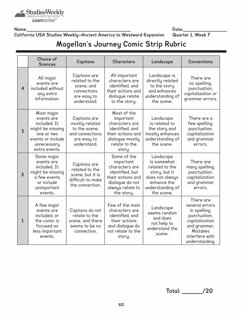
Name:_____________________________________________ Date:___________________California USA Studies Weekly—Ancient America to Westward Expansion Quarter 1, Week 7
Magellan’s Journey Comic Strip Rubric
Choice of Scences Captions Characters Landscape Conventions
4
All major events are
included without any extra
information.
Captions are related to the
scene, and connections are easy to understand.
All important characters are identified, and
their actions and dialogue relate
to the story.
Landscape is directly related
to the story and enhances
understanding of the scene.
There are no spelling, punctuation,
capitalization or grammar errors.
3
Most major events are included. It
might be missing one or two
events or include unnecessary extra events.
Captions are mostly related to the scene,
and connections are easy to understand.
Most of the important
characters are identified, and
their actions and dialogue mostly
relate to the story.
Landscape is related to the story and
mostly enhances understanding of
the scene.
There are a few spelling, punctuation,
capitalization and grammar
errors.
2
Some major events are included. It
might be missing a few events
or include unimportant
events.
Captions are related to the scene, but it is
difficult to make the connection.
Some of the important
characters are identified, but
their actions and dialogue do not always relate to
the story.
Landscape is somewhat
related to the story, but it
does not always enhance the
understanding of the scene.
There are many spelling, punctuation,
capitalization and grammar
errors.
1
A few major events are included, or the comic is focused on
less important events.
Captions do not relate to the
scene, and there seems to be no
connection.
Few of the main characters are identified, and their actions
and dialogue do not relate to the
story.
Landscape seems random
and does not help to
understand the scene.
There are several errors
in spelling, punctuation,
capitalization and grammar.
Mistakes interfere with understanding.
Total: _______/20
113113
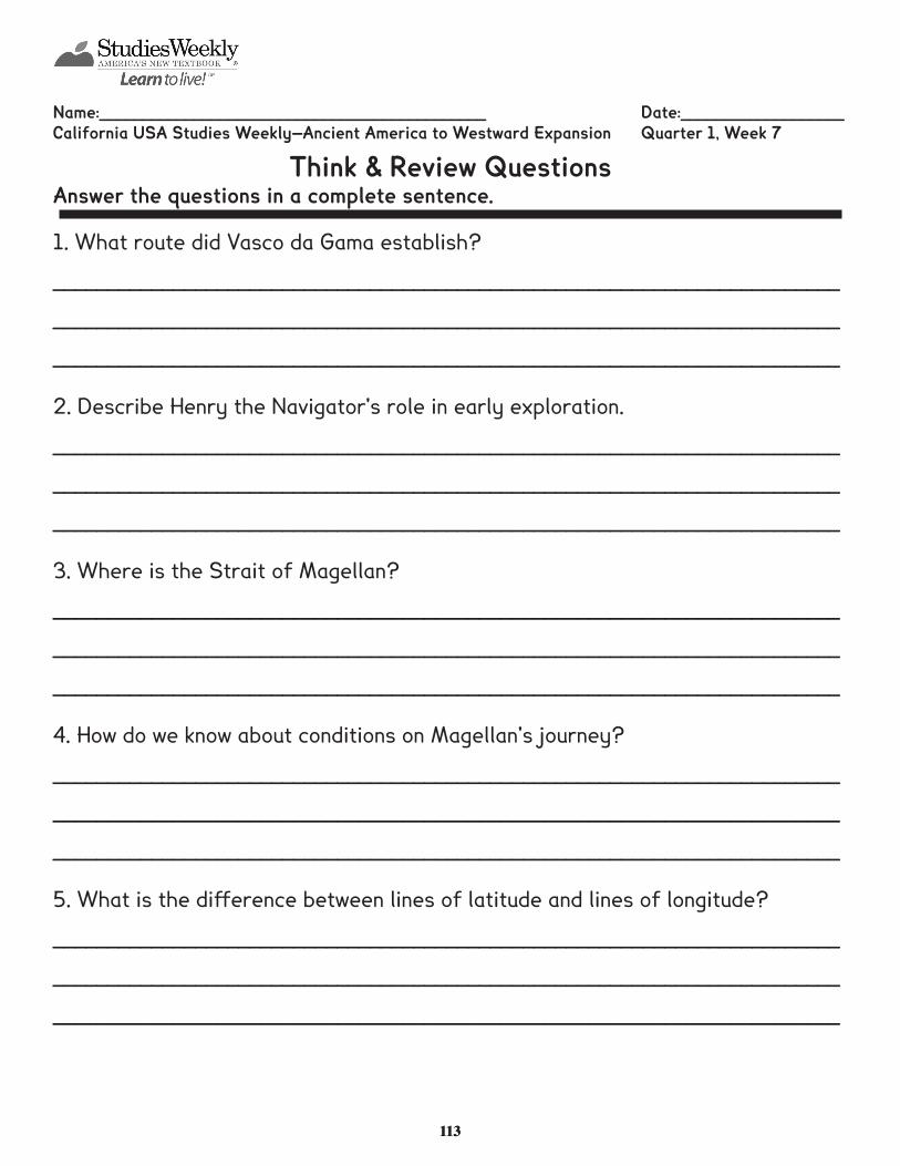
Name:_____________________________________________ Date:___________________California USA Studies Weekly—Ancient America to Westward Expansion Quarter 1, Week 7
Think & Review QuestionsAnswer the questions in a complete sentence.
1. What route did Vasco da Gama establish?
________________________________________________________________________
________________________________________________________________________
________________________________________________________________________
2. Describe Henry the Navigator's role in early exploration.
________________________________________________________________________
________________________________________________________________________
________________________________________________________________________
3. Where is the Strait of Magellan?
________________________________________________________________________
________________________________________________________________________
________________________________________________________________________
4. How do we know about conditions on Magellan's journey?
________________________________________________________________________
________________________________________________________________________
________________________________________________________________________
5. What is the difference between lines of latitude and lines of longitude?
________________________________________________________________________
________________________________________________________________________
________________________________________________________________________
114114
Name:_____________________________________________ Date:___________________California USA Studies Weekly—Ancient America to Westward Expansion Quarter 1, Week 7
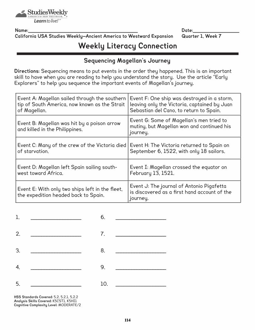
Weekly Literacy Connection
Sequencing Magellan’s JourneyDirections: Sequencing means to put events in the order they happened. This is an important skill to have when you are reading to help you understand the story. Use the article “Early Explorers” to help you sequence the important events of Magellan’s journey.
HSS Standards Covered: 5.2, 5.2.1, 5.2.2Analysis Skills Covered: K5CST1, K5HI1Cognitive Complexity Level: MODERATE/2
Event A: Magellan sailed through the southern tip of South America, now known as the Strait of Magellan.
Event F: One ship was destroyed in a storm, leaving only the Victoria, captained by Juan Sebastian del Cano, to return to Spain.
Event B: Magellan was hit by a poison arrow and killed in the Philippines.
Event G: Some of Magellan’s men tried to mutiny, but Magellan won and continued his journey.
Event C: Many of the crew of the Victoria died of starvation.
Event H: The Victoria returned to Spain on September 6, 1522, with only 18 sailors.
Event D: Magellan left Spain sailing south-west toward Africa.
Event I: Magellan crossed the equator on February 13, 1521.
Event E: With only two ships left in the fleet, the expedition headed back to Spain.
Event J: The journal of Antonio Pigafetta is discovered as a first hand account of the journey.
1. ___________________
2. ___________________
3. ___________________
4. ___________________
5. ___________________
6. ___________________
7. ___________________
8. ___________________
9. ___________________
10. ___________________
115115
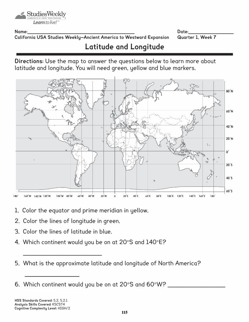
Name:_____________________________________________ Date:___________________California USA Studies Weekly—Ancient America to Westward Expansion Quarter 1, Week 7
Latitude and Longitude
Directions: Use the map to answer the questions below to learn more about latitude and longitude. You will need green, yellow and blue markers.
1. Color the equator and prime meridian in yellow.
2. Color the lines of longitude in green.
3. Color the lines of latitude in blue.
4. Which continent would you be on at 20°S and 140°E?
__________________________
5. What is the approximate latitude and longitude of North America?
__________________
6. Which continent would you be on at 20°S and 60°W? ___________________
HSS Standards Covered: 5.2, 5.2.1Analysis Skills Covered: K5CST4Cognitive Complexity Level: HIGH/2
116116
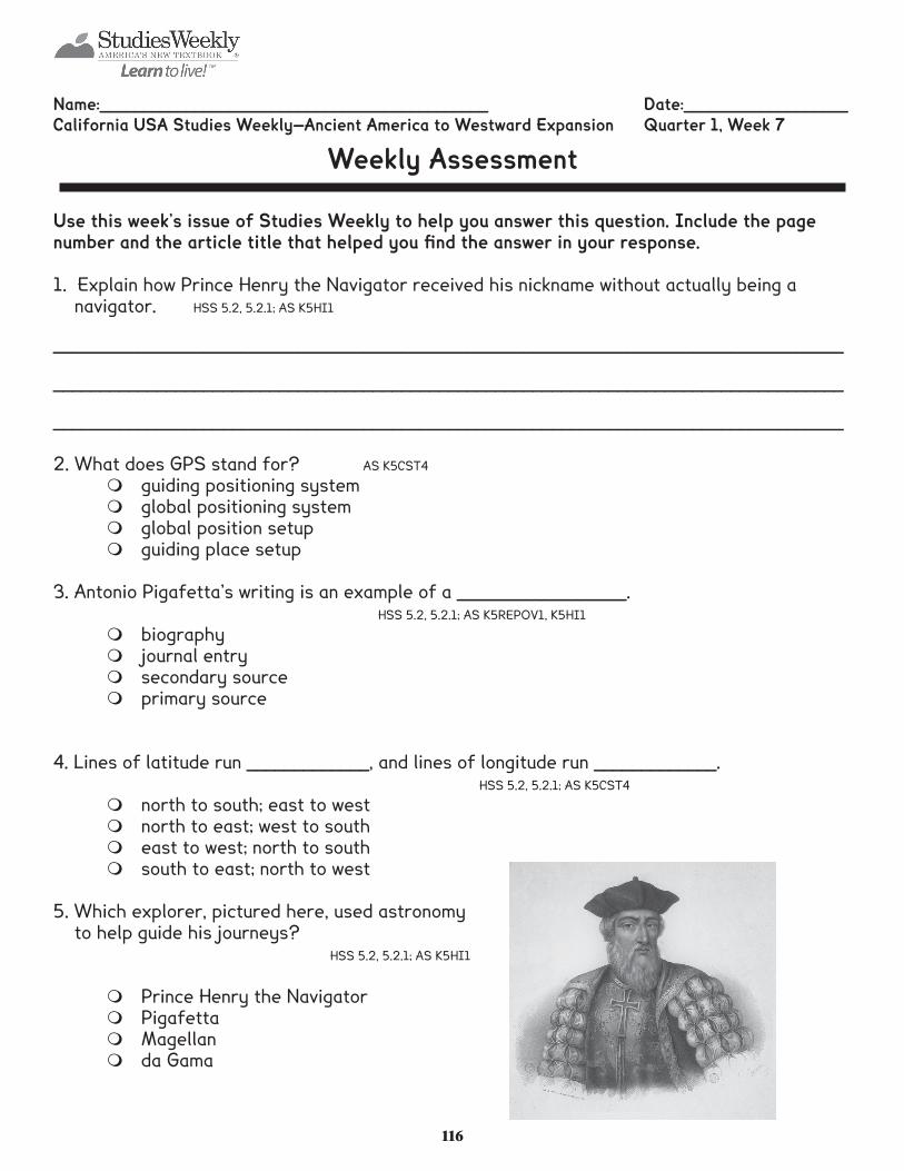
Name:_____________________________________________ Date:___________________California USA Studies Weekly—Ancient America to Westward Expansion Quarter 1, Week 7
Weekly Assessment
Use this week’s issue of Studies Weekly to help you answer this question. Include the page number and the article title that helped you fi nd the answer in your response.
1. Explain how Prince Henry the Navigator received his nickname without actually being a navigator. HSS 5.2, 5.2.1; AS K5HI1
____________________________________________________________________________________
____________________________________________________________________________________
____________________________________________________________________________________
2. What does GPS stand for? AS K5CST4
m guiding positioning systemm global positioning systemm global position setupm guiding place setup
3. Antonio Pigafetta’s writing is an example of a __________________. HSS 5.2, 5.2.1; AS K5REPOV1, K5HI1
m biography m journal entrym secondary source m primary source
4. Lines of latitude run _____________, and lines of longitude run _____________. HSS 5.2, 5.2.1; AS K5CST4
m north to south; east to westm north to east; west to southm east to west; north to southm south to east; north to west
5. Which explorer, pictured here, used astronomy to help guide his journeys?
HSS 5.2, 5.2.1; AS K5HI1
m Prince Henry the Navigatorm Pigafettam Magellanm da Gama
117117
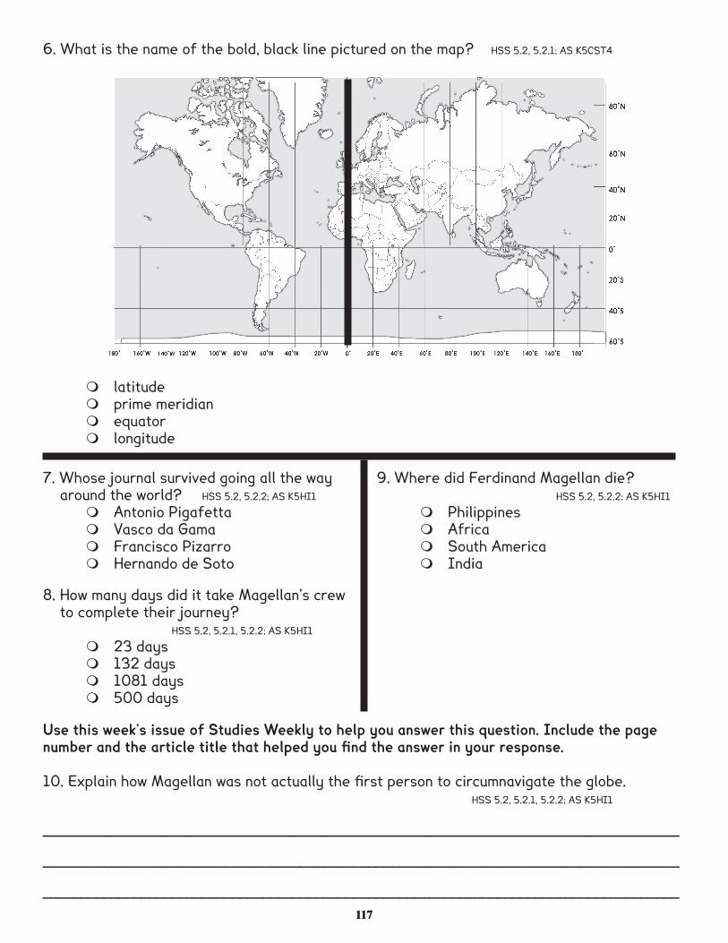
6. What is the name of the bold, black line pictured on the map? HSS 5.2, 5.2.1; AS K5CST4
m latitudem prime meridianm equatorm longitude
Use this week’s issue of Studies Weekly to help you answer this question. Include the page number and the article title that helped you fi nd the answer in your response.
10. Explain how Magellan was not actually the fi rst person to circumnavigate the globe. HSS 5.2, 5.2.1, 5.2.2; AS K5HI1
____________________________________________________________________________________
____________________________________________________________________________________
____________________________________________________________________________________
7. Whose journal survived going all the way around the world? HSS 5.2, 5.2.2; AS K5HI1
m Antonio Pigafettam Vasco da Gama m Francisco Pizarro m Hernando de Soto
8. How many days did it take Magellan’s crew to complete their journey?
HSS 5.2, 5.2.1, 5.2.2; AS K5HI1
m 23 daysm 132 daysm 1081 daysm 500 days
9. Where did Ferdinand Magellan die? HSS 5.2, 5.2.2; AS K5HI1
m Philippinesm Africam South Americam India