Embed Size (px)
Citation preview
Arnold Schwarzenegger, Governor
California Planning Guide: An Introduction to Planning in California
Governor’s Office of Planning and Research 1400 Tenth Street P.O. Box 3044 Sacramento, CA 95814 (916) 445-0613 Sean Walsh, Director, OPR Terry Roberts, Director, State Clearinghouse Shauna Pellman, Planning Intern December 2005 Edition

California Planning Guide
Table of Contents
INTRODUCTION................................................................................................................................. i THE PLANNING PROCESS .............................................................................................................. 1
Groups Involved in Planning ................................................................................................... 1 Public Involvement .................................................................................................................. 1 ANNEXATION AND INCORPORATION........................................................................................ 2
Sphere of Influence ................................................................................................................... 2 Annexation................................................................................................................................. 2
Incorporation............................................................................................................................. 2 THE GENERAL PLAN...................................................................................................................... 3
The Seven Required Elements ................................................................................................. 4 Consistency ................................................................................................................................ 4 Adopting and Amending the Plan ........................................................................................... 5 Community Plans ...................................................................................................................... 5 Specific Plans ............................................................................................................................. 5 ZONING .............................................................................................................................................. 5
Rezoning .................................................................................................................................... 6 Variances ................................................................................................................................... 8 Conditional Use Permits ........................................................................................................... 8
SUBDIVISIONS .................................................................................................................................. 9
Tentative Map ........................................................................................................................... 9 Final Map................................................................................................................................... 9 PROJECT APPROVAL PROCESS ................................................................................................. 9
Permits ...................................................................................................................................... 9 California Environmental Quality Act (CEQA) .................................................................... 10
Project ................................................................................................................................... 10 Lead Agency ......................................................................................................................... 10 Analyzing Projects ................................................................................................................ 10 Negative Declaration and Mitigated Negative Declaration .................................................. 11 Environmental Impact Report (EIR)..................................................................................... 11 Project Approval ................................................................................................................... 11
The Permit Streamlining Act ................................................................................................... 12 COMMON PLANNING TERMS ............................................................................................... 13-17
SOURCES FOR MORE INFORMATION ..................................................................................... 18 FIGURES Figure 1: Sample of a Zoning Map.......................................................................................... 7 Figure 2: Simplified CEQA Flow Chart ................................................................................. 12

California Planning Guide
- i
INTRODUCTION
The California Planning Guide is an introduction to the planning process in California. It explains the basic tools used in the planning process including the General Plan, zoning, and the California Environmental Quality Act (CEQA). In addition, this publication provides a very general overview of several complex planning laws. Readers should refer to the text of these laws for a complete and detailed understanding of their specific provisions. This planning guide focuses on planning from the perspective of cities and counties, although there are numerous other agencies involved in land use planning decisions. Additional sources of information are provided at the end of this publication. The Governor’s Office of Planning and Research is responsible for the administration of the California Environmental Quality Act and provides technical assistance to local planners, community residents, and state agencies and departments on planning in California. This planning guide is part of a series of technical memos and advisories intended to inform planning professionals and the general public. The California Planning Guide is an update of a 1989 publication written by Antero Rivasplata, whose contribution is gratefully acknowledged. Please feel free to reproduce all or part of this document. You need not secure permission; we ask that you print it accurately and give credit to the Governor’s Office of Planning and Research.
California Planning Guide
1
The Brown Act
Cities and counties must provide advance public notice of the hearings and meetings of their councils, boards, and other groups. Meetings and hearings, with some exceptions, must be open to the public (Government Code Sections 54950 - 54963 and 65090 et seq.).
THE PLANNING PROCESS Planning is the process of deciding how a community uses its land and other resources. The planning process involvesanalyzing the environmental and socioeconomic impacts of development and infrastructure projects. Planning decisions usually require local political approval, and reflect the desires and interests of the community. Local and state laws define the process for making planning decisions. (Government Code Sections 65000-66037).
The State delegates most local land use and development decisions to cities and counties. State law requires that each incorporated city and county adopt "a comprehensive, long-term general plan for [its] physical development." This general plan is the foundation for community decisions that will affect the future location of housing, business, industry, roads, parks, and other land uses, protect the public from noise and other environmental hazards, and conserve natural resources. Each community’s elected legislative body, upon recommendation of their planning commission, implements its general plan through its zoning, subdivision, and other ordinances.
There is no requirement that adjoining cities or counties have identical, or even similar, plans and ordinances. Each city and each county adopts its own general plan and development regulations. In turn, each is solely responsible for the planning decisions made within its jurisdiction.
Groups Involved in Planning In most communities, the city council or board of supervisors appoints one or more groups to consider planning issues. Some of the more common planning groups are:
• The Planning Commission, which considers general plan and specific plan amendments, zone changes, major subdivisions, conditional use permits, and variances.
• The Zoning Adjustment Board, which may also consider conditional use permits, variances, and other minor permits.
• The Architectural Review or Design Review Board, which reviews projects to ensure that they meet community aesthetic standards or follow community design guidelines.
Often these appointed groups have the power to approve projects, subject to appeal to the council or board of supervisors. In some cities and counties, these appointed groups simply advise the elected officials on the projects that they review, leaving actual project approval to the city council or board of supervisors. Public Involvement State planning laws require cities and counties to involve the public before making certain planning decisions. Members of the public can be involved in planning in a variety of ways. They can vote for local government officials who support their vision of the community; contact local officials about planning issues; participate in a neighborhood group; learn from and

California Planning Guide
2
educate others in the community about planning issues; and participate in government sponsored planning meetings, focus groups, and public hearings. Many local planning issues require a public hearing before the issue can be approved by the local legislative body or appointed commissions. A public hearing is open to everyone, and offers the opportunity to learn about an issue and to express one’s opinion about the issue. The agency holding the hearing must provide public notice of the hearing at least ten days in advance. Interested persons can request to be on the agency’s mailing list to receive information about specific projects.
ANNEXATION AND INCORPORATION
Annexation (the addition of territory to an existing city or special district) and incorporation (creation of a new city) are controlled by the Local Agency Formation Commission (LAFCO) established in each county by state law. A LAFCO is made up of elected officials selected by their counties, cities, and, in some cases, special districts. LAFCO duties include: (1) establishing the spheres of influence that designate the ultimate service areas of cities and special districts; (2) studying and approving requests for city annexations; and, (3) studying and approving proposals for city incorporations (Government Code Section 56000 et seq.).
Sphere of Influence
The sphere of influence designates the physical boundaries and service area of a city or special district. Each county’s
LAFCO is responsible for establishing a sphere for each city and special district in the county. The purpose of the sphere is to act as a benchmark for future annexation decisions.
Cities cannot establish their own sphere of influence. The LAFCO has sole responsibility for doing this. However, a city may request that the LAFCO amends its sphere. Some cities use their sphere of influence as a boundary for their general plan.
Annexation
When the LAFCO receives an annexation request, it will convene a hearing to determine the merits of the proposal. Annexations may be requested by affected landowners or by a city.
The LAFCO will deny, approve or conditionally approve annexation proposals based on its policies and state law. For example, annexation cannot occur unless the LAFCO has adopted a sphere of influence for the city seeking the annexation and the area proposed to be annexed is within the city's sphere. The LAFCO members tentatively approve requests for annexation hearings, and, if necessary, an election. Annexations which have been passed by a vote of the inhabitants or which have not been defeated by protest (in those instances where no election was required) must be certified by the LAFCO and meet all its conditions before they become final. The LAFCO, not the city, has final responsibility for the annexation process.
Incorporation
When a new city is proposed to be formed, the LAFCO studies the financial feasibility of the proposed city, its financial impact on

California Planning Guide
3
the county and special districts, and the provision of public services. If the proposal is not financially feasible, the LAFCO can terminate the proceedings. If the proposed city appears to be feasible, LAFCO will refer the proposal (and a set of conditions to be met upon incorporation) to the county board of supervisors for a public hearing on the subject. Incorporation proceedings are terminated if the supervisors receive protests from a majority of the voters residing within the proposed city boundaries. If they do not receive a majority protest, an election will be held on the question of whether to create the city and to elect city officials.
THE GENERAL PLAN
The general plan is a community's blueprint for future development. It describes a community's development goals and policies. It also is the foundation for land use decisions made by the planning commission, city council, or board of supervisors.
A general plan consists of at least two parts. It must contain a written text describing the community's goals, objectives, and policies for development. It must also contain a map (or maps) and diagrams illustrating the generalized distribution of land uses, the road system, environmental hazard areas, the open space system, and other policy statements that can be illustrated (Government Code Section 65302). The maps and diagrams must work together with the written portions of the
plan to establish a clear view of the community's future.
The general plan must contain at least seven components (called mandatory elements) addressing a set of basic planning issues (Government Code Section 65302). Each city and county determines the relative importance of these issues to their local circumstances and decides how they are to be discussed in the general plan. They may also voluntarily adopt additional elements, called optional elements, covering subjects of local interest. Some examples of optional elements include: air quality, recreation, community design, or public facilities.
Although general plans are not required to follow a standard format, many contain similar features. Some of the things to look for in the written portion of a generall plan are goals (abstract and general expressions of community values), objectives (specific intermediate steps in attaining a goal), policies (specific statements that guide decision making), and implementation programs (descriptions of how the goals, objectives, and policies are to be put into action). Many plans also contain background information about the community, such as population projections, traffic levels, natural hazards, community history, and housing characteristics.
The General Plan and Zoning Are Not the Same
A general plan is a set of long-term goals and policies that the community uses to guide development decisions. Although the plan establishes standards for the location and density of land uses, it does not directly regulate land use.
Zoning, on the other hand, is regulatory. Under the zoning ordinance, development must comply with specific, enforceable standards such as minimum lot size, maximum building height, minimum building setback, and a list of allowable uses. Zoning is applied lot-by-lot, whereas the general plan has a community-wide perspective.
California Planning Guide
4
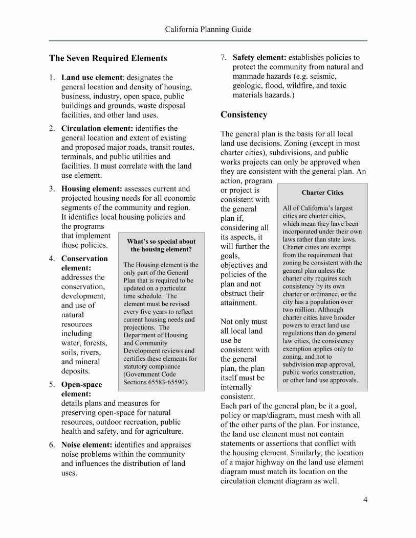
Charter Cities
All of California’s largest cities are charter cities, which mean they have been incorporated under their own laws rather than state laws. Charter cities are exempt from the requirement that zoning be consistent with the general plan unless the charter city requires such consistency by its own charter or ordinance, or the city has a population over two million. Although charter cities have broader powers to enact land use regulations than do general law cities, the consistency exemption applies only to zoning, and not to subdivision map approval, public works construction, or other land use approvals.
The Seven Required Elements
1. Land use element: designates the general location and density of housing, business, industry, open space, public buildings and grounds, waste disposal facilities, and other land uses.
2. Circulation element: identifies the general location and extent of existing and proposed major roads, transit routes, terminals, and public utilities and facilities. It must correlate with the land use element.
3. Housing element: assesses current and projected housing needs for all economic segments of the community and region. It identifies local housing policies and the programs that implement those policies.
4. Conservation element: addresses the conservation, development, and use of natural resources including water, forests, soils, rivers, and mineral deposits.
5. Open-space element: details plans and measures for preserving open-space for natural resources, outdoor recreation, public health and safety, and for agriculture.
6. Noise element: identifies and appraises noise problems within the community and influences the distribution of land uses.
7. Safety element: establishes policies to protect the community from natural and manmade hazards (e.g. seismic, geologic, flood, wildfire, and toxic materials hazards.)
Consistency
The general plan is the basis for all local land use decisions. Zoning (except in most charter cities), subdivisions, and public works projects can only be approved when they are consistent with the general plan. An action, program or project is consistent with the general plan if, considering all its aspects, it will further the goals, objectives and policies of the plan and not obstruct their attainment.
Not only must all local land use be consistent with the general plan, the plan itself must be internally consistent. Each part of the general plan, be it a goal, policy or map/diagram, must mesh with all of the other parts of the plan. For instance, the land use element must not contain statements or assertions that conflict with the housing element. Similarly, the location of a major highway on the land use element diagram must match its location on the circulation element diagram as well.
What’s so special about the housing element?
The Housing element is the only part of the General Plan that is required to be updated on a particular time schedule. The element must be revised every five years to reflect current housing needs and projections. The Department of Housing and Community Development reviews and certifies these elements for statutory compliance (Government Code Sections 65583-65590).
California Planning Guide
5
Adopting and Amending the Plan
The process of adopting or amending a general plan requires public participation. Cities and counties must hold public hearings for such proposals. Advance notice of the place and time of the hearing must be published in the newspaper (when there is no paper, notice must be posted in the vicinity of the project site) and also mailed directly to the involved property owners. State planning law also requires that cities and counties consult with California Native American tribes prior to adopting or amending the general plan. Copies of the adopted or amended plans must be available for public purchase within two days after a final decision.
Each of the general plan's seven required elements can be amended only four times per calendar year. More than one change may be considered at each of these four opportunities. Optional elements can be amended at any time.
The planning commission, and the city council or county board of supervisors, must each hold at least one public hearing prior to approving or amending the plan. The commission usually holds its hearing first and makes specific recommendations to the council or board. A recommendation for approval must be made by a majority of the total membership of the commission.
The council or board will take final action on the proposals at their hearing. Approvals must be made by a majority of the total membership of the council or board. If they make substantial changes to any planning commission recommendations, those items must be sent back to the commission for further study and recommendations before a final decision is made. The commission will
have 40 days in which to make any further recommendations.
Community Plans
A Community plan focuses planning efforts on a smaller area or neighborhood. A community plan is part of the local general plan. It addresses issues pertinent to a particular area or community within the city or county and supplements the policies of the general plan. Accordingly, it must be consistent with the general plan in all respects.
Specific Plans
A specific plan implements, but is not technically a part of, the local general plan. Specific plans describe allowable land uses, identify open space, and detail infrastructure availability and financing for a portion of the community. In some jurisdictions, specific plans also take the place of zoning. These specific plans must be consistent with the general plan. In turn, zoning, subdivision, and public works decisions must comply with the provisions of the specific plan. Specific plans are adopted and amended in the same manner as general plans.
ZONING
The distribution of residential, commercial, industrial, and other zones must be based on the pattern of land uses established by the community's general plan. Zoning maps illustrate how all uses are distributed geographically.
Zoning is adopted by ordinance and carries the weight of local law. Land may be put
California Planning Guide
6
Overlay Zones
Overlay zones provide an additional layer of standards. They are often set up to protect natural and cultural areas such as historic districts, residential enclaves, wetlands, water fronts, and scenic views.
only to those uses allowed by the zoning designation assigned to it. For example, if a commercial zone does not allow 5-story office buildings, then no such building could be built on land with a commercial zone designation.
The zoning ordinance regulates land uses within the community. It assigns each piece of property to a zone which describes the rules under which that land may be used. These classifications, such as "R-1" for single-family residences or "C-1" for neighborhood commercial uses, cover in specific terms the range of uses that are allowed in the general plan.
A typical zoning ordinance describes numerous zone classifications and development standards for each. Each of these zones identifies allowable uses and sets standards such as minimum lot size, maximum building height, and minimum front yard depth. In most local ordinances, development of allowable uses does not require a public hearing. Increasingly, however, communities are requiring a public review of the project's design before a building permit is issued.
In many communities, the planning commission is not the only body responsible for making zoning decisions. A board of zoning adjustment or a zoning administrator may be appointed to consider use permit and variance requests. Building design may be
subject to approval by a design review or architectural review board. Public notice of zoning hearings must be given at least 10 days before the hearing by advertisement in a newspaper of general circulation and by direct mailing to the owners of property located within 300 feet of the proposal's boundaries.
Rezoning
If a landowner proposes a use that is not allowed in that zone, then a change of zone (rezoning) is required for that use to occur. The local planning commission and the city council or county board of supervisors must hold public hearings before property may be rezoned. The council or board is not obligated to approve requests for rezoning and, except in charter cities, must deny such requests when the proposed zone conflicts with the general plan.
.
Form-based Code
In 2004, Assembly Bill 1268 was passed allowing the use of form-based codes. This bill changed planning law to allow form and design to be expressed in a community’s Land Use Element and Zoning Ordinance. Traditional zoning creates zones that allow certain building uses. Form-based code is more flexible about building uses in each zone, and more stringent about design elements such as architecture, landscaping, and ways of making streets and sidewalks bike and pedestrian friendly.
California Planning Guide
7
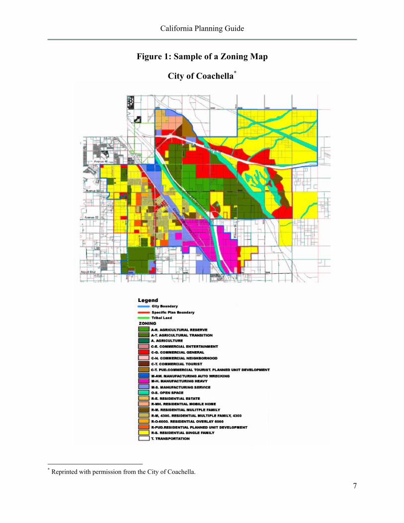
Figure 1: Sample of a Zoning Map
City of Coachella*
* Reprinted with permission from the City of Coachella.
California Planning Guide
8
Variances
A variance is a limited waiver of development standards allowed by the zoning ordinance. It may be granted, after a public hearing, in special cases where: (1) strict application of the zoning regulations would deprive property of the uses enjoyed by nearby lands in the same zone; and (2) restrictions have been imposed to ensure that the variance will not be a grant of special privilege.
A variance does not permit a use that is not otherwise allowed in that zone (for example, a commercial use may not be approved in a residential zone by variance). Economic hardship alone is not sufficient justification for approval of a variance.
Typically, variances are considered when the physical characteristics of the property make it difficult to use. For instance, in a situation where the rear half of a lot is a steep slope, a variance might be approved to allow a house to be built closer to the street than usually allowed.
Conditional Use Permits (CUPs)
Some types of land uses are only allowed upon approval of a conditional use permit (also called a CUP or special use permit) after a public hearing. These uses might include community facilities (i.e., hospitals or schools), public buildings or grounds (i.e., fire stations or parks), temporary or hard-to-classify uses (i.e., Christmas tree sales), or uses with potentially significant environmental impacts (i.e., hazardous chemical storage or surface mining). The local zoning ordinance specifies the uses for which a conditional use permit is required, the zones they may be allowed in, and the public hearing procedure.
A CUP imposes special development requirements to insure that the use will not be detrimental to its surroundings. Requirements might include, for example, additional landscaping, soundproofing, limited hours of operation, additional parking, or road improvements. A CUP does not rezone the land.
What is Smart Growth? Smart Growth is development that serves the economy, the community, and the environment. It changes the terms of the development debate away from the traditional growth/no growth question to “how and where should new development be accommodated.” Smart Growth answers these questions by simultaneously achieving:
• Healthy communities that provide families with a clean environment. Smart growth balances development and environmental protection – accommodating growth while preserving open space and critical habitat, reusing land, and protecting water supplies and air quality.
• Economic development and jobs that create business opportunities and improve local tax base; that provide neighborhood services and amenities; and that create economically competitive communities.
• Strong neighborhoods which provide a range of housing options giving people the opportunity to choose housing that best suits them. It maintains and enhances the value of existing neighborhoods and creates a sense of community.
• Transportation choices that give people the option to walk, ride a bike, take transit, or drive.
California Planning Guide
9
SUBDIVISIONS
In general, land cannot be subdivided in California without local government approval. Dividing land for sale, lease or financing is regulated by local ordinances based on the state Subdivision Map Act (commencing at Government Code Section 66410). The local general plan and the zoning, subdivision, and other ordinances govern the design of the subdivision, the size of its lots, and the types of improvements that will be required as conditions of approval.
There are basically two kinds of subdivisions: (1) parcel maps, which are limited to divisions resulting in fewer than 5 lots (with certain exceptions), and (2) subdivisions (or tract maps), which create 5 or more lots.
Tract maps and, where provided by local ordinance, parcel maps are approved in two stages.
Tentative Map
Upon receiving an application for a tentative subdivision map, the city or county staff will examine the design of the subdivision to ensure that it meets the requirements of the general plan and the subdivision ordinance. An environmental impact analysis must be done and an advertised public hearing held before a tentative map is considered for approval. If approved, the map will be subject to conditions that the subdivider must meet within a specific time period. While these conditions are being met, no lots have been officially approved.
Final Map
When all of the conditions set out in the approved tentative map have been satisfied,
and compliance certified by city or county officials, the city council or county board of supervisors will approve a final map. Unlike a tentative map, which can be denied if it does not meet city or county standards, the final map must be approved (with some exceptions) if it substantially complies with the previously approved tentative map. The subdivider may now record the map at the County Recorder's office.
Subdivision approval is conditioned upon the subdivider providing public improvements such as streets, drainage facilities, water supply or sewer lines to serve the subdivision. They may also be required to dedicate park land to the community. These improvements must be installed or secured by bond before the city or county will grant final map approval and allow the subdivision to be recorded in the county recorder's office.
Lots within the subdivision cannot be sold and are not legal divisions of land until a final map has been recorded. The subdivider has at least two years (and with extensions, usually more) in which to comply with the improvement requirements, gain final administrative approval, and record the final map.
PROJECT APPROVAL PROCESS
Permits
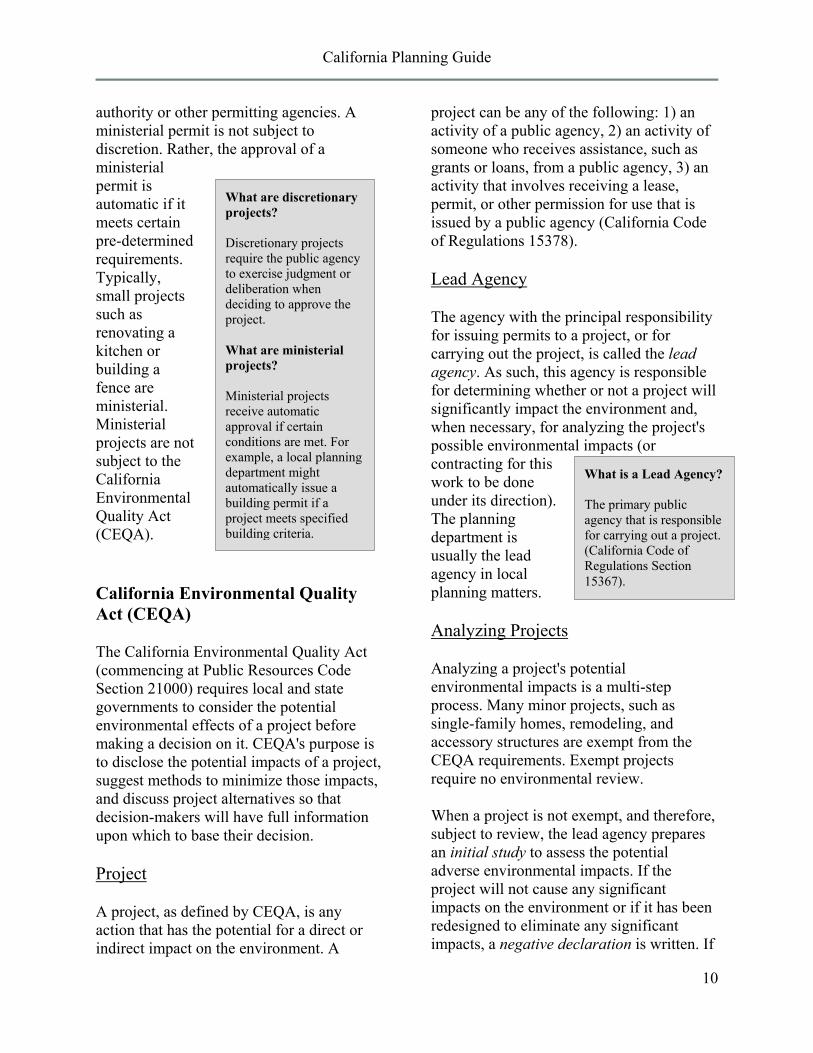
Most projects require one or more permits, depending upon state and local codes and regulations. Generally speaking, permits fall into two categories: discretionary and ministerial. A discretionary permit is subject to the evaluation, judgment, and approval or denial by the local planning
California Planning Guide
10
What is a Lead Agency? The primary public agency that is responsible for carrying out a project. (California Code of Regulations Section 15367).
authority or other permitting agencies. A ministerial permit is not subject to discretion. Rather, the approval of a ministerial permit is automatic if it meets certain pre-determined requirements. Typically, small projects such as renovating a kitchen or building a fence are ministerial. Ministerial projects are not subject to the California Environmental Quality Act (CEQA).
California Environmental Quality Act (CEQA)
The California Environmental Quality Act (commencing at Public Resources Code Section 21000) requires local and state governments to consider the potential environmental effects of a project before making a decision on it. CEQA's purpose is to disclose the potential impacts of a project, suggest methods to minimize those impacts, and discuss project alternatives so that decision-makers will have full information upon which to base their decision.
Project
A project, as defined by CEQA, is any action that has the potential for a direct or indirect impact on the environment. A
project can be any of the following: 1) an activity of a public agency, 2) an activity of someone who receives assistance, such as grants or loans, from a public agency, 3) an activity that involves receiving a lease, permit, or other permission for use that is issued by a public agency (California Code of Regulations 15378).
Lead Agency
The agency with the principal responsibility for issuing permits to a project, or for carrying out the project, is called the lead agency. As such, this agency is responsible for determining whether or not a project will significantly impact the environment and, when necessary, for analyzing the project's possible environmental impacts (or contracting for this work to be done under its direction). The planning department is usually the lead agency in local planning matters.
Analyzing Projects
Analyzing a project's potential environmental impacts is a multi-step process. Many minor projects, such as single-family homes, remodeling, and accessory structures are exempt from the CEQA requirements. Exempt projects require no environmental review.
When a project is not exempt, and therefore, subject to review, the lead agency prepares an initial study to assess the potential adverse environmental impacts. If the project will not cause any significant impacts on the environment or if it has been redesigned to eliminate any significant impacts, a negative declaration is written. If
What are discretionary projects? Discretionary projects require the public agency to exercise judgment or deliberation when deciding to approve the project. What are ministerial projects? Ministerial projects receive automatic approval if certain conditions are met. For example, a local planning department might automatically issue a building permit if a project meets specified building criteria.
California Planning Guide
11
What is Mitigation?
Measures taken to eliminate, avoid, rectify, compensate, or reduce environmental impacts.
EIR Contents
• Project description • Environmental Setting • Impacts
o Growth inducing o Cumulative
• Mitigation measures
significant environmental impacts are identified, then an Environmental Impact Report (EIR) must be written before the project can be considered by decision makers. Upon approval of a project for which a negative declaration is adopted or an EIR certified, the city or county must also adopt a monitoring program to ensure that the mitigation measures will be completed as required.
Both negative declarations and EIRs are objective, informational documents. They neither approve nor deny a project. Environmental analysis must be done as early as possible in the process of considering a project and must address the entire project. The CEQA Guidelines describes the different types of EIRs that may be prepared.
Negative Declaration and Mitigated Negative Declaration
A Negative Declaration (ND) describes why a project will not have any significant impacts on the environment. A Mitigated Negative Declaration (MND) describes a project that has incorporated changes, or mitigation measures, to ensure that there will be no significant impacts resulting from the project. The ND and the MND can be used only when significant impacts are totally eliminated. CEQA requires that NDs and MNDs be made available for review by the public and other agencies prior to approval of the project. The review period (a minimum of 20 days) allows concerned citizens and public agencies to comment on the contents and adequacy of the environmental
document prior to its adoption.
Environmental Impact Report (EIR)
An EIR discusses the proposed project, its environmental setting, its probable impacts, feasible means of reducing or eliminating those impacts, its cumulative effects in the context of other development, and feasible alternatives to the project. As opposed to NDs and MNDs, an EIR may conclude that there is no feasible way of eliminating all significant impacts, even after consideration of mitigation measures and alternatives to the project. Similar to Negative Declarations, CEQA requires a draft EIR to be made available to the public and public agencies for review. The review period is a minimum of 30 days, and allows citizens and agencies to comment on the document before its certification. The final EIR must incorporate written responses to the comments submitted by reviewers.
Project Approval
Before the lead agency approves a project, it must certify the adequacy of the Negative Declaration, Mitigated Negative Declaration, or EIR. If its decision to approve a project will result in unavoidable significant environmental impacts, the lead agency must state, in writing, its overriding reasons for granting the approval. In addition, when mitigation measures are adopted as a result of a Mitigated Negative Declaration or EIR, the lead agency must enact a program for reporting on or monitoring the implementation of those measures
California Planning Guide
12
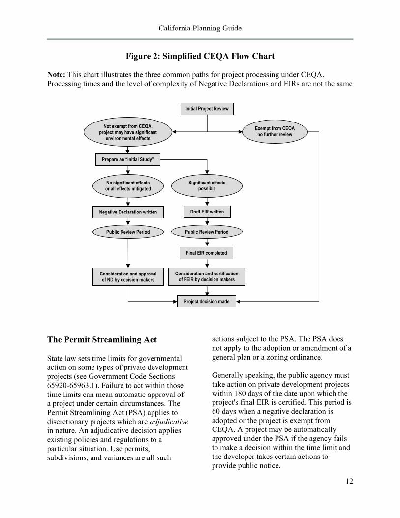
Figure 2: Simplified CEQA Flow Chart
Note: This chart illustrates the three common paths for project processing under CEQA. Processing times and the level of complexity of Negative Declarations and EIRs are not the same
The Permit Streamlining Act
State law sets time limits for governmental action on some types of private development projects (see Government Code Sections 65920-65963.1). Failure to act within those time limits can mean automatic approval of a project under certain circumstances. The Permit Streamlining Act (PSA) applies to discretionary projects which are adjudicative in nature. An adjudicative decision applies existing policies and regulations to a particular situation. Use permits, subdivisions, and variances are all such
actions subject to the PSA. The PSA does not apply to the adoption or amendment of a general plan or a zoning ordinance.
Generally speaking, the public agency must take action on private development projects within 180 days of the date upon which the project's final EIR is certified. This period is 60 days when a negative declaration is adopted or the project is exempt from CEQA. A project may be automatically approved under the PSA if the agency fails to make a decision within the time limit and the developer takes certain actions to provide public notice.
Initial Project Review
Prepare an “Initial Study”
Draft EIR written Negative Declaration written
Final EIR completed
Consideration and approval of ND by decision makers
Consideration and certification of FEIR by decision makers
Project decision made
Exempt from CEQA no further review
No significant effects or all effects mitigated
Significant effects possible
Public Review Period Public Review Period
Not exempt from CEQA, project may have significant
environmental effects
California Planning Guide
13
COMMON PLANNING TERMS
Terms used in this guide are in bold Accessory Use
An activity or structure that is incidental to the main use of a site. Building Envelope
The space remaining on a site for structures after all building setback, height limit, and bulk requirements have been met.
Capital Improvement Program A timetable for the installation of permanent public structures, facilities, roads, and other improvements based upon budget projections.
CEQA The California Environmental Quality Act (see Public Resources Code section 21000). CEQA requires that private and public projects' potential adverse effects upon the environment be reviewed by decision-makers.
Charter City A city which has been incorporated under its own charter rather than under the general laws of the state. Charter cities have broader powers than do general law cities.
Cluster Development Development which is clustered in a portion of a site, leaving the remainder in open-space. The amount of development allowed equals the amount that would have otherwise been allowed on the entire site.
COG Council of Governments. California's 25 COGs are regional planning agencies concerned primarily with transportation planning and housing; they do not directly regulate land use. Elected officials from each of the cities and counties belonging to the COG make up its governing board.
Community Plan A portion of the local general plan that focuses on a particular area or community within the city or county. Community plans supplement the contents of the general plan.
Conditional Use Permit (CUP) A permit authorizing a use not routinely allowed on a particular site, subject to a public hearing. If approval is granted, the developer must meet certain conditions to harmonize the project with its surroundings.
Dedication A grant of private land to a public agency for public use. Dedications are often used to obtain roads and parkland needed to serve a project.
Density Bonus An increase in the allowable number of residences granted by the city or county in return for the project's providing low- or moderate-income housing. (see Government Code section 65915)
Design Review Board A group appointed by the city council to consider the design and aesthetics of development within all or a portion of the community.

California Planning Guide
14
Development Agreement A binding contract between a developer and a city or county establishing the conditions under which a particular development may occur. The local government "freezes" the regulations applicable to the site for an agreed upon period of time. (see Government Code section 65864)
Development Fees Fees charged as a precondition to construction or development approval. The most common are: (1) impact fees (such as parkland acquisition fees, school facilities fees, or street construction fees) related to funding public improvements necessitated in part or in whole by the development; (2) connection fees (such as water fees) to cover the cost of installing public services to the development; (3) permit fees (such as building permits or grading permits) for the administrative costs of processing development plans; and, (4) application fees (rezoning, variance, etc.) for the administrative costs of reviewing and hearing development proposals.
Downzone A change of zoning to a more restrictive zone (for example, from multi-family residential to single-family residential).
EIR Environmental Impact Report. A detailed review of a proposed project, its potential adverse impacts upon the environment, measures that may avoid or reduce those impacts, and alternatives to the project.
Easement The right to use property owned by another for a specific purpose. Power line easements are a common example.
Eminent Domain The right of government to take private property for public use upon the payment of just compensation to the owner. This is also called condemnation (condemnation can also mean the closing of an unsafe structure by a public agency to protect the community safety).
Exaction A fee or dedication required as a condition of development permit approval.
Final Map Subdivision The final map must be filed before the tentative map expires. Approval of the final map is ministerial if all of the conditions of approval attached to the tentative map have been met.
Findings The legal "footprints" which an agency must leave to bridge the analytical gap between the raw data considered by the agency and its ultimate decision. They expose its mode of analysis of facts, regulations, and policies.
Floor Area Ratio (FAR) A measure of development intensity. FAR is the ratio of the floor area of a building to the area of its site. For instance, both a two-story building that covers an entire lot and a four-story building that covers 1/2 of a lot have FARs of 2.
General Law City A city incorporated under and subject to the general laws of the state.
California Planning Guide
15
General Plan A statement of policies, including text and diagrams, setting forth objectives, principles, standards, and plan proposals, for the future physical development of the city or county. (see Government Code section 65300)
"Granny" Housing An accessory dwelling for one or more elderly persons that is attached to or separate from a main residence. Government Code section 65852.1 allows cities and counties to approve such units in single-family neighborhoods.
Growth Management A local program limiting the rate of community growth. Growth management strategies vary, but they can include capping the annual number of building permits, relating allowable development intensity to certain levels of infrastructure service or limiting the location of new development.
Impact Fees See Development Fees.
Infrastructure A general term for public and quasi-public utilities and facilities such as roads, bridges, sewer plants, water lines, power lines, fire stations, etc.
Initial Study An analysis of a project's potential environmental effects and their relative significance. An initial study is preliminary to deciding whether to prepare a negative declaration or an EIR.
Initiative A ballot measure which has qualified for election as a result of voter petition. At the local level, initiatives usually focus on changes or additions to the general plan and zoning ordinance. The initiative power is reserved for the public by the California Constitution.
Inverse Condemnation The illegal removal of property value through excessive government regulation. Legal advice should be sought before proceeding in cases of potential inverse condemnation.
LAFCO The Cortese/Knox Act (see Government Code section 56000) establishes a Local Agency Formation Commission in each county. A LAFCO is made up of elected officials from the county, cities, and, in some cases, special districts. It administers the state law governing city incorporation and annexation proposals.
Mitigation Measure The California Environmental Quality Act requires that when an environmental impact or potential impact will occur, measures must be proposed that will eliminate, avoid, rectify, compensate for or reduce that effect.
Moratorium A halt to new development or the issuance of permits. Moratoria are often imposed while a new general plan or zoning ordinance is written or when sewer or water facilities are inadequate to serve additional development. (See Government Code section 65858)
Negative Declaration A negative declaration is written when a project is subject to CEQA, but will not have a significant effect upon the environment. The negative declaration describes why the
California Planning Guide
16
project will not have a significant effect and may propose measures that avoid all possible effects.
Nonconforming Use A land use which does not meet current zoning requirements.
Overlay Zone A zone which is superimposed upon other zoning. Overlay zones are used in areas which need special protection (as in a historic preservation district) or have special problems (such as steep slopes or flooding). Development of land subject to an overlay must comply with the regulations of both zones.
Parcel Map A minor subdivision resulting in fewer than 5 lots.
Planned Unit Development (PUD) Land use zoning which allows the adoption of a set of development standards that are specific to a particular project. PUD zones usually do not contain detailed development standards; those are established during the process of considering proposals and adopted by ordinance upon project approval.
Referendum A voter challenge to legislative action taken by a city council or county board of supervisors. If enough voters' signatures are filed before the legislative action becomes final, the council or board must either rescind its decision or call an election on the issue. The California Constitution guarantees the public's power of referendum.
School Impact Fees Fees imposed on new developments to offset their impacts on area schools.
Setback The minimum distance required by zoning to be maintained between two structures or between a structure and a property line.
Specific Plan A plan addressing land use distribution, open space availability, infrastructure, and infrastructure financing for a portion of the community. Specific plans put the provisions of the local general plan into action (see Government Code section 65450).
Sphere of Influence A plan for the "probable physical boundary and service area of a local agency" as approved by the LAFCO. It identifies the area available to a city for future annexation. However, unless another arrangement has been made, the city has no actual authority over land outside its city limits.
Spot Zoning The zoning of an isolated parcel in a manner which is inconsistent or incompatible with surrounding zoning or land uses, particularly if done to favor a particular landowner. A conditional use permit is not a spot zone.
Strip Development Commercial and high-density residential development located adjacent to major streets. This type of development is characterized by its shallow depth, street-oriented layout, lack of unified design theme, and numerous points of street access. It impedes smooth traffic flow.
California Planning Guide
17
Tentative Subdivision Map or Tentative Map The map or drawing illustrating a subdivision proposal. The city or county will conditionally approve or deny the proposed subdivision based upon the design depicted on the tentative map.
Tract Map See final map subdivision.
Transportation Systems Management (TSM) A program coordinating many forms of transportation (car, bus, carpool, rapid transit, bicycle, etc.) in order to distribute the traffic impacts of new development. Instead of emphasizing road expansion or construction, TSM examines methods of increasing road efficiency.
Variance A limited waiver from the requirements of the zoning ordinance. Variance requests are subject to public hearing and may only be granted under special circumstances.
Zoning Local codes regulating the use and development of property. The zoning ordinance divides the city or county into land use districts or "zones", illustrated on zoning maps, and specifies the allowable uses within each such zone. It establishes development standards such as minimum lot size, maximum structure height, building setbacks, and yard size.
California Planning Guide
18
SOURCES FOR MORE INFORMATION
The reader is encouraged to refer to the following sources for a better understanding of planning in California.
California Environmental Quality Act: Statutes and Guidelines (Resources Agency) The CEQA Guidelines describe the requirements for evaluating environmental impacts. Available online at http://ceres.ca.gov/ceqa/
California Land Use and Planning Law, by Daniel J. Curtin Jr., (Solano Press, Pt. Arena, California), revised annually. A look at the planning, zoning, subdivision, and environmental quality laws that is illustrated by references to numerous court cases.
The General Plan Guidelines (Governor's Office of Planning and Research, Sacramento, California). The Guidelines discuss local planning activities and how to write or revise a general plan. Available online at http://www.opr.ca.gov/publications/
Growth Within Bounds: Report of the Commission on Local Governance for the 21st Century, 2000. Recommendations on future local governance options, including LAFCO reform. Available online at http://www.opr.ca.gov/publications/
Guide to California Planning, by William J. Fulton (Solano Press, Point Arena, California). A lively, well-written discussion of nearly every aspect of planning in the State.
Subdivision Map Act Manual, by Daniel J. Curtin, Jr., (Solano Press, Pt. Arena, California). A practitioner's guide to the Map Act, including pertinent legal precedents.
California Statutes Full text of the following California Statutes may be found on the Official California Legislative Information website: www.leginfo.ca.gov/calaw.html CEQA Public Resources Code Sections 21000-21178 LAFCO Law Government Code Sections 56000-57550 Planning and Zoning Law Government Code Sections 65000-66037 General Plans Government Code Sections 65300-65404 Specific Plans Government Code Sections 65450-65457 Zoning Government Code Sections 65800-65863.13 Permit Streamlining Act Government Code Sections 65920-65963.1 Subdivision Map Act Government Code Sections 66410-66499.58