Embed Size (px)
Citation preview

California High-Speed Rail Authority
Burbank to Los AngelesProject Section
SupplementalAlternativesAnalysis
April 2016

California High-Speed Rail Project
Burbank to Los Angeles Project Section
SUPPLEMENTAL ALTERNATIVESANALYSIS REPORT
APRIL 2016

Statewide Program
The California High-Speed Rail Authority (Authority) is responsible for planning, designing, building andoperating the first high-speed rail in the nation. California high-speed rail will connect the mega-regions ofthe state, contribute to economic development and a cleaner environment, create jobs, and preserveagricultural and protected lands. When it is completed, it will run from San Francisco to the Los Angelesbasin in under three hours at speeds capable of exceeding 200 miles per hour. The system will eventuallyextend to Sacramento and San Diego, totaling 800 miles with up to 24 stations. In addition, we areworking with regional partners to implement a statewide rail modernization plan that will invest billions ofdollars in local and regional rail lines to meet the state’s 21st century transportation needs.
The California High-Speed Rail program is already delivering benefits to California, years before railoperations actually will begin. It has employed over 260 certified small businesses to work on planning,design and construction activities throughout the state, and is creating new jobs and trainingopportunities. Ultimately, High-Speed Rail will create 3,500 permanent jobs, in addition to tens ofthousands of temporary jobs designing and building the system. Once operational, the system willoperate on 100% renewable energy, providing a clean alternative to the current transportation optionsthat degrade air quality across the state.
As part of the program, the California High-Speed Rail Authority is working with regional partners toimplement a statewide rail modernization plan that will invest billions of dollars in local and regional raillines to meet the state’s 21st century transportation needs. The proposed projects would add capacity toallow for more rail service, construct new overcrossings to reduce local traffic delays and improve safety,and implement technologies to increase safety for all users. These improvements will provide immediatebenefits to existing rail services and local communities, while also setting the stage for future CaliforniaHigh-Speed Rail service.
Burbank to Los Angeles Section
The Burbank to Los Angeles Section will connect two key multi-modal transportation hubs, the BurbankAirport area, and Los Angeles Union Station, providing a critical link to the regional and statewidetransportation networks. The approximately 12-mile alignment generally follows the existing railroad right-of-way through the cities of Burbank, Glendale, and Los Angeles, adjacent to the Los Angeles River. Itwill provide new opportunities for economic development and revitalization near Burbank Bob HopeAirport. In preparation for high-speed rail, the corridor receive safety and efficiency benefits from newseparated crossings at most railroad intersections, as well as many upgrades to existing infrastructure.
The stations in Burbank and Los Angeles will provide connections to many destinations andtransportation options. Burbank serves as a gateway to the San Fernando Valley and key employmentand tourism centers. The planned station in Burbank is adjacent to Bob Hope Airport, which providescommercial airline service to destinations nationwide. Additionally, existing and planned Metrolink stationsand the recently opened Regional Intermodal Transportation Center at the Airport provide connectionsacross the region. An extension of the Metro Red Line to Burbank Bob Hope Airport is underconsideration that would link the site to Hollywood and Downtown Los Angeles. Los Angeles UnionStation is the region’s central transportation hub, providing access to Amtrak intercity rail, six Metrolinkcommuter rail lines, three local rail lines (with several more planned) and bus services from multipletransit agencies. It is adjacent to downtown Los Angeles, a massive employment and entertainment hubproviding more than 300,000 jobs.

Table of Contents
California High-Speed Rail Authority
Burbank to Los Angeles Project Section Supplemental Alternatives Analysis Page | i
TABLE OF CONTENTSES 1 Executive Summary .................................................................................................................. 1
ES 1.1 Burbank to Los Angeles Project Section Background ...................................................... 2ES 1.2 Collaborative Planning Approach .................................................................................... 4ES 1.3 Summary of Recommendations in the Supplemental Alternatives Analysis ..................... 6ES 1.4 Next Steps...................................................................................................................... 6
1 Introduction ............................................................................................................................... 71.1 Burbank to Los Angeles Project Section Background ...................................................... 71.2 Alternatives Development Approach ............................................................................... 8
1.2.1 Meeting Project Purpose and Need/Project Objectives .......................................... 81.2.2 Consistency with Business Plan Objectives ......................................................... 10
1.3 Collaborative Approach to Alternatives Evaluation ........................................................ 121.3.1 Project Objectives ............................................................................................... 121.3.2 Community.......................................................................................................... 121.3.3 Environmental Resources ................................................................................... 131.3.4 Collaborative Approach Results .......................................................................... 13
1.4 Agency and Community Outreach ................................................................................ 131.4.1 Summary of Public Scoping and Agency Meetings .............................................. 141.4.2 Summary of Community Open House Meetings .................................................. 151.4.3 Summary of Stakeholder Working Group Meetings.............................................. 161.4.4 Summary of Regional Agency Activities............................................................... 161.4.5 Summary of Corridor Community Activities .......................................................... 171.4.6 Summary of Environmental Justice Outreach Efforts ........................................... 181.4.7 Record of Outreach Briefings .............................................................................. 18
2 Methodology ........................................................................................................................... 192.1 Alternatives Analysis Methods ...................................................................................... 192.2 Alternatives Analysis Criteria ........................................................................................ 20
3 Description of Alternatives ..................................................................................................... 243.1 Previously Identified Alternatives .................................................................................. 24
3.1.1 Burbank Airport Station to SR-2 .......................................................................... 273.1.2 SR-2 to LAUS ..................................................................................................... 27
3.2 2016 Analysis and Refinements .................................................................................... 283.2.1 Burbank Airport Station to Alameda Avenue ........................................................ 283.2.2 Alameda Avenue to SR-2 — Refine At-Grade Alignment ..................................... 283.2.3 SR-2 to LAUS —Refine At-Grade Alignment ....................................................... 283.2.4 SR-2 to LAUS — Withdraw Tunnel Alignments .................................................... 293.2.5 Los Angeles Union Station — Withdraw Elevated Platform Option ....................... 31
3.3 Description of 2016 SAA Alternative ............................................................................. 313.3.1 Burbank Airport Station to Alameda Avenue ........................................................ 313.3.2 Alameda Avenue to SR-2 .................................................................................... 333.3.3 SR-2 to LAUS ..................................................................................................... 33
4 Alternatives Evaluation ........................................................................................................... 364.1 Key Differences Between Options ................................................................................. 374.2 Areas of No Difference ................................................................................................. 38
5 Recommendation .................................................................................................................... 39

Table of Contents
California High-Speed Rail Authority
ii | Page Burbank to Los Angeles Project Section Supplemental Alternatives Analysis
TablesTable 1-1 Community Meetings since August 2014 ...................................................................... 14Table 1-2 Key Community Themes, Concerns, and Project Coordination ...................................... 17Table 2-1 Design Objectives......................................................................................................... 20Table 2-2 High-Speed Rail Alternatives Analysis Evaluation Measures ......................................... 21Table 3-1 Burbank to Los Angeles Alignment Alternatives and Station Options ............................. 25Table 4-1 Summary of Distinguishing Evaluation Measurement Criteria ........................................ 36Table 4-2 Evaluation Criteria with No Difference Between Design Options .................................... 38Table 5-1 Alternatives Refinement and Evaluation Summary ........................................................ 40
FiguresFigure ES-1 Environmental and Alternatives Analysis Processes ....................................................... 1Figure ES-2 Burbank to Los Angeles Project Section Overview .......................................................... 3Figure ES-3 Collaborative Approach .................................................................................................. 4Figure ES-4 Evolution of Alternatives ................................................................................................. 5Figure ES-5 On-Going Community Engagement ................................................................................ 6Figure 1-1 Collaborative Approach ................................................................................................ 12Figure 3-1 Alignment Alternatives and Station Locations Carried Forward in the 2014 SAA............ 26Figure 3-2 2016 Design Refinements in the SR-2 to LAUS Subsection .......................................... 30Figure 3-3 2016 SAA Alternative and Design Options .................................................................... 32Figure 3-4 Alameda Avenue to SR-2 – Dedicated Alignment Cross-Section ................................... 33Figure 3-5 SR-2 to SR-110 – Shared Option Cross-Section ........................................................... 34Figure 3-6 SR-110 to Mission Junction – Shared Option Cross-Section ......................................... 34Figure 3-7 SR-2 to SR-110 – Dedicated Option Cross-Section ....................................................... 35Figure 3-8 SR-110 to Mission Junction – Dedicated Option Cross-Section ..................................... 35
AppendicesAppendix A Detailed Evaluation TableAppendix B Outreach Summary Table
Table of Contents
California High-Speed Rail Authority
Burbank to Los Angeles Project Section Supplemental Alternatives Analysis Page | iii
ABBREVIATIONS AND ACRONYMSAA Alternatives AnalysisAmtrak National Railroad Passenger CorporationAuthority California High-Speed Rail AuthorityCaltrans California Department of TransportationCARB California Air Resources BoardCDFW California Department of Fish and WildlifeCEQA California Environmental Quality ActCMF Central Maintenance FacilityCWA Clean Water ActDTSC California Department of Toxic Substances ControlEIR Environmental Impact ReportEIS Environmental Impact StatementFRA Federal Railroad AdministrationGIS Geographic Information SystemsHSR High-Speed RailIOS Initial Operating SegmentLADOT City of Los Angeles Department of TransportationLAP Los Angeles to Palmdale (Former Extent of the Burbank to Los Angeles Section)LAUS Los Angeles Union StationLOS level-of-serviceMetro Los Angeles County Metropolitan Transportation AuthorityMetrolink Southern California Regional Rail AuthorityNEPA National Environmental Policy ActNOI Notice of IntentNOP Notice of PreparationPAA Preliminary Alternatives AnalysisSAA Supplemental Alternatives AnalysisSCRIP Southern California Regional Interconnector ProjectSCRRA Southern California Regional Rail AuthoritySHPO California State Historic Preservation OfficeSR State RouteSTB Surface Transportation BoardSWG Stakeholder Working GroupTOD Transit-Oriented DevelopmentUPRR Union Pacific RailroadUSACE U.S. Army Corps of EngineersUSEPA U.S. Environmental Protection AgencyUSFWS U.S. Fish and Wildlife Service

Executive Summary
California High-Speed Rail Authority
Burbank to Los Angeles Project Section Supplemental Alternatives Analysis Page | 1
ES 1 Executive SummaryThe California High-Speed Rail Authority (Authority) is responsible for planning, designing, building, andoperation of the first high-speed rail system in the nation. The California High-Speed Rail System willconnect the mega-regions of the state, contribute to economic development and a cleaner environment,create jobs, and preserve agricultural and protected lands. By 2029, the system will run from SanFrancisco to the Los Angeles basin in under three hours at speeds of over 200 miles per hour. Thesystem will eventually extend to Sacramento and San Diego, totaling 800 miles with up to 24 stations.
The system is being developed in sections; this report presents the Supplemental Alternatives Analysis(SAA) for the Burbank to Los Angeles Project Section.
The purpose of the SAA process is to describe the range of alternatives considered for the Burbank toLos Angeles Project Section, and to do the following: (1) evaluate whether the alternatives meet the High-Speed Rail Project objectives and the purpose and need; (2) evaluate and disclose the potential impactsof the alternatives based on a screening level of information, (3) evaluate whether the alternatives arepotentially feasible and reasonable; and (4) either recommend alternatives for further study in theenvironmental clearance process or withdraw them from further evaluation. Figure ES-1 illustrates thisprocess as a part of the California Environmental Quality Act (CEQA) and the National EnvironmentalPolicy Act (NEPA) evaluation processes.
This SAA informs the project description in the project-level environmental documents that will complywith CEQA and NEPA requirements. It also sets parameters for the environmental analysis and design.
Figure ES- 1 Environmental and Alternatives Analysis Processes

Executive Summary
California High-Speed Rail Authority
2 | Page Burbank to Los Angeles Project Section Supplemental Alternatives Analysis
ES 1.1 Burbank to Los Angeles Project Section Background
The Burbank to Los Angeles Project Section of the California High-Speed Rail system is approximately12 miles long, starting from the proposed Burbank Airport Station in the City of Burbank and ending atLos Angeles Union Station (LAUS) in the City of Los Angeles. This corridor runs through a narrow andconstrained urban environment along an existing rail corridor. Within the existing rail corridor, the LosAngeles County Metropolitan Transportation Authority (Metro) owns the rail right-of-way, the SouthernCalifornia Regional Rail Authority owns the track and operates the Metrolink commuter rail service,Amtrak provides intercity passenger service, and the Union Pacific Railroad (UPRR) holds track accessrights and operates freight trains.
In 2014, the Authority published a Palmdale to Los Angeles SAA Report and held scoping meetings toseparate Burbank to Los Angeles into a distinct project section for study. One of the main reasons for theproject section split was the Initial Operating Section (IOS) concept and its interim terminus in the SanFernando Valley, which was discussed in the Authority’s 2012 and 2014 Business Plans. Additionally, theAuthority and Federal Railroad Administration (FRA) determined that separate environmental documentswould be more beneficial to address environmental impacts and conduct stakeholder outreach, becausekey environmental resources likely to be impacted were different between the two areas, and separateenvironmental documents better supported project phasing and sequencing. Since then, the Authorityand FRA have completed additional analysis on this project section and have prepared this SAA todescribe the updates.
Figure ES- 2 illustrates the potential range of alternatives for the Burbank to Los Angeles Project Section,which have been refined based on feedback from communities and resource agencies and on newtechnical information. A single build alternative with options is recommended to be carried forward, alongwith the No-Project Alternative, as the reasonable range of alternatives for the Project to be analyzed indepth in project-level environmental documents, which will be subsequently circulated for public reviewand comment.

Executive Summary
California High-Speed Rail Authority
Burbank to Los Angeles Project Section Supplemental Alternatives Analysis Page | 3
Refined alignments reflect feedback from communities, resourceagencies, and additional technical information obtained.
Figure ES- 2 Burbank to Los Angeles Project Section Overview
March 30, 2016

Executive Summary
California High-Speed Rail Authority
4 | Page Burbank to Los Angeles Project Section Supplemental Alternatives Analysis
ES 1.2 Collaborative Planning Approach
The Authority evaluates project alternatives using systemperformance criteria that address design differences andqualities, and correspond to the project’s Purpose and Needand objectives. The Authority considers input fromstakeholders through a collaborative approach to alternativesevaluation shown in Figure ES-3. This approach seeks toavoid or minimize potential impacts by balancing the projectobjectives, environmental resources, and community concernsfor any given alternative.
As part of this collaborative approach, the Authority has heldseveral meetings to engage with stakeholders and solicitfeedback. The 2010 Preliminary Alternatives Analysis (PAA),2011 SAA, and 2014 SAA include descriptions of the outreachmeetings the Authority conducted to inform the reports. ThisSAA provides a list of meetings held since the California High-Speed Rail Authority Board of Directors (Authority Board) wasbriefed on the 2014 SAA on June 3, 2014; the list is found inAppendix B.
In addition, the Authority released a Notice of Preparation (NOP), and the FRA published a Notice ofIntent (NOI) for the Palmdale to Burbank and Burbank to Los Angeles Project Sections on July 24, 2014.The concept of splitting the Palmdale to Los Angeles Project Section into two sections was introduced inthe 2014 SAA and was implemented with the release of the NOPs/NOIs. In relation to these NOPs/NOIs,the Authority hosted seven scoping meetings in August 2014 throughout the project area between theCities of Palmdale and Los Angeles. These meetings were held to allow public agencies and themembers of the general public to provide comments on the types of analyses to be included in thePalmdale to Burbank and Burbank to Los Angeles environmental documents.
The feedback from these public meetings was used to develop the alternatives and design refinements,which were shared with the public after the scoping period in Fall 2014. These efforts are described inmore detail Section 1.4. A summary of the meetings include the following:
· Five open house meetings held between May and June 2014· Seven public scoping meetings held in August 2014· Three open house meetings held in November 2015· One Stakeholder Working Group meeting held in November 2015
Feedback from the public has included concerns over the following:
· Potential noise and vibration· Potential visual impacts· Potential impacts to community character· Potential impacts to the Los Angeles River· Project cost and funding· Potential right-of-way impacts· Consistency with local planning· Other potential impacts as documented in this report
Figure ES- 4 shows the results of the collaborative planning process; the route concepts and thegeographic boundaries have evolved over the years, with this SAA consolidating and redefiningsubsections for analysis.
The alternative development processseeks to balance project objectives,natural resources, and the protection ofcommunity character.
Figure ES- 3 Collaborative Approach

Executive Summary
California High-Speed Rail Authority
Burbank to Los Angeles Project Section Supplemental Alternatives Analysis Page | 5
The collaborative planning process is reflected in the evolution of route conceptssince 2010. The changes in the geographic boundaries have also changed overthe years, with this SAA consolidating and redefining old subsections for analysis.
Figure ES- 4 Evolution of Alternatives
March 28, 2016

Executive Summary
California High-Speed Rail Authority
6 | Page Burbank to Los Angeles Project Section Supplemental Alternatives Analysis
ES 1.3 Summary of Recommendations in the Supplemental AlternativesAnalysis
Based on the additional design work, outreach, and analysis conducted after the 2014 SAA, this 2016SAA recommends eliminating the following 2014 SAA alignment alternatives and station options:
· Eliminate the option of high-speed rail along the eastern limits of the existing railroad right-of-wayfrom further consideration.
· Eliminate tunnel alternatives (LAPT1 and LAPT3) from further consideration.· Eliminate the elevated station platform option at LAUS from further consideration.
The 2016 refinement work incorporated new technical information, and this SAA recommends carryingforward the following build alternatives and options:
· Carry forward two station options at Burbank Airport Station and two alternatives from BurbankAirport Station to Alameda Avenue (further detail is provided in the 2016 Palmdale to Burbank SAA).
· Carry forward one at-grade alternative from Alameda Avenue to LAUS, with two design options fromSR-2 to LAUS.
· Carry forward at-grade station platforms at LAUS.
These recommendations above may be subject to concurrence by the U.S. Army Corps of Engineers(USACE) and the U.S. Environmental Protection Agency (USEPA) as well as to further evaluation in theCEQA/NEPA environmental review process.
ES 1.4 Next Steps
The previously completed SAA Reports and this document establish that the alignments being carriedforward for detailed study in the project-level environmental document sufficiently meet project objectivesand purpose and need, are potentially feasible and reasonable, and have varying levels of environmentaland community impacts. Authority staff will continue engaging with local government and the public; theongoing community engagement process is illustrated in Figure ES- 5. Additionally, Authority and FRAstaff will work with the USACE and the USEPA to finalize alternatives to be evaluated in the project-levelenvironmental document.
Figure ES- 5 On-Going Community Engagement

1 Introduction
California High-Speed Rail Authority
Burbank to Los Angeles Project Section Supplemental Alternatives Analysis Page | 7
1 IntroductionThe California High-Speed Rail Authority (Authority) isassessing alternatives for the California High-Speed Railproject section between Burbank and Los Angeles todetermine reasonable alternatives that merit detailed studyin a project-level environmental document. This report buildsupon the Alternatives Analysis (AA) reports completedpreviously, and presents the changes that have been madein response to stakeholder input and new technicalinformation. These new technical developments include the emphasis on phased implementation of theHigh-Speed Rail system and implementation of a blended system that meets the goals of providing aone-seat ride from San Francisco to Los Angeles and Anaheim.
While this 2016 Supplemental Alternative Analysis (SAA) Report considers alternatives within a smallsection of the entire high-speed rail network, these alternatives are evaluated in the context of the High-Speed Rail system as a whole to meet the High-Speed Rail Project goals. For example, alternatives inindividual project sections that may increase travel time and/or disproportionately increaseimplementation cost could cumulatively influence how the High-Speed Rail system can meet its program-wide goals.
The purposes of this SAA are as follows:
· Provide screening environmental and preliminary engineering information on a range of alternativesconsidered for the Burbank to Los Angeles Project Section (referred to as the Project Sectionthroughout this document)
· Report how the range of alternatives considered either meet or do not meet the High-Speed Railobjectives and project purpose and need
· Identify potential broad impacts associated with each alternative to environmental resources
· Recommend alternatives for additional analysis in the environmental clearance process or theirwithdrawal from further evaluation
1.1 Burbank to Los Angeles Project Section Background
The Burbank to Los Angeles Project Section of the High-Speed Rail system is approximately 12 mileslong, starting from the proposed Burbank Airport Station in the City of Burbank, traveling through the Cityof Glendale, and ending at Los Angeles Union Station (LAUS) in the City of Los Angeles. This ProjectSection runs through a narrow and constrained urban environment, and generally travels along theexisting rail corridor and adjacent to the Los Angeles River. Within the existing rail corridor, the LosAngeles County Metropolitan Transportation Authority (Metro) owns the railroad right-of-way, theSouthern California Regional Rail Authority owns the track and operates the Metrolink commuter railservice, Amtrak provides intercity passenger service, and the Union Pacific Railroad (UPRR) holds trackaccess rights and operates freight trains.
The Burbank to Los Angeles Project Section is an essential part of the statewide High-Speed RailSystem. It would provide a new transportation option contributing to increased mobility and improvedaccess to major urban areas throughout California. The High-Speed Rail plans for this area have evolvedthroughout the years, not only in response to stakeholder input, but also because of changes to theoverall High-Speed Rail program and to the adjoining project sections.
Previously, the 2010 Palmdale to Los Angeles Preliminary Alternative Analysis (PAA) recommendedalignment alternatives and station options for the Palmdale to Los Angeles Project Section based on theprogram-level corridor selected in 2005. The 2011 Palmdale to Los Angeles SAA focused specifically onthe subsections from the community of Sylmar to LAUS, and reevaluated the alternatives and station
Section 1 at a Glance—In this section you will find thefollowing information:
� Burbank to Los Angeles Project Section Background� Alternatives Development Approach� Collaborative Approach to Evaluation of Alternatives� Agency and Community Outreach and Input

1 Introduction
California High-Speed Rail Authority
8 | Page Burbank to Los Angeles Project Section Supplemental Alternatives Analysis
options. The 2014 Palmdale to Los Angeles SAA reevaluated the entire project section, incorporating theconclusions from the previous AA reports, and recommended the following:
· Divide the Palmdale to Los Angeles Project Section into two separate High-Speed Rail projectsections: Palmdale to Burbank and Burbank to Los Angeles
· Reintroduce a high-speed rail alignment along the west side of the railroad right-of-way, withMetrolink tracks along the east side, throughout the San Fernando Valley
· Withdraw both the Branford Street and San Fernando Station Options in the San Fernando Valley,and carry forward the Burbank Airport Station Option
· Slightly shift the tunnel approach alternative alignment east to accommodate an at-grade or elevatedconnection to LAUS
This 2016 SAA Report is consistent with the 2014 Notice of Preparation (NOP)/Notice of Intent (NOI) andhas been informed by the subsequent scoping process and the 2014 and Draft 2016 Business Plans.These developments led to an update of the geographic boundaries used for analysis in this SAA. TheBurbank to Los Angeles Project Section originates at Burbank Airport Station and terminates at LAUS,and will be analyzed as such in future environmental documents. Previously, the areas between Burbankand Los Angeles had been analyzed within three subsections: from the community of Sylmar to StateRoute 2 (SR-2), from SR-2 to the Metrolink Central Maintenance Facility (CMF), and from the MetrolinkCMF to LAUS. This SAA Report consolidates these previously considered subsections. The alignmentoptions for the portion of the Burbank to Los Angeles Section from Burbank Airport Station south toAlameda Avenue are dependent on the alignment alternatives for the Palmdale to Burbank Section.Consequently, the SAA analysis of the portion of the Burbank to Los Angeles Section from BurbankAirport Station south to Alameda Avenue is provided in the 2016 Palmdale to Burbank SAA, and isprovided here only by reference. In addition, this SAA does not alter the alternatives proposed from northof Alameda Avenue to the proposed Burbank Airport Station as recommended in the 2016 Palmdale toBurbank SAA, which includes three refined alignment alternatives and two station options.
Since the 2014 Palmdale to Los Angeles SAA, the Authority has continued to refine the alternatives byresponding to community feedback and by performing additional engineering and environmental analysis.This SAA Report documents the additional analysis and refinement work performed for the alignment andstation configuration options, and provides recommendations for withdrawal or further consideration in theBurbank to Los Angeles Project Section environmental process.
1.2 Alternatives Development Approach
Through the alternatives screening process, the Authority and the FRA seek to identify a reasonablerange of alternatives for detailed study by defining station and alignment configurations that would meetthe project’s purpose and need and the agencies’ goals and objectives, and that would be potentiallyfeasible. Additionally, in the alternatives screening process, the Authority and FRA identify areas ofpotential environmental impacts, and conduct a comparative evaluation of the alternatives. Everyconceivable alternative to a project need not be evaluated. Rather, when multiple potentially feasibleoptions exist, a reasonable range of alternatives is considered. Alternatives that are not potentiallyfeasible or that do not meet the basic purpose and need are not required to be considered.
The following sections summarize the Authority’s goals and objectives found within its purpose and needand the 2014 and Draft 2016 Business Plans. Section 2 provides detailed descriptions of theenvironmental and engineering criteria that are used to determine an alternative’s feasibility.
1.2.1 Meeting Project Purpose and Need/Project Objectives
The Authority is responsible for planning, designing, building, and operation of the High-Speed RailSystem and ensuring coordination with California’s existing transportation network. This SAA comparesthe proposed alternatives against the High-Speed Rail System purpose and need as described in the2005 Statewide Program Environmental Impact Report (EIR)/Environmental Impact Statement (EIS):

1 Introduction
California High-Speed Rail Authority
Burbank to Los Angeles Project Section Supplemental Alternatives Analysis Page | 9
The purpose of the statewide [High-Speed Train] HST system is to provide a reliable high-speed electric-powered train system that links the major metropolitan areas of the state,and that delivers predictable and consistent travel times. A further objective is to providean interface with commercial airports, mass transit, and the highway network, and to relievecapacity constraints of the existing transportation system as increases in intercity traveldemand in California occur, in a manner sensitive to and protective of California’s uniquenatural resources (Authority and FRA 2005).
The Burbank to Los Angeles Project Section purpose and need, as described in the 2014 Burbank to LosAngeles Scoping Report, is:
The purpose of the Project is to implement the Burbank to Los Angeles High-Speed Rail ProjectSection of the California High-Speed Rail System; to provide the public with electric-poweredhigh-speed rail service that provides predictable and consistent travel times between major urbancenters, and connectivity to airports, mass transit systems, and the highway network in the SanFernando Valley and the Los Angeles basin; and to connect the North and Southern portions ofthe Statewide High-Speed Rail System, also allowing direct connectivity with existing regional railnetworks in the Los Angeles area. (Authority and FRA, 2014).
If a project would discharge dredged or fill material into waters of the United States, Section 404 of theClean Water Act (CWA) requires a permit from the United States Army Corps of Engineers (USACE). If aCWA Section 404 individual permit is required, the preparation of a Section 404(b)(1) AlternativesAnalysis is required. For CWA Section 404(b)(1) compliance, the USACE must take into consideration theapplicant’s needs in the context of the geographic area of the proposed action and the type of projectbeing proposed. Both the USACE and U.S. Environmental Protection Agency (USEPA) have agreed toparticipate as cooperating agencies under NEPA, and they have concurred on the High-Speed RailProject purpose and need. The USACE has determined that the overall project purpose (as stated above)allows for a reasonable range of practicable alternatives to be analyzed and is acceptable as the basis forthe USACE 404(b)(1) AA.
The Authority has adopted the following objectives for the proposed High-Speed Rail Project, which areincluded in the 2005 Statewide Program EIR/ EIS:
· Provide intercity travel capacity to supplement critically overused interstate highways and commercialairports.
· Meet future intercity travel demand that will be unmet by present transportation systems and increasecapacity for intercity mobility.
· Maximize intermodal transportation opportunities by locating stations in areas with good access tolocal mass transit or other modes of transportation.
· Improve the intercity travel experience for Californians by providing comfortable, safe, frequent, andreliable high-speed travel.
· Provide a sustainable reduction in travel time between major urban centers
· Increase the efficiency of the intercity transportation system.
· Reduce potential impacts on communities and the environment by having the alignment followexisting transportation or utility corridors to the extent feasible.
· Develop a practical and economically viable transportation system that can be implemented inphases and generate revenues in excess of operations and maintenance costs.
· Provide intercity travel in a manner that minimizes urban sprawl, is sensitive to and protective of theregion’s natural resources, and reduces emissions and vehicle miles traveled for intercity trips.

1 Introduction
California High-Speed Rail Authority
10 | Page Burbank to Los Angeles Project Section Supplemental Alternatives Analysis
· Preserve wildlife corridors and mitigate potential impacts to wildlife movement where feasible in orderto limit the extent to which the system may present an additional barrier to wildlife’s naturalmovement.
1.2.2 Consistency with Business Plan Objectives
1.2.2.1 Business Plan
The Authority publishes a business plan according to statute every two years that serves as thefoundational document for implementing the state’s high-speed rail system. The plan includes progress todate, updates information and forecasts and identifies key milestones and decisions. It includes adescription of the proposed service, expected patronage, operating and maintenance costs, anticipatedcosts and funding, environmental and construction schedules for the Phase 1 segments and programrisks.
1.2.2.2 Previous Business Plans
In 2012, the Authority adopted its 2012 Business Plan that laid out a newframework for implementing the California High-Speed Rail system inconcert with other state, regional and local rail investments, as part of abroader statewide rail modernization program. In that same year, theLegislature approved – and Governor Brown signed into law – Senate Bill1029 (Budget Act of 2012) approving almost $8 billion in federal andstate funds for the construction of the first high-speed rail investment inthe Central Valley and 15 bookend and connectivity projects throughoutthe state. In 2014, the Authority adopted its 2014 Business Plan that builton and updated the 2012 Business Plan, implementing the requirementsof Senate Bill 1029.
The Authority issued a Draft 2014 Business Plan on February 7, 2014,received and considered public comments, and published the 2014Business Plan on April 30, 2014. The 2014 Business Plan:
· Updated forecasts and estimates informed by rigorous externalscrutiny
· Introduced a risk-based breakeven analysis that continued to show financial viability
· Confirmed that the system will be an attractive private sector investment opportunity
1.2.2.3 Draft 2016 Business Plan
On February 18, 2016, the Authority released its Draft 2016 Business Planfor a 60-day public comment period. At this time, the comment period isopen and the Authority Board is anticipated to take up adoption of theDraft 2016 Business Plan at its April 21, 2016 meeting.
The Draft 2016 Business Plan has three fundamental objectives:
· First, initiate high-speed rail passenger service as soon as possible,which will demonstrate the benefits of the project and begin generatingrevenues to then attract private sector participation and help fundextending the system beyond an initial line.
· Second, make strategic, concurrent investments throughout thesystem that will be linked together over time. By making discreteinvestments that connect state, regional, and local rail systems, theproject can provide immediate mobility, environmental, economic and

1 Introduction
California High-Speed Rail Authority
Burbank to Los Angeles Project Section Supplemental Alternatives Analysis Page | 11
community benefits. Together these prepare a solid foundation for high-speed rail and provide forearly implementation of projects that will be required for High-Speed Rail construction. The Authoritywill enter into partnering agreements with other transportation providers, aggregate federal, state, andlocal funding sources, and advance regional planning and coordination. This approach will yield thebest and fastest results.
· Third, position the Authority to construct additional segments as funding becomes available. Thisrequires completing the required environmental analyses for every mile of the program and securingenvironmental approvals as soon as possible. Additionally, environmental clearance positionsconcurrent investments in blended corridors for funding ahead of full segment implementation.
1.2.2.4 Difference between 2014 and Draft 2016 Business Plan
Following are the differences between the 2014 and Draft 2016 Business Plans:
· Funding—The funding authorized by the Governor and Legislature, by the federal government andthe people of California is sufficient to deliver a high-speed rail line connecting the Silicon Valley tothe Central Valley.
· Schedule—The Authority now projects starting passenger service on the Silicon Valley to the CentralValley line in 2025 instead of on a line between Merced and the San Fernando Valley in 2022.
· Cost Estimates—The capital cost estimates for building the Phase 1 system between SanFrancisco/Merced and Los Angeles/Anaheim are lower than prior estimates.
1.2.2.5 SAA consistency with the Business Plan
The alternatives considered in this SAA are consistent with the goals and objectives laid out in the Draft2016 Business Plan and previously iterated in the 2014 Business Plan. Advancing the environmentalclearance of the program allows the program to be construction-ready which will maximize flexibility tocapture new funding opportunities. Additionally, it will provide greater certainty about route and stationlocations to help local communities and transport partners with their planning decisions.
The Burbank to Los Angeles Project Section alternatives will utilize a blended service approach toconnect two key multi-modal transportation hubs, connecting the San Fernando Valley and DowntownLos Angeles. Benefits will be multiplied by investing in core capacity for passenger rail service in theurban core that improves safety and efficiency of existing passenger and freight rail service while pavingthe way for High-Speed Rail.

1 Introduction
California High-Speed Rail Authority
12 | Page Burbank to Los Angeles Project Section Supplemental Alternatives Analysis
1.3 Collaborative Approach toAlternatives Evaluation
This SAA documents how each of the alternativesmeets the purpose and need for the project. ThisSAA also describes how evaluation measuresapplied through a collaborative process helped theAuthority determine recommendations foralternatives to be carried forward for environmentalanalysis and which did not meet the evaluationmeasures and will not be carried forward for furtheranalysis.
The SAA process is intended to provide theAuthority and the FRA with sufficient informationand documentation on how evaluation measuresand criteria have been applied to potentialalternatives to optimize project objectives, minimizepotential environmental impacts, and identify projectinformation from the communities along thecorridor. Figure 1-1 shows the collaborativeapproach to the alternatives evaluation. The threekey areas of the collaborative approach aresummarized below.
1.3.1 Project Objectives
The project objectives that will lead to the selection of a preferred alternative are driven by safety, traveltime, reliability, cost, environmental impacts, and operation of the High-Speed Rail system. At each stageof development, the Authority performs extensive technical evaluation on proposed alternatives to makesure that they meet the objectives of the future operation of high-speed rail service. Several of the keyconsiderations that will ultimately drive the success of the project are also some of the most difficult toachieve, and they include:
· Connecting major population areas—Place stations in the major urban centers to bring the train tothe greatest number of people and maximize ridership of the system.
· Network integration with existing systems—Place stations next to existing and plannedtransportation centers to provide seamless multimodal transfers and system-wide transportationimprovements.
· Cost effectiveness—Accomplish these goals cost-effectively, and to the extent possible, multiply thebenefits of each dollar invested across the wider multimodal network and the broader community.
1.3.2 Community
The Authority has developed and is implementing an intensive stakeholder engagement program, whichsupports the development of alternatives during the environmental process, and ultimately informs theselection of a preferred alternative. To date, more than 90 meetings, briefings, and conversations havebeen held to gather, confirm, and understand key community concerns so they can be incorporated intothe balancing process defined in Section 1.3.
The collaborative approach balances projectobjectives, natural resources, and communityconcerns.
Figure 1-1 Collaborative Approach
1 Introduction
California High-Speed Rail Authority
Burbank to Los Angeles Project Section Supplemental Alternatives Analysis Page | 13
1.3.3 Environmental Resources
Environmental resource considerations are guided byfederal laws, state laws, and local considerations,which protect natural resources and inform decisionmakers and the public about potential environmentaleffects of project alternatives. Feedback fromcommunity members and stakeholders also helpsfocus attention on environmental resources of concern.Environmental resources are largely protected by lawsand regulations administered by government agencies,which are listed in Section 1.4.
1.3.4 Collaborative Approach Results
The collaborative approach has led to an evolution of the alternatives considered for this Project Sectionsince 2010. This collaborative approach will continue to inform the process through selection of apreferred alternative and decisions by the Authority and FRA under CEQA/ NEPA.
Figure ES- 4 shows an overview of major changes resulting from the collaborative approach, includingthe changes in geographic boundaries used for analysis. The AA process for this Project Section can bebriefly summarized as follows:
· In 2010, the PAA built upon the 2005 Programmatic EIR/EIS and recommended several alignmentsand seven station options for further environmental analysis.
· The 2011 SAA evaluated the Sylmar to LAUS subsections (while the Palmdale to Sylmar subsectionswere evaluated in a separate SAA in 2012.)
· The 2014 SAA reevaluated the alternatives from Palmdale to Los Angeles. In fall of 2014, through theenvironmental scoping process, the Palmdale to Los Angeles Project Section was split into thePalmdale to Burbank and Burbank to Los Angeles Project Sections.
· Additional analysis for the Burbank to Los Angeles Project Section began in early 2015, and thealternatives were refined.
This 2016 SAA continues the evaluation process and makes recommendations that are summarized inSection 4.
1.4 Agency and Community Outreach
Agency and community input is a critical component to the alternatives analysis process. Input isnecessary to gather specific and detailed information on how the proposed alignments can perform withineach community and resource area, and how alternatives can avoid or minimize potential impacts. Togather this input, the Authority undertook a rigorous and robust outreach approach at the federal, state,regional, local, and community levels.
Several federal and state agencies are engaged in the alternatives development process and work inconjunction with the Authority to identify and protect resources of concern. These agencies haveconsultation, oversight, and authority over many of the key environmental resources that are included inthe Authority AA evaluation measures and that will be studied further during the environmental process.Some of these agencies include, but are not limited to:
· USACE· USEPA· Surface Transportation Board (STB)· U.S. Fish and Wildlife Service (USFWS)· California State Historic Preservation Office (SHPO)
Some of the major environmental concerns heardthroughout the collaborative stakeholder engagementprocess.
� Noise and vibration� Traffic� Air quality� Aesthetics� Safety and security� Los Angeles River

1 Introduction
California High-Speed Rail Authority
14 | Page Burbank to Los Angeles Project Section Supplemental Alternatives Analysis
· California Department of Transportation (Caltrans)· California State Water Resources Control Board· California Air Resources Board (CARB)· California Department of Toxic Substances Control (DTSC)· California Department of Fish and Wildlife (CDFW)
In addition to working with agencies, the Authority recognizesthat the individuals most knowledgeable about any givencommunity are the residents, business owners, and workforcewithin that community. The Authority’s comprehensivecommunity engagement program includes at-large publicmeetings and a stakeholder working group (SWG). Throughoutthis discussion with stakeholders, the Burbank to Los Angelesteam gathered feedback regarding the technical aspects of theproposed alternatives and station options along with generalquestions as to the statewide and section-specific process. Thecomments received at these meetings were collected andconsidered during the development of this document.Additionally, these comments will be used during theenvironmental review and/or design refinement processesmoving forward. This list is representative of the communityconcerns submitted as comments to the Authority. TheAuthority keeps a comprehensive database containing allcomments received during the project development process,which is used regularly to balance community needs withproject objectives and natural resource impacts through thealternatives development process.
Table 1-1 summarizes the community meetings that have takenplace for this Project Section. The following sectionssummarize the Authority’s agency and community engagementefforts. Appendix B contains a full list of outreach activities.
Table 1-1 Community Meetings since August 2014
Date Meeting Format Number of Meetings
2014
August Public Scoping 7
2015
August Public Information Meeting 2
November SWG 1
Open House 3
1.4.1 Summary of Public Scoping and Agency Meetings
The Authority released an NOP, and the FRA published an NOI for the Palmdale to Burbank and Burbankto Los Angeles Project Sections on July 24, 2014. The NOI listed STB, USACE, and BLM as cooperatingfederal agencies.
After the NOI/NOP, the Authority hosted seven public scoping meetings for the Palmdale to Burbank andBurbank to Los Angeles Project Sections’ environmental documents between August 5, 2014, and August19, 2014. Over 900 participants attended the scoping meetings, and 140 comment forms weresubmitted—107 for the Palmdale to Burbank Project Section and 33 for the Burbank to Los Angeles
Stakeholder comments covered a wide rangeof topics, including, but not limited to:
� Bicycle/pedestrian� Business resources� Connectivity� Consistency with other plans� Construction issues� Earthquakes� Eminent domain� Engineering design� Environmental process� Funding� Future development plans� Grade crossings� Health� Historic architectural resources� Impacts to the Los Angeles River� Land acquisition� Legal/litigation� Mitigation� Noise/vibration� Operational issues� Property values� Ridership� Right-of-way� Schools and houses of worship� Station design� Technology� Traffic� Visual resources
1 Introduction
California High-Speed Rail Authority
Burbank to Los Angeles Project Section Supplemental Alternatives Analysis Page | 15
Project Section. In addition, one federal agency scoping meeting was tailored for resource agencies andheld on August 8, 2014. The attending federal agencies included FRA, STB, USACE, USEPA, USFWS,U.S. Bureau of Reclamation, and National Marine Fisheries Service.
Scoping comments and questions collected at the meetings, sent via mail, and submitted through theAuthority’s website comment form are included in the 2014 Burbank to Los Angeles Scoping Report,which is available for public review on the Authority’s website at the following location under the “2014Scoping Report” dropdown heading: http://www.hsr.ca.gov/Programs/Statewide_Rail_Modernization/Project_Sections/burbank_losangeles.html. Comments received during the Burbank to Los AngelesProject Section scoping process identified potential environmental impacts, mitigation measures, andalternatives. This information will inform the analysis that the Authority and FRA will present in the draftenvironmental document. Additional public scoping details for the Burbank to Los Angeles Project Sectionare provided in the scoping report described above.
Since the 2014 scoping meetings, the Authority has held detailed working sessions with local agency staffto discuss the nuances of track alignments and possible design modifications with the goal of avoiding orminimizing impacts. The project team has been coordinating with local jurisdictional staff on current andfuture projects in the area to deepen the understanding of key issues and community concerns.
Consultation meetings with the USACE and USEPA have also been ongoing, for the Section 404process. Checkpoint A has been completed for the Burbank to Los Angeles Project Section, andconcurrence is not required for a nation-wide permit.
1.4.2 Summary of Community Open House Meetings
To update the public on the project and collect additional feedback, the Authority held three open housemeetings for the Burbank to Los Angeles Project Section in November 2015. The Authority used a varietyof noticing methods to encourage public participation, and they included mailing of notices, flyerdistribution, electronic distribution, display advertisements, media coverage, social media, andstakeholder coordination and briefings. All forms of noticing provided meeting details (dates, times,locations, and language services) as well as contact information for accessing additional Project Sectiondetails.
The Authority continues to use the feedback received during these meetings to develop the alternativesfurther. A summary of these meetings follows:
Meeting Title: 2015 SAA Update
Number of Meetings: 3
Total Attendees: Over 160
Meeting Locations
� November 10, 5:30-7:30PM: Los Angeles Union Station, 800 N. Alameda Street, Los Angeles, CA 90012� November 16, 5:30-7:30PM: Glendale Adult Recreation Center, 201 E. Colorado Street, Glendale, CA 91205� November 19, 5:30-7:30PM: Los Angeles River Center & Gardens, 570 W. Avenue 26, Los Angeles CA 90065Meeting Format: Open House and Presentation
� Information provided through staffed topic specific stations and presentation� One-on-one dialogue between the community members and technical staff� Discussed latest project updates and answered stakeholder questions� Language interpreters were made available at all meetings based on language needs identified through U.S. Census data� One of the meetings was conducted in Spanish and English� One of the meetings offered a live webcast
1 Introduction
California High-Speed Rail Authority
16 | Page Burbank to Los Angeles Project Section Supplemental Alternatives Analysis
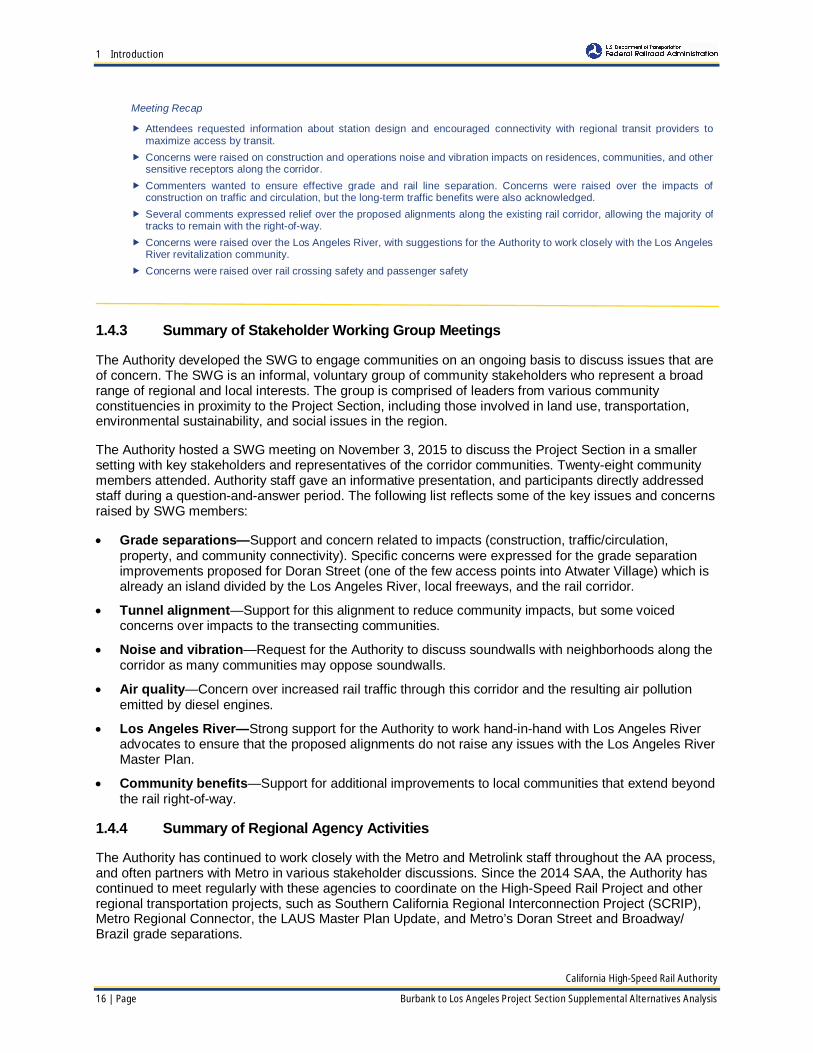
1.4.3 Summary of Stakeholder Working Group Meetings
The Authority developed the SWG to engage communities on an ongoing basis to discuss issues that areof concern. The SWG is an informal, voluntary group of community stakeholders who represent a broadrange of regional and local interests. The group is comprised of leaders from various communityconstituencies in proximity to the Project Section, including those involved in land use, transportation,environmental sustainability, and social issues in the region.
The Authority hosted a SWG meeting on November 3, 2015 to discuss the Project Section in a smallersetting with key stakeholders and representatives of the corridor communities. Twenty-eight communitymembers attended. Authority staff gave an informative presentation, and participants directly addressedstaff during a question-and-answer period. The following list reflects some of the key issues and concernsraised by SWG members:
· Grade separations—Support and concern related to impacts (construction, traffic/circulation,property, and community connectivity). Specific concerns were expressed for the grade separationimprovements proposed for Doran Street (one of the few access points into Atwater Village) which isalready an island divided by the Los Angeles River, local freeways, and the rail corridor.
· Tunnel alignment—Support for this alignment to reduce community impacts, but some voicedconcerns over impacts to the transecting communities.
· Noise and vibration—Request for the Authority to discuss soundwalls with neighborhoods along thecorridor as many communities may oppose soundwalls.
· Air quality—Concern over increased rail traffic through this corridor and the resulting air pollutionemitted by diesel engines.
· Los Angeles River—Strong support for the Authority to work hand-in-hand with Los Angeles Riveradvocates to ensure that the proposed alignments do not raise any issues with the Los Angeles RiverMaster Plan.
· Community benefits—Support for additional improvements to local communities that extend beyondthe rail right-of-way.
1.4.4 Summary of Regional Agency Activities
The Authority has continued to work closely with the Metro and Metrolink staff throughout the AA process,and often partners with Metro in various stakeholder discussions. Since the 2014 SAA, the Authority hascontinued to meet regularly with these agencies to coordinate on the High-Speed Rail Project and otherregional transportation projects, such as Southern California Regional Interconnection Project (SCRIP),Metro Regional Connector, the LAUS Master Plan Update, and Metro’s Doran Street and Broadway/Brazil grade separations.
Meeting Recap
� Attendees requested information about station design and encouraged connectivity with regional transit providers tomaximize access by transit.
� Concerns were raised on construction and operations noise and vibration impacts on residences, communities, and othersensitive receptors along the corridor.
� Commenters wanted to ensure effective grade and rail line separation. Concerns were raised over the impacts ofconstruction on traffic and circulation, but the long-term traffic benefits were also acknowledged.
� Several comments expressed relief over the proposed alignments along the existing rail corridor, allowing the majority oftracks to remain with the right-of-way.
� Concerns were raised over the Los Angeles River, with suggestions for the Authority to work closely with the Los AngelesRiver revitalization community.
� Concerns were raised over rail crossing safety and passenger safety

1 Introduction
California High-Speed Rail Authority
Burbank to Los Angeles Project Section Supplemental Alternatives Analysis Page | 17
A key issue that has emerged through these meetings is Metro’s preference for locating the high-speedrail tracks along the western limits of the Metro-owned right-of-way. Its main concern with locating High-Speed Rail on the eastern side of the right-of-way is that it would cut off existing and potential rail freightcustomers for UPRR, which has rights to operate on the Metro-owned right-of-way.
1.4.5 Summary of Corridor Community Activities
The Authority has held recurring meetings with stakeholders, communities, and community organizationsacross the Project Section. These meetings varied from one-on-one discussions to group settings andpresentations. All meetings provided information about the project and collected information aboutexisting conditions and current and future area projects to further the understanding of key issues ofconcern in each location. Key themes, concerns, and related projects identified during these meetings arepresented in Table 1-2.
Table 1-2 Key Community Themes, Concerns, and Project Coordination
Community IssuesCity of BurbankThemes Unique history, intersection of aerospace, media center, and strong hometown
character
Concerns Station connectivity, traffic and circulation, noise/vibration, and business and jobopportunities
Key Stakeholders Airport stakeholders, adjacent residents, adjacent property owners and businesses,local chambers of commerce, local service clubs, local homeowner associations,schools, local service clubs, religious organizations
Project Coordination Effective coordination with local projects, including LinkBurbank, the relocated BobHope Airport Terminal, and the Hollywood Way Metrolink Station, EcoDistrict
City of GlendaleThemes Strong city identity, established business community, historic Metrolink Station
Concerns Impacts from grade separations, preserving adjacent properties along right-of-wayespecially businesses, construction impacts, Metrolink station, noise/vibration, andtraffic and circulation
Key Stakeholders Adjacent residents, adjacent property owners and businesses, local chambers ofcommerce, local service clubs, local homeowner associations, schools, local serviceclubs, religious organizations
Project Coordination Planning for grade separations; accommodation of the Glendale Metrolink Station
City of Los Angeles (Community of South of SR-2)Themes Focus on multi-modal connectivity, revitalization of the Los Angeles River
Concerns Alignment alternatives and entrance into LAUS, traffic and circulation, noise/vibration(particularly related to schools and other sensitive receptors) and interface with theLos Angeles River
Key Stakeholders Neighborhood Councils, Los Angeles River groups, Chinatown stakeholders, localbusinesses, equestrian community, downtown stakeholders, local chambers, localservice clubs, local homeowner associations, schools, religious organizations
Project Coordination Coordination with other major projects, including the Los Angeles River and LAUSMaster Plan
The information in this table is not exhaustive in nature, but rather provides a representative snapshot of each location.

1 Introduction
California High-Speed Rail Authority
18 | Page Burbank to Los Angeles Project Section Supplemental Alternatives Analysis
1.4.6 Summary of Environmental Justice Outreach Efforts
A priority for the Authority is to conduct a robust environmental justice outreach effort. The Authority’spolicy is to duly emphasize the fair and meaningful involvement of all stakeholders regardless of race,color, national origin, or income with respect to the High-Speed Rail Project planning, development,operations, and maintenance.
For the SWG, the Authority sent invitations to various organizations, with a focused effort to recruitattendees that represented communities of minority or low-income populations. For the recent openhouses, each meeting provided language interpreters based on the language needs, which wereidentified using 2010 US Census data and a threshold of 4% limited-English proficiency per census tract.The languages at these meetings included Arabic, Armenian, Chinese, Japanese, Korean, Russian,Spanish, Tagalog, and Vietnamese. The Authority also ensure facilities were accessible for persons withdisabilities. Additionally, the Authority placed ads publicizing the open houses in 22 publications, many ofwhich serve a readership representative of environmental justice communities. These included KoreanTimes, Rafu Shimpo, Eastsider online, Azbarez Armenian News, Beirut Times, World Journal ChineseDaily News, Asian Journal, La Opinion, and Vien Dong.
To support the release of this SAA, the Authority is continuing to prioritize its efforts to reachenvironmental justice communities and adjacent neighborhoods along the corridor. As it is critical to meetstakeholders in their local gathering places, the Authority will conduct presentations at local communitygroups, such as neighborhood councils, and set up information tables at community festivals and popularactivity centers (shopping centers, parks, etc.), with the goal of increasing the convenience forenvironmental justice stakeholders and their likelihood of engaging with the project team. The Authoritywill also continue to be responsive to the language needs of each community, to ensure the information ismeaningfully shared with a diverse range of stakeholders along the corridor.
1.4.7 Record of Outreach Briefings
The Authority has continued to brief city staff, regional agency staff, and elected officials on the project’sstatus. Appendix B includes the detailed list of outreach briefings for the Project Section since May 2014.

2 Methodology
California High-Speed Rail Authority
Burbank to Los Angeles Project Section Supplemental Alternatives Analysis Page | 19
2 Methodology
2.1 Alternatives Analysis Methods
This SAA Report follows the defined AA methods thatthe Authority and FRA developed in 2011 (TechnicalMemorandum, Alternatives Analysis Methods forProject EIR/EIS, Version 3). The 2011 guidance usesboth qualitative and quantitative measures that reflect a mixture of applicable policy, environmental, andtechnical considerations. Specifically, it directs that the AA process shall,
Identify reasonable and feasible project alternatives that would meet the Purpose and Need forthe project and are consistent with the Basis of Design Report, identify those alternatives whereenvironmental issues (severe conflicts or constraints) or engineering challenges may justifydropping them from further analysis, and provide comparative information and data that highlightand compare similarities and differences between alternatives by using project design criteria.(Authority and FRA, 2011)
Through the AA process, the Authority and FRA seek to identify reasonable alternatives by defining arange of station and alignment configurations that would fulfill the project’s purpose and need; meet theagencies’ goals and objectives; avoid and minimize negative impacts to key resource areas, and in doingso, identify preliminary areas of potential environmental impacts; and allow for a comparative evaluationof the alternatives. Alternatives that are not potentially feasible or that do not meet basic purpose andneed can be eliminated from further analysis with documentation of the reason for their withdrawal.
The Authority seeks input on conceptual alternatives with community and agency stakeholders, andbased on feedback, the project team makes modifications to avoid or minimize impacts to thecommunities and environment, while balancing the design objectives. The project team uses multipletechniques to gather information and develop and compare alternatives, which include the following:
· Field inspections of corridors—The potential alignment, right-of-way, and station locations are thesubject of field inspection by qualified planners, engineers, and environmental scientists withexperience in tunneling, railroad operations, and construction of linear transportation projects toidentify conditions and factors not visible in aerial photos or on maps. Over the course of the study,field inspections become progressively more detailed as the alternatives are refined by the planning,environmental, and engineering work.
· Environmental analysis utilizing geographic information system (GIS) technology—The bulk ofthe assessment is performed using GIS data, which enables depictions of the project’s interactionswith a variety of measurable geographic features, both natural and built. GIS data are used to assessimpacts on farmland, water resources, floodplains, wetlands, threatened and endangered species,cultural resources, current urban development, infrastructure, oil and gas exploration, and productionand other resources.
· Engineering assessment—Engineering assessments are provided for a number of measures thatcan be readily quantified at this stage of project development. The engineering assessments canprovide information on project length, travel time, and configuration of key features of the alignmentsuch as the presence of existing infrastructure and geology.
· Qualitative assessment—A number of the qualitative measures used to describe the alternativealignments are developed by professionals with experience in the construction and operation of high-speed rail and other transportation systems. These measures include constructability, accessibility,operability, maintainability, right-of-way, public infrastructure impacts, railway infrastructure impacts,and environmental impacts.
Section 2 at a Glance—In this section you will find thefollowing information:
� Alternatives Analysis Methods� Alternatives Analysis Criteria

2 Methodology
California High-Speed Rail Authority
20 | Page Burbank to Los Angeles Project Section Supplemental Alternatives Analysis
· Conceptual footprint analysis—Quantitative and qualitative evaluation of the alternatives is basedon conceptual project footprints for each of the alternatives. These conceptual project footprints arebased on the track area, and exclude potential station areas, potential traction power substationlocations, potential radio tower locations, right-of-way requirements for new/modified gradeseparations, right-of-way requirements for affected third parties, potential temporary constructioneasement locations, and other ancillary facilities for each of the alternatives.
· Operational constraints analysis—The alternatives have been modeled to assess their operationalfeasibility. Some of the operational constraints include track configuration, existing and trainoperations, and non-revenue train moves.
· Community/stakeholder outreach—The project team conducts outreach meetings withstakeholders and the general public to discuss and receive feedback on the project alternatives. Inputfrom the outreach process provides insight regarding local issues and concerns, and can be used tosupplement the information provided by the other information-gathering techniques cited above.
· Agency coordination—The project team meets periodically with local, regional, and federal agencystaff to identify resources of concern, coordinate on consultation and permitting processes, andoccasionally partner on stakeholder engagement.
The Authority has developed assessment and analysis measures for each of the techniques outlinedabove. The evaluation measures, as applied, are progressively more technical and quantitative asalternatives evolve.
The environmental analysis in this SAA Report uses a planning footprint approach. In contrast to acenterline approach, which is often used to screen a large number of alternatives, the planning footprintapproach is appropriate for this SAA analysis, as the alternatives are few and analytically similar. As withall such review under applicable federal and state laws, a more detailed analysis based on theengineered project footprint will occur in future environmental documents.
2.2 Alternatives Analysis Criteria
In addition to considering the objectives of the project purpose and need and the 2014 and 2016Business Plans, the Authority evaluates project alternatives using system performance criteria thataddress design differences and qualities. These design objectives are shown indicated in Table 2-1, whileTable 2-2 lists the performance criteria related to environmental and community impacts. The projectteam provides estimates where it is possible to quantify impacts and qualitative evaluation where it is notpossible to quantify impacts.
Table 2-1 Design Objectives
Objective Criteria
Maximize ridership/revenue potential Travel time/route length
Maximize connectivity and accessibility Intermodal connections
Minimize operating and capital costs Operations and maintenance issues and costs
Source: Technical Memorandum, Alternatives Analysis Methods for Project EIR/EIS, Version 3, 2011

2 Methodology
California High-Speed Rail Authority
Burbank to Los Angeles Project Section Supplemental Alternatives Analysis Page | 21
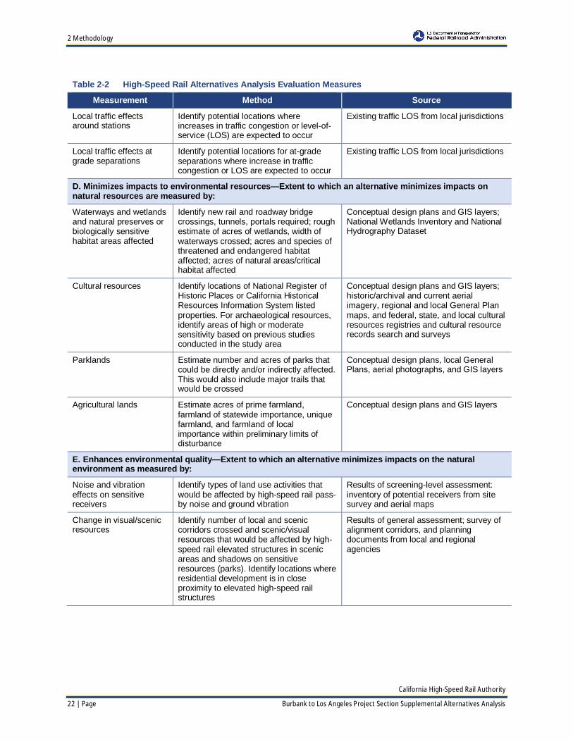
Table 2-2 High-Speed Rail Alternatives Analysis Evaluation Measures
Measurement Method Source
A. Land use supports transit use and is consistent with existing, adopted local, regional, state, and federalplans, and is supported by existing or future growth areas as measured by:
Development potentialfor transit-orienteddevelopment (TOD)within walking distance ofstation
Identify existing and proposed land useswithin one-half mile of station locations.Identify if there are TOD districts, TODoverlay zones, mixed-use designations, orif local jurisdictions have identified stationareas for redevelopment or economicdevelopment
Regional and local planning documentsand land use analysis and input from localplanning agencies
Consistency with otherplanning efforts andadopted plans
Qualitative—General analysis ofapplicable planning and policy documents
Land use analysis and input from planningagencies
B. Construction of the alternative is feasible in terms of engineering challenges and right-of-way constraintsas measured by:
Constructability, accessfor construction; withinexisting transportationright-of-way
Extent of feasible access to alignment forconstruction
Conceptual design plans and maps
Disruption to existingrailroads
Right-of-way constraints and impacts onexisting railroads
Conceptual design plans and maps
Disruption to andrelocation of utilities
Number of utilities crossed Conceptual design plans and maps
C. Minimizes disruption to neighborhoods and communities (including Environmental Justicecommunities)—Extent to which an alternative minimizes right-of-way acquisitions, minimizes dividing anestablished community, and minimizes conflicts with community resources
Displacements If possible, estimate number of propertiesby land use type that would be displaced,or acres of land within the right-of-way/station footprint, by type of land use:single-family, multifamily,retail/commercial, industrial, etc.
Identified by comparing the alignmentconceptual design drawings with aerialphotographs, zoning maps, GIS layers,and regional and local General Plan maps
Property with accessaffected
Estimate number of potential locationsalong the alignments or at stationlocations where, and the extent to which,access would be affected
Conceptual design plans and aerialphotographs
Proximity to schools Consistent with, and exceeding PublicResources Code Section 21151.4, identifythe location of schools within 1,500 feeton each side of the construction footprint
Conceptual design plans, aerialphotographs, GIS layers, and regional andlocal General Plan maps
Proximity to landfills Consistent with Title 27 of the CaliforniaCode of Regulations, identify the locationof landfills within 0.25 mile of each side ofthe construction footprint
Conceptual design plans and aerialphotographs
Proximity to Section 4(f)resources
Identify protected parks, wildlife refuges,or historical sites to determine if apermanent, temporary, or constructive usewould likely occur
Conceptual design plans, historic/archivaland current aerial imagery, GIS layers,regional and local General Plan maps, andfederal, state, and local cultural resourcesregistries
2 Methodology
California High-Speed Rail Authority
22 | Page Burbank to Los Angeles Project Section Supplemental Alternatives Analysis
Table 2-2 High-Speed Rail Alternatives Analysis Evaluation Measures
Measurement Method Source
Local traffic effectsaround stations
Identify potential locations whereincreases in traffic congestion or level-of-service (LOS) are expected to occur
Existing traffic LOS from local jurisdictions
Local traffic effects atgrade separations
Identify potential locations for at-gradeseparations where increase in trafficcongestion or LOS are expected to occur
Existing traffic LOS from local jurisdictions
D. Minimizes impacts to environmental resources—Extent to which an alternative minimizes impacts onnatural resources are measured by:
Waterways and wetlandsand natural preserves orbiologically sensitivehabitat areas affected
Identify new rail and roadway bridgecrossings, tunnels, portals required; roughestimate of acres of wetlands, width ofwaterways crossed; acres and species ofthreatened and endangered habitataffected; acres of natural areas/criticalhabitat affected
Conceptual design plans and GIS layers;National Wetlands Inventory and NationalHydrography Dataset
Cultural resources Identify locations of National Register ofHistoric Places or California HistoricalResources Information System listedproperties. For archaeological resources,identify areas of high or moderatesensitivity based on previous studiesconducted in the study area
Conceptual design plans and GIS layers;historic/archival and current aerialimagery, regional and local General Planmaps, and federal, state, and local culturalresources registries and cultural resourcerecords search and surveys
Parklands Estimate number and acres of parks thatcould be directly and/or indirectly affected.This would also include major trails thatwould be crossed
Conceptual design plans, local GeneralPlans, aerial photographs, and GIS layers
Agricultural lands Estimate acres of prime farmland,farmland of statewide importance, uniquefarmland, and farmland of localimportance within preliminary limits ofdisturbance
Conceptual design plans and GIS layers
E. Enhances environmental quality—Extent to which an alternative minimizes impacts on the naturalenvironment as measured by:
Noise and vibrationeffects on sensitivereceivers
Identify types of land use activities thatwould be affected by high-speed rail pass-by noise and ground vibration
Results of screening-level assessment:inventory of potential receivers from sitesurvey and aerial maps
Change in visual/scenicresources
Identify number of local and sceniccorridors crossed and scenic/visualresources that would be affected by high-speed rail elevated structures in scenicareas and shadows on sensitiveresources (parks). Identify locations whereresidential development is in closeproximity to elevated high-speed railstructures
Results of general assessment; survey ofalignment corridors, and planningdocuments from local and regionalagencies

2 Methodology
California High-Speed Rail Authority
Burbank to Los Angeles Project Section Supplemental Alternatives Analysis Page | 23
Table 2-2 High-Speed Rail Alternatives Analysis Evaluation Measures
Measurement Method Source
Maximize avoidance ofareas with geological andsoils constraints
Identify number of crossings of knownseismic faults, estimate acres ofencroachment into areas with highlyerodible soils, acres of encroachment intoareas with high landslide susceptibility;evaluate groundwater impacts
United States Geological Survey mapsand available GIS data; CaliforniaDepartment of Conservation’s CaliforniaGeologic Survey, Regional GeologicHazards and Mapping Program; checkMap Index to identify maps appropriate forHigh-Speed Rail sections
Maximize avoidance ofareas with potentialhazardous materials
Identify hazardous materials/waste areasto avoid constraints
Data from previous records searchconducted for other projects within thestudy area
Source: Technical Memorandum, Alternatives Analysis Methods for Project EIR/EIS, Version 3, 2011Since the 2011 guidance, new criteria have been added for this analysis (proximity to schools, landfills, and Section 4(f) resources).
Section 4(f) of the U.S. Department of Transportation Act (49 U.S.C. Section 303) is a federal law thatlimits the use of certain parks, recreation areas, refuges and historic properties for transportation projects.Section 4(f) applies to transportation projects that require funding or other approvals by any USDepartment of Transportation agency, including FRA.
Section 4(f) states that land from a publicly owned park, recreation area, wildlife or waterfowl refuge, or asignificant historic site can be used for a transportation project only if (1) there is no feasible and prudentalternatives to the use of these resources and all possible planning has been taken to minimize harm tothe resource, or (2) the use would result in a de minimis impact on the Section 4(f) property. A finding ofde minimis impact requires concurrence of the official with jurisdiction over the Section 4(f) property.
For purposes of this AA, FRA and the Authority have sought to identify potential Section 4(f) uses foreach of the alternatives considered, based on the information available at this stage of the study. Thisanalysis includes the use of GIS that incorporates existing data regarding locations of known parks,recreation areas, refuges, and historic sites. Fieldwork to identify and evaluate potential Section 4(f)resources has not yet been completed. In addition, engineering at this stage is not advanced sufficientlyto determine the extent of potential impacts on these resources from a Section 4(f) perspective.
The potential 4(f) impacts have been pointed out in this document to advance the project design and workto avoid and/or minimize impacts to these resources going forward. This also allows the Authority to beginplanning with resource owners to minimize harm to these resources, if needed.
After FRA and the Authority select a range of alternatives for detailed study, a full and complete Section4(f) analysis will be completed for this project. As part of that analysis, determinations may changeregarding the Section 4(f) status of properties considered in this report and additional Section 4(f)properties may be identified. In addition, more detailed information will be developed regarding thealternatives’ effects on Section 4(f) resources. Where necessary, alternatives to avoid, minimize, andmitigate impacts on Section 4(f) resources will be considered. This analysis will be included in the draftenvironmental document.

3 Description of Alternatives
California High-Speed Rail Authority
24 | Page Burbank to Los Angeles Project Section Supplemental Alternatives Analysis
3 Description of AlternativesThis SAA Report focuses on the range of alternativesfor the Burbank to Los Angeles Project Section. It alsoprovides a narrative description of previouslyconsidered alternatives to provide context, coveringthe work that has been completed since the 2014scoping meetings and descriptions of the currentlyproposed alternatives.
3.1 Previously Identified Alternatives
The 2010 PAA began the NEPA/CEQA alternatives screening process for the Palmdale to Los AngelesProject Section, and it analyzed potential alignment alternatives, station locations, and design optionsfrom the City of Palmdale to Los Angeles Union Station. The 2011 SAA reevaluated the Palmdale to LosAngeles Project Section, focusing on the subsections from Sylmar to LAUS. Finally, the 2014 SAAreevaluated all alignment alternatives, and it recommended splitting the Palmdale to Los Angeles ProjectSection into two separate sections: Palmdale to Burbank and Burbank to Los Angeles. The reasons forsplitting the project section included the IOS concept and allowing for more effective planning and publicoutreach in a highly populated area. The 2014 SAA also identified the Burbank Airport Station as thelogical station location in the San Fernando Valley.
The 2014 Palmdale to Los Angeles SAA described the range of alternatives from Burbank Airport Stationto LAUS. Table 3-1 provides an all-inclusive list of the alternatives previously identified through the AAprocess, along with the recommendations of this SAA (labeled as “2016 SAA”). Since the geographicboundaries have changed over the years, the table summarizes the previous AA Reports together andthe 2016 SAA separately. Figure 3-1 shows the alternatives that were recommended in the 2014 SAA tobe carried forward for analysis in future environmental documents. The 2014 alternatives are the startingpoint for the 2016 SAA analysis, and are described in more detail in the following sections.
Section 3 at a Glance—In this section you will find thefollowing information:
� Previously Identified Alternatives� 2016 Analysis and Refinements� Description of 2016 SAA Alternatives

3 Description of Alternatives
California High-Speed Rail Authority
Burbank to Los Angeles Project Section Supplemental Alternatives Analysis Page | 25
Table 3-1 Burbank to Los Angeles Alignment Alternatives and Station OptionsSubsections andStations Alternatives and Station Options Carried Forward Withdrawn
2010 PAA, 2011 SAA, and 2014 SAA for Palmdale to Los Angeles Project Section
LAUS to Metrolink CMF
LAPT1 (tunnel) All AAs
LAPT2 (tunnel) 2011 SAA
LAPT3 (tunnel) All AAs
LAP1A (surface) 2010 PAA
LAP1B (surface) 2010 PAA
LAP1C (surface) All AAs (renamedSurface in 2014 SAA)
Metrolink CMF to SR-2
Metrolink at-grade2011 and 2014 SAAs
(withdrawn in 2010 PAA,but reintroduced in 2011)
Metrolink in trench 2011 SAA
San Fernando Road in trench 2011 SAA
SR-2 to Sylmar
HSR on east side of right-of-way All AAs
HSR on west side of right-of-way2014 SAA (withdrawn in
2010 PAA, butreintroduced in 2014)
LAUS PlatformElevated All AAs
At-Grade All AAs
2016 SAA for Burbank to Los Angeles Project Section
Burbank Airport StationPlatform Options*
At-Grade X
Tunnel X
Burbank Airport Station toAlameda Avenue*
At-grade alignment X
Tunnel alignment X
Alameda Avenue to SR-2HSR on east side of right-of-way X
HSR on west side of right-of-way X
SR-2 to LAUS
LAPT1 X
LAPT3 X
Surface (refined to include two at-grade options) X
LAUS Platform OptionsElevated X
At-Grade X
LAP = Los Angeles-Palmdale; SR = State Route*Detailed analysis provided in the 2016 Palmdale to Burbank SAASources: Palmdale to Los Angeles Preliminary Alternative Analysis, 2010; Palmdale to Los Angeles Supplemental AlternativeAnalyses, 2011 and 2014, Palmdale to Burbank Supplemental Alternative Analysis, 2016.

3 Description of Alternatives
California High-Speed Rail Authority
26 | Page Burbank to Los Angeles Project Section Supplemental Alternatives Analysis
These alternatives were recommended for further evaluation in 2014, and wereused as a starting point for the 2016 SAA work.
Figure 3-1 Alignment Alternatives and Station Locations Carried Forward in the 2014 SAA
March 4, 2016

3 Description of Alternatives
California High-Speed Rail Authority
Burbank to Los Angeles Project Section Supplemental Alternatives Analysis Page | 27
3.1.1 Burbank Airport Station to SR-2
The 2010 Palmdale to Los Angeles PAA first proposed at-grade high-speed rail tracks along the easternlimits of the Metro-owned right-of-way from Sylmar to SR-2, with the Metrolink tracks on the west side.This was carried forward in the 2011 SAA. The 2014 SAA reintroduced the option of high-speed railtracks along the west side of the right-of-way (an option that had been previously withdrawn in the 2010PAA). The east-side and west-side alternatives in this subsection were both carried forward, and aredescribed below:
· HSR on east side of right-of-way—The dedicated high-speed rail tracks would be placed within theeastern limits of the existing right-of-way, with Metrolink tracks along the western limits, asrecommended in the 2011 SAA. The 2015 Palmdale to Burbank SAA recommended withdrawing thisoption due to continued coordination with Metro and Metrolink that confirmed that their double trackproject design works best on the east side of the right-of-way, with the high-speed rail alignment onthe west side of the existing right-of-way. Furthermore, UPRR has submitted written commentsstating their preference for a high-speed rail alignment on the west side of the existing right-of-way.This configuration would avoid the need to sever existing UPRR connections to industrial facilities onthe east side of the right-of-way.
· HSR on west side of right-of-way—The 2014 SAA reintroduced the option of placing the dedicatedhigh-speed rail tracks within the western limits of the existing right-of-way, with Metrolink tracks alongthe eastern limits.
The 2015 Palmdale to Burbank SAA proposed new alignment alternatives that required consideration ofan underground Burbank Airport Station as well as alignment alternatives in tunnel from Burbank AirportStation south to the Burbank Junction near the intersection of Victory Boulevard and Burbank Boulevard.That SAA moved forward eight alternatives, four which would utilize the at-grade station alternative andat-grade tracks south of Burbank Airport Station and four that would utilize the underground BurbankAirport Station and an underground alignment south of Burbank Airport Station to Burbank Junctionbefore merging with the at-grade tracks. For further details, refer to the 2016 Palmdale to Burbank SAA.
3.1.2 SR-2 to LAUS
For this subsection, the 2010 PAA proposed that the alignment could either be at-grade or in a trenchalong the eastern side of the right-of-way. From the Metrolink CMF to LAUS, the alignment would rise uponto a viaduct on the east bank of the Los Angeles River, and approach LAUS at either an elevated or anat-grade platform. The subsequent 2011 P-LA SAA carried this alternative forward, but recommended theSR-2 to Metrolink CMF segment to be placed at-grade. The 2014 SAA carried forward the three optionsrecommended in the 2011 SAA, with some refinements to one of the tunnel alternatives. The alternativesare shown in Figure 3-1, and include:
· Surface Alternative (known as LAP1C in previous AAs)—Starting at SR-2 and traveling south, thededicated high-speed rail tracks were at-grade on the east side of the right-of-way. South of I-5, thetracks rose up onto a viaduct structure on the east bank of the Los Angeles River. The alternativecrossed the River between Main Street and Spring Street. The viaduct structure continued along MainStreet, and entered LAUS at either an elevated or an at-grade station platform.
· LAPT1—Starting at SR-2 and traveling south along the eastern side of the existing right-of-way, theLAPT1 Alternative was a bored tunnel, passing underneath Elysian Park, homes along SolanoAvenue, and Los Angeles State Historic Park. The bored tunnel transitioned to cut-and-cover beneathSpring Street, and emerged above grade immediately north of LAUS near Main Street. LAPT1 wasrefined in the 2014 SAA to allow for either an elevated or at-grade station platform.
· LAPT3—This tunnel alternative shared the same alignment as LAPT1, from SR-2 to aroundCasanova Street. From Casanova Street, the LAPT3 Alternative curved east, and emerged to abovegrade at Spring Street, farther north than LAPT1. This alignment alternative allowed for either an at-grade of aerial station platform option.

3 Description of Alternatives
California High-Speed Rail Authority
28 | Page Burbank to Los Angeles Project Section Supplemental Alternatives Analysis
3.2 2016 Analysis and Refinements
Since the 2014 P-LA SAA, the Authority has continued to refine the alignment alternatives by respondingto community feedback and by performing additional engineering and environmental review in acontinued effort to find ways to avoid or minimize the anticipated community and natural resourceimpacts.
For purposes of the refinement work, the previously considered subsections were consolidated into thefollowing two subsections: Burbank Airport Station to the vicinity of SR-2, and SR-2 to LAUS. This SAAReport includes solely by reference the two alternatives between Burbank Airport Station and AlamedaAvenue and the two station platform options at Burbank Airport Station. Please refer to the 2016Palmdale to Burbank Supplemental Alternatives Analysis for more details
The following sections describe the design refinements. One of the main goals was to keep the high-speed rail alignments within the existing railroad right-of-way to the maximum extent possible to minimizeadjacent right-of-way and environmental impacts. Additionally, the design refinements took into accountthe physical and operational constraints around Metrolink CMF.
3.2.1 Burbank Airport Station to Alameda Avenue
The 2016 Palmdale to Burbank SAA provides details on the refinements to the alignment alternatives thatare associated with both station options and the track grade options (at-grade or tunnel) for the portion ofthe Burbank to Los Angeles Section from Burbank Airport Station and Alameda Avenue. The 2016Palmdale to Burbank SAA refined the eight alignment alternatives from the 2015 Palmdale to BurbankSAA as follows:
· Refined from four to two alignment alternatives that would be compatible with an at-grade station andan at-grade track alignment from Burbank Airport Station to Alameda Avenue
· Refined from four to one alignment alternative that would be compatible with an underground stationand an underground track alignment from Burbank Airport Station to Alameda Avenue
· Recommended two station options at Burbank Airport Station: At-Grade and Underground
3.2.2 Alameda Avenue to SR-2 — Refine At-Grade Alignment
The analysis completed in 2015 drew two primary conclusions. First was to withdraw the option of placingthe high-speed rail tracks on the east side of the right-of-way, while recommending the option of high-speed rail tracks on the west side of the right-of-way. This refinement eliminates the need for complicatedcrossovers further south along the route, the construction of which would have had potential right-of-wayand environmental impacts. It also maintains consistency with the project section to the north, as the2015 Palmdale to Burbank SAA also recommended west-side high-speed rail tracks. Secondly, designrefinements allowed for a smaller trackwork footprint, which reduced potential right-of-way impacts andaddressed community concerns.
3.2.3 SR-2 to LAUS —Refine At-Grade Alignment
The 2014 Surface Alternative was refined to stay at-grade primarily within the existing right-of-wayapproaching LAUS from the north. Previously, a major stakeholder concern was impacts to adjacent landand to the Los Angeles River, as the proposed viaduct structure traveled down Main Street to enterLAUS. The elevated structure had been designed to provide for dedicated high-speed rail infrastructure,but it would have increased the potential for noise impacts, visual impacts, and residential andcommercial displacements. The 2016 refinement work took into account the stakeholders’ concerns, andthe refined at-grade alignment would allow the track footprint to be reduced, minimizing the potentialresidential and commercial displacements in Downtown Los Angeles.
Additionally, in this subsection, previous AAs recommended two dedicated high-speed rail tracks on theeast side of the Metrolink tracks. In order to avoid and minimize environmental impacts, the recent

3 Description of Alternatives
California High-Speed Rail Authority
Burbank to Los Angeles Project Section Supplemental Alternatives Analysis Page | 29
refinement work incorporated the Authority principle of a blended system, described in Section 1.2.2. Thisresulted in two design options for this subsection, one shared and one dedicated, both of which wouldcontinue south from the Alameda Avenue to SR-2 subsection, with high-speed rail tracks within thewestern limits of the existing right-of-way and Metrolink tracks along the east side.
Both design options are constrained, operationally and physically, by the Metrolink CMF. The CMF is themajor daily servicing location and maintenance facility for the Metrolink system in the region, and between50 and 60 non-revenue trains operate between LAUS and the CMF each weekday. The southern yardentrance, existing track configuration, surrounding road network, and the Los Angeles River all createphysical constraints in this area, which have been taken into account in the design refinements. Thedesign options in this subsection are shown in Figure 3-2 along with the previously consideredalternatives.
3.2.4 SR-2 to LAUS — Withdraw Tunnel Alignments
The project team took into account several factors during the refinement process, including the key goalsand vision of both the 2014 and Draft 2016 Business Plans for Phase 1 of the High-Speed Rail System.First, the high costs of constructing a dedicated tunnel alignment conflicted with the Authority’s goal ofusing existing infrastructure to maximize benefits while minimizing cost. Tunnel construction costsgenerally range from $200 to $260 million per mile1, and preliminary capital cost estimates for the tunnelin this subsection were about four times higher than the cost of constructing an at-grade alternative.
Secondly, the project team analyzed the portal locations of the two 2014 SAA tunnel alternatives, with agoal of avoiding or minimizing the portals’ environmental impacts. LAPT1 and LAPT3 shared a northerntunnel portal, which would have had potential impacts on several sensitive land uses, including park land(Rio de Los Angeles State Park) and two schools (Los Feliz Charter School for the Arts and SotomayorLearning Academies). The southern portals of both 2014 tunnel alternatives would have been adjacent tothe Los Angeles State Historic Park. The most recent refinement work examined alternate locations forthe northern tunnel portal, but the project team found that the area near SR-2 is extremely constrained.All other northern portal locations could also have affected at least one sensitive land use orenvironmental resource. Similarly, on the southern end of the tunnel alternatives, there could have beenconsiderable property access impacts during construction, even with a refined design.
In addition to the tunnel portal right-of-way impacts, there would have been considerable right-of-wayimpacts once the tunnel surfaced to above-grade; the tunnel alignments approaching LAUS would havepotentially displaced a large number of commercial properties just north of the station, as they wereoutside of the existing railroad right-of-way.
Finally, many of the stakeholders’ concerns in the past stemmed from concerns with the previouslyproposed Surface Alternative, which had the potential for right-of-way, visual, noise, and other impactsalong the Los Angeles River and on surrounding areas. The tunnel alternatives had been designed toavoid the impacts associated with the Surface Alternative by bypassing many sensitive land uses in thisarea. However, as the refined at-grade alternative addresses many of the stakeholder concerns, the needfor a tunnel as an avoidance alternative has diminished.
For these reasons, the tunnel alignments have been withdrawn.
1 Rostami, J., Sepehrmanesh, M., Gharahbaghm E.A., Mojtabai, N. (2012).Planning level tunnel cost estimation based on statisticalanalysis of historical data. Tunnelling and Underground Space Technology, 33, 22-33.

3 Description of Alternatives
California High-Speed Rail Authority
30 | Page Burbank to Los Angeles Project Section Supplemental Alternatives Analysis
LAPT1 and LAPT3 were withdrawn. Surface Alternative was refined to stay at-grade. The Shared Design option merges high-speed rail operations withMetrolink onto a shared track along the west side of right-of-way. The Dedicated Option has dedicatedhigh-speed rail tracks along the west side of the right-of-way and shifts Metrolink trains to run on theexisting conventional rail tracks along the east side of the right-of-way.* High-speed rail tracks for both options located within the existing rail corridor.
Figure 3-2 2016 Design Refinements in the SR-2 to LAUS Subsection
April 6, 2016

3 Description of Alternatives
California High-Speed Rail Authority
Burbank to Los Angeles Project Section Supplemental Alternatives Analysis Page | 31
3.2.5 Los Angeles Union Station — Withdraw Elevated Platform Option
The 2010 PAA for the Palmdale to Los Angeles Project Section presented both elevated and at-gradeplatform options at LAUS, and both options were carried forward in subsequent SAAs. However, sincethe 2014 scoping meetings, the Authority Board and the Metro Board have taken action to advance an at-grade station platform within LAUS, making the elevated station platform option infeasible. In October2015, the Metro Board moved to implement the LAUS Master Plan, which solidified the at-grade stationplatform plans. Additionally, the Metro Board and the Authority Board made additional actions in October2015 and February 2016, respectively, to integrate the High-Speed Rail Project with the LAUS MasterPlan and SCRIP.
For these reasons, the aerial LAUS configuration has been withdrawn from consideration.
3.3 Description of 2016 SAA Alternative
Previous AA reports analyzed alternatives based on subsections, with SR-2 being the key limit. This SAAreport consolidates previous geographic boundaries into the following three subsections: Burbank Airportto Alameda Avenue, Alameda Avenue to SR-2, and SR-2 to LAUS. The alignment options for the portionof the Burbank to Los Angeles Section from Burbank Airport Station south to Alameda Avenue aredependent on the alignment alternatives for the Palmdale to Burbank Section presented in the 2016Palmdale to Burbank SAA. Consequently, the segment between the proposed Burbank Airport Stationand Alameda Avenue is only described briefly in the following section, and is addressed in detail in the2016 Palmdale to Burbank SAA.
Based on the 2016 refinements, this SAA proposes one at-grade alternative with two at-grade designoptions south of SR-2. The alternative and two design options evaluated in this section have beendeveloped and refined based on public comments and feedback, as well as engineering feasibilityconsiderations. Figure 3-3 shows the proposed alternative for the Project Section, with the two designoptions south of SR-2.
3.3.1 Burbank Airport Station to Alameda Avenue
The 2014 NOI/NOP identified the possibility of additional alignments between the City of Palmdale andthe City of Burbank. Through the scoping process and further design refinements, the Authoritydeveloped several new recommendations. The 2016 Palmdale to Burbank SAA recommends thefollowing Burbank Airport station options and alignments to the south of the station:
· One at-grade station platform option (compatible with two of the three proposed Palmdale to Burbankalignment alternatives)
· One underground station platform option (compatible with one of the three proposed Palmdale toBurbank alignment alternatives)
· One at-grade alignment from Burbank Airport Station south to Alameda Avenue (compatible with twoof the three proposed Palmdale to Burbank alignment alternatives)
· One underground alignment from Burbank Airport Station south to Alameda Avenue (compatible withone of the three proposed Palmdale to Burbank alignment alternatives)
The proposed at-grade station option would be located along the existing railroad right-of-way just west ofHollywood Way. The proposed at-grade alignment would travel south from this station option along therailroad right-of-way to Alameda Avenue, where it would join with the proposed at-grade alignment withinthis SAA. The proposed underground station option would be located south of San Fernando Road andpartially under Hollywood Way. The alignment south of the station would travel underground and emergeto at-grade at Pacific Avenue and Reese Place, and then join with the proposed at-grade alignment atBurbank Boulevard to travel along the existing railroad right-of-way.

3 Description of Alternatives
California High-Speed Rail Authority
32 | Page Burbank to Los Angeles Project Section Supplemental Alternatives Analysis
At-grade alternative, with two design options from SR-2 to LAUS
Figure 3-3 2016 SAA Alternative and Design Options
March 30, 2016

3 Description of Alternatives
California High-Speed Rail Authority
Burbank to Los Angeles Project Section Supplemental Alternatives Analysis Page | 33
3.3.2 Alameda Avenue to SR-2
The proposed alternative would continue off the southern limit of the alternatives evaluated in the 2016Palmdale to Burbank SAA, just south of Alameda Avenue in Burbank. The alternative would run within theexisting railroad right-of-way, west of the existing Metrolink tracks (which would continue to be sharedwith UPRR freight and Amtrak in this subsection). The Metrolink tracks would be shifted slightly east, toaccommodate the addition of two additional high-speed rail tracks within the existing railroad corridor.About 0.25 miles south of Alameda Avenue, the alternative enters the City of Glendale and would crossseveral arterials that would need to be grade-separated or closed: Sonora Avenue, Grandview Avenue,and Flower Street. The grade separations or closures would apply to all four tracks within the corridor.The alternative would cross Verdugo Wash, where an existing Metrolink bridge is currently located, on anew structure to accommodate the additional tracks. It would continue south along existing railroad right-of-way, which follows the Glendale and Los Angeles city borders. The alternative would cross DoranStreet and Brazil/Broadway, which are at-grade; Metro is currently planning the grade separations forthese streets. Continuing south, the alternative would cross Colorado Street on an existing Metrolinkbridge, cross Chevy Chase Drive, which would need to be grade separated, and cross existing bridgesover Los Feliz Boulevard and Glendale Boulevard. The existing bridges at Colorado Street, Los FelizBoulevard, and Glendale Boulevard would require some modifications to accommodate additional tracks.The Glendale Metrolink Station is located just north of Glendale Boulevard, but will not be served by high-speed rail service.
Figure 3-4 illustrates the placement of the tracks within the right-of-way, with the dedicated high-speedrail tracks placed along the western limits.
Source: STV/JLP, 2016 (figure not to scale)The refined alternative in this subsection is more within the existing railroad right-of-way, with the high-speed railtracks on the west side.
Figure 3-4 Alameda Avenue to SR-2 – Dedicated Alignment Cross-Section
3.3.3 SR-2 to LAUS
3.3.3.1 Shared Option
For the Shared Option, just south of Glendale Boulevard, the alignment would begin to transition into ashared-track configuration; the Metrolink tracks would merge with the high-speed rail tracks on thewestern side of the existing railroad right-of-way, with freight trains running on the eastern side. A flyoverwould be required to merge high-speed rail and Metrolink operations; this would be needed to avoidconflicts between northbound high-speed trains and southbound Metrolink trains, and to provide foradequate capacity for passenger rail operations. This grade-separated flyover structure would be locatedroughly between Glendale Boulevard and Fletcher Drive.

3 Description of Alternatives
California High-Speed Rail Authority
34 | Page Burbank to Los Angeles Project Section Supplemental Alternatives Analysis
The shared-track alignment would travel south and run along the west side of the Metrolink CMF. OneUPRR/Amtrak track and a realigned siding would run along the east side of the CMF. Figure 3-5 shows atypical cross-section of this area, with the shared High-Speed Rail/Metrolink tracks to the west.
The shared tracks would cross the Los Angeles River just north of SR-110 on an existing Metrolinkbridge, which would be electrified and would require modifications to the bridge deck to accommodatehigh-speed rail service. After the bridge, the alignment would continue within the existing right-of-wayalong the west bank of the Los Angeles River. By shifting High-Speed Rail and Metrolink trains to thewest bank, it would clear conflicting moves at the southern end of the CMF, and would allow UPRR,Amtrak, and non-revenue Metrolink trains to operate along the east bank between the CMF and LAUS.This track configuration is illustrated in Figure 3-6.
Continuing south, the shared tracks would cross Main Street, which is currently at-grade and would likelyrequire a grade separation, and continue along the existing right-of-way to terminate at LAUS.
Source: STV/JLP, 2016 (figure not to scale)From SR-2 to SR-110, High-Speed Rail and Metrolink would share tracks along the west side of the right-of-way.UPRR and Amtrak would operate on one track the east side of the right-of-way, which is made operationally feasibleby the flyover structure near Glendale Boulevard.
Figure 3-5 SR-2 to SR-110 – Shared Option Cross-Section
Source: STV/JLP, 2016 (figure not to scale)The shared tracks would cross the Los Angeles River just north of SR-110 and run along the west bank. UPRR,Amtrak, and non-revenue Metrolink trains would operate on the east bank of the River.
Figure 3-6 SR-110 to Mission Junction – Shared Option Cross-Section

3 Description of Alternatives
California High-Speed Rail Authority
Burbank to Los Angeles Project Section Supplemental Alternatives Analysis Page | 35
3.3.3.2 Dedicated Option
The Dedicated Option would generally follow the same route as the Shared Option within the existing railcorridor. The key feature that distinguishes the two design options is the Dedicated Option would providededicated high-speed rail infrastructure along the entire length of the Project Section. To allow for high-speed trains to run on dedicated tracks on the west side of the right-of-way, Metrolink trains would beshifted to the east side of the right-of-way. The cross-section for this area is shown in Figure 3-7. About0.75 miles south of SR-2, a realigned siding/storage track would be added, bringing the total number oftracks in the corridor to five. The set of three tracks would curve around the eastern edge of the MetrolinkCMF, and additional track relocations and shifts would be needed within the CMF. The realigned sidingwould end at the southern end of the CMF.
South of I-5, the configuration of dedicated high-speed rail tracks would be the same as those in theshared option: the dedicated high-speed rail tracks would cross the Los Angeles River on the Metrolinkbridge north of SR-110, and travel along the west bank of the River. Two UPRR/Amtrak/Metrolink trackswould run along the east bank of the Los Angeles River, and then cross the River on the existing MissionTower bridge just south of Main Street, which would need to be double-tracked. This track configuration isshown in Figure 3-8.
Source: STV/JLP, 2016 (figure not to scale)From SR-2 to SR-110, dedicated high-speed rail tracks travel along the west side of the right-of-way. Metrolinkservice would be shifted to the UPRR/Amtrak tracks on the east side of the right-of-way.
Figure 3-7 SR-2 to SR-110 – Dedicated Option Cross-Section
Source: STV/JLP, 2016 (figure not to scale)The dedicated high-speed rail tracks would cross the Los Angeles River just north of SR-110 and run along the westbank. UPRR, Amtrak, and Metrolink trains would operate on the east bank of the River.
Figure 3-8 SR-110 to Mission Junction – Dedicated Option Cross-Section

4 Alternatives Evaluation
California High-Speed Rail Authority
36 | Page Burbank to Los Angeles Project Section Supplemental Alternatives Analysis
4 Alternatives EvaluationThis SAA evaluates the alternative and the two designoptions using the Authority measurement criteria, listedin full in Table 2-2. However, the Burbank to LosAngeles corridor is highly urbanized, and there arelimited options to feasibly introduce high-speed railinfrastructure; therefore, the potential impacts areprimarily related to the built environment, rather thannatural resources.
As discussed previously, the alignment options for the portion of the Burbank to Los Angeles Section fromBurbank Airport Station south to Alameda Avenue are dependent on the alignment alternatives for thePalmdale to Burbank Section presented in the 2016 Palmdale to Burbank SAA. Consequently, the AAanalysis for that portion is presented in the 2016 Palmdale to Burbank SAA and that document should bereferenced for detailed analysis. The evaluation presented below is from Alameda Avenue to LAUS only,as these portions are independent of the Palmdale to Burbank alignment alternatives.
The following sections focus on the distinguishing criteria, which are summarized in Table 4-1. Thesecriteria, along with other environmental resources areas, will be evaluated in full in the project-levelenvironmental document.
Table 4-1Summary of Distinguishing Evaluation Measurement Criteria
Measurement At-Grade with Shared Option At-Grade with Dedicated Option
Constructability
Maximizeconstructability
Would require a flyover in order to accommodateshared high-speed rail and Metrolink tracks.
Would require the construction of a thirdtrack for Metrolink/Amtrak/UPRR near theMetrolink CMF.
Communities
Displacements
Would potentially impact more properties,because of the flyover structure.
· Residential: 7 parcels· Industrial/Commercial: 42 parcels· Government: 1 parcel
Would potentially impact fewer properties.
· Residential: 6 parcels· Industrial/Commercial: 16 parcels· Government: 1 parcel
Proximity toSection 4(f)/6(f)Resources
Would be adjacent to Taylor Yard parcel/G2 site,where Los Angeles City is planning a park, andalso adjacent to the Rio de Los Angeles StatePark
Could be slightly inside of the Taylor YardParcel/G2 site, where Los Angeles City isplanning a park. It is also adjacent to theRio de Los Angeles State Park.Engineering refinements are currentlyunderway to minimize or avoid impacts.
Natural Resources
Parklands See discussion about Section 4(f) See discussion about Section 4(f)
Environmental Quality
Noise andvibration
May have some noise effects due to high-speedrail train trips and the flyover structure, and couldpotentially be higher than existing railroad noiselevels in that area.
May have some noise effects due to high-speed rail train trips, and could potentiallybe higher than existing railroad noiselevels resulting from shifting Metrolinkservice to the east bank of the LosAngeles River.
Section 4 at a Glance—In this section you will find thefollowing information:
� Key Differences Between Design Options� Areas of No Difference

4 Alternatives Evaluation
California High-Speed Rail Authority
Burbank to Los Angeles Project Section Supplemental Alternatives Analysis Page | 37
Table 4-1Summary of Distinguishing Evaluation Measurement Criteria
Measurement At-Grade with Shared Option At-Grade with Dedicated Option
Visual/scenicresources
The flyover structure near Glendale Boulevardwould likely alter the visual setting, but visualimpacts along the rest of the alternative wouldnot be not anticipated to be substantial.
Would not be altered substantially.
4.1 Key Differences Between Options
As this SAA proposes one build alternative with two design options south of SR-2, the followingcomparisons focus only on the potential impacts of the two design options.
Constructability
The Shared Option would require flyover structure, which would potentially be more complex, as theoption would be built while the railroad corridor is still active and in operation. The Dedicated Optionwould require relocating the siding on the east side of the Metrolink CMF, but there would be a morestraightforward construction and interim operating condition than the Shared Option.
Right-of-Way Impacts
Based on the trackwork footprint analysis approach, as described in Section 2.1, the alternative with theShared Option would affect a total of 42 industrial/commercial parcels, 7 residential parcels, and 1government parcel. A large number of these potential property displacements would be a result of theflyover structure needed to merge Metrolink and high-speed rail operations south of SR-2. Additionally,sharing tracks with Metrolink would require changes in Metrolink operations along the corridor andthrough the CMF. Preliminary discussions with Metrolink staff indicated that the agency would be open torelocating certain maintenance functions performed at the CMF to a facility in Orange County or theInland Empire. Metrolink would be able to continue many maintenance functions such as storage, heavyrepair, sanding, fueling, and car washing at the current CMF location. The relocation of any Metrolinkmaintenance functions associated with the High-Speed Rail Project would be subject to further refinementand evaluation in the environmental document.
The alternative with the Dedicated Option would affect a total 16 industrial/commercial parcels, 6residential parcels, and 1 government parcel. The primary difference between the two options is theDedicated Option would not require a flyover structure. The impacts to the Metrolink CMF would besimilar as for the Shared Option.
Section 4(f) Resources
Both the Shared and Dedicated design options would be adjacent to Rio de Los Angeles State Park. TheShared Option would be adjacent to and the Dedicated Option would be within the Taylor Yard/G2 site,where the City of Los Angeles is currently planning a park as part of the Los Angeles River revitalizationefforts. However, there is currently ambiguity around the G2 parcel, in regards to ownership, future use,and the proposed site plan describing the ultimate build-out and use of the site as a park. Multipleagencies that are currently coordinating on the land in that area, including the City of Los Angeles,Metrolink, Metro, and UPRR. The alternative recommended in this SAA would be designed and, ifnecessary, refined to not preclude the other future park plans on the parcel to the extent possible, and toavoid or minimize a Section 4(f) impact. It should be noted that the potential Section 4(f) resourcesrequire additional analysis to determine whether they would be protected under Section 4(f) or wouldresult in a de minimis finding.
Noise and Vibration
Some increase in noise levels would be expected for both design options, as a result of the addition ofhigh-speed trains operating in the corridor. For the Shared Option, the flyover structure would elevate

4 Alternatives Evaluation
California High-Speed Rail Authority
38 | Page Burbank to Los Angeles Project Section Supplemental Alternatives Analysis
trains in an area with some residences, and potentially increase noise levels. The Dedicated Option shiftsMetrolink trains to the east bank of the Los Angeles River from SR-110 to south of Main Street, and therewould potentially be some increase in noise levels for the east bank of the River within that segment.
Visual Setting
The Shared Option flyover structure near Glendale Boulevard would likely alter the visual setting. TheDedicated Option is not anticipated to alter the visual setting substantially.
4.2 Areas of No Difference
At the current level of design and analysis, both design options measure similarly under several criteria.Table 4-2 lists the evaluation criteria where the two design options have no differences.
Table 4-2 Evaluation Criteria with No Difference Between Design Options
Category Measurement
Performance ObjectivesRidership/revenue potentialConnectivity and accessibilityOperating and capital costs
ConstructabilityDisruption to existing railroadsDisruption to and relocation of utilities
Land UseTOD development potentialConsistency with other planning efforts and adopted plans
Communities
Property with access affectedProximity to schoolsProximity to landfillsStation area trafficGrade separations traffic
Natural Resources
WaterwaysCultural resourcesAgricultural lands
Environmental QualityGeology and soilsHazardous materials

5 Recommendation
California High-Speed Rail Authority
Burbank to Los Angeles Project Section Supplemental Alternatives Analysis Page | 39
5 RecommendationBased on the 2010 PAA, 2011 SAA, 2014 SAA, and the most recently completely refinement work, this2016 SAA recommends the at-grade alternative with two design options south of SR-2 to LAUS to becarried forward for further evaluation in the Burbank to Los Angeles project-level environmental clearanceprocess, subject to the requirements of CEQA and NEPA. Table 5-1 contains a summary of therefinement work and alternatives evaluation. Figure 3.1-1 shows the recommended alternative. In additionto the “No Project” alternative, the alternative and station option would include.
Alternatives and Potential Options to be Carried Forward
No Project Alternative
At-Grade Alternative with Shared Option
At-Grade Alternative with Dedicated Option
At-Grade LAUS Station Option
As discussed previously, the alignment options for the portion of the Burbank to Los Angeles Section fromBurbank Airport Station south to Alameda Avenue are dependent on the alignment alternatives for thePalmdale to Burbank Section presented in the 2016 Palmdale to Burbank SAA. Consequently, the SAArecommendation for that portion is presented in the 2016 Palmdale to Burbank SAA and that documentshould be referenced for details. The recommendation presented above is from Alameda Avenue toLAUS only, as this portion is independent of the Palmdale to Burbank alignment alternatives.

5 Recommendation
California High-Speed Rail Authority
40 | Page Burbank to Los Angeles Project Section Supplemental Alternatives Analysis
Table 5-1 Alternatives Refinement and Evaluation Summary
Alternativesand StationOptions
AADecision
Reasons forElimination
Additional Observations/Comments
Car
ryFo
rwar
d
Not
Car
ried
Forw
ard
Goa
ls&
Obj
ectiv
es1
Con
stru
ctio
n2
Rig
ht-o
f-Way
3
Com
mun
ityIm
pact
4
Envi
ronm
ent5
HSR on eastside of right-of-way
X X
Not consistent with decision made in 2015 Palmdale toBurbank SAA regarding track placement. Would conflict withfuture Metro/Metrolink double tracking projects. UPRR hasexpressed opposition and concern about affectingoperations if high-speed rail tracks on east side of right-of-way. Lastly, a flyover would be required near the join to thePalmdale to Burbank Section (in which high-speed railtracks are proposed along the west), resulting in additionalright-of-way impacts.
HSR on westside of right-of-way
X
Surface (refined) Alternative refined, because of right-of-way, community, andenvironmental impacts associated with viaduct structure
At-Grade withSharedOption
X
At-Grade withDedicatedOption
X
LAPT1 X X X X X
Portal locations would have had potential impacts on parksand schools, as well as commercial and residentialdisplacements. Construction would be costly and does notintegrate the Blended System approach.
LAPT3 X X X X X
Portal locations would have had potential impacts on parksand schools, as well as commercial and residentialdisplacements. Construction would be costly and does notintegrate the Blended System approach.
LAUS ElevatedStation X X
Would not be consistent with Authority Board and MetroBoard direction to integrate the High-Speed Rail Project withLAUS plans
LAUS At-GradeStation X1 Goals & Objectives: The alternative does not meet the Authority’s goals and objectives as laid out in the Purpose and Need andthe 2014 and Draft 2016 Business Plans, described in Sections 1.2 and 2.2.2 Construction: The alternative’s constructability is undesirable in terms of engineering challenges, assessed using themethodology described in Section 2.3 Right-of-way: The alternative does not minimize right-of-way acquisitions, or construction of the alternative is undesirable interms of right-of-way constraints, assessed using the methodology described in Section 2.4 Community Impact: The alternative does not minimize disruption to neighborhoods and communities, divides an existingcommunity, or does not minimize conflicts with community resources, assessed using the methodology described in Section 2.5 Environment: The alternative does not minimize impacts on environmental resources or environmental quality, assessed usingthe methodology described in Section 2.

Appendix A: Detailed Evaluation Table
California High-Speed Rail Authority
Burbank to Los Angeles Project Section Supplemental Alternatives Analysis Page | 41
Appendix A Detailed Evaluation TableTable A- 1 Evaluation of Burbank to Los Angeles Project Section Design Options
Measurement Method Source
Design Objectives
Maximize connectivity andaccessibility
Common to both design options
Both design options would connect to other modes of transit at stations at LAUS and Burbank Airport Station.
Maximize ridership/revenuepotential
Common to both design options
Both design options would fulfill the ridership needs. Revenue potential would be the same for both design options.
Minimize capital and operatingcosts
Common to both alternatives
Both design options would have similar capital and operating costs.
Land Use
TOD development potential Common to both design options
Under both design options, the stations would be in the same location, and therefore the TOD potential would be similar.
Consistency with other planningefforts and adopted plans Common to both design options
Both design options would be similar in their consistency with other planning efforts and adopted plans.
Constructability
Constructability, access forconstruction; within existingtransportation right-of-way
Would require a flyover in order to accommodate sharedhigh-speed rail and Metrolink tracks.
Would require the construction of a third track forMetrolink/Amtrak/UPRR near the Metrolink CMF.
Disruption to existing railroads Common to both design options
Both design options would require revisions to Metrolink tracks and operations. The Shared Option would require Metrolinkto share tracks with the High-Speed Rail Project, while the Dedicated Option would require Metrolink operations to beshifted to the east bank of the Los Angeles River.

Appendix A: Detailed Evaluation Table
California High-Speed Rail Authority
42 | Page Burbank to Los Angeles Project Section Supplemental Alternatives Analysis
Table A- 1 Evaluation of Burbank to Los Angeles Project Section Design Options
Measurement Method Source
Disruption to and relocation ofutilities Common to both design options
Both design options would have similar impacts on utilities.
Communities
Displacements Would potentially impact more properties, due to theflyover structure.
· Residential: 7 parcels· Industrial/Commercial: 42 parcels· Government: 1 parcel
Would potentially impact fewer properties.
· Residential: 6 parcels· Industrial/Commercial: 16 parcels· Government: 1 parcel
Property with access affected Common to both design options
Both design options would have similar property access impacts.
Proximity to schools Common to both design options
Both design options would not have direct impacts on schools. Potential indirect impacts to schools will be analyzed in theproject-level environmental document.
Proximity to landfills Common to both design options
The closest landfill is approximated 5 miles east from both design options.
Proximity to Section 4(f)resources Would be adjacent to Taylor Yard parcel/G2 site, where
LA City is planning a park, and also to the Rio de LosAngeles State Park
Would be slightly outside of existing right-of-way near theTaylor Yard Parcel/G2 site, where LA City is planning a park,and also to the Rio de Los Angeles State Park
Local traffic effects aroundstations Common to both design options
Both design options have the same station locations.
Local traffic effects at gradeseparations Common to both design options
Both design options would require the same grade separations.
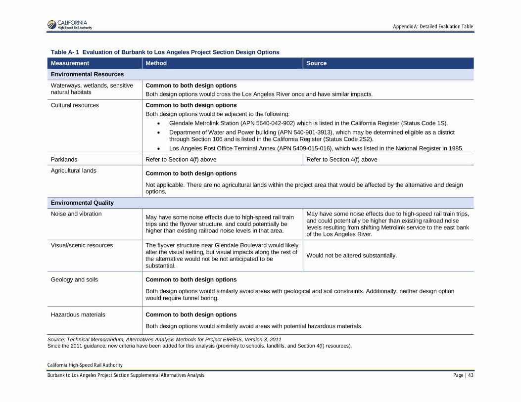
Appendix A: Detailed Evaluation Table
California High-Speed Rail Authority
Burbank to Los Angeles Project Section Supplemental Alternatives Analysis Page | 43
Table A- 1 Evaluation of Burbank to Los Angeles Project Section Design Options
Measurement Method Source
Environmental Resources
Waterways, wetlands, sensitivenatural habitats
Common to both design optionsBoth design options would cross the Los Angeles River once and have similar impacts.
Cultural resources Common to both design optionsBoth design options would be adjacent to the following:
· Glendale Metrolink Station (APN 5640-042-902) which is listed in the California Register (Status Code 1S).· Department of Water and Power building (APN 540-901-3913), which may be determined eligible as a district
through Section 106 and is listed in the California Register (Status Code 2S2).· Los Angeles Post Office Terminal Annex (APN 5409-015-016), which was listed in the National Register in 1985.
Parklands Refer to Section 4(f) above Refer to Section 4(f) above
Agricultural lands Common to both design options
Not applicable. There are no agricultural lands within the project area that would be affected by the alternative and designoptions.
Environmental Quality
Noise and vibration May have some noise effects due to high-speed rail traintrips and the flyover structure, and could potentially behigher than existing railroad noise levels in that area.
May have some noise effects due to high-speed rail train trips,and could potentially be higher than existing railroad noiselevels resulting from shifting Metrolink service to the east bankof the Los Angeles River.
Visual/scenic resources The flyover structure near Glendale Boulevard would likelyalter the visual setting, but visual impacts along the rest ofthe alternative would not be not anticipated to besubstantial.
Would not be altered substantially.
Geology and soils Common to both design options
Both design options would similarly avoid areas with geological and soil constraints. Additionally, neither design optionwould require tunnel boring.
Hazardous materials Common to both design options
Both design options would similarly avoid areas with potential hazardous materials.
Source: Technical Memorandum, Alternatives Analysis Methods for Project EIR/EIS, Version 3, 2011Since the 2011 guidance, new criteria have been added for this analysis (proximity to schools, landfills, and Section 4(f) resources).

Appendix A: Detailed Evaluation Table
California High-Speed Rail Authority
44 | Page Burbank to Los Angeles Project Section Supplemental Alternatives Analysis
This Page Intentionally Left Blank

Appendix B: Outreach Summary Table
California High-Speed Rail Authority
Burbank to Los Angeles Project Section Supplemental Alternatives Analysis Page | 45
Appendix B Outreach Summary Table
Table B-1 Outreach Summary Table
No. Date Meeting Category1 Jurisdiction
1 May 6, 2014 Burbank City Council B Burbank
2 May 13, 2014 Office of LA City Councilmember FelipeFuentes B Los Angeles
3 May 21, 2014 SAA Community Open House Meeting –Downtown LA P Los Angeles
4 May 28, 2014 SAA Community Open House Meeting –Burbank P Burbank
5 May 13, 2014 Office of LA City Councilmember FelipeFuentes B Los Angeles
6 June 25, 2014 USACE and USEPA AS Federal
7 July 21, 2014 City of Burbank Transportation Committee STO Burbank
8 July 23, 2014 Walt Disney Studios STO Burbank
9 August 5, 2014 LADOT and Planning Department AS Los Angeles
10 August 6, 2014 Scoping Meeting - Burbank P Burbank
11 August 8, 2014 Scoping Meeting – FRA, STB, USACE,USEPA, USFWS, USBoR, NMFS P Federal
12 August 12, 2014 City of Los Angeles Planning Staff AS Los Angeles
13 August 12, 2014 Los Angeles River/Natural ResourcesDefense Council Working Group STO Los Angeles
14 August 19, 2014 Scoping Meeting - LA Union Station P Los Angeles
15 August 27, 2014 Little Tokyo Leadership GIO Los Angeles
16 September 2, 2014 Office of LA City Councilmember MitchO’Farrell B Los Angeles
17 September 4, 2014 Office of LA City Councilmember GilbertCedillo B Los Angeles
18 September 8, 2014 Office of U.S. Congressman XavierBecerra's B Los Angeles
19 September 9, 2014 Joint City of Burbank Council andTransportation Commission meeting STO Burbank
20 September 9, 2014 Burbank Area Legislative Briefing B Burbank
21 September 25, 2014 Tribal Information Meeting STO Los AngelesCounty
22 October 6, 2014 Los Angeles River Cooperation Committee STO Los Angeles
23 October 16, 2014 Burbank Chamber of Commerce GIO Burbank
24 October 27, 2014 USACE, USEPA, USFWS, and USFS AS Federal
25 November 4, 2014 Burbank & Glendale TransportationManagement Organizations STO Burbank
26 December 5, 2014 Walt Disney Studios STO Burbank
27 December 9, 2014 Office of Congressman Adam Schiff B Los AngelesCounty

Appendix B: Outreach Summary Table
California High-Speed Rail Authority
46 | Page Burbank to Los Angeles Project Section Supplemental Alternatives Analysis
Table B-1 Outreach Summary Table
No. Date Meeting Category1 Jurisdiction
28 January 21, 2015 Los Angeles Business Council Institute –Legislative Committee GIO Los Angeles
County
29 January 21, 2015 Office of LA County Supervisor Hilda Solis B Los AngelesCounty
30 January 28, 2015 City of Glendale AS Glendale
31 February 3, 2015 Burbank City Council B Burbank
32 February 7, 2015 Los Angeles Neighborhood Council Coalition STO Los Angeles
33 February 17, 2015 USACE AS Federal
34 February 17, 2015 USFS AS Federal
35 February 19, 2015 Legislative Briefing B / AS Los AngelesCounty
36 March 3, 2015 Office of LA City Mayor Eric Garcetti B Los Angeles
37 March 10, 2015 USEPA AS Federal
38 March 18, 2015 Office of Assemblyman Miguel Santiago B Los AngelesCounty
39 April 8, 2015 Independent Cities Association – Board ofDirectors Member, Robert Gonzales B Los Angeles
40 April 8, 2015 Legislative Briefing B Los AngelesCounty
41 April 9, 2015 Legislative Briefing B Los AngelesCounty
42 April 15, 2015 Metro Monthly Outreach Call AS Los AngelesCounty
43 April 21, 2015 USACE, USEPA, and USFWS AS Federal
44 April 28, 2015 USFS AS Federal
45 May 1, 2015 Office of LA County Supervisor Sheila Kuehl B Los AngelesCounty
46 May 15, 2015 Legislative Briefing B Los AngelesCounty
47 May 19, 2015 USFS AS Federal
48 May 20, 2015 USACE, USEPA, USFWS, and USFS AS Federal
49 May 20, 2015 Metro/HSR Monthly Outreach Call AS Los AngelesCounty
50 May 22, 2015 Office of Congressman Adam Schiff B Los AngelesCounty
51 June 17, 2015 Metro/HSR Monthly Outreach Call AS Los AngelesCounty
52 July 15, 2015 Metro/HSR Monthly Outreach Call AS Los AngelesCounty
53 July 23, 2015 City of Burbank Staff Briefing AS Burbank
54 July 29, 2015 City of Los Angeles Planning Staff AS Los Angeles

Appendix B: Outreach Summary Table
California High-Speed Rail Authority
Burbank to Los Angeles Project Section Supplemental Alternatives Analysis Page | 47
Table B-1 Outreach Summary Table
No. Date Meeting Category1 Jurisdiction
55 August 3, 2015 Glendale Concert in the Park P Glendale
56 August 20, 2015 Grand Ave (Los Angeles) Farmers Market P Los Angeles
57 September 8, 2015 Office of Los Angeles City Mayor EricGarcetti B Los Angeles
58 September 25, 2015 Office of Congresswoman Judy Chu B Los AngelesCounty
59 September 25, 2015 Office of Congressman Adam Schiff B Los AngelesCounty
60 October 5, 2015 Office of Senator Carol Liu B Los AngelesCounty
61 October 21, 2015 Office of LA City Mayor Eric Garcetti B Los Angeles
62 October 21, 2015 Metro/HSR Monthly Outreach Call AS Los AngelesCounty
63 October 27, 2015 Glendale City Council Briefing B Glendale
64 October 29, 2015 Legislative Staff Briefing B Los AngelesCounty
65 November 3, 2015 Stakeholder Working Group Meeting SWG Los AngelesCounty
66 November 6, 2015 USACE/ EPA Briefing AS Federal
67 November 10, 2015 Office of Congressman Xavier Becerra AS Los AngelesCounty
68 November 10, 2015 Community Open House (Downtown LA) P Los Angeles
69 November 16, 2015 Glendale City Staff Briefing AS Glendale
70 November 16, 2015 Community Open House (Glendale) P Glendale
71 November 17, 2015 The California Endowment Briefing GIO/AS Los Angeles
72 November 19, 2015 USACE Briefing AS Federal
73 November 19, 2015 Community Open House Meeting (CypressPark/LA) P Los Angeles
74 December 2-4, 2015 California Transportation PlanningConference GIO Los Angeles
75 December 8, 2015 Reimbursable Agreement with City of LA AS Los Angeles
76 December 8, 2015 Briefing - Office of Councilman O'Farrell B Los Angeles
77 December 8, 2015 Briefing - Office of Councilman Huizar B Los Angeles
78 December 8, 2015 Briefing - with Office of Senator DeLeon B Los Angeles
79 December 9, 1915 LADOT AS Los Angeles
80 December 10, 2015 The Transit Coalition Event GIO Los Angeles
81 December 16, 2015 Chinatown Business Improvement District STO Los Angeles
82 December 16, 2015 Metro/HSR Monthly Outreach Call AS Los Angeles
83 January 7, 2016 LOSSAN TAC Monthly Coordination AS Southern California
84 January 20, 2016 Metro/HSR Monthly Outreach Call AS Los Angeles

Appendix B: Outreach Summary Table
California High-Speed Rail Authority
48 | Page Burbank to Los Angeles Project Section Supplemental Alternatives Analysis
Table B-1 Outreach Summary Table
No. Date Meeting Category1 Jurisdiction
85 January 21, 2016 Small Business Workshop - LARiver/Glendale AS Glendale/Los
Angeles
86 January 28, 2016 Chinatown Business Improvement DistrictBoard – Presentation STO Los Angeles
87 February 9, 2016 NRDC Working Group STO Los Angeles
88 February 17, 2016 Metro/HSR Monthly Outreach Call AS Los Angeles
89 February 19, 2016 USC APA and ITE Student ChaptersPresentation GIO Los Angeles
90 February 19, 2016 Office of Councilmember Cedillo AS Los Angeles
91 February 19, 2016 Office of Councilman O'Farrell AS Los Angeles
92 February 23, 2016 Metro Meet the Primes - Exhibit Booth GIO Los Angeles
93 March 8, 2016 Cypress Park Neighborhood Council STO Los Angeles
94 March 16, 2016 City of Los Angeles Staff AS Los Angeles
95 March 16, 2016 City of Glendale Staff AS Glendale
96 March 26, 2016 Cesar Chavez celebration AS Glendale
97 April 2, 2016 Stakeholder Working Group Meeting SWG Los Angeles
FRA = Federal Railroad Administration; NMFS = National Marine Fisheries Service; NRDC = Natural Resources Defense Council;STB = Surface Transportation Board; USACE = United States Army Corps of Engineers; USBoR = United States Bureau ofReclamation; USEPA = United States Environmental Protection Agency; USFS = United States Forest Service; USFWS = UnitedStates Fish and Wildlife Service
1 Category Key: AS = Agency Staff; B = Briefing; GIO = General Interest Organization; PIM = Public Information Meeting;STO = Stakeholder Organization; SWG = Stakeholder Working Group