Embed Size (px)
Citation preview
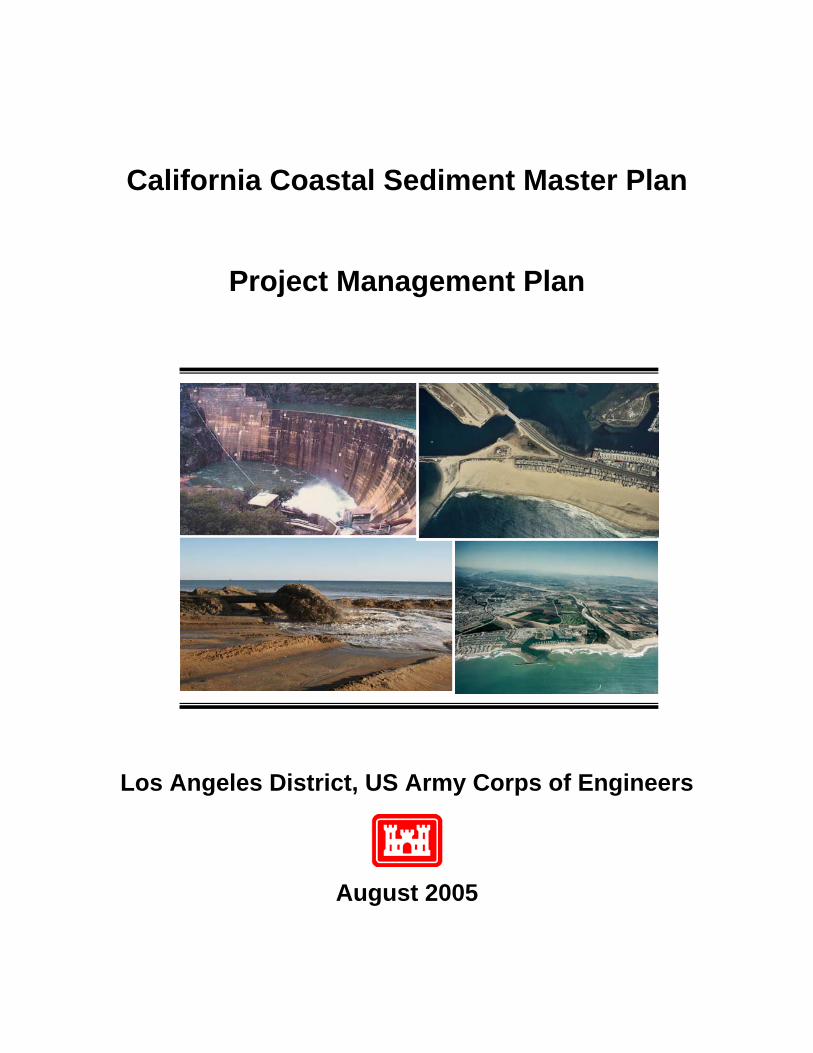
California Coastal Sediment Master Plan
Project Management Plan
Los Angeles District, US Army Corps of Engineers
August 2005
PROJECT MANAGEMENT PLAN
California Coastal Sediment Master Plan

PURPOSE AND SCOPE 1-1
PROJECT MANAGEMENT PLAN California Coastal Sediment Master Plan
DEFINITION OF A PROJECT MANAGEMENT PLAN: The Project Management Plan for the feasibility phase, herein after referred to as the PMP, is an attachment to the Feasibility Cost Sharing Agreement (FCSA), which defines the planning approach, activities to be accomplished, schedule, and associated costs that the Federal Government and the local sponsor(s) will be supporting financially. The PMP, therefore defines a contract between the Corps and the local Sponsor(s), and reflects a "buy in" on the part of the financial backers, as well as those who will be performing, and reviewing, the activities involved in the feasibility study. The PMP describes the initial tasks of the feasibility phase, continues through the preparation of the final feasibility report, the project management plan for project implementation and design agreement, and concludes with support during the Washington-level review of the final feasibility report. The PMP is a basis for change. Planning is an iterative process without a predetermined outcome. Therefore, estimated time and cost can and does change. It may be necessary to revise the scope following reformulation and evaluations of the alternatives. The scope and assumptions, for this study effort, should be clearly outlined and stated so the Corps and the Sponsors(s) understand the objectives and agree with the level of detail contained in the PMP. If study tasks are added or removed from the plan contained herein, and significantly impact cost or schedule beyond that allowable as stated in the FCSA, this PMP will be revised to reflect the required change. Any impact in time or cost can be assessed and an appropriate decision or recommendation can be made on how to proceed. The PMP provides the basis for change as well as allows the documentation of significant alterations. The PMP is a basis for review and evaluation of the feasibility report. Since the PMP represents a contract among study participants, it will be used as the basis to determine if the draft feasibility report has been developed in accordance with established procedures and previous agreements. The PMP reflects the agreed upon scope between the Corps and the Sponsor(s) and outlines the intent of the study to the Corps’ District, Division, and Headquarters’ management and to the sponsor’s management. It not only contains the scope but also critical assumptions, methodologies, and the level of detail for the studies that are to be conducted during the feasibility study. A review of the draft report will be completed to ensure that the study has been prepared consistent with the contents of this PMP. The objective is to provide early assurance that the study activities, tasks and documentation is performed consistent with Corps policies and guidelines and will be supported by Corps Headquarters and the Sponsor’s management. The PMP is a study management tool. It includes scopes of work that are used for funds allocation by the project manager. It forms the basis for identifying commitments to the non-Federal sponsor and serves as a basis for performance measurement. SUMMARY OF PROJECT MANAGEMENT PLAN CONTENTS: This PMP is comprised of the following chapters: Chapter 1 - Purpose and Scope. This chapter includes the definition of the PMP and a summary of the PMP requirements. Chapter 2 - Section 905(b) Analysis. This chapter includes the approved Section 905(b) Analysis that includes an overview of the reconnaissance study findings, the plan formulation rationale and proposed streamlining initiatives. This chapter also documents any deviations
CHAPTER 1 PURPOSE AND SCOPE
PURPOSE AND SCOPE 1-2
PROJECT MANAGEMENT PLAN California Coastal Sediment Master Plan
from the approved Section 905(b) Analysis that have occurred during the negotiations of the FCSA. Chapter 3 - Work Breakdown Structure. A product based Work Breakdown Structure (WBS) defines the project, sub-projects, parent tasks and tasks that will be accomplished through the study. Chapter 4 - Scopes of Work. A detailed scope of the tasks and activities that describe the work to be accomplished, in narrative form, that answers the questions: "what, how, and how much". This chapter provides a reference to the detailed scopes of work that are included as Enclosure C to the PMP. Chapter 5 - Responsibility Assignment. An Organizational Breakdown Structure (OBS) will define "who" will perform work on the study. This allows the identification of the functional organization that will perform each of the tasks in a Responsibility Assignment Matrix (RAM). Chapter 6 – Feasibility Study Schedule. The schedule will define "when" key decision points, CESPD milestone conferences and mandatory HQUSACE milestones will be accomplished. Chapter 7 - Feasibility Cost Estimate. This is the baseline estimate for the feasibility phase of the study. Chapter 8 - Quality Management Plan: This chapter supplements the district’s Quality Management Plan. It highlights any deviations to the district’s plan and lists the members of the study team and the independent review team. Chapter 9 - Identification of Procedures and Criteria: This chapter identifies references to the regulations and other guidance that covers the planning process and reporting procedures. Chapter 10 - Coordination Mechanisms: This chapter describes the study’s public involvement program. STUDY ROADMAP The intent of the California Coastal Sediment Master Plan (Master Plan) is to develop a comprehensive sediment management plan at a super-regional scale that covers the entire coastal zone of the state of California. In order to do that the study must first gather all existing data at a coarse level that is relevant to establishing the foundation for sediment management along the coast. Once this task is completed, data gaps can then be identified. A more refined data collection program will be initiated for discrete regions upon accomplishing the initial phase of the state-wide data collection efforts. By undertaking an approach of first developing a broadly based data management system for coastal sediments and then nesting this system to specific regions, will allow for useful information being almost immediately available across the State’s shorelines for other initiatives undertaken by interests outside the Master Plan program and identifying areas of immediate focus for developing regional decision support systems for the management of coastal sediments. As decision support systems are developed at a regional level, these systems will be modified for export to other physically compatible regions, until decision support systems for sediment management within each coastal region has been placed into operation. Tackling the enormous project area in this manner will allow sediment management answers to be developed quicker, and allows the study to focus on specific sediment issues in each region. For example, a lack of sediment is of great concern to those in central and southern California, whereas, environmental issues, related to sediment, are a
PURPOSE AND SCOPE 1-3
PROJECT MANAGEMENT PLAN California Coastal Sediment Master Plan
greater concern in northern California. It is important that the study does not treat the entire coast in the same manner.
Section 905(b) Analysis 2-1
PROJECT MANAGEMENT PLAN California Coastal Sediment Master Plan
CALIFORNIA COASTAL SEDIMENT MASTER PLAN RECONNAISANCE STUDY SECTION 905(b) (WRDA 86) ANALYSIS 1. Study Authority This Section 905(b) analysis was prepared under the following authority: House Committee on Transportation and Infrastructure Resolution 2672, May 22, 2002 “California Coastal Sediment Master Plan resolved by the Committee on Transportation and Infrastructure of the United States House of Representatives, That, in accordance with Section 110 of the River and Harbor Act of 1962, the Secretary of the Army is requested to develop a comprehensive plan for the management of sediment in coastal California for purposes of reducing shoreline erosion and coastal storm damages, providing for environmental restoration and protection, increasing natural sediment supply to coast, restoring and preserving beaches, improving water quality along coastal beaches, beneficially using material dredged from ports, harbors and other opportunistic sediment sources, and related purposes.” Funds in the amount of $100,000 were appropriated in FY03 to conduct the reconnaissance phase of this study. 2. Study Purpose California’s beaches and coastal areas provide a valuable habitat resource for a wide variety of marine life and endangered species. Additionally, it’s sandy beaches, meandering bicycle paths, seaside residences; ports, harbors, surf and beautiful sunsets are a determinant for California’s economy and quality of life. From an economy too small to measure before the Gold Rush, California has emerged as the eighth ranked economy in the world, becoming the first state whose gross product exceeded the trillion-dollar mark in 1997. Coastal tourism is an integral part of the state and local economies. In 1998 the State of California Department of Boating and Waterways conducted studies that estimated California’s beach economy was responsible for $14 billion in direct spending, generating $1 billion in state taxes and more than 500,000 jobs. Coastal sediments that comprise California’s beaches today have historically originated from inland sources, through a series of physical processes and mechanisms, involving terrestrial erosion, hydraulic transport and finally deposition within rivers, coastal lagoons/estuaries and exposed shorelines. Once reaching the coast, these sediments again undergo the cycle of erosion, transport and redistribution. California has approximately 1,100 miles of coastline, 86 percent of this valuable resource is actively eroding due to natural and human induced alterations in the sediment’s cycle. Navigation and shoreline structures, along with implementation of water control projects, have contributed significantly in affecting total yield and movement of sediments to and along the coast. It is clearly understood that there is a strong interdependency amongst coastal sediments and the wide array of today’s coastal resources issues. Recreation, public and aquatic ecosystem health, water quality, navigation safety, storm damage reduction, shoreline protection, sand rights and economic vitality are prime examples of areas of public interest which are directly impacted by the transport and distribution of coastal sediments. In the past, coastal resources issues within the State of California have been addressed and compartmentalized at either site or project specific levels. However, state and Federal agencies are now looking, in an era of
CHAPTER 2 SECTION 905(B)(WRDA) ANALYSIS
Section 905(b) Analysis 2-2
PROJECT MANAGEMENT PLAN California Coastal Sediment Master Plan
limited resources, for an efficient blend of scientific evidence and public policy to facilitate regional inter-agency cooperative initiatives to protect, enhance and restore California’s important coastal resources through a system-wide sediment management approach. As a result, the U.S. Army Corps of Engineers and the State of California through the California Resources Agency have established a formal collaborative relationship to address these issues at a “super-regional” scale under the Coastal Sediments Management Workgroup, which has cumulated in the initiation of a comprehensive and adaptive Master Plan to programmatically manage California’s coastal sediments. The California Coastal Sediments Master Plan’s integrated approach to sediment management will maximize Federal, State and local investments by developing “super-regional” solutions to coastal resources problems and providing lasting benefits by allowing agencies to efficiently work together by leveraging financial and technical resources. The Master Plan will provide coastal managers, planners and engineers with the information needed to develop best management practices and optimize strategies to realize environmental and economic benefits for the State of California and the Nation. Among the main objectives for the Master Plan is to generate information to identify and prioritize sediment-related projects; review regulatory coordination; develop opportunistic sand programs; develop a programmatic Environmental Impact Statement; and assess the cumulative impacts and benefits of sediment-related projects at regional levels. The purpose of the California Coastal Sediments Master Plan is to determine if there is a Federal interest in a cost-shared feasibility study to provide framework for storm damage reduction, environmental restoration, navigation, recreation, and related purposes along the California coast. The Master Plan will consolidate information on the historic, present, and project future conditions related to coastal resources along the California coast; develop and analyze coastal processes; and provide a framework for the State of California and other interests managing the coastal resources along California. This could include identifying problems, needs and opportunities; developing localized and regional solutions; prioritizing solutions; and developing common databases. The purpose of this Section 905(b) (WRDA 86) Analysis is to document the basis for this finding and establish the scope of the study. As the document that establishes the scope of the study, the Section 905(b) (WRDA 86) Analysis is used as the chapter of the Project Management Plan (PMP), which presents the reconnaissance overview and rationale for plan formulation. 3. Location of Study, Non-Federal Sponsor and Congressional District The study area covers the entire California region approximately 1,770 kilometers (1,100 miles) of shoreline along the Pacific Ocean coastline. The State of California, the third largest state in the United States, has a total area of 411,469 sq km (158,869 sq mi), including 6,929 sq km (2,674 sq mi) of inland water and 575 sq km (222 sq mi) of coastal waters over which it has jurisdiction (Attachment 1).
With 12 physiographic regions from high mountains, foothill woodland, chaparral, moist forests, and an alternating rocky and sandy coast, California has high topographic diversity, including the highest land in the continuous 48 states (Mt. Whitney’s elevation is 4,406 meters). Large differences in daily and annual temperatures, precipitation, and evaporation lead to differing vegetation patterns and centers of plant endemism. Where rivers and smaller drainages reach the coast, there may be protected bays, salt marshes, and coastal dunes.
In the past, the dominant source of sediments to the coast has been rivers and
streams. These were the transport mechanisms that moved sediment from the
Section 905(b) Analysis 2-3
PROJECT MANAGEMENT PLAN California Coastal Sediment Master Plan
mountains and uplands to the lowland basins and nearshore systems. However, over the last thirty or forty years most of the rivers have been tamed through the construction of large dams (more than 1,200), trapping all but the finest sediments being transported downstream.
Damming rivers has cut off more than 50 percent of the sand supply. As a
result, the beaches of California have undergone substantial erosion since the construction of these dams. Only in northern California is there a constant supply of sediments to the nearshore as there wasn’t a need to dam the streams and rivers in the early days and now the Wild and Scenic Rivers Act of 1972 protect them. (Kenzer, et. al., 1992)
Other human induced factors to consider in this equation are the impacts over
tourism industry and Californian’s quality of life. As much as 85 percent of the state’s population live within 50 miles to the coastline. This results in significant urbanization pressures, which impact coastal resources.
Residents and visitors enjoy California's beaches; more than 100 million visitors
come to the California beaches annually, almost 60 million visitors in Los Angeles County alone. These beach users are generating millions of dollars in taxes to local, state and Federal level. (Kenzer, et. al, 1992)
California is now the seventh ranking economy in the world, about the size of
Mainland China, and larger than Brazil, Canada or Spain. California's gross product exceeded the trillion-dollar mark in 1997, the first state to achieve this record. In 1999, California was the first state to top $1 trillion in personal income. (California Dept of Finance http://www.dof.ca.gov/HTML/FS_DATA/HistoryCAEconomy/index.htm)
In 1999, the California Department of Boating and Waterways commissioned
San Francisco State University to ascertain the impact of beaches on California’s economy. The results showed that in 1995, it was estimated that the state’s beaches were responsible for $10 billion in direct spending (updated to 1998 to $14 billion), $1 billion in state taxes and more than 500,000 jobs. The spending, with a multiplier effect, was almost 3 percent of the economic activity in the state in 1995. Beach-related jobs constituted 3.5 percent of the state’s employment. (King and Potepan, 1997)
This is important at both the Federal and State levels. A strong California
economy reflects in California taxpayers sending a record $23 billion windfall to Washington in 1999, and maintained its donor state status for a 13th straight year by November 2000. Demonstrating that protecting California coastal resources (closely related with the economy's strength) is directly linked to Federal benefits. (California's Balance of Payments with the Federal Treasury FY 81-99 The California Institute for Federal Policy Research http://www.calinst.org/pubs/bop2000.htm)
In order to preserve and restore our remaining coastal shorelines, wetlands and
watersheds there is a need to develop a comprehensive sediment master plan that utilizes a regional systematic approach to resolving coastal sediment management issues.
The non-Federal Sponsor for the feasibility phase of this Master Plan Study is the California Department of Boating and Waterways.

Section 905(b) Analysis 2-4
PROJECT MANAGEMENT PLAN California Coastal Sediment Master Plan
1) The study area lies within the jurisdiction of Congressional Districts as detailed in Attachment 2. 2) United States Senators representing California, Barbara Boxer and Diane Feinstein, are also interested in this study. 4. Prior Reports and Existing Projects a. The following reports have been reviewed as part of this study. 1) Beach Erosion at Santa Barbara, U.S. Army Corps of Engineers, House Document 552-75th Congress, 3rd Session, 1938. The earliest Federal study within the area concerned with shoreline processes was completed on January 15, 1938. Summarizing serious erosion along the coast from Santa Barbara point to the Carpinteria Creek, the field study recommended that the dredged material from Santa Barbara harbor be placed on East Beach for beach restoration. Subsequent supplementary studies were conducted in 1941, 1942, and 1946 to assess the effectiveness of beach restoration by artificial nourishment that was performed in 1940. 2) Shore protection report on proposed harbor improvements at Ventura and Hueneme, U.S. Army Corps of Engineers, May 20, 1940. A shore protection report to assess the probable effect of proposed harbor improvements being considered at Ventura and Port Hueneme was prepared to in 1940. Field survey data that was collected indicated that shoreline advances between Ventura and Point Hueneme occurred. Northwest of this area the mountainous coastline was concluded to be gradually receding. The shoreline between Port Hueneme and Point Mugu was considered to be stable. 3) Harbor and Shore protection in the vicinity of Port Hueneme, California, U.S. Army Corps of Engineers, October 1948. A report regarding harbor and shore protection in the vicinity of Port Hueneme was published pursuant to Public Law 525, House Resolution 6407 as approved by the 79th Congress on July 24, 1946. The report was prepared to investigate the serious beach erosion downcoast of Port Hueneme that occurred as a result of jetty improvements constructed at the entrance in 1940. A beach nourishment program with an initial fill of 3.1 million cubic meters (4 million cubic yards) and biennial replenishment of 766,000 cubic meters (one million cubic yards) was concluded to be the preferred mitigation alternative. The report further recommended that a small-craft harbor be constructed upcoast with a sand trap in order to provide sand storage and support the beach maintenance program. 4) Beach-Erosion Control Report on Cooperative Study of Pacific Coastline of the State of California from Point Mugu to San Pedro Breakwater, U.S. Army Corps of Engineers, Los Angeles District, September 1950. This comprehensive study analyzes data acquired from previous investigations in the regions of the California coastline between Point Mugu in Ventura County and the San Pedro breakwater located in Los Angeles County. This report represents the earliest and most extensive historical database regarding the volumes and directions of alongshore littoral transport, historical shoreline orientation, wave dynamics, fluvial watershed discharges, and beach morphology. The findings indicate that the littoral material reaching Santa Monica Bay appears to be principally derived from sources upcoast from Point Mugu and that local tributary streams contribute relatively small amounts of materials to the beach. The direction of transport was found to be generally downcoast except for the region between Torrance Beach and Rocky Point where there appeared to be a local reversal in the net littoral transport direction. The report indicates that the artificial beach fill alternative would afford the best means of beach erosion protection in the Santa Monica Bay.
Section 905(b) Analysis 2-5
PROJECT MANAGEMENT PLAN California Coastal Sediment Master Plan
5) Beach Erosion Control Report on cooperative study of pacific coastline of the state of California, Carpinteria to Point Mugu”, U.S. Army Corps of Engineers, February 1951. In 1951, a beach erosion control study was conducted on the Santa Barbara/Ventura coastline from Carpinteria to Point Mugu. A report was prepared to assess the characteristics of littoral drift within this coastal segment. It was concluded that the littoral drift was predominantly downcoast at a rate ranging from 191,000 m3/yr (250,000 cy/yr) at Carpinteria to 765,000 m3/yr (1,000,000 cy/yr) along the Oxnard plain. Fluvial delivery was estimated to be 191,000 m3/yr (250,000 cy/yr) from streams between Carpinteria and Ventura River and 917,400 m3/yr (1,200,000 cy/yr) from the Santa Clara River respectively. The report proposed that a groin field be constructed adjacent to Ventura Pier to stabilize an eroding beach condition. 6) As part of Public Law 286, 84th congress, approved July 28, 1956, Federal assistance was authorized for protection of publicly owned shores with provisional assistance available for privately held areas. As a result of the Act, the Corps inaugurated a continuing cooperative study of the coast of southern California between Cape San Martin and the Mexican border. The purpose of the Study was to determine areas of active or potential erosion, obtain wave and shore process data, evaluate attempts to solve beach erosion problems, and generally determine the overall shoreline conditions within the study limits.
7) Two interim reports (Beach Erosion Control Report on Cooperative Study of Coast of Southern California, Point Conception to Mexican Boundary, Appendix VII, Interim Report, U.S. Army Corps of Engineers, Los Angeles District Corps of Engineers, April 5, 1960. and Beach Erosion Control Report on Cooperative Study of Coast of Southern California, Point Conception to Mexican Boundary, Appendix VII, 2nd Interim Report with Appendixes, U.S. Army Corps of Engineers, Los Angeles District Corps of Engineers, August 24, 1962), a special interim report on Ventura area (Special Interim Report on Ventura Area, Beach Erosion Control Report on Coast of Southern California, Appendix VII, U.S. Army Corps of Engineers, August 10, 1961), a final report (Beach Erosion Control Report on Cooperative Study of Southern California, Cape San Martin to Mexican Boundary, Appendix VII, Final Report, U. S. Army Cops of Engineers, Los Angeles District Corps of Engineers, June 1967), and two three-year reports (Beach Erosion Control Report on Cooperative Research and Data Collection Program of Coast of Southern California, Cape San Martin to Mexican Boundary, Three Year Period, 1964-1965-1966, U.S. Army Corps of Engineers, Los Angeles District Corps of Engineers, 1969 and Beach Erosion Control Report on Cooperative Research and Data Collection Program of Coast of Southern California, Cape San Martin to Mexican Boundary, Three Year Report, 1967 – 1969, U.S. Army Corps of Engineers, Los Angeles District Corps of Engineers, December 1970) were prepared. These reports, generally described the shoreline conditions along the Santa Barbara and Ventura coastline and indicated the following findings: 1) the beaches downcoast of Santa Barbara Harbor are dependent upon sand bypassing from the maintenance dredging; 2) severe erosion has occurred at Sandyland Cove (Padero Lane) and remedial protection measures are necessary; 3) Carpinteria Beach State Park is a wide sandy beach that has maintained its stability over the past few years; 4) between Rincon Point and Ventura River, most of the beaches are covered with exposed cobbles, and in some areas a thin layer of sand; 5) the shoreline between the Ventura Pier and the Ventura Harbor is currently a wide stable beach due to the construction of a groin field; 6) the beach between the Santa Clara River and Channel Islands Harbor is relatively stable; 7) the shoreline between Port Hueneme and Point Mugu is generally stable, except at the U.S. Navy facility where erosion is occurring; and 8) most of the shoreline beyond Point Mugu to the Ventura-Los Angeles County line is rocky with a few stretches of unstable sandy beach. 8) Inspection Tour of Shoreline-Santa Barbara to Imperial Beach, Department of Water Resources, U.S. Corps of Engineers, June 1966. This report provides aerial photographs,
Section 905(b) Analysis 2-6
PROJECT MANAGEMENT PLAN California Coastal Sediment Master Plan
design specifications, and improvement plan formulations for increased shore protection between Point Mugu and the San Pedro Breakwater. 9) Beach Erosion Control Report on Cooperative Research and Data Collection Program of Coast of Southern California-Cape San Martin to Mexican Boundary Three-Year Report -- 1964-1966, U.S. Army Corps of Engineers, December 1967. This report presents the results of a three-year research and data collections program for the California coastline, south of San Luis Obispo County, to identify areas of active or potential erosion. The data collections, specifically for Los Angeles County, include aerial and ground photographs, hydrographic surveys, numerous sand samples, descriptions of beach morphology, and a step-resistant wave gage located at the end of the Ventura Pier. Trends of severe erosion were found to occur at Westward Beach, upcoast of Point Dume, at Redondo Beach, downcoast of the Redondo Submarine Canyon, and along several pocket beaches located on the Palos Verdes Peninsula. 10) Beach Erosion Control Report on Cooperative Research and Data Collection Program of Coast of Southern California-Cape San Martin to Mexican Boundary Three-Year Report- 1967-1969, U.S. Army Corps of Engineers, December 1970. This second three-year report presents the results of a research and data collections program for the California coastline, south of San Luis Obispo County, for identifying areas of active or potential erosion. With regards to Los Angeles County, the report includes analysis from data obtained through beach inspections, aerial and ground photographs, hydrographic surveys, sand samples, one wave gage, offshore sand sources, shoreline conditions, evaluation of wave refraction models and beach profiles. 11) In 1978, the Corps of Engineers (Inspection Tour of Shoreline Santa Barbara to Imperial Beach, U.S. Army Corps of Engineers, May 1978 and Survey Report for Beach Erosion Control, Ventura County, California” Main Report and Appendices, U.S. Army Corps of Engineers, May 1979) prepared a survey report for Ventura County and performed a shoreline inspection from Santa Barbara to Imperial Beach. The survey report indicated that the shoreline within Ventura County has gradually eroded. The shoreline investigation showed that major problems exist at Faria and Hobson Beach parks, and Emma Wood State Beach where periodic erosion has threatened public and private property. The erosion problems at Faria and Hobson Beach parks occurred soon after completion of the Highway 101 construction at Seacliff in the early 1970s. 12) Sediment Management for Southern California Mountains, Coastal Plains and Shoreline-Part C: Coastal Sediment Delivery by Major Rivers in Southern California, William R. Brownlie and Brent D. Taylor, February 1981. This joint study conducted by the Environmental Quality Laboratory at the California Institute of Technology and the Center for Coastal Studies at the Scripps Institution of Oceanography determines the effects human developments have had on the sedimentary processes of Southern California’s drainage basins. Fifty three percent of the total drainage area in Southern California has been altered by either major water retention structures, diversion facilities, channelization, sand and gravel mining operations, percolation basins, ground water pumping, irrigation ditches, or other man-made systems. This report provides detailed information on the sedimentary delivery and transport rates of the major and minor fluvial sources throughout Los Angeles, Orange, and San Diego Counties. 13) Southern California Coastal Photography and Beach Profile Index, Coast of California Storm and Tidal Waves Study, U.S. Army Corps of Engineers, February 1986. This report provides an inventory of the available coastal data in the archives located at the Corps of Engineers Los Angeles District Headquarters. The information includes aerial and ground photographs, beach profile data, beach characteristics, historic shoreline changes, and the effects of storms on beach morphology and structures. The report also documents any significant beach and inlet changes along the Los Angeles County shoreline.
Section 905(b) Analysis 2-7
PROJECT MANAGEMENT PLAN California Coastal Sediment Master Plan
14) The City of Carpinteria has prepared an annual summary for its winter protection berm project since 1986. Each year, the city constructs a 1,450-foot sand berm between Linden Avenue and Ash Avenue to provide storm-damage protection between the months of December and April. Each annual report includes the project description, sand berm volume calculations, beach profile surveys and biological reports related to the grunion surveys (Annual Project Summary for Winter Protection Berm Project, City of Carpinteria, 1986-1996). 15) Consolidated Plan of Study, Coast of California Storm and Tidal Waves Study, U. S. Army Corps of Engineers, March 1987. This report presents a consolidated study plan for the entire 1,760-kilometer (1,100-mile) California Shoreline after a plan of study laid out in 1983 and to be completed in 1989 for the San Diego Region. Six shoreline regions are discretized on the basis of scientific and practical consideration. All study efforts shall result in three products: coastal erosion and water level planning map, a coastal planning handbook for the region, and a state-of-the-coast summary report. This consolidated plan defines different levels of study plans based upon a number of practical and scientific reasons. For the South Coast Region including both Los Angeles and Orange Counties, a minimum plan of study is recommended. 16) Coastal Sand Management Plan; Santa Barbara/Ventura County Coastline”, prepared for Beach Erosion Authority for Clean Oceans and Nourishment (BEACON). Executive Summary Main Report and Appendices, Noble Consultants, Inc., July 1989. A coastal sand management plan was prepared by Noble Consultants, Inc. for the Beach Erosion Authority for Clean Oceans and Nourishment (BEACON). The purpose of the study was to develop an understanding of the coastal processes within the Santa Barbara and Ventura County coastline and provide a regionally coordinated program to manage existing sand sources. Offshore sand sources were identified and preferred plans for beach nourishment were recommended in the study. 17) Rancho Palos Verdes/Rolling Hills, California Reconnaissance Study, U.S. Army Corps of Engineers, June 1990. This final reconnaissance study report investigates the feasibility of constructing shoreline erosion mitigation measures in order to prevent landslides, provide additional bluff stabilization, and eliminate the transport of debris and sediment to the nearshore and downcoast areas along the Palos Verdes Peninsula. The areas of prime concern include Portuguese Bend, Abalone Cove, and Klondike Canyon. Nine alternative measures are proposed with varying degrees of expected environmental and economic benefits. 18) Historical Changes in the Beaches of Los Angeles County, Malaga Cove to Topanga Canyon, 1935-1990, Coastal Frontiers Corporation prepared for County of Los Angeles Department of Beaches and Harbors, 1992. This report presents the effects human intervention has had along the Santa Monica Bay shoreline from Malaga Cove to Topanga Canyon. Beach profile surveys were conducted in May 1989, January 1990, and June 1990, the results of which were compared to historic profile surveys conducted in October 1935, November 1946, and October 1953. The analysis indicates that as a result of the 23.7 million cubic meters (31.6 million cubic yards) of artificial nourishment placed along the beach, 95% of which was placed prior to 1970, and the subsequent departmentalization of the shoreline, beach widths have increased by 45 to 152 meters (150 to 500 feet) throughout the nourished region. Adverse beach erosion impacts as a result of human activities were found to occur downdrift of some of the early constructed coastal structures; however, by nourishing the adjacent beaches at the time of construction, this problem was mitigated. 19) Malibu/Los Angeles County Coastline Reconnaissance Report, Los Angeles County, California, U.S. Army Corps of Engineers, April 1994. The purpose of this reconnaissance report is to determine the feasibility of providing shoreline protection against coastal storm flooding along the open coast from the Los Angeles/Ventura County line to Malaga Cove in Los

Section 905(b) Analysis 2-8
PROJECT MANAGEMENT PLAN California Coastal Sediment Master Plan
Angeles County. This report outlines the physical characteristics within the study area including the geologic setting, beach morphology, sediment sources, bathymetry, climate, tides and water levels, wave activity, currents, and the basic coastal processes of the region. The project shoreline was divided into 20 reaches on the basis of distinguishing the differences in the beach characteristics and the density of the existing development. In addition, potential erosion prone areas are identified through coastal engineering analysis, and alternative mitigation strategies are proposed. 20) Review of Alternative Shoreline Erosion Management Strategy, Surfer’s Point, prepared for the City of San Buenaventura, Noble Consultants, Inc., July 1995. The City of San Buenaventura conducted a shoreline erosion study at Surfer’s Point. Alternative shoreline erosion management strategies were proposed to address a chronic erosion condition. Subsequently, a conceptual design study was conducted to develop a preferred alternative of managed shoreline retreat to protect a very popular bike path, pedestrian walkway, public parking areas, sensitive dune habitat, and beach access (Surfers Point Park, Managed Plan for Shoreline Retreat, prepared for the City of San Buenaventura, Noble Consultants, Inc., December 2000.). 21) Sand Contribution from Bluff Recession between Point Conception and Santa Barbara, California”, Diener, B. G., Shore and Beach, Vol. 68, No. 2, April 2000. A bluff erosion analysis between Point Conception and Santa Barbara was conducted to estimate the sediment contribution. Based upon historical aerial photographs and other information, it was concluded that bluff erosion supplies approximately 81,000 m3/yr (106,000 cy/yr) of sand to the littoral cell between Point Conception and Santa Barbara. 22) Goleta Beach Demonstration Project, Borrow Site Investigation, prepared for Beach Erosion Authority for Clean Oceans and Nourishment, Noble Consultants, Inc., October 2001. A beach demonstration nourishment project is currently proposed by BEACON to place approximately 191,000 cubic meters (250,000 cy) of material at Goleta Beach to alleviate a severe erosion condition. Field survey work to locate a suitable source of offshore borrow material was completed. 23) Goleta Beach County Park, Long Term Beach Restoration and Shoreline Erosion Management, Final Plan, prepared for the County of Santa Barbara, Moffatt and Nichol Engineers, March 2002. A long-term plan for beach restoration and shoreline erosion management at Goleta Beach County Park was prepared by the County of Santa Barbara. The purpose of this plan study was to 1) maintain a recreational beach and easy beach access; 2) improve environmental conditions within the park including the Goleta Slough; and 3) protect the supporting parking lot, buildings, and utilities infrastructures within the park. 24) California Beach Restoration Study, A report on the future need for beach nourishment in California and the effectiveness of past projects was prepared by the Department of Boating and Waterways and State Coastal Conservancy in 2002. The report summarized the economic value of beach nourishment projects to the State’s economy. In order to restore the State’s beaches, a restoration cost of approximately $120 million for initial construction and $27 million for annual maintenance was identified. The report also summarized the processes of natural supply of sediment to the coast and ways to reduce current sand delivery deficits caused by historical development and urbanization of the tributary watersheds. Removal of dams or bypassing sand around the barriers was concluded to be a principal action for consideration that would lessen future dependency on artificial beach nourishment. b. This study is not investigating any potential modifications to existing projects: Not applicable

Section 905(b) Analysis 2-9
PROJECT MANAGEMENT PLAN California Coastal Sediment Master Plan
5. Plan Formulation During a feasibility phase study, the formulation of solutions to specific problems is guided by six planning steps set forth in the Water Resource Council’s Principles and Guidelines. However, for this California Coastal Sediment Master Plan Study, the planning steps are modified as: 1) specify problems and opportunities; 2) inventory and forecast of coastal use; 3) understanding of regional coastal processes; 4) formulate regional sand management plans; 5) compare alternative plans, and 6) select recommended regional plans for implementation. The scope of data called for under these six steps shall guide the gathering and presentation of information resulting in the California Coastal Sediment Master Plan Study, to assure that the resulting products can be of use to the local sponsor and other potential coastal planners. a. National Objectives 1) The development and preparation of products under the California Coastal Sediment Master Plan, California will be pursued considering the national or Federal objective of water and related land resources planning. This national objective is to contribute to the national economic development consistent with protecting the nation’s environment, pursuant to national environmental statutes, applicable executive orders, and other Federal planning requirements. Contributions to National Economic Development (NED) are increases in net value of the national output of goods and services, expressed in monetary units. Contributions to NED are the direct benefits that accrue in the planning area and the rest of the nation. Considering this objective will assure that study data is complete and adequate for whatever purposes it may serve in the future. 2) The Corps of Engineers has added a second national objective for Ecosystem Restoration in response to legislation and administration policy. This objective, which will also be considered during the course of the study, is to contribute to the nation’s ecosystems through ecosystem restoration, with contributions measured by changes in the amounts and values of habitat. Public Concerns A number of public concerns have been identified during the reconnaissance study. Initial concerns were expressed in the study authorization. Additional input was received through coordination with the State Resources Agency and its member agencies. The public concerns related to the establishment of planning objectives and planning constraints are: 1) Preservation and maintenance of sandy beaches is a high priority. To that end, it is desirable to better understand the regional coastal processes so that the performance of beach nourishment projects and management of existing sand bypass facilities can be improved. 2) Episodic storm events along the coastline result in repeated damages to public and private facilities and pose additional public safety concerns. 3) Degradation of existing conditions adversely impact recreational beach opportunities and fosters the continued nearshore encroachment of public and private structures. 4) Shoreline management strategies should be implemented that are not detrimental to the existing marine resources. Problems and Opportunities
Section 905(b) Analysis 2-10
PROJECT MANAGEMENT PLAN California Coastal Sediment Master Plan
The evaluation of public concerns often reflects a range of needs perceived by the public, and described in the context of problems and opportunities that can be addressed through water and related land management plans. For each problem and opportunity, the existing conditions and the expected future conditions are described, as follows:
1) Problems i. Loss of beach width and/or water quality degradation results in the loss of
recreational opportunities. Sedimentation of navigation channels results in navigation safety issues for boaters.
ii. Loss of beach width may result in an increase in coastal storm damage due to exposure of structures to direct wave attack, runup, and inundation.
iii. Loss of coastal wetlands due to land changes and sedimentation in wetlands and estuaries.
iv. Loss of Fish and Wildlife habitat for species such as grunion, snowy plover, least tern, steel head, as well as coastal marsh, wetlands, etc.
v. Lack of agency coordination amongst Federal, State and Local can lead to regulatory conflicts, redundancy in study and project efforts, failure to leverage funds for projects that are mutually beneficial to both State and Federal agencies.
vi. Coastal Navigation Safety can be impacted by shoaling and lack of dredge disposal sites.
vii. Sedimentation behind dams causes a loss of flood control and water supply capacity.
viii. Loss of Beneficial Reuse Opportunities of Sediments Due to Lack of Consensus on Physical Compatibility (80/20 Rule). Lack of compressive knowledge about sediment characteristics/process/impacts relationships.
ix. Anthropogenic interference and growth on sediment transport with regard to sand rights and Total Maximum Daily Loads (TMDLs).
x. Cost and impacts of transporting beach quality sediments from the source to the coastline.
xi. Regulators desire for greater than 90 percent coarse sand for beach nourishment projects, yet most natural sources of sand are approximately 60 percent coarse sand.
xii. Surveys of existing grain size distributions along California beaches are needed to establish sediment compatibility with existing conditions
xiii. NTU-based turbidity standards are very hard to deal with due to changing marine conditions and may not be the best method of analysis.
xiv. Educational tools are needed for regulators and project proponents to provide general information on coastal processes and basis for variances from the current 80/20 coarse/fines ratio typically required for beach nourishment projects.
xv. Regional sediment movement patterns need to be known to provide a framework for site-specific studies to determine where the fines are being transported.
Section 905(b) Analysis 2-11
PROJECT MANAGEMENT PLAN California Coastal Sediment Master Plan
xvi. Standardized and approved regulatory sampling protocols for turbidity and grain size distribution in beach/nearshore/offshore areas are needed.
xvii. Beach nourishment projects require comprehensive monitoring plans that produce scientifically defensible products, yet plan requirements often vary significantly across jurisdictional boundaries.
xviii. Project reporting requirements produce time delays that often result in loss of opportunities to use opportunistic sand sources for beach nourishment materials.
xix. Sand mining from rivers and use of dredged sands for construction materials reduces the amount of sand available for beaches.
xx. Areas of high geologic hazard need to be identified to support decisions about armoring, feasibility of other protective devices, coastal/planned, hazard avoidance retreat and economics of beach nourishment. Coastal geologic hazards include actively eroding areas, landslides, active fault zones, earthquake shaking/toppling and tsunami run-up zones.
2) Opportunities
i. Leverage of State and Federal Agencies technical expertise and financial resources for site specific projects.
ii. Eliminate redundancy of projects, studies and technical efforts and optimize the efficiency and effectiveness of coastal zone projects through improving Federal, State and Local coordination, cooperation and investments.
iii. Streamline the coastal zone project permitting through the development of processes frameworks for the local applicant. Potential for a “Single permit“ considering all conditions imposed by all regulatory agencies with jurisdiction.
iv. Establish relationships between Federal and State recreational benefit analyses. Currently, the Federal and State analyses account for recreation benefits in different ways. The State’s argument is that the Federal analysis does not optimally account for recreational benefits and thereby discounting important benefits for the Nation.
v. Develop regional benefits associated with critical shoreline areas by determining the differential benefits (i.e., taxes, recreation, storm damage reduction) as a result of better regional sediment management practices for critical shoreline areas.
vi. Examine or evaluate proposed coastal zone uses strategies which would be analogous to the benefits to beneficial uses of water.
vii. Establish sediments and resources relationships (i.e., how do sediments either benefit or adversely affect nearshore habitat.
viii. Identify mechanisms to streamline implementation of Federal coastal resources related projects. Evaluate the need for adjusting the Continue Authority Projects (CAP) to reflect current cost for small projects. In addition, consider the need for a special CAP authority to address coastal resources needs for California (i.e, similar to the Everglades).
ix. Develop a programmatic strategy for the management of coastal zone sediments consistent with NEPA and CEQA. Develop a programmatic EIS/EIR to reduce the time frame, if consistent with the Sediment Master Plan, to begin site-specific projects.
x. Integrate, manage and visualize all coastal zone related spatial data through GIS Applications for decision making purposes. Use maps to show decision makers relationships among sediment functions, sediments sources and distribution.
Section 905(b) Analysis 2-12
PROJECT MANAGEMENT PLAN California Coastal Sediment Master Plan
Improve the decision making process through the use of a web accessible (IMS) decision support tools.
xi. Facilitate access of coastal zone sediments data for the use by the general public, agencies and research facilities.
xii. Beneficially reuse material dredged from ports, harbors and other opportunistic sediment sources, to provide continued safe transit of recreational, commercial and military maritime traffic.
xiii. Establish consensus on the physical compatibility of opportunistic sediment sources for beneficial reuse. Review the existing 80/20 rule of thumb for beach compatible material; determine localized site specific grain-size ratio and distribution criteria; and reevaluate habitat impacts due to 1-foot per year burial rate).
xiv. Review sand rights and potential to develop a mitigation bank for preventing transport of beach quality sediments to the coast.
xv. Provide a resources management information tool and technical resources to support individual projects.
xvi. Review existing Acts and Policies (i.e., National Sediment Resources Sustainability Management Act) to determine any inconsistencies.
xvii. Investigate the existing transportation infrastructure and determine if there is any potential for improving transportation distribution of sediments between source and sink. Develop a system wide transportation network to optimize the distribution of sediments between sources and sinks.
xviii. Statewide GIS system will allow project proponents and other users to quickly identify natural resources that could be impacted by sediment management activities in their local areas.
xix. Regional and project based sediment transport information provides for understanding of the potential impacts of sediment management on water quality and natural resources.
xx. Educational “workshop” information could be placed on compact discs for distribution to interested parties
xxi. Protocols for 3-dimensional sampling standardized across jurisdictional boundaries could facilitate acceptance of variable compatibility requirements.
xxii. Development of a comprehensive stockpile and transport network could increase the amount of opportunistic sand that reaches the beaches.
xxiii. Development of Coastal Hazard Zoned to guide development and nourishment activities/priorities could be conducted by the Federal (US Geologic Survey) or State (California Geologic Survey) geological organizations.
d. Planning Objectives
The standard objectives of conventional feasibility studies of coastal problems do not apply to the products mandated under California Coastal Sediment Master Plan Study authorities and guidelines. The planning objectives for the California Coastal Sediment Master Plan Study are specified as follows:
• To develop an integrated coastal processes database including the quantification of controlling coastal processes and potential long-term shoreline evolution trends to aid in future study and project implementation.
• To implement a regional shore protection and sand management plan to preserve and/or enhance existing beaches and mitigate coastal erosion and storm damage potential.
• To reduce coastal storm-related damage to public and private properties and increase recreational beach opportunities.
Section 905(b) Analysis 2-13
PROJECT MANAGEMENT PLAN California Coastal Sediment Master Plan
• Increase recreational values by restoring and improving area beaches. • Preserve and improve environmental resources to the maximum extent practicable.
e. Planning Constraints
Unlike planning objectives that represent desired positive changes, planning constraints represent restrictions that should not be violated. Planning constraints which should be factored in the study products, are as follows:
1) Compliance with State Resource Agency goals and objectives and applicable Local City Coastal Plans.
2) Compliance with various regulatory agencies must be included in study products. The agencies include the California Coastal Commission, California State Lands Commission, California Regional Water Quality Control Boards, California Department of Fish and Game, U.S. Fish and Wildlife Service, the National Marine Fisheries Service, and regulations and planning guidelines of the Corps of Engineers.
3) Synchronization of local, State and Federal funding sources for near term and out-years.
4) Program limitations imposed by State and Federal coastal resources management programs (State of California Beach Restoration Program AB64 and Section 103 Corps)
5) Policies and priorities conflicts among State and Federal policies addressing shoreline management and allocation of resources to individual projects related to the coastal resources management.
6) Existing subjective guidelines regarding the physical suitability of sediments for beneficial reuse.
7) Potential adverse environmental impacts from the sediment transport removal and disposal for beneficial re-use purposes.
8) Differing goals and objectives for the California State Agencies, other Federal Agencies, non-profit organizations, and the public related to coastal zone uses and management.
Tasks to Address Planning Objectives
The study area’s coastal morphology and land uses are diverse. The character of the shoreline varies from non-existent beaches and rocky coast to expanses of wide sandy berms. Incident wave energy, the principal driving force of the littoral sediment, similarly varies from full open coast exposure to semi-protected conditions. Land uses range from non-populated reaches to metropolitan areas. The urbanized coast along the eastern end of the study area was developed within the past century. The population growth and infrastructure development has in some cases altered the natural system and created a dependence of continued human intervention to maintain healthy beaches. Thus, a number of important issues and questions exist that require a better understanding of the relevant coastal processes, quantification of the key physical processes, and formulation of appropriate shoreline management strategies. The study products that are intended to respond to the planning objectives, include:
Section 905(b) Analysis 2-14
PROJECT MANAGEMENT PLAN California Coastal Sediment Master Plan
Data and Information Collection
The goal of the data collection effort is to characterize California coastal sediment systems using existing and ongoing studies. The initial step will be to catalogue prior reports and ongoing studies for specific coastal sites and regional studies as available. Data and information collection will focus on the physical properties of coastal sediment systems, affected natural resources, and regulations and policies that impact sediment management. This data collection effort also will identify data gaps that will be used as guidance for subsequent original data collection efforts. Coastal sediment system characterization includes an inventory and assessment of:
• Sand sources (wetland restoration projects, coastal bluffs, opportunistic sand projects, port and channel dredging, inland sources, and offshore sites);
• Fluvial and estuarine barriers to sediment transport (jetties, groins, dams, transportation infrastructure, mines, etc.;
• Impaired water bodies (for assessment of regulatory constraints to fluvial transport of sediment);
• Natural and artificial littoral barriers (headlands, reefs, submarine canyons, etc.); • Fluvial and littoral physical processes; • Coastal geomorphologic changes; and • Coastal sediment budgets. • Natural resources affected by coastal sediment systems, such as nearshore habitats,
beaches, dunes, and estuarine and riparian wetlands, also will be inventoried and characterized during the master plan development. Characterization of affected natural resources might include location, human use, tolerance to sediment influences, and seasonal and annual persistence. Characterization of affected natural resources will provide important information for the prioritization of coastal sediment management problems.
Regulations and policies that affect coastal sediment management will be identified and a set of characterization criteria will be determined. Part of the identification process will include an inventory of agency jurisdictions and responsibilities for specific sediment-related resources and geographic areas. An analysis of policy and regulatory effects on coastal sediment management will be conducted in the master plan development. This analysis would include regulation compatibility, interagency coordination, and rectification of any regulatory inconsistencies, and how to streamline the regulatory process, develop a reference that identifies the ongoing and planned activities of agencies with jurisdiction over California’s coast, and develop informational guides illustrating the beach nourishment process for interested parties.
GIS Database Development
A GIS database will be the central repository of geo-referenced sediment management data that will be the basis of many analytical tasks to be conducted during development of the master plan and during implementation of priority projects. Determination of database hosting and database maintenance responsibilities are two key issues that must be resolved to ensure effective application of GIS tools and analysis. A significant component of the data-gathering task identified above will be the collection, quality review, and assembly of existing GIS data. All original data collection will utilize geo-referencing to the fullest extent possible to ensure the broadest application of GIS based tools and analysis.
Section 905(b) Analysis 2-15
PROJECT MANAGEMENT PLAN California Coastal Sediment Master Plan
Information Dissemination
Information dissemination will be conducted through the institutionalization of inter- and intra- agency networks, development of a GIS-based Internet map server, and public information outreach. Considering that the planning horizon of the master plan is long-term, network institutionalization would provide more established and more lasting links among agencies and stakeholders than other personality-based networks. The definition and structure of institutionalized inter- and intra- agency networks would be determined and implemented in the master plan development. Establishment of these networks will support subsequent phases of master plan development and will be instrumental for master plan implementation. A GIS-based Internet map server will be developed to ensure agency and stakeholder access to GIS-based tools and analysis. As with the development of the GIS database, determination of server residence and maintenance responsibilities are critical tasks that must be accomplished to ensure fullest utilization of this analytical tool. The Internet map server will be linked to the coastal sediment management master plan website that will be developed for general public and agency use. The main purpose of the coastal sediment management master plan website will be to educate and update government agencies, non-government organizations, and the public about coastal sediment systems. A consistent public outreach theme will be the importance of regional planning for sediment management that incorporates and addresses local needs, rather than developing isolated site specific sediment management plans. The website will be a focal point of internet based communication for all coastal sediment management related issues, agencies, and stakeholders. Determination of server residence and website maintenance are critical issues that must be resolved, as has been noted for other shared information resources. The master plan development also will include a public involvement strategy that coordinates all outreach efforts including public meetings, printed matter, press releases, and Internet based information access.
Templates for Opportunistic Sand Programs
Develop guidance for statewide applications that facilitates the management of sand on a regional (i.e., littoral cell) basis. This template will identify how to define conditions adequately such that the use of geologic materials that contain between 51 and 80 percent sand sized particles for beach nourishment can be considered. Checklist examples include project size, harbor entrance, proximity to rivers, project type, time of year, resources in area, etc. Sediment movement patterns would be identified. If such information were not already available, then monitoring to obtain such data would be appropriate. Protocols to establish conditions of potential nourishment sites and sources of nourishment sediment that would facilitate comparison for compatibility would be included, such as: 3-dimensional sampling for borrow and receiver sites standardized across jurisdictional districts; consistency in sampling requirements between source and destination sediments; sampling and data collection in the offshore, nearshore, beach and inland source and receiver locations.
Evaluate Fate and Transport of Sediments
Evaluate the impacts and fate of fine-grained material within and/or deposited from turbidity plumes. Things to consider include: review of historical data; standardize method(s) for turbidity sampling; assess what level of turbidity monitoring during sediment management activities is
Section 905(b) Analysis 2-16
PROJECT MANAGEMENT PLAN California Coastal Sediment Master Plan
needed to more directly relate turbidity levels to biological effects; type and level of comprehensive pre- and post-project monitoring plan required to evaluate project performance and impacts; assess the duration of natural and anthropogenic turbidity plumes; acquire data on the fate and transport of fines during natural events of turbidity; objective analyses of the fate and transport of fine sediment from rivers; assess whether there may be beneficial use of those fines; and assess whether there are scientifically valid ways to compare the effects of storm water runoff, depositing a large volume of fine-grained material over a very large area, to what occurs in the relatively narrow nearshore band during beach replenishment. Develop information as to where the fines have and are being transported, by: evaluating the use of potential “tracers” (radioactive dyes, “passive” geologic materials); assess various models that predict dispersion and transport of fines; and evaluate and quantify suspension versus deposition. The study will also be designed to evaluate the major littoral sediment budgets along the California Coast, to provide a framework for and guidance on project-based studies. The study should determine, in conjunction with the U.S. Environmental Protection Agency (EPA), U.S. Army Corps of Engineers (USACE), California Coastal Commission (CCC) and Regional Water Quality Control Boards (RWQCB), the necessary elements that should be considered in regional- and project- based sediment transport/budgets, including: summaries of available information on methodology and historical and present day values; variations and standard deviations between individual years and decadal cycles; volume and rate of sediment transport; residence time of sediments; vector patterns of sediment movement; ultimate sinks of sediments; and inaccuracies in accounting.
Compile Information on Biological Impacts
Compile known information relating to the potential impact that beach nourishment activities may have on sensitive biological organisms, to begin addressing resource manager concerns. Potential areas of study include: what is the comprehensive list of species that are potentially threatened by beach nourishment activities along the entire California coast; what are the concerns for these species and can such concerns be supported scientifically; what are the scientific bases for various prohibition zones surrounding bird nesting areas and do these zones reflect the actual impact range for each species; do nesting season limitations reflect the actual time that the area is used for nesting, or should the length of time or areas under limitation be revised; can the effects of turbidity on the foraging capabilities of fish and birds be quantified; how do beach nourishment profiles evolve over time as the profiles are exposed to wave action; does the beach profile readjust as a wedge of sediment that buries or smothers biota, or as a thin layer of sediment that allows biota to adapt; what are the differences in beach profiles for sand-sized sediment and fine-grained materials; how are kelp beds, herring eggs and salmon runs, eelgrass and other critical species affected by turbidity plumes; is there a critical volume or rate of sedimentation that causes an adverse impact to resources; and are there habitats that lie dormant during particular times of year, such that activities conducted during the dormant periods have potential to affect marine resources.
Economic Analyses
Identify and describe the economic elements related to sediment extraction/dredging, disposal and transportation along the coast of California. While each coastal watershed might not contain all of the elements identified through this task, the list of elements should include all elements that might be found in coastal watersheds. Elements might include: income from in-stream sand and gravel mining revenues, beach-related tourism and recreation, water
Section 905(b) Analysis 2-17
PROJECT MANAGEMENT PLAN California Coastal Sediment Master Plan
reservoirs/dams; costs of sediment disposal, transportation or separation; and costs of beach nourishment and of dredging sediment from ports, harbors and debris basins. Assess the public and private monetary costs and benefits of each element, and identify competing interests for sand. Prepare a final report that summarizes findings and recommends actions (for individual elements) based on those findings.
Priority Project List Development
Existing research and on-going studies have identified sediment management “hot spots” and recommended actions for local projects. The scoping of problems and objectives and the public outreach components of master plan development also will identify priority locations and problem activities. During the master plan development, these existing analyses and prioritized projects will be evaluated from a regional perspective to assess potential solutions based on environmental impacts, cultural impacts, and economic benefits and costs. Prioritization criteria will be developed and applied to identify projects to create a prioritized list of sediment management actions that may be implemented prior to completion of master plan development. The prioritized will be the basis for a more extensive and inclusive list of coastal sediment management and restoration needs. The master plan development will fully catalogue and assess potential regional solutions to coastal sediment management problems. Solutions may include Corps of Engineers ecosystem restoration projects, feasibility studies, or projects pursued under the Corps’ continuing authorities program. Identify potential project funding sources, partnerships, and project implementation schedules.
Filling Data Gaps
The purpose of data collection effort is to characterize California coastal sediment systems using existing and ongoing studies and to identify information gaps that need to be filled by original data gathering. Original data gathering efforts will be conducted to complement and verify existing data, address data gaps, and complete the characterization of California coastal sediment systems. As with all data and information collected as a part of the master plan, the data gathered will be geo-referenced to the fullest extent possible and made publicly available through the master plan website and the GIS based internet map server. Data and information collected will be used to update the priority project list.
Habitat Impact Assessments
The purpose of the habitat impact analysis is to characterize coastal sediment impacts on habitats at a regional scale. These might include impacts to riparian and estuarine wetlands, beach and dune habitats, and estuarine and nearshore open water habitats. The habitat impact analysis would look at impacts of increased sedimentation and lack of sediment nourishment. Impacts related to turbidity and fine sediment suspension also would be addressed in this analysis. Currently, there is little analytical data concerning sediment impacts on habitat. Habitat impact analysis would focus on statewide expansion of the natural resource mapping demonstration project to map habitat for sediment management planning. Monitoring will be coordinated with the regulatory community to look at natural high flow events and the controlled beach fill projects.
Section 905(b) Analysis 2-18
PROJECT MANAGEMENT PLAN California Coastal Sediment Master Plan
Policy and Regulation Assessment
The master plan development includes an inventory of agency jurisdictions and responsibilities for specific sediment-related resources and geographic areas. An analysis of policy and regulatory effects on coastal sediment management will be conducted for the purpose of addressing regulation compatibility, interagency coordination, and rectification of any regulatory inconsistencies. This analysis also will look for opportunities to support coastal sediment management through non-structural measures such as sand banks, tax or fee structures, and mitigation.
Establishment of Project Partnerships
Information gathered during the assessment of agency jurisdictions and during the development of the priority project list, will be used as the basis for identifying and establishing agency-to-agency and organization-to-agency partnerships for priority project development and implementation. Establishment of project partnerships is a preliminary step towards identification of financial sponsors for projects identified on the priority project list. The establishment of project partnerships provides opportunities for multi-agency and multi-organization input into project development and implementation.
Establishment of Project Funding Sources
Comprehensive coastal sediment management in California requires a long-term commitment of resources, multi-agency cooperation, and strong public support. Projects of the magnitude likely to be placed on the priority project list are often cost-shared among multiple project sponsors. Development of funding streams for large, multi-phased, multi-sponsor projects is a critical and time-consuming component of project development. The master plan development will identify existing and develop potential funding sources for priority projects. The purpose of this task is to have funding opportunities identified and, to the extent possible, have funds allocated for coastal sediment management in general and to individual projects in particular.
Sediment Transportation Infrastructure Assessment
Natural and man-made sediment transport barriers exist throughout California’s coastal watersheds. Bringing trapped sediments to California’s beaches is expected to be a major component of coastal sediment management. Sediments may be transported by rivers and streams once barriers are removed or by-passed. There also may be situations in which fluvial transport is not feasible and alternative transport mechanisms must be considered. The sediment transportation infrastructure assessment will identify non-fluvial transportation alternatives such as barges, trucks, pipelines, etc., and develop a set of criteria that can be used in selecting a sediment transportation mode for a specific project.
Regional Sediment Management Impact Analyses
The topics to be covered by regional sediment management impact analyses are recreation, habitat, economics, and real estate. These analyses will collect and review existing studies of sediment dependent or sediment-related impacts. The purpose of these analyses is to establish existing conditions, identify trends, and forecast regional impacts of sediment management alternatives. Since the analyses will be regional in scope and based upon existing information, the forecasts of expected future conditions will be suitable for large-scale planning purposes and would not replace feasibility and NEPA-level analyses that are required for individual projects. The information gained from these analyses will be used to increase public awareness, information, and education.
Section 905(b) Analysis 2-19
PROJECT MANAGEMENT PLAN California Coastal Sediment Master Plan
For the analysis of regional sediment management impacts on recreation, the focus mainly would be on beach, nearshore, and estuarine recreation. Impacts may include sedimentation of estuarine waters that reduces recreational fishing or shell fishing opportunities, lack of beach nourishment that reduces beach area available for access or use, or offshore deposition that creates or disrupts favorable surf conditions. The analysis would differentiate between residential and tourism-related impacts. Recreational impacts may be measured in user-days or in the economic value of the recreational experience. The analysis of economic impacts would be based, in part, on existing conditions and trends identified in the recreation and habitat impact analyses. Economic impacts would include effects on regional economies and effects on individual values for recreational uses of natural resources, such as fishing and beach use. As with the other impact analyses, the economic impact analysis would be based upon existing data on current conditions, trends, and potential future conditions. The real estate impact analysis would identify and categorize coastal watershed property ownership according to five ownership types: Federal, state, county, municipality, and private. To the extent possible, ownership types would be geo-referenced and input into the GIS database. The real estate impact analysis also would conduct a preliminary assessment of sediment related property damages based upon studies in the existing literature. The future potential for sediment related property damage also would be assessed from information contained in the existing literature and would include potential impacts related to sea level rise and climatic change.
Relative Sea Level Rise And Climatic Changes
The master plan development will assess the relationships among sediment management, sea level rise, and climatic change. This assessment will identify the significant issues and review the existing literature to assess the way that sediment management would be affected by alternative sea level rise and climatic change scenarios.
g. Preliminary Effort Preliminary effort under the 905(b) Reconnaissance Study indicates that the proposed study will result in significant progress toward understanding the regional coastal processes that affect the stability and dynamic evolution of the California coastline. This understanding will allow important predictive models to be developed. These tools will also allow simulation of the nearshore coastal responses to be performed for a variety of input conditions. As a result of a better understanding of the episodic and cyclical nature of the region’s coastal dynamics can result, and more enlightened predictions and engineering proposals can be made that will form the foundation of a detailed regional sediment management and monitoring program. The study results will determine the effectiveness of beach nourishment as a shoreline management tool and appropriate measures to prolong the longevity of individual placements. 6. Federal Interest The proposed feasibility study shall review the US Army Corps of Engineers regional reports on the Coast of California under the authority of Section 208 of the Flood Control Act of 1965 and other pertinent reports, with a view toward development of a comprehensive regional management plan for the State of California’s 1,100 mile coastal zone to address the restoration, protection and preservation of sediment resources; reduce damages associated with shoreline erosion and coastal storms; increase natural sediment supply to the coast; restore and preserve the beaches for recreation; improve water quality within the coastal
Section 905(b) Analysis 2-20
PROJECT MANAGEMENT PLAN California Coastal Sediment Master Plan
nearshore; restore and preserve ecological systems; beneficially reuse dredged material from ports, harbors and other opportunistic sediments sources; and, other related purposes. There is Federal interest in continuing the study into the feasibility phase. The proposed study will evaluate an array of technical, economic, environmental and policy variables to develop regional management and monitoring plans for coastal sediments, along with identifying and formulating potential inter-relatable projects for ecosystem restoration, dredged material disposal management and beneficial reuse, recreation, and coastal storm damage reduction consistent with current planning policies and guidelines. 7. Preliminary Financial Analysis As the non-Federal Sponsor, the California Department of Boating and Waterways will be required to provide 50% of the cost of the feasibility phase study. A letter of intent from the California Department of Boating and Waterways stating willingness to pursue the Feasibility Phase Study and share in its cost, and an understanding of the cost sharing that is required for future actions is included as Attachment 3. 8. Assumptions and Exceptions a. Feasibility Phase Assumptions. The following critical assumptions will provide a basis for the feasibility study: 1). Policy Exceptions and Streamlining Initiatives. The study will be conducted in accordance with the Principles and Guidelines and Corps of Engineers regulations. No exceptions to established guidance have been identified, which will streamline the feasibility study process without adversely impacting the study quality. No policy exceptions are anticipated as a result from the approval of the Section 905(b) Analysis by HQUSACE. No Environmental Impact Statement (EIS) will be prepared. This study is similar to watershed studies and that plans will be developed only to a conceptual level of detail. Potential for spin off project specific feasibility study based on the Master Plan findings for Federal participation under a current Corps program. b. Other Approvals Required. No other items such as studies and new benefit categories require HQUSACE approval.

Section 905(b) Analysis 2-21
PROJECT MANAGEMENT PLAN California Coastal Sediment Master Plan
9. Feasibility Phase Milestones The total duration of the proposed Study is estimated to be 5 years. The following table lists the schedule of key milestones for this feasibility study. A detailed milestone description for each task will be provided in the Project Management Plan (PMP).
Milestone Description Duration (mo)
Cumulative (mo) Month
Milestone F1 Initiate Study 0 0 May-04
Milestone F2 Public Workshop/Scoping 1 1 Jun-04
Milestone F3 Study Scoping Meeting 4 5 Nov-04
Milestone F4 Sediment Management Plan Review Conference 34 39 Feb-08
Milestone F4A Sediment Management Plan Formulation Briefing 4 43 Jun-08
Milestone F5 Draft Study Report 6 49 Dec-08
Milestone F6 Final Public Meeting 1 50 Jan-09
Milestone F7 Study Review Conference 1 51 Feb-09
Milestone F8 Final Report to SPD 4 55 Jun-09
Milestone F9 DE’s Public Notice 1 56 Jul-09
- Chief's Report 2 58 Sep-09
- Project Authoriztion 2 60 Nov-09
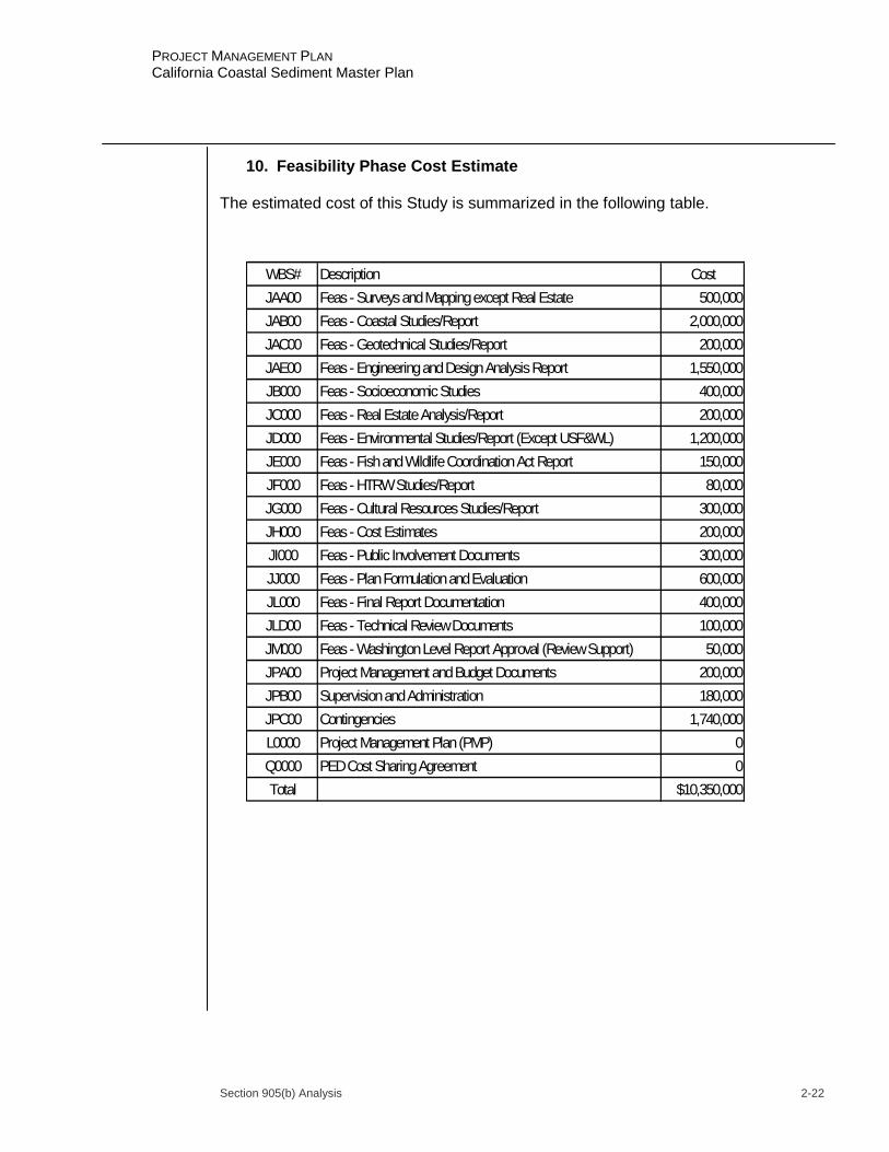
Section 905(b) Analysis 2-22
PROJECT MANAGEMENT PLAN California Coastal Sediment Master Plan
10. Feasibility Phase Cost Estimate The estimated cost of this Study is summarized in the following table.
WBS# Description CostJAA00 Feas - Surveys and Mapping except Real Estate 500,000JAB00 Feas - Coastal Studies/Report 2,000,000JAC00 Feas - Geotechnical Studies/Report 200,000JAE00 Feas - Engineering and Design Analysis Report 1,550,000JB000 Feas - Socioeconomic Studies 400,000JC000 Feas - Real Estate Analysis/Report 200,000JD000 Feas - Environmental Studies/Report (Except USF&WL) 1,200,000JE000 Feas - Fish and Wildlife Coordination Act Report 150,000JF000 Feas - HTRW Studies/Report 80,000JG000 Feas - Cultural Resources Studies/Report 300,000JH000 Feas - Cost Estimates 200,000JI000 Feas - Public Involvement Documents 300,000JJ000 Feas - Plan Formulation and Evaluation 600,000JL000 Feas - Final Report Documentation 400,000JLD00 Feas - Technical Review Documents 100,000JM000 Feas - Washington Level Report Approval (Review Support) 50,000JPA00 Project Management and Budget Documents 200,000JPB00 Supervision and Administration 180,000JPC00 Contingencies 1,740,000L0000 Project Management Plan (PMP) 0Q0000 PED Cost Sharing Agreement 0Total $10,350,000

Section 905(b) Analysis 2-23
PROJECT MANAGEMENT PLAN California Coastal Sediment Master Plan
11. Views of Other Resource Agencies Because of the funding and time constraints of the reconnaissance phase, only limited and informal coordination has been conducted with other resource agencies. Based upon the current data deficiencies and limited knowledge regarding the coastal processes of the entire California coastline, views from various local municipalities include the desire to preserve beaches, minimize use of structural shoreline stabilization measures, and protect nearshore marine habitats. The Coastal Sediment Management Workgroup (CSMW) was established as a partnership between the USACE and the California Resources Agency to facilitate regional approaches to protecting, enhancing and restoring California's coastal beaches and watersheds through Federal, State and local cooperative efforts. The ultimate goal of the CSMW is provide coastal beach and watershed management. Key to achieving this goal is creating a comprehensive, statewide, California Coastal Sediment Master Plan. Participants in this CSMW include the Army Corps of Engineers South Pacific Division, the San Francisco and Los Angeles Districts, the California Resources Agency, the CA Department of Boating and Waterways, the CA Department of Fish and Game, the CA State Lands Commission, the CA Coastal Commission, the CA State Coastal Conservancy, the CA Department of Parks and Recreation, CA Geological Survey, USGS, and CalCoast, an advocacy organization representing many coastal cities and counties. 12. Potential Issues Affecting Initiation of Feasibility Phase a. Continuation of this study into the cost-shared feasibility-level study phase is contingent upon an executed Feasibility Cost-Sharing Agreement (FCSA). Failure to achieve an executed FCSA within 18 months of the approval of the Section 905(b) Analysis will result in termination of the study. There are no apparent issues at this time that impact on the implementation of the feasibility phase. b. The schedule for signing the Feasibility Cost-Sharing Agreement is April 2004. Based on the schedule of milestones, completion of the California Coastal Sediment Master Plan report would be in April 2009, with a potential Congressional Authorization in WRDA 2010. 13. Project Area Map A map of the study area is shown in Attachment 1.
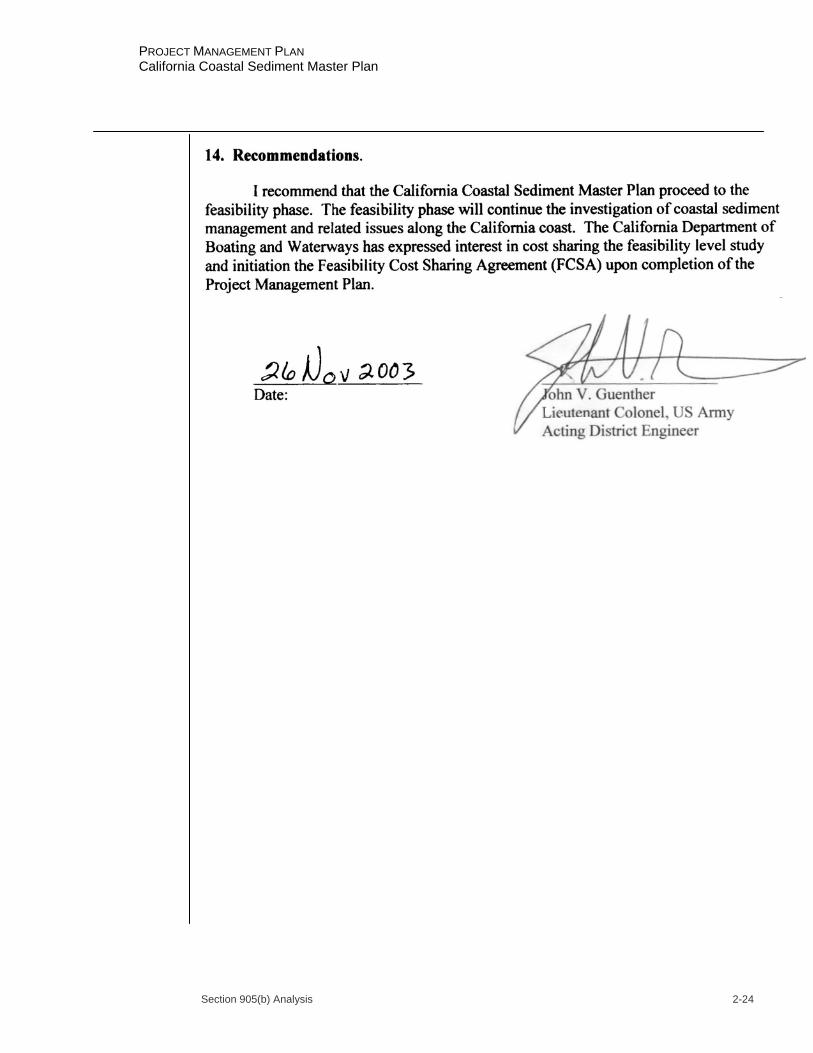
Section 905(b) Analysis 2-24
PROJECT MANAGEMENT PLAN California Coastal Sediment Master Plan
Section 905(b) Analysis 2-25
PROJECT MANAGEMENT PLAN California Coastal Sediment Master Plan
15. Changes to the approved Section 905(b) Analysis a. The Section 905(b) Analysis was approved by Corps Headquarters on 26 November 2003. b. Revisions to the cost, schedule or scope have been made from the approved Section 905(b) Analysis as a result of final negotiations of the PMP and FCSA. These changes can be found in Chapters 4, 6, and 7.

Section 905(b) Analysis 2-26
PROJECT MANAGEMENT PLAN California Coastal Sediment Master Plan
ATTACHMENT 1
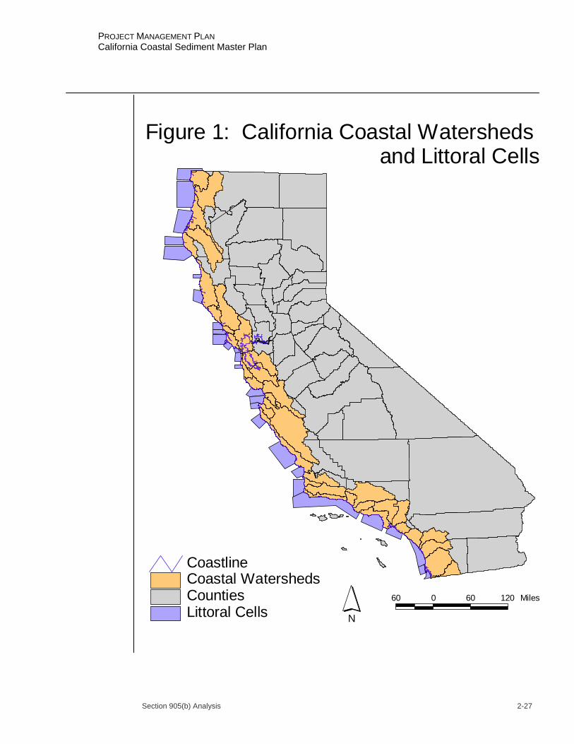
Section 905(b) Analysis 2-27
PROJECT MANAGEMENT PLAN California Coastal Sediment Master Plan
Littoral CellsCountiesCoastal WatershedsCoastline
N
60 0 60 120 Miles
Figure 1: California Coastal Watersheds and Littoral Cells
Section 905(b) Analysis 2-28
PROJECT MANAGEMENT PLAN California Coastal Sediment Master Plan
ATTACHMENT 2
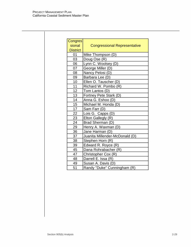
Section 905(b) Analysis 2-29
PROJECT MANAGEMENT PLAN California Coastal Sediment Master Plan
Congressional District
Congressional Representative
01 Mike Thompson (D)03 Doug Ose (R)06 Lynn C. Woolsey (D)07 George Miller (D)08 Nancy Pelosi (D)09 Barbara Lee (D)10 Ellen O. Tauscher (D)11 Richard W. Pombo (R)12 Tom Lantos (D)13 Fortney Pete Stark (D)14 Anna G. Eshoo (D)15 Michael M. Honda (D)17 Sam Farr (D)22 Lois G. Capps (D)23 Elton Gallegly (R)24 Brad Sherman (D)29 Henry A. Waxman (D)36 Jane Harman (D)37 Juanita Millender-McDonald (D)38 Stephen Horn (R)39 Edward R. Royce (R)45 Dana Rohrabacher (R)47 Christopher Cox (R)48 Darrell E. Issa (R)49 Susan A. Davis (D)51 Randy "Duke" Cunningham (R)

Section 905(b) Analysis 2-30
PROJECT MANAGEMENT PLAN California Coastal Sediment Master Plan
ATTACHMENT 3
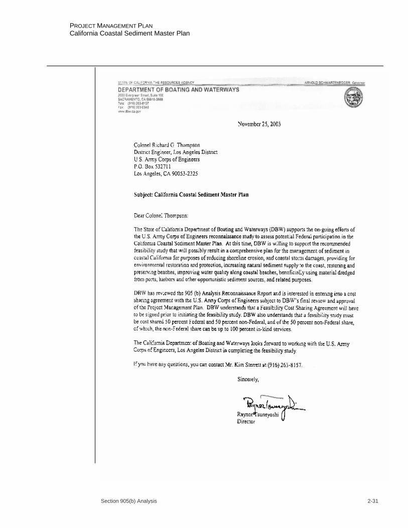
Section 905(b) Analysis 2-31
PROJECT MANAGEMENT PLAN California Coastal Sediment Master Plan
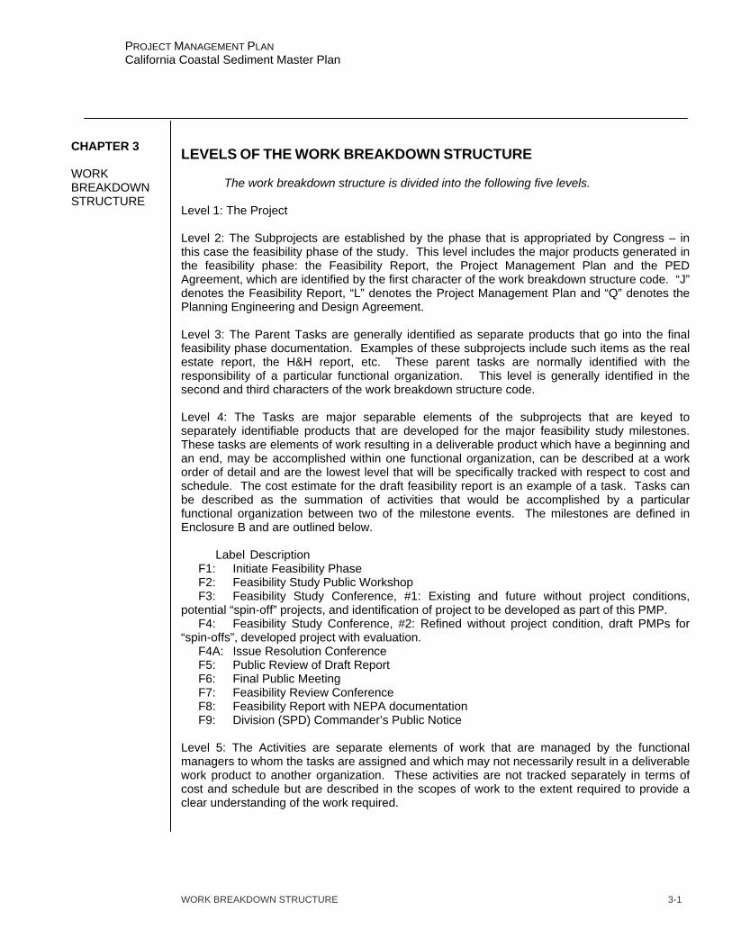
WORK BREAKDOWN STRUCTURE 3-1
PROJECT MANAGEMENT PLAN California Coastal Sediment Master Plan
LEVELS OF THE WORK BREAKDOWN STRUCTURE
The work breakdown structure is divided into the following five levels. Level 1: The Project Level 2: The Subprojects are established by the phase that is appropriated by Congress – in this case the feasibility phase of the study. This level includes the major products generated in the feasibility phase: the Feasibility Report, the Project Management Plan and the PED Agreement, which are identified by the first character of the work breakdown structure code. “J” denotes the Feasibility Report, “L” denotes the Project Management Plan and “Q” denotes the Planning Engineering and Design Agreement. Level 3: The Parent Tasks are generally identified as separate products that go into the final feasibility phase documentation. Examples of these subprojects include such items as the real estate report, the H&H report, etc. These parent tasks are normally identified with the responsibility of a particular functional organization. This level is generally identified in the second and third characters of the work breakdown structure code. Level 4: The Tasks are major separable elements of the subprojects that are keyed to separately identifiable products that are developed for the major feasibility study milestones. These tasks are elements of work resulting in a deliverable product which have a beginning and an end, may be accomplished within one functional organization, can be described at a work order of detail and are the lowest level that will be specifically tracked with respect to cost and schedule. The cost estimate for the draft feasibility report is an example of a task. Tasks can be described as the summation of activities that would be accomplished by a particular functional organization between two of the milestone events. The milestones are defined in Enclosure B and are outlined below. Label Description F1: Initiate Feasibility Phase F2: Feasibility Study Public Workshop F3: Feasibility Study Conference, #1: Existing and future without project conditions, potential “spin-off” projects, and identification of project to be developed as part of this PMP. F4: Feasibility Study Conference, #2: Refined without project condition, draft PMPs for “spin-offs”, developed project with evaluation. F4A: Issue Resolution Conference F5: Public Review of Draft Report F6: Final Public Meeting F7: Feasibility Review Conference F8: Feasibility Report with NEPA documentation F9: Division (SPD) Commander’s Public Notice Level 5: The Activities are separate elements of work that are managed by the functional managers to whom the tasks are assigned and which may not necessarily result in a deliverable work product to another organization. These activities are not tracked separately in terms of cost and schedule but are described in the scopes of work to the extent required to provide a clear understanding of the work required.
CHAPTER 3 WORK BREAKDOWN STRUCTURE

WORK BREAKDOWN STRUCTURE 3-2
PROJECT MANAGEMENT PLAN California Coastal Sediment Master Plan
LISTING OF TASKS - WORK BREAKDOWN STRUCTURE In accordance with the levels described above, the following Work Breakdown Structure, WBS, indicates the relationship between the subprojects, parent tasks and subordinate tasks. The tasks in bold type are parent tasks and the regular types are subtasks. All tasks listed below may occur during the feasibility phase. The “J” leading the WBS numbers denotes the feasibility report subproject, the “L” denotes the Project Management Plan subproject and the “Q” denotes the Planning Engineering and Design Agreement subproject. The project is not listed or identified in these generic tasks, but can be identified from the title of this document and the title of the 905(b) contained in Chapter II.
WBS# Description
J0000 Feasibility Report (Feas) J0000 Milestones Initiate Feasibility Phase Feas Study Pub Wkshp (F2) Feas Study Conf #1 (F3) Feas Study Conf #2 (F4) Date of AFB Public Review of Draft Report Final Public Meeting Feasibility Review Conference Feasibility Report w\NEPA MSC Commander's Public Notice Filing of Final EIS/EA Chief's Report to ASA (CW) ROD Signed or FONSI Signed President Signs Authorization JA000 Engineering Appendix JAA00 Feas - Surveys and Mapping except Real Estate Surveys and Mapping - Without Project Conditions Mapping - With Project Conditions Mapping - AFB documentation Mapping - Draft Report Mapping - Final Report JAB00 Feas - Hydrology and Hydraulics Studies/Report (Coastal) H&H - Without Project Conditions & Preliminary Plans H&H - With Project Conditions for Final Plans H&H - AFB documentation H&H - Draft Report H&H - Final Report JAC00 Feas - Geotechnical Studies/Report Geotech - Without Project Conditions & Preliminary Plans Geotech - With Project Conditions for Final Plans Geotech - AFB documentation Geotech - Draft Report Geotech - Final Report JAE00 Feas - Engineering and Design Analysis/Report Engr & Design - Without Project Conditions & Preliminary Plans
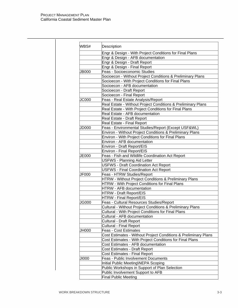
WORK BREAKDOWN STRUCTURE 3-3
PROJECT MANAGEMENT PLAN California Coastal Sediment Master Plan
WBS# Description
Engr & Design - With Project Conditions for Final Plans Engr & Design - AFB documentation Engr & Design - Draft Report Engr & Design - Final Report JB000 Feas - Socioeconomic Studies Socioecon - Without Project Conditions & Preliminary Plans Socioecon - With Project Conditions for Final Plans Socioecon - AFB documentation Socioecon - Draft Report Socioecon - Final Report JC000 Feas - Real Estate Analysis/Report Real Estate - Without Project Conditions & Preliminary Plans Real Estate - With Project Conditions for Final Plans Real Estate - AFB documentation Real Estate - Draft Report Real Estate - Final Report JD000 Feas - Environmental Studies/Report (Except USF&WL) Environ - Without Project Conditions & Preliminary Plans Environ - With Project Conditions for Final Plans Environ - AFB documentation Environ - Draft Report/EIS Environ - Final Report/EIS JE000 Feas - Fish and Wildlife Coordination Act Report USFWS - Planning Aid Letter USFWS - Draft Coordination Act Report USFWS - Final Coordination Act Report JF000 Feas - HTRW Studies/Report HTRW - Without Project Conditions & Preliminary Plans HTRW - With Project Conditions for Final Plans HTRW - AFB documentation HTRW - Draft Report/EIS HTRW - Final Report/EIS JG000 Feas - Cultural Resources Studies/Report Cultural - Without Project Conditions & Preliminary Plans Cultural - With Project Conditions for Final Plans Cultural - AFB documentation Cultural - Draft Report Cultural - Final Report JH000 Feas - Cost Estimates Cost Estimates - Without Project Conditions & Preliminary Plans Cost Estimates - With Project Conditions for Final Plans Cost Estimates - AFB documentation Cost Estimates - Draft Report Cost Estimates - Final Report JI000 Feas - Public Involvement Documents Initial Public Meeting\NEPA Scoping Public Workshops in Support of Plan Selection Public Involvement Support to AFB Final Public Meeting
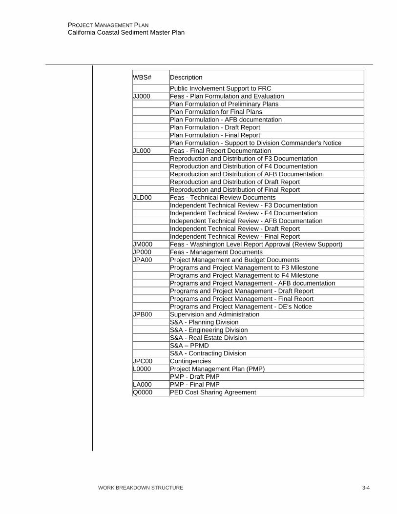
WORK BREAKDOWN STRUCTURE 3-4
PROJECT MANAGEMENT PLAN California Coastal Sediment Master Plan
WBS# Description
Public Involvement Support to FRC JJ000 Feas - Plan Formulation and Evaluation Plan Formulation of Preliminary Plans Plan Formulation for Final Plans Plan Formulation - AFB documentation Plan Formulation - Draft Report Plan Formulation - Final Report Plan Formulation - Support to Division Commander's Notice JL000 Feas - Final Report Documentation Reproduction and Distribution of F3 Documentation Reproduction and Distribution of F4 Documentation Reproduction and Distribution of AFB Documentation Reproduction and Distribution of Draft Report Reproduction and Distribution of Final Report JLD00 Feas - Technical Review Documents Independent Technical Review - F3 Documentation Independent Technical Review - F4 Documentation Independent Technical Review - AFB Documentation Independent Technical Review - Draft Report Independent Technical Review - Final Report JM000 Feas - Washington Level Report Approval (Review Support) JP000 Feas - Management Documents JPA00 Project Management and Budget Documents Programs and Project Management to F3 Milestone Programs and Project Management to F4 Milestone Programs and Project Management - AFB documentation Programs and Project Management - Draft Report Programs and Project Management - Final Report Programs and Project Management - DE's Notice JPB00 Supervision and Administration S&A - Planning Division S&A - Engineering Division S&A - Real Estate Division S&A – PPMD S&A - Contracting Division JPC00 Contingencies L0000 Project Management Plan (PMP) PMP - Draft PMP LA000 PMP - Final PMP Q0000 PED Cost Sharing Agreement
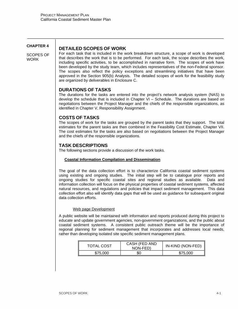
SCOPES OF WORK 4-1
PROJECT MANAGEMENT PLAN California Coastal Sediment Master Plan
DETAILED SCOPES OF WORK For each task that is included in the work breakdown structure, a scope of work is developed that describes the work that is to be performed. For each task, the scope describes the work, including specific activities, to be accomplished in narrative form. The scopes of work have been developed by the study team, which includes representatives of the non-Federal sponsor. The scopes also reflect the policy exceptions and streamlining initiatives that have been approved in the Section 905(b) Analysis. The detailed scopes of work for the feasibility study are organized by deliverables in Enclosure C. DURATIONS OF TASKS The durations for the tasks are entered into the project’s network analysis system (NAS) to develop the schedule that is included in Chapter VI – Schedule. The durations are based on negotiations between the Project Manager and the chiefs of the responsible organizations, as identified in Chapter V, Responsibility Assignment. COSTS OF TASKS The scopes of work for the tasks are grouped by the parent tasks that they support. The total estimates for the parent tasks are then combined in the Feasibility Cost Estimate, Chapter VII. The cost estimates for the tasks are also based on negotiations between the Project Manager and the chiefs of the responsible organizations. TASK DESCRIPTIONS The following sections provide a discussion of the work tasks.
Coastal Information Compilation and Dissemination
The goal of the data collection effort is to characterize California coastal sediment systems using existing and ongoing studies. The initial step will be to catalogue prior reports and ongoing studies for specific coastal sites and regional studies as available. Data and information collection will focus on the physical properties of coastal sediment systems, affected natural resources, and regulations and policies that impact sediment management. This data collection effort also will identify data gaps that will be used as guidance for subsequent original data collection efforts.
Web page Development
A public website will be maintained with information and reports produced during this project to educate and update government agencies, non-government organizations, and the public about coastal sediment systems. A consistent public outreach theme will be the importance of regional planning for sediment management that incorporates and addresses local needs, rather than developing isolated site specific sediment management plans.
TOTAL COST CASH (FED AND NON-FED) IN-KIND (NON-FED)
$75,000 $0 $75,000
CHAPTER 4 SCOPES OF WORK
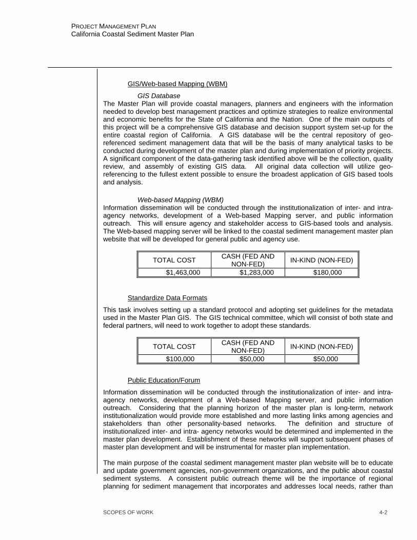
SCOPES OF WORK 4-2
PROJECT MANAGEMENT PLAN California Coastal Sediment Master Plan
GIS/Web-based Mapping (WBM)
GIS Database The Master Plan will provide coastal managers, planners and engineers with the information needed to develop best management practices and optimize strategies to realize environmental and economic benefits for the State of California and the Nation. One of the main outputs of this project will be a comprehensive GIS database and decision support system set-up for the entire coastal region of California. A GIS database will be the central repository of geo-referenced sediment management data that will be the basis of many analytical tasks to be conducted during development of the master plan and during implementation of priority projects. A significant component of the data-gathering task identified above will be the collection, quality review, and assembly of existing GIS data. All original data collection will utilize geo-referencing to the fullest extent possible to ensure the broadest application of GIS based tools and analysis.
Web-based Mapping (WBM) Information dissemination will be conducted through the institutionalization of inter- and intra- agency networks, development of a Web-based Mapping server, and public information outreach. This will ensure agency and stakeholder access to GIS-based tools and analysis. The Web-based mapping server will be linked to the coastal sediment management master plan website that will be developed for general public and agency use.
TOTAL COST CASH (FED AND NON-FED) IN-KIND (NON-FED)
$1,463,000 $1,283,000 $180,000
Standardize Data Formats
This task involves setting up a standard protocol and adopting set guidelines for the metadata used in the Master Plan GIS. The GIS technical committee, which will consist of both state and federal partners, will need to work together to adopt these standards.
TOTAL COST CASH (FED AND NON-FED) IN-KIND (NON-FED)
$100,000 $50,000 $50,000
Public Education/Forum
Information dissemination will be conducted through the institutionalization of inter- and intra- agency networks, development of a Web-based Mapping server, and public information outreach. Considering that the planning horizon of the master plan is long-term, network institutionalization would provide more established and more lasting links among agencies and stakeholders than other personality-based networks. The definition and structure of institutionalized inter- and intra- agency networks would be determined and implemented in the master plan development. Establishment of these networks will support subsequent phases of master plan development and will be instrumental for master plan implementation. The main purpose of the coastal sediment management master plan website will be to educate and update government agencies, non-government organizations, and the public about coastal sediment systems. A consistent public outreach theme will be the importance of regional planning for sediment management that incorporates and addresses local needs, rather than

SCOPES OF WORK 4-3
PROJECT MANAGEMENT PLAN California Coastal Sediment Master Plan
developing isolated site specific sediment management plans. The website will be a focal point of internet based communication for all coastal sediment management related issues, agencies, and stakeholders. Determination of server residence and website maintenance are critical issues that must be resolved, as has been noted for other shared information resources. A series of public workshops and meeting with local, county and regional government agencies will be held throughout the coastal portions of the state as one of the early tasks in the Sediment Master Plan. The public workshops are an opportunity to share the project plan and goals with the public, gather information on local sedimentation and shoreline erosion problems, identify local sediment management-related activities, and identify coordination and data sharing opportunities with local government and groups such as watershed councils.
TOTAL COST CASH (FED AND NON-FED) IN-KIND (NON-FED)
$180,000 $30,000 $150,000
Update and Maintenance
This task will cover the update and maintenance of the GIS database and Web-based Mapping site during the life of the project. This task also includes server costs and renewal of software licenses that are required to maintain the GIS and WBM systems.
TOTAL COST CASH (FED AND NON-FED) IN-KIND (NON-FED)
$411,000 $411,000 $0
Recreation – Water Quality, Parks, Day Use, Tourism
Water Quality
Develop an inventory of water quality issues and statistics along the coast. The quality of the beach experience is directly tied to water quality; therefore, areas with poor water quality need to be identified. The source of the pollutants and potential ways to improve water quality will also be identified. The economic affects on recreation value related to water quality will be evaluated.
Parks, Day Use, Tourism
For the analysis of regional sediment management impacts on recreation, the focus mainly would be on beach, nearshore, and estuarine recreation. Impacts may include sedimentation of estuarine waters that reduces recreational fishing or shell fishing opportunities, lack of beach nourishment that reduces beach area available for access or use, or offshore deposition that creates or disrupts favorable surf conditions. The analysis would differentiate between residential and tourism-related impacts. Recreational impacts may be measured in user-days or in the economic value of the recreational experience. The analysis of economic impacts would be based, in part, on existing conditions and trends identified in the recreation and habitat impact analyses. Economic impacts would include effects on regional economies and effects on individual values for recreational uses of natural resources, such as fishing and beach use. As with the other impact analyses, the economic
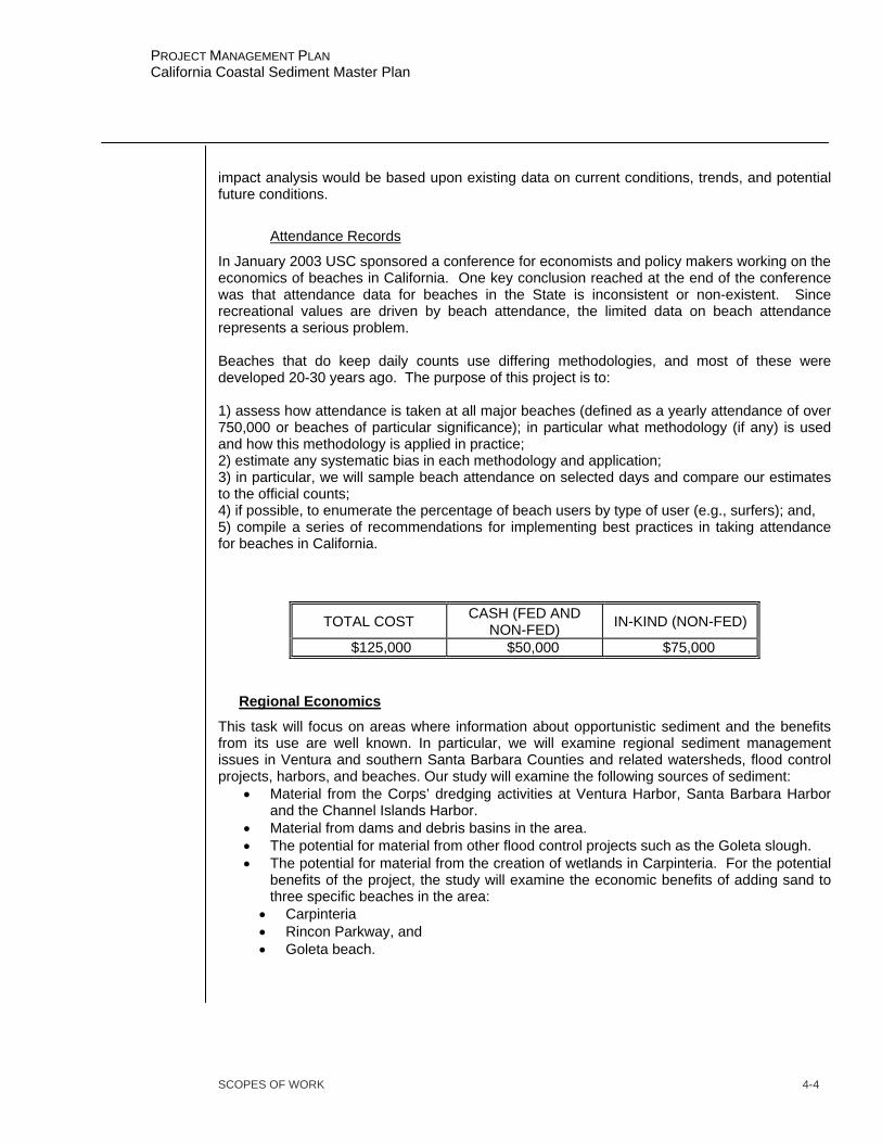
SCOPES OF WORK 4-4
PROJECT MANAGEMENT PLAN California Coastal Sediment Master Plan
impact analysis would be based upon existing data on current conditions, trends, and potential future conditions.
Attendance Records
In January 2003 USC sponsored a conference for economists and policy makers working on the economics of beaches in California. One key conclusion reached at the end of the conference was that attendance data for beaches in the State is inconsistent or non-existent. Since recreational values are driven by beach attendance, the limited data on beach attendance represents a serious problem. Beaches that do keep daily counts use differing methodologies, and most of these were developed 20-30 years ago. The purpose of this project is to: 1) assess how attendance is taken at all major beaches (defined as a yearly attendance of over 750,000 or beaches of particular significance); in particular what methodology (if any) is used and how this methodology is applied in practice; 2) estimate any systematic bias in each methodology and application; 3) in particular, we will sample beach attendance on selected days and compare our estimates to the official counts; 4) if possible, to enumerate the percentage of beach users by type of user (e.g., surfers); and, 5) compile a series of recommendations for implementing best practices in taking attendance for beaches in California.
TOTAL COST CASH (FED AND NON-FED) IN-KIND (NON-FED)
$125,000 $50,000 $75,000
Regional Economics
This task will focus on areas where information about opportunistic sediment and the benefits from its use are well known. In particular, we will examine regional sediment management issues in Ventura and southern Santa Barbara Counties and related watersheds, flood control projects, harbors, and beaches. Our study will examine the following sources of sediment:
• Material from the Corps’ dredging activities at Ventura Harbor, Santa Barbara Harbor and the Channel Islands Harbor.
• Material from dams and debris basins in the area. • The potential for material from other flood control projects such as the Goleta slough. • The potential for material from the creation of wetlands in Carpinteria. For the potential
benefits of the project, the study will examine the economic benefits of adding sand to three specific beaches in the area:
• Carpinteria • Rincon Parkway, and • Goleta beach.
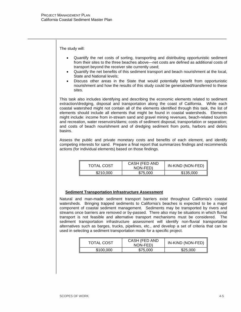
SCOPES OF WORK 4-5
PROJECT MANAGEMENT PLAN California Coastal Sediment Master Plan
The study will:
• Quantify the net costs of sorting, transporting and distributing opportunistic sediment from their sites to the three beaches above—net costs are defined as additional costs of transport beyond the receiver site currently used;
• Quantify the net benefits of this sediment transport and beach nourishment at the local, State and National levels;
• Discuss other areas in the State that would potentially benefit from opportunistic nourishment and how the results of this study could be generalized/transferred to these sites.
This task also includes identifying and describing the economic elements related to sediment extraction/dredging, disposal and transportation along the coast of California. While each coastal watershed might not contain all of the elements identified through this task, the list of elements should include all elements that might be found in coastal watersheds. Elements might include: income from in-stream sand and gravel mining revenues, beach-related tourism and recreation, water reservoirs/dams; costs of sediment disposal, transportation or separation; and costs of beach nourishment and of dredging sediment from ports, harbors and debris basins. Assess the public and private monetary costs and benefits of each element, and identify competing interests for sand. Prepare a final report that summarizes findings and recommends actions (for individual elements) based on those findings.
TOTAL COST CASH (FED AND NON-FED) IN-KIND (NON-FED)
$210,000 $75,000 $135,000
Sediment Transportation Infrastructure Assessment
Natural and man-made sediment transport barriers exist throughout California’s coastal watersheds. Bringing trapped sediments to California’s beaches is expected to be a major component of coastal sediment management. Sediments may be transported by rivers and streams once barriers are removed or by-passed. There also may be situations in which fluvial transport is not feasible and alternative transport mechanisms must be considered. The sediment transportation infrastructure assessment will identify non-fluvial transportation alternatives such as barges, trucks, pipelines, etc., and develop a set of criteria that can be used in selecting a sediment transportation mode for a specific project.
TOTAL COST CASH (FED AND NON-FED) IN-KIND (NON-FED)
$100,000 $75,000 $25,000
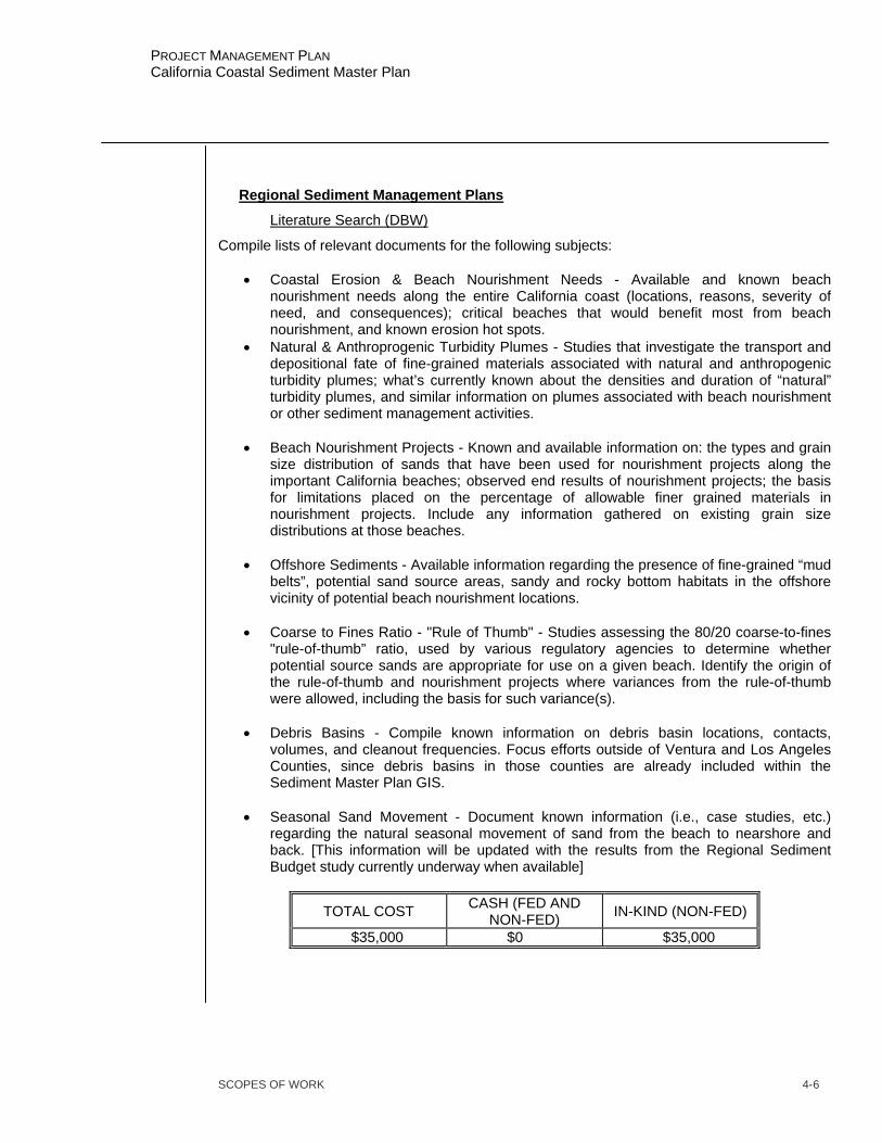
SCOPES OF WORK 4-6
PROJECT MANAGEMENT PLAN California Coastal Sediment Master Plan
Regional Sediment Management Plans
Literature Search (DBW)
Compile lists of relevant documents for the following subjects:
• Coastal Erosion & Beach Nourishment Needs - Available and known beach nourishment needs along the entire California coast (locations, reasons, severity of need, and consequences); critical beaches that would benefit most from beach nourishment, and known erosion hot spots.
• Natural & Anthroprogenic Turbidity Plumes - Studies that investigate the transport and depositional fate of fine-grained materials associated with natural and anthropogenic turbidity plumes; what’s currently known about the densities and duration of “natural” turbidity plumes, and similar information on plumes associated with beach nourishment or other sediment management activities.
• Beach Nourishment Projects - Known and available information on: the types and grain
size distribution of sands that have been used for nourishment projects along the important California beaches; observed end results of nourishment projects; the basis for limitations placed on the percentage of allowable finer grained materials in nourishment projects. Include any information gathered on existing grain size distributions at those beaches.
• Offshore Sediments - Available information regarding the presence of fine-grained “mud
belts”, potential sand source areas, sandy and rocky bottom habitats in the offshore vicinity of potential beach nourishment locations.
• Coarse to Fines Ratio - "Rule of Thumb" - Studies assessing the 80/20 coarse-to-fines
"rule-of-thumb” ratio, used by various regulatory agencies to determine whether potential source sands are appropriate for use on a given beach. Identify the origin of the rule-of-thumb and nourishment projects where variances from the rule-of-thumb were allowed, including the basis for such variance(s).
• Debris Basins - Compile known information on debris basin locations, contacts,
volumes, and cleanout frequencies. Focus efforts outside of Ventura and Los Angeles Counties, since debris basins in those counties are already included within the Sediment Master Plan GIS.
• Seasonal Sand Movement - Document known information (i.e., case studies, etc.)
regarding the natural seasonal movement of sand from the beach to nearshore and back. [This information will be updated with the results from the Regional Sediment Budget study currently underway when available]
TOTAL COST CASH (FED AND NON-FED) IN-KIND (NON-FED)
$35,000 $0 $35,000
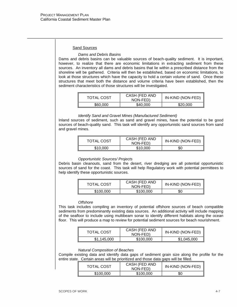
SCOPES OF WORK 4-7
PROJECT MANAGEMENT PLAN California Coastal Sediment Master Plan
Sand Sources
Dams and Debris Basins Dams and debris basins can be valuable sources of beach-quality sediment. It is important, however, to realize that there are economic limitations in extracting sediment from these sources. An inventory all dams and debris basins that lie within a prescribed distance from the shoreline will be gathered. Criteria will then be established, based on economic limitations, to look at those structures which have the capacity to hold a certain volume of sand. Once these structures that meet both the distance and volume criteria have been established, then the sediment characteristics of those structures will be investigated.
TOTAL COST CASH (FED AND NON-FED) IN-KIND (NON-FED)
$60,000 $40,000 $20,000
Identify Sand and Gravel Mines (Manufactured Sediment) Inland sources of sediment, such as sand and gravel mines, have the potential to be good sources of beach-quality sand. This task will identify any opportunistic sand sources from sand and gravel mines.
TOTAL COST CASH (FED AND NON-FED) IN-KIND (NON-FED)
$10,000 $10,000 $0
Opportunistic Sources/ Projects Debris basin cleanouts, sand from the desert, river dredging are all potential opportunistic sources of sand for the coast. This task will help Regulatory work with potential permittees to help identify these opportunistic sources.
TOTAL COST CASH (FED AND NON-FED) IN-KIND (NON-FED)
$100,000 $100,000 $0
Offshore This task includes compiling an inventory of potential offshore sources of beach compatible sediments from predominantly existing data sources. An additional activity will include mapping of the seafloor to include using multibeam sonar to identify different habitats along the ocean floor. This will produce a map to review for potential sediment sources for beach nourishment.
TOTAL COST CASH (FED AND NON-FED) IN-KIND (NON-FED)
$1,145,000 $100,000 $1,045,000
Natural Composition of Beaches Compile existing data and identify data gaps of sediment grain size along the profile for the entire state. Certain areas will be prioritized and those data gaps will be filled.
TOTAL COST CASH (FED AND NON-FED) IN-KIND (NON-FED)
$100,000 $100,000 $0
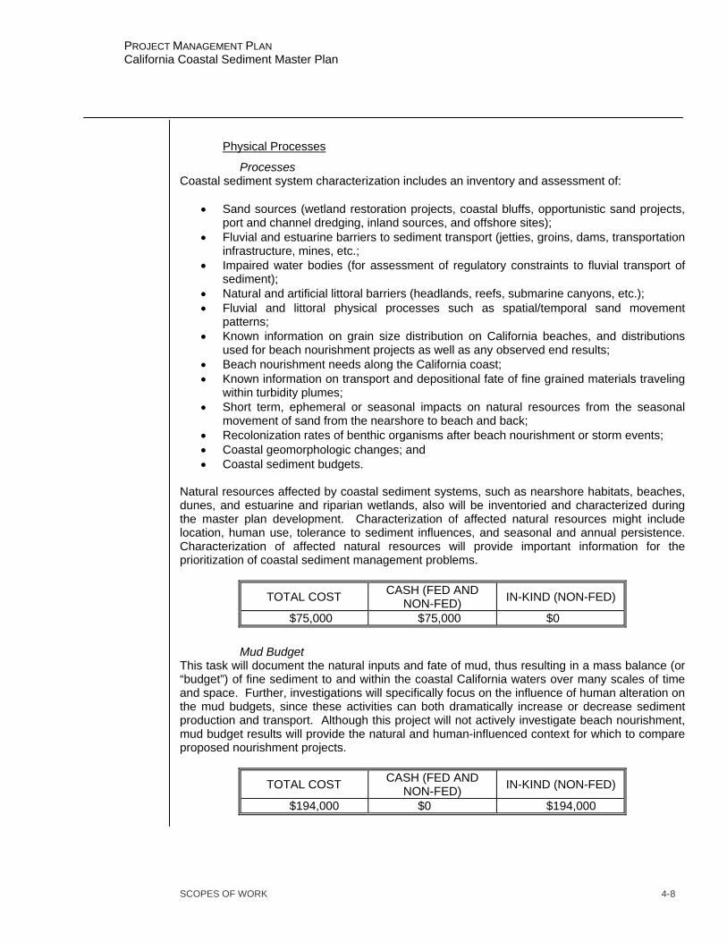
SCOPES OF WORK 4-8
PROJECT MANAGEMENT PLAN California Coastal Sediment Master Plan
Physical Processes
Processes Coastal sediment system characterization includes an inventory and assessment of:
• Sand sources (wetland restoration projects, coastal bluffs, opportunistic sand projects, port and channel dredging, inland sources, and offshore sites);
• Fluvial and estuarine barriers to sediment transport (jetties, groins, dams, transportation infrastructure, mines, etc.;
• Impaired water bodies (for assessment of regulatory constraints to fluvial transport of sediment);
• Natural and artificial littoral barriers (headlands, reefs, submarine canyons, etc.); • Fluvial and littoral physical processes such as spatial/temporal sand movement
patterns; • Known information on grain size distribution on California beaches, and distributions
used for beach nourishment projects as well as any observed end results; • Beach nourishment needs along the California coast; • Known information on transport and depositional fate of fine grained materials traveling
within turbidity plumes; • Short term, ephemeral or seasonal impacts on natural resources from the seasonal
movement of sand from the nearshore to beach and back; • Recolonization rates of benthic organisms after beach nourishment or storm events; • Coastal geomorphologic changes; and • Coastal sediment budgets.
Natural resources affected by coastal sediment systems, such as nearshore habitats, beaches, dunes, and estuarine and riparian wetlands, also will be inventoried and characterized during the master plan development. Characterization of affected natural resources might include location, human use, tolerance to sediment influences, and seasonal and annual persistence. Characterization of affected natural resources will provide important information for the prioritization of coastal sediment management problems.
TOTAL COST CASH (FED AND NON-FED) IN-KIND (NON-FED)
$75,000 $75,000 $0
Mud Budget This task will document the natural inputs and fate of mud, thus resulting in a mass balance (or “budget”) of fine sediment to and within the coastal California waters over many scales of time and space. Further, investigations will specifically focus on the influence of human alteration on the mud budgets, since these activities can both dramatically increase or decrease sediment production and transport. Although this project will not actively investigate beach nourishment, mud budget results will provide the natural and human-influenced context for which to compare proposed nourishment projects.
TOTAL COST CASH (FED AND NON-FED) IN-KIND (NON-FED)
$194,000 $0 $194,000

SCOPES OF WORK 4-9
PROJECT MANAGEMENT PLAN California Coastal Sediment Master Plan
Regional Sediment Budgets This task is aimed at understanding sediment movement and amounts prior to human intervention and alterations within the littoral cells. A summary document that will provide the non-technical reader with a sense of littoral cells or beach compartments, how littoral budget components are determined, measured or approximated, and what assumptions or uncertainties are involved in littoral budget determinations will be produced. This document would be well illustrated in order to provide both written and graphical explanations of littoral cell functioning and budget determinations and will include:
• A critical examination of often used littoral cell boundaries for the coast of California and confirmation or revision of these cell boundaries as well as possible with existing data..
• An evaluation of the long term dredging volumes from each of California’s coastal harbors and a determination of average annual rates as proxies for littoral drift rates.
• A compilation of existing data on sand sources/inputs to California’s littoral cells and comparison with the calculated dredging/littoral drift rates in order to provide a cross-check on volume consistency in the individual littoral cell budgets.
• Development of littoral sand budgets under pre-existing natural conditions of sediment input and littoral transport and also under present altered conditions.
• Field and lab work needed to determine how much sand has been cut off from littoral cells throughout California from dams, debris basins, channelization projects, and seawalls and revetments.
• A compilation all of the existing information on the components of individual littoral cells and littoral drift rates into a GIS compatible with CSMW’s Sediment Master Plan GIS format and metadata needs.
• Preparation of a summary document that would provide the non-technical reader with a sense of the functioning and importance of littoral cells or beach compartments, how littoral budget components are determined, measured or approximated, and what assumptions or uncertainties are involved.
• Preparation of a summary white paper on the spatial and temporal (seasonal and decadal) movement of sand within littoral cells.
• Preparation of a summary white paper on the movement of sand within a littoral cell resulting from a beach nourishment project using a comprehensive beach and offshore morphology data set.
TOTAL COST CASH (FED AND NON-FED) IN-KIND (NON-FED)
$97,000 $0 $97,000
Physical Barriers
Create an inventory of physical barriers to sediment transport along the California coast. This will include dams and navigation structures.
TOTAL COST CASH (FED AND NON-FED) IN-KIND (NON-FED)
$150,000 $150,000 $0

SCOPES OF WORK 4-10
PROJECT MANAGEMENT PLAN California Coastal Sediment Master Plan
Relative Sea Level/ Climatic Changes
The master plan development will assess the relationships among sediment management, sea level rise, and climatic change. This assessment will identify the significant issues and review the existing literature to assess the way that sediment management would be affected by alternative sea level rise and climatic change scenarios.
TOTAL COST CASH (FED AND NON-FED) IN-KIND (NON-FED)
$50,000 $50,000 $0
Policies, Procedures, and Regulations
Existing Policies and Permitting
The master plan development includes an inventory of agency jurisdictions and responsibilities for specific sediment-related resources and geographic areas. An analysis of policy and regulatory effects on coastal sediment management will be conducted for the purpose of addressing regulation compatibility, interagency coordination, and rectification of any regulatory inconsistencies. This analysis also will look for opportunities to support coastal sediment management through non-structural measures such as sand banks, tax or fee structures, and mitigation. Policies, Procedures, and Regulations (PPR) Analysis - Analyze the local, state and federal policies, regulations and procedures that potentially affect regional sediment management, (e.g., beach nourishment) activities. These activities include the dredging/excavation, transportation and “disposal” (e.g., beach nourishment) of sediment in coastal watersheds and littoral cells. Specific tasks include:
• Identify and discuss application of current state and federal PPRs in relation to coastal watersheds and sediment management.
• Develop a draft “Beach Nourishment Reference Guide” that defines the requirements of each agency with jurisdictional responsibility for the California coastline, and illustrates the regulatory process via flow charts or similar graphics.
• Research current local, county, and regional PPRs related to regional sediment management in open coastal watersheds and littoral cells.
• Make specific recommendations for changes to existing PPRs and suggestions for new PPRs that would facilitate regional sediment management at all levels of government.
• Prepare final report that will be an analysis of all PPRs in California with specific recommendations on how to streamline the beach nourishment process and steps needed to implement the recommended changes.
• Link information into GIS format. Regulations and policies that affect coastal sediment management will be identified and a set of characterization criteria will be determined. Part of the identification process will include an inventory of agency jurisdictions and responsibilities for specific sediment-related resources and geographic areas. An analysis of policy and regulatory effects on coastal sediment management will be conducted in the master plan development. This analysis would include regulation compatibility, interagency coordination, rectification of any regulatory inconsistencies, and how to streamline the regulatory process, develop a reference that identifies the ongoing
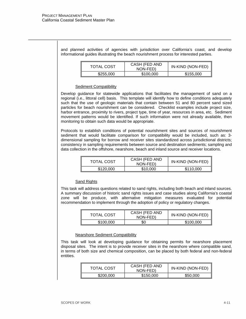
SCOPES OF WORK 4-11
PROJECT MANAGEMENT PLAN California Coastal Sediment Master Plan
and planned activities of agencies with jurisdiction over California’s coast, and develop informational guides illustrating the beach nourishment process for interested parties.
TOTAL COST CASH (FED AND NON-FED) IN-KIND (NON-FED)
$255,000 $100,000 $155,000
Sediment Compatibility
Develop guidance for statewide applications that facilitates the management of sand on a regional (i.e., littoral cell) basis. This template will identify how to define conditions adequately such that the use of geologic materials that contain between 51 and 80 percent sand sized particles for beach nourishment can be considered. Checklist examples include project size, harbor entrance, proximity to rivers, project type, time of year, resources in area, etc. Sediment movement patterns would be identified. If such information were not already available, then monitoring to obtain such data would be appropriate. Protocols to establish conditions of potential nourishment sites and sources of nourishment sediment that would facilitate comparison for compatibility would be included, such as: 3-dimensional sampling for borrow and receiver sites standardized across jurisdictional districts; consistency in sampling requirements between source and destination sediments; sampling and data collection in the offshore, nearshore, beach and inland source and receiver locations.
TOTAL COST CASH (FED AND NON-FED) IN-KIND (NON-FED)
$120,000 $10,000 $110,000
Sand Rights
This task will address questions related to sand rights, including both beach and inland sources. A summary discussion of historic sand rights issues and case studies along California’s coastal zone will be produce, with alternative mitigation measures evaluated for potential recommendation to implement through the adoption of policy or regulatory changes.
TOTAL COST CASH (FED AND NON-FED) IN-KIND (NON-FED)
$100,000 $0 $100,000
Nearshore Sediment Compatibility
This task will look at developing guidance for obtaining permits for nearshore placement disposal sites. The intent is to provide receiver sites in the nearshore where compatible sand, in terms of both size and chemical composition, can be placed by both federal and non-federal entities.
TOTAL COST CASH (FED AND NON-FED) IN-KIND (NON-FED)
$200,000 $150,000 $50,000

SCOPES OF WORK 4-12
PROJECT MANAGEMENT PLAN California Coastal Sediment Master Plan
Habitat and Biological Impacts
Programmatic EIS
This task will entail submission of the Programmatic EIR/EIS report. This document will evaluate the environmental effects of the alternative plans, including the No Action alternative. Recommended mitigation and monitoring plans will also be included. The report will satisfying federal requirements and CEQA regulations. The draft Programmatic EIR/EIS report, including a 404(b)(1) Evaluation, will be circulated to allow the State and Federal agencies and interested organizations and individuals the ability to provide additional comments and constructive criticisms. The document will also be used to obtain necessary permits and authorizations from agencies including the California Coastal Commission (CCC) and the California Regional Water Quality Control Board (CRWQCB). If necessary, Endangered Species Act consultation will be initiated at this time.
TOTAL COST CASH (FED AND NON-FED) IN-KIND (NON-FED)
$300,000 $300,000 $0
Habitat Mapping
This task includes the collection, organization and creation of geospatial data to map wetland and riparian habitats in a total of 194 USGS Orthoquadrangles in the California coastal watersheds. The wetland and riparian data layers produced through this study will be done using standard U.S. Fish and Wildlife Service National Wetland Inventory (NWI) procedures for mapping and digital database construction. The mapping will be conducted using recent aerial imagery (2000 or newer) and computer mapping techniques supplemented with in-field data collection. At the completion of the project, the digital data will be available to any potential users through the Internet. It is anticipated that the data will be combined with other data layers (e.g., hydrology, soils, biotic information, etc.) to facilitate resource management, watershed planning, habitat restoration, impact analyses, and project planning activities conducted by many programs.
TOTAL COST CASH (FED AND NON-FED) IN-KIND (NON-FED)
$900,000 $900,000 $0
Biological Impacts
Identify and assess all literature sources relating to potential biological impacts of coastal sediment management activities and then develop science-based recommendations to address those relevant concerns as they relate to sensitive biota, habitats or ecosystems. The Study will assemble and report on all known and relevant information for ease of reference, and explain the bases for concern without using technical jargon. The report will also consider and recommend ways to facilitate sediment management activities without negatively impacting coastal biota, and include a discussion on ecosystems versus species approach to decision making.
TOTAL COST CASH (FED AND NON-FED) IN-KIND (NON-FED)
$154,000 $0 $154,000
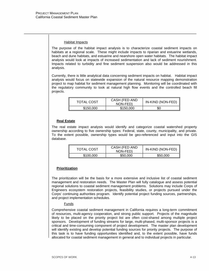
SCOPES OF WORK 4-13
PROJECT MANAGEMENT PLAN California Coastal Sediment Master Plan
Habitat Impacts
The purpose of the habitat impact analysis is to characterize coastal sediment impacts on habitats at a regional scale. These might include impacts to riparian and estuarine wetlands, beach and dune habitats, and estuarine and nearshore open water habitats. The habitat impact analysis would look at impacts of increased sedimentation and lack of sediment nourishment. Impacts related to turbidity and fine sediment suspension also would be addressed in this analysis. Currently, there is little analytical data concerning sediment impacts on habitat. Habitat impact analysis would focus on statewide expansion of the natural resource mapping demonstration project to map habitat for sediment management planning. Monitoring will be coordinated with the regulatory community to look at natural high flow events and the controlled beach fill projects.
TOTAL COST CASH (FED AND NON-FED) IN-KIND (NON-FED)
$150,000 $150,000 $0
Real Estate
The real estate impact analysis would identify and categorize coastal watershed property ownership according to five ownership types: Federal, state, county, municipality, and private. To the extent possible, ownership types would be geo-referenced and input into the GIS database.
TOTAL COST CASH (FED AND NON-FED) IN-KIND (NON-FED)
$100,000 $50,000 $50,000
Prioritization
The prioritization will be the basis for a more extensive and inclusive list of coastal sediment management and restoration needs. The Master Plan will fully catalogue and assess potential regional solutions to coastal sediment management problems. Solutions may include Corps of Engineers ecosystem restoration projects, feasibility studies, or projects pursued under the Corps’ continuing authorities program. Identify potential project funding sources, partnerships, and project implementation schedules.
Funds
Comprehensive coastal sediment management in California requires a long-term commitment of resources, multi-agency cooperation, and strong public support. Projects of the magnitude likely to be placed on the priority project list are often cost-shared among multiple project sponsors. Development of funding streams for large, multi-phased, multi-sponsor projects is a critical and time-consuming component of project development. The master plan development will identify existing and develop potential funding sources for priority projects. The purpose of this task is to have funding opportunities identified and, to the extent possible, have funds allocated for coastal sediment management in general and to individual projects in particular.

SCOPES OF WORK 4-14
PROJECT MANAGEMENT PLAN California Coastal Sediment Master Plan
TOTAL COST CASH (FED AND NON-FED) IN-KIND (NON-FED)
$100,000 $50,000 $50,000
Hot Spots
Existing research and on-going studies have identified sediment management “hot spots” and recommended actions for local projects. The scoping of problems and objectives and the public outreach components of master plan development also will identify priority locations and problem activities. During the master plan development, these existing analyses and prioritized projects will be evaluated from a regional perspective to assess potential solutions based on environmental impacts, cultural impacts, and economic benefits and costs. Prioritization criteria will be developed and applied to identify projects to create a prioritized list of sediment management actions that may be implemented prior to completion of master plan development.
TOTAL COST CASH (FED AND NON-FED) IN-KIND (NON-FED)
$90,000 $50,000 $40,000
Interagency Coordination
Information gathered during the assessment of agency jurisdictions and during the development of the priority project list, will be used as the basis for identifying and establishing agency-to-agency and organization-to-agency partnerships for priority project development and implementation. Establishment of project partnerships is a preliminary step towards identification of financial sponsors for projects identified on the priority project list. The establishment of project partnerships provides opportunities for multi-agency and multi-organization input into project development and implementation.
TOTAL COST CASH (FED AND NON-FED) IN-KIND (NON-FED)
$200,000 $100,000 $100,000
Regional Demonstration Project
The purpose of this task is to conduct a pilot-scale project that puts into practice the regional use of beach compatible sediments in a beneficial manner. As data is collected and analyzed, and as the Master Plan’s decision support systems become functional, the nature of the pilot-scale project for regional sediment management will be determined upon concensus of the study’s stakeholders and within envirornmental, technical and financial constraints.
TOTAL COST CASH (FED AND NON-FED) IN-KIND (NON-FED)
$1,300,000 $655,000 $645,000

SCOPES OF WORK 4-15
PROJECT MANAGEMENT PLAN California Coastal Sediment Master Plan
Plan Formulation
Plan formulation is the process of integrating and analyzing the technical data that is made available during the course of the feasibility phase. The Principles and Guidelines (P&G Water Resources Council, 1983), the centerpiece of Corps planning guidance, enumerates a six-step planning process that provides a conceptual planning sequence for determining the feasibility of alternative project plans. The six steps follow a logical order, beginning with identifying problems and opportunities through formulation of alternative plans that may reduce problems or exploit opportunities, to comparison and eventual selection of a recommended plan that is considered to be in the federal interest. Plan formulation for this study will modify the conventional six steps to the following:
• specify problems and opportunities • inventory and forecast of coastal use; • understanding of regional coastal processes; • formulate regional sand management plans; • compare alternative plans; and • select a recommended regional plan for implementation.
TOTAL COST CASH (FED AND NON-FED) IN-KIND (NON-FED)
$625,000 $475,000 $150,000
Study Management
The Study Managers will provide direction to members of the technical study team, and brief the California Coastal Sediment Master Plan Project Delivery Team (PDT). Technical coordination and inter-disciplinary planning are the responsibilities of the Study Managers. This will include monitoring the scope and progress of activities to ensure that the study is consistent with relevant planning and engineering guidelines and policy. Deviations in scope, that affect schedule and cost, will be coordinated with the Sponsor and discussed with the PDT. The Study Managers will coordinate with the PDT, which will include: Representatives from the Corps and the Department of Boating and Waterways (DBW). The Study Managers, Corps and Sponsor, intend to meet bi-monthly or as needed, with the PDT to discuss study progress, direction, data collection/analyses, additional information needs, local community concerns, in-kind deliverables, Corps and A/E contractor deliverables, product acceptance, and financial commitments.
TOTAL COST CASH (FED AND NON-FED) IN-KIND (NON-FED)
$600,000 $300,000 $300,000
Project Management
Project management tasks and activities include tracking, controlling and reporting on overall project schedule and cost. The project manager also develops and negotiates the Project Management Plan for Planning Engineering and Design (PED) and negotiates and prepares Project Cooperation Agreements (PCAs). Meetings between the Corps and the Sponsor will be

SCOPES OF WORK 4-16
PROJECT MANAGEMENT PLAN California Coastal Sediment Master Plan
held periodically to coordinate and report on the status of the study tasks and activities and determine in-kind services and credits.
TOTAL COST CASH (FED AND NON-FED) IN-KIND (NON-FED)
$925,000 $250,000 $675,000
Technical Review
This task involves the review of documents and preparation of comments by the members of the Technical Review Team as required by various study milestones.
TOTAL COST CASH (FED AND NON-FED) IN-KIND (NON-FED)
$150,000 $100,000 $50,000

RESPONSIBILITY ASSIGNMENT 5-1
PROJECT MANAGEMENT PLAN California Coastal Sediment Master Plan
ORGANIZATIONAL BREAKDOWN STRUCTURE The scopes of work represent agreements between the Project Manager and first line supervisors of functional organizations. The functions of these organizations in support of the project are defined by the work that is assigned. All organizations responsible for tasks, including the local Sponsor and other agencies, are included with their organization codes in the following Organizational Breakdown Structure (OBS).
Table 1 - OBS: USACE SPL
Division/Branch/Section Organization Code CESPL-
Engineering// ED- Engineering/Design/Coastal Engineering ED-DC Engineering/Design/Cost/ ED-DS Engineering/Geotechnical/Geology ED-GG Engineering/Geotechnical/Soils ED-GD Engineering/Survey & Mapping/ ED-GS Construction Operations CO Construction Operations/Regulatory CO-RN Construction Operations/Navigation CO-ON Planning// PD- Planning/Economics/ PD-E Planning/Environmental/ PD-RN Planning/Plan Formulation/ PD-W Planning/Plan Formulation/Coastal Studies Group PD-WS Project Management// PM- Project Management/Civil/ PM-C Project Management/Programs/ PM-P Real Estate// RE Real Estate/Planning/ RE-P
Table 2 - OBS: Sponsor
Sponsor Code California Department of Boating and Waterways DBW
CHAPTER 5
RESPONSIBILITY ASSIGNMENT

RESPONSIBILITY ASSIGNMENT 5-2
PROJECT MANAGEMENT PLAN California Coastal Sediment Master Plan
RESPONSIBILITY ASSIGNMENT MATRIX Task responsibility is assigned based on the Work Breakdown Structure (WBS). Each main task has been assigned to an organization. For example: WBS JJ000 – Public Involvement is assigned to PD-WW, which is the Watershed Studies Group in the Planning Division. The Responsibility Assignment Matrix (RAM) is shown below. Table 3 - Responsibility Assignment Matrix
WBS# Description Organization Code* Sponsor**
JAA00 Feas – Surveys and Mapping except Real Estate ED-GS DBW
JAB00 Feas – Hydrology and Hydraulics Studies/Report (Coastal) ED-DC DBW
JAC00 Feas – Geotechnical Studies/Report ED-G DBW JAE00 Feas – Engineering and Design Analysis/Report ED-D DBW JB000 Feas – Socioeconomic Studies PD-E DBW JC000 Feas - Real Estate Analysis/Report RE-P DBW
JD000 Feas – Environmental Studies/Report (ExceptUSF&WL) PD-R DBW
JH000 Feas - Cost Estimates ED-DS DBW JI000 Feas – Public Involvement Documents PD-WS DBW JJ000 Feas - Plan Formulation and Evaluation PD-WS DBW JL000 Feas - Final Report Documentation PD-WS DBW JLD00 Feas – Technical Review Documents PD-W DBW
JM000 Feas – Washington Level Report Approval (ReviewSupport) PD-W DBW
JPA00 Project Management and Budget Documents PM DBW JPB00 Supervision and Administration All DBW JPC00 Contingencies Not Assigned L0000 Project Management Plan (PMP) PM-C DBW Q0000 PED Cost Sharing Agreement PM-C DBW * Names for organizations codes are shown on Tables 2,
3, and 4.
** The Sponsor is not responsible for any of the tasks butis involved in the preparation and development of most of them.

FEASIBILITY STUDY SCHEDULE 6-1
PROJECT MANAGEMENT PLAN California Coastal Sediment Master Plan
CHAPTER 6 FEASIBILITY STUDY SCHEDULE
SCHEDULE DEVELOPMENT The schedule was prepared based on the tasks and Work Breakdown Structure listed in Chapter III and IV. All tasks were coordinated with the study team members and approved by their respective supervisors. FUNDING CONSTRAINTS Funding for the first Fiscal Year of the feasibility study is normally limited because of the uncertainty in the initiation of the feasibility phase. Initiating this study is tied to receipt of funds from the Federal Government and from the Sponsor. Study initiation dates can be delayed due to delays in receipt of funding from either study partner. Budget prioritizes can and do change. The schedule is based upon unconstrained funding. Any changes from expected funding can cause schedule impacts. LOCAL SPONSOR COMMITMENTS The Project Manager and the Sponsor’s representative will meet at the beginning of each Fiscal Year and identify two to five tasks that are important for the district to complete during the Fiscal Year. These commitments will be flagged in the P2 database and monitored and reported on accordingly. These commitments can coincide with the Milestones identified in the study schedule. 4. UNCERTAINTIES IN THE SCHEDULE The reconnaissance study contains limited evaluation. As the study proceeds, the intended tasks and activities will be evaluated and refocused if necessary. A contingency has been included to account for small unintended, additional, tasks and activities necessary to complete an acceptable Feasibility Study. Changes to tasks and activities or adding other ones may require the schedule and cost to be readdressed. MILESTONE SCHEDULE A new milestone schedule has been developed since completion of the Reconnaissance Study. The new schedule is shown in Table 1.

FEASIBILITY STUDY SCHEDULE 6-2
PROJECT MANAGEMENT PLAN California Coastal Sediment Master Plan
Table 1 – Milestone Schedule
Milestone Description Duration (mo)
Cumulative (mo) Month
Milestone F1 Initiate Study 0 0 Sep-05
Milestone F2 Public Workshop/Scoping 1 1 Oct-05
Milestone F3 Study Scoping Meeting 24 25 Sep-07
Milestone F4 Sediment Management Plan Review Conference 22 47 Jul-09
Milestone F4A Sediment Management Plan Formulation Briefing 3 50 Oct-09
Milestone F5 Draft Study Report 4 54 Feb-10
Milestone F6 Final Public Meeting 2 56 Apr-10
Milestone F7 Study Review Conference 2 58 Jun-10
Milestone F8 Final Report to SPD 3 61 Sep-10
Milestone F9 DE’s Public Notice 2 63 Nov-10
Chief’s Report 1 64 Dec-10
Project Authorization 2 66 Feb-11
FEASIBILITY COST ESTIMATE 7-1
PROJECT MANAGEMENT PLAN California Coastal Sediment Master Plan
CHAPTER 7 FEASIBILITY COST ESTIMATE
BASIS FOR THE COST ESTIMATE The feasibility cost estimate is based on the costs that were identified for the individual tasks developed by the study team members and negotiated with the Sponsor. Study cost estimates include allowances for inflation, product cost increases, and other incidental increases in cost pressure. Significant inflation or increases in product costs could require the schedule and cost to be renegotiated. Contingency is included to adequately respond to uncertainty in the study tasks and activities. A relatively small amount of contingency has been planned as part of this study. Significant increases in cost will require cost and schedule renegotiations. Cost for Independent Technical Review (ITR) is separated by its own Work Breakdown Structure (WBS) Number. Seamless review and informal reviews for each task is included in the respective WBS estimate. Supervision and administration costs are included in each WBS estimate. Inflation and cost changes are assumed to be incidental. If either is significant this PMP will be revised and the associated costs negotiated. COSTS FOR FEDERAL AND NON-FEDERAL ACTIVITIES The Sponsor and the Government will each contribute 50 percent of the study cost. The Sponsor’s share can be in-kind work and/or cash. The cost estimate shows the Federal and Sponsor Cash and In-Kind credit by major Work Breakdown Structure Number described in Chapter III. The costs are shown in the table below.
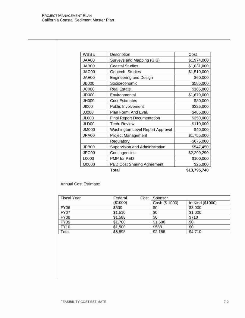
FEASIBILITY COST ESTIMATE 7-2
PROJECT MANAGEMENT PLAN California Coastal Sediment Master Plan
WBS # Description Cost JAA00 Surveys and Mapping (GIS) $1,974,000JAB00 Coastal Studies $1,031,000JAC00 Geotech. Studies $1,510,000JAE00 Engineering and Design $60,000JB000 Socioeconomic $585,000JC000 Real Estate $165,000JD000 Environmental $1,679,000JH000 Cost Estimates $80,000JI000 Public Involvement $325,000JJ000 Plan Form. And Eval. $485,000JL000 Final Report Documentation $350,000JLD00 Tech. Review $110,000JM000 Washington Level Report Approval $40,000JPA00 Project Management $1,755,000 Regulatory $675,000JPB00 Supervision and Administration $547,450JPC00 Contingencies $2,299,290L0000 PMP for PED $100,000Q0000 PED Cost Sharing Agreement $25,000 Total $13,795,740
Annual Cost Estimate:
Sponsor Fiscal Year Federal Cost ($1000) Cash ($ 1000) In-Kind ($1000)
FY06 $600 $0 $3,000 FY07 $1,510 $0 $1,000 FY08 $1,588 $0 $710 FY09 $1,700 $1,600 $0 FY10 $1,500 $588 $0 Total $6,898 $2,188 $4,710

QUALITY CONTROL PLAN 8-1
PROJECT MANAGEMENT PLAN California Coastal Sediment Master Plan
CHAPTER 8 QUALITY CONTROL PLAN
QUALTIY CONTROL PLAN OBJECTIVE The quality control plan objective is to prepare and complete the feasibility phase while meeting or exceeding the customer’s requirements and expectation, and maintaining consistency with Corps policies, guidelines and regulations. TECHNICAL REVIEW GUIDELINES The guidelines for Independent Technical Review are set forth in the South Pacific Division Quality Management Plan, CESPD R 1110-1-8, and in the corresponding District Quality Management Plan, CESPL-OM-1105-1-2. STUDY TEAM MEMBERS Organization Name Phone DBW Clif Davenport 707-576-2986 CESPL-PD-WS Susie Ming 213-452-3789 CESPL-PD-WS Heather Schlosser 213-452-3810 CESPL-PM Tony Risko 213-452-4004 CESPD-PD-TO George Domurat 415-977-8050 CESPN-ET-PF Karen Berresford 415-977-8681 CESPL-PD Mark Bierman 213-452-3827 CESPL-CO-RN Josh Burnam 213-452-3294 CESPL-CO-ON Jim Fields 213-452-3403 CESPL-ED-DC Frank Wu 213-452-3684 CESPL-ED-GD Greg Dombrosky 213-452-3592 CESPL-ED-DS Phil Eng 213-452-3744 CESPL-ED Ken Raabe 213-452-3596 CESPL-PD-RN Larry Smith 213-452-3846 CESPL-PD-WS MaLisa Martin 213-452-3828 CESPL-RE-P Pete Garcia 213-452-3131 TECHNICAL REVIEW TEAM MEMBERS: The first review to be done by the review team is scheduled prior to the F3 milestone, which is about one (1) year into the study. Approximately three months prior to the F3 milestone a technical review team will be assembled. Invariable promotions and/or job changes require this action. However, the assembled team members will be experienced in their respective areas, sufficient to perform the review for the desired outcome as defined in guidelines. DOCUMENTS TO BE REVIEWED AND SCHEDULE FOR REVIEW ACTIVITES All the products listed in the detailed scopes of work in Chapter IV, will be subject to independent technical review. Seamless single discipline review will be accomplished prior to the release of materials to other members of the study team or integrated into the overall study. Section chiefs shall be responsible for their respective areas study input accuracy. Section

QUALITY CONTROL PLAN 8-2
PROJECT MANAGEMENT PLAN California Coastal Sediment Master Plan
chiefs will assure that the seamless review has occurred prior to any independent technical review. Independent technical review will occur prior to the CESPD milestones that include product documents; the F3 (without project condition), F4 (with project condition), issue resolution conferences, F5 (draft document), and F8 (final document). These products shall be essentially complete before review is undertaken. Since this quality control will have occurred prior to each milestone conference, the conference is free to address critical outstanding issues and set direction for the next step of the study, since a firm technical basis for making decisions will have already been established. In general, the independent technical review will be initiated at least two weeks prior to each milestone and at least two weeks prior to any HQUSACE issue resolution conference. Independent Technical Review is the responsibility of the contractor for all contracted work. Quality assurance of the contractor’s quality control will be the responsibility of the contract issuing organization. DEVIATIONS FROM THE APPROVED QUALITY MANGEMENT PLAN No deviations from the Quality Management Plan are proposed. COST ESTIMATE FOR QUALITY MANAGEMENT The cost for conducting independent technical review is shown in Chapter III. Supervision and Administration costs as well as seamless review costs related to Quality Management is included in each individual estimate grouped by Work Breakdown Structure described in chapter III. These costs are assumed to be about 1.0 % of the main product task cost (about $100,000). The cost for independent technical review is approximately $110,000, which is approximately 1% of the study cost estimate. The total estimated cost for Quality Management is $547,450, which is approximately 5% of the study cost.
PMP QUALITY CERTICATION The Chief, Planning Division has certified that 1) the independent technical review process for this PMP has been completed, 2) all issues have been addressed, 3) the streamlining initiatives proposed in this PMP will result in a technically adequate product, and 4) appropriate quality control plan requirements have been adequately incorporated into this PMP. The signed certification is included as Enclosure D. FEASIBILITY PHASE CERTIFICATION Independent technical review documentation shall be included with the submission all reports to CESPD. Independent technical review documentation shall be accompanied by certification, indicating that the independent technical review process has been completed and that all technical issues have been resolved. The certification requirement applies to all documentation that will be forwarded to either CESPD or HQUSACE for review or approval. The Chief, Planning Division will certify the pre-conference documentation for the HQUSACE issue resolution conferences and the draft feasibility report. The District Commander will certify the final feasibility report, which includes the signed recommendation of the District Commander. This certification will follow the example that is included as Appendix H of the CESPD Quality Management Plan and will be signed by the Chief, Planning Division and the District Commander.

IDENTIFICATON OF PROCEDURES AND CRITERIA 9-1
PROJECT MANAGEMENT PLAN California Coastal Sediment Master Plan
CHAPTER 9 IDENTIFICATON OF PROCEDURES AND CRITERIA
EVOLUTION OF THE PMP This PMP describes all activities from the initial tasks of the feasibility phase through the preparation of the final feasibility report, the project management plan for project implementation and design agreement, and concludes with the district's support during the Washington-Level Review. As this PMP is based primarily on existing information, it will be subject to scope changes as the technical picture unfolds. While this PMP includes tasks through the completion of the feasibility study, the level of detail in the scopes of work are greater for those tasks that occur prior to the first milestone conference. This plan will be reviewed at the first milestone conference and additional detail will be added to the scopes of work for the subsequent tasks. During the feasibility phase of the study, the current PMP, including the documentation of agreements on changes to the conduct of the study, will be addressed at each of the CESPD milestone conferences and at the formal issue resolution conferences with HQUSACE, including the AFB and FRC. THE PLANNING PROCESS The Water Resource Council's Principles and Guidelines (P&G) is the basic planning guidance, which establishes a six-step planning process. This process is a conceptual planning sequence for developing solutions to water resource problems and opportunities. The Planning Manual and Planning Primer, both published by IWR provide excellent coverage of the planning process. The South Pacific Division also provides training in the six- step process. This six-step process will be followed during this study. POLICY The policies that govern the development of projects are contained in the DIGEST OF WATER REOURCES POLICIES AND AUTHORITIES, EP 1165-2-1. CORPS REGULATIONS All of the Corps’ current regulations are included on the HQUSACE homepage. The most important of these regulations is ER 1105-2-100, PLANNING GUIDANCE NOTEBOOK. Policy compliance review is addressed in EC 1165-2-203, TECHNICAL AND POLICY COMPLIANCE REVIEW. And, quality control is covered in the CESPD Quality Management Plan, CESPD R 1110-1-8. The review of the products will be accomplished with the review checklist that is provided in EC 1165-2-203 as Appendix B, POLICY COMPLIANCE REIVEW CONSIDERATIONS. PROCESSING REQUIREMENTS In addition to ER 1105-2-100, the South Pacific Division has provided additional guidance on the processing requirements for each of the milestone submittals. This guidance is contained in CESPD-ET-P memorandum, dated 30 March 2000, subject: Processing of Planning Reports in the South Pacific Division.
COORDINATION MECHANISMS 10-1
PROJECT MANAGEMENT PLAN California Coastal Sediment Master Plan
CHAPTER 10 COORDINATION MECHANISMS
CESPD MILESTONES Two of the milestones in the CESPD milestone system have been established specifically for the purpose of providing a public forum to receive public input. The first of these is the initial public workshop. This workshop is an opportunity to present the study to the public, obtain input and public opinions, and fulfill the NEPA scoping meeting requirements. The second milestone in the system is the final public meeting. This meeting is after the release of the draft report for public review and is an opportunity to present the findings of the draft report to the public and receive public comment. STUDY SPECIFIC PUBLIC INVOLVEMENT ACTIVITIES In addition to the two public meetings mentioned above, this study includes seven (7) public meetings located at various coastal counties to assist with steering the study. Additionally, 2 meetings a year will be held in conjunction with the Coastal Sediment Management Workgroup (CSMW). The purpose of these meetings will be to present findings from the Master Plan study and the receive feedback from stakeholders.
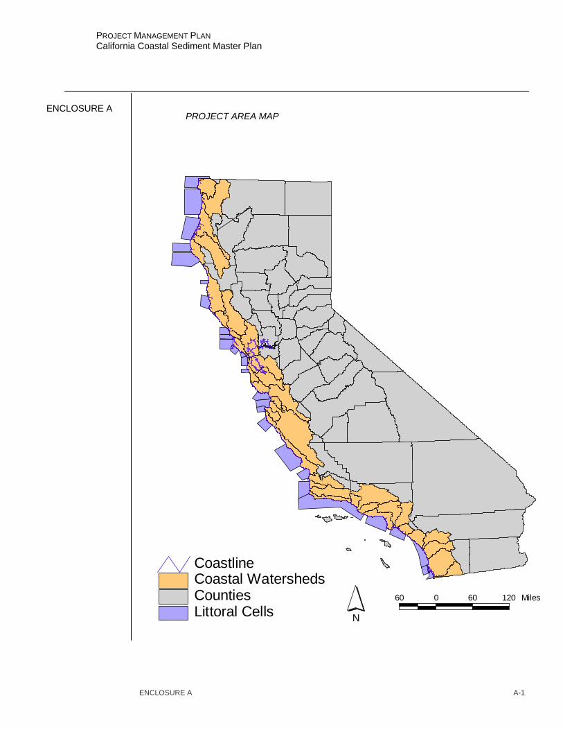
ENCLOSURE A A-1
PROJECT MANAGEMENT PLAN California Coastal Sediment Master Plan
ENCLOSURE A PROJECT AREA MAP
Littoral CellsCountiesCoastal WatershedsCoastline
N
60 0 60 120 Miles
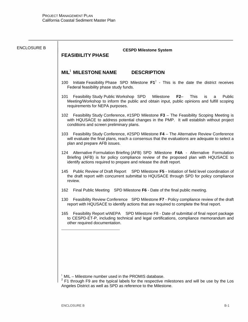
ENCLOSURE B B-1
PROJECT MANAGEMENT PLAN California Coastal Sediment Master Plan
ENCLOSURE B CESPD Milestone System
FEASIBILITY PHASE MIL1 MILESTONE NAME DESCRIPTION 100 Initiate Feasibility Phase SPD Milestone F12 - This is the date the district receives
Federal feasibility phase study funds. 101 Feasibility Study Public Workshop SPD Milestone F2– This is a Public
Meeting/Workshop to inform the public and obtain input, public opinions and fulfill scoping requirements for NEPA purposes.
102 Feasibility Study Conference, #1SPD Milestone F3 – The Feasibility Scoping Meeting is
with HQUSACE to address potential changes in the PMP. It will establish without project conditions and screen preliminary plans.
103 Feasibility Study Conference, #2SPD Milestone F4 – The Alternative Review Conference
will evaluate the final plans, reach a consensus that the evaluations are adequate to select a plan and prepare AFB issues.
124 Alternative Formulation Briefing (AFB) SPD Milestone F4A - Alternative Formulation
Briefing (AFB) is for policy compliance review of the proposed plan with HQUSACE to identify actions required to prepare and release the draft report.
145 Public Review of Draft Report SPD Milestone F5 - Initiation of field level coordination of
the draft report with concurrent submittal to HQUSACE through SPD for policy compliance review.
162 Final Public Meeting SPD Milestone F6 - Date of the final public meeting. 130 Feasibility Review Conference SPD Milestone F7 - Policy compliance review of the draft
report with HQUSACE to identify actions that are required to complete the final report. 165 Feasibility Report w\NEPA SPD Milestone F8 - Date of submittal of final report package
to CESPD-ET-P, including technical and legal certifications, compliance memorandum and other required documentation.
1 MIL – Milestone number used in the PROMIS database. 2 F1 through F9 are the typical labels for the respective milestones and will be use by the Los Angeles District as well as SPD as reference to the Milestone.

ENCLOSURE B B-2
PROJECT MANAGEMENT PLAN California Coastal Sediment Master Plan
170 MSC Commander’s Public Notice SPD Milestone F9 - Date of issue of the Division
Commander’s Public Notice. Congressional notification would occur two days prior. The report and supporting documentation would be forwarded to HQUSACE. This milestone is used as the completion of the feasibility report in the CMR.
310 Filing of Final EIS/EA Date that the notice appears in the Federal Register.
Letters for filing would be furnished by HQUSACE. 330 Chief’s Report to ASA (CW) Date of the signed report of the Chief of Engineers. 320 ROD Signed or FONSI Signed Date that the ROD is signed by the ASA(CW) when
forwarded for authorization. 350 President Signs Authorization Date President signs authorizing legislation.
ENCLOSURE C C-1
PROJECT MANAGEMENT PLAN California Coastal Sediment Master Plan
ENCLOSURE C DETAILED SCOPES OF WORK Detailed Scopes are contained in Chapter 4 of this PMP. No further details regarding work descriptions will be included in this document, at this time.

PROJECT MANAGEMENT PLAN
Califorr113 Coastal Sediment Master Plan
ENCLOSURE DQUALITY CONTROL
COMPLETION OF QUALITY CONTROL ACTIVITIES
The District has completed the Project Management Plan for the Westminster Watershed,Feasibility Study All quality control activities defined in the generic quality control plan forreconnaissance phase products have been completed. Compliance with clearly establishedpolicy principles and procedures, utilizing justified and valid assumptions, has been verified,including whether the PMP meets the non-Federal Sponsors needs and is consistent with lawand existing Corps policy. All issues and concerns resulting from the independent technicalreview of the PMP have been resolved.
CERTIFICATION
Certification is hereby given that 1) the independent technical review process for this PMPhas been completed, 2) all issues have been addressed, 3) the streamlining initiatives proposedin this PMP will result in a technically adequate product, and 4) appropriate quality control planrequirements have been adequately incorporated into this PMP. In summary, the study mayproceed into the feasibility phase in accordance with this PMP.
l~fL~lL~5=- ~~~~~~Bb -
ENCLOSURE D
FICA TIONCERITI
0-1
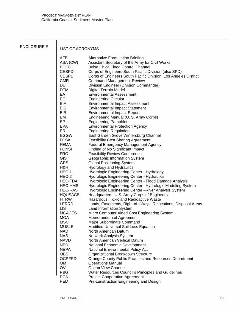
ENCLOSURE E E-1
PROJECT MANAGEMENT PLAN California Coastal Sediment Master Plan
ENCLOSURE E LIST OF ACRONYMS
AFB Alternative Formulation Briefing ASA (CW) Assistant Secretary of the Army for Civil Works BCFC Bolsa Chica Flood Control Channel CESPD Corps of Engineers South Pacific Division (also SPD) CESPL Corps of Engineers South Pacific Division, Los Angeles District CMR Command Management Review DE Division Engineer (Division Commander) DTM Digital Terrain Model EA Environmental Assessment EC Engineering Circular EIA Environmental Impact Assessment EIS Environmental Impact Statement EIR Environmental Impact Report EM Engineering Manual (U. S. Army Corps) EP Engineering Pamphlet EPA Environmental Protection Agency ER Engineering Regulation EGGW East Garden Grove Wintersburg Channel FCSA Feasibility Cost Sharing Agreement FEMA Federal Emergency Management Agency FONSI Finding of No Significant Impact FRC Feasibility Review Conference GIS Geographic Information System GPS Global Positioning System H&H Hydrology and Hydraulics HEC-1 Hydrologic Engineering Center - Hydrology HEC-2 Hydrologic Engineering Center - Hydraulics HEC-FDA Hydrologic Engineering Center - Flood Damage Analysis HEC-HMS Hydrologic Engineering Center –Hydrologic Modeling System HEC-RAS Hydrologic Engineering Center –River Analysis System HQUSACE Headquarters, U.S. Army Corps of Engineers HTRW Hazardous, Toxic and Radioactive Waste LERRD Lands, Easements, Right-of –Ways, Relocations, Disposal Areas LIS Land Information System MCACES Micro Computer Aided Cost Engineering System MOA Memorandum of Agreement MSC Major Subordinate Command MUSLE Modified Universal Soil Loss Equation NAD North American Datum NAS Network Analysis System NAVD North American Vertical Datum NED National Economic Development NEPA National Environmental Policy Act OBS Organizational Breakdown Structure OCPFRD Orange County Public Facilities and Resources Department OM Operations Manual OV Ocean View Channel P&G Water Resources Council’s Principles and Guidelines PCA Project Cooperation Agreement PED Pre-construction Engineering and Design

ENCLOSURE E E-2
PROJECT MANAGEMENT PLAN California Coastal Sediment Master Plan
PM Project Manager PMP Project Management Plan PPMD Programs and Project Management Division PROMIS Project Management Information System PSP Project study plan (now referred to as a PMP) RAM Responsibility Assignment Matrix ROD Record of Decision S&A Supervision and Administration SAM Sediment Analysis Model PDT Project Delivery Team SPD South Pacific Division (CESPD) USFWS United States Fish and Wildlife Service USGS United States Geologic Survey WBS Work Breakdown Structure WRDA Water Resources Development Act