Embed Size (px)
Citation preview

Calibration and validation of lake surface temperaturesimulations with the coupled WRF-lake model
Hongping Gu & Jiming Jin & Yihua Wu & Michael B. Ek &
Zachary M. Subin
Received: 31 January 2013 /Accepted: 30 September 2013# Springer Science+Business Media Dordrecht 2013
Abstract A one-dimensional (1-D) physically based lake model was coupled to the WeatherResearch and Forecasting (WRF) model version 3.2 developed by the National Center forAtmospheric Research to dynamically simulate physical processes of lakes and their effectson weather and climate at local and regional scales. Our study area is focused on the GreatLakes. This coupled model realistically reproduces the lake surface temperature (LST) at abuoy station in a shallow lake (Lake Erie) while generating strong LST biases ranging from−20 to 20 °C at a buoy station in a deep lake (Lake Superior). Through many sensitivitytests, we find that the biases in the deep lake LST simulations result from the drasticunderestimation of heat transfer between the lower and upper parts of the lake throughunrealistic eddy diffusion. Additional tests were made to calibrate the eddy diffusivity inWRF-Lake. It is found that when this parameter is multiplied by a factor ranging from 102 to105 for various lake depths deeper than 15 m, the LST simulations for the deep lake buoystation show good agreement with observations, and the bias range reduces to ±4 °C.Essentially, the enlarged eddy diffusivity strengthens heat transfer within the lake columnsin the deep lake, which is significantly underestimated in the lake model without calibration.Validation simulations with the calibrated eddy diffusivity were carried out for the whole ofLake Superior and Lake Erie. The LST simulations still have a substantial bias reductionwhen compared with those produced with the original eddy diffusivity, indicating that the
Climatic ChangeDOI 10.1007/s10584-013-0978-y
This article is part of a Special Issue on “Regional Earth System Modeling” edited by Zong-Liang Yang andCongbin Fu.
H. GuKey Laboratory of Regional Climate-Environment Research for Temperate East Asia (RCE-TEA),Institute of Atmospheric Physics, Chinese Academy of Sciences, Beijing, China
H. Gu : J. Jin (*)Departments of Watershed Science and Plants, Soils, and Climate, Utah State University,5210 Old Main Hill, Logan, UT 84341, USAe-mail: [email protected]
Y. Wu :M. B. EkEnvironmental Modeling Center, National Centers for Environmental Prediction, National Oceanic andAtmospheric Administration–National Weather Service, Camp Springs, MD, USA
Z. M. SubinPrinceton Environmental Institute, Princeton University, Princeton, NJ, USA

calibrated parameter is representative. In addition, the improved 1-D lake model with WRFreasonably reproduces the remotely sensed LST geographic distribution.
1 Introduction
Lake-atmosphere interactions are important to local and regional weather and climate in lake-dominant areas (Bates et al. 1993; Swayne et al. 2005; Leon et al. 2007; Rouse et al. 2005;Samuelsson et al. 2010; Subin et al. 2012; Notaro et al. 2013; Vavrus et al. 2013; Wright et al.2013). Lake-atmosphere interactions can lead to the production of lake effect precipitationduring early winter or spring when cold air masses are warmed andmoistened by the underlyingwater, generating heavy snowfall in the downwind regions (Eichenlaub 1979; Braham andDungey 1984; Niziol et al. 1995; Scott and Huff 1996). For example, a severe early wintersnowstorm occurred from November 9 to 14, 1996, in the Great Lakes region and led tohundreds of thousands of customers losing electric power (Schmidlin and Kosarik 1999). Thisstorm dumped nearly 178 cm of snow on the ground. The precipitation amount, extent, andintensity depended on the air-lake temperature difference and the over-water fetch. An earlystudy by Lavoie (1972) used a simple numerical model to examine lake-atmosphereinteractions with some success, showing that the temperature difference between the lake andlower atmosphere is themost important indicator of the intensity of lake-effect precipitation. Anobservational study by Holroyd (1971) indicated that a 13 °C temperature difference betweenthe lake and the 850-mb level of the atmosphere was a necessary condition for lake-effectsnowfall. Some researchers have incorporated one-dimensional (1-D) physically based lakeschemes with weather and climate models to investigate the impact of lakes on weather andclimate at local or regional scales (Lavoie 1972; Hostetler 1993; Bates et al. 1993; Samuelssonet al. 2010).
Over the last three decades, various 1-D lake models with different degrees of sophisticationin physical processes have been developed (Henderson-Sellers 1985; Ljungemyr et al. 1996;Goyette et al. 2000; Tsuang et al. 2001). Stepanenko et al. (2010) conducted the Lake-ModelIntercomparison Project with these 1-D lake models ranging from the simplest one-bulk-layermodels to complex finite-difference models with a turbulence closure scheme. Their resultsindicated that these models could realistically simulate water mixing processes and temperatureprofiles in shallow lakes that were mostly less than 50 m deep (Boyce et al. 1993; Peeters et al.2002; Yeates and Imberger 2003; Mironov et al. 2010). However, problems arose when thesemodels were used to simulate energy exchanges within deep lakes that were mainly more than50 m deep. For instance, none of these models was able to realistically reproduce the observedlake surface temperature (LST) in Lake Michigan, with an average depth of 85 m. To eliminatethe errors from the simulated atmospheric forcing, observational data were used to drive two 1-D lake models for the Great Lakes (Martynov et al. 2010); the results showed that both modelsperformed poorly in simulating water temperature in deeper lakes (e.g., Lake Superior, with anaverage depth of 147m), strongly indicating that the simulated temperature errors resulted fromunrealistic lake process simulations.
Thus, there is a need to fully understand physical processes, especially in deep lakes, in orderto improve simulations and predictions of lake thermal conditions and lake-atmosphereinteractions. For this study, we coupled a 1-D physically based lake model with an advancedregional climate model to examine lake process simulations at a regional scale by comparingsimulations for a shallow lake and a deep lake in the Great Lakes. Our special focus is onimproving and gaining a better understanding of deep lake process simulations through a largenumber of modeling experiments with our coupled model. This paper is arranged as follows:
Climatic Change

model descriptions are presented in Section 2, model configuration and data introduction areincluded in Section 3, results and analysis are given in Section 4, and the last section containsconclusions and discussion.
2 Model descriptions
2.1 The 1-D lake model
The lake model used in this study is a 1-D mass and energy balance model that was retrievedfrom the Community Land Model (CLM) version 3.5 (Oleson et al. 2004). This lake model isdescribed in Zeng et al. (2002) and uses the concepts in Henderson-Sellers (1985), Henderson-Sellers and Davies (1989), Hostetler (1993), Hostetler et al. (1994), and Bonan (1995), alongwith some of the modifications in Subin et al. (2012). The lake depth is originally set to 50 m forall lakes and is divided into 10 layers. However, such a fixed lake depth model setting couldcause significant biases in lake thermal process simulations as discussed in the remainingsections, especially for deep lakes (e.g., depth > 50m). Therefore, actual lake depth data at 1 kmresolution (Kourzeneva 2010) are used in our study, and the top lake layer is always set to 0.1 mregardless of the lake depth in order to reflect the diurnal cycle of surface variables; thethickness of the lake layer then gradually increases from the second layer to the tenth layer atthe bottom. The lake temperature for each layer is computed based on a Crank-Nicholsonthermal diffusion solution, and the lake surface heat and water fluxes are calculated assuming afreely varying (infinitesimal skin) surface temperature, with aerodynamic resistances computedas for nonvegetated surfaces in CLM (Oleson et al. 2004). There are also 10 layers of soil on thelake bottom, 5 layers of snow on the lake ice, and a parameterization of the fraction of ice on thelake surface added by Subin et al. (2012), in addition to correction of several errors in thecalculation of surface fluxes and eddy diffusivity occurring in the original CLM3.5 code(Oleson et al. 2004). Energy transfer between the lake layers is controlled by temperaturedifferences and molecular and eddy diffusion. The molecular diffusivity in the model is set to aconstant (1.433×10⁻⁷ m2/s), and the eddy diffusivity (ke) is parameterized mainly as a functionof near-surface wind stress and lake density gradient (Henderson-Sellers et al. 1983;Henderson-Sellers 1985). When the LST is below the freezing point, the eddy diffusivity isset to zero. At the lake bottom, the heat flux exchange between the lake and soil is calculatedbased on the energy transfer equation. However, there is no lake scheme in any of the releaseversions (up to Version 3.4.1) of WRF, which is one of the most advanced regional climatemodels in the world. For this study, the lake model discussed above is coupled with WRF(hereafter WRF-Lake) to explicitly simulate and predict lake processes and lake-atmosphereinteractions in regional climate systems.
3 Model configuration and data
In this study, we focus on two lakes in the Great Lakes region: Lake Superior, with an averagedepth of 147 m as mentioned previously and a maximum depth of 406 m; and Lake Erie, withan average depth of 19 m and a maximum depth of 64 m. The former represents deep lakes, andthe latter represents shallow lakes. In this study, we focus only on lake water processes; lake iceand its related snow processes are not included and will be addressed elsewhere. Thus, ourstudy period is 1 September 2001 to 31 December 2002, an ice-free period in all of the GreatLakes. To achieve realistic LST simulations, lake profile initializations are very important,
Climatic Change

especially for deep lakes. The lake temperatures in the top layer for 1 September 2001 areinitialized with the Moderate Resolution Imaging Spectroradiometer (MODIS) LST, and fromthe second layer to the bottom layer, the initial temperature values are assigned based roughlyon the shape of the observed lake temperature profile for 1 September 2008 for Lake Superior,which was obtained from the University of Minnesota (http://www.seagrant.umn.edu/superior/processes). Through this method, we found that the layers of a lake column deeper than 50 mwere mostly initialized at 4 °C for Lake Superior and Lake Erie for the start time of thesimulations. Our results show that there is no clear convergence or divergence betweenobservations and simulations (discussed in Section 4), indicating our lake temperature initialconditions may be reasonable. Originally, we planned to use the simulations of the first threemonths (September, October, and November 2001) as a model spin-up. However, oursimulations agree very well with observations for these three months, and thus we take theresults for the entire study period (1 September 2001 through 31 December 2002) for time seriesanalysis.
Our two simulation domains are 60×40model grids at a 10 km resolution and are centered at47.59oN, 88.20oW on Lake Superior and at 42.25oN, 81.25oW on Lake Erie, respectively(Fig. 1).We performed a series of sensitivity tests withWRF and found an optimal combinationthat produced realistic precipitation and temperature simulations (figures not shown). In thisoptimal combination, we used the Noah land surface scheme, the Lin microphysics scheme (Linet al. 1983), the Kain-Fritsch scheme (Kain and Fritsch 1993) for parameterizing cumulusclouds, the Yonsei University scheme for boundary layer processes (Hong and Pan 1996), theRapid Radiative Transfer Model (RRTM) based on Mlawer and Clough (1997) for calculatinglongwave radiation, and the Dudhia scheme for calculating shortwave radiation (Dudhia 1989).
Superior
Erie
Sta on 45004
Sta on 45005
m
a
b
Fig. 1 Lake depth observations: (a) Lake Superior (deep lake) and the location of buoy station 45004: 47.584 N,86.587W; water depth: 227.4 m; (b) Lake Erie (shallow lake) with the location of buoy station 45005: 41.677 N,82.398 W; water depth: 12.6 m
Climatic Change
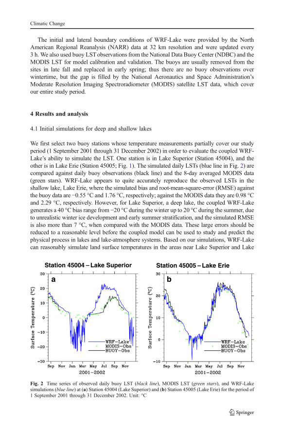
The initial and lateral boundary conditions of WRF-Lake were provided by the NorthAmerican Regional Reanalysis (NARR) data at 32 km resolution and were updated every3 h.We also used buoy LSTobservations from the National Data Buoy Center (NDBC) and theMODIS LST for model calibration and validation. The buoys are usually removed from thesites in late fall and replaced in early spring; thus there are no buoy observations overwintertime, but the gap is filled by the National Aeronautics and Space Administration’sModerate Resolution Imaging Spectroradiometer (MODIS) satellite LST data, which coverour entire study period.
4 Results and analysis
4.1 Initial simulations for deep and shallow lakes
We first select two buoy stations whose temperature measurements partially cover our studyperiod (1 September 2001 through 31 December 2002) in order to evaluate the coupled WRF-Lake’s ability to simulate the LST. One station is in Lake Superior (Station 45004), and theother is in Lake Erie (Station 45005; Fig. 1). The simulated daily LSTs (blue line in Fig. 2) arecompared against daily buoy observations (black line) and the 8-day averaged MODIS data(green stars). WRF-Lake appears to quite accurately reproduce the observed LSTs in theshallow lake, Lake Erie, where the simulated bias and root-mean-square-error (RMSE) againstthe buoy data are −0.55 °C and 1.76 °C, respectively; against the MODIS data they are 0.98 °Cand 2.29 °C, respectively. However, for Lake Superior, a deep lake, the coupled WRF-Lakegenerates a 40 °C bias range from −20 °C during the winter up to 20 °C during the summer, dueto unrealistic winter ice development and early summer stratification, and the simulated RMSEis also more than 7 °C, when compared with the MODIS data. These large errors should bereduced to a reasonable level before the coupled model can be used to study and predict thephysical process in lakes and lake-atmosphere systems. Based on our simulations, WRF-Lakecan reasonably simulate land surface temperatures in the areas near Lake Superior and Lake
Station 45004 – Lake Superior Station 45005 – Lake Erie
a b
Fig. 2 Time series of observed daily buoy LST (black line), MODIS LST (green stars), and WRF-Lakesimulations (blue line) at (a) Station 45004 (Lake Superior) and (b) Station 45005 (Lake Erie) for the period of1 September 2001 through 31 December 2002. Unit: °C
Climatic Change

Erie when compared to theMODIS surface temperatures (figure not shown), suggesting that theatmospheric forcing generated by WRF is within a plausible range. Thus, the errors seen in theLST simulations for the deep lake likely result from unrealistic simulation of lake mechanismsin the model. Similar large biases in deep lake LST simulations are seen in Martynov et al.(2010) and Stepanenko et al. (2010) using offline lake models forced by observed atmosphericdata, further confirming that the deep lake processes need to be closely investigated.
4.2 Atmospheric forcing for deep and shallow lakes
To understand the lake process simulations, we first need to examine the near-surfaceatmospheric forcings. Figures 3a and b show the comparison of the 30-year climatologiesof the observed air temperatures at a height of 4 m and LSTs in Lake Superior (Station45004) and Lake Erie (Station 45005). The pattern of 4 m height temperatures follows that
Station 45004 – Lake Superior Station 45005 – Lake Erie
ATLST
ATLST
Wave Height
a b
c
Fig. 3 Thirty-year climatology (1981–2010) of observed daily LST (black line, unit: °C) and near-surface airtemperature at a height of 4 m (AT, blue line, unit: °C) for (a) Station 45004 (Lake Superior) and (b) Station45005 (Lake Erie). Also, (c) wave height climatology for the same period for both buoy stations
Climatic Change

of the LST in Lake Erie very closely, while there are large discrepancies between the twovariables in Lake Superior, especially during the summer and winter. This phenomenonindicates that for the shallow lake the lake-atmosphere is well coupled, and the LSTvariation follows the changes in the atmospheric forcing. In other words, if an accurateatmospheric forcing is generated over the shallow lake in our coupled WRF-Lake model, theLST can be realistically reproduced. For the deep lake, atmospheric forcing is apparently notthe only factor that controls changes in LST. One hypothesis is that the deep part of the lakeoften acts as an energy sink or source to modulate changes in LST. Thus, understanding heattransfer within the deep lake may be important to estimate the LST in Lake Superior.
Figure 3c shows the observed wave height climatology derived from data over the 30-year period from 1981 to 2010 at the two buoy stations (Stations 45004 and 45005) in LakeSuperior and Lake Erie, respectively. This figure indicates that the wave height in LakeSuperior is much higher than that in Lake Erie; the average wave height in Lake Erie isbelow 1 m, while it more than doubles in Lake Superior. These large differences occur in thespring, fall, and winter. The differences in wave height indicate that turbulent water mixingin the deep lake is much stronger than in the shallow lake. Based on these observations, wehypothesize that heat transfer through water mixing in the deep lake is stronger than in theshallow lake, and the large simulated LST biases (Fig. 2a) result from the insufficientestimation of heat exchange within the deep lake in our coupled WRF-Lake model.
4.3 Calibration of lake eddy diffusion
As we discussed in Section 2.1, two parameters control heat transfer within lakes: molecular andeddy diffusivities. Adjusting these two parameters could lead to changes in LST simulations.Martynov et al. (2010) found a large bias in their deep lake LST simulations using a lake modelsimilar to the one we have coupled toWRF. They increased molecular diffusivity in an attempt tostrengthen heat flux transfer in the deep lakes. However, the simulated changes in LST producedwith these increased molecular diffusivity values did not follow the observed LST patterns. Wehave also done sensitivity tests with different molecular diffusivity values and produced similarbiased patterns. These results tell us that the large biases in LST simulations shown in Fig. 2a arenot related to molecular diffusion. Therefore, we performed additional sensitivity tests bychanging the eddy diffusivity (ke). In order to have a clear perception of ke scaling in the lakemodel, we have examined the ke values in the lake column. It is shown that the original ke valuesat Station 45004 range from around 1×10⁻⁴ to 5×10⁻⁴ m2/s, which are on the same order as thosediscussed in Sweers 1970; Csanady 1964, and Csanady 1966.We then increased ke by a factor of103, and the corresponding WRF-Lake results show that the simulated LST pattern (red line inFig. 4) starts to approach the observations. We then enlarged ke by a factor of 105, and theresulting LST simulations (purple line in Fig. 4) approach the observations very closely. Inparticular, the enormous cold biases occurring in the winter disappear. Moreover, an observedtemperature drop is seen in August, and WRF-Lake is able to simulate this drop, but thesimulations do not match well with the observations in either shape or magnitude when ke isincreased by a factor of 103 or 105. Especially, in the latter case, the temperature is underestimatedby themodel, implying that the simulated turbulent water mixing in the lakemay be too strong forthat month. Through these tests, it is apparent that a single value of eddy diffusivity may not beable to sufficiently capture complex turbulent mixing processes in the deep lake. Thus, weperformed many additional model tests with different eddy diffusivity values to produce betterLSTsimulations than those shown in Fig. 4. Based on the experience and knowledge gained fromthese modeling tests, we set eddy diffusivity as a function of lake depth and LST as shown inTable 1, where the LSTat the previous time step was used to set the factor value for ke at the next
Climatic Change

time step in the model. Based on our simulations for these two lakes, we found that when the lakeis deeper than 15 m, there is a clear divergence between observations and simulations with theoriginal ke (figure not shown), indicating a limit of the original ke at lake depths greater than thisvalue. Table 1 shows that an increase in eddy diffusivity is made for nonfreezing lakes deeperthan 15m. However, we believe that the criteria for distinguishing deep and shallow lakes are stillmodel dependent. Specifically, for this lake model, a greater eddy diffusivity is needed when thelake depth is deeper than 15 m.
In general, when the lake is deeper and the LST is equal to or lower than 4 °C but greater thanthe freezing point, ke is multiplied by a larger factor, and vice versa. Under this LST range, whichoften occurs during the cold season, stratification in the upper part of the lake is usually weak, andthe turbulent water mixing driven by the near-surface wind stress can easily reach the lower part ofthe lake or even its bottom, indicating a large eddy diffusivity value.When the LST increases from4 °C, which occurs in the Great Lakes mostly during late spring and summer, there is an increasein the epilimnion, defined as the depth of thewarmwater layer at the top of the lake. Strongest lakestratification over the year usually occurs during this period of time. Thus, lake stratification in thewarm seasons greatly limits water mixing, indicating a small eddy diffusivity value.
We applied the calibrated values of eddy diffusivity shown in Table 1 to WRF-Lake andperformed one additional simulation for the period of 1 September 2001 through 31 December2002. Figure 5 shows that with these calibrated eddy diffusivity values, WRF-Lake quitereasonably reproduces the LST observations (red line in Fig. 5). The bias range decreases from
Station 45004 – Lake Superior
Fig. 4 Time series of daily LST (unit: °C) at Station 45004 (Lake Superior) from MODIS data (green stars),buoy observations (black line), and WRF-Lake simulations with three different eddy diffusivities (blue, red,and purple lines) for the period of 1 September 2001 through 31 December 2002
Table 1 Calibrated eddy diffusivities for different lake depths under the three LST ranges. ke is the originaleddy diffusivity (unit: m2 s−1)
Depth LST > 4 °C 0–4 °C ≤ 0 °C
≥ 150 m 102ke 105ke 0
15~150 m 102ke 104ke 0
≤ 15 m ke ke 0
Climatic Change

± 20 °C to about ±4 °C, and the RMSE also reduces to 2–5 °C from about 7 °C when comparedagainst both buoy and MODIS observations. Clearly, the calibrated eddy diffusivity values inTable 1 drastically improve our LSTsimulations for Lake Superior. The same diffusivity values inWRF-Lake are also applied to Lake Erie, and slightly improved results are also seen whencompared to those in Fig. 2b. We also draw the vertical temperature profile evolution for ourstudy periods (Fig. 6). From this figure, we can clearly see that in the original lake model, lakestratification is very thin when compared with observations for 2008 and 2009 (obtained from theUniversity of Minnesota, http://www.seagrant.umn.edu/superior/processes). Especially duringthe winter, the stratification reaches about 15 m in depth. After we multiply the original ke byfactors ranging from 102 to 105, the vertical heat transfer increases greatly, and the thermoclinegoes deeper in both summer and winter. Also, the winter cooling and summer warming arepostponed, and vertical mixing is strengthened, resulting in more realistic LST simulations.However, these eddy diffusivity values are based on the modeling results, and they may notaccurately reflect actual conditions, but we further validate these calibrated diffusivity values withadditional simulations, as described in the following section.
4.4 Validation of the LST simulations
All of the above simulations are calibrated at the buoy stations in Lake Superior and Lake Erie, andit is still unknownwhether the calibrated parameters are suitable for the rest of the two lakes. Thus,a validation process is vital for generalizing the use of the coupled model. Figure 7shows the time series of the LST simulations with WRF-Lake and MODIS observationsaveraged over the whole of Lake Superior and Lake Erie. The model with the calibratededdy diffusivity improves LST simulations to a great extent when compared with themodel without calibration and the MODIS data. For Lake Superior, the bias rangedecreases from −18.2–14.0 °C to −6.3–5.2 °C, and the RMSE reduces from 6.2 °C to1.5 °C. We also see improvements in the LST simulations in Lake Erie, because there arestill many lake columns deeper than 15 m in that lake (Fig. 1). The bias range for thisshallow lake decreases from ± 7.0 °C to ± 4.0 °C, and the RMSE reduces from 3.0 °C to2.0 °C.
Station 45004 – Lake Superior
Fig. 5 Time series of daily LST (unit: °C) at Station 45004 (Lake Superior) from MODIS data (green stars),buoy observations (black line), and simulations by the original WRF-Lake (blue line) and the calibrated WRF-Lake (red line) for the period of 1 September 2001 through 31 December 2002
Climatic Change

We have examined the geographic distribution of MODIS and simulated LSTs at a seasonalscale for Lake Superior and Lake Erie (figures not shown), respectively. It is evident that thecalibratedWRF-Lakemodel produces very reasonable simulations for the spatial distribution ofLST in both lakes when compared with the MODIS data. In addition, the biases for almost allseasons are reduced with the new eddy diffusivity values. The greatest improvements are seenin the summer for both lakes. The bias range decreases from −3.20–8.5 °C to −0.4–1.3 °C forLake Superior, and −0.23–3.27 °C to 0.35–1.44 °C for Lake Erie. These validation simulations
Lake Superior Lake Eriea b
Fig. 7 Daily LST time series of MODIS (green stars) and simulations by the original WRF-Lake (blue line)and calibrated WRF-Lake (red line) for the whole of (a) Lake Superior and (b) Lake Erie for the period of 1September 2001 through 31 December 2002. Unit: °C
oCa b
Fig. 6 Vertical water temperature profiles simulated by the original WRF-Lake (a) and calibrated WRF-Lake(b) for Station 45004 for the period of 1 September 2001 through 31 December 2002. Unit: °C
Climatic Change

clearly indicate that the calibrated eddy diffusivity values allow realistic simulations in bothshallow and deep lakes.
5 Conclusions and discussion
A 1-D physically based lake model was coupled to WRF (version 3.2) to dynamically simulatelake processes and lake-atmosphere interactions. The coupled model realistically reproduces theLSTat a buoy station in the shallow lake (Lake Erie), while it generates strong LST biases rangingfrom −20 °C to 20 °C at a buoy station in the deep lake (Lake Superior). Through a large number ofsensitivity tests, we found that the biases in the deep lake LST simulations result from the drasticunderestimation of heat transfer between the lower and upper parts of the lake through eddydiffusion. Additional tests were made to calibrate the eddy diffusivity inWRF-Lake.We found thatwhen this parameter is multiplied by a factor ranging from 102 to 105 for various lake depths deeperthan 15 m, the simulations for the deep lake station show good agreement with the observations.Essentially, the enlarged eddy diffusivity strengthens heat transfer within the lake columns in thedeep lake, which is significantly underestimated in the model with the original diffusivity.Validation simulations with the calibrated eddy diffusivity values were carried out for the wholeof Lake Superior and Lake Erie. A remarkable bias reduction in these simulations is still seen whencompared with those simulations produced with the original eddy diffusivity, indicating that thecalibrated parameters are representative. Very importantly, the improved 1-D lake modelreasonably reproduces the observed spatial distribution of LST.
In this modeling exercise, the original eddy diffusivity is increased by up to several orders, andthe augmented parameter very effectively helps produce realistic LST simulations. However, itshould be realized that the model is simply being tuned to work for the deeper Great Lakes bylumping all 3-D processes into a 1-D proxy. The simulated vertical temperature profiles still needto be fully evaluated with high-quality observations. Nevertheless, we did not have access tolong-term temperature profile observations for deep lakes at the time of this study to comparewith our modeling results. Based on this study, it is obvious that a better understanding of thephysical processes inside lakes are vital to producing realistic modeling results, and related fieldwork should be strongly emphasized in the future.
Acknowledgments This work was supported by the Utah Agricultural Experiment Station, the NOAAMAPP NA090AR4310195 grant, and the EPA RD83418601 grant.
References
Bates GT, Giorgi F, Hostetler SW (1993) Toward the simulation of the effects of the Great Lakes on regionalclimate. Mon Weather Rev 121:1373–1387
Bonan GB (1995) Sensitivity of a GCM simulation to inclusion of inland water surfaces. J Clim 8:2691–2704Boyce FM, Hamblin PF, Harvey LD, Schertzer WM, McCrimmon RC (1993) Response of the thermal
structure of Lake Ontario to deep cooling water withdrawals and to global warming. J Gt Lakes Res19:603–616
Braham RR, Dungey MJ (1984) Quantitative estimates of the effect of Lake Michigan on snowfall. J ApplMeteorol 23:940–949
Csanady GT (1964) Turbulence and diffusion in the Great Lakes. Mich Univ Gt Lakes Res 11:326–339Csanady GT (1966) Dispersal of foreign matter by the currents and eddies of the Great Lakes. Mich Univ Gt
Lakes Res 15:283–294Dudhia J (1989) Numerical study of convection observed during the winter monsoon experiment using a
mesoscale two-dimensional model. J Atmos Sci 46:3077–3107
Climatic Change

Eichenlaub VL (1979) Weather and climate of the Great Lakes region. University of Notre Dame PressISBN:0268019290
Goyette S, McFarlane NA, Flato GM (2000) Application of the canadian regional climate model to theLaurentian Great Lakes region: implementation of a lake model. Atmos-Ocean 38:481–503
Henderson-Sellers B (1985) New formulation of eddy diffusion thermocline models. Appl Math Modelling9:441–446
Henderson-Sellers B, Davies AM (1989) Thermal stratification modeling for oceans and lakes. Ann RevNumer Fluid Mech Heat Transf 2:86–156
Henderson-Sellers B, McCormick MJ, Scavia D (1983) A comparison of the formulation for eddy diffusion intwo one-dimensional stratification models. Appl Math Mod 7:212–215
Holroyd EW (1971) Lake-effect cloud bands as seen from weather satellites. J Atmos Sci 28:1165–1170Hong SY, Pan HL (1996) Nonlocal boundary layer vertical diffusion in a medium-range forecast model. Mon
Weather Rev 124:2322–2339Hostetler SW (1993) Interactive coupling of a lake thermal model with a regional climate model. J Geophys
Res 98:5045–5057Hostetler SW, Giorgi F et al (1994) Lake-atmosphere feedbacks associated with Paleolakes Bonneville and
Lahontan. Sci 263(5147):665Kain JS, Fritsch JM (1993) Convective parameterization for mesoscale models: the Kain-Fritsch scheme. The
representation of cumulus convection in numerical models,MeteorMonogr, No. 46, AmerMeteor Soc 165–170Kourzeneva E (2010) External data for lake parameterization in numerical weather prediction and climate
modeling. Boreal Env Res 15:165–177Lavoie RL (1972) A mesoscale model of lake effect snowstorms. J Atmos Sci 29:1025–1040Leon LF, Lam DCL, Schertzer WM, Swayne DA, Imberger J (2007) Towards coupling a 3-D hydrodynamic
lake model with the Canadian regional climate model: simulation on Great Slave Lake. Environ ModelSoftw 22:787–796
Lin YL, Farley RD, Orville HD (1983) Bulk parameterization of the snow field in a cloud model. J Clim ApplMeteorol 22:1065–1092
Ljungemyr P, Gustafsson N, Omstedt A (1996) Parameterization of lake thermodynamics in a high-resolutionweather forecasting model. Tellus A 48:608–621
Martynov A, Sushama L, Laprise R (2010) Simulation of temperate freezing lakes by one-dimensional lakemodels: performance assessment for interactive coupling with regional climate models. Boreal Env Res15:143–164
Mironov D, Rontu L et al (2010) Towards improved representation of lakes in numerical weather predictionand climate models: introduction to the special issue of Boreal Environment Research. Boreal Env Res15:97–99
Mlawer EJ, Clough SA (1997) On the extension of RRTM to the shortwave region. In: Proceedings of theSixth Atmospheric Measurement (ARM) Science Team Meeting, CONF-9603149. US Department ofEnergy, Washington, pp 223–226
Niziol TA, Snyder WR, Waldstreicher JS (1995) Winter weather forecasting throughout the eastern UnitedStates. IV: lake effect snow. Weather Forecast 10:61–77
Notaro M, Zarrin A, Vavrus S, Bennington V (2013) Simulation of heavy lake-effect snowstorms across theGreat Lakes basin by RegCM4: Synoptic climatology and variability. Mon Wea Rev (in press).
Oleson KW, Dai Y, Bonan G et al (2004) Technical description of the community land model (CLM). NCAR/TN-461+STR, 174 p
Peeters F, Livingstone DM, Goudsmit GH, Kipfer R, Forster R (2002) Modeling 50 years of historicaltemperature profiles in a large central European lake. Limnol Oceanogr 47:186–197
Rouse WR, Oswald CJ, Binyamin J et al (2005) The role of northern lakes in a regional energy balance. JHydrometeorol 6:291–305
Samuelsson P, Kourzeneva E, Mironov D (2010) The impact of lakes on the European climate as simulated bya regional climate model. Boreal Env Res 15:113–129
Schmidlin TW, Kosarik J (1999) A record Ohio snowfall during 9–14 November 1996. Bull AmMeteorol Soc80:1107–1116
Scott RW, Huff FA (1996) Impacts of the Great Lakes on regional climate conditions. J Gt Lakes Res 22:845–863Stepanenko VM, Goyette S, Martynov A, Perroud M, Fang X, Mironov D (2010) First steps of a lake model
intercomparison project: lakeMIP. Boreal Env Res 15:191–202Subin ZM, Riley WJ, Mironov D (2012) An improved lake model for climate simulations: model structure,
evaluation, and sensitivity analyses in CESM1. J Adv Model Earth Syst 4, M02001Swayne D, Lam D, MacKay M, Rouse W, Schertzer W (2005) Assessment of the interaction between the
Canadian Regional Climate Model and lake thermal–hydrodynamic models. EnvironModel Softw 20:1505–1513
Climatic Change
Sweers HE (1970) Vertical diffusivity coefficient in a thermocline. Limnol Oceanogr 15:273–280Tsuang BJ, Tu CY, Arpe K (2001) Lake parameterization for climate models. Report No. 316, Max Planck
Institute for Meteorology, 72 pVavrus S, Notaro M, Zarrin A (2013) The role of ice cover in heavy lake-effect snowstorms over the Great
Lakes basin as simulated by RegCM4. Mon Weather Rev 141:148–165Wright DM, Posselt DJ, Steiner AL (2013) Sensitivity of lake-effect snowfall to lake ice cover and
temperature in the Great Lakes region. Mon Weather Rev 141:670–689Yeates PS, Imberger J (2003) Pseudo two-dimensional simulations of internal and boundary fluxes in stratified
lakes and reservoirs. Inter J River Basin Manag 1:297–319Zeng X, Shaikh M, Dai Y, Dickinson RE, Myneni R (2002) Coupling of the common land model to the
NCAR community climate model. J Clim 15:1832–1854
Climatic Change