Embed Size (px)
Citation preview


CALA MINNOLA WRECK In Cala Minnola, on the eastern coast of the island of Levanzo, a wreck was found many years ago at a depth of – m 27 – 30. Although it was heavily looted there are still about 60 amphorae still visible on the soil. The area is non far from Punta Altarella where there are the remains of some plastered basins cut into the rock that are belonging to a garum farm of Hellenistic and roman period.
What was remaining of the wreck was excavated in 2005 by Soprintendenza del Mare. Cargo was formed by wine amphorae of Dressel 1b type. There were also different varieties of potsherds, some of them belonging to black painted ware of middle 1st cent b.C. Few were the traces of wooden elements and only one lead pipe. Amphorae, coated by pitch, were containing wine. It should be possible that the same amphorae could have been used to contain garum on the way back towards peninsular Italy.
The provenance of the ship seems to be sure because of a mark impressed on one amphora. It shows the name of PAPIA. It is the name of a very important family that was running wide estates in lower Latium. We know that this family was producing wine and exporting it all over Mediterranean. It is likely that the leader of that family was in that period a woman : Tertia that we know was living around the middle !st cent. b.C.
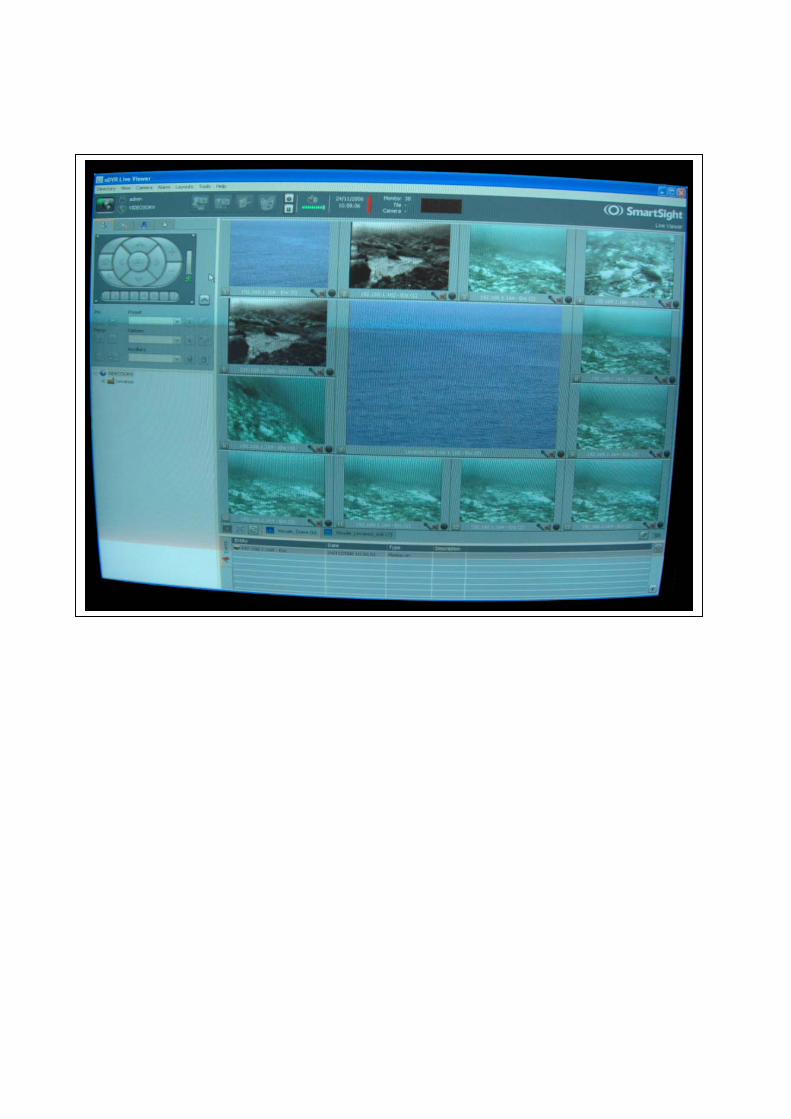
What has been left o the soil is the original situation of the cargo after it was collapsing from the wreck rolling over the rocky slope. The fall ended on the sandy soil where we found the remaining amphorae that are visible with guided tours. Since july 2006 the wreck is visible also from the land through a video control system. 4 video cameras are placed around the amphorae and, by wire, bring images to an antenna on the coast. From this point images “fly” and reach Town Hall of Favignana where they are visible to the public. Sebastiano Tusa


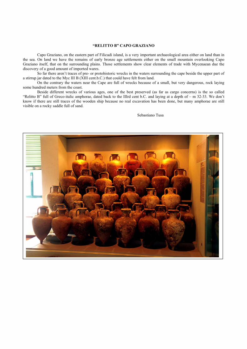
“RELITTO B” CAPO GRAZIANO
Capo Graziano, on the eastern part of Filicudi island, is a very important archaeological area either on land than in the sea. On land we have the remains of early bronze age settlements either on the small mountain overlooking Capo Graziano itself, that on the surrounding plains. Those settlements show clear elements of trade with Mycenaean due the discovery of a good amount of imported wares. So far there aren’t traces of pre- or protohistoric wrecks in the waters surrounding the cape beside the upper part of a stirrup jar dated to the Myc III B (XIII cent.b.C.) that could have felt from land. On the contrary the waters near the Cape are full of wrecks because of a small, but very dangerous, rock laying some hundred meters from the coast. Beside different wrecks of various ages, one of the best preserved (as far as cargo concerns) is the so called “Relitto B” full of Greco-italic amphorae, dated back to the IIIrd cent b.C. and laying at a depth of – m 32-33. We don’t know if there are still traces of the wooden ship because no real excavation has been done, but many amphorae are still visible on a rocky saddle full of sand. Sebastiano Tusa
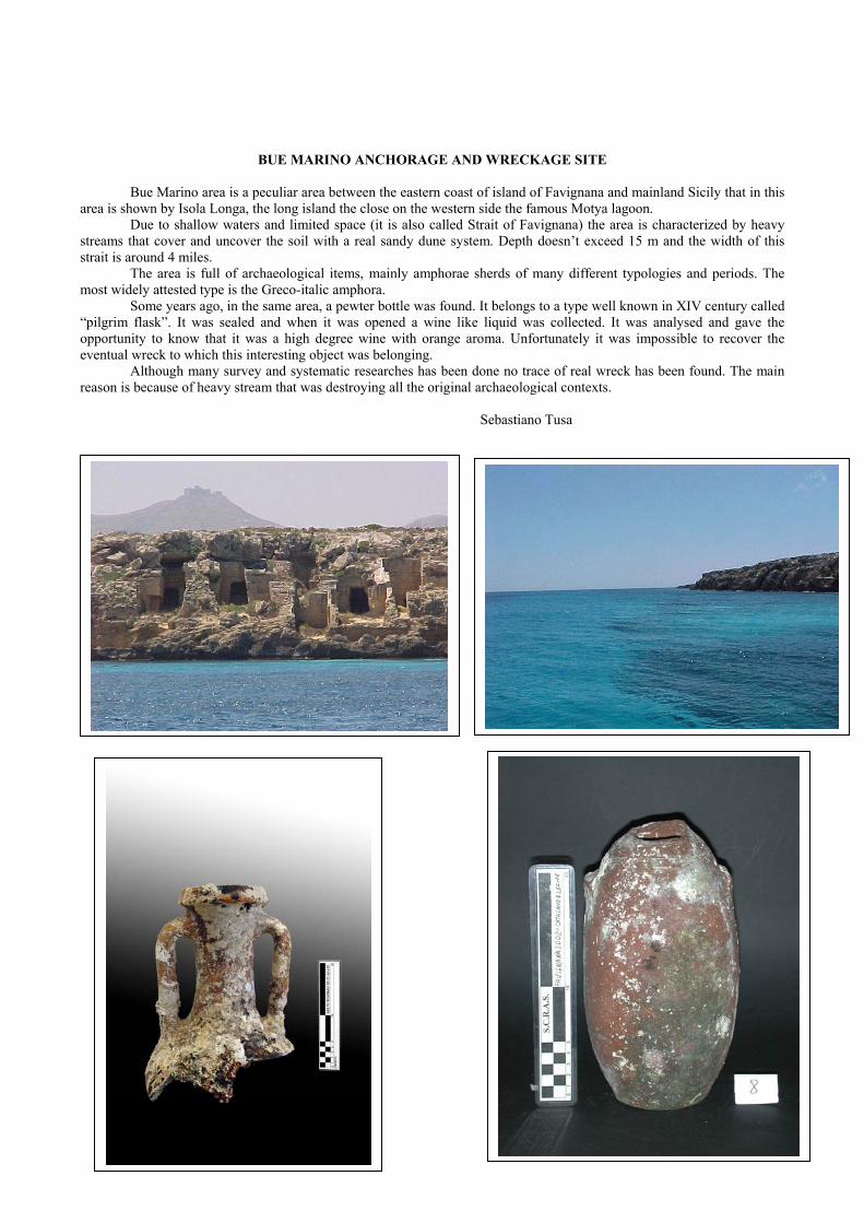
BUE MARINO ANCHORAGE AND WRECKAGE SITE Bue Marino area is a peculiar area between the eastern coast of island of Favignana and mainland Sicily that in this area is shown by Isola Longa, the long island the close on the western side the famous Motya lagoon. Due to shallow waters and limited space (it is also called Strait of Favignana) the area is characterized by heavy streams that cover and uncover the soil with a real sandy dune system. Depth doesn’t exceed 15 m and the width of this strait is around 4 miles. The area is full of archaeological items, mainly amphorae sherds of many different typologies and periods. The most widely attested type is the Greco-italic amphora. Some years ago, in the same area, a pewter bottle was found. It belongs to a type well known in XIV century called “pilgrim flask”. It was sealed and when it was opened a wine like liquid was collected. It was analysed and gave the opportunity to know that it was a high degree wine with orange aroma. Unfortunately it was impossible to recover the eventual wreck to which this interesting object was belonging. Although many survey and systematic researches has been done no trace of real wreck has been found. The main reason is because of heavy stream that was destroying all the original archaeological contexts. Sebastiano Tusa

GADIR WRECK
Gadir bay is placed on the south - east coast of Pantelleria and it is one of the few places good for landing as far as navigation concerns. This area contains all the fundamental requirements of an ancient landing place. More precisely, it forms an excellent natural shelter from all winds, except that coming from the west. In addition, a spring of drinkable water emerges nearby, and in the past the sea penetrated inland for an additional two hundred metres, evidently making the landing place safer. Moreover there should have been a small beach where pulling the ship in winter or in stormy periods. The place was also easily approachable from the highlands of Pantelleria. During the past we know that hundreds (if not thousands) of amphorae were looted. According to the tales there were mounds of amphorae in the bay of Gadir. Nowadays few dozens of amphorae are left along with one lead anchor and few wooden elements. But it is still fascinating diving through the remains of what was the cargo of at least two Punic Hellenistic ships at a depth varying from 27 to 42 metres and in a radius of about three hundred metres. The amphorae so far recovered, Roman examples of the Dressel lA, lB, lC, 2-6 types, Greco-Italic types and Punic of twelve different types (‘hole-mouth’ included), are unmistakable testimony to more than one old shipwreck dating back to the fourth century BC onwards. In Gadir, in collaboration with the ‘Carabinieri’, a systematic survey of the area also in deep waters with the help of ROV ‘Pluto’ was started by the Soprintendenza del Mare with the help of the archaeologist Marco Chioffi.. An area of about 40,000 square metres at a depth of between 50 and 120 metres was surveyed. The sea bottom is gently sloping, showing the presence of many amphorae scattered clearly coming down from the real wreck site. During the survey we encountered both Punic and Italic amphorae (types: Mana C 1, Mana C 2 , Greco-Italic, Dressel 1A1, 1A2, 1B, 1C, 2, 4, 18) along with an iron plough. Two hundred of these amphorae belonging to the wrecks of Gadir were sized by Carabinieri, and Guardia di Finanza and are the base of an exhibition that, since 1998, Marco Chioffi have held in the Castle of Pantelleria during the summer. In a short time (2008-2009) all these amphorae will be part of the Underwater archaeological museum in preparation at Arenella in Pantelleria. Due to the importance of the site and because a lot of amphorae and other archaeological items are still visible in the sea an archaeological tour was placed in the area of ancient wreckage with a rope that is leading the scuba divers through the most important archaeological features that are explained by plastic labels nearby. Moreover a plastic booklet was printed and it is at disposal of scuba divers that would like to have more information during immersion. The management of this area was given to the local diving club. Since one year a video control system is operating in one area of the wreck. Images in real time are on the web and could be seen all over the world through Soprintendenza del Mare web site. Sebastiano Tusa


SECCA DI CAPISTELLO WRECK The real excavation of the wreck took place in 1977 under the direction of Michael Katzev and Donald A. Frey (INA) with the technical support of Sub Sea Oil Co.. But sometime earlier a team of DAI (Deutsche Archäologische Institut) started the survey of the wreck, but it was stopped by the tragic death of two archaeologists. The excavation of 1977 was the first deepwater archaeological excavation. The wreck lies at - m 59. To excavate the ship properly, saturation diving had to be done. Divers breathed a helium and oxygen mixture. Dives were 5, 7 and 9 days. This meant that the divers had to go through 38 hours decompression at the end of their shift. On the whole, divers worked on the wreck for two hours. There were teams of four, two diving in the morning and two in the afternoon. For safety reasons, one diver always monitored the other from the on-site diving bell. For further safety, there was a continual diver-surface com and CCTV. However, there was a lot of interference. The hull was the major artefact to be uncovered in the 1977 excavation. Of the hull, around 6 sq. m was exposed during excavation with the further indication that more lay under a layer of undisturbed sand and amphorae. The details of the uncovered hull are as follows: The main section featured eight to ten exposed strakes on which eight frames were located and overlain with three interior planks. The frames were moulded 10cm and sided 16cm. The strakes are given an average measurement of 20cm in width and 4.5cm in thickness. These were joined together by pegged mortise-and-tenon fastenings that were widely spaced - between 16cm to 18.5cm. Mortises averaged 5cm to 6cm deep. A large interior timber was uncovered in the excavation running longitudinally across six frames. Measuring 30cm wide and 6cm thick, the timber may have acted as a clamp to strengthen the hull from the inside. Two other interior timbers were recovered which could have been the remains of ceiling planking. A wooden pole 7cm in diameter lied parallel to the main timber but was unattached to the hull, it's purpose remains unknown. Brushwood was found beneath the amphorae and spread over the inside of the hull. The interior of the hull was coated with a thin layer of a dark tarry substance which had to be removed by the divers to get to the tenon peg outlines and the seams between the strakes. A number of copper and iron nails were also found, one complete measuring 15cm in length and retaining its original clenched shape. The Capistello ship, indicated by the size of the hull recovered and by that remained buried or lost, is believed to be bigger than the Kyrenia ship of roughly a century earlier. The Kyrenia measured 15m by 5m. The Capistello is dated to the fifth century BC, 100 years prior to the Kyrenia. The Capistello wreck was a small freighter carrying amphorae and Campanian ware, a fairly normal cargo for a Mediterranean freighter to carry. The Capistello wreck was dated to the IVth century, a century later than the Kyrenia. The building technique of the ship falls into the transitional period of Mediterranean boatbuilding as shown by the Kyrenia and St Congloue ships. The Capistello wreck has mortise and tenon fastenings, but they are widely spaced and do not give the hull strength and integrity. This is carried by the frames, which were moulded to fit the hull. They are fastened by copper nails to the hull, the nails clenched over on the inside. The frames were a pattern of floor timbers and half-frames alternating with each other. Additionally, the excavation showed a logitudinal timber running over the frames. It was 30 cm wide, and was used as a stringer to further strengthen the hull.

Bibliography Blanck H., 1978, Der Schiffsfund von der Secca di Capistello bei Lipari. Mitteilungen des Deutschen Archaologischen Instituts, Romisch Abteilung 85. Mainz am Rhein.
Frey D.A. & Hentschel F.D. & Keith D.H., 1978, Deepwater archaeology. The Capistello wreck excavation, Lipari, Aeolian Islands. IJNA, 7.4: 279-300.
Frey D.A. #et al#., 1979,L'archeologia sottomarina a grande Profondita: gli scavi di Capistello.Sicilia Archeologica, 12.39. (Trapani)
Kapitan G., 1978, Exploration at Cape Graziano, Filicudi, Aeolian Islands, 1977. IJNA, 7.4: 269-277.
Picozzi S., 1979, La nave di Capistello. Il Subacqueo, 7.70.
Sebastiano Tusa


ANCHORAGE AND WRECKAGE SITE OF TONNARELLA
Not far from Mazara del Vallo and few hundreds meters east of Capo Feto, in front of a white sandy beach some years ago it was identified a wide area covered by potsherds at a depth of 2 – 4 m. Limited excavation was carried on and it appeared that the area was bringing traces of a wreck of Hellenistic period. The ship sunk with a cargo of Greco-italic amphorae that were partly recovered at that time, partly scattered by the sea over a wide area. Pieces of wood and some lead pipes were also belonging to the same ship. On the rim of one Greco-italic amphora there was a latin inscription. Sebastiano Tusa


ANCHORAGE AND WRECKAGE SITE OF TRAVERSA GRANITOLA
The area west of Capo Granitola, between Selinunte and Mazara del Vallo, where the lighthouse is placed, is one the most difficult for navigation because of heavy streams that frequently affect the possibility of sailing around the cape. For this reason the area is full of wrecks that till now haven’t been systematically surveyed. We know the presence in the area of a Spanish wreck with cannons, of an Hellenistic wreck with architectural elements such as capitals and of a cargo of marble blocks of IIIrd cent a.D. coming from western Anatolia. It is interesting to note that the soil, characterized by sand, posidonia and rocks, is full of remains, mainly pottery of different variety and age. Sebastiano Tusa