Embed Size (px)
Citation preview
East Sardinia Coast From Cagliari to Olbia
East Sardinia Sailing Route offers tourists a variety of cues from a nautical point of view. The predominant winds in this part of the coast are from the north west and the south east. The itinerary also allows you to enjoy the beauty of the coasts of Sardinia from a privileged point of view, with a new landscape day after day, between coves of white sand or rocks and crystal clear water where you can moor.
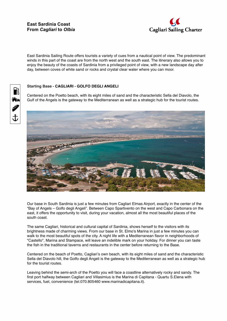
Starting Base - CAGLIARI - GOLFO DEGLI ANGELI
Centered on the Poetto beach, with its eight miles of sand and the characteristic Sella del Diavolo, the Gulf of the Angels is the gateway to the Mediterranean as well as a strategic hub for the tourist routes.
Our base in South Sardinia is just a few minutes from Cagliari Elmas Airport, exactly in the center of the “Bay of Angels – Golfo degli Angeli”. Between Capo Spartivento on the west and Capo Carbonara on the east, it offers the opportunity to visit, during your vacation, almost all the most beautiful places of the south coast.
The same Cagliari, historical and cultural capital of Sardinia, shows herself to the visitors with its brightness made of charming views. From our base in St. Elmo's Marina in just a few minutes you can walk to the most beautiful spots of the city. A night life with a Mediterranean flavor in neighborhoods of "Castello", Marina and Stampace, will leave an indelible mark on your holiday. For dinner you can taste the fish in the traditional taverns and restaurants in the center before returning to the Base.
Centered on the beach of Poetto, Cagliariʼs own beach, with its eight miles of sand and the characteristic Sella del Diavolo hill, the Golfo degli Angeli is the gateway to the Mediterranean as well as a strategic hub for the tourist routes.
Leaving behind the semi-arch of the Poetto you will face a coastline alternatively rocky and sandy. The first port halfway between Cagliari and Villasimius is the Marina di Capitana - Quartu S.Elena with services, fuel, convenience (tel.070.805460 www.marinadicapitana.it).
!
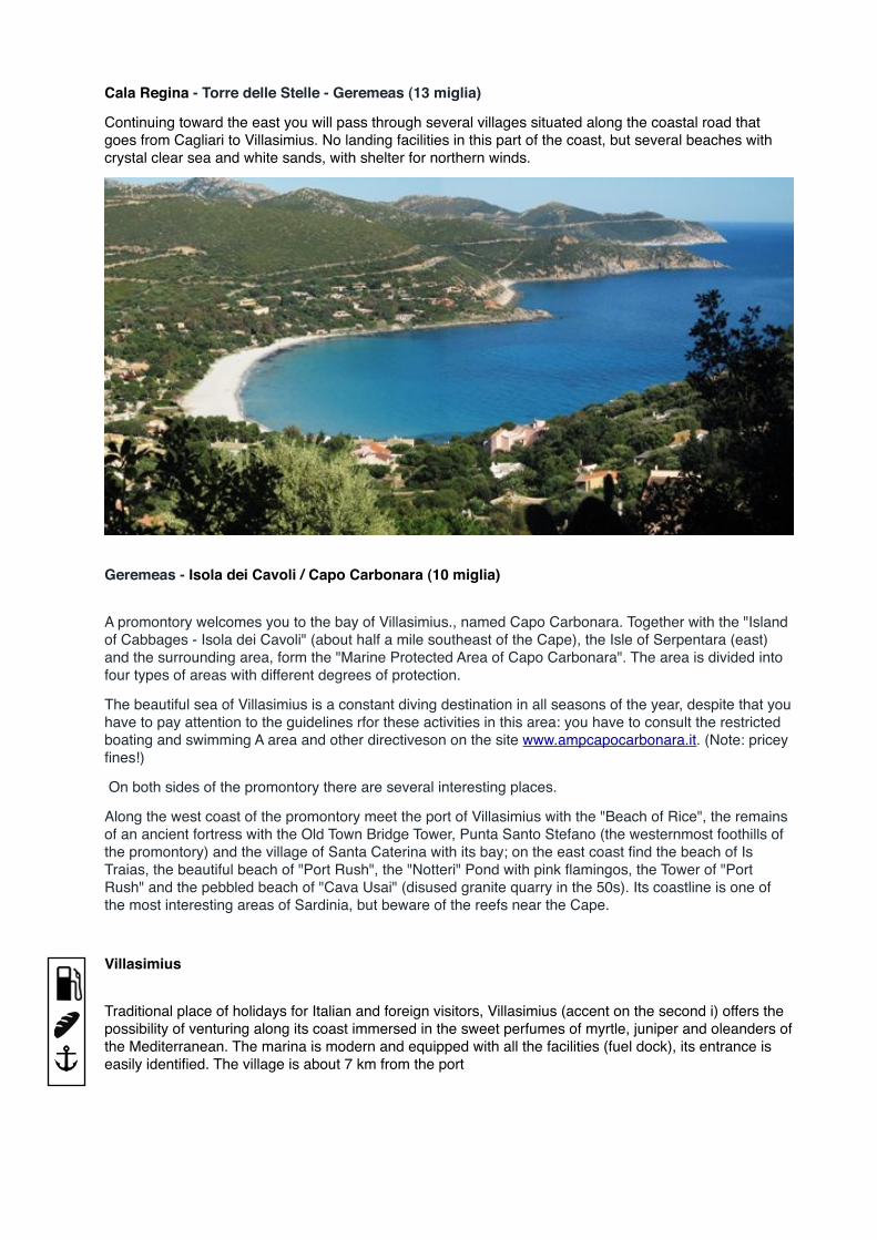
Cala Regina - Torre delle Stelle - Geremeas (13 miglia)
Continuing toward the east you will pass through several villages situated along the coastal road that goes from Cagliari to Villasimius. No landing facilities in this part of the coast, but several beaches with crystal clear sea and white sands, with shelter for northern winds.
Geremeas - Isola dei Cavoli / Capo Carbonara (10 miglia)
A promontory welcomes you to the bay of Villasimius., named Capo Carbonara. Together with the "Island of Cabbages - Isola dei Cavoli" (about half a mile southeast of the Cape), the Isle of Serpentara (east) and the surrounding area, form the "Marine Protected Area of Capo Carbonara". The area is divided into four types of areas with different degrees of protection.
The beautiful sea of Villasimius is a constant diving destination in all seasons of the year, despite that you have to pay attention to the guidelines rfor these activities in this area: you have to consult the restricted boating and swimming A area and other directiveson on the site www.ampcapocarbonara.it. (Note: pricey fines!)
On both sides of the promontory there are several interesting places.
Along the west coast of the promontory meet the port of Villasimius with the "Beach of Rice", the remains of an ancient fortress with the Old Town Bridge Tower, Punta Santo Stefano (the westernmost foothills of the promontory) and the village of Santa Caterina with its bay; on the east coast find the beach of Is Traias, the beautiful beach of "Port Rush", the "Notteri" Pond with pink flamingos, the Tower of "Port Rush" and the pebbled beach of "Cava Usai" (disused granite quarry in the 50s). Its coastline is one of the most interesting areas of Sardinia, but beware of the reefs near the Cape.
Villasimius
Traditional place of holidays for Italian and foreign visitors, Villasimius (accent on the second i) offers the possibility of venturing along its coast immersed in the sweet perfumes of myrtle, juniper and oleanders of the Mediterranean. The marina is modern and equipped with all the facilities (fuel dock), its entrance is easily identified. The village is about 7 km from the port
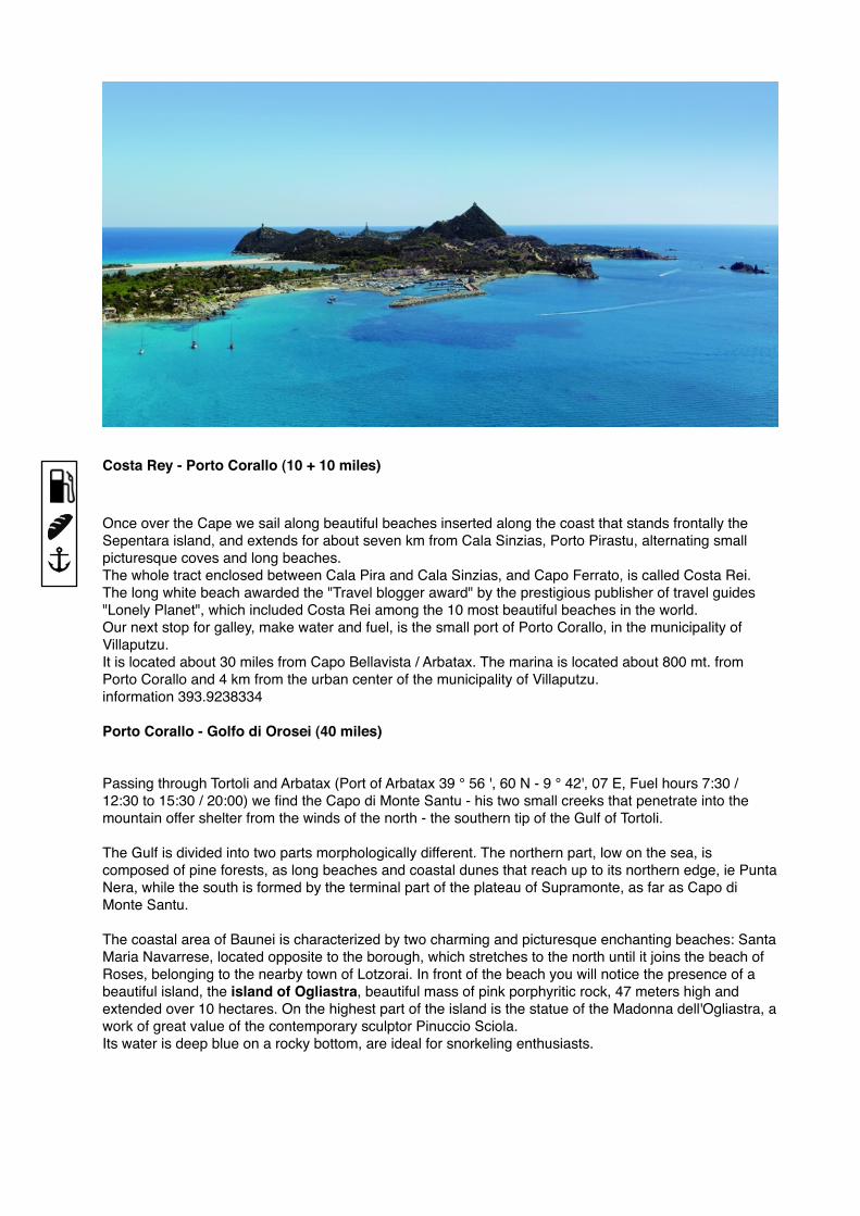
Costa Rey - Porto Corallo (10 + 10 miles)
Once over the Cape we sail along beautiful beaches inserted along the coast that stands frontally the Sepentara island, and extends for about seven km from Cala Sinzias, Porto Pirastu, alternating small picturesque coves and long beaches.The whole tract enclosed between Cala Pira and Cala Sinzias, and Capo Ferrato, is called Costa Rei. The long white beach awarded the "Travel blogger award" by the prestigious publisher of travel guides "Lonely Planet", which included Costa Rei among the 10 most beautiful beaches in the world.Our next stop for galley, make water and fuel, is the small port of Porto Corallo, in the municipality of Villaputzu.It is located about 30 miles from Capo Bellavista / Arbatax. The marina is located about 800 mt. from Porto Corallo and 4 km from the urban center of the municipality of Villaputzu.information 393.9238334
Porto Corallo - Golfo di Orosei (40 miles)
Passing through Tortoli and Arbatax (Port of Arbatax 39 ° 56 ', 60 N - 9 ° 42', 07 E, Fuel hours 7:30 / 12:30 to 15:30 / 20:00) we find the Capo di Monte Santu - his two small creeks that penetrate into the mountain offer shelter from the winds of the north - the southern tip of the Gulf of Tortoli.
The Gulf is divided into two parts morphologically different. The northern part, low on the sea, is composed of pine forests, as long beaches and coastal dunes that reach up to its northern edge, ie Punta Nera, while the south is formed by the terminal part of the plateau of Supramonte, as far as Capo di Monte Santu.
The coastal area of Baunei is characterized by two charming and picturesque enchanting beaches: Santa Maria Navarrese, located opposite to the borough, which stretches to the north until it joins the beach of Roses, belonging to the nearby town of Lotzorai. In front of the beach you will notice the presence of a beautiful island, the island of Ogliastra, beautiful mass of pink porphyritic rock, 47 meters high and extended over 10 hectares. On the highest part of the island is the statue of the Madonna dell'Ogliastra, a work of great value of the contemporary sculptor Pinuccio Sciola. Its water is deep blue on a rocky bottom, are ideal for snorkeling enthusiasts.
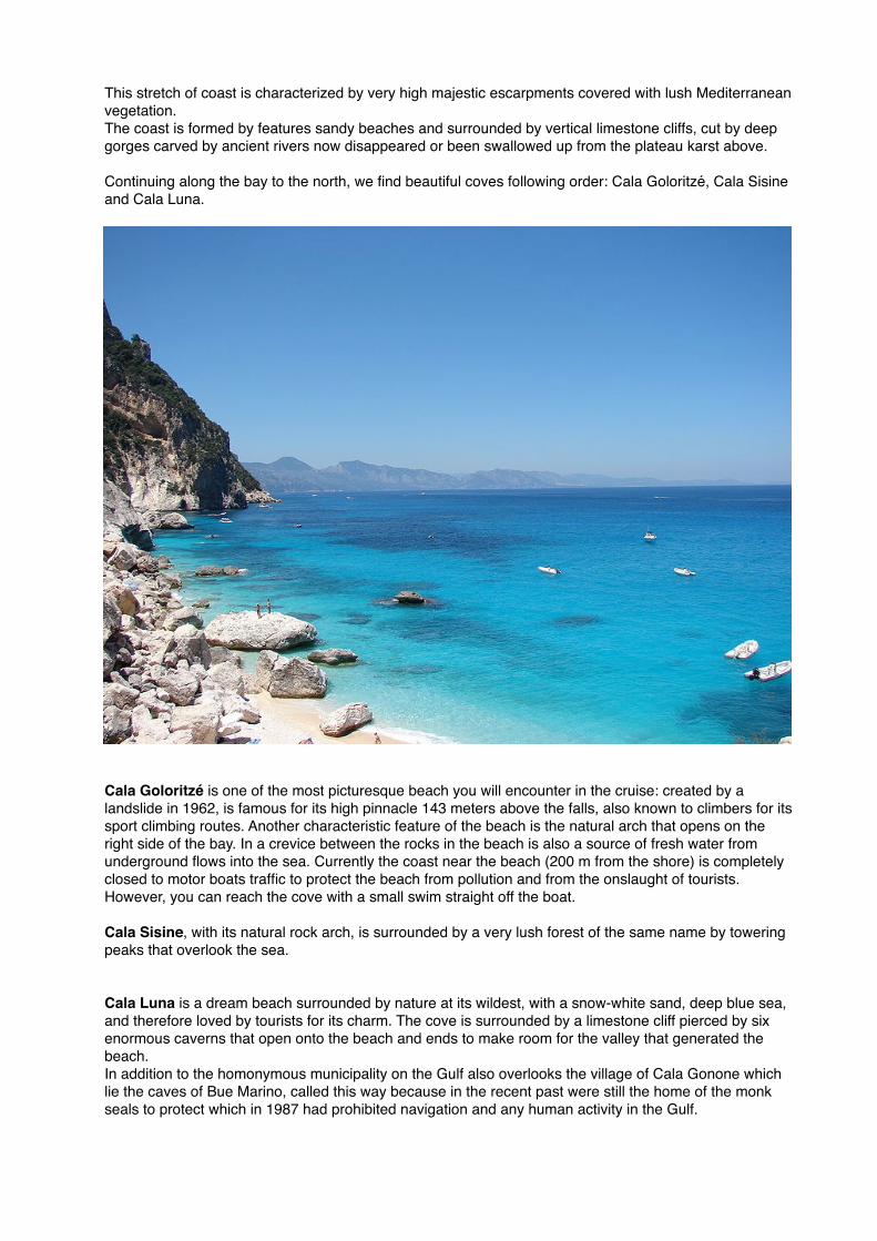
This stretch of coast is characterized by very high majestic escarpments covered with lush Mediterranean vegetation.The coast is formed by features sandy beaches and surrounded by vertical limestone cliffs, cut by deep gorges carved by ancient rivers now disappeared or been swallowed up from the plateau karst above.
Continuing along the bay to the north, we find beautiful coves following order: Cala Goloritzé, Cala Sisine and Cala Luna.
Cala Goloritzé is one of the most picturesque beach you will encounter in the cruise: created by a landslide in 1962, is famous for its high pinnacle 143 meters above the falls, also known to climbers for its sport climbing routes. Another characteristic feature of the beach is the natural arch that opens on the right side of the bay. In a crevice between the rocks in the beach is also a source of fresh water from underground flows into the sea. Currently the coast near the beach (200 m from the shore) is completely closed to motor boats traffic to protect the beach from pollution and from the onslaught of tourists.However, you can reach the cove with a small swim straight off the boat.
Cala Sisine, with its natural rock arch, is surrounded by a very lush forest of the same name by towering peaks that overlook the sea.
Cala Luna is a dream beach surrounded by nature at its wildest, with a snow-white sand, deep blue sea, and therefore loved by tourists for its charm. The cove is surrounded by a limestone cliff pierced by six enormous caverns that open onto the beach and ends to make room for the valley that generated the beach.In addition to the homonymous municipality on the Gulf also overlooks the village of Cala Gonone which lie the caves of Bue Marino, called this way because in the recent past were still the home of the monk seals to protect which in 1987 had prohibited navigation and any human activity in the Gulf.
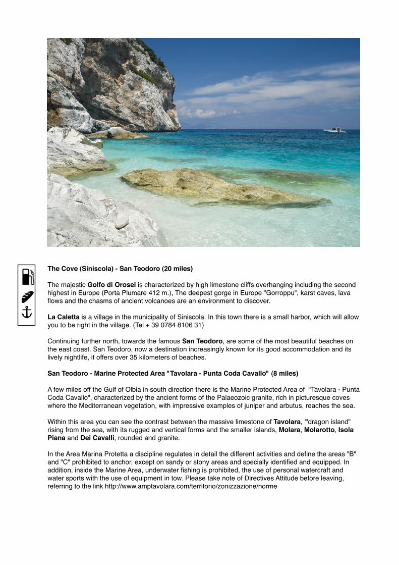
The Cove (Siniscola) - San Teodoro (20 miles) The majestic Golfo di Orosei is characterized by high limestone cliffs overhanging including the second highest in Europe (Porta Plumare 412 m.), The deepest gorge in Europe "Gorroppu", karst caves, lava flows and the chasms of ancient volcanoes are an environment to discover.
La Caletta is a village in the municipality of Siniscola. In this town there is a small harbor, which will allow you to be right in the village. (Tel + 39 0784 8106 31)
Continuing further north, towards the famous San Teodoro, are some of the most beautiful beaches on the east coast. San Teodoro, now a destination increasingly known for its good accommodation and its lively nightlife, it offers over 35 kilometers of beaches.
San Teodoro - Marine Protected Area "Tavolara - Punta Coda Cavallo" (8 miles)
A few miles off the Gulf of Olbia in south direction there is the Marine Protected Area of "Tavolara - Punta Coda Cavallo", characterized by the ancient forms of the Palaeozoic granite, rich in picturesque coves where the Mediterranean vegetation, with impressive examples of juniper and arbutus, reaches the sea.
Within this area you can see the contrast between the massive limestone of Tavolara, '"dragon island" rising from the sea, with its rugged and vertical forms and the smaller islands, Molara, Molarotto, Isola Piana and Dei Cavalli, rounded and granite.
In the Area Marina Protetta a discipline regulates in detail the different activities and define the areas "B" and "C" prohibited to anchor, except on sandy or stony areas and specially identified and equipped. In addition, inside the Marine Area, underwater fishing is prohibited, the use of personal watercraft and water sports with the use of equipment in tow. Please take note of Directives Attitude before leaving, referring to the link http://www.amptavolara.com/territorio/zonizzazione/norme
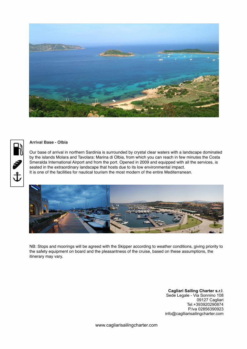
Arrival Base - Olbia
Our base of arrival in northern Sardinia is surrounded by crystal clear waters with a landscape dominated by the islands Molara and Tavolara: Marina di Olbia, from which you can reach in few minutes the Costa Smeralda International Airport and from the port. Opened in 2009 and equipped with all the services, is seated in the extraordinary landscape that hosts due to its low environmental impact.It is one of the facilities for nautical tourism the most modern of the entire Mediterranean.
NB: Stops and moorings will be agreed with the Skipper according to weather conditions, giving priority to the safety equipment on board and the pleasantness of the cruise, based on these assumptions, the itinerary may vary.
Cagliari Sailing Charter s.r.l.Sede Legale - Via Sonnino 108
09127 CagliariTel.+393920290874P.Iva 02856390923
www.cagliarisailingcharter.com


![Rough guide to Sardinia: Cagliari - Villasimius [Travel Guide]](https://img.pdfslide.us/doc/110x75/547bd5a4b379595e2b8b4de0/rough-guide-to-sardinia-cagliari-villasimius-travel-guide.jpg)
![Rough gude to Sardinia: Cagliari - Pula - Chia [Travel Guide]](https://img.pdfslide.us/doc/110x75/5538028c4a7959437c8b4659/rough-gude-to-sardinia-cagliari-pula-chia-travel-guide.jpg)