Embed Size (px)
DESCRIPTION
Rules Regulations Ra 4566
Citation preview
7/17/2019 Cagayan Riverine Zone Development Framework Plan 2005_2030
http://slidepdf.com/reader/full/cagayan-riverine-zone-development-framework-plan-20052030 1/57
Cagayan Riverine ZoneDevelopment Framework Plan
2005—2030
Regional Development Council 02
Tuguegarao City
7/17/2019 Cagayan Riverine Zone Development Framework Plan 2005_2030
http://slidepdf.com/reader/full/cagayan-riverine-zone-development-framework-plan-20052030 2/57
essage
The adoption of the Cagayan Riverine Zone Development FrameworkPlan (CRZDFP) 2005-2030, is a step closer to our desire to harmonizeand sustainably maximize the multiple uses of the Cagayan River asidentified in the Regional Physical Framework Plan (RPFP) 2005-2030.
A greater challenge is the implementation of the document whichrequires a deeper commitment in the preservation of the integrity of ourenvironment while allowing the development of the River and itsenvirons.
The formulation of the document involved the wide participation of concerned agencies
and with extensive consultation the local government units and the civil society, prior toits adoption and approval by the Regional Development Council. The inputs andproposals from the consultations have enriched this document as our convergenceframework for the sustainable development of the Cagayan Riverine Zone.
The document will provide the policy framework to synchronize efforts in addressingissues and problems to accelerate the sustainable development in the Riverine Zoneand realize its full development potential. The Plan should also provide the overalldirection for programs and projects in the Development Plans of the Provinces, Citiesand Municipalities in the region. Let us therefore, purposively use this Plan to guide theutilization and management of water and land resources along the Cagayan River.
I appreciate the importance of crafting a good plan and give higher degree of credenceto ensuring its successful implementation. This is the greatest challenge for the LocalGovernment Units and to other stakeholders of the Cagayan River’s development. It isat the local level where we feel that the dedication and commitment of our Local ChiefExecutives and Sanggunians are most needed.
The individual agencies and instrumentalities of the public sector as well as thebusiness and industrial sectors whose activities may affect the Riverine Zone areencouraged to take guidance from this Plan.
With enough determination and commitment, I believe and I am confident, that we canachieve our goal in uplifting the lives of the residents along the Cagayan Riverine Zone
in particular and the people of Cagayan Valley in general.
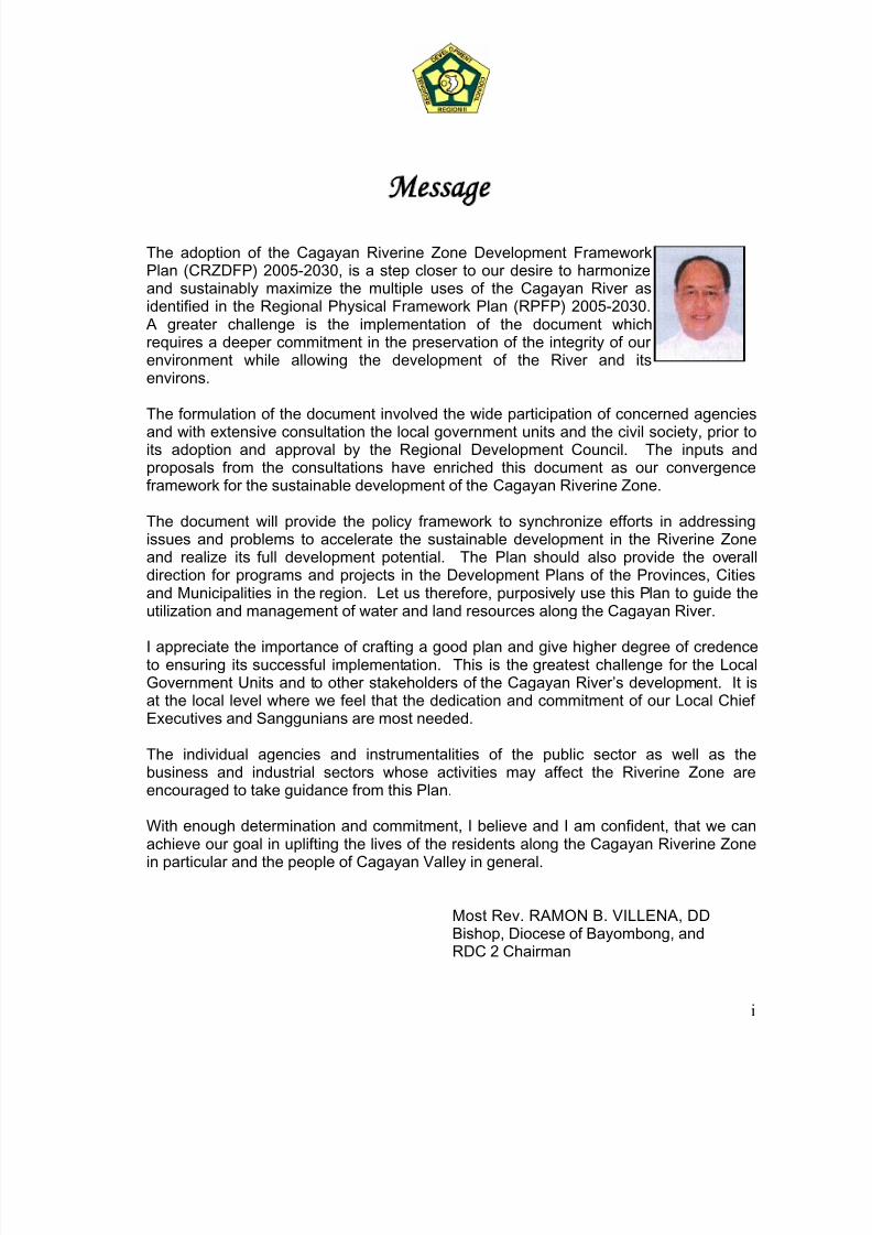
Most Rev. RAMON B. VILLENA, DD
Bishop, Diocese of Bayombong, andRDC 2 Chairman
i
7/17/2019 Cagayan Riverine Zone Development Framework Plan 2005_2030
http://slidepdf.com/reader/full/cagayan-riverine-zone-development-framework-plan-20052030 3/57
oreword
The Cagayan River, the longest river in the country and one ofthe biggest resource of the region is being threatened byurbanization and unsustainable economic activities. However,this resource has not been fully tapped, and the Plan looks intothe development of the river’s productive potentials. Thus,preparation of the Cagayan Riverine Development FrameworkPlan (2005-2030) underscores the need to protect and preservewhat needs to be preserved for future generations.
This Plan is very useful for planners and policy makers in coming up with policiesand strategies to address the problems and issues related to the quality, characterand aesthetic value of the Riverine Zone. At the same time be efforts of
program/project implementers will be synchronized and guided on how land andwater management be sustainably carried out within the riverine zone. Majorurgent projects are identified which will be implemented during the entire term ofthe Plan.
The preparation of this document is made possible through the dedicatedcommitment of the Technical Working Group of the Regional Land Use Committee.The planning process took the TWG two years to complete the document.Consultations were made in different levels where the first stage of consultationwas with the provinces through the Provincial Land Use Committee (PLUC) ofeach province; the second level with the Sectoral Committees of the RDC; and thethird level was done with the Regional Stakeholders composed of the Chairmen or
presidents of the PAFCs and RAFC, Irrigators’ Association, Tourist organizations,contractors, among others. The comments and recommendations generatedsignificantly improved the Plan and led to the approval by the RDC in December2006.
It is hoped that after so many years of complacency, everyone will now take activerole in protecting, developing and preserving the biggest resource of the region.
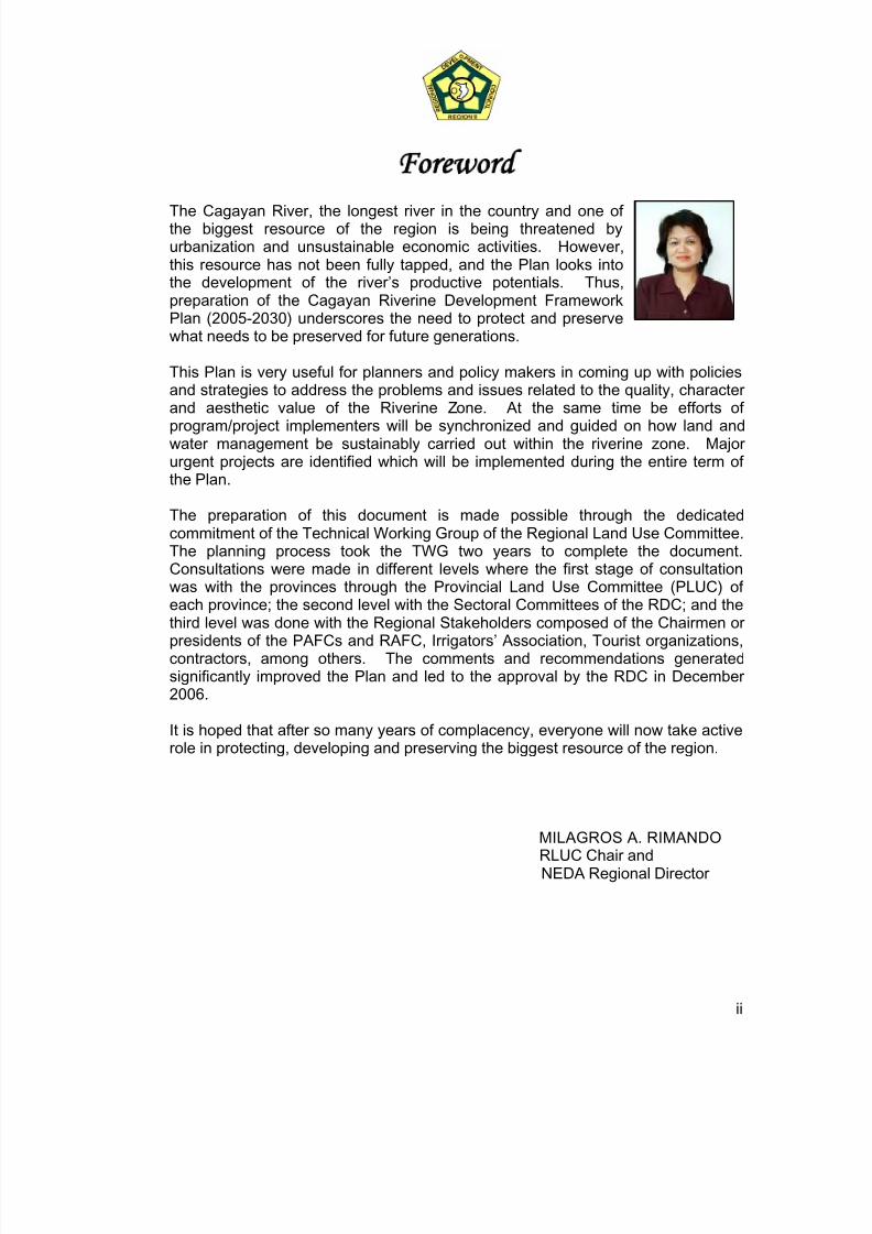
MILAGROS A. RIMANDO
RLUC Chair andNEDA Regional Director
ii
7/17/2019 Cagayan Riverine Zone Development Framework Plan 2005_2030
http://slidepdf.com/reader/full/cagayan-riverine-zone-development-framework-plan-20052030 4/57
TABLE OF CONTENTS
ChapterNo.
C O N T E N T PageNo.
1
2
3
4
5
6
Message of the RDC II ChairForewordTable of ContentsList of Tables and FiguresList of AcronymsExecutive Summary
Introductiona) Background and Rationaleb) Plan Objectivec) The Cagayan Riverine Area Coverage
Profile of the Cagayan Valley
Characteristics and Condition of the Cagayan Riverine Zonea) Physical Characteristics of the Cagayan Riverine Zoneb) Current Uses of the Cagayan River
Development Potentials and Problems of the Cagayan Riverine Zonea) Potentials of the Riverine Zoneb) Problems and Issues in the Riverine Zone
Goal, Objectives, Policies and Strategies
Institutional and Operational Mechanisma) Financing the Planb) Monitoring and Evaluationc) Plan Implementation Support
APPENDICES
Appendix I - Specific Policies on Land and Water Utilization,Protection and Management
Appendix II - List of Threatened Species Recorded in Region 02
Appendix III - Checklist of Water Birds Recorded along Cagayan River
Appendix IV - Joint RDC II, RPOC, RDCC Resolution
i
ii
iii
iv
v
vi
1112
4
88
16
202023
29
37374040
41
44
46
49
iii
7/17/2019 Cagayan Riverine Zone Development Framework Plan 2005_2030
http://slidepdf.com/reader/full/cagayan-riverine-zone-development-framework-plan-20052030 5/57
iv
LIST OF TABLES AND FIGURES
Table/Fig.No.
TITLE OF TABLES and FIGURES PageNo.
1
2
3
4
5
6
7
8
9
10
1
2
3
4
5
6
7
A. TABLE
Land Area and Classification of Region 02
Estimated runoff of the River Basin and its Tributaties
Number of threatened species recorded within the CagayanValley Region
Number of Terrestial Flora Identified in Cagayan Valley
Plant Forms and Number of Species in the Cagayan Valley Area
Conservation Status of Flora Species in Cagayan Valley
Terrestial Fauna Recorded in Cagayan Valley
Rare, Threatened and Endangered Fauna Species Region 2, asof 2006
Initial List of Freshwater Fish Species along the Cagayan River asof 2006
Urgent Projects for Implementation in the Cagayan Riverine Zone
B. FIGURES
Major Land Use Categories
Schematic Diagram Showing the Cagayan River and its MajorTributaries
Location and Political Subdivision of the Cagayan Valley Region
GRDP Performance: Region 2, 2003-2004
The Cagayan River Basin
Inundation Area of the Cagayan River
Major Agricultural Areas
5
10
12
12
13
13
14
14
15
38
2
3
4
6
9
11
21
7/17/2019 Cagayan Riverine Zone Development Framework Plan 2005_2030
http://slidepdf.com/reader/full/cagayan-riverine-zone-development-framework-plan-20052030 6/57
v
LIST OF ACRONYMS
AFMA - Agriculture and Fisheries Modernization Act A&D - Alienable and DisposableBFAR - Bureau of Fisheries and Aquatic ResourcesBRS - Bureau of Research and StandardsBSWM - Bureau of Soils and Water ManagementCITES - Convention of International Trade in Endangered SpeciesCLUP - Comprehensive Land Use PlanC/MLUC - City/Municipal Land Use CommitteeCOC - Cut-Off-ChannelCRZDFP - Cagayan Riverine Zone Development Framework PlanDA - Department of AgricultureDLR - Department of Land ReformDENR - Department of Environment and Natural ResourcesEIA - Environmental Impact AssessmentFARMCs - Fisheries and Aquatic Resources Management CouncilGIS - Geographic Information SystemIEC - Information Education CampaignIMR - Infant Mortality RateIPM - Integrated Pest ManagementIUCN - International Union for the Conservation of NatureJICA - Japan International Cooperation AgencyKBA - Key Biodiversity AreasLGC - Local Government CodeLGU - Local Government UnitMCM - Million Cubic MetersMOA - Memorandum of AgreementMRF - Materials Recovery FacilitiesNGO - Non-Government OrganizationNIPAS - National Integrated Protected Areas SystemNPAAAD - Network of Protected Areas for Agriculture and Agro-industrial
DevelopmentODA - Official Development AssistancePLUC - Provincial Land Use CommitteePO - Peoples OrganizationPPFP - Provincial Physical Framework PlanRDC - Regional Development CouncilRLAs - Regional Line AgenciesRLUC - Regional Land Use CommitteeRPFP - Regional Physical Framework PlanSAFDZ - Strategic Agriculture and Fisheries Development Zone
SFR - Small Farm ReservoirSUCs - State Universities and CollegesSWIP - Small Water Impounding ProjectTWG - Technical Working Group
7/17/2019 Cagayan Riverine Zone Development Framework Plan 2005_2030
http://slidepdf.com/reader/full/cagayan-riverine-zone-development-framework-plan-20052030 7/57
vi
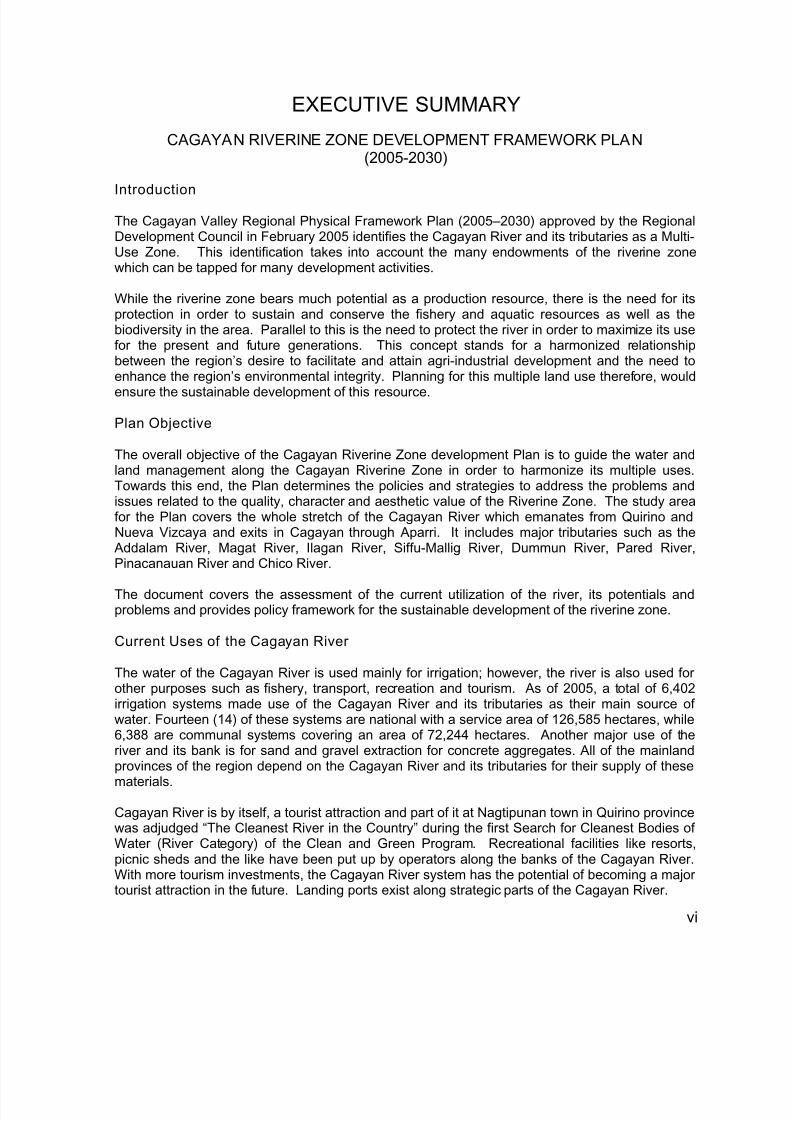
EXECUTIVE SUMMARY
CAGAYAN RIVERINE ZONE DEVELOPMENT FRAMEWORK PLAN(2005-2030)
Introduction
The Cagayan Valley Regional Physical Framework Plan (2005–2030) approved by the RegionalDevelopment Council in February 2005 identifies the Cagayan River and its tributaries as a Multi-Use Zone. This identification takes into account the many endowments of the riverine zonewhich can be tapped for many development activities.
While the riverine zone bears much potential as a production resource, there is the need for itsprotection in order to sustain and conserve the fishery and aquatic resources as well as thebiodiversity in the area. Parallel to this is the need to protect the river in order to maximize its usefor the present and future generations. This concept stands for a harmonized relationshipbetween the region’s desire to facilitate and attain agri-industrial development and the need toenhance the region’s environmental integrity. Planning for this multiple land use therefore, would
ensure the sustainable development of this resource.
Plan Objective
The overall objective of the Cagayan Riverine Zone development Plan is to guide the water andland management along the Cagayan Riverine Zone in order to harmonize its multiple uses.Towards this end, the Plan determines the policies and strategies to address the problems andissues related to the quality, character and aesthetic value of the Riverine Zone. The study areafor the Plan covers the whole stretch of the Cagayan River which emanates from Quirino andNueva Vizcaya and exits in Cagayan through Aparri. It includes major tributaries such as the
Addalam River, Magat River, Ilagan River, Siffu-Mallig River, Dummun River, Pared River,Pinacanauan River and Chico River.
The document covers the assessment of the current utilization of the river, its potentials andproblems and provides policy framework for the sustainable development of the riverine zone.
Current Uses of the Cagayan River
The water of the Cagayan River is used mainly for irrigation; however, the river is also used forother purposes such as fishery, transport, recreation and tourism. As of 2005, a total of 6,402irrigation systems made use of the Cagayan River and its tributaries as their main source ofwater. Fourteen (14) of these systems are national with a service area of 126,585 hectares, while6,388 are communal systems covering an area of 72,244 hectares. Another major use of theriver and its bank is for sand and gravel extraction for concrete aggregates. All of the mainlandprovinces of the region depend on the Cagayan River and its tributaries for their supply of these
materials.
Cagayan River is by itself, a tourist attraction and part of it at Nagtipunan town in Quirino provincewas adjudged “The Cleanest River in the Country” during the first Search for Cleanest Bodies ofWater (River Category) of the Clean and Green Program. Recreational facilities like resorts,picnic sheds and the like have been put up by operators along the banks of the Cagayan River.With more tourism investments, the Cagayan River system has the potential of becoming a majortourist attraction in the future. Landing ports exist along strategic parts of the Cagayan River.
7/17/2019 Cagayan Riverine Zone Development Framework Plan 2005_2030
http://slidepdf.com/reader/full/cagayan-riverine-zone-development-framework-plan-20052030 8/57
vii
The Cagayan River is a major fishing ground for the region’s farmers and fisherfolk. It plays avital role as a fisheries and aquatic resource in the region. Given its wide area, it is one of theprincipal sources of freshwater fish such as the high-priced Ludong, cestraeus plicatilis, mollusks(unnok; dalilea spp., balinggasa; anodonta woodiana, tulya; corbicula manilensis, and kabibe;batissa violacea, etc.) and crustacean (aramang; palaemon and acetes spp., etc.).
The river’s major tributary (Magat) is also tapped for hydro-electric power plant. In agriculture,the total cropland area for municipalities along Cagayan River is 519,525.93 hectares which isabout 79 percent of the regional cropland of 654,560 hectares (Land Use and Vegetation Data,D.A R02). Of this area, 206,510.80 hectares or 40 percent is devoted to rice which indirectly ordirectly draw irrigation waters from the Cagayan River. It was estimated that 135,548.00 hectaresare devoted to corn and are concentrated in plains as well as rolling areas suitable for corn in theprovinces of Cagayan and Isabela .
Potentials, Problems and Issues
a) Potentials
The Riverine zone of the Region is endowed with various resources that can be tapped for
various development activities. Its fertile lands can be developed for agriculture, its eco-tourismpotentials, rich bio-diversity with increased fishing and aquaculture potential, water for irrigationdevelopment and the river provides opportunity for expansion of transport route for the region’sproducts and travelers.
b) Problems and Issues
In spite of the potentials offered by the river, there are limited development activities occurring inthe area due to the low level of advocacy and promotion causing minimum productivity of thezone in terms of economic activity. Specifically, there are four major factors that contributed tothese problems to include the extensive and prolonged flooding, limited water supply during dryseason, deteriorating water quality and low level of promotion on the potentials of the riverine
zone.
The main factor to the problem on prolonged inundation and lack of water during summer are theinsufficient structural facilities to regulate flood waters during rainy season and storage dams tocollect and stock water reserves for use during dry season. Aggravating the situation are thedeteriorating forest cover of watersheds, high rate of erosion, heavy siltation and the narrowportions causing bottlenecks in the downstream stretch of the river specifically in Tupang in
Alcala, Nassiping, Gattaran and Magapit, Lallo all in the provinces of Cagayan.
It is also observed that the water quality of the river is deteriorating due to improper wastedisposal, heavy use of chemicals in farming and unregulated disposal of mine tailings.
Goal, policies and strategies
Recognizing the significance of the river in the development of the region, the RDC2 now aims toaccelerate the sustainable development in the riverine zone through proper management. Inorder to enhance the productivity and realize the full development potential of the area thefollowing policies and strategies will be implemented:
7/17/2019 Cagayan Riverine Zone Development Framework Plan 2005_2030
http://slidepdf.com/reader/full/cagayan-riverine-zone-development-framework-plan-20052030 9/57
viii
a) Policies 1) Mitigation of the destructive effect of flooding and reduction of its extent in terms of area and
time.2) Availability of adequate water supply during dry season for domestic, industrial and
agricultural uses.3) Improvement of the deteriorating water quality in the Cagayan Riverine Zone.
4) Optimization of the development potentials of the Cagayan Riverine Zone.
b) Strategies1) Construction of multi-purpose dams and water impounding facilities.2) Construction of cut-off channels and riverbank protection facilities.3) Maintain the favorable depth of the river by dredging along heavily silted portions of the river
and removal of sediments allowing for faster flow of water especially during rainy season tofurther reduce the destructive effect of floods.
4) Strictly enforce environmental laws.5) Improve the forest covers of watershed through the preparation and implementation of a
watershed management plan.6) Conduct research to determine the effects of diverting the waters of Cagayan River to the
Casecnan.
7) Rationalize disposal of wastes through the conduct of massive IEC on WasteManagement; construction of sanitary landfill, establishment of Barangay MaterialRecovery Facilities (MRF) and strict implementation of environmental and related laws.
8) Promote and encourage farmers to adopt sustainable farming practices and regulation of theuse of farm chemicals.
9) Plan and control the use of the river for sand and gravel extraction.10) Increase investments in the Cagayan Riverine Zone by promoting the development potentials
of the zone in the tourism, irrigation and power generation, fisheries, river transport andmining and quarrying.
Implementing Mechanism
The implementation of the Cagayan Riverine Zone Development Framework Plan will be aconcerted effort of the different RLAs, LGUs and other stakeholders. An Implementing Body orStructure is needed to oversee and orchestrate the overall implementation of the CagayanRiverine Plan.
While awaiting the creation and operationalization of the permanent Implementing Body, aMemorandum of Agreement (MOA), will be forged between and among the RDC2 and theprovinces of Cagayan, Isabela, Quirino and Nueva Vizcaya and the Cities of Santiago City,Cauayan City and Tuguegarao City. The MOA which shall provide an interim mechanism tosynchronize the activities in the Riverine Plan shall specifically detail the roles of the RDC2, LGUsand other concerned entities.
The identified urgent projects and activities require an estimated cost of P114.21 billion where
bulk (96.65%) of this is allotted for the construction of multi-purpose dams (Matuno, Tumanuini,Siffu, Mallig, Alimit and Kalipkip). Other immediate measures include the construction of urgentbank protection works, SWIPs and Small Farm Reservoirs (SFR), tourism and fisherydevelopment, solid waste management and dredging of critical portions of the Cagayan River.
The implementation of the Plan shall be closely monitored through the assistance of theProvincial/City/Municipal Land Use Committees (P/C/MLUCs) and this will be supported withadvocacy, capability building and research.
7/17/2019 Cagayan Riverine Zone Development Framework Plan 2005_2030
http://slidepdf.com/reader/full/cagayan-riverine-zone-development-framework-plan-20052030 10/57
Chapter 1
Introduction
I. Background and Rationale
The general policy of the country as enshrined in the Philippine Constitution, Section 16,mentions that “the State shall protect and advance the right of the people to a balanced andhealthful ecology in accord with the rhythm and harmony of nature”. Various policy guidelines onland and water utilization, protection and management, are specifically crafted to create, develop,maintain and improve conditions under which man and nature can thrive harmoniously to fulfill thesocial, economic and other requirements of present and future generations and to ensure theattainment of an environmental quality that is conducive to a life of dignity and well-being.
The Regional Physical Framework Plan (2000- 2030) spells the policies and directions for theregion’s resources to be used and protected in the next thirty years. Urgent concerns that require
immediate attention are to be addressed within the first phase of the plan or in the next ten years.One of the major concerns that require immediate attention is the Cagayan Riverive Zone.
The Cagayan Valley Regional Physical Framework Plan (2000 – 2030) approved by the RegionalDevelopment Council in February 2005 identifies the Cagayan River and its tributaries as a Multi-Use Zone. This identification takes into account the many endowments of the riverine zone whichcan be tapped for many development activities. Planning for this multiple land use therefore,would ensure the sustainable development of this resource. The concern about the CagayanRiver is properly addressed in the “Parallel Growth Spatial Strategy” of the RPFP which is theoverall framework for the utilization, allocation and development of the region’s physicalresources. This concept stands for a harmonized relationship between the region’s desire tofacilitate and attain agri-industrial development and the need to enhance the region’s
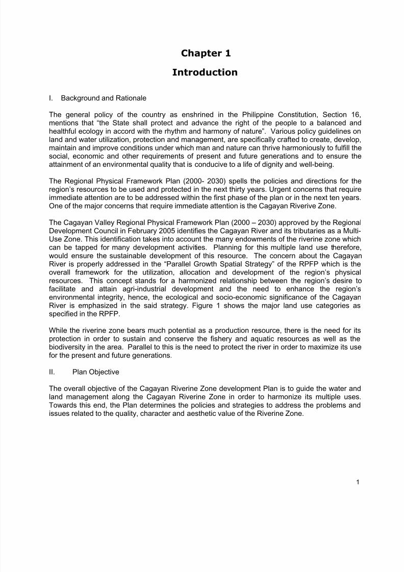
environmental integrity, hence, the ecological and socio-economic significance of the CagayanRiver is emphasized in the said strategy. Figure 1 shows the major land use categories asspecified in the RPFP.
While the riverine zone bears much potential as a production resource, there is the need for itsprotection in order to sustain and conserve the fishery and aquatic resources as well as thebiodiversity in the area. Parallel to this is the need to protect the river in order to maximize its usefor the present and future generations.
II. Plan Objective
The overall objective of the Cagayan Riverine Zone development Plan is to guide the water andland management along the Cagayan Riverine Zone in order to harmonize its multiple uses.Towards this end, the Plan determines the policies and strategies to address the problems andissues related to the quality, character and aesthetic value of the Riverine Zone.
1
7/17/2019 Cagayan Riverine Zone Development Framework Plan 2005_2030
http://slidepdf.com/reader/full/cagayan-riverine-zone-development-framework-plan-20052030 11/57
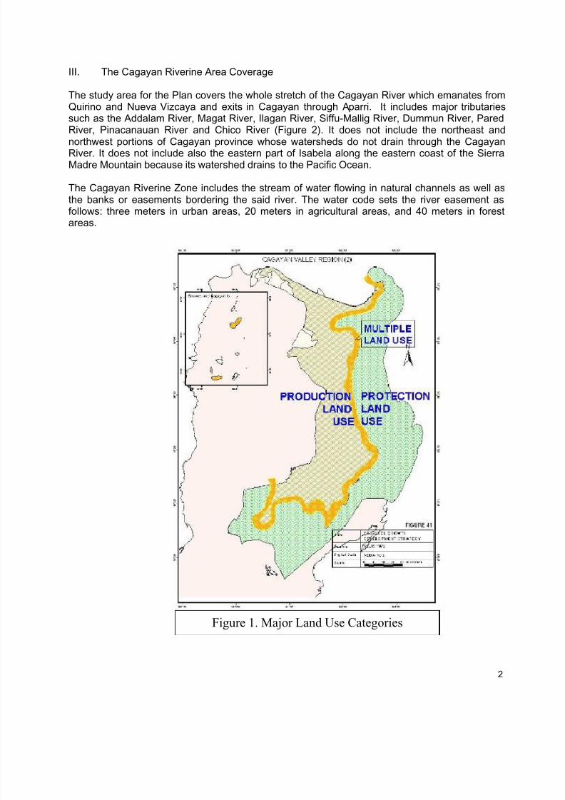
III. The Cagayan Riverine Area Coverage
The study area for the Plan covers the whole stretch of the Cagayan River which emanates fromQuirino and Nueva Vizcaya and exits in Cagayan through Aparri. It includes major tributariessuch as the Addalam River, Magat River, Ilagan River, Siffu-Mallig River, Dummun River, ParedRiver, Pinacanauan River and Chico River (Figure 2). It does not include the northeast and
northwest portions of Cagayan province whose watersheds do not drain through the CagayanRiver. It does not include also the eastern part of Isabela along the eastern coast of the SierraMadre Mountain because its watershed drains to the Pacific Ocean.
The Cagayan Riverine Zone includes the stream of water flowing in natural channels as well asthe banks or easements bordering the said river. The water code sets the river easement asfollows: three meters in urban areas, 20 meters in agricultural areas, and 40 meters in forestareas.
Figure 1. Major Land Use Categories
2
7/17/2019 Cagayan Riverine Zone Development Framework Plan 2005_2030
http://slidepdf.com/reader/full/cagayan-riverine-zone-development-framework-plan-20052030 12/57
Figure 2. Schematic Diagram showing the Cagayan River and its major tributaries
3
Babuyan Channel
Chico River
Aparri
• Magapit
Faire • Nassiping
Alcala
Pared River
Tuguegarao City
Cagayan River
Cabagan Pinacanauan R
Tuguegarao River
Zinundungan River
Tumauini River
MalligMallig River
RoxasSiffu River
Ilagan Ilagan River
Dummun River
SantaCruz RiverSan Mateo
Magat River
Santiago CityCauayan City
Naguilian
Addalam River San
Agustin
Nagtipun
Jones
Bayombong
Legend:
City
Municipality
• Barangay
River
Source : Lower Cagayan River
Ganano River
Dibubu River
Casecnan River
7/17/2019 Cagayan Riverine Zone Development Framework Plan 2005_2030
http://slidepdf.com/reader/full/cagayan-riverine-zone-development-framework-plan-20052030 13/57
Pared River
Chapter 2
Profile of the Cagayan Valley
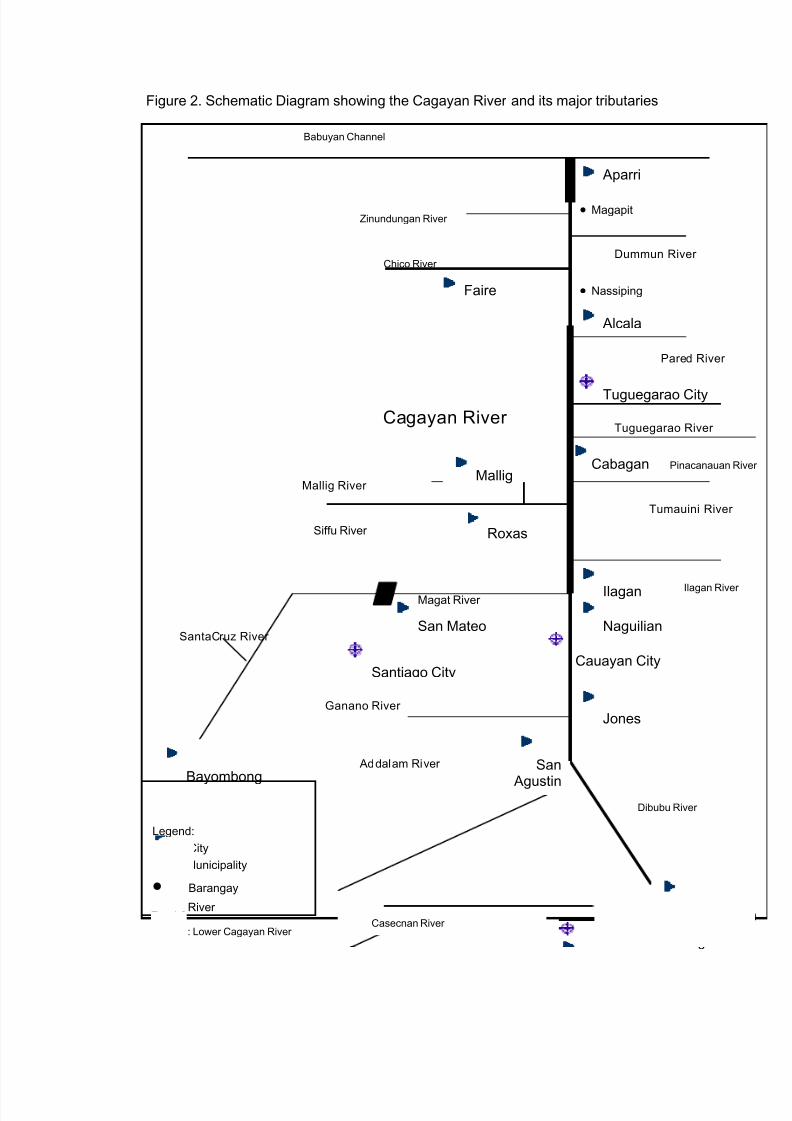
Location
Cagayan valley lies in the northeastern tipof the Philippines. It is bounded by threebig mountain ranges namely, Cordillera onthe west, Caraballo on the south and SieraMadre on the east. On the north is theBabuyan channel where the Cagayan Riverdrains.
Political Subdivisions
The region has five provinces namely,Batanes, Cagayan, Isabela, Nueva Vizcayaand Quirino, covering a total of 10congressional districts, 3 cities, 90municipalities and 2,343 barangays. TheCagayan River flows through the mainlandprovinces (Fig. 3).
Land Area
The region’s land area is the 4th largestregion in the country. It has a total land
area of about 2,683,758 hectares which is9% of the total area of the Philippines. Outof these, 965,965 hectares are alienableand disposable (A & D) lands, and1,717,793 hectares are forestlands. Theforest land areas are further categorizedinto Production forest, with 929,630.802hectares and Protection Forest, with 788,162.198 hectares.
Figure 3. Location and Polit ical Subdivis ion of CagayanValley Region
Table 1. Land Area and Classi fication of Region 02
Category Area (has.)
1. Forest Area
1.1 Protection1.2 Production
1,717,793
788,162.198929,630.802
2. Alienable and Disposable( A and D ) 965,965
Regional Land Area 2,683,758Source: DENR Region 2 (2006)
4
7/17/2019 Cagayan Riverine Zone Development Framework Plan 2005_2030
http://slidepdf.com/reader/full/cagayan-riverine-zone-development-framework-plan-20052030 14/57
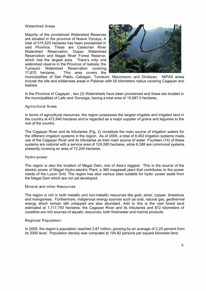
Watershed Areas
Majority of the proclaimed Watershed Reservesare situated in the province of Nueva Vizcaya, Atotal of 515,520 hectares has been proclaimed insaid Province. These are Casecnan River
Watershed Reservation, Dupax WatershedReservation and Magat River Forest Reserve,which has the largest area. There’s only onewatershed reserve in the Province of Isabela, theTumauini Watershed Reservation covering17,670 hectares. This area covers themunicipalities of San Pablo, Cabagan, Tumauini, Maconacon and Divilacan. NIPAS areasinclude the idle and wilderness areas in Palanan with 50 kilometers radius covering Cagayan andIsabela.
In the Province of Cagayan , two (2) Watersheds have been proclaimed and these are located inthe municipalities of Lallo and Gonzaga, having a total area of 15,987.0 hectares.
Agricu ltural Areas
In terms of agricultural resources, the region possesses the largest irrigable and irrigated land inthe country at 472,640 hectares and is regarded as a major supplier of grains and legumes to therest of the country.
The Cagayan River and its tributaries (Fig. 2) constitute the main source of irrigation waters forthe different irrigation systems in the region. As of 2005, a total of 6,402 irrigation systems madeuse of the Cagayan River and its tributaries as their main source of water. Fourteen (14) of thesesystems are national with a service area of 126,585 hectares, while 6,388 are communal systemspresently covering an area of 72,244 hectares.
Hydro-power
The region is also the location of Magat Dam, one of Asia’s biggest. This is the source of theelectric power of Magat Hydro-electric Plant, a 360 megawatt plant that contributes to the powerneeds of the Luzon Grid. The region has also various sites suitable for hydo- power aside fromthe Magat Dam which are not yet developed.
Mineral and other Resources
The region is rich in both metallic and non-metallic resources like gold, silver, copper, limestoneand manganese. Furthermore, indigenous energy sources such as coal, natural gas, geothermal
energy which remain still untapped are also abundant. Add to this is the vast forest landestimated at 1,717,793 hectares; the Cagayan River and its tributaries and 872 kilometers ofcoastline are rich sources of aquatic resources, both freshwater and marine products
Regional Population:
In 2005, the region’s population reached 3.87 million, growing by an average of 2.25 percent fromits 2000 level. Population density was computed at 104.82 persons per square kilometer land.
5
7/17/2019 Cagayan Riverine Zone Development Framework Plan 2005_2030
http://slidepdf.com/reader/full/cagayan-riverine-zone-development-framework-plan-20052030 15/57
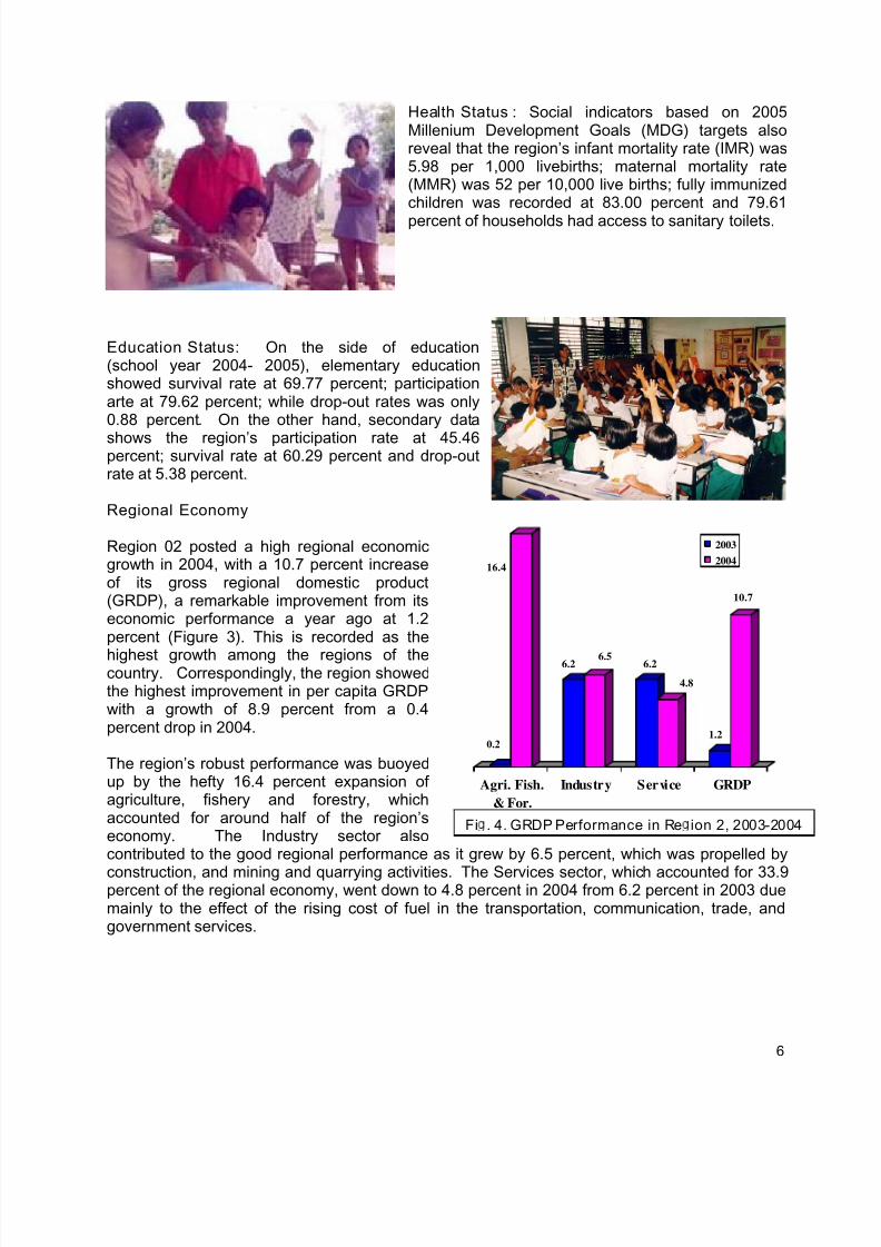
Health Status : Social indicators based on 2005Millenium Development Goals (MDG) targets alsoreveal that the region’s infant mortality rate (IMR) was5.98 per 1,000 livebirths; maternal mortality rate(MMR) was 52 per 10,000 live births; fully immunizedchildren was recorded at 83.00 percent and 79.61
percent of households had access to sanitary toilets.
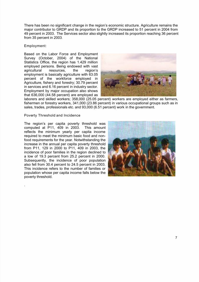
Education Status: On the side of education(school year 2004- 2005), elementary educationshowed survival rate at 69.77 percent; participationarte at 79.62 percent; while drop-out rates was only0.88 percent. On the other hand, secondary data
shows the region’s participation rate at 45.46percent; survival rate at 60.29 percent and drop-outrate at 5.38 percent.
Regional Economy
0.2
16.4
6.2 6.5 6.2
4.8
1.2
10.7
Agri. Fish.
& For.
Industry Service GRDP
2003
2004
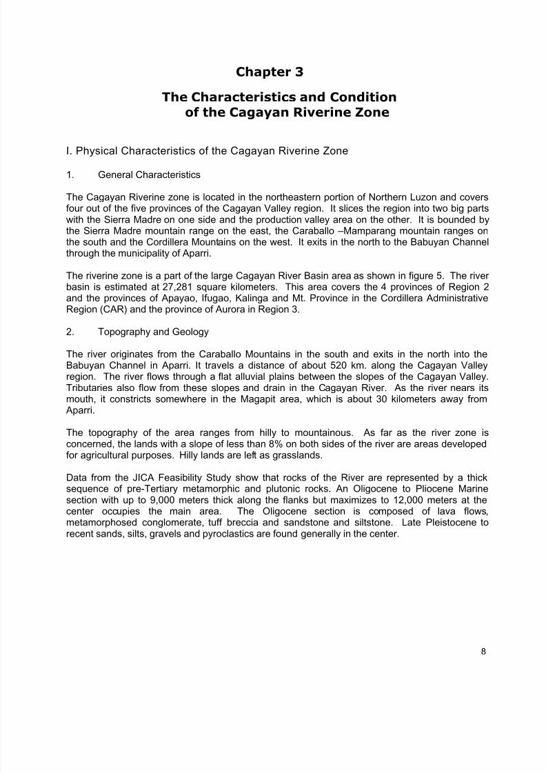
Region 02 posted a high regional economicgrowth in 2004, with a 10.7 percent increaseof its gross regional domestic product(GRDP), a remarkable improvement from itseconomic performance a year ago at 1.2percent (Figure 3). This is recorded as the
highest growth among the regions of thecountry. Correspondingly, the region showedthe highest improvement in per capita GRDPwith a growth of 8.9 percent from a 0.4percent drop in 2004.
The region’s robust performance was buoyedup by the hefty 16.4 percent expansion ofagriculture, fishery and forestry, whichaccounted for around half of the region’seconomy. The Industry sector alsocontributed to the good regional performance as it grew by 6.5 percent, which was propelled by
construction, and mining and quarrying activities. The Services sector, which accounted for 33.9percent of the regional economy, went down to 4.8 percent in 2004 from 6.2 percent in 2003 duemainly to the effect of the rising cost of fuel in the transportation, communication, trade, andgovernment services.
Fi . 4. GRDP Performance in Re ion 2, 2003-2004
6
7/17/2019 Cagayan Riverine Zone Development Framework Plan 2005_2030
http://slidepdf.com/reader/full/cagayan-riverine-zone-development-framework-plan-20052030 16/57
There has been no significant change in the region’s economic structure. Agriculture remains themajor contributor to GRDP and its proportion to the GRDP increased to 51 percent in 2004 from49 percent in 2003. The Services sector also slightly increased its proportion reaching 36 percentfrom 35 percent in 2003.
Employment:
Based on the Labor Force and EmploymentSurvey (October, 2004) of the NationalStatistics Office, the region has 1.429 millionemployed persons. Being endowed with vastagricultural resources, the region’semployment is basically agriculture with 63.05percent of the workforce employed in
Agriculture, fishery and forestry; 30.79 percentin services and 6.16 percent in industry sector.Employment by major occupation also showsthat 636,000 (44.58 percent) are employed as
laborers and skilled workers; 358,000 (25.05 percent) workers are employed either as farmers,fishermen or forestry workers, 341,000 (23.86 percent) in various occupational groups such as insales, trades, professionals etc. and 93,000 (6.51 percent) work in the government.
Poverty Threshold and Incidence
The region’s per capita poverty threshold wascomputed at P11, 409 in 2003. This amountreflects the minimum yearly per capita incomerequired to meet the minimum basic food and non-food requirements for the year. Notwithstanding theincrease in the annual per capita poverty threshold
from P11, 129 in 2000 to P11, 409 in 2003, theincidence of poor families in the region declined toa low of 19.3 percent from 25.2 percent in 2000.Subsequently, the incidence of poor populationalso fell from 30.4 percent to 24.5 percent in 2003.This incidence refers to the number of families orpopulation whose per capita income falls below thepoverty threshold.
.
7
7/17/2019 Cagayan Riverine Zone Development Framework Plan 2005_2030
http://slidepdf.com/reader/full/cagayan-riverine-zone-development-framework-plan-20052030 17/57
Chapter 3
The Characteristics and Conditionof the Cagayan Riverine Zone
I. Physical Characteristics of the Cagayan Riverine Zone
1. General Characteristics
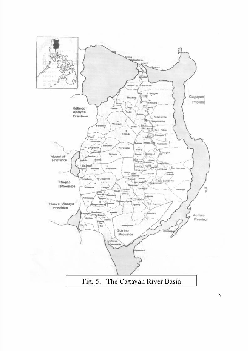
The Cagayan Riverine zone is located in the northeastern portion of Northern Luzon and coversfour out of the five provinces of the Cagayan Valley region. It slices the region into two big partswith the Sierra Madre on one side and the production valley area on the other. It is bounded bythe Sierra Madre mountain range on the east, the Caraballo –Mamparang mountain ranges onthe south and the Cordillera Mountains on the west. It exits in the north to the Babuyan Channelthrough the municipality of Aparri.
The riverine zone is a part of the large Cagayan River Basin area as shown in figure 5. The riverbasin is estimated at 27,281 square kilometers. This area covers the 4 provinces of Region 2and the provinces of Apayao, Ifugao, Kalinga and Mt. Province in the Cordillera AdministrativeRegion (CAR) and the province of Aurora in Region 3.
2. Topography and Geology
The river originates from the Caraballo Mountains in the south and exits in the north into theBabuyan Channel in Aparri. It travels a distance of about 520 km. along the Cagayan Valleyregion. The river flows through a flat alluvial plains between the slopes of the Cagayan Valley.Tributaries also flow from these slopes and drain in the Cagayan River. As the river nears itsmouth, it constricts somewhere in the Magapit area, which is about 30 kilometers away from
Aparri.
The topography of the area ranges from hilly to mountainous. As far as the river zone isconcerned, the lands with a slope of less than 8% on both sides of the river are areas developedfor agricultural purposes. Hilly lands are left as grasslands.
Data from the JICA Feasibility Study show that rocks of the River are represented by a thicksequence of pre-Tertiary metamorphic and plutonic rocks. An Oligocene to Pliocene Marinesection with up to 9,000 meters thick along the flanks but maximizes to 12,000 meters at thecenter occupies the main area. The Oligocene section is composed of lava flows,metamorphosed conglomerate, tuff breccia and sandstone and siltstone. Late Pleistocene torecent sands, silts, gravels and pyroclastics are found generally in the center.
8
7/17/2019 Cagayan Riverine Zone Development Framework Plan 2005_2030
http://slidepdf.com/reader/full/cagayan-riverine-zone-development-framework-plan-20052030 18/57
Fi . 5. The Ca a an River Basin
9
7/17/2019 Cagayan Riverine Zone Development Framework Plan 2005_2030
http://slidepdf.com/reader/full/cagayan-riverine-zone-development-framework-plan-20052030 19/57
3. Meteorology
The climate in the Cagayan River zone falls under Type III. This is characterized by not verypronounced seasons with relatively dry weather condition from November to April while the rest ofthe months from May to October are noted as wet weather.
Climate variability in the region also ascribed to the El Nino phenomenon. Records show that ElNino occurs almost every three years. On the other hand, typhoons also normally strike duringthe months of July to December, with an average of 8 typhoons every year.
4. Hydrology
Hydrology of the Cagayan River Basin reflects an average annual rainfall of 2,600 mm whichvaries from less than 2,000 mm in the lowland to more than 4,000 mm in the mountainous area.
Average monthly temperature ranges from 23.1 degrees Celsius in January to 29.0 degreesCelsius in May. Annual average is computed at 26.4 degrees Celsius at Tuguegarao City. Highhumidity between 70% and 90% is observed within the area while daily evaporation is 4 mm to5mm. The maximum is recorded in April and the minimum in December. During the rainy and
typhoon months, floods usually occur which bring about abundant rainfall to the river basin.
The major tributaries of the Cagayan River are the Magat River, Ilagan River, Siffu-Mallig Riverand Chico River. The average runoff of the river and its tributaries are shown below:
Table 2. Estimated runof f of the River Basin and its Tributaties
Tributary Catchment (sq. km) Annual Average Runoff(cu. m/s)
Upper Cagayan River 6,633 289.3
Magat River 5,113 269.8
Ilagan River 3,132 147.1
Siffu-Mallig River 2,015 88.2Chico River 4,551 256.1
Whole Basin 27,281 1,371.6Source: JICA FS of Flood Control Project for the Lower Cagayan River
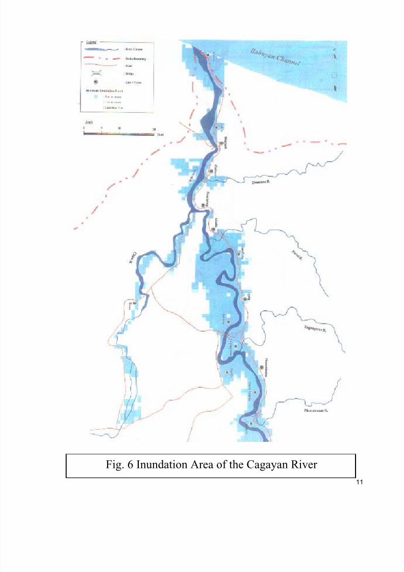
5. Inundation
Based on the RPFP, the inundation area of the Cagayan River and its tributaries is estimated at186,000 hectares covering 52 municipalities of the region. Specifically, these municipalities aremostly located in the provinces of Cagayan, Isabela and Nueva Vizcaya as shown in Figure 6.Theses areas are within the 650,243 hectares presently used for agricultural production.Settlements near the Cagayan River and its tributaries are also subjected to flood occurrence,
and most of these are found in the urban areas of the region where public river easements aredisregarded.
6. Flora and Fauna
The Cagayan Valley region is endowed with rich biodiversity. In the recent Philippine BiodiversityConservation Priority Setting, the region has been identified as one of the priority conservation
10
7/17/2019 Cagayan Riverine Zone Development Framework Plan 2005_2030
http://slidepdf.com/reader/full/cagayan-riverine-zone-development-framework-plan-20052030 20/57
11
Fig. 6 Inundation Area of the Cagayan River
7/17/2019 Cagayan Riverine Zone Development Framework Plan 2005_2030
http://slidepdf.com/reader/full/cagayan-riverine-zone-development-framework-plan-20052030 21/57
sites within the country and its vast forest that function as watershed for the Cagayan River isidentified as Key Biodiversity Areas (KBA). This means that these areas are home to severalthreatened species that are found nowhere else in the world. Part of the process is alsoidentifying candidate KBA, of which Cagayan River is among the areas identified. These areasare potential biodiversity rich areas but do not have enough information available to merit a KeyBiodiversity Area status. They are also priority area for research.
To date, there are 75 species of plants and animals recorded in the Cagayan Valley Region thatare threatened and categorized as Critically Endangered, Endangered and Vulnerable by theInternational Union for the Conservation of Nature (IUCN) 2006 Red List (Table 3). Among thethreatened species 75% are found only in the Philippines. This makes the region a globallyimportant conservation site. Appendix 1 shows the list of threatened species in Region 02.
Table 3. Number of Threatened Species Recorded Within the Cagayan Valley Region
IUCN Criteria Fauna Flora Total
Critically Endangered 3 18 21
Endangered 8 5 13
Vulnerable 28 13 41
39 36 75Source: Conservation International Philippines, DENR-PAWB and Haribon Foundation. 2006.Priority Sites for Conservation in the Philippines: KBAs. Quezon City, Philippines, 24 pp.
Few studies have been done on the biodiversity of Cagayan River. Most of the informationavailable is anecdotal and historical accounts from early naturalist and explorers such as thepresence of freshwater crocodiles in the river. The only recent study conducted on flora andfauna of Cagayan river was done by JICA in 2001 as part of the feasibility study of flood control inthe lower Cagayan River. The study documented a total of 79 families with 298 species of which37 are endemic and 7 are considered endangered as they are affected by human activities and/ordue to habitat loss (Table 4).
Table 4. Number of Terrestial Flora Identified in Cagayan Valley
Item NumberRecorded
Remarks
Family 79
Species 298
Endemics 37 Defined as those found only in the Philippines
Indigenous Species 80Defined as those that can be found in thePhilippines and elsewhere in Southeast Asia butnot necessarily exotic in the whole region.
Endangered Species 7
Rare Species 10
Indeterminate Species 23 Defined as those that are consideredecologically endangered but there not enoughdata to support such status.
Source: JICA FS of Flood Control project in the Lower Cagayan River, CY 2001
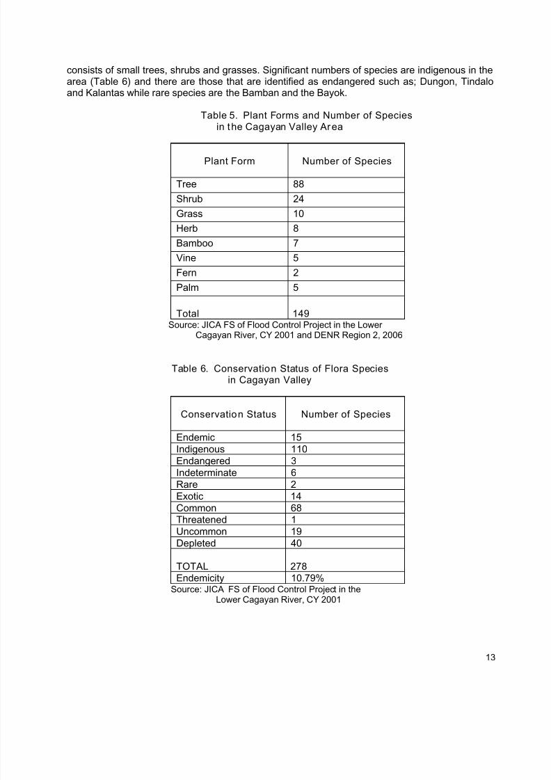
The tree species still dominate the lower Cagayan River area with 88 species, followed by shrubswith 24 and grass with 10 species (Table 5). This kind of distribution reflects two types ofecosystems that dominate the area: the forest ecosystem and the lowland ecosystem that
12
7/17/2019 Cagayan Riverine Zone Development Framework Plan 2005_2030
http://slidepdf.com/reader/full/cagayan-riverine-zone-development-framework-plan-20052030 22/57
consists of small trees, shrubs and grasses. Significant numbers of species are indigenous in thearea (Table 6) and there are those that are identified as endangered such as; Dungon, Tindaloand Kalantas while rare species are the Bamban and the Bayok.
Table 5. Plant Forms and Number of Speciesin the Cagayan Valley Area
Plant Form Number of Species
Tree 88
Shrub 24
Grass 10
Herb 8
Bamboo 7
Vine 5
Fern 2Palm 5
Total 149Source: JICA FS of Flood Control Project in the Lower
Cagayan River, CY 2001 and DENR Region 2, 2006
Table 6. Conservation Status of Flora Speciesin Cagayan Valley
Conservation Status Number of Species
Endemic 15
Indigenous 110
Endangered 3
Indeterminate 6
Rare 2
Exotic 14
Common 68Threatened 1
Uncommon 19
Depleted 40
TOTAL 278
Endemicity 10.79%Source: JICA FS of Flood Control Project in the
Lower Cagayan River, CY 2001
13
7/17/2019 Cagayan Riverine Zone Development Framework Plan 2005_2030
http://slidepdf.com/reader/full/cagayan-riverine-zone-development-framework-plan-20052030 23/57
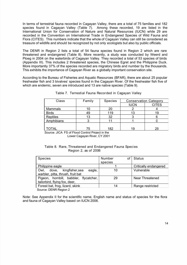
In terms of terrestrial fauna recorded in Cagayan Valley, there are a total of 75 families and 182species found in Cagayan Valley (Table 7). Among these recorded, 19 are listed in theInternational Union for Conservation of Nature and Natural Resources (IUCN) while 29 arerecorded in the Convention on International Trade in Endangered Species of Wild Fauna andFlora (CITES). This numbers indicate that the whole of Cagayan Valley can still be considered astreasure of wildlife and should be recognized by not only ecologists but also by public officials.
The DENR in Region 2 lists a total of 54 fauna species found in Region 2 which are rarethreatened and endangered (Table 8). More recently, a study was conducted by Weerd andPloeg in 2004 on the waterbirds of Cagayan Valley. They recorded a total of 53 species of birds(Appendix III). This includes 2 threatened species, the Chinese Egret and the Philippine Duck.More importantly 37% of the species recorded are migratory birds and number by the thousands.This exhibits the importance of Cagayan River as a globally important conservation site.
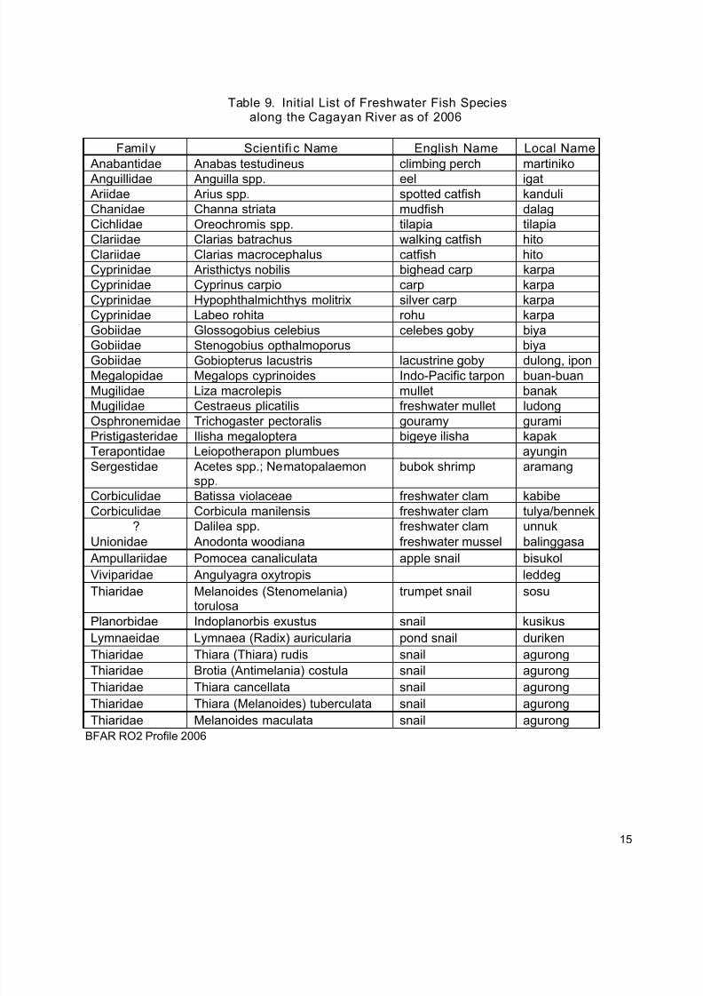
According to the Bureau of Fisheries and Aquatic Resources (BFAR), there are about 25 popularfreshwater fish and 3 bivalves’ species found in the Cagayan River. Of the freshwater fish five ofwhich are endemic, seven are introduced and 13 are native species (Table 9).
Table 7. Terrestial Fauna Recorded in Cagayan Valley
Conservation CategoryClass Family Species
IUCN CITES
Mammals 10 20 2 4
Birds 49 119 13 19
Reptiles 13 32 3 6
Amphibians 3 11 1 0
TOTAL 75 182 19 29Source: JICA FS of Flood Control Project in the
Lower Cagayan River, CY 2001
Table 8. Rare, Threatened and Endangered Fauna SpeciesRegion 2, as of 2006
Species Number ofspecies
Status
Philippine eagle 1 Critically endangered
Owl, dove, kingfisher,sea eagle,warbler, pitta, thrush, fruit bat
10 Vulnerable
Pigeon, hornbill, babbler, flycatcher,tailorbird, flying fox, deer,
29 Near Threatened
Forest bat, frog, lizard, skink 14 Range restrictedSource: DENR Region 2
Note: See Appendix II for the scientific name, English name and status of species for the floraand fauna of Cagayan Valley based on IUCN 2006.
14
7/17/2019 Cagayan Riverine Zone Development Framework Plan 2005_2030
http://slidepdf.com/reader/full/cagayan-riverine-zone-development-framework-plan-20052030 24/57
Table 9. Initial List of Freshwater Fish Speciesalong the Cagayan River as of 2006
Family Scientifi c Name English Name Local Name
Anabantidae Anabas testudineus climbing perch martiniko
Anguillidae Anguilla spp. eel igat Ariidae Arius spp. spotted catfish kanduli
Chanidae Channa striata mudfish dalag
Cichlidae Oreochromis spp. tilapia tilapia
Clariidae Clarias batrachus walking catfish hito
Clariidae Clarias macrocephalus catfish hito
Cyprinidae Aristhictys nobilis bighead carp karpa
Cyprinidae Cyprinus carpio carp karpa
Cyprinidae Hypophthalmichthys molitrix silver carp karpa
Cyprinidae Labeo rohita rohu karpa
Gobiidae Glossogobius celebius celebes goby biya
Gobiidae Stenogobius opthalmoporus biyaGobiidae Gobiopterus lacustris lacustrine goby dulong, ipon
Megalopidae Megalops cyprinoides Indo-Pacific tarpon buan-buan
Mugilidae Liza macrolepis mullet banak
Mugilidae Cestraeus plicatilis freshwater mullet ludong
Osphronemidae Trichogaster pectoralis gouramy gurami
Pristigasteridae Ilisha megaloptera bigeye ilisha kapak
Terapontidae Leiopotherapon plumbues ayungin
Sergestidae Acetes spp.; Nematopalaemonspp.
bubok shrimp aramang
Corbiculidae Batissa violaceae freshwater clam kabibe
Corbiculidae Corbicula manilensis freshwater clam tulya/bennek
? Dalilea spp. freshwater clam unnukUnionidae Anodonta woodiana freshwater mussel balinggasa
Ampullariidae Pomocea canaliculata apple snail bisukol
Viviparidae Angulyagra oxytropis leddeg
Thiaridae Melanoides (Stenomelania)torulosa
trumpet snail sosu
Planorbidae Indoplanorbis exustus snail kusikus
Lymnaeidae Lymnaea (Radix) auricularia pond snail duriken
Thiaridae Thiara (Thiara) rudis snail agurong
Thiaridae Brotia (Antimelania) costula snail agurong
Thiaridae Thiara cancellata snail agurong
Thiaridae Thiara (Melanoides) tuberculata snail agurong
Thiaridae Melanoides maculata snail agurong
BFAR RO2 Profile 2006
15
7/17/2019 Cagayan Riverine Zone Development Framework Plan 2005_2030
http://slidepdf.com/reader/full/cagayan-riverine-zone-development-framework-plan-20052030 25/57
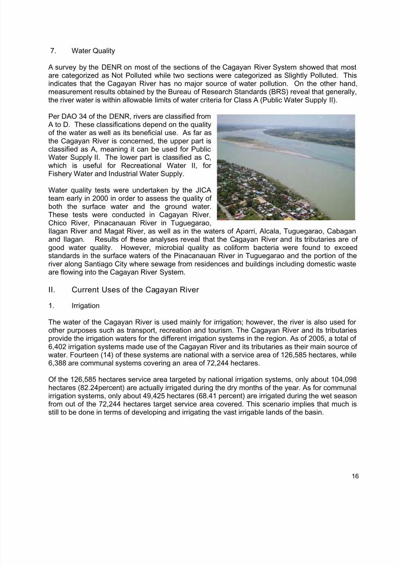
7. Water Quality
A survey by the DENR on most of the sections of the Cagayan River System showed that mostare categorized as Not Polluted while two sections were categorized as Slightly Polluted. Thisindicates that the Cagayan River has no major source of water pollution. On the other hand,measurement results obtained by the Bureau of Research Standards (BRS) reveal that generally,
the river water is within allowable limits of water criteria for Class A (Public Water Supply II).
Per DAO 34 of the DENR, rivers are classified from A to D. These classifications depend on the qualityof the water as well as its beneficial use. As far asthe Cagayan River is concerned, the upper part isclassified as A, meaning it can be used for PublicWater Supply II. The lower part is classified as C,which is useful for Recreational Water II, forFishery Water and Industrial Water Supply.
Water quality tests were undertaken by the JICA
team early in 2000 in order to assess the quality ofboth the surface water and the ground water.These tests were conducted in Cagayan River,Chico River, Pinacanauan River in Tuguegarao,Ilagan River and Magat River, as well as in the waters of Aparri, Alcala, Tuguegarao, Cabaganand Ilagan. Results of these analyses reveal that the Cagayan River and its tributaries are ofgood water quality. However, microbial quality as coliform bacteria were found to exceedstandards in the surface waters of the Pinacanauan River in Tuguegarao and the portion of theriver along Santiago City where sewage from residences and buildings including domestic wasteare flowing into the Cagayan River System.
II. Current Uses of the Cagayan River
1. Irrigation
The water of the Cagayan River is used mainly for irrigation; however, the river is also used forother purposes such as transport, recreation and tourism. The Cagayan River and its tributariesprovide the irrigation waters for the different irrigation systems in the region. As of 2005, a total of6,402 irrigation systems made use of the Cagayan River and its tributaries as their main source ofwater. Fourteen (14) of these systems are national with a service area of 126,585 hectares, while6,388 are communal systems covering an area of 72,244 hectares.
Of the 126,585 hectares service area targeted by national irrigation systems, only about 104,098hectares (82.24percent) are actually irrigated during the dry months of the year. As for communal
irrigation systems, only about 49,425 hectares (68.41 percent) are irrigated during the wet seasonfrom out of the 72,244 hectares target service area covered. This scenario implies that much isstill to be done in terms of developing and irrigating the vast irrigable lands of the basin.
16
7/17/2019 Cagayan Riverine Zone Development Framework Plan 2005_2030
http://slidepdf.com/reader/full/cagayan-riverine-zone-development-framework-plan-20052030 26/57
2. Quarrying and Gold Panning
Another major use of the river and its bank is for sand and gravel extraction for concreteaggregates. All of the mainland provinces of the region depend on the Cagayan River and itstributaries for their supply of these materials.
The Cagayan riverine zone production areas and the annual production rate per province as ofyear 2005 are summarized as follows:
o Cagayan – has a production area of 107 hectares at an annual extraction rate of 986,067cubic meters of sand and gravel. On metallic minerals, there are 20 hectares productionareas with production rate of 420 metric tons.
o Isabela – has a production area of 108 hectares with extraction rate of 1,035,692 cubicmeters of sand and gravel. For metallic minerals, there are 20 hectares with a productionrate of 2,000 metric tons of minerals,
o Nueva Vizcaya – has a production area of 35 hectares with extraction rate of 280,060cubic meters of sand and gravel. For metallic minerals, there are 410 hectares with49,000 metric tons of minerals extracted. A projected 2,000,000 metric tons of mineralscontaining gold and copper is also available in the province.
o Quirino – has 5 hectares production area with an extraction rate of 21,748 cubic meters ofsand and gravel.
Aside form the abovementioned production of sand and gravel, small-scale mining (gold panning)activities are also undertaken in the tributaries of the river in Quirino and Nueva Vizcaya. On theother hand, manganese and chromite permits are released in the provinces of Cagayan andIsabela.
As of August 2006, there are pending applications for industrial sand and gravel extraction with atotal land coverage area of 167 hectares located in the provinces of Cagayan and Isabela.
3. Tourism and Culture
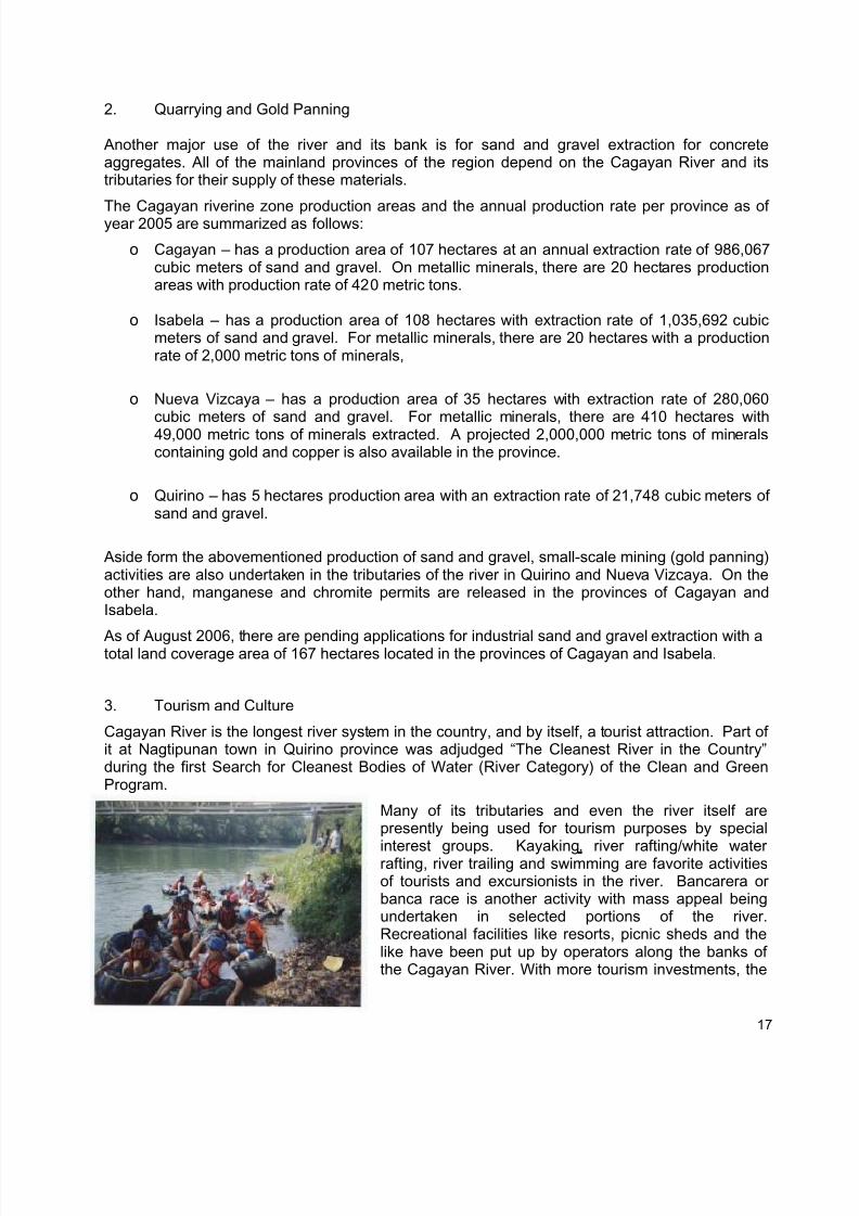
Cagayan River is the longest river system in the country, and by itself, a tourist attraction. Part ofit at Nagtipunan town in Quirino province was adjudged “The Cleanest River in the Country”during the first Search for Cleanest Bodies of Water (River Category) of the Clean and GreenProgram.
Many of its tributaries and even the river itself arepresently being used for tourism purposes by special
interest groups. Kayaking, river rafting/white waterrafting, river trailing and swimming are favorite activitiesof tourists and excursionists in the river. Bancarera orbanca race is another activity with mass appeal beingundertaken in selected portions of the river.Recreational facilities like resorts, picnic sheds and thelike have been put up by operators along the banks ofthe Cagayan River. With more tourism investments, the
17
7/17/2019 Cagayan Riverine Zone Development Framework Plan 2005_2030
http://slidepdf.com/reader/full/cagayan-riverine-zone-development-framework-plan-20052030 27/57
Cagayan River system has the potential of becoming a major tourist attraction in the future.
Presently, the river is being used by some municipalities and provinces of the region for culturalcelebrations during fiestas such as the fluvial parade of Our Lady of Piat, in Cagayan which iscelebrated every first week of July.
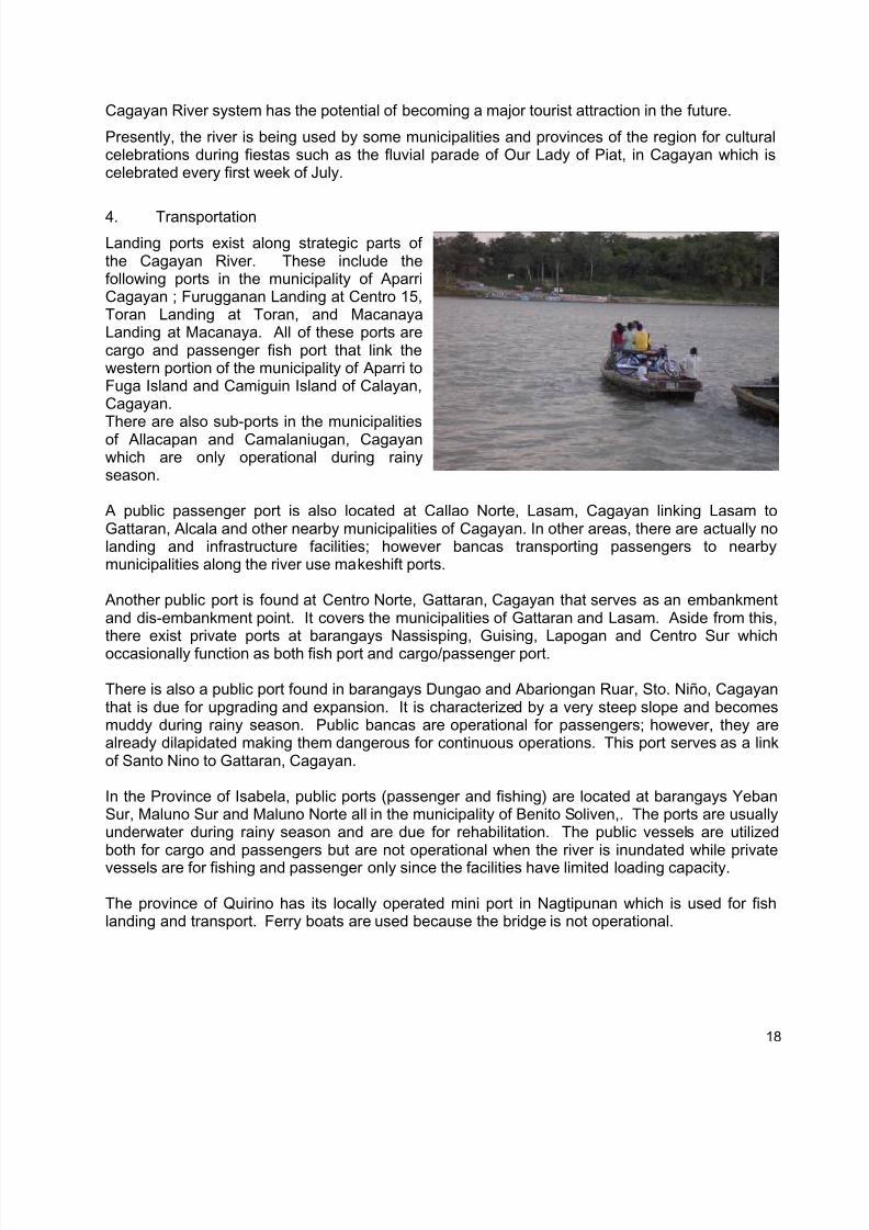
4. Transportation
Landing ports exist along strategic parts ofthe Cagayan River. These include thefollowing ports in the municipality of AparriCagayan ; Furugganan Landing at Centro 15,Toran Landing at Toran, and MacanayaLanding at Macanaya. All of these ports arecargo and passenger fish port that link thewestern portion of the municipality of Aparri toFuga Island and Camiguin Island of Calayan,Cagayan.There are also sub-ports in the municipalitiesof Allacapan and Camalaniugan, Cagayanwhich are only operational during rainyseason.
A public passenger port is also located at Callao Norte, Lasam, Cagayan linking Lasam toGattaran, Alcala and other nearby municipalities of Cagayan. In other areas, there are actually nolanding and infrastructure facilities; however bancas transporting passengers to nearbymunicipalities along the river use makeshift ports.
Another public port is found at Centro Norte, Gattaran, Cagayan that serves as an embankmentand dis-embankment point. It covers the municipalities of Gattaran and Lasam. Aside from this,there exist private ports at barangays Nassisping, Guising, Lapogan and Centro Sur whichoccasionally function as both fish port and cargo/passenger port.
There is also a public port found in barangays Dungao and Abariongan Ruar, Sto. Niño, Cagayanthat is due for upgrading and expansion. It is characterized by a very steep slope and becomesmuddy during rainy season. Public bancas are operational for passengers; however, they arealready dilapidated making them dangerous for continuous operations. This port serves as a linkof Santo Nino to Gattaran, Cagayan.
In the Province of Isabela, public ports (passenger and fishing) are located at barangays YebanSur, Maluno Sur and Maluno Norte all in the municipality of Benito Soliven,. The ports are usuallyunderwater during rainy season and are due for rehabilitation. The public vessels are utilizedboth for cargo and passengers but are not operational when the river is inundated while privatevessels are for fishing and passenger only since the facilities have limited loading capacity.
The province of Quirino has its locally operated mini port in Nagtipunan which is used for fishlanding and transport. Ferry boats are used because the bridge is not operational.
18
7/17/2019 Cagayan Riverine Zone Development Framework Plan 2005_2030
http://slidepdf.com/reader/full/cagayan-riverine-zone-development-framework-plan-20052030 28/57
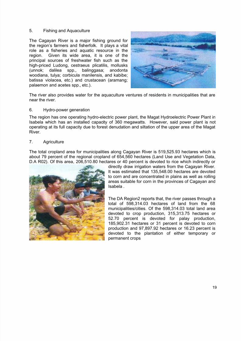
5. Fishing and Aquaculture
The Cagayan River is a major fishing ground forthe region’s farmers and fisherfolk. It plays a vitalrole as a fisheries and aquatic resource in theregion. Given its wide area, it is one of the
principal sources of freshwater fish such as thehigh-priced Ludong, cestraeus plicatilis, mollusks(unnok; dalilea spp., balinggasa; anodontawoodiana, tulya; corbicula manilensis, and kabibe;batissa violacea, etc.) and crustacean (aramang;palaemon and acetes spp., etc.).
The river also provides water for the aquaculture ventures of residents in municipalities that arenear the river.
6. Hydro-power generation
The region has one operating hydro-electric power plant, the Magat Hydroelectric Power Plant inIsabela which has an installed capacity of 360 megawatts. However, said power plant is notoperating at its full capacity due to forest denudation and siltation of the upper area of the MagatRiver.
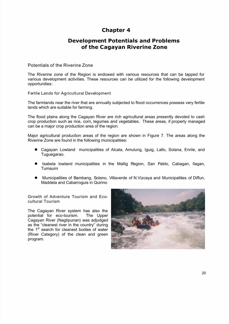
7. Agriculture
The total cropland area for municipalities along Cagayan River is 519,525.93 hectares which isabout 79 percent of the regional cropland of 654,560 hectares (Land Use and Vegetation Data,D.A R02). Of this area, 206,510.80 hectares or 40 percent is devoted to rice which indirectly or
directly draw irrigation waters from the Cagayan River.It was estimated that 135,548.00 hectares are devotedto corn and are concentrated in plains as well as rollingareas suitable for corn in the provinces of Cagayan andIsabela .
The DA Region2 reports that, the river passes through atotal of 598,314.03 hectares of land from the 68municipalities/cities. Of the 598,314.03 total land areadevoted to crop production, 315,313.75 hectares or52.70 percent is devoted for palay production,185,902.31 hectares or 31 percent is devoted to cornproduction and 97,897.92 hectares or 16.23 percent isdevoted to the plantation of either temporary or
permanent crops
19
7/17/2019 Cagayan Riverine Zone Development Framework Plan 2005_2030
http://slidepdf.com/reader/full/cagayan-riverine-zone-development-framework-plan-20052030 29/57
Chapter 4
Development Potentials and Problemsof the Cagayan Riverine Zone
Potentials of the Riverine Zone
The Riverine zone of the Region is endowed with various resources that can be tapped forvarious development activities. These resources can be utilized for the following developmentopportunities:
Fertile Lands for Agricultural Development
The farmlands near the river that are annually subjected to flood occurrences possess very fertilelands which are suitable for farming.
The flood plains along the Cagayan River are rich agricultural areas presently devoted to cashcrop production such as rice, corn, legumes and vegetables. These areas, if properly managedcan be a major crop production area of the region.
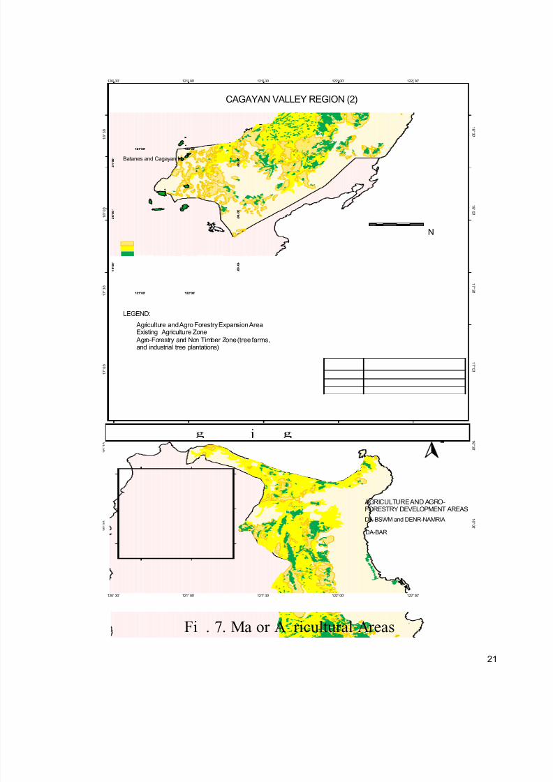
Major agricultural production areas of the region are shown in Figure 7. The areas along theRiverine Zone are found in the following municipalities:
Cagayan Lowland municipalities of Alcala, Amulung, Iguig, Lallo, Solana, Enrile, andTuguegarao.
Isabela lowland municipalities in the Mallig Region, San Pablo, Cabagan, Ilagan,
Tumauini
Municipalities of Bambang, Solano, Villaverde of N.Vizcaya and Municipalities of Diffun,Maddela and Cabarroguis in Quirino
Growth of Adventure Tourism and Eco-cultural Tourism
The Cagayan River system has also thepotential for eco-tourism. The UpperCagayan River (Nagtipunan) was adjudgedas the “cleanest river in the country” duringthe 1st search for cleanest bodies of water(River Category) of the clean and greenprogram.
20
7/17/2019 Cagayan Riverine Zone Development Framework Plan 2005_2030
http://slidepdf.com/reader/full/cagayan-riverine-zone-development-framework-plan-20052030 30/57
10 0 10 20 30 Kilometer s
N
1
9 ° 0 0 ' 1
9 ° 0 0 '
2 0 ° 0 0
' 2 0 ° 0 0 '
2
1 ° 0 0
' 2 1
° 0 0 '
121°00'
121°00'
122°00'
122°00'
1 6 ° 0 0 '
1 6 ° 0 0 '
1 6 ° 3 0 '
1 6 ° 3 0 '
1 7 ° 0 0 '
1 7 ° 0 0 '
1 7 ° 3 0 '
1 7 ° 3 0 '
1 8 ° 0 0 '
1 8 ° 0 0 '
1 8
° 3 0 '
1 8 ° 3 0 '
120°30'
120°30'
121°00'
121°00'
121°30'
121°30'
122°00'
122°00'
122°30'
122°30'
Title
Source
Digital Data
Scale
Batanes and Cagayan Is.
LEGEND:
FIGURE 46
CAGAYAN VALLEY REGION (2)
Existing Agriculture Zone Agriculture and Agro Forestry Expansion Area
Agro-Forestry and Non Timber Zone (tree farms,and industrial tree plantations)
AGRICULTURE AND AGRO-FORESTRY DEVELOPMENT AREAS
DA-BSWM and DENR-NAMRIA
DA-BAR
Fi . 7. Ma or A ricultural Areas
21
7/17/2019 Cagayan Riverine Zone Development Framework Plan 2005_2030
http://slidepdf.com/reader/full/cagayan-riverine-zone-development-framework-plan-20052030 31/57
Presently, it is being used by some municipalities and provinces of the region for culturalcelebrations during fiestas such as fluvial parades and the “bancarera”. Special interest groupsalso attract visitors by promoting the river and its tributaries for kayaking, river rafting, white waterrafting and river trailing. Excursionists also use the river as picnic and swimming area,encouraging some businessmen to establish resorts along the riverbanks. Promoting the river foreco-tourism and providing facilities will attract more tourists and investors in the area.
Rich Biodiversity Potential
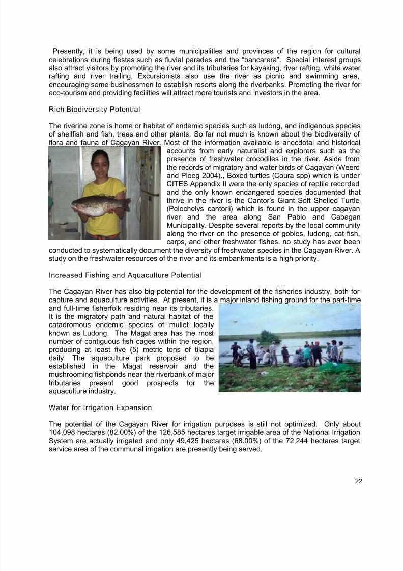
The riverine zone is home or habitat of endemic species such as ludong, and indigenous speciesof shellfish and fish, trees and other plants. So far not much is known about the biodiversity offlora and fauna of Cagayan River. Most of the information available is anecdotal and historical
accounts from early naturalist and explorers such as thepresence of freshwater crocodiles in the river. Aside fromthe records of migratory and water birds of Cagayan (Weerdand Ploeg 2004)., Boxed turtles (Coura spp) which is underCITES Appendix II were the only species of reptile recordedand the only known endangered species documented that
thrive in the river is the Cantor’s Giant Soft Shelled Turtle(Pelochelys cantorii) which is found in the upper cagayanriver and the area along San Pablo and CabaganMunicipality. Despite several reports by the local communityalong the river on the presence of gobies, ludong, cat fish,carps, and other freshwater fishes, no study has ever been
conducted to systematically document the diversity of freshwater species in the Cagayan River. Astudy on the freshwater resources of the river and its embankments is a high priority.
Increased Fishing and Aquaculture Potential
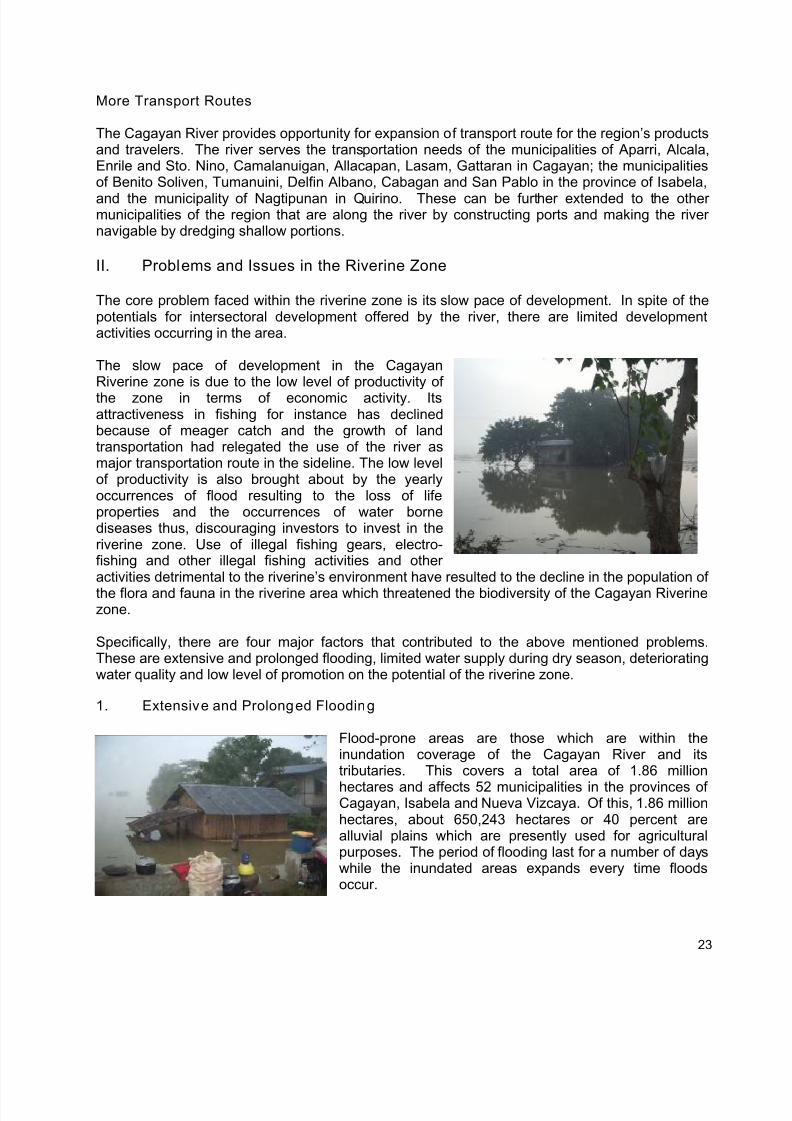
The Cagayan River has also big potential for the development of the fisheries industry, both for
capture and aquaculture activities. At present, it is a major inland fishing ground for the part-timeand full-time fisherfolk residing near its tributaries.It is the migratory path and natural habitat of thecatadromous endemic species of mullet locallyknown as Ludong. The Magat area has the mostnumber of contiguous fish cages within the region,producing at least five (5) metric tons of tilapiadaily. The aquaculture park proposed to beestablished in the Magat reservoir and themushrooming fishponds near the riverbank of majortributaries present good prospects for theaquaculture industry.
Water for Irrigation Expansion
The potential of the Cagayan River for irrigation purposes is still not optimized. Only about104,098 hectares (82.00%) of the 126,585 hectares target irrigable area of the National IrrigationSystem are actually irrigated and only 49,425 hectares (68.00%) of the 72,244 hectares targetservice area of the communal irrigation are presently being served.
22
7/17/2019 Cagayan Riverine Zone Development Framework Plan 2005_2030
http://slidepdf.com/reader/full/cagayan-riverine-zone-development-framework-plan-20052030 32/57
More Transport Routes
The Cagayan River provides opportunity for expansion of transport route for the region’s productsand travelers. The river serves the transportation needs of the municipalities of Aparri, Alcala,Enrile and Sto. Nino, Camalanuigan, Allacapan, Lasam, Gattaran in Cagayan; the municipalitiesof Benito Soliven, Tumanuini, Delfin Albano, Cabagan and San Pablo in the province of Isabela,
and the municipality of Nagtipunan in Quirino. These can be further extended to the othermunicipalities of the region that are along the river by constructing ports and making the rivernavigable by dredging shallow portions.
II. Problems and Issues in the Riverine Zone
The core problem faced within the riverine zone is its slow pace of development. In spite of thepotentials for intersectoral development offered by the river, there are limited developmentactivities occurring in the area.
The slow pace of development in the CagayanRiverine zone is due to the low level of productivity ofthe zone in terms of economic activity. Itsattractiveness in fishing for instance has declinedbecause of meager catch and the growth of landtransportation had relegated the use of the river asmajor transportation route in the sideline. The low levelof productivity is also brought about by the yearlyoccurrences of flood resulting to the loss of lifeproperties and the occurrences of water bornediseases thus, discouraging investors to invest in theriverine zone. Use of illegal fishing gears, electro-fishing and other illegal fishing activities and otheractivities detrimental to the riverine’s environment have resulted to the decline in the population of
the flora and fauna in the riverine area which threatened the biodiversity of the Cagayan Riverinezone.
Specifically, there are four major factors that contributed to the above mentioned problems.These are extensive and prolonged flooding, limited water supply during dry season, deterioratingwater quality and low level of promotion on the potential of the riverine zone.
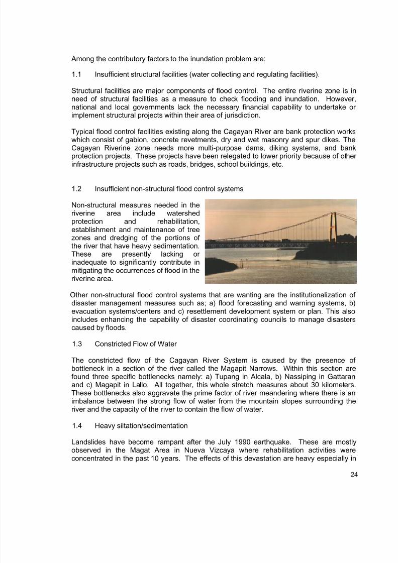
1. Extensive and Prolonged Flooding
Flood-prone areas are those which are within theinundation coverage of the Cagayan River and itstributaries. This covers a total area of 1.86 million
hectares and affects 52 municipalities in the provinces ofCagayan, Isabela and Nueva Vizcaya. Of this, 1.86 millionhectares, about 650,243 hectares or 40 percent arealluvial plains which are presently used for agriculturalpurposes. The period of flooding last for a number of dayswhile the inundated areas expands every time floodsoccur.
23
7/17/2019 Cagayan Riverine Zone Development Framework Plan 2005_2030
http://slidepdf.com/reader/full/cagayan-riverine-zone-development-framework-plan-20052030 33/57
Among the contributory factors to the inundation problem are:
1.1 Insufficient structural facilities (water collecting and regulating facilities).
Structural facilities are major components of flood control. The entire riverine zone is in
need of structural facilities as a measure to check flooding and inundation. However,national and local governments lack the necessary financial capability to undertake orimplement structural projects within their area of jurisdiction.
Typical flood control facilities existing along the Cagayan River are bank protection workswhich consist of gabion, concrete revetments, dry and wet masonry and spur dikes. TheCagayan Riverine zone needs more multi-purpose dams, diking systems, and bankprotection projects. These projects have been relegated to lower priority because of otherinfrastructure projects such as roads, bridges, school buildings, etc.
1.2 Insufficient non-structural flood control systems
Non-structural measures needed in theriverine area include watershedprotection and rehabilitation,establishment and maintenance of treezones and dredging of the portions ofthe river that have heavy sedimentation.These are presently lacking orinadequate to significantly contribute inmitigating the occurrences of flood in theriverine area.
Other non-structural flood control systems that are wanting are the institutionalization ofdisaster management measures such as; a) flood forecasting and warning systems, b)evacuation systems/centers and c) resettlement development system or plan. This alsoincludes enhancing the capability of disaster coordinating councils to manage disasterscaused by floods.
1.3 Constricted Flow of Water
The constricted flow of the Cagayan River System is caused by the presence ofbottleneck in a section of the river called the Magapit Narrows. Within this section arefound three specific bottlenecks namely: a) Tupang in Alcala, b) Nassiping in Gattaranand c) Magapit in Lallo. All together, this whole stretch measures about 30 kilometers.
These bottlenecks also aggravate the prime factor of river meandering where there is animbalance between the strong flow of water from the mountain slopes surrounding theriver and the capacity of the river to contain the flow of water.
1.4 Heavy siltation/sedimentation
Landslides have become rampant after the July 1990 earthquake. These are mostlyobserved in the Magat Area in Nueva Vizcaya where rehabilitation activities wereconcentrated in the past 10 years. The effects of this devastation are heavy especially in
24
7/17/2019 Cagayan Riverine Zone Development Framework Plan 2005_2030
http://slidepdf.com/reader/full/cagayan-riverine-zone-development-framework-plan-20052030 34/57
the Upper Cagayan River or along the Magat Dam Reservoir where sediment dischargesin the watersheds have increased.
The Dam has a basin area of 4,140 sq. kms. When this was completed less than 25years ago, the reservoir had a live storage capacity of 1.2 billion cu.m and a dead storagecapacity of 300 million cu. m. However, due to continuous increase in sedimentation from
the upper basin, the dead storage capacity has been reduced to 112 million cu.m duringthe past years. The annual sedimentation rate was recorded at 10.4 million cu.m , whichis twice the projected rate of 5.5 cu.m. This is also occurring in the Cagayan River and itstributaries.
Heavy sedimentation in the middle and lower portions of the Cagayan River are observedespecially in the following sections; Amulung, Lallo, Camalaniugan and at the rivermouthin Aparri.
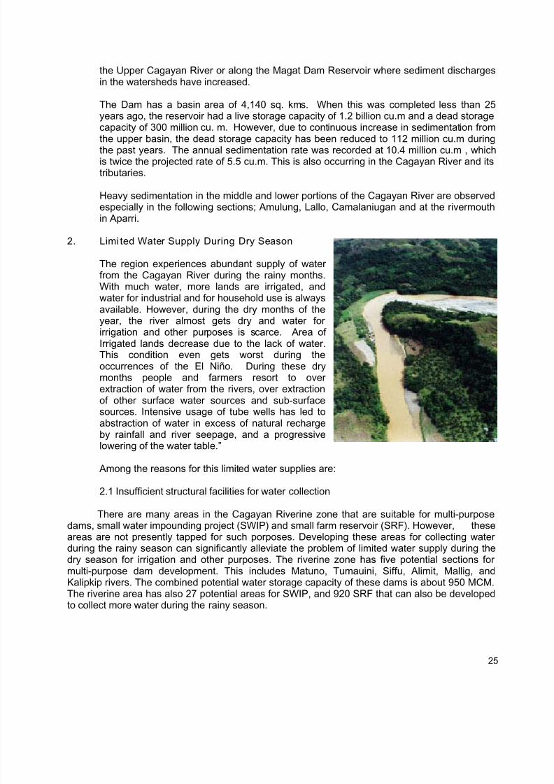
2. Limi ted Water Supply During Dry Season
The region experiences abundant supply of water
from the Cagayan River during the rainy months.With much water, more lands are irrigated, andwater for industrial and for household use is alwaysavailable. However, during the dry months of theyear, the river almost gets dry and water forirrigation and other purposes is scarce. Area ofIrrigated lands decrease due to the lack of water.This condition even gets worst during theoccurrences of the El Niño. During these drymonths people and farmers resort to overextraction of water from the rivers, over extractionof other surface water sources and sub-surface
sources. Intensive usage of tube wells has led toabstraction of water in excess of natural rechargeby rainfall and river seepage, and a progressivelowering of the water table.”
Among the reasons for this limited water supplies are:
2.1 Insufficient structural facilities for water collection
There are many areas in the Cagayan Riverine zone that are suitable for multi-purposedams, small water impounding project (SWIP) and small farm reservoir (SRF). However, theseareas are not presently tapped for such porposes. Developing these areas for collecting water
during the rainy season can significantly alleviate the problem of limited water supply during thedry season for irrigation and other purposes. The riverine zone has five potential sections formulti-purpose dam development. This includes Matuno, Tumauini, Siffu, Alimit, Mallig, andKalipkip rivers. The combined potential water storage capacity of these dams is about 950 MCM.The riverine area has also 27 potential areas for SWIP, and 920 SRF that can also be developedto collect more water during the rainy season.
25
7/17/2019 Cagayan Riverine Zone Development Framework Plan 2005_2030
http://slidepdf.com/reader/full/cagayan-riverine-zone-development-framework-plan-20052030 35/57
2.2 Deteriorating forest cover of the watersheds
Forest cover of the watersheds of the Cagayan River has been declining. This resulted toincreased surface runoff during rainy season because of the thinning of vegetation thatdeters the flow of water. Vegetation slows down the flow of water thereby increasing waterinfiltration and the storage of water in the upland. This will give rise to the continuous flow
of water in streams even during dry season. The deteriorating vegetation of thewatersheds therefore is one of the causes of the drying up of streams limiting watersupply during dry season.
The declining forest cover is due to the increasing exploitation of the region’s watersheds(human intrusion, slash and burn farming practices and illegal logging activities).Other indirect causes are population growth in the upland due to migration from thelowlands; inappropriate conservation measures; absence of mechanisms to facilitate andcoordinate the mandates of various agencies; inadequate land use and managementplans; absence of institutional mechanism to encourage active, collective and sustainableparticipation of stakeholdersr. Likewise, there is a very poor watershed management dueto the absence of watershed management plan.
2.3 Diversion of the waters from Casecnan to the Pantabangan Reservoir
One of the possible factors affecting the volume of water of the Cagayan River especiallyduring the dry season is the diversion of the waters of the Cagayan River to the Casecnanreservoir. This can affect the availability of the waters required by the region for irrigationand other purposes especially during dry season.
3. Deteriorating water quality
Water quality is a vital factor in attracting investors to the river. Good water quality attractsinvestors and tourists to the river. While the upper portion of the river (Quirino area) is still clean
and potable, the lower end of the river particularly in the areas of Isabela and Cagayan is gettingmore turbid every year. The slow deterioration in the quality of the water of the river is caused bythe following:
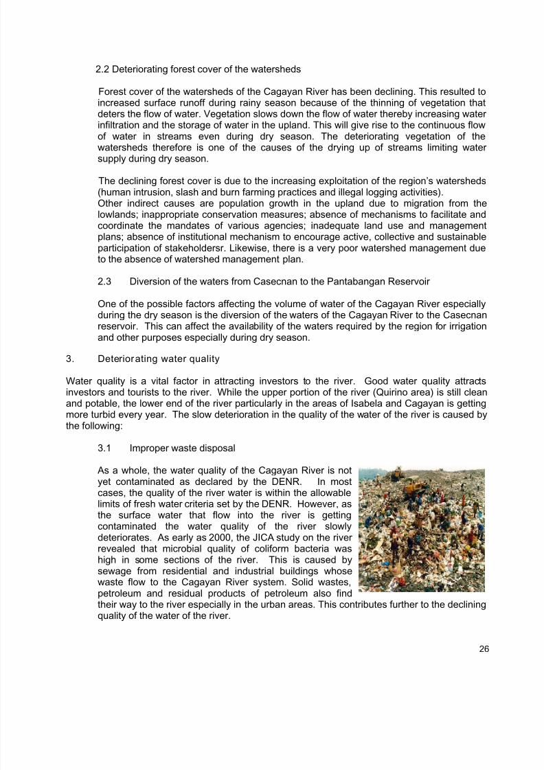
3.1 Improper waste disposal
As a whole, the water quality of the Cagayan River is notyet contaminated as declared by the DENR. In mostcases, the quality of the river water is within the allowablelimits of fresh water criteria set by the DENR. However, asthe surface water that flow into the river is gettingcontaminated the water quality of the river slowly
deteriorates. As early as 2000, the JICA study on the riverrevealed that microbial quality of coliform bacteria washigh in some sections of the river. This is caused bysewage from residential and industrial buildings whosewaste flow to the Cagayan River system. Solid wastes,petroleum and residual products of petroleum also findtheir way to the river especially in the urban areas. This contributes further to the decliningquality of the water of the river.
26
7/17/2019 Cagayan Riverine Zone Development Framework Plan 2005_2030
http://slidepdf.com/reader/full/cagayan-riverine-zone-development-framework-plan-20052030 36/57
3.2 Heavy use of Chemicals in farming
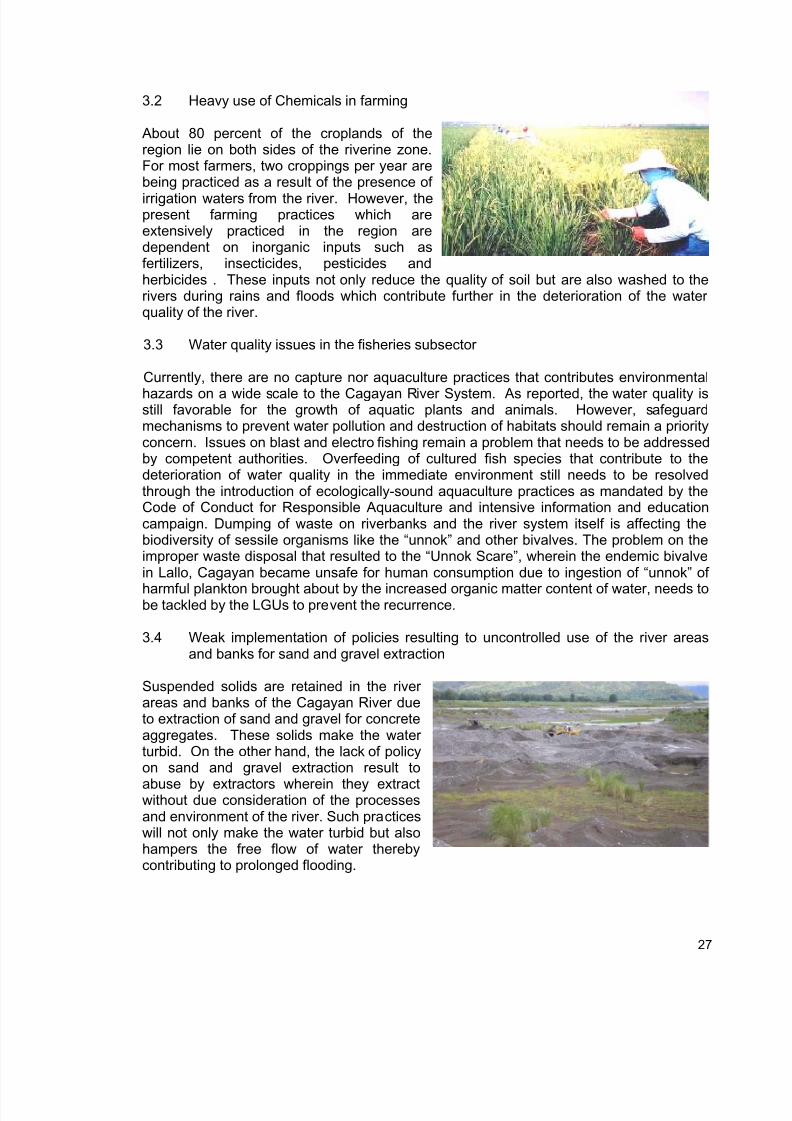
About 80 percent of the croplands of theregion lie on both sides of the riverine zone.For most farmers, two croppings per year arebeing practiced as a result of the presence of
irrigation waters from the river. However, thepresent farming practices which areextensively practiced in the region aredependent on inorganic inputs such asfertilizers, insecticides, pesticides andherbicides . These inputs not only reduce the quality of soil but are also washed to therivers during rains and floods which contribute further in the deterioration of the waterquality of the river.
3.3 Water quality issues in the fisheries subsector
Currently, there are no capture nor aquaculture practices that contributes environmental
hazards on a wide scale to the Cagayan River System. As reported, the water quality isstill favorable for the growth of aquatic plants and animals. However, safeguardmechanisms to prevent water pollution and destruction of habitats should remain a priorityconcern. Issues on blast and electro fishing remain a problem that needs to be addressedby competent authorities. Overfeeding of cultured fish species that contribute to thedeterioration of water quality in the immediate environment still needs to be resolvedthrough the introduction of ecologically-sound aquaculture practices as mandated by theCode of Conduct for Responsible Aquaculture and intensive information and educationcampaign. Dumping of waste on riverbanks and the river system itself is affecting thebiodiversity of sessile organisms like the “unnok” and other bivalves. The problem on theimproper waste disposal that resulted to the “Unnok Scare”, wherein the endemic bivalvein Lallo, Cagayan became unsafe for human consumption due to ingestion of “unnok” of
harmful plankton brought about by the increased organic matter content of water, needs tobe tackled by the LGUs to prevent the recurrence.
3.4 Weak implementation of policies resulting to uncontrolled use of the river areasand banks for sand and gravel extraction
Suspended solids are retained in the riverareas and banks of the Cagayan River dueto extraction of sand and gravel for concreteaggregates. These solids make the waterturbid. On the other hand, the lack of policyon sand and gravel extraction result to
abuse by extractors wherein they extractwithout due consideration of the processesand environment of the river. Such practiceswill not only make the water turbid but alsohampers the free flow of water therebycontributing to prolonged flooding.
27
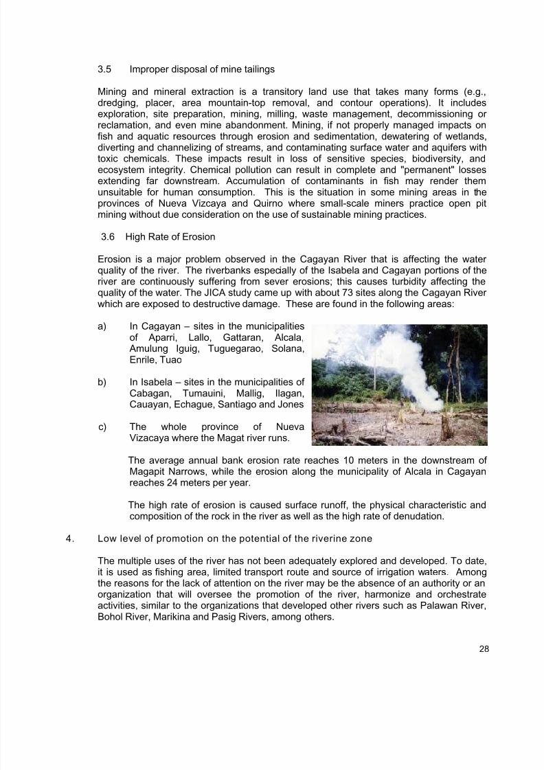
7/17/2019 Cagayan Riverine Zone Development Framework Plan 2005_2030
http://slidepdf.com/reader/full/cagayan-riverine-zone-development-framework-plan-20052030 37/57
3.5 Improper disposal of mine tailings
Mining and mineral extraction is a transitory land use that takes many forms (e.g.,dredging, placer, area mountain-top removal, and contour operations). It includesexploration, site preparation, mining, milling, waste management, decommissioning orreclamation, and even mine abandonment. Mining, if not properly managed impacts on
fish and aquatic resources through erosion and sedimentation, dewatering of wetlands,diverting and channelizing of streams, and contaminating surface water and aquifers withtoxic chemicals. These impacts result in loss of sensitive species, biodiversity, andecosystem integrity. Chemical pollution can result in complete and "permanent" lossesextending far downstream. Accumulation of contaminants in fish may render themunsuitable for human consumption. This is the situation in some mining areas in theprovinces of Nueva Vizcaya and Quirno where small-scale miners practice open pitmining without due consideration on the use of sustainable mining practices.
3.6 High Rate of Erosion
Erosion is a major problem observed in the Cagayan River that is affecting the water
quality of the river. The riverbanks especially of the Isabela and Cagayan portions of theriver are continuously suffering from sever erosions; this causes turbidity affecting thequality of the water. The JICA study came up with about 73 sites along the Cagayan Riverwhich are exposed to destructive damage. These are found in the following areas:
a) In Cagayan – sites in the municipalitiesof Aparri, Lallo, Gattaran, Alcala,
Amulung Iguig, Tuguegarao, Solana,Enrile, Tuao
b) In Isabela – sites in the municipalities ofCabagan, Tumauini, Mallig, Ilagan,
Cauayan, Echague, Santiago and Jones
c) The whole province of NuevaVizacaya where the Magat river runs.
The average annual bank erosion rate reaches 10 meters in the downstream ofMagapit Narrows, while the erosion along the municipality of Alcala in Cagayanreaches 24 meters per year.
The high rate of erosion is caused surface runoff, the physical characteristic andcomposition of the rock in the river as well as the high rate of denudation.
4. Low level of promotion on the potential of the riverine zone
The multiple uses of the river has not been adequately explored and developed. To date,it is used as fishing area, limited transport route and source of irrigation waters. Amongthe reasons for the lack of attention on the river may be the absence of an authority or anorganization that will oversee the promotion of the river, harmonize and orchestrateactivities, similar to the organizations that developed other rivers such as Palawan River,Bohol River, Marikina and Pasig Rivers, among others.
28
7/17/2019 Cagayan Riverine Zone Development Framework Plan 2005_2030
http://slidepdf.com/reader/full/cagayan-riverine-zone-development-framework-plan-20052030 38/57
Chapter 5
Goal, Objectives, Policies and Strategies
The Cagayan River System which traverses four provinces of region 2 is considered to be a
major resource of the region. The key role of this resource in the overall development of theregion is recognized in the Regional Physical Framework Plan by delineating the riverine zone asmultiple land use zone. Presently, the riverine zone’s contribution to the development of theregion is not yet optimized because the use of the resource is still limited to the traditional use asfishing ground, irrigation, and agriculture, venue for cultural celebrations, recreational and to alimited extent for transport.
Goal:
To accelerate the sustainable development in the riverine zone through proper management, inorder to realize the full development potential of the area.
Objectives:
The goal can be realized through the attainment of the following objectives:
1. To enhance the productivity and safety of the Cagayan Riverine Zone. At the end of thePlan period, it is targeted that investments in terms of agriculture, fishery, tourism,transportation, power and irrigation shall have increased within the Riverine Zone.
2. To improve the level of population of the aquatic resources in the Cagayan Riverine Zonesuch that by year 2010, this will have increased by 15% compared to its 2000 level andreach 100% by year 2030.
Policies:
The attainment of the objectives hinges on the following policies;
1) Mitigation of the destructive effect of flooding and reduction of its extent in terms of area andtime.
2) Availability of adequate water supply during dry season for domestic, industrial andagricultural uses.
3) Improvement of the deteriorating water quality in the Cagayan Riverine Zone.4) Optimization of the development potentials of the Cagayan Riverine Zone.
Strategies:
The following strategies will be adopted to operationalize the policies of the plan.
1. Strategies for the mitigation of the destructive effectof flooding and reduction o f its extent in terms of area and time.
1.1. Reduce extent of flooding in terms of area and time through the construction of multi-purpose dams and water impounding facilities.
29
7/17/2019 Cagayan Riverine Zone Development Framework Plan 2005_2030
http://slidepdf.com/reader/full/cagayan-riverine-zone-development-framework-plan-20052030 39/57
Construction of structural flood control facilities such as dams, small water impoundingprojects and small farm reservoir can substantially reduce the occurrence of flood in theriverine area. The volume of water that flows into the river can be reduced by storing therain water in these structures and can be released and used for irrigation and otherpurposes during dry season.
Construction of small water impounding facilities and multi-purpose dams shall beprovided in the strategic sites in the Cagayan River and its tributaries to regulate floodwaters. Multi-purpose dams shall be constructed in the upstream of the river preferablyon major tributaries that contribute substantial discharge during rainy season or duringflood occurrence. Priority shall be given to these structures in order to regulate andreduce flood discharge over the low-lying downstream flood prone areas. Theconstruction of dams will ensure and significantly reduce the area affected by flooding inthe lower reaches of the river. Agricultural damages are expected to be reduced to theminimum due to a much lesser flooded area and flooding time.
1.2. Construct cut-off channels.
Channel normalization in the Magapit narrows which serves as the bottleneck and theprimary cause of inundation in the lower sections of the Cagayan River is suggested tobe undertaken. Cut-off-channel will be constructed in three (3) sections to ensure asmooth and accelerated drainage of flood water in the lower sections of the river.However, a study is suggested to be done before its implementation to ensure that thebenefits out weight any cost due to its implementation.
1.3. Construct riverbank protection facilities.
Another strategy to control and delay the sudden discharge of flood water from theupstream is the conservation of the retardation capabilities of the banks of the riverchannel in the upper reaches of the Cagayan River and its tributaries. Efforts will be
focused on bank protection on these sections to ensure stable and erosion-freeembankment. Bank protection and dike structures shall also be constructed to protectlow-lying areas within its lower reaches.
1.4. Maintain the favorable depth of the river by dredging along heavily silted portions of theriver and removal of sediments allowing for faster flow of water especially during rainyseason to further reduce the destructive effect of floods.
Areas that have heavy sedimentation such as the Amulung and Aparri portions of theriver retard the flow of flood waters. Towards this end, studies should be conducted todetermine if dredging is possible as well as to determine if there are negative effects ofsuch activity. Following this, cost estimates of dredging activities should be made and
financing assistance be sought at the national and international sources.
1.5. Improve and institutionalize flood control and mitigating systems
Flood control and mitigating systems that are wanting are the institutionalization ofdisaster management measures such as; a) flood forecasting and warning systems, b)evacuation systems/centers and c) resettlement development system or plan. This alsoincludes enhancing the capability of disaster coordinating councils to manage disasterscaused by floods.
30
7/17/2019 Cagayan Riverine Zone Development Framework Plan 2005_2030
http://slidepdf.com/reader/full/cagayan-riverine-zone-development-framework-plan-20052030 40/57
The upgrading and operationalization of flood warning system is also needed to furtherreduce the destructions brought about by flooding. Along with the upgraded floodwarning system shall be the capability building of Regional and Local DisasterCoordinating Councils.
1.6. Strictly enforce the easement required by the Water Code of the Philippines.
The local government units are enjoined to strictly enforce the easement required in theWater Code of the Philippines. The water code sets the river easement as follows: threemeters in urban areas, 20 meters in agricultural areas, and 40 meters in forest areas.Provision of the easement area would help render an un-obstructed flow of waterespecially during the occurrences of flood. This will also stabilize and protect the riverbanks from erosion.
1.7. Ensure that in-stream projects (Dams, bridges, SWIPs) within the riverine zone do notinterfere with natural stream processes.
SEC. 56 of the Phili ppine Water Code prohibits any constructions which obstruct any
defined migration path of migratory fish species such as river mouths and estuaries.Structure should be designed improve the passage of fish particularly during spawningseasons in the Cagayan River and its tributaries. FAO 109 also prohibits theconstruction or establishment of fishpond or fish enclosures in inland waters withoutpermit. Observance and strict enforcement of this provision of the water code willcontribute to the reduction of the damages caused by flood for it will allow free flow ofstream water thereby reducing the time of inundation. This will also help in improving thedeclining population of aquatic flora and fauna by providing favorable environment fortheir natural growth.
2. Strategies fo r ensuring the availability of adequate water supply during dry season for
domestic, indust rial and agricultural uses.
2.1. Construct structural facilities for water collection
This strategy is in conjunction with the strategy on the construction of dams and waterimpounding facilities to control flood which was earlier mentioned. Control of flood usingsuch structures would also result to the storage of rain water which can be releasedduring the dry months. Hence, implementing the strategy to control flood through theconstruction of multi-purpose dams and small water impounding projects would alsoensure the availability of adequate water supply during dry season for irrigation andother purposes.
There are many areas in the Cagayan Riverine zone that are suitable for multi-purpose
dams, Small Water Impounding Project (SWIP) and Small Farm Reservoir (SRF).However, these areas are not presently tapped for such purposes. Developing theseareas for collecting water during the rainy season can significantly alleviate the problemof limited water supply during the dry season for irrigation and other purposes. Theriverine zone has five potential sections for multi-purpose dam development. Thisincludes Matuno, Tumauini, Siffu, Alimit, Mallig, and Kalipkip rivers. The combinedpotential water storage capacity of these dams is about 950 MCM. The riverine area hasalso 27 potential areas for SWIP, and 920 SRF that can also be developed to collectmore water during the rainy season.
31
7/17/2019 Cagayan Riverine Zone Development Framework Plan 2005_2030
http://slidepdf.com/reader/full/cagayan-riverine-zone-development-framework-plan-20052030 41/57
2.2. Improve the forest covers of watershed through the preparation and implementation of a
watershed management plan.
Forest cover of the watersheds of the Cagayan River has been declining. This resultedto increased surface runoff during rainy season because of the thinning of vegetation
that deters the flow of water. Vegetation slows down the flow of water thereby increasingwater infiltration and the storage of water in the upland. This will give rise to thecontinuous flow of water in streams even during dry season. The deterioratingvegetation of the watersheds therefore is one of the causes of the drying up of streamslimiting water supply during dry season. It also results to increase in the rate of erosion.High rate of erosion causes siltation and sedimentation of waterways therebycontributing to the destructive effect of flooding by prolonging the time and extending thearea affected. Erosion also contributes to the decline of the water quality of the CagayanRiverine because it makes the water turbid which is one of the major parameters forfavorable growth of aquatic life. Preparation and implementation of a watershedmanagement plan would therefore address many problems. The problem on forestcover which will be adequately taken cared of by such plan and its implementation is
paramount in the development of the Cagayan Riverine.
2.3. Identify and delineate impact reforestation areas within protection forest.
Protection forests, especially those that are untenured shall be the subject of closerprotection and management. As such, exploitation of whatever nature is not allowed.Henceforth, all areas falling under this type shall be improved to enhance its biologicalfeatures.
Presently, Region 02 excluding Batanes has 774, 666.198 hectares of protection forestwith 308, 995.849 hectares of untenured portion. The impact areas within the untenuredportion are identified and delineated on the ground. These areas are situated in the 20
municipalities of the region having an estimated area of 63,593 hectares.
2.4. Conduct research to determine the effects of diverting the waters of Cagayan River tothe Casecnan.
There is the need to conduct research to determine the effects of diverting the waters ofCagayan River to the Casecnan and institute mitigating measures to avert any negativeeffects brought about by such water diversion.
3. Strategies for improving the water quality in the Riverine Zone.
3.1. Rationalize disposal of wastes through the conduct of massive IEC on Waste
Management; construction of sanitary landfill, establishment of Barangay MaterialRecovery Facilities (MRF) and strict implementation of environmental and related laws.
All sorts of wastes generated by the households, commercial, service and industrialestablishments find their ways into the Cagayan River contributing to the decliningquality of the water especially in urban areas. Awareness campaign on the negativeeffect of such to the population is needed aside from the provision of waste disposalfacilities and systems such as landfill.
32
7/17/2019 Cagayan Riverine Zone Development Framework Plan 2005_2030
http://slidepdf.com/reader/full/cagayan-riverine-zone-development-framework-plan-20052030 42/57
There should be strict implementation of the RA 9003 (Solid Waste Management Act)and RA on Clean Air Act and Water Act and other related laws such as P.D. 1152,P.D.1067, P.D. 1586, and P.D. 7586. Strict observance and enforcement of these lawswill not only help in maintaining good water quality of the river but will also help inimproving the declining population of the aquatic flora and fauna in the riverine area.Clean water will provide favorable environment for their growth and reproduction.
3.2. Promote and encourage farmers to adopt sustainable farming practices and regulation ofthe use of farm chemicals.
The following should be undertaken in support of the strategy;
- Wide adoption of organic farming system thru the conduct of Integrated PestManagement (IPM) Trainings;
- Packaging and adoption of Sustainable farming practices. Local ordinances should beenacted such that these packaged farming practices will be the one adopted andimplemented by farmers;
- Pushing for a law requiring agriculturist to prescribe pesticides and other farm inputs asprerequisite by farmers to purchase such farm inputs. The justification here lies in thefact that agriculturists are now required to pass the board examination before they couldbe recognized and one form of recognition of their expertise is for them to prescribeproper farm inputs. There is also the need to strictly implement R.A. 8436 and DAO 38.
3.3. Promote environment-friendly fishing practices and improve aquaculture productivitywithin ecological limits
Some incidence of blast fishing, electro fishing and establishment of illegal stationaryfishing gears are still observed in some parts of the Cagayan Riverine area. These
fishing practices do not only put into peril the future population of aquatic resources butalso contribute somehow to the deteriorating quality of the river. Blast fishing isparticularly destructive because of the direct effect on fish and invertebrates within theblast zone. Not only are the preferred species and sizes killed but the blast also kills allthe fish in that area (http://www.tracc.00server.com/Fisheries/blast_fishing). This maylead to changes in fish populations that could further result in the changes in ecologicalniches or directly reduce the biodiversity within a particular area. Continuous improperimplementations of package of technology in aquaculture contribute further to thedeterioration of water quality. Hence, the need to strictly implement monitoring, controland surveillance measures provided under the Philippine Fisheries Code of 1998 (RA8550).
3.4. Plan and control the use of the river for sand and gravel extraction
The present practice of indiscriminately extracting sand and gravel in the Cagayan Riverand its tributaries obstruct the free flow of water contributing to prolonged flooding andalso contributes to the turbidity of the water affecting the water quality. The oildischarges of the heavy equipments that go into the river during operation furthercontribute to the poor quality of the water. There should be proper planning andcontrolled extraction of sand and gravel to arrest the further deterioration of the qualityof the water of the river.
33
7/17/2019 Cagayan Riverine Zone Development Framework Plan 2005_2030
http://slidepdf.com/reader/full/cagayan-riverine-zone-development-framework-plan-20052030 43/57
4. Strategies for opt imizing of the development potentials o f the Cagayan Riverine Zone.
Increase investments in the Cagayan Riverine Zone by promoting the developmentpotentials of the zone in the following areas:
4.1. Tourism
- Conduct of cultural activities and celebrations;- Promotion of fresh water sports and freshwater sports fishing;- Construction of recreational facilities.
4.2. Irrigation and power generation- Identification and Investigation of possible Small Scale Irrigation Project and Multi-
Purpose Dam Project from existing maps by the concerned agency fortechnical and economic feasibility, social acceptability, funding andimplementation;
- Encouraging LGU’s, existing irrigators association and farmer groups to reportpotential irrigable area with dependable water source for irrigation
development;
- Encouraging LGU’s through resolution/ordinances to set aside portion of theirdevelopment fund for the repair and rehabilitation of existing small scaleIrrigation system as well as construction of new irrigation project;
- IEC to Irrigator’s Associations on the efficient utilization and management ofirrigation water.
4.3. Fisheriesa. Aquaculture- Adopt proper water usage and effluent management;
- Apply the recommended practices on Fisheries Administrative Order No. 214on feed, feed use and management;
- Continuous water quality monitoring and issuance of water quality bulletin andadvisory to guide fish producers;
- Culture of aquatic species with high local demand;- Demonstrate and pilot mature aquaculture technologies for future
commercialization;- Develop culture techniques for endemic species such as “Ludong”, cestraeus plicatilis;- Empower fisher folk through capability-building and technology trainings;- Establish aquaculture parks;- Establish more hatcheries to support the input requirement of farm operators;- Formulate incentives to encourage compliance with the environmental
standards and promotion of sustainable management practices on aquaculture;- Improve aquaculture data management;- Improve farm design and construction;- Promote fish health management practices;- Provide post harvest facilities in major aquaculture areas like the Magat
reservoir;- Recommend policies to govern the introduction of exotic species and
genetically modified organisms;- Register all aquaculture farms as mandated by law for regulatory purposes;
34
7/17/2019 Cagayan Riverine Zone Development Framework Plan 2005_2030
http://slidepdf.com/reader/full/cagayan-riverine-zone-development-framework-plan-20052030 44/57
- Regulate the use of drugs, chemicals, potentially toxic pesticides and fertilizers so asnot to endanger food safety or threaten the environment;
- Research and development of ecologically-sound aquaculture technologies;- Support the policy on the insurance of aquaculture crops/stocks (FAO 215);
- Venture into the production of high value fishery commodities.
b. Capture fisheries- Conduct capabiity-building and values-orientation seminars to eliminate illegal fishing
activities;- Conduct technology demonstration and training on the design, construction and
use of environment-friendly fishing gears;- Improve capture fishing technology;- Provide alternative livelihood to marginal fisherfolk;- Sustain the fingerling dispersal program;
c. Maintenance of the diversity and abundance of aquatic communities- Conduct intensive IEC on riverside residents and farmers on the ill-effects of
dumping of wastes and discharge of water from croplands containingfertilizers and pesticides to the riverine ecosystem;
- Conduct studies relative to the recommendation to CITES based on thecurrent state of fish and aquatic resources within the riverine zone;
- Establish fish sanctuaries and fishery reserves along the riverine zone for specialor limited use, including but not limited to educational, research, and or specialmanagement purposes;
- Mandatory construction of fish ladders in all dams and other major water controlstructures;
- No foreign finfish, mollusk, crustaceans or aquatic plants shall be introduced without asound ecological, biological and environmental justification based on scientific studiessubject to biosafety standards as provided for by existing laws: provided, however,that the government may approved the introduction of foreign aquatic species forscientific research purposes;
- Organize fisherfolk organizations that shall become government partners in theprotection and conservation of the lacustrine resources;
- Research and development on the biology of aquatic fauna and flora found in theriverine zone;
- Stock assessment of macro fauna and flora in the riverine zone;- Studies on hydrology, bathymetry and other lacustrine acoustics necessary for the
conservation of critical breeding, feeding and growing habitats of endemic fisheryspecies;
- Zonation plan that will define the boundaries of specific areas for fisheryutilization and development purposes, such as for aquaculture and otheruses;
- Protection and improvement the status of endemic, threatened andendangered species, and formulate and implement (threatened species)recovery plans. Establish cost sharing mechanism with various stakeholders(e.g. LGUs, private sectors, fisherfolks) highlighting priorities areas in theriverine zone area;
- Utilization of the EIA System, review and regulate all gravel and sandexcavation, bridge construction and other development projects that may
35
7/17/2019 Cagayan Riverine Zone Development Framework Plan 2005_2030
http://slidepdf.com/reader/full/cagayan-riverine-zone-development-framework-plan-20052030 45/57
impact on the river and recommend appropriate action to maintain, improveor protect aquatic habitats;
- Adoption of a standardized monitoring plan for Cagayan River and itsvarious tributaries on its endemicity and maintain a region wide databaselinked to the regional geographic information system database for planning.
d. Enforcement of fishery laws and related laws- Formulation of Municipal Fisheries Ordinance mandating, among others, the
protection and conservation measures of the riverine fishery resources;- Mandatory and urgent creation of Fisheries and Aquatic Resources
Management Councils (FARMCs) in municipalities and barangays abuttingthe Cagayan River System with existing fisherfolk organizations;
- Strict implementation of the provisions under the Philippine Fisheries Code of1998 (RA 8550) and its Implementing Rules and Regulations, including theapproved Fisheries Administrative Orders;
- Effect the convergence of LGUs and existing institutions toward inter-provincial or interregional cooperation for the protection, maintenance,enforcement of laws and sustainable utilization of the Cagayan river
- Cooperation of LGUs with DENR in the preparation of Cagayan Valley RiverWaterPolicy which restricts/regulate the use of water;
- Conduct of training and deputization of fishery wardens;- Conduct market denial activity in local markets within the Cagayan Riverine Zone;- Encourage LGU legislative bodies to ensure the protection and sustainable
use of rivers in their respective areas through localization andmainstreaming of existing legislations on river waters;
- Strict implementation of the provisions of the Fisheries Code.
4.4. River transportation
- Port improvement /rehabilitation and construction;
- Dredging of silted portions of the river making it ideal for navigation;- Making the river a major transport route (from upper to lower Cagayan River).
4.5. Mining and quarrying
- Encouraging local government units to enact ordinances similar to what is being donein the province of Cagayan where operators are not allowed to leavebehind, piles of gravel in the are where they operate. This will ensure that the area isfree of encumbrances such that the river will maintain its smooth flow;
- Deputizing mining warden.
36
7/17/2019 Cagayan Riverine Zone Development Framework Plan 2005_2030
http://slidepdf.com/reader/full/cagayan-riverine-zone-development-framework-plan-20052030 46/57
Chapter 6
INSTITUTIONAL AND OPERATIONAL MECHANISM
The implementation of the Cagayan Riverine Zone Development Framework Plan will be aconcerted effort of the different RLAs, LGUs and other stakeholders. An Implementing Body orStructure is needed to oversee and orchestrate the overall implementation of the CagayanRiverine Plan.
The Regional Land Use Committee (RLUC) shall conceptualize and develop long-termimplementing mechanism and structure to coordinate the programs and projects in the CagayanRiverine Plan. Considering the critical role of the Provinces, Cities, RLAs and NGOs in the useand development of the river, the stakeholders shall be properly consulted in theconceptualization and development of this implementing mechanism. This is to have a widerparticipation and also ensure full support and commitment of Local Chief Executives and otherstakeholders in the region to the Cagyan Riverine Program.
The Committee (RLUC) shall explore options of creating the Body and ascertain the feasibility ofits establishment and operation. The Body may be created through legislation or by an ExecutiveOrder or even Joint Executive/Legislative Order among concerned LGUs to include the provincesof Cagayan, Isabela, Quirino and Nueva Vizcaya and the City Governments of Santiago City,Cauayan City and Tuguegarao City.
The Cagayan Riverine Plan subsumes projects that are urgent and require immediateimplementation and therefore, an interim implementing mechanism will be adopted to guide thedifferent stakeholders. While awaiting the creation and operationalization of the permanentImplementing Body, a Memorandum of Agreement (MOA), will be forged between and among theRDC2 and the provinces of Cagayan, Isabela, Quirino and Nueva Vizcaya and the Cities of
Santiago City, Cauayan City and Tuguegarao City. The MOA which shall provide an interimmechanism to synchronize the activities in the Riverine Plan shall specifically detail the roles ofthe RDC2, LGUs and other concerned entities. The Regional Development Council 02 (RDC2)shall facilitate the development of the MOA for the implementation of the Cagayan Riverine ZoneDevelopment Framework Plan.
Financing the plan
The plan commands a considerable amount of financial support to realize the programs andprojects in the Cagayan Riverine Zone Development Framework Plan. The initial cost in theimplementation of the plan which primarily involves the implementation of urgent projects in theriverine area is estimated at P114.210 B. Given this huge required amount, funding of these
projects can be sourced from the Official Development Assistance (ODA) with correspondingnational and local government share.
The national government shall provide the necessary counterpart for projects needing ODA fundsand shall allocate funding support to small and medium projects with region wide implementation.The local government units will finance projects that are local in nature and are encouraged toprovide counterpart for other projects needing such. The breakdown and details of the urgentprojects are shown in the Table 10.
37
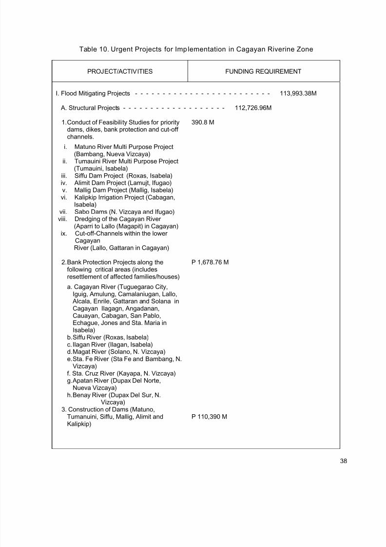
7/17/2019 Cagayan Riverine Zone Development Framework Plan 2005_2030
http://slidepdf.com/reader/full/cagayan-riverine-zone-development-framework-plan-20052030 47/57
Table 10. Urgent Projects for Implementation in Cagayan Riverine Zone
PROJECT/ACTIVITIES FUNDING REQUIREMENT
I. Flood Mitigating Projects - - - - - - - - - - - - - - - - - - - - - - - - - 113,993.38M
A. Structural Projects - - - - - - - - - - - - - - - - - - - 112,726.96M
1. Conduct of Feasibility Studies for prioritydams, dikes, bank protection and cut-offchannels.
i. Matuno River Multi Purpose Project(Bambang, Nueva Vizcaya)
ii. Tumauini River Multi Purpose Project(Tumauini, Isabela)
iii. Siffu Dam Project (Roxas, Isabela)iv. Alimit Dam Project (Lamujt, Ifugao)
v. Mallig Dam Project (Mallig, Isabela)vi. Kalipkip Irrigation Project (Cabagan,
Isabela)vii. Sabo Dams (N. Vizcaya and Ifugao)viii. Dredging of the Cagayan River
(Aparri to Lallo (Magapit) in Cagayan)ix. Cut-off-Channels within the lower
CagayanRiver (Lallo, Gattaran in Cagayan)
390.8 M
2. Bank Protection Projects along thefollowing critical areas (includesresettlement of affected families/houses)
a. Cagayan River (Tuguegarao City,Iguig, Amulung, Camalaniugan, Lallo,
Alcala, Enrile, Gattaran and Solana inCagayan Ilagagn, Angadanan,Cauayan, Cabagan, San Pablo,Echague, Jones and Sta. Maria inIsabela)
b. Siffu River (Roxas, Isabela)c. Ilagan River (Ilagan, Isabela)d. Magat River (Solano, N. Vizcaya)e. Sta. Fe River (Sta Fe and Bambang, N.
Vizcaya)f. Sta. Cruz River (Kayapa, N. Vizcaya)
g. Apatan River (Dupax Del Norte,Nueva Vizcaya)h. Benay River (Dupax Del Sur, N.
Vizcaya)
P 1,678.76 M
3. Construction of Dams (Matuno,Tumanuini, Siffu, Mallig, Alimit andKalipkip)
P 110,390 M
38
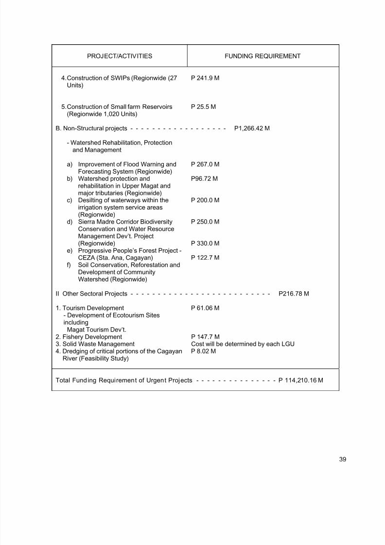
7/17/2019 Cagayan Riverine Zone Development Framework Plan 2005_2030
http://slidepdf.com/reader/full/cagayan-riverine-zone-development-framework-plan-20052030 48/57
PROJECT/ACTIVITIES FUNDING REQUIREMENT
4. Construction of SWIPs (Regionwide (27Units)
P 241.9 M
5. Construction of Small farm Reservoirs(Regionwide 1,020 Units)
P 25.5 M
B. Non-Structural projects - - - - - - - - - - - - - - - - - - P1,266.42 M
- Watershed Rehabilitation, Protectionand Management
a) Improvement of Flood Warning andForecasting System (Regionwide)
b) Watershed protection andrehabilitation in Upper Magat and
major tributaries (Regionwide)c) Desilting of waterways within the
irrigation system service areas(Regionwide)
d) Sierra Madre Corridor BiodiversityConservation and Water ResourceManagement Dev’t. Project(Regionwide)
e) Progressive People’s Forest Project -CEZA (Sta. Ana, Cagayan)
f) Soil Conservation, Reforestation andDevelopment of CommunityWatershed (Regionwide)
P 267.0 M
P96.72 M
P 200.0 M
P 250.0 M
P 330.0 M
P 122.7 M
II Other Sectoral Projects - - - - - - - - - - - - - - - - - - - - - - - - - - P216.78 M
1. Tourism Development- Development of Ecotourism SitesincludingMagat Tourism Dev’t.
P 61.06 M
2. Fishery Development P 147.7 M3. Solid Waste Management Cost will be determined by each LGU 4. Dredging of critical portions of the Cagayan
River (Feasibility Study)P 8.02 M
Total Fund ing Requirement of Urgent Projects - - - - - - - - - - - - - - - P 114,210.16 M
39
7/17/2019 Cagayan Riverine Zone Development Framework Plan 2005_2030
http://slidepdf.com/reader/full/cagayan-riverine-zone-development-framework-plan-20052030 49/57
Monitoring and Evaluation
The implementation of the Plan shall be closely monitored through the assistance of theProvincial/City/Municipal Land Use Committees (P/C/MLUCs). Part of the implementingmechanism shall be a monitoring system that shall be established involving major/criticalagencies such as the DENR, DA, BFAR, DPWH, DOTC and DTI. The Results Monitoring
Evaluation (RME) System will be employed as much as possible in the monitoring process.Close coordination between RLUC, PLUCs and C/MCLUCs in the monitoring of the Planimplementation shall be established.
Plan Implementation Support
1. Plan Advocacy
The support of the local government units is crucial in the implementation of the Plan.Hence, involvement of the LGUs, from planning to implementation and monitoring andevaluation is mandatory. As a policy framework document, mainstreaming of the RiverinePlan in the different LGUs shall be a challenge in the implementation of the document.
Part of the commitment and support of the provinces, cities and concerned municipalitiesshall be the preparation of their respective Riverine Plan counterpart. Concerned LGUsshall formulate their respective riverine plans.
The conduct of provincial, city and municipal consultation shall be complemented by IECactivities. Printed materials (popularize the plan) will be distributed which will beaugmented with radio and cable TV presentations in conjunction with the programs of theDILG.
2. Capability Building
The Regional Development Council (RDC2) and its member agencies and LGUs shall betechnically capable in the different facets of riverine development. Ideally, theimplementing structure shall be a well rounded and technically equipped body. Itsmembers shall undergo series of capacity-building activities to have adequate exposure inriverine policy making and management.
Equally important shall be the conduct of field visits and exposure trips to existing orsimilar institutions for the sharing of experiences and practices.
3. Research and Technical Assistance
Regional Line Agencies (RLAs), State Universities and Colleges (SUCs) and other bodies
will be regularly tapped to provide technical assistance in the conduct of researches andpreparation of proposals in order to assure better projects and development activities in
the Zone.
40
7/17/2019 Cagayan Riverine Zone Development Framework Plan 2005_2030
http://slidepdf.com/reader/full/cagayan-riverine-zone-development-framework-plan-20052030 50/57
APPENDICES
Appendix I
Specific Policies on land and water utilization, protection and management:
• P.D.1586: ESTABLISHING AN ENVIRONMENTAL IMPACT STATEMENT SYSTEM,INCLUDING OTHER ENVIRONMENTAL MANAGEMENT RELATED MEASURES ANDFOR OTHER PURPOSES.
Environmental Impact Statements provides the establishment and institutionalization of asystem whereby the exigencies of socio-economic undertakings can be reconciled with therequirements of environmental quality. It also caused for the declaration of certain projects,undertakings or areas in the country as environmentally critical. For this purpose, the properland and water use pattern for the areas of said critical projects shall be prepared . The decreealso declared the policy of the State to attain and maintain a rational and orderly balancebetween socio-economic growth and environmental protection. Specifically, to ensure theprotection of river systems, aquifers and mangrove vegetations from pollution andenvironmental degradation:
• R.A.No.7586: AN ACT PROVIDING FOR THE ESTABLISHMENT AND MANAGEMENT OFNATIONAL INTEGRATED PROTECTED AREAS SYSTEM, DEFINING ITS SCOPE ANDCOVERAGE, AND FOR OTHER PURPOSES
National Integrated Protected Areas System Act of 1992 recognizes the critical importance ofprotecting and maintaining the natural biological and physical diversities of the environmentnotably on areas with biologically unique features to sustain human life and development, aswell as plant and animal life. In this regard, the State adopts the policy to establish acomprehensive system of integrated protected areas within the classification of national parkas provided for by the Constitution for the purpose of securing perpetual existence of all
native plants and animals for the present and future generations.
• Department of Agr icul ture, Administrative Order No. 38 Series of 1999
Adoption of strategic Agriculture and Fishery Development Zones (SAFDZ) and the Networkof Protected Areas for Agriculture and Agro-industrial Development (NPAAD) as the primenatural and economic resource endowments for the modernization of agriculture and fisherysectors in the Philippines and providing institutional mechanisms for their sustainableutilization, management and protection
• P.D.1067: The Water Code of the Philipp ines
The 1976 Water Code of the Philippines adopts a basic law governing the ownership,appropriation, utilization, exploitation, development, conservation and protection of waterresources and rights to land thereto. It provides that any watershed or any area of landadjacent to any surface water or overlaying any ground water may be declared as protectedarea. Rules and regulations may be promulgated to prohibit or control such activities by theowners or occupants thereof within the protected area which may damage or cause thedeterioration of the surface water or groundwater or interfere with the investigation, use,control, protection, management or administrative of such waters.
41
7/17/2019 Cagayan Riverine Zone Development Framework Plan 2005_2030
http://slidepdf.com/reader/full/cagayan-riverine-zone-development-framework-plan-20052030 51/57
• PD 1152- Philippine Environmental Code
The Code prescribed the management guidelines aimed to protect and improve the quality ofPhilippine water resources through a) classification of Philippine Waters according to bestusage, b) establish of water quality standards, c) protection and improvement of the qualityand d) responsibilities for surveillance and mitigation of pollution incidents.
• RA 6657 : Agrarian Reform Law
The law provides that no conversion of public agricultural lands into other uses except whenthe land will have greater economic value for residential, commercial and industrial purposesas determined by the local government units and concurred by concerned agencies that theDepartment of Agrarian Reform may authorized the reclassification or conversion anddeposition of the land.
• RA 8550: Fisheries Code
Provides for the conservation, protection and sustained management of the country's fisheryand aquatic resources, the improvement of productivity of aquaculture within ecological limits
Instructs the BFAR to coordinate with LGUs, FARMCs,a nd other government agencies in thedevelopment, conservation, protection, utilization and management of fisheries and aquaticresources.
Mandates the LGUs to prohibit or limit fishery whenever it is determined by the LGU and theDA that a municipal water is overfished based on available data or information or in danger ofbeing overfished, and that there is a need to regenerate the fishery resources in that water,the LGU shall prohibit or limit fishery activity in the said waters.
Stipulates that not over ten percent (10%) of the suitable water surface; area of all lakes andrivers shall be allotted for aquaculture purposes like fish pens, fish cages and fish traps; andthe stocking density and feeding requirement which shall he controlled and determined by itscarrying capacity:
• REPUBLIC ACT NO. 8435: AGRICULTURE AND FISHERIES MODERNIZATION ACT OF1997
States that development should be compatible with the preservation of the ecosystem inareas where agriculture and fisheries activities are carried out. The State should exert careand judicious use of the country's natural resources in order to attain long-term sustainability
•
RA 7160: Local Government Code 1991
Local Government Code of 1991 states that a city or municipality may classify agriculturallands provided that there exists an approved zoning ordinance implementing itscomprehensive land use plan and provided that it is within the limits prescribed thereof. It isfurther stated that agricultural lands maybe classified if it cease to be economically feasibleand sound agricultural purposes or when the land shall have substantially greater economicvalues for residential, commercial and industrial purposes. Agricultural lands may bereclassified in excess of the limits for food production, human settlements, ecological
42
7/17/2019 Cagayan Riverine Zone Development Framework Plan 2005_2030
http://slidepdf.com/reader/full/cagayan-riverine-zone-development-framework-plan-20052030 52/57
considerations, and other relevant factors in the city or municipality. Cities and municipalitiesare also mandated to prepare and update their respective comprehensive land use plansenacted through zoning ordinances which shall be the basis for use of their resources andreclassification of agricultural lands.
• Republ ic Act No. 8041: Water Crisis Act of 1995
Declared the policy of the State to adopt urgent and effective measures to address thenationwide water crisis which adversely allocate the health and well-being of the population,food production and industrialization process and that issues relevant to the water crisisincluding, but not limited to, supply , distribution , finance , privatization of state-run waterfacilities, the protection and conservation of watersheds and the waste and pilferage of water,should be addressed
• R.A. NO. 9003: An Act Providing for an ecological Solid Waste Management Program,Creating the Necessary Institutional Mechanisms and Incentives, Declaring Certainacts Prohibited and Providing Penalties, Appropriating Funds Thereof, and for OtherPurpose.
This is an act enforcing local government units to properly manage their solid waste disposal. A system of segregation and collection of solid waste shall be established by the LGU fromthe barangay level. Proper disposal of disposable waste should also be done by establishingsanitary landfills.
43
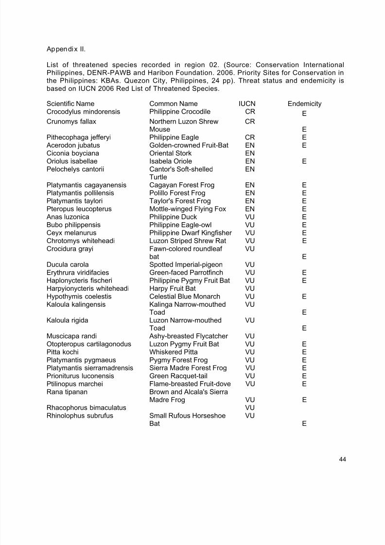
7/17/2019 Cagayan Riverine Zone Development Framework Plan 2005_2030
http://slidepdf.com/reader/full/cagayan-riverine-zone-development-framework-plan-20052030 53/57
Appendix II.
List of threatened species recorded in region 02. (Source: Conservation InternationalPhilippines, DENR-PAWB and Haribon Foundation. 2006. Priority Sites for Conservation inthe Philippines: KBAs. Quezon City, Philippines, 24 pp). Threat status and endemicity isbased on IUCN 2006 Red List of Threatened Species.
Scientific Name Common Name IUCN EndemicityCrocodylus mindorensis Philippine Crocodile CR ECrunomys fallax Northern Luzon Shrew
MouseCR
EPithecophaga jefferyi Philippine Eagle CR E Acerodon jubatus Golden-crowned Fruit-Bat EN ECiconia boyciana Oriental Stork ENOriolus isabellae Isabela Oriole EN EPelochelys cantorii Cantor's Soft-shelled
TurtleEN
Platymantis cagayanensis Cagayan Forest Frog EN E
Platymantis pollilensis Polillo Forest Frog EN EPlatymantis taylori Taylor's Forest Frog EN EPteropus leucopterus Mottle-winged Flying Fox EN E Anas luzonica Philippine Duck VU EBubo philippensis Philippine Eagle-owl VU ECeyx melanurus Philippine Dwarf Kingfisher VU EChrotomys whiteheadi Luzon Striped Shrew Rat VU ECrocidura grayi Fawn-colored roundleaf
batVU
EDucula carola Spotted Imperial-pigeon VUErythrura viridifacies Green-faced Parrotfinch VU EHaplonycteris fischeri Philippine Pygmy Fruit Bat VU E
Harpyionycteris whiteheadi Harpy Fruit Bat VUHypothymis coelestis Celestial Blue Monarch VU EKaloula kalingensis Kalinga Narrow-mouthed
ToadVU
EKaloula rigida Luzon Narrow-mouthed
ToadVU
EMuscicapa randi Ashy-breasted Flycatcher VUOtopteropus cartilagonodus Luzon Pygmy Fruit Bat VU EPitta kochi Whiskered Pitta VU EPlatymantis pygmaeus Pygmy Forest Frog VU EPlatymantis sierramadrensis Sierra Madre Forest Frog VU EPrioniturus luconensis Green Racquet-tail VU E
Ptilinopus marchei Flame-breasted Fruit-dove VU ERana tipanan Brown and Alcala's Sierra
Madre Frog VU ERhacophorus bimaculatus VURhinolophus subrufus Small Rufous Horseshoe
BatVU
E
44
7/17/2019 Cagayan Riverine Zone Development Framework Plan 2005_2030
http://slidepdf.com/reader/full/cagayan-riverine-zone-development-framework-plan-20052030 54/57
Continuation of Appendix II.Scientific Name Common Name IUCN EndemicityRhinomyias insignis White-browed Jungle-
flycatcherVU
ERhyacornis bicolor Luzon Water-redstart VU ESpizaetus philippensis Philippine Hawk-eagle VU E
Sus philippensis Philippine Warty Pig VU EVaranus olivaceus Monitor Lizard VU EZoothera cinerea Ashy Ground Thrush VU EFlora
Scientific Name Common Name IUCNDipterocarpus gracilis Panau CR NEDipterocarpus grandiflorus Apitong CR NEDipterocarpus hasselti CR ?Dipterocarpus kerrii Malapanau CR NEDipterocarpus kunstleri CR NEDipterocarpus validus Hagakhak CR NE
Hopea acuminata Manggchapui/Dalingdingan CR EHopea cagayanensis CR EHopea malibato Broad-winged Apitong CR EHopea plagata Saplungan CR NEParashorea malaanonan CRShorea contorta White Lauan CR EShorea guiso Guijo CRShorea malibato CR EShorea negrosensis Red Lauan CR E
Shorea palosapis Mayapis CR EShorea polysperma Tanguile CR EVatica pachyphylla CR E
Gloeocarpus patentivalvis Tamaho EN EGuioa discolor EN EGuioa myriadenia EN E
Mangifera monandra _ EN EVatica mangachapoi Narig EN NE Agathis philippensis Almaciga VU ?
Aglaia aherniana Alamag VU E
Aglaia pyriformis Panining-peneras VU E Alangium longiflorum VU NEDillenia philippinensis Katmon VU E
Dillenia reifferscheidtia (D.reifferscheidia [?]) Katmon Kalabau VU E
Diospyros blancoi VU EDiplodiscus paniculatus Balobo VU EFicus ulmifolia Is-is VU E
Guioa bicolor Kaninging VU ELithocarpus ovalis VU EMacaranga caudatifolia VU EMangifera altissima Pahutan VU NE
45
7/17/2019 Cagayan Riverine Zone Development Framework Plan 2005_2030
http://slidepdf.com/reader/full/cagayan-riverine-zone-development-framework-plan-20052030 55/57
Appendix III. Check list of water b irds recorded along Cagayan River. This is adopted f romWeerd and Ploeg 2004.
46
7/17/2019 Cagayan Riverine Zone Development Framework Plan 2005_2030
http://slidepdf.com/reader/full/cagayan-riverine-zone-development-framework-plan-20052030 56/57
Continuation of Appendix III
47
7/17/2019 Cagayan Riverine Zone Development Framework Plan 2005_2030
http://slidepdf.com/reader/full/cagayan-riverine-zone-development-framework-plan-20052030 57/57
Continuation of Appendix II