Embed Size (px)
Citation preview

Cadastre and Cadastral Cadastre and Cadastral ResearchResearch
Gerhard NavratilGerhard NavratilInstitute for Geoinformation and Institute for Geoinformation and
CartographyCartographyResearch Group GeoinformationResearch Group Geoinformation

Gerhard [email protected]
Outline
• Introduction to Austrian land administration• Cadastral Research
– Understanding the past– Improving the present– Shaping the future
• Concluding remarks

Gerhard [email protected]
Austrian Land Administration
Land Register Parcel-ID Cadastre• Land Register
– Registration of title– Transfer of property requires document and
registration• Cadastre
– Complete coverage– Boundaries and land use

Gerhard [email protected]
Austrian Land Register (1)
At the local courts, civil law regulationsPrinciples of
– Publicity (formal/material)– Inscription– Predecessor– Priority– Legality– Evidence
Gerhard [email protected]
Austrian Land Register (2)
Goals– Documentation of
ownership– Protecting private
rights
(www.meingrundstueck.at)

Gerhard [email protected]
Austrian Cadastre (1)
At the ministry of economy (BEV), public law regulations
Principles– Complete documentation– Unique identifiers– Positional reference– Accuracy– Security– Documentation of changes– Up-to-dateness of data

Gerhard [email protected]
Austrian Cadastre (2)
Goals– Documentation of tesselation– Basis for land taxation– Large scale map– Geographic reference
for land register
(Hackl, 2007)

Gerhard [email protected]
Understanding the Past
• Understanding the concepts– Why this design?– General concepts behind the cadastral
design? Process knowledge, alternative models
• Understanding the technology– Limitations in the past?– Technological improvement? Historic changes (data/documentation)

Gerhard [email protected]
Cadastral Processes (1)
Rights connect land to persons, need to be• Created• Changed / Transferred• Checked• Enforced
legal subjectnatural, juridical
persons
rights
legal objectreal estate objects
physical objectparcel, building
(Twaroch & Muggenhuber 1997)

Gerhard [email protected]
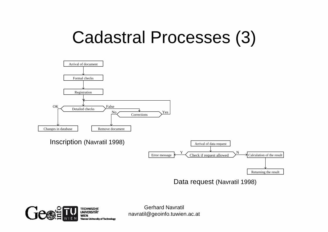
Cadastral Processes (2)
Two types or processes• Data requests• Inscriptions (updates, corrections,
additions, …)
Persons Owners
Data request Inscription
Database (Navratil 1998)
Gerhard [email protected]
Cadastral Processes (3)Arrival of document
Formal checks
Registration
Detailed checks
Changes in database
Corrections
Remove document
OKYes
FalseNo
Arrival of data request
Check if request allowedError message Calculation of the result
Returning the result
Y N
Inscription (Navratil 1998)
Data request (Navratil 1998)

Gerhard [email protected]
Process Design: Sale (1)
Cadastre/Land register are trusted sources reliance on correctness
Possible problems during purchase of property? (Navratil et al. 2005)
• Involuntary sale• Seller not owner• Sold twice• Payment problemsLand register deals with these problems!

Gerhard [email protected]
Process Design: Sale (2)
• Involuntary sale – involvement of notary in signing process
• Seller not owner – trusted system• Sold twice – rank certificate• Payment problems – involvement of notary
in payment processDiscussion helps to understand why an
exiting system is designed as it is!

Gerhard [email protected]
Process Design: Expropriation
Def: „to take land from its owner; esp., to take for public use or in the public interest, as by right of eminent domain.“ (Neufeldt 1997)
• Public use/public interest• Minimum extent• Compensation (height?)

Gerhard [email protected]
Spatial Extent of Parcels
Different kinds of documentation possible (Navratil 2011a)
• A single point (with area) as an anchor of ownership
• Verbal description of the boundary• Graphical representation of the boundary• Mathematical representation of the
boundary

Gerhard [email protected]
Limitations in the Past: Areas
• Different types of area estimation: Triangles, weighting, counting(later: planimeter, from coordinates)
• Area calculated twice, maximum error for difference:– 1:2880– 1:1440– 1:720
FF 500.0001.0FF 250.0001.0FF 125.0001.0

Gerhard [email protected]
Use and Economic Importance of Area
• Value of land (no guarantee of correctness)
• Land tax (ha)
• Legal properties (e.g., right to hunt)

Gerhard [email protected]
Steps
• Re-projection for map projection changeazimuthal projection Gauß-Krüger
• Re-projection for scale change• Re-drawing• Digitization• Map ‚improvement‘
No quality estimates found (Molzer 2012)

Gerhard [email protected]
Comparable Maps?
Forrest maps of Austrian National Forrests(OeBF)
Created 1850-Digitized 1990-93Scanned 2007How does it match
with the DKM?

Gerhard [email protected]
Improving the Present
• How to deal with problems from the past
• User needs and capabilities
• Legal aspects
• International comparison

Gerhard [email protected]
Problems from the Past (1)
Homogeneity of the coordinate frame insufficient
Method to adapt data of powersuppliers
(Höggerl & Imrek 2007)

Gerhard [email protected]
Cadastral Quality
• Law stipulates 15cm for coordinate cadastre
• Metadata for INSPIRE data set: 10m• Corrections of up to 150m (in the
mountains)
What is the geometrical quality?How shall land owners understand this?

Gerhard [email protected]
Classification of Deviations (1)
Reasons for deviations:• Original surveys imprecise• Reality changed• Data changed

Gerhard [email protected]
Classification of Deviations (2)Reality changed• Plate tectonics• Land slides• Changes of coastlines or riverbeds• Change of sea level• Optimization of land use (agreement between
owners)• Accidentally change of parcel extent• Pushing the boundaries (e.g., farmers)

Gerhard [email protected]
Classification of Deviations (3)
Data changed• Transformation• Re-projection• Redrawing• Digitizing• Homogenization

Gerhard [email protected]
Classification SchemeDeviation from
Observation Data ManagementTransformationRe-Projection
RedrawingDigitizing
Homogenization
Change of Reality
Physical ChangePlate Tectonics
Land SlideCoastal/Riverbed Change
Rise of Sealevel
Social ChangePractical Simplification
Boundary Push

Gerhard [email protected]
Existing Data Sets
• Original survey („Urmappe“)
• Change documents
• Observations of the current reality

Gerhard [email protected]
Check with Change Documents (1)
Update documentsMeasures shouldbe unchanged in the digital cadastral map
Statistical evaluationpossible

Gerhard [email protected]
Check with Change Documents (2)Distribution of Deviations In Vienna
0
5
10
15
20
25
30
35
40
45
50
-2.8
... -
2.6
-2.6
… -2
.4
-2.4
… -2
.2
-2.2
… -2
.0
-2.0
… -1
.8
-1.8
… -1
.6
-1.6
… -1
.4
-1.4
… -1
.2
-1.2
… -1
.0
-1.0
… -0
.8
-0.8
… -0
.6
-0.6
… -0
.4
-0.4
… -0
.2
-0.2
… 0
.0
0.0
… +
0.2
+0.2
… +
0.4
+0.4
… +
0.6
+0.6
… +
0.8
+0.8
… +
1.0
+1.0
… +
1.2
+1.2
… +
1.4
+1.0
… +
1.6
+1.4
… +
1.2
+1.6
… +
1.8
+1.8
… +
2.0
+2.0
… +
2.2
+2.2
… +
2.4
+2.4
… +
2.6
Deviation in [m]
Urban area, 234 distancesBetween 5 and 94m
Rural area, 38 distancesBetween 2.4 and 84m
Distribution of Deviations in Carinthia
0
0,5
1
1,5
2
2,5
3
3,5
4
4,5
-2.8
... -
2.6
-2.6
… -2
.4
-2.4
… -2
.2
-2.2
… -2
.0
-2.0
… -1
.8
-1.8
… -1
.6
-1.6
… -1
.4
-1.4
… -1
.2
-1.2
… -1
.0
-1.0
… -0
.8
-0.8
… -0
.6
-0.6
… -0
.4
-0.4
… -0
.2
-0.2
… 0
.0
0.0
… +
0.2
+0.2
… +
0.4
+0.4
… +
0.6
+0.6
… +
0.8
+0.8
… +
1.0
+1.0
… +
1.2
+1.2
… +
1.4
+1.0
… +
1.6
+1.4
… +
1.2
+1.6
… +
1.8
+1.8
… +
2.0
+2.0
… +
2.2
+2.2
… +
2.4
+2.4
… +
2.6
Deviation in [m]
(Navratil 2011b)

Gerhard [email protected]
How to Model the Accuracy?
Possibility Distributions?
1 cm 1 m 10 m 5 cm
1 Week 200 years
(Navratil 2007)
Positional accuracy Currency

Gerhard [email protected]
User Needs
Land owners need correct and reliable information– Relative position to their neighbours– High accuracy

Gerhard [email protected]
User Capabilities
Measure horizontal distance of 6 / 36 / 70m with a tape measure
(Navratil & Hackl 2008)

Gerhard [email protected]
Legal Aspects (1)
• Discussion of new decree / new law for surveying
• How to fix quality in a law?Adjustment too expensive / complicated?Define terms correctly?

Gerhard [email protected]
Legal Aspects (2)
Legal vs. technical decision makingExample
– Legal distance 4m– True distance 3.96m– Accuracy of parcel
boundary 15cmStatistical test: Hypothesis accepted that
distance is ok …Court decision: Distance is too small …
minimum distance4.00m
building
parcel boundary

Gerhard [email protected]
International Comparison (1)
Land administration Austria and Serbia
(Mansberger et al. 2011)

Gerhard [email protected]
International Comparison (2)
• Austrian system for export?Has been exported to Russia!
• Can we learn from experiences on quality improvement in Germany?Would provide 16 reports!Especially experiences from ALKIS would be valuable

Gerhard [email protected]
Shaping the Future
• Potentials in land administration• Measurement-based cadastre• 3D-cadastre• Public-law property restrictions• i-Cadastre?
Gerhard [email protected]
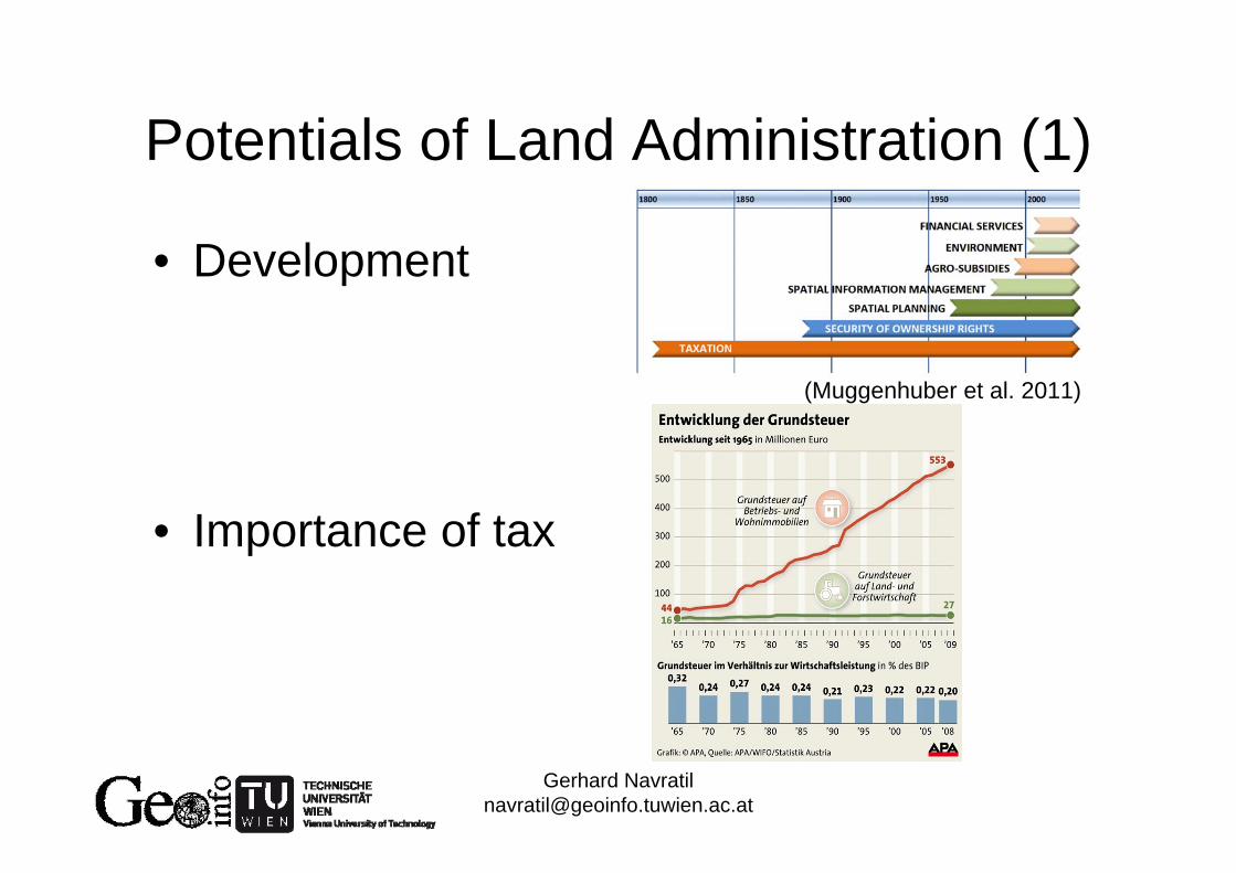
Potentials of Land Administration (1)
• Development
• Importance of tax
(Muggenhuber et al. 2011)

Gerhard [email protected]
Potentials of Land Administration (2)
Parameters for Innovation
Each segment has potentiale.g., change detection by
crowd sourcing, cadastreas basis of geodatainfrastructure, eGovernment,application of airborne laser scanning and digital photogrammetry, in-situ and real-time application, …

Gerhard [email protected]
Measurement-based Cadastre (1)
Measurements define the geometry and are stored in the system, coordinates are computed if necessary
e.g., ArcGISSurveyAnalyst
(Navratil & Franz2004)
Gerhard [email protected]
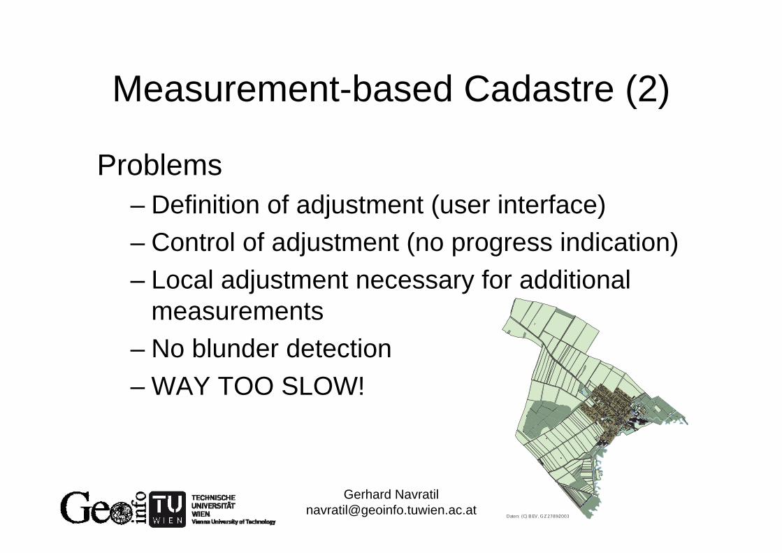
Measurement-based Cadastre (2)
Problems– Definition of adjustment (user interface)– Control of adjustment (no progress indication)– Local adjustment necessary for additional
measurements– No blunder detection– WAY TOO SLOW!
Daten: (C) BEV, GZ 2789/2003

Gerhard [email protected]
3D-Cadastre (Navratil & Unger submitted)
• Do we need it?• What is a suitable height system?
– Dynamic heights– Orthometric heights– Normal heights– Ellipsoidal heights
• Quality requirements?• Absolute or relative

Gerhard [email protected]
Public-Law Property Restrictions (1)
Heavy impact on value of property relevant for
– Real estate broker– Credit institutes– Tax authority (?)
How to implement it?What are relevant restrictions?Who has the data?

Gerhard [email protected]
Public-Law Property Restrictions (2)
Central access vs. de-central storage
(Spangl & Navratil submitted)

Gerhard [email protected]
i-Cadastre (Navratil et al. 2011)
• Cadastre as a location-based service– Location independent access to cadastral
data– More accurate location information for
applications• Examples
– Fishing permit– Ownership query– Illegal garbage disposal

Gerhard [email protected]
Concluding Remarks
• Cadastres are long-lasting systems• We need to understand the past to shape
the future• We need to investigate market needs• We need to adapt modern technologies
What are you waiting for? Do it!

Gerhard [email protected]
References• Hackl, M. (2007) Dreidimensionaler Kataster. Master Thesis. TU Wien.• Höggerl, N. & Imrek, E. (2007) Recent Steps towards the Introduction of ETRS89 in Austria. Geodetski Vestnik,
51(4): 742-750.• Mansberger, R., Aleksic, I., Muggenhuber, G. Navratil, G., Tesla, N., Twaroch, C. (2011) Land Administration
Systems in Austria and Serbia: Current Tasks and Potentials. 1st Serbian Geodetic Congress • Molzer, M. (2012) Von der Urmappe zur DKM: Untersuchung der Umbildungsschritte. Bachelor Thesis. TU Wien.• Muggenhuber, G., Navratil, G., Twaroch, C., Mansberger, R. (2011) Development and Potential for Improvement
of the Austrian Land Administration System. FIG Working Week 2011 • Navratil, G. (1998) An object-oriented model of a cadaster. Master Theses. TU Wien.• Navratil, G. (2007) Modeling Data Quality with Possibility-Distributions. 5th ISSDQ.• Navratil, G. (2011a) Cadastral Boundaries: Benefits of Complexity. URISA Journal, Vol. 23(1), pp. 19-27.• Navratil, G. (2011b) Quality Assessment for Cadastral Geometry. 7th ISSDQ.• Navratil, G. & Franz, M. (2004) Messbasierte Systeme mit ArcGIS Survey Analyst. AGIT • Navratil, G. & Hackl, M. (2008) Genauigkeit der von Laien durchgeführten horizontalen Seitenmessung. VGI,
96(1), pp. 27-36.• Navratil, G., Mansberger, R., Muggenhuber, G. (2011) i-Cadastre – A Prospective LBS-Tool for E-Government in
Land Management? 8th Symposium on LBS. • Navratil, G. Twaroch, F., Frank A.U. (2005) Complexity vs. Security in the Austrian Land Register. CORP 2005• Navratil, G. & Unger, E. (submitted to CEUS) Height Systems for 3D Cadastres.• Neufeldt, V. (1997) Webster's New World College Dictionary. Macmillan• Twaroch, C. & Muggenhuber, G. (1997) Evolution of land registration and cadastre; Case study: Austria. Joint
European conference on geographical information