Embed Size (px)
Citation preview

CADASTRAL STUDIES(MGU1014 / MGHU1514)
WEEK 12&13-NEW CADASTRAL SYSTEM IN MALAYSIA
SR DR. TAN LIAT CHOON07-5530844
016-4975551
1

OUTLINE
• Applied eCadastre
2

APPLIED eCADASTRE
3

OVERVIEW OF NDCDB
4

Surveyed value
System value• Different value for the same entity in PDUK
5
Previous System

CATEGORY
Std Dev
Northing
Std Dev
Easting
Urban/ New Development
± 5 cm
or better
± 5 cm
or better
Semi Urban/Rural ± 10 cm
or better
± 10 cm
or better
6
NDCDB Accuracy

7
NDCDB Cassini GeocentricGDM2000 (KPUP 2/2009)

PDUK/DCDB
NDCDB
8
NDCDB Cassini Geocentric GDM2000

No Status Code Description Map Object
1 PU 10 JabatanFile
Hardcopy : Register FileDigital PU: Receive and auto register file
Hardcopy: (No)Digital PU : (Yes – PU Layer)
LS File Pre-comp : Receive and auto register file Yes (PU Layer)
2 Survey 20 Job Ready for Survey Yes (PU Layer)
3 Surveyed 30 Job has been Surveyed Yes (Pre NDCDB)
4 Surveyed (Relative ) 35 Job has been Process eQC Relative Yes (Pre NDCDB Relative)
5 Generated PA 40 PA generated Yes (Pre NDCDB)
6 Generated PA (Relative) 45 PA generated Relative Yes (Pre NDCDB Relative)
7 Approve 50 PA Approved by CS Yes (Pre NDCDB)
8 Approved (Relative) 55 Relative PA Approved by CS Yes (Relative NDCDB)
9 NDCDB 65 Lot append into NDCDB Yes (NDCDB)
10 NDCDB (Relative) 75 Lot append into Relative NDCDB Yes (Relative NDCDB)
11 Inactive 99 Archive Lot Yes (Invisible to user)
12 Transition 60 Happen when there is New NDCDB Update;Existing Version of NDCDB will be set to status 60 to differentiate from the New Version NDCDB (65).
Hidden
13 9910 9910 PU Lot Without Map Object
14 9950 9950 New PDUK Lot without Map Object(Due to COD of R&R)
15 Strata Main Lot 81 Lot with Strata Job Yes (NDCDB Existing During Strata File Registration)9

PENDING FOR APPROVAL
PRECOMP
10
NDCDB Cassini Geocentric GDM2000

PU Lot (Lot Status = 10 and 20)
Default Visible
11

Pre NDCDB (Lot Status = 30, 40, 50)
Default Visible12

Pre-NDCDB Relative (Lot Status = 35, 45, 55)
Default InVisible(User Need to Turn On via Layer Control)
13
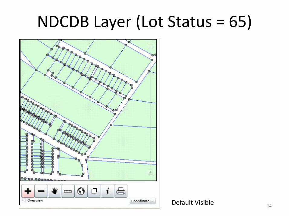
NDCDB Layer (Lot Status = 65)
Default Visible14

Relative NDCDB Layer (Lot Status = 75)
Default InVisible(User Need to Turn On via Layer Control)
15

Transition Layer
Default InVisible(User Need to Turn On via Layer Control)To View the Transition Layer, User need to Turn off the NDCDB Layer
16

Field 2 Finish (F2F)KPUP 2/2005 – System Coordinate
17

18
Previous System Coordinate

19
eCadastre System Coordinate

20
eCadastre System Coordinate

21
eCadastre System Coordinate

22
eCadastre System Coordinate

23
eCadastre System Coordinate

Field 2 Finish (F2F) KPUP 7/2005 – Pre-Comp
24

25
Coordinate Pre-Comp Data Format (Structure Description)

No NDCDB surrounding, therefore needed GDM2000 coordinates either by GNSS survey or traversing
26
Pre-Comp Criteria KPUP6/2009 Pg 17
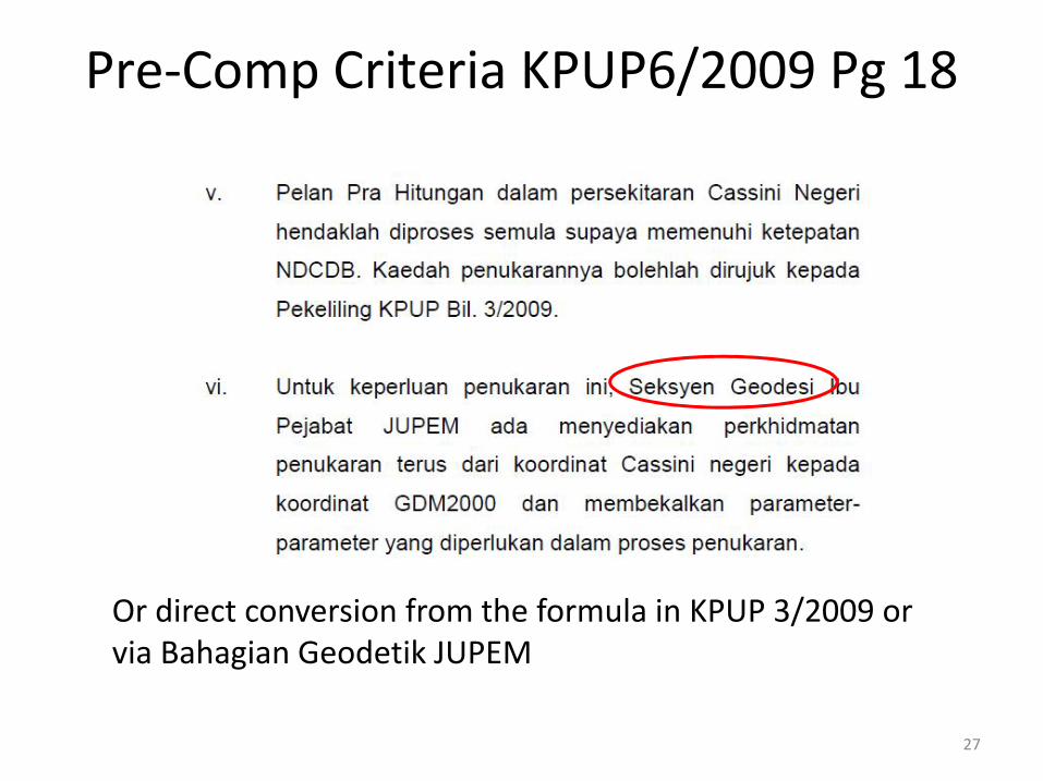
Or direct conversion from the formula in KPUP 3/2009 or via Bahagian Geodetik JUPEM
27
Pre-Comp Criteria KPUP6/2009 Pg 18
28
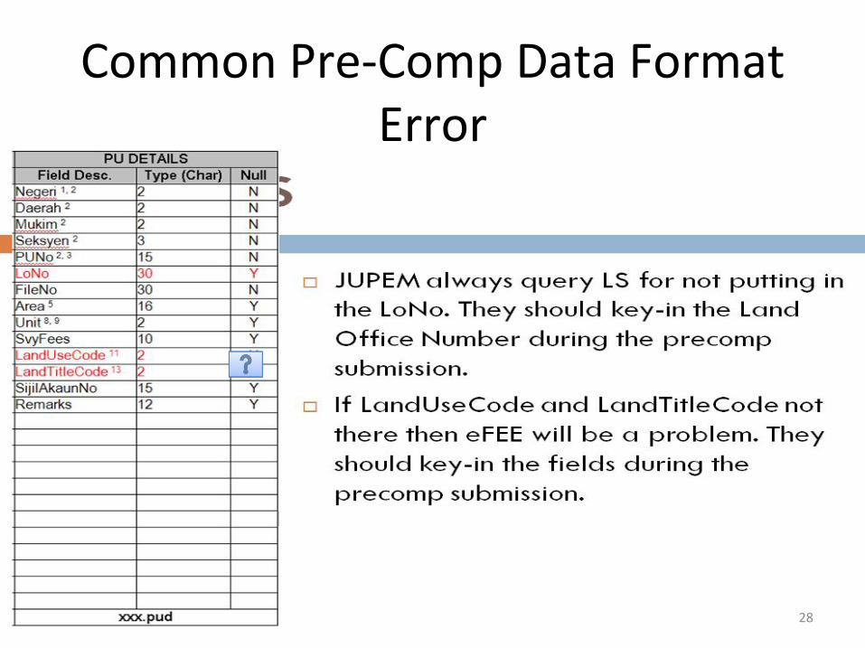
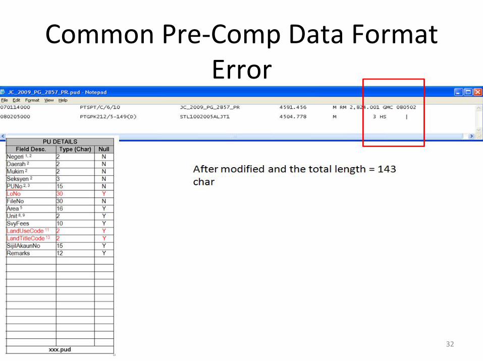
Common Pre-Comp Data Format Error

Land Office number is empty in the PUD file 29

30
Common Pre-Comp Data Format Error

31
Common Pre-Comp Data Format Error
32
Common Pre-Comp Data Format Error

The graphic shown only 2 lots 33
Common Pre-Comp Data Format Error

34
Common Pre-Comp Data Format Error

35
Common Pre-Comp Data Format Error

36
Common Pre-Comp Admin Area Validation

37
Common Pre-Comp Admin Area Validation

38
Sample Pre-comp ASCII –During Submission

Sample Approved Pre-comp ASCII (File Number and Lot Number Inserted)
39

Sample Pre-comp ASCII – During Submission For Resurvey Lot (Landed)
40

*
Submission For Resurvey Lot (Strata) –No pre-comp ASCII needed
Select Strata From the Drop Down List
Select Ukuran Semula From the Drop Down List
41

Submission For Resurvey Lot (Strata) –No pre-comp ASCII needed
*
42

Submission For Resurvey Lot (Strata) –No pre-comp ASCII needed
User need to fill in the UPI for the Resurvey LotAnd other necessary information
43

Field 2 Finish (F2F) KPUP 7/2005 – KPUP 11/2005 – Final Survey
44

45
F2F Data Format
46
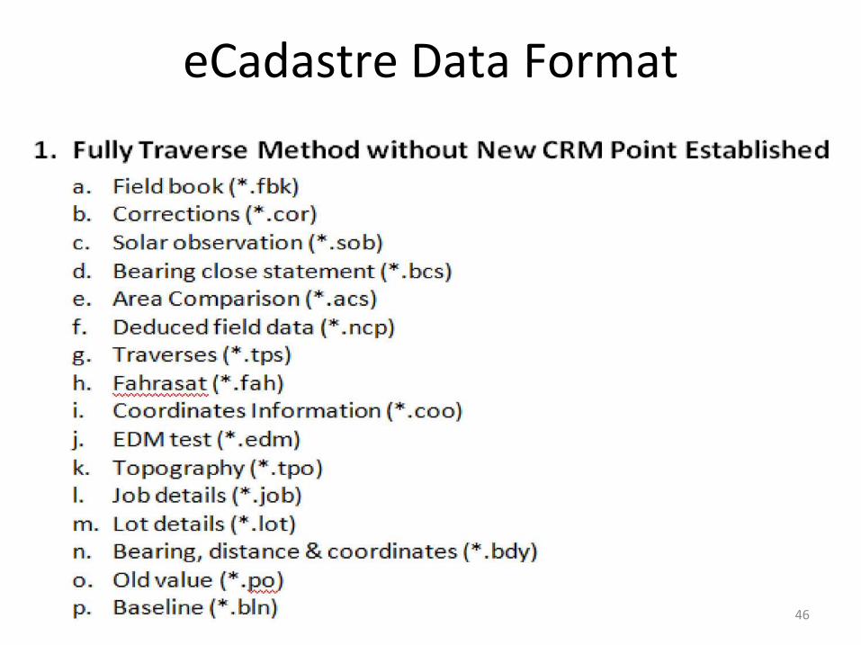
eCadastre Data Format

47
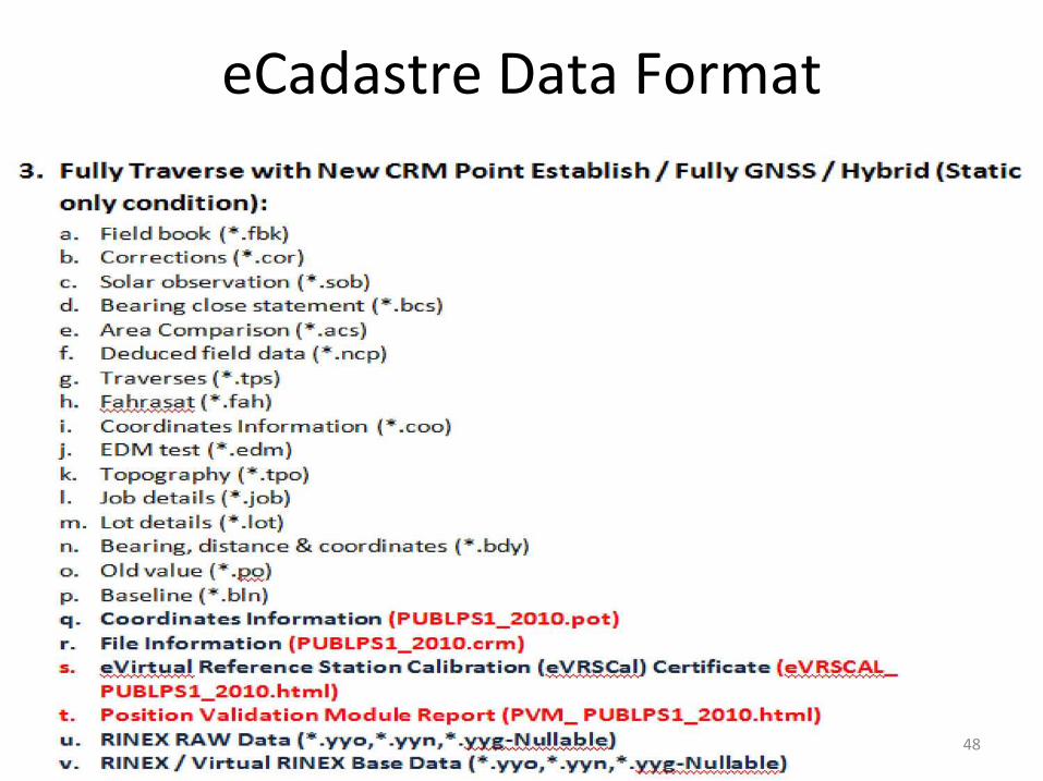
eCadastre Data Format
48
eCadastre Data Format

49
eCadastre NULLABLE Data Format

50
eCadastre Folder Structure

SAMPLE OF FINAL SURVEYFOLDER STRUCTURE
51

File folder without GNSS data
52

File folder with GNSS data
53

File folder with GNSS data : in CRM sub-folder
54

File folder with GNSS data : in GDSMPROJECT/RAW sub-folder
55

File folder with GNSS data : in SURVEYED/ASCII sub-folder
56
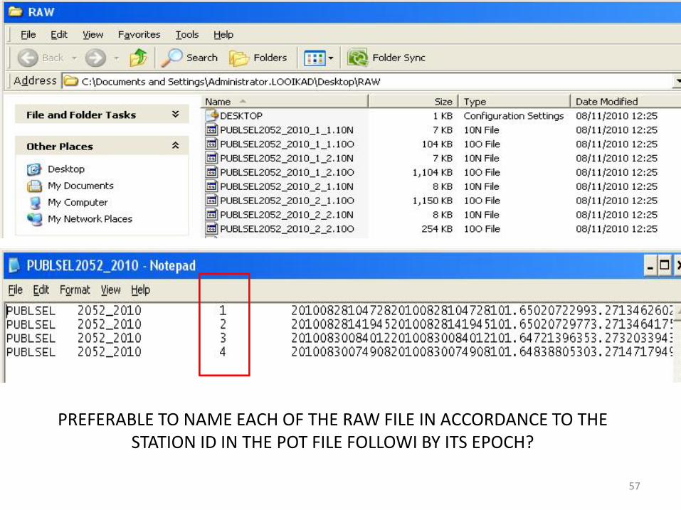
57
PREFERABLE TO NAME EACH OF THE RAW FILE IN ACCORDANCE TO THE STATION ID IN THE POT FILE FOLLOWI BY ITS EPOCH?

58
JUPEM NEED TO ASSIGN STNID TO MATCH THOSE IN POT FILE FOR RTK OBSERVATION WHEN PROCESS THE RINEX RAW FROM LS

59
THE PROCESSED RINEX RAW FROM LS IN JUPEM APPLICATION WILL BE USED TO COMPARE WITH THOSE IN POT FILE

FINAL SURVEY ASCIICOMMON ERROR
60

FILE NOT SUPPOSE TO BE NULL BECOME NULL
61
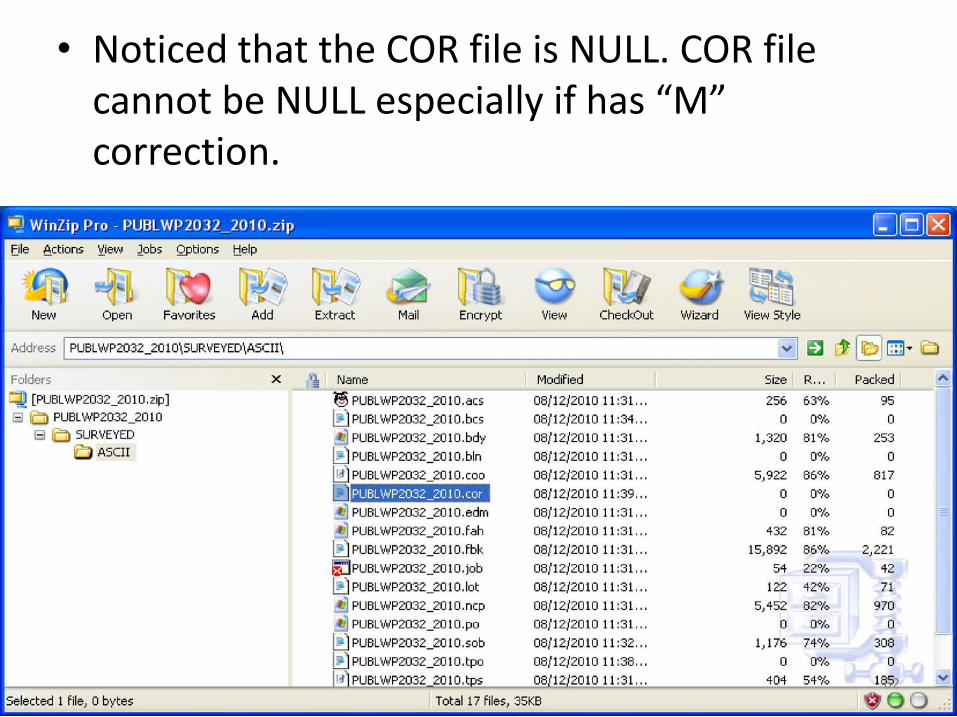
• Noticed that the COR file is NULL. COR file cannot be NULL especially if has “M” correction.
62

The FAH file is null (0 kb). This file is mandatory and must has data inside.
63
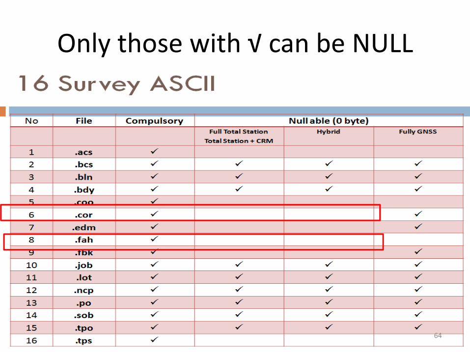
Only those with √ can be NULL
64

TIME FORMAT IN SOB WRONGLY DEFINED
65

Sun observation (SOB) file problem with date format.
66

After altering the Sun observation (SOB) file with the correct date format, the file is processed successfully
67

LOWER BOUND RESULT68

ERROR ASCII FILE - BCS
69

70

More than 30 minutes for a 102 lots file to upload to jupem2u Perak and still pending. 71

Then uncheck the 90% message box.
72

Check Error Log File
•Click to list the files relative to the selected Survey File
73

View Attachment
• Click on the ‘View Attachment’.
74

View Error Log File
• Click on the ‘View Attachment’.
75
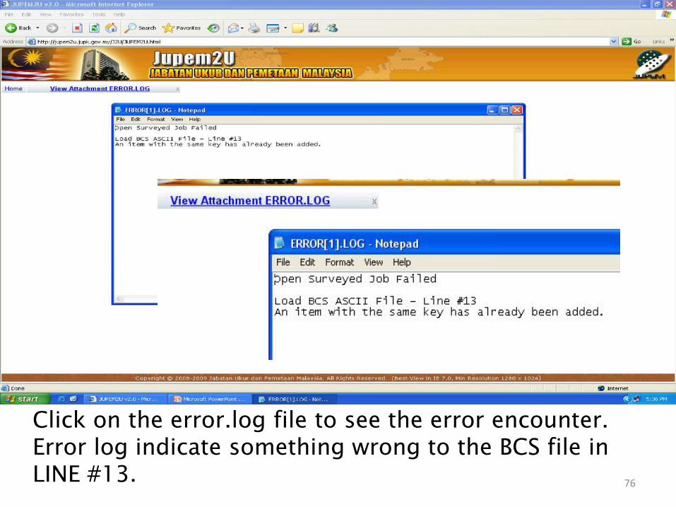
Click on the error.log file to see the error encounter. Error log indicate something wrong to the BCS file in LINE #13. 76

Might be due to these two duplicated record 109-10-11. Delete all the data in the BCS file and
resubmit. BCS file can be NULL.
77

Only those with √ can be NULL
78

Upload again the same file but with BCS file NULL at 1120am.
79

Result LOWER BOUND at 1122am. It is only taken 2 minutes to process online.
80

MASALAH ASCII FILE – TPSMark Description not defined
81

Mark Description in TPS file is not defined.
82

• TPS ASCII : “K” must be added– Sample
• COO ASCII : Attribute must match criteria as below:– Code = 6 , or – MarkDesc = All batu tanda (BKL, BL, pBKL…)
• Sample
– Code = 4– MarkDesc = BKL (Match)
• TPS and COO ASCII is valid, and stn 2 match the LSA fix point criteria. Thus, stn 2 will be used as Fix Station in LSA computation
Scenario I : NDCDB Station
* Station Type : Traverse = 4, GPS = 6 83

• TPS ASCII : “K” must be added– Sample
• COO ASCII : Attribute must match criteria as below:– Code = 6 , or – MarkDesc = All batu tanda (BKL, BL, pBKL…)
• Sample
– Code = 6 (Match)– MarkDesc = PB
• TPS and COO ASCII is valid, and stn 2 match the LSA fix point criteria. Thus, stn 2 will be used as Fix Station in LSA computation
Scenario II : GPS/CRM/CCI Station
* Station Type : GPS = 6 84

MASALAH FIXED POINTS- TPSnot meeting the minimum
requirement
85

FIELD SURVEY –
KPUP6/2009 Pg51
86

Fix Points In TPS
• 3 GPS points
• 2 GPS points + 1 NDCDB point
• 1 GPS point + 2 NDCDB points
• 3 NDCDB points
• PDUK POINTS ARE NOT ACCEPTED
87

Datum from CRM. No “C” correction needed as JUPEM is using LSA. CRM RAW files needed.
88
Field Survey-Closing by JUPEM

4
8
5
6
1
9
10
7
11
12
13
2
3
Datum with 3 good old marks (+-10cm compare to NDCDB). No “C” correction needed as JUPEM is using LSA. LS shall need to apply the “C”.
89

1
2
3
5
4
9
10
6
11
7
8
Datum with azimuth (SUN). No “C” correction needed as JUPEM is using LSA but “M” correction is crucial. LS shall need to apply the “M&C”.
90

System claimed no fixed points. The DAT file also does not contain any fixed points.
91

In the TPS file, STN1,2,3,4,5,7 are defined as fixed points
92
PRE-NDCDB
93

MASALAH ASCII FILE – TPSnot meeting the minimum
requirement
94

The ERROR.LOG shown no 3 fixed points
95

If there are 3 fixed points, they will be shown in the DAT file. But DAT only shown 1; there is STN22 even though TPS defined STN 22,14,1. Meaning to say, STN14 and 1 got problem.
96

By keying-in the STN22 coordinate using the COORDINATE icon at the bottom right, the cross displayed marked the STN22 location. It is NDCDB mark. 97

By keying-in the STN14 coordinate using the COORDINATE icon at the bottom right, the cross displayed marked the STN14 location. It is NOT an NDCDB mark. DARK GREEN represent PDUK and LIGHT GREEN represent NDCDB. 98

By keying-in the STN1 coordinate using the COORDINATE icon at the bottom right, the cross displayed marked the STN1 location. It is NOT an NDCDB mark. DARK GREEN represent PDUK and LIGHT GREEN represent NDCDB. 99

T H A N K YO U
100