Embed Size (px)
Citation preview

AA CCaaddaassttrraall GGeeooddaattaabbaassee ffoorr tthhee UU..SS.. FFiisshh && WWiillddlliiffee SSeerrvviiccee
Douglas L. Vandegraft ABSTRACT: The U.S. Fish & Wildlife Service “Cadastral Data Working Group,” comprised of Cartographers and GIS Specialists from all management Regions, has produced a state-of-the-art database that will store data for all interests in real property in the National Wildlife Refuge System. Upon completion, the Cadastral Geodatabase will become an integral component of the Refuge Lands Geographic Information System (RLGIS) by supplying boundary and parcel information to the biological geodatabases currently within the RLGIS data model. Cadastral data describes the past, current, and future right, title and interest in real property, including the spatial information necessary to describe the geographic extent. The spatial information includes survey and description frameworks such as the Public Land Survey System (PLSS), as well as parcel surveys and boundary descriptions. The geodatabase is the common data storage for attribute tables, geographic features, satellite and aerial imagery, surface modeling data, and survey measurements. A consistent and accurate Cadastral Geodatabase that is common across the nation and can be shared between Regions will enable users to leverage the spatial data to its full potential. Once implemented, the Cadastral Geodatabase will be able to answer boundary and land status queries on a national scale. KEYWORDS: Cadastral; geodatabase; U.S. Fish and Wildlife Service; National Wildlife Refuge System.
IInnttrroodduuccttiioonn The U.S. Fish & Wildlife Service (FWS) has been using geographic information system (GIS) technology since the mid-1980’s to map lands and waters for which they have management responsibility. This includes the National Wildlife Refuge System (NWRS), which consists of over 100 million acres located within 548 wildlife refuges (2008). The FWS manages these lands and waters through a regime of eight geographic “Regions,” defined primarily by State boundaries and physical geography (i.e. Region 3 is the Midwest Region, also known as the “Great Lakes / Big Rivers Region.”). While much of the day-to-day management of FWS lands occurs from Field Stations located near a particular wildlife refuge or other FWS property, most of the decisions affecting the entire Region are made from a designated “Regional Office” located in a major city within the Region. Primary mapping capabilities are also found in these Regional Offices. The responsibility for mapping the “land status” (cadastral) information for FWS lands has historically been assigned to the Division of Realty. The FWS Division of Realty has maintained land status maps in a standardized fashion since the 1940’s. Using traditional cartographic methods, the maps reflected the NWRS, national fish hatcheries, coordination (shared management) areas, and administrative sites. Most of the early (pre-1980) wildlife refuges were mapped on 1-3 sheets of paper or mylar, most of which included latitude/longitude coordinate tics along the map borders, and a PLSS township and range grid, where applicable. Because of the dynamic nature of the FWS land acquisition programs, the
maps required frequent revisions. The Alaska National Interest Lands Conservation Act of 1980 (Public Law 96-487, 12/2/1980) doubled the size of the NWRS, and eventually provided a large incentive to computer-automate the mapping processes for the FWS. In the 1980’s, several of the Regional Offices began using the “AutoCAD” software for their mapping activities. AutoCAD, made by Autodesk Inc., was the first mapping software to be incorporated into the official FWS standards for the mapping of real property. As revised in 1995, the “Maps” chapter of the FWS manual reflected AutoCAD hatch patterns to display the various land status categories. It also included guidelines for the specific “Rapidograph” pen size to use for the many linetypes used on the Realty maps. Separate from the “Maps” chapter effort, a FWS GIS Steering Committee was formed in 1991. The Steering Committee consisted of one representative from each Region, and was chaired by the National Spatial Data Manager. In 1996, the “Service Lands Spatial Data Guidelines Project” was launched. An ad hoc subcommittee of the FWS GIS Steering Committee developed a “Process Description for Creating and Managing Service Lands Boundary Digital Data” (“Standard Operating Procedure 98-01”) document. The objective of SOP 98-01 was to “provide an accurate, documented and nationally consistent method for creating and updating a spatial data layer for National Wildlife Refuge boundary information.” SOP 98-01 provided specific instructions for digitizing the Division of Realty land status maps. “Process 1” employed the “Arc/Info” software, made by Environmental Systems Research Institute Inc. (ESRI), and “Process 2” was for the AutoCAD software. The data digitized using AutoCAD was intended to be migrated to the Arc/Info coverage environment so that the refuge boundaries and individual land status polygons could be attributed. The attribution scheme decided upon for SOP 98-01 used several identical attributes for lines and polygons: IFWS Number = A specific number assigned to each refuge Refuge Name = three letter abbreviation of the full refuge name Refuge Unit = three letter abbreviation of any smaller management unit within the refuge The digitized lines (arcs) had a unique attribute: Boundary = type of boundary The boundary arcs were coded with a single letter indicating the type of boundary represented: L = legislative (the legislative boundary encompassing lands approved for acquisition by FWS) O = owned (the external boundary of lands currently owned by FWS) E = easement (the boundary of land where an easement or lease shares rights with the FWS) S = secondary (the boundary of land where the jurisdiction of FWS is secondary to another Federal agency) P = parcel (boundary lines representing units of acquisition, used primarily for private lands) Boundary arcs could also be coded with letter combinations: LO = (FWS owns the land bordering the legislative boundary) LE = (FWS has an easement bordering the legislative boundary) OE = (the boundary shared by FWS owned land and land with an easement) EX = (the boundary of a wetland easement) Polygons had two unique attributes:

Ownership Status = legal status of land ownership relative to the FWS Acreage of polygon = acreage of the polygon The ownership of the polygons were coded according to the following: O = owned (lands currently owned by FWS) I = inholding (private land within the legislative boundary with potential for acquisition) E = easement (land where an easement or lease shares rights with the FWS) S = secondary (land where the jurisdiction of the FWS is secondary to another Federal agency) X = exclusion (private land within the legislative boundary without potential for acquisition) U = uncertain (status is unknown, disputed, or requires research) The methodology and attribution scheme described in SOP 98-10 was adopted by all of the Regions, and led to the digitizing of all the external boundaries of the National Wildlife Refuges, and much of the internal land status. However, a complete dataset of all digital refuge boundaries combined with all digital land status for the entire NWRS was never achieved. In 2000, the Headquarters Office for the NWRS in Washington D.C. hired a Chief Cartographer, who was given a primary charge of helping the Regions to complete the digitizing of boundaries and land status within the NWRS. In 2002, a working group was formed with representatives from each Region to develop new mapping standards for the FWS that embraced GIS technological capabilities and streamlined the production of map products. Over the next three years, the “Maps” chapter of the FWS manual was completely rewritten, and a new standard for NWRS maps adopted. Meanwhile, the Environmental Research Systems Institute (ESRI, Inc.) engineers for the ArcInfo software were making dramatic changes in the architecture of their data storage model. The era of a single-user GIS professional generating individual “coverages” and “shapefiles” and storing them on their personal computer was evolving into a multi-user environment where maps and data were being accessed via the internet and intranet. “Enterprise Integration” implied a new strategy to manage the GIS from a centralized database using a geographic “geodatabase” environment. In response to the ESRI product evolution, the same group of professionals who developed new standards for mapping the FWS lands and waters would take up the challenge of developing a geodatabase that would store and manage the FWS cadastral data, creating a “spatial database for FWS cadastral data and a common boundary dataset for all Regions to utilize.”
Cadastral Geodatabase defined The term “cadastral” as defined by the Merriam-Webster dictionary is (1): of or relating to a cadastre, and (2): showing or recording property boundaries, subdivision lines, buildings, and related details. (www.merriam-webster.com, 2008). The Cadastral Subcommittee of the Federal Geographic Data Committee, in their “Cadastral Data Content Standard for the National Spatial Data Infrastructure” (2002) document, defined cadastral data as

“the geographic extent of the past, current, and future rights and interests in real property including the spatial information necessary to describe that geographic extent. Rights and interests are the benefits or enjoyment in real property that can be conveyed, transferred, or otherwise allocated to another for economic remuneration. Rights and interests are recorded in land record documents. The spatial information necessary to describe rights and interests includes surveys and legal description frameworks such as the Public Land Survey System, as well as parcel-by-parcel surveys and descriptions.” The term “geodatabase” was invented by ESRI, Inc. and is a word not yet recognized by Merriam-Webster. The word implies “geographic database” which was probably the original intent. The actual definition, of which there are several from ESRI, includes: “An ArcInfo 8 data storage format. A geodatabase represents geographic features and attributes as objects and is hosted inside a relational database management system.” “A geographic database that is hosted inside a relational database management system that provides services for managing geographic data. These services include validation rules, relationships, and topological associations.” “A physical store of geographic data and a transactional model for management work flows.” “A database or file structure used primarily to store, query, and manipulate spatial data. Geodatabases store geometry, a spatial reference system, attributes, and behavioral rules for data.” The key word here is “relational.” The ability for the geodatabase to make a relation (to associate) a particular object to any number of other objects represents a major innovation in GIS technology. In the diagram below (Figure 1), we see a small portion of the geodatabase that the FWS is using to map and manage lands within the NWRS. The “Basedata” (states, cities, streets) is related to the “Hydrology” (lakes, streams) which is related to the “FWSBoundary” (boundary and other cadastral data) which in turn is related to other vectors that reflect agriculture, animal biology, and animal chemical control.
Figure 1: Data layers from the Refuge Lands GIS (RLGIS) geodatabase as viewed in ArcCatalog.
The geodatabase is an object-oriented vector data model. In the geodatabase, entities are represented as objects with properties, behavior, and relationships. A variety of different object types, such as simple objects, geographic features (objects with a location), network features (objects with geometric integration with other features), and annotation features, can all reside and relate to each other within the geodatabase. The geodatabase model allows the user to define relationships between objects, together with rules for maintaining the referential integrity between the objects. Several specific entities combine to create the geodatabase: Feature Class: a collection of geographic features with the same geometry type (such as a point, line, or polygon), the same attributes, and the same spatial reference. Feature classes allow homogenous features to be grouped into a single unit for data storage purposes.

Feature Dataset: a collection of Feature Classes stored together that share the same spatial reference, meaning that they have the same coordinate system and they are located within a common geographic area. Feature Classes with different geometry types may be stored in a Feature Dataset. An analogy can be made comparing the geodatabase to a library. The Feature Dataset represents a bookshelf, and the Feature Classes represent the books. Field: a vertical column in a table containing numbers or words that further describe the feature class. Domain: The range of values allowed for entities in the field within the feature class. Topology is the term used to describe the rules and behavior used to manage the feature classes. Topology controls the editing tools and helps to maintain integrity of the data. The geodatabase evaluates the data against the topologic rules during a validation process. Any violations to the topologic rules are identified as errors, which can be corrected or identified as exceptions to the rules.
Refuge Land Geographic Information Systems (RLGIS)
RLGIS was developed to assist FWS managers and biologists in the collection, organization, and use of spatial data for their day-to-day management activities as well as the development and implementation of biological programs. Field Station managers and wildlife biologists within the NWRS indicated a need to collect and manage spatial information in a consistent and effective manner. Based on the data requirements submitted by the field stations, regional GIS support staff developed the data structures, protocols, and applications for creating spatial data, populating databases and managing the resulting information. The product resulting from this effort is RLGIS.
RLGIS began as a grassroots effort in Region 3 in the late 1990s. In 2004, Regions 1, 2, and 6 developed a new version that would support Refuge Field Stations across the three Regions. In 2005, the initiative was expanded to include participation from all Regions.
The RLGIS data model encompasses three geodatabases:
• Features, Management Units, and Monitoring (47 Feature Classes)
• Landcover and Habitat (10 Feature Classes)
• Resource Management (15 Feature Classes, 27 Relationship Tables)
A critical component missing from the RLGIS was the cadastral layer. The job of creating a cadastral geodatabase for use with the RLGIS was assumed by the same working group who revised the “Mapping” chapter of the FWS manual. The working group convened to begin this new effort at a meeting in Denver, CO, in October 2005.
Designing a Cadastral Geodatabase for the FWS
Fortunately for the working group, several of the members had been involved with RLGIS and with using geodatabases. Region 7, for example, had already migrated all of their coverage and
shapefile data to a cadastral geodatabase they had designed. Many of the concepts from SOP 98-01, and definitions from the new “Mapping” chapter would be used to start building the primary feature classes, fields, and domains.
The working group, now calling itself the “Cadastral Data Working Group” (CDWG), agreed that they were working to assemble a geodatabase model that would be common to all Regions and could be combined (“rolled-up”) to represent all of the FWS lands and waters. Further, the Regions would be responsible for populating and maintaining a specific version of the geodatabase assigned exclusively to their Region. While additional feature classes, fields, and domains could be added to a Regional version, all of the Regions would maintain a national version that would remain intact with the common, agreed upon core features, fields and domains.
A primary goal of the FWS is to acquire land and water areas for the protection of wildlife habitats. Historically, wildlife refuges have been created by a variety of legal actions, from Executive Orders issued by the President, to the donation of lands by a person or group. Since the 1970’s, FWS biologists from the Division of Planning have identified lands or waters that are deemed valuable as habitat for an animal, bird, fish, or plant species. Boundary lines are drawn on maps identifying the valuable habitat areas, and an extensive process begins to approve the areas for inclusion within the NWRS. When the creation of a wildlife refuge is approved, the process of acquiring lands within the approved boundary begins. The FWS has a policy of acquiring lands only from willing sellers.
There are two basic types of boundaries associated with a wildlife refuge:
1) Approved Acquisition boundary: the line(s) enclosing those lands that the FWS has authority to acquire, in whole or in part. This boundary often encompasses both public and private land, but does not imply that all private parcels within the boundary are targeted for FWS acquisition.
2) Interest boundary: the line(s) enclosing those lands for which the FWS has fee (primary, full ownership) or less than fee interest (secondary, such as a “conservation easement”). Where the FWS has the primary interest in the land or water, management responsibility is implied.
Approved Acquisition boundary replaces the term “Legislative boundary” which was used in SOP 98-01. This was decided primarily because the word legislative implies being created by an Act of Congress. While Congress has the power to do this, there are many other ways to create a national wildlife refuge. The legal action that provides for the creation of the refuge constitutes the “authority.” In many cases, this same authority allows the FWS to legally acquire lands within the exterior (approved acquisition) boundary.
Interest boundary replaces the term “Refuge boundary” which was used by many Regions to identify those lands actually managed by the FWS. However, in Region 7 (Alaska), “refuge boundary” is still commonly used to describe the exterior (approved acquisition) boundary.
On FWS maps, individual parcels of land or water areas are identified by a “Tract Boundary” and “Tract Number.” A “Status Map” depicts the tracts of land or water on which the FWS has acquired a property interest. An “Ownership Map” also depicts inholdings, which are lands within the approved acquisition boundary for which the FWS has yet to acquire an interest.
Inholdings may be identified by tract boundary and tract number in addition to all of the information found on a Status Map.
The concept of inholdings is not unique to the NWRS. For example, there are private lands within the boundaries of National Parks and National Forests also. Some of these inholdings will remain in private ownership, without any action by the Federal Government to acquire the lands. This kind of situation is exemplified in cases where an approved acquisition boundary for a national wildlife refuge encompasses a vast area, including towns and cities. The FWS has no intention to acquire the cities and towns, but rather intends to acquire a certain percentage of land within the approved acquisition boundary. A good example is the Silvio O. Conte National Fish and Wildlife Refuge, which utilizes the entire watershed of the Connecticut River as the approved acquisition boundary. This refuge was established in 1997 to conserve, protect and enhance the abundance and diversity of native plant, fish and wildlife species and the ecosystems on which they depend throughout the 7.2 million acre Connecticut River watershed. The watershed covers large areas of Vermont, New Hampshire, Massachusetts and Connecticut, including such cities as Hartford, CT, and Springfield, MA. The biologists have identified “focus areas” within the approved acquisition boundary where land acquisition is prioritized. This method of establishing focus areas is practiced in other refuges with similar extensive approved acquisition boundaries.
In addition to inholdings, the FWS may issue a permit for a specific land use, such as sand or gravel extraction. The FWS also allows an easement or a right-of-way to a private party, such as for a road or trail. These equate to an encumbrance on lands managed by the FWS.
There are lands within FWS managed areas that have been designated by Congress as “wilderness”, and rivers that have been designated as “wild and scenic.” These types of special designations bring additional regulations and affect how the FWS manages the area.
In the Lower 48 states, the perimeter for all the approved acquisition boundaries is approximately 1,671,010,429 meters (1,038,318 miles). While many of these boundary lines can be described using the PLSS, less than half of these boundary lines have been surveyed and platted by a professional land surveyor. This perimeter figure does not include the FWS lands and waters in Alaska, Hawaii, Pacific Islands or the Caribbean. The percentage of surveyed boundaries in these latter areas is considerably less. However, many of the parcels of land managed by the FWS within the approved acquisition boundaries have been surveyed. This includes the National Wildlife Refuges in Alaska, where the Bureau of Land Management has worked to survey the lands owned by Alaska Native Corporations, individual Natives, and the lands owned by the State. It made sense to the CDWG to reflect not only the accuracy of the line features, but to show where survey monuments have been set along these lines. The entry of land survey data into the cadastral geodatabase will be a big effort, but the reward for knowing relative line accuracy and where the land survey control exists will be huge.
The CDWG has defined several feature classes to capture the primary cadastral features:
Polygon Features “FWSApproved” = FWS Approved Acquisition Boundary. Encompasses land that FWS has authority to acquire in whole (all land within boundary). “FWSApprovedLtd” = FWS Approved Acquisition Boundary Limited. Encompasses land that FWS has authority to acquire in part (certain percentage of land within boundary).

“AcqApproval” = Acquisition Approval. Describes the approval authority under which land has been or may be acquired. “FWSInterest” = FWS Interest. Service acquired tracts, fee title or less-than-fee title. Includes all Service managed tracts. “Inholdings” = Inholdings. Unacquired tracts within the approved acquisition boundary (usually private lands). “FWSEncumbrance” = FWS Encumbrance. Permits and outgrants issued by the Service. Includes most easements and Rights-of-Way. “SpecialDesignation” = Special Designation. Boundaries of wilderness areas and other special designations. Point Features “SurveyMonument” = Land Survey Monuments. Inventory of monument locations. Line Features “TractBoundary” = Tract Boundary. Linear feature attributes of FWSInterest tracts (polygons). Within the Feature Classes are found specific “Fields” which add value and further describe the features. Several fields are common to all Feature Classes. Common Fields “IFWS” = Department of the Interior-FWS Number. A unique code assigned by the Washington Office, Division of Realty, to each organizational unit, area, or project site over which the FWS has some type of jurisdiction. “LIT” = Literals. Unique alpha codes assigned by the Washington Office, Division of Realty, that identify the organizational units, areas, and project sites on Service-owned lands. Example: Petit Manan National Wildlife Refuge = PMN. “ORGNAME” = official name of the organization. Example: Petit Manan National Wildlife Refuge. “ORGCODE” = a unique five-digit numeric code assigned by the Washington Office, Division of Financial Management, to FWS organizations where personnel are assigned, including all unstaffed land management units. “RSL_TYPE” = Organization Type. Administrative categories that identify FWS organizations by their primary facility function, program activities, specialized duties and responsibilities, and/or operational status. Example: National Wildlife Refuge. “CMPXNAME” = name of the management complex. Some units of the NWRS are managed together in a “complex” because they are located relatively close to each other. Example: Maine Coastal Islands National Wildlife Refuge Complex.

“FWSREGION” = FWS Region Number. Regional offices within the FWS that have responsibility for program and/or administrative activities within a geographically-defined area. “GISACRES” = Geographic Information System Acres. Acres determined by GIS software for each polygon. “DOCACRES” = Document Acres. Acres indicated in a deed or other official document. The following are those Feature Classes that contain Fields that are not common to all Feature Classes. Unique Fields FWSApprovedLtd: “MAXACRES” = the maximum number of acres approved for acquisition within this boundary. AcqApproval: “AUTHTYPE” = the type of authority that approved the lands within the boundary for acquisition. Examples: Executive Order, Public Law, Secretarial Order. “DATEAPPR” = the date that the area was approved for acquisition according to a legal document. “COMMENTS” = any additional information can be added here. FWSInterest: “USRIGHTS” = a claim, title, or legal interest in anything which is enforceable by U.S. law. “INTTYPE1” = Interest Type No. 1. The primary real property interest (land or water) held by the FWS. “INTTYPE2” = Interest Type No. 2. The secondary real property interest (land or water) held by the FWS. “INTIDNO” = internal identification number. FWSEncumbrance: “ENCBTYPE” = the type of encumbrance (easement, Right-of-Way, etc.) “ISUDATE” = the date the legal document activating the encumbrance was issued. “EXPDATE” = the date the legal document activating the encumbrance will expire. “ENCBIDNO” = the identification number of the encumbrance. FWSInterest & FWS Encumbrance: “DIVNAME” = name given to a FWS organizational division. “UNITNAME” = name given to a FWS organizational unit. “SUBNAME” = name given to a FWS organizational subunit. “SURACRES” = the number of acres determined by a land survey. Inholdings: “OWNERNA” = name of the owner of the inholding. FWSInterest & FWS Encumbrance & Inholdings: “TRACTNO” = a number assigned to a tract of land or water. SpecialDesignation: “DOCNAME” = name of the legal document creating the special designation. “DESNAME” = name of the special designation. Example: Monomoy Wilderness. “DESTYPE” = type of the special designation.
“DESDATE” = date that the special designation became effective. “REACHMIL” = number of river reach miles within the special designation. SurveyMonument: “DESIGNAT” = designation (specific purpose of the monument). “TYPE” = specific type of monument (brass cap, iron rod, etc.). “DESCRIPT” = description of monument (corner number). “LOCATION” = location of monument (PLSS, latitude/longitude coordinates). “SETBY” = who (agency, private firm) the monument was set by. “SETYEAR” = year the monument was set. “YEARFND” = year the monument was found/inspected. “CONDITN” = condition of the monument. “PROBLEM” = any known problem with the monument. “PROBDESC” = further description of the problem. TractBoundary: “INTLCODE” = internal code number. “RELICODE” = reliability code number (value pertaining to accuracy). The following Domains contain specific values allowed within the fields that further describe the feature class. The topologic rules enforce the domains so that data is accurately reflected in the cadastral geodatabase. ApprType = Approval Type. The specific authority that approved the acquisition of land and/or water. Examples: Executive Order, Public Law, Secretarial Order. IntCode1 = Interest Code #1. The primary interest the FWS has in a parcel of land or water. Examples: Owned, Easement, Life Estate. IntCode2 = Interest Code #2. The secondary interest the FWS has in a parcel of land or water. Examples: Conservation easement, road right-of-way, pipeline easement. EncbType = Type of Encumbrance. The specific use for which the encumbrance exists. Examples: Water, road, pipeline. USRights = U.S. Rights. A claim, title, or legal interest in anything which is enforceable by U.S. law. Examples: Public domain, acquired. FWSReg = FWS Region name. The descriptive name for the Region (not the number). Example: Mountain and Prairie Region. OrgName = Organization Name. The name of the FWS station or facility. Example: White Sulphur Springs National Fish Hatchery. OrgCode = Organization Code. The code assigned to the facility. Example: 12511 RslType = Organization type. The type of facility. Example: National Wildlife Refuge. Lit = Literal. The three-letter literal for the facility. Example: WSS
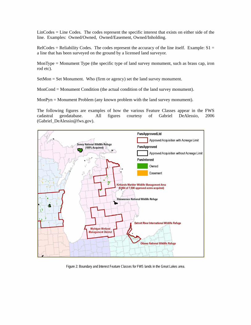
LinCodes = Line Codes. The codes represent the specific interest that exists on either side of the line. Examples: Owned/Owned, Owned/Easement, Owned/Inholding. RelCodes = Reliability Codes. The codes represent the accuracy of the line itself. Example: S1 = a line that has been surveyed on the ground by a licensed land surveyor. MonType = Monument Type (the specific type of land survey monument, such as brass cap, iron rod etc). SetMon = Set Monument. Who (firm or agency) set the land survey monument. MonCond = Monument Condition (the actual condition of the land survey monument). MonPyn = Monument Problem (any known problem with the land survey monument). The following figures are examples of how the various Feature Classes appear in the FWS cadastral geodatabase. All figures courtesy of Gabriel DeAlessio, 2006 ([email protected]).
Figure 2: Boundary and Interest Feature Classes for FWS lands in the Great Lakes area.

Figure 3: Special Designation Feature Class.
Figure 4: Fee Interest lands. Figure 5: Inholdings.

Maintaining and Serving the Cadastral Geodatabase
When the Regions have populated their portion of the cadastral geodatabase, a combining of all of the Regional data into a national dataset can begin. This is commonly referred to as a “roll-up.” Accessing, maintaining and serving the “rolled-up” data is all part of an “Enterprise GIS.” As of this date (9/1/2008), three new data servers have been established in Lakewood, CO, to store and serve FWS GIS data. On one of these servers, the “rolled-up” cadastral geodatabase, representing all NWRS data, will reside. The software managing this data will be ArcSDE and ArcGIS Server.
ArcSDE (spatial database engine) is the ESRI software for a server that provides client applications (such as ArcGIS) a gateway for accessing, managing, and using geospatial data in a relational database, including database management systems (DBMS), such as Oracle. In order that the FWS cadastral geodatabase can be edited and used simultaneously by many users, we will use the ArcSDE to manage the geodatabase.
ArcGIS Server is the ESRI software that enables organizations to put maps, data, and tools on the internet. ArcGIS Server also allows the user to configure geodata services. A geodata service provides access to the geodatabase through the internet using ArcGIS Server. The geodata service enables the user to query the geodatabase for information, make maps using data extraction, and perform geodatabase replication operations.
To distribute the data from the national cadastral geodatabase back out to the Regions for editing and updating, ArcGIS uses a “replication” process. The cadastral data will be copied from the source geodatabase to a target geodatabase(s), creating a replica in each geodatabase. The replica copy describes what data has been replicated and contains the information needed to synchronize changes. The replica in the source geodatabase is called the “parent,” and the replica in the target geodatabase is called the “child.” Together they are referred to as the “replica pair.”
The replication process allows the entire geodatabase to be replicated or just specific datasets. It also enables the user to specify which features within the dataset to be replicated. As this applies to the FWS cadastral geodatabase, we will be able to replicate just the FWSApproved or FWSInterest feature classes for editing (two feature classes that might require frequent editing).
Geodatabase replication is built upon a process known as “versioning.” Versioning allows multiple users, such as the Regional Cartographers, to view and edit simultaneously through a “check-in/check-out” procedure. All edits are made to the child replica data, and the changes are then synchronized with the parent replica. Errors or other conflicts are resolved during a reconciliation process. Once the parent replica receives all of the changes and the conflicts have been resolved, the revised geodatabase is available for all to use. The commands to perform geodatabase replication are found in ArcCatalog.
A recent development in the latest edition of the geodatabase is the ability to archive. When edits are made to the parent version, the original entry remains intact but is archived. The user is then able to navigate through the history of edits made using the date of the edit or a “historical marker.”

The following diagram (Figure 2) illustrates the how the FWS Cadastral Geodatabase will be maintained and served. The box labeled “Land Record System” is described in the next section.
Figure 6: Process diagram for completing and maintaining the FWS cadastral geodatabase. Courtesy, Gabriel DeAlessio 2008 ([email protected])
Using the Cadastral Geodatabase
When the FWS Cadastral Geodatabase is finally “rolled up” and residing on a server, it will be ready to be put to work. For the first time in the history of the FWS, a geospatial database of the entire NWRS will be available to answer questions on a national scale. The FWS Directorate has requested the following information from the Chief Cartographer, all of which can be viewed and compiled by the cadastral geodatabase:
1) Total lands/acres within all of the approved acquisition (AA) boundaries, by refuge. 2) Total lands/acres of land owned by FWS within the AA boundaries, by refuge.

3) Total lands/acres of easements, by refuge. 4) Total lands/acres of private land (not yet acquired) within AA boundaries, by refuge. 5) Total lands/acres of private land not within "focus areas" (for those refuges for which FWS intends to buy only a certain percentage of lands within the AA boundary). 6) Total lands/acres within AA boundaries withdrawn from the public domain. 7) Total lands/acres within AA boundaries that definitively will not/cannot be acquired because of development, etc., by refuge. 8) Total lands/acres of leases, by refuge. 9) Total lands/acres managed under cooperative agreement, by refuge. Because ArcGIS geodatabase operates in a relational database format, we will be able to interface the cadastral geodatabase to other FWS databases. In particular, the Land Record System (LRS), which is maintained by the Division of Realty, will add many valuable tables of information. The LRS contains a comprehensive record of each tract of real property acquired by the FWS. Included are such data common to the cadastral geodatabase such as the Region number, name of the refuge, and tract number. But the LRS contains very detailed data about how a particular tract of land was acquired, including how much the FWS paid for the tract, the date the tract was acquired, and who the tract was acquired from. When the cadastral geodatabase is linked to the LRS (Regional geodatabases have already successfully done this), additional information can be obtained, such as: 1) Total lands/acres purchased with a particular funding source (Migratory Bird Conservation Fund, Land and Water Conservation Fund, etc.) 2) Total lands/acres donated within AA boundaries 3) Which lands were purchased after 1980? Prior to 1940?, etc. The screenshot below (Figure 3) is from the Region 5 cadastral geodatabase for the Moosehorn National Wildlife Refuge in Maine. The Cartographer has linked the geodatabase to the LRS and displayed the results. The top half of the table at right reflects the Feature Classes from the geodatabase that are associated with the tract outlined in red. The bottom half of the table reflects data from the LRS.

Figure 7: Portion of the cadastral geodatabase data for the Moosehorn National Wildlife Refuge, Maine Courtesy, Rick Schauffler 2008 ([email protected])
Because the cadastral geodatabase and the LRS share some identical records, we will use a diagnostic program to reveal any discrepancies, which will provide quality control for both databases.
While the Regional Cartographers and other FWS staff experienced in GIS will access the cadastral geodatabase with ArcGIS, plans are being made to develop a web page built on the ArcGIS Server platform that non-GIS users can use. The web page will consist of a base map of North America, including the North Pacific Ocean and the Caribbean Sea (to include refuges such as Guam and Vieques). Included will be the usual map base layers such as hydrology, highways, and major towns and cities. The NWRS AA boundaries will be displayed on top of these base layers. A simple tool bar will allow the user to zoom in to a particular refuge, where they can view the various parcels of land and water that have been coded using the cadastral geodatabase. A pop-up window will display the data describing the specific boundaries, interests, and acreages associated with a particular tract.
Conclusions
The goal of a complete dataset of all digital National Wildlife Refuge boundaries combined with all digital land status for the entire NWRS is close to being achieved. As of this date (9/1/2008), plans are in place for the CDWG to meet in Anchorage, Alaska, on 9/15/2008 to “roll-up” all Regional data into one National Cadastral Geodatabase. Any agreed upon changes and revisions will be made to the rolled-up data model. The CDWG will also work to compile a draft “User’s Manual” so that the processes of populating the geodatabase with cadastral data are documented. Completion and maintenance of the cadastral geodatabase will provide the users of RLGIS the essential boundary and parcel information for the biological geodatabases currently within the RLGIS data model. The future display of the cadastral geodatabase spatial data on a web page will provide the FWS Directorate and FWS employees an accurate, convenient and consistent avenue to view FWS lands and waters, which will aid in decision making. The web page will also provide the public a way to quickly view the entire NWRS and determine where public lands open to visitation are located.
REFERENCES Environmental Systems Research Institute Inc. (2007) An Overview of Distributing Data with Geodatabases. ESRI Technical Paper No. 34131, www.esri.com Environmental Systems Research Institute Inc. (2001) Dictionary of GIS Terminology, ESRI Press Federal Geographic Data Committee Cadastral Subcommittee (2003) FGDC Cadastral Data Content Standard version 1.3 http://www.nationalcad.org/showdoclist.asp?doctype=1&navsrc=Standards U.S. Fish and Wildlife Service (1998) Process Description for Creating and Managing Service Lands Boundary Digital Data (SOP 98-01) http://www.fws.gov/data/gissop.html U.S. Fish and Wildlife Service (20088) Refuge Land Geographic Information Systems (RLGIS) Data Model https://intranet.fws.gov/region9/refuges/rlgis/datamodel/overview.html <FWS agency intranet access only>


![GDB telux ver090906 - cs.tau.ac.il · (gdb) watch expr –stops whenever the value of the expression changes (gdb ) i b (gdb) clear [arg ] (gdb) delete [bnum ] Without arguments deletes](https://img.pdfslide.us/doc/110x75/5ae0abbc7f8b9ab4688daeeb/gdb-telux-ver090906-cstauacil-gdb-watch-expr-stops-whenever-the-value-of.jpg)