Embed Size (px)
DESCRIPTION
Executive summary Cabo Dorado enviromental impact manifestation (mia)
Citation preview
EXECUTIVE SUMMARY CABO DORADO: MIA-R
1
EXECUTIVE SUMMARY
Cabo Dorado is an investment project in the State of Baja California Sur; particularly in the area known as
“Cabo del Este” (East Cape) in the municipality of Los Cabos. This project aims to promote specialized
tourism, about cultural, educational, scientific, and sports exchanges between Mexico and the Asian continent
as well as to serve as a common ground for fostering business development. Therefore, area of 3770.5
hectares was allocated to the project.
Cabo Dorado is promoted by the company La Rivera Desarrollos BCS S. de R. L. de C.V., a joint venture
between American and Asian investors who are determined to promote a radically different concept from the
one of the project that was intended to be developed in the same location and which was placed at issue at the
time.
1. Objectives.
Cabo Dorado project is proposed as part of the consolidation of the development of the municipality, which is
considered for tourism purposes; therefore, the proposed project is defined by six elements that make up its
objectives:
1. Promote cultural tourism, and stablish it as a space for permanent cultural exchange through constant
exhibitions, events and festivals.
2. Provide health and wellness tourism through the convergence of knowledge on the subject.
3. Encourage technological and trade exchange tourism by creating spaces that facilitate physical activity.
4. Encourage education and research tourism thanks to the creation of a dynamic space dedicated to
education and research in multilateral issues.
5. Promote sports tourism by creating areas dedicated to high performance sports and specialized
knowledge exchange among professionals.
6. Making the best of the beach tourism potential.
As a support the objectives, Cabo Dorado considers the development of 9 hotels, temporary housing for
residents and visitors, and two golf courses. Likewise there will be infrastructure to support tourism and deem
it as high-quality recreation, health, and sports center and shopping area.
Cabo Dorado is a different and innovative project that, by design, regards the environment and the natural
resources as its building blocks. As a result, Cabo Dorado includes environmental elements in its designs, in
as much in its floor plan as in water availability; both elements are already defined and accepted thus allowing
an efficient and sustainable use of the area and the natural resources.
EXECUTIVE SUMMARY CABO DORADO: MIA-R
2
2. Major works and / or activities.
Cabo Dorado must be understood as a real estate development that includes a set of works and activities
relating to the preparation and construction, operation and maintenance of various elements such as hotels,
condominiums, housing developments, restaurants, commercial facilities, general services and equipment,
golf courses and infrastructure for providing the services necessary for the viability of all of the
aforementioned, such as a work for water supply and wastewater plant, relocating an airstrip and the
consequent change of forest land use resulting from uprooting some of the elements in the project so as to
obtain a tourist land use, consistent with the policies development and land use in effect for the area.
In order to contextualize the elements of the project, it is proposed to assume a scale perspective:
Works of the Project: The Full Project
The proposal of the project is to develop it in 3,770.5 hectares, which includes a right of way of 7.11 hectares
that is necessary for the water supply network.
Works of the Project: Premises
The project proposes to allocate 1219.3 hectares to tourism land use (under the Ecological Zoning Plan of the
municipality of Los Cabos, Baja California Sur, POELMC), which is equivalent to 32.3% of the total area of
the property. The rest of the area of the property (67.7%) will be left as forest land with a preservation use
(under the POELMC); therefore, the current vegetation conditions and land use will be kept.
EXECUTIVE SUMMARY CABO DORADO: MIA-R
3
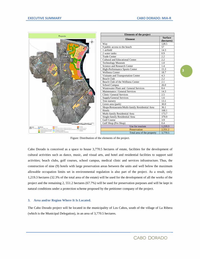
Elements of the project
Element Surface
(hectares)
Way 128.5
9 public access to the beach 57
1 airfield 14.3
2 water tanks 0.9
Trade Center 2.2
Cultural and Educational Center 2.2
Technology Museum 1.0
Science and Research Center 1.4
High-Performance Sports Center 15.3
Wellness Center 18.7
Visitants and Transportation Center 4.3
Beach Club 2.2
Beach Club of the Wellness Center 2.1
School Campus 26.0
Wastewater Plant and General Services 8.4
Maintenance / General Services 14.3
Clinic/ General Services 2.5
Supply/General Services 1.6
Tree nursery 13.1
Green area (park) 30.0
Shops/Restaurants/Multi-family Residential Area 36.1
Hotels 168.1
Multi-family Residential Area 173.7
Single-family Residential Area 379.9
Gulf Course 3.9
Gulf Shop (Pro Shop) 0.4
Use for tourism 1,219.3
Preservation 2,551.2
Total area of the property 3,770.5
Figure: Distribution of the elements of the project.
Cabo Dorado is conceived as a space to house 3,770.5 hectares of estate, facilities for the development of
cultural activities such as dance, music, and visual arts, and hotel and residential facilities to support said
activities; beach clubs, golf courses, school campus, medical clinic and services infrastructure. Thus, the
construction of nine (9) hotels with large preservation areas between the units and well below the maximum
allowable occupation limits set in environmental regulation is also part of the project. As a result, only
1,219.3 hectares (32.3% of the total area of the estate) will be used for the development of all the works of the
project and the remaining 2, 551.2 hectares (67.7%) will be used for preservation purposes and will be kept in
natural conditions under a protection scheme proposed by the petitioner company of the project.
3. Area and/or Region Where It Is Located.
The Cabo Dorado project will be located in the municipality of Los Cabos, south of the village of La Ribera
(which is the Municipal Delegation), in an area of 3,770.5 hectares.
EXECUTIVE SUMMARY CABO DORADO: MIA-R
4
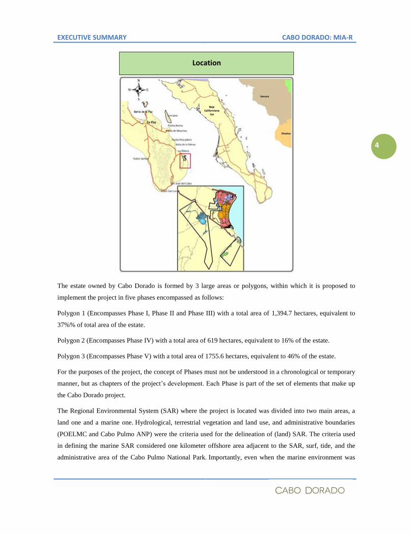
The estate owned by Cabo Dorado is formed by 3 large areas or polygons, within which it is proposed to
implement the project in five phases encompassed as follows:
Polygon 1 (Encompasses Phase I, Phase II and Phase III) with a total area of 1,394.7 hectares, equivalent to
37%% of total area of the estate.
Polygon 2 (Encompasses Phase IV) with a total area of 619 hectares, equivalent to 16% of the estate.
Polygon 3 (Encompasses Phase V) with a total area of 1755.6 hectares, equivalent to 46% of the estate.
For the purposes of the project, the concept of Phases must not be understood in a chronological or temporary
manner, but as chapters of the project’s development. Each Phase is part of the set of elements that make up
the Cabo Dorado project.
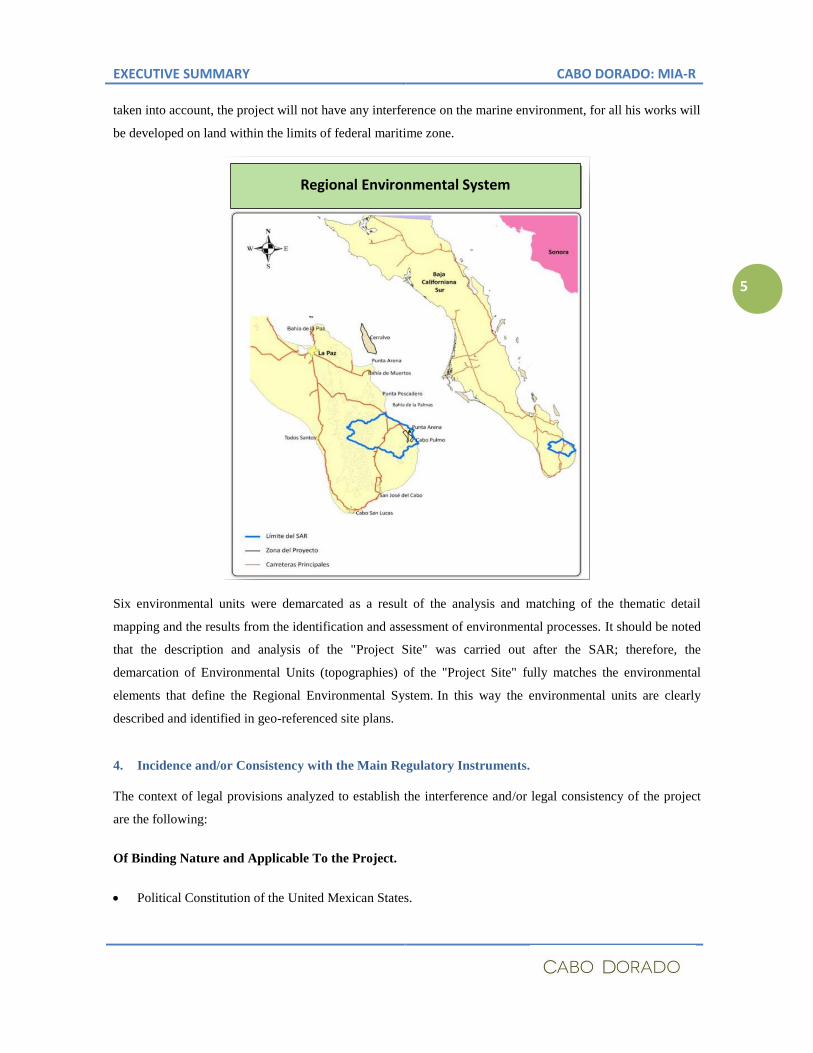
The Regional Environmental System (SAR) where the project is located was divided into two main areas, a
land one and a marine one. Hydrological, terrestrial vegetation and land use, and administrative boundaries
(POELMC and Cabo Pulmo ANP) were the criteria used for the delineation of (land) SAR. The criteria used
in defining the marine SAR considered one kilometer offshore area adjacent to the SAR, surf, tide, and the
administrative area of the Cabo Pulmo National Park. Importantly, even when the marine environment was
Location
EXECUTIVE SUMMARY CABO DORADO: MIA-R
5
taken into account, the project will not have any interference on the marine environment, for all his works will
be developed on land within the limits of federal maritime zone.
Six environmental units were demarcated as a result of the analysis and matching of the thematic detail
mapping and the results from the identification and assessment of environmental processes. It should be noted
that the description and analysis of the "Project Site" was carried out after the SAR; therefore, the
demarcation of Environmental Units (topographies) of the "Project Site" fully matches the environmental
elements that define the Regional Environmental System. In this way the environmental units are clearly
described and identified in geo-referenced site plans.
4. Incidence and/or Consistency with the Main Regulatory Instruments.
The context of legal provisions analyzed to establish the interference and/or legal consistency of the project
are the following:
Of Binding Nature and Applicable To the Project.
Political Constitution of the United Mexican States.
Regional Environmental System
EXECUTIVE SUMMARY CABO DORADO: MIA-R
6
General Law of Ecological Equilibrium and Environmental Protection and its Regulation on
Environmental Impact Assessment.
National Water Law and its Regulations.
National Property Act and the Regulations for the use and exploitation of the territorial sea, waterways,
beaches, federal maritime zone and land reclamation.
General Law on Sustainable Forestry Development and its Regulation.
General Law for the Prevention and Integral Management of Wastes.
Program for the General Ecological Management of Lands
Plan of Land Use Regulation of the municipality of Los Cabos, Baja California Sur Mexican Official
Standards
Of Binding Nature, Not Applicable to the Project as They Regulate a Different Site From the Proposed
One.
Decree establishing the Protected Area with National Park status, Cabo Pulmo June the 6th
, 1995.
Program Management of the Protected Area with National Park status, Cabo Pulmo November the 13th
,
2009.
Convention on Wetlands of International Importance RAMSAR Site, Natural Protected Area Cabo
Pulmo.
Marine Ecological Program of the Gulf of California POEMGC (published in the Official Gazette of the
Federation on Friday, December the 15th
, 2006).
Regionalization Instruments, Non-Binding, Lacking Regulatory Nature.
Relevant Area for the Preservation of Birds-AICA
(CONABIO) Priority Hydrological Regions CONABIO
Priority Terrestrial Regions
CONABIO Priority Marine Regions
Mexico's National Commission for the Knowledge and Use of Biodiversity (CONABIO)
Analysis of gaps and omissions in the preservation of terrestrial biodiversity in Mexico: spaces and
species (The National Commission on Natural Protected Areas ) CONANP-CONABIO
Regarding the authorization for changing the Land Use of Forest Lands (CUSTF), with respect to the
conditions of use, development, change in land use from forest lands to tourism lands, impacts to the
biodiversity, the vegetation cover, the soil and the environmental services, all these elements were assessed in
due course and authorized by SEMARNAT through its Federal Delegation in the State of Baja California Sur,
under the provisions of the General Law of Sustainable Forestry Development, as set in the CUSTF. The
aforesaid conditions have been cleared and executed according to the procedure set in the LGDFS and its
EXECUTIVE SUMMARY CABO DORADO: MIA-R
7
Regulations; therefore, these rights are valid and applicable to the estate in question and to any and all
projects submitted which are located in the authorized area. In view thereof, the project proposed to EIA
complies with the authorization of CUSTF and with the use from which the aforementioned authorization
arises. Therefore, CUSTF’s authorization is valid and enforceable and supports the rights acquired. Such
rights are legally protected by the provisions of the Constitution, as stated herein above.
Regarding the use and exploitation of water: the authorization issued by the National Water Commission,
which sets the volume for the exploitation and use of water found in the estate where the tourism project is
being developed, is valid by operation of law. Therefore, the authorization holds the rights protected by the
Constitution and is not subjected to interpretation or correction as the environmental and legal conditions that
gave rise to it remain unchanged to this date and that and the project to develop in this estate meets and does
not modify the conditions set in the authorization.
It is important to highlight that the use of water granted under concession to the owner does not threaten
the ecological balance of ecosystems or the access of other stakeholders to water, this based on the NOM-
011-CONAGUA-2000 and in the Update on Mean Annual Availability of Groundwater in Santiago Aquifer
(0320) State of Baja California Sur, as published in the Official Gazette of the Federation on August the 28th
,
2009 in what follows that the Aquifer from which the project will be supplied of water has no deficit, shows
availability for 4.15 million m3, considers concessions for use for 15.7 million m
3, and the Natural Dedicated
Discharge is guaranteed by a volume of 4.6 million m3. Since the concessions were granted to the owner in
1994 and 1996 and have been considered in the Update on Mean Annual Availability of Groundwater in
Santiago Aquifer (0320) State of Baja California Sur, as published in the Official Gazette of the Federation
on August the 28th
, 2009 in compliance with NOM-011-CONAGUA-2000.
The analysis done on linking planning instruments and applicable laws and regulations showed that the SAR
is in a context regulated and planned by said instruments, with “touristic” and “preservation” uses; therefore,
the development of the area was planned having this two basic criteria as guideposts. Moreover, in this
analysis it was determined that the project is compatible, as it conforms to the tourism and preservation land
use and as it complies with the occupancy limits set out in POELMC.
Regarding the Ecological Zoning Plan of the municipality of Los Cabos, Baja California Sur (POELMC)
published in the Official Gazette of the State of Baja California Sur on August the 31st, 1995, the proposed
project has an area of 3,770.5 hectares regulated by the POELMC, which classifies the territory of the
municipality into Environmental Management Units and grants an Environmental Policy and Land Use
Zoning to each one of them.
As stated hereinabove, the property covers an area of 3,770.5 hectares, of which 2,741.96 hectares (72.7% of
the total area) are located within the UGA T-13; 336.7 hectares (8.9% of the total area) are located within the
UGA T-14; and 691.8 hectares (18.3% of the total area) are located within the UGA T-19. POELMC sets
the following policies, land use and ecological criteria for UGA T-13, UGA T-14 and UGA T19:
EXECUTIVE SUMMARY CABO DORADO: MIA-R
8
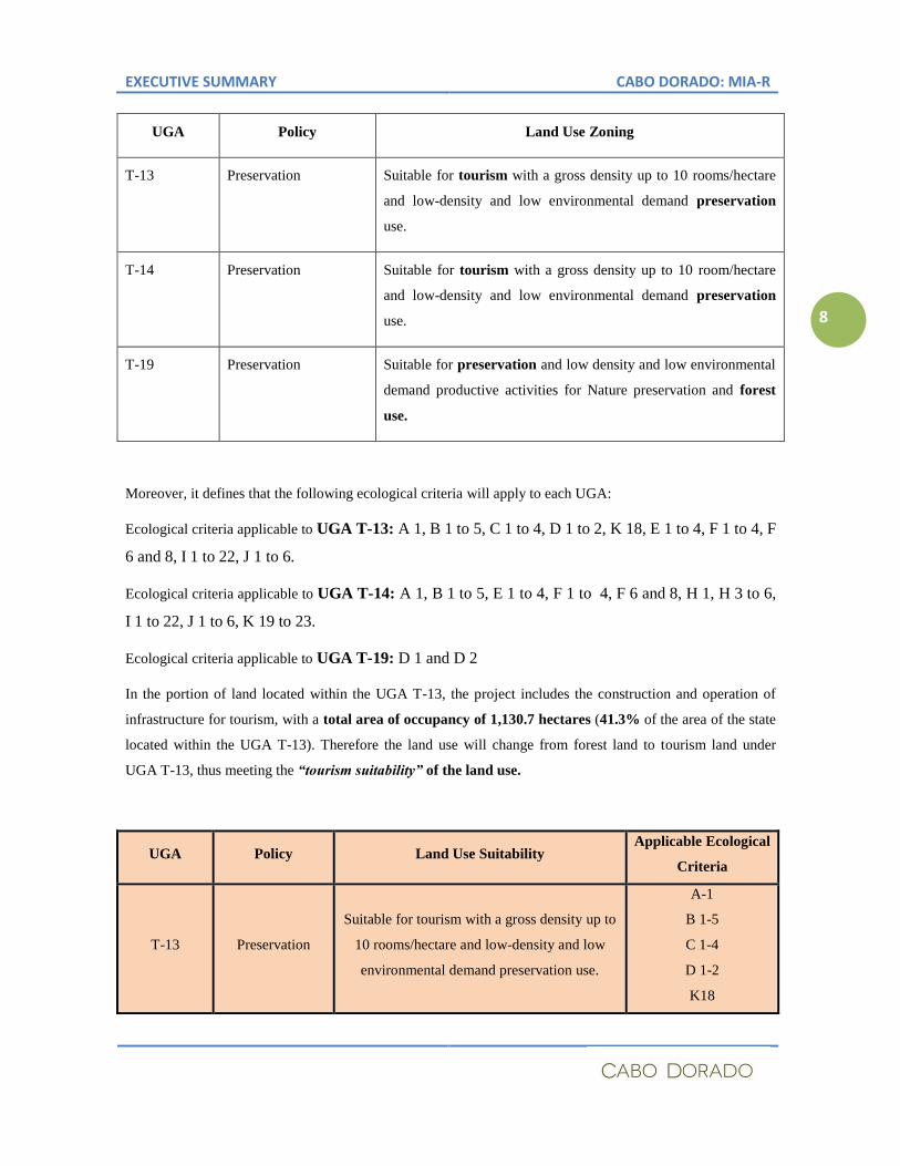
UGA Policy Land Use Zoning
T-13 Preservation Suitable for tourism with a gross density up to 10 rooms/hectare
and low-density and low environmental demand preservation
use.
T-14 Preservation Suitable for tourism with a gross density up to 10 room/hectare
and low-density and low environmental demand preservation
use.
T-19 Preservation Suitable for preservation and low density and low environmental
demand productive activities for Nature preservation and forest
use.
Moreover, it defines that the following ecological criteria will apply to each UGA:
Ecological criteria applicable to UGA T-13: A 1, B 1 to 5, C 1 to 4, D 1 to 2, K 18, E 1 to 4, F 1 to 4, F
6 and 8, I 1 to 22, J 1 to 6.
Ecological criteria applicable to UGA T-14: A 1, B 1 to 5, E 1 to 4, F 1 to 4, F 6 and 8, H 1, H 3 to 6,
I 1 to 22, J 1 to 6, K 19 to 23.
Ecological criteria applicable to UGA T-19: D 1 and D 2
In the portion of land located within the UGA T-13, the project includes the construction and operation of
infrastructure for tourism, with a total area of occupancy of 1,130.7 hectares (41.3% of the area of the state
located within the UGA T-13). Therefore the land use will change from forest land to tourism land under
UGA T-13, thus meeting the “tourism suitability” of the land use.
UGA Policy Land Use Suitability Applicable Ecological
Criteria
T-13 Preservation
Suitable for tourism with a gross density up to
10 rooms/hectare and low-density and low
environmental demand preservation use.
A-1
B 1-5
C 1-4
D 1-2
K18
EXECUTIVE SUMMARY CABO DORADO: MIA-R
9
The tourist devoted area will have an installed capacity of 4,020 hotel rooms distributed in 8 hotels and 6,061
households (equivalent to 18,183 hotel rooms); which amounts to a gross density of 8.1 rooms/hectare. It is
important to mention that, given the area of 2,741.96 hectares of land spread over the UGA T-13, that portion
of the estate has a maximum installation potential of up to 27,419 hotel rooms; therefore, the project
complies with the gross density allowed "up to 10 rooms per hectare" for that UGA T-13 and shows a
lower density limit than the one set in POELMC.
In the fraction of land located within the UGA T-13, the project allocated 1,611.24 hectares (58.76% of the
area of land located within the UGA T-13) as Reserve with preservation purposes; thus, complying with the
land use foreseen for UGT T-13 regarding the “low density and low environmental demand
preservationist use."
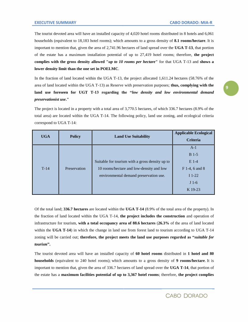
The project is located in a property with a total area of 3,770.5 hectares, of which 336.7 hectares (8.9% of the
total area) are located within the UGA T-14. The following policy, land use zoning, and ecological criteria
correspond to UGA T-14:
UGA Policy Land Use Suitability Applicable Ecological
Criteria
T-14 Preservation
Suitable for tourism with a gross density up to
10 rooms/hectare and low-density and low
environmental demand preservation use.
A-1
B 1-5
E 1-4
F 1-4, 6 and 8
I 1-22
J 1-6
K 19-23
Of the total land; 336.7 hectares are located within the UGA T-14 (8.9% of the total area of the property). In
the fraction of land located within the UGA T-14, the project includes the construction and operation of
infrastructure for tourism, with a total occupancy area of 88.6 hectares (26.3% of the area of land located
within the UGA T-14) in which the change in land use from forest land to tourism according to UGA T-14
zoning will be carried out; therefore, the project meets the land use purposes regarded as “suitable for
tourism”.
The tourist devoted area will have an installed capacity of 60 hotel rooms distributed in 1 hotel and 80
households (equivalent to 240 hotel rooms); which amounts to a gross density of 9 rooms/hectare. It is
important to mention that, given the area of 336.7 hectares of land spread over the UGA T-14, that portion of
the estate has a maximum facilities potential of up to 3,367 hotel rooms; therefore, the project complies
EXECUTIVE SUMMARY CABO DORADO: MIA-R
10
with the gross density allowed "up to 10 rooms per hectare" for that UGA T-14 and shows a lower density
limit than the one set in POELMC.
In the fraction of land located within the UGA T-14, the project allocated 248.1 hectares (73.7% of the area of
land located within the UGA T-14) as Reserve with preservation purposes; thus, complying with the land
use foreseen for UGT T-14 regarding the “low density and low environmental demand preservationist
use."
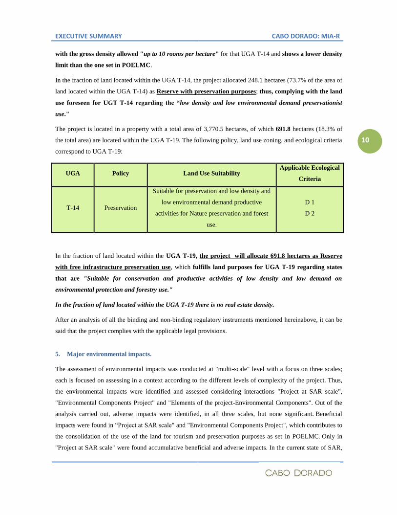
The project is located in a property with a total area of 3,770.5 hectares, of which 691.8 hectares (18.3% of
the total area) are located within the UGA T-19. The following policy, land use zoning, and ecological criteria
correspond to UGA T-19:
UGA Policy Land Use Suitability Applicable Ecological
Criteria
T-14 Preservation
Suitable for preservation and low density and
low environmental demand productive
activities for Nature preservation and forest
use.
D 1
D 2
In the fraction of land located within the UGA T-19, the project will allocate 691.8 hectares as Reserve
with free infrastructure preservation use, which fulfills land purposes for UGA T-19 regarding states
that are "Suitable for conservation and productive activities of low density and low demand on
environmental protection and forestry use."
In the fraction of land located within the UGA T-19 there is no real estate density.
After an analysis of all the binding and non-binding regulatory instruments mentioned hereinabove, it can be
said that the project complies with the applicable legal provisions.
5. Major environmental impacts.
The assessment of environmental impacts was conducted at "multi-scale" level with a focus on three scales;
each is focused on assessing in a context according to the different levels of complexity of the project. Thus,
the environmental impacts were identified and assessed considering interactions "Project at SAR scale",
"Environmental Components Project" and "Elements of the project-Environmental Components". Out of the
analysis carried out, adverse impacts were identified, in all three scales, but none significant. Beneficial
impacts were found in “Project at SAR scale" and "Environmental Components Project", which contributes to
the consolidation of the use of the land for tourism and preservation purposes as set in POELMC. Only in
"Project at SAR scale" were found accumulative beneficial and adverse impacts. In the current state of SAR,
EXECUTIVE SUMMARY CABO DORADO: MIA-R
11
none of the identified impacts caused significant changes in the ecosystems and natural resources or in the
health, which could jeopardize the existence and development of man and other living beings and the
continuity of natural processes.
The adverse environmental impacts identified at "Project at SAR scale" are: a) Decrease in the width of
environments present in the SAR, caused by the use of the land for tourism purposes; b) Pressure on the
Administration of Natural Resources and Services due to the change of land use in the SAR, according to the
foreseen development policies; and c) Pressure on the Administration of Natural Resources and Services due
population growth (temporary and permanent residents) in the SAR according to the foreseen development
policies. The benefits resulting from the project development are: i) Consolidation of tourism and preservation
purposes under the PELMC for the UGS T-13 and T-14 and the preservation purpose of the UGA T-19; and
ii) Contribution to the consolidation of the development model provided by the government of Baja California
Sur.
The water used in the economic activities of the project will be treated and reused from the beginning of the
project, without discharges of wastewaters to the environment. This will be implemented through a
comprehensive strategy for the efficient use of water throughout its cycle, from the extraction and
transportation from the wells to the project site to the facilities were it will be used and up to its treatment and
reuse for watering and maintenance of the golf course and the green areas in the project; thus favoring
infiltration and improvement of micro climatic conditions in the project site. All this is shown in a water
availability program and a comprehensive hydrology and costal processes program where the strategies, lines
of actions and efficiency and efficacy measurement mechanisms are defined.
Aware of the magnitude of the project, besides a sustainable planning and design regarding water
consumption, power consumption is also a key element in the design; therefore, the use of solar power for
lighting all public areas and for supplying basic services in hotel, residential, and services facilities was also
part of the project, thereby obtaining less energy from the power supply network and reducing the ecological
footprint. The Asian investment group is leader in the development, use and implementation of clean energy
generation technologies, particularly solar power; therefore this element is project’s strength and ensures the
application of state-of-the-art technology and an efficient use of energy.
Like in any development project, the assessment of direct and indirect environmental impacts had allowed to
design a preventive, mitigation and compensation strategy that ensures the sustainability of the project’s site
without compromising the ecological balance of the area. In this sense, the removal of the vegetation cover,
as set in the authorization of the change of land use of forest lands, besides providing economic compensation
resources to the Mexican Forest Fund (under the General Law for the Development of Sustainable Forests),
implies the creation of a Germplasm Bank. Said bank will favor actions of reforestation and restoration of the
vegetal cover with endemic species of the site and will contribute to the federal, state and municipality
governments’ programs. Thus, the governments rest assured that they will have access to the endemic genetic
EXECUTIVE SUMMARY CABO DORADO: MIA-R
12
material, through the Germplasm bank, which contributes to preserve the flora diversity of the area.
Regarding fauna: 67.7% of the total surface of the state was allocated to preservation purposes. Within that
area, a rescue and relocation program for wild animals will be in place so as to guarantee, by its
implementation and results assessment, the continuance of evolutionary processes of endemic fauna.
Another characteristic of the development of society is waste generation; therefore, the wastes management
and final disposal of residues is an inherent element of the project; thus, the design, construction and
operation of facilities for urban solid wastes management will be a joint commitment with the municipality, as
nowadays the service does not exist in the Cabo del Este area. In this way, not only Cabo Dorado will enjoy
the service, but also all the nearby towns, such as La Riviera and Cabo Pulmo, where wastes are either buried
or burned nowadays, with the corresponding negative impact on the environment.
In line with the climate change mitigation and adaptation commitments, Cabo Dorado has included in the
development a series of elements coherent with such mechanisms so as to reduce the carbon footprint. Firstly,
the buildings located in front of the coastal line, besides protecting and preserving the active coastal dune of
the beach (with a height of -2 meters above sea level), have set a construction height limit of +6 meters above
sea level for buildings with beach front. In order to do it, the models on the sea level increase in the next 50
years were taken into account, as well as the tidal waves in extreme cases. This measure allows the
preservation of ecological balance in the beach and in the sea front, as well as protects the population and
serves and climate change adaptation mechanism. Regarding air emissions: the project pretends to limit the
use of automobiles in the area by implementing an internal transportation system so as to reduce the use of
vehicles and favors the decrease of greenhouse gases. On this regard, the Asian investment group is a leader
in the development of public transportation projects and equipment, which facilitates access to state-of-the-art
technology and its use in the project.
The implementation of an exchange and training mechanism on development and research issues is an
strength of Cabo Dorado, who will be the means through which the youth population will have elements for
participating in educational and professional programs that are expected to be part of the project. This entails
the strengthening of business activities and increasing the quality of life of the population in the region. The
creation of the Investigation Center of the Gulf of California, as a mechanism for exchanging and developing
human resources is intended to strengthen the protection and preservation activities of the National Maritime
Park of Cabo Pulmo with environmental promotion and educative actions, development of investigation lines
and knowledge generation regarding this ecosystem and the numerous and valuable natural resources of the
Gulf of California and its islands.
6. Mitigation, Compensation or Restoration Measures.
The management of strategies for preventing and mitigating environmental impacts, through the proposed
Comprehensive Environmental Management System (SIGA), has two scopes. The first is as the planning area
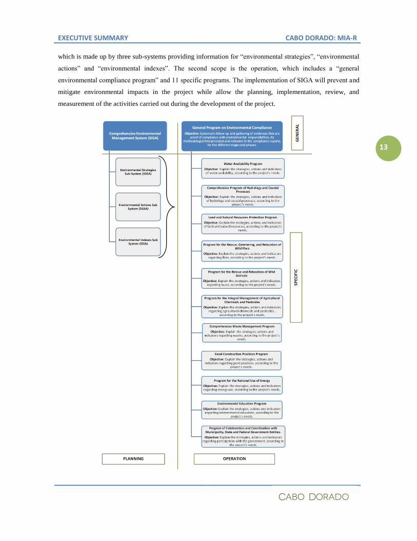
EXECUTIVE SUMMARY CABO DORADO: MIA-R
13
which is made up by three sub-systems providing information for “environmental strategies”, “environmental
actions” and “environmental indexes”. The second scope is the operation, which includes a “general
environmental compliance program” and 11 specific programs. The implementation of SIGA will prevent and
mitigate environmental impacts in the project while allow the planning, implementation, review, and
measurement of the activities carried out during the development of the project.
EXECUTIVE SUMMARY CABO DORADO: MIA-R
14
7. Justification for Choosing the Site over Other Alternatives.
The project is located in an area that was assessed and defined under democratic and participative processes
for defining the development alternatives, as the State Development Plan, the POELMC and the set of
authorizations granted to the holder within the powers of other related authorities delimit the alternatives for
complying with the environmental policies of the POELMC and the tourist and preservation purposes for the
estate. Therefore, the site was the only alternative for developing the project.
Cabo Dorado is a project conceived as means to amalgamate the best of the cultures in the Pacific Rim, within
a sustainably planned and developed area, with a broad participation of local and regional population so as to
contribute to the sustainable development of Baja California Sur and Mexico, in an innovative development
scheme in harmony with the environment and the local population.