Embed Size (px)
Citation preview
CAA201421st century Archeaology
concepts, methods and tools
Proceedings of the 42nd Annual Conference on Computer
Applications and Quantitative
Methods in Archaeology
Edited by
F. Giligny, F. Djindjian, L. Costa, P. Moscatiand S. Robert
Archaeopress Archaeology
ArchaeopressGordon House
276 Banbury RoadOxford OX2 7ED
www.archaeopress.com
ISBN 978 1 78491 100 3ISBN 978 1 78491 101 0 (e-Pdf)
© Archaeopress and the individual authors 2015
Cover photograph © Emilie Lesvignes
All rights reserved. No part of this book may be reproduced, stored in retrieval system, or transmitted, in any form or by any means, electronic, mechanical, photocopying or otherwise,
without the prior written permission of the copyright owners.
Printed in England by Oxuniprint, Oxford
This book is available direct from Archaeopress or from our website www.archaeopress.com
Contents
Foreword ������������������������������������������������������������������������������������������������������������������������������������������������������������������� v
Computers and mathematics in Archaeology, anatomy of an ineluctable success! ���������������������������������������������������� 1François DJINDJIAN
Chapter 1 Historiography
Towards a History of Archaeological Computing: An Introduction ������������������������������������������������������������������������������ 9Paola MOSCATI
A retrospective on GIS and AIS platforms for Public Archaeology in Italy� Searching backward for roots and looking onwards for new methodological road-maps ����������������������������������������������������������������������������������������������������������� 17Mirella SERLORENZI, Ilaria JOVINE, Giorgia LEONI, Andrea DE TOMMASI, Andrea VARAVALLO
Art History of the Ancient Near East and Mathematical Models� An Overview ��������������������������������������������������������� 29Alessandro DI LUDOVICO and Sergio CAMIZ
Archaeology and Computer Applications: the automatic cataloging of Italian archaeological heritage ��������������������� 35Alessandra CARAVALE
Chapter 2 Field and laboratory data recording
Practical Assessment of a Multi-Frequency Slingram EMI for Archaeological Prospection ���������������������������������������� 43François-Xavier SIMON, Alain TABBAGH, Apostolos SARRIS
Utilizing Magnetic Prospection and GIS to Examine Settlement Organization in Neolithic Southeastern Europe ������ 53Alexis NIEKAMP, Apostolos SARRIS
Historic Forest Change: New approaches to Land Use Land Cover ���������������������������������������������������������������������������� 65Charlotte E. STANCIOFF, Robert G. PONTIUS Jr, Scott MADRY, Elizabeth JONES
Challenges and Perspectives of Woodland Archaeology Across Europe �������������������������������������������������������������������� 73Hauke KENZLER, Karsten LAMBERS
Archaeological Mapping of Large Forested Areas, Using Semi-Automatic Detection and Visual Interpretation of High-Resolution Lidar Data ���������������������������������������������������������������������������������������������������������������������������������������������� 81Øivind Due TRIER, Lars HOLGER PILØ
Laser scanning and Automated Photogrammetry for Knowledge and Representation of the Rupestrian Architecture in Cappadocia: Sahinefendi and the Open Air Museum of Goreme �������������������������������������������������������������������������� 87Marco CARPICECI, Carlo INGLESE
Advantages and Disadvantages of Digital Approach in Archaeological Fieldwork ����������������������������������������������������� 95Carlo BIANCHINI, Francesco BORGOGNI, Alfonso IPPOLITO
From Survey to Representation of the Model� A Documentation of Typological and Chronological Sequences of Archaeological Artefacts: Traditional and Innovative Approach ����������������������������������������������������������������������������� 107Alfonso IPPOLITO, Luca J. SENATORE, Barbara BELELLI MARCHESINI, Gabriella CEROLI
Archaeology in the Third and Fourth Dimensions: A Case Study of 3D Data Collection and Analysis From Prince Rupert, BC, Canada ������������������������������������������������������������������������������������������������������������������������������������������������ 115Alyssa PARKER, Morley ELDRIDGE
Integrated RTI Approaches for the Study of Painted Surfaces ��������������������������������������������������������������������������������� 123Eleni KOTOULA, Graeme EARL
Survey, Documentation and Analysis of the Archeological Architecture: the House of the Knights of Rhodes in the Forum of Augustus ������������������������������������������������������������������������������������������������������������������������������������������������ 135Carlo BIANCHINI, Gaia Lisa TACCHI
Digital Research Strategies for Ancient Papyri: A Case Study on Mounted Fragments of The Derveni Papyrus �������� 145 Eleni Kotoula, Graeme Earl
i
Chapter 3� Ontologies and Standards
Towards Linked-Data in Numismatics: How the DIANA Approach can Improve the Diachrony Integrating Heterogeneous Pieces of Data ������������������������������������������������������������������������������������������������������������������������������� 157Maria CALTABIANO, Mariangela PUGLISI, Antonio CELESTI, Grazia SALAMONE
Celtic Coins in context, a new database ����������������������������������������������������������������������������������������������������������������� 165Katherine GRUEL, Agnes TRICOCHE, Philippe CHARNOTET
Uncertainty handling for ancient coinage �������������������������������������������������������������������������������������������������������������� 171Karsten TOLLE, David WIGG-WOLF
Interoperability of the ArSol (Archives du Sol) database based on the CIDOC-CRM ontology���������������������������������� 179Emeline LE GOFF, Olivier MARLET, Xavier RODIER, Stéphane CURET, Philippe HUSI
Find the balance - Modelling aspects in Archaeological Information Systems ��������������������������������������������������������� 187Franz SCHWARZBACH, Felix F. SCHÄFER, Alexander SCHULZE
Integration of Archaeological Datasets through the Gradual Refinement of Models ����������������������������������������������� 193Cesar GONZALEZ-PEREZ, Patricia MARTÍN-RODILLA
Linked Open Greek Pottery ������������������������������������������������������������������������������������������������������������������������������������ 205Ethan GRUBER, T.J. SMITH
The Digital Archaeological Workflow: A Case Study from Sweden �������������������������������������������������������������������������� 215Marcus J. SMITH
Exploring time and space in the annotation of museum catalogues: The Sloane virtual exhibition experience ������� 221Stephen STEAD, Dominic OLDMAN, Jonathan Whitson CLOUD
Building comprehensive management systems for cultural – historical information ����������������������������������������������� 227Chryssoula BEKIARI, Martin DOERR, Dimitris ANGELAKIS, Flora KARAGIANNI
Managing Time Dimension in the Archaeological Urban Information System of the Historical Heritage of Rome and Verona ������������������������������������������������������������������������������������������������������������������������������������������������������������������ 235Alberto BELUSSI, Sara MIGLIORINI, Piergiovanna GROSSI
Towards an Archaeological Information System: Improving the Core Data Model �������������������������������������������������� 245Muriel van RUYMBEKE, Cyril CARRÉ, Vincent DELFOSSE, Pierre HALLOT, Michelle PFEIFFER, Roland BILLEN
Chapter 4� Internet and Archaeology
Archaeological open access journals: the case of ‘Archeologia e Calcolatori’ ���������������������������������������������������������� 257Alessandra CARAVALE, Alessandra PIERGROSSI
Massive Open Online Opportunity: MOOCs and Internet–Based Communities of Archaeological Practice ������������� 265Jeffrey P. EMANUEL
Moving Instruction Beyond the Museum’s Walls: Priorities in Online Public Education at the Oriental Institute ���� 271Kathryn GROSSMAN, Catherine Kenyon, Megaera LORENZ, Brittany HAYDEN
Crowd- and Community-Fuelled Archaeology� Early Results from the MicroPasts Project �������������������������������������� 279Chiara BONACCHI, Andrew BEVAN, Daniel PETT, Adi KEINAN-SCHOONBAERT
The ACCORD project: Archaeological Community Co-Production of Research Resources ���������������������������������������� 289Stuart JEFFREY, Alex HALE, Cara JONES, Sian JONES, Mhairi MAXWELL
Chapter 5� Archaeological Information Systems
12000 years of human occupation, 3 meters deep stratigraphy, 12 hectares… A geographical information system (GIS) for the preventive archaeology operation at Alizay (Normandie, France) ������������������������������������������������������� 299S. MAZET, C. MARCIGN, B. AUBRY, I. COMTE, P. BOULINGUIEZ
Records and spatial representations in the context of a rescue excavation: the case of Quincieux (Rhône-Alpes, France) ������������������������������������������������������������������������������������������������������������������������������������������������������������������ 305Ellebore SEGAIN, Veronique VACHON, Bernard MOULIN, Cécile RAMPONI, Wojciech WIDLAK
ii
Cartography and heritage: past practice and future potential for mapping Scotland’s cultural heritage������������������ 315Peter MCKEAGUE
Visualization based on the Norwegian University Museum Database �������������������������������������������������������������������� 323Espen ULEBERG, Mieko MATSUMOTO
An Inventory of Lucanian Heritage ������������������������������������������������������������������������������������������������������������������������� 333Alain DUPLOUY, Vincenzo CAPOZZOLI, Alessia ZAMBON
Integrating complex archaeological datasets from the Neolithic in a web-based GIS ���������������������������������������������� 341Kai-Christian BRUHN, Thomas ENGEL, Tobias KOHR, Detlef GRONENBORN
Enhanced 3D-GIS: Documenting Insula V 1 in Pompeii ������������������������������������������������������������������������������������������� 349Giacomo LANDESCHI, Nicolò DELL’UNTO, Daniele FERDANI, Stefan LINDGREN, Anne-Marie LEANDER TOUATI
MAPPA Open Data Metadata� The importance of archaeological background� ������������������������������������������������������� 361Francesca ANICHINI, Gabriele GATTIGLIA
A simple way to formalize the dating of stratigraphic units ������������������������������������������������������������������������������������ 365 Bruno DESACHY
Recognizing temporalities in urban units from a functional approach: three case studies �������������������������������������� 371 Julie GRAVIER
OH_FET: A Computer Application for Analysing Urban Dynamics Over Long Time Spans �������������������������������������� 381Laure SALIGNY, Ludovic GRANJON, Thomas HUET, Gaël SIMON, Xavier RODIER, Bastien LEFEBVRE
An ‘alphabet’ to describe the spatio-temporal dynamics of settlement systems: a relevant representation of time? �� 393Marie-Jeanne OURIACHI, Frédérique BERTONCELLO, with the collaboration of Pierre NOUVEL, Laure NUNINGER, Elise FOVET, Stephane ALIX
Chapter 6� GIS and spatial analysis
ArkeoGIS, Merging Geographical and Archaeological Datas OnlineLoup BERNARD, Damien ERTLEN, Dominique SCHWARTZ
Counting Sheep Without Falling Asleep: Using Gis to Calculate the Minimum Number of Skeletal Elements (Mne) And Other Archaeozoological Measures At Schöningen 13Ii-4 ‘Spear Horizon’ ������������������������������������������������������� 407Alejandro GARCÍA-MORENO, Jarod M. HUTSON, Aritza VILLALUENGA, Elaine TURNER, Sabine GAUDZINSKI-WINDHEUSER
Looking for the best� A comparison between GIS and PageRank based algorithms for preventive archaeology in urban areas ����������������������������������������������������������������������������������������������������������������������������������������������������������� 413Dubbini NEVIO, Gabriele GATTIGLIA, Augusto PALOMBINI
Analyses of bone modifications on human remains: a GIS approach ���������������������������������������������������������������������� 423Elsa CIESIELSKI, Hervé BOHBOT
Territorial organisation of the Terramare culture (Bronze Age, Italy): use of GIS methodology to tackle societal issues ����431Julie BOUDRY
From the excavation to the territory: contributions of GIS tools to the study of the spatial organization of the archaeological site of Argentomagus (France, Indre, Saint-Marcel/Argenton-sur-Creuse) ��������������������������������������� 443Emeline LE GOFF, Laure LAÜT, Yoann RABASTÉ, Françoise DUMASY
The integration of landscape processes in archaeological site prediction in the Mugello basin (Tuscany/Italy) ������ 451Elmar SCHMALTZ, Michael MÄRKER, Hans-Joachim ROSNER, Adrew-Williams KANDEL
The use of Burgundy stone from ancient times to the present day ������������������������������������������������������������������������� 459Stéphane BÜTTNER, Delphine MONTANGE, Laure SALIGNY, Marion FOUCHER with the collaboration of Eric LECLERCQ, Marinette SAVONNET
Exploring Intervisibility Networks: A Case Study From Bronze and Iron Age Istria (Croatia and Slovenia) ��������������� 469Zoran ČUČKOVIĆ
iii
Chapter 7� Mathematics and statistics in archaeology
Intentional Process Modeling of Statistical Analysis Methods �������������������������������������������������������������������������������� 481Charlotte HUG, Rebecca DENECKÈRE, Ammar AYMEN
Ancient Mesopotamian Glyptic Products, Statistics and Data Mining: A Research Proposal ����������������������������������� 489Alessandro DI LUDOVICO, Sergio CAMIZ
Intrasite spatial analysis applied to the Neolithic sites of the Paris Basin: from the archaeological feature to global analysis ����������������������������������������������������������������������������������������������������������������������������������������������������������������� 497François GILIGNY
Statistical and mathematical models for archaeological data mining: a comparison ����������������������������������������������� 509Nevio DUBBINI, Adam LODOEN
Chapter 8� 3D Archaeology and virtual Archaeology
Measuring and describing 3D texture �������������������������������������������������������������������������������������������������������������������� 519Vera MOITINHO DE ALMEIDA, Juan Antonio BARCELÓ
Old versus new – introducing image-based 3D modeling into the general documentation workflow of archaeological rescue excavations. Case studies: the Čachtice and Bratislava castles, Slovakia ������������������������������������������������������ 529Jan ZACHAR, Seta ŠTUHEC
Beyond spreadsheets: digitising the archaeological artefact inventory process ����������������������������������������������������� 541Arianna TRAVIGLIA, Stephen WHITE, Andrew WILSON
Potentialities of 3D Reconstruction in Maritime Archaeology �������������������������������������������������������������������������������� 549Elisa COSTA, Carlo BELTRAME, Francesco GUERRA
Cultural Heritage Documentation in Cave Environnement Using Low-Cost Means for Archaeologists� Case Study of the Larchant Caves in the Fontainebleau Forest in France �������������������������������������������������������������������������������������� 557Aurelia LUREAU, Mehdi BELARBI, Pascal RAYMOND, Régis TOUQUET
Forum Romanum: A 3D Model For Self-Service Educational Purposes �������������������������������������������������������������������� 569Philippe FLEURY, Sophie MADELEINE, Nicolas LEFÈVRE
The Virtual Reconstruction of a Small Medieval Town: The Case of Briviesca (Spain) ��������������������������������������������� 575Mario ALAGUERO, Andres BUSTILLO, Blanca GUINEA, Lena IGLESIAS
25 Years of Experience in Virtual Reconstructions - Research Projects, Status Quo of Current Research and Visions for the Future ������������������������������������������������������������������������������������������������������������������������������������������������������������� 585Mieke PFARR-HARFST
Chapter 9� Multi-agent systems and complex system modelling
A Density-Based Simulation Approach for Evaluating Prehistoric Population Fluctuations in Finland ��������������������� 595Tarja SUNDELL, Juhana KAMMONEN
Multi-Agent Modelling of the Neolithic LBK ����������������������������������������������������������������������������������������������������������� 595Jean-Pierre BOCQUET-APPEL, Richard MOUSSA, Jérôme DUBOULOZ
Explaining the Adoption of ‘Innovations’ in Western Europe during Bronze Age: Towards an Agent-Based Simulation ����613Juan A. BARCELÓ, Florencia DEL CASTILLO BERNAL, Giacomo CAPUZZO, Berta MORELL, Joan NEGRE
Spatial Interaction Simulation Methods for Ancient Settlement Distributions in Central Italy �������������������������������� 621Taylor OSHAN, Carson FARMER, Eoin O’DONOGHUE
Interactions and network analysis of a rock art site in Morro do Chapéu, Bahia, Brazil ������������������������������������������ 631Carlos ETCHEVARNE, Grégoire VAN HAVRE
iv
Proceedings of the 42nd Annual Conference on Computer Applications and Quantitative Methods in ArchaeologyCAA 2014 - 21st Century Archaeology/F. Giligny, F. Djindjian, L. Costa, P. Moscati, S. Robert (eds.)
333
An Inventory of Lucanian Heritage
AbstractThe project ‘Ancient Lucania: archaeology and national heritage’ aims at investigating the process of Lucanian ethnogenesis using, beside texts, an archaeological approach. In order to achieve this project, we are compiling both a ‘Gazetteer of archaeological sites of ancient Lucania’ and an ‘Inventory of Lucanian antiquities’. To manage and organize our data, we needed to develop a relational database providing a simple and efficient end-user experience, as well as an online collaborative work platform meeting the needs of several contemporary accesses. These requirements had to be associated with a low-cost development process demanding no specific programming skills and sustainable ensuing maintenance costs. Accordingly, we opted for a proprietary database management system. FileMaker products swiftly appeared as both practical and sustainable solutions. This paper presents the technical choices made to conceive a relational database, to implement its structure in FileMaker and to add mapping tools in the resulting Ancient Lucania Database.
Keywords: Relational database, proprietary DBMS, FileMaker, mapping tools, ancient Lucani
In the last decade, the Chair of Greek archaeology of the University Paris 1 Panthéon-Sorbonne has acquired a growing expertise in developing web-related GIS and databases in fieldwork archaeology. More specifically, within the context of the international Itanos survey project, we developed an online database aimed at solving the typical problems of a collaborative work involving many archaeologists scattered around the world (Costa et al. 2008, Duplouy et al. 2009). Benefiting from this experience, our research team is now involved in a new project related to ‘Ancient Lucania: archaeology and national heritage’, which is funded by the City of Paris through the 2012-2015 Emergence(s) scheme. For more than four decades, archaeologists of Paris 1 have been involved in various Lucanian archaeological fieldworks, exploring most of the Lucanian territory and a diversity of historical, archaeological and landscape situations.
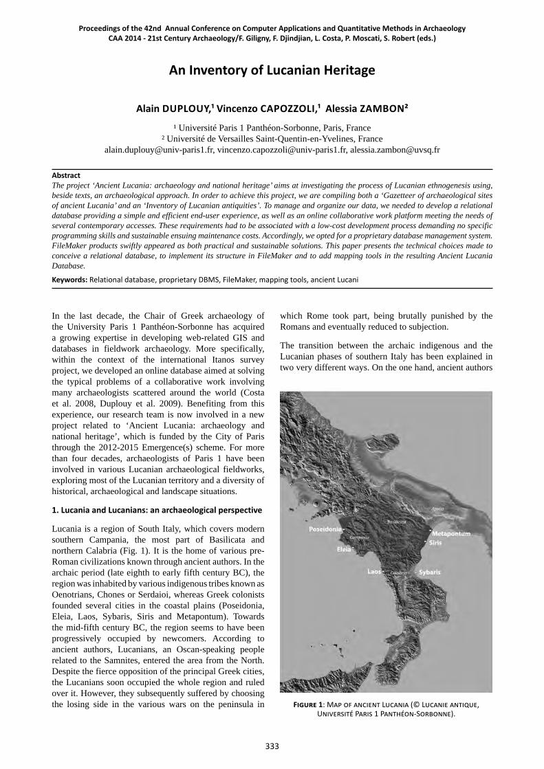
1. Lucania and Lucanians: an archaeological perspective
Lucania is a region of South Italy, which covers modern southern Campania, the most part of Basilicata and northern Calabria (Fig. 1). It is the home of various pre-Roman civilizations known through ancient authors. In the archaic period (late eighth to early fifth century BC), the region was inhabited by various indigenous tribes known as Oenotrians, Chones or Serdaioi, whereas Greek colonists founded several cities in the coastal plains (Poseidonia, Eleia, Laos, Sybaris, Siris and Metapontum). Towards the mid-fifth century BC, the region seems to have been progressively occupied by newcomers. According to ancient authors, Lucanians, an Oscan-speaking people related to the Samnites, entered the area from the North. Despite the fierce opposition of the principal Greek cities, the Lucanians soon occupied the whole region and ruled over it. However, they subsequently suffered by choosing the losing side in the various wars on the peninsula in
which Rome took part, being brutally punished by the Romans and eventually reduced to subjection.
The transition between the archaic indigenous and the Lucanian phases of southern Italy has been explained in two very different ways. On the one hand, ancient authors
Alain DUPLOUY,¹ Vincenzo CAPOZZOLI,¹ Alessia ZAMBON²
¹ Université Paris 1 Panthéon-Sorbonne, Paris, France ² Université de Versailles Saint-Quentin-en-Yvelines, France
[email protected], [email protected], [email protected]
Figure 1: Map of ancient Lucania (© Lucanie antique, Université Paris 1 Panthéon-Sorbonne).
334 CAA 2014 ParisArchaeological Information Systems
A. Duplouy, V. Capozzoli, A. Zambon / An Inventory of Lucanian Heritage
and various modern historians subscribed to the idea of a migration of Samnite tribes coming from the North and expanding into Lucania. On the other hand, however, many archaeologists favour the idea of an internal evolution, named ‘Lucanian ethnogenesis’, and imagine the maturation of a Lucanian identity within the local populations of archaic Lucania (e.g. Pontrandolfo 1982). The literary model of Samnite expansionism is actually never completely dismissed and is regularly reintroduced, consciously or not, in archaeological interpretation, which has often proven to be unable to leave the choice between Samnite expansionism and indigenous internal evolution.
Beyond ancient texts, which insist on feuds between Greeks and Lucanians, material culture remains the most significant documentation available on pre-Roman Lucania and offers the best prospect of gaining an understanding of the full complexity of local situations in its chronological depth, without reducing it to ethnicity matter. Instead of opposing Greeks and indigenous populations in the historical pattern of southern Italy, all these people must actually be considered in the wider network of Mediterranean history (Horden & Purcell 2000, Morris 2005). As recent literature tends to show, patterns of evolution during the whole pre-Roman period are related to multiple transformations in the material culture that are not necessarily ethnically bounded, but are also typical of a global Mediterranean evolution in which Lucania, as a region located at the crossroads of multiple cultural influences, took part.
Labelling cultures is not an end in itself. But characterising them is a necessity. To be specific, archaic indigenous material cultures and Lucanian as well are actually made of specific sets of attributes, but also marked by significant internal variations (see Morgan 1999). In order to assess the process of ‘Lucanian ethnogenesis’ during the fifth and fourth century BC within the wider spectre of Mediterranean context while taking into account the diversity of local patterns and the various substrata of archaic Lucania, it could be worth using a polythetic model. As formalized by David Clarke (1968: 668), the polythetic model offers an interesting tool to explain archaeological diversity by allowing variations in the definition of a specific culture. The point is not to define a set of distinctive attributes that would be ethnically relevant, but rather to explain the variability of that material culture.
2. Ancient Lucania: archaeology and national heritage
This is not the place to present or discuss all these historical questions, and we shall focus on the instruments built in order to conduct the research. We decided to gather all pieces of archaeological evidence and to undertake the collation of a ‘Gazetteer of archaeological sites of pre-Roman Lucania’. There is plenty of archaeological data available on ancient Lucania. The first major discoveries date back to eighteenth-century antiquarians, but the creation of the Soprintendenza della Basilicata in 1964 and its establishment in Potenza marked the beginning of systematic archaeological researches. Archaeological activity was intense in Basilicata
in the last decades, with plentiful operations of rescue and preventive archaeology beside planned fieldworks. Half a century of activity has also produced a profusion of reports, which are unfortunately dispersed in local periodicals, museum catalogues and regional conference proceedings that are not always easily available outside of Italy. One of the aims of the project is to gather in a comprehensive database all pieces of information related to archaeological sites and material excavated in the territory covered by pre-Roman Lucania. The objective is both to provide a convenient access to scattered information, but also to take a critical stance, particularly on earlier researches, that takes into account recent discoveries and interpretative models. By the end of the project, the Ancient Lucania Database will eventually contain a large number of evidences, making it easily available for analytical purposes and archaeological synthesis.
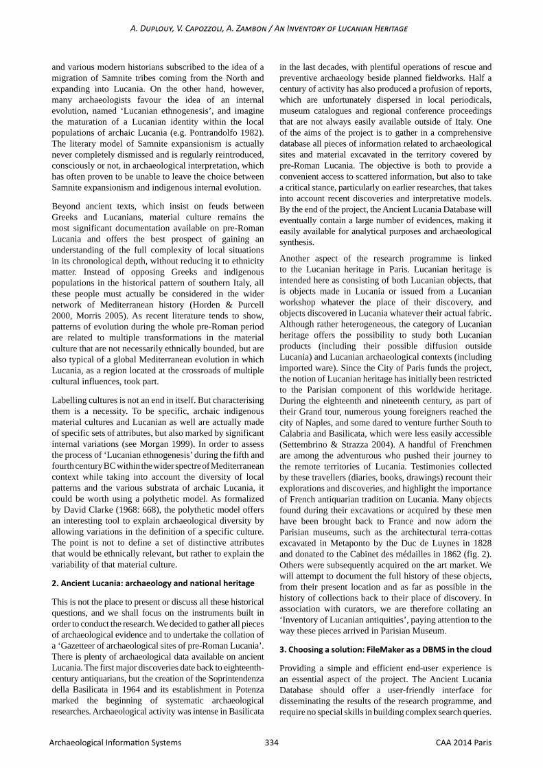
Another aspect of the research programme is linked to the Lucanian heritage in Paris. Lucanian heritage is intended here as consisting of both Lucanian objects, that is objects made in Lucania or issued from a Lucanian workshop whatever the place of their discovery, and objects discovered in Lucania whatever their actual fabric. Although rather heterogeneous, the category of Lucanian heritage offers the possibility to study both Lucanian products (including their possible diffusion outside Lucania) and Lucanian archaeological contexts (including imported ware). Since the City of Paris funds the project, the notion of Lucanian heritage has initially been restricted to the Parisian component of this worldwide heritage. During the eighteenth and nineteenth century, as part of their Grand tour, numerous young foreigners reached the city of Naples, and some dared to venture further South to Calabria and Basilicata, which were less easily accessible (Settembrino & Strazza 2004). A handful of Frenchmen are among the adventurous who pushed their journey to the remote territories of Lucania. Testimonies collected by these travellers (diaries, books, drawings) recount their explorations and discoveries, and highlight the importance of French antiquarian tradition on Lucania. Many objects found during their excavations or acquired by these men have been brought back to France and now adorn the Parisian museums, such as the architectural terra-cottas excavated in Metaponto by the Duc de Luynes in 1828 and donated to the Cabinet des médailles in 1862 (fig. 2). Others were subsequently acquired on the art market. We will attempt to document the full history of these objects, from their present location and as far as possible in the history of collections back to their place of discovery. In association with curators, we are therefore collating an ‘Inventory of Lucanian antiquities’, paying attention to the way these pieces arrived in Parisian Museum.
3. Choosing a solution: FileMaker as a DBMS in the cloud
Providing a simple and efficient end-user experience is an essential aspect of the project. The Ancient Lucania Database should offer a user-friendly interface for disseminating the results of the research programme, and require no special skills in building complex search queries.
F. Giligny, F. Djindjian, L. Costa, P. Moscati, S. Robert (eds.) / Proceedings of CAA 2014 Paris
335 CAA 2014 ParisArchaeological Information Systems
It should also provide a collaborative work platform that meets the needs of several contemporary accesses on the same set of data, both in capturing, analysing and searching the data. These requirements had to be associated with a low-cost development process, demanding no specific programming skills, and sustainable ensuing maintenance costs as well. In 2006 indeed, the creation of the already mentioned Itanos Survey Database (http://prospection-itanos.efa.gr) with open-source technologies – typically an Apache-MySQL-PHP system – required specific development by a computer engineer, and its maintenance over the years has proven to be costly and discontinuous. Capitalizing on this previous experience, it has been decided not to replicate this solution. Actually, open source software is in no way free for archaeologists who want to focus on the archaeological part of their job without turning into computer programmers… even if they are ‘geeks’.
Considering these prerequisites, we opted for a proprietary database management system (DBMS), and FileMaker products swiftly appeared as both practical and sustainable solutions. Although an expensive alternative to open source software from the sole perspective of the purchase of the licences, this solution actually complies with all the requirements of the project. Building the Ancient Lucania Database with FileMaker offered the following advantages: (a) simple structuring of our dataset with a minimum of technical knowledge, (b) easy access by non-specialists, and (c) instant sharing over the internet by multiple users.
a) FileMaker offers quite an easy, though powerful, implementation of relational datasets. Since its initial launch, FileMaker’s relational model has been considerably enriched. Establishing relations throughout the dataset has been built at the core of the managing capacity of the software, allowing complex relations to be created with a minimum of technical knowledge. Despite some peculiarities of the FileMaker technology as a DBMS in managing tables and relationships (see below), FileMaker’s relational model offers multiple tables per file and a graphical relationship editor that displays and allows
manipulation of related tables in a manner that resembles canonical entity-relationship modelling.
b) As a subsidiary of Apple Inc., FileMaker Inc. has always been careful to associate his database engine with a graphical user interface (GUI) compliant with the expectations of non-specialist users. In developing the Ancient Lucania Database we were very keen on offering the same user-friendly experience to end-users, immediately providing them all relevant information. That is to say that user requirements and areas of interest were considered right from the start in the design of the tool against an archaeological background interest. There are indeed plenty of queries that can be performed against the whole collected set of data, but only some of them are really relevant to an archaeological research on ancient Lucania. In other words, visualization of relevant data has been prioritized against the whole series of possible interactions with the dataset. Instead of performing any kind of on-demand queries with more or less complex search criteria, FileMaker offers these oriented visualisation capabilities, turning end-users toward specific areas of research by referring to previously created relations in the relationship graph (RG). If FileMaker doesn’t have the flexibility of SQL – even if plugins and recent implementations in the latest versions of the software have brought a full set of SQL capabilities –, it is actually built on a different concept.
c) A database is useless if it cannot be accessed widely and easily. The Ancient Lucania Database had to provide a collaborative work platform that meets the needs of end-users for capturing and searching data. Simultaneously accessing the most up-to-date information could only be achieved through a centrally hosted database on a server. Cloud technologies therefore appeared as a necessity. Accordingly, our choice to use FileMaker has also been determined by the need to interact with other researchers and databases through the FileMaker Server capabilities. In this perspective we benefitted from the technological infrastructure offered by the Huma-num Very Large Facility, which has been established to facilitate the digital turn in humanities and social sciences among French research operators. Huma-num provides the capabilities of FileMaker Server at no cost for our team.
Considering their potentialities and knowing their restrictions, FileMaker products nevertheless appeared as practical and viable solutions to be used as a DBMS in the cloud for the Ancient Lucania Database. We are fully aware that entrusting our data to propriety database systems can be risky, as it already happened that database companies went under, leaving scholars with datasets difficult to access on new computers that couldn’t run the older database software. However, although the whole set of data and the structure of the Ancient Lucania Database will be enclosed in a proprietary file system, the formal organisation of a FileMaker database can still be transferred, with various adaptations, to open source solutions in the possible (but still unlikely) event of a breakdown of FileMaker Inc. and the discontinuity of its development.
Figure 2: Architectural terra-cotta with lion-head spout (Paris, Cabinet des médailles, Luynes 780) (© Lucanie antique,
Université Paris 1 Panthéon-Sorbonne).

336 CAA 2014 ParisArchaeological Information Systems
A. Duplouy, V. Capozzoli, A. Zambon / An Inventory of Lucanian Heritage
The Ancient Lucania Database was created using FileMaker Pro 12, with a later upgrade to FileMaker Pro 13, which allows a much broader set of solutions for the graphical user interface and upgraded web publishing capabilities through the WebDirect technology. It has been hosted on a Huma-num FileMaker Server 12 since the summer 2013, and then migrated to a FileMaker Server 13. Since FileMaker natively manages multiple users with specific accounts and privilege sets, data are automatically signed when captured or modified. Beside registered users, a more general audience of scholars interested in ancient Lucania can also fully access the data as simple guests with no writing permissions. The database can be accessed through a FileMaker client on a desktop or laptop, through the FileMaker Go app on an iOS device, or through a simple web browser on any computer through our website (http://lucanie-antique.univ-paris1.fr). FileMaker technologies indeed provide a type of quick, easy and secure web publishing by creating the web form and other codes needed to access the database as a website, with no development skills required. The database accessed via the web uses an interface that mirrors the one used in the desktop app, and changes made through the web are updated to the FileMaker Server-hosted database in real time.
All this allowed us to spare weeks of specific development by a computer engineer. Even archaeologists with a reasonable knowledge of FileMaker are able to modify the structure of the data, the layout of the interface or the way the DBMS works. This could never be achieved with an externalised development process, except with time-consuming backwards and forwards exchanges between archaeologists and engineers.
4. Building the database: from data to end-users
The first task was to describe the collected data and their processing requirements as an elementary entity-relationship model (ER model) (Fig. 3). Considering the ambitions of our programme towards archaeology and cultural heritage, the conceptual data model has been organized around three main objects: the archaeological sites of Lucania, the Lucanian antiquities and the people related either to the exploration of Lucania or to the collecting of Lucanian antiquities (travellers, collectors, art dealers or even famous curators). These entities are characterized by
Figure 3: ER model of the Ancient Lucania Database (© Lucanie antique, Université Paris 1
Panthéon-Sorbonne).
specific attributes and documented by what we may call references (hundreds of bibliographic records, unpublished archive references, administrative boundaries, and images). They are also linked with each other by relationships that express the dependencies and requirements between them. The relational database has been implemented moving from this elementary conceptual model, which has been kept pro memoria as a gateway to the Ancient Lucania Database.
4.1. Defining and naming the tables
Each entity of the conceptual ER model is represented as a table, with data fields being the attributes. The key principle in building a relational database is that one-to-one relations are included as fields in the current table, one-to-many relations need a related table with match (or key) fields, and many-to-many relations require an intermediary table between two related tables. To be specific, to one archaeological site correspond several objects, but every object is linked to only one site. For instance, among the numerous antiquities discovered in the Achaean colony of Metaponto, the proto-classical architectural terra-cottas kept at the Cabinet des médailles in Paris were excavated in the urban sanctuary (the so-called temple of Apollo Lyceum, actually the temple of Hera) and brought to France by the Duc de Luynes. In that case, the relation between a single site and the objects found there is a one-to-many. Conversely, different persons (travellers, curators, art-dealers, etc.) can be related to the same sites. For example, Aubin-Louis Millin, traveling in southern Italy between 1811 and 1813, explored various sites in Campania, Calabria, Basilicata, Apulia and elsewhere (D’Achille et al. 2012a and 2012b), but these sites where also visited by other travellers. In that case, the relations are many-to-many relationships, and intermediary tables are necessary to establish the links between sites and people.
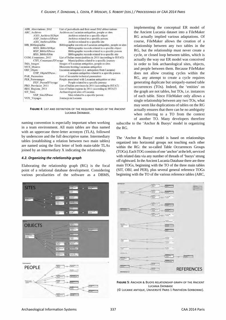
Although there are only three main objects on which the Ancient Lucania research project focuses, 23 tables were actually necessary to implement the conceptual ER model and organize every piece of information and their relations (Fig. 4).
Despite the lack of specific requirements and the general flexibility of FileMaker coding, adopting a consistent
F. Giligny, F. Djindjian, L. Costa, P. Moscati, S. Robert (eds.) / Proceedings of CAA 2014 Paris
337 CAA 2014 ParisArchaeological Information Systems
naming convention is especially important when working in a team environment. All main tables are thus named with an uppercase three-letter acronym (TLA), followed by underscore and the full descriptive name. Intermediary tables (establishing a relation between two main tables)are named using the first letter of both main-table TLAs joined by an intermediary X indicating the relationship.
4.2. Organizing the relationship graph
Elaborating the relationship graph (RG) is the focal point of a relational database development. Considering various peculiarities of the software as a DBMS,
Figure 5: Anchor & Buoys relationship graph of the Ancient Lucania Database
(© Lucanie antique, Université Paris 1 Panthéon-Sorbonne).
Figure 4: List and definition of the required tables of the Ancient Lucania Database.
implementing the conceptual ER model of the Ancient Lucania dataset into a FileMaker RG actually implied various adaptations. Of course, FileMaker allows the creation of a relationship between any two tables in the RG, but the relationship must never create a cycle, or closed loop between tables, which is actually the way our ER model was conceived in order to link archaeological sites, objects, and people between them. Because FileMaker does not allow creating cycles within the RG, any attempt to create a cycle requires generating duplicate but uniquely-named table occurrences (TOs). Indeed, the ‘entities’ on the graph are not tables, but TOs, i.e. instances of each table. Since FileMaker only allows a single relationship between any two TOs, what may seem like duplications of tables on the RG actually ensures that there can be no ambiguity when referring to a TO from the context of another TO. Many developers therefore
subscribe to the ‘Anchor & Buoys’ model in organizing the RG.
The ‘Anchor & Buoys’ model is based on relationships organized into horizontal groups not touching each other within the RG: the so-called Table Occurrences Groups (TOGs). Each TOG consists of one ‘anchor’ at the left, serviced with related data via any number of threads of ‘buoys’ strung off rightward. In the Ancient Lucania Database there are three main TOGs, beginning with the TO of the three main tables (SIT, OBJ, and PER), plus several general reference TOGs beginning with the TO of the various reference tables (ARC,
338 CAA 2014 ParisArchaeological Information Systems
A. Duplouy, V. Capozzoli, A. Zambon / An Inventory of Lucanian Heritage
BIB, IMA, COM, PRO, REG, MUS, VOY). The RG (fig. 5) has been graphically designed in order to vertically align the different ‘anchors’ as well as the ‘buoys’ (including intermediary and related tables).
Of course, the ‘Anchor & Buoys’ model is not without various restraints. Such a hierarchical model lends itself indeed to the requirement of only one path between any two TOs. It means that the ensuing RG does not support bi-directional relations inherently, so that expressing right-to-left data requires creating another TOG with another ‘anchor’ as initial point. The necessity to create the same relationship in different TOGs to replicate the same functionality in different contexts nevertheless ensures every relationship is created from the context of each specific TO. To some degree, the ‘Anchor & Buoys’ model was developed for the FileMaker developers’ convenience, in order to ease the randomness and difficulties of finding one’s way around and of knowing one’s context. Being formally codified, such a method therefore also ensures that all archaeologists ever implied in (future) developments of the Ancient Lucania Database will find their way out, even if the RG cannot be automatically replicated in an open source DBMS. Whereas the conceptual ER model is the main structuring expression of all dependencies and requirements between the various entities of the database, the RG is actually nothing more than a visual tool helping the developer to execute the relationships that are needed to express the required links between the various parts of the dataset and that are offered to end-users queries.
4.3. Designing layouts and end-user interface
According to the ‘Anchor & Buoys’ model, layouts may only be based on the ‘anchor’ (leftmost) TO. The ‘buoy’ TOs exist solely to feed data to any layouts based on the
‘anchor’. Although there are as many layouts as TOGs, allowing a full and detailed access to the whole dataset, the database however favours a direct access, both in capturing and searching mode, to the three main objects of the research. These main layouts allow to visualize at a glance the whole relevant data, even if stored in related tables. Moreover, the main layouts have been elaborated in order to always reproduce the same graphical and conceptual pattern.
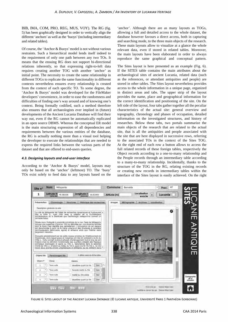
The Sites layout is here presented as an example (Fig. 6). If the SITES table contains the main attributes about the archaeological sites of ancient Lucania, related data (such as the references, or attendant antiquities and people) are stored in other tables. The Sites layout nevertheless provides access to the whole information in a unique page, organized in distinct areas and tabs. The upper strip of the layout provides the name, place and geographical information for the correct identification and positioning of the site. On the left side of the layout, four tabs gather together all the peculiar characteristics of the actual site: general overview and topography, chronology and phases of occupation, detailed information on the investigated structures, and history of researches. Below these tabs, two portals summarize the main objects of the research that are related to the actual site, that is all the antiquities and people associated with the site that are here displayed in successive rows, referring to the associated TOs in the context of the Sites TOG. At the right end of each row a button allows to access the full related records of these foreign tables, respectively the Object records according to a one-to-many relationship and the People records through an intermediary table according to a many-to-many relationship. Incidentally, thanks to the structure of the TOG in the RG, relating existing records or creating new records in intermediary tables within the interface of the Sites layout is easily achieved. On the right
Figure 6: Sites layout of the Ancient Lucania Database (© Lucanie antique, Université Paris 1 Panthéon-Sorbonne)
F. Giligny, F. Djindjian, L. Costa, P. Moscati, S. Robert (eds.) / Proceedings of CAA 2014 Paris
339 CAA 2014 ParisArchaeological Information Systems
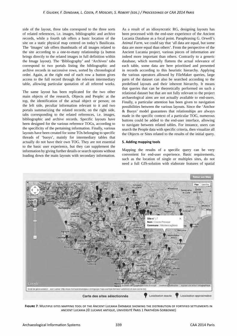
side of the layout, three tabs correspond to the three sorts of related references, i.e. images, bibliographic and archive records, while a fourth tab offers a basic location of the site on a static physical map centred on today’s Basilicata. The ‘Images’ tab offers thumbnails of all images related to the site according to a one-to-many relationship (a button brings directly to the related images in full definition within the Image layout). The ‘Bibliography’ and ‘Archives’ tabs correspond to two portals listing the bibliographic and archive records in successive rows, sorted by chronological order. Again, at the right end of each row a button gives access to the full record through the relevant intermediary table, allowing particular quotation of all referred works.
The same layout has been replicated for the two other main objects of the research, Objects and People: at the top, the identification of the actual object or person; on the left side, peculiar information relevant to it and two portals summarizing the related records; on the right side, tabs corresponding to the related references, i.e. images, bibliographic and archive records. Specific layouts have been designed for the various reference TOGs, according to the specificity of the pertaining information. Finally, various layouts have been created for some TOs belonging to specific threads of ‘buoys’, mainly for intermediary tables that actually do not have their own TOG. They are not essential to the basic user experience, but they can supplement the information by giving further details or search options without loading down the main layouts with secondary information.
As a result of an idiosyncratic RG, designing layouts has been processed with the end-user experience of the Ancient Lucania Database as a focal point. Paraphrasing G. Orwell’s Animal Farm, we could say that ‘all data are equal, but some data are more equal than others’. From the perspective of the Ancient Lucania project, various pieces of information are indeed more important than others. Contrarily to a generic database, which normally flattens the actual relevance of each table, some data are here prioritised and presented in records according to this heuristic hierarchy. Applying the various operators allowed by FileMaker queries, large parts of the dataset can also be searched according to the predefined layouts and their inherent hierarchy. It means that queries that can be theoretically performed on such a relational dataset but that are not fully relevant to the project archaeological aims are not actually available to end-users. Finally, a particular attention has been given to navigation possibilities between the various layouts. Since the ‘Anchor & Buoys’ model guarantees that relationships are always made in the specific context of a particular TOG, numerous buttons could be added to the end-user interface, allowing to navigate between related tables. For instance, users can search the People data with specific criteria, then visualize all the Objects or Sites related to the results of the initial query.
5. Adding mapping tools
Mapping the results of a specific query can be very convenient for end-user experience. Basic requirements, such as the location of single or multiples sites, do not need a full GIS-solution with elaborate features of spatial
Figure 7: Multiple-sites mapping tool of the Ancient Lucania Database showing the distribution of fortified settlements in ancient Lucania (© Lucanie antique, Université Paris 1 Panthéon-Sorbonne)
340 CAA 2014 ParisArchaeological Information Systems
A. Duplouy, V. Capozzoli, A. Zambon / An Inventory of Lucanian Heritage
analysis. Although these might be of some interest for an on-going research project on ancient Lucania, they are not the main purpose of the actual database. Simple mapping tools are nevertheless a plus that can be added to the user interface thanks to various technologies built in within FileMaker products or offered on the web by Google Maps.
As already mentioned, the location of every archaeological site is provided as a component of the Sites layout. The site is located on a static map thanks to the FileMaker web viewer tool and the Google Maps API, using the geographic coordinates manually included in the description of the site. In compiling the records, archaeologists are indeed asked to enter the location of each site according to Google Maps geographic coordinate system (latitude and longitude in decimal degrees, according to the specific 3857 EPSG code allocated to the Google Maps datum). They also have to specify the accuracy of their cartographic information, by choosing between an approximate location – when no precise location is available in the extant literature – or an exact location (i.e. less than a 100m radius) – thanks to a published map or to personal on-site experience.
The main interest of a mapping tool is actually to provide a map of multiple sites matching definite attributes, such as the result of a query performed within the Sites layout. Generating a map of all fortified settlements, for instance, can be very meaningful to users of the Ancient Lucania Database. This implementation nevertheless required a bit more of specific development and coding, even if there are several examples provided on the internet with the associated code and scripting documentation. To be specific, our work benefitted from the generic script generously provided on his website by Jean Lasnier, a developer of FileMaker solutions (www.filemakerdeveloppeur.com/google-maps-exemple-filemaker-webdirect/), which has been adapted to the peculiarities of the Ancient Lucania Database. The solution consists in writing a JavaScript code recorded as a field of the Parameters table (PAR), whose variables are dynamically modified thanks to a FileMaker script defining an array of figures with the coordinates (and their accuracy level) of the sites to be mapped. The JavaScript code is sent to Google Maps API with the relevant data and then visualized in a FileMaker web viewer (Fig. 7). Sites whose location is approximate are mapped with a red pin, sites with an exact location are marked with a blue pin. To each marker is attached an info window that displays the site number, its name and the municipality in which it is located. The web viewer displays by default a physical map based on terrain information, which can be switched to other map types provided by Google (road map view, Google Earth satellite images, or an hybrid map combining the latters). Of course, the map can be zoomed in or out, and it natively provides an access to the Google Street View service. In substance, end-users can map on demand the result of any query performed against the data displayed in the Sites layout, just by clicking on a button launching the whole process of map making. Moreover, since the Objects and People tables are related to the Sites table in the RG, the result of any query made in the associated layouts can be visualized as a map, such as the distribution map of Lucanian red figures vases hosted in Parisian museums – provided that the relevant provenance information exists – or the itinerary of travellers in southern Italy.
Eventually, the Ancient Lucania Database will offer to all scholars interested by the archaeology and cultural heritage of this southern-Italian area a powerful, but yet user-friendly research tool gathering all useful information, with a critical perspective, as well as elementary mapping functionalities allowing cartographic visualization of the principal search queries.
References
CLARKE, D. L. (1968). Analytical Archaeology, London: Methuen.
COSTA, L., DUPLOUY, A., EYRAUD, F. and SARRIS, A. (2008). Vers la mise en réseau des données et des chercheurs : le système d’information de la prospection d’Itanos (Crète orientale). Archeologia e calcolatori. 19. pp. 103-122.
D’ACHILLE, A.-M., IACOBINI, A., PRETI-HAMARD, M., RIGHETTI TOSTI-CROCE, M. and TOSCANO, G. (2012) Viaggi e coscienza patrimoniale : Aubin-Louis Millin (1759-1818) tra Francia e Italia. Voyages et conscience patrimoniale : Aubin-Louis Millin (1759-1818) entre France et Italie. Rome: Campisano.
D’ACHILLE, A.-M., IACOBINI, A. and TOSCANO, G. (2012). Il viaggio disegnato : Aubin-Louis Millin nell’Italia di Napoleone, 1811-1813. Rome: Campisano.
DUPLOUY, A., SCHNAPP, A., SCHNAPP-GOURBEILLON, A., TSIGONAKI, C. and VIVIERS, D. (2009). Recherches archéologiques à Itanos (Crète orientale). Revue archéologique. pp. 208-219.
HORDEN, P. and PURCELL, N. (2000). The Corrupting Sea: A Study of Mediterranean History. Oxford: Blackwell.
MORGAN, C. (1999). The Archaeology of Ethnicity in the Colonial World of the Eighth to Sixth Centuries BC: Approaches and Prospects. In: Confini e frontiera nella Grecità d’Occidente. Atti del trentasettesimo convegno di studi sulla Magna Grecia, Taranto 3-6 Ottobre 1997. Taranto: Istituto per la storia e l’archeologia della Magna Grecia. pp. 85-144.
MORRIS, I. (2005). Mediterraneisation. In: Malkin, I. (ed.). Mediterranean Paradigms and Classical Antiquity. London: Routledge. pp. 30-55.
PONTRANDOLFO, A. (1982). I Lucani. Etnografia e archeologia di una regione antica, Milan: Longanesi.
SETTEMBRINO, G. and STRAZZA, M. (2004).Viaggiatori in Basilicata (1777-1880), Potenza: Consiglio regionale della Basilicata.
Webography
DUPLOUY, A. (2006-2014). Prospection Itanos. Base de données en ligne. [Online] Available from: http://prospection-itanos.efa.gr/. [Accessed: 23rd July 2014].
DUPLOUY, A. (2013-2014). La Lucanie antique: archéologie et patrimoine. [Online] Available from: http://lucanie-antique.univ-paris1.fr [Accessed: 23rd July 2014].
LASNIER, J. (2011-2014). Développement simple en FileMaker. [Online] Available from: http://www.filemakerdeveloppeur.com. [Accessed: 23rd July 2014].