Embed Size (px)
Citation preview
FACTUAL REPORT
SITE: Branston Lock Development CLIENT: Staffordshire County Council / Nurton Development
(Quintus) LTD ORDER No: 48000040114/006 DATE: 07 January 2016 REPORT No: C4877
P/2016/00474
Received 24.03.2016
CC Ground Investigations Ltd Report C4877
CONTENTS
REPORT
1. INTRODUCTION 1
2. SITE DESCRIPTION AND GEOLOGY 3
2.1 Site Description 3
2.2 Geology 3
3. GROUND INVESTIGATION 4
3.1 Fieldwork 4
3.2 In Situ Testing 6
3.3 Logging 6
3.4 Laboratory Testing 7
4. REFERENCES 9
APPENDICES
Appendix A – Site Plan
Appendix B – Exploratory Hole Data
Appendix C – Laboratory Test Results
Appendix D – SPT Calibration Data
CC Ground Investigations Ltd Report C4877
Page 1
1. INTRODUCTION
This investigation was carried out by CC Ground Investigations Ltd (CCGI) on the
instruction and on behalf of Staffordshire County Council / Nurton Development
(Quintus) LTD (The Client) under the technical direction of Amey OWR Limited.
The purpose of the ground investigation was to provide information to assist in the
design of Branston Locks Development Phase 1; a new access route from the A38
roundabout, canal bridge and roads in to the Branston Locks Development.
The scope of the ground investigation was defined in the Engineer’s specification,
reference: Ground Investigation Specification Staffordshire County council‐
Branston Locks Development (CON‐GE‐BHAM‐COSTCDX8620‐GI‐001‐Revision 0).
This report describes the work carried out by CC Ground Investigations Ltd and
presents the findings.
All information, comments and opinions given in this report are based on the
ground conditions encountered during the site work, and on the results of
laboratory and field tests performed during the investigation. There may however
be conditions at or adjacent to the site which have not been taken into account,
such as unpredictable soil strata and water conditions between or below
exploratory holes. A careful watch should be maintained during any future
groundworks and the comments of this report reviewed as necessary.
This report has been prepared for Staffordshire County Council / Nurton
Development (Quintus) LTD and Amey OWR Limited. This report shall not be

CC Ground Investigations Ltd Report C4877
Page 2
relied upon or transferred to other parties without the written consent of CC
Ground Investigations Ltd. Should any information contained within this report
be used by any unauthorised third party it is done so at their own risk and shall
not be the responsibility of CC Ground Investigations Ltd.
CC Ground Investigations Ltd Report C4877
Page 3
2. SITE DESCRIPTION AND GEOLOGY
2.1 Site Description
The area of investigation comprises a small residential area and local nature
reserve, North of Branston Road with the land currently used for agricultural
purposes, which consists of predominantly open fields at, nearest postcode DE14
3EZ. The site is centred on the approximate National Grid Reference SK 21705
21302.
2.2 Geology
Geological Records (British Geological Survey (BGS), England and Wales sheet 140
Burton upon Trent 1:50,000 scale) indicate the site is underlain by superficial
deposits of Holme Pierrepont Sand and Gravel Member, part of the Trent Valley
Formation. Underlying solid geology comprising mudstones of the Mercia
Mudstone Group is recorded.
CC Ground Investigations Ltd Report C4877
Page 4
3. GROUND INVESTIGATION
3.1 Fieldwork
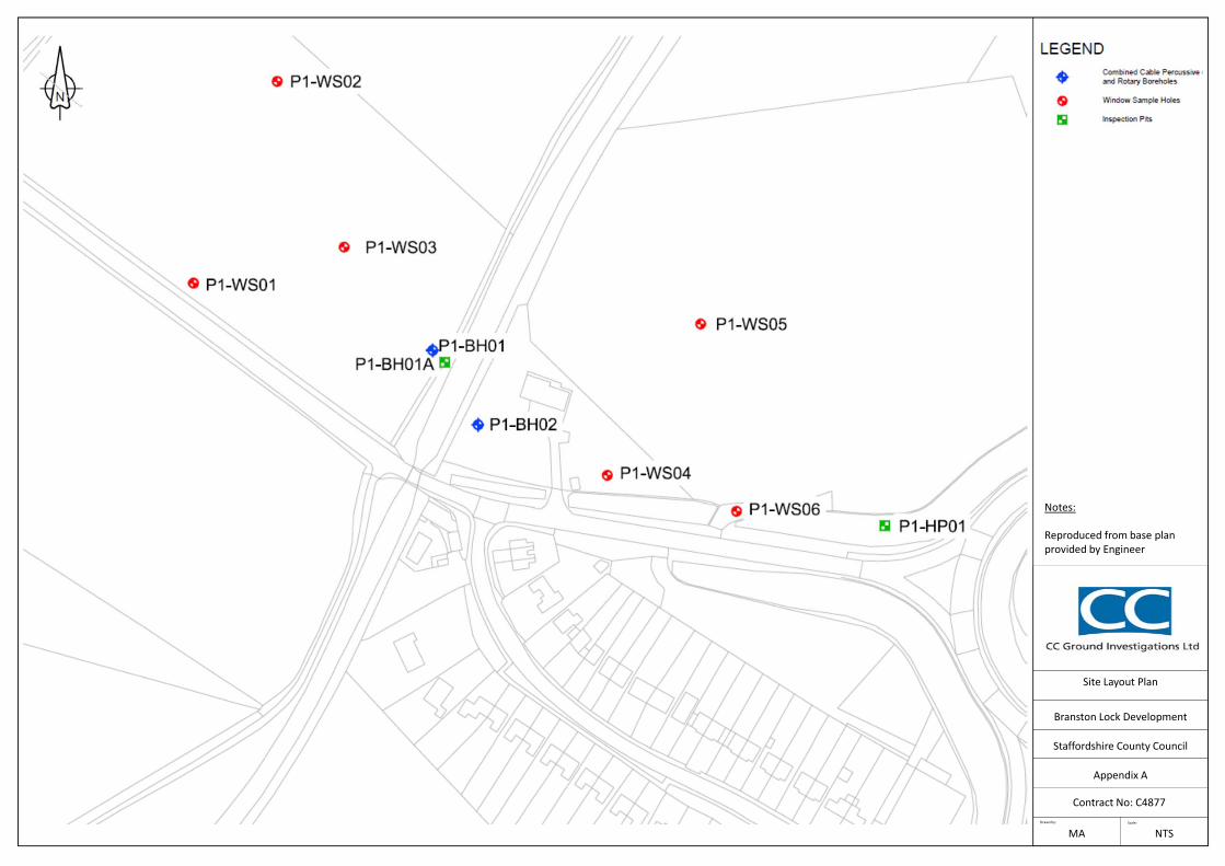
Ten exploratory holes were carried out between 12th and 17th of November 2015.
All exploratory hole locations are shown on the site plan (Appendix A). The
exploratory hole locations were set out by CCGI as directed by the Client on site.
The fieldwork was carried out in general accordance with BS5930, Amendment 2
(2010).
The boreholes, referenced P1‐BH01, P1‐BH01A and P1‐BH02 (Exploratory Hole Data
– Appendix B) were formed using a track mounted Comacchio MC300 multi
purpose rig. Following CAT scanning hand tools were used to excavate an
inspection pit to a maximum depth of 1.20m to check for buried services. Bulk and
environmental soil samples were taken and retained from the inspection pits. The
boreholes were then advanced using percussive sampling techniques to produce
continuous disturbed samples ranging between 112mm and 98mm diameter.
On refusal of percussive sampling the boreholes were continued by rotary core
drilling techniques utilising a water/polymer flush. A double‐tube swivel core barrel
with a semi‐rigid plastic liner was utilised to recover continuous cores of 91mm
diameter.
Undisturbed samples of 100mm nominal diameter were taken in suitable cohesive
material using an open drive sampler U(T)100. The samples were wax sealed on site
to prevent moisture loss.
CC Ground Investigations Ltd Report C4877
Page 5
The boreholes, referenced P1‐WS01 to P1‐WS06 (Exploratory Hole Data – Appendix
B) were formed using a track mounted Terrier drilling rig. Following CAT scanning
hand tools were used to excavate an inspection pit to a maximum depth of 1.20m
to check for buried services. Bulk and environmental soil samples were taken and
retained from the inspection pits. The boreholes were then advanced using
percussive sampling techniques to produce continuous disturbed samples ranging
between 83mm and 71mm diameter.
Soil samples were retained in semi‐rigid plastic liners, which were capped on site to
prevent moisture loss.
Boreholes were monitored for groundwater ingress as they were advanced. Upon
encountering water, sampling was temporarily stopped to allow the level to
stabilise. Water levels were also recorded at the start and finish of each shift, on
completion of the borehole and are presented on the relevant log.
On completion, a gas/water monitoring standpipes was installed in P1‐BH01. Each
installation consisted of a 50mm ID HDPE slotted tube set in a filter response zone
of limestone free gravel. The installation was sealed above and below with a
bentonite pellet seal and accessed via a valve assembly. The installation was
protected at the surface by a lockable stopcock cover set in concrete. Installation
details are given on the relevant borehole log.
The inspection pits, referenced P1‐BH01A and P1‐HP01 (Exploratory Hole Data –
Appendix B) were undertaken to provide further information in close proximity to
the existing embankment and canal towpath. Representative bulk disturbed and
environmental soil samples were taken at a range of depths.
CC Ground Investigations Ltd Report C4877
Page 6
On completion, all remaining positions were backfilled with bentonite pellets and
arisings with the surface reinstated.
Subsequent to fieldwork, all exploratory hole positions were surveyed and National
Grid co‐ordinates and levels are presented on the relevant log.
On completion of fieldwork all samples were brought to CCGI’s office for storage.
3.2 In Situ Testing
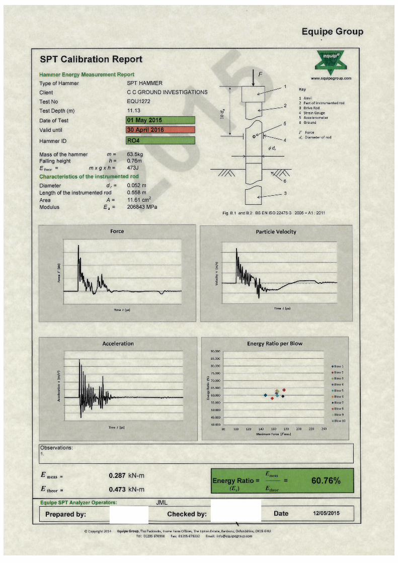
Standard penetration tests (SPT) were carried out in general accordance with BS EN
ISO 22476‐3:2005. A split barrel or a solid cone was used depending upon the
materials encountered and the split barrel samples retained as small disturbed
samples. The SPT N value was taken as the number of blows to penetrate the
300mm test drive following a 150mm seating drive. Where low penetration was
recorded the seating drive was terminated at 25 blows and the test drive
completed after a further 50 blows. SPT results are summarised as uncorrected N
values on the borehole logs and . SPT hammer calibration data is presented in
Appendix D.
3.3 Logging
Soil and rock samples from the exploratory holes were logged by an Engineering
Geologist in general accordance with BS5930, Amendment 2 (2010). Bulk, small
disturbed, core and environmental soil samples were taken retained at a range of
depths. Environmental soil samples were stored on site in temperature controlled
conditions. Soil and rock descriptions are presented in the borehole logs together
CC Ground Investigations Ltd Report C4877
Page 7
with details of sampling, in situ testing and relevant comments on drilling
techniques.
Prior to logging photographs of the samples were taken and are presented
following the relevant log.
3.4 Laboratory Testing
The following laboratory tests were carried out by Professional Soils Laboratory
(UKAS No. 4043) in accordance with BS1377:1990, Parts 1 to 8, unless otherwise
stated. The results are presented in Appendix C.
Test Type No. of Tests Remarks
Natural Moisture Content 24 The results are shown on the summary of soil classification tests.
Liquid and Plastic Limits 11 The results are shown on the plasticity chart and summary of soil classification tests.
Particle Size Distribution (wet sieving method)
19 The fine fractions of 12 of these tests were further analysed using the pipette method.
One Dimensional Consolidation 1
Multi‐stage Quick Undrained Triaxial Test
1 Carried out on a full diameter UT100 sample.
Point Load Strength 3 ISRM RTH 325‐89 SR12
BRE SD1 chemical testing suite for soil and water
6 Testing carried out by Chemical Testing Laboratories in accordance with BRE Special Digest 1.
CC Ground Investigations Ltd Report C4877
Page 8
A range of chemical tests were carried out on soil and water samples by i2
Analytical (UKAS No. 4041). Testing was carried out in accordance with ISO 17025.
The results are tabulated and presented in Appendix C.
CC GROUND INVESTIGATIONS LIMITED
Mike Atherton BSc (Hons) FGS Rob Clarke. BSc (Hons) MSc (Eng) FGS Senior Engineering Geologist Director
CC Ground Investigations Ltd Report C4877
Page 9
4. REFERENCES
British Geological Society, Solid and Drift Sheet 140, Burton Upon Trent, 1:50,000 scale
BRE Special Digest 1:2003: Concrete in aggressive ground. Part 1.
BS 5930+A2:1999 (2010), Code of Practice for Site Investigations
BS 1377: Parts 1 to 9 (1990), Methods of Tests of Soils for Civil Engineering Purposes
BS EN ISO 14688: Part 1: (2002), Identification and description of soil.
BS EN ISO 14688: Part 2: (2004), Principles for a classification of soil.
BS EN ISO 14689: Part 1: (2003), Identification and description.
BS EN ISO 22475: Part 1: (2006), Technical principles for execution.
BS EN ISO 22476: Part 3: (2005), Standard penetration test.
ISRM RTH 325‐89 SR12, Suggested Method for Determining Point Load Strength.

CC Ground Investigations Ltd Report C4877
APPENDIX A
Appendix A – Site Plan
Site Layout Plan
Contract No: C4877
Staffordshire County Council
Appendix A
Branston Lock Development
Drawn by: Scale:
MA NTS
Notes:
Reproduced from base plan provided by Engineer

CC Ground Investigations Ltd Report C4877
APPENDIX B
Appendix B – Exploratory Hole Data
CC Ground Investigations Ltd
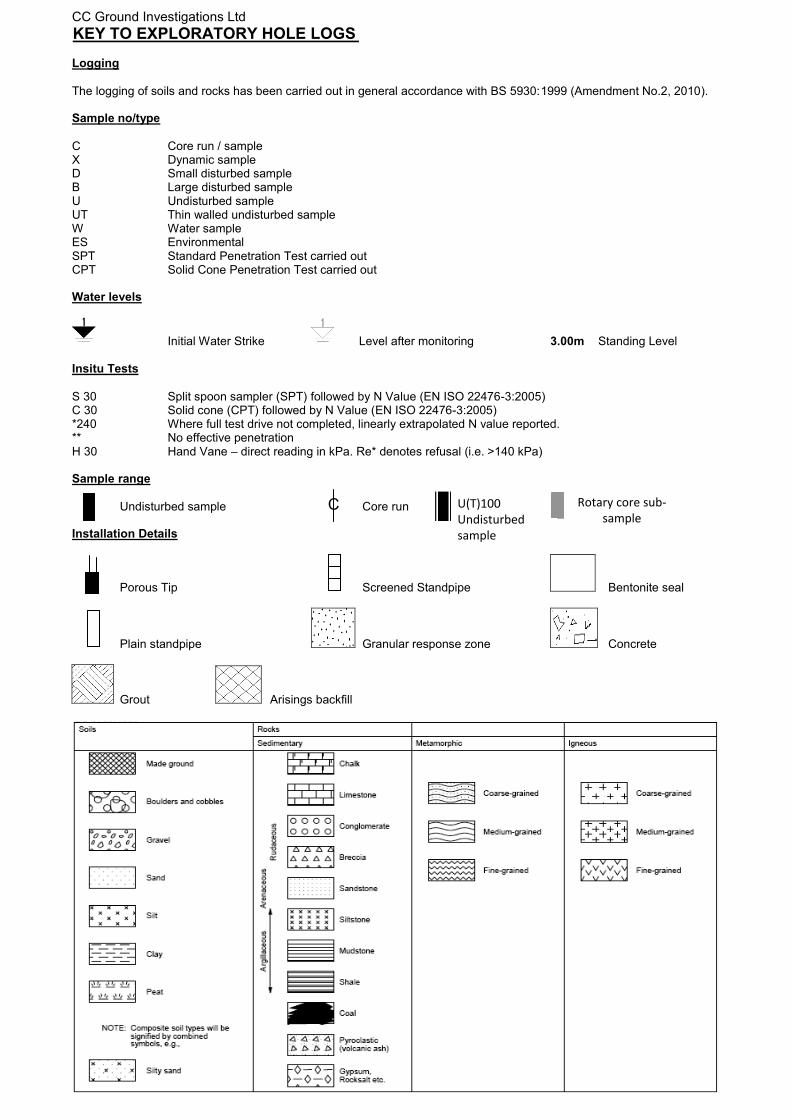
KEY TO EXPLORATORY HOLE LOGS
Logging
The logging of soils and rocks has been carried out in general accordance with BS 5930:1999 (Amendment No.2, 2010).
Sample no/type
C Core run / sample X Dynamic sample D Small disturbed sample B Large disturbed sample U Undisturbed sample UT Thin walled undisturbed sample W Water sample ES Environmental SPT Standard Penetration Test carried out CPT Solid Cone Penetration Test carried out
Water levels
Initial Water Strike Level after monitoring 3.00m Standing Level
Insitu Tests
S 30 Split spoon sampler (SPT) followed by N Value (EN ISO 22476-3:2005) C 30 Solid cone (CPT) followed by N Value (EN ISO 22476-3:2005) *240 Where full test drive not completed, linearly extrapolated N value reported. ** No effective penetration H 30 Hand Vane – direct reading in kPa. Re* denotes refusal (i.e. >140 kPa)
Sample range
Undisturbed sample Core run
Installation Details
Porous Tip Screened Standpipe Bentonite seal
Plain standpipe Granular response zone Concrete
Grout Arisings backfill
C U(T)100
Undisturbed
sample
Rotary core sub-
sample
47.24
47.04
46.69
46.04
45.09
42.84
41.34
0.30
0.50
0.85
1.50
2.45
4.70
6.20
(0.65)
(0.95)
(2.25)
(1.50)
(3.00)
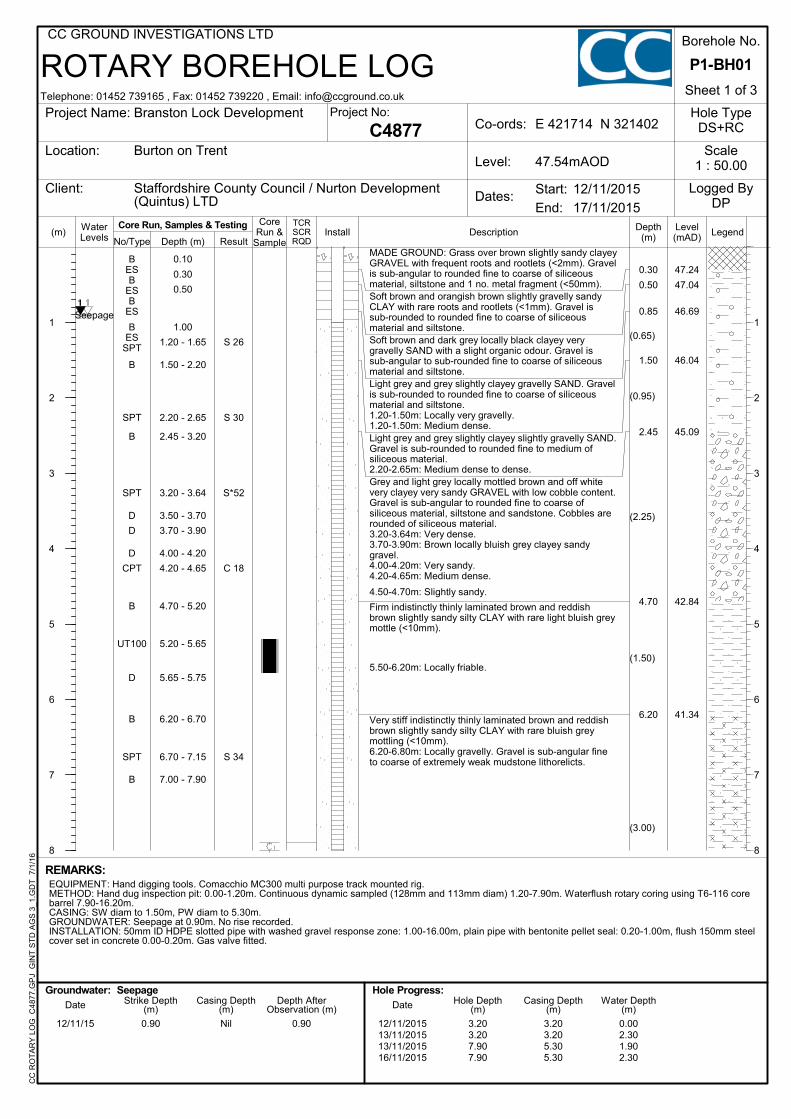
MADE GROUND: Grass over brown slightly sandy clayeyGRAVEL with frequent roots and rootlets (<2mm). Gravelis sub-angular to rounded fine to coarse of siliceousmaterial, siltstone and 1 no. metal fragment (<50mm).Soft brown and orangish brown slightly gravelly sandyCLAY with rare roots and rootlets (<1mm). Gravel issub-rounded to rounded fine to coarse of siliceousmaterial and siltstone.Soft brown and dark grey locally black clayey verygravelly SAND with a slight organic odour. Gravel issub-angular to sub-rounded fine to coarse of siliceousmaterial and siltstone.Light grey and grey slightly clayey gravelly SAND. Gravelis sub-rounded to rounded fine to coarse of siliceousmaterial and siltstone.1.20-1.50m: Locally very gravelly.1.20-1.50m: Medium dense.Light grey and grey slightly clayey slightly gravelly SAND.Gravel is sub-rounded to rounded fine to medium ofsiliceous material.2.20-2.65m: Medium dense to dense.Grey and light grey locally mottled brown and off whitevery clayey very sandy GRAVEL with low cobble content.Gravel is sub-angular to rounded fine to coarse ofsiliceous material, siltstone and sandstone. Cobbles arerounded of siliceous material.3.20-3.64m: Very dense.3.70-3.90m: Brown locally bluish grey clayey sandygravel.4.00-4.20m: Very sandy.4.20-4.65m: Medium dense.
4.50-4.70m: Slightly sandy.
Firm indistinctly thinly laminated brown and reddishbrown slightly sandy silty CLAY with rare light bluish greymottle (<10mm).
5.50-6.20m: Locally friable.
Very stiff indistinctly thinly laminated brown and reddishbrown slightly sandy silty CLAY with rare bluish greymottling (<10mm).6.20-6.80m: Locally gravelly. Gravel is sub-angular fineto coarse of extremely weak mudstone lithorelicts.
Seepage
BESB
ESB
ES
BES
SPT
B
SPT
B
SPT
D
D
D
CPT
B
UT100
D
B
SPT
B
0.10
0.30
0.50
1.00
1.20 - 1.65
1.50 - 2.20
2.20 - 2.65
2.45 - 3.20
3.20 - 3.64
3.50 - 3.70
3.70 - 3.90
4.00 - 4.20
4.20 - 4.65
4.70 - 5.20
5.20 - 5.65
5.65 - 5.75
6.20 - 6.70
6.70 - 7.15
7.00 - 7.90
S 26
S 30
S*52
C 18
S 34
0.90 Nil 0.90 3.203.207.907.90
3.203.205.305.30
0.002.301.902.30
12/11/15 12/11/201513/11/201513/11/201516/11/2015
REMARKS:EQUIPMENT: Hand digging tools. Comacchio MC300 multi purpose track mounted rig.METHOD: Hand dug inspection pit: 0.00-1.20m. Continuous dynamic sampled (128mm and 113mm diam) 1.20-7.90m. Waterflush rotary coring using T6-116 corebarrel 7.90-16.20m.CASING: SW diam to 1.50m, PW diam to 5.30m.GROUNDWATER: Seepage at 0.90m. No rise recorded.INSTALLATION: 50mm ID HDPE slotted pipe with washed gravel response zone: 1.00-16.00m, plain pipe with bentonite pellet seal: 0.20-1.00m, flush 150mm steelcover set in concrete 0.00-0.20m. Gas valve fitted.
(m)
1
2
3
4
5
6
7
8
1
2
3
4
5
6
7
8
LegendLevel(mAD)
Depth(m)
ROTARY BOREHOLE LOG
InstallTCRSCRRQD
CoreRun &
SampleDescriptionWater
Levels No/Type Depth (m) Result
Telephone: 01452 739165 , Fax: 01452 739220 , Email: [email protected]
CC GROUND INVESTIGATIONS LTDC
C R
OT
AR
Y L
OG
C48
77.G
PJ
GIN
T S
TD
AG
S 3
_1.G
DT
7/
1/16
Hole TypeDS+RC
17/11/2015
Date Strike Depth(m)
Casing Depth(m)
Depth AfterObservation (m)
Hole Progress:Date Hole Depth
(m)Casing Depth
(m)Water Depth
(m)
C4877
Groundwater:
End:
12/11/2015Start:
Project Name:
Location:
Client:
Borehole No.
Sheet 1 of 3
Logged ByDP
Project No:
Dates:
Co-ords:
Level:
E 421714 N 321402Branston Lock Development
Burton on Trent
Staffordshire County Council / Nurton Development(Quintus) LTD
P1-BH01
Scale1 : 50.0047.54mAOD
Core Run, Samples & Testing
Seepage
38.34
37.19
35.49
33.14
32.39
31.94
31.34
9.20
10.35
12.05
14.40
15.15
15.60
16.20
28%0%0%
78%0%0%
89%2%0%
100%5%0%
100%0%0%
95%41%0%
98%52%14%
(1.15)
(1.70)
(2.35)
(0.75)
(0.45)
(0.60)
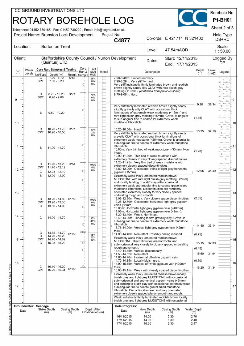
7.90-8.40m: Limited recovery.7.90-8.29m: Very stiff to hard.Very stiff indistinctly thinly laminated brown and reddishbrown slightly sandy silty CLAY with rare bluish greymottling (<10mm). (continued from previous sheet)8.70-9.06m: Hard.
Very stiff thinly laminated reddish brown slightly sandyslightly gravelly silty CLAY with occasional thicklaminations of extremely weak mudstone (<15mm) andrare light bluish grey mottling (<5mm). Gravel is angularto sub-angular fine to coarse lof extremely weakmudstone lithorelicts.
10.20-10.56m: Hard.Very stiff thinly laminated reddish brown slightly sandygravelly CLAY with occasional thick laminations ofextremely weak mudstone (<20mm). Gravel is angular tosub-angular fine to coarse of extremely weak mudstonelithorelicts.10.80m: Very thin bed of weak mudstone (<30mm). Nonintact.10.90-11.00m: Thin bed of weak mudstone withextremely closely to very closely spaced discontinuities.11.20-11.25m: Very thin bed of weak mudstone withextremely closely spaced discontinuities.11.80-12.00m: Occasional veins of light grey horizontalgypsum (<5mm).Extremely weak thinly laminated reddish brownMUDSTONE with rare light bluish grey mottling (<2mm)and locally tending to a stiff clay with occasionalextremely weak sub-angular fine to coarse gravel sizedmudstone lithorelicts. Discontinuities are randomlyorientated extremely closely to very closely spacedundulating rough and smooth.12.05-12.20m: Weak. Very closely space discontinuities.12.25-12.70m: Occasional horizontal light grey gypsumveins (<5mm).13.00m: Horizontal light grey gypsum vein (<40mm).13.05m: Horizontal light grey gypsum vein (<2mm).13.20-13.40m: Weak. Non-intact.13.40-14.00m: Tending to firm gravelly clay. Gravel issub-angular fine to coarse of extremely weak mudstonelithorelicts.13.75-14.00m: Vertical light grey gypsum vein (<2mmthick).14.00-14.40m: Non-intact. Possibly drilling induced.Extremely weak thinly laminated reddish brownMUDSTONE. Discontinuities are horizontal andsub-horizontal very closely to closely spaced undulatingrough and smooth.14.40-14.45m: Vertical discontinuity.14.50-14.52m: Non-intact.14.65-14.70m: Horizontal off-white gypsum vein.14.70-14.85m: Locally bluish grey.14.90-15.15m: Vertical off-white gypsum vein (<20mmthick).15.00-15.15m: Weak with closely spaced discontinuities.Extremely weak thinly laminated reddish brown locallybluish grey and light grey MUDSTONE with occasionalsub-horizontal and sub-vertical gypsum veins (<5mm)and tending to a stiff clay with occasional extremely weaksub-angular fine to coarse gravel sized mudstonelithorelicts. Discontinuities are randomly orientatedextremely closely spaced planar smooth and rough.Weak indistinctly thinly laminated reddish brown locallybluish grey and light grey MUDSTONE with occasional
CSPT
CSPT
B
CCPT
B
CCPT
CB
CCPT
B
C
CC
CPTC
CCPT
7.90 - 8.707.90 - 8.29
8.70 - 10.208.70 - 9.06
9.50 - 10.20
10.20 - 11.7010.20 - 10.56
11.00 - 11.70
11.70 - 13.2011.70 - 12.12
12.03 - 12.1012.20 - 12.90
13.20 - 14.0013.20 - 13.3513.50 - 14.00
14.00 - 14.70
14.65 - 14.7014.70 - 16.2014.70 - 14.8915.08 - 15.20
16.10 - 16.2016.20 - 16.34
S*63
S*71
C*71
C*54
C*750
C*150
C*158
14.0014.0016.20
5.305.305.30
2.702.402.47
16/11/201517/11/201517/11/2015
(m)
9
10
11
12
13
14
15
16
17
9
10
11
12
13
14
15
16
17
LegendLevel(mAD)
Depth(m)
ROTARY BOREHOLE LOG
InstallTCRSCRRQD
CoreRun &
SampleDescriptionWater
Levels No/Type Depth (m) Result
Telephone: 01452 739165 , Fax: 01452 739220 , Email: [email protected]
CC GROUND INVESTIGATIONS LTDC
C R
OT
AR
Y L
OG
C48
77.G
PJ
GIN
T S
TD
AG
S 3
_1.G
DT
7/
1/16
Hole TypeDS+RC
17/11/2015
Date Strike Depth(m)
Casing Depth(m)
Depth AfterObservation (m)
Hole Progress:Date Hole Depth
(m)Casing Depth
(m)Water Depth
(m)
C4877
Groundwater:
End:
12/11/2015Start:
Project Name:
Location:
Client:
Borehole No.
Sheet 2 of 3
Logged ByDP
Project No:
Dates:
Co-ords:
Level:
E 421714 N 321402Branston Lock Development
Burton on Trent
Staffordshire County Council / Nurton Development(Quintus) LTD
P1-BH01
Scale1 : 50.0047.54mAOD
Core Run, Samples & Testing
Seepage
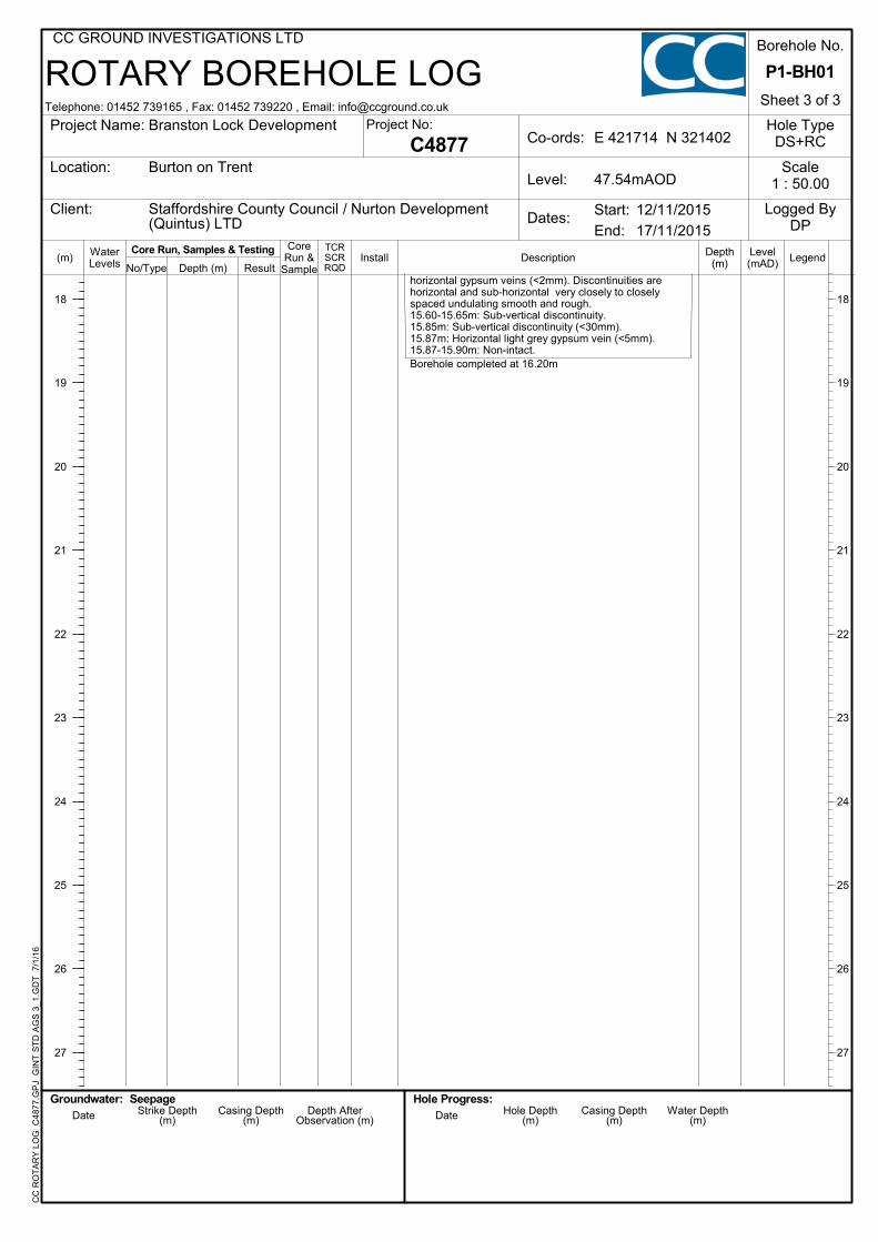
horizontal gypsum veins (<2mm). Discontinuities arehorizontal and sub-horizontal very closely to closelyspaced undulating smooth and rough.15.60-15.65m: Sub-vertical discontinuity.15.85m: Sub-vertical discontinuity (<30mm).15.87m: Horizontal light grey gypsum vein (<5mm).15.87-15.90m: Non-intact.Borehole completed at 16.20m
(m)
18
19
20
21
22
23
24
25
26
27
18
19
20
21
22
23
24
25
26
27
LegendLevel(mAD)
Depth(m)
ROTARY BOREHOLE LOG
InstallTCRSCRRQD
CoreRun &
SampleDescriptionWater
Levels No/Type Depth (m) Result
Telephone: 01452 739165 , Fax: 01452 739220 , Email: [email protected]
CC GROUND INVESTIGATIONS LTDC
C R
OT
AR
Y L
OG
C48
77.G
PJ
GIN
T S
TD
AG
S 3
_1.G
DT
7/
1/16
Hole TypeDS+RC
17/11/2015
Date Strike Depth(m)
Casing Depth(m)
Depth AfterObservation (m)
Hole Progress:Date Hole Depth
(m)Casing Depth
(m)Water Depth
(m)
C4877
Groundwater:
End:
12/11/2015Start:
Project Name:
Location:
Client:
Borehole No.
Sheet 3 of 3
Logged ByDP
Project No:
Dates:
Co-ords:
Level:
E 421714 N 321402Branston Lock Development
Burton on Trent
Staffordshire County Council / Nurton Development(Quintus) LTD
P1-BH01
Scale1 : 50.0047.54mAOD
Core Run, Samples & Testing
Seepage
Borehole ID:
Core Photograph
Contract ID:
Contract Name:
Hole ID:
C4877
Client:
Box No:
Depth:
1
1.20m – 3.20m
Branson Locks
Staffordshire County Council
P1 BH01
Borehole ID:
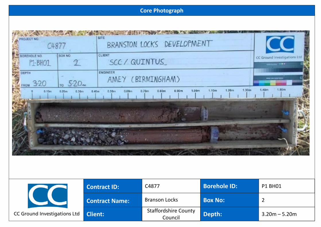
Core Photograph
Contract ID:
Contract Name:
Hole ID:
C4877
Client:
Box No:
Depth:
2
3.20m – 5.20m
Branson Locks
P1 BH01
Staffordshire County Council
Borehole ID:
Core Photograph
Contract ID:
Contract Name:
Hole ID:
C4877
Client:
Box No:
Depth:
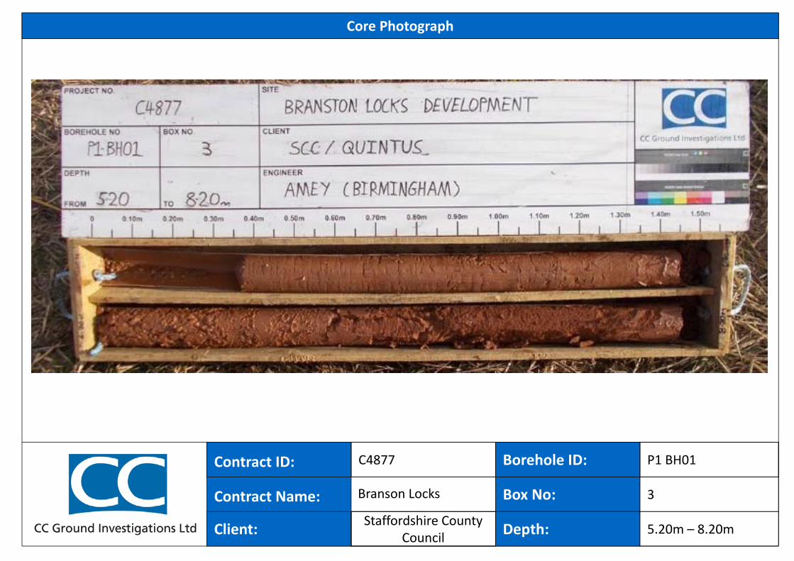
3
5.20m – 8.20m
Branson Locks
P1 BH01
Staffordshire County Council
Borehole ID:
Core Photograph
Contract ID:
Contract Name:
Hole ID:
C4877
Client:
Box No:
Depth:
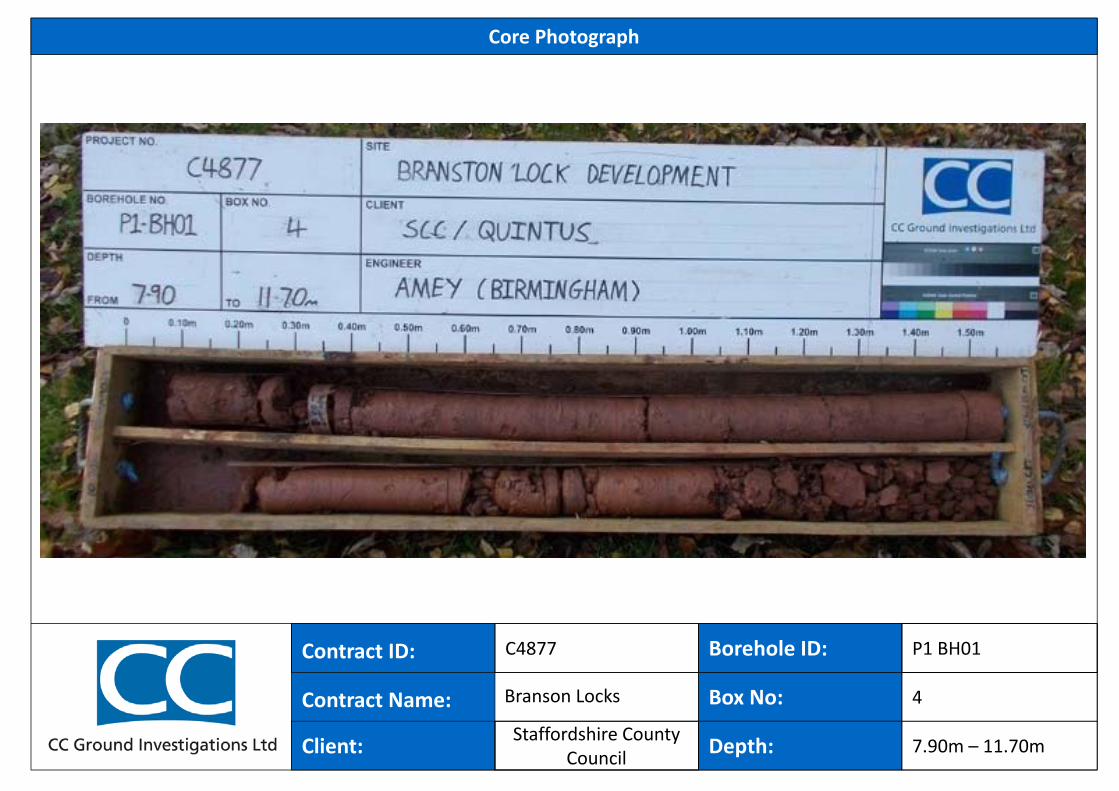
4
7.90m – 11.70m
Branson Locks
P1 BH01
Staffordshire County Council
Borehole ID:
Core Photograph
Contract ID:
Contract Name:
Hole ID:
C4877
Client:
Box No:
Depth:
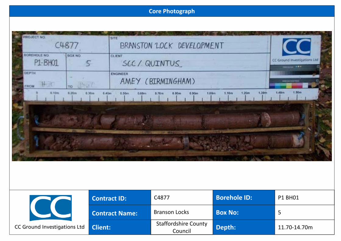
5
11.70‐14.70m
Branson Locks
P1 BH01
Staffordshire County Council
Borehole ID:
Core Photograph
Contract ID:
Contract Name:
Hole ID:
C4877
Client:
Box No:
Depth:
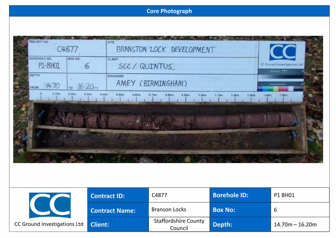
6
14.70m – 16.20m
Branson Locks
P1 BH01
Staffordshire County Council
48.01
47.71
47.41
0.15
0.45
0.75
(0.15)
(0.30)
(0.30)
Dry
BES
BES
BES
0.20
0.50
0.70
FILL: Grass over soft grey and brown slightly gravelly sandy CLAY with frequentroots and rootlets (<2mm). Gravel is sub-angular to rounded fine to coarse ofconcrete, sandstone and siliceous material.
FILL: Brown slightly clayey sandy GRAVEL. Gravel is sub-angular to rounded fineto coarse of siliceous material, siltstone, brick, concrete and porcelain.
FILL: Brown and dark brown silty very sandy GRAVEL. Gravel is sub-angular torounded fine to coarse of siliceous material, brick and siltstone.
0.70-0.75m: Locally brown and orangish brown. Locally sandy.
Inspection pit completed at 0.75m
(m)
1
2
1
2
LegendLevel(mAD)
Depth(m)
WaterLevels No/Type Depth (m) Result
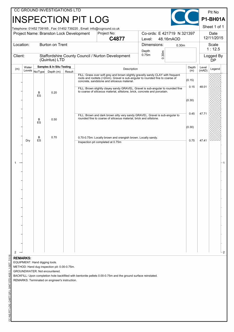
INSPECTION PIT LOG
Description
CC
IN
S P
IT L
OG
C48
77.G
PJ
GIN
T S
TD
AG
S 3
_1.G
DT
7/
1/16
Project Name:
Location: Dimensions:
Client:
Sheet 1 of 1
Date12/11/2015
Scale1 : 12.5
Logged ByDP
0.30m
0.30
m
Co-ords:
Level:
E 421719 N 321397
C4877Project No:
REMARKS:
Burton on Trent
Staffordshire County Council / Nurton Development(Quintus) LTD
EQUIPMENT: Hand digging tools.
METHOD: Hand dug inspection pit: 0.00-0.75m.
GROUNDWATER: Not encountered.
BACKFILL: Upon completion hole backfilled with bentonite pellets 0.00-0.75m and the ground surface reinstated.
REMARKS: Terminated on engineer's instruction.
Branston Lock Development
P1-BH01A
Pit No
Depth0.75m
48.16mAOD
Telephone: 01452 739165 , Fax: 01452 739220 , Email: [email protected]
CC GROUND INVESTIGATIONS LTD
Samples & In Situ Testing
47.41
46.91
46.66
45.91
45.56
44.56
0.35
0.85
1.10
1.85
2.20
3.20
(0.50)
(0.75)
(1.00)
MADE GROUND: Grass over soft dark brown slightlysandy gravelly CLAY with occasional roots and rootlets(<2mm) and low cobble content. Gravel is angular torounded fine to coarse of siliceous material, clinker, slagand wood fragments (<30mm). Cobbles are sub-angularof brick.MADE GROUND: Soft friable grey and greyish brownslightly gravelly sandy silty CLAY with rare roots androotlets (<2mm) and low cobble content. Gravel isangular to rounded fine to coarse of glass, brick,siliceous material, slag, slate and porcelain. Cobbles aresub-angular of siliceous material.0.70-0.85m: Locally gravelly.Brown and orangish brown clayey sandy GRAVEL.Gravel is sub-rounded to rounded fine to coarse ofsiliceous material, sandstone and mudstone.Dense brown and orangish brown locally orange slightlyclayey sandy locally very sandy GRAVEL. Gravel issub-rounded to rounded fine to coarse of siliceousmaterial and sandstone.1.55-1.85m: Brown and reddish brown.Brown and light reddish brown slightly clayey gravellySAND. Gravel is sub-angular to rounded fine to coarse ofsiliceous material, siltstone and sandstone.Dense brown slightly clayey very sandy GRAVEL. Gravelis sub-angular to rounded fine to coarse of siliceousmaterial and sandstone.2.20-2.75m: Recovered as slightly sandy gravel.Borehole completed at 3.20m
BESB
ESBB
ESB
SPT
B
B
BCPT
B
0.20
0.50
0.70
0.90
1.101.20 - 1.65
1.55 - 1.85
1.85 - 2.20
2.20 - 2.752.20 - 2.65
2.75 - 3.20
S 38
C 47
3.20 2.20 0.0018/11/2015
REMARKS:EQUIPMENT: Hand digging tools. Comacchio MC300 multi purpose track mounted rig.METHOD: Hand dug inspection pit: 0.00-1.20m. Continuous dynamic sampled (128mm diam) 1.20-2.20m, (113mm diam) 2.20-3.20m.CASING: SW diam to 1.30m, PW diam to 2.20m.GROUNDWATER: None encountered prior to the use of a water flush.BACKFILL: Upon completion hole backfilled with bentonite pellets 0.00-3.20m and the ground surface reinstated.
(m)
1
2
3
4
5
6
7
8
1
2
3
4
5
6
7
8
LegendLevel(mAD)
Depth(m)
ROTARY BOREHOLE LOG
InstallTCRSCRRQD
CoreRun &
SampleDescriptionWater
Levels No/Type Depth (m) Result
Telephone: 01452 739165 , Fax: 01452 739220 , Email: [email protected]
CC GROUND INVESTIGATIONS LTDC
C R
OT
AR
Y L
OG
C48
77.G
PJ
GIN
T S
TD
AG
S 3
_1.G
DT
7/
1/16
Hole TypeDS+RC
19/11/2015
Date Strike Depth(m)
Casing Depth(m)
Depth AfterObservation (m)
Hole Progress:Date Hole Depth
(m)Casing Depth
(m)Water Depth
(m)
C4877
Groundwater:
End:
17/11/2015Start:
Project Name:
Location:
Client:
Borehole No.
Sheet 1 of 1
Logged ByDP
Project No:
Dates:
Co-ords:
Level:
E 421733 N 321371Branston Lock Development
Burton on Trent
Staffordshire County Council / Nurton Development(Quintus) LTD
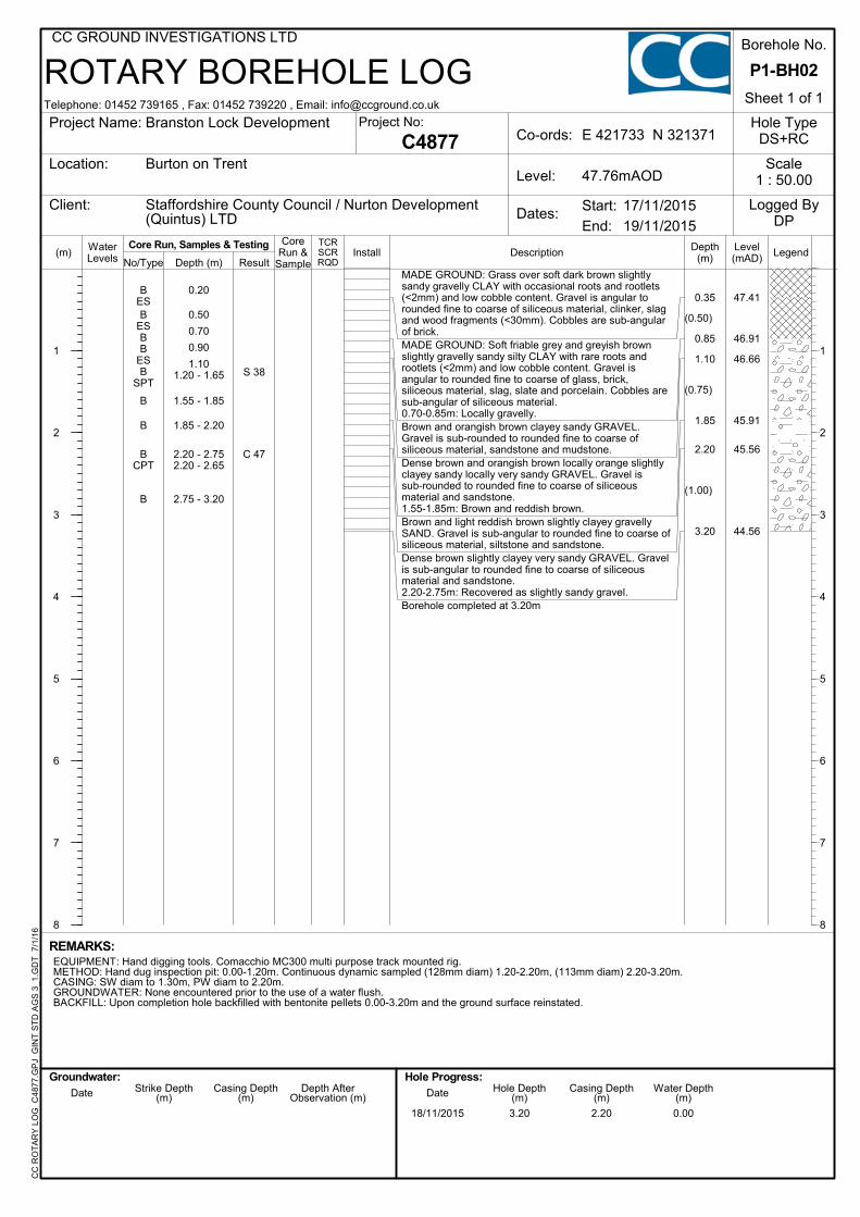
P1-BH02
Scale1 : 50.0047.76mAOD
Core Run, Samples & Testing
Borehole ID:
Core Photograph
Contract ID:
Contract Name:
Hole ID:
C4877
Client:
Box No:
Depth:
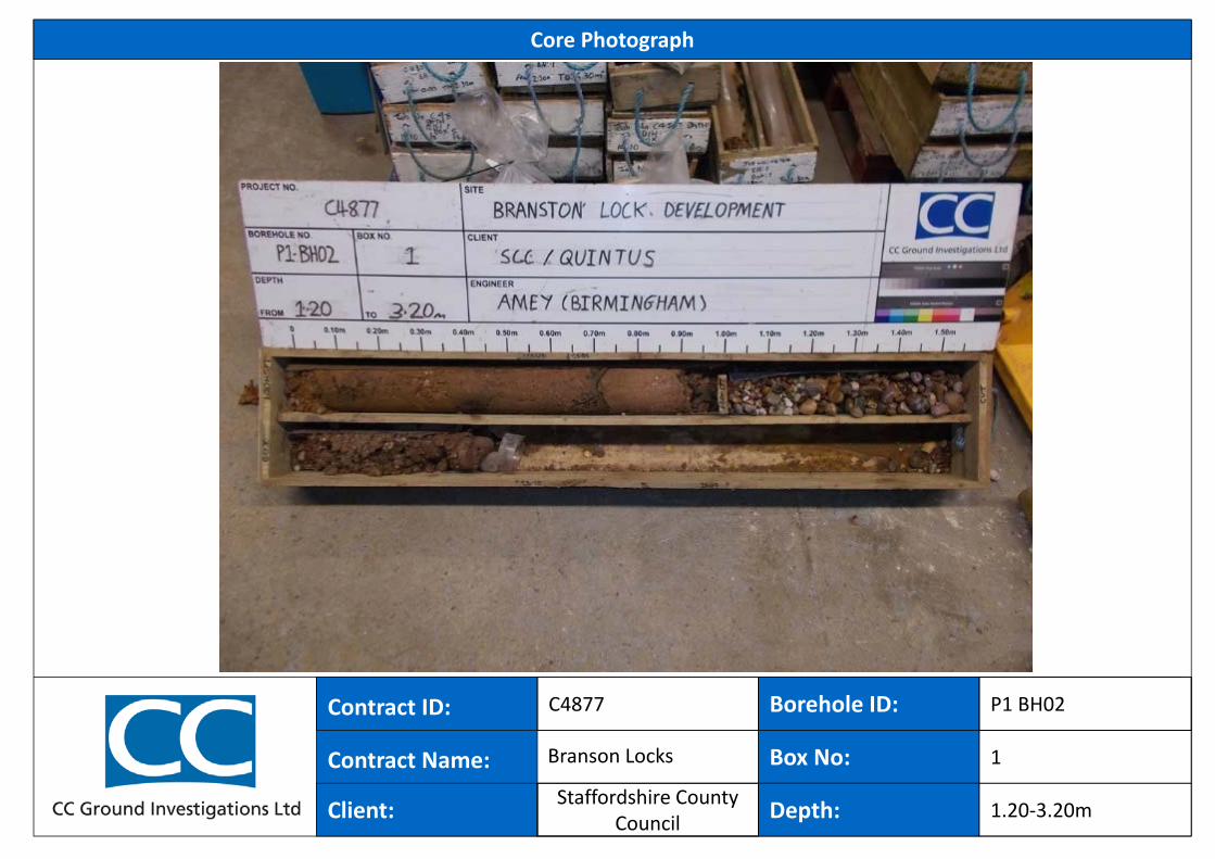
1
1.20‐3.20m
Branson Locks
P1 BH02
Staffordshire County Council
46.96
46.66
44.41
0.45
0.75
3.00
(0.45)
(0.30)
(2.25)
BB
ES
BES
BES
SPT
D
BSPT
B
0.100.20
0.50
1.00
1.20 - 1.65
1.40 - 1.55
2.00 - 2.502.00 - 2.45
2.50 - 3.00
Grass over soft brown and greyish brown slightly sandy slightlygravelly CLAY with occasional roots and rootlets (<1mm).Gravel is sub-angular to sub-rounded fine to coarse of siliceousmaterial.0.00-0.20m: Locally orangish brown.Light grey and brownish grey locally orangish brown slightlyclayey very sandy GRAVEL. Gravel is sub-angular to roundedfine to coarse of siliceous material, siltstone and sandstone.
Medium dense grey and light greyish brown slightly clayeysandy GRAVEL. Gravel is sub-rounded to rounded fine tocoarse of siliceous material, siltstone and sandstone.
1.40-1.55m: Slightly sandy.
1.80-2.00m: Slightly clayey gravelly sand.
2.50-3.00m: Very sandy.
Borehole completed at 3.00m
S 17
S 27
2.00 2.00 2.00 3.00 3.00 2.0016/11/15 16/11/2015
REMARKS:EQUIPMENT: Hand digging tools. Terrier 2002 track mounted rig.METHOD: Hand dug inspection pit: 0.00-1.20m. Continuous disturbed sampling using 101mm diam sample barrel: 1.20-3.00m.CASING: 113mm diam to 3.00m.GROUNDWATER: Standing at 2.00m following SPT 2.00-2.45m. No rise recorded.BACKFILL: Upon completion hole backfilled with arisings 2.30-3.00m and bentonite pellets 0.00-2.30m and the ground surface reinstated.REMARKS: Sand "blowing" inside casing to 2.30m following sample run 2.00-3.00m
(m)
1
2
3
4
5
1
2
3
4
5
LegendLevel(mAD)Sample Depth
(m)WaterLevels No/Type Depth (m)
WINDOW SAMPLE LOG
DescriptionInstallResult
Telephone: 01452 739165 , Fax: 01452 739220 , Email: [email protected]
CC GROUND INVESTIGATIONS LTDC
C W
S L
OG
C
4877
.GP
J G
INT
ST
D A
GS
3_1
.GD
T
7/1/
16
Hole TypeWS
16/11/2015
Date Strike Depth(m)
Casing Depth(m)
Depth AfterObservation (m)
Hole Progress:Date Hole Depth
(m)Casing Depth
(m)Water Depth
(m)
C4877
Groundwater:
End:
16/11/2015Start:
Project Name:
Location:
Client:
Borehole No.
Sheet 1 of 1
Logged ByDP
Project No:
Dates:
Co-ords:
Level:
E 421614 N 321430Branston Lock Development
Burton on Trent
Staffordshire County Council / Nurton Development(Quintus) LTD
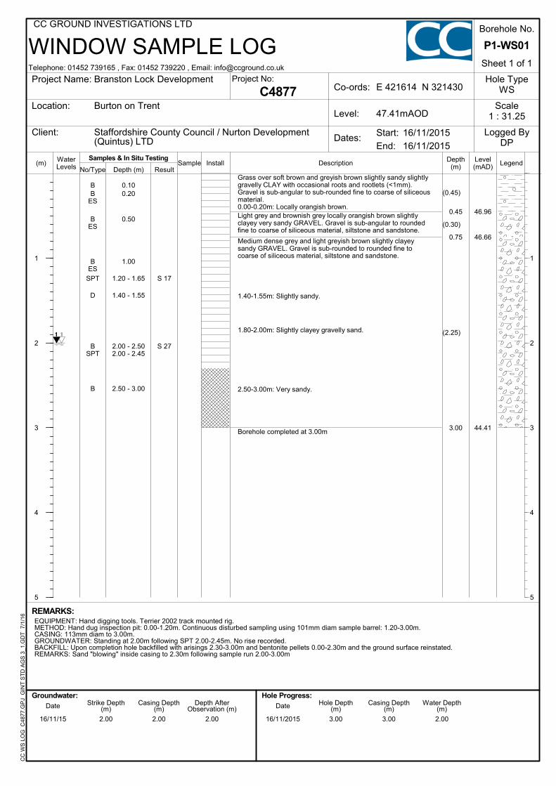
P1-WS01
Scale1 : 31.2547.41mAOD
Samples & In Situ Testing
Hole ID:
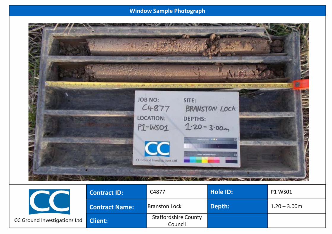
Window Sample Photograph
Contract ID:
Contract Name:
Hole ID:
C4877
Client:
Depth: 1.20 – 3.00mBranston Lock
Staffordshire County Council
P1 WS01
47.07
45.57
45.17
44.77
0.70
2.20
2.60
3.00
(0.70)
(1.50)
(0.40)
(0.40)
BES
BES
BES
BES
BSPT
SPT
B
B
SPT
0.20
0.50
0.70
1.00
1.20 - 2.001.20 - 1.65
2.00 - 2.45
2.20 - 2.60
2.60 - 3.00
3.00 - 3.45
Grass over soft dark brown locally light grey slightly sandygravelly CLAY with rare roots and rootlets (<1mm). Gravel issub-rounded to rounded fine to coarse of siliceous material andsiltstone.
Medium dense brown and orangish brown locally light grey andorange slightly clayey sandy locally very sandy GRAVEL. Gravelis sub-angular to rounded fine to coarse of siliceous material,siltstone and sandstone.1.00-1.20m: Locally clayey.
1.20m: 1 no. rounded cobble of siliceous material.
1.90m: 1 no. rounded cobble of siliceous material.
Medium dense light brown and light greyish brown slightlyclayey gravelly SAND. Gravel is sub-rounded to rounded fine tocoarse of siliceous material and sandstone.
Light brown and light greyish brown locally orange slightly clayeysandy GRAVEL with low cobble content. Gravel is sub-roundedto rounded fine to coarse of siliceous material and siltstone.Cobbles are rounded of siliceous material and sandstone.
Borehole completed at 3.00m
S 27
S 47
S 19
2.50 2.00 2.50 3.00 2.00 2.5016/11/15 16/11/2015
REMARKS:EQUIPMENT: Hand digging tools. Terrier 2002 track mounted rig.METHOD: Hand dug inspection pit: 0.00-1.20m. Continuous disturbed sampling using 101mm diam sample barrel: 1.20-3.00m.CASING: 113mm diam to 2.00m.GROUNDWATER: Standing at 2.50m following sample run 2.00-3.00m. No rise recorded.BACKFILL: Upon completion hole backfilled with bentonite pellets 0.00-3.00m and the ground surface reinstated.
(m)
1
2
3
4
5
1
2
3
4
5
LegendLevel(mAD)Sample Depth
(m)WaterLevels No/Type Depth (m)
WINDOW SAMPLE LOG
DescriptionInstallResult
Telephone: 01452 739165 , Fax: 01452 739220 , Email: [email protected]
CC GROUND INVESTIGATIONS LTDC
C W
S L
OG
C
4877
.GP
J G
INT
ST
D A
GS
3_1
.GD
T
7/1/
16
Hole TypeWS
16/11/2015
Date Strike Depth(m)
Casing Depth(m)
Depth AfterObservation (m)
Hole Progress:Date Hole Depth
(m)Casing Depth
(m)Water Depth
(m)
C4877
Groundwater:
End:
16/11/2015Start:
Project Name:
Location:
Client:
Borehole No.
Sheet 1 of 1
Logged ByDP
Project No:
Dates:
Co-ords:
Level:
E 421649 N 321514Branston Lock Development
Burton on Trent
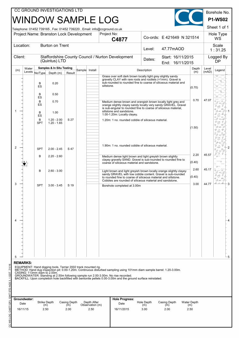
Staffordshire County Council / Nurton Development(Quintus) LTD
P1-WS02
Scale1 : 31.2547.77mAOD
Samples & In Situ Testing
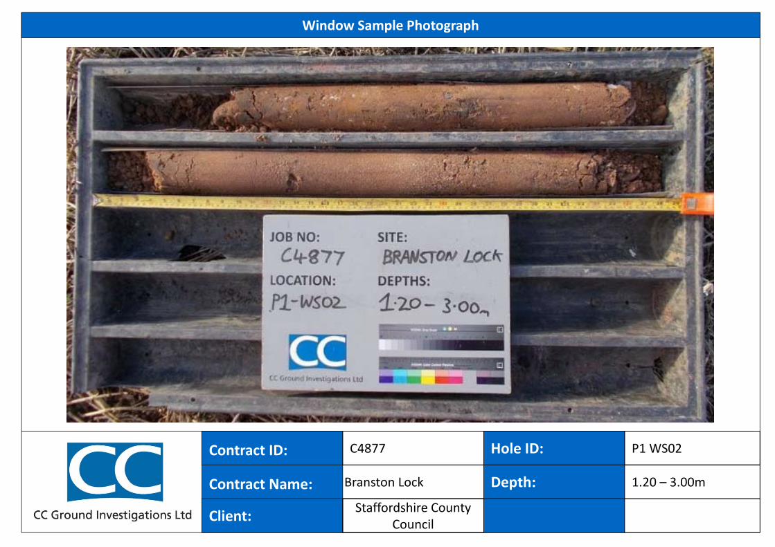
Hole ID:
Window Sample Photograph
Contract ID:
Contract Name:
Hole ID:
C4877
Client:
Depth: 1.20 – 3.00mBranston Lock
P1 WS02
Staffordshire County Council
47.19
46.29
45.94
44.54
0.35
1.25
1.60
3.00
(0.35)
(0.90)
(0.35)
(1.40)
BESB
BES
BES
SPTB
B
SPT
B
B
SPT
0.20
0.35
0.50
1.00
1.20 - 1.651.25 - 1.60
1.60 - 2.00
2.00 - 2.45
2.30 - 2.70
2.70 - 3.00
3.00 - 3.45
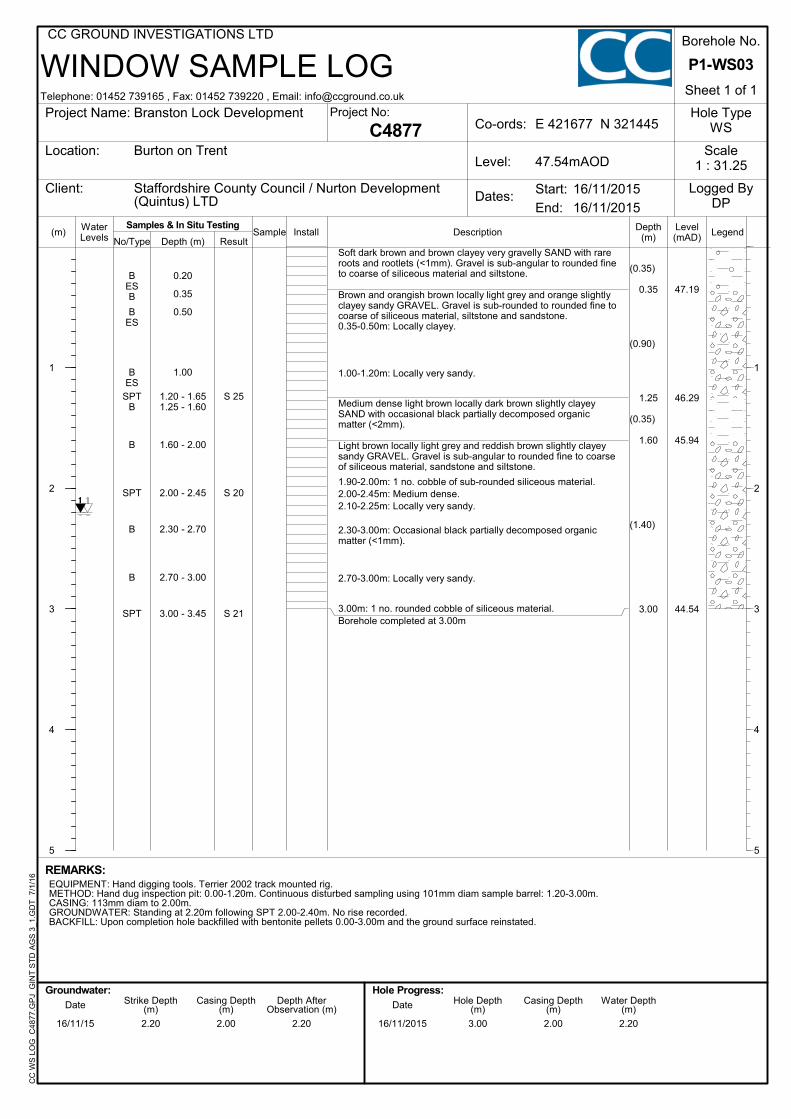
Soft dark brown and brown clayey very gravelly SAND with rareroots and rootlets (<1mm). Gravel is sub-angular to rounded fineto coarse of siliceous material and siltstone.
Brown and orangish brown locally light grey and orange slightlyclayey sandy GRAVEL. Gravel is sub-rounded to rounded fine tocoarse of siliceous material, siltstone and sandstone.0.35-0.50m: Locally clayey.
1.00-1.20m: Locally very sandy.
Medium dense light brown locally dark brown slightly clayeySAND with occasional black partially decomposed organicmatter (<2mm).
Light brown locally light grey and reddish brown slightly clayeysandy GRAVEL. Gravel is sub-angular to rounded fine to coarseof siliceous material, sandstone and siltstone.
1.90-2.00m: 1 no. cobble of sub-rounded siliceous material.2.00-2.45m: Medium dense.2.10-2.25m: Locally very sandy.
2.30-3.00m: Occasional black partially decomposed organicmatter (<1mm).
2.70-3.00m: Locally very sandy.
3.00m: 1 no. rounded cobble of siliceous material.Borehole completed at 3.00m
S 25
S 20
S 21
2.20 2.00 2.20 3.00 2.00 2.2016/11/15 16/11/2015
REMARKS:EQUIPMENT: Hand digging tools. Terrier 2002 track mounted rig.METHOD: Hand dug inspection pit: 0.00-1.20m. Continuous disturbed sampling using 101mm diam sample barrel: 1.20-3.00m.CASING: 113mm diam to 2.00m.GROUNDWATER: Standing at 2.20m following SPT 2.00-2.40m. No rise recorded.BACKFILL: Upon completion hole backfilled with bentonite pellets 0.00-3.00m and the ground surface reinstated.
(m)
1
2
3
4
5
1
2
3
4
5
LegendLevel(mAD)Sample Depth
(m)WaterLevels No/Type Depth (m)
WINDOW SAMPLE LOG
DescriptionInstallResult
Telephone: 01452 739165 , Fax: 01452 739220 , Email: [email protected]
CC GROUND INVESTIGATIONS LTDC
C W
S L
OG
C
4877
.GP
J G
INT
ST
D A
GS
3_1
.GD
T
7/1/
16
Hole TypeWS
16/11/2015
Date Strike Depth(m)
Casing Depth(m)
Depth AfterObservation (m)
Hole Progress:Date Hole Depth
(m)Casing Depth
(m)Water Depth
(m)
C4877
Groundwater:
End:
16/11/2015Start:
Project Name:
Location:
Client:
Borehole No.
Sheet 1 of 1
Logged ByDP
Project No:
Dates:
Co-ords:
Level:
E 421677 N 321445Branston Lock Development
Burton on Trent
Staffordshire County Council / Nurton Development(Quintus) LTD
P1-WS03
Scale1 : 31.2547.54mAOD
Samples & In Situ Testing
Hole ID:
Window Sample Photograph
Contract ID:
Contract Name:
Hole ID:
C4877
Client:
Depth: 1.20 – 3.00mBranston Lock
P1 WS03
Staffordshire County Council
47.68
47.38
46.33
46.08
0.40
0.70
1.75
2.00
(0.40)
(0.30)
(1.05)
(0.25)
Dry
BES
BES
BES
SPT
B
B
CPT
0.20
0.50
1.00
1.20 - 1.65
1.35 - 1.65
1.75 - 2.00
2.00 - 2.29
MADE GROUND: Grass over soft brown slightly sandy slightlygravelly CLAY with occasional roots and rootlets (<1mm).Gravel is sub-angular to rounded fine to coarse of siliceousmaterial and wood fragments (<40mm).0.05m: Red twine across pit (<5mm).Orangish brown and brown clayey very sandy GRAVEL with rareroots and rootlets (<1mm). Gravel is sub-rounded to roundedfine to coarse of siliceous material, siltstone and sandstone.Orangish brown and orange slightly clayey sandy locally verysandy GRAVEL. Gravel is sub-rounded to rounded fine tocoarse of siliceous material, mudstone and sandstone.
1.20-1.65m: Dense.
1.35-1.65m: Light grey locally off white and purplish brown.Sandy.
Orangish brown and light brown slightly clayey very sandyGRAVEL. Gravel is sub-rounded to rounded fine to coarse ofsiliceous material and sandstone.Borehole completed at 2.00m
S 43
C*79
2.00 Nil Dry16/11/2015
REMARKS:EQUIPMENT: Hand digging tools. Terrier 2002 track mounted rig.METHOD: Hand dug inspection pit: 0.00-1.20m. Continuous disturbed sampling using 101mm diam sample barrel: 1.20-2.00m.CASING: None used.GROUNDWATER: Not encountered.BACKFILL: Upon completion hole backfilled with bentonite pellets 0.00-2.00m and the ground surface reinstated.REMARKS: Borehole collapsed to 1.20m following sample run 1.20-2.00m.
(m)
1
2
3
4
5
1
2
3
4
5
LegendLevel(mAD)Sample Depth
(m)WaterLevels No/Type Depth (m)
WINDOW SAMPLE LOG
DescriptionInstallResult
Telephone: 01452 739165 , Fax: 01452 739220 , Email: [email protected]
CC GROUND INVESTIGATIONS LTDC
C W
S L
OG
C
4877
.GP
J G
INT
ST
D A
GS
3_1
.GD
T
7/1/
16
Hole TypeWS
17/11/2015
Date Strike Depth(m)
Casing Depth(m)
Depth AfterObservation (m)
Hole Progress:Date Hole Depth
(m)Casing Depth
(m)Water Depth
(m)
C4877
Groundwater:
End:
17/11/2015Start:
Project Name:
Location:
Client:
Borehole No.
Sheet 1 of 1
Logged ByDP
Project No:
Dates:
Co-ords:
Level:
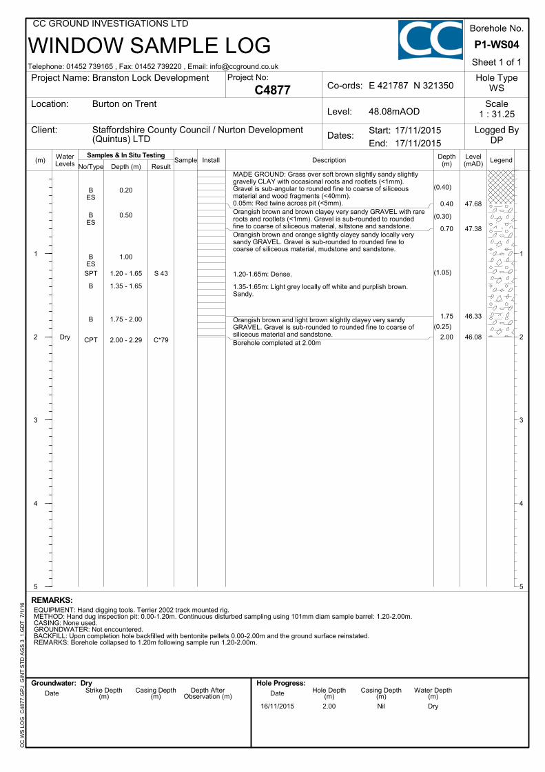
E 421787 N 321350Branston Lock Development
Burton on Trent
Staffordshire County Council / Nurton Development(Quintus) LTD
P1-WS04
Scale1 : 31.2548.08mAOD
Samples & In Situ Testing
Dry
Hole ID:
Window Sample Photograph
Contract ID:
Contract Name:
Hole ID:
C4877
Client:
Depth: 1.10 – 2.00mBranston Lock
P1 WS04
Staffordshire County Council
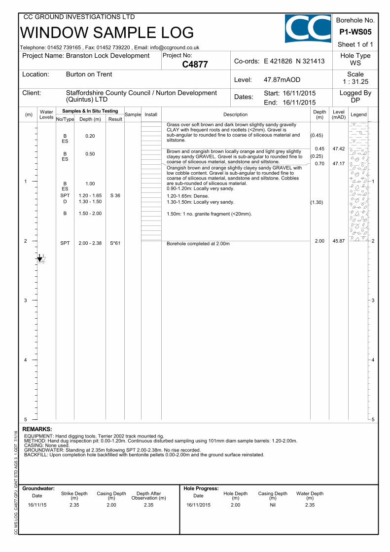
47.42
47.17
45.87
0.45
0.70
2.00
(0.45)
(0.25)
(1.30)
BES
BES
BES
SPTD
B
SPT
0.20
0.50
1.00
1.20 - 1.651.30 - 1.50
1.50 - 2.00
2.00 - 2.38
Grass over soft brown and dark brown slightly sandy gravellyCLAY with frequent roots and rootlets (<2mm). Gravel issub-angular to rounded fine to coarse of siliceous material andsiltstone.
Brown and orangish brown locally orange and light grey slightlyclayey sandy GRAVEL. Gravel is sub-angular to rounded fine tocoarse of siliceous material, sandstone and siltstone.Orangish brown and orange slightly clayey sandy GRAVEL withlow cobble content. Gravel is sub-angular to rounded fine tocoarse of siliceous material, sandstone and siltstone. Cobblesare sub-rounded of siliceous material.0.90-1.20m: Locally very sandy.
1.20-1.65m: Dense.1.30-1.50m: Locally very sandy.
1.50m: 1 no. granite fragment (<20mm).
Borehole completed at 2.00m
S 36
S*61
2.35 2.00 2.35 2.00 Nil 2.3516/11/15 16/11/2015
REMARKS:EQUIPMENT: Hand digging tools. Terrier 2002 track mounted rig.METHOD: Hand dug inspection pit: 0.00-1.20m. Continuous disturbed sampling using 101mm diam sample barrels: 1.20-2.00m.CASING: None used.GROUNDWATER: Standing at 2.35m following SPT 2.00-2.38m. No rise recorded.BACKFILL: Upon completion hole backfilled with bentonite pellets 0.00-2.00m and the ground surface reinstated.
(m)
1
2
3
4
5
1
2
3
4
5
LegendLevel(mAD)Sample Depth
(m)WaterLevels No/Type Depth (m)
WINDOW SAMPLE LOG
DescriptionInstallResult
Telephone: 01452 739165 , Fax: 01452 739220 , Email: [email protected]
CC GROUND INVESTIGATIONS LTDC
C W
S L
OG
C
4877
.GP
J G
INT
ST
D A
GS
3_1
.GD
T
7/1/
16
Hole TypeWS
16/11/2015
Date Strike Depth(m)
Casing Depth(m)
Depth AfterObservation (m)
Hole Progress:Date Hole Depth
(m)Casing Depth
(m)Water Depth
(m)
C4877
Groundwater:
End:
16/11/2015Start:
Project Name:
Location:
Client:
Borehole No.
Sheet 1 of 1
Logged ByDP
Project No:
Dates:
Co-ords:
Level:
E 421826 N 321413Branston Lock Development
Burton on Trent
Staffordshire County Council / Nurton Development(Quintus) LTD
P1-WS05
Scale1 : 31.2547.87mAOD
Samples & In Situ Testing
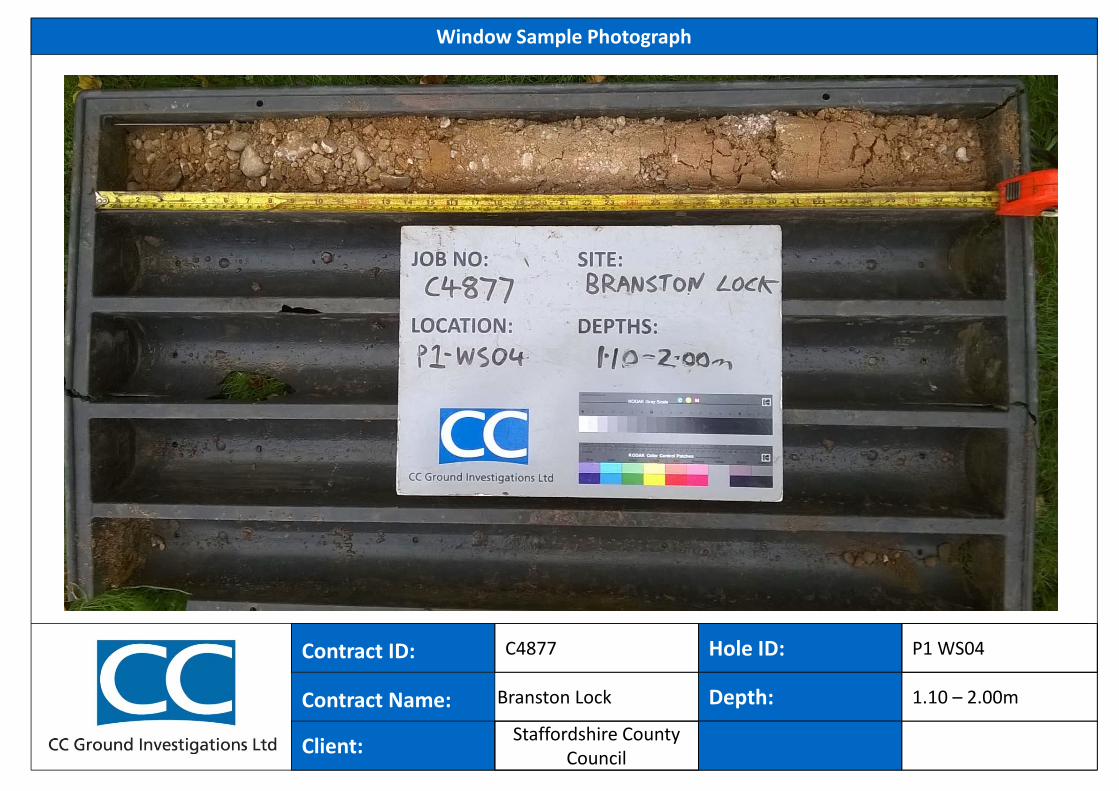
Hole ID:
Window Sample Photograph
Contract ID:
Contract Name:
Hole ID:
C4877
Client:
Depth: 1.20 – 2.00mBranston Lock
P1 WS05
Staffordshire County Council
52.43
48.68
47.88
0.15
3.90
4.70
(3.75)
(0.80)
Dry
BESB
ES
BES
BES
SPTB
SPT
B
ESSPT
B
BSPT
SPT
0.100.20
0.50
1.00
1.20 - 1.651.30 - 2.00
2.00 - 2.45
2.25 - 3.00
3.003.00 - 3.45
3.40 - 3.90
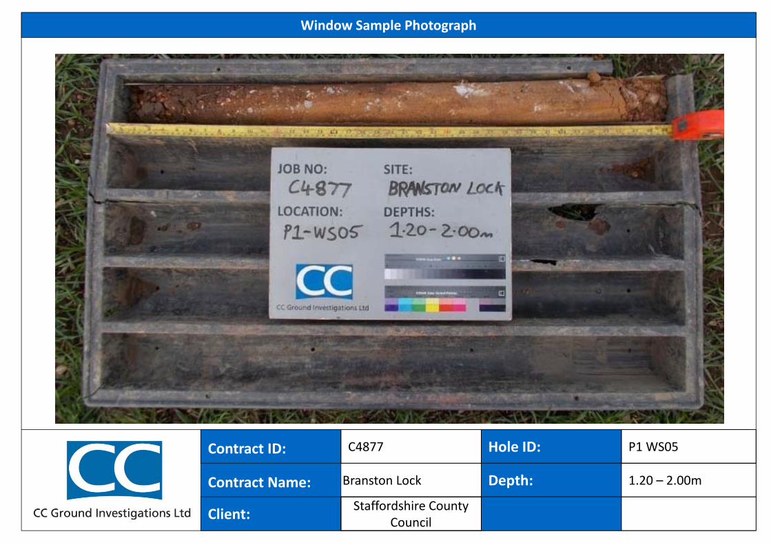
4.00 - 4.704.00 - 4.45
4.70 - 4.77
FILL: Black and dark brown slightly clayey slightly sandyGRAVEL. Gravel is angular to sub-angular fine to coarse ofclinker.FILL: Firm locally friable reddish brown and brown slightly sandyslightly gravelly, locally gravelly CLAY. Gravel is angular tosub-rounded fine to coarse of siliceous material, concrete,mudstone, limestone, wood, sandstone and brick.
2.30-2.40m: Dark brown.
3.60m: 1 no. black sub-angular slag piece (<40mm).
FILL: Soft reddish brown sandy slightly gravelly CLAY. Gravel issub-angular to rounded fine to coarse of siliceous material andmudstone. (POSSIBLE NATURAL).
Borehole completed at 4.70m
S 12
S 8
S 6
S 3
S*500
4.70 Nil Dry17/11/2015
REMARKS:EQUIPMENT: Hand digging tools. Terrier 2002 track mounted rig.METHOD: Hand dug inspection pit: 0.00-1.20m. Continuous disturbed sampling using 101mm and 86mm diam sample barrels: 1.20-4.70m.CASING: None used.GROUNDWATER: Not encountered.BACKFILL: Upon completion hole backfilled with bentonite pellets 0.00-4.70m and the ground surface reinstated.REMARKS: Window sample refused at 4.70m.
(m)
1
2
3
4
5
1
2
3
4
5
LegendLevel(mAD)Sample Depth
(m)WaterLevels No/Type Depth (m)
WINDOW SAMPLE LOG
DescriptionInstallResult
Telephone: 01452 739165 , Fax: 01452 739220 , Email: [email protected]
CC GROUND INVESTIGATIONS LTDC
C W
S L
OG
C
4877
.GP
J G
INT
ST
D A
GS
3_1
.GD
T
7/1/
16
Hole TypeWS
17/11/2015
Date Strike Depth(m)
Casing Depth(m)
Depth AfterObservation (m)
Hole Progress:Date Hole Depth
(m)Casing Depth
(m)Water Depth
(m)
C4877
Groundwater:
End:
17/11/2015Start:
Project Name:
Location:
Client:
Borehole No.
Sheet 1 of 1
Logged ByDP
Project No:
Dates:
Co-ords:
Level:
E 421841 N 321335Branston Lock Development
Burton on Trent
Staffordshire County Council / Nurton Development(Quintus) LTD
P1-WS06
Scale1 : 31.2552.58mAOD
Samples & In Situ Testing
Dry
Hole ID:
Window Sample Photograph
Contract ID:
Contract Name:
Hole ID:
C4877
Client:
Depth: 1.20 – 4.70mBranston Lock
P1 WS06
Staffordshire County Council
47.68
47.03
0.40
1.05
(0.40)
(0.65)
Dry
BES
BES
BES
0.20
0.50
0.90
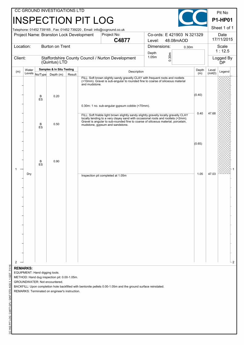
FILL: Soft brown slightly sandy gravelly CLAY with frequent roots and rootlets(<10mm). Gravel is sub-angular to rounded fine to coarse of siliceous materialand mudstone.
0.30m: 1 no. sub-angular gypsum cobble (<70mm).
FILL: Soft friable light brown slightly sandy slightly gravelly locally gravelly CLAYlocally tending to a very clayey sand with occasional roots and rootlets (<2mm).Gravel is angular to sub-rounded fine to coarse of siliceous material, porcelain,mudstone, gypsum and sandstone.
Inspection pit completed at 1.05m
(m)
1
2
1
2
LegendLevel(mAD)
Depth(m)
WaterLevels No/Type Depth (m) Result
INSPECTION PIT LOG
Description
CC
IN
S P
IT L
OG
C48
77.G
PJ
GIN
T S
TD
AG
S 3
_1.G
DT
7/
1/16
Project Name:
Location: Dimensions:
Client:
Sheet 1 of 1
Date17/11/2015
Scale1 : 12.5
Logged ByDP
0.30m
0.30
m
Co-ords:
Level:
E 421903 N 321329
C4877Project No:
REMARKS:
Burton on Trent
Staffordshire County Council / Nurton Development(Quintus) LTD
EQUIPMENT: Hand digging tools.
METHOD: Hand dug inspection pit: 0.00-1.05m.
GROUNDWATER: Not encountered.
BACKFILL: Upon completion hole backfilled with bentonite pellets 0.00-1.05m and the ground surface reinstated.
REMARKS: Terminated on engineer's instruction.
Branston Lock Development
P1-HP01
Pit No
Depth1.05m
48.08mAOD
Telephone: 01452 739165 , Fax: 01452 739220 , Email: [email protected]
CC GROUND INVESTIGATIONS LTD
Samples & In Situ Testing
CC Ground Investigation Limited
STANDARD PENETRATION TEST
Telephone: 01452 739165, Fax: 01452 739220, Email: [email protected]
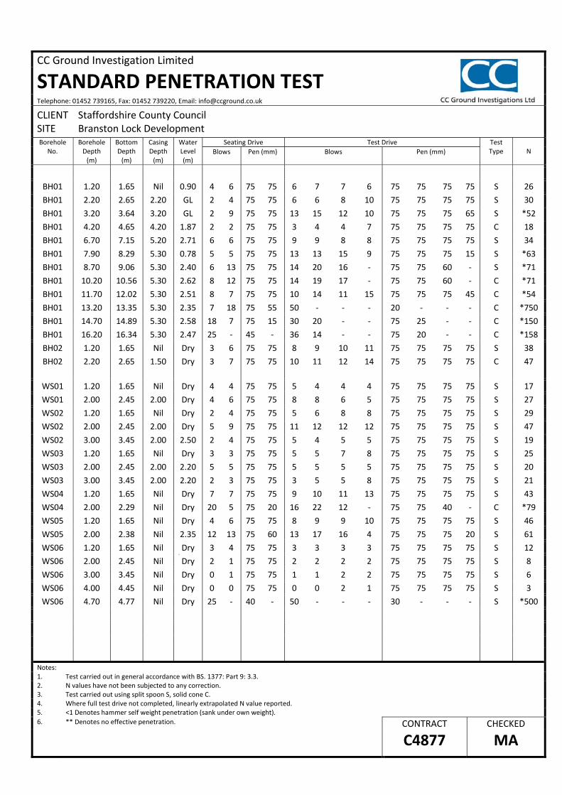
CLIENT Staffordshire County Council SITE Branston Lock Development Borehole
No. Borehole Depth (m)
Bottom Depth (m)
Casing Depth (m)
Water Level (m)
Seating Drive Test Drive Test Type N Blows Pen (mm) Blows Pen (mm)
BH01 1.20 1.65 Nil 0.90 4 6 75 75 6 7 7 6 75 75 75 75 S 26
BH01 2.20 2.65 2.20 GL 2 4 75 75 6 6 8 10 75 75 75 75 S 30
BH01 3.20 3.64 3.20 GL 2 9 75 75 13 15 12 10 75 75 75 65 S *52
BH01 4.20 4.65 4.20 1.87 2 2 75 75 3 4 4 7 75 75 75 75 C 18
BH01 6.70 7.15 5.20 2.71 6 6 75 75 9 9 8 8 75 75 75 75 S 34
BH01 7.90 8.29 5.30 0.78 5 5 75 75 13 13 15 9 75 75 75 15 S *63
BH01 8.70 9.06 5.30 2.40 6 13 75 75 14 20 16 ‐ 75 75 60 ‐ S *71
BH01 10.20 10.56 5.30 2.62 8 12 75 75 14 19 17 ‐ 75 75 60 ‐ C *71
BH01 11.70 12.02 5.30 2.51 8 7 75 75 10 14 11 15 75 75 75 45 C *54
BH01 13.20 13.35 5.30 2.35 7 18 75 55 50 ‐ ‐ ‐ 20 ‐ ‐ ‐ C *750
BH01 14.70 14.89 5.30 2.58 18 7 75 15 30 20 ‐ ‐ 75 25 ‐ ‐ C *150
BH01 16.20 16.34 5.30 2.47 25 ‐ 45 ‐ 36 14 ‐ ‐ 75 20 ‐ ‐ C *158
BH02
BH02
1.20
2.20
1.65
2.65
Nil
1.50
Dry
Dry
3
3
6
7
75
75
75
75
8
10
9
11
10
12
11
14
75
75
75
75
75
75
75
75
S
C
38
47
WS01 1.20 1.65 Nil Dry 4 4 75 75 5 4 4 4 75 75 75 75 S 17
WS01 2.00 2.45 2.00 Dry 4 6 75 75 8 8 6 5 75 75 75 75 S 27
WS02 1.20 1.65 Nil Dry 2 4 75 75 5 6 8 8 75 75 75 75 S 29
WS02 2.00 2.45 2.00 Dry 5 9 75 75 11 12 12 12 75 75 75 75 S 47
WS02 3.00 3.45 2.00 2.50 2 4 75 75 5 4 5 5 75 75 75 75 S 19
WS03 1.20 1.65 Nil Dry 3 3 75 75 5 5 7 8 75 75 75 75 S 25
WS03 2.00 2.45 2.00 2.20 5 5 75 75 5 5 5 5 75 75 75 75 S 20
WS03 3.00 3.45 2.00 2.20 2 3 75 75 3 5 5 8 75 75 75 75 S 21
WS04 1.20 1.65 Nil Dry 7 7 75 75 9 10 11 13 75 75 75 75 S 43
WS04 2.00 2.29 Nil Dry 20 5 75 20 16 22 12 ‐ 75 75 40 ‐ C *79
WS05 1.20 1.65 Nil Dry 4 6 75 75 8 9 9 10 75 75 75 75 S 46
WS05 2.00 2.38 Nil 2.35 12 13 75 60 13 17 16 4 75 75 75 20 S 61
WS06 1.20 1.65 Nil Dry 3 4 75 75 3 3 3 3 75 75 75 75 S 12 y
WS06 2.00 2.45 Nil Dry 2 1 75 75 2 2 2 2 75 75 75 75 S 8
WS06 3.00 3.45 Nil Dry 0 1 75 75 1 1 2 2 75 75 75 75 S 6
WS06 4.00 4.45 Nil Dry 0 0 75 75 0 0 2 1 75 75 75 75 S 3
WS06 4.70 4.77 Nil Dry 25 ‐ 40 ‐ 50 ‐ ‐ ‐ 30 ‐ ‐ ‐ S *500
Notes: 1. Test carried out in general accordance with BS. 1377: Part 9: 3.3. 2. N values have not been subjected to any correction. 3. Test carried out using split spoon S, solid cone C. 4. Where full test drive not completed, linearly extrapolated N value reported. 5. <1 Denotes hammer self weight penetration (sank under own weight).
6. ** Denotes no effective penetration. CONTRACT CHECKED
C4877 MA

CC Ground Investigations Ltd Report C4877
APPENDIX C
Appendix C – Laboratory Test Results
5 – 7 Hexthorpe Road, Hexthorpe, Doncaster DN4 0AR tel: +44 (0)844 815 6641 fax: +44 (0)844 815 6642 e-mail: [email protected]
A copy of the Laboratory Schedule of accredited tests as issued by UKAS is attached to this report. This certificate is issued in accordance with the accreditation requirements of the United Kingdom Accreditation Service. The results reported herein relate only to the material supplied to the laboratory. This certificate shall not be reproduced in full,
without the prior written approval of the laboratory.
Checked and Approved Signatories:
R Gunson A Watkins M Beastall (Director) (Director) (Laboratory Manager)
D Lambe S Royle (Senior Technician) (Senior Technician)
Page 1 of
LABORATORY REPORT
4043
Contract Number: PSL15/5865
Report Date: 17 December 2015
Client’s Reference: C4877
Client Name: CC Ground Investigations Ltd Unit A2 Innsworth Technology Park. Innsworth Lane Gloucester GL3 1DL
For the attention of: Mike Atherton
Contract Title: Branston Lock
Date Received: 03/12/2015 Date Commenced: 03/12/2015 Date Completed: 17/12/2015
Notes: Opinions and Interpretations are outside the UKAS Accreditation * Denotes test not included in laboratory scope of accreditation$ Denotes test carried out by approved contractor
PSL001 Issue 2 Nov 15 Page of .
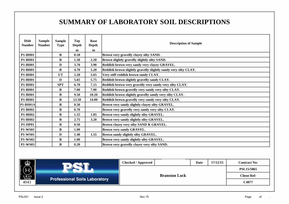
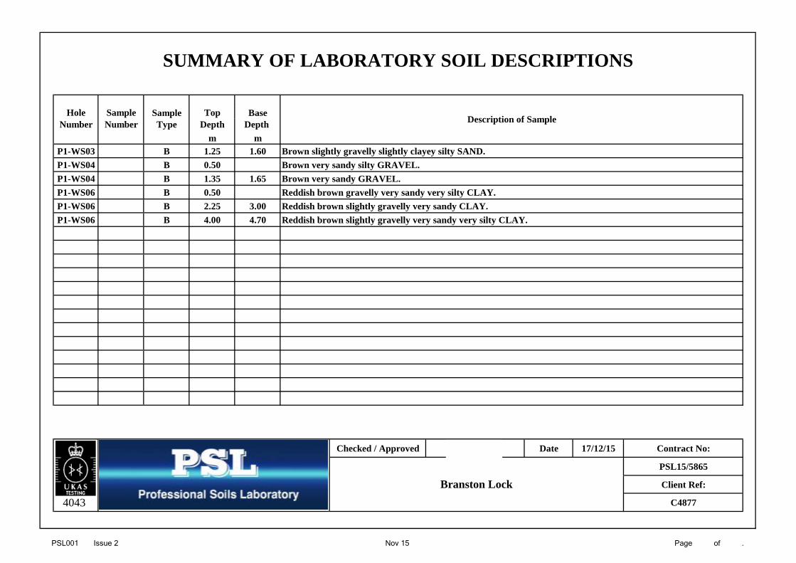
Hole Sample Sample Top BaseNumber Number Type Depth Depth
m mP1-BH01 B 0.50 Brown very gravelly clayey silty SAND.P1-BH01 B 1.50 2.20 Brown slightly gravelly slightly silty SAND.P1-BH01 D 3.70 3.90 Reddish brown very sandy very clayey GRAVEL.P1-BH01 B 4.70 5.20 Reddish brown slightly gravelly slightly sandy very silty CLAY.P1-BH01 UT 5.20 5.65 Very stiff reddish brown sandy CLAY.P1-BH01 D 5.65 5.75 Reddish brown slightly gravelly sandy CLAY.P1-BH01 SPT 6.70 7.15 Reddish brown very gravelly very sandy very silty CLAY.P1-BH01 B 7.00 7.90 Reddish brown gravelly very sandy very silty CLAY.P1-BH01 B 9.50 10.20 Reddish brown slightly gravelly sandy very silty CLAY.P1-BH01 B 13.50 14.00 Reddish brown gravelly very sandy very silty CLAY.
P1-BH01A B 0.50 Brown very sandy slightly clayey silty GRAVEL.P1-BH02 B 0.70 Brown very gravelly very sandy very silty CLAY.P1-BH02 B 1.55 1.85 Brown very sandy slightly silty GRAVEL.P1-BH02 B 2.75 3.20 Brown very sandy slightly silty GRAVEL.P1-HP01 B 0.50 Brown clayey very silty SAND & GRAVEL.P1-WS01 B 1.00 Brown very sandy GRAVEL.P1-WS01 D 1.40 1.55 Brown sandy slightly silty GRAVEL.P1-WS02 B 1.00 Brown very sandy slightly silty GRAVEL.P1-WS03 B 0.20 Brown very gravelly clayey very silty SAND.
Checked / Approved Date 17/12/15 Contract No:
PSL15/5865
Client Ref:
4043 C4877
SUMMARY OF LABORATORY SOIL DESCRIPTIONS
Description of Sample
Branston Lock
PSL001 Issue 2 Nov 15 Page of .
Hole Sample Sample Top Base
Number Number Type Depth Depth m m
P1-WS03 B 1.25 1.60 Brown slightly gravelly slightly clayey silty SAND.P1-WS04 B 0.50 Brown very sandy silty GRAVEL.P1-WS04 B 1.35 1.65 Brown very sandy GRAVEL.P1-WS06 B 0.50 Reddish brown gravelly very sandy very silty CLAY.P1-WS06 B 2.25 3.00 Reddish brown slightly gravelly very sandy CLAY.P1-WS06 B 4.00 4.70 Reddish brown slightly gravelly very sandy very silty CLAY.
Checked / Approved Date 17/12/15 Contract No:
PSL15/5865
Client Ref:
4043 C4877
Branston Lock
SUMMARY OF LABORATORY SOIL DESCRIPTIONS
Description of Sample
PSL002 Issue 2 Nov 15 Page of .
(BS1377 : PART 2 : 1990)
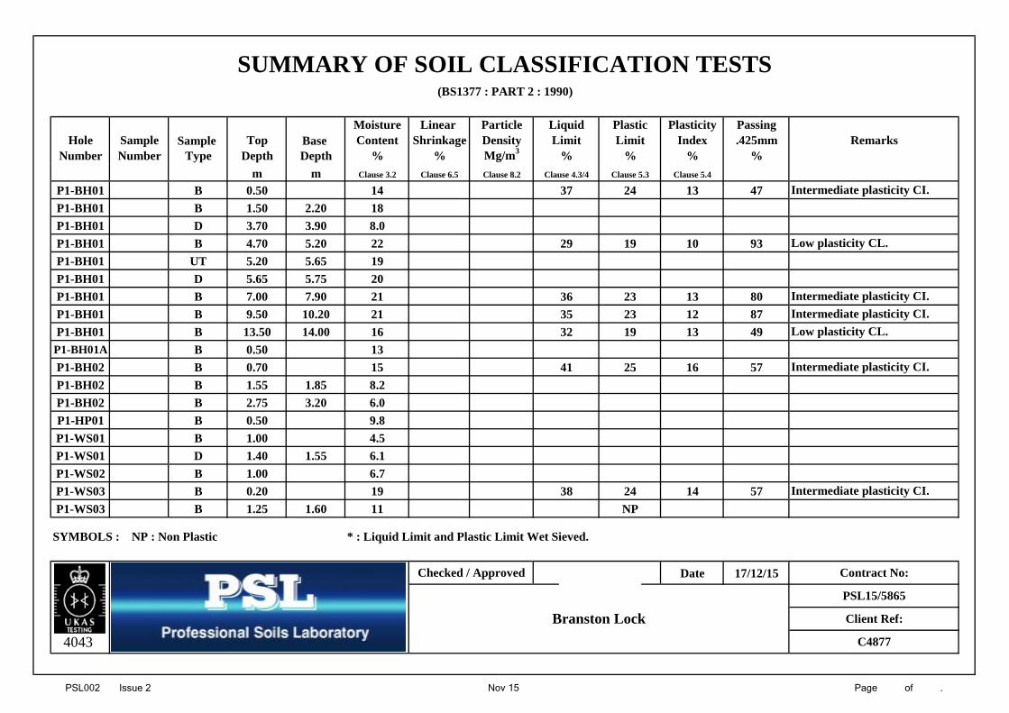
Moisture Linear Particle Liquid Plastic Plasticity PassingHole Sample Sample Top Base Content Shrinkage Density Limit Limit Index .425mm Remarks
Number Number Type Depth Depth % % Mg/m3 % % % %m m Clause 3.2 Clause 6.5 Clause 8.2 Clause 4.3/4 Clause 5.3 Clause 5.4
P1-BH01 B 0.50 14 37 24 13 47P1-BH01 B 1.50 2.20 18P1-BH01 D 3.70 3.90 8.0P1-BH01 B 4.70 5.20 22 29 19 10 93P1-BH01 UT 5.20 5.65 19P1-BH01 D 5.65 5.75 20P1-BH01 B 7.00 7.90 21 36 23 13 80P1-BH01 B 9.50 10.20 21 35 23 12 87P1-BH01 B 13.50 14.00 16 32 19 13 49
P1-BH01A B 0.50 13P1-BH02 B 0.70 15 41 25 16 57P1-BH02 B 1.55 1.85 8.2P1-BH02 B 2.75 3.20 6.0P1-HP01 B 0.50 9.8P1-WS01 B 1.00 4.5P1-WS01 D 1.40 1.55 6.1P1-WS02 B 1.00 6.7P1-WS03 B 0.20 19 38 24 14 57P1-WS03 B 1.25 1.60 11 NP
SYMBOLS : NP : Non Plastic * : Liquid Limit and Plastic Limit Wet Sieved.
Date 17/12/15
4043
Checked / Approved
Branston LockPSL15/5865
Intermediate plasticity CI.
Intermediate plasticity CI.
Client Ref:
Intermediate plasticity CI.
C4877
Contract No:
Intermediate plasticity CI.
SUMMARY OF SOIL CLASSIFICATION TESTS
Low plasticity CL.
Intermediate plasticity CI.
Low plasticity CL.

PSL002 Issue 2 Nov 15 Page of .
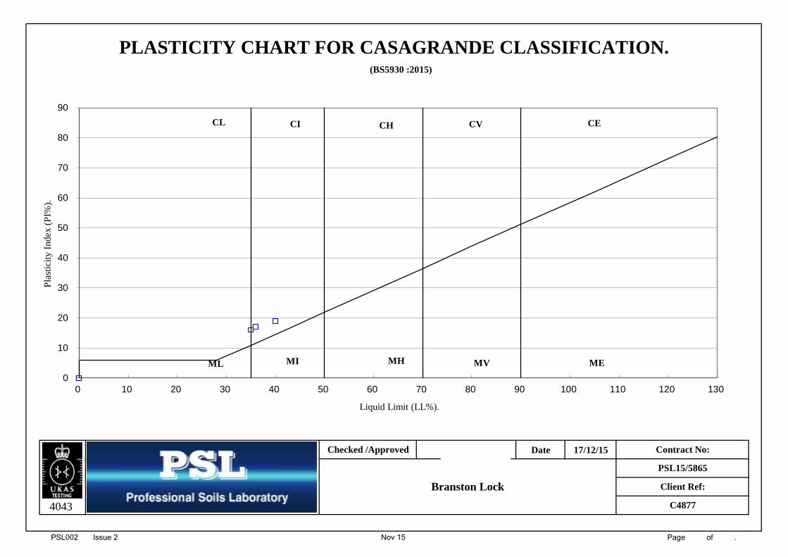
(BS5930 :2015)
Date 17/12/15
4043 C4877
Branston Lock
Checked /Approved Contract No:
PSL15/5865
Client Ref:
PLASTICITY CHART FOR CASAGRANDE CLASSIFICATION.
0
10
20
30
40
50
60
70
80
90
0 10 20 30 40 50 60 70 80 90 100 110 120 130
Pla
stic
ity
Inde
x (P
I%).
Liquid Limit (LL%).
CL CI CH CV CE
ML MI MH MV ME
PSL002 Issue 2 Nov 15 Page of .
(BS1377 : PART 2 : 1990)
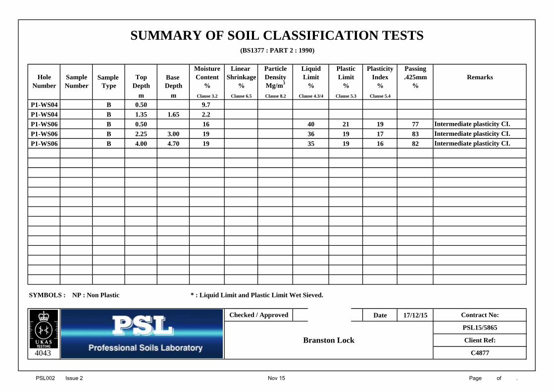
Moisture Linear Particle Liquid Plastic Plasticity PassingHole Sample Sample Top Base Content Shrinkage Density Limit Limit Index .425mm Remarks
Number Number Type Depth Depth % % Mg/m3 % % % %m m Clause 3.2 Clause 6.5 Clause 8.2 Clause 4.3/4 Clause 5.3 Clause 5.4
P1-WS04 B 0.50 9.7P1-WS04 B 1.35 1.65 2.2P1-WS06 B 0.50 16 40 21 19 77P1-WS06 B 2.25 3.00 19 36 19 17 83P1-WS06 B 4.00 4.70 19 35 19 16 82
SYMBOLS : NP : Non Plastic * : Liquid Limit and Plastic Limit Wet Sieved.
Date 17/12/15
4043
SUMMARY OF SOIL CLASSIFICATION TESTS
Intermediate plasticity CI.Intermediate plasticity CI.
Intermediate plasticity CI.
Client Ref:
C4877
Contract No:
PSL15/5865
Checked / Approved
Branston Lock
PSL002 Issue 2 Nov 15 Page of .
(BS5930 :2015)
Date 17/12/15
4043 C4877
Branston Lock
Checked /Approved Contract No:
PSL15/5865
Client Ref:
PLASTICITY CHART FOR CASAGRANDE CLASSIFICATION.
0
10
20
30
40
50
60
70
80
90
0 10 20 30 40 50 60 70 80 90 100 110 120 130
Pla
stic
ity
Inde
x (P
I%).
Liquid Limit (LL%).
CL CI CH CV CE
ML MI MH MV ME

PSL005 Nov 15 Page of
Hole Number: Top Depth (m):
Sample Number: Base Depth(m):
Sample Type:
BS Test Percentage Particle Percentage Soil Total
Sieve Passing Diameter Passing Fraction Percentage
125 100 2 275 100 0.02 18 Cobbles 063 100 2 2 Gravel 32
37.5 97 0.006 14 Sand 4720 90 2 2 Silt 1210 81 0.002 9 Clay 96.3 77
3.35 712 68
1.18 650.6 590.3 40
0.212 30 Remarks:0.15 25 See summary of soil descriptions.
0.063 21
Date 17/12/15
4043
0.50
Contract No:
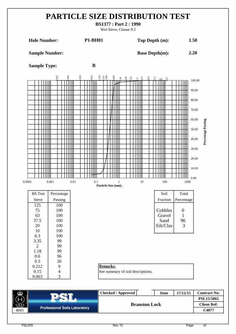
P1-BH01
B
PSL15/5865Client Ref:
C4877
PARTICLE SIZE DISTRIBUTION TESTBS1377 : Part 2 : 1990
Wet Sieve & Pipette Analysis, Clause 9.2 & 9.4
Checked / Approved
Branston Lock
0.00
2
0.00
6
0.02
0
0.06
3
0.15
0
0.21
2 0.
300
0.60
0
1.18
2.00
3.35
6.3
10.0
20.0
37.5
63
75
125
0.00
10.00
20.00
30.00
40.00
50.00
60.00
70.00
80.00
90.00
100.00
0.0001 0.001 0.01 0.1 1 10 100 1000
Perc
enta
ge P
assi
ng.
Particle Size (mm).
PSL005 Nov 15 Page of
Hole Number: Top Depth (m):
Sample Number: Base Depth(m):
Sample Type:
BS Test Percentage 1 1 Soil Total
Sieve Passing 1 1 Fraction Percentage
125 100 1 175 100 1 1 Cobbles 063 100 1 1 Gravel 1
37.5 100 1 1 Sand 9620 100 1 1 Silt/Clay 310 100 1 16.3 100
3.35 992 99
1.18 990.6 960.3 26
0.212 9 Remarks:0.15 4 See summary of soil descriptions.
0.063 3
Date 17/12/15
4043
1.50
2.20
Contract No:
P1-BH01
B
PSL15/5865Client Ref:
C4877
PARTICLE SIZE DISTRIBUTION TESTBS1377 : Part 2 : 1990
Wet Sieve, Clause 9.2
Checked / Approved
Branston Lock
0.00
2
0.00
6
0.02
0
0.06
3
0.15
0
0.21
2 0.
300
0.60
0
1.18
2.00
3.35
6.3
10.0
20.0
37.5
63
75
125
0.00
10.00
20.00
30.00
40.00
50.00
60.00
70.00
80.00
90.00
100.00
0.0001 0.001 0.01 0.1 1 10 100 1000
Perc
enta
ge P
assi
ng.
Particle Size (mm).

PSL005 Nov 15 Page of
Hole Number: Top Depth (m):
Sample Number: Base Depth(m):
Sample Type:
BS Test Percentage 1 1 Soil Total
Sieve Passing 1 1 Fraction Percentage
125 100 1 175 100 1 1 Cobbles 063 100 1 1 Gravel 51
37.5 100 1 1 Sand 2520 76 1 1 Silt/Clay 2410 62 1 16.3 58
3.35 532 49
1.18 460.6 410.3 30
0.212 27 Remarks:0.15 25 See summary of soil descriptions.
0.063 24
Date 17/12/15
4043
3.70
3.90
Contract No:
P1-BH01
D
PSL15/5865Client Ref:
C4877
PARTICLE SIZE DISTRIBUTION TESTBS1377 : Part 2 : 1990
Wet Sieve, Clause 9.2
Checked / Approved
Branston Lock
0.00
2
0.00
6
0.02
0
0.06
3
0.15
0
0.21
2 0.
300
0.60
0
1.18
2.00
3.35
6.3
10.0
20.0
37.5
63
75
125
0.00
10.00
20.00
30.00
40.00
50.00
60.00
70.00
80.00
90.00
100.00
0.0001 0.001 0.01 0.1 1 10 100 1000
Perc
enta
ge P
assi
ng.
Particle Size (mm).

PSL005 Nov 15 Page of
Hole Number: Top Depth (m):
Sample Number: Base Depth(m):
Sample Type:
BS Test Percentage Particle Percentage Soil Total
Sieve Passing Diameter Passing Fraction Percentage
125 100 2 275 100 0.02 66 Cobbles 063 100 2 2 Gravel 1
37.5 100 0.006 48 Sand 920 100 2 2 Silt 5510 100 0.002 35 Clay 356.3 100
3.35 1002 99
1.18 980.6 960.3 93
0.212 92 Remarks:0.15 91 See summary of soil descriptions.
0.063 90
Date 17/12/15
4043
4.70
5.20
Contract No:
P1-BH01
B
PSL15/5865Client Ref:
C4877
PARTICLE SIZE DISTRIBUTION TESTBS1377 : Part 2 : 1990
Wet Sieve & Pipette Analysis, Clause 9.2 & 9.4
Checked / Approved
Branston Lock
0.00
2
0.00
6
0.02
0
0.06
3
0.15
0
0.21
2 0.
300
0.60
0
1.18
2.00
3.35
6.3
10.0
20.0
37.5
63
75
125
0.00
10.00
20.00
30.00
40.00
50.00
60.00
70.00
80.00
90.00
100.00
0.0001 0.001 0.01 0.1 1 10 100 1000
Perc
enta
ge P
assi
ng.
Particle Size (mm).

PSL005 Nov 15 Page of
Hole Number: Top Depth (m):
Sample Number: Base Depth(m):
Sample Type:
BS Test Percentage Particle Percentage Soil Total
Sieve Passing Diameter Passing Fraction Percentage
125 100 2 275 100 0.02 32 Cobbles 063 100 2 2 Gravel 36
37.5 100 0.006 25 Sand 2720 94 2 2 Silt 2210 91 0.002 15 Clay 156.3 85
3.35 732 64
1.18 570.6 500.3 45
0.212 42 Remarks:0.15 40 See summary of soil descriptions.
0.063 37
Date 17/12/15
4043
6.70
7.15
Contract No:
P1-BH01
SPT
PSL15/5865Client Ref:
C4877
PARTICLE SIZE DISTRIBUTION TESTBS1377 : Part 2 : 1990
Wet Sieve & Pipette Analysis, Clause 9.2 & 9.4
Checked / Approved
Branston Lock
0.00
2
0.00
6
0.02
0
0.06
3
0.15
0
0.21
2 0.
300
0.60
0
1.18
2.00
3.35
6.3
10.0
20.0
37.5
63
75
125
0.00
10.00
20.00
30.00
40.00
50.00
60.00
70.00
80.00
90.00
100.00
0.0001 0.001 0.01 0.1 1 10 100 1000
Perc
enta
ge P
assi
ng.
Particle Size (mm).

PSL005 Nov 15 Page of
Hole Number: Top Depth (m):
Sample Number: Base Depth(m):
Sample Type:
BS Test Percentage Particle Percentage Soil Total
Sieve Passing Diameter Passing Fraction Percentage
125 100 2 275 100 0.02 61 Cobbles 063 100 2 2 Gravel 3
37.5 100 0.006 45 Sand 1520 100 2 2 Silt 4910 100 0.002 33 Clay 336.3 99
3.35 982 97
1.18 950.6 910.3 86
0.212 84 Remarks:0.15 83 See summary of soil descriptions.
0.063 82
Date 17/12/15
4043
9.50
10.20
Contract No:
P1-BH01
B
PSL15/5865Client Ref:
C4877
PARTICLE SIZE DISTRIBUTION TESTBS1377 : Part 2 : 1990
Wet Sieve & Pipette Analysis, Clause 9.2 & 9.4
Checked / Approved
Branston Lock
0.00
2
0.00
6
0.02
0
0.06
3
0.15
0
0.21
2 0.
300
0.60
0
1.18
2.00
3.35
6.3
10.0
20.0
37.5
63
75
125
0.00
10.00
20.00
30.00
40.00
50.00
60.00
70.00
80.00
90.00
100.00
0.0001 0.001 0.01 0.1 1 10 100 1000
Perc
enta
ge P
assi
ng.
Particle Size (mm).

PSL005 Nov 15 Page of
Hole Number: Top Depth (m):
Sample Number: Base Depth(m):
Sample Type:
BS Test Percentage Particle Percentage Soil Total
Sieve Passing Diameter Passing Fraction Percentage
125 100 2 275 100 0.02 32 Cobbles 063 100 2 2 Gravel 11
37.5 100 0.006 24 Sand 5220 95 2 2 Silt 2210 95 0.002 15 Clay 156.3 95
3.35 942 89
1.18 770.6 560.3 45
0.212 42 Remarks:0.15 39 See summary of soil descriptions.
0.063 37
Date 17/12/15
4043
13.50
14.00
Contract No:
P1-BH01
B
PSL15/5865Client Ref:
C4877
PARTICLE SIZE DISTRIBUTION TESTBS1377 : Part 2 : 1990
Wet Sieve & Pipette Analysis, Clause 9.2 & 9.4
Checked / Approved
Branston Lock
0.00
2
0.00
6
0.02
0
0.06
3
0.15
0
0.21
2 0.
300
0.60
0
1.18
2.00
3.35
6.3
10.0
20.0
37.5
63
75
125
0.00
10.00
20.00
30.00
40.00
50.00
60.00
70.00
80.00
90.00
100.00
0.0001 0.001 0.01 0.1 1 10 100 1000
Perc
enta
ge P
assi
ng.
Particle Size (mm).
PSL005 Nov 15 Page of
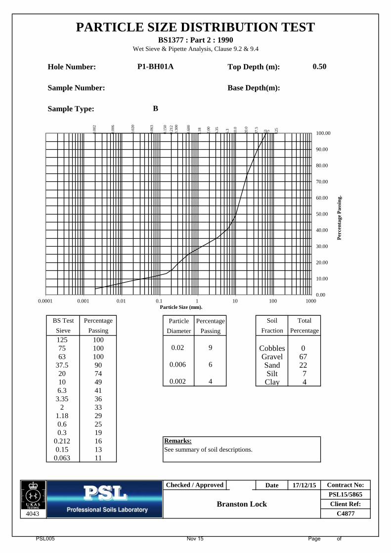
Hole Number: Top Depth (m):
Sample Number: Base Depth(m):
Sample Type:
BS Test Percentage Particle Percentage Soil Total
Sieve Passing Diameter Passing Fraction Percentage
125 100 2 275 100 0.02 9 Cobbles 063 100 2 2 Gravel 67
37.5 90 0.006 6 Sand 2220 74 2 2 Silt 710 49 0.002 4 Clay 46.3 41
3.35 362 33
1.18 290.6 250.3 19
0.212 16 Remarks:0.15 13 See summary of soil descriptions.
0.063 11
Date 17/12/15
4043
0.50
Contract No:
P1-BH01A
B
PSL15/5865Client Ref:
C4877
PARTICLE SIZE DISTRIBUTION TESTBS1377 : Part 2 : 1990
Wet Sieve & Pipette Analysis, Clause 9.2 & 9.4
Checked / Approved
Branston Lock
0.00
2
0.00
6
0.02
0
0.06
3
0.15
0
0.21
2 0.
300
0.60
0
1.18
2.00
3.35
6.3
10.0
20.0
37.5
63
75
125
0.00
10.00
20.00
30.00
40.00
50.00
60.00
70.00
80.00
90.00
100.00
0.0001 0.001 0.01 0.1 1 10 100 1000
Perc
enta
ge P
assi
ng.
Particle Size (mm).

PSL005 Nov 15 Page of
Hole Number: Top Depth (m):
Sample Number: Base Depth(m):
Sample Type:
BS Test Percentage Particle Percentage Soil Total
Sieve Passing Diameter Passing Fraction Percentage
125 100 2 275 100 0.02 33 Cobbles 063 100 2 2 Gravel 26
37.5 92 0.006 25 Sand 3620 89 2 2 Silt 2310 82 0.002 15 Clay 156.3 79
3.35 772 74
1.18 710.6 660.3 53
0.212 45 Remarks:0.15 41 See summary of soil descriptions.
0.063 38
Date 17/12/15
4043
0.70
Contract No:
P1-BH02
B
PSL15/5865Client Ref:
C4877
PARTICLE SIZE DISTRIBUTION TESTBS1377 : Part 2 : 1990
Wet Sieve & Pipette Analysis, Clause 9.2 & 9.4
Checked / Approved
Branston Lock
0.00
2
0.00
6
0.02
0
0.06
3
0.15
0
0.21
2 0.
300
0.60
0
1.18
2.00
3.35
6.3
10.0
20.0
37.5
63
75
125
0.00
10.00
20.00
30.00
40.00
50.00
60.00
70.00
80.00
90.00
100.00
0.0001 0.001 0.01 0.1 1 10 100 1000
Perc
enta
ge P
assi
ng.
Particle Size (mm).

PSL005 Nov 15 Page of
Hole Number: Top Depth (m):
Sample Number: Base Depth(m):
Sample Type:
BS Test Percentage 1 1 Soil Total
Sieve Passing 1 1 Fraction Percentage
125 100 1 175 100 1 1 Cobbles 063 100 1 1 Gravel 61
37.5 100 1 1 Sand 3820 85 1 1 Silt/Clay 110 55 1 16.3 48
3.35 422 39
1.18 380.6 340.3 15
0.212 5 Remarks:0.15 2 See summary of soil descriptions.
0.063 1
Date 17/12/15
4043
1.55
1.85
Contract No:
P1-BH02
B
PSL15/5865Client Ref:
C4877
PARTICLE SIZE DISTRIBUTION TESTBS1377 : Part 2 : 1990
Wet Sieve, Clause 9.2
Checked / Approved
Branston Lock
0.00
2
0.00
6
0.02
0
0.06
3
0.15
0
0.21
2 0.
300
0.60
0
1.18
2.00
3.35
6.3
10.0
20.0
37.5
63
75
125
0.00
10.00
20.00
30.00
40.00
50.00
60.00
70.00
80.00
90.00
100.00
0.0001 0.001 0.01 0.1 1 10 100 1000
Perc
enta
ge P
assi
ng.
Particle Size (mm).

PSL005 Nov 15 Page of
Hole Number: Top Depth (m):
Sample Number: Base Depth(m):
Sample Type:
BS Test Percentage 1 1 Soil Total
Sieve Passing 1 1 Fraction Percentage
125 100 1 175 100 1 1 Cobbles 063 100 1 1 Gravel 75
37.5 88 1 1 Sand 2320 71 1 1 Silt/Clay 210 45 1 16.3 35
3.35 292 25
1.18 230.6 190.3 7
0.212 4 Remarks:0.15 3 See summary of soil descriptions.
0.063 2
Date 17/12/15
4043
2.75
3.20
Contract No:
P1-BH02
B
PSL15/5865Client Ref:
C4877
PARTICLE SIZE DISTRIBUTION TESTBS1377 : Part 2 : 1990
Wet Sieve, Clause 9.2
Checked / Approved
Branston Lock
0.00
2
0.00
6
0.02
0
0.06
3
0.15
0
0.21
2 0.
300
0.60
0
1.18
2.00
3.35
6.3
10.0
20.0
37.5
63
75
125
0.00
10.00
20.00
30.00
40.00
50.00
60.00
70.00
80.00
90.00
100.00
0.0001 0.001 0.01 0.1 1 10 100 1000
Perc
enta
ge P
assi
ng.
Particle Size (mm).

PSL005 Nov 15 Page of
Hole Number: Top Depth (m):
Sample Number: Base Depth(m):
Sample Type:
BS Test Percentage Particle Percentage Soil Total
Sieve Passing Diameter Passing Fraction Percentage
125 100 2 275 100 0.02 26 Cobbles 063 100 2 2 Gravel 33
37.5 93 0.006 20 Sand 3620 86 2 2 Silt 1910 77 0.002 12 Clay 126.3 73
3.35 692 67
1.18 650.6 590.3 44
0.212 38 Remarks:0.15 34 See summary of soil descriptions.
0.063 31
Date 17/12/15
4043
0.50
Contract No:
P1-HP01
B
PSL15/5865Client Ref:
C4877
PARTICLE SIZE DISTRIBUTION TESTBS1377 : Part 2 : 1990
Wet Sieve & Pipette Analysis, Clause 9.2 & 9.4
Checked / Approved
Branston Lock
0.00
2
0.00
6
0.02
0
0.06
3
0.15
0
0.21
2 0.
300
0.60
0
1.18
2.00
3.35
6.3
10.0
20.0
37.5
63
75
125
0.00
10.00
20.00
30.00
40.00
50.00
60.00
70.00
80.00
90.00
100.00
0.0001 0.001 0.01 0.1 1 10 100 1000
Perc
enta
ge P
assi
ng.
Particle Size (mm).

PSL005 Nov 15 Page of
Hole Number: Top Depth (m):
Sample Number: Base Depth(m):
Sample Type:
BS Test Percentage 1 1 Soil Total
Sieve Passing 1 1 Fraction Percentage
125 100 1 175 100 1 1 Cobbles 063 100 1 1 Gravel 81
37.5 100 1 1 Sand 1620 82 1 1 Silt/Clay 310 45 1 16.3 35
3.35 232 19
1.18 160.6 120.3 6
0.212 4 Remarks:0.15 4 See summary of soil descriptions.
0.063 3
Date 17/12/15
4043
Contract No:
P1-WS01
D
PSL15/5865Client Ref:
C4877
PARTICLE SIZE DISTRIBUTION TESTBS1377 : Part 2 : 1990
Wet Sieve, Clause 9.2
Checked / Approved
Branston Lock
1.40
1.550.
002
0.00
6
0.02
0
0.06
3
0.15
0
0.21
2 0.
300
0.60
0
1.18
2.00
3.35
6.3
10.0
20.0
37.5
63
75
125
0.00
10.00
20.00
30.00
40.00
50.00
60.00
70.00
80.00
90.00
100.00
0.0001 0.001 0.01 0.1 1 10 100 1000
Perc
enta
ge P
assi
ng.
Particle Size (mm).

PSL005 Nov 15 Page of
Hole Number: Top Depth (m):
Sample Number: Base Depth(m):
Sample Type:
BS Test Percentage 1 1 Soil Total
Sieve Passing 1 1 Fraction Percentage
125 100 1 175 100 1 1 Cobbles 063 100 1 1 Gravel 69
37.5 100 1 1 Sand 2620 80 1 1 Silt/Clay 510 56 1 16.3 46
3.35 362 31
1.18 270.6 160.3 8
0.212 7 Remarks:0.15 6 See summary of soil descriptions.
0.063 5
Date 17/12/15
4043
PSL15/5865Client Ref:
C4877
PARTICLE SIZE DISTRIBUTION TESTBS1377 : Part 2 : 1990
Wet Sieve, Clause 9.2
Checked / Approved
Branston Lock
1.00
Contract No:
P1-WS02
B
0.00
2
0.00
6
0.02
0
0.06
3
0.15
0
0.21
2 0.
300
0.60
0
1.18
2.00
3.35
6.3
10.0
20.0
37.5
63
75
125
0.00
10.00
20.00
30.00
40.00
50.00
60.00
70.00
80.00
90.00
100.00
0.0001 0.001 0.01 0.1 1 10 100 1000
Perc
enta
ge P
assi
ng.
Particle Size (mm).
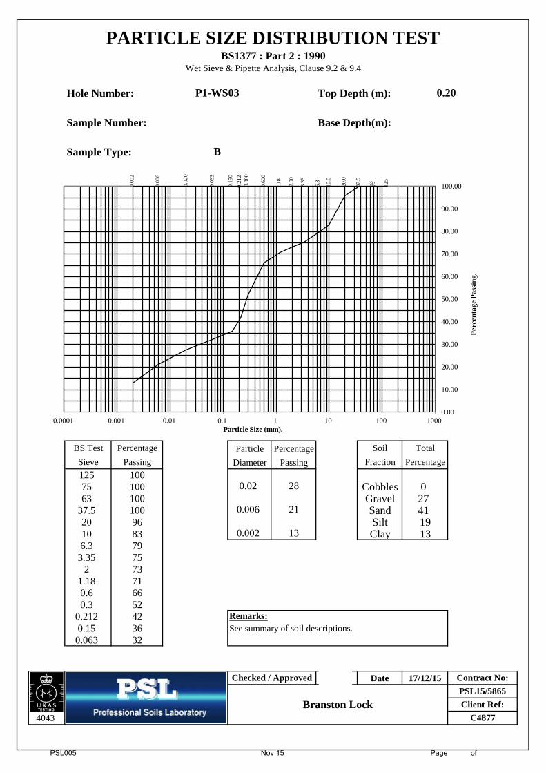
PSL005 Nov 15 Page of
Hole Number: Top Depth (m):
Sample Number: Base Depth(m):
Sample Type:
BS Test Percentage Particle Percentage Soil Total
Sieve Passing Diameter Passing Fraction Percentage
125 100 2 275 100 0.02 28 Cobbles 063 100 2 2 Gravel 27
37.5 100 0.006 21 Sand 4120 96 2 2 Silt 1910 83 0.002 13 Clay 136.3 79
3.35 752 73
1.18 710.6 660.3 52
0.212 42 Remarks:0.15 36 See summary of soil descriptions.
0.063 32
Date 17/12/15
4043
PSL15/5865Client Ref:
C4877
PARTICLE SIZE DISTRIBUTION TESTBS1377 : Part 2 : 1990
Wet Sieve & Pipette Analysis, Clause 9.2 & 9.4
Checked / Approved
Branston Lock
0.20
Contract No:
P1-WS03
B
0.00
2
0.00
6
0.02
0
0.06
3
0.15
0
0.21
2 0.
300
0.60
0
1.18
2.00
3.35
6.3
10.0
20.0
37.5
63
75
125
0.00
10.00
20.00
30.00
40.00
50.00
60.00
70.00
80.00
90.00
100.00
0.0001 0.001 0.01 0.1 1 10 100 1000
Perc
enta
ge P
assi
ng.
Particle Size (mm).
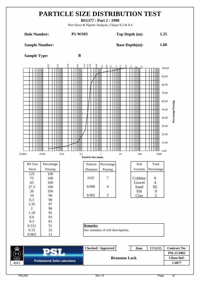
PSL005 Nov 15 Page of
Hole Number: Top Depth (m):
Sample Number: Base Depth(m):
Sample Type:
BS Test Percentage Particle Percentage Soil Total
Sieve Passing Diameter Passing Fraction Percentage
125 100 2 275 100 0.02 7 Cobbles 063 100 2 2 Gravel 4
37.5 100 0.006 4 Sand 8520 100 2 2 Silt 910 99 0.002 2 Clay 26.3 98
3.35 972 96
1.18 950.6 930.3 81
0.212 51 Remarks:0.15 25 See summary of soil descriptions.
0.063 11
Date 17/12/15
4043
Contract No:
P1-WS03
B
PSL15/5865Client Ref:
C4877
PARTICLE SIZE DISTRIBUTION TESTBS1377 : Part 2 : 1990
Wet Sieve & Pipette Analysis, Clause 9.2 & 9.4
Checked / Approved
Branston Lock
1.25
1.600.
002
0.00
6
0.02
0
0.06
3
0.15
0
0.21
2 0.
300
0.60
0
1.18
2.00
3.35
6.3
10.0
20.0
37.5
63
75
125
0.00
10.00
20.00
30.00
40.00
50.00
60.00
70.00
80.00
90.00
100.00
0.0001 0.001 0.01 0.1 1 10 100 1000
Perc
enta
ge P
assi
ng.
Particle Size (mm).

PSL005 Nov 15 Page of
Hole Number: Top Depth (m):
Sample Number: Base Depth(m):
Sample Type:
BS Test Percentage 1 1 Soil Total
Sieve Passing 1 1 Fraction Percentage
125 100 1 175 100 1 1 Cobbles 063 100 1 1 Gravel 53
37.5 100 1 1 Sand 3320 84 1 1 Silt/Clay 1410 59 1 16.3 53
3.35 492 47
1.18 450.6 410.3 25
0.212 19 Remarks:0.15 16 See summary of soil descriptions.
0.063 14
Date 17/12/15
4043
Contract No:
P1-WS04
B
PSL15/5865Client Ref:
C4877
PARTICLE SIZE DISTRIBUTION TESTBS1377 : Part 2 : 1990
Wet Sieve, Clause 9.2
Checked / Approved
Branston Lock
0.50
0.00
2
0.00
6
0.02
0
0.06
3
0.15
0
0.21
2 0.
300
0.60
0
1.18
2.00
3.35
6.3
10.0
20.0
37.5
63
75
125
0.00
10.00
20.00
30.00
40.00
50.00
60.00
70.00
80.00
90.00
100.00
0.0001 0.001 0.01 0.1 1 10 100 1000
Perc
enta
ge P
assi
ng.
Particle Size (mm).
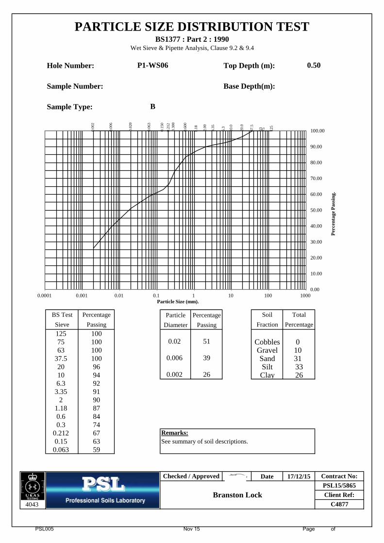
PSL005 Nov 15 Page of
Hole Number: Top Depth (m):
Sample Number: Base Depth(m):
Sample Type:
BS Test Percentage Particle Percentage Soil Total
Sieve Passing Diameter Passing Fraction Percentage
125 100 2 275 100 0.02 51 Cobbles 063 100 2 2 Gravel 10
37.5 100 0.006 39 Sand 3120 96 2 2 Silt 3310 94 0.002 26 Clay 266.3 92
3.35 912 90
1.18 870.6 840.3 74
0.212 67 Remarks:0.15 63 See summary of soil descriptions.
0.063 59
Date 17/12/15
4043
Contract No:
P1-WS06
B
PSL15/5865Client Ref:
C4877
PARTICLE SIZE DISTRIBUTION TESTBS1377 : Part 2 : 1990
Wet Sieve & Pipette Analysis, Clause 9.2 & 9.4
Checked / Approved
Branston Lock
0.50
0.00
2
0.00
6
0.02
0
0.06
3
0.15
0
0.21
2 0.
300
0.60
0
1.18
2.00
3.35
6.3
10.0
20.0
37.5
63
75
125
0.00
10.00
20.00
30.00
40.00
50.00
60.00
70.00
80.00
90.00
100.00
0.0001 0.001 0.01 0.1 1 10 100 1000
Perc
enta
ge P
assi
ng.
Particle Size (mm).
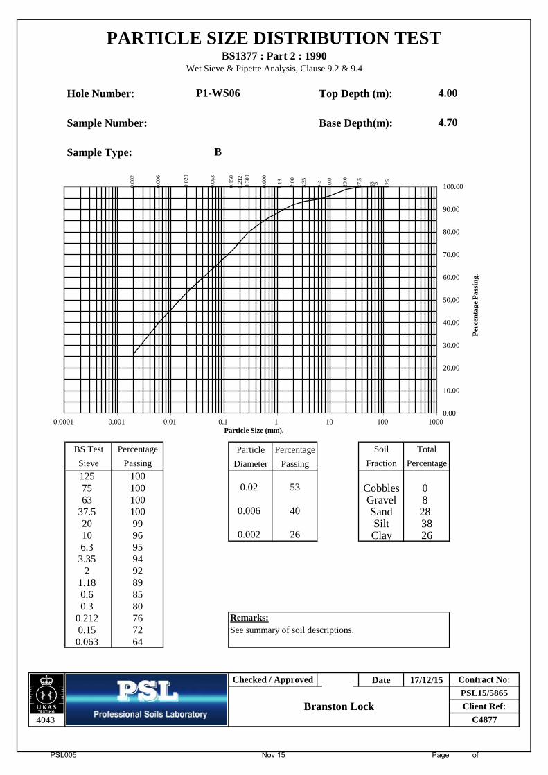
PSL005 Nov 15 Page of
Hole Number: Top Depth (m):
Sample Number: Base Depth(m):
Sample Type:
BS Test Percentage Particle Percentage Soil Total
Sieve Passing Diameter Passing Fraction Percentage
125 100 2 275 100 0.02 53 Cobbles 063 100 2 2 Gravel 8
37.5 100 0.006 40 Sand 2820 99 2 2 Silt 3810 96 0.002 26 Clay 266.3 95
3.35 942 92
1.18 890.6 850.3 80
0.212 76 Remarks:0.15 72 See summary of soil descriptions.
0.063 64
Date 17/12/15
4043
Contract No:
P1-WS06
B
PSL15/5865Client Ref:
C4877
PARTICLE SIZE DISTRIBUTION TESTBS1377 : Part 2 : 1990
Wet Sieve & Pipette Analysis, Clause 9.2 & 9.4
Checked / Approved
Branston Lock
4.00
4.700.
002
0.00
6
0.02
0
0.06
3
0.15
0
0.21
2 0.
300
0.60
0
1.18
2.00
3.35
6.3
10.0
20.0
37.5
63
75
125
0.00
10.00
20.00
30.00
40.00
50.00
60.00
70.00
80.00
90.00
100.00
0.0001 0.001 0.01 0.1 1 10 100 1000
Perc
enta
ge P
assi
ng.
Particle Size (mm).
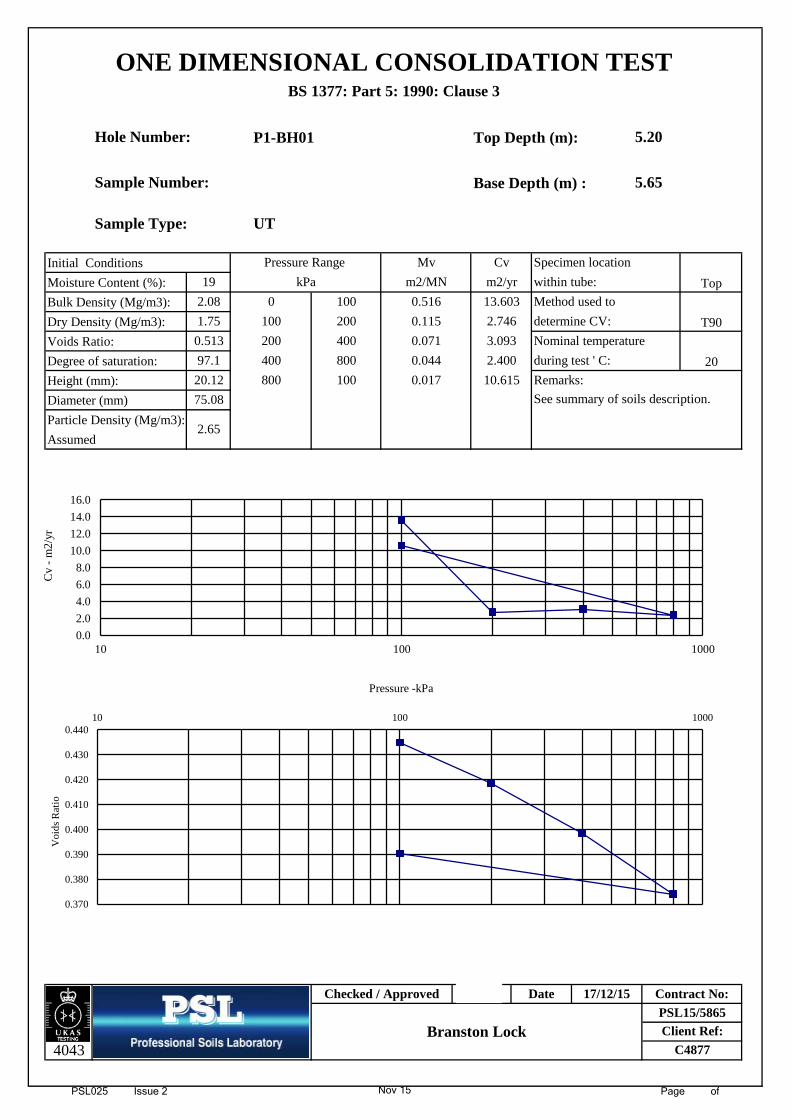
PSL025 Issue 2 Nov 15 Page of
P1-BH01 Top Depth (m):
Base Depth (m) :
Initial Conditions
Moisture Content (%):
Bulk Density (Mg/m3):
Dry Density (Mg/m3):
Voids Ratio:
Degree of saturation:
Height (mm):
Diameter (mm)
Particle Density (Mg/m3):
Assumed
Remarks:
C4877
Checked / Approved
Branston Lock
Date 17/12/15
Client Ref:
Contract No:PSL15/5865
ONE DIMENSIONAL CONSOLIDATION TESTBS 1377: Part 5: 1990: Clause 3
Sample Type:
0
100
200
0.044
4043
400
Sample Number:
0.071
Hole Number:
19 kPa
Cv
5.65
400
200 2.746
13.603100
Top
Method used to
determine CV:
Nominal temperature3.093
2.400
See summary of soils description.
2.65
75.08
UT
5.20
Specimen location
m2/yr
T90
20
800 0.017
97.1 800
20.12 100
within tube:
0.115
0.516
10.615
0.513
during test ' C:
Pressure Range Mv
1.75
2.08
m2/MN
0.370
0.380
0.390
0.400
0.410
0.420
0.430
0.44010 100 1000
Voi
ds R
atio
0.0
2.0
4.0
6.0
8.0
10.0
12.0
14.0
16.0
10 100 1000
Cv
- m
2/yr
Pressure -kPa
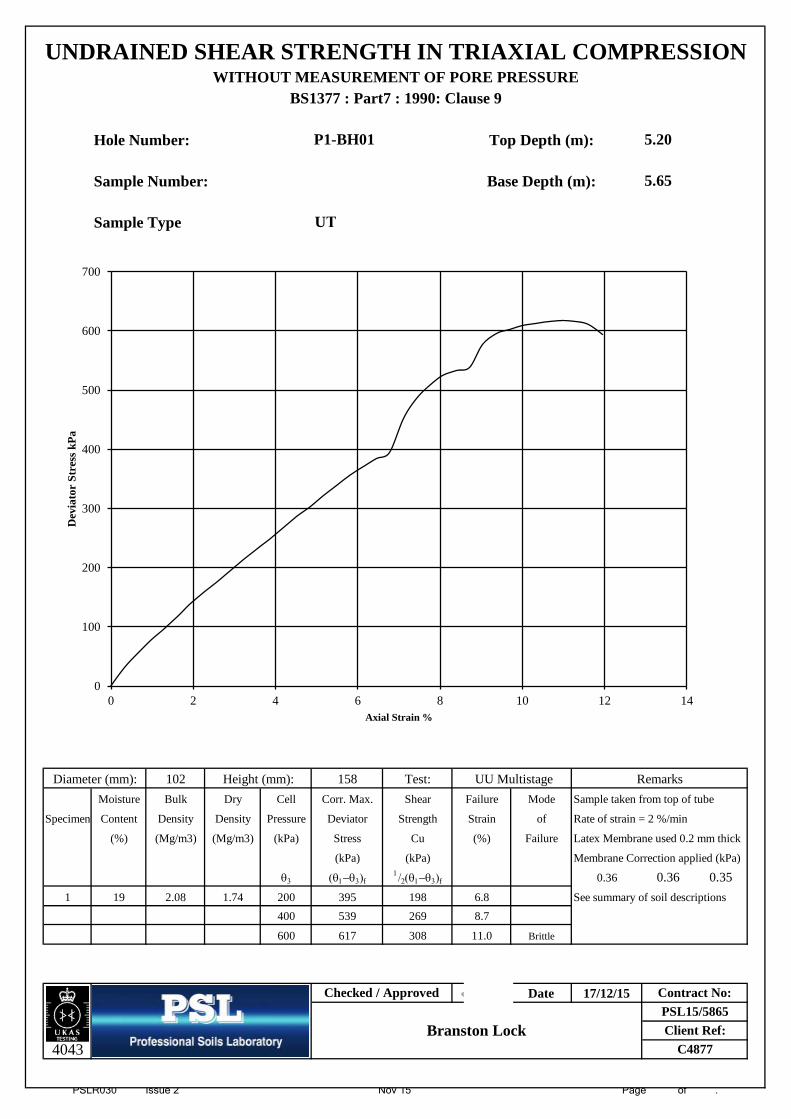
PSLR030 Issue 2 Nov 15 Page of .
Hole Number: Top Depth (m):
Sample Number: Base Depth (m):
Sample Type
102 158 Test:
Moisture Bulk Dry Cell Corr. Max. Shear Failure Mode Sample taken from top of tube
Specimen Content Density Density Pressure Deviator Strength Strain of Rate of strain = 2 %/min
(%) (Mg/m3) (Mg/m3) (kPa) Stress Cu (%) Failure Latex Membrane used 0.2 mm thick
(kPa) (kPa) Membrane Correction applied (kPa)
θ3 (θ1−θ3)f1/2(θ1−θ3)f 0.36 0.36 0.35
1 19 2.08 1.74 200 395 198 6.8 See summary of soil descriptions
400 539 269 8.7
600 617 308 11.0 Brittle
Date 17/12/15
4043
Diameter (mm):
Client Ref:
5.20
5.65
UNDRAINED SHEAR STRENGTH IN TRIAXIAL COMPRESSIONWITHOUT MEASUREMENT OF PORE PRESSURE
BS1377 : Part7 : 1990: Clause 9
Remarks
Checked / ApprovedPSL15/5865
Contract No:
Branston LockC4877
UT
UU Multistage
P1-BH01
Height (mm):
0
100
200
300
400
500
600
700
0 2 4 6 8 10 12 14
Dev
iato
r St
ress
kPa
Axial Strain %
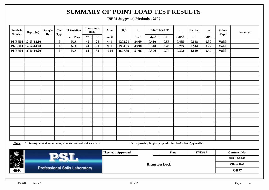
PSL029 Issue 2 Nov 15 Page of
Orientation Area De2 De Is Corr Fac Is50
Par / Perp W D (mm2) (mm) (Mpa) (kN) (MPa) F (MPa)
P1-BH01 12.03-12.10 I N/A 45 21 441 1203.21 34.69 0.410 0.55 0.455 0.848 0.39 Valid P1-BH01 14.64-14.70 I N/A 49 31 961 1934.05 43.98 0.340 0.45 0.235 0.944 0.22 Valid P1-BH01 16.10-16.20 I N/A 64 32 1024 2607.59 51.06 0.590 0.79 0.302 1.010 0.30 Valid
*Note All testing carried out on samples at as received water content Par = parallel, Perp = perpendicular, N/A = Not Applicable
4043
Date
Failure Type Remarks
SUMMARY OF POINT LOAD TEST RESULTS ISRM Suggested Methods : 2007
Branston Lock
Contract No:
PSL15/5865
Client Ref:
17/12/15
Borehole Number Depth (m) Test
Type
Dimensions (mm) Failure Load (P)Sample
Ref
Checked / Approved
C4877

Client
Our Reference
Client Reference
Order No
Contract Title
Description
Date Received
Date Started
Date Completed
Test Procedures
Notes
Approved By
Rob Brown
Certificate of AnalysisCertificate Number 15-53754
23-Dec-15
Professional Soils Laboratory Ltd
5/7 Hexthorpe Road
Hexthorpe
DN4 0AR
15-53754
PSL15/5865
Identified by prefix DETSn (details on request).
Opinions and interpretations are outside the scope of UKAS accreditation. This
certificate is issued in accordance with the accreditation requirements of the United
Kingdom Accreditation Service. The results reported herein relate only to the material
supplied to the laboratory. Observations and interpretations are outside the scope of
ISO 17025. This certificate shall not be reproduced except in full, without the prior
written approval of the laboratory.
Business Manager
(not supplied)
PSL15/5865
One Soil sample.
17-Dec-15
17-Dec-15
23-Dec-15
Derwentside Environmental Testing Services Limited
Unit 2, Park Road Industrial Estate South, Consett, Co Durham, DH8 5PY
Tel: 01207 582333 • email: [email protected] • www.dets.co.uk Page 1 of 3 .
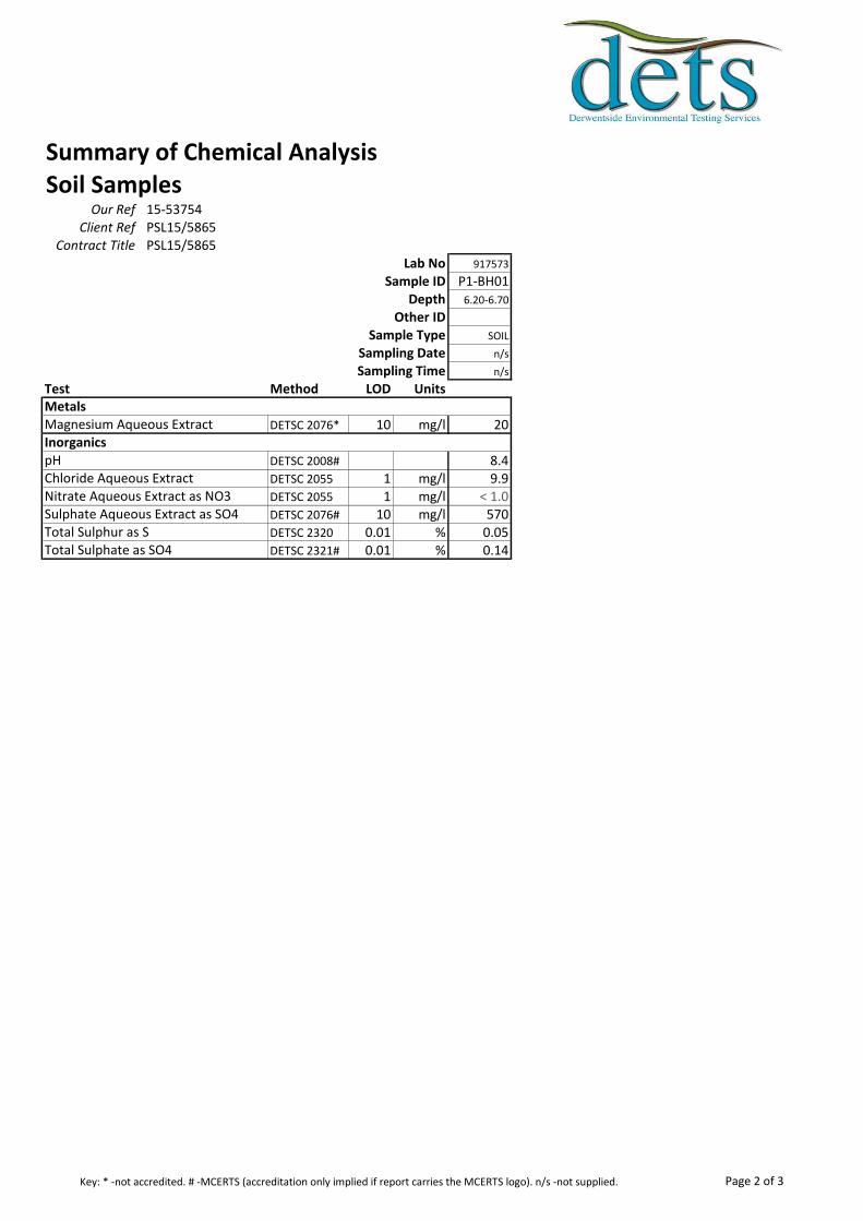
Summary of Chemical AnalysisSoil Samples
Our Ref 15-53754Client Ref PSL15/5865
Contract Title PSL15/5865Lab No 917573
Sample ID P1-BH01Depth 6.20-6.70
Other IDSample Type SOIL
Sampling Date n/s
Sampling Time n/s
Test Method LOD Units
DETSC 2076* 10 mg/l 20
DETSC 2008# 8.4DETSC 2055 1 mg/l 9.9DETSC 2055 1 mg/l < 1.0DETSC 2076# 10 mg/l 570DETSC 2320 0.01 % 0.05DETSC 2321# 0.01 % 0.14Total Sulphate as SO4
Metals
InorganicsMagnesium Aqueous Extract
pHChloride Aqueous ExtractNitrate Aqueous Extract as NO3Sulphate Aqueous Extract as SO4Total Sulphur as S
Page 2 of 3Key: * -not accredited. # -MCERTS (accreditation only implied if report carries the MCERTS logo). n/s -not supplied.
Information in Support of the Analytical ResultsOur Ref 15-53754
Client Ref PSL15/5865Contract PSL15/5865
Containers Received & Deviating Samples
Lab No Sample ID
Date
Sampled Containers Received Holding time exceeded for tests
Inappropriate
container for
tests917573 P1-BH01 6.20-6.70 SOIL PT 500ml Sample date not supplied
Soil Analysis NotesInorganic soil analysis was carried out on a dried sample, crushed to pass a 425µm sieve, in accordance with BS1377.
Organic soil analysis was carried out on an 'as received' sample. Organics results are corrected for moisture and expressed on a dry weight basis.
The Loss on Drying, used to express organics analysis on an air dried basis, is carried out at a temperature of 28°C +/-2°C.
DisposalFrom the issue date of this test certificate, samples will be held for the following times prior to disposal :-
Soils - 1 month, Liquids - 2 weeks, Asbestos (test portion) - 6 months
Key: P-Plastic T-Tub
DETS cannot be held responsible for the integrity of samples received whereby the laboratory did not undertake the sampling. In this instance samples received may
be deviating. Deviating Sample criteria are based on British and International standards and laboratory trials in conjunction with the UKAS note 'Guidance on
Deviating Samples'. All samples received are listed above. However, those samples that have additional comments in relation to hold time and/or inappropriate
containers are deviating due to the reasons stated. This means that the analysis is accredited where applicable, but results may be compromised due to sample
deviations. If no sampled date (soils) or date+time (waters) has been supplied then samples are deviating. However, if you are able to supply a sampled date (and
time for waters) this will prevent samples being reported as deviating where specific hold times are not exceeded and where the container supplied is suitable.
Page 3 of 3
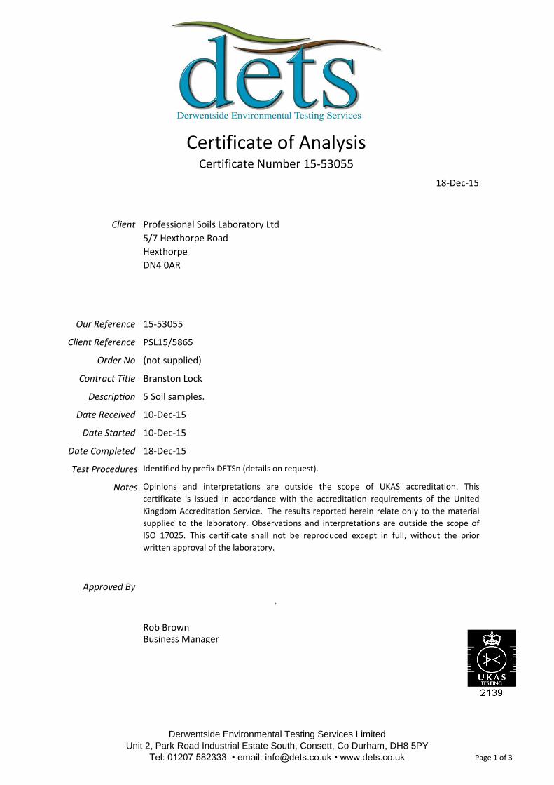
Client
Our Reference
Client Reference
Order No
Contract Title
Description
Date Received
Date Started
Date Completed
Test Procedures
Notes
Approved By
Rob Brown
Identified by prefix DETSn (details on request).
Opinions and interpretations are outside the scope of UKAS accreditation. This
certificate is issued in accordance with the accreditation requirements of the United
Kingdom Accreditation Service. The results reported herein relate only to the material
supplied to the laboratory. Observations and interpretations are outside the scope of
ISO 17025. This certificate shall not be reproduced except in full, without the prior
written approval of the laboratory.
Business Manager
(not supplied)
Branston Lock
5 Soil samples.
10-Dec-15
10-Dec-15
18-Dec-15
Certificate of AnalysisCertificate Number 15-53055
18-Dec-15
Professional Soils Laboratory Ltd
5/7 Hexthorpe Road
Hexthorpe
DN4 0AR
15-53055
PSL15/5865
Derwentside Environmental Testing Services Limited
Unit 2, Park Road Industrial Estate South, Consett, Co Durham, DH8 5PY
Tel: 01207 582333 • email: [email protected] • www.dets.co.uk Page 1 of 3 .
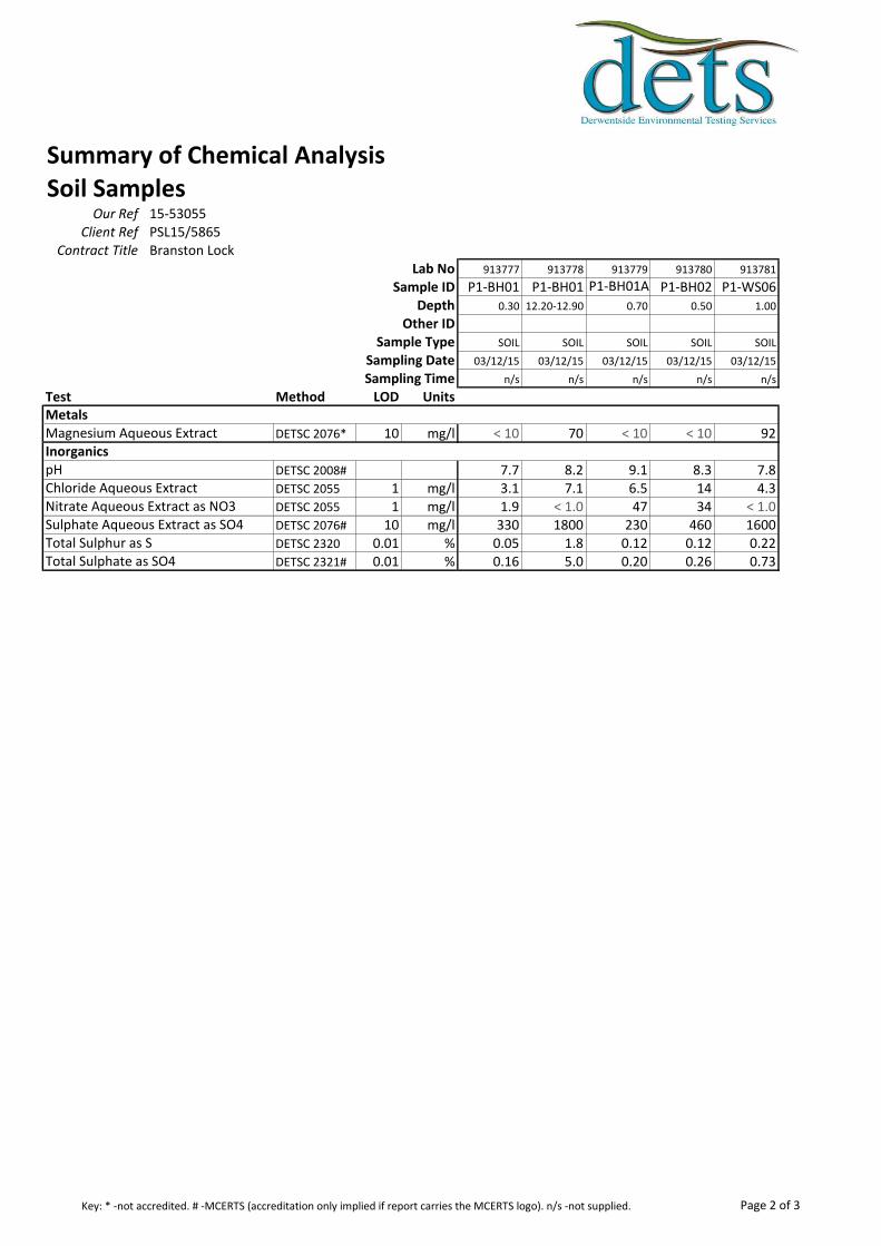
Summary of Chemical AnalysisSoil Samples
Our Ref 15-53055Client Ref PSL15/5865
Contract Title Branston LockLab No 913777 913778 913779 913780 913781
Sample ID P1-BH01 P1-BH01 P1-BH01A P1-BH02 P1-WS06Depth 0.30 12.20-12.90 0.70 0.50 1.00
Other IDSample Type SOIL SOIL SOIL SOIL SOIL
Sampling Date 03/12/15 03/12/15 03/12/15 03/12/15 03/12/15
Sampling Time n/s n/s n/s n/s n/s
Test Method LOD Units
DETSC 2076* 10 mg/l < 10 70 < 10 < 10 92
DETSC 2008# 7.7 8.2 9.1 8.3 7.8DETSC 2055 1 mg/l 3.1 7.1 6.5 14 4.3DETSC 2055 1 mg/l 1.9 < 1.0 47 34 < 1.0DETSC 2076# 10 mg/l 330 1800 230 460 1600DETSC 2320 0.01 % 0.05 1.8 0.12 0.12 0.22DETSC 2321# 0.01 % 0.16 5.0 0.20 0.26 0.73Total Sulphate as SO4
Metals
InorganicsMagnesium Aqueous Extract
pHChloride Aqueous ExtractNitrate Aqueous Extract as NO3Sulphate Aqueous Extract as SO4Total Sulphur as S
Page 2 of 3Key: * -not accredited. # -MCERTS (accreditation only implied if report carries the MCERTS logo). n/s -not supplied.
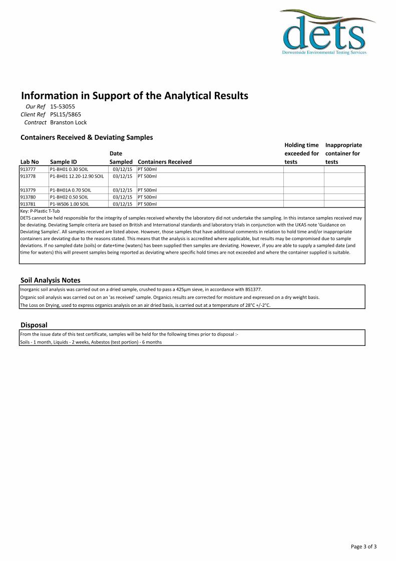
Information in Support of the Analytical ResultsOur Ref 15-53055
Client Ref PSL15/5865Contract Branston Lock
Containers Received & Deviating Samples
Lab No Sample ID
Date
Sampled Containers Received
Holding time
exceeded for
tests
Inappropriate
container for
tests913777 P1-BH01 0.30 SOIL 03/12/15 PT 500ml
913778 P1-BH01 12.20-12.90 SOIL 03/12/15 PT 500ml
913779 P1-BH01A 0.70 SOIL 03/12/15 PT 500ml
913780 P1-BH02 0.50 SOIL 03/12/15 PT 500ml
913781 P1-WS06 1.00 SOIL 03/12/15 PT 500ml
Soil Analysis NotesInorganic soil analysis was carried out on a dried sample, crushed to pass a 425µm sieve, in accordance with BS1377.
Organic soil analysis was carried out on an 'as received' sample. Organics results are corrected for moisture and expressed on a dry weight basis.
The Loss on Drying, used to express organics analysis on an air dried basis, is carried out at a temperature of 28°C +/-2°C.
DisposalFrom the issue date of this test certificate, samples will be held for the following times prior to disposal :-
Soils - 1 month, Liquids - 2 weeks, Asbestos (test portion) - 6 months
Key: P-Plastic T-Tub
DETS cannot be held responsible for the integrity of samples received whereby the laboratory did not undertake the sampling. In this instance samples received may
be deviating. Deviating Sample criteria are based on British and International standards and laboratory trials in conjunction with the UKAS note 'Guidance on
Deviating Samples'. All samples received are listed above. However, those samples that have additional comments in relation to hold time and/or inappropriate
containers are deviating due to the reasons stated. This means that the analysis is accredited where applicable, but results may be compromised due to sample
deviations. If no sampled date (soils) or date+time (waters) has been supplied then samples are deviating. However, if you are able to supply a sampled date (and
time for waters) this will prevent samples being reported as deviating where specific hold times are not exceeded and where the container supplied is suitable.
Page 3 of 3

This certificate should not be reproduced, except in full, without the express permission of the laboratory.
The results included within the report are representative of the samples submitted for analysis.
Iss No 15-83305-1
Page 1 of 5
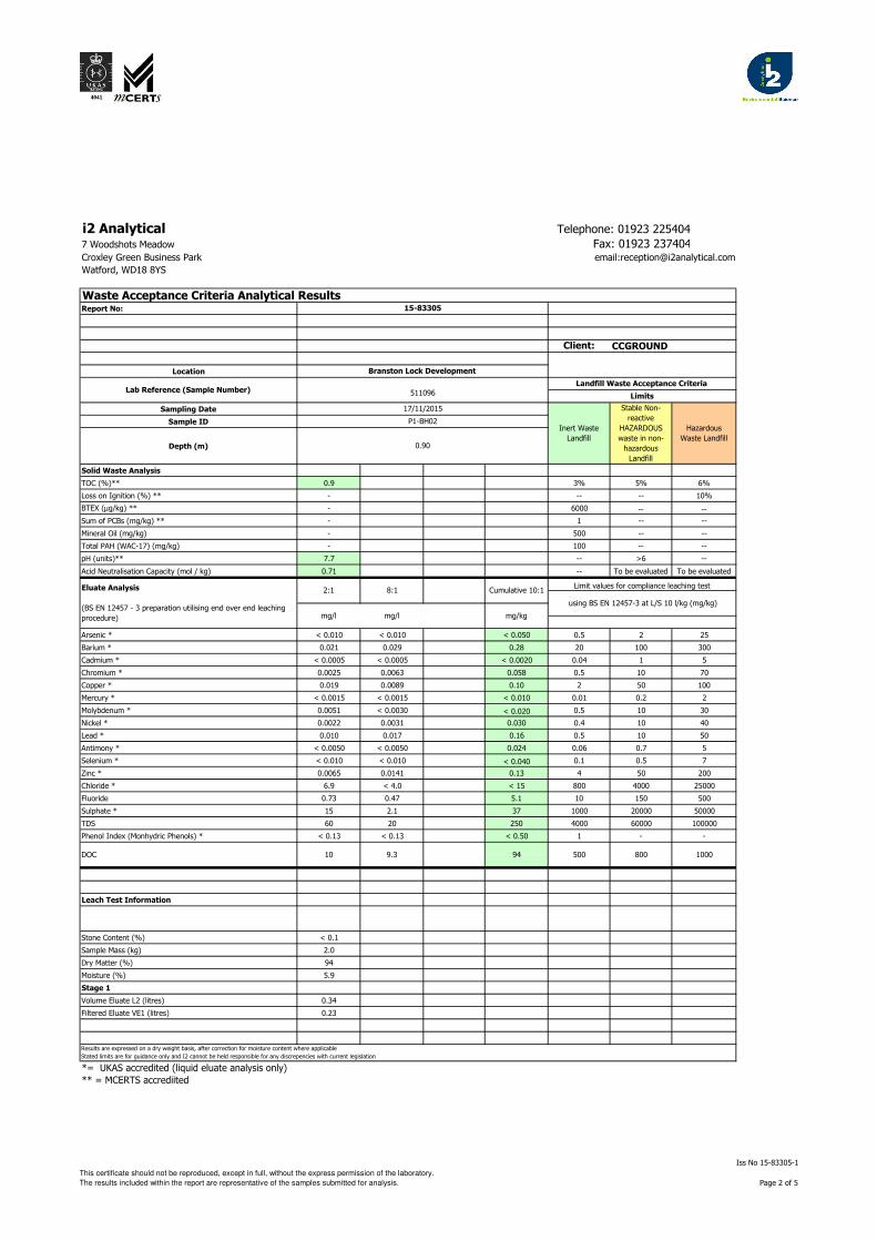
i2 Analytical Telephone: 01923 225404
7 Woodshots Meadow Fax: 01923 237404Croxley Green Business Park email:[email protected]
Watford, WD18 8YS
Report No:
Client:
Location
Sampling Date
Sample ID
Depth (m)
Solid Waste Analysis
TOC (%)** 0.9 3% 5% 6%
Loss on Ignition (%) ** - -- -- 10%
BTEX (µg/kg) ** - 6000 -- --
Sum of PCBs (mg/kg) ** - 1 -- --
Mineral Oil (mg/kg) - 500 -- --
Total PAH (WAC-17) (mg/kg) - 100 -- --
pH (units)** 7.7 -- >6 --
Acid Neutralisation Capacity (mol / kg) 0.71 -- To be evaluated To be evaluated
Arsenic * < 0.010 < 0.010 < 0.050 0.5 2 25
Barium * 0.021 0.029 0.28 20 100 300
Cadmium * < 0.0005 < 0.0005 < 0.0020 0.04 1 5
Chromium * 0.0025 0.0063 0.058 0.5 10 70
Copper * 0.019 0.0089 0.10 2 50 100
Mercury * < 0.0015 < 0.0015 < 0.010 0.01 0.2 2
Molybdenum * 0.0051 < 0.0030 < 0.020 0.5 10 30
Nickel * 0.0022 0.0031 0.030 0.4 10 40
Lead * 0.010 0.017 0.16 0.5 10 50
Antimony * < 0.0050 < 0.0050 0.024 0.06 0.7 5
Selenium * < 0.010 < 0.010 < 0.040 0.1 0.5 7
Zinc * 0.0065 0.0141 0.13 4 50 200
Chloride * 6.9 < 4.0 < 15 800 4000 25000
Fluoride 0.73 0.47 5.1 10 150 500
Sulphate * 15 2.1 37 1000 20000 50000
TDS 60 20 250 4000 60000 100000
Phenol Index (Monhydric Phenols) * < 0.13 < 0.13 < 0.50 1 - -
Leach Test Information
Stone Content (%) < 0.1 0
Sample Mass (kg) 2.0
Dry Matter (%) 94
Moisture (%) 5.9
Stage 1
Volume Eluate L2 (litres) 0.34
Filtered Eluate VE1 (litres) 0.23
*= UKAS accredited (liquid eluate analysis only)
** = MCERTS accrediited
mg/kg
using BS EN 12457-3 at L/S 10 l/kg (mg/kg)
Waste Acceptance Criteria Analytical Results
Landfill Waste Acceptance Criteria
Branston Lock Development
Lab Reference (Sample Number)Limits511096
Cumulative 10:1
15-83305
CCGROUND
Stable Non-
reactive
HAZARDOUS
waste in non-
hazardous
Landfill
Limit values for compliance leaching test
Inert Waste
Landfill
Hazardous
Waste Landfill
17/11/2015
P1-BH02
0.90
2:1 8:1
DOC 10 9.3
mg/l mg/l
Eluate Analysis
(BS EN 12457 - 3 preparation utilising end over end leaching
procedure)
800 100094 500
Results are expressed on a dry weight basis, after correction for moisture content where applicable
Stated limits are for guidance only and I2 cannot be held responsible for any discrepencies with current legislation
This certificate should not be reproduced, except in full, without the express permission of the laboratory.
The results included within the report are representative of the samples submitted for analysis.
Iss No 15-83305-1
Page 2 of 5

i2 Analytical Telephone: 01923 225404
7 Woodshots Meadow Fax: 01923 237404Croxley Green Business Park email:[email protected]
Watford, WD18 8YS
Report No:
Client:
Location
Sampling Date
Sample ID
Depth (m)
Solid Waste Analysis
TOC (%)** 0.3 3% 5% 6%
Loss on Ignition (%) ** - -- -- 10%
BTEX (µg/kg) ** - 6000 -- --
Sum of PCBs (mg/kg) ** - 1 -- --
Mineral Oil (mg/kg) - 500 -- --
Total PAH (WAC-17) (mg/kg) - 100 -- --
pH (units)** 6.6 -- >6 --
Acid Neutralisation Capacity (mol / kg) -0.37 -- To be evaluated To be evaluated
Arsenic * < 0.010 < 0.010 < 0.050 0.5 2 25
Barium * 0.090 0.055 0.59 20 100 300
Cadmium * < 0.0005 < 0.0005 < 0.0020 0.04 1 5
Chromium * < 0.0010 0.0012 0.012 0.5 10 70
Copper * 0.0088 0.0066 0.069 2 50 100
Mercury * < 0.0015 < 0.0015 < 0.010 0.01 0.2 2
Molybdenum * < 0.0030 < 0.0030 < 0.020 0.5 10 30
Nickel * < 0.0010 < 0.0010 < 0.0050 0.4 10 40
Lead * 0.0050 < 0.0050 < 0.020 0.5 10 50
Antimony * < 0.0050 < 0.0050 0.045 0.06 0.7 5
Selenium * < 0.010 < 0.010 < 0.040 0.1 0.5 7
Zinc * 0.0028 < 0.0010 < 0.020 4 50 200
Chloride * < 4.0 < 4.0 < 15 800 4000 25000
Fluoride 0.64 0.61 6.1 10 150 500
Sulphate * 620 90 1600 1000 20000 50000
TDS 620 160 2200 4000 60000 100000
Phenol Index (Monhydric Phenols) * < 0.13 < 0.13 < 0.50 1 - -
Leach Test Information
Stone Content (%) < 0.1 0
Sample Mass (kg) 1.7
Dry Matter (%) 90
Moisture (%) 10
Stage 1
Volume Eluate L2 (litres) 0.33
Filtered Eluate VE1 (litres) 0.24
*= UKAS accredited (liquid eluate analysis only)
** = MCERTS accrediited
500DOC 18
Cumulative 10:1Limit values for compliance leaching test
using BS EN 12457-3 at L/S 10 l/kg (mg/kg)
mg/l mg/l mg/kg
Eluate Analysis
(BS EN 12457 - 3 preparation utilising end over end leaching
procedure)
2:1 8:1
1.53.3
Lab Reference (Sample Number) 511097Landfill Waste Acceptance Criteria
Limits
17/11/2015
Inert Waste
Landfill
Stable Non-
reactive
HAZARDOUS
waste in non-
hazardous
Landfill
Hazardous
Waste Landfill
P1-WS06
0.50
Branston Lock Development
Waste Acceptance Criteria Analytical Results15-83305
Results are expressed on a dry weight basis, after correction for moisture content where applicable
Stated limits are for guidance only and I2 cannot be held responsible for any discrepencies with current legislation
800 1000
CCGROUND
This certificate should not be reproduced, except in full, without the express permission of the laboratory.
The results included within the report are representative of the samples submitted for analysis.
Iss No 15-83305-1
Page 3 of 5
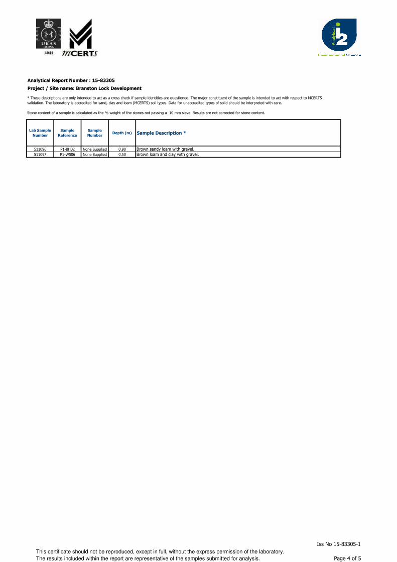
Analytical Report Number : 15-83305
Project / Site name: Branston Lock Development
Lab Sample
Number
Sample
Reference
Sample
NumberDepth (m) Sample Description *
511096 P1-BH02 None Supplied 0.90 Brown sandy loam with gravel.
511097 P1-WS06 None Supplied 0.50 Brown loam and clay with gravel.
* These descriptions are only intended to act as a cross check if sample identities are questioned. The major constituent of the sample is intended to act with respect to MCERTS
validation. The laboratory is accredited for sand, clay and loam (MCERTS) soil types. Data for unaccredited types of solid should be interpreted with care.
Stone content of a sample is calculated as the % weight of the stones not passing a 10 mm sieve. Results are not corrected for stone content.
This certificate should not be reproduced, except in full, without the express permission of the laboratory.
The results included within the report are representative of the samples submitted for analysis.
Iss No 15-83305-1
Page 4 of 5
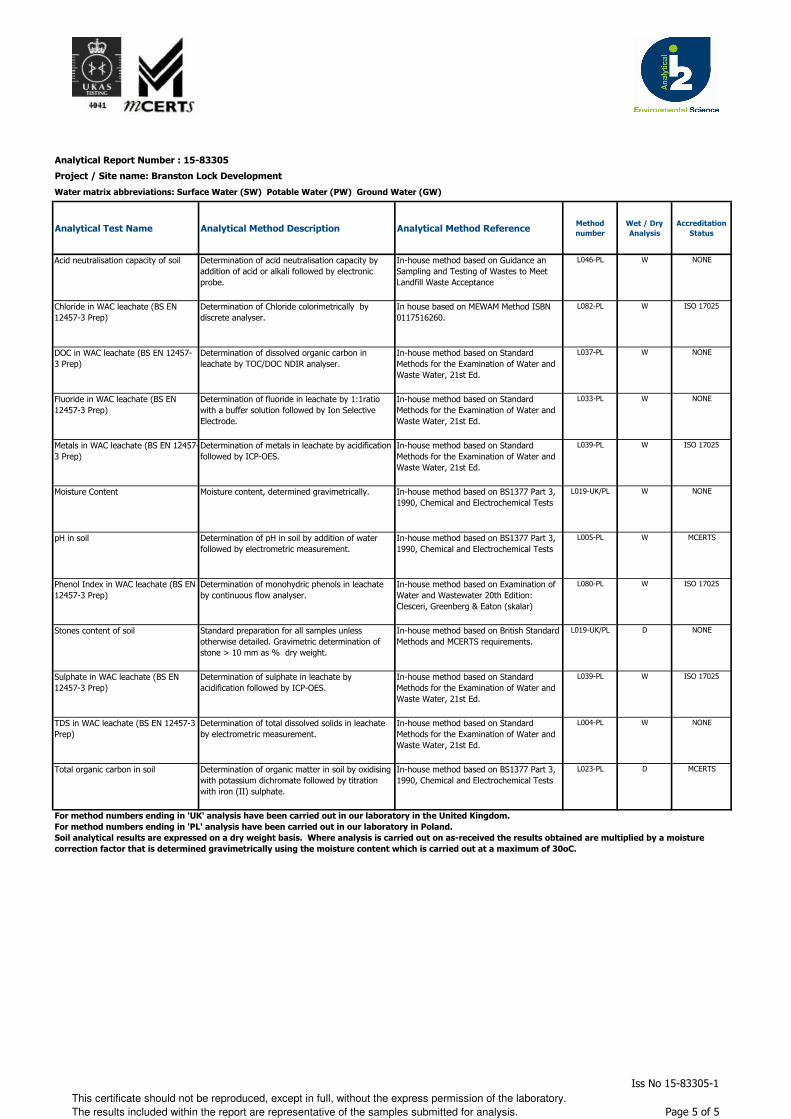
Analytical Report Number : 15-83305
Project / Site name: Branston Lock Development
Water matrix abbreviations: Surface Water (SW) Potable Water (PW) Ground Water (GW)
Analytical Test Name Analytical Method Description Analytical Method ReferenceMethod
number
Wet / Dry
Analysis
Accreditation
Status
Acid neutralisation capacity of soil Determination of acid neutralisation capacity by
addition of acid or alkali followed by electronic
probe.
In-house method based on Guidance an
Sampling and Testing of Wastes to Meet
Landfill Waste Acceptance
L046-PL W NONE
Chloride in WAC leachate (BS EN
12457-3 Prep)
Determination of Chloride colorimetrically by
discrete analyser.
In house based on MEWAM Method ISBN
0117516260.
L082-PL W ISO 17025
DOC in WAC leachate (BS EN 12457-
3 Prep)
Determination of dissolved organic carbon in
leachate by TOC/DOC NDIR analyser.
In-house method based on Standard
Methods for the Examination of Water and
Waste Water, 21st Ed.
L037-PL W NONE
Fluoride in WAC leachate (BS EN
12457-3 Prep)
Determination of fluoride in leachate by 1:1ratio
with a buffer solution followed by Ion Selective
Electrode.
In-house method based on Standard
Methods for the Examination of Water and
Waste Water, 21st Ed.
L033-PL W NONE
Metals in WAC leachate (BS EN 12457-
3 Prep)
Determination of metals in leachate by acidification
followed by ICP-OES.
In-house method based on Standard
Methods for the Examination of Water and
Waste Water, 21st Ed.
L039-PL W ISO 17025
Moisture Content Moisture content, determined gravimetrically. In-house method based on BS1377 Part 3,
1990, Chemical and Electrochemical Tests
L019-UK/PL W NONE
pH in soil Determination of pH in soil by addition of water
followed by electrometric measurement.
In-house method based on BS1377 Part 3,
1990, Chemical and Electrochemical Tests
L005-PL W MCERTS
Phenol Index in WAC leachate (BS EN
12457-3 Prep)
Determination of monohydric phenols in leachate
by continuous flow analyser.
In-house method based on Examination of
Water and Wastewater 20th Edition:
Clesceri, Greenberg & Eaton (skalar)
L080-PL W ISO 17025
Stones content of soil Standard preparation for all samples unless
otherwise detailed. Gravimetric determination of
stone > 10 mm as % dry weight.
In-house method based on British Standard
Methods and MCERTS requirements.
L019-UK/PL D NONE
Sulphate in WAC leachate (BS EN
12457-3 Prep)
Determination of sulphate in leachate by
acidification followed by ICP-OES.
In-house method based on Standard
Methods for the Examination of Water and
Waste Water, 21st Ed.
L039-PL W ISO 17025
TDS in WAC leachate (BS EN 12457-3
Prep)
Determination of total dissolved solids in leachate
by electrometric measurement.
In-house method based on Standard
Methods for the Examination of Water and
Waste Water, 21st Ed.
L004-PL W NONE
Total organic carbon in soil Determination of organic matter in soil by oxidising
with potassium dichromate followed by titration
with iron (II) sulphate.
In-house method based on BS1377 Part 3,
1990, Chemical and Electrochemical Tests
L023-PL D MCERTS
For method numbers ending in 'UK' analysis have been carried out in our laboratory in the United Kingdom.
For method numbers ending in 'PL' analysis have been carried out in our laboratory in Poland.
Soil analytical results are expressed on a dry weight basis. Where analysis is carried out on as-received the results obtained are multiplied by a moisture
correction factor that is determined gravimetrically using the moisture content which is carried out at a maximum of 30oC.
This certificate should not be reproduced, except in full, without the express permission of the laboratory.
The results included within the report are representative of the samples submitted for analysis.
Iss No 15-83305-1
Page 5 of 5
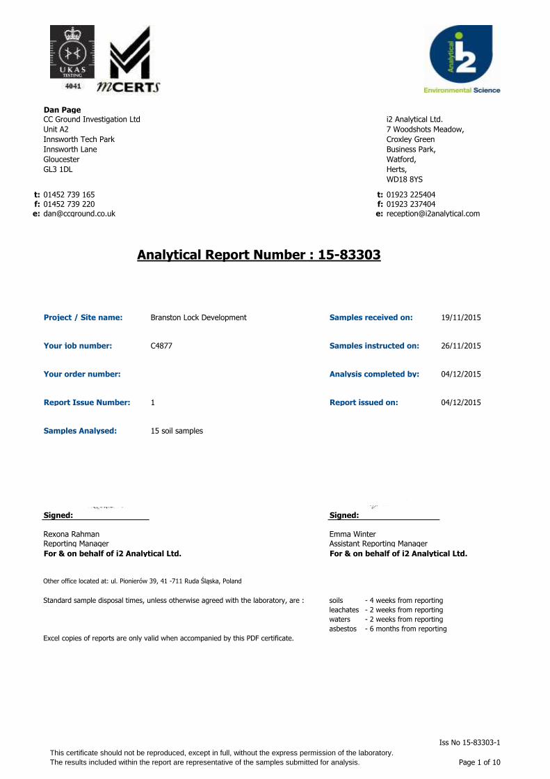
Dan Page
t: 01452 739 165 t: 01923 225404f: 01452 739 220 f: 01923 237404e: [email protected] e:
Project / Site name: Samples received on: 19/11/2015
Your job number: C4877 Samples instructed on: 26/11/2015
Your order number: Analysis completed by: 04/12/2015
Report Issue Number: 1 Report issued on: 04/12/2015
Samples Analysed:
Signed: Signed:
Reporting Manager Assistant Reporting Manager
For & on behalf of i2 Analytical Ltd. For & on behalf of i2 Analytical Ltd.
Other office located at: ul. Pionierów 39, 41 -711 Ruda Śląska, Poland
Standard sample disposal times, unless otherwise agreed with the laboratory, are : soils - 4 weeks from reporting
leachates - 2 weeks from reporting
waters - 2 weeks from reporting
asbestos - 6 months from reporting
Excel copies of reports are only valid when accompanied by this PDF certificate.
15 soil samples
Branston Lock Development
CC Ground Investigation Ltd
Unit A2
Innsworth Tech Park
Innsworth Lane
Gloucester
GL3 1DL
i2 Analytical Ltd.
7 Woodshots Meadow,
Croxley Green
Business Park,
Watford,
Herts,
WD18 8YS
Analytical Report Number : 15-83303
Rexona Rahman
Emma Winter
This certificate should not be reproduced, except in full, without the express permission of the laboratory.
The results included within the report are representative of the samples submitted for analysis.
Iss No 15-83303-1
Page 1 of 10
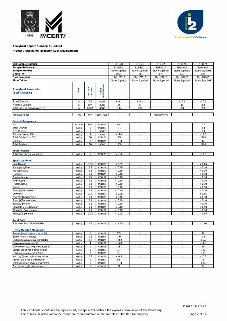
Analytical Report Number: 15-83303
Project / Site name: Branston Lock Development
Lab Sample Number 511070 511071 511072 511073 511074
Sample Reference P1-BH01 P1-BH01 P1-BH01A P1-BH01A P1-BH01A
Sample Number None Supplied None Supplied None Supplied None Supplied None Supplied
Depth (m) 0.50 1.00 0.20 0.50 0.70
Date Sampled 12/11/2015 12/11/2015 12/11/2015 12/11/2015 12/11/2015
Time Taken None Supplied None Supplied None Supplied None Supplied None Supplied
Analytical Parameter
(Soil Analysis)
Un
its
Lim
it of
de
tectio
n
Accre
dita
tion
Sta
tus
Stone Content % 0.1 NONE < 0.1 < 0.1 - < 0.1 < 0.1
Moisture Content % N/A NONE 15 14 - 13 8.2
Total mass of sample received kg 0.001 NONE 1.6 2.0 - 2.0 2.0
Asbestos in Soil Type N/A ISO 17025 - - Not-detected - -
General Inorganics
pH pH Units N/A MCERTS 6.8 - - - 7.7
Total Cyanide mg/kg 1 MCERTS < 1 - - - < 1
Free Cyanide mg/kg 1 NONE < 1 - - - < 1
Thiocyanate as SCN mg/kg 5 NONE < 5.0 - - - < 5.0Total Sulphate as SO4 mg/kg 50 MCERTS 1900 - - - 1100
Sulphide mg/kg 1 MCERTS < 1.0 - - - 12
Total Sulphur mg/kg 50 NONE 1600 - - - 1200
Total Phenols
Total Phenols (monohydric) mg/kg 1 MCERTS < 1.0 - - - < 1.0
Speciated PAHs
Naphthalene mg/kg 0.05 MCERTS < 0.05 - - - < 0.05
Acenaphthylene mg/kg 0.1 MCERTS < 0.10 - - - < 0.10
Acenaphthene mg/kg 0.1 MCERTS < 0.10 - - - < 0.10
Fluorene mg/kg 0.1 MCERTS < 0.10 - - - < 0.10
Phenanthrene mg/kg 0.1 MCERTS < 0.10 - - - < 0.10
Anthracene mg/kg 0.1 MCERTS < 0.10 - - - < 0.10
Fluoranthene mg/kg 0.1 MCERTS < 0.10 - - - < 0.10
Pyrene mg/kg 0.1 MCERTS < 0.10 - - - < 0.10
Benzo(a)anthracene mg/kg 0.1 MCERTS < 0.10 - - - < 0.10
Chrysene mg/kg 0.05 MCERTS < 0.05 - - - < 0.05
Benzo(b)fluoranthene mg/kg 0.1 MCERTS < 0.10 - - - < 0.10
Benzo(k)fluoranthene mg/kg 0.1 MCERTS < 0.10 - - - < 0.10
Benzo(a)pyrene mg/kg 0.1 MCERTS < 0.10 - - - < 0.10
Indeno(1,2,3-cd)pyrene mg/kg 0.1 MCERTS < 0.10 - - - < 0.10
Dibenz(a,h)anthracene mg/kg 0.1 MCERTS < 0.10 - - - < 0.10
Benzo(ghi)perylene mg/kg 0.05 MCERTS < 0.05 - - - < 0.05
Total PAH
Speciated Total EPA-16 PAHs mg/kg 1.6 MCERTS < 1.60 - - - < 1.60
Heavy Metals / Metalloids
Arsenic (aqua regia extractable) mg/kg 1 MCERTS 5.3 - - - 18
Boron (water soluble) mg/kg 0.2 MCERTS 1.9 - - - 3.5
Cadmium (aqua regia extractable) mg/kg 0.2 MCERTS < 0.2 - - - < 0.2
Chromium (hexavalent) mg/kg 4 MCERTS < 4.0 - - - < 4.0
Chromium (aqua regia extractable) mg/kg 1 MCERTS 11 - - - 10
Copper (aqua regia extractable) mg/kg 1 MCERTS 7.7 - - - 120
Lead (aqua regia extractable) mg/kg 1 MCERTS 13 - - - 140
Mercury (aqua regia extractable) mg/kg 0.3 MCERTS < 0.3 - - - < 0.3
Nickel (aqua regia extractable) mg/kg 1 MCERTS 9.5 - - - 46
Selenium (aqua regia extractable) mg/kg 1 MCERTS < 1.0 - - - < 1.0
Zinc (aqua regia extractable) mg/kg 1 MCERTS 22 - - - 84
This certificate should not be reproduced, except in full, without the express permission of the laboratory.
The results included within the report are representative of the samples submitted for analysis.
Iss No 15-83303-1
Page 2 of 10
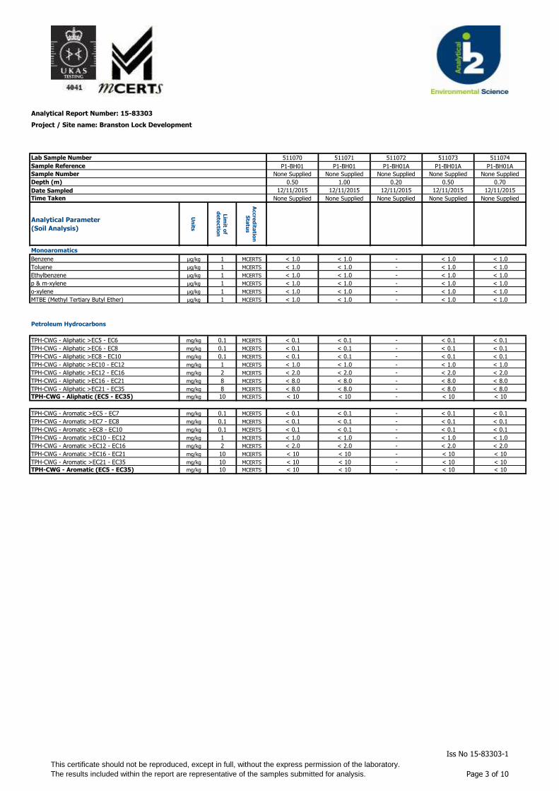
Analytical Report Number: 15-83303
Project / Site name: Branston Lock Development
Lab Sample Number 511070 511071 511072 511073 511074
Sample Reference P1-BH01 P1-BH01 P1-BH01A P1-BH01A P1-BH01A
Sample Number None Supplied None Supplied None Supplied None Supplied None Supplied
Depth (m) 0.50 1.00 0.20 0.50 0.70
Date Sampled 12/11/2015 12/11/2015 12/11/2015 12/11/2015 12/11/2015
Time Taken None Supplied None Supplied None Supplied None Supplied None Supplied
Analytical Parameter
(Soil Analysis)
Un
its
Lim
it of
de
tectio
n
Accre
dita
tion
Sta
tus
Monoaromatics
Benzene µg/kg 1 MCERTS < 1.0 < 1.0 - < 1.0 < 1.0
Toluene µg/kg 1 MCERTS < 1.0 < 1.0 - < 1.0 < 1.0
Ethylbenzene µg/kg 1 MCERTS < 1.0 < 1.0 - < 1.0 < 1.0
p & m-xylene µg/kg 1 MCERTS < 1.0 < 1.0 - < 1.0 < 1.0
o-xylene µg/kg 1 MCERTS < 1.0 < 1.0 - < 1.0 < 1.0
MTBE (Methyl Tertiary Butyl Ether) µg/kg 1 MCERTS < 1.0 < 1.0 - < 1.0 < 1.0
Petroleum Hydrocarbons
TPH-CWG - Aliphatic >EC5 - EC6 mg/kg 0.1 MCERTS < 0.1 < 0.1 - < 0.1 < 0.1
TPH-CWG - Aliphatic >EC6 - EC8 mg/kg 0.1 MCERTS < 0.1 < 0.1 - < 0.1 < 0.1
TPH-CWG - Aliphatic >EC8 - EC10 mg/kg 0.1 MCERTS < 0.1 < 0.1 - < 0.1 < 0.1
TPH-CWG - Aliphatic >EC10 - EC12 mg/kg 1 MCERTS < 1.0 < 1.0 - < 1.0 < 1.0
TPH-CWG - Aliphatic >EC12 - EC16 mg/kg 2 MCERTS < 2.0 < 2.0 - < 2.0 < 2.0
TPH-CWG - Aliphatic >EC16 - EC21 mg/kg 8 MCERTS < 8.0 < 8.0 - < 8.0 < 8.0
TPH-CWG - Aliphatic >EC21 - EC35 mg/kg 8 MCERTS < 8.0 < 8.0 - < 8.0 < 8.0
TPH-CWG - Aliphatic (EC5 - EC35) mg/kg 10 MCERTS < 10 < 10 - < 10 < 10
TPH-CWG - Aromatic >EC5 - EC7 mg/kg 0.1 MCERTS < 0.1 < 0.1 - < 0.1 < 0.1
TPH-CWG - Aromatic >EC7 - EC8 mg/kg 0.1 MCERTS < 0.1 < 0.1 - < 0.1 < 0.1
TPH-CWG - Aromatic >EC8 - EC10 mg/kg 0.1 MCERTS < 0.1 < 0.1 - < 0.1 < 0.1
TPH-CWG - Aromatic >EC10 - EC12 mg/kg 1 MCERTS < 1.0 < 1.0 - < 1.0 < 1.0
TPH-CWG - Aromatic >EC12 - EC16 mg/kg 2 MCERTS < 2.0 < 2.0 - < 2.0 < 2.0
TPH-CWG - Aromatic >EC16 - EC21 mg/kg 10 MCERTS < 10 < 10 - < 10 < 10
TPH-CWG - Aromatic >EC21 - EC35 mg/kg 10 MCERTS < 10 < 10 - < 10 < 10
TPH-CWG - Aromatic (EC5 - EC35) mg/kg 10 MCERTS < 10 < 10 - < 10 < 10
This certificate should not be reproduced, except in full, without the express permission of the laboratory.
The results included within the report are representative of the samples submitted for analysis.
Iss No 15-83303-1
Page 3 of 10
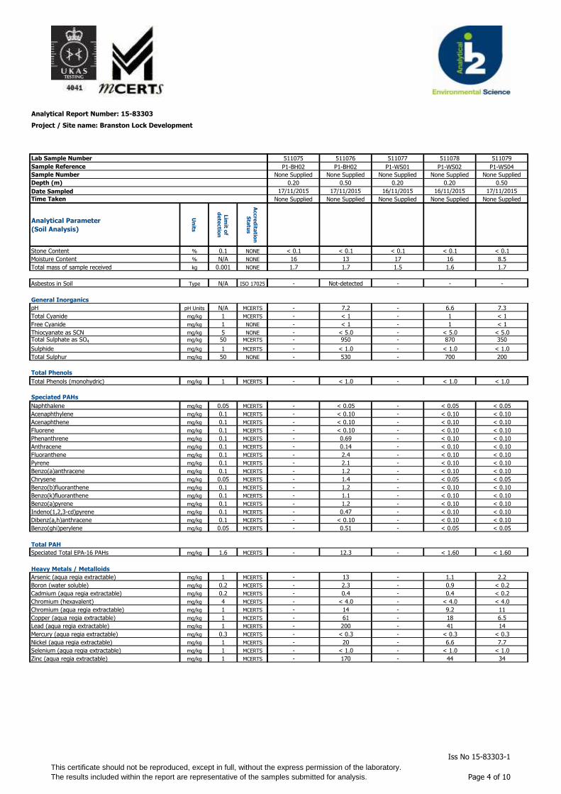
Analytical Report Number: 15-83303
Project / Site name: Branston Lock Development
Lab Sample Number
Sample Reference
Sample Number
Depth (m)
Date Sampled
Time Taken
Analytical Parameter
(Soil Analysis)
Un
its
Lim
it of
de
tectio
n
Accre
dita
tion
Sta
tus
Stone Content % 0.1 NONE
Moisture Content % N/A NONE
Total mass of sample received kg 0.001 NONE
Asbestos in Soil Type N/A ISO 17025
General Inorganics
pH pH Units N/A MCERTS
Total Cyanide mg/kg 1 MCERTS
Free Cyanide mg/kg 1 NONE
Thiocyanate as SCN mg/kg 5 NONE
Total Sulphate as SO4 mg/kg 50 MCERTS
Sulphide mg/kg 1 MCERTS
Total Sulphur mg/kg 50 NONE
Total Phenols
Total Phenols (monohydric) mg/kg 1 MCERTS
Speciated PAHs
Naphthalene mg/kg 0.05 MCERTS
Acenaphthylene mg/kg 0.1 MCERTS
Acenaphthene mg/kg 0.1 MCERTS
Fluorene mg/kg 0.1 MCERTS
Phenanthrene mg/kg 0.1 MCERTS
Anthracene mg/kg 0.1 MCERTS
Fluoranthene mg/kg 0.1 MCERTS
Pyrene mg/kg 0.1 MCERTS
Benzo(a)anthracene mg/kg 0.1 MCERTS
Chrysene mg/kg 0.05 MCERTS
Benzo(b)fluoranthene mg/kg 0.1 MCERTS
Benzo(k)fluoranthene mg/kg 0.1 MCERTS
Benzo(a)pyrene mg/kg 0.1 MCERTS
Indeno(1,2,3-cd)pyrene mg/kg 0.1 MCERTS
Dibenz(a,h)anthracene mg/kg 0.1 MCERTS
Benzo(ghi)perylene mg/kg 0.05 MCERTS
Total PAH
Speciated Total EPA-16 PAHs mg/kg 1.6 MCERTS
Heavy Metals / Metalloids
Arsenic (aqua regia extractable) mg/kg 1 MCERTS
Boron (water soluble) mg/kg 0.2 MCERTS
Cadmium (aqua regia extractable) mg/kg 0.2 MCERTS
Chromium (hexavalent) mg/kg 4 MCERTS
Chromium (aqua regia extractable) mg/kg 1 MCERTS
Copper (aqua regia extractable) mg/kg 1 MCERTS
Lead (aqua regia extractable) mg/kg 1 MCERTS
Mercury (aqua regia extractable) mg/kg 0.3 MCERTS
Nickel (aqua regia extractable) mg/kg 1 MCERTS
Selenium (aqua regia extractable) mg/kg 1 MCERTS
Zinc (aqua regia extractable) mg/kg 1 MCERTS
511075 511076 511077 511078 511079
P1-BH02 P1-BH02 P1-WS01 P1-WS02 P1-WS04
None Supplied None Supplied None Supplied None Supplied None Supplied
0.20 0.50 0.20 0.20 0.50
17/11/2015 17/11/2015 16/11/2015 16/11/2015 17/11/2015
None Supplied None Supplied None Supplied None Supplied None Supplied
< 0.1 < 0.1 < 0.1 < 0.1 < 0.1
16 13 17 16 8.5
1.7 1.7 1.5 1.6 1.7
- Not-detected - - -
- 7.2 - 6.6 7.3
- < 1 - 1 < 1
- < 1 - 1 < 1
- < 5.0 - < 5.0 < 5.0- 950 - 870 350
- < 1.0 - < 1.0 < 1.0
- 530 - 700 200
- < 1.0 - < 1.0 < 1.0
- < 0.05 - < 0.05 < 0.05
- < 0.10 - < 0.10 < 0.10
- < 0.10 - < 0.10 < 0.10
- < 0.10 - < 0.10 < 0.10
- 0.69 - < 0.10 < 0.10
- 0.14 - < 0.10 < 0.10
- 2.4 - < 0.10 < 0.10
- 2.1 - < 0.10 < 0.10
- 1.2 - < 0.10 < 0.10
- 1.4 - < 0.05 < 0.05
- 1.2 - < 0.10 < 0.10
- 1.1 - < 0.10 < 0.10
- 1.2 - < 0.10 < 0.10
- 0.47 - < 0.10 < 0.10
- < 0.10 - < 0.10 < 0.10
- 0.51 - < 0.05 < 0.05
- 12.3 - < 1.60 < 1.60
- 13 - 1.1 2.2
- 2.3 - 0.9 < 0.2
- 0.4 - 0.4 < 0.2
- < 4.0 - < 4.0 < 4.0
- 14 - 9.2 11
- 61 - 18 6.5
- 200 - 41 14
- < 0.3 - < 0.3 < 0.3
- 20 - 6.6 7.7
- < 1.0 - < 1.0 < 1.0
- 170 - 44 34
This certificate should not be reproduced, except in full, without the express permission of the laboratory.
The results included within the report are representative of the samples submitted for analysis.
Iss No 15-83303-1
Page 4 of 10

Analytical Report Number: 15-83303
Project / Site name: Branston Lock Development
Lab Sample Number
Sample Reference
Sample Number
Depth (m)
Date Sampled
Time Taken
Analytical Parameter
(Soil Analysis)
Un
its
Lim
it of
de
tectio
n
Accre
dita
tion
Sta
tus
Stone Content % 0.1 NONEMonoaromatics
Benzene µg/kg 1 MCERTS
Toluene µg/kg 1 MCERTS
Ethylbenzene µg/kg 1 MCERTS
p & m-xylene µg/kg 1 MCERTS
o-xylene µg/kg 1 MCERTS
MTBE (Methyl Tertiary Butyl Ether) µg/kg 1 MCERTS
Petroleum Hydrocarbons
TPH-CWG - Aliphatic >EC5 - EC6 mg/kg 0.1 MCERTS
TPH-CWG - Aliphatic >EC6 - EC8 mg/kg 0.1 MCERTS
TPH-CWG - Aliphatic >EC8 - EC10 mg/kg 0.1 MCERTS
TPH-CWG - Aliphatic >EC10 - EC12 mg/kg 1 MCERTS
TPH-CWG - Aliphatic >EC12 - EC16 mg/kg 2 MCERTS
TPH-CWG - Aliphatic >EC16 - EC21 mg/kg 8 MCERTS
TPH-CWG - Aliphatic >EC21 - EC35 mg/kg 8 MCERTS
TPH-CWG - Aliphatic (EC5 - EC35) mg/kg 10 MCERTS
TPH-CWG - Aromatic >EC5 - EC7 mg/kg 0.1 MCERTS
TPH-CWG - Aromatic >EC7 - EC8 mg/kg 0.1 MCERTS
TPH-CWG - Aromatic >EC8 - EC10 mg/kg 0.1 MCERTS
TPH-CWG - Aromatic >EC10 - EC12 mg/kg 1 MCERTS
TPH-CWG - Aromatic >EC12 - EC16 mg/kg 2 MCERTS
TPH-CWG - Aromatic >EC16 - EC21 mg/kg 10 MCERTS
TPH-CWG - Aromatic >EC21 - EC35 mg/kg 10 MCERTS
TPH-CWG - Aromatic (EC5 - EC35) mg/kg 10 MCERTS
511075 511076 511077 511078 511079
P1-BH02 P1-BH02 P1-WS01 P1-WS02 P1-WS04
None Supplied None Supplied None Supplied None Supplied None Supplied
0.20 0.50 0.20 0.20 0.50
17/11/2015 17/11/2015 16/11/2015 16/11/2015 17/11/2015
None Supplied None Supplied None Supplied None Supplied None Supplied
< 1.0 < 1.0 < 1.0 < 1.0 < 1.0
< 1.0 < 1.0 < 1.0 < 1.0 < 1.0
< 1.0 < 1.0 < 1.0 < 1.0 < 1.0
< 1.0 < 1.0 < 1.0 < 1.0 < 1.0
< 1.0 < 1.0 < 1.0 < 1.0 < 1.0
< 1.0 < 1.0 < 1.0 < 1.0 < 1.0
< 0.1 < 0.1 < 0.1 < 0.1 < 0.1
< 0.1 < 0.1 < 0.1 < 0.1 < 0.1
< 0.1 < 0.1 < 0.1 < 0.1 < 0.1
< 1.0 < 1.0 < 1.0 < 1.0 < 1.0
< 2.0 < 2.0 < 2.0 < 2.0 < 2.0
< 8.0 < 8.0 < 8.0 < 8.0 < 8.0
27 11 < 8.0 < 8.0 < 8.0
30 11 < 10 < 10 < 10
< 0.1 < 0.1 < 0.1 < 0.1 < 0.1
< 0.1 < 0.1 < 0.1 < 0.1 < 0.1
< 0.1 < 0.1 < 0.1 < 0.1 < 0.1
< 1.0 < 1.0 < 1.0 < 1.0 < 1.0
4.6 2.8 < 2.0 < 2.0 < 2.0
26 19 < 10 < 10 < 10
87 41 < 10 < 10 < 10
120 63 < 10 < 10 < 10
This certificate should not be reproduced, except in full, without the express permission of the laboratory.
The results included within the report are representative of the samples submitted for analysis.
Iss No 15-83303-1
Page 5 of 10
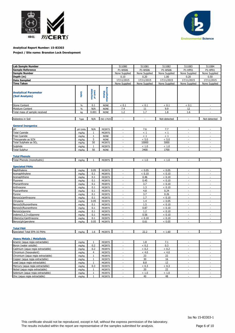
Analytical Report Number: 15-83303
Project / Site name: Branston Lock Development
Lab Sample Number
Sample Reference
Sample Number
Depth (m)
Date Sampled
Time Taken
Analytical Parameter
(Soil Analysis)
Un
its
Lim
it of
de
tectio
n
Accre
dita
tion
Sta
tus
Stone Content % 0.1 NONE
Moisture Content % N/A NONE
Total mass of sample received kg 0.001 NONE
Asbestos in Soil Type N/A ISO 17025
General Inorganics
pH pH Units N/A MCERTS
Total Cyanide mg/kg 1 MCERTS
Free Cyanide mg/kg 1 NONE
Thiocyanate as SCN mg/kg 5 NONE
Total Sulphate as SO4 mg/kg 50 MCERTS
Sulphide mg/kg 1 MCERTS
Total Sulphur mg/kg 50 NONE
Total Phenols
Total Phenols (monohydric) mg/kg 1 MCERTS
Speciated PAHs
Naphthalene mg/kg 0.05 MCERTS
Acenaphthylene mg/kg 0.1 MCERTS
Acenaphthene mg/kg 0.1 MCERTS
Fluorene mg/kg 0.1 MCERTS
Phenanthrene mg/kg 0.1 MCERTS
Anthracene mg/kg 0.1 MCERTS
Fluoranthene mg/kg 0.1 MCERTS
Pyrene mg/kg 0.1 MCERTS
Benzo(a)anthracene mg/kg 0.1 MCERTS
Chrysene mg/kg 0.05 MCERTS
Benzo(b)fluoranthene mg/kg 0.1 MCERTS
Benzo(k)fluoranthene mg/kg 0.1 MCERTS
Benzo(a)pyrene mg/kg 0.1 MCERTS
Indeno(1,2,3-cd)pyrene mg/kg 0.1 MCERTS
Dibenz(a,h)anthracene mg/kg 0.1 MCERTS
Benzo(ghi)perylene mg/kg 0.05 MCERTS
Total PAH
Speciated Total EPA-16 PAHs mg/kg 1.6 MCERTS
Heavy Metals / Metalloids
Arsenic (aqua regia extractable) mg/kg 1 MCERTS
Boron (water soluble) mg/kg 0.2 MCERTS
Cadmium (aqua regia extractable) mg/kg 0.2 MCERTS
Chromium (hexavalent) mg/kg 4 MCERTS
Chromium (aqua regia extractable) mg/kg 1 MCERTS
Copper (aqua regia extractable) mg/kg 1 MCERTS
Lead (aqua regia extractable) mg/kg 1 MCERTS
Mercury (aqua regia extractable) mg/kg 0.3 MCERTS
Nickel (aqua regia extractable) mg/kg 1 MCERTS
Selenium (aqua regia extractable) mg/kg 1 MCERTS
Zinc (aqua regia extractable) mg/kg 1 MCERTS
511080 511081 511082 511083 511084
P1-WS06 P1-WS06 P1-WS06 P1-HP01 P1-HP01
None Supplied None Supplied None Supplied None Supplied None Supplied
0.10 0.20 1.00 0.20 0.50
17/11/2015 17/11/2015 17/11/2015 17/11/2015 17/11/2015
None Supplied None Supplied None Supplied None Supplied None Supplied
< 0.1 < 0.1 < 0.1 < 0.1 -
7.4 11 9.9 12 -
1.2 1.7 1.8 1.6 -
- - Not-detected - Not-detected
- 7.6 7.7 - -
- < 1 < 1 - -
- < 1 < 1 - -
- < 5.0 < 5.0 - -- 10000 5000 - -
- < 1.0 < 1.0 - -
- 3400 1700 - -
- < 1.0 < 1.0 - -
- < 0.05 < 0.05 - -
- < 0.10 < 0.10 - -
- 0.46 < 0.10 - -
- 0.45 < 0.10 - -
- 3.7 < 0.10 - -
- 1.3 < 0.10 - -
- 4.8 0.24 - -
- 3.7 0.26 - -
- 1.7 < 0.10 - -
- 1.4 < 0.05 - -
- 1.5 < 0.10 - -
- 0.87 < 0.10 - -
- 1.2 < 0.10 - -
- 0.56 < 0.10 - -
- < 0.10 < 0.10 - -
- 0.61 < 0.05 - -
- 22.2 < 1.60 - -
- 1.8 7.1 - -
- < 0.2 0.3 - -
- < 0.2 < 0.2 - -
- < 4.0 < 4.0 - -
- 23 22 - -
- 30 16 - -
- 8.8 12 - -
- < 0.3 < 0.3 - -
- 20 22 - -
- < 1.0 < 1.0 - -
- 40 48 - -
This certificate should not be reproduced, except in full, without the express permission of the laboratory.
The results included within the report are representative of the samples submitted for analysis.
Iss No 15-83303-1
Page 6 of 10

Analytical Report Number: 15-83303
Project / Site name: Branston Lock Development
Lab Sample Number
Sample Reference
Sample Number
Depth (m)
Date Sampled
Time Taken
Analytical Parameter
(Soil Analysis)
Un
its
Lim
it of
de
tectio
n
Accre
dita
tion
Sta
tus
Stone Content % 0.1 NONEMonoaromatics
Benzene µg/kg 1 MCERTS
Toluene µg/kg 1 MCERTS
Ethylbenzene µg/kg 1 MCERTS
p & m-xylene µg/kg 1 MCERTS
o-xylene µg/kg 1 MCERTS
MTBE (Methyl Tertiary Butyl Ether) µg/kg 1 MCERTS
Petroleum Hydrocarbons
TPH-CWG - Aliphatic >EC5 - EC6 mg/kg 0.1 MCERTS
TPH-CWG - Aliphatic >EC6 - EC8 mg/kg 0.1 MCERTS
TPH-CWG - Aliphatic >EC8 - EC10 mg/kg 0.1 MCERTS
TPH-CWG - Aliphatic >EC10 - EC12 mg/kg 1 MCERTS
TPH-CWG - Aliphatic >EC12 - EC16 mg/kg 2 MCERTS
TPH-CWG - Aliphatic >EC16 - EC21 mg/kg 8 MCERTS
TPH-CWG - Aliphatic >EC21 - EC35 mg/kg 8 MCERTS
TPH-CWG - Aliphatic (EC5 - EC35) mg/kg 10 MCERTS
TPH-CWG - Aromatic >EC5 - EC7 mg/kg 0.1 MCERTS
TPH-CWG - Aromatic >EC7 - EC8 mg/kg 0.1 MCERTS
TPH-CWG - Aromatic >EC8 - EC10 mg/kg 0.1 MCERTS
TPH-CWG - Aromatic >EC10 - EC12 mg/kg 1 MCERTS
TPH-CWG - Aromatic >EC12 - EC16 mg/kg 2 MCERTS
TPH-CWG - Aromatic >EC16 - EC21 mg/kg 10 MCERTS
TPH-CWG - Aromatic >EC21 - EC35 mg/kg 10 MCERTS
TPH-CWG - Aromatic (EC5 - EC35) mg/kg 10 MCERTS
511080 511081 511082 511083 511084
P1-WS06 P1-WS06 P1-WS06 P1-HP01 P1-HP01
None Supplied None Supplied None Supplied None Supplied None Supplied
0.10 0.20 1.00 0.20 0.50
17/11/2015 17/11/2015 17/11/2015 17/11/2015 17/11/2015
None Supplied None Supplied None Supplied None Supplied None Supplied
< 1.0 < 1.0 < 1.0 < 1.0 -
< 1.0 < 1.0 < 1.0 < 1.0 -
< 1.0 < 1.0 < 1.0 < 1.0 -
< 1.0 < 1.0 < 1.0 < 1.0 -
< 1.0 < 1.0 < 1.0 < 1.0 -
< 1.0 < 1.0 < 1.0 < 1.0 -
< 0.1 < 0.1 < 0.1 < 0.1 -
< 0.1 < 0.1 < 0.1 < 0.1 -
< 0.1 < 0.1 < 0.1 < 0.1 -
< 1.0 < 1.0 < 1.0 < 1.0 -
< 2.0 < 2.0 < 2.0 < 2.0 -
< 8.0 < 8.0 < 8.0 < 8.0 -
470 43 < 8.0 10 -
480 46 < 10 13 -
< 0.1 < 0.1 < 0.1 < 0.1 -
< 0.1 < 0.1 < 0.1 < 0.1 -
< 0.1 < 0.1 < 0.1 < 0.1 -
< 1.0 1.2 < 1.0 < 1.0 -
< 2.0 7.4 < 2.0 < 2.0 -
< 10 21 < 10 < 10 -
830 49 < 10 25 -
830 79 < 10 35 -
This certificate should not be reproduced, except in full, without the express permission of the laboratory.
The results included within the report are representative of the samples submitted for analysis.
Iss No 15-83303-1
Page 7 of 10
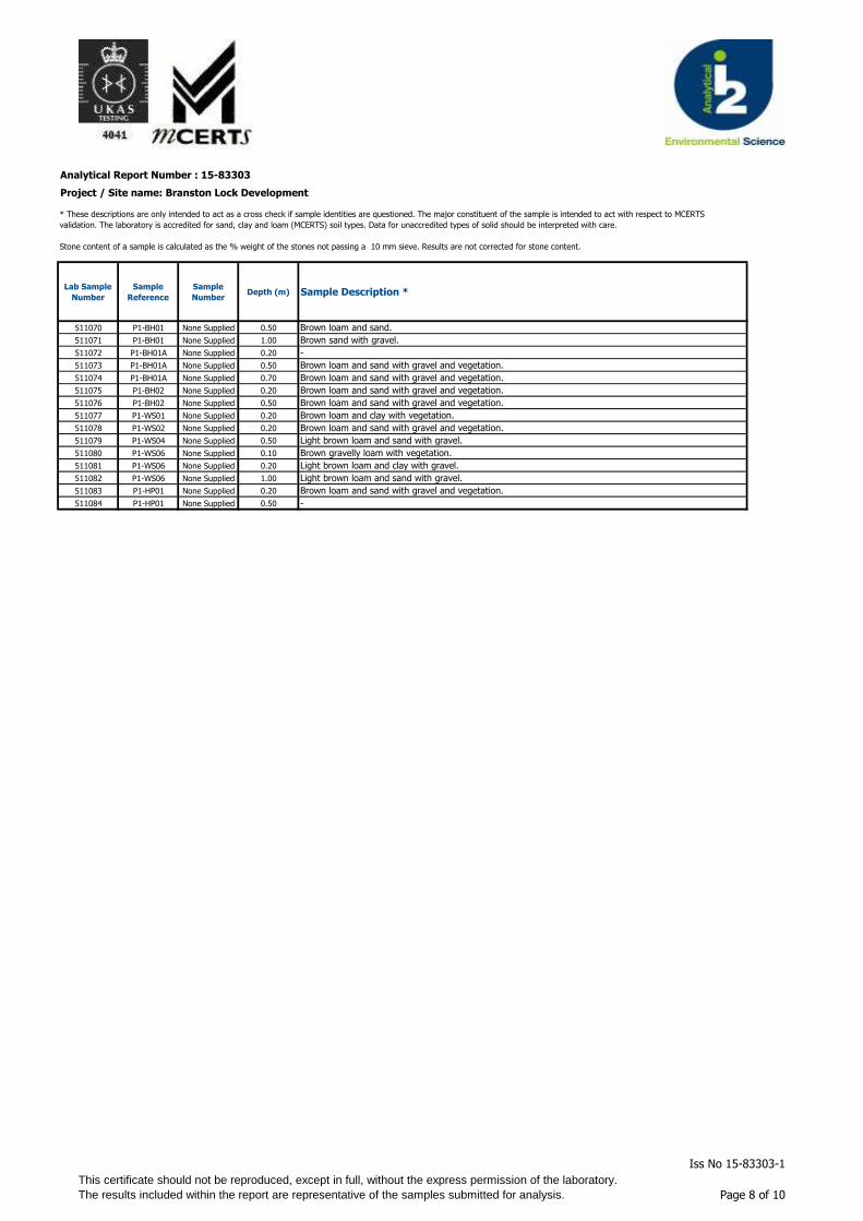
Analytical Report Number : 15-83303
Project / Site name: Branston Lock Development
Lab Sample
Number
Sample
Reference
Sample
NumberDepth (m) Sample Description *
511070 P1-BH01 None Supplied 0.50 Brown loam and sand.
511071 P1-BH01 None Supplied 1.00 Brown sand with gravel.
511072 P1-BH01A None Supplied 0.20 -
511073 P1-BH01A None Supplied 0.50 Brown loam and sand with gravel and vegetation.
511074 P1-BH01A None Supplied 0.70 Brown loam and sand with gravel and vegetation.
511075 P1-BH02 None Supplied 0.20 Brown loam and sand with gravel and vegetation.
511076 P1-BH02 None Supplied 0.50 Brown loam and sand with gravel and vegetation.
511077 P1-WS01 None Supplied 0.20 Brown loam and clay with vegetation.
511078 P1-WS02 None Supplied 0.20 Brown loam and sand with gravel and vegetation.
511079 P1-WS04 None Supplied 0.50 Light brown loam and sand with gravel.
511080 P1-WS06 None Supplied 0.10 Brown gravelly loam with vegetation.
511081 P1-WS06 None Supplied 0.20 Light brown loam and clay with gravel.
511082 P1-WS06 None Supplied 1.00 Light brown loam and sand with gravel.
511083 P1-HP01 None Supplied 0.20 Brown loam and sand with gravel and vegetation.
511084 P1-HP01 None Supplied 0.50 -
* These descriptions are only intended to act as a cross check if sample identities are questioned. The major constituent of the sample is intended to act with respect to MCERTS
validation. The laboratory is accredited for sand, clay and loam (MCERTS) soil types. Data for unaccredited types of solid should be interpreted with care.
Stone content of a sample is calculated as the % weight of the stones not passing a 10 mm sieve. Results are not corrected for stone content.
This certificate should not be reproduced, except in full, without the express permission of the laboratory.
The results included within the report are representative of the samples submitted for analysis.
Iss No 15-83303-1
Page 8 of 10
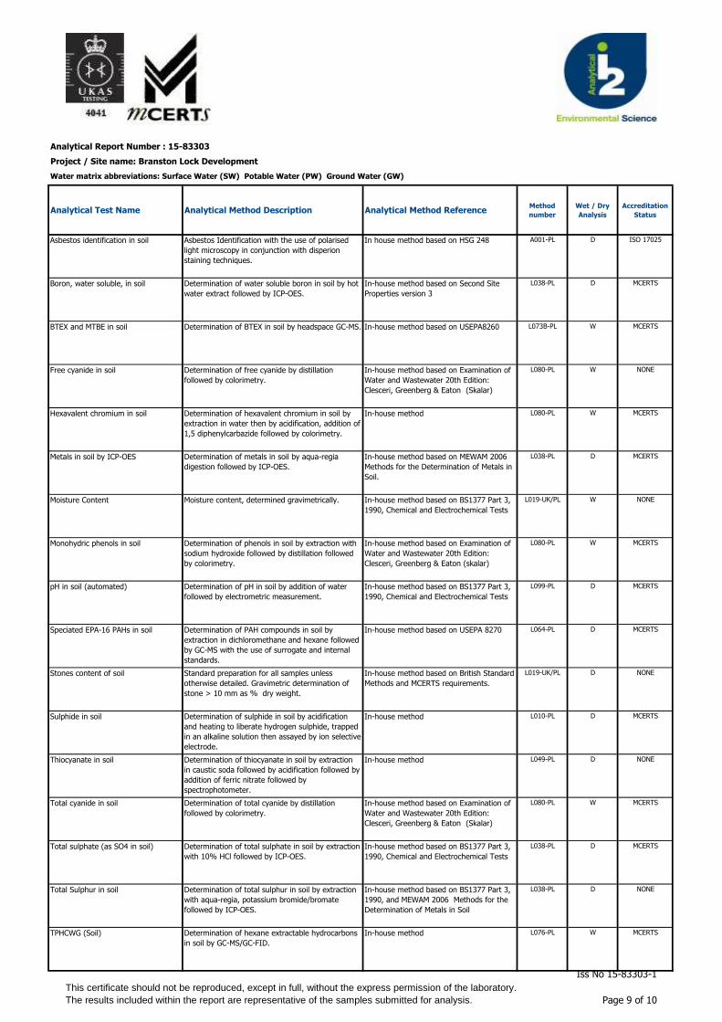
Analytical Report Number : 15-83303
Project / Site name: Branston Lock Development
Water matrix abbreviations: Surface Water (SW) Potable Water (PW) Ground Water (GW)
Analytical Test Name Analytical Method Description Analytical Method ReferenceMethod
number
Wet / Dry
Analysis
Accreditation
Status
Asbestos identification in soil Asbestos Identification with the use of polarised
light microscopy in conjunction with disperion
staining techniques.
In house method based on HSG 248 A001-PL D ISO 17025
Boron, water soluble, in soil Determination of water soluble boron in soil by hot
water extract followed by ICP-OES.
In-house method based on Second Site
Properties version 3
L038-PL D MCERTS
BTEX and MTBE in soil Determination of BTEX in soil by headspace GC-MS. In-house method based on USEPA8260 L073B-PL W MCERTS
Free cyanide in soil Determination of free cyanide by distillation
followed by colorimetry.
In-house method based on Examination of
Water and Wastewater 20th Edition:
Clesceri, Greenberg & Eaton (Skalar)
L080-PL W NONE
Hexavalent chromium in soil Determination of hexavalent chromium in soil by
extraction in water then by acidification, addition of
1,5 diphenylcarbazide followed by colorimetry.
In-house method L080-PL W MCERTS
Metals in soil by ICP-OES Determination of metals in soil by aqua-regia
digestion followed by ICP-OES.
In-house method based on MEWAM 2006
Methods for the Determination of Metals in
Soil.
L038-PL D MCERTS
Moisture Content Moisture content, determined gravimetrically. In-house method based on BS1377 Part 3,
1990, Chemical and Electrochemical Tests
L019-UK/PL W NONE
Monohydric phenols in soil Determination of phenols in soil by extraction with
sodium hydroxide followed by distillation followed
by colorimetry.
In-house method based on Examination of
Water and Wastewater 20th Edition:
Clesceri, Greenberg & Eaton (skalar)
L080-PL W MCERTS
pH in soil (automated) Determination of pH in soil by addition of water
followed by electrometric measurement.
In-house method based on BS1377 Part 3,
1990, Chemical and Electrochemical Tests
L099-PL D MCERTS
Speciated EPA-16 PAHs in soil Determination of PAH compounds in soil by
extraction in dichloromethane and hexane followed
by GC-MS with the use of surrogate and internal
standards.
In-house method based on USEPA 8270 L064-PL D MCERTS
Stones content of soil Standard preparation for all samples unless
otherwise detailed. Gravimetric determination of
stone > 10 mm as % dry weight.
In-house method based on British Standard
Methods and MCERTS requirements.
L019-UK/PL D NONE
Sulphide in soil Determination of sulphide in soil by acidification
and heating to liberate hydrogen sulphide, trapped
in an alkaline solution then assayed by ion selective
electrode.
In-house method L010-PL D MCERTS
Thiocyanate in soil Determination of thiocyanate in soil by extraction
in caustic soda followed by acidification followed by
addition of ferric nitrate followed by
spectrophotometer.
In-house method L049-PL D NONE
Total cyanide in soil Determination of total cyanide by distillation
followed by colorimetry.
In-house method based on Examination of
Water and Wastewater 20th Edition:
Clesceri, Greenberg & Eaton (Skalar)
L080-PL W MCERTS
Total sulphate (as SO4 in soil) Determination of total sulphate in soil by extraction
with 10% HCl followed by ICP-OES.
In-house method based on BS1377 Part 3,
1990, Chemical and Electrochemical Tests
L038-PL D MCERTS
Total Sulphur in soil Determination of total sulphur in soil by extraction
with aqua-regia, potassium bromide/bromate
followed by ICP-OES.
In-house method based on BS1377 Part 3,
1990, and MEWAM 2006 Methods for the
Determination of Metals in Soil
L038-PL D NONE
TPHCWG (Soil) Determination of hexane extractable hydrocarbons
in soil by GC-MS/GC-FID.
In-house method L076-PL W MCERTS
This certificate should not be reproduced, except in full, without the express permission of the laboratory.
The results included within the report are representative of the samples submitted for analysis.
Iss No 15-83303-1
Page 9 of 10
Analytical Report Number : 15-83303
Project / Site name: Branston Lock Development
Water matrix abbreviations: Surface Water (SW) Potable Water (PW) Ground Water (GW)
Analytical Test Name Analytical Method Description Analytical Method ReferenceMethod
number
Wet / Dry
Analysis
Accreditation
Status
For method numbers ending in 'UK' analysis have been carried out in our laboratory in the United Kingdom.
For method numbers ending in 'PL' analysis have been carried out in our laboratory in Poland.
Soil analytical results are expressed on a dry weight basis. Where analysis is carried out on as-received the results obtained are multiplied by a moisture
correction factor that is determined gravimetrically using the moisture content which is carried out at a maximum of 30oC.
This certificate should not be reproduced, except in full, without the express permission of the laboratory.
The results included within the report are representative of the samples submitted for analysis.
Iss No 15-83303-1
Page 10 of 10
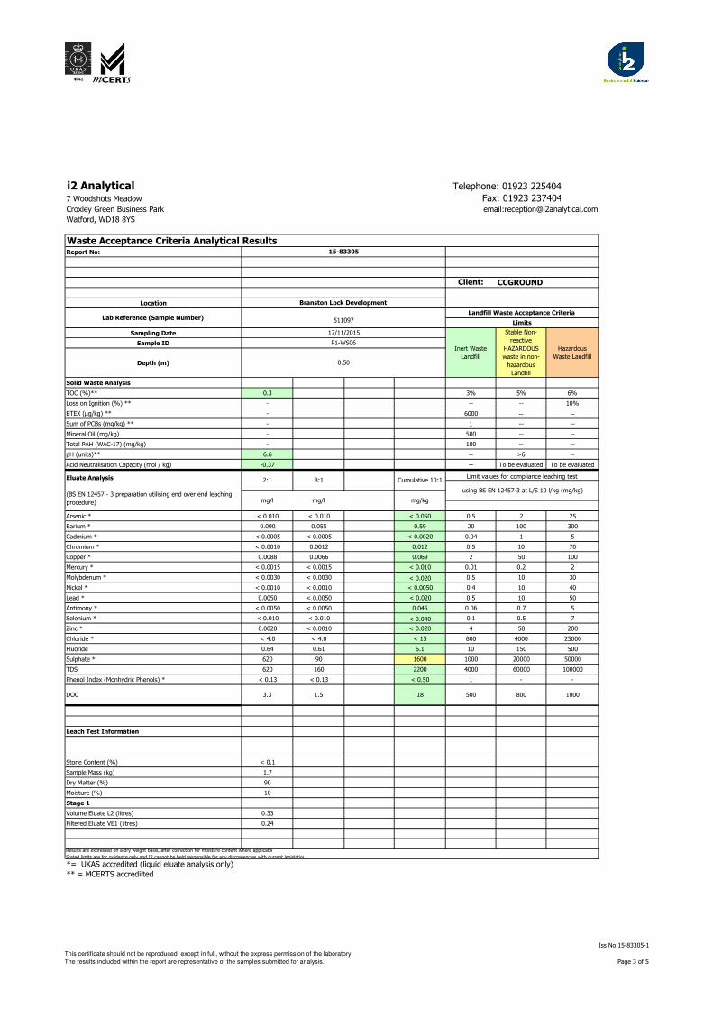
i2 Analytical Telephone: 01923 225404
7 Woodshots Meadow Fax: 01923 237404Croxley Green Business Park email:[email protected]
Watford, WD18 8YS
Report No:
Client:
Location
Sampling Date
Sample ID
Depth (m)
Solid Waste Analysis
TOC (%)** 0.3 3% 5% 6%
Loss on Ignition (%) ** - -- -- 10%
BTEX (µg/kg) ** - 6000 -- --
Sum of PCBs (mg/kg) ** - 1 -- --
Mineral Oil (mg/kg) - 500 -- --
Total PAH (WAC-17) (mg/kg) - 100 -- --
pH (units)** 6.6 -- >6 --
Acid Neutralisation Capacity (mol / kg) -0.37 -- To be evaluated To be evaluated
Arsenic * < 0.010 < 0.010 < 0.050 0.5 2 25
Barium * 0.090 0.055 0.59 20 100 300
Cadmium * < 0.0005 < 0.0005 < 0.0020 0.04 1 5
Chromium * < 0.0010 0.0012 0.012 0.5 10 70
Copper * 0.0088 0.0066 0.069 2 50 100
Mercury * < 0.0015 < 0.0015 < 0.010 0.01 0.2 2
Molybdenum * < 0.0030 < 0.0030 < 0.020 0.5 10 30
Nickel * < 0.0010 < 0.0010 < 0.0050 0.4 10 40
Lead * 0.0050 < 0.0050 < 0.020 0.5 10 50
Antimony * < 0.0050 < 0.0050 0.045 0.06 0.7 5
Selenium * < 0.010 < 0.010 < 0.040 0.1 0.5 7
Zinc * 0.0028 < 0.0010 < 0.020 4 50 200
Chloride * < 4.0 < 4.0 < 15 800 4000 25000
Fluoride 0.64 0.61 6.1 10 150 500
Sulphate * 620 90 1600 1000 20000 50000
TDS 620 160 2200 4000 60000 100000
Phenol Index (Monhydric Phenols) * < 0.13 < 0.13 < 0.50 1 - -
Leach Test Information
Stone Content (%) < 0.1 0
Sample Mass (kg) 1.7
Dry Matter (%) 90
Moisture (%) 10
Stage 1
Volume Eluate L2 (litres) 0.33
Filtered Eluate VE1 (litres) 0.24
*= UKAS accredited (liquid eluate analysis only)
** = MCERTS accrediited
500DOC 18
Cumulative 10:1Limit values for compliance leaching test
using BS EN 12457-3 at L/S 10 l/kg (mg/kg)
mg/l mg/l mg/kg
Eluate Analysis
(BS EN 12457 - 3 preparation utilising end over end leaching
procedure)
2:1 8:1
1.53.3
Lab Reference (Sample Number) 511097Landfill Waste Acceptance Criteria
Limits
17/11/2015
Inert Waste
Landfill
Stable Non-
reactive
HAZARDOUS
waste in non-
hazardous
Landfill
Hazardous
Waste Landfill
P1-WS06
0.50
Branston Lock Development
Waste Acceptance Criteria Analytical Results15-83305
Results are expressed on a dry weight basis, after correction for moisture content where applicable
Stated limits are for guidance only and I2 cannot be held responsible for any discrepencies with current legislation
800 1000
CCGROUND
This certificate should not be reproduced, except in full, without the express permission of the laboratory.
The results included within the report are representative of the samples submitted for analysis.
Iss No 15-83305-1
Page 3 of 5

Analytical Report Number : 15-83305
Project / Site name: Branston Lock Development
Lab Sample
Number
Sample
Reference
Sample
NumberDepth (m) Sample Description *
511096 P1-BH02 None Supplied 0.90 Brown sandy loam with gravel.
511097 P1-WS06 None Supplied 0.50 Brown loam and clay with gravel.
* These descriptions are only intended to act as a cross check if sample identities are questioned. The major constituent of the sample is intended to act with respect to MCERTS
validation. The laboratory is accredited for sand, clay and loam (MCERTS) soil types. Data for unaccredited types of solid should be interpreted with care.
Stone content of a sample is calculated as the % weight of the stones not passing a 10 mm sieve. Results are not corrected for stone content.
This certificate should not be reproduced, except in full, without the express permission of the laboratory.
The results included within the report are representative of the samples submitted for analysis.
Iss No 15-83305-1
Page 4 of 5

Analytical Report Number : 15-83305
Project / Site name: Branston Lock Development
Water matrix abbreviations: Surface Water (SW) Potable Water (PW) Ground Water (GW)
Analytical Test Name Analytical Method Description Analytical Method ReferenceMethod
number
Wet / Dry
Analysis
Accreditation
Status
Acid neutralisation capacity of soil Determination of acid neutralisation capacity by
addition of acid or alkali followed by electronic
probe.
In-house method based on Guidance an
Sampling and Testing of Wastes to Meet
Landfill Waste Acceptance
L046-PL W NONE
Chloride in WAC leachate (BS EN
12457-3 Prep)
Determination of Chloride colorimetrically by
discrete analyser.
In house based on MEWAM Method ISBN
0117516260.
L082-PL W ISO 17025
DOC in WAC leachate (BS EN 12457-
3 Prep)
Determination of dissolved organic carbon in
leachate by TOC/DOC NDIR analyser.
In-house method based on Standard
Methods for the Examination of Water and
Waste Water, 21st Ed.
L037-PL W NONE
Fluoride in WAC leachate (BS EN
12457-3 Prep)
Determination of fluoride in leachate by 1:1ratio
with a buffer solution followed by Ion Selective
Electrode.
In-house method based on Standard
Methods for the Examination of Water and
Waste Water, 21st Ed.
L033-PL W NONE
Metals in WAC leachate (BS EN 12457-
3 Prep)
Determination of metals in leachate by acidification
followed by ICP-OES.
In-house method based on Standard
Methods for the Examination of Water and
Waste Water, 21st Ed.
L039-PL W ISO 17025
Moisture Content Moisture content, determined gravimetrically. In-house method based on BS1377 Part 3,
1990, Chemical and Electrochemical Tests
L019-UK/PL W NONE
pH in soil Determination of pH in soil by addition of water
followed by electrometric measurement.
In-house method based on BS1377 Part 3,
1990, Chemical and Electrochemical Tests
L005-PL W MCERTS
Phenol Index in WAC leachate (BS EN
12457-3 Prep)
Determination of monohydric phenols in leachate
by continuous flow analyser.
In-house method based on Examination of
Water and Wastewater 20th Edition:
Clesceri, Greenberg & Eaton (skalar)
L080-PL W ISO 17025
Stones content of soil Standard preparation for all samples unless
otherwise detailed. Gravimetric determination of
stone > 10 mm as % dry weight.
In-house method based on British Standard
Methods and MCERTS requirements.
L019-UK/PL D NONE
Sulphate in WAC leachate (BS EN
12457-3 Prep)
Determination of sulphate in leachate by
acidification followed by ICP-OES.
In-house method based on Standard
Methods for the Examination of Water and
Waste Water, 21st Ed.
L039-PL W ISO 17025
TDS in WAC leachate (BS EN 12457-3
Prep)
Determination of total dissolved solids in leachate
by electrometric measurement.
In-house method based on Standard
Methods for the Examination of Water and
Waste Water, 21st Ed.
L004-PL W NONE
Total organic carbon in soil Determination of organic matter in soil by oxidising
with potassium dichromate followed by titration
with iron (II) sulphate.
In-house method based on BS1377 Part 3,
1990, Chemical and Electrochemical Tests
L023-PL D MCERTS
For method numbers ending in 'UK' analysis have been carried out in our laboratory in the United Kingdom.
For method numbers ending in 'PL' analysis have been carried out in our laboratory in Poland.
Soil analytical results are expressed on a dry weight basis. Where analysis is carried out on as-received the results obtained are multiplied by a moisture
correction factor that is determined gravimetrically using the moisture content which is carried out at a maximum of 30oC.
This certificate should not be reproduced, except in full, without the express permission of the laboratory.
The results included within the report are representative of the samples submitted for analysis.
Iss No 15-83305-1
Page 5 of 5
This certificate should not be reproduced, except in full, without the express permission of the laboratory.
The results included within the report are representative of the samples submitted for analysis.
Iss No 15-83305-1
Page 1 of 5

CC Ground Investigations Ltd Report C4877
APPENDIX D
Appendix D – SPT Calibration Data